Embed Size (px)
Citation preview
SA-None
AIRCRAFT ACCIDENT REPORT MINERAL COUNTY AIRLINES
d.b.a. HAWTHORNE NEVADA AIRLINES,
NEAR LONE PINE, CALIFORNIA FEBRUARY 18,1969
Adopted: FEBRUARY 4,1970
DC-3, N15570
NATIONAL TRANSPORTATION SAFETY BOARD Bureau of Aviation Safety Washington, D. C. 20591
1
1
For a l e by Clearinghouse :or Federal Seientifle and Technical Information, U.S. Department of commerce, Spdn&ld, Va. 22151. Annual Subscription price $12.00 Domestic: $15.00 Foreign:
Single copy $3.00: Mieroflehe $0.05. Order Number: NTSB-AAR-70-5
NATIONAL TRANSPORTATION SAFETY BOARD DEPARTMENT OF TRANSPORTATION
d.b.a. HAWTHORNE NEVADA AIRLINES. MINERAL COUNTY AIRLINES.
NEAR LONE PINE. CALIFORNIA DC.3. N15570
FEBRUARY 18. 1969
TABLE OF CONTENTS
1 . 1.1 1.2 1.3 1.4 1.5 1.6 1.7 1.8 1.9 1.10
1.12 1.11
1.13 1.14 1.15 1.16 2 . 2.1 2.2
3 .
synopsis ............................................. Probable Cause ........................................ Investigation ........................................ History of the Flight ................................ Damage to Aircraft Injuries to Persons
Other Damage ......................................... Aircraft History Crew Information
Meteorological Information ........................... Aids to Navigation ................................... Aerodrome and Ground Facilities Communications
Aircraft Wreckage Flight Recorders
Fire .................................................. Survival Aspects ..................................... Company Information .................................. Search and Rescue .................................... Analysis and Conclusions ............................. Analysis ............................................. Conclusions ..........................................
(a) Findings ..................................... (b) Probable Cause ...............................
.................................. ................................... ..................................... .....................................
....................................... ...................... ..................................... ....................................
...................................... Appendix A Recommendations
Appendix B Attachment 1
1 1 2 2
3 3
4 4 4
9 5
9 9 9 9 13 13 14
15 14
19 15
19 20 20
F i l e No. 3-2594
NATIONAL TRANSPORTATION S A F E R BOARD DEPARTMENT OF TRANSPORTATION
AIRCRAFT ACCIDENT REPORT
Adopted: February 4 , 1970
MINERAL COUNTY AIRLINES, d. b . a. HAWTHORNE NEVADA AIRLINES,
DC-3, N15570 NEAR LONE PINE, CALIFORNIA
FEBRUARY 18, 1969
SYNOPSIS
A Hawthorne-Nevada Airlines (NEVT),E3, N15570, operating as Flight 708, crashed approximately 11 naut ica l miles west of Lone Pine, California, about 0510 P . s . ~ . , February 18, 1969. The 32 passengers and three crewmembers aboard the a i r c r a f t died i n t h e accident, and the a i r c r a f t was destroyed.
1969, on a VFR f l i g h t plan f o r Burbank and Long Beach, California. A t 0406, Flight 708 contacted the Tonopah Fl ight Service S ta t ion on the Mina VOR frequency and activated a VFR f l i g h t plan which had previously been f i l e d by telephone from Hawthorne, Nevada. No fu r the r contact was had with the f l i g h t . The a i r c r a f t was declared missing, and presumed down somewhere between Hawthorne, Nevada, and Burbank, California. Air and ground search operations were i n s t i t u t e d , but due t o heavy snows and inclement weather, the a i r c r a f t was not located. The crash site, approximately 11 naut ica l miles west of Lone Pine, California, was located August 8, 1969. The a i r c r a f t crashed on t h e e a s t s lope of Mount Whitney, a t an elevation of approximately 11,770 f e e t . A l l persons on board the a i r c r a f t perished i n the impact.
The f l i g h t departed Hawthorne, Nevada, 0350 P.s . t . , on February 18,
The Board determines t h a t t h e probable cause of t h i s accident was the deviation from the prescribed route of f l i g h t , as authorized i n the company's FAA-approved Operations speci f ica t ions , r esu l t ing i n the a i r - c r a f t being operated under IFR weather conditions, i n high mountainous ter ra in , i n an area where there was a lack of radio navigation aids,
...
- 2 -
1. INVESTIGATION
1.1 History of the Fl ight
Hawthorne Nevada Airlines (NEVT) operated a da i ly round t r i p from Long Beach, California (LGB), t o Hawthorne, Nevada (HTH), with a s top a t Burbank, California (BUR). On weekdays, t h e f l i g h t was scheduled t o depart LGB a t 1830 P . 8 . t . ) 11 and depart HTH a t 0400 P . 8 . t . t he follow- ing morning f o r the re turn t r i p .
scheduled, with 32 passengers and a crew of three, and arrived a t HTH a t approximately 2040, February 17, 1969. After a r r i v a l a t the a i rpor t ,
Hawthorne, a dis tance of 1 mile. The captain and f i r s t o f f i c e r u t i l i z e d the passengers and stewardess were transported by bus t o a lodge i n
a company ca r t o reach the lodge.
N15570, a DC-3, operating as Fl ight 708, departed LGB and BUR, as
.The captain and f i r s t o f f i c e r checked in to t h e i r rooms a t the
passengers, checked i n t o her room some 15 minutes l a t e r . None of the lodge a t approximately 2115. The stewardess, a f t e r tending t o the
crew v i s i t e d the casino, associated with the lodge, during the layover.
While a t HTH, t he a i r c r a f t was serviced with 200 gallons of 100- octane gas.
Approximately 0300, February 18, 1969, the flightcrew entered t h e restaurant a t t h e casino. The first o f f i c e r then went t o the telephone t o check weather and f i l e the clearance f o r the re turn f l i g h t .
(TPH) F l ight Service Stat ion (FSS). After receiving t h e weather br ief ing , A t approximately 0305, the f i r s t o f f i ce r felephoned the Tonopah
which included AIRMET Alpha 2 and the area forecast , he f i l e d t h e follow- ing f l i g h t plan:
Fl ight 708, DC- 3, Visual Fl ight Rules (VFR) d i r e c t Hawthorne t o Burbank, A l t i t u d e 11,500 fee t , Time en route 2 plus 15 21, fue l on board 3 plus 40, P i l o t Hamer, Aircraft color - Blue and white, Estimated off the ground 11502 31. Approximately 0335, the bus departed the casino with the passengers
and stewardess f o r the re turn t r i p t o the a i rpor t . The captain and f i r s t o f f i c e r had departed e a r l i e r by company car t o make the a i r c r a f t ready f o r the re turn f l i g h t .
- I / A l l times a re Paci f ic standard, based on the 24-hour clock unless otherwise specif ied. - 2/ 2 plus 1 5 - 4 hours and 15 minutes.
- 31 1150Z--Greenwich mean time. For purpose of c l a r i t y and s impl ic i ty ,
o f f i c i a l communications with ground. radio f a c i l i t i e s a re given i n a l l departure times, estimated times of a r r iva l s , and times used on
Greenwich mean time or Zulu time. This time i s 8 hours l a t e r than Paci f ic standard time.
.A
D t he f i
P Servic t h e i r was OI
was dl low c the a
the c t o a
impa of i
neal The]
1 .2
1.:
n a t
I-
a t
ed
3
ing a IW-
'8
s t
- 3 -
the f i e ld once while climbing f o r a l t i t u d e . Directly a f t e r takeoff a witness reported seeing the a i r c r a f t c i r c l e
Service Stat ion, u t i l i z i n g the Mina VOR frequency, and requested t h a t A t 0406, while i n f l i g h t , the crew contacted the Tonopah Fl ight
the i r f l i g h t plan be opened, A/ and s t a t ed t h a t t h e i r actual takeoff time was 0350. No fur ther contact of any nature was made with the f l i g h t .
An extensive ground and a i r search was launched a f t e r the a i r c r a f t was declared missing. Due t o heavy snow accumulations on t h e ground, low clouds throughout the search period, and extremely hazardous t e r r a i n , the a i r c r a f t was not located u n t i l August 8, 1969.
Pursuant t o the approved operating specif icat ions issued by the FAA, the only authorized route the company could f l y while operating subject t o a VFR clearance was as follows:
\
From HTH d i r e c t t o the in tersec t ion of Victor Airway 105 (V105) and the 240° radia l (240R) of Mina (MVA) VOR I/ V105 t o Beatty (BTY) VTAC a/ BTY VTAC d i r e c t Inyokern Airport, Cal ifornia
PMD VTAC v ia Federal Airways t o BUk Inyokern Airport direct Palmdale (PMD) VTAC
approximately 11 nautical miles (NM) west of Lone Pine, California. The impact had occurred on the face of a near v e r t i c a l c l i f f a t an elevat ion of about 11,770 f e e t m.s.1. The main body of t h e wreckage was s i tua ted near the base of the c l i f f a t l a t i t u d e 36O35'45" N. , longitude 118'15'52'' W. There were no survivors.
1 .2 Iniuries t o Persons
The a i r c r a f t wreckage was located on the e a s t slope of Mount Whitney,
Iniuries - Crew Passengers Others
Fatal Nonfatal None
3 0 0
32 0 0
0 0 0
1.3 Damage t o Aircraf t
me a i r c r a f t was destroyed by impact and subsequent f i re .
- 4 / Aircraft is i n the a i r and the crew requests t h a t the f l i g h t plan
- 5 / VOR-VHP Omnidirectional Range. which was previously f i l e d be act ivated.
- 6/ VTAC-Combination VOR and TACAN c i v i l f a c i l i t y providing both azimuth and distance information.
. .
- 4 -
1 .4 Other Damage
None
1.5 Crew Information
See Appendix B.
1.6 Aircraf t History
Aircraf t Company. NEVT placed the a i r c r a f t i n t h e i r service on August 2, N15570, s e r i a l No. 6320, was manufactured i n 1943 by the Douglas
Aero-Bulletin 7A. I/ P a r t 121 of the Federal Aviation Regulations (FAR) 1964. The airworthiness c e r t i f i c a t e was reissued July 2 , 1964, under
d ic ta ted the c r i t e r i a under which the subject a i r c r a f t was maintained.
W i f l
; i n ce
1 w i
hour overhaul was due i n 2,379 hours. The t o t a l time of the a i r c r a f t was 48,274 hours. The next 10,000-
1 The a i r c r a f t was equipped with two P r a t t & Whitney, Rl830-92, engines
and two Hamilton Standard 23350 propellers with Model 6353A-18 blades. The a i r c r a f t was not equipped with wing and empennage deicer boots. The only operable ant i- icing and/or deicing devices were windshield and propeller deicing equipment a d c a r b u r e t o r heat . The only method, avai lable t o the crew, t o check f o r external ic ing a f t e r dark was t h e il lumination from the landing l i g h t s and hand f l a sh l igh t s . The NEVT Maintenance Manual, Minimum Equipment L i s t (MEL), Items J and K, p rohib i t the operation of t h e a i r c r a f t when areas of known o r probable ic ing conditions exist o r a r e forecast f o r the route t o be flown. g/
- 71 I f there is no category, as i n the case of a i r c r a f t c e r t i f i c a t e d p r i o r t o the adoption of the regulations which established categories , the regulat ion o r other information shown as the c e r t i f i c a t i o n bas is on the applicable a i r c r a f t speci f ica t ion o r l i s t i n g i s entered on the Standard Airworthiness Cer t i f ica te , FAA Form 1362. For example, Aero-Bulletin 7A is the c e r t i f i c a t i o n basis f o r a Douglas DC-3C-SC3GY as i n the case of N15570.
L i s t f o r En Route Dispatch, Item J and K read as follows:
C e t I c (
- 81 NEVT Maintenance Manual, Chapter 11, Section 2.95.1, Minimum Equipment
J. Aircraf t may be operated, providing no known o r probable ic ing condition ex i s t s , or is forecas t f o r route t o be flown.
K . Ai rcraf t may be operated without boots, providing no known o r probable ic ing condition ex i s t s , or is forecas t f o r route t o be flown.
able be
known 3r
- 5 -
with the exception of minor discrepancies which had no bearing on the flight of February 18, 1969, the aircraft and powerplants were maintained
cedures . in accordance with existing NEVT and FAA-approved directives and pro-
The company maintenance records that were reviewed disclosed that,
Weight and balance were within limits at takeoff from HTH and were within limits at the time of the accident.
The aircraft was equipped with:
2 VHF Omnidirectional Range Receivers (VOR) 2 VHF Transceivers 1 Distance Measure Equipment Receiver (DME) 1 Marker Beacon Receiver 2 Automatic Direction Finder (ADF) Receivers (Radio Compasses) 1 Glide Slope Receiver
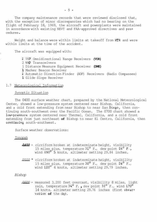
1.7 Meteorological Information
Synoptic Situation
The 0400 surface weather chart, prepared by the National Meteorological Center, showed a low-pressure system centered near Bishop, California, and a cold front extending from near Bishop to near San Diego, then con- tinuing south-southwest over the Pacific Ocean. The 0700 chart showed a lourpressure system centered near Thermal, California, and a cold front extending from just northeast of Bishop to near El Centro, California, then continuing south-southwest.
Surface weather observations:
Tonopah
- 0400 - cirriform broken at indeterminate height, visibility 15 miles plus, temperature 31' F., dew point 24' F., wind 090' 5 knots, altimeter setting 29.84 inches.
- 0500 - cirriform broken at indeterminate height, visibility 15 miles plus, temperature 30' F., dew point 24O F., wind 120° 6 knots, altimeter setting 29.79 inches.
Bishop
- 0600 - measured 3,200 feet overcast, visibility 8 miles, light rain, temperature 34' F. , dew point 32' F., wind 170'
vation of the day). 14 knots, altimeter setting 29.76 inches (first obser-
- 6 -
Edwards AFB
- 0400 - measured 4,500 f e e t overcast, v i s i b i l i t y 15 miles, temperature 46' F. , dew point 38' F., wind 270' 10 knots, a l t imeter s e t t i n g 29.76 inches.
- 0500 - measured 1,500 f e e t overcast, v i s i b i l i t y 7 miles, l i g h t r a in shavers, temperature 43' F. , dew point 40° F., wind 310' 8 knots, a l t imeter s e t t i n g 29.76 inches, l i g h t r a i n showers, occasionally moderate. th;
re3
- 0600 - measured 2,300 f e e t overcast, v i s i b i l i t y 7 miles, l i g h t
8 knots, a l t imeter s e t t i n g 29.75 inches, ce i l ing 1,700 rain, temperature 42' F., dew point 41' F., wind 310
var iable 2,800 fee t , l i g h t rain, occasionally moderate. re1
Palmdale
- 0300 - measured 4,000 f e e t broken, 5,500 f e e t overcast, v i s i b i l i t y 10 miles, temperature 460 F., dew point 38' F., wind 170' 13 knots, a l t imeter s e t t i n g 29.75 inches, r a i n began a t 0245 and ended a t 0256.
- 0400 - measured 3,000 feet broken, 5,500 f e e t overcast, v i s i b i l i t y 7 miles, l i g h t r a in , temperature 43O F . , dew point 38' F., wind 120' 5 knots, a l t imeter s e t t i n g 29.76 inches, r a i n began a t 0328.
- 0500 Record Special - measured 2,500 f e e t overcast, v i s i b i l i t y
30° F., wind 100' 7 knots, a l t imeter s e t t i n g 29.76 7 miles, l i g h t rain, temperature 43O F., dew point
inches.
- 0600 - measured 2,500 f e e t broken, 5,000 f e e t overcast, v i s i b i l i t y 7 miles, l i g h t ra in , temperature 44O F . , dew point 38' F., wind 200' 3 knots, a l t imeter s e t t i n g 29.75 inches.
Burbank
- 0300 - 400 f e e t scat tered, estimated 3,000 f e e t broken, v i s i b i l i t y 4 miles, moderate ra in , temperature 52' F., dew point 48' F . , wind 120' 5 knots.
- 0400 - measured 2,300 f e e t broken, high broken, v i s i b i l i t y 7 miles, temperature 51' F., dew point 47' F., wind 320' 4 knots, r a i n ended a t 0335.
Bu we
1
- 7 -
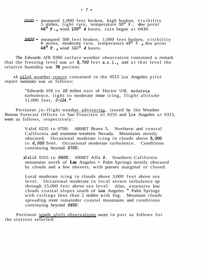
- 0500 - measured 1,000 f e e t broken, high broken, v i s i b i l i t y 5 miles, l i g h t rain, temperature 50' F. , dew point 46' F . , wind 120' 4 knots, r a i n began a t 0430.
- 0600 - measured 500 f e e t broken, 1,000 f e e t broken, v i s i b i l i t y 4 miles, moderate ra in , temperature 49' F . , dew point 46' F. , wind 320' 4 knots.
The Edwards AFB 0300 surface weather observation contained a remark that the freezing level was a t 6,700 f e e t m.s.l., and a t t h a t level the relat ive humidity was 78 percent.
report summary was as follows: r A p i l o t weather report contained i n the 0515 Los Angeles p i l o t
"Edwards AFB t o 10 miles eas t of Hector VOR, aoderate turbulence, l i g h t t o moderate rime icing, f l i g h t a l t i t u d e 11,000 fee t , C-124."
Pertinent in- f l igh t weather advisories, issued by the Weather Bureau Forecast Offices i n San Francisco a t 0255 and Los Angeles a t 0315, were as follows, respectively:
Valid 0255 t o 0700. AIRMET Bravo 5. Northern and cent ra l California and extreme western Nevada. Mountains mostly obscured. Occasional moderate ic ing i n clouds above 5,000 t o 6,000 feet. Occasional moderate turbulence. Conditions continuing beyond 0700.
KValid 0315 t o 0600. AIRMET Alfa 2 . Southern California mountains north of Los Angeles - Palm Springs mostly obscured by clouds and a few shavers, with passes marginal or closed.
Local moderate icing i n clouds above 3,000 f e e t above sea
through 15,000 f e e t above sea l eve l . Also, extensive low level . Occasional moderate t o loca l severe turbulence up
clouds coas ta l slopes south of Los Angeles - Palm Springs with ce i l ings less than 2 miles with fog. Mountain clouds spreading over remainder coastal mountains and conditions continuing beyond 0600.
the s ta t ions selected: Pertinent winds a l o f t observations were i n pa r t as follows f o r
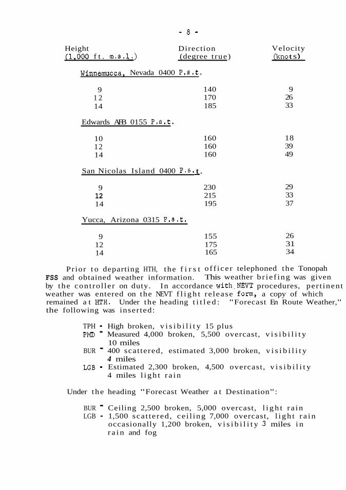
- 8 -
Height Direction (1,000 f t . m.s.1.) (degree t rue)
Winnemucca, Nevada 0400 P.S.t.
140 170 185
160 160 160
9 1 2 14
Edwards AFB 0155 P.8 . t .
10 12 14
San Nicolas Island 0400 P.S.
9 12 14
Yucca, Arizona 0315 P.S. t .
12 9
14
- t.
230 215 195
155 175 165
Velocity jkno t s )
26 9
33
18 39 49
29 33 37
26 31 34
FSS and obtained weather information. This weather b r i e f ing was given Prior t o departing HTH, the f i r s t o f f i ce r telephoned the Tonopah
by the cont ro l le r on duty. In accordance with.NEVT procedures, per t inent weather was entered on the NEVT f l i g h t re lease form, a copy of which remained a t IDH. Under the heading t i t l e d : "Forecast En Route Weather," the following was inserted:
TPH - High broken, v i s i b i l i t y 15 plus PMD - Measured 4,000 broken, 5,500 overcast, v i s i b i l i t y
BUR - 400 scat tered, estimated 3,000 broken, v i s i b i l i t y
LGB - Estimated 2,300 broken, 4,500 overcast, v i s i b i l i t y
10 miles
4 miles
4 miles l i g h t r a i n
Under the heading "Forecast Weather a t Destination":
BUR - Ceiling 2,500 broken, 5,000 overcast, l i g h t r a in LGB - 1,500 sca t tered , ce i l ing 7,000 overcast, l i g h t r a i n
occasionally 1,200 broken, v i s i b i l i t y 3 miles i n r a i n and fog
.I
t he c A t t h VFR f
1 .E
crew
f o r DME I Flig a.zir
f ac
1.9
rec OPf
1 .1
I 1.
i 1 t h j j 1.
! 11 a1 a1 - - 9,
1-
LA -
1
lent
:r,"
- 9 -
In addition t o the surface weather as l i s t e d i n the f l i g h t release,
A t the conclusion of the weather brief ing, the f i r s t o f f i c e r f i l e d a the controller read the contents of AIRMET Alfa 2 t o the f i r s t o f f i ce r .
VFR f l i g h t plan with the TPH FSS.
1.8 Aids t o Navigation
The following radio navigational f a c i l i t i e s were avai lable f o r crew use along the route set f o r t h i n NEVT'S operations speci f ica t ions :
MVA VTAC 115.1 MHz g/ Coaldale, Nevada (OAL) VTAC BTY VTAC
117.7 M H z 114.7 M H z
China Lake Naval A i r S ta t ion TACAN (NID) PMO VTAC
CH 43, 110.6 MHz 114.5 M H z
fo r f u l l u t i l i z a t i o n . F l ight 708 did not have t h i s equipment, but had Dm. Tuning t h e DME t o the paired frequency of N I D (110.6) would permit Flight 708 t o receive distance information from the TACAN; however, no azimuth information would be received.
The N I D TACAN i s a mil i tary s t a t i o n and required TACAN equipment
f a c i l i t i e s while Fl ight 708 was airborne.
1.9 Communications
There were no known interruptions t o the output of any of these
The only known communication from Fl ight 708 while airborne was received by the TPH FSS on the MVA frequency, requesting t h a t the FSS open the a i r c r a f t ' s f l i g h t plan, which had been f i l e d p r io r t o departure.
1.10 Aerodrome and Ground F a c i l i t i e s
Not applicable.
1.11 Flight Recorders
No f l i g h t voice recorders were ins ta l l ed aboard N15570, nor a r e they required by current Federal Aviation Regulations.
1.12 Aircraft Wreckage
11,770 m.s.l., as measured by an a i r c r a f t pressure a l t imeter . This altimeter was cross-referenced, f o r accuracy, t o the a i rpor t elevation a t Lone Pine, California, and with the al t imeters of hel icopters i n
Impact occurred on the face of a sheer c l i f f a t an elevat ion of
- 91 MHz - Abbreviation f o r MegaHertz (megacycles).
- 10 - service a t the accident s i te . The main body of the wreckage s l i d down the c l i f f and came t o rest 500 feet back from the c l i f f a t an elevat ion of 11,400 feet m.s.1. The gradient from the main body of the wreckage t o the base of the c l i f f varied from 45O t o 55O, and a i r c r a f t pa r t s were
si te is above t h e snow l i n e . (See Attachment 1.) The c l i f f , against which located between the main body of the wreckage and t h e c l i f f base. The
the a i r c r a f t crashed, formed a par t of the south wall of an oblong bowl- shaped canyon, oriented eas t t o west.
Parts of the s t ruc ture and engines of N15570 were located a t t h e base of the c l i f f , where impact occurred. Parts were scat tered f o r approximately 400 f e e t down the slope t o an area where l a rge sect ions of the a i r c r a f t had come t o rest, a f t e r s l i d i n g down the slope. The centerl ine of the wreckage s c a t t e r was aligned on a north-south heading.
could not be ident i f ied , although portions of cockpit equipment were found i n the wreckege.
The forward portion of the fuselage, including the cockpit enclosure,
Both wings separated from the center wing sec t ion a t the wing a t tach
wingtip had separated. This sect ion included the outboard f l a p and point . The r igh t wing was i n t a c t t o the wingtip a t t ach point, but the
a i le ron with tab. The leading edge was crushed a f t and outboard. A l l control cable breaks exhibited t e n s i l e f a i l u r e . The l e f t wing was i n t a c t from the a t tach point area t o the wingtip, and included t h e a i l e ron and outboard f l a p . The wing leading edge, a t the inboard separat ion area, was crushed a f t and inboard. The w i n g top skin and s t r inge r s were buckled upward and a f t . The lower surface was rol led upward. The wingtip and 10 f e e t of the wing outboard leading edge were crushed upward and a f t .
The a f t fuselage and empennage sec t ion separated from the remainder of the fuselage, a t the forward edge of the cargo door. The edges on the
horizontal s t a b i l i z e r s and the v e r t i c a l s t a b i l i z e r were attached t o t h i s forward end of t h i s segment were crushed t o the l e f t and a f t . Both
sec t ion .
attachments were complete. The t r a i l i n g edge of the rudder was crushed forward. The upper portion of the rudder was crushed forward beyond t h e rudder t o the s t a b i l i z e r a t tach point .
The rudder was attached t o the v e r t i c a l s t a b i l i z e r . A l l rudder
The l e f t and r igh t horizontal s t a b i l i z e r s were i n t a c t . The r i g h t elevator separated from the s t a b i l i z e r and was found i n the wreckage s c a t t e r . The l e f t e levator inboard sec t ion was attached t o the s t a b i l i z e r .
was not recovered. The r i b s t ruc tu re was crushed downward and forward. .The outboard sec t ion
i j
i
j i
L t
slc arc evi
cy: T h ' of
CY li
f l au
f l e: 0'
d
e C
Y C
1
1
WI
t OY
.n
.o f
t e
1
nc
Cb Y
id t
l i
d
t
ir i c
n on e ere
which U l - 2
!
.g .
ound sure,
tach
act 1
:led
!er :he
S
e
:er. )n
!
- 11 -
slope, and the r i g h t was 500 feet down the slope i n the main wreckage area. Both engines received impact damage and nei ther exhibited any evidence of in- f l igh t o r ground f i r e damage.
Both engines were located. The l e f t engine was 200 f e e t d m the
Visual inspection of the l e f t engine through the Nos. 1 and 2 cylinder openings d i d not reveal any evidence of preimpact f a i l u r e . The wafer-type o i l screen was disassembled and inspected. Small amunts of carbon were present, but no evidence of metal contamination was noted.
cylinder openings with the same resu l t s . There were some small bronze- l ike metallic pa r t i c l e s attached t o the o i l screen.
The r ight engine was s imi lar ly examined u t i l i z i n g the Nos. 3 and 4
A l l of the f l i g h t , engine, and systems control panels were damaged from impact and ensuing f i r e . A l l of these instruments were broken away from t h e i r panels.
fuses were missing. The i n t e r i o r of the main radio function box was examined. The wiring was i n good order and there was no evidence of overheating.
The main radio fuse panel and function box were found. A l l of the
documented. Set t ings and readings were recorded and, a t a l a t e r date, certain uni t s were taken t o the appropriate f a c i l i t y f o r de ta i led examination.
The instruments, radio un i t s , and pa r t s recovered a t the s i te were
was broken, the pointers were missing, the adjustment knob was broken off , and the a l t imeter s e t t i n g was 29.78 inches.
One al t imeter was found near the main wreckage c lus te r . Its glass
The bent face of the other al t imeter was recovered a t the c l i f f base. It contained the L0,OOO-foot and 1,000-foot pointer and scales . The 100-foot pointer and sca le were missing. By comparison with a good, l ike- type al t imeter , using the alignment p in marks, the following was noted:
(a) Approximate a l t i t u d e of 11,700 f e e t m.s.1. (b) Approximate a l t imeter s e t t i n g of 29.78 inches.
stem broken o f f . The case was in tac t , but the minute hand was loose. The time shown was 5:21.
An a i r c r a f t clock was found with the glass missing and the winding
The magnetic compass was recovered. The glass was broken and the card was loose. It indicated a reading of approximately 170°.
- 1 2 - One di rec t ional gyro was recovered. The instrument was damaged
by impact forces. The heading card contained the marks of the face aperture. The marks occurred approximately a t 170° and 1950.
c l i f f base. The wheel exhibited a i r nozzle damage t o the dr ive buckets, The gyro wheel of the turn and bank indicator was recovered a t the
concentric t o the pa ra l l e l s ides of the wheel.
The following communications and navigational un i t s were recovered These uni ts received impact damage, and some had been exposed t o ground
Laboratory in Los Angeles, California, t o e s t ab l i sh c rys ta l s e t t i n g s . f i r e . These un i t s were taken t o and examined a t the FAA Avionics
The laboratory readings of these se t t ings were as follows:
(a) VHF Navigation Receiver, Type 51R3 114.6 (b) VHF Navigation Receiver, Type 51R3 114.(tenths switch
(c) DME Interrogator destroyed by f i r e ) 111.6
(d) VHF Transceiver 1 2 2 . tenths between .75 and
(e) VHF Transceiver .80 whole number switch between 118. and 119., tenths switch between .40 and .45
degrees of external impact damage. The switches were found i n the off Both ADF receivers , type MN-62AY were recovered showing varied
position, with no evidence of impact damage. The f ron t cover p la t e s on the receiver un i t s were loose. The ceramic shaf ts through the frequency p la te s were broken and the plates were f r e e t o move. Par ts of both tuning control panels f o r these un i t s were recovered. These un i t s and par ts of tuning panels were taken t o the FAA Avionics F a c i l i t y a t Los Angeles f o r examination. The following was obtained using the tuning condenser dr ive mechanism measurements:
ADF Receiver, tuned t o 500 kHz on 410-850 Band ADF Receiver, tuned t o 117 kHz on 100-200 Band
i n and bent t o the l e f t . The glass was broken and the TO/FROM pointer was missing. This uni t showed a 159' reading.
The magnetic bearing indicator was recovered. This un i t was crushed
The course indicator was recovered, crushed a t the forward and a f t ends. The forward frame of t h i s un i t was missing, and the adjustment stem was bent and broken a t the a f t end. This un i t showed a 063' s e t t i n g .
t o severe impact forces. A l l radio and navigation components discussed above were subjected
not I
i n s t~
The : and
of t and
p la t the how€ The
alcc PUml f ou1 t o :
1.1:
cau
1.1
Cr)i
f 0:
I
75 and
ing
I
- 13 -
instruments were recovered and documented. Detailed descript ions a r e not considered relevant t o the type of f l i g h t being conducted.
Various other navigational and communications receivers and
The l ines were broken away, the valve on top of the b o t t l e was closed, and the bo t t l e was empty.
The main oxygen b o t t l e was recovered i n the main wreckage area .
Three small oxygen walk-around bo t t l e s were recovered. The heads of two bot t les were broken o f f . The th i rd b o t t l e was i n good condition and had a 500 p . 8 . i . gauge reading.
Two oxygen flow regulators were recovered. Their pointers and face plates were loose. These regulators a re located i n the cockpit and serve
however, the flow valves i n each regulator were i n the closed posi t ion. the p i lo t and copilot posi t ions. The flow metering kn0b.s were missing;
The outlet f i t t i n g s and supply l ines were broken o f f .
1:
Deicer boots were not i n s t a l l e d on t h i s a i r c r a f t . The isopropyl
pump switch was not found. The prop deicer flow control valves were alcohol tank and motor-driven pump were not found. The propeller deicer
found in the f u l l open posi t ion. Switches and valves had been subjected t o f i r e and impact damage.
1.13 Fire There was no evidence of in- f l igh t f i r e . A l l f i re damage was
caused by postimpact, fuel-fed f i r e .
1.14 Survival Aspects
This was a nonsurvivable accident.
Nine watches were found i n the wreckage s c a t t e r . Those with i n t a c t crystals had stopped a t the following times:
Lady's watch Lady's watch
Man's watch Man's watch
5 :08 5:09 5 :09 5:11
following times : Watches with missing or destroyed c rys ta l s had stopped a t the
Man's watch 5:07
Man's watch Lady's watch 5: 10
6:20 Unidentified watch 7:05
- 14 - 1.15 Company Information
a i r t a x i operator based i n Burbank, and holds Cer t i f i ca te No. 17-WE-66, Mineral County Airlines, d.b.a. Hawthorne Nevada Airl ines, is an
issued by the FAA. They have been authorized by the Civi l Aeronautics Board t o operate la rge a i r c r a f t (over 12,500 lbs . ) . Under t h i s authori- zation, the company, a t the time of the accident, operated two D c - 3 ' ~ ~ including the crashed a i r c r a f t , and one L-049. They operate the follow- ing scheduled services: between Long Beach, Burbank, and Hawthorne, Nevada; between the San Francisco-Oakland area and Hawthorne, with occasional t r i p s t o Tahoe, California. Their main business i s transport- ing customers t o the gambling casinos i n Nevada.
Hawthorne' Nevada Airl ines operates t h e i r la rge a i r c r a f t under the operating rules of the FAR'S Part 121, as set f o r t h i n t h e i r approved operation speci f ica t ions . They have been authorized t o u t i l i z e a f l i g h t following system i n l i e u of a dispatch system.
1.16 Search and Rescue
Western Aerospace Rescue Recovery Center (WARRC), located a t Hamilton Air Force Base, California, launched an intensive search which continued
hampered t h i s e f f o r t . The WARRC reported t h a t mi l i ta ry volunteers and through March 8 . Inclement weather, producing heavy snows, grea t ly
of 426 s o r t i e s were flown, involving 944.3 flight-hours. The following Civil A i r Patrol (CAP) personnel part icipated i n the search. A t o t a l
types of a i r c r a f t were u t i l i zed :
Immediately upon not i f ica t ion t h a t the a i r c r a f t was missing, the
13 - HC-130 (USAF Hercules) 3 - HC-97 (USAF Stra tocruisers) 2 - tRT-16 (USAF Albatross) 4 - T-28 (From USNAS China Lake)
38 - Light Aircraf t from Nevada CAP
from Bishop, California)
from Bishop, California)
172 - Light Aircraf t from California CAP
8 - Light Aircraft (Civi l ian Volunteers
1 - Helicopter (Civi l ian Volunteers
i n the search. Approximately 302 ground vehicles were u t i l i z e d . These included CAP vehicles and vehicles from Mineral County and Inyo County Sher i f fs ' o f f i ces .
Seventy-eight ground teams and about 1,095 personnel were involved
A t o t a l of 188 mobile radio un i t s and 83 fixed ground radio un i t s were used.
"a
- 15 -
s an E-66, tics thori-
1Ilow- le,
isport-
3’s)
, the ,ed l i g h t
the 3n inued
md 3 1
ring
Lved :se tY
lts
There is no f igure f o r the amount of monies expended f o r the search. The Air Force, i n addition t o supplying the fue l fo r its own a i r c r a f t , reimburses the CAP f o r the fue l and o i l u t i l i z e d i n i t s a i r c r a f t and
?-ground vehicles.
gave no position reports and the exact f l ightpath was unknown. The searchers covered a wide area but met with no success. The fu l l - sca le search was suspended on March 8. As of t h a t time, there were no reports of injury or death t o any personnel involved i n the search.
No de f in i t ive area fo r search could be established, s ince the f l i g h t
During the weekend of March 15 and 16, WARRC reported t h a t the California CAP f l ew 49 s o r t i e s involving 22 l i g h t a i r c r a f t , which
“accumulated 103.5 flight-hours i n the continuing search f o r the missing aircraft . During t h i s e f f o r t , one a i r c r a f t was l o s t . It was reported to have crashed a t the 12,500-foot level on M t . Tom. There were three persons on board, who were subsequently rescued by hel icopter . Two of the occupants were reported t o have sustained undetermined back in ju r i e s . The third occupant received a leg injury. A l l were members of the California CAP. The a i r c r a f t was privately owned.
The search continued, on a spasmoaic basis , with many f a l s e leads being followed, t o no avai l . On August 8, 1969, the wreckage was located by the p i l o t of a small a i r c r a f t from Bakersfield, California. The p i l o t returned i n a hel icopter the next day, August 9, and ve r i f i ed t h e wreckage as that of N15570. Later t h a t same day, a Kaman H43B hel icopter from WARRC flew two s o r t i e s t o the accident s i t e from Lone Pine, t ransport ing
t o the scene. Inyo County Sher i f f ’s and China Lake Mountain Rescue Group’s personnel
the accident s i te . A t the time, the hel icopter was carrying a crew of three, the Inyo County Sheriff,and t h e County Coroner. The Sheriff received in jur ies , requiring h i s hospital izat ion, and the hel icopter was extensively damaged.
On August 10, the hel icopter crashed while attempting t o land near
2 . ANALYSIS AND CONCLUSIONS
- , 2.1 Analysis
?.. evidence of any mechanical, e l e c t r i c a l , powerplant, radio, or navigational :. system malfunctions t h a t would have contributed t o t h i s accident. Further,
The examination of the a i r c r a f t wreckage and systems disclosed no
there was no evidence of any f l i g h t instrument er ror .
the areas of navigation and weather. The Board f i n d s t h a t the causal fac tors of t h i s accident l ie within
- 16 -
naut ica l miles west of Lone Pine, California. The a i r c r a f t had impacted imp, the south wall of an oblong, bowl-shaped, east-west oriented canyon a t a measured a l t i t u d e of 11,770 f e e t m . s . 1 . The a i r c r a f t was on a southerly I ter
a c t
heading of approximately 170° t o 195' magnetic and i n a cru ise a t t i t u d e , a t the time of impact. Brcept f o r an area north t o northeast, the walls of the canyon extend t o an elevation grea ter than the a l t i t u d e of the impact point. The a i r c r a f t would have had t o t rack between 180° t o 225O sho
v a l
magnetic t o gain entrance t o the canyon on i t s north s ide and reach the ~ rep crash s i t e on the south wall. of
Although the authorized route f o r t h i s f l i g h t , as set f o r t h i n ' col
Hawthorne Nevada Airl ines operations speci f ica t ions , required the a i r c r a f t and c l o
t o j o i n V105 airway northwest of Mina VOR, then proceed v i a V105 t o Beatty VTAC, then d i r e c t t o Inyokern Airport, d i r e c t t o Palmdale VTAC,
and
then v ia Federal Airways t o Burbank, t h e crew f i l e d a VFR f l i g h t plan
obvious route from Hawthorne t o the impact s i t e would have been down the bet requesting a d i r e c t f l i g h t between Hawthorne and Burbank. The most the
Owens Valley, over Bishop, California, t o the impact s i te . This route most closely approximated the d i r e c t route as requested on t h e VFR f l i g h t ~ i n
ins
plan. ani T h f
FSS was 0350. The approximate time of impact, as determined by the The ATD (Actual Time of Departure) as given by t h e crew t o Tonopah WOI
stopped watches a t the crash site, was 0510. The approximate elapsed be,
time of 1 hour and 20 minutes was su f f i c i en t t o permit F l igh t 708 t o f l y t h e route from Hawthorne, over Bishop, down the Owens Valley t o the
The wreckage was located on the eas t slope of Mount Whitney, 11
co1
was no logica l or conceivable reason t o believe the crew would f l y the impact s i te . This is considered the-route taken by the f l i g h t . There
authorized route pa r t way and then deviate. Also, the elapsed time from ATD t o impact was insuf f i c i en t t o allow such a route t o be flown.
measured from mountain peak t o mountain peak, is only about 20 nautical The width of the Owens Valley (a NNW-SSE oriented va l ley) ,
miles. The t e r r a i n rises above 14,000 f e e t m.s.1. on e i t h e r s i d e of the va l ley . No VOR airways t raverse the val ley, nor a r e the re any VOWVTAC f a c i l i t i e s close enough t o supply r e l i a b l e navigation information. There were no usable f a c i l i t i e s i n t h i s area t h a t would permit accurate u t i l i z a - t i o n of the ADF. In addition, both ADF switches were found i n the off position, with no evidence of impact damage.
t o navigate a s l o t approximately 100 naut ica l miles long and about 20 naut ica l miles wide. To accomplish t h i s f e a t safely, the flightcrew
A t an a l t i t u d e of 11,500 f e e t m.s.l., t h e route required the crew
ar f r cl wh s e of Th r e
f r SE ut rc O j
SE
al would have t o maintain continuous reference t o known ground checkpoints, I t i and the mountains would have t o be v i s i b l e . a
been down the
mation. There curate u t i l i z a -
- 17 - The crash occurred a t night. There was no moon. The a i r c r a f t
impacted i n a cru ise a t t i t u d e . There was no indicat ion of any evasive
te r ra in was not v i s i b l e t o the crew. action being taken. Therefore, the Board i s of the opinion t h a t the
valley. By 0700, the f ront had crossed the val ley. Sequence reports showed lowering ce i l ings over the route of f l i g h t . The f irst weather report of the day from Bishop, issued a t 0600, reported a measured ce i l ing of 3,200 f e e t with l i g h t r a in . The accident probably occurred behind the cold front. The weather would have been characterized by low overcast, clouds, and snow. The accident s i t e would have been obscured by clouds, and cloud tops would have been above 20,000 feet m.s.1. Prec ip i ta t ion and moderate t o heavy icing conditions would have been encountered.
A t 0400, a cold f ront was lying along the western s ide of the
As Flight 708 proceeded d m the val ley, it was operating close t o the cold front . The a i r c r a f t could have been f lying beneath an overcast, between cloud levels , i n an area of prec ip i ta t ion , o r completely upon instruments. Support f o r the conclusion t h a t the a i r c r a f t was operating i n o r in to icing conditions was found i n the pos i t ion of the propeller anti- icing flow valves. The propeller deicer pump switch was not found. The flow valves were found i n the f u l l open posi t ion. Impact forces would not a f fec t the posi t ion of these valves. The valves would not have been opened unless the a i r c r a f t was e i t h e r in , o r entering into, ic ing conditions.
As Fl ight 708 proceeded south d m the val ley, it entered an area of worsening weather caused by the eastward movement of the cold front. Whether the a i r c r a f t was en t i r e ly on instruments, i n and out of clouds, between or belcw layers , or operating i n snow, i s not known. Whatever the f l i g h t conditions, forward v i s i b i l i t y must have become severely restricted. With the loss of ground reference, the p o s s i b i l i t i e s of navigating the Owens Valley a t 11,500 feet m.s.1. were almost n i l . There were no radio navigational f a c i l i t i e s within range from which rel iable information could be obtained. Laboratory analysis of t h e c rys ta l settings on the VOR receivers did not place them on any re l i ab le VOR frequency. The c rys ta l se t t ings , coupled with the onmi-bearing se lec to r settings, suggest the poss ib i l i ty t h a t BTY and PMD VTAC'S were being u t i l i z e d . The in te l l igence received from these f a c i l i t i e s would be un- rel iable due t o the mountainous t e r ra in , as well as the range and a l t i t u d e of the a i r c r a f t from the transmitting s t a t ions .
approximate center of the val ley. Examination of the compass cards of The point of impact was approximately 11 nautical miles from the
the magnetic compass and d i rec t ional gyro indicated the a i r c r a f t was on a heading between 170' t o 195'.
- 18 -
f l i g h t down Owens Valley. There was a headwind averaging 165' a t 35 knots acting on the a i r c r a f t during the f l i g h t time of over an hour.
A course of approximately 145' is necessary i n order t o take the
from which the f l i g h t might adequately pinpoint t h e i r pos i t ion as they
was a system of dead reckoning, DR (heading, time, and distance) . This progressed down Owens Valley. The only navigational system avai lable
system involves establ ishing a heading t h a t w i l l make good a spec i f i c t rack. The heading is held f o r t h e time computed as necessary t o cover the distance desired.
As previously discussed, there were no r e l i a b l e navigational aids
The distance from Hawthorne t o a point south of Owens Lake and west
would be out of Owens Valley and the t e r r a i n could be successfully over- of the China Lake r e s t r i c t e d area (R2505) is about 145 miles. This point
flown a t the f l i g h t ' s a l t i t u d e of 11,500 f e e t . Having reached t h i s point ,
Palmdale. the f l i g h t could take up B more southerly heading and proceed on t o
The crew received no winds a l o f t information and therefore could not know t h a t they were f lying i n a headwind of about 35 knots. This, of course, r e su l t s i n a lower than anticipated ground speed. Therefore, i n the f l i g h t time of a l i t t l e over an hour a t a ground speed of approxi- mately 105 knots, and with due consideration f o r climb- to- flight a l t i t u d e , the a i r c r a f t would progress t o a posi t ion north-northeast of Mount Whitney,
concludes t h a t the crew proceeded d m Owens Valley, unaware of the instead of out of the Valley south of Owens Lake. The Board, therefore ,
headwinds, t o a point i n time where they f e l t they were out of the Valley. A t t h i s position, they took up a more southerly heading (170' t o 195O) i n order t o proceed t o Palmdale. In ac tua l i ty , they were north-northeast of Mount Whitney. The southerly heading placed the a i r - c r a f t on a course which took it in to the north opening of the canyon and against the south wall,
*
In summary, the Board finds t h a t a f t e r takeoff , F l ight 708 climbed and proceeded toward Bishop, California, a t an a l t i t u d e of 11,500 f e e t m.s.1. Sometime a f t e r t h e a i r c r a f t passed over Bishop, an area of deter iorat ing weather was encountered, with an ensuing loss of forward v i s i b i l i t y . The loss of v i s i b i l i t y rendered pi lotage by outside v isual
Valley using DR navigational methods. There were no accurate radio reference impossible,and'the f l i g h t attempted t o t raverse the Owens
navigational aids avai lable. Unaware of the headwinds, the crew changed course when they thought they were out of the Valley and s t ruck the mountains on the west'side 05 t he Valley.
O a t 35 take the
ional aids
Specific to cover
ake and west Th i s point
ful ly over- d t h i s point, on t o
Dre could
Therefore. 1. This,
If t he
eading they were
d the a i r - canyon and
18 climbed 500 f e e t I of
e visual forward
hens adio w changed
the
- 19 - 2.2 Conclusions
(a) Findings
1. N15570 was c e r t i f i c a t e d and maintained i n an airworthy condition as prescribed by FAA regulat ions.
2 . N15570 was not equipped with wing and empennage deicer boots.
3 . The company's Minimum Equipment L i s t (hEL) barred f l i g h t when areas of known o r probable ic ing exist , o r a r e forecast t o e x i s t f o r the route t o be flown.
4 . N15570 was below the maximum gross weight allowable f o r takeoff, and within the a l lavable c.g. limits a t takeoff from Hawthorne, Nevada.
5 . The flightcrew was properly qual i f ied and i n compliance with FAA f l i g h t time l imi ta t ions and crew rest regulat ions.
6 . The weather br ief ing was adequate. .Based on the information available, the crew should have been a le r t ed t o the probabil i ty t h a t weather conditions i n the Owens Valley
request and did not receive a br ief ing on the winds a l o f t could become marginal f o r a VFR f l i g h t . The crew did not
over the proposed route of f l i g h t .
7 . A VFR f l i g h t plan was f i l e d by telephone with FSS a t Tonopah.
8. The route of f l i g h t as f i l e d was Hawthorne t o Burbank d i rec t , with 11,500 feet m . s . 1 . as the en route a l t i t u d e .
9. The time of departure from Hawthorne was approximately 0350 P.s.t . , and time of impact was approximately 0510 P.S.t.
10. The route of f l i g h t was from Hawthorne, d i r e c t t o Bishop, and then t o point of impact.
11. A magnetic heading of about 145' was necessary t o t raverse Owens Val ley.
12. A change of heading t o 170' t o 195' was made j u s t p r io r t o impact, which brought t h e a i r c r a f t i n t o the canyon and up against the south wall.
13.
14.
15.
16.
17.
18.
19.
20 *
21.
22.
- 20 - A change of heading was made because the crew thought
up a more southerly heading toward Palmdale. they were out of the Valley and i n a pos i t ion t o take
The a i rcraf t was i n s t r a i g h t and level f l i g h t when it struck the canyon wall a t the 11,770-foot l eve l .
The al t imeters were properly se t , and there was no al t imetry e r ro r .
The accident s i t e was obscured because of weather and darkness.
The propeller ant i- icing flow valves were positioned f u l l open.
The e l e c t r i c a l , radio navigation, and communications systems were functioning properly.
There a re no r e l i a b l e navigational a ids i n Owens Valley.
Both engines were delivering power i n the c ru i se range a t impact.
There was no evidence of in- f l igh t s t r u c t u r a l f a i l u r e or f i r e .
This was a nonsurvivable accident.
(b) Probable Cause
was the deviation from the prescribed route of ? l igh t , as authorized The Board determines t h a t the probable cause of t h i s accident
i n the company's FAA-approved operations speci f ica t ions , r e su l t ing i n the a i r c r a f t being operated under IFR weather conditions, in high mountainous t e r ra in , i n an area where there was a lack of radio navigation a ids .
3 . RECOMMENDATIONS
February 18, 1969. The wreckage was not located u n t i l August 8, 1969, a period of almost 6 months. During t h i s period, considerable e f f o r t ,
was systematic and extensive a t i ts beginning, as time went on, t he monies, and manpower went in to an extensive search. Although the search
e f f o r t s narrowed as i n t e r e s t waned and manpower and machines became more
As s t a t ed i n t h i s report , t he a i r c r a f t was declared missing on
i
d i f f i c u l t t o obtain. ,
ought take
en it
no
r and
oned
ions
Valley.
range
i lure
accident s authorized
ons, i n high result ing
f radio
ing on 6, 1969,
the search ef for t ,
the ecame more
- 21 -
the crash instead of some 6 months l a t e r , the cos t of the search and Had the wreckage been located e a r l i e r , t h a t i s , d i r e c t l y a f t e r
rescue e f fo r t would have been reduced substant ia l ly . In addit ion, exposure of man and machines t o hazardous f l i g h t and ground search conditions would have been minimized. We know now t h a t none of the lives on board this a i r c r a f t would have been saved through expeditious location of the wreckage, but h i s to ry te l ls us there have been survivors of other accidents t h a t have perished awaiting rescue.
would have provided an expeditious means of locat ing the a i r c r a f t . By A crash locator beacon, activated once the a i r c r a f t had crashed,
l e t t e r dated May 31, 1968, the Safety Board commented favorably t o the FAA Administrator concerning Information Release 68-12 and Advanced Notice of Proposed Rule Making (NPRM) 68-4 on the subject "Crash Locator Beacon Requirements f o r General Aviation."
Beacons and Survival Radio Equipment f o r Air Taxi Operators and Commercial Operators of Small Aircraft." By le t ter t o the Administrator dated May 26, 1969, the Safety Board commented favorably t o the proposal. It was pointed out t h a t a crash locator beacon would have been of a s s i s t - ance in locating N15570, which was missing a t t h a t time.
In March of 1969, the FAA ci rcula ted NPRM 69-11, "Crash Locator
BY THE NATIONAL TRANSPORTATION SAFETY BOARD:
/s/ JOHN H. REED C h a i r m a n
/s/ OSCAR M. LAUREL Member
/s/ FRANCIS H. McADAMS Member
/s/ LOUIS M. THAYER Member
/s/ ISABEL A. BURGESS Member
February 4, 1970.
APPENDIX A
~~
Investigation and Hearinx
On the afternoon of February 18, 1969, the Board was notified that the aircraft was missing and presumed down on a flight from Hawthorne, Nevada,to Burbank, California. Investigators departed immediately for Hawthorne and Burbank. Since the aircraft was not located at that time, only the operational and maintenance records phases of the investigation Were conducted. Interested parties included the Federal Aviation Administration, Hawthorne Nevada Airlines, and Pratt & Whitney Aircraft
wae completed on February 25. Since the aircraft had not been located, Division of United Aircraft Corporation. This phase of the investigation
the investigators departed for their home bases.
On August 8, 1969, the wreckage of N15570 was sighted. On August 9, the sighting was confirmed and investigators moved into the site on August 11. Systems, Human Factors,and Structures/Powerplants groups were organized to conduct the investigation at the site.
The on-scene investigation was completed on August 14.
There was no public hearing.
3 . Preliminary Reports
An interim report of investigation summarizing the facts disclosed by se of the investigation was published on April 17, 1969.
APPENDIX B
William Hall
, born May 6, 1925, was employed by Hawthorne Nevada r l ines on June 1, 1964. He held Air l ine Transport C e r t i f i c a t e No. 2915, with ra t ings i n the DC-3, DC-4, C-46, L-049, and Martin 202/204. sa t i s fac to r i ly passed h i s l a s t physical examination f o r a f i r s t -
ass medical c e r t i f i c a t e on September 3, 1968, with no l imi ta t ions .
Captain Hall had accumulated a t o t a l of 16,348 hours, including ,000 hours i n the DC-3. He had flown 519.9 hours i n 1968. He had 1- a t o t a l of 27.8 hours i n t h e pas t 90 days, and, 3.3 hours i n t h e es t 30 days. There was no f l i g h t time recorded f o r Captain Hall i n
January. He flew 3.3 hours i n the L-049 on February 12, 1969. He .Joggad 2.5 hours instrument time i n 1968.
Captain Hall received h i s l a s t proficiency check on January 3, 1969, his l a s t en route check (L-049) on June 26, 1968, and completed re- curcpnt ground t ra in ing i n December 1968.
Captain Hall was l i s t e d as company Director of Operations, Chief P i lo t , as well as FAA Authorized Check Airman i n the DC-3 and L-049.
First Officer Raymond Hamer
Fifst Officer Hamer, born November 19, 1927, was employed by the company on April 15, 1965. He held Commercial P i l o t Cer t i f i ca te No. 1332332, which was upgraded t o an Air l ine Transport Cer t i f i ca te on
' January 1, 1969. He s a t i s f a c t o r i l y passed a f i r s t - c l a s s medical exam- ination on November 26, 1968, and was issued a c e r t i f i c a t e with no limitations.
were flown i n 1968. He flew 162.4 hours i n t h e l a s t 90 days, and 53.4 hours in the l a s t 30 days. He recorded no instrument time i n 1968, 0.5 hours i n January 1969, and 0.0 hours i n February 1969.
Mr. Hamer had accumulated a t o t a l of 3,445 hours, of which 967.9
Mr. Hamer received a l i n e check on February 1, 1969, and an
Link proficiency t ra in ing on January 30, 1969, and 16 hours of recurrent instrument proficiency check the same date . He completed 5 hours of
ground school t ra in ing on January 21, 1969.
- 2 -
Stewardess Patr ic ia S. Nannes
Stewardess Nannes, born August 9, 1947, was employed by the company
on October 25, 1968, and flew as stewardess on both the LC-3 and L-049. i n September 1968. She completed a 50-hour a i r l i n e stewardess program
The flightcrew had 24 hours rest pr io r t o departing Long Beach, California, and a rest period of approximately 4 hours between the time' of. landing a t Hawthorne and the departure fo r Burbank.
‘MAM BODY OF WRECKAG
I LOOKING SOUTHEAST 8 =HELIPAD LOOKING SOUTH\
8
t I
NATIONAL TRANSPORTATION SAFETY E DEPARTMENT OF TRANSPORTATION
Washington, D.C.
WRECKAGE DISTRIBUTION CHART HAWTHORNE NEVADA AIRLINES DOUGLAS DC-3C N15570
11 nautical miles west o f Lone Pine, Calif. February 18, 1969