Embed Size (px)
Citation preview

Air Masses, Fronts & Storms

Air Masses and Fronts
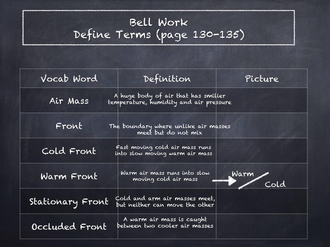
Bell Work Define Terms (page 130-135)
Vocab Word Definition Picture
Air Mass
Front
Cold Front
Warm Front
Stationary Front
Occluded Front
A huge body of air that has smilier temperature, humidity and air pressure
The boundary where unlike air masses meet but do not mix
Fast moving cold air mass runs into slow moving warm air mass
Warm air mass runs into slow moving cold air mass
Warm Cold
Cold and arm air masses meet, but neither can move the other
A warm air mass is caught between two cooler air masses
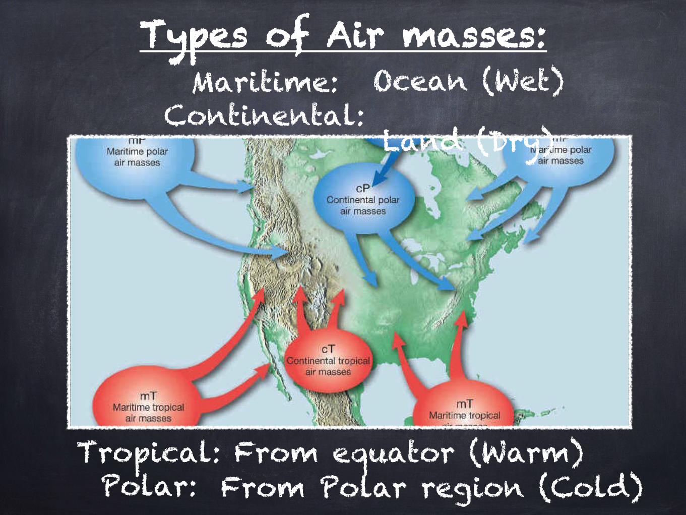
Maritime: Continental:
Tropical: Polar:
Types of Air masses: Ocean (Wet)
Land (Dry)
From equator (Warm) From Polar region (Cold)
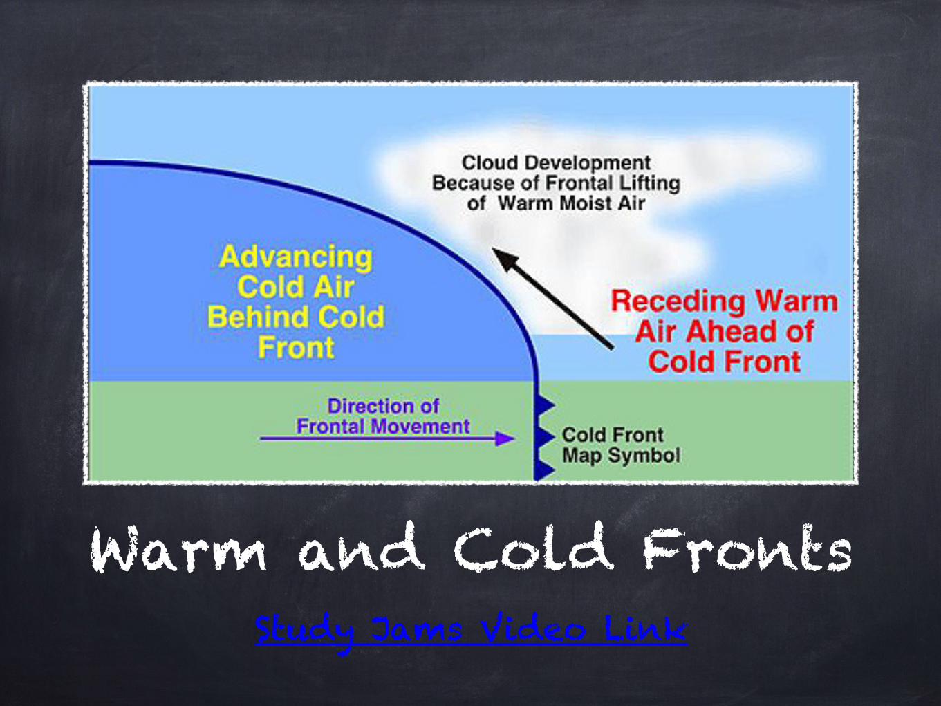
Warm and Cold Fronts Study Jams Video Link
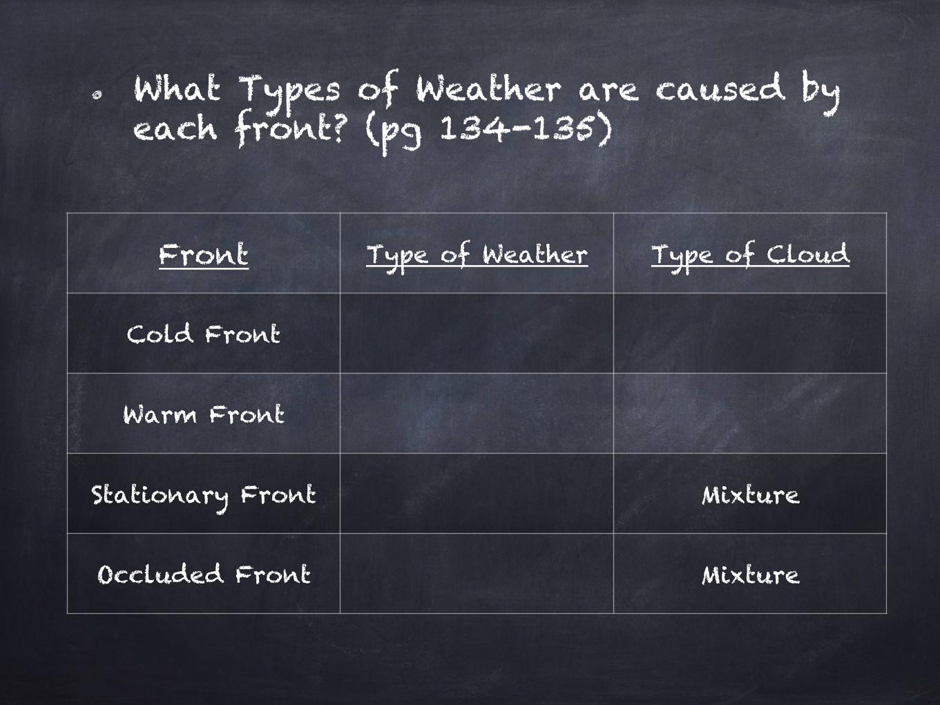
What Types of Weather are caused by each front? (pg 134-135)
Front Type of Weather Type of Cloud
Cold Front
Warm Front
Stationary Front Mixture
Occluded Front Mixture

- What other factors might affect the type of weather you would
see?

Warm Up 10/20:
Cold Front
Warm Front
Stationary Front
Occluded Front
1) Guess what type of front each of these
symbols represent:
2) What type of weather do you think North Carolina will be
having?
How do you know?

Low Pressure vs. High Pressure Areas
- Low Pressure causes Cyclones. This decreasing air pressure creates clouds,
wind and precipitation.
- High Pressure causes Anticyclones. This
descending air generally causes dry, clear weather.

Storms

Bill Nye “Storms” Video
Write down 10 facts fron the video.
Bill Nye “Storms” video
Link

Warm-Up Write the question & answer- What characteristics would
result in the lowest air density:
Hot or Cold? Wet or Dry?
Hint: Think about low/high pressure
areas.

Storms: Violent disturbances within the atmosphere.
Caused by sudden changes in air pressure which cause rapid air movement in an area.
Similar conditions often produce different types of storms.
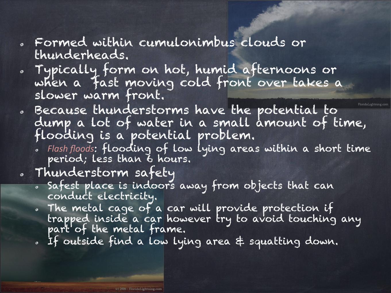
Formed within cumulonimbus clouds or thunderheads.
Typically form on hot, humid afternoons or when a fast moving cold front over takes a slower warm front.
Because thunderstorms have the potential to dump a lot of water in a small amount of time, flooding is a potential problem. Flash floods: flooding of low lying areas within a short time period; less than 6 hours.
Thunderstorm safety Safest place is indoors away from objects that can conduct electricity.
The metal cage of a car will provide protection if trapped inside a car however try to avoid touching any part of the metal frame.
If outside find a low lying area & squatting down.

Types of storms Thunderstorms
Fast moving storms that are often accompanied by heavy precipitation, frequent thunder and visible lightning. Lightning: sudden spark or electrical discharge typically caused by the build up of positive charges on Earth with negative charges within the air. Cloud to cloud
Cloud to ground Ground to cloud (rare)
Thunder is caused as air is superheated (30,000ºC), expands, and explodes. Thunder is the sound wave created from the explosion.
Because sound travels slower than light, thunder always comes after lightning not the other way around.
Lightning Strikes

How can you determine how far away lighting is when watching a thunderstorm?
Roughly sound travels at about 350 meters per second (1,200 feet per second). So sound travels 1
mile in roughly 5 seconds. When you see the flash of lighting, you can start counting seconds and then divide to see how far
away the lightning struck.
If it takes 10 seconds for the thunder to roll in, the lightning
struck about 2 miles away.

Tornadoes Tornados are rapidly whirling, funnel-shaped cloud that reaches down from a storm cloud to touch Earth’s surface.
Typically form during the Spring & Summer under the same conditions as those of a thunderstorm.
Tornado formation Warm, moist air flows in at the bottom of a cumulonimbus cloud & rapidly moves upward generating a low pressure area inside the cloud.
The warm air begins to rotate due to winds within the cloud blowing in different directions: The result is the cloud begins to spin like a top.
As part of the cloud descends to touch the ground, a tornado or funnel cloud is generated with winds up to 340 mph.
Tornado Video

The Fujita Scale Used to determine the severity of a tornado. Based on the amount of damage created as well as the wind speed.
F-0: Gale tornado, 40-72 mph winds F-1: Moderate tornado, 73-112 mph winds
F-2: Significant tornado, 113-157 mph winds F-3: Severe tornado, 158-206 mph winds F-4: Devastating tornado, 207-260 mph winds F-5: Incredible tornado, 261-300+ mph winds
Tornado alley Located in the Midwest region of the U.S. & is known for the development of tornadoes.
Includes the states of S. Dakota, Iowa, Nebraska, Kansas, Oklahoma, and Texas.

Hurricanes Tropical cyclone (low pressure) that typically measures 300-500 miles across with winds from 70-200 mph.
Comes from the West Indian word Huracan or “big wind.”
Called Typhoons when formed in the Pacific Ocean; Chinese word, Táifēng or “great wind.”
Hurricanes are named by the World Meteorological Organization.
Guided or directed by the Trade winds. Typically forms during the months of late July to early October.
Can only form over water that is at least 80ºF.
Hurricane Katrina

Stages of Hurricane Development 1. Stage 1: Tropical disturbance; 10-23 mph 2. Stage 2: Tropical depression; 23-39 mph 3. Stage 3: Tropical storm; 40-73 mph 4. Stage 4: Hurricane; 74 mph
The Saffir-Simpson scale Scale used to determine the severity of a
hurricane. Category 1: wind speed 74-95 mph; storm surge 4-5 feet. Category 2: wind speed 96-110 mph; storm surge 6-8 feet.
Category 3: wind speed 111-130 mph; storm surge 9-12 feet. Category 4: wind speed 131-155 mph; storm surge 13-18
feet. Category 5: wind speed 155+ mph; storm surge 18+ feet Hurricane Katrina was a category 3 hurricane when it made
landfall near New Orleans, La on August 29, 2008. Costliest natural disaster 6th strongest to form, 3rd strongest to make landfall 1 of the 5 deadliest

Warm Up 1) What does a hurricane need in order to form?
2) When and where are
tornadoes more common?
3) Review: What type of front will cause fog?
water that is at least 80ºF.
Midwest region in spring or summer
- Stationary Front

Winter storms Lake effect snow
is produced during when cold winds move across long expanses of warmer lake water, providing energy and picking up water vapor, which freezes and is deposited on the shores.
Great Lakes area (Michigan, Wisconsin, & Buffalo, NY)
Raleigh Snow Storm
Lake Effect Snow