Embed Size (px)
Citation preview


AIP MACAO GUANG ZHOU FIR – HONG KONG FIR AD2-VMMC-63 A SID MACAO RWY 16 26 MAY 2016 (BIGRO 9 D, MIGAG 9 D, NLG 9 D, SHL 9 D)
CAT A, B, C, D
Civil Aviation Authority – Macao, China AIRAC AMDT 01/16
BIGRO 9 D (minimum climb gradient of 3.8% required until leaving 1500 m) Climb straight ahead to cross MCU DME 8.5 at 2000 ft (610 m) or above, then turn right on track 282°M, continue climbing and pass Sanzao beacon (U 272 kHz) at 1500 m. Climb on track 281°M to BOKAT at 3600 m, turn left on heading 249°M to BIGRO. If MCU is unserviceable, BIGRO 9 D is not permitted, request BIGRO 1 D SID. MIPAG 9 D (minimum climb gradient of 3.8% required until leaving 2400 m) Climb straight ahead to cross MCU DME 8.5 at 2000 ft (610 m) or above, then turn right to MCU via MCU R196° and cross MCU at 1800 m. Leave MCU on R019° and continue climbing to 2400 m, at LATOP turn right to establish on ZAO R040°. Continue climbing on ZAO R040° to 3300 m and maintain. At GLN DME 21.5 proceed on GLN R224° to GLN, turn left on GLN R310° to MIPAG. If MCU is unserviceable, MIPAG 9 D is not permitted, request MIPAG 1 D SID. NLG 9 D (minimum climb gradient of 3.8% required until reaching 2400 m) Climb straight ahead to cross MCU DME 8.5 at 2000 ft (610 m) or above, then turn right to MCU via MCU R196° and cross MCU at 1800 m. Leave MCU on R019° and reach 2400 m by LATOP. At LATOP turn left to establish NLG R166° and descend to reach 1500m by NLG. If MCU is unserviceable, NLG 9 D is not permitted, request NLG 1 D SID. SHL 9 D (minimum climb gradient of 3.8% required until leaving 2400 m) Climb straight ahead to cross MCU DME 8.5 at 2000 ft (610 m) or above, then turn right to MCU via MCU R196° and cross MCU at 1800 m. Leave MCU on R019° and continue climbing to 2400 m, at LATOP turn right to establish on ZAO R040°. Continue climbing on ZAO R040° to 3300 m and maintain. At GLN DME 21.5 proceed on GLN R224° and pass GLN. Leave GLN on R340° to IDUMA at 3300 m/3600 m. Turn left at IDUMA and proceed to SHL via SHL R157°.
If MCU is unserviceable, SHL 9 D is not permitted, request SHL 1 D SID. REMARK: (1) Aircraft unable to comply with the minimum climb gradient must inform MACAO ground control at first contact
to allow special coordination. (2) Maximum departure turning speed: 205 kt IAS.


AIP MACAO GUANG ZHOU FIR – HONG KONG FIR AD2-VMMC-64 SID MACAO RWY 16 26 MAY 2016 (BIGRO 1 D, MIPAG 1 D, NLG 1 D, SHL 1 D)
CAT A, B, C, D
Civil Aviation Authority – Macao, China AIRAC AMDT 01/16
BIGRO 1 D (minimum climb gradient of 3.8% required until leaving 1500 m) Climb straight ahead to 1500 m and cross ZAO DME 14.8 NM at 2000 ft (610 m) or above then turn right on track 282°M, continue climbing and pass Sanzao beacon (U 272 kHz) at 1500 m. Climb on track 281°M to BOKAT at 3600 m, turn left on heading 249°M to BIGRO. MIPAG 1 D (minimum climb gradient of 3.8% required until leaving 2400 m) Climb straight ahead to 1800 m and cross ZAO DME 14.8 NM at 2000 ft (610 m) or above then turn right to ZAO via ZAO R194° and cross ZAO DME 6.7 NM at 1800 m, leave ZAO on R040° and cross 2400 m by LATOP. Continue climbing on ZAO R040° to 3300 m/3600 m and maintain. At GLN DME 21.5 proceed on GLN R224° to GLN, turn left on GLN R310° to MIPAG. NLG 1 D (minimum climb gradient of 3.8% required until reaching 2400 m) Climb straight ahead to 1800 m and cross ZAO DME 14.8 NM at 2000 ft (610 m) or above then turn right to ZAO via ZAO R194° and cross LKC DME 21.6 NM at 1800 m, leave ZAO on R040° and reach 2400 m by LATOP. At LATOP turn left to establish NLG R166° and descend to reach 1500m by NLG. SHL 1 D (minimum climb gradient of 3.8% required until leaving 2400 m) Climb straight ahead to 1800 m and cross ZAO DME 14.8 NM at 2000 ft (610 m) or above then turn right to ZAO via ZAO R194° and cross LKC DME 21.6 NM at 1800 m, leave ZAO on R040° and cross 2400 m by LATOP. Continue climbing on ZAO R040° to 3300 m and maintain. At GLN DME 21.5 proceed on GLN R224° and pass GLN. Leave GLN on R340° to IDUMA at 3300 m. Turn left at IDUMA and proceed to SHL via SHL R157°.
REMARK: (1) These SIDs are available when MCU is unserviceable. (2) Aircraft unable to comply with the minimum climb gradient must inform MACAO ground control at first contact to
allow special coordinations. (3) Maximum departure truning speed: 205 kt IAS.


AIP MACAO GUANG ZHOU FIR – HONG KONG FIR AD2-VMMC-64 B RNAV (GNSS) SID MACAO RWY 16 20 FEB 2014 (BIGRO 2 D, MIPAG 2 D, NLG 2 D, SHL 2 D) CAT A, B, C, D
Civil Aviation Authority – Macao, China AMDT 26
BIGRO 2 D (minimum climb gradient of 3.8% required until leaving 1500 m) Depart and Climb to fly-over MC501 on course 163°M at 2000 ft (610 m) or above, then turn right to Sanzao beacon (U 272 kHz) at 1500 m on course 282°M. To MC502 at 3600 m and BIGRO. MIPAG 2 D (minimum climb gradient of 3.8% required until leaving 2400 m) Depart and Climb to fly-over MC501 on course 163°M at 2000 ft (610 m) or above, then turn right direct to MCU at 1800 m. to LATOP at 2400m, to MC419, GLN, MIPAG. NLG 2 D (minimum climb gradient of 3.8% required until reaching 2400 m) Depart and Climb to fly-over MC501 on course 163°M at 2000 ft (610 m) or above, then turn right direct to MCU at 1800 m. to LATOP at 2400m, and to NLG at 1500m. SHL 2 D (minimum climb gradient of 3.8% required until leaving 2400 m) Depart and Climb to fly-over MC501 on course 163°M at 2000 ft (610 m) or above, then turn right direct to MCU at 1800 m. to LATOP at 2400m, to MC419, GLN, IDUMA at 3300 m and to SHL. REMARK : (1) For RNAV(GNSS) SID aircraft must be approved by State of Registry in accordance with ICAO RNP1 standard or
equivalent. Carriage of certified GNSS receiver is mandatory. (2) Aircraft that do not have approval or whose RNP1/ P-RNAV capability has been degraded before departure shall
use the Conventional Departure Procedure: BIGRO 9 D, NLG 9 D, SHL 9 D, BIGRO 1 D, NLG 1 D or SHL 1 D. (3) Aircraft unable to comply with the minimum climb gradient must inform MACAO ground control at first contact to
allow special coordinations. (4) Maximum departure turning speed: 205 kt IAS.

AD2-VMMC-64 C GUANG ZHOU FIR – HONG KONG FIR AIP MACAO 20 FEB 2014 RNAV (GNSS) SID MACAO RWY 16 (BIGRO 2 D, MIPAG 2 D, NLG 2 D, SHL 2 D) CAT A, B, C, D
AMDT 26 Civil Aviation Authority – Macao, China
FMC Database Coding Reference for RNAV(GNSS) SIDs
BIGRO 2 D Sequence Number
Path Terminator Waypoint Fly-
over Track °M
(°T) Distance
(NM) Turn Dir
Altitude (ft)
Speed (knot)
001 CF MC501 Y 163 (161) 8.6 — +2000 -205 002 CF U — 282(280) — R 4900 -205 003 TF MC502 — 282(280) 19 — 11800 - 004 TF BIGRO — 249(247) 72.1 — — —
MIPAG 2 D
Sequence Number
Path Terminator Waypoint Fly-
over Track °M
(°T) Distance
(NM) Turn Dir
Altitude (ft)
Speed (knot)
001 CF MC501 Y 163 (161) 8.6 — +2000 -205 002 DF MCU — — — R 5900 -205 003 TF LATOP — 018(016) 9 — 7900 - 004 TF MC419 — 040(038) 12 — — - 005 TF GLN — 043(041) 22 — — - 006 TF MIPAG — 310(308) 20.5 L — —
NLG 2 D
Sequence Number
Path Terminator Waypoint Fly-
over Track °M
(°T) Distance
(NM) Turn Dir
Altitude (ft)
Speed (knot)
001 CF MC501 Y 163 (161) 8.6 — +2000 -205 002 DF MCU — — — R 5900 -205 003 TF LATOP — 018(016) 9 — 7900 — 004 TF NLG — 345(343) 15.6 — 4900 —
SHL 2 D
Sequence Number
Path Terminator Waypoint Fly-
over Track °M
(°T) Distance
(NM) Turn Dir
Altitude (ft)
Speed (knot)
001 CF MC501 Y 163 (161) 8.6 — +2000 -205 002 DF MCU — — — R 5900 -205 003 TF LATOP — 018(016) 9 — 7900 - 004 TF MC419 — 040(038) 12 — — - 005 TF GLN — 043(041) 22 — — - 006 TF IDUMA — 340(338) 12.0 — 10800 — 007 TF SHL — 337(335) 13.1 — — —

AIP MACAO GUANG ZHOU FIR – HONG KONG FIR AD2-VMMC-64 D RNAV (GNSS) SID MACAO RWY 16 20 FEB 2014 (BIGRO 2 D, MIPAG 2 D, NLG 2 D, SHL 2 D) CAT A, B, C, D
Civil Aviation Authority – Macao, China AMDT 26
Waypoint Coordinates
Waypoint Name
Coordinates (WGS84)
MC501 22°00′03.00″N 113°38′45.76″E U 21°59.3′N 113°21.3′E
MC502 22°02′43.76″N 113°00′50.39″E BIGRO 21°34.2′N 111°49.6′E LATOP 22°16.9′N 113°38.6′E
NLG 22°31.9′N 113°33.7′E MC419 22°26′25.37″N 113°46′47.49″E
GLN 22°42.5′N 114°02.0′E IDUMA 22°53.8′N 113°57.1′E
SHL 23°05.5′N 113°51.0′E MIPAG 22°55.3′N 113°44.5′E

AIP MACAO GUANG ZHOU FIR – HONG KONG FIR AD2-VMMC-64 F
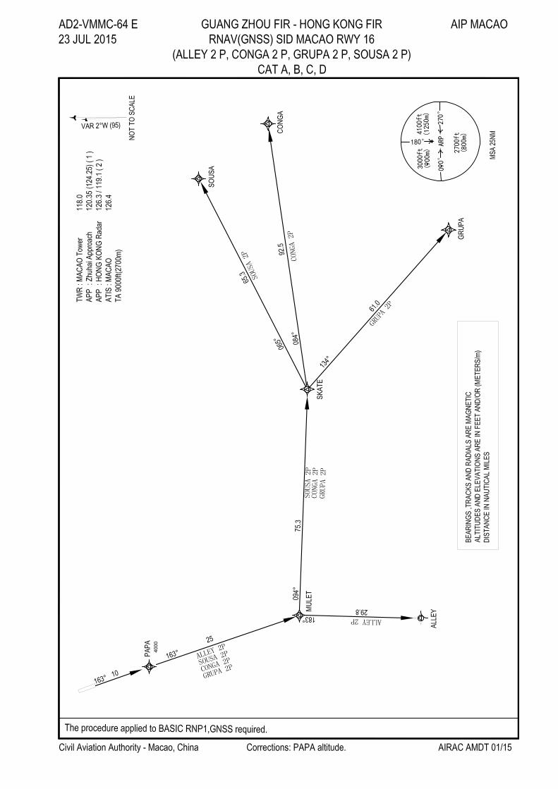
RNAV(GNSS) SID MACAO RWY 16 23 JUL 2015
(ALLEY 2 P, CONGA 2 P, GRUPA 2 P, SOUSA 2 P)
CAT A, B, C, D
Civil Aviation Authority – Macao, China AIRAC AMDT 01/15
ALLEY 2 P
Climb on track 163°M to PAPA at 4000 ft. Expect further climb when instructed by ATC. To MULET and ALLEY.
Continue on Terminal Transition route published in Hong Kong AIP.
CONGA 2 P
Climb on track 163°M to PAPA at 4000 ft. Expect further climb when instructed by ATC. To MULET, SKATE and
CONGA. Continue on Terminal Transition Routes published in Hong Kong AIP.
GRUPA 2 P
Climb on track 163°M to PAPA at 4000 ft. Expect further climb when instructed by ATC. To MULET, SKATE and
GRUPA. Continue on Terminal Transition Routes published in Hong Kong AIP.
SOUSA 2 P
Climb on track 163°M to PAPA at 4000 ft. Expect further climb when instructed by ATC. To MULET, SKATE and
SOUSA. Continue on Terminal Transition Routes published in Hong Kong AIP.
REMARK:
(1) For RNAV(GNSS) SID aircraft must be approved by State of Registry in accordance with ICAO RNP1 standard or
equivalent. Carriage of certified GNSS receiver is mandatory.
(2) Aircraft that do not have approval or whose RNP1/ P-RNAV capability has been degraded before departure shall
use the Conventional Departure Procedure:
Proceed on MCU R163° to PAPA at 4000 ft. Further climb when instructed by ATC. From PAPA expect radar
vectors to ALLEY, CONGA, GRUPA or SOUSA.
If MCU is unserviceable, Climb straight ahead to 4000 ft, track direct to MULET and expect radar vectors to
ALLEY, CONGA, GRUPA or SOUSA.
(3) Aircraft are NOT TO OVERSHOOT JIUZHOU DVOR (ZAO 117.2 MHz) R230° which defines the northern limit
for flights taking off RWY 34 due to NOISE ABATEMENT for Zhuhai City.
(4) Aircraft unable to comply with the minimum climb gradient must inform MACAO ground control at first contact to
allow special coordination.
(5) Aircraft shall fly at 250 kt or less below FL 110 transiting Hong Kong Airspace
(6) In the event of loss of communication, aircraft shall comply with the last acknowledged clearance up to the next
reporting point in the SID, then climb to the flight planned cruising level and follow the flight planned route to join
the appropriate airway.

AD2-VMMC-64 G GUANG ZHOU FIR – HONG KONG FIR AIP MACAO
23 JUL 2015 RNAV(GNSS) SID MACAO RWY 16
(ALLEY 2 P, CONGA 2 P, GRUPA 2 P, SOUSA 2 P)
CAT A, B, C, D
AIRAC AMDT 01/15 Civil Aviation Authority – Macao, China
FMC Database Coding Reference for RNAV(GNSS) SIDs
ALLEY 2 P
Sequence
Number
Path
Terminator Waypoint
Fly-
over
Track °M
(°T)
Distance
(NM)
Turn
Dir
Altitude
(ft)
Speed
(knot)
001 CA — 163 (161) — 420 —
002 CF PAPA — 163 (161) 10.0 — 4000 —
003 TF MULET — 163 (161) 26.4 — — —
004 TF ALLEY — 183 (181) 29.8 — — —
SOUSA 2 P (RWY16 SID)
Sequence
Number
Path
Terminator Waypoint
Fly-
over
Track °M
(°T)
Distance
(NM)
Turn
Dir
Altitude
(ft)
Speed
(knot)
001 CA — 163 (161) — 420 —
002 CF PAPA — 163 (161) 10.0 — 4000 —
003 TF MULET — 163 (161) 26.4 — — —
004 TF SKATE — 094 (092) 75.3 — — —
005 TF SOUSA — 065 (063) 65.3 — — —
CONGA 2 P (RWY16 SID)
Sequence
Number
Path
Terminator Waypoint
Fly-
over
Track °M
(°T)
Distance
(NM)
Turn
Dir
Altitude
(ft)
Speed
(knot)
001 CA — 163 (161) — 420 —
002 CF PAPA — 163 (161) 10.0 — 4000 —
003 TF MULET — 163(161) 26.4 — — —
004 TF SKATE — 094(092) 75.3 — — —
005 TF CONGA — 084(082) 92.5 — — —
GRUPA 2 P (RWY16 SID)
Sequence
Number
Path
Terminator Waypoint
Fly-
over
Track °M
(°T)
Distance
(NM)
Turn
Dir
Altitude
(ft)
Speed
(knot)
001 CA — 163 (161) — 420 —
002 CF PAPA — 163 (161) 10.0 — 4000 —
003 TF MULET — 163 (161) 26.4 — — —
004 TF SKATE — 094 (092) 75.3 — — —
005 TF GRUPA — 134 (132) 61.0 — — —

AIP MACAO GUANG ZHOU FIR – HONG KONG FIR AD2-VMMC-64 H RNAV(GNSS) SID MACAO RWY 16 19 SEP 2013 (ALLEY 2 P, CONGA 2 P, GRUPA 2 P, SOUSA 2 P) CAT A, B, C, D
Civil Aviation Authority – Macao, China AIRAC AMDT 01/13
Waypoint Coordinates
Waypoint Name
Coordinates (WGS84)
MC501 22°00′03.00″N 113°38′45.76″E MULET 21°35′02.0″N 113°47′52.0″E ALLEY 21°05′11.2″ 113°47′09.5″E SKATE 21°31′55.0″N 115°08′40.0″E SOUSA 22°01′10.4″N 116°11′27.8″E CONGA 21°44′02.5″N 116°47′05.9″E GRUPA 20°50′44.0″N 115°56′59.0″E