Embed Size (px)
Citation preview
100
Chapter III
AGRO-PASTORALISM AND THE EARLY CHIEFDOM
In this chapter, an attempt has been made to unravel the formation of the
Kolathunadu in the Iron Age and early historic period. Kolathunadu neither did
exist in that name during those periods nor did it appear till the beginning of 12th
century A.D. However, the region has a long historical tradition which is revealed
through the existence of archaeological and historical evidences. No written
accounts are available to trace the origin of the nadu in the early historic times, but
the process of the configuration can be reproduced through the analysis of the
cultural materials unearthed from the Iron Age burial monuments and the poetical
representation of the region reflected in the Sangam texts.
There are limited indications on the early formation of the region as an
agrarian unit in the northern Kerala. The signs of the early formation of region
comprising Kolathunadu have appeared in the Tamil texts, the early Tamil heroic
poetry1, in association with a velir chief named Nannan. Nannan of Ezhimalai was
the first political entity of the region under study as referred in the Early Tamil
heroic poems like Akananuru, Purananuru, Patittupathu, Kuruntokai and
Pattupattu. The poems delineate the nature of the chiefdom of Nannan, the
predatory Velir 2 chief of the Ezhilkunram (Ezhimalai). Along with the eulogy of
the Nannan‟s splendor they also hint at the geo- cultural features of the region. But
1 K. Kailasapathy, Tamil Heroic poetry, OUP, London, 1968
2 There are different level of chiefly power represented in the Tamil poems and they are mainly
the Kizhar,Velir and Vendar. The Velir seems to be the most archaic and lineage conscious. The
poem shows that the Velir chieftains held sway over the Kurinji and Mullai tracts (Pastoral forest
hills and hillocks). They were hill chieftains heading mostly the decent groups called Vetar, Itayar
and Kuravar. For details see, Rajan Gurukkal and Raghava Varier (ed.), Cultural History of
Kerala, Vol. I, Department of Cultural publication, Government of Kerala, Thiruvananthapuram,
1999, Pp199-200
101
they do not provide any indications on the geographical extension of his territory.
Accordingly, Ezhimala and its surrounding resourceful regions were under the
predatory control of this Velir chief and he had companions like Minjili, Atti etc.
The poems related to these heroes will also be used for the study. The following
session will be an attempt to unravel the formation of early settlements in the
region of Kolathunadu. It will also delineate the formation of a tribal chiefdom
within the cultural landscape under study in the lights of available evidences.
Archaeological evidences on the early settlement formation
To delineate the early nature of landscape and its influence in the formation
of various settlement unit and subsistence strategies, at first, it is necessary to
come across the existing available archaeological evidences.3 The Iron Age burial
monuments and the cultural assemblages from the burials are the major
archaeological remains from the region. Very few archaeological traces on the
pastoral systems are also found. They have furnished certain significant hints on
the early human occupation in the landscape.
A number of megalithic burial sites have already been documented and
reported from the region under discussion. The colonial government under Madras
Presidency has made the pioneer attempt to document such sites of North Kerala.4
It was William Logan who excavated a rock-cut sepulcher at Banglamotta
paramba and Trichambaram near Thalipparamba in Kannur district and unearthed
3 The archaeological sites are in fact the spot on the landscape with detectable traces of human
activity. It could be dwelling sites, butchering areas, quarries for raw materials, burials or
monuments, rock art sites, sacred places, etc. Paul Bahn, Archaeology : A very short introduction,
OUP,1996, p 55 4 As part of the administration the colonial bureaucrat administrators have surveyed the existing
monuments. J. Babington, “Description of the Pandoo Coollies in Malabar” Transactions of the
literary society of Bombay, 1823, 3:324-330, Robert Sewell, Lists of the antiquarian remains in
the presidency of Madras, Vol.1, Government Press, Madras, 1882, Pp 241-243

102
typical megalithic assemblages including pots and iron implements.5 Robert
Sewell‟s “List of the Antiquarian remains in the presidency of Madras” has also
furnished a taluk wise distribution list of Iron Age burials.6 This is the only
available comprehensive list of the archaeological sites of Malabar, which is very
much useful to conduct further field explorations.7 However since the Sewell‟s
times, no serious attempt has been done to update the archaeological finds.8
Not many Iron Age sites have been excavated in the northern part of
Kerala. A rock cut sepulcher at Chitrari 9 and a stone circle with rock cut sepulcher
inside at Naduvil 10 have been excavated by K.J. John. Since the region is thickly
populated, extensive excavations are not possible. The entire landscape is under
private hands and therefore the preservation of the site after excavation or
salvaging explorations will not be practical. Thus, the only possible thing will be
systematic explorations and its scientific documentation. The following part will
furnish the updates of the archaeological remains, which have been collected
through an extensive field work from the region.
5 William Logan, Malabar Manual, Vol.,Kerala State Gazetteer department, Thiruvananthapuram,
(1887) 2000 edition, Pp 181-183 (see the drawings of the sepulchers between these pages) 6 Robert Sewell, Lists of the antiquarian remains in the presidency of Madras, Vol.1Pp 241-43.
Sewell‟s sites Cherukunnu, Kalliyad, Malappattam (rock-cut cave), Karivellur, Kavvai (dolmen
and menhirs), Kuttiattur (dolmen and rock-cut cave). 7 The list of Sewell is very much useful to conduct field research either for the relocation of the
listed sites or for the discovery of new sites. Interestingly most of the sites found recently, are
located in the adjacent or surrounding spots of the reported sites. For instance, a cluster of
megaliths including umbrella stone, urn burials, and rock-cut caves are found at Karivellur region
which is near to the menhir and dolmens reported by Sewell. 8 There is a district wise list prepared by T.Sathyamurti. T.Sathyamurthi, The iron age in Kerala-A
Report on Mangad Excavation, Department of Archaeology Kerala, Trivandrum, 1992, Pp 25-31 9 K.J. John, “Rock-cut Cave Tombs of Chitrari : Some new lights on the Rock cut cave tombs of
Malabar” in Journal of Kerala Studies, 1(4): 383-386 10
K. J. John, “Unpublished excavation report of Naduvil, Kannur district”, Department of history,
Calicut University, 1990, cited in Manjula Poyil, Death Funeral and Ancestors : cults of the dead
and the Malabar tribes, unpublished Ph.D thesis, Department of History, Calicut University,
2006, Pp 94-95
103
Recent Explorations
About 35 megalithic sites have been noticed and documented from the
present Kannur district (for detailed list of the explorations see appendix I). They
include rock cut caves, multiple hood stone circles, umbrella stones, urn burials
etc. Some of them are located in the surrounding areas of the earlier reported sites.
The rock-cut caves in the hard laterite surfaces are the major megalithic monument
type found. This monolithic rock-cut sepulcher has been considered as the unique
feature of Malabar.11 They have decorated doors or door jambs, finished circular
ground surface, dome size finished roof, pot holes at the top of the roof or pillar at
the center and in certain occasion stone platforms. There is a stone platform in a
rock cut sepulcher at Sreekantapuram. Caves with square type doors are generally
found and such sepulchers are found at Mathil, Mathamangalam, Ullur,
Ezhumvayal, Kunneru, Cherupuzha, Althatta, Mavicheri, Sreekantapuram,
Kannapuram, Echilamvayal, Purathukavu etc.12 The arch type door construction
was not unknown to the people of the Iron Age megaliths as it testified the rock
cut cave from Ezhilode. Most of the sepulchers have port holes at the top of the
roof and often they were covered with a laterite stopper. Such well decorated
stoppers were found from Ezhilode, Ezhumvayal and Alathatta Mavicheri. The
entrance of the sepulchers perhaps was covered with a square stone slab. Well
finished laterite slabs have been used to close the entrance of the single chambered
rock cut sepulchers found at Alathatta Mavicheri,Cherupuzha and Ezhumvayal.
11
K.R. Srinivasan, “The megalithic burials and urn-fields of south India in the light of Tamil
Literature and tradition, in Ancient India, New Delhi,1946,p.10, T. Satyamurthy, The Iron Age in
Kerala, A report of the Mangadu excavation, Department of Archaeology, Thiruvanathapuram,
1992, p 2 12
About 28 rock cut caves have been explored and documented from the region between the
Perumba and Valapattanam rivers of the present Kannur district. See appendix I

104
The pillared chamber was another important monument type from the region. A
destroyed rock-cut chamber with a square pillar at the center discovered from
Korom, near Payyannur and Sreekantapuram near Talipparamba. Similarly double
chamber rock cut sepulcher was found at Menachur near Talipparamba. Most of
these sepulchers have long passage, which roughly ranges from 1 meter to 5 meter
length and 1 meter to 2.50 meter width, up to the entrance.13
The rock cut sepulchers were built in the laterite surface of hillocks or its
slopes. Most of them were accidently discovered and opened by the local people.14
An arch shaped single chamber rock-cut sepulcher was found at Ezhilode near
Payyannur from where a few pottery and terracotta objects were collected (plate
13
The width of the passage varies according to the size of the entrance of the sepulchers. It seems
to have shown the multiplicity of the construction or some kind of priority or concerns to the dead
according to their social status or power. 14
They were accidently opened by the people and owing to their ignorance on the value of the
artifacts or due to their wild enthusiasm for finding the treasures, all these materials got destroyed.
None of these sites were documented or reported in a proper way. The documentation of these
finds is often reduced into a press release given by the person who explored the site and in most
cases these salvaging finds are kept in the private custody. Hence the only possible thing is the
collection of oral information regarding the discovery of the site and the cultural remains. Many of
such reliable information of archaeological findings have been gathered from the field. For
instance, the discovery of bone powder of an extended human burial along with a number of pots
including black and red, red slipped leg jars, with lids or stands etc from a rock-cut sepulcher at
Sreekantapuram, burial pots, bone fragments, iron objects and terracotta lamb from a rock cut
cave at Cherupuzha, two small pots in Red, Black colours, four Legged Jars from the rock-cut
caves at Badiramanaparamba Kunneru etc are too significant, but none of them were preserved. In
spite of the fact that the rock cut cave at Sreekantapuram was opened around 30 years back, the
plot owner could still remember that moment with excitement. The monument at Cherupuzha was
opened just 3 years before. These kinds of information are useful for making a distribution map of
the Iron Age Megaliths of the region.

105
No.2).15 The artifacts include black and red ware, red slipped legged jars, black
wares, and ritual pots and terracotta objects.16
The multiple hood stone circles are the other significant burial monuments
of the region under study. A multiple hood stone circle burial monument was
found at Kozhummal near Karivellur (plate No.4).17 Similarly a cluster of huge
stone circle with decorated stone slabs has been reported from the Nenthravattam
at Naduvil, near Talipparamba (plate No.5)18 and when excavated earlier a rock
cut chamber was found inside the circle from which a large amount of Iron Age
cultural remains were unearthed.19 A huge stone circle was also found at
Purathukavu, Pattuvam, Talipparamba Taluk.20
Umbrella stones with massive mushroom type orthostat made of a single
laterite stone block and the clinostat made of three or four laterite slabs at the
bottom were found at Adupputippara, Peralam, Velam, and Chempottikunnu (plate
15
These pots have been preserved in the Elamkulam. P.N. Kunjan Pilla Museum, Department of
history, University of Calicut 16
These materials were found from a construction site and all artifacts were in a dilapidated
condition
17 The site can be excavated as it is undisturbed and preserved in an un-occupied plot.
18 Out of the four circles, the biggest one had 12 huge slabs (about 2.50 to 3m height, 90cm x
110cm width and 30 to 45cm thickness).
19 K.J. John, “Unpublished excavation report of Naduvil, Kannur district”, Department of History,
Calicut University, 1990, cited in Manjula Poyil, Death Funeral and Ancestors : cults of the dead
and the Malabar tribes, unpublished PhD thesis, Department of History, Calicut University,
2006, Pp 94-95. 20
A stone circle at Purathukavu, Ariyil, near. Govt. Model Residential School Pattuvam,
Talipparamba Taluk, Kannur district. It is found in a laterite plateau near to a sacred grove called
Purathukavu. According to the local information the Teyyam (ancestral cult) of the sacred groove
got inside the stone circle and chant Tottam songs at the time of the Teyyam festival. This oracle is
the beginning ritual of the festivals in the sacred grove. The stone circle is not in perfect alignment
and it has 36 dressed laterite stone slabs in vertical position. It has about 13.55 and 10. 85 length
in the east west and north south direction respectively. Three slabs are misplaced.
106
No.6). Along with these monuments, a number of urn burials have also been found
from various parts of the region.
All the sites mentioned above yielded typical megalithic artifacts including
black and red ware, red slipped ware, legged jars, coursed red ware, black ware,
terracotta lids and bases of the pots, small black coloured terracotta objects, iron
implements and semi precious items like beads and bronze objects. A bronze vase
and unidentified bronze equipment, iron sword, dagger, trident, knives, chisel, iron
saucer lamp, iron tripod, a crystal bead, a quartz bead, earthen vases, ring stands
and pots were unearthed from Naduvil.21 Similarly, the black and red ware, red
ware vases and bowls with lids which treasure the bone relics were recovered from
the clusters of rock-cut sepulchers at Chitrari.22 Out of thirteen pots recovered, two
contained charred bones. Rock-cut sepulchers of Ezhilode and Alathatta Mavicheri
had also yielded a large quantity of black and red ware and red slipped legged jars
(Plate.No.2 & 7).23 But no single evidence on the habitation cum burial site has
been found from the region.24
21
K.J. John, “Unpublished excavation report of Naduvil, Kannur district”, Pp 94-95 22
K.J. John, “Rock-cut Cave Tombs of Chitrari: Some new lights on the Rock cut cave tombs of
Malabar” in Journal of Kerala Studies, 1(4): 383-386 23
The ceramics were found from the sepulchers, which were opened by the local people, and they
were in dilapidated condition and highly weathered due to the rain. The ceramics of Ezhiode
sepulcher is now preserved in the Elankulam Kunjan Pilla Memorial museum, Department of
History, University of Calicut. Few pot sherds from Alathatta Mavicheri are preserved in the Sir
Sayyed College, Talipparamba. 24
The obvious evidence of the megalithic habitation has not yielded from Kerala. It is stated that
“the contemporary population density and the consequent intensive land use pattern, the dispersed
settlement pattern, the high rainfall and the resultant floods, which modify and conceal the
material evidences, and the thick vegetation cover substantially decrease the visibility of the
archaeological record in Kerala.” Rajan Gurukkal and Raghava Varier, Cultural History of
Kerala, Pp129-131
107
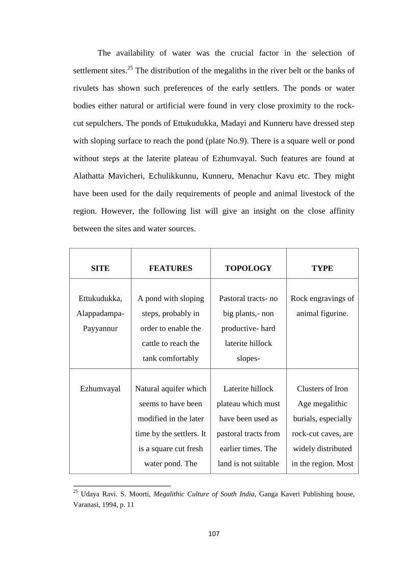
The availability of water was the crucial factor in the selection of
settlement sites.25 The distribution of the megaliths in the river belt or the banks of
rivulets has shown such preferences of the early settlers. The ponds or water
bodies either natural or artificial were found in very close proximity to the rock-
cut sepulchers. The ponds of Ettukudukka, Madayi and Kunneru have dressed step
with sloping surface to reach the pond (plate No.9). There is a square well or pond
without steps at the laterite plateau of Ezhumvayal. Such features are found at
Alathatta Mavicheri, Echulikkunnu, Kunneru, Menachur Kavu etc. They might
have been used for the daily requirements of people and animal livestock of the
region. However, the following list will give an insight on the close affinity
between the sites and water sources.
25
Udaya Ravi. S. Moorti, Megalithic Culture of South India, Ganga Kaveri Publishing house,
Varanasi, 1994, p. 11
SITE
FEATURES
TOPOLOGY
TYPE
Ettukudukka,
Alappadampa-
Payyannur
A pond with sloping
steps, probably in
order to enable the
cattle to reach the
tank comfortably
Pastoral tracts- no
big plants,- non
productive- hard
laterite hillock
slopes-
Rock engravings of
animal figurine.
Ezhumvayal
Natural aquifer which
seems to have been
modified in the later
time by the settlers. It
is a square cut fresh
water pond. The
Laterite hillock
plateau which must
have been used as
pastoral tracts from
earlier times. The
land is not suitable
Clusters of Iron
Age megalithic
burials, especially
rock-cut caves, are
widely distributed
in the region. Most

108
water scale does not
diminish even during
summer time.
for any kind of
production process.
The movement of
cattle herds in the
plot is very unique
to the region even in
modern times. The
plot is recently
occupied. No single
evidence like temple
sites or inscriptions
etc is available on
the later settlements
after the Iron Age.
of them require a
systematic
exploration and a
scientific
documentation
including
excavation.
A few signs of the
hoof prints of
animals and foot
prints of humans
are found
Madayi para
(rocky plateau)
There is a pond called
Juthakkulam (Jewish
pond) which must
have been a modified
form of an earlier
natural water body. It
has steps sloping
towards east west
direction. Such water
presence can also be
seen in the plateau
Laterite plateau with
natural aquifers,
Pastoral tracts and
some kind of millet
or punam cultivation
had been practiced
here. It was common
even during colonial
times as evidenced
in the Settlement
Register.
Megalithic clusters
and the presence of
early historic West
Asian ceramics are
the significant
features. In the
slope of the
plateau, an archaic
sacred grove and a
temple existed. The
region was a major
coastal exchange
center and had
witnessed
continuous
settlements in latter
109
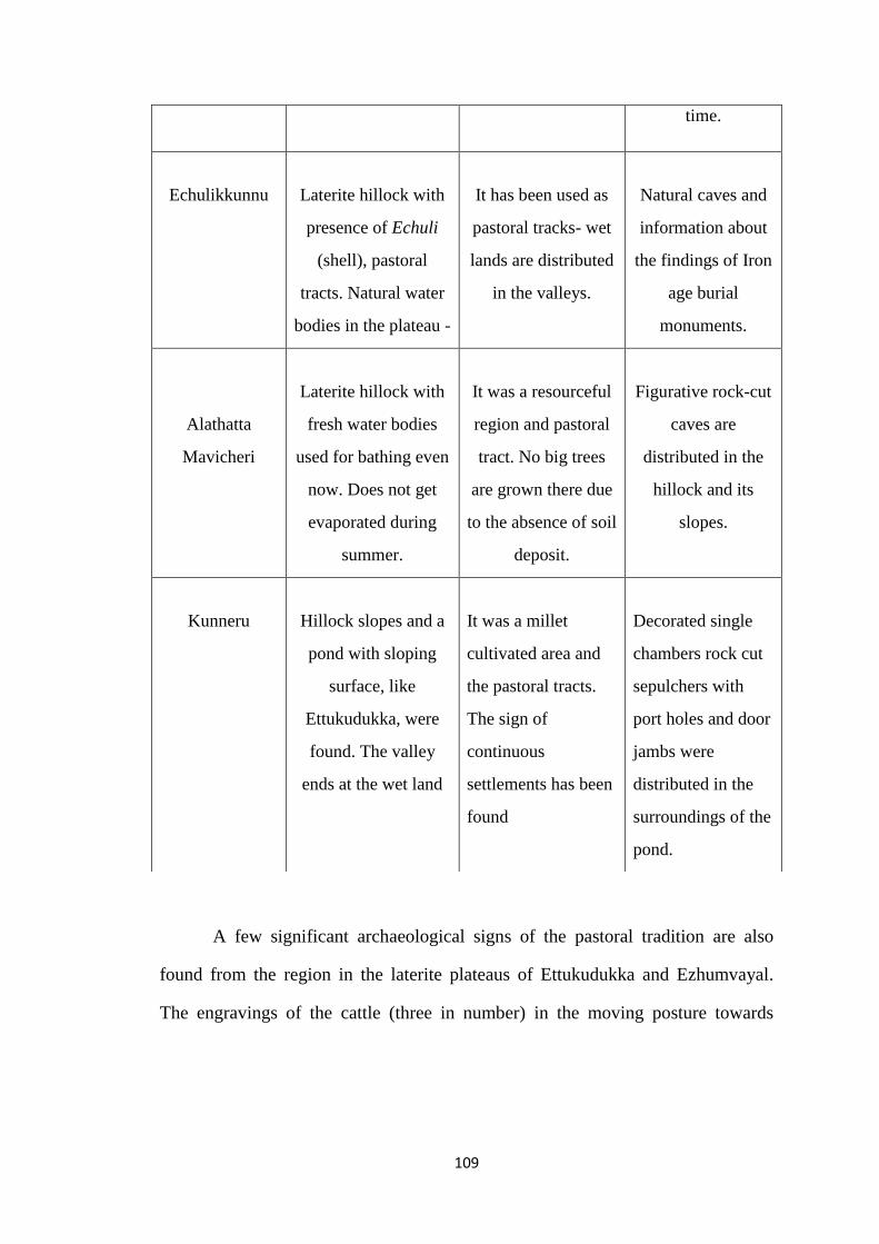
A few significant archaeological signs of the pastoral tradition are also
found from the region in the laterite plateaus of Ettukudukka and Ezhumvayal.
The engravings of the cattle (three in number) in the moving posture towards
time.
Echulikkunnu
Laterite hillock with
presence of Echuli
(shell), pastoral
tracts. Natural water
bodies in the plateau -
It has been used as
pastoral tracks- wet
lands are distributed
in the valleys.
Natural caves and
information about
the findings of Iron
age burial
monuments.
Alathatta
Mavicheri
Laterite hillock with
fresh water bodies
used for bathing even
now. Does not get
evaporated during
summer.
It was a resourceful
region and pastoral
tract. No big trees
are grown there due
to the absence of soil
deposit.
Figurative rock-cut
caves are
distributed in the
hillock and its
slopes.
Kunneru
Hillock slopes and a
pond with sloping
surface, like
Ettukudukka, were
found. The valley
ends at the wet land
It was a millet
cultivated area and
the pastoral tracts.
The sign of
continuous
settlements has been
found
Decorated single
chambers rock cut
sepulchers with
port holes and door
jambs were
distributed in the
surroundings of the
pond.

110
eastern direction are found at Ettukudukka of Perumba river belt (Plate.8).26 This
can be really significant as it is the only such trace from Kerala that has been
located. Both the topographical features and the information gathered from the
local settlers have shown that the plot has been under the use of pastoral
communities. Accordingly, Ettukudukka was earlier a grazing land where
shepherds used to live. Near to the engravings site, there is a tank, with sloping
surface and steps, probably in order to enable the cattle to reach the tank
comfortably (Plate.9). A cluster of hoof prints and a single foot print of a human
being are discovered from the laterite hillocks at Ezhumvayal, Kuppam river belt,
near Thalipparamba.27 The foot print is imprinted in the north east direction and
the hoof prints are scattered in the surroundings of the same (Plate.10,11).28 Since
these cultural materials are silent about the time, they have to be contextually
placed. We are not sure whether they belong to the early historic period or later.
But the close affinity of rock cut sepulchers of Iron Age to these sites and the
26
“The engravings are found on a hard laterite surface, on the Ettukudukka- Pakkayam road about
half a km away from the Ettukudukka bus stop at Kankol Alappadamba Panchayath, 12km to the
east of Payyannur in Kannur district. The thickness (width) of the engravings varies from half a
cm to two cm in. The engravings are found on an area about 50sq ft and all the engravings are
facing east.” Sreelatha Damodaran, K.P. Rajesh and K.N. Ganesh, “Rock Engravings at
Ettukudukka, Kannur district, Kerala”, in AdhAram, A journal of Kerala Archaeology & History,
Vol. I, M.G. University, Kottayam, 2006, p.84 27
Unlike the engraving of Ettukudkka, which seems to have been the product of the aesthetic
sense of the then living communities, the foot print and hoof prints seems to be quiet natural.
These prints seem to have been imprinted on a marshy space, which got formed owing to the soil
deposit in the depressions of the plateau at the rainy season, and later hardening due to the intense
heat of the sun light. If so, it can be argued that the region was not under use for a long time.
28 The figurines are carved in the hard laterite surface; most probably by using iron objects; the
depth of the carving varies from 0.5 cm to 2cm.

111
conspicuous absence of the source materials of the later occupation seems to have
shown their possible earlier entity.29
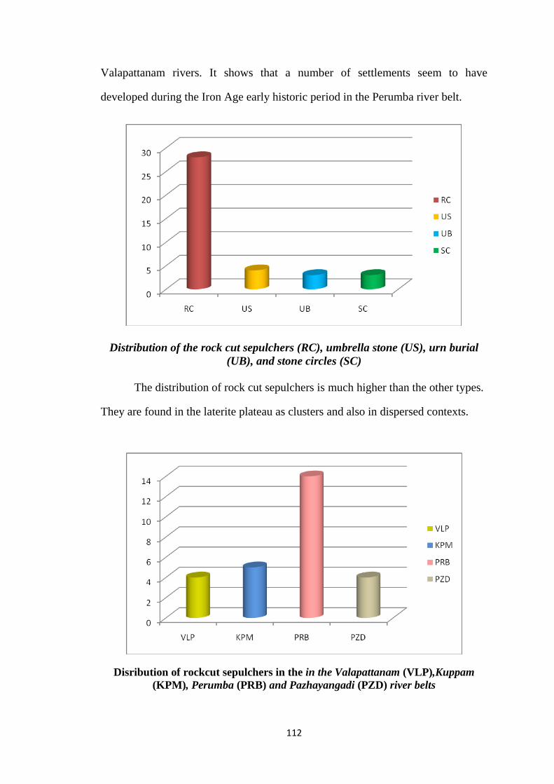
The pattern of burial distribution
The major burial types found in the region are rock cut sepulchers.30 The
following graph, which is prepared on the basis of the field explorations, shows
the distribution of different types of Iron Age burial sites in the region under study
Iron Age burial site distribution in the Valapattanam (VLP), Kuppam (KPM),
Perumba (PRB) and Pazhayangadi (PZD) river belts
The burial sites of the region under study were found mainly in the
Valapattanam, Kuppam, Perumba and Pazhayangadi, river belts. The number of
sites distributed in the Perumba river belt is higher than the Kuppam and
29
The site is located in the hard laterite and an unproductive area. It was unoccupied area for a
long period. The evidences of the later period like temple, inscription, dwelling remains, etc are
not found. There are no foot paths, ways, etc. There is no travel accessibility even in the present
time. But the pastoral channels are abundant. Most recently this area got occupied by people 30
The region under study is a laterite dominated area and the monuments are often found in the
slopes of the hard laterite hillock slopes. The shape of this monument is interesting. The inner
space of almost all caves with port holes looks like a pot. The port hole which is often covered by
a stone lid is similar to the neck portion of a pot. Was this an urn cave?
112
Valapattanam rivers. It shows that a number of settlements seem to have
developed during the Iron Age early historic period in the Perumba river belt.
Distribution of the rock cut sepulchers (RC), umbrella stone (US), urn burial
(UB), and stone circles (SC)
The distribution of rock cut sepulchers is much higher than the other types.
They are found in the laterite plateau as clusters and also in dispersed contexts.
Disribution of rockcut sepulchers in the in the Valapattanam (VLP),Kuppam
(KPM), Perumba (PRB) and Pazhayangadi (PZD) river belts

113
The distribution of rock cut sepulchers are varied in the major river belts of
the region. The largest quantity is found in the Perumba river belt, followed by
Kuppam. Almost equal numbers of sites are discovered in the Valapattanam and
Pazhayangadi river belts. It again shows that the Perumba river belt, which flows
in the valley of Ezhimala, was the first core of the early human occupation in the
region. The rock-cut caves are not like an ordinary pit burial. It requires more
skilled labour support and it represented the formation of a kind of advanced
settlement in the region, which will be discussed in another part of this chapter.
Besides, the surveyed burial sites have shown certain pattern of the
contemporary geo-cultural settings.
1. The sites are mainly distributed in the hillocks, hillock slopes, laterite table
land or in its slopes and they are located in the proximity of the water
courses.31 It is argued that the megalithic monuments are invariably found
to occur on high rocky grounds unfit for cultivation.32
2. The rock- cut sepulchers and stone circles are generally found in the hard
laterite hillock slopes and the laterite plateau. The entrance of the rock-cut
sepulcher is often faced towards the productive plots spread in the valley of
the hillock. The clusters of the rock cut sepulchers are spread over in a
single plot in most cases. It shows that the contemporary people seem to
have separate spaces for the dead, probably in the nearby areas of their
settlements.
31
These plots are non-productive in nature owing to the privation of soil deposits in the surface.
The seasonal monsoons do not let them remain in the surface and washes out the terrain each time.
Thus major cultivation was not possible there and consequently the plot became a graze land. 32
For details, K.R. Srinivasan and N.R. Banargee, „Surveys of South Indian megaliths‟ in Ancient
India, No; 9, K.A. Nilakanta Sastri, The Illustrated History of South India: From Pre historic
times to the fall of Vijayanagar, with an introduction by R. Chambaka Lakshmi and an epilogue
By P.M. Rajan Gurukkal, OUP, 2009,p 7.

114
3. The existence of the burials itself is a sign of the historical continuity of the
region.33 The region, where the megalithic burials are found, has witnessed
the continuous settlements.34
4. The splendid monolithic monuments and the unearthed burial goods
represent the possible development of various skilled occupational groups
who were depending on the surplus of the society. The megalithic period
witnessed population increase and the emergence of specialized craft
groups which facilitated the interaction between various production units,35
which will be discussed in another part. The wide distribution of the burial
sites in the river belts has proved the Iron Age demography.
5. The grave goods point to a primarily hunting and food gathering society
which was gradually shifted to sedentary agriculture.36 The presence of
Black and Red ware in the burial monuments seems to have pointed to the
beginning phase of agriculture. But the irrigated agriculture became
prominent in later time.37
6. The copper or bronze finds are also significant as they point toward the
accessibility of the alloy technology to the contemporary society on the one
33
They have been getting an auspicious space in the settlement area and normally the settlers of
the region do not attempt to disturb the monument either due to the fear or the obeisance to the
ancestors. That is the reason behind the existence of such monuments even now in different parts
of Kerala. 34
The evidences of later times like inscriptions, literary compositions, structural remains of the
sacred spaces and dwellings etc have been found in the nearby area of the burial sites. For
instance, the Eramam, Ramanthali, Kunneru, Ezhimala, Kannapuram, Maniyur, etc 35
R.K. Mohanty and V. Selvakumar, “The Archaeology of Megaliths in India: 1947-1997” in S
Settar, Ravi Korisettar, Pre history Archaeology of south Asia vol I, I.C.H.R, Manohar New Delhi,
2002, Pp 313-351 36
Rajan Guukkal, The Kerala temple and early medieval agrarian system, Vallahol Vidyapitam,
Sukapuram, 1992, Pp16-17 37
Ibid, p 17, R.K. Mohanty and V. Selvakumar, “The Archaeology of Megaliths in India: 1947-
1997” p 331

115
hand and on the other they are the crucial traces of the exchange systems
developed in the region. Since copper and lead are not available locally
they must have been brought from outside.38 Copper and bronze (copper
bronze alloy) objects have been unearthed from the burial contexts in
Kerala, though less in number.39
All these archaeological evidences have revealed the early human
occupation of the region and their active involvement in the contemporary
environment. All these monuments are located in the non-productive hillock
slopes. Interestingly, most of them are found in the pastoral zones. The engravings
and the hoof prints of cattle have emphasized the possible entity of the cattle
rearing pastoral community in hillocks and its slopes. However, the possible entity
of various occupational groups including skilled, who were the masters of
megalithic technology and non-skilled have also been hinted by the wide
distribution of the megaliths, especially the rock-cut sepulchers. In order to tackle
38
In the recent excavation at Pattanam, an early historic site in the Periyar river belt, unearthed a
large quantity of led scroll and copper objects from the early historic archaeological layers, which
proved that these object were part of the maritime trade. For details, Cherian, P.J, V.Selvakumar,
K.P. Shajan (et.al), Interim Reports of Pattanam Excavations-2007,2008, 2009,2010 and 2011,
Kerala Council for Historical Research, Thiruvananthapuram. 39
A copper bangle fragment found from a cists burial at Arippa, Kollam district. For details, P.
Rajendran and C.S.P. Iyyer, “A preliminary report on the characterization of copper and gold
ornaments of the Arippa megalithic culture in Kollam district, Kerala, South India”,Man and
Environment 22(2):61-66, A copper dish has been discovered from a dolmenoid cists at the
Ambalamedu site by Rajan Gurukkal. Cited in Rajan Gurukkal and Raghava Varier, Cultural
history of Kerala, p 135. Copper or bronze vessel or bowl and a copper lid portion have been
unearthed from Perambra Kodakkal in Calicut district. For details, K. J John, “Perambra,1979
New light on Kodakkals of Malabar” in R.K. Sharma (Ed), Indian Archaeology New
Perspectives, Agam Kalam Prakashan, New Delhi, 1982, Pp 148-154. Few highly corroded
copper fragments have been recovered from the rock cut chamber inside a stone circle from
Anakkara, Palakkad district. For details, Rajan Gurukkal, “Unpublished excavation report of
Anakkara Megaliths, Plakkad district- 2009, M. G University Kottayam. A lid fragment of bronze
is found by the present researcher from a destroyed cist burial at Chakkothu paramba, Chengaroth,
near Perambra Kodakkal, Calicut district.

116
the features of megalithic economy and contemporary social contexts, it is
required to unravel the possible social structure represented in the early Tamil
heroic poetries.
Map. 2. The Distributon of Iron Age megaliths in the Perumba, Kuppam and
Valapattanam River belts
Literary allusions
The Sangam literatures like Akananuru, Purananuru, Pathittupathu,
Kuunthokai, Nattinai, Pattupattu etc have given few hints on the formation of

117
early settlements in the region of Kolathunadu. As mentioned earlier, here the
main focus will be on the songs related to Ezhimalai, its chieftain Nannan, his
plunder marches and his companion Minjili and others. Akananuru gives
substantial signifiers on the contemporary landscape and the geomorphology.
The poetical allusions on the region under study mainly appear in the
Kurinji and Palai songs of Akam literature; occasionally it also appears in the
Neital and Marutham songs.40 Like Kurinchi, Mullai, Marutham and Neital, the
Palai or parched land did not exist as a separate geo-economic zone. Instead, it
was formed naturally owing to the draught or decline of the hilly forest tracts
(Kurinchi), or the bushy grazing zones (Mullai) in the top or slopes of hillocks.41
Since the representations of the region under discussion mainly appears in the
Palai songs, the entire region under the predatory control of Nannan of Ezhimalai
must have been the Kurinji or Mullai dominated tracts and occasionally it
transformed into the non productive barren zone (Palai).
The region, according to the literary references, has an undulated landscape
which comprised of hillocks, slopes, narrow wet land in the valley between the
hilly tracts, the narrow passes in the hillock slopes to the valley, parched zones
either in the hillocks or in the slopes, productive garden lands, wet land cultivation
units in the elevated terraces, streams and fresh water channels etc. The poetic
expressions like nedum perum kunraththu,42 arumchuram iranta43, aruviyaarkkum
40
Tinai is a poetical conception of the contemporary geo- eco zones. There appears five tinais
(aintinai); Kurinchi (hilly tracts), Mullai (Pastoral tracts) Palai (parched zones), Marutham (wet
plain field), and Neital (coastal zones) For details, Rajan Gurukkal and Raghava Varier, Cultural
history of Kerala, Pp 165-173 41
Rajan Gurukkal and Raghava Varier, Cultural history of Kerala, p 172 42
Means the big mountain or hillocks, Akananuru, 258:6 (hereafter A.N), (Malayalam
Translation), Nenmara. P. Visvanathan Nair, (ed),Three volumes, Trissur 1981, 1983, 1984 43
Get down the risky passes, A. N. 97:8
118
maynthikazh chilambil,44 poraiya chiru vellaruvi45 etc have shown the features of
undulated terrain. Ezhimalai is the important mountain of this undulated
landscape. It is a resourceful mountain and the references indicate that primitive
production units and pastoral tracts were widely distributed in the surroundings of
Ezhimala. The mountain appears as forest tract where the venga tree has grown
abundantly.46 Ezhimala which refers to as Ezhilkunram47 was under the predatory
control of a Velir chief Nannan. It is jutting into the Arabian Sea and its valley is
often washed out by the waves of the sea. According to literature, foreign trade
ships or canoe often faced misfortunes in the natural coastal port due to the hard
laterite formation in the valley of the Perumthurai, which seems to have
represented a harbor near to the mountain Ezhimalai.48 This geographical setting
itself was very much helpful to the pirates and the coastal plunder groups, which
will be discussed later. In another song Pazhi appears as the adjacent mountain to
Ezhimalai.49 Pazhi was the center of the predatory chief Nannan and also the core
of the resource accumulation and its redistribution.50
The mountains are the natural aquifers. The term Chinai or Irumchinai
which frequently appears in the Kurinji songs shows the presence of the water
source in the hilly forest tracts. The terms Parainedumchinai, Perumchinai,
Nirachunai etc. are the direct indication on the presence of water in the laterite
hillocks plains.51 The bushes growing in the surroundings of the water-body
44
Represents the streams that are flowing in the hillock slopes, A. N. 262:14 45
Means the small streams of the hillocks, A. N. 345:15 46
“Ezhir kunrathukkarunkalu vengai chempumi”, A.N. 345: 7-8, “Ezhir kunrathu kkava aru
kezhkolathiruntharai nivantha karunkal vengai” A.N. 349: 9-10 47
A.N. 349:9 48
“Nirankuneerparappiru kanalam perumthurai” A.N. 152:6 49
Ezhil neduvarai pAzhi chilampil, A.N. 152:13 50
It has been argued that Pazhi was the capital city Kingdom of Ezhimalai of Nannan.
Elamkulam. P.N. Kunjan Pillai, Studies in Kerala History, Kottayam, 1970, p. 43. 51
A.N. 2:4, 178:3, 345:16

119
occurs in the hillock plains (Kurinji).52 Such features are visible even in the
present geography. The ponds with full of fresh water, which are not evaporated
even in the summer season, have been found at Ezhumvayal, Ettukudukka,
Alathatta Mavicheri , Madayi etc very close to the Iron Age burial sites.
There were passes and narrow ways with full of stones and gravel in the
hillock slopes. The poems referred to the movement of heroes through the risky
passes of the hillock slopes.53 Such references have shown the possible spread of
pathways in the slopes of the mountains. These passes must have been an active
route of the reciprocal relationship between various eco-zones. The landscape of
the present Kannur district has very much resemblance with the references in the
literatures. The region has natural elevation and its corresponding depressions like
the simile used by the poet Mamulanar regarding Viyalur.54 The slopes of each
hillocks ends at a narrow wet plain and it end at the valley of another mountain or
hillocks. The wet plains are located between two hillocks. The productivity of
such wet regions was depended on the flood water from the mountains. The flood
water in the rainy season from the hillocks and its slopes (peyalu Alai kalangiya
malai) 55 seems to have brought all natural deposits including soils, dry leaves etc
to the valley. These natural fertilizers caused the formation of fertile swampy plots
in the valleys. This natural process itself was the principal factor behind the
formation of resourceful and productive units in the region. The term aruvi 56 has
52
A.N. 178, “aaru chernthu anna ooru nirpata ar” 53
“Arunchuram Irantha Kodiyor”, A.N. 97:8 54
“Viyalur anna ninna alamulair” A.N. 97:13-15, Mamulanar says, Viyalur hill is like the bosom
of the heroine. The simile leads us to make a possible assumption that the mountain has slopes and
it ends at a narrow valley (the poet seems to have used this simile to describe the existing
topography). Such geographical features are almost visible in the contemporary landscape of north
and north eastern part of Ezhimalai. 55
A.N. 142:23, 208:18 56
A.N. 262:14, 345:15

120
indicated the existence of streams in the slopes. According to the poetical
references all these streams were originated from the mountains and flow down
the mountain slopes, into the valley, and finally constituted a water body.57 This
flood water, which comes down from the mountains, also transformed into a big
water body in the valley. Such perennial water bodies were formed in the valley of
Kurinji zones. The formation of non fertile sandy belt (Varmanal)58 after rainy
season in the river banks is another geographical feature which appears in the
poem.
Formation of turai was also significant in the landscape under discussion.
Turai seems to be an opening space between land and water channels; rivers or
sea. It is a confluence of emotional space and social requisites to the kurinji
dominated landscape of the nadu. It developed as a center of surplus exchange and
cultural transaction. The rivers have such openings to large water bodies. The term
Munturai and Keezhturai seem to have indicated the formation of such openings in
a single water body.59 Or it could be an indication of two distinct exchange spaces
of the same water channel existed in a confined distance. Some priority could be
attributed to the setting of these Turai. It could be the availability of products or
the frequency of the distribution of settlements. The frequency of the exchange
seems to have also been different. Turai also appears as a coastal village where the
57
“Aruviyarkkum mayanthi kal chilampilu nunpa ruvalai puthanmichai nanakkum”, shows the
streams of the hillock slopes which joins together and fall into the slopes. The presence of
waterfall in the hillock slopes is evident here. A.N. 262:14-15. “Kanmichai yuzhi zhipuyaru
chernthu anna Uru Neerpadar” A.N.178:6-7, shows that the drop by drop water fall from the
rocky plains of the hillocks region becomes a big water body like river. 58
“vArmanal akal atalyattu atai karai” , means on the banks of the sandy river bed. A.N.97:18 59
A.N. 356:1,18
121
fishing communities were settled.60 Such villages are set up on the banks of river
or such perennial water channels.
A few hints on early historic climate
It is a complex endeavor to make a discussion on the nature of climate in the early
phase of human life as it is unrecorded. It is not clear whether this society had
developed astronomical notions or calculations of the cyclical seasonal changes.
The literary references in the Akananuru have clearly shown that the society was
conscious about the seasonal changes. The spread of drought owing to the high
temperature and consequently the evaporation of the water sources and resourceful
units are testified by the terms like Tirankutham, (drained plot) and varumchunai,
(evaporated water body).61 The arrival of rainy season in the region is apparent in
the usage of the terms tanmazhai 62 inamazhai thavazhum ezhil kunrathu (cluster
of clouds above the mountain Ezhil or visible from the Ezhimala hillock).63 The
cloudy climate gradually follows lightning and thunder (chelmakkal) and leads to
incessant rain.64 The turbulent flood water from the hillock which flows by the
streams has shown the frequency of rains in the region.65 Thus the water
evaporated plots became wet and ready to vegetate and the atmosphere also
became cool and pleasant.66 The term mamuri inru marakompu akaippa 67 means
the tiny tips of water spread on branches and leaves of the tree may show the end
60
The coastal fishermen settlement, which seems to have developed on the river banks, appears in
the marutham pattu, A.N. 196:1-7 61
A.N. 119 62
“Thanmazhai thavazham neer thazh nananthalai kadunkattu, edukkum nedum perum kunathu”
A. N. 258:5-6 63
A.N. 345:7 64
“Kallena kkanamazhai pozhintha kanmadiyiravil”, A.N. 392:11-12 65
“Peyalu alai kalangiya malai” A.N. 142: 23 66
“mazhaipozhintha, vijumtali pozhinthu vemmai neengi than potham pathul chelkena” A.N.
345:1-2 67
Ibid 345:13

122
of rain and the arrival of another state of nature, probably the beginning of spring
season. The term uraikazhinthu ulantha pintai 68 (after the end of rain) has also
indicated the arrival of the same. The beginning and end of each season are
represented in the poems. On the basis of the references, a cyclical chart can be
prepared on the climate of the region; as follows;
Nature of climate of the region under study as represented in the Akam literature
The evaporation of water in the land, the decline of fertility, seasonal flood
owing to the rain and the consequent formation of the fertile tracts in the valley,
the arrival of a spring season etc were cyclically occurred in the region. This
cyclical change of weather itself was the main factor behind the formation of early
settlement in the region under study.
68
Ibid 345:14
Cloudy sky
Lightening /
Thunder
Rainy
Drizzle
Incessant
Flood
Abatement
Ends
Moisture Dewy
Coolness
Tepid
climate
High temperature
Drought
Sultry climate
Water evaporated lands

123
On the basis of the aforesaid available source materials, the residuary
segment of this chapter will examine the process of the social formation of the
region under study in the iron age early historic period.
Socio- economic Geography
The archaeological traces from the field and the poetical expressions that
appear in the early Tamil literatures have revealed the possible evolution of a
society with agro-pastoral subsistence forms in which the hunting and food
gathering were also sustained.69 The integration of multiple means of subsistence
forms seem to have resulted in the formation of different forms of occupational
groups and the possible development of their settlements. The reciprocal
relationships between these settlements and the development of exchange network
in the cultural landscape have been constituted in the backdrop of the agro-pastoral
economic system. Various knowledge forms and technologies have also formed
and they became the constituent element to facilitate the process of the evolution
of the society. All these process have corresponded to the development of surplus
accumulation systems, which can be termed as chiefdom.
69
Regarding the subsistence base of megalithic people, there are different theories among the
South Indian scholars. B.K. Gururaja Rao, Ramachandran, T. Sathyamurthy etc argued that they
were settled agrarian community. Leshnik, Sontheimer, Narasimhaiah , S. B. Deo etc argued that
the megalithic people were Pastoral nomadic., J.R. Mclntosh, The Megalithic Culture of India: A
chronological study, PhD dissertation, Cambridge University of Cambridge. All these arguments
are cited in R.K. Mohanty and V. Selvakumar, “The archaeology of the Megaliths in India:1947-
1997” in S Settar and Ravi Korisettar, Indian archaeology retrospect ,Pre History Archaeology of
South Asia, I.C.H.R, Manohar, New Delhi, 2002, p 330. According to Udayaravi .S. Moorti, the
megalithic people practiced a mixed economy based on agro-pastoral production. Udayaravi. S.
Moorti, Megalithic Culture of South India, Ganga Kaveri Publishing house, Varanasi, 1994, p 44,
Rajan Gurukkal and Raghava Varier ed. Cultural History of Kerala, Chapter V

124
Means of subsistence
Various kinds of subsistence forms were developed in the aforesaid geo-
economic landscape. It includes hunting and food gathering, cattle keeping,
plunder or robbery, slash and burn cultivation, craft production and fishing and
salt making. None of these were autonomous in any pure sense and had
considerable overlap among them depending upon the nature of the eco-zones
(Tinai).70 The archaeological and literary evidences revealed the development of
such subsistence forms in the hillock slopes and the forest tracts of the region. The
hunting and food gathering were the most primitive modes of subsistence. The
arrival of hunters in the forestland and the scared situation of the faunas are
appeared in the poem.71 The hunters used primitive tools like Kavanai 72 (catapult
or a stone used in a sling) and Vel or trident.73 The cultural artifacts unearthed
from the Iron Age burials like trident, arrowheads and such other iron implements
have also proved the existence of hunting gathering subsistence forms in the
region.74 The tribal kin groups collectively gathered their daily food from this wild
and resourceful forest region and then redistributed it among the tribe.75
From the topographical features and evidences related to the region under
study, it is clear that the cattle keeping developed as an important subsistence
form. The cattle herds used to graze in the pastoral tracts of the region.76 The
70
For instance, pastoral means of subsistence was substantially supplemented by shifting
cultivation. Rajan Gurukkal and Raghava Varier, Cultural History of Kerala, p 228 71
“ thinai mey yanai inan irunth oda..” A.N. 392:13. Such reference seems to have represented
the terrible condition in the forest at the time of hunting. 72
“Kal Uyar kazhuthin chenon eruntha Valvaaykkavanin Katuvati Ollena”, A.N. 392:15 73
A.N. 152:10-11, 392:21 74
K. J. John, “Unpublished excavation report of Naduvil, Kannur district” 75
A.N. 178:4, 5, 12. This poem has given a clear picture of food gathering. They collected roots,
Kizhangu (tuber), Chembu (colocasia) and drank water from the streams and ate tina, (millet). 76
A.N. 97:4
125
grazing tracts, which appear in the Tamil songs, are mainly spread in the hillock or
hillock slopes. The herds of cows and deers grazing in the slopes of the hilly forest
were often threatened by leopards.77 The natural aquifers and water bodies
(Chinai) of the hillocks are also a constituent element in the formation of grazing
land.78 The Iron Age burial monuments especially the rock-cut sepulchers were
widely distributed in the nearby areas of the grazing land. Naturally, this area was
not useful for cultivation and the plots remained non productive. Such fresh water
sources, which refer to the Tamil literature as Chinai , are found in the hard
laterite table lands and they seem to have been used by the cattle herds and the
group of shepherds of the region. The availability of water was the crucial factor
in the selection of settlement sites.79 A wide area in and around the present
Ezhimalai, including the laterite plateau of Ettukudukka, Naduvil, Alathatta,
Ezhumvayal, Talipparamba, Madayi, Sreekandapuram, Alathatta, Kunneru,
Echilamvayal, Korom, Payyannur, Kunjimangalam, Pilathara etc, contained
grazing tracts. These regions, the main areas of the nadu under study, have been
occupied by the cattle and cattle keepers for a long period.
The shifting slash and burn cultivation was widely performed in the hilly
kurinji zones of the region. Such production units have been mentioned in the
poem as nadu. It has been stated that nadu appears widely in the Kurinji songs,80
which means it originates in the hilly forest tracts where the affluent water sources
exist. The nadu, as productive space and settlement unit, got separate entity from
the kadu or resourceful forest region.81 The terms kadu and nadu denoted the
77
A.N. 392:11-18 78
See the table of the water aquifers, Echulikunnu, Mavicheri, Madayi, Ezhumvayal,
Ettukudukka, Cheemeni etc 79
Udayaravi. S. Moorti, Megalithic Culture of South India : Socio-economic perspectives, p-12 80
Rajan Gurukkal & Raghava Varier, Cultural History of Kerala, p 174 81
Ibid, Pp 174-175

126
conversion of natural space into productive space and the nadu included
habitational and productive spaces.82 The term Nalmalainadu shows the formation
of prosperous productive units in the mountain tracts and also the settlement
areas.83 The term punanadu has shown the punam cultivated production unit in
slope or valley of the hillocks.84 Punam involved slash and burn cultivation, which
extended to both forest and grassy lands.85 Such punam cultivating agrarian units
were developed in Ezhimalai and its surrounding hillocks. The swampy areas and
the bushes growing hillock plains seem to have also reclaimed and transformed
into cultivable tracts. The land was prepared by burning the dry leaves and bushes.
Then they tilled the plot by using plough pulled by cows and used natural
fertilizers like the mixture of cow-dung and leaves of plant.86 However, the
references indicate that the early cultivation units were spread mainly in the hilly
tracts and the garden land areas in the valleys of the mountain. The terms like
Chiruthinaipperum Punamvechanadu87(millet cultivating agrarian unit),
Chiruthinai nalmalainadu88 (millet cultivating prosperous agrarian unit in the
hillock), Nannan punanadu 89(millet cultivating unit under the sway of Nannan),
Nannan nalnadu90 (the prosperous agrarian unit of Nannan) etc have shown the
82
K.N. Ganesh, “Lived spaces in history: A study in human geography in the context of Sangam
texts” in Studies in History – 25,2,n.s (2009), Sage Publication, New Delhi, p 173 83
A.N. 178:13 84
A.N. 396:2. Elankulam. P.N. Kunjan Pilla has identified Punanadu with Punnad located
somewhere in Malabar, or probably the present Coorg area. Elankulam. P.N. Kunjan Pilla,
Keralam Anchum Arum Nuttandukalil, National Book Stall, Kottayam, 1961, p 68, Studies in
Kerala history, National Book Stall, Kottayam, 1970, P 42. 85
K.N. Ganesh, “Lived spaces in history: A study in human geography in the context of Sangam
texts” p 173 86
“Muthaipadu pachunkaattarirupavar mayakki-ppaktupala punda vuzhavura chennchey
idumurai nirampi aakuvinai kkaliththu paachilai yamanta payara pukkane”, A.N. 262:1-4 87
A. N. 148:6 88
“….Chiruthinai vilaikuran meythu kanninithupadukku nanmalai nadanu..” A.N, 178:12-13 89
A. N. 396:2 90
A. N. 349:8

127
formation of agrarian tracts in the Kurinji region. The term Nannan Parambu has
denoted the spread of garden lands in the hillock slopes or the valleys under the
predatory control of Nannan.91 All these have shown that early nadu was
completely slash and burn Punam cultivated units. Nannan, the chief of the region,
has actually come out from the backdrop of the surplus of these cultivation areas.
The cultivation process seems to have gradually extended from the hillock
region to the wet fertile plains in the valleys. The discoveries of the black and red
wares from the burial monuments, mentioned earlier, have represented the gradual
shift from the hunting and food gathering to the sedentary agriculture.92 They were
widely found from the rock-cut sepulchers, which seem to have represented the
advanced settlements, of the region. There is no evidence for precisely associating
the Iron Age megalithic people with irrigated agriculture which is not unlikely in a
later phase of their culture.93 The wet lands seem to have developed in the river
valleys and the valleys of the hillocks.94 The fertility of these tracts has entirely
depended on the monsoon. After each monsoon the valleys of the hillocks became
fertile due to the deltaic deposit.
The formation of paddy cultivation units in the Marutham tracts is evident
in the literature. Nannan had predatory control over the paddy production unit.95
91
A. N. 356:8. As this term occurs in the Marutham song, it seems to have an elevated space near
to wet lands. Elankulam. P. N. Kunjan Pilla has referred it as the garden unit, which seems to have
located somewhere in the hillocks or its slopes. Elankulam P N Kunjan Pilla, Keralam Anchum
Arum Nuttandukalil, Pp 79-80 92
Rajan Gurukkal, The Kerala Temple and early medieval agrarian system, Pp 16-17 93
Ibid, p 17 94
The wet lands of the region under study are located in the valley between two laterite hillocks,
from where a number of megaliths are discovered. The fields are too narrow and completely
depended on the monsoon. 95
“Nedunkathir Nellin Vallam Kizhavon”, means the chief of the paddy grown Vallam, seems be
an Ur. A.N. 356:13. “Nedungathir nellin” means the long spike of rice corn. It shows that the rice
was not unknown to the contemporary society.

128
The term Nedunkathir Kazhani shows the formation of rich paddy field in the river
valley.96 The productive units were distributed in the surrounding zones of the
Naravu.97 Unfortunately we do not have tangible archaeological remains such as
rice husks or grains to substantiate the presence of rice in the early historic context
from the region. There is oral information regarding the discovery of a pot full rice
husk in a rock cut near Cheemeni.98 This find might have shown the possible
spread of the paddy cultivation in the hillock plateaus of the northern Kerala
during the Iron Age.
Cattle keeping was another important means of subsistence of the people.
The cattle seem to have been fostered for domestic and agrarian purposes.99 The
engravings and hoof prints of cattle seem to have shown the pastoral potential of
the region and that the region has a long tradition of cattle keeping. The
availability of wide pastoral tracts seems to be the reason behind the continuity of
this process.100 A number of ponds with sloping surface or steps which enabled the
cattle to access the water were found from the region. This feature could only be
96
“Nedunkathir kazhani than chaykanathuyanar thanpanai.” A. N. 220:18. As this term occurs in
the song related to archaic Brahmin settlement Chellur, it can be assumed that this ur seems to
have developed in the Kuppam river belt. 97
Pathittupathu, 6-10 (hereafter P.p.6-10), edited by G.Vaidyanatha Ayyer (ed), Kerala Sahutya
Academy, Trissur, 1961 98
A person, who opened a rock cut sepulcher at Cheemeni, near Cheemeni town, Kasargode
district, has given trustful information regarding the findings of rice husks in a red pot. Cheemeni
is hillock region which is the part of Ettukudukka hillock belt. A cluster of megalithic sepulchers
were found at the plot of Adukkadi Kunjatha Maniyani of Chemeni Padinjarekkara. About three
sepulchers discovered from there were demolished. This site is not systematically documented.
The site was documented by the present researcher on 16-10-2008 and submitted a report as part
of the UGC-SAP project “Historical Geography of Malabar” in the Department of History
University of Calicut. 99
“pakadupala poondauzhavura chenchey itamurai…”, shows that the cattle were used for
plowing the land. A.N. 262:2-3 100
The cattle keeping was one of the dominant subsistent forms in the region, which has its origin
from Iron Age early historical phase. There is a community called Maniyani with cattle keeping
as the dominant subsistence form in the present Kannur and Kasarcode districts.
129
particular to this region. The threat of plunder on the cattle wealth also occurs in
the literature. The cattle were usually plundered as they were one of the food items
of the tribal groups,101 which revealed that the cattle wealth was fundamental part
of the early historic economy.
The cattle and the itinerary caravan groups were plundered since plunder
was a means of subsistence developed in the region. The Palai, parched geo-
economic zones, which formed due to the seasonal changes in the Kurinji or
Mullai zones, was the core area of the robbers. Armed clans like Maravar and
Eyiner used to plunder the people passing through the Palai tracts.102 The cattle
lifting of the Maravas, which was termed as Vetchi, and the fight to recover the
same were part of the Sangam society.103 The cattle herds were frequently
plundered by the Adavar.104 The cattle were killed for food and the flesh or cooked
meat redistributed among the kin groups. The mazhavar or maravar, the plunders,
were active in the Palai eco-zone and according to the reference in the Akananuru,
they were used by the abandoned hearth of itinerary caravan merchants to cook the
plundered cattle flesh.105 The travelers, especially the merchant groups, were often
accompanied by the armed personages to protect them from accidental
misfortunes. Both plunder and protection were part of the possible means of
subsistence of the Palai.106 The memorial stones were erected in memory of such
warrior groups.107 The wealth appropriated through the plunder was also the vital
101
A.N. 119: 8-9 102
Rajan Gurukkal and Raghava Varier, Cultural history of Kerala, Pp 172-173 103
M.G.S. Narayanan, “Cattle raiders of the Sangam Age”, in Foundations of South Indian
society and culture, Bharatheeya Book Corporation, Delhi, 1994, Pp 83-96 104
“Iravukkurumpu Alara Noori nirai pakuththu irunkalu mutakkar thitti kentum kolaivilu Atavar
”, A.N. 97 :4-6 Atavar seems to be plunder tribal group similar to the Vetchi Maravar. 105
“Umanchathirantha Ozhikal Atuppin Nonchilai Mazhavar Unpuzhukkayarum” A.N. 119:8-9 106
Rajan Gurukkal & Raghava Varier, Cultural History, Pp173-73 107
K. Rajan, South Indian Memorial Stones, Manoo Pathikam, Tanjavur, 2000

130
constituent of the surplus of the region. Nannan appears in the literature as the
chief of the Ezhi mountain with sumptuous amount of resources, which seems to
have gathered from wild forest through plunder and predatory marches.
The coastal piracy was its utmost condition as evidenced in the Greco-
Roman travelers‟ accounts. The pirates were concentrated in the southern side of
the Ezhimalai, the space which is not easily visible from the sea owing to the
natural jutting of the mountain, and therefore it was a lurking place to plunder the
travelers or traders. According to Pliny, the robbers must have been active in the
first two marts of Damirice, namely Naura (Cannanore / Narath ?) and Tyndis
(Ponnani?).108 Ptolemy refers to the pirates of Nitria, a port which seems to have
been located in the northern part of Ezhimala.109 The active presence of Maravas,
the plundering tribal groups, in the coastal port city Naravu is referred to in the
Patitupathu.110 All these have shown that the pirates were active in the port cities
of the region.
Fishing was also developed as a dominant means of subsistence in the
nearby coast of the occupied productive units of the nadu. In a marutham song, a
heroine appears unhappy because of the irresponsible attitude of the hero who
expressed reluctance to engage in fishing.111 As it appears in the marutham songs,
the region represented in the song must have been a productive unit which existed
on the river banks, where the fishermen settlements were also developed. Even
now the coastal villages are distributed in the Pazhayangadi, Kunneru, and Kavvai
108
E.H. Warmington, The Commerce between the Roman Empire and India, Munshiram
Manoharlal Publishers, New Delhi, First Indian edition 1995 (1928), p 57 109
J.W. Mc Crintle, Ancient India as described by Ptolemy, Today‟s & Tomorrow‟s Printers and
Publishers, New Delhi, 1884, Pp 47-50 110
P.p. 6-10 111
A.N. 196:1-7

131
and most of them still remain as fishing coasts. The term Uppuchirai112 has also
hinted at the existence of salt pans and the possible development of salt making as
another subsistence form in the region. It further indicates the possible
development of a reciprocal exchange relation between the settlers of the sea coast
and the hilly tracts.
Formation of settlements
As the archaeological evidences are silent about the early historic
habitation sites, it is necessary to turn to the contemporary Tamil literatures.
However, the wide distributions of Iron Age burial sites in the non productive
hillock slopes have hinted at the possible spread of Iron Age habitations. The
megalithic people had dispersed settlement pattern. Though the evidences of the
habitation or habitation cum burial are absent, the distribution pattern of the burial
sites in the aforementioned river belts of the region under study has shown the
possible spread of settlement units. The settlement units seem to have been
scattered in the nearby area of the burial sites and the surroundings of these river
and their tributaries belts. Thus, the Iron Age (Megalithic) burials and its
assemblages and literatures, have given few signifiers on the possible development
of various labour forms and their settlement sites in the region.
The basic geographic and settlement unit was Ur that meant a kin based
settlement consisting of few kutis.113 Kuti is the standard name of the settlement,
which is found in all Tinai.114 Viyalur 115 (agrarian units were under the sway of
112
A.N. 208: 19 113
Rajan Gurukkal and Raghava Varier, Cultural history of Kerala, p 173 114
K.N. Ganesh, “Lived spaces in history: A study in human geography in the context of Sangam
texts”, p 168 115
A. N. 97:13, Elamkulam. P.N. Kunjan Pillai, Keralam Anchum Arum Nuttandukalil, p. 74.
132
Nannan) and Chirur116 (literally means small settlement) have appeared in the
poems as the prosperous agrarian or resourceful settlement units. Urs were the
archaic geographical units where the cultivation started. Muthur or Chemmal
Muthur 117, Unur seems to have been the traditional settlements and the Chellur, at
Talipparamba, was one of the archaic Brahmin settlements of the region under
discussion.118 Similarly kunru or malai, and turai or pattanam seem to have
indicated the occupied area in the hillocks or its slopes and the development of
exchange centers in the coast. The craft group settlement units like teru or
neduntheru became the significant constituent of the region under study and
developed the nearby areas of the productive lands.119
It is very complex to disclose the space management of the early historic
people. The settlement units seem to have spread in the slopes of the hillocks and
close to the productive settlements. But no clear archaeological signs are available
to delineate their notion of space for each settlement units. It can be said that they
had separate space for the disposition of the dead or the cremation which has been
reflected in the setting of the monument in the non-productive hillock slopes.
However, the following part will delineate various types of occupational groups
and possible formation of their settlements in the region of Kolathunadu in the
early times.
It is argued that “a majority of the habitation or habitations cum burial sites
are situated on the major tributaries of major river streams and not on the major
river banks. It seems that the danger of recurrent floods in the major rivers was
116
“Kunruzhai nanniya cheerur”, A.N.152:2 117
A.N. 15:7-8 118
A.N. 220 : 3 119
A.N. 356:5
133
probably the main hindrance.”120 It is clear that the burial monuments are mainly
distributed in the belts of the tributaries of Perumba, Kuppam and Valapattanam
rivers.121 The distribution of the megaliths have shown the possible spread of
distinct occupational groups and they were formed on the basis of the surplus
extracted through the slash and burn and shifting cultivation and resource
accumulation.
The megalithic monuments and the unearthed cultural materials have
revealed the possible entity of various skilled occupational groups like stone
cutters, masons, pot makers, iron smiths, braziers, gold smiths etc. Iron was the
most prominent metal used by the people. The iron working was the central
feature of contemporary technology and the iron smelting was a specialized craft
which is evidenced by the iron objects or implements unearthed from the
burials.122 Iron sword, dagger, tridents, knives, chisel, saucer lamps and tripod
were recovered from Naduvil.123 But no traces of the iron smelting like crucibles
are found from the Iron Age burial context. Instead, some poetical expressions on
the process of metal (iron or gold) tool making are available in the literature.124
The decorated and finished rock cut sepulchers and the decorated slabs of the
multiple hood stone circles in the hard iron rich laterite plateaus have indicated the
use of sharpened iron chisels or axes or such tools by the masons. The door jambs,
the port holes, its lids (plate No.3) and the roof represented the accuracy and the
technological sophistication of the megalithic masonry. Highly figurative square
and arch type doors of the rock cut sepulchers are found from Kunneru, Chunda,
Alathatta Mavicheri and Ezhilode and the circular port holes, which vary in its
120
Udayaravi S Moorti, Megalithic Culture of South India : Socio economic perspectives, p 12 121
See the graphical representation of the megalithic site distribution in the major river belt 122
Rajan Gurukkal & Raghava Varier, Cultural history of Kerala, Pp 133-34 123
K.J. John, “Unpublished Excavation report of Naduvil stone circle” 124
“Eri Iyalponnin konku chorppu Uraipa”, A.N. 142:24
134
thickness and diameters, have shown the multiplicity of the technological skills
and the possible use of different kinds of tools for its construction. The masons
must have based on certain calculations or plans for the construction of such
monolithic monuments and it is tangible in the accuracy of stone dressing and the
aesthetic beauty of monuments. They must have developed tools for both rough
works and more meticulous finishing works. The huge burial monuments
presuppose their builders‟ knowledge and technology regarding a variety of things
such as identification, cutting, shaping and transporting of the raw material for
construction.125 However, the study of megalithic technology still remains a virgin
area and it requires more scientific analysis.
The melting of gold and copper base alloy seems to have developed. The
bronze vase or the unidentified bronze equipment from Naduvil and the allusions
regarding the manufacturing units of gold smith or silver smith in the
Akananuru126 have underlined the necessary development of a specialized craft
group in the region under study.
We have some clues on beads and toys manufacturing units among the
craft groups. The references like uruvukilar ervinaipolintha pavai127(a doll or
figurine made of wood, clay, stone etc) and thathucheypavai128 (a doll or figurine
made of metal) indicated that the poet had known about such manufacturing
activities in the region he belonged. The crystal and quartz beads from the stone
circle at Naduvil have shown either the presence of the bead making crafts or the
inland exchanges that flourished in the region.129 The possible development of
125
Rajan Gurukkal & Raghava Varier, Cultural history of Kerala, p. 141 126
“Pon urai kattalai katuppakkanvara”, A.N, 178 127
A.N.142:21 128
A.N. 392:6 129
K.J. John, “Unpublished Naduvil excavation report”
135
bead manufacturing units in the west coast of Kerala, especially in the Periyar
river belt, has proved by the extensive excavations at Pattanam.130 This site could
be contemporary to Naura in the Northern part.131 According to E H Warmington,
the beryl from Punnata in the south west of Mysore would be sent to Naura.132
However, all these have shown that a specialized group either for bead making or
for bead exchange developed in the region.
The ceramics consist of Black and Red ware, Red slipped leg wares, Black
ware and Russet Coated painted wares, which yielded from the burial monuments,
indicated the possible spread of the some kind of ceramic technology and the
potter‟s settlements. A large number of potteries were unearthed from the rock-cut
sepulchers at Ezhilode, in the Perumba river belt and the Alathatta Mavicheri at
Talipparamba in the tributary of Kuppam River belt. Distinct variety of potteries
has also been found from a rock-cut sepulcher at Sreekantapuram.133 The
megalithic people must have used the pots for storing water and cooking food
130
Pattanam Excavations unearthed a number of evidences relating to bead manufacture. The
debitages and rough outs of the precious stones like carnelian, chalcedony, quartz, amethyst,
agate, garnet, beryl etc have shown the development of the bead making in the early historic time,
For detail, V. Selvakumar, P.K. Gopi and K.P. Shajan, “Trial Excavations at Pattanam :a
preliminary report, Journal of Center for Heritage Studies, Trippunithara, India 1:83-88, 2005.
P.J. Cherian V. Selvakumar, K.P. Shajan and K. Rajan, Pattanam Excavations: Interim Reports,
2007, 2008 & 2009, K.C.H.R, Thiruvananthapuram. P.J. Cherian, Nambirajan, V. Selvakumar,
K.P. Shajan and K. Rajan, Pattanam Excavations: Interim Reports, 2010, 201, K.C.H.R,
Thiruvananthapuram. 131
It has been argued that Pattanam could be a part of ancient Muciri which referred to the Greek-
Roman literatures and early Tamil texts. If so, Naura could be contemporary to the Pattanam site,
i.e. ancient Muziri. K.P. Shajan, P. J. Cherian and V. Selvakumar, “Pattanam Mussiris Thanneyo”,
in AdhAram: a journal for Kerala Archaeology and History, Vol 1, Keraleeya Purathathva Samiti,
M.G. University, Kottayam, 2006, Pp 50-59 132
“Beryl was one of the most demandable maritime goods of South India which was available in
the Coimbatore region. Three important Indian mines are recorded: at Padiyur, at Punnata in the
South West of Mysore and at Vaniyambadi in the district of Salem. The beryl of Coimbatore was
at least partly controlled by the Cheras- they would be sent down the Ponnani to Tyndis and so to
Muziris; those from Punnata would be sent to Naura and so to Muziris; those of Salem would go
to the Chola coast and then round.” E.H. Warmington, The commerce between the Roman, p 251 133
For details, Rajan Gurukkal & Raghava Varier, Cultural history of Kerala, p 138

136
items. The pots were also used for storing toddy.134 The making of burial urn was
also quiet significant in the contemporary society.135 Both the handmade and
wheel made technology have been developed as it testified the well burned fine
quality pots and rough made urns unearthed. The pot makers must have acquired
skills of inverted burning and furnace making technology.136 The perfection of
vessels and pots testifies the increased use of wheel in making small objects.
However, the well fired and rough pots have indicated the proliferation of the
skilled pot making craft group settlements in the nadu.
The merchants were another group, who bought the goods from various
eco-zones covering the coastal zones (salt or fish), the resourceful forest region
(spices and wild meats), the fertile agrarian food production spaces (millet or
paddy), formed in the region under study. The term umanchath represents the
itinerary salt merchants of the region.137 It also indirectly proves the possible
existence of various knowledge forms of salt making and a group of skilled
labourers who executed the salt pans (uppuchira). The presence of people, who
spoke another language (Mozhipeyar) and wore strange dresses, and the settlement
unit (Teyam) are referred in the literature. 138 Such references seem to have shown
the movements of the people from different regions. It is not clear whether they
were traders or immigrant communities. But the frequent movements of the
134
A.N. 356:1-2 135
Purananuru, (hereafter P.N.) 187, 228: 1, 10-15, 256:1-7, edited by V.R. Paramesvaran Pilla,
Kerala Sahitya Academy, Trissur, (1969),1997 136
The wide distribution of black and red wares, which recovered from the burial monuments, has
shown the inverted burning technological skill of the potters of the region. A large number of such
potteries were unearthed from Ezhilode and Alathatta Mavicheri. 137
A.N.119:9 138
A.N. 31:14-15,67:12-13,127:17,205:24,211:9,295:17,349:14, “Chelpeyar theyetha churan
Iranthor”

137
people, which seem to be part of predatory marches, caravan groups, cattle lifting
etc, are clearly represented.
The eulogizing bard, one of the dependent occupational groups, was spread
over the region.139 The bards were often depicted as the poor section of the
community and they lived at the mercy of the chiefs. They eulogized the
splendors of their heroes and this became the means of their subsistence. In turn
they received gifts which range from millet to elephants as reward from the
chieftains.140
However, the above discussion bears out the formation of agro-pastoral
units along with the development of the complex form of kinship labour forms.
The surplus either from production units of the hilly tracts or accumulated through
hunting gathering and plunder were redistributed among the tribe. The creation of
surplus was the foremost factor behind the formation of various occupational
groups and persuaded the formation reciprocal relation between the tribal
settlements.
The exchange
The surplus from the aforementioned slash and burn cultivation and
resource units and growing agro-pastoral settlements had been corresponded to the
development of the reciprocal exchange relations in the society. It has already
been scholarly approved as the existence of different kinds of exchange forms in
the early historical time.141 The redistribution of accumulated surplus among the
members of tribe under the supervision of chiefs was the most primitive form of
139
A.N. 208:1-5. 349:5-9, K. Kailasapathy, Tamil Heroic Poetry, Pp 94-134 140
Gift from Ay Eyinan, A.N. 208:1-5 141
Reciprocity, goods to goods exchange, salt and paddy as medium, mercantile circulation and
transmarine contacts were the mode of exchanges. This theory adopted from Karl Polyani. For
details, Rajan Gurukkal & Raghava Varier, Cultural History of Kerala, Pp 176-183
138
exchange. Similarly goods to goods exchange or the reciprocal surplus exchange
within the kin based tribal settlements, according to which each groups had to give
something and collect certain other goods in return, also developed. It has been
suggested that the producers of each Tinai or eco-zones were exchanged with
those of other tracts.142 Reciprocity was the basis for the development of such
practice. Hence the givers and the takers would be the same person as everyone
engaged in the exchange networks. The term noduthu/noduthal that appears in the
songs shows that the internal exchange network was active in the Ezhimalai and
its surrounding agrarian units.143 The reciprocal exchange between the hilly tracts
and the river valley coastal fishing or salt making zones of the region is evidenced
by the term uppuchirai, which was mentioned earlier. As Kurinji being a hilly
forest tract, it is impossible to develop a salt pan there, so the term Uppu which
appears in the Kurinji song seems to be referring to the presence of itinerary salt
merchants from the coastal plains in the Kurinji zone.144 The term Nedutheru,
which appears in the Marutham song, indicates the formation of internal exchange
spaces in the region.145 The salt and paddy were the medium of exchange.146
According to a Neital poem, different types of paddy were exhibited in the
exchange space called Unur.147 This reference indicates that the paddy seems to
have been brought to the coastal area from the hillocks plains and also from the
142
Ibid, p. 177 143
A.N. 196:3 144
The salt exchange was executed by a group of professional merchants called umanar. The
poems refer to carts of umanar waiting near pans with huge heaps of salt ready to be loaded for
carting to distant places through difficult and inhospitable terrain. The different modes of
movement of salt from the coastal pans up to the hill regions in the far interior are referred to in a
large number of songs with great picturesque details. For details, Rajan Gurukkal & Raghava
Varier, Cultural History of Kerala, p. 180 145
A N, 356:5 146
Rajan Gurukkal and Raghava Varier, Cultural History of Kerala, p 179 147
A N. 220:13

139
wet Marutham tracts. Toddy was one of the items of exchange.148 The fish and salt
circulation took place in various places.149These exchanges must have been based
on certain standard traditional weight and measurement. The term like njerman
terikkol indicates that the contemporary society had certain instruments for
measuring weights of the goods.150
Inland itinerary mercantile circulation was another important form of
exchange.151 The itinerary merchant groups passed through land where they were
threatened by robbers and so were often accompanied by the armed protection
groups. They carried food items and prepared their daily meals on the way. The
abandoned hearth, used by the itinerary merchant groups for cooking, mentioned
in the literature,152 has shown the continuous movements of itinerary traders
through the region. The poem indicates that the salt merchants (Umancattu)
passed through the evaporated zones (thiranku tham).153 The non local ceramics
like russet coated ware, black and red ware, which yielded from the Iron Age
burial monuments, have also pointed out the possible development of exchange
relation with the northern parts of Ezhimalai, i.e. modern Karnataka region. The
merchants seem to have collected the products from the interior exchange centers
and brought it to the wide exchange networks.
148
A.N. 196:1-3, 356:1-3 149
The Rajan Gurukkal & Raghava Varier, Cultural History of Kerala, p.180 150
A.N. 349: 3-4 For details, M.R. Raghava Varier “Neital tinai : A Socio-economic Analysis”,
Unpublished article, Calicut University, 1996. Cited in Rajan Gurukkal & Raghava Varier,
Cultural History of Kerala, p 179. According to Nenmara. P. Viswanathan Nair, this could be a
weighing tool made of silver. Nenmara P Visvanathan Nair, Akananuru Vol. 3, Kerala Sahitya
Academy, Trissur, 1984, p144 151
Rajan Gurukkal & Raghava Varier, Cultural History of Kerala, Pp 179-181 152
Ibid 153
“Umanchattu irantha ozhikal aduppu”- means the stone made oven which was given up by the
itinerary merchants. A.N.119:8-9
140
Certain hints are available on the development of transmarine contacts of
the region with outside, especially the Mediterranean world.154 Tamil literature
says about the arrival of wooden canoe with gold, which often faced misfortunes
at the confluence of valley of laterite hillocks, to the Perumthurai , probably near
to Pazhi, of Ezhimala Nannan.155 They seem to have collected the wild good
including spices, ivory and woods that were gathered in the coastal ports of the
region. The earlier communities of the region had brisk transmarine contacts, by
which they seem to have obtained gold or such non-local precious things, with the
outside world. Nannan of Ezhimalai described in the poems as a chief who was
always decked up in gold and his city Pazhi was full of splendor for its gold
treasure.156 Elamkulam. P.N. Kunjan Pillai has pointed out that there was a
pattanam in Pazhikkunnu.157 It is argued that the Pazhi was the capital or sub
capital of Nannan and it was located on the hill top somewhere in the Ezhimalai.158
But, according to the literatures, especially in the Akananuru, Pazhi seems to have
been a street where immense wealth was accumulated and redistributed and
located in the plains at the valley of hillocks.159 It could also be a space of internal
exchange.160 Similarly, the presence of Turai (Munturai, Kizhturai, Perumthurai
154
The recent archaeological evidences from Pattanam Excavation (Peiyar river belt, Ernakulam,
Kerala) proved that the Malabar Coast had brisk trade relation with North Africa (Egypt) and
West Asian regions even during pre-Roman phase. For details P.J. Cherian, V. Selvakumar and
K.P. Shajan et.al, Interim Report of Pattanam Excavations 2007-11. 155
A.N.152: 4-7 156
A.N. 15:10-11, 396:1-3 157
Elankulan.P.N. Kunjan Pillai, Samskarathinte Nazhikakkallukal, Kottayam, 1967,p 58,Keralam
Anchum Arum Nuttantukalil, Pp 74-76, Studies in Kerala history, Pp 45-47 158
Ibid, Pp 45-47 159
Most of the references on Pazhi occur in the Kurinji, Palai and Marutham songs which seem to
have shown that it could be located somewhere in the slope of hillocks. A. N. 15 (Palai ), A. N.
208 (Kurinji), A. N. 396 (Marutham). 160
Since the core settlement area of the early historic time discovered in the Perumba river belt,
the Pazhi Street seems to have existed in the same belt and most probably it could be located in
the present Payyannur area. According to the Payyannurpattu, it was a major street, where the
141
etc) in the west coast of the region has also indicated the possible development of
river based exchanges.161 Most of these seem to have existed in the west coast of
Arabian Sea in the vicinity of Ezhimalai.
The unearthed gold remains of Naduvil 162 and the Roman gold coins of
first century A.D from Kottayam Poyil near Koothuparamba163 in Kannur district
have also validated the flourished brisk trade relation between the west coast of
northern Kerala and the Mediterranean world in the early historic times. Periplus
of Erithrian Sea and Ptolemy‟s work refer to the port city Naura and the
threatening of the pirates of Nitria, located to the north of Naura, in the northern
part of Malabar Coast. According to Periplus Maris Erythraei (Periplus of
Erithian Sea) Limyrike (Malabar) started at Naura, an emporium which did not
belong to the Chera Kingdom, but at the same time was situated outside the area
controlled by the pirates.164 Naura is identified with somewhere around coast of
present Cannanore165 or Narath.166 Pliny says that Naura was not a desirable port
of call on account of the neighboring pirates, who occupy a place called Nitriae.167
Nitria, according to him, lay immediately to the north of Tyndis; it has been
internal and external exchanges have taken place, even in the medieval time. However, it is also
argued that etymologically Pazhi has some connection with Pazhayangadi T. Pavithran, “Naravum
Pazhiyum”, Chirakkal T Balakrishnan Nair, Prabandhangalum Samaharangalum, cited in N.V.P.
Unithiri, Studies in Sanskrit Literature, Calicut University Press, 2004, p. 96. But owing to the
absence of the solid evidences we are not able to reach a concrete conclusion. 161
A. N. 152:6, 196:2, 199:19-20, 356:1, 18 162
K. J. John, “Unpublished Reports of Naduvil Excavation.”
163 T. Sathyamurthi, Catalogue of Roman Gold coins, Department of Archaeology Kerala,
Thiruvananthapuram, 1992, p.13,33
164 Federico de Romanis, “Rome and the Notia of India: Relations between Rome and Southern
India from 30 BC to the Flavian Period” in F. De Romanis & A. Tchrnia (edited), Crossings;
Early Mediteranian Contacts with India, Manohar, New Delhi,1997, Pp 90-98. 165
Elankulam. P.N. Kunjan Pillai, Studies in Kerala history, 166
M. P. Kumaran, Kolathupazhama, Kerala Sahitya Academy, Trissur, 1998, Pp24-29 167
Federico de Romanis, “Rome and the Notia of India: Relations between Rome and Southern
India from 30 BC to the Flavian Period,” p.91

142
thought, therefore and with good reason that if Nitria is not exactly the Naura
mentioned in the Periplus Maris Erithriae it must have been situated very close to
it.168 Naravu appears in the Patittupathu as the coastal port where the maravas
(looters) were active.169 If so, it can be seen that the pirates‟ concentration of the
region seems to have been found in the nearby areas of Ezhimalai. The
geographical position of Ezhimalai, which is jutting to the Arabian Sea, was most
favorable to the pirates to loot the travelers and turn back to the concealed plot.
The traders from Mediterranean region who were moving to the Roman trade
center at Muziris of the Cheras , were often attacked and looted by the Nitrias. As
we have no tangible proof to identify the exact location of Nitria and the identity
of pirates, it is possible to assume that these people might have belonged to
Nannan‟s region.170 Nannan was depicted as a plunder chief and his prosperity was
actually based on the resources accumulated from the plunder marches. However,
all these indications proved that the interior exchange and coast based maritime
trade were active in the region.
IV. Formation of Early Chiefdom
The above discussion reveals that an agro-pastoral society with complex
forms of occupational groups and reciprocal exchange relations have been
developed in the region. These complexities seem to have corresponded to the
evolution of a system of surplus accumulation and its redistribution. The available
archaeological remains and literary evidences have pointed out that this system
could be chiefdom. Various forms of surplus accumulation such as plunder, cattle
lifting and tribute from the regions that were under the predatory control of the
168
Ibid 169
P.p. 6-10 170
We don‟t know whether the Nitriae is the Greek version of the river Neytara, another name of
the Valapattanam river or the term Neerthurai of Nannan‟s regions.
143
chief were evident in the literatures. It is suggested that “plunder was the
institutional means to extract resources from the centers beyond the network of
redistributive social relationships for every chieftain, and appears to be
fundamental to the maintenance of the contemporary redistributive system.”171 The
plundered items were redistributed among the members of the tribe according to
their requirements. Thus the process of redistribution in chiefdom was
concentrated on one point: the chief.172 There are instances of redistribution of the
accumulated surpluses by Nannan to the members of the tribe.173 It is already
stated that Ezhimalai was the most prominent hill chiefdom of Kerala during early
historic times.174 Our knowledge regarding the early chiefdom of the region is
based on the early Tamil literatures in which the name Nannan of Pazhi or
Ezhilkunram occurs in several contexts.175
The formation of Nannan‟s chiefdom represented the early political
evolution of the region of Kolathunadu.176 Ezhimala was the core region of the
chiefdom and Pazhi appeared as the important space of the chief Nannan. The
above discussion proves that the early chiefdom seems to have extended to the
Perumba river belt in the valley of Ezhimala. However, the available evidences
indicate that Nannan‟s region did not belong to the Cheras, the early political
entity of Kerala. It is stated that slightly to the north of the Ezhimalai from
171
Rajan Gurukkal and Raghava Varier, Cultural history of Kerala, p 177 172
Elmen R Service, Profiles in Ethnology, p 230 173
A.N. 349:3-14 174
Rajan Gurukkal and Ragava Varier, Cultural history of Kerala, p. 200 175
A N, 15:10-11,97:12-13,142:9, 152:13-14, 173:16, 199:20, 208:14, 349:8-9, 356:8, 392:27,
396:1-6, P.N. 151, 154, Kuruntokai 73,292,(hereafter K.T), (Malayalam translation) by
Melangathu Narayanankutti, Kerala Sahitya Academy, Trissur, 1983, 176
There are two theories on the political system of Nannan ; „Kingdom‟ theory of
Elankulam.P.N. Kunjan Pillai, and ‟Chiefdom‟ theory of Rajan Gurukkal, Raghava Varier, K.N.
Ganesh. Elankulam P.N. Kunjan Pillai, Keralam Anchum Arum Nuttantukalil, Pp 64-82, Studies in
Kerala history, Pp 41-52, Rajan Gurukkal and Raghava Varier, Cultural history of Kerala, Pp
199-213, K. N. Ganesh, Keralathinte Innalekal, Pp 344-348
144
Nannan‟s country began the Mozhipeyar Desam or the land of a non-local
tongue.177 In Akam 349 the poet Mamulanar alludes that the hero was crossing the
mountain pass to the land of another language.178 According to Ptolemy, the
Nitrias, who seem to belong to the Nannan‟s territory, was not part of Cheras who
were the custodian of the Roman trade center at Muziris while the Cera‟s country
started from the port Tyndis.179
Nannan belongs to the chiefly lineage called Velir.180 The Velir seems to be
the most archaic and lineage conscious and the Velir chieftains held sway over the
Kurinji and Mullai tracts, i.e. pastoral forest hill.181 The Velir chiefs also tried to
control the maritime exchanges.182 Nannan also had predatory control over the
slash and burn Punam cultivating units of the hillock plains and wetland agrarian
tracts in the valley of hillocks. As mentioned earlier, Nannan plundered cattle
wealth and gold frequently. He seems to have obtained gold or such precious
metals and stones through the plunder marches. Pazhi was famous for its gold
treasure and considered as the core of Nannan's chiefdom. The accumulated
surplus seems to have been stored in this city. Similarly, Vakai Perumturai which
seems to have been a coastal port under Nannan, also had a significant role in the
making of the chiefdom.183 Nannan had collected Tirai, which seems to be similar
to bali or some kind of voluntary gift, from the conquered region.184 It was another
form of surplus accumulation.
177
Elankulam. P.N. Kunjanpillai argues this land is Kannada speaking area; Karnataka region
Studies in Kerala History, p. 41 178
“Cholpayar desam”, A N, 349: 4, 15 179
J.W. Mc Crintle, , Ancient India as described by Ptolemy, Pp 48-50 180
Nannan Venman, A.N. 97:12, Velirompinar vaithu, A.N. 258:1-3 181
Rajan Gurukkal and Raghava Varier, Cultural history of Kerala, Pp 199-200 182
K.N. Ganesh, Keralthinte Innalekal, p 345 183
A.N. 199:19-20 184
A.N. 142 : 8-9
145
'Vaka',(Albizia Lebbeck) was the guardian tree of Nannan and he is
referred to as Vakaiperumturai (the chief who had vakai as totem and control over
the port city in the region).185 The totem may represent power of the entire tribe
and when chopped by the opponents the power of the chief would decline. Thus
the totem is the symbolic representation of chief‟s power. Narmudicheralathan, the
Chera chief, chopped the vaka of Nannan and this incident was considered to have
brought the end of Nannan. In some occasions 'Venga' (Pterocarpus Marsupiens)
is also mentioned as the important tree in connection with Nannan.186 The poems
signify the existence of Vaka tree throughout the region of Nannan. The
importance of Vaka tree could be seen in the later phase of the formation of
Kolathunadu, especially in the Mushika period.
In a chiefdom society, the chief was central to the entire matters of the
tribe.187 Thus the chiefdoms have centralized direction, hereditary hierarchical
status arrangements with an aristocratic ethos, but no formal, legal apparatus of
forceful repression.188 But unlike the references on Nannan, no mentions are in the
literatures on the existence of any kind of chiefly hierarchy in the chiefdom of
Ezhimala. The existence of the huge and highly decorated megalithic burial like
rock-cut sepulchers, umbrella stones, the stone circle and urn burials have shown
the possible existence of some kind of socio-political hierarchy in the society.
They have indicated the possible entity of the multiple forms of power systems,
which seems to have represented the possible existence of minor chiefs in the
Nannan‟s region. Nannan had a warrior group as companion under the supervision
185
A.N. 142, 199, pp. 4-10 186
A.N. 349:8-10 187
Elman. R. Service, Origin of the State and Civilization: The Process of Cultural Evolution,
New York, 1975, p16 188
Ibid
146
of Jnimili, a warrior girl, including cavalry and elephants.189 There are few hints
on the succession line of the Nannan in the literature.190 It is stated that after the
demise of Nannan of Ezhimala his son Nannan Uthiyan took control over Pazhi.191
However, the Nannan‟s successors seem to have survived in the region for a long
period. The possibility of such a continuation is represented by the name of
Nandana that occurs in the Mushikavamsakavya, the 11th century A.D literature,192
which will be discussed in the next chapter.
Nannan faced the frequent threat from the Cheras. The main reason of the
conflict between Nannan and the Cheras was the predatory control over the Pazhi
and Vakai Perunthurai. Both these port cities as the poems referred were famous
for its gold treasure and they were under the control of Nannan. The second major
reason was the activities of the pirate in the port Nitrias. They looted the wealth of
the Roman fleet which moved through the west coast of the sea and this gradually
affected the brisk trade between the Cheras and the Mediterranean world. Thus,
the ceasing of the piracy and the capture of the predatory control over this coastal
chiefdom was a necessary factor to the Chera. This conflict led to the demise of
Nannan by Narmudicheralathan.193 However, the above discussion revealed that,
according to the available evidences, the Velir chiefdom of Nannan was the initial
form of political entity of the region under study.
189
A.N. 148:5-8, 196:12, 208:1-14 190
“Nannan Uthiyam arunkati Pazhi”, 258:1-15 191
Elankulam. P.N. Kunjan Pilla, Studies in Kerala History, Pp 50-51 192
It is argued that the Nannan of Ezhimala and the Nandana of the Mushika seem to be the same.
M.G.S. Narayanan, Re-interpretation of South Indian history, College book house, Trivandrum,
1977, Pp 63-64 193
A. N. 199:19-24

147
Conclusion
It is stated that, in the early historic context, the social formation was the
aggregate of coexistence and interaction of different forms of subsistence
including hunting, gathering, herding cum shifting cultivation, plough agriculture
and craft production structured by the dominance of agro-pastoralism.194 They
practiced hunting and food gathering along with primitive cultivation and cattle
keeping. The undulated topography and the lack of middle land formation caused
in the formation of wide pastoral tracts in the hillocks and hillock slopes. The
grazing tracts were spread over the plateau and the slopes of the hillock. Even now
the grazing fields are widely distributed in the present Kannur district, i.e the area
of the nadu under discussion.
The wide distributions of the burial monuments, especially the rock-cut
sepulchers, and the engravings at Ettukutukka and Ezhumvayal in the Perumba
river belt have shown that it was the first core settlement area of the region
comprising Kolathunadu. The distribution pattern of the rock-cut sepulchers
revealed the formation of advanced form of human settlement in the hillock
slopes. Almost all literary allusions indicated that the forest land reclaimed for
slash and burn cultivation. Such Punam cultivating units, which termed as nadu in
the early Tamil literatures, were widely occurred in the hilly region and its slopes.
They were mostly the millet and paddy cultivation units. Cattle keeping continued
as the dominant form of subsistence. Such agro-pastoral subsistent systems
resulted in the evolution of a complex form of redistributive economy with the
complex division of labour. The different types of burial structures have testified
the existence of a society with some kind of socio-political hierarchy.
194
Rajan Gurukkal, “Social Formation from the Ancient to Early Medieval” in his Social
Formation of Early south India, Oxford University Press, New Delhi, 2010, p 205

148
The early political form of the region was developed from this material
background. It was a chiefdom polity evolved under the Velir chief Nannan.
Nannan accrued surplus through predatory marches to the Punam cultivation units
and resourceful forest tracts, through the looting of cattle and caravan merchant
groups and also through collecting Tirai (probably voluntary gifts or tribute) from
the chief of the region on which Nannan had predatory control. The redistribution
of accumulated surplus was also done by the chief.
From the above discussion it is clear that the valleys of the hillocks were
not under cultivation during the early period. Instead, the nadus developed in the
hilly forest and in the slopes of the hillocks. The wet lands in the valley were not
widely under cultivation. But the evidences of the later time like Malaipatukatam,
a post Sangam literature, Mushikavamsakavya and a few epigraphs of 11th and 12th
century have shown the extension of the wet land cultivation and the formation of
the agrarian settlements in the region under study. This will be the center theme of
the next chapter.
![A Novel Aqueous Two Phase System Composed of Surfactant … · 2017. 3. 31. · Molecules 2015, 20 11186 using supercritical fluid extraction [18]. Microwave-assisted aqueous enzymatic](https://img.pdfslide.us/doc/110x75/5fcef4bffc525b7c6933753d/a-novel-aqueous-two-phase-system-composed-of-surfactant-2017-3-31-molecules.jpg)