Embed Size (px)
Citation preview

Agisoft PhotoScan20180409_Tecolote_HighRez_edifice_plus_north
Processing Report06 May 2018

Survey Data
500 m
1
2
3
4
5
6
7
8
9
> 9
Fig. 1. Camera locations and image overlap.
Number of images: 2,024
Flying altitude: 133 m
Ground resolution: 3.35 cm/pix
Coverage area: 1.81 km²
Camera stations: 2,024
Tie points: 694,271
Projections: 6,848,577
Reprojection error: 0.539 pix
Camera Model Resolution Focal Length Pixel Size Precalibrated
FC6310 (8.8 mm) 5472 x 3648 8.8 mm 2.41 x 2.41 μm No
Table 1. Cameras.

Camera Calibration
1 pix
Fig. 2. Image residuals for FC6310 (8.8 mm).
FC6310 (8.8 mm)2024 images
Type Resolution Focal Length Pixel SizeFrame 5472 x 3648 8.8 mm 2.41 x 2.41 μm
Value Error F Cx Cy K1 K2 K3 P1 P2
B1 -0.206864
B2 0.37546
K4 -0.0638605
F 3663.07 0.054 1.00 0.49 -0.12 -0.15 0.20 -0.20 0.01 -0.03
Cx -13.027 0.0052 1.00 -0.05 -0.06 0.08 -0.08 0.65 -0.01
Cy 5.95843 0.0036 1.00 0.01 -0.02 0.02 0.01 0.61
K1 0.00874261 6.6e-06 1.00 -0.84 0.79 0.11 -0.01
K2 -0.0541945 1.7e-05 1.00 -0.99 0.00 -0.01
K3 0.103518 1.5e-05 1.00 -0.00 0.01
P1 5.45253e-05 4e-07 1.00 -0.01
P2 -0.000211029 2.9e-07 1.00
Table 2. Calibration coefficients and correlation matrix.
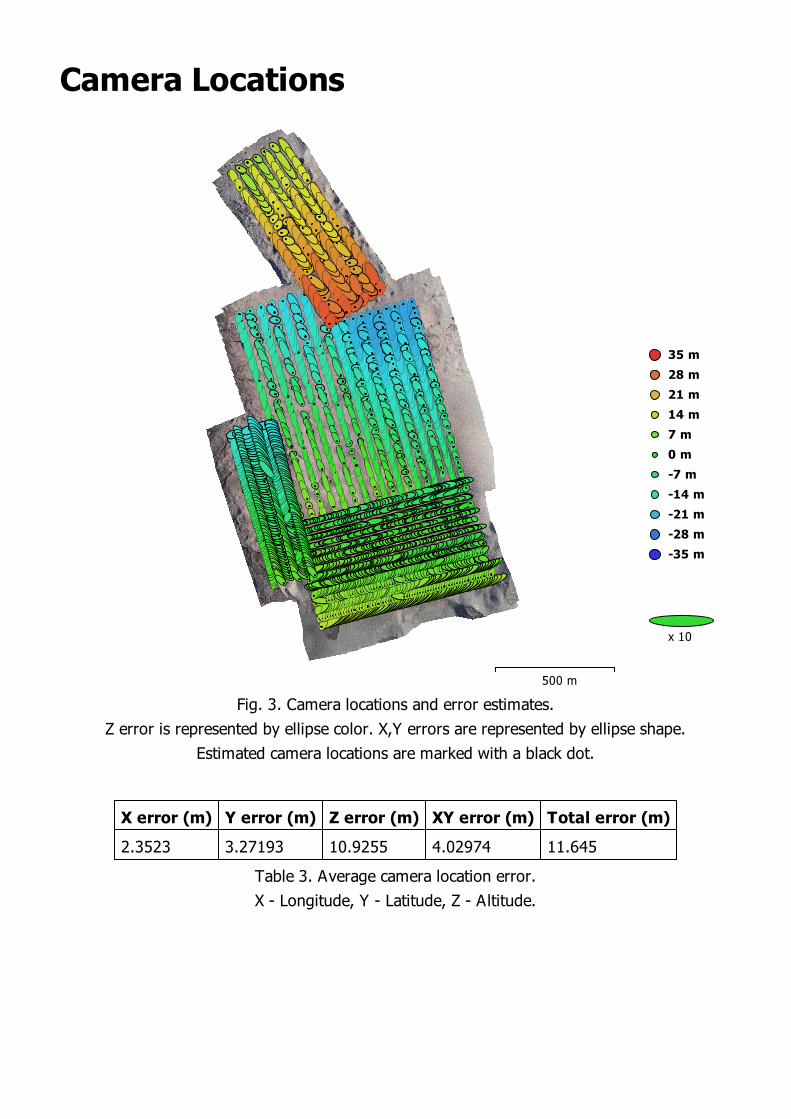
Camera Locations
500 m
-35 m
-28 m
-21 m
-14 m
-7 m
0 m
7 m
14 m
21 m
28 m
35 m
x 10
Fig. 3. Camera locations and error estimates.
Z error is represented by ellipse color. X,Y errors are represented by ellipse shape.
Estimated camera locations are marked with a black dot.
X error (m) Y error (m) Z error (m) XY error (m) Total error (m)
2.3523 3.27193 10.9255 4.02974 11.645
Table 3. Average camera location error.
X - Longitude, Y - Latitude, Z - Altitude.
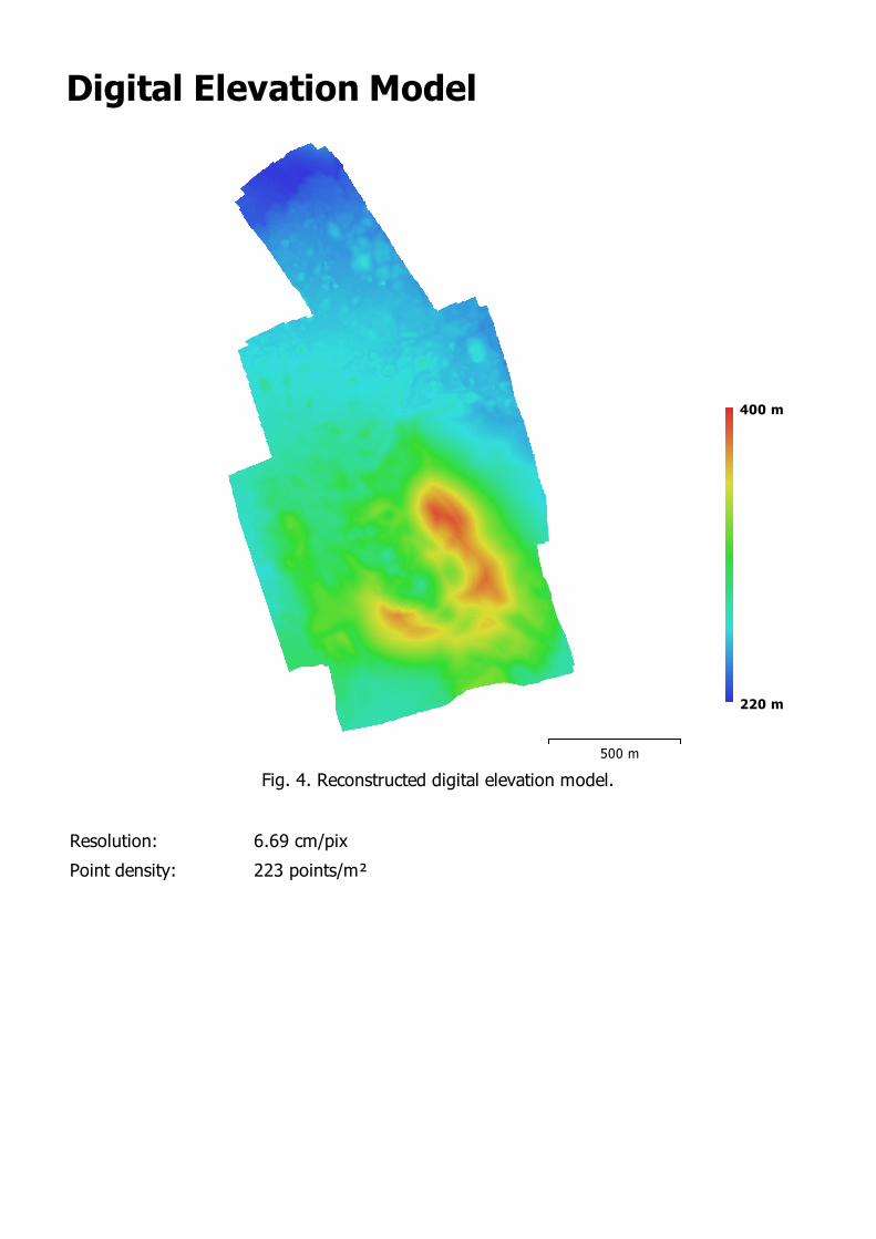
Digital Elevation Model
500 m
220 m
400 m
Fig. 4. Reconstructed digital elevation model.
Resolution: 6.69 cm/pix
Point density: 223 points/m²

Processing Parameters
GeneralCameras 2024Aligned cameras 2024Coordinate system WGS 84 (EPSG::4326)Rotation angles Yaw, Pitch, Roll
Point CloudPoints 694,271 of 786,683RMS reprojection error 0.211023 (0.539165 pix)Max reprojection error 0.927127 (29.0434 pix)Mean key point size 2.50253 pixEffective overlap 11.9145Alignment parameters
Accuracy HighGeneric preselection YesReference preselection YesKey point limit 40,000Tie point limit 4,000Adaptive camera model fitt ing YesMatching time 4 hours 19 minutesAlignment time 20 minutes 15 seconds
Optimization parametersParameters f, cx, cy, k1-k3, p1, p2Fit rolling shutter NoOptimization time 50 seconds
Dense Point CloudPoints 562,821,095Reconstruction parameters
Quality HighDepth filtering MildDepth maps generation time 8 days 18 hoursDense cloud generation time 4 days 13 hours
ModelFaces 112,004,430Vertices 56,020,326Texture 4,096 x 4,096, uint8Reconstruction parameters
Surface type Height fieldSource data DenseInterpolation EnabledQuality HighDepth filtering MildFace count 112,564,142Processing time 53 minutes 43 seconds
Texturing parametersMapping mode GenericBlending mode MosaicTexture size 4,096 x 4,096Enable color correction NoEnable hole filling YesUV mapping time 30 minutes 22 secondsBlending time 4 hours 15 minutes
DEMSize 28,247 x 41,366Coordinate system WGS 84 (EPSG::4326)Reconstruction parameters
Source data Dense cloud

Interpolation EnabledProcessing time 10 minutes 47 seconds
OrthomosaicSize 39,312 x 66,706Coordinate system WGS 84 (EPSG::4326)Channels 3, uint8Reconstruction parameters
Blending mode MosaicSurface MeshEnable color correction NoEnable hole filling YesProcessing time 18 hours 48 minutes
SoftwareVersion 1.3.2 build 4205Platform Windows 64


![Robot Raconteur® using C# - Amazon S3 · single float int8 sbyte uint8 byte int16 short uint16 ushort int32 int uint32 uint int64 long uint64 ulong double[] double[] single ... If](https://img.pdfslide.us/doc/110x75/5adb19417f8b9ae1768e1513/robot-raconteur-using-c-amazon-s3-float-int8-sbyte-uint8-byte-int16-short-uint16.jpg)