Embed Size (px)
Citation preview

AGENDA ITEM NO .... 2 ..........
North L ana rks hire
Council
Planning Applications for consideration of PI an n i n g and Transport at ion Com m it t ee
Committee Date: 22 JANUARY 2014
Ordnance Survey maps reproduced from Ordnance Survey with permission of HMSO Crown Copyright reserved
1
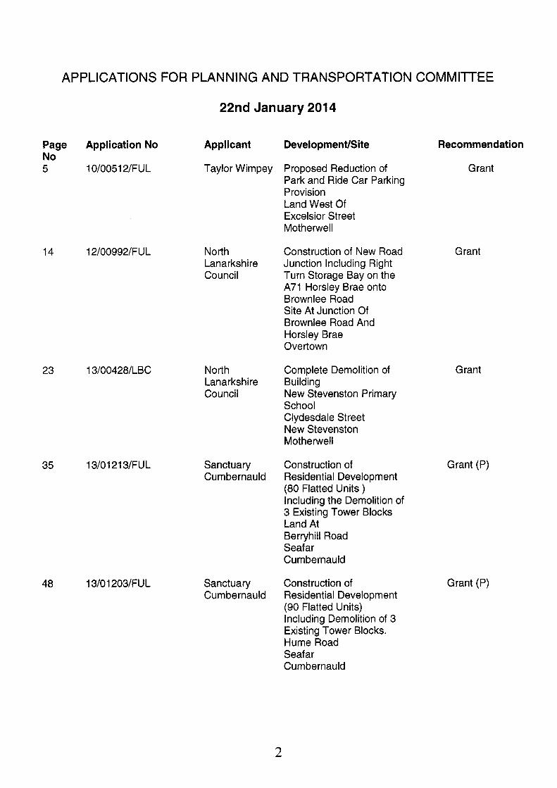
APPLICATIONS FOR PLANNING AND TRANSPORTATION COMMllTEE
22nd January 201 4
Page No 5
14
23
35
48
Application No
10/00512/FUL
12/00992/FUL
13/00428/LBC
13/01 21 3/FUL
1 3/0 1 203/FU L
Applicant
Taylor Wimpey
North Lanarkshire Council
North Lanarkshire Council
Sanctuary Cumbernauld
Sanctuary Cumbernauld
Development/Site
Proposed Reduction of Park and Ride Car Parking Provision Land West Of Excelsior Street Motherwell
Construction of New Road Junction Including Right Turn Storage Bay on the A71 Horsley Brae onto Brownlee Road Site At Junction Of Brownlee Road And Horsley Brae Overtown
Complete Demolition of Building New Stevenston Primary School Clydesdale Street New Stevenston Motherwell
Construction of Residential Development (80 Flatted Units ) Including the Demolition of 3 Existing Tower Blocks Land At Berryhill Road Seafar Cumbernauld
Construction of Residential Development (90 Flatted Units) Including Demolition of 3 Existing Tower Blocks. Hume Road Seafar Cumbernauld
Recommendation
Grant
Grant
Grant
Grant (P)
Grant (P)
2

62 13/01 204/FUL Sanctuary Cumbernauld
75 13/01 983/FUL Mr & Mrs Derek McLeod
81 13/021 19/FUL Mrs Linda Hamilton
90 13/02161/FUL Mr & Mrs Alan Jane Fowler
95 1 3/02 1 66/FU L Mr David Stirling
Construction of Grant (P) Residential Development (39 Residential Flatted Units) Including the Demolition of Care Home. Ochil View Residential Home Hume Road Seafar Cumbernauld Glasgow
Erection of Dwellinghouse Refuse Site to North West of Rimmon Cottage Benhar Road Shotts
Construction of Cattery Grant Building (Sui Generis), Format ion of Access, Parking Area, Associated Landscaping and Temporary Caravan Accommodation Site At Junction Of Cameron Road And Old Biggar Road Riggend
Change of Use of Land to Private Garden Ground and Construction of Ancillary Summerhouse and Timber Decking (in restrospect) Ivy Cottage 500 Allanton Road Allanton Shotts
Grant
Local Centre/Retail Development 6 Units (Class 1, Class 2, Class 3 and Hot-Food Takeaway) Site South Of Arran Avenue Sikeside Coatbridge
Grant
3
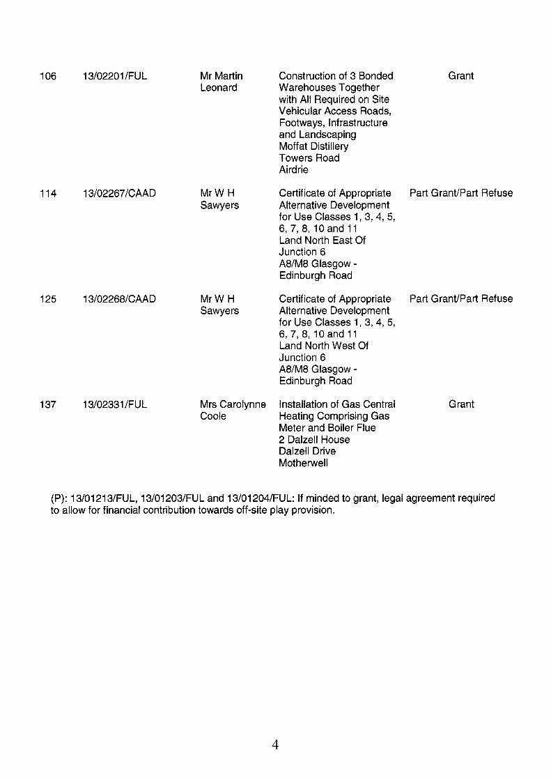
106 13/02201/FUL
114 13/02267/CAAD
125 13/02268/CAAD
137 13/02331 /FUL
Mr Martin Leonard
MrW H Sawyers
MrW H Sawyers
Mrs Carolynne Coole
Construction of 3 Bonded Warehouses Together with All Required on Site Vehicular Access Roads, Footways, Infrastructure and Landscaping Moffat Distillery Towers Road Airdrie
Grant
Certificate of Appropriate Alternative Development for Use Classes 1, 3,4, 5, 6,7,8,10 and 11 Land North East Of Junction 6 A8/M8 Glasgow - Edinburgh Road
Part GranVPart Refuse
Certificate of Appropriate Alternative Development for Use Classes 1, 3,4, 5, 6,7,8,10 and 11 Land North West Of Junction 6 A8/M8 Glasgow - Edinburgh Road
Part Grant/Part Refuse
Installation of Gas Central Heating Comprising Gas Meter and Boiler Flue 2 Dalzell House Dalzell Drive Motherwell
Grant
(P): 13/01213/FUL, 13/01 203/FUL and 13/01204/FUL: If minded to grant, legal agreement required to allow for financial contribution towards off-site play provision.
4

Application No:
10/00512/FUL
Proposed Development:
Formation of Park and Ride Facility Comprising of 25 Spaces Site Address:
Land West Of Excelsior Street Motherwell ML1 2JU
Date Registered:
14th May 201 0
Applicant: Taylor Wimpey Ground Floor Cirrus Building Glasgow Airport Business Park Marchburn Drive Paisley PA3 2SJ Application Level: Local Application
Agent: NIA
Contrary to Development Plan: No
Ward: Representations: 01 8 Motherwell South East And Ravenscraig Kaye Harmon, Thomas Lunny, Gary O'Rorke, Alan Valentine,
8 letters of representation received from 4 parties.
Recommendation: Approve Subject to Conditions
Reasoned Justification:
The proposed development is considered acceptable when assessed against the North Lanarkshire Local Plan in that it will provide and aid the use of sustainable transport and will not adversely affect the character of the surrounding residential area.
5

Repduoled by petmission dtheOwhante Sumq on kehalfofHMSO. B C m Copytiglt and database n@
Ordnance Sutwy Licemenumber i00023396.
m9. MHgM m w d . MLI 2JU Formation o f Park and Ride Facility Comprising I A I
P roduoe d by 10/005121FUL Planning and Regeneration N Regeneration and Enrironm Land West Of, Excelsior Street, Motherwell North Lanrrkshlrc C
Fleming House 2 Tryst R odd Cumbemruld QV IJW
Taylor Wimpey
of 25 Spaces * Representation 6

Proposed Conditions:-
1.
2.
3.
4.
5.
6.
7.
That, except as may otherwise be agreed in writing by the Planning Authority, the development shall be implemented in accordance with drawing number AL(0)OI Rev D.
Reason: To clarify the drawing on which this approval of permission is founded.
That BEFORE the development hereby permitted starts, full details of the design and location of all fences and walls to be erected on the site shall be submitted to, and approved in writing by the Planning Authority and thereafter erected in accordance with the details approved under the terms of this condition, prior to the site being brought into use.
Reason: In the interests of the amenity of the site and the general area.
That BEFORE the development hereby permitted starts, a scheme of landscaping, shall be submitted to, and approved in writing by the Planning Authority, and it shall include:-
(a) Details of any earth moulding and hard landscaping, boundary treatment, grass seeding and turfing; (b) A scheme of tree and shrub planting, incorporating details of the location, number, variety and size of trees and shrubs to be planted. The scheme shall include native species such as Hazel, Rowan, Sycamore, Cherry and Willow; (c) A timetable for completion of these works contemporaneously with the development.
Reason: In the interest of the car park users and the amenity of the general area
That all works included in the scheme of landscaping and planting, approved under the terms of condition 3; above, shall be implemented in accordance with the approved timetable associated with the phasing of the development and any trees, shrubs, or areas of grass which die, are removed, damaged, or become diseased, within two years of the completion of the landscaping, shall be replaced within the following year.
Reason: In the interest of the car park users and the amenity of the general area.
That before the development hereby permitted is brought into use, all the parking and manoeuvring areas shown on the approved plans, shall be levelled, properly drained, surfaced in a material which the Planning Authority has approved in writing before the start of surfacing work and clearly marked out.
Reason: In the interest of the amenity of the site and the general area.
That BEFORE any works of any description start on the application site, unless otherwise agreed in writing with the Planning Authority, a comprehensive site investigation report shall be submitted to and for the approval of the said Authority. The investigation must be carried out in accordance with current best practice advice, such as BS 10175: 'The Investigation of Potentially Contaminated Sites' or CLR 11, The report must include a site specific risk assessment of all relevant pollution linkages and a conceptual site model. Depending on the results of the investigation, a detailed Remediation Strategy may be required.
Reason: To establish whether or not site decontamination is required in the interests of the amenity and wellbeing of future users of the car park and pedestrians.
That any remediation works identified by the site investigation required in terms of Condition 6, shall be carried out to the satisfaction of the Planning Authority, A certificate (signed by a chartered Environmental Engineer) shall be submitted to the Planning Authority confirming that any remediation works have been carried out in
7

accordance with the terms of the Remediation Strategy.
8.
9.
10.
11.
Reason: To establish whether or not site decontamination is required in the interests of the amenity and wellbeing of future users of the car park and pedestrians.
That BEFORE the development hereby permitted starts, unless otherwise agreed in writing with the Planning Authority, full details of the proposed surface water drainage scheme shall be submitted to the said Authority and shall be certified by a chartered civil engineer experienced in drainage works as complying with the most recent SEPA SUDS guidance.
Reason: To ensure that the drainage scheme complies with best SUDS practice to protect adjacent watercourses and groundwater.
That the SUDS compliant surface water drainage scheme approved in terms of Condition 8 shall be implemented contemporaneously with the development in so far as is reasonably practical. Within three months of the construction of the SUDS, a certificate (signed by a Chartered Civil Engineer experienced in drainage works) shall be submitted to the Planning Authority confirming that the SUDS has been constructed in accordance with the relevant SEPA SUDS guidance.
Reason: To safeguard adjacent watercourses and groundwater from pollution
That PRIOR to the commencement of development, the applicant shall provide written confirmation to the Planning Authority that all the requirements of Scottish Water can be fully met to demonstrate that the development will not have an impact on their assets, and that suitable infrastructure can be put in place to support the development.
Reason: To ensure the provision of satisfactory drainage arrangements.
The BEFORE any works of any description start on the application site, details of all external lighting, including any provision for C C N Cameras, for within the site shall be submitted to and approved by the Planning Authority, and shall thereafter be installed in accordance with the details approved under the terms of this condition.
Reason: In the interests of visual amenity of the site and the general area.
8

Backaround Paoers:
Consultation Responses:
Memo from Transportation received 2!jth May 2010 and 24'h December 2013. Letters from Strathclyde Passenger Transport received 27th May 201 0 and 20th January 201 1, Letter from Network Rail received 7th June 2010 and 23'd September 2013.
Contact Information:
Any person wishing to inspect these documents should contact Mr Fraser Miller at 01236 632503
Report Date:
1 3'h January 201 4
9

APPLICATION NO. 10/00512/FUL
1.
1 .I
2.
2.1
3.
3.1
4.
4.1
5.
5.1
6.
6.1
6.2
6.3
7.
7.1
Site DescriDtion
The application site measures approximately 0.87 hectares and comprises of open land with grass and soil throughout. There are no mature trees on the site, however the eastern boundary has some landscaping on it backing onto the dwellings beyond. The application site is bounded by dwellings to the east, south and west and by the railway line with Shieldmuir Station beyond to the north. A footpath runs the full length of the site, connecting the site from Range Road to the railway bridge that links into Shieldmuir Station.
Proposed Develoament
The applicant seeks planning permission for the construction of a 25 space surface level car park as a ’park and ride’ facility serving Shieldmuir Railway Station. The car park will be served via a new access on Range Road at the mid point of the site. The new access road is to run the length of the eastern boundary of the site for a length of 115 metres linking in with the parking area comprising of 25 spaces. The car park is proposed to occupy 0.07 hectares of the northern section of the site, with the remaining section of the site being landscaped with the potential for future development opportunities. It is anticipated that lighting columns are to be spread evenly throughout the site.
Applicant’s Supaortina Information
No additional information has been submitted in support of the application.
Site History
The area of ground was originally proposed as a Park and Ride facility for Shieldmuir Station. Planning Approval 07/01652/AMD for the Amendment to Condition 2 (a) of 03/01302/REM relating to the park and ride facility required the park and ride facility to be finished and operational before the completion of the 20th last dwellinghouse. However, following the submission of the current applicatb: for the Reduction of the Park and Ride Parking Facility to 25 Spaces on the 14 May 2010, the applicant seeks to reduce the required provision from circa 100 spaces.
The site is zoned as HCFlA (Residential Amenity) in the North Lanarkshire Local Plan.
Consultations
Transportation raised no objections to the proposal.
Strathclyde Passenger Transport have requested the provision of CCTV and lighting within the site in order that the site could be considered for inclusion within railway ownership.
Network Rail raised no objections to the proposed development.
Eight letters of representation have been received from four parties following the neighbour notification and press advertisement procedures. It should be noted that following the submission of an amended plan and the re-notification of neighbours on the 1 gth November 201 3, no additional letters were received. A summary of the points raised is detailed below:
10

8.
8.1
8.2
The landscaped buffer between the proposed park and ride is insufficient and is 1 metre from the boundary fences which is only 10 metres from the rear elevation of the objector’s property. There will be an adverse impact on residential amenity by virtue of lighting from lighting columns and vehicle lights due to the decreased size of landscaped buffer. The outlook from the objector’s property will be impacted upon as it will now consist of a bland car park with little or no landscaping. Noise pollution from vehicles utilising the site in the early hours of the morning and at night time. Furthermore there may be issues of car alarms being set off adding to noise from the development. There are increased concerns over the security of residential properties as there has been a number of acts of vandalism in this area with youths congregating on the paths and at the bridge. What is the rational behind the reduced car park facility? Is there the possibility of a residential development on the remaining land? As the increased length of road would suggest so. Are there measures proposed for traffic calming on the access road? Will additional planting be planted along the Colville Gardens boundary? It is requested that the existing footpath be removed as a footpath will be provided on either side of the proposed access road. When is the facility to be built and what are the construction hours proposed? The impact of the development on the objector‘s property will adversely impact upon the property value of the dwelling.
In addition to the objections received there has been local concern raised about the general appearance of the site and of the delays in the construction of the proposed facility.
Plannina Assessment
In accordance with Section 25 of Town and Country Planning (Scotland) Act 1997, planning decisions must be made in accordance with the development plan, unless material considerations indicate otherwise. The application raises no strategic issues, it can therefore be assessed in terms of the local plan policies. In the North Lanarkshire Local Plan (NLLP) the site is zoned as HCFIA (Residential Amenity).
Policy HCF1 A seeks to protect the established amenity of residential areas and states that developments of an ancillary nature may be acceptable subject to the assessment of the impact on residential amenity and provision for servicing and parking. The site was identified within the original planning application for the residential development as a site for a park and ride facility with approximately 100 spaces. The majority of the site was proposed to be developed and the timescales for its implementation was amended under planning approval 07/01 652/AMD requiring the park and ride facility to be finished and operational before the completion of the 20th last dwelling. This timescale was not adhered to and following negotiations in 201 0 between the applicant, Network Rail, Strathclyde Passenger Transport and the Council an agreement was reached for the provision of a smaller park and ride facility that was to provide 25 spaces. In assessing the amended layout, 0.07 hectares of the 0.87 hectare site is to be developed and the site layout and end use will retain an open aspect at this location. Planning conditions are recommended to provide a suitable landscaping scheme around the perimeter of the car park and throughout the site to reduce the visual impact of the park and ride facility. Furthermore, following the submission of amended plans, a landscaped buffer of 10 metres is to be formed between the facility and the rear garden fences of the dwellings to the west of the site. Pedestrian access is maintained throughout the site with a footpath being located on either side of the access road and through maintaining the pedestrian links to the railway over the bridge and onto Range Road. Currently on street parking is in existence on Range Road by users of Shieldmuir Station and the proposed car park
11

would therefore reduce the impact on the existing on street parking in the surrounding streets. The delays in the progression of the scheme have been caused by the need to get agreement on the transfer of the land to Network Rail and First Scotrail for the ongoing management and maintenance of the site and for amendments to the road to access the scheme to allow for adoption by the Council. It is considered that the use of this site as a park and ride facility acceptably relates to the original planning approval that covered the site and the wider residential area and that its introduction would not significantly impact on the character and amenity of this area and complies with the requirements of policy HCFI A.
The NLLP also requires proposed developments to be assessed against policies DSP 1 (Amount of Development), DSP 2 (Location of Development), DSP 3 (Impact of Development) and DSP 4 (Quality of Development). Given the scale and nature of the development, Policies DSP 1-3 would not be of relevance to this application.
8.3
8.4 Policy DSP4 (Quality of Development) indicates that developments should integrate successfully with the surrounding area and avoid harm to the neighbouring amenity by relating well to the existing context and avoiding adverse impact on existing properties through loss of amenity including noise and disturbance. It also indicates that consideration should be given to siting, layout, scale, materials and access. The development relates to the formation of a car park, which on balance, is considered acceptable. In this case, it is considered that, given the size and nature of the application site, that there will be a minimal impact on the rear gardens of the dwellings to the east and west of the site. There are no trees within the application site, however a planning condition is recommended ensuring that a landscaping scheme is submitted to ensure appropriate planting is undertaken to create a buffer between the rear fences of the adjacent dwellings and the car park. Furthermore, a planning condition requiring further details on lighting and CCTV provision along with finalised details of boundary treatments, including any requirements for fencing around the perimeters of the site is also proposed. The proposed design and layout of the site is considered to be acceptable in this location. With regards to the drainage implications of the development, the developer will be required to submit confirmation that the design and construction of the drainage infrastructure is in accordance with the requirements of SEPA and Scottish Water. The development is therefore in accordance with policy DSP 4.
Consultations:
With regard to the consultation responses, Transportation have raised no objections to the scheme following the inclusion of a turning facility.
8.5
Retxesentations:
In terms of representations received, it is advised that the impact on the amenity and privacy of adjacent properties, transportation issues and noise have been discussed in paragraphs 8.2 to 8.4 above. Anti-social behaviour would be a matter for the local police and the impact of the development on property values is not a material consideration in the assessment of the application. Conditions are proposed to secure the submission and implementation of a landscaping scheme, fencing details, drainage, lighting and for the provision of CCTV. The existing footpath links in with the footpath that runs through the residential area and there are no proposals to remove this well used pedestrian link. Confirmation of the start date is to be received in the event that the application is approved and the hours for the construction of the facility would be controlled through separate legislation enforced by Protective Services.
8.6
9. Conclusions
9.1 In conclusion, this application has to be assessed against the relevant policies of the Development Plan unless there are material considerations which indicate otherwise.
12

In this instance, it is considered that the principle of the development has been established through the original permission for the park and ride facility. Following the detailed assessment of the application and the submission of amended plans, it is considered that the proposed development is acceptable when considered against the relevant policies of the North Lanarkshire Local Plan. It is therefore recommended that planning permission be granted subject to conditions.
13

Application No:
12/00992/FUL
Proposed Development:
Construction of New Road Junction Including Right Turn Storage Bay on the A71 Horsley Brae onto Brownlee Road
Site Address:
Site At Junction Of Brownlee Road And Horsley Brae Overtown
Date Registered:
5th September 201 3
Applicant: North Lanarkshire Council Traffic and Transportation Fleming House 2 Tryst Road Cumbernauld G67 1JW Application Level: Local Application
Agent: N/A
Contrary to Development Plan: No
Ward: Representations: 020 Wishaw Marion Fellows, Jim Hume, Samuel Love, Frank McKay,
5 letters of representation received from 4 parties.
Recommendation: Approve Subject to Conditions
Reasoned Justification:
The proposed widening of the road to accommodate the junction improvements is considered acceptable in terms of the relevant policies of the North Lanarkshire Local Plan. It is considered that the road improvements are unlikely to have a significant adverse impact on existing uses around the road junction or lead to a significant loss of land from the area surrounding the road to the detriment of the Green Belt and the area of Great Landscape Value.
14

ofb-Suva).m
zcii~~m -suv* -n-1mZf396
WofHMSoOamn
PLANNING APPLICATION 12/00992/FUL
Right Turn Storage Bay on the A71 Horsley Brae onto Brownlee Road Site At Junction Of Brownlee Road And Horsley Brae Ovettown 5 Representations outwith Map Area
Construction of New Road Junction Including Produced by Pknnlrg and Repnerabn Regeneratton 6 Ernlronmental Sew North Lanarkshire Council mmtw HW 2 Tryst Road Cumbemaukl G67 1JW 1 5

Proposed Conditions:-
1.
2.
3.
4.
5
That the development hereby permitted shall be carried out strictly in accordance with the approved details submitted as part of the application and no change to those details shall be made without prior written approval of the Planning Authority.
Reason: To clarify the drawings on which this approval of permission is founded.
That before the development hereby permitted starts unless otherwise agreed in writing with the Planning Authority, a detailed scheme of landscaping shall be submitted to, and approved in writing by the Planning Authority, and it shall include:-
(a) details of any earth moulding and hard landscaping, boundary treatment, grass seeding and turfing; (b) a scheme of tree and shrub planting, incorporating details of the location, number, variety and size of trees and shrubs to be planted; (c) an indication of all existing trees and hedgerows, plus details of those to be retained, and measures for their protection in the course of development;
Reason: To enable the Planning Authority to consider these aspects in detail.
That all works included in the scheme of landscaping and planting, approved under the terms of condition 2 above, shall be completed in accordance with the approved schedule, and any trees, shrubs, or areas of grass which die, are removed, damaged, or become diseased, within two years of the development hereby permitted becoming operational shall be replaced within the following year with others of a similar size and species unless otherwise agreed in writing with the Planning Authority.
Reason: To ensure the implementation of the landscaping scheme in the interest of amenity.
That prior to the removal of the trees within the site, a further bat potential survey shall be carried out and if potential is found, a bat emergence survey shall be undertaken, the said surveys shall thereafter be submitted to and approved in writing by the Planning Authority before the removal of the trees. As a result of the study, should any remediation measures be required for the relocation of any protected species, this shall be implemented in accordance with a timetable agreed in writing with the Planning Authority in consultation with Scottish Natural Heritage, prior to the removal of trees within the application site.
Reason: To ensure compliance with Schedule 5 of the Wildlife and Countryside Act 1981 (as amended) and Schedule 2 of the Conservation (Natural Habitats &c.) Regulations 1994.
That all works to the trees to be felled or the subject of trimming, canopy reduction or other arboricultural works shall be section felled/trimmedtfs detailed in section 6.2 of the Ecological Assessment by Alpha Ecology Ltd dated 6 December 201 3. The trees shall be the subject of a dawn survey and climbing inspection by an experienced tree- surgeon, using an endoscope where required, prior to removal by section felling. In the event that bats are found at any point during the tree works, a European Protected Species License will be required to be obtained from Scottish Natural Heritage and tree works shall cease with immediate effect with the relocation of any protected species being implemented in accordance with a timetable agreed in writing with the Planning Authority in consultation with Scottish Natural Heritage prior to tree works recommencing.
Reason: To ensure compliance with Schedule 5 of the Wildlife and Countryside Act 1981 (as amended) and Schedule 2 of the Conservation (Natural Habitats &c.) Regulations 1994.
16

6. In the event that site clearance cannot be restricted to being outwith the breeding bird season March - August inclusive, the site must be inspected by a suitably qualified ecologist for nesting birds within 48 hours of commencing site clearance. Site clearance will be restricted to safe working distances from any nesting sites that are found (as determined by the ecologist) until the birds have completed nesting. Nesting sites must be demarcated with fencing to prevent disturbance from site clearance.
Reason: To ensure compliance with the Wildlife & Countryside Act 1981.
7. That the works associated with the Badger Sett exclusion and destruction shall be carried out in accordance with Method Statement submitted by Alpha Ecology Ltd and, for the avoidance of doubt the works hereby permitted shall only commence once it has been demonstrated to the satisfaction of the planning authority, that a License has been obtained from Scottish Natural Heritage.
Reason: To define the permission.
8. That BEFORE the development hereby permitted starts, a Badger Protection Plan, addressing the protection of Badgers, Badger Setts and access to their foraging ground, shall be submitted to the Planning Authority for approval in conjunction with SNH. Full details of protection and mitigation measures are to be provided and all approved mitigation works are to be carried out to the satisfaction of the Planning Authority and SNH prior to works starting on the site.
Reason: In the interests of nature conservation and for the protection of Badgers and their safe access to foraging grounds.
9. That before the development hereby permitted starts, tree protection measures in accordance with BS 5837 shall be erected along the drip line of the trees on the northern section of the A71 B7011 junction, and shall not be removed without the approval in writing of the Planning Authority.
Reason: To maintain the contribution of existing trees to the landscape quality of the area and to ensure that the trees on the southern, western and northern boundaries are protected during the works.
10. That PRIOR to any works of any description being commenced on the application site, an appropriate programme of remedial works to stabilise coal mine workings within the site shall be submitted to and approved in writing by the Planning Authority in conjunction with The Coal Authority.
Reason: To ensure that the coal mine workings within the site are stabilised in the interests of the safety of future users of the site.
11. That prior to the development being brought into use, the remediation works identified and required in terms of Condition 10 above shall be completed and a certificate (signed by a Chartered Environmental Engineer) shall be submitted to the Planning Authority confirming that any remediation works have been carried out in accordance with the terms of the Remediation Strategy.
Reason: To ensure that the coal mine workings within the site are stabilised in the interests of the safety of future users of the site.
17

Backaround PaDers:
Consultation Responses:
Memo from Protective Services receivy? 24'h September 201 3 Memo from Transportation received 11 September 2013. Memos from Greenspace received on the 22"d October, 20th December 201 3 and 6'h January 2014. Letter from the Coal Authority received 24'h September 201 3.
Contact Information:
Any person wishing to inspect these documents should contact Mr Fraser Miller at 01 236 632503
Report Date:
1 3'h January 201 4
18

APPLICATION NO. 12/00992/FUL
REPORT
1.
1.1
2.
2.1
3.
3.1
4.
4.1
5.
5.1
6.
6.1
6.2
6.3
6.4
Site DescriDtion
The application site extends to 1.4 hectares and comprises of a 370 metre section of the A71 Horsley Brae a 170 metre section of the 87011 Brownlee Road and a 27 metre stretch of the private access road on the western side of the A71 opposite the Brownlee Road, to the North of the Garrion Bridge. The application site comprises of the road and a 21 metre buffer on the eastern side of the carriageway. The road rises from the south to the north and decreases steeply onto the Brownlee Road. The application site is bounded by open land to the west, the Garrion Bridge Garden Centre to the south east, with open land to the east and by a wooded area on the northern and southern side of the Brownlee Road. Hedging runs the length of the road on both sides and there are three mature trees on the south eastern side of the road between the Garden Centre and the Brownlee Road junction.
ProPosed DeveloPment
Planning permission is sought to increase the width of the public road to form a new junction on the A71 and the B7011 and to form a new right hand storage bay on the A71 onto the 8701 1. A number of alterations are proposed within the carriageway in addition to a reduction in the speed limit to 30 mph. These aspects of the development have been designed in accordance with the requirements of the road design under the Roads (Scotland) Act 1984 and the Design Manual for Roads and Bridges (DMRB). The application is a joint project between South Lanarkshire Council and North Lanarkshire Council.
Amticant’s Sumortina Information
The applicant has submitted a Coal Mining Risk Assessment and a Protected Species Survey in connection with the application.
Site Historv
No relevant site history.
DeveloDment Plan
The application site is zoned as NBE 3A Assessing Development in the Green Belt, NBEl A3b Area of Great Landscape Value and NBEl A4a Site of Importance for Nature Conservation in the North Lanarkshire Local Plan.
Consultations
Transportation raised no objections to the proposed development.
Protective Services have raised no objections
Greenspace requested the submission of a Protected Species Survey and, following its receipt, have advised of the requirement for additional survey work to be undertaken and of the requirement for the applicant to obtain licenses from Scottish Natural Heritage.
The Coal Authority have raised no objections subject to the imposition of a planning condition requiring further investigation works, prior to the commencement of the development.
19

7.
7.1
a.
8.1
8.2
8.3
Representations
Five letters of representation have been received from four parties following the neighbour notification and press advertisement procedures. The issues raised are summarised below:
1. 2.
3.
4.
5. 6.
7.
8. 9.
10.
There was no neighbour notification carried out advising of the application. The amendments to the access road that leads to the farm will not allow daily procedures to be carried out as unrestricted access is required onto the A71. The proposed junction arrangement would restrict vehicles turning right from the private road onto the A71. It has been asked if the junction to be shown to work with all the vehicle types for all current and proposed permitted movements, on vertical and horizontal plan. Furthermore, there are concerns that the right turn restriction from the access road will lead to people carrying out banned movements adversely impacting upon road safety. Have the designs been developed and appraised? What other options were considered and how the effect of the designs would impact upon the local rural community? Were there workshops or consultations? Questions over the benefits and dis-benifits of the plans in terms of access, accident reduction and increased mileage of the local community. Has a road safety audit been carried out? What consideration has been made for emergency vehicles to access the private road? Are the bus stops to be retained at their current position and where will the shelters be? What assessment has been carried out in relation to vulnerable road users? Are street lights proposed and what would the impact be on insects and mammals? The proposals offer no solution to the issue of traffic flows and seek to relocate the issue 20 metres down the road representing a misuse of public funds.
Planninu Assessment
In accordance with Section 25 of Town and Country Planning (Scotland) Act 1997, planning decisions must be made in accordance with the development plan, unless material considerations indicate otherwise. The application raises no strategic issues, it can therefore be assessed in terms of the local plan policies. In the North Lanarkshire Local Plan (NLLP) the site is zoned as NBE 3A Assessing Development in the Green Belt and NBEl A3b Area of Great Landscape Value. A section of the site to the north and south of Brownlee Road is zoned NBE1 A4a (Site of Importance for Nature Conservation).
Policy NBE 3A (Green Belt) seeks to protect the character and promote development in the Green Belt by restricting development to acceptable types whilst Policy NBEl A3b states that permission will only be granted for proposals that have demonstrated that there will be no adverse impacts or that any impacts can be mitigated in environmental terms. The application site extends into a Site of Importance for Nature Conservation that is on both sides of the Brownlee Road. Policy NBEl A4a applies and seeks confirmation that there will be no adverse impacts or that any impacts can be appropriately mitigated.
The land covered by these local plan policies aligns the road and mainly covers areas which require minor earthworks and landscaping associated with the proposals. Given that the land involved is marginal in terms of size and scale and is restricted to open land mostly to the east of the existing road, the proposed development would not adversely affect the function and character of the Green Belt and the Area of Great Landscape Value from being included in the proposals. These areas of land have been included following the preparation of a detailed scheme that allows for the formation of a right hand storage bay from the A71 onto the 87011 to reduce
20

congestion at this junction. It is considered that in this case, the proposed marginal encroachment into Green Belt and a Site of Importance for Nature Conservation within the Area of Great Landscape Value can be accommodated without detriment to the surrounding area.
Policies DSP 1-3 (Amount, Location and Impact of Development): Given the scale and nature of the development, Policies DSP 1-3 would not be of relevance to this application.
8.5 DSP4 (Quality of Development) indicates that developments should integrate successfully with the surrounding area and avoid harm to the neighbouring amenity by relating well to the existing context and avoiding adverse impact on existing properties through loss of amenity including noise and disturbance. It also indicates that consideration should be given to siting, layout, scale, materials and access.
In assessing the impact of the proposed development on the area, it is considered that the proposed amendments to the junction will integrate well with their location. In this instance, it should be noted that as the proposed development involves the upgrading of the A71 and B7011 junction, the design principles are limited given the requirements of the road design under the Roads (Scotland) Act 1984 and the Design Manual for Roads and Bridges (DMRB). The proposed development is not considered to adversely affect the character of the area or have any significant long term adverse visual impacts on the landscape. Whilst traffic flow will be impacted upon at the construction phase, this is considered to be a short term issue of a temporary nature. There is considered to be no overriding adverse impacts on natural habitats given the minor nature of tree removal and earthworks. Whilst there is evidence of protected species adjacent to the site, appropriate mitigation measures have been detailed and these measures are to be implemented in accordance with the requirements of Greenspace and appropriate planning conditions are proposed to secure this. Some tree works are required, mostly those that adjoin the carriageway on the eastern side of the A71 and whilst no landscaping details have been submitted at this stage, a planning condition is recommended to ensure that a full detailed scheme is submitted prior to the commencement of works on site detailing suitable replacement planting. The trees on the periphery of the site are not to be affected by the development, however, it is considered appropriate to ensure that tree protection measures are installed prior to the start of works on site and that prior to the lopping/topping of trees, a further survey be carried out to ensure that no statutory protected species would be adversely impacted upon. The proposed junction improvement works will support the transportation links into the area to encourage greater transport connections relieving a long standing area of congestion at peak times. It is therefore considered that subject to the recommended conditions, the proposal complies with the relevant criteria contained in Policy DSP4.
8.4
8.6
8.7 In connection with the comments received from consultees, planning conditions are attached to meet with the requirements of Greenspace Services and the Coal Authority.
8.8 In response to the letters of representation received, the respective responses should be noted:
1.
2.
The standard neighbour notification procedures were carried out and on the grounds that land without an associated postal address adjoined the boundary of the application site a neigVFour notification advertisement was displayed in the Wishaw Press on the 18 September 2013. A number of turning track movements were carried out by Transportation and these have been modelled against the proposed layout and the models highlight that the left and right turns from the private access on to the A71 can be carried out. There are no restrictions to be placed onto the A71 for vehicles looking to exit onto the A71 in either direction. However, given the geometry involved, there is no scope to allow a straight ahead movement
21

from the access to Brownlee Road and vice versa. The turning templates include vehicles up to the size of the maximum legal vehicles permitted by Construction Use Regulations on the road network.
The layout was assessed during the design stage using turning track diagrams to model the following manoeuvres :- a. Tractor and Hay Wagon - Left turn into access and right turn out of the
access. b. Maximum Legal Articulated Vehicle - Left turn into access and right turn
out of the access, right turn from Horsley Brae to Brownlee Road and southbound straight through on Horsley Brae.
c. Pantechnicon - Left turn into access and right turn out of the access. d. Low Loader - Left turn into access and right turn out of the access.
All the above turning track diagrams show the appropriate manoeuvres being carried out successfully.
The project is designed on design speed as per Design Manual for Roads and Bridges. It is not common practice to design on the basis of non- compliance or illegal manoeuvres. There was a STAG part 1 report prepared by Faber Maunsell and STAG Part 2 by WSP. As part of this process, a workshop was arranged for key stakeholders in the project and this was carried out prior to the submission of the application for planning permission. It should be noted that, in order to complement the proposed arrangements, a reduced speed limit of 30mph is proposed, A Stage 1 Road Safety Audit was carried out as part of the STAG process. Track diagrams were carried out as detailed at point 2 above. There are no proposals to change the bus stop locations on A71 Horsley Brae. The proposed design shows an improved pedestrian link to Brownlee Road and seeks to improve road safety at this location. There are no proposals to provide street lighting to compliment the proposals. The source and scale of the funding for the road infrastructure improvements are not material planning considerations to warrant refusal of planning permission. The proposed works are required to upgrade the existing substandard junction from the A71 to the B7011 to accommodate the additional traffic using this route.
3.
4. 5. 6.
7.
8. 9.
9 Conclusions
9.1 Taking all of the above matters into account, it is considered that the application is in accordance with Policies NBE 3A and NBel A3b through the construction of road improvement works which would support the local road network. Furthermore, it is considered that the proposal accords with Policies DSP 1 to 4 of the North Lanarkshire Local Plan and consideration has also been given to the letters of representation received in arriving at this recommendation. Drawing all matters together, it is therefore recommended that planning permission be granted subject to conditions.
22

Application No:
13/00428/LBC
Proposed Development:
Complete Demolition of Building Site Address:
New Stevenston Primary School Clydesdale Street New Stevenston Motherwell ML1 4JG
Date Registered:
21 st March 201 3
Applicant: North Lanarkshire Council Fleming House 2 Tryst Road Cumbernauld G67 IJW Application Level: Local Application
Agent: N/A
Contrary to Development Plan: No
Ward: Representations: 01 7 Motherwell North Shahid Farooq, Helen McKenna, Peter Nolan
2 online comments received.
Recommendation: Approve
Reasoned Justification :
The development meets the criteria set out in the relevant policies contained within the North Lanarkshire Local Plan and Scottish Historic Environment Policy. The development can be accommodated without detriment to the surrounding residential area.
23

A IYTb Loo
I

Proposed Conditions:-
1.
2.
3.
4.
5.
That demolition work shall not commence for at least 3 months following the date that the applicant notifies the Royal Commission on the Ancient and Historical Monuments of Scotland (RCAHMS) of their intention to carry out the work, and until it is subsequently confirmed by the RCAHMS that they are satisfied that all features of historic or architectural merit have been appropriately recorded, or that they do not wish to record it.
Reason: To enable the RCAHMS to record the building.
That demolition work shall not commence until it has been demonstrated to the satisfaction of the Planning Authority that the appropriate Licence for the addressing of bat roosts has been obtained from Scottish Natural Heritage in accordance with the recommendations of the report titled ‘Bat Survey, New Stevenston Primary, New Stevenston’ by Wild Surveys Ltd, dated 1 Oth July 201 3. Furthermore, should demolition not have taken place before June 2014, an update survey shall be submitted for the approval of the Planning Authority in consultation with Scottish Natural Heritage and thereafter the works shall be carried out in accordance with the terms approved under this condition.
Reason: To ensure compliance with The Conservation (Natural Habitats & c.) Amendment (Scotland) Regulations 2007 and to avoid any adverse impact on protected species.
That should no development occur within the site within 18 months of the date of this demolition, a report shall be submitted to and approved in writing by the Planning Authority, detailing the anticipated timescales in which development is expected to take place. If no development is scheduled at that time, a scheme of landscaping and maintenance for the site shall be submitted to and approved by the Planning Authority and shall thereafter be implemented in accordance with a timescale agreed under the terms of this condition.
Reason: To ensure that the site is not left vacant indefinitely, in the interests of amenity of the site and surrounding area.
That before demolition commences, details shall be submitted for the approval of the Planning Authority confirming the architectural/decorative features to be salvaged for re-use on the new build development, and a method statement shall be submitted detailing the means for their extraction and protection during demolition and the works shall thereafter be carried out in accordance with the details approved under the terms of this condition.
Reason: To enable the Planning Authority to consider these details in the interests of the visual amenity of the site.
That before demolition commences, details shall be submitted for the approval of the Planning Authority confirming the extent of wall/railings to be retained on site and thereafterl these boundaries shall be retained and protected during demolition in accordance with the details approved under the terms of this condition.
Reason: To enable the Planning Authority to consider these details in the interests of the visual amenity of the site.
Note to Committee
Should committee be minded to grant the development, it should be noted that under the terms of the Planning (Listed Buildings and Conservation Areas) (Scotland) Act 1997, the
25

decision would require to be referred to the Scottish Ministers in light of the nature of development involving complete demolition, and due to the Council’s status as applicant.
26

Backaround PaDers:
Consultation Responses:
Email from Historic Scotland received 4'h N%vember 2013 Letter from Scottish Civic Trust received 10 April 2012 Letter from Architectural Heritage Society received 18 April 201 3
Contact Information:
Any person wishing to inspect these documents should contact Mrs Joanne Delaney at 01236 632647.
Report Date:
1 Oth January 201 4
27

APPLICATION NO. 13/00428/LBC
REPORT
1.
1.1
1.2
2.
2.1
3.
3.1
4.
4.1
Site DescriDtion
New Stevenston primary school is a category C listed building, located on a prominent corner site between Clydesdale Street to the north, Coronation Road to the south and an unnamed road to the immediate east. Residential properties lie to the east, south and west, with open space to the north and the Glasgow-Shotts train line beyond. Vehicular access into the site is taken from Coronation Road or the unnamed side road at the north eastern corner, with pedestrian access also available from Clydesdale Street. The boundary treatments comprise dwarf stone walling with infill painted railings along the Clydesdale Street frontage, whilst a 2 metre stone wall surrounds the rear on all sides.
New Stevenston primary school is an example of a large School Board building with a striking highly crafted stone colonnaded double-height entrance hall dominating the interior spaces, surviving predominantly to its original symmetrical plan. When originally constructed in 1895, the school was single storey, being raised to two storeys shortly afterwards using the same stone detailing. The slate roof on the main school building has been renewed in recent years, although still comprises traditional ScottishNVelsh slate. An early 20th century annex is located behind the main school building, which is part single storey and part two storey. There are also several small single-storey store-type buildings on the site which are modern additions, mainly constructed from breezeblock or facing brick.
ProDosed DeveloDment
Listed building consent is sought for the complete demolition of the school. A condition is recommended to confirm the extent of walVrailings to be retained on site. The school is non-operational, the building no longer used and the demolition may enable development of residential properties as part of North Lanarkshire Council’s Building for the Future house building programme. This would be subject to assessment via a future application, although the Housing and Social WorktFervices Committee agreed to progress a scheme at the site at their meeting on 15 August 201 3.
Awlicant’s Sumortina Information
The applicant submitted supporting information justifying demolition as they considered it would provide significant benefit to the community through enabling the development of affordable housing, enhancing the visual amenity of the site, and removing a potential danger to the public, due to its deteriorating condition. The applicant also submitted background information on marketing of the site, maintenance costs, and damage reports. A demolition statement was also submitted noting that any items of architectural or historical importance will be removed by hand where necessary, prior to mechanical demolition and stored offsite for a certain period. In addition, a bat survey was undertaken which confirmed the existence of roosts within the building.
Site History
The school was in operational use until June 2006, whereafter services were relocated to a new joint campus under the Council’s schools modernisation programme. The building was declared surplus in December 2005 and no interest was expressed by any Council Service or other public sector partner agency for re- use, hence it was to be placed on the open market. When the surplus report was approved in 2005, the building was not listed and it was intended to be demolished to enable re-development and marketing of a cleared site. However, following the listing
28

4.2
4.3
4.4
5.
5.1
6.
6.1
6.2
in June 2006, a development brief was prepared seeking its refurbishmentkonversion, specifically noting that any proposals for demolition would not be considered. No minimum value, nor end use were prescribed in order to maximise market interest.
Even though it coincided with the peak of the property boom, market interest was poor with only 5 submissions, despite over 200 flyers/development briefs being issued, adverts in local and national newspapers, a ‘for sale’ board erected on site, direct mailing to recognised developers, housebuilders and property agents, a listing on the Scottish Property Network, as well as being recorded on the Buildings at Risk Register. However, the successful bidder subsequently gained consents on 16 August 2007 & 1 6‘h October 2007 for the Conversion of the Former Primary School to Residential Accommodation and Erection of 4 no Townhouses (reference nos. 07/00227/FUL & 07/00376/LBC). Unfortunately, economic decline occurred shortly thereafter and these consents were never implemented, nor the sale concluded.
The school was re-marketed in 201 0, with the campaign broadly similar to the original exercise in terms of exposure and direct mailing. The direct mailing was also extended to target various public sector agencies beyond the scope of those contacted in the original campaign. An entry was also placed on the Council’s own website. Offers were again invited with no minimum asking price and a note that any proposals for demolition would not be supported. This marketing exercise received only two offers. The first proposed conversion to a care facility, however this was not supported by Social Work Services due to the existence of local provision, coupled with policies to assist people to remain in their own homes for as long as possible. Concern was also raised that the applicant had no stated experience in the care home sector, nor conversion of listed buildings. The second offer was rejected on the basis that it did not represent best value for the Council in terms of the statutory regulations that require that ‘a local authority shall not dispose of land for a consideration less than the best that can reasonably be obtained’.
Since the 2010 re-marketing, the ‘for sale’ board has been retained on the site, alongside the listing on the Scottish Property Network and entry on the Buildings at Risk Register. To date, only one or two enquiries have been received but nothing has come of them, leading the applicant to conclude that there is no genuine market interest in the property. Since its closure, almost f 120,000 has been spent repairing the building in an attempt to keep it wind and watertight, however it has fallen victim of vandalism and lead theft and is now in a significantly deteriorated condition from water penetration and fire damage and also poses a safety risk to anyone unlawfully entering the building.
Development Plan
The site is zoned as HCF2 AI (Sites for (Short Term) Housing Development) on the adopted North Lanarkshire Local Plan (2012).
Consultations
Historic Scotland (HS) considers that further justification is required to support demolition through the submission of repair and refurbishment costs, which could then be weighed against the marketing history, new build housing proposals, and recent approaches by a charity group.
The Scottish Civic Trust (SCT) similarly considered that insufficient information was available on appraisals and detailed costs for repair. They also commented that recording of a building on the Buildings at Risk Register is not a marketing strategy in itself.
29

6.3 The Architectural Heritage Society for Scotland (AHSS) objected to the proposals and considered that a longer term view should be taken to re-use the building, beyond current negative perceptions derived from the financial situation.
7. Rewesentat ions
7.1 One online objection was received from the charity Active4Al1, highlighting that they made an application to acquire the building from the Council in July 2012 for the purposes of creating a training centre for carpentry skills to be used by the long term unemployed and other community groups. They stated that they had the expertise to reinstate the building to its original condition and believe the majority of residents wish to see the building refurbished.
7.2 A further online comment was received simply highlighting procedural requirements with respect to the obligations on the applicant to notify the Royal Commission on the Ancient and Historical Monuments of Scotland (RCAHMS) to allow recording of important features prior to demolition, in the event that consent is given.
8. Plannina Assessment
8.1 Section 14(2) of the Town and Country Planning (Listed Buildings and Conservation Areas) (Scotland) Act 1997, requires that in considering whether to grant listed building consent for any works, the planning authority shall have special regard to the desirability of preserving the building or its setting or any features of special architectural or historic interest which it possesses. As this is an application for Listed Building Consent, the appropriate policies in the adopted local plan are applicable as well as all relevant Historic Scotland policy and guidance.
National Policy - Scottish Historic Environment Policy (SHEP) December 201 1
8.2 Once lost, listed buildings cannot be replaced. They can be robbed of their special interest either by inappropriate alteration or by demolition. There is, therefore, a presumption against demolition or other works that adversely affect the special interest of a listed building or its setting. In the case of applications for the demolition of listed buildings it is Scottish Ministers' policy that no listed building should be demolished unless it can be clearly demonstrated that every effort has been made to retain it. Planning authorities should therefore only approve such applications where they are satisfied that: a. the building is not of special interest; or b. the building is incapable of repair; or c. the demolition of the building is essential to delivering significant benefits to economic growth or the wider community; or d . the repair of the building is not economically viable and that it has been marketed at a price reflecting its location and condition to potential restoring purchasers for a reasonable period.
The above policy has been drafted such that it is not a sequential test, but rather only one of the four tests must be satisfied to merit demolition. In their justification statement, the applicant has provided some commentary on each category, but contend that demolition can be justified under the third test.
8.3 With respect to the first test, Historic Scotland's (HS) listing team re-surveyed the building in February 2012 and re-affirmed its category C listing as they considered that the internal grandeur remains clear. Whilst the applicant accepts that HS consider that the building remains of special interest, they also note that there are other examples of this type of 19th century public school building within North Lanarkshire and that these are more likely to be secured for the future through being purchased and refurbished by the market due to their physical condition and more
30

advantageous location. Based on this information, it is considered that demolition cannot be justified under this test.
8.4
8.5
8.6
8.7
In terms of the second test, the applicant accepts that the building is technically capable of repair, however, they considered that significant issues may arise with respect to any refurbishment project, particularly the constraints to design which may arise in adhering to building standards Regulations, particularly Fire Regulations, which may adversely affect the original plan form and detailing and result in the enclosure of the main stair and hall balcony. Based on this information, it is considered that demolition cannot be justified under this test.
In terms of the third test, as noted above in paragraph 2.1, the Housing and Social Work Services Committee agreed to progress a scheme at the site at their meeting on 1 5‘h August 201 3 as part of the Council’s ‘Building for the Future Programme’ and it is under this category that the applicant contends that demolition can be justified, due to the significant benefits to the wider community. In considering this category, it is noted that whilst a scheme to refurbish and reuse the building would be preferable, very little interest has been shown following extensive marketing over a prolonged period, even during the peak of the property boom in 2006, nor since. As such, it is considered highly unlikely that a refurbishment scheme will be forthcoming, meanwhile the Council is faced with the very grim reality of retaining a building which continues to physically deteriorate due to vandalism, despite significant outlay on maintenance at a time when budgets are being constrained. Given the building’s prominent location off a main traffic corridor, it is considered that its deteriorating condition, coupled with boarded up windows and signs warning it’s a ‘dangerous building’, has a significant detrimental impact upon the visual amenity and perception of the area, as well as posing a potential safety issue to anyone unlawfully entering the building.
In the absence of a refurbishment proposal, and with positive alternative options coming forward, it is considered that there is the potential for significant benefit to the residential area in securing a positive use through redevelopment. The above Programme is a priority project for the council and funding has been secured from the Housing Revenue Account to develop 1,000 new homes over a 10 year period. Development on this site (for which there is a commitment) would assist with this provision of affordable housing, as well as offering a positive use for an otherwise disused and deteriorating building. Notwithstanding that no detailed permission is currently in place for re-development (and would require to be achieved), the site is seen as an important factor in achieving the corporate priorities of the Council. Housing Services have confirmed that they are only interested in developing a cleared site. In order to meet identified need, the Council are currently developing low rise housing, predominantly semi-detached, cottage flats or bungalows. This is because a high proportion of the Council’s existing housing stock comprises of flats with a common close entrance, and there is a shortage of cottage type housing to meet the needs of families and older people.
Whilst this would require to be assessed through a future application, any new development would require to meet a high design standard in terms of housing, landscaping and respect the residential area. Clydesdale Street is considered a prominent street, being the main traffic corridor between New Stevenston and Mossend and any re-development would require to have a presence onto the street, reinforcing the strong street pattern that exists. Consideration could also be given to the re-use of the stonework of the existing building within the new build or landscaping proposals for the site and a condition is recommended in this respect. The development of Council housing for rent would be managed, designed and built by the Council retaining control of quality to reflect the residential area. While details of these proposals would require to be assessed through a further application, the ‘principle’ in broad land-use terms is considered acceptable and commitment (and ownership) exists within the Council in terms of taking such projects forward. The demolition of the building and redevelopment of the site for uses valuable to the
31
community is considered a positive use of public funds, and is something that can be realised with significant local benefits in delivering additional affordable housing, enhancing the visual amenity of the site, and removing a potential danger to the public. As such, it is considered that demolition is justified under the third test of SHEP.
8.8 In terms of the fourth test, the applicant did not commission costs for refurbishmentkonversion as they considered that the building lends itself to a variety of uses (hence the non-restrictive marketing), each of which would carry their own distinctive costs which could vary greatly. They considered that it would be for prospective purchasers to undertake surveys proving the viability or otherwise of their own unique project. In addition, given the already high expenditure on maintenance, they considered that a survey on refurbishmentkonversion costs would not be an acceptable use of public money. Nevertheless, given the current condition of the building, they considered that a substantial investment would be required. In the absence of costs, demolition cannot be justified under this test. However, it is considered reasonable that the applicant has taken this stance due to the complexities involved in attempting to articulate costs between a wide variety of uses, which in turn, would necessitate further financial outlays in commissioning these surveys, in times of public financial austerity. The method, coverage, and sustained period of marketing, coupled with non-restrictive end-use or minimum price terms are also acceptable and it is considered that the Council has exhausted all available means within its abilities to try to secure the building’s retention and refurbishment.
8.9 In terms of SHEP, only one of the tests need be met and it is considered that for the reasons given above in paragraphs 8.5-8.7, demolition is justified under the third test.
AdoDted Local Plan
8.10 In the adopted North Lanarkshire Local Plan (NLLP) (2012) the site is zoned as HCF2 A1 (Sites for (Short Term) Housing Development). Policies NBEl B2C and NBE2 83 (Protecting the Natural and Built Environment - Listed Buildings), NBE 1A6 (Protecting the Natural and Built Environment (Protected Species)) and DSP4 (Quality of Development) are also relevant as is Supplementary Planning Guidance (SPG) 05 (Rescuing a Listed Building) and 20 (Biodiversity & Development).
Policy HCF2 A1 seeks to satisfy housing demand through the development of sites identified in the associated Schedule. The site was zoned under this policy in recognition of the now lapsed consents for conversion to residential use. Given its subsequent allocation for new build Council housing, it is considered that the re- development of the site for residential use will accord with policy HCF2 A1 in principle.
Policy NBEl B2C and SPG 05 re-affirm the policy position of the SHEP, that there is a presumption against demolition of listed buildings unless the proposals clearly demonstrate compliance with at least one of the 4 tests noted above in paragraph 8.2. Policy NBE2 83 also seeks to promote improvement initiatives by requiring proposals affecting listed buildings to contribute to their enhancement. For the reasons discussed in paragraphs 8.5-8.7 above, it is considered that demolition is justified under the third test, and in turn, the proposals are in compliance with policies NBEl B2C, NBE2 83 and SPG 05.
8.11
8.12
8.13 Policy NBE 1A6 indicates that development that significantly affects a species protected by law will only be permitted where an appraisal has demonstrated that the protected species would not be compromised. SPG 20 (Biodiversity & Development) requires that applicable developments demonstrate any risk and means for mitigation of European Protected Species, in this case bats. A bat survey was submitted which confirmed the existence of bat roost sites within the buildings. As such, no work can commence until a licence is approved by Scottish Natural Heritage (SNH) to sensitively address these roosts. In addition, should demolition be delayed, a further
32

update survey would also be required. It is considered that in these circumstances, it is acceptable to recommend the imposition of a suspensive condition which addresses these requirements. This would ensure that this species is not compromised. As such, the proposals are considered to accord with Policy NBE 1A6 and SPG 20.
8.14 The NLLP also requires proposed developments to be assessed against policies DSP 1 (Amount of Development), DSP 2 (Location of Development), DSP 3 (Impact of Development) and DSP 4 (Quality of Development). Due to the nature of the proposals, it is considered that policies DSPI -3 are not applicable in this case. Policy DSP4 states that proposals must demonstrate that: an appraisal has been carried out on the existing character and features of the site and a high quality development is achieved that will integrate successfully into the local area avoiding harm and adverse impacts to neighbouring amenity. Where appropriate, proposals require to safeguard or enhance features of historic environment interest. As has been discussed above in paragraph 8.5, it is considered that the continuing deterioration of the building is having a detrimental affect on the visual amenity and perception of the area. It is considered that the demolition and re-development of the site will positively contribute to the enhancement of the site, subject to the assessment of a future planning application. Nevertheless, as no firm proposals are available at the moment and in the interests that the site does not decline further following demolition, a condition is recommended requiring the submission of landscape and maintenance proposals for the site, should it remain un-developed in excess of 18 months if listed building consent is granted.
Consultations
8.15 The comments of HS and SCT with respect to the fourth SHEP test have been addressed above under paragraph 8.8 as it is considered reasonable that the applicant did not commission costs for refurbishment due to the complexities involved with a wide variety of potential uses, coupled with the significant further financial outlay associated with such surveys at a time of budget constraints. Only one test must be met to satisfy SHEP and it is considered that justification for demolition has been demonstrated under the third test and there is no requirement to satisfy the fourth test. With regard to SCT's further comment that 'recording of a building on the Buildings at Risk Register is not a marketing strategy in itself', it is noted that the applicant undertook an extensive marketing campaign (as listed in paragraph 4.2 above) beyond solely recording the building on this Register, the method and coverage of which are considered acceptable. With regard to the comments of AHSS that a longer term view should be taken to re-use the building, it is noted that the building has been marketed for re-use for over 7 years during periods of both peak development as well as economic decline, neither of which generated much market interest. It is considered reasonable to conclude that there is little chance of a viable offer coming forward to refurbish the building.
ReDresentations
8.16 With regard to the online comment from RCAHMS, a condition is recommended to allow the Commission to carry out their recording works.
8.17 With regard to the online comment from Active4All noting their attempt to acquire the building to establish a carpentry training facility, the applicant notes that this organisation required premises that offered scope to (1) deliver 'classroom based training, (2) provide a hall or gym for wheelchair basketball, and (3) offer a store/showroom for used office furniture. By July 2012, the building was in a very dilapidated state and clearly wasn't suitable for any of the stated requirements without major renovation at significant cost. Following further discussion between the Council's Property Services and the organisation, it emerged that funding was not in place to purchase/refurbish the school. With no funding certainty, Property Services
33

were concerned that the project may not be delivered and the building would deteriorate further, hence no sale progressed.
9. Conclusions
9.1 In conclusion, the demolition of the deteriorating building and redevelopment of the site for uses valuable to the community is considered a positive use of public funds and is something that can be realised with significant local benefits in delivering additional affordable housing, enhancing the visual amenity of the site, and removing a potential danger to the public. As such, it is considered that demolition is justified and it is recommended that listed building consent is granted. As this application has been made by the Council and relates to demolition of a Category C listed building, the final determination of the application will be made by Scottish Minsters.
34

Application No:
13/01 21 3/FUL
Proposed Development:
Construction of Residential Development (80 Flatted Units ) Including the Demolition of 3 Existing Tower Blocks Site Address:
Land At Berryhill Road Seafar Cum bernauld North Lanarkshire G67 1LZ
Date Registered:
9th July 2013
Applicant: Sanctuary Cumbernauld Fleming House 2 Tryst Road Cumbernauld G67 IJW
Application Level: Major Application
Ward: 003 Cumbernauld South William Goldie, Allan Graham, Paddy Hogg, Stephanie Muir,
Agent: Alan Farningham Farningham Planning Ltd The Bourse 47 Timber Bush Leith EH6 6QH
Contrary to Development Plan: No
Representations: 1 letter of representation received.
Recommendation: Approve subject to Conditions
Reasoned Justification:
The site is within an existing residential area and would integrate satisfactorily with the surrounding area and would not result in any unacceptable adverse impact on established residential amenity.
Legal Agreement:
If the Committee are minded to grant permission, the decision notice will not be issued until a legal agreement is signed between the Council and developer with regard to a financial contribution of f250 per flat for improvements to off-site play facilities in lieu of on-site provision.
35

13/01 21 WUL Sanctuaiy Cumbernauld Land A t Bertyhill Road Seafar Cumbernauld Construction of Residential Development (80 Flatted Units) including the Demolition of 3 Existing Tower Bbcks
*Representation
Produced by Planning and Regenerdion Regeneration andEnvironmental Senices North Lanakshire Council Fleming H o w 2 Tryst R oad CumbcrnauM 087 IJbY
I I I I
36

Proposed Conditions-
1.
2.
3.
4.
5.
6.
7.
That the development hereby permitted shall be started within five years of the date of this permission.
Reason: To accord with the provisions of the Planning etc (Scotland) Act 2006 and to reflect the phasing of the wider Cumbernauld high rise redevelopment scheme.
That the development hereby permitted shall be carried out strictly in accordance with the approved details submitted as part of the application and no change to those details shall be made without prior written approval of the Planning Authority.
Reason: To clarify the drawings on which this approval of permission is founded.
That for the duration of the construction works one or more Site Notices, printed on durable material, shall be displayed in a prominent place at or in the vicinity of the development such that it is readily visible to the public; the Notice must accord with Schedule 7 of the Planning etc (Scotland) Act 2006 and must give details of the approved development, its address, details of the planning permission and information on where further information about the development can be obtained.
Reason: To accord with the provisions of the Planning etc (Scotland) Act 2006.
That FOLLOWING demolition of each of the existing buildings and BEFORE development works start on this area of the application site, unless otherwise agreed in writing with the Planning Authority, a supplementary site investigation report shall be submitted to and for the approval of the said Authority. The investigation must be carried out in accordance with current best practice advice, such as BS 10175 : 'The Investigation of Potentially Contaminated Sites' or CLR 11. The report must include a site specific risk assessment of all relevant pollution linkages and a conceptual site model. Depending on the results of the investigation, a detailed Remediation Strategy may be required.
Reason: To establish the extent and nature of decontamination required in the interests of the amenity and wellbeing of future residents.
That any remediation works identified by the site investigation required in terms of Condition 4 above and Jonson, Poole & Bloomer site investigation report (May 2013), shall be carried out. A certificate (signed by a chartered Environmental Engineer) shall be submitted to the Planning Authority confirming that any remediation works have been carried out in accordance with the terms of the Remediation Strategy.
Reason: To ensure that the site is free of contamination in the interests of the amenity and wellbeing of future residents.
That before the development hereby permitted starts, unless otherwise agreed in writing with the Planning Authority; full details of the proposed surface water drainage scheme shall be submitted to the said Authority and shall be certified by a chartered civil engineer as complying with the most recent SEPA SUDS guidance.
Reason: To ensure that the drainage scheme complies with best SUDS practice to protect adjacent watercourses and groundwater and in the interests of the amenity and wellbeing of existing and future residents adjacent to and within the development site.
That the SUDS compliant surface water drainage scheme approved in terms of
37
Condition 6 shall be implemented contemporaneously with the development in so far as is reasonably practical. Within three months of the construction of the SUDS, a certificate (signed by a Chartered Civil Engineer experienced in drainage works) shall be submitted to the Planning Authority confirming that the SUDS has been constructed in accordance with the relevant ClRlA Manual and the approved plans.
Reason: To safeguard adjacent watercourses and groundwater from pollution and in the interests of the amenity and wellbeing of existing and future residents adjacent to and within the development site.
8. That prior to the commencement of development, the applicant shall provide written confirmation to the Planning Authority that all the requirements of Scottish Water can be fully met to demonstrate that the development will not have an impact on their assets, and that suitable infrastructure can be put in place to support the development.
Reason: To ensure the provision of satisfactory drainage arrangements.
9. That BEFORE the development hereby permitted starts, a scheme of landscaping shall be submitted to, and approved in writing by the Planning Authority, and it shall include:-
(a) details of any earth moulding and hard landscaping, boundary treatment, grass seeding and turfing; (b) A tree survey detailing the existing trees on site indicating which are to be removed and which will be retained. (c) Details of trees protection measures across the site. For the avoidance of doubt this shall include protection measures for trees along the north/west boundary of the site. (d) a scheme of tree and shrub planting, incorporating details of the location, number, variety and size of trees and shrubs to be planted; (e) Details of slope stabilisation measures for the earth works along the north/west boundary; (f) a detailed timetable for all landscaping works which shall provide for these works being carried out contemporaneously with the development of the site.
Reason: To enable the Planning Authority to consider these aspects in detail, to ensure high quality visual amenity.
10. That all works included in the scheme of landscaping and planting, approved under the terms of condition 9 above, shall be completed in accordance with the approved timetable, and any trees, shrubs, or areas of grass which die, are removed, damaged, or become diseased, within two years of the full occupation of the development hereby permitted, shall be replaced within the following year with others of a similar size and species.
Reason: To ensure the implementation of the landscaping scheme in the interest of amenity.
That before the development hereby permitted starts, tree protection measures in accordance with British Standard BS 5837 shall be erected along the drip line of the woodland trees along the north eastern boundary and shall not be removed without the approval in writing of the Planning Authority.
11.
Reason: To protect the existing tree cover
12. That no trees within the application site shall be lopped, topped or felled and no shrubs or hedges, shall be removed from the application site, without the prior approval in writing of the Planning Authority.
Reason: In the interests of the conservation value of the site and the visual amenity of the site and the adjacent residents.
38

13. The BEFORE the first block hereby permitted is first occupied, details of all external lighting for within the site shall be submitted to and approved by the Planning Authority, and any lighting erected within the site shall be installed in accordance with the details approved under the terms of this condition.
Reason: In the interests of visual amenity of the site and the general area.
14. That BEFORE the development hereby permitted starts, a management and maintenance scheme shall be submitted to, and approved in writing by the Planning Authority, and it shall include proposals for the continuing care, maintenance and protection of:-
(a) the proposed footpaths; (b) the proposed parking areas; (c) the proposed external lighting; (d) the proposed grassed, planted and landscaped areas; (e) the proposed fences.
Reason: To ensure the implementation of the landscaping scheme in the interest of amenity.
That BEFORE completion of the development hereby permitted, the management and maintenance scheme approved under the terms of condition 14 shall be in operation.
15.
Reason: In the interests of visual amenity.
16. That BEFORE the development hereby permitted starts, samples of the facing materials to be used on all external walls and roofs shall be submitted to, and approved in writing by the Planning Authority and the development shall be implemented in accordance with the details approved under the terms of this condition.
Reason: To enable the Planning Authority to consider these aspects in detail and in the interest of visual amenity.
17. That BEFORE the development hereby permitted starts, full details of the design and location of all fences and walls to be erected on the site shall be submitted to, and approved in writing by the Planning Authority.
Reason: To enable the Planning Authority to consider these aspects in detail.
18. That before the development hereby permitted starts, details of a scheme, which provides sufficient space within the application site for disabled parking provision at 6% the total number of spaces to be provided (dimensions as described in the Roads Guidelines published by the said Roads Authority), shall be submitted to, and approved in writing by the Planning Authority and shall and thereafter, be maintained as car parking spaces with these enhanced dimensions.
Reason: To ensure the provision of adequate parking facilities within the site.
19. That before each block hereby permitted is first occupied, all areas covered by the scheme, approved under the terms of condition 18; above, shall be levelled, properly drained, surfaced in a material which the Planning Authority has approved in writing before the start of surfacing works, and clearly marked out and shall, thereafter, be maintained as a parking areas.
Reason: To ensure the provision of adequate parking facilities within the site.
39
20. That, except as may otherwise be agreed in writing by the Planning Authority, no public roads or footways shall be stopped up or otherwise diverted until the necessary orders have been obtained and an agreed alternative route is open and available for use.
Reason: To allow for the necessary statutory procedures to be carried out.
21. That should 12 months or more elapse between the timing of the initial ecological survey dated July 2073 hereby approved, and development commencing, a further survey shall be undertaken on the site to determine the presence of any statutorily protected species, the said survey shall thereafter be submitted to and approved in writing by the Planning Authority before any development commences on the site. As a result of the study, should any mitigation measures be required for any protected species, this shall be implemented in accordance with the species protection plan agreed in writing with the Planning Authority in consultation with Scottish Natural Heritage before works commence on the site.
Reason: To ensure compliance with The Conservation (Natural Habitats & c.) Regulations 1994 (as amended); the Wildlife and Countryside Act (1981) as amended; the Protection of Badgers Act 1992 (as amended); and the Nature Conservation (Scotland) Act 2004.'
22. That prior to commencement of development, a Construction Method Statement shall be submitted to and approved by the Planning Authority. For the avoidance of doubt, the Construction Method Statement shall cover:
Details of the proposed phasing of all works; Details of the demolition of all existing structures within the site; Details of all on-site construction including means of access to the site and; A dust management plan during the construction period:
The development shall be implemented in accordance with the approved Construction Method Statement.
Reason: In the interests of the amenity of the area particularly neighbouring residential properties, to ensure that necessary contingencies are in place, to minimise pollution risks arising from construction activities and in the interests of road safety.
40

Backaround Paoers:
Consultation Responses:
NLC Greenspace Memorandum received 1 7'h July;Ol3 Traffic & Transportation memorandum received 19 July 201 3 Environmental Health (including Pollution Control) Memorandum received 1 7'h July 201 3 Scottish Power Environmental Planning letter received 24'h July 201 3 Scottish Water (Glasgow) Letter received 2dh July 201 3 Play Services Manager e-mail memorandum received 2gth August 201 3 Scottish Environment Protection Agency letter received 1 6'h September 201 2
Contact Information:
Any person wishing to inspect these documents should contact Mr Gordon Arthur at 01236 632524
Report Date:
7'h January 201 4
41

APPLICATION NO. 13/01213/FUL
REPORT
1.
1.1
1.2
1.3
1.4
1.5
2.
2.1
2.2
2.3
Site Description
The site is located towards the north-west of Cumbernauld centre and is bisected by Berryhill Road. Access to Berryhill Road is via Seafar Road which rises from west to east in a long curve. The site is fully occupied with three 12 storey residential towers and a 2 storey parking deck. The existing landscaping around the buildings is a mix of concrete paving and stone features forming physical barriers around pedestrian areas.
The existing high rise blocks on the site are prominent in their appearance, constructed in the 1960's and dominate the skyline in this part of Seafar. The blocks are linked with pedestrian "piazzas" of hard standing grey slabs with car parking areas and occasional planting. The proposed development aims to integrate with this existing environment and improve pedestrian access through the site.
The main parts of the site are separated by Berryhill Road, which rises to the south- east towards Seafar Road and the main vehicular access point to the site. Around the site the existing pedestrian footpaths are substandard. A number of steep, uneven and cobbled access ramps provide limited accessibility through the site. Currently there are no pavements to Berryhill Road, Braeface Road and prominent sections of Seafar Road. Access through the woodland area to the north-east of the site is provided via an uneven slabbed path through overgrown woodland and a steep access ramp.
The site has little quality planting with the exception of small planter beds and some small trees and hedging within the pedestrian hard landscaped areas. The north eastern site boundary is defined by an area of amenity woodland containing some substantial trees. To the south-west of the site there is a poorly defined area of open space.
Generally, the site is within an area of two storey terraced housing consistent with the New Town development of Cumbernauld built in the 1960s - 70s. The surrounding housing is primarily finished with grey dry-dash render with smaller areas of brickwork and painted timber cladding. Roofs are generally monopitch bitumen or asphalt with flat roofs over canopies and porches.
Proposed Development
This application is for a residential development of 80 flats contained in 5 separate blocks of flats (of either 3 or 4 storeys) with associated landscaping and car parking (1 04 Spaces). Each flat will have 2 bedrooms.
The existing road geometry current parking areas off Berryhill Road will be altered to enable revised accesses to individual parking courts. The buildings are a mix of 3 and 4 storey blocks of flats with dual pitch roof with mono pitch sections at the end of each block. The proposed materials comprise facing brick with panels of light coloured render and cladding and tiled roof.
This application is for social housing and forms the next stage in a wider project to regenerate 12 residential high rise blocks at Seafar and Kildrum in Cumbernauld which is known as the High Rise Regeneration project being carried out by Sanctuary Cumbernauld. Planning permission for the redevelopment of Seafar House, whick formed the first stage of the project, was granted permission (1 1/00898/FUL) on 30 March 201 2.
42

3.
3.1
4.
4.1
5.
5.1
6.
6. I
6.2
6.3
6.4
6.5
6.6
6.7
Applicant’s Supportina Information
The applicant submitted a Pre-Application Consultation Report and a Design and Access Statement which incorporates the following information:
Ecology Report (Protected Species Survey) Landscape and Open Space Maintenance Statement Site Investigation Justification for Car Parking Provision Engineering Statement Drainage and SUD’s Design statement Access statement Construction management phasing plan
Site History
There is no relevant planning history to this site.
Development Plan
The application site is located within an area covered by policy HCF 1A Residential Amenity in the North Lanarkshire Local Plan. This policy seeks to protect existing residential areas and by a presumption against developments or land uses which would be detrimental to residential amenity. Policies DSPI-4 are also relevant and are addressed in detail in the Planning Assessment Section below.
Consultations
A summary of the comments received from the consultees is as follows:
Traffic and Transportation raise no objection and recommended a number of conditions be applied to the layout in relation to road width and geometry, visibility, parking provision. These technical have been addressed through the submission of a revised layout plan with the exception of parking provision. This is considered in section 8.18 below. It is also noted that a stopping up order will be required to close parts of the public road network across the site to accommodate the development.
Play Services raise no objection and has advised that a financial contribution is acceptable in lieu of equipped play provision for this site.
Greenspaces have no objections to the proposed development subject to conditions regarding best practice in relation to protected species, landscaping, biodiversity and the protection of trees during construction works.
Protective Services raise no objection to the application but following the late submission of a site investigation report it is recommended conditions are attached regarding the potential for mitigation measures particularly post demolition. Further comment has been provided in relation to noise during construction, lighting and waste.
The following consultees had no objection:
0 SEPA 0 Scottish Water
The site falls within a coal authority zone 2 and it is recommended that the standard informative for such areas is attached to the decision.
43
7.
7.1
8.
8.1
8.2
8.3
8.4
8.5
8.6
8.7
8.8
Following the standard neighbour notification and press advertisement process 1 letter of representation was received. The main points raised in these representations are summarised as follows:
0 Damage to existing property and impact on existing residential amenity (construction and demolition phases).
Plannina Assessment
Under Section 25 of the Town and Country Planning (Scotland) Act 1997, planning decisions must be made in accordance with the relevant development plan unless material considerations indicate otherwise. The application raises no strategic issues in terms of the Glasgow and Clyde Valley Strategic Development Plan and therefore it can be assessed in terms of local plan policy.
North Lanarkshire local plan Policy HCF 1A Residential Amenity applies to this site where there is a presumption against developments detrimental to residential amenity in primarily residential areas. It is considered that the application complies with this policy. Policies DSPI -4 are also relevant and is addressed in turn below.
This application represents replacement housing in an existing residential area and does not represent an addition to the planned housing land supply. It is therefore considered that the proposal accords with policy DSPI Amount of Development.
As noted above this application does not represent an addition to the planned housing land supply. In terms of location it represents urban regeneration of housing in an existing and well established residential area and as such is considered acceptable in this regard complying with policy DSP 2 Location of Development.
The Developer’s Guide to Open Space play provision guidance requires medium sized developments (between 30 to 99 dwellings) to provide total minimum play space of 1,500 square metres with at least 500 square metres to be equipped play space. Alternatively, a financial contribution can be made where there are suitable existing play facilities nearby which could benefit from upgrading works.ln this case, as with the other phases of the Cumbernauld High Rise Project, it has been agreed that a financial contribution can be made in lieu of on-site play provision which will be used to create or upgrade play facilities in the wider Seafar area.
Policy DSP 4 Quality of Development considers more development site specific impacts, and provides a range of assessment criteria set out below which are addressed in turn below:
The applicant has submitted a Design and Access Statement in support of the application as required for an application which falls within the Major category of development and is considered acceptable.
The applicant submitted an ecological survey with the planning application which did not find any evidence of protected species or sensitive habitat. Consultation with Greenspace services on these surveys has confirmed that that the findings of these surveys can be accepted. It is noted that a number of trees out with the boundary require to be protected during the demolition process and mitigation is recommended in guarding against potential impact on biodiversity across and on the woodland boundary of the site; however, suitable replacement planting (in terms of number, size and species) will be accommodated within the landscaped areas should there be a requirement for the removal of trees within the site and this will be controlled by condition. An informative is recommended to advise the applicant of the potential for
44

breeding birds in the months March to August.
8.9
8.10
8.1 1
8.12
8.13
8.14
8.15
8.16
8.17
Part 3(a) of the policy considers Siting, Overall Layout, density, form, scale, height, massing, proportion, detailing, colour, materials and open space and Part 3(f) integrating successfully into the local area and avoiding harm to the neighbouring amenity. For the purposes of this report parts 3(a) and (f) have been considered together as they are so closely linked in terms of the overall assessment.
The proposed 3 and 4 storey buildings represent a significant change to the much higher existing tower blocks. This phase, together with the wider high rise project, will have a significant impact on the skyline of Cumbernauld; however, this must be seen in the context of the wider significant regeneration benefits to the town and surrounding dwellings. On balance therefore the wider landscape impacts of the development are considered to be within acceptable limits due to the reduced height impact. It is also acknowledged that the building footprint within the site is also greater given the reduction in height but continues to fall within acceptable limits.
The blocks comprise of dual pitched roofs throughout with sections punctuated by changes in ridge height. The windows are designed to maximise solar gain and provide passive surveillance to the parking courtyards and communal landscaped areas. The blocks are arranged around parking courts and amenity spaces and a combination of intervening land and building orientating ensures that there is no loss of residential amenity in terms of privacy, overlooking or loss of sunlight /day light
In terms of materials the applicant proposes a mix of facing brick, render and cladding. On this basis the palette of materials (facing brick, cladding and render) being proposed is also considered to be acceptable in principle at this location. A condition is recommended in order to confirm the final finished materials.
Given the foregoing it is therefore considered that design and layout of the development is acceptable and satisfactorily integrates with the surrounding area.
In considering open space and play provision the document Developer’s Guide to Open Space minimum space around dwellings guidance requires that flatted developments have 20sq.m of amenity space per bedroom. In this case the layout requires 1600 sq.m of open space. It is acknowledged that the increased building footprint on the site has reduced the amount of open space surrounding the flatted blocks; however, the layout accommodates an reasonable level of open space provision which will be enhanced by an improved landscape design and is therefore acceptable.
The applicant recognises the need for high quality landscaping in the design and access statement which advises that both soft and hard landscaping will be designed accordingly. Given the importance of the landscaping within this scheme it is considered that a condition requiring the submission of a detailed landscaping scheme should be placed on any approval. As noted above this would also include the provision of additional tree planting to avoid loss of habitat caused by the removal of some trees to accommodate the development.
In considering part 3(b) of the policy which looks at whether the proposal provides a safe inclusive convenient and welcoming development which has attractive pedestrian links, integrates with public transport, green networks, wider links and assesses the access for cars and appropriate car parking, the following comments are relevant.
The Traffic and Transportation comments make a number of recommendations which includes visibility, road geometry and level of parking provision. These technical matters have been addressed in an amended layout drawing demonstrating these points satisfactorily. Parking however is considered below in paragraph (8.18).
45

8.18 In terms of the first outstanding issue it is acknowledged that the parking provision of 130% (104 spaces) falls short of the 180% (144 spaces) required under parking standards; however, it is considered acceptable in this case due to the social housing tenure proposed for the site and the proximity to local bus routes and the town centre (immediately adjacent to the site on Seafar ring road). To allay fears relating to the reduced parking provision the applicant has submitted a robust case to justify the reduction based on their knowledge of the proposed user group of the site (older age profile, single household compositions and associated low car ownership levels). Based on this information Sanctuary has suggested that a total of 104 car parking spaces would be required to serve the residents of this development. As such they argue that the 104 spaces which are to be provided for both residents and visitors is sufficient and that more spaces would represent an unacceptably high over-provision in this location resulting in an expanse of under-utilised parking courts. The level of parking provision in this particular case is considered to be acceptable.
The Design and Access Statement advises that the proposed housing takes into account best practice design promoted by The Sustainable Housing Design Guide for Scotland and has been designed to promote long term sustainability. Measures include the layout maximising solar gain, high levels of insulation and careful consideration of construction methods and materials for their low embodied energy, reduction in maintenance requirements and reduction in waste. In this respect the proposal accords with Part 3(c) of the policy considering Sustainable Development.
In considering Part 3(d) of the policy mitigating potential air quality, noise or pollution impacts: The redevelopment of the site results in fewer residential units and as such will is highly unlikely to increase any impact on air quality. It is acknowledged that there will be noise associated with demolition and construction works; however, this impact will be temporary in nature with the completed development constituting of everyday noise associated with any residential development.
8.19
8.20
8.21 An initial drainage strategy has been included in the Design and Access Statement. The strategy includes foul sewerage connection to the existing Scottish Water network. Surface water will also connect to a network following a level of attenuation (permeable paving with granular sub base) which will also form the SUDS for the surface water from private parking and hard standing areas. Whilst the principle of this strategy is acceptable a condition shall be placed on the consent requiring the submission of a more detailed certified drainage scheme and another condition shall require the implementation of the scheme to be certified. As such the proposal complies with Part 3(e) Protecting Water bodies and SUDS/Drainage.
8.22 In conclusion, the design and layout is considered to accord with policy HCFlA and satisfy the terms of policies DSPI -4 in the North Lanarkshire Local Plan.
8.23 The applicant has requested that the period for implementing the development is extended beyond conventional the three year period to between five and seven years in this case. Given that the redevelopment of these flats form part of a wider regeneration initiative and the Planning Authority is aware of the phased nature of the proposal it is considered that the required time period for implementing the permission is extended. It is therefore recommended that an appropriate condition is attached to this permission.
8.24 Retxesentations
The following comments are made in respect of the issues raised in letters of representation:
Point of objection: Damage may occur to surrounding properties as a result of the development.
46

Comment: While the planning service does not anticipate damage to third party property, such an event may be addressed directly by the applicant without the intervention of the planning service.
Point of objection: The development will result in noise and inconvenience which should be taken into consideration.
Comment: While the development is likely to result an impact locally, as a temporary reduction in amenity this is considered acceptable in enabling future development of the area.
8.24 Consultations: With regards to matters raised above in consultation responses, should the members be minded to approve the application, suitable planning conditions in relation to the following, tree protection, boundary treatment, soft and hard landscaping, the timing of species surveys and the potential for mitigation raised by Protective Services and the Coal Authority are recommended.
8.25 In the absence of any more detailed information at this stage, The Coal Authority concurs with the recommendations in the Executive Summary of the Chemical Contamination, Gas Emissions and Mining Investigation Report; that coal mining legacy potentially poses a risk to the proposed development and that intrusive site investigation works should be undertaken prior to development in order to establish the exact situation regarding potential coal mining legacy issues on the site. A Planning Condition is recommended, should planning permission be granted for the proposed development, to require an appropriate programme of intrusive site investigation works to be undertaken to confirm shallow coal mining conditions prior to commencement of development. The condition should also ensure that, in the event that the site investigations confirm the need for remedial works to treat any areas of shallow mine workings and/or any other mitigation measures (e.g. gas protection measures) to ensure the safety and stability of the proposed development, these works should also be undertaken prior to commencement of development.
8.26 In considering comments from Transportation matters raised are of a minor technical nature and may be addressed with the submission of an amended plan.
9. Conclusions
9.1 Taking the above assessment into account it is considered that the detailed design and layout of the proposal represents the significant regeneration of this site and creates a strong sense of place and identity and is welcomed as the on going regeneration of the wider Seafar area. It is considered that this together with the applicant’s robust justification statement outweighs the shortfall in the standard level of parking provision. On balance it is considered that the development adequately accords with the provisions of the adopted North Lanarkshire Local Plan. It is considered that comment raised by consultees on areas of technical detail can be addressed through the use of conditions and legal agreement. The objections raised in the letters of representation have been fully considered; however, for the reasons detailed in the planning assessment above, they have not been upheld. It is therefore recommended that planning permission be granted subject to conditions and completion of the proposed legal agreement.
7
47

Application No:
13/01 203/FUL
Proposed Development:
Construction of residential development (90 Flatted Units) Including Demolition of 3 Existing Tower Blocks. Site Address:
Hume Road Seafar Cum bernauld G67 1AS
Date Registered:
1 st July 201 3
Applicant: Sanctuary Cumbernauld Fleming House 2 Tryst Road Cumbernauld G67 IJW
Application Level: Major Application
Agent: Farningham Planning Ltd The Bourse 47 Timber Bush Leith EH6 6QH
Contrary to Development Flan: No
Ward: Representations: 003 Cumbernauld South William Goldie, Allan Graham, Paddy Hogg, Stephanie Muir,
2 letters of representation received.
Recommendation: Approve subject to conditions
Reasoned Justification:
The site is within an existing residential area and would integrate satisfactorily with the surrounding area and would not result in any unacceptable adverse impact on established residential amenity.
Legal Agreement:
If the Committee are minded to grant permission, the decision notice will not be issued until a legal agreement is signed between the Council and developer with regard to a financial contribution of f250 per flat for improvements to off-site play facilities in lieu of on-site provision.
48
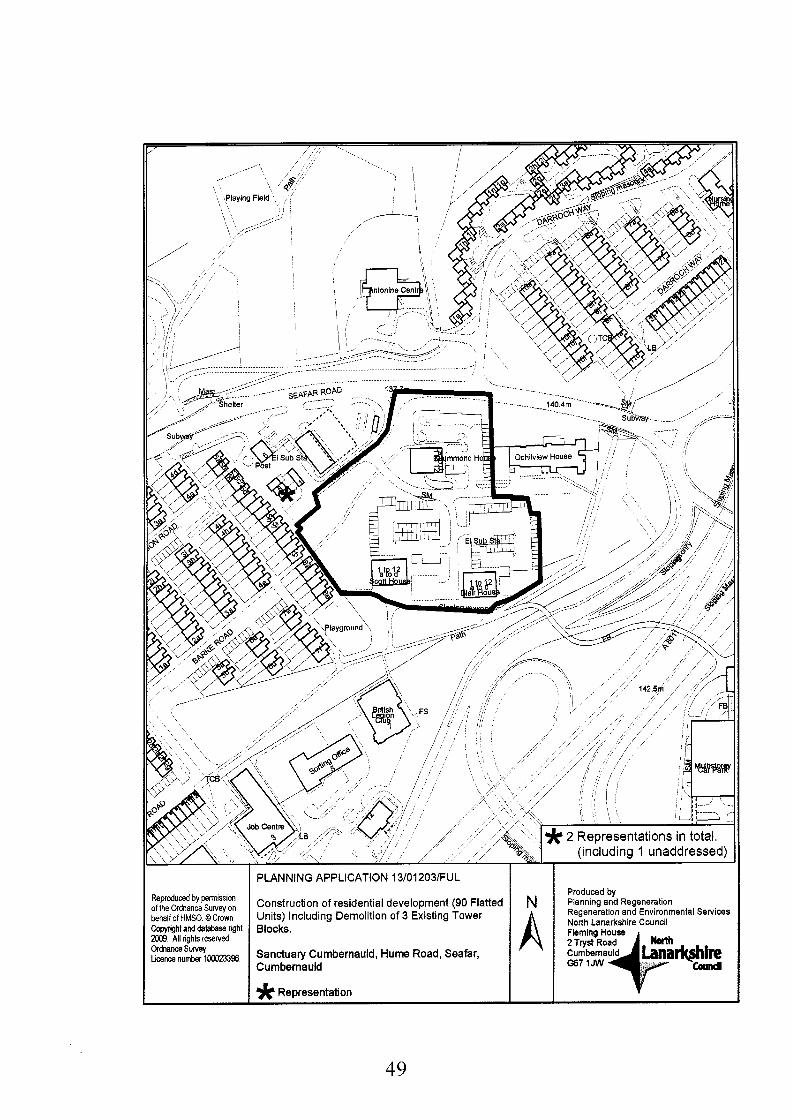
Reproduced by permission of the O,dnanceSurveyon behallof HMSO @Crown CoWrrghtanddalabsse nght 2009 All rights reserved ordnance survey Lmncenumber 1m96
49
PLANNING APPLICATION 13/01203/FUL
Construction of residential development (90 Flatted Units) Including Demolltion of 3 Existing Tower Blocks.
Sanctuary Cumbernauld, H u m Road, Seafar, Cumbernauld * Representation
Produced by Planning and Regeneration Regeneration and Environmental Services North Lanarkshire Council
rkshim collad

Proposed Conditions:-
1.
2.
3.
4.
5.
6.
7.
That the development hereby permitted shall be started within five years of the date of this permission.
Reason: To accord with the provisions of the Planning etc (Scotland) Act 2006 and to reflect the phasing of the wider Cumbernauld high rise redevelopment scheme.
That the development hereby permitted shall be carried out strictly in accordance with the approved details submitted as part of the application and no change to those details shall be made without prior written approval of the Planning Authority.
Reason: To clarify the drawings on which this approval of permission is founded.
That for the duration of the construction works one or more Site Notices, printed on durable material, shall be displayed in a prominent place at or in the vicinity of the development such that it is readily visible to the public; the Notice must accord with Schedule 7 of the Planning etc (Scotland) Act 2006 and must give details of the approved development, its address, details of the planning permission and information on where further information about the development can be obtained.
Reason: To accord with the provisions of the Planning etc (Scotland) Act 2006.
That FOLLOWING demolition of each of the existing buildings and BEFORE development works start on this area of the application site, unless otherwise agreed in writing with the Planning Authority, a supplementary site investigation report shall be submitted to and for the approval of the said Authority. The investigation must be carried out in accordance with current best practice advice, such as BS 10175: 'The Investigation of Potentially Contaminated Sites' or CLR 11. The report must include a site specific risk assessment of all relevant pollution linkages and a conceptual site model. Depending on the results of the investigation, a detailed Remediation Strategy may be required.
Reason: To establish the extent and nature of decontamination required in the interests of the amenity and wellbeing of future residents.
That any remediation works identified by the site investigation required in terms of Condition 4 above and Jonson, Poole & Bloomer site investigation report (April 2013), shall be carried out. A certificate (signed by a chartered Environmental Engineer) shall be submitted to the Planning Authority confirming that any remediation works have been carried out in accordance with the terms of the Remediation Strategy.
Reason: To ensure that the site is free of contamination in the interests of the amenity and wellbeing of future residents.
That before the development hereby permitted starts, unless otherwise agreed in writing with the Planning Authority; full details of the proposed surface water drainage scheme shall be submitted to the said Authority and shall be certified by a chartered civil engineer as complying with the most recent SEPA SUDS guidance.
Reason: To ensure that the drainage scheme complies with best SUDS practice to protect adjacent watercourses and groundwater and in the interests of the amenity and wellbeing of existing and future residents adjacent to and within the development site.
That the SUDS compliant surface water drainage scheme approved in terms of Condition 6 shall be implemented contemporaneously with the development in so far as is reasonably practical. Within three months of the construction of the SUDS, a certificate (signed by a Chartered Civil Engineer experienced in drainage works) shall
50

be submitted to the Planning Authority confirming that the SUDS has been constructed in accordance with the relevant ClRlA Manual and the approved plans.
Reason: To safeguard adjacent watercourses and groundwater from pollution and in the interests of the amenity and wellbeing of existing and future residents adjacent to and within the development site.
8. That prior to the commencement of development, the applicant shall provide written confirmation to the Planning Authority that all the requirements of Scottish Water can be fully met to demonstrate that the development will not have an impact on their assets, and that suitable infrastructure can be put in place to support the development.
Reason: To ensure the provision of satisfactory drainage arrangements.
9. That BEFORE the development hereby permitted starts, a scheme of landscaping shall be submitted to, and approved in writing by the Planning Authority, and it shall include:-
(a) details of any earth moulding and hard landscaping, boundary treatment, grass seeding and turfing; (b) A tree survey detailing the existing trees on site indicating which are to be removed and which will be retained. (c) Details of trees protection measures across the site. For the avoidance of doubt this shall include protection measures for trees along the north/west boundary of the site. (d) a scheme of tree and shrub planting, incorporating details of the location, number, variety and size of trees and shrubs to be planted; (e) Details of slope stabilisation measures for the earth works along the north/west boundary; (f) a detailed timetable for all landscaping works which shall provide for these works being carried out contemporaneously with the development of the site.
Reason: To enable the Planning Authority to consider these aspects in detail, to ensure high quality visual amenity.
10. That all works included in the scheme of landscaping and planting, approved under the terms of condition 9 above, shall be completed in accordance with the approved timetable, and any trees, shrubs, or areas of grass which die, are removed, damaged, or become diseased, within two years of the full occupation of the development hereby permitted, shall be replaced within the following year with others of a similar size and species.
Reason: To ensure the implementation of the landscaping scheme in the interest of amenity.
11. That before the development hereby permitted starts; tree protection measures in accordance with British Standard BS 5837 shall be erected along the drip line of the trees along the southern boundary and shall not be removed without the approval in writing of the Planning Authority.
Reason: To protect the existing tree cover.
12. That no trees within the application site shall be lopped, topped or felled and no shrubs or hedges shall be removed from the application site, without the prior approval in writing of the Planning Authority.
Reason: In the interests of the conservation value of the site and the visual amenity of the site and the adjacent residents.
13. The BEFORE the first block hereby permitted is first occupied, details of all external lighting for within the site shall be submitted to and approved by the Planning Authority,
51

and any lighting erected within the site shall be installed in accordance with the details approved under the terms of this condition.
Reason: In the interests of visual amenity of the site and the general area.
14. That BEFORE the development hereby permitted starts, a management and maintenance scheme shall be submitted to, and approved in writing by the Planning Authority, and it shall include proposals for the continuing care, maintenance and protection of:-
(a) the proposed footpaths; (b) the proposed parking areas; (c) the proposed external lighting; (d) the proposed grassed, planted and landscaped areas; (e) the proposed fences.
Reason: To ensure the implementation of the landscaping scheme in the interest of amenity.
15. That BEFORE completion of the development hereby permitted, the management and maintenance scheme approved under the terms of condition 14 shall be in operation.
Reason: In the interests of visual amenity.
16. That BEFORE the development hereby permitted starts, samples of the facing materials to be used on all external walls and roofs shall be submitted to, and approved in writing by the Planning Authority and the development shall be implemented in accordance with the details approved under the terms of this condition.
Reason: To enable the Planning Authority to consider these aspects in detail and in the interest of visual amenity.
17. That BEFORE the development hereby permitted starts, full details of the design and location of all fences and walls to be erected on the site shall be submitted to, and approved in writing by the Planning Authority.
Reason: To enable the Planning Authority to consider these aspects in detail.
18. That before the development hereby permitted starts, details of a scheme, which provides sufficient space within the application site for disabled parking provision at 6% the total number of spaces to be provided (dimensions as described in the Roads Guidelines published by the said Roads Authority), shall be submitted to, and approved in writing by the Planning Authority and shall and thereafter, be maintained as car parking spaces with these enhanced dimensions.
Reason: To ensure the provision of adequate parking facilities within the site.
19. That prior to commencement of development, a Construction Method Statement shall be submitted to and approved by the Planning Authority. For the avoidance of doubt, the Construction Method Statement shall cover:
e
0
e
e
The development shall be implemented in accordance with the approved Construction Method Statement.
Details of the proposed phasing of all works; Details of the demolition of all existing structures within the site; Details of all on-site construction including means of access to the site and; A dust management plan during the construction period:
52

Reason: In the interests of the amenity of the area particularly neighbouring residential properties, to ensure that necessary contingencies are in place, to minimise pollution risks arising from construction activities and in the interests of road safety.
20. That before each block hereby permitted is first occupied, all areas covered by the scheme, approved under the terms of condition 18; above, shall be levelled, properly drained, surfaced in a material which the Planning Authority has approved in writing before the start of surfacing works, and clearly marked out and shall, thereafter, be maintained as a parking areas.
Reason: To ensure the provision of adequate parking facilities within the site.
21. That before the development hereby permitted commences, details of mitigation measures for the removal or relocation of all SP Energy Networks apparatus within the site shall be submitted to and approved in writing by the Planning Authority and thereafter the measures shall be undertaken prior to the development being brought into use.
Reason: To protect all SP Energy Networks apparatus and in the interests of health and safety.
22. That, except as may otherwise be agreed in writing by the Planning Authority, no public roads or footways shall be stopped up or otherwise diverted until the necessary orders have been obtained and an agreed alternative route is open and available for use.
Reason: To allow for the necessary statutory procedures to be carried out.
23. That should 12 months or more elapse between the timing of the initial ecological survey dated July 2073 hereby approved, and development commencing, a further survey shall be undertaken on the site to determine the presence of any statutorily protected species, the said survey shall thereafter be submitted to and approved in writing by the Planning Authority before any development commences on the site. As a result of the study, should any mitigation measures be required for any protected species, this shall be implemented in accordance with the species protection plan agreed in writing with the Planning Authority in consultation with Scottish Natural Heritage before works commence on the site.
Reason: To ensure compliance with The Conservation (Natural Habitats & c.) Regulations 1994 (as amended); the Wildlife and Countryside Act (1981) as amended; the Protection of Badgers Act 1992 (as amended); and the Nature Conservation (Scotland) Act 2004.'
53
Backaround PaDers:
Consultation Responses:
Traffic & Transportation memorandum received 23rd July 2013 Environmental Health (including Pollution Control) memorandum received 1 7'h July 201 3 Scottish Environment Protection Agefcy letter ;fceived 26'h September 201 2 The Coal Authority letter received 24 July & 4 September 2013 Scottish Power Environmental Planning letter received 24'h July 201 3 Scottish Water (Glasgow) letter received 2gth July 201 3 Scottish Gas Network letter received 24'h July 2013 NLC Greenspace services memorandum received 28'h August 201 3 Play Services Manager e-mail memorandum received 2gth August 201 3
Contact Information:
Any person wishing to inspect these documents should contact Mr Gordon Arthur at 01236 632524
Report Date:
7'h January 201 4
54

APPLICATION NO. 13/01203/FUL
REPORT
1.
1.1
1.2
1.3
2.
2.1
2.2
2.3
2.4
3.
3.1
Site Description
The site occupies an area of 1.52 hectares and takes the form of a plateau raised above the surrounding access roads and is therefore open to the surrounding area. The site currently contains 3 x 12 story high tower blocks built in the 1960s. The site lies between central way (A8011) directly south and Seafar Road to the north providing direct access to Cumbernauld Town Centre, the wider road network and public transport links. The area beyond the site boundary is largely residential with the Burns Road High rise blocks to the south and 2-storey terraced housing to the west. A former Care Home bounds the site on its north eastern corner. To the north- west, there are some small retail premises including a Costcutter grocer and a petrol station. A woodland buffer to the south and east create a mature planted boundary to the main ring roads below. The neighbouring site, Ochilview House, which currently contains a disused 3 storey care home, is the subject of planning application (1 3/01 204/FUL) Construction of Residential Development (39 Residential Flatted Units) Including the Demolition of Care Home which is also being considered at this meeting.
Vehicular access to the site is via the existing adopted road junction from Seafar Road. This established access point will be maintained within the proposed residential site layout. An internal vehicular route serves the car parking areas.
Pedestrian and cycle access is provided by an elevated footpath linking to the Burns Road site to the south and into the town centre. Footpaths within the site boundary facilitate safe pedestrian circulation between blocks, car parking and designated open amenity space.
Proposed Development
This application is for a residential development of 90 flats contained in 5 separate blocks of flats (of either 3 or 4 storeys) with associated landscaping and car parking (120 Spaces). Each flat will have 2 bedrooms.
The existing road geometry of Hume will be altered to enable additional accesses to individual parking courts.
The buildings are a mix of 3 and 4 storey blocks of flats with dual pitch roof with mono pitch sections at the end of some block. The proposed materials comprise facing brick with panels of light coloured render and cladding and tiled roof.
This application is for social housing and forms the next stage in a wider project to regenerate residential high rise blocks at Seafar and Kildrum in Cumbernauld which is known as the High Rise Regeneration project being carried out by Sanctuary Cumbernauld. This project also includes sites Berryhill Road, Hume Road, and Burns Road. Planning permission for the redevelopment of Seafar House, whick formed the first stage of the project, was granted permission (1 1/00898/FUL) on 30 March 201 2.
Applicant’s Supportina Information
The applicant submitted a Pre-Application Consultation Report and a Design and Access Statement which incorporates the following information:
0
Site Investigation
Ecology Report (Protected Species Survey) Landscape and Open Space Maintenance Statement
5 5

4.
4. I
5.
5.1
6.
6.1
6.2
6.3
6.4
6.5
6.6
6.7
6.8
0
0 Engineering Statement 0 Drainage and SUD’s 0 Design solution statement 0 Access statement
Justification for Car Parking Provision
Site Histor!
There is no relevant planning history to this site.
Development Plan
The application site is located within an area covered by policy HCF 1A Residential Amenity in the North Lanarkshire Local Plan. This policy seeks to protect existing residential areas and by a presumption against developments or land uses which would be detrimental to residential amenity. Policies DSPI-4 are also relevant and are addressed in detail in the Planning Assessment Section below.
Consultations
A summary of the comments received from the consultees is as follows:
Traffic and Transportation raise no objection and recommended a number of conditions be applied to the layout in relation to road width and geometry, visibility, parking provision. These technical matters may be addressed by planning condition with the exception of parking provision. This is considered in section 8.18 below. It is also noted that a stopping up order will be required to close parts of the public road network across the site to accommodate the development.
Play Services raise no objection and it is considered that a financial contribution is acceptable in lieu of equipped play provision for this site.
Greenspaces have no objections to the proposed development subject to conditions regarding best practice in relation to protected species, landscaping, biodiversity and the protection of trees during construction works.
Protective Services raise no objection to the application but following the submission of a site investigation report it is recommended conditions are attached regarding the potential for mitigation measures particularly post demolition. Further comment has been provided in relation to noise during construction, lighting and waste.
The Coal Authority considers that the content and conclusions of the Chemical Contamination, Gas Emissions and Mining Investigation Report are sufficient for the purposes of the planning system in demonstrating that the application site is, or can be made, safe and stable for the proposed development. A condition is recommended requiring confirmation of the findings of intrusive site investigation works.
Scottish Power Energy Networks have objected to the proposal in that they have received no information from the applicant to advise if the proposal would affect their apparatus. They have advised that there is an operational substation and high voltage cables within the vicinity of the proposed development site.
The following consultees had no objection:
0 Scottish Gas 0 SEPA 0 Scottish Water 0
56

7. Rewesentat ions
7.1 Following the standard neighbour notification and press advertisement process 2 letters of representation were received. The main points raised in these representations are summarised as follows: Impact on access to local business (parking) and impact on existing parking.
8. Plannina Assessment
8.1 Under Section 25 of the Town and Country Planning (Scotland) Act 1997, planning decisions must be made in accordance with the relevant development plan unless material considerations indicate otherwise. The application raises no strategic issues in terms of the Glasgow and Clyde Valley Strategic Development Plan and therefore it can be assessed in terms of local plan policy.
8.2 North Lanarkshire local dan Policy HCF 1A Residential Amenity applies to this site where there is a presumption against developments detrimental to residential amenity in primarily residential areas. It is considered that the application complies with this policy. Policies DSP1-4 are also relevant and is addressed in turn below.
8.3 This application represents replacement housing in an existing residential area and does not represent an addition to the planned housing land supply. It is therefore considered that the proposal accords with policy DSP1 Amount of Development.
8.4 As noted above this application does not represent an addition to the planned housing land supply. In terms of location it represents urban regeneration of housing in an existing and well established residential area and as such is considered acceptable in this regard complying with policy DSP 2 Location of Development.
8.5 The Developer’s Guide to Open Space play provision guidance requires medium developments of this nature (between 30 to 99 dwellings) to provide total minimum play space of 1,500 square metres with at least 500 square metres to be equipped play space. Alternatively, a financial contribution can be made where there is a suitable existing play facility nearby which could benefit from upgrading works. In this case, as with the other phases of the Cumbernauld High Rise Project, it has been agreed that a financial contribution can be made in lieu of on-site play provision which will be used to create or upgrade play facilities in the wider Seafar area.
8.6 Policy DSP 4 Quality of Development considers more development site specific impacts, and provides a range of assessment criteria set out below which are addressed in turn below:
8.7 The applicant has submitted a Design and Access Statement in support of the application as required for an application which falls within the Major category of development and is considered acceptable.
8.8 The applicant submitted an ecological survey with the planning application which did not find any evidence of protected species or sensitive habitat. Consultation with Greenspace services on these surveys has confirmed that that the findings of these surveys can be accepted. It is noted that some trees may require to be removed from the site and that this will have an impact on biodiversity across the site; however, suitable replacement planting (in terms of number, size and species) will be accommodated within the landscaped areas and this will be controlled by condition. An informative is recommended to advise the applicant of the potential for breeding birds in the months March to August.
8.9 Part 3(a) of the policy considers Siting, Overall Layout, density, form, scale, height, massing, proportion, detailing, colour, materials and open space and Part 3(f)
57

8.10
8.1 1
8.12
8.13
8.14
8.15
8.16
8.17
8.18
integrating successfully into the local area and avoiding harm to the neighbouring amenity. For the purposes of this report parts 3(a) and (f) have been considered together as they are so closely linked in terms of the overall assessment.
The proposed 3 and 4 storey buildings represent a significant change to the much higher existing tower blocks. This phase, together with the wider high rise project, will have a significant impact on the skyline of Cumbernauld; however, this must be seen in the context of the wider significant regeneration benefits to the town and surrounding dwellings. The feasibility of replacing tall tower blocks with equally tall blocks is not a desirable option. On balance therefore the wider landscape impacts of the development are considered to be within acceptable limits due to the reduced height impact. It is also acknowledged that the building footprint within the site is also greater given the reduction in height but continues to fall within acceptable limits.
The blocks are a mix of dual pitched roofs with monopitch sections punctuating the end of each block with dual pitched roof predominant throughout. The windows are designed to maximise solar gain and provide passive surveillance to the parking courtyards and communal landscaped areas. The blocks are arranged around parking courts and amenity spaces and a combination of intervening land and building orientating ensures that there is no loss of residential amenity in terms of privacy, overlooking or loss of sunlight /day light
In terms of materials the applicant proposes a mix of facing brick, render and cladding. On this basis the palette of materials (facing brick, cladding and render) being proposed is also considered to be acceptable in principle at this location. A condition is recommended in order to confirm the final finished materials.
Given the foregoing it is therefore considered that design and layout of the development is acceptable and satisfactorily integrates with the surrounding area.
In considering open space and play provision the document Developer’s Guide to Open Space minimum space around dwellings guidance requires that flatted developments have 20sq.m of garden space per bedroom. In this case the layout requires 1800 sq.m of open space. It is acknowledged that the increased building footprint on the site has reduced the amount of open space surrounding the flatted blocks; however, the layout accommodates a reasonable level of open space provision (32% of the site) which will be enhanced by an improved landscape design and is therefore acceptable.
The applicant recognises the need for high quality landscaping in the design and access statement which advises that both soft and hard landscaping will be designed accordingly. Given the importance of the landscaping within this scheme it is considered that a condition requiring the submission of a detailed landscaping scheme should be placed on any approval. As noted above this would also include the provision of additional tree planting to avoid loss of habitat caused by the removal of some trees to accommodate the development.
In considering part 3(b) of the policy which looks at whether the proposal provides a safe inclusive convenient and welcoming development which has attractive pedestrian links, integrates with public transport] green networks, wider links and assesses the access for cars and appropriate car parking, the following comments are relevant.
The Traffic and Transportation comments make a number of recommendations which includes visibility] road geometry and level of parking provision. These technical matters have been addressed in an amended layout drawing demonstrating these points satisfactorily. Parking however is considered below in paragraph (8.18).
In terms of the latter outstanding issue it is acknowledged that the parking provision of 130% (120 spaces) falls short of the 180% (162 spaces) required under parking
58

standards; however, it is considered acceptable in this case due to the social housing tenure proposed for the site and the proximity to local bus routes and the town centre (within short walking distance). To allay fears relating to the reduced parking provision the applicant has submitted a robust case to justify the reduction based on their knowledge of the proposed user group of the site (older age profile, single household compositions and associated low car ownership levels). Based on this information Sanctuary has suggested that a total of only 120 car parking spaces would be required to serve the residents of this development. As such they argue that the 162spaces which are to be provided for both residents and visitors is sufficient and that more spaces would represent an unacceptably high over-provision in this location resulting in under-utilised parking courts as opposed to amenity landscaping. The level of parking provision in this particular case is considered to be acceptable.
8.19 The Design and Access Statement advises that the proposed housing takes into account best practice design promoted by The Sustainable Housing Design Guide for Scotland and has been designed to promote long term sustainability. Measures include the layout maximising solar gain, high levels of insulation and careful consideration of construction methods and materials for their low embodied energy, reduction in maintenance requirements and reduction in waste. In this respect the proposal accords with Part 3(c) of the policy considering Sustainable Development.
8.20 In considering Part 3(d) of the policy mitigating potential air quality, noise or pollution impacts: The redevelopment of the site results in fewer residential units and as such will is highly unlikely to increase any impact on air quality. It is acknowledged that there will be noise associated with demolition and construction works; however, this impact will be temporary in nature with the completed development constituting of everyday noise associated with any residential development.
8.21 An initial drainage strategy has been included in the Design and Access Statement. The strategy includes foul sewerage connection to the existing Scottish Water network. Surface water will also connect to a network following a level of attenuation (permeable paving with granular sub base) which will also form the SUDS for the surface water from private parking and hard standing areas. Whilst the principle of this strategy is acceptable a condition shall be placed on the consent requiring the submission of a more detailed certified drainage scheme and another condition shall require the implementation of the scheme to be certified. As such the proposal complies with Part 3(e) Protecting Water bodies and SUDWDrainage.
8.22 In conclusion, the design and layout is considered to accord with policy HCFIA and satisfy the terms of policies DSPl-4 in the North Lanarkshire Local Plan.
8.23 The applicant has requested that the period for implementing the development is extended beyond conventional the three year period to between five and seven years in this case. Given that the redevelopment of these flats form part of a wider regeneration initiative and the Planning Authority is aware of the phased nature of the proposal it is considered that the required time period for implementing the permission is extended. It is therefore recommended that an appropriate condition is attached to this permission.
Consultations
8.23 With regards to matters raised in consultation responses, that have not yet been addressed, it is proposed to attach suitable planning conditions in relation to the following, tree protection, boundary treatment, soft and hard landscaping and the potential for mitigation raised by Protective Services and the Coal Authority.
8.24 The comments made by Greenspaces Services, conditions relating to tree protection and landscaping are recommended. With reference to the badger survey, the ecological report submitted by the applicant did state that there was no evidence of
59

badgers found within the boundaries of the site. Having regard to the seasonal and momentary nature of the report the potential for protected species to migrate onto the site prior to demolition and other works commencing has been highlighted. The future occupation of the site in regard to the protected species can be addressed through the recommended conditions. In particular Greenspaces recommended that due to the extended period within which demolition has been approved, a further potential survey is recommended (within a 12 month period) to determine whether bats or badgers are using the site, in particular if bats are roosting in the domestic garage buildings or trees at the site. The survey submitted at application stage confirmed that that no badgers are currently using the site and that there is a potential for bat roost in the existing garage buildings, as such, conditions are recommended to reflect the future actions identified in the memorandum.
8.25 In considering comments from Transportation matters raised are of a minor technical nature and may be addressed with the submission of an amended plan. The exception to this is the proposed parking levels which are discussed in para. 8.8 above.
8.26 In the absence of any more detailed information at this stage, The Coal Authority concurs with the recommendations in the Executive Summary of the Chemical Contamination, Gas Emissions and Mining Investigation Report; that coal mining legacy potentially poses a risk to the proposed development and that intrusive site investigation works should be undertaken prior to development in order to establish the exact situation regarding potential coal mining legacy issues on the site. A Planning Condition is recommended, should planning permission be granted for the proposed development, to require an appropriate programme of intrusive site investigation works to be undertaken to confirm shallow coal mining conditions prior to commencement of development. The condition should also ensure that, in the event that the site investigations confirm the need for remedial works to treat any areas of shallow mine workings and/or any other mitigation measures (e.g. gas protection measures) to ensure the safety and stability of the proposed development, these works should also be undertaken prior to commencement of development.
8.27 In terms of the response from SP Energy Networks, the applicant would require to liaise with them prior to any works commencing to ensure that their apparatus is unaffected by the proposed development and this matter is addressed by a planning condition.
8.28 Representations
The following comments are made in respect of the issues raised in letters of representation:
Point of objection: The development may impact on a neighbouring hair dressing business and parking in the vicinity.
Comment: While the planning service does not anticipate significant disruption to this business, located out with the site boundary, it should be bourn in mind that large developments often result in a degree of disruption. That said dedicated parking out with the site boundary should remain as such. It is noted from the applicants design statement that on site movement and interim parking provision is considered with the applicant proposing a suitable traffic management system to ensure that access continues for existing residents.
9. Conclusions
9.1 Taking the above assessment into account it is considered that the detailed design and layout of the proposal represents the significant regeneration of this site and creates a strong sense of place and identity and is welcomed as the on going regeneration of the wider Seafar area. It is considered that this together with the
60

applicant’s robust justification statement outweighs the shorlfall in the standard level of parking provision. On balance it is considered that the development adequately accords with the provisions of the adopted North Lanarkshire Local Plan. It is considered that comment raised by consultees on areas of technical detail can be addressed through the use of conditions and legal agreement. The objections raised in the letters of representation have been fully considered; however, for the reasons detailed in the planning assessment above, they have not been upheld. It is therefore recommended that planning permission be granted subject to conditions and completion of the proposed legal agreement.
\ 61

Application No:
13/01 204/FUL
Proposed Development:
Construction of Residential Development (39 Residential Flatted Units) Including the Demolition of Care Home. Site Address:
Ochil View Residential Home Hume Road Seafar Cumbernauld Glasgow North Lanarkshire G67 IAP
Date Registered:
1st July 2013
Applicant: Sanctuary Cumbernauld Fleming House 2 Tryst Road Cumbernauld G67 1JW
Application Level: Local Application
Agent: Farningham Planning Ltd The Bourse 47 Timber Bush Leith EH6 6QH
Contrary to Development Plan: No
Ward: Representations: 003 Cumbernauld South William Goldie, Allan Graham, Paddy Hogg, Stephanie Muir,
letter(s) of representation received.
Recommendation: Approve subject to condition
Reasoned Justification:
The site is within an existing residential area and would integrate satisfactorily with the surrounding area and would not result in any unacceptable adverse impact on established residential amenity.
Legal Agreement:
If the Committee are minded to grant permission, the decision notice will not be issued until a legal agreement is signed between the Council and developer with regard to a financial contribution of f250 per flat for improvements to off-site play facilities in lieu of on-site provision.
62

eproduced ty petmission the0rehame Sunrryon W+ofHUSO. OCmwn opyfiglt and dat&Dase g l t m9. NI @hk Iesewcd. Wnance S w e y aemenunberi00023396.
Plannmg and Regeneration Plannning Application 13~12041FUL
(39 Residential Flatted Units) Including the Demolition of Care Home.
Cumbetnauld
63

Proposed Conditions:-
1.
2.
3.
4.
5.
6.
That the development hereby permitted shall be carried out strictly in accordance with the approved details submitted as part of the application and no change to those details shall be made without prior written approval of the Planning Authority.
Reason: To clarify the drawings on which this approval of permission is founded.
That for the duration of the construction works one or more Site Notices, printed on durable material, shall be displayed in a prominent place at or in the vicinity of the development such that it is readily visible to the public; the Notice must accord with Schedule 7 of the Planning etc (Scotland) Act 2006 and must give details of the approved development, its address, details of the planning permission and information on where further information about the development can be obtained.
Reason: To accord with the provisions of the Planning etc (Scotland) Act 2006.
That FOLLOWING demolition of each of the existing buildings and BEFORE development works start on this area of the application site, unless otherwise agreed in writing with the Planning Authority, a supplementary site investigation report shall be submitted to and for the approval of the said Authority. The investigation must be carried out in accordance with current best practice advice, such as BS 10175 : 'The Investigation of Potentially Contaminated Sites' or CLR 11. The report must include a site specific risk assessment of all relevant pollution linkages and a conceptual site model. Depending on the results of the investigation, a detailed Remediation Strategy may be required. For the avoidance of doubt this supplemental investigation requires to meet ClRlA scope requirements and should include representative certified asbestos testing.
Reason: To establish the extent and nature of decontamination required in the interests of the amenity and wellbeing of future residents.
That any remediation works identified by the site investigation required in terms of Condition 3 above and Jonson, Poole & Bloomer site investigation report (April 2013), shall be carried out. A certificate (signed by a chartered Environmental Engineer) shall be submitted to the Planning Authority confirming that any remediation works have been carried out in accordance with the terms of the Remediation Strategy.
Reason: To ensure that the site is free of contamination in the interests of the amenity and wellbeing of future residents.
That before the development hereby permitted starts, unless otherwise agreed in writing with the Planning Authority; full details of the proposed surface water drainage scheme shall be submitted to the said Authority and shall be certified by a chartered civil engineer as complying with the most recent SEPA SUDS guidance.
Reason: To ensure that the drainage scheme complies with best SUDS practice to protect adjacent watercourses and groundwater and in the interests of the amenity and wellbeing of existing and future residents adjacent to and within the development site.
That the SUDS compliant surface water drainage scheme approved in terms of Condition 5 shall be implemented contemporaneously with the development in so far as is reasonably practical. Within three months of the construction of the SUDS, a certificate (signed by a Chartered Civil Engineer experienced in drainage works) shall be submitted to the Planning Authority confirming that the SUDS has been constructed in accordance with the relevant ClRlA Manual and the approved plans.
64

7.
8.
9.
10.
11.
Reason: To safeguard adjacent watercourses and groundwater from pollution and in the interests of the amenity and wellbeing of existing and future residents adjacent to and within the development site.
That prior to the commencement of development, the applicant shall provide written confirmation to the Planning Authority that all the requirements of Scottish Water can be fully met to demonstrate that the development will not have an impact on their assets, and that suitable infrastructure can be put in place to support the development.
Reason: To ensure the provision of satisfactory drainage arrangements.
That BEFORE the development hereby permitted starts, a scheme of landscaping shall be submitted to, and approved in writing by the Planning Authority, and it shall include:-
(a) details of any earth moulding and hard landscaping, boundary treatment, grass seeding and turfing; (b) A tree survey detailing the existing trees on site indicating which are to be removed and which will be retained.(for the avoidance of doubt trees removed shall be replaced on site with trees of the same species and of appropriate age and girth.) (c) Details of trees protection measures across the site. For the avoidance of doubt this shall include protection measures for trees along the boundary of the site. (d) a scheme of tree and shrub planting, incorporating details of the location, number, variety and size of trees and shrubs to be planted; (e) a detailed timetable for all landscaping works which shall provide for these works
being carried out contemporaneously with the development of the site.
Reason: To enable the Planning Authority to consider these aspects in detail, to ensure high quality visual amenity.
That all works included in the scheme of landscaping and planting, approved under the terms of condition 8 above, shall be completed in accordance with the approved timetable, and any trees, shrubs, or areas of grass which die, are removed, damaged, or become diseased, within two years of the full occupation of the development hereby permitted, shall be replaced within the following year with others of a similar size and species.
Reason: To ensure the implementation of the landscaping scheme in the interest of amenity.
The BEFORE the first block hereby permitted is first occupied, details of all external lighting for within the site shall be submitted to and approved by the Planning Authority, and any lighting erected within the site shall be installed in accordance with the details approved under the terms of this condition.
Reason: In the interests of visual amenity of the site and the general area.
That BEFORE the development hereby permitted starts, a management and maintenance scheme shall be submitted to, and approved in writing by the Planning Authority, and it shall include proposals for the continuing care, maintenance and protection of:-
(a) the proposed footpaths; (b) the proposed parking areas; (c) the proposed external lighting; (d) the proposed grassed, planted and landscaped areas; (e) the proposed fences.
Reason: To ensure the implementation of the landscaping scheme in the interest of
65

amenity.
12. That BEFORE completion of the development hereby permitted, the management and maintenance scheme approved under the terms of condition 11 shall be in operation.
Reason: In the interests of visual amenity.
13. That BEFORE the development hereby permitted starts, samples of the facing materials to be used on all external walls and roofs shall be submitted to, and approved in writing by the Planning Authority and the development shall be implemented in accordance with the details approved under the terms of this condition.
Reason: To enable the Planning Authority to consider these aspects in detail and in the interest of visual amenity.
14. That BEFORE the development hereby permitted starts, full details of the design and location of all fences and walls to be erected on the site shall be submitted to, and approved in writing by the Planning Authority.
Reason: To enable the Planning Authority to consider these aspects in detail.
15. That prior to commencement of development, a Construction Method Statement shall be submitted to and approved by the Planning Authority. For the avoidance of doubt, the Construction Method Statement shall cover:
0
0
0
0
Details of the proposed phasing of all works; Details of the demolition of all existing structures within the site; Details of all on-site construction including means of access to the site and; A dust management plan during the construction period:
The development shall be implemented in accordance with the approved Construction Method Statement.
Reason: In the interests of the amenity of the area particularly neighbouring residential properties, to ensure that necessary contingencies are in place, to minimise pollution risks arising from construction activities and in the interests of road safety.
16. That before the development hereby permitted starts, details of a scheme, which provides sufficient space within the application site for disabled parking provision at 6% the total number of spaces to be provided (dimensions as described in the Roads Guidelines published by the said Roads Authority), shall be submitted to, and approved in writing by the Planning Authority and shall and thereafter, be maintained as car parking spaces with these enhanced dimensions.
Reason: To ensure the provision of adequate parking facilities within the site.
17. That before each block hereby permitted is first occupied, all areas covered by the scheme, approved under the terms of condition 16; above, shall be levelled, properly drained, surfaced in a material which the Planning Authority has approved in writing before the start of surfacing works, and clearly marked out and shall, thereafter, be maintained as a parking areas.
Reason: To ensure the provision of adequate parking facilities within the site.
18. That should 12 months or more elapse between the timing of the initial ecological survey dated July 2073 hereby approved, and development commencing, a further survey shall be undertaken on the site to determine the presence of any statutorily
66

protected species, the said survey shall thereafter be submitted to and approved in writing by the Planning Authority before any development commences on the site. As a result of the study, should any mitigation measures be required for any protected species, this shall be implemented in accordance with the species protection plan agreed in writing with the Planning Authority in consultation with Scottish Natural Heritage before works commence on the site.
Reason: To ensure compliance with The Conservation (Natural Habitats & c.) Regulations 1994 (as amended); the Wildlife and Countryside Act (1981) as amended; the Protection of Badgers Act 1992 (as amended); and the Nature Conservation (Scotland) Act 2004.'
67

Backaround PaDers:
Consultation Responses:
Traffic & Transportation memorandum received memorandum received 23rd $ly 201 3 Environmental Health (including Pollution Control) memorandum received 17 July 201 3 Scottish Water (Glasgow) memorandumt;eceived 26'h July 201 3 Scottish Gas Network Letter received 30 July 201 3 Scottish Environment Protection Agetcy letter ryfeived 1" October 201 3 The Coal Authority letter received 24 July & 30 August 201 3 NLC Greenspace Memorandum received 28'h August 201 3 Play Services Manager e-mail memorandum received 2gth August 201 3
Contact information:
Any person wishing to inspect these documents should contact Mr Gordon Arthur at 01 236 632524
Report Date:
7th January 201 4
68

APPLICATION NO. 13/01204/FUL
REPORT
1.
1.1
1.2
1.3
1.4
1.5
2.
2.1
2.2
2.3
Site Description
The development site is located on the northern edge of Cumbernauld’s central area, approximately 0.5 miles from the town centre. The site is bounded by Seafar Road to the north and east with Central Way (A8011) to the south. Generally adjacent dwellings consist of two storey terraced housing and high rise blocks at Hume Road which were built circa 1970 and are 12 storeys high, as such, the surrounding context is an established residential area, where the housing is predominantly rendered with a grey finish, some white and some brown, with some evidence of brickwork. Roofing is generally grey concrete interlocking tiles and double pitched with some very shallow mono-pitched roofs and some flat roofed porches in places.
The site occupies an area of 0.59 hectares and is generally level with localised mounds of earth, sloping towards the application boundary. The site has some mature boundary planting. To the west beyond Seafar Road there are some small retail premises including a Costcurtter grocer and a petrol station. A woodland buffer to the south and east create separation and privacy from the main roads below. The neighbouring site to the west, Hume Road, which currently has 3 no high rise blocks, will be the subject of future redevelopment for circa 90 no flatted dwellings (based on current proposals) and is considered in planning application 13/01 203/FUL also being put before the committee.
Vehicular access to the site is via the Hume Road site to the west and the existing adopted road junction from Seafar Road. An internal vehicular route serves the car parking areas, Pedestrian and cycle access is provided by bounding footpaths to the south and west and an elevated footpath over Central Way (A8011) linking to the Burns Road site to the south and into the town centre.
Footpaths within the site boundary facilitate safe pedestrian circulation between blocks, car parking and designated open amenity space. Central Way (A8011) is south and Seafar road directly north providing direct access to Cumbernauld Town Centre, the wider road network and public transport links along Seafar Road.
The care home was built as a contemporary of the neighbouring residential development. It was declared surplus to operational requirements by North Lanarkshire Council’s Housing and Social Work Services Committee on the 16th June 201 1.
Proposed Development
This application is for a residential development of 39 flats contained in 2 separate blocks of flats (of either 3 storey 9 unit block or 3-4 storeys 30 unit block) with associated landscaping and car parking (51 Spaces). Each flat will have 2 bedrooms.
The existing road geometry of the section of Hume Road (access) terminating at the site will be unaltered. Alterations to the internal layout of the site will enable additional accesses to individual parking courts via a roundel feature. The buildings are a mix of 3 and 4 storey blocks of flats with dual pitch roof with mono pitch sections at the end of each block. The proposed materials comprise facing brick with panels of light coloured render and cladding and tiled roof.
This application is for social housing and forms the next stage in a wider project to regenerate 12 residential high rise blocks at Seafar and Kildrum in Cumbernauld which is known as the High Rise Regeneration project being carried out by Sanctuary Cumbernauld-This project also includes sites Berryhill Road, Hume Road, and Burns
69

Road. Planning permission for the redevelopment of Seafar House, which formed the first stage of the project, was granted permission (1 1/00898/FUL) on 30th March 2012. It is intended that Ochilview will be developed prior to Hume Road. The first phase being the demolition of the former care home to make way for new homes.The Ochilview site is the first stage of the wider Hume Road regeneration that constitutes Phase 3 of the High Rise Regeneration Project (Phase 7- Seafar House, Phase 2- Allanfauld Road, Phase 4- Burns Road).
3. Applicant’s Sumortinu Information
3.1 The applicant submitted a Pre-Application Consultation Report and a Design and Access Statement which incorporates the following information:
0
0 Site Investigation 0
0 Engineering Statement 0 Drainage and SUD’s 0 Design solution statement 0 Access statement
Ecology Report (Protected Species Survey)
Justification for Car Parking Provision
4. Site History
4.1 There is no relevant planning history to this site.
5. DeveloPment Plan
5.1 The application site is located within an area covered by policy HCF 1A Residential Amenity in the North Lanarkshire Local Plan. This policy seeks to protect existing residential areas and by a presumption against developments or land uses which would be detrimental to residential amenity. Policies DSP1-4 are also relevant and are addressed in detail in the Planning Assessment Section below.
6. Consultations
6.1 A summary of the comments received from the consultees is as follows:
6.2 Traffic and Transportation raise no objection and recommended a number of conditions be applied to the layout in relation to road width and geometry, visibility, parking provision. These technical have been addressed through the submission of a revised layout plan with the exception of parking provision. This is considered in section 8.1 8 below.
6.3 Play Services raise no objection and has advised that a financial contribution is acceptable in lieu of equipped play provision for this site.
6.4 Greenspaces have no objections to the proposed development subject to conditions regarding best practice in relation to protected species, landscaping, biodiversity and the protection of trees during construction works.
6.5 Scottish Natural Heritage (SNH) were consulted regarding a bat roost found during the applicants appointed ecologists survey and a bat exclusion license will be required in dealing appropriately with the roost prior to the demolition of the building.
6.6 Protective Services raise no objection to the application but following the submission of a site investigation report it is recommended conditions are attached regarding the potential for mitigation measures particularly post demolition. Further comment has been provided in relation to noise during construction, lighting and waste.
70

6.7
6.8
7.
7.1
8.
8.1
8.2
8.3
8.4
8.5
8.6
8.7
8.8
The Coal Authority considers that the content and conclusions of the Chemical Contamination, Gas Emissions and Mining Investigation Report are sufficient for the purposes of the planning system in demonstrating that the application site is, or can be made, safe and stable for the proposed development. A condition is recommended requiring confirmation of the findings of intrusive site investigation works.
The following consultees had no objection:
0 Scottish Gas 0 SEPA
Scottish Water
Representations
Following the standard neighbour notification and press advertisement process no letters of representation were received.
Planninq Assessment
Under Section 25 of the Town and Country Planning (Scotland) Act 1997, planning decisions must be made in accordance with the relevant development plan unless material considerations indicate otherwise. The application raises no strategic issues in terms of the Glasgow and Clyde Valley Strategic Development Plan and therefore it can be assessed in terms of local plan policy.
North Lanarkshire local ~ l a n Policy HCF 1A Residential Amenity applies to this site where there is a presumption against developments detrimental to residential amenity in primarily residential areas. It is considered that the application complies with this policy. Policies DSP1-4 are also relevant and is addressed in turn below.
This application represents replacement housing in an existing residential area and does not represent an addition to the planned housing land supply. It is therefore considered that the proposal accords with policy DSP1 Amount of Development.
As noted above this application does not represent an addition to the planned housing land supply. In terms of location it represents urban regeneration of housing in an existing and well established residential area and as such is considered acceptable in this regard complying with policy DSP 2 Location of Development.
The Developer's Guide to Open Space play provision guidance requires medium developments of this nature (between 30 to 99 dwellings) to provide total minimum play space of 1,500 square metres with at least 500 square metres to be equipped play space. Alternatively, a financial contribution can be made where there are suitable existing play facilities nearby which could benefit from upgrading works. In this case, as with the other phases of the Cumbernauld High Rise Project, it has been agreed that a financial contribution can be made in lieu of on-site play provision which will be used to create or upgrade play facilities in the wider Seafar area.
Policy DSP 4 Quality of Development considers more development site specific impacts, and provides a range of assessment criteria set out below which are addressed in turn below:
The applicant has submitted a Design and Access Statement in support of the application as required for an application which falls within the Major category of development and is considered acceptable.
Initial consultation with NLC Greenspace Development (Biodiversity) advised that bat roosts were present within the roof structure of the building. The applicant, following these initial findings submitted a revised survey report which identified a requirement
71

8.9
8.10
8.1 1
8.12
8.13
8.14
8.15
8.16
for a bat disturbance license from Scottish Natural Heritage which was duly issued. Initial consultation with Greenspaces service advised that works must be carried out within a year of all requested surveys. Updated surveys will be required if this is not possible. Greenspace Development strongly recommends that the site is also checked for Badgers immediately prior to any demolition of existing buildings by a qualified ecologist (preferably a member of the Chartered Institute of Ecology and Environmental Management) a condition and informative covering these aspects of natural heritage are recommended.
It is noted that a number of trees may require to be removed from the site and that this will have an impact on biodiversity across the site; however, suitable replacement planting (in terms of number, size and species) will be accommodated within the landscaped areas and this will be controlled by condition. An informative is recommended to advise the applicant of the potential for breeding birds in the months March to August.
Part 3(a) of the policy considers Siting, Overall Layout, density, form, scale, height, massing, proportion, detailing, colour, materials and open space and Part 3(f) integrating successfully into the local area and avoiding harm to the neighbouring amenity. For the purposes of this report parts 3(a) and (f) have been considered together as they are so closely linked in terms of the overall assessment.
The proposed 3 and 4 storey buildings represent a significant change to the current single three storey block. This proposal will increase the amount of development on this site significantly but within the bounds of acceptability and may be considered in the context of the wider regeneration benefits to the town and surrounding dwellings given that the building has remained in a poor state of repair for a number of years. On balance therefore the wider landscape impacts of the development are considered to be within acceptable limits due to the equivalent height impact of the proposed flats. It is also acknowledged that the building footprint within the site is greater given the increased number of blocks this however continues to fall within acceptable limits.
The blocks are a mix of dual pitched roofs with mono pitch sections incorporated within each block dual pitched roof predominant throughout. The windows are designed to maximise solar gain and provide passive surveillance to the parking courtyards and communal landscaped areas. The blocks are arranged around parking courts and amenity spaces and a combination of intervening land and building orientating ensures that there is no loss of residential amenity in terms of privacy, overlooking or loss of sunlight /day light
In terms of materials the applicant proposes a mix of facing brick, render and cladding. On this basis the palette of materials (facing brick, cladding and render) being proposed is also considered to be acceptable in principle at this location. A condition is recommended in order to confirm the final finished materials.
Given the foregoing it is therefore considered that design and layout of the development is acceptable and satisfactorily integrates with the surrounding area.
In considering open space and play provision the document Developer’s Guide to Open Space minimum space around dwellings guidance requires that flatted developments have 20sq.m of garden space per bedroom. In this case the layout requires 1380 sq.m of open space. It is acknowledged that the increased building footprint on the site has reduced the amount of open space surrounding the flatted blocks; however, the layout accommodates a reasonable level of open space provision (43% of the site) which will be enhanced by an improved landscape design and is therefore acceptable.
The applicant recognises the need for high quality landscaping in the design and access statement which advises that both soft and hard landscaping will be designed
72
accordingly. Given the importance of the landscaping within this scheme it is considered that a condition requiring the submission of a detailed landscaping scheme should be placed on any approval. As noted above this would also include the provision of additional tree planting to avoid loss of habitat caused by the removal of some trees to accommodate the development.
8.17 In considering part 3(b) of the policy which looks at whether the proposal provides a safe inclusive convenient and welcoming development which has attractive pedestrian links, integrates with public transport, green networks, wider links and assesses the access for cars and appropriate car parking, the following comments are relevant.
8.18 The Traffic and Transportation comments make a number of recommendations which includes visibility, road geometry and level of parking provision. These technical matters have been addressed in an amended layout drawing demonstrating these points satisfactorily. Parking however is considered below in paragraph (8.19).
8.19 In terms of the first outstanding issue it is acknowledged that the parking provision of 130% (51 Spaces) falls short of the 180% (71 spaces) required under parking standards; however, it is considered acceptable in this case due to the social housing tenure proposed for the site and the proximity to local bus routes and the town centre (adjacent to the site on Seafar Road opposite the service station). To allay fears relating to the reduced parking provision the applicant has submitted a robust case to justify the reduction based on their knowledge of the proposed user group of the site (older age profile, single household compositions and associated low car ownership levels). Based on this information Sanctuary has suggested that a total of 51 car parking spaces would be required to serve the residents of this development. As such they argue that the 51 spaces which are to be provided for both residents and visitors is sufficient and that more spaces would represent an unacceptably high over- provision in this location resulting in a number of under-utilised parking courts. The level of parking provision in this particular case is considered to be acceptable.
8.20 The Design and Access Statement advises that the proposed housing takes into account best practice design promoted by The Sustainable Housing Design Guide for Scotland and has been designed to promote long term sustainability. Measures include the layout maximising solar gain, high levels of insulation and careful consideration of construction methods and materials for their low embodied energy, reduction in maintenance requirements and reduction in waste. In this respect the proposal accords with Part 3(c) of the policy considering Sustainable Development.
8.21 In considering Part 3(d) of the policy mitigating potential air quality, noise or pollution impacts: The redevelopment of the site results in fewer residential units and as such will is highly unlikely to increase any impact on air quality. It is acknowledged that there will be noise associated with demolition and construction works; however, this impact will be temporary in nature with the completed development constituting of everyday noise associated with any residential development.
8.22 An initial drainage strategy has been included in the Design and Access Statement. The strategy includes foul sewerage connection to the existing Scottish Water network. Surface water will also connect to a network following a level of attenuation (permeable paving with granular sub base) which will also form the SUDS for the surface water from private parking and hard standing areas. Whilst the principle of this strategy is acceptable a condition shall be placed on the consent requiring the submission of a more detailed certified drainage scheme and another condition shall require the implementation of the scheme to be certified. As such the proposal complies with Part 3(e) Protecting Water bodies and SUDGDrainage.
8.23 In conclusion, the design and layout is considered to accord with policy HCFIA and satisfy the terms of policies DSPl-4 in the North Lanarkshire Local Plan.
73

8.24 Consultations:
8.25 With regards to matters raised above in consultation responses, should the members be minded to approve the application, suitable planning conditions in relation to the following, tree protection, boundary treatment, soft and hard landscaping, the timing of species surveys and the potential for mitigation raised by Protective Services and the Coal Authority are recommended.
8.26 In considering comments from Transportation matters raised are of a minor technical nature and may be addressed with the submission of an amended plan.
8.27 In the absence of any more detailed information at this stage, The Coal Authority concurs with the recommendations in the Executive Summary of the Chemical Contamination, Gas Emissions and Mining Investigation Report; that coal mining legacy potentially poses a risk to the proposed development and that intrusive site investigation works should be undertaken prior to development in order to establish the exact situation regarding coal mining legacy issues on the site. A Planning Condition is recommended, should planning permission be granted for the proposed development, to require an appropriate programme of intrusive site investigation works to be undertaken to confirm shallow coal mining conditions prior to commencement of development. The condition should also ensure that, in the event that the site investigations confirm the need for remedial works to treat any areas of shallow mine workings and/or any other mitigation measures (e.g. gas protection measures) to ensure the safety and stability of the proposed development, these works should also be undertaken prior to commencement of development.
9. Conclusions
9.1 Taking the above assessment into account it is considered that the detailed design and layout of the proposal represents the significant regeneration of this site and creates a strong sense of place and identity and is welcomed as the on going regeneration of the wider seafar area. It is considered that this together with the applicant’s robust justification statement outweighs the shortfall in the standard level of parking provision. On balance it is considered that the development adequately accords with the provisions of the adopted North Lanarkshire Local Plan. It is considered that comment raised by consultees on areas of technical detail can be addressed through the use of conditions and legal agreement. The objections raised in the letters of representation have been fully considered; however, for the reasons detailed in the planning assessment above, they have not been upheld. It is therefore recommended that planning permission be granted subject to conditions and completion of the proposed legal agreement.
74
Application No:
13/01 983/FUL
Proposed Development:
Erection of Dwellinghouse Site Address:
Site To North West Of Rimmon Cottage Benhar Road Shotts
Date Registered:
15th October 201 3
Applicant: Mr & Mrs Derek McLeod 1 Bunkbonny Gardens Breich West Lothian EH55 8DN
Application Level: Local
Ward: 012 Fortissat Charles Cefferty, Thomas Cochrane, James Robertson,
Agent: WD Blair Associates Ltd Staff Cottage 6 Fauldhouse Road Longridge West Lothian EH47 8AQ
Contrary to Development Plan: Yes
Representations: One letter of support and one letter of representation received.
Recommendation: Refuse
Reasoned Justification:
The proposed application, taking account of the development plan and all material considerations, is contrary to Policies NBE 36 and DSP4 of the North Lanarkshire Local Plan and Supplementary Planning Guidance SPG 08 in that the proposed development does not relate to the formation of a new cluster or a reconfiguration of an existing cluster and there is no suitable justification for a detached dwelling in this location.
75
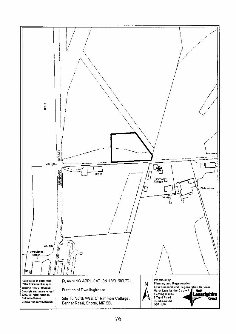
c c c
m
I
237.7r
N PLANNING APPLICATION 13~1983/FlJL
Erection o f Dwellinghouse
Site To North West Of Rimmon Cottage, 5enhar R o a d , S h o t t s , M17 55J
A Produced by Planning and Regeneration
Fleming House 2 Tyst Road Cumbernauld G87 I J W
Reploduced by petmission dthe Onhence Suweyon khatofHMS0. @Crown CopytigH and datalrase nglf
Ordnance Suwey ljceme number 100023396.
ao9. All light5 m5ew ed.
I I I I
76
Recommendation: Refuse for the Following Reasons:-
1. The proposed dwellinghouse is contrary to the terms of the North Lanarkshire Local Plan in that it does not accord with policy NBE 3B Assessing Development in the Rural Investment Area and Supplementary Planning Guidance 08 (Development in the Rural Investment Areas) as the site is not recognised as an existing cluster and the proposed dwellinghouse cannot be regarded as a new cluster, furthermore the proposed dwelling is not connected with agriculture or forestry and the applicant has failed to demonstrate an overriding specific locational need.
Backaround Papers:
Consultation Responses:
Memo from Transportation received 1 4'h Noxember 201 3 Memo from Protective Services rectved 25 October 2013 Memo from Greenspace received 5 December 201 3
Contact Information:
Any person wishing to inspect these documents should contact ,.,, Fraser 632503
Report Date:
8'h January 2014
liller at 1236
77

APPLICATION NO. 13/01983/FUL
REPORT
1.
1.1
2.
2.1
3.
3.1
4.
4.1
5.
5.1
6.
6.1
6.2
7.
7.1
Site Description
The application site is an area of ground extending to 0.26 hectares on land to the north west of Rimmon Cottage and to the west of Shotts Golf Club, off Benhar Road, Shotts. The site is situated approximately 100 metres east of the junction of the access road and Benhar Road. The site is relatively level with the southern section comprising of open grass with the northern section of the site comprising of a semi mature planted tree belt. The golf club adjoins the site to the east behind the tree belt and Rimmon Cottage is located to the south east along side the Golf Course Club House. Open land is located to the south and west of the application site with the remainder of the tree belt being to the north with the golf course beyond.
Proposed Development
Planning permission is sought for the erection of a detached dwellinghouse fronting onto the access road. The plot would have a frontage of 65 metres at a depth of 48 metres. The proposed dwellinghouse would be set back 7 metres from the road and would measure 23 metres in length by 13 metres in width. The dwelling is to be single storey and would have a ‘H’ shaped footprint. A single garage is to be constructed on the eastern section of the site. The dwelling is to be finished with smooth interlocking tiles and render. A new vehicular access would be formed to the site from the established access road.
Applicant’s Sumortina Information
A letter of support has been submitted with the application from Shotts Golf Club advising that the proposed dwelling is in keeping with the surrounding area and that the sale of the land will release much needed funds to the Club thereby assisting in future funding and ensuring affordable fees to retain existing and help gain new members.
Site History
No relevant history on application site.
Development Plan
The application site is zoned as NBE 3B Assessing Development in the Rural Investment Area in the North Lanarkshire Local Plan.
Transportation and Protective Services raised no objections to the application.
Greenspace requested the submission of a badger survey and advised that site clearance would be required to be carried outwith the breeding bird season.
Representations
A letter of representation has been received from the adjacent property. The letter does not seek to object to the principle of the development but requests that consideration be given to their water supply that travels across the front of the development site.
78

a. Plannina Assessment
8.1 In accordance with Section 25 of Town and Country Planning (Scotland) Act 1997, planning decisions must be made in accordance with the development plan unless material considerations indicate otherwise. The application raises no strategic issues; it can therefore be assessed in terms of the local plan policies. In the North Lanarkshire Local Plan (NLLP) the site is zoned as NBE 38 Assessing Development in the Rural Investment Area (RIA) with the associated Supplementary Planning Guidance 08 (Development in the Rural Investment Area) also relevant.
8.2 Policy NBE 38 seeks to protect the character of and to promote development in Rural Investment Area through restricting development to acceptable types. There is a general presumption in favour of granting planning permission for new dwellings in the RIA if they:-
i) Enhance an existing cluster of development and are acceptable in terms of design, scale and countryside integration.
ii) Enhance the natural heritage value of the site (new planting, removal of intrusive features).
iii) Respect the natural boundaries (road, hedge, tree line, watercourse) and include works to reinforce and enhance boundaries and buffers.
Policy NBE 38 seeks to protect the character of and to promote development in the Rural Investment Area through restricting development to those uses considered appropriate in the Green Belt and meeting the assessment criteria in Policy NBE 3A as relevant to the RIA. The types of development identified as being acceptable consist of proposals for agriculture, forestry or horticulture, telecommunications, the generation of power through renewable sources, limited extensions or alteration of existing buildings and facilities for outdoor recreation, education and tourism that are compatible with an agricultural or natural setting.
8.3 In assessing the proposed development against Policy NBE 3B it is considered that the development for a single dwelling would not be in accordance with the types of acceptable development specified by policy NBE 3A as relevant to the Rural Investment Area. As such the development requires to be assessed by the impact criteria of policy NBE 38 that states that developments of up to 4 dwellings require to enhance an existing cluster of development and be acceptable in terms of design, scale, access and countryside integration and adhere to the criteria of Supplementary Planning Guidance (SPG) Note 08. SPG 08 defines what constitutes a building cluster and specifies layout and design requirements for cluster development proposals. The proposed development is not within or adjacent to an existing cluster as the proposed house is a single, stand alone development with no scope for it to form part of a cluster in terms of the SPG. No suitable justification for a detached dwelling has been proposed for this location and the development is considered to be contrary to the locational requirements of Policy NBE 36 and SPG 08. The principle of a residential development in the RIA at this location is therefore not deemed acceptable.
8.4 SPG 08 also defines appropriate forms of development that may be associated with a cluster development. New buildings are expected to respect the traditional building form of a farm courtyard. As indicated at paragraph above, the proposal is for a house and detached garage within a large plot, the proposals bear no resemblance to a courtyard formation. Nor is it possible for the development to be reconfigured to form a courtyard development or indeed to replace an existing building cluster with a new building cluster.
8.5 SPG 08 K, N, 0 and P also defines appropriate design requirements for new buildings. In terms of detailed design, the proposed house and garage are considered to be of a simple traditional design as required by the SPG. In terms of construction materials, the proposed use of smooth profile tiles on the roof is considered acceptable and the
79

proposed rendered finish and the use of central mullions with windows with a vertical emphasis, would be appropriate. A suitable planning condition could have been utilised to require the submission of materials prior to the start of works on site had this proposal been considered to comply with Policy NBE 36. The proposals are considered to be in keeping with the massing, scale and design guidance requirements contained within SPG 08.
8.6 The NLLP also requires proposed developments to be assessed against policies DSP 1 (Amount of Development), DSP 2 (Location of Development), DSP 3 (Impact of Development) and DSP 4 (Quality of Development). Policy DSP 1 and DSP 2 is not applicable in this instance as the proposed development falls below the threshold of 10 units as defined by DSP 1. Given the limited scale of the development, DSP3 is not a material consideration. With regards to DSP4, the site layout proposed design and finishing materials of the dwelling that would be acceptable, however this does not outweigh the other policy requirements.
8.7 In connection with the comments received from consultees, planning conditions could be attached to meet with the requirements of Transportation, Protective Services and Greenspace Services, had the proposal been supportable in policy terms.
8.8 In response to the supporting statement submitted by the Golf Club it should be noted that while the sale of the land would provide financial assistance to the Golf Club it is not considered that this financial assistance would outweigh the locational requirements of the development plan as detailed above.
8.9 In response to the objection, in the event that the application were approved, the applicant would be responsible for dealing with service connections to the site and ensuring that those adjacent to the site are not adversely impacted on.
9. Conclusions
9.1 To conclude, taking account of the development plan and all material considerations, the proposed development is contrary to Policies NBE 36 of the North Lanarkshire Local Plan and Supplementary Planning Guidance SPG 08 in that there is no suitable justification for a detached dwelling at this location. It is therefore recommended that permission be refused.
80

Application No:
13/02119/FUL
Proposed Development:
Construction of Cattery Building (Sui Generis), Formation of Access, Parking Area, Associated Landscaping and Temporary Caravan Accommodation Site Address:
Site At Junction Of Cameron Road And Old Biggar Road Riggend ML6 7TX
Date Registered:
13th November 201 3
Applicant: Mrs Linda Hamilton 540 Sterling Road Riggend Airdrie ML6 7SS
Application Level: Local Application
Ward: 007 - Airdrie North
Agent: Michael Lowe M2 Solutions Ltd 17 Greenhill Crescent Elderslie PA5 9AW
Contrary to Development Plan: Yes
Representations: No representations received.
Recommendation: Approve Subject to Conditions
Reasoned Justification:
The proposed development meets the criteria set out in the relevarit policies contained within the North Lanarkshire Local Plan. The proposed development is acceptable in terms of its impact upon the property and the surrounding Greenbelt area.
81

Repmhad b, penis5ion dthe Orohance Sung on Mat dHUSO. OCmwn CopyngManddat&ased@ 2309. ~ i inghb rasemed. Ovdnance Suney Liceme number 1000233396.
Produced by Planning and Regenerr tbn
N Regeneration and Enuironm North Lanarkshire Council Flemtng House 2 Tryst Road Cumberneuld GCiP IJW
13~2119~FUL Mrs Linda Hamilton Site At Junction Of Cameron Road And
Biggar Road, Riggend, ML6 7TX Construction of Cattery Building (Sui Generis), Formation o f A c c e s s , Parking Area, Associated Landscaping and Temporary Caravan

Proposed Conditions:-
1.
2.
3.
4.
5.
6.
7.
That the development hereby permitted shall be started within 18 months of the date of this permission.
Reason: To accord with the provisions of the Town and Country Planning (Scotland) Act 1997 as amended by the Planning etc (Scotland) Act 2006.
That except as may otherwise be agreed in writing by the Planning Authority, the development shall be implemented in accordance with drawing numbers 201 3-01 -01 1 and 201 3-01 -020-b
Reason: To clarify the drawings on which this approval of permission is founded.
That the temporary residential accommodation shall remain on site for a period of three years from the date of this permission whilst the new business is being established, and unless further consent is granted by the Planning Authority for it to remain, the caravan and cattery building shall be removed from the site and the ground made good to the satisfaction of the Planning Authority no later than 20th January 201 7.
Reason: To accord with policy NBE3A (Green Belt) in the North Lanarkshire Local Plan.
That the occupation of the temporary residential accommodation hereby permitted shall at all times be limited to a person who is employed full time in the cattery business.
Reason: To accord with policy NBE3A (Green Belt) in the North Lanarkshire Local Plan.
That before the development hereby permitted starts full details of the design and location of all fences and walls to be erected on the site shall be submitted to and approved in writing by the Planning Authority.
Reason: In the interests of rural amenity by ensuring that walls and fences are appropriate for the site and the general area
That BEFORE the development hereby permitted starts, full details of the facing materials to be used on all external walls and roofs shall be submitted to, and approved in writing by the Planning authority and the development shall be implemented in accordance with the details approved under the terms of this condition.
Reason: In the interests of rural amenity by ensuring that the proposed materials are appropriate for the site and the general area
That BEFORE the development hereby permitted starts, a scheme of landscaping shall be submitted to, and approved in writing by the Planning Authority, and it shall include:-
(a) details of any earth moulding and hard landscaping, boundary treatment, grass seeding and turfing; (b) a scheme of tree and shrub planting, incorporating details of the location, number, variety and size of trees and shrubs to be planted; (c) an indication of all existing trees and hedgerows, plus details of those to be retained, and measures for their protection in the course of development (d) a detailed timetable for all landscaping works which shall provide for these works being carried out contemporaneously with the development of the site.
Reason: To enable the Planning Authority to consider these aspects in detail.
83

8. That all works included in the scheme of landscaping and planting approved under the terms of condition 7 above, shall be completed within 6 months of the dwellings being occupied and any trees, shrubs, or areas of grass which die, are removed, damaged, or become diseased, within two years of the full occupation of the development hereby permitted, shall be replaced within the following year with others of a similar size and species.
Reason: To ensure effective landscaping.
That before development starts, details of access improvements and the surface finishes to all parking and manoeuvring areas, shall be submitted to, and approved in writing by the Planning Authority and will thereafter be implemented on site.
9.
Reason: To ensure the provision of adequate parking facilities within the site.
10. That unless as may other wise be agreed in writing by the Planning Authority, the mitigation measures identified in the Ecological Assessment Report dated 27'h October 2013 shall be implemented in full as part of the development. Furthermore prior to any development commencing, a site walkover survey for badger and otter is carried out.
Reason: To minimise the potential impact of the development on protected species
11. That should 12 months or more elapse between the timing of the initial ecological survey dated 27th October 201 3 hereby approved, and development commencing, a further survey shall be undertaken on the site to determine the presence of any statutorily protected species, the said survey shall thereafter be submitted to and approved in writing by the Planning Authority before any development commences on the site. As a result of the study, should any mitigation measures be required for any protected species, this shall be implemented in accordance with the species protection plan agreed in writing with the Planning Authority in consultation with Scottish Natural Heritage before works commence on the site.
Reason: To ensure compliance with The Conservation (Natural Habitats & c.) Regulations 1994 (as amended); the Wildlife and Countryside Act (1 981) as amended; the Protection of Badgers Act 1992 (as amended); and the Nature Conservation (Scotland) Act 2004.
84
Backaround PaPers:
Consultation Responses:
Scottish Environment Protection Agency received 1 dh November 201 3 Scottish Water received 1 8'h November 2013 Environmental Health (including Pollution Control) received 1 8'h November 201 3 NLC Greenspace received 2nd December 201 3 Business Service received 1 lth December 201 3 Traffic & Transportation received 1 6'h December 201 3
Contact Information:
Any person wishing to inspect these documents should contact Ms Suzanne Cusick at 01 236 632645
Report Date:
14th January 201 3
85

APPLICATION NO: 13/02119/FUL
REPORT
1.
1 .I
2.
2.1
3.
3.1
4.
4. I
4.2
5.
5.1
Site DescriDtion
The site is an area of uncultivated rural land approximately 1200 square meters in relatively poor condition forming part of a larger rural area designated as greenbelt. There are several mature trees at the south and west peripheries of the site. The site is bound on all sides by rural land; Cameron Road borders the site on the south, Old Biggar Road borders on the west and Cameron Burn borders the east boundary. The are no immediate neighbouring dwellings; Whinrigg Cottage is approximately 190 meters to the north and Breckenridge House is 150 meters to the west. The site slopes down towards the north boundary terminating at Cameron Burn.
ProDosed DeveloDment
The application seeks consent for the construction of a cattery building (sui generis), formation of access, parking area, associated landscaping and temporary caravan accommodation at the junction of Cameron Road and Old Biggar Road. The proposed cattery would be sited within the south east corner of the application site and would feature a green metal shallow hipped roof, horizontal cedar timber cladding walls and brown UPVC windows and door units. The cattery would have an ‘L‘ long-house shaped footprint measuring 17.5 metres by 14.3 metres with a depth of 3.6 metres and would reach 3.1 metres at its highest point. Information received confirms that the cattery would provide short term accommodation for approximately 20t cats. The proposed temporary caravan accommodation required to provide 24 hour care and security of the boarding cats would be sited in the North West corner of the site. The site would provide parking for 10 vehicles and a vehicle turning area whilst access to the site would be formed via Cameron Road, 44 metres west of the junction with Old Biggar Road. A stob and wire fencing enclosure would be erected around the boundary of the site.
Atmlicant’s Sumortina Information
The applicant has submitted the following reports:
0
0
0
0
Protective Species Ecological Report submitted 6‘h November 201 3 Design Statement submitted 6th November 201 3 Business Plan submitted 27’’ November 201 3 Financial Projections (Years 1 to 3) submitted 3rd December 2013
Site History
Application number 12/01084/P PP for the construction of a dwellinghouse (In principle) was withdrawn on the 7’h November 201 2
Application reference number 13/01 240/FUL for the construction of cattery building, formation of access, parking area, assogiated landscaping and temporary caravan accommodation was withdrawn on the 13 September 201 3.
The site is zoned as NBE 3 A (Green Belt) in the North Lanarkshire Local Plan 2012
86

6.
6.1
6.2
6.3
6.4
6.5
6.6
7.
7. I
8
8.1
8.2
Scottish Environment Protection Agency confirmed no objections to the proposal.
Scottish Water confirmed no objections to the proposal.
Environmental Health (including Pollution Control) confirm no objections to the proposal provided the application includes an advisory setting out the recommended guidance on site contamination, dust levels, burning of waste, noise levels and construction working hours.
Greenspace confirmed no objection to the proposal in terms of public access however strongly advised that development, following any approval of the application, complies with recommendations on protected species, biodiversity, and Japanese Knotweed found within the site and also the proposed SUDS scheme.
NLC Business Services advised that on the basis of the information received, the proposed cattery business would have modest pre-drawings trading profit in year 1 and a reasonable net profit after tax in years 2 and 3. Proactive marketing would be essential to achieve the projection target and enable the business to service the loan required to establish the cattery.
Traffic & Transportation confirmed they had no objection to the proposal in terms of the siting of the proposed access and the proposed turning facility within the site. However advised that as the land required to achieve the standard visibility splays in not owned by the applicant this could be reason to refuse the application. Traffic and Transportation also recommended that the proposal provides car parking for 10 vehicles; 2 for the temporary caravan accommodation and eight spaces for the proposed cattery. The dimensions for these spaces should also be confirmed to ensure they meet standard 5 metres by 2.5 metres car parking requirements.
ReDresentations
No letters of representation have been received following the press advertisement
Plannina Assessment
In accordance with Section 25 of the Town and Country Planning (Scotland) Act 1997, planning decisions must be made in accordance with the development plan unless material considerations indicate otherwise. The application raises no strategic issues; it can therefore be assessed in terms of the local plan policy.
The site is zoned as NBE 3 A (Green Belt) which aims to protect the Green Belt through a presumption against development other than that associated with appropriate rural uses such as those necessary for agriculture, forestry or horticulture, facilities for outdoor recreation, tourism or other appropriate rural uses etc. Local plan policy also provides a list of criteria in which to assess all new proposals within the Greenbelt area. Supplementary Planning Guidance (SPG) 07 - Assessing Development in the Greenbelt clarifies local plan policy criteria and is a material consideration in determining applications for planning permission in the greenbelt area. SPG 07 reiterates the presumption against new businesses and dwellings not associated with the rural nature of the Greenbelt and exceptions must be justified by the applicant. The following criteria in which to assess new development includes measuring the proposals’ positive economic benefit, impact on the environment of the site and the surrounding area, the specific locational need of the proposal and the proposed scale, mass and design of the development SPG 07 also states that all applications for new businesses within the greenbelt should be accompanied with a financially robust Business Plan. Businesses must be established for a minimum of 3 years prior the consideration of a permanent dwelling, 18 months for temporary dwelling. The North Lanarkshire Local Plan also requires
87

proposed developments to be assessed against DSP policies; DSP l(Amount of Development), DSP 2(Location of Development), DSP3 (Impact of Development) and DSP 4 (Quality of Development). In this instance, due to the scale and nature of the development, the proposal will be assessed against DSP 4 (Quality of Development). Under policy DSP4 development will only be permitted where high standards of site planning and sustainable design are achieved. Developments are required to integrate successfully into the local and wider area in terms of the suitability of the site and its setting and use: the design and scale of the development including the roads access and parking, traffic and transportation links and road safety without having an adverse impact on the amenity of the area.
8-3 A key issue is the locational need for the proposed cattery and temporary accommodation within the Green Belt. The proposed cattery may be acceptable within the category ‘other appropriate rural uses’ within policy NBE 3 A I as catteries and kennels may be more appropriate to a non-urban settings such as the Green Belt due to the potential noise and smells associated with accommodating 20+ cats. As such, it is considered there is a specific locational need for the proposed cattery to be sited in the rural area. The application has been supported by a Business Plan detailing the predicted financial projections for years 1, 2 and 3 of the proposed cattery. As mentioned above in part 6.5, NLC Business Service has confirmed the proposed cattery is likely to attain a modest profit whilst successful marketing would achieve the targets and cover the required business loan. It is therefore considered the proposed cattery has the potential to be a viable business and has a realistic chance of being implemented successfully. An Ecological Report submitted with the application provides detailed ecological assessments for the potential impacts at the site including the adjacent habitats of the Cameron Burn and Glen Sites of Importance to Nature to the north of the site. Greenspace, as mentioned above in part 6.4, has considered the information received and has no objections to the proposed development provided the applicant complies with recommendations relating to the wildlife and biodiversity found on the site area. Should the application be granted, planning conditions would ensure the relevant recommendations are fulfilled. With regards to the design and scale of the development, a Design Statement received with the application confirms that the architectural features of the proposal would be low impact, in the traditional farm stead courtyard style with heights reflective of traditional stabledbarn style farming development and the proposed materials finishing materials would imitate those found within the surrounding area. The cattery would be positioned to the rear of the site to utilise the existing landscape as background to reduce the visual impact of the development. The proposed scale, design and siting of the cattery accords with the design requirements contained within SPG07 and is therefore considered acceptable.
8.5 It is acknowledged that temporary accommodation in relation to proposed new business in the Green Belt will only be considered following the successful establishment of the business. However given the nature of the proposal in that the boarding cats would require care and security on a 24/7 basis, it is considered appropriate that temporary accommodation is required in this instance. Although Traffic and Transportation confirm no objections to the proposed development, they advised the visibility splay would not meet the standard requirements due to land ownership issues. However it is considered that as the application site is located in a relatively quite location with no nearby residents or properties and little passing traffic the proposed visibility splay has no significant adverse road safety issues.
8.6 In light of the above, it is considered that the proposal can be justified against local plan policies NBEIA and DSP 4 and SPG 07. The proposed site is in poor condition, prone to dumping activities and as a result has sparse uneven ground cover. The proposed cattery is therefore considered suitable at this rural location and the temporary residential caravan accommodation would be acceptable in order to provide care and security of the cats associated withy the business. It is recommended that temporary planning permission is granted subject to conditions for a period of three years to allow sufficient time for the business to establish.
88

9. Conclusions
9.1 The proposed development complies with policies NBE 3A and DSP4 of the North Lanarkshire Local Plan and Supplementary Planning Guidance 07. It is recommended that temporary planning permission be granted for a period of three years.
89
Application No:
13/02161/FUL
Proposed Development:
Change of Use of Woodland to Private Garden Ground and Construction of Ancillary Summerhouse and Timber Decking (in restrospect) Site Address:
Ivy Cottage 500 Allanton Road Allanton Shotts North Lanarkshire ML7 5DL
Date Registered:
15th November 201 3
Applicant: Mr & Mrs Alan Jane Fowler Ivy Cottage 500 Allanton Road Allanton Shotts ML7 5DL Application Level: Local Application
Agent: N/A
Contrary to Development Plan: No
Ward: Representations: 01 2 Fortissat None. Charles Cefferty, Thomas Cochrane, James Robertson,
Recommendation:
Reasoned Justification: The change of use of the land to private garden ground, the summer house and associated decking are acceptable and can be justified in terms of the relevant policies of the North Lanarkshire Local Plan and associated Supplementary Planning Guidance.
90

Approve Subject To Conditions
1. That the use of the summer house hereby permitted shall be restricted to private use incidental to the enjoyment of the dwellinghouse on the site and no commercial activity shall be carried out, in, or from, the summer house.
Reason: To enable the Planning Authority to retain effective control, in order to protect the integrity of the Rural Investment Area.
2. That the summer house hereby approved shall only be considered as an ancillary annex to the original dwellinghouse at Ivy Cottage, 500 Allanton Road, Allanton and shall not be considered as a separate house under the terms of Class 9 of the (Town and Country Planning) (Use Classes Order) (Scotland) 1997.
Reason: To define the permission.
3. The summer house hereby permitted, shall not be sold or let separately from the existing dwellinghouse.
Reason: To define the permission.
4. That within three months of the date of this permission, a scheme of landscaping shall be submitted to, and approved in writing by the Planning Authority, and it shall include:-
(a) details of any earth moulding and hard landscaping, boundary treatment, grass seeding and turfing; (b) a scheme of tree and shrub planting, incorporating details of the location, number, variety and size of trees and shrubs to be planted; (c) an indication of all existing trees and hedgerows, plus details of those to be retained. (d) a detailed timetable for all landscaping works which shall provide for these works being carried out.
Reason: To protect the visual amenity of the site and the general area; and to enable the council to consider these matters in detail.
5. That all works included in the scheme of landscaping and planting, approved under the terms of condition 4; above, shall be completed in accordance with the approved timetable, and any trees, shrubs, or areas of grass which die, are removed, damaged, or become diseased, within two years of the full occupation of the development hereby permitted, shall be replaced within the following year with others of a similar size and species.
Reason: To protect the visual amenity of the site and the general area.
91

Backaround Paoers:
Consultation Responses: None Contact Information: Any person wishing to inspect these documents should contact Mrs Mary Hogg at 01 236 632506
Report Date: 18th December 201 3
92

APPLICATION NO. 13/02161/FUL
REPORT
1.
1 .I
2.
2.1
3.
4.
4.1
5.
6.
7.
7.1
8.
8.1
Site Description
The application site is a triangular area of ground to the west and adjacent to Ivy Cottage, fronting on to Allanton Road. To the south of the site is open land which has been mined in the past. The applicant purchased the area of ground in 2012. The area of ground measures approximately 558 square metres. The site slopes down from south to north and levels out at Allanton Road. The site also slopes east to west from ivy cottage up to the back boundary fence. Beyond, the land rises again and then levels off. The site has been cleared of numerous mature trees, bushes and hedgerow and a wooden summer house (approximately 68 square metres in area) with associated decking has been erected on the ground. The summer house sits higher than Ivy Cottage on decking that has been constructed over the slope of the ground to make construction of the summer house possible. A glass balustrade surrounds the decking. The summer house has four windows and patio doors on the north/front elevation to take advantage of views over the open fields on the south side of Allanton Road. A side door is located on the east elevation for easy access from Ivy Cottage.
Proposed Development
The applicants seek planning permission to formalise the change of use of the ground to private garden ground and the construction of the summer house and decking.
Applicant’s Supportinu Information
The applicants have intimated that the summer house is an ancillary leisure space for the enjoyment of Ivy Cottage and for no other purpose.
Site Historv
There is no recorded planning history for this site.
Development Plan
The site lies within the Rural Investment Area (Policy NBE 3 A) and on the periphery of an Opencast Coal Extraction Search Area (Policy EDI 2 C2) of the North Lanarkshire Local Plan 201 2.
Consultations
No consultations were undertaken as part of the planning assessment of this application.
No representations have been received following the press advertisement time period.
Planninu Assessment
In accordance with Section 25 of Town and Country Planning (Scotland) Act 1997, planning decisions must be made in accordance with the development plan unless material considerations indicate otherwise. The application raises no strategic issues; it can therefore be assessed in terms of the local plan policies.
93

8.2 In the North Lanarkshire Local Plan (NLLP) the site is zoned as NBE 3B Assessing Development in the Rural Investment Area (RIA). This policy seeks to protect the character and promote development within this area by restricting development to acceptable types and by the application of specified assessment criteria. Supplementary Planning Guidance 08 Assessing Development in the RIA is a material consideration. Section - Ancillary Buildings and Gardens states that they should be limited, located sensitively within the plot to form a clear relationship to the existing buildings and the external materials should compliment the existing building within the plot. Private garden areas should generally be well screened with existing walls and hedges enhanced wherever necessary. A clear distinction between the residential garden area and any adjoining agricultural fields is essential.
8.3 The change of use of this area of ground will have little or no impact upon the character of the RIA or raise any issues in terms of the assessment criteria as the area is directly adjacent to Ivy cottage and has been successfully included within the garden ground area. The site is not in open countryside but hard up against the busy A71 (Allanton Road). The summer house sits higher than the cottage and the road and is visible from the road because of the rising level of the land and the removal of the hedge, bush and tree line adjacent to Allanton Road. The summer house has been designed as a low structure (2.5 metres in height) with a flat roof to minimise the visual impact; sitting under the ridge line of the land beyond. The wood structure of the summer house and decking will weather in time and further help the visual impact when viewed from the road. A condition would be imposed to replace the hedge, bush and tree line to help screen the summer house and decking. Given the above the development would comply with the policy position stated in SPG 08 and accord with policy NBE 3B.
8.4 The site lies on the periphery of an area promoted in the local plan as an Opencast Coal Extraction Search Area (Policy EDI 2 C2). However, given the size of the strip of land south of Allanton Road included within this search area and, that the majority of the search area lies to the north of Allanton Road and, that the land to the south of the planning application site has already been the subject of coal extraction, it is considered that this strip of land would not be included in any future coal mining operation.
9. Conclusions
9.1 Taking all of the above into account, it is considered that the change of use of the land to private garden ground, the summer house and associated decking are acceptable and can be justified in terms of the relevant policies of the North Lanarkshire Local Plan and associated Supplementary Planning Guidance. It is therefore recommended that permission be granted in retrospect with appropriate conditions relative to landscaping and restrictive use of the summer house.
94

Application No:
13/02166/FUL
Proposed Development:
Local Centre/Retail Development 6 Units (Class 1, Class 2, Class 3 and Hot-Food Takeaway)
Site Address:
Site South Of Arran Avenue Sikeside Coatbridge ML5 4PY
Date Registered:
18th November 201 3
Applicant: Mr David Stirling Allan Water Developments 248 Kenilworth Road Stirling FK9 4DU
Application Level: Local Application
Agent: Kenneth Blackburn The McLennan Partnership Ltd Burgh Business Centre 75 King Street Rutherglen Glasgow G73 1 JS
Contrary to Development Plan: Yes
Ward: Representations: 01 0 Coatbridge South James Brooks, John Higgins, lmtiaz Majid,
21 letters of representation received.
Recommendation: Approve Subject to Conditions
Reasoned Justification:
The proposed local retail centre is considered to be acceptable and the proposal will not detract from the amenity of the application site or the surrounding area. The impact on neighbouring properties is considered to be acceptable. The proposal complies with policies of the North Lanarkshire Local Plan.
95

13fl2 166iFU L Produced by kpmdueed by petmission ftheOnhanoe Sutuey on Mr David ehaBofHMSO @Crown Site South Of Arran Avenue, Sikeside, Coatbridge :opyrigttandda*a= r i f l Local CentreiRetail Development 6 Units 009. Allrights resewd. [Class 1, Class 2, Class 3 and Hot-Food Takeaway)
Planning and Regeneration N Regeneration and E North Lanarkshire C Flemrng House 2 Tyst Road Cumbernauld A 067 I JW
Irdnance Sutuey ieeme number iOOOZi396. * Re p ns

Proposed Conditions:-
1.
2.
3.
4.
5.
6.
7.
8.
That, except for the requirements of conditions below or as may otherwise be agreed in writing by the Planning Authority, the development shall be implemented in accordance with drawing numbers:- 2012-2/U001 , 2012-21/B/001 and 201 2-21/P/001.
Reason: To clarify the drawings on which this approval of permission is founded.
That before the development hereby permitted starts, full details of the facing materials to be used on all external walls and roofs shall be submitted to, and approved in writing by the Planning Authority, including any modifications as may be required.
Reason: To enable the Planning Authority to consider these aspects.
That PRIOR to any works of any description being commenced on the application site, a comprehensive site investigation report shall be submitted to and approved in writing by the Planning Authority. The investigation must be carried out in accordance with current best practice, such as BS 101 75: The Investigation of Potentially Contaminated Sites, or CLR 11. The report must include a site specific risk assessment of all relevant pollution linkages and a conceptual site model. Depending on the results of the investigation, a detailed Remediation Strategy may be required as part of the above report.
Reason: To ensure that the site is free of contamination in the interests of the amenity.
That on completion of any remedial works identified by the site investigation required under the terms of Condition (3) and before the retail units within the site are operational, a certificate (signed by a Chartered Environmental Engineer) shall be submitted to the Planning Authority confirming that any such remediation works have been carried out in accordance with the submitted details.
Reason: To ensure the site is free of contamination in the interests of the amenity of future users of the retail units.
That before the retail units hereby approved are operational, the associated parking and manoeuvring area as shown on the approved plans, shall be levelled, properly drained and surfaced in a material which the Planning Authority has approved in writing before the start of surfacing work and clearly marked out, and shall, thereafter, be maintained as parking and manoeuvring areas.
Reason: In order that vehicles can enter and leave the site in forward gear and to ensure adequate parking provision.
That BEFORE the development hereby permitted starts, full details of the design and location of all fences and walls to be erected on the site shall be submitted to and approved in writing by the Planning Authority, and that before the any of the retail units hereby approved are operational, the associated fences/walls approved under this condition shall be erected and maintained to the satisfaction of the Planning Authority.
Reason: To enable the Planning Authority to consider these aspects in detail.
That notwithstanding the requirements of condition 6 above, BEFORE the development hereby permitted starts, full details of the acoustic barrier around the service area docking bay shall be submitted to and approved in writing by the Planning Authority.
Reason: To safeguard the amenity of the adjacent residential properties.
That BEFORE the development hereby permitted is completed, the acoustic barrier, as
97

approved under the terms of condition 7; above, shall be erected and thereafter retained.
Reason: To safeguard the residential amenity of the area.
9. That BEFORE the development hereby permitted starts, unless otherwise agreed in writing with the Planning Authority full details of the proposed surface water drainage scheme shall be submitted to the said Authority and shall be certified by a chartered civil engineer experienced in drainage works as complying with the most recent SEPA SUDS guidance.
Reason: To ensure that the drainage scheme complies with best practice to protect adjacent watercourses and groundwater.
10. That the SUDS compliant surface water drainage scheme approved in terms of Condition 9 shall be implemented contemporaneously with the development in so far as reasonably practical. Within three months of the construction of the SUDS, a certificate (signed by a Chartered Civil Engineer experienced in drainage works) shall be submitted to the Planning Authority confirming that the SUDS has been constructed in accordance with the relevant SEPA SUDS guidance.
Reason: To safeguard adjacent watercourses and groundwater from pollution.
11. That BEFORE the development hereby permitted starts, a scheme of landscaping shall be submitted to, and approved in writing by the Planning Authority, and it shall include:-
(a) details of any earth moulding and hard landscaping, boundary treatment, grass seeding and turfing; (b) a scheme of tree and shrub planting, incorporating details of the location, number, variety and size of trees and shrubs to be planted; (c) a detailed timetable for all landscaping works which shall provide for these works being carried out contemporaneously with the development of the site.
Reason: To enable the Planning Authority to consider these aspects.
12. That all works included in the scheme of landscaping and planting, approved under the terms of condition 11 above, shall be completed in accordance with the approved timetable, and any trees, shrubs, or areas of grass which die, are removed, damaged, or become diseased, within two years of the full occupation of the development hereby permitted, shall be replaced within the following year with others of a similar size and species.
Reason: In the interests of amenity.
13. That before the development hereby permitted starts, a management and maintenance scheme shall be submitted to, and approved in writing by the Planning Authority, and it shall include proposals for the continuing care, maintenance and protection of:-
(a) the proposed footpaths; (b) the proposed parking areas; (c) the proposed external lighting; (d) the proposed grassed, planted and landscaped areas; (e) the proposed fences to be erected along the boundaries
Reason: To enable the Planning Authority to consider these aspects in detail.
14. That BEFORE development hereby permitted becomes operational, the management and maintenance scheme approved under the terms of condition 13; shall be in operation.
98
Reason: To ensure ongoing maintenance in the interests of visual amenity.
15. That the design, installation and operation of any air conditioninghentilation or other plant for the proposed development and any other noise associated with the completed development shall be such as will not give rise to a noise level, assessed with the windows open, within any dwelling or noise sensitive buildings in excess of the equivalent to Noise Rating Curve (N.R.C.) 35 between 07.00 hours and 20.00 hours and N.R.C. 25 at all other times.
Reason: To safeguard the amenity of the adjoining residential area.
16. That unless otherwise agreed in writing with the Planning Authority deliveries to the site shall be restricted to 0800 to 2200 daily Monday to Saturday only, unless otherwise agreed in writing by the Planning Authority.
Reason: To safeguard the amenity of the adjoining residential area.
17. That prior to the commencement of operations on site detailed drawings of an external extraction system which will be required for the cooking of food, shall be submitted to, and approved in writing by the Planning Authority and the development shall be implemented in accordance with the details approved under the terms of this condition.
Reason: To ensure that the premises are adequately ventilated and that fumes and odours associated with the cooking of food are adequately extracted in the interests of residential amenity.
18. That the extraction system as approved under condition 17 above shall be installed to the satisfaction of the Planning Authority prior to the implementation of the use hereby approved.
Reason: To ensure that the premises are provided with an adequate ventilation/extraction system, as required, in the interests of residential amenity.
19. The hot food takeaway business hereby permitted shall operate no later than 23.00 hours, unless the planning authority has given prior written approval for a variation.
Reason: To protect neighbouring residents from noise and disturbance, particularly in the late evening.
20. That BEFORE the development herby permitted starts, a detailed drawing showing the location of all bin stores and bin provision shall be submitted to and approved in writing by the Planning Authority.
Reason: To ensure that adequate bin provision is provided.
21. That, notwithstanding the provisions of the Town and Country Planning (General Permitted Development) (Scotland) Order 1992, only two units shall be used as a hot food takeaway (Sui Generous), unless otherwise agreed in writing with the Planning Authority.
Reason: To enable the Planning Authority to retain effective control.
99
Backaround Papers:
Consultation Responses: Memo from Traffic & Transportation received on 1 3'h January 201 4 Memo from Protective Services received on 1 2th December 201 3 Letter from Scottish Water received on 2nd December 2013 Letter from Scottish Gas Network received on 1 8Ih December 201 3 Letter from The Coal Authority received on gth January 201 4
Contact Information: Any person wishing to inspect these documents should contact Mr Kevin Divin at 01236 632508
Re ort Date: 13' January 201 4 R
100
APPLICATION NO. 13/02166/FUL
REPORT
1.
1.1
2.
2.1
3.
3.1
4.
4.1
5.
5.1
5.2
6.
6.1
Site Description
The application site relates to a former housing area that extends to some 1.1 6 ha in area. The site was formerly occupied by local authority housing that was demolished some time ago. The site is bounded by Sikeside Street to the east beyond which are flatted properties, Paddock Street to the south with playing fields beyond, a Nursing Home to the west and existing houses to the north. The site is relatively flat and has a well kept grassed surface with a few semi-mature trees along the Paddock Street boundary.
Proposed Development
Full planning permission is being sought for local centrehetail development of 6 commercial units (class 1 (shops), class 2 (financial, professional or other services), class 3 (food and drink) and hot-food takeaway). The proposal would result in a terrace of six commercial units measuring 19.8 metres wide, 53.5 metres long, a maximum height of 6 metres fallings to 4 metres with a footprint of approximately 883 square metres. The proposal seeks to create three commercial units at 93 square metres, two commercial units at 11 6 square metres and one large commercial unit at 372 square metres. The units will face unto Paddock Street with car parking to the southern and eastern boundaries of the site. The proposed commercial units will have modern glazed shop fronts with timber and reconstituted stone cladding. The proposal will use the existing access off Sikeside Street and provide fifty-one off street car parking spaces within the site.
Applicant’s Sumortina Information
The applicant has submitted a supporting planning statement discussing the relevant planning policies of the North Lanarkshire Local Plan and other material considerations.
Site Historv
The following previous application is relevant to the current proposal:
0 06/00431/FUL Erection of 20 Detached Dwellinghouses - Approved 2gth November 2006
Development Plan
The proposal raises no strategic issues and can therefore be assessed in terms of Local Plan policies.
The application site is zoned as HCF 2 A1 (Sites for (Short-term) Housing Development) within the adopted North Lanarkshire Local Plan.
Consultations
A summary of comments from the consultees are as follows:
i. Protective Services have no objection subject conditions relating to noise levels from associated plant installations, restrictions on delivery times, details of extraction systems and hours of operations for the proposed hot food use. Traffic & Transportation have no objection. ii.
101

iii. Scottish Water has no objection to this planning application. Balmore Water Treatment Works currently has capacity to service this proposed development. Daldowie Waste Water Treatment Works currently has capacity to service this proposed development. A totally separate drainage system will be required with the surface water discharging to a suitable outlet. Scottish Water requires a sustainable urban drainage system SUDS) as detailed in Sewers for Scotland 2 if the system is to be considered for adoption. The Coal Authority has no objection subject to the imposition of a planning conditions requiring a site investigation works prior to commencement of development. In the event that the site investigations confirm the need for remedial works to treat the areas of shallow mine workings to ensure the safety and stability of the proposed development, this should also be conditioned to ensure that any remedial works identified by the site investigation are undertaken prior to commencement of the development. Scottish Gas Networks identifies the location of existing gas supply apparatus in the vicinity of the application site and provides safety advice during any construction work.
iv.
V.
7. Rewesentat ions
7.1 Following the standard neighbour notification process and newspaper advertisement, twenty-one letters of objection have been received including two petitions in objection (one with 37 signatures and other has 19 signatures). The letters of object are on the grounds of loss of amenity to existing care home, impact on access arrangements, and risk to local businesses, inappropriate location, noise & disruption, upgrade community facilities, danger to pedestrians, alcohol sales, local need, litter, privacy and the site should be used for residential development.
8. Plannina Assessment
8.1 Section 25 of the Town and Country Planning (Scotland) Act 1997 requires that planning decisions must be made in accordance with the development plan unless material considerations indicate otherwise.
8.2 DeveloDment Plan -North Lanarkshire Local Plan: The application site is covered by policy HCF 2 AI (Sites for (Short-term) Housing Development) and this reflects the planning history of the application site where planning permission was granted for 20 dwellinghouses in 2gth November 2006 which has not been implemented. The current proposal seeks permission for 6 commercial units which, strictly speaking, would be contrary to policy HCF 2 AI.
Given the nature of the proposed development and the surrounding area, it is considered that policy HCF 1 A (Protecting Residential Amenity and Community Facilities - Residential Areas) is of relevance to this proposal. Policy HCF 1 A states that developments of an ancillary nature may be acceptable subject to impact on residential amenity. It is considered that the proposed use can take place without a detrimental impact on residential amenity and planning conditions will ensure this to be the case. Furthermore, identified as a suitable commercial activity in a residential area is retail development for local needs and given the proposal seeks permission for a six small scale commercial units, this proposal seeks to be a small retail development that is likely to attract the majority of its custom from the local area which is, therefore, in accordance with policy HCF 1 A.
8.3
8.4 The proposal is a retail development outside the designated retail centre. The floor space of the proposal, however, falls short of 1,000 sq m gross where Policy RTC 3A (Assessing Retail and Commercial Development) would apply. The development, due to the proposed commercial floor area, does not require to be assessed against the criteria contained in Policy RTC 3A. Notwithstanding the scale being considered
102

appropriate to the location, the proposal, due to the amount of commercial floor space, would have no significant negative impact on town centre retailing, therefore, the scale and nature of the proposed development means that it does not require to be assessed against the criteria set out in Policy RTC3A as the proposal is for local retailing, providing facilities for an area which is currently deficient in such facilities where the largest unit is proposed to be limited to 372 square metres (gross).
8.5 Policy RTC 38 (Bad Neighbour Development) states that the Council will accept the development of hot food shops where there is no anticipated adverse effect on the amenity of local residents. Given that only a maximum of two units will be occupied by a hot food business and the distance from the adjacent care home being 29 metres and the nearest dwelling being 44 metres, as such, the introduction of hot food shops are considered acceptable at this location in that it would not give rise to an unacceptable loss of amenity according with Policy RTC 3B (Bad Neighbour Development). In terms of ventilation and noise, no details have been submitted and it is recommended that details on the method of ventilation and noise levels are conditioned in order to ensure these aspects do not become a nuisance.
8.6 The North Lanarkshire Local Plan also requires proposed developments to be assessed against policies DSP 1 (Amount of Development), DSP 2 (Location of Development), DSP 3 (Impact of Development) and DSP 4 (Quality of Development). Given the scale and nature of the development, DSP 1 and DSP 3 are not relevant in this instance. Policy DSP 2 covers the location of development, amongst other matters, this policy specifies that for developments to be acceptable, they should be consistent with locational criteria including, the use of brown field sites, supporting the hierarchy of sustainable transport modes, safeguarding vitality and viability of town centres in considering the foregoing the proposal is accords with this policy. Policy DSP 4 considers the quality of development, in this respect the proposal achieves an acceptable quality of development in terms of siting, layout, the contemporary design is acceptable in terms of form, scale, height, massing, detailing and materials providing an acceptable level of landscaping in which to frame the development. It is also noted that servicing of the development is to the rear towards a shared boundary with dwellings to the north. The rear of the site is quite visible from Sikeside Street which will be the service area to the commercial units so should be suitably screened. As a precaution against potential disturbance, an acoustic fence should be erected and a restriction placed on delivery times. It is recommended that these matters are the subject of a condition. A condition covering landscape details along the boundaries of the application site and associated maintenance agreement is also recommend. In this respect the proposal accords with policy DSP4.
8.7 Consultations: Concerning the comments made by Protective Services with respect to noise levels from associated plant installations, restrictions on delivery times, details of extraction systems and hours of operations for the proposed hot food use, appropriate planning conditions are recommended. With reference to the comments made by the Coal Authority, a suitable planning condition is recommended.
8.8 Representations: In terms of the objections raised, I would offer the following comments:
Point of Objection: Any future development beside Carnbroe Care Home must take consideration of the fact that we are caring for the vulnerable elderly and as such any issues such as noise, access and increased footfall will impact the care we deliver.
Comment: As discussed in detail above, it is considered that the proposed local retail centre is appropriate in this location without resulting in any significant impact on the amenity of the surrounding area.
Point of Objection: It is considered that the proposed commercial units including the hot food takeaway affect existing access arrangements and impact any emergency
103

ambulance access to the care home.
Comment: The proposed commercial units will have a separate access from the adjacent care home, therefore, will not affect access in an event of an emergency.
Point of Objection: The proposed commercial units will put existing local businesses at risk.
Comment: The proposal is not considered to be a size that will affect established commercial centres.
Point of Objection: Not appropriate to build a local shopping development next to a care home.
Comment: The proposed local retail centre is appropriate in this location without resulting in any significant impact on the amenity of the surrounding area.
Point of Objection: The development will cause noise and disturbance problems especially from deliveries, additional traffic and construction work.
Comment: The proposal will not cause such significant noise and disturbance from deliveries or additional traffic to justify refusing planning permission. Conditions to protect amenity are also recommended. With respect to construction work, it is acknowledged that there would be a temporary period of noise and disruption should the development receive planning permission.
Point of Objection: It would be better to finish the redevelopment of the old football park opposite by building something useful for the community.
Comment: The land opposite the application site is not under consideration in this planning application.
Point of Objection: The development would be located on a very busy road and there is potential danger for pedestrians, especially children, to the cross this road to use the facility.
Comment: The existing footpaths and pedestrians crossing surrounding the application site would provide sufficient, safe access to the proposed local neighbourhood centre.
Point of Objection: Any new retail development is likely be selling alcohol and the last thing the Sikeside area needs is more alcohol and the trouble that surrounds it.
Comment: The sale of alcohol would be a matter for the Council’s Licensing Service.
Point of Objection: Sikeside already have a good local shop and takeaway and there is no need for any more in this area.
Comment: The question of need would be a matter for the applicant, as from a planning point of view, a local retail centre is an acceptable development in an established residential area. In addition, competition between business is not a material planning consideration.
Point of Objection: The development would generate a lot more litter in the area.
Comment: Concerning the bin provision, a planning condition can be attached if the proposal receives planning permission to ensure that adequate bin provision is provided.
Point of Objection: The proposal will cause a loss of privacy to all the neighbours
104

who are mostly elderly and care home.
Comment: The proposed local retail centre will be located approximately 29 metres from the adjacent care home which is sufficient distance to not cause any privacy issues.
Point of Objection: The application site should be used for more houses as we all know we are short of small houses.
Comment: The suitability of the local retail centre has been assessed above and considered to be acceptable.
9. Conclusions
9. 1 In conclusion, it is considered that the proposal complies with policies HCF 1A (Protecting Residential Amenity and Community Facilities - Residential Areas), RTC 3B (Bad Neighbour Development), DSP 2 (Location of Development), and DSP 4 (Quality of Development) of the North Lanarkshire Local Plan 2012. It is considered that the proposed hot food unit would not have an adverse impact on the amenity of the area, which is predominantly residential and the proposed retail units are an acceptable use within a residential area. Taking the above into consideration and notwithstanding the objections received, it is recommended that planning permission be approved.
105

Proposed Development: Application No:
13/02201/FUL Construction of 3 Bonded Warehouses Together with All Required on Site Vehicular Access Roads, Footways, Infrastructure and Landscaping
Site Address:
Moffat Distillery Towers Road Airdrie ML6 8PL
Date Registered:
25th November 201 3
Applicant: Mr Martin Leonard lnver House Distillers Ltd Moffat Distillery 1 Roughrigg Road Airdrie ML6 8PL
Application Level: Local Application
Agent: Robert Ramage 83 Architects The Matrix 1 14 Cowcaddens Road Glasgow G4 OHL
Contrary to Development Plan: No
Ward: Representations: 01 1 Airdrie South Agnes Coyle, Michael Coyle, Thomas Curley, David Fagan,
9 letters of representation received.
Recommendation: Approve Subject to Conditions
Reasoned Justification:
The proposal complies with Policy in EDI 1A (Industrial and Business Areas) in the adopted North Lanarkshire Local Plan. The proposed use, scale and location of the development are considered to be acceptable and the proposal will not detract from the amenity of the application site or the surrounding area, there is no significant concern that the nature of the business could give rise to a significant change to the character of the location and affect its overall attractiveness for business and industry. The impact on neighbouring properties is considered to be acceptable.
106

Reproduced by perrnmon of the Ordnance Survey on behalfof HMSO *Crown Cop~lghtanddatabase 'Ight 2039 All nghts reserved Ordnance Survey Licence number l O @ l B 3 %
Produced by Planning and Regeneration Environmental and Regeneration Services
PLANNING APPLICATION 13/02201/FUL
Construction of 3 Bonded Warehouses Together with All Required on Site Vehicular Access Roads, Footways, Infrastructure and Landscaping
Moffat Distillery, Towers Road, Airdrie, ML6 8PL
North Lanarkshire Council Fleming House 2 Tryst Road Cumbernauld
Lanati@ire r - G67 1JW v
107

Proposed Conditions:-
1,
2,
3.
4.
5.
6.
7.
That, except for the requirements of conditions below or as may otherwise be agreed in writing by the Planning Authority, the development shall be implemented in accordance with drawing numbers (L) 01 , (L) 02, (L) 05, (L) 06, (L) 07, (L) 08, (L) 09, (L) 10, (L) 11, (L) 12 and (L) 13.
Reason: To clarify the drawings on which this approval of permission is founded.
That before any works start in relation to external lighting and floodlighting to be used throughout the development, full details of all such lighting shall be submitted to and approved in writing by the Planning Authority. The lighting shall be designed to minimise the upward spread of light near to and above the horizontal. Glare shall be kept to a minimum by ensuring that the main beam angle of all lights directed towards any potential observer is not more than 70". Once agreed, the lighting shall be implemented in accordance with the details approved under the terms of this condition.
Reason: To safeguard the amenity of the local environment and nearby communities.
That before the development hereby permitted starts, full details of the facing materials to be used on all external walls and roofs shall be submitted to, and approved in writing by the Planning Authority, including any modifications as may be required.
Reason: To enable the Planning Authority to consider these aspects.
That PRIOR to any works of any description being commenced on the application site, a comprehensive site investigation report incorporating mineral stability issues shall be submitted to and approved in writing by the Planning Authority. The investigation must be carried out in accordance with current best practice, such as BS 10175: The Investigation of Potentially Contaminated Sites, or CLR 11. The report must include a site specific risk assessment of all relevant pollution linkages and a conceptual site model. Depending on the results of the investigation, a detailed Remediation Strategy may be required as part of the above report.
Reason: To ensure that the site is free of contamination.
That for the avoidance of doubt, any remediation works identified by the site investigation required in terms of Condition 4 above, shall be carried out to the satisfaction of the Planning Authority. A certificate (signed by a responsible Environmental Engineer) shall be submitted to the Planning Authority confirming that any remediation works have been carried out in accordance with the terms of the Remediation Strategy.
Reason: To ensure that the site is free of contamination.
That BEFORE the development hereby permitted starts, unless otherwise agreed in writing with the Planning Authority, full details of the proposed surface water drainage scheme shall be submitted to the said Authority and shall be certified by a chartered civil engineer as complying with the most recent SEPA SUDS guidance.
Reason: To ensure that the drainage scheme complies with best SUDS practice to protect adjacent watercourses and groundwater.
That the SUDS compliant surface water drainage scheme approved in terms of Condition 6 shall be implemented contemporaneously with the development in so far as is reasonably practical. Within three months of the construction of the SUDS, a certificate (signed by a Chartered Civil Engineer) shall be submitted to the Planning Authority confirming that the SUDS has been constructed in accordance with the
108
relevant SEPA SUDS guidance.
Reason: To safeguard adjacent watercourses and groundwater from pollution.
8. That before the development hereby permitted starts, unless otherwise agreed in writing by the Planning Authority; the applicant shall provide written confirmation to the Planning Authority that all the requirements of Scottish Water have been fully met in respect of providing the necessary site drainage infrastructure to serve the development.
Reason: To ensure the provision of satisfactory site drainage arrangements,
9. That within 28 days prior to the start of the development hereby permitted a pre-start ecological survey for badger shall be undertaken and submitted to the Planning Authority for written approval. For the avoidance of doubt, should any of these species be found within the application site then appropriate mitigation shall be proposed for the approval of the Planning Authority and SNH.
Reason: To ensure compliance with The Conservation (Natural Habitats & c.) Regulations 1994 (as amended); the Wildlife and Countryside Act (1981) as amended; the Protection of Badgers Act 1992 (as amended); and the Nature Conservation (Scotland) Act 2004.'
Backaround Papers:
Consultation Responses: Online letter from Health and Safety Executivyhreceived on 17'h December 2013 Memo from Protective Services received on 5 2ecember 201 3 Memo from Greenspace Services received on 9 Jtnuary 201 4 Memo from Traffic & Transportation received on 13 January 201 4
Contact Information: Any person wishing to inspect these documents should contact Mr Kevin Divin at 01236 632508
Re ort Date: 13' January 201 4 R
109
APPLICATION NO. 13/02201/FUL
REPORT
1.
1.1
2.
2.1
3.
3.1
4.
4.1
5.
5.1
5.2
Site Description
The application site relates to a vacant area within lnver House Distillers Ltd bonded warehouse site. The site was forms part of a wider site that dates back to 1964 which currently consists of 32 bonded warehouses, a bottling plant and offices. The application site previously hosted the makings whisky distillery facilities abandoned by the previous owners circa 1970’s, where the foundations and floor slabs of the previous distillery are still visible. Currently high level, high voltage electricity pylons and cables traverse the site north to south and a 15 inch water main traverses the site east to west. The site is bounded by open countryside to the north, east and south, while to the west is a mature tree belt and a steeply sloping ravine down to the banks of the North Calder Water beyond which is an established residential area to the west. Vehicular access to the site is via Roughrigg Road.
Proposed Development
Full planning permission is being sought for construction of 3 bonded warehouses together with all required on site vehicular access roads, footways, infrastructure and landscaping. The three proposed bonded warehouses will vary in size, phase 1 will consist of eight units that will measure 158 metres long, 88 metres wide, a ridge height of 11.85 metres with a total footprint of 7598 square metres; phase 2 will consist of ten units that will measure 159 metres long, 62 metres wide, a ridge height of 11.85 metres with a total footprint of 9900 square metres; and phase 3 will consist of two units that will measure 64 metres long, 30 metres wide, a ridge height of 11.85 metres with a total footprint of 1890 square metres. The proposed bonded warehouses will be finished in profiled insulated metal cladding to both roof and walls in a “Goosewing Grey” RAL 080 70 05 colour and a smooth red facing brick base course. The proposal will tie in with the existing bonded warehouse site and use the existing access off Roughrigg Road.
Applicant’s Suwortinu Information
The applicant has submitted a design statement, ecological report and coal mining risk assessment.
Site Historv
The following previous application is relevant to the current proposal:
a 95/05181/FUL Erection of Single Store] Detached Building for use as Office/Laboratory (Class 4) - Approved 2” May 1995 01/00061/HSC Claim for Deemed Consent (Hazardous Substance Consent) - Approved 5‘h July 2001 01/00072/HSC Claim for Deemed Consent - Hazardous Substance Consent - Approved 5‘h July 2001
a
a
Development Plan
The proposal raises no strategic issues and can therefore be assessed in terms of Local Plan policies.
The application site is covered by Policy EDI 1Al (Existing Industrial and Business Areas) within the adopted North Lanarkshire Local Plan.
110

6.
6.1
7.
7.1
8.
8.1
8.2
8.3
Consultations
A summary of comments from the consultees are as follows:
i. Protective Services have no objection subject to a noise quantitative assessment and a site investigation with a detailed remediation strategy if required. Reference is also made to best practice relating to noise from construction, construction hours, dust control, construction waste, light pollution and the presence of any unsuspected contamination. Traffic & Transportation have no objection as this proposal is to add 3 bonded warehouses to the existing well-established premises and will not affect the existing adjacent public road network. Health and Safety Executive does not advise, on safety grounds, against the granting of planning permission in this case. Greenspace Services seeks assurances that there will be no impact on the North Calder Water: Moffat Mills-Dunrobin SINC. Notes that Burn Wood will remain largely untouched and recommends selective thinning within the rest of the woodland. A badger survey is required to be carried out prior to the commencement of ground work and the removal of any scrub should be undertaken out with the breeding bird season.
ii.
iii.
iv.
Following the standard neighbour notification process and newspaper advertisement, nine letters of representation have been received from neighbouring residents which object on the grounds of growth of fungi, fire risk, overshadowing, ground stability, flooding, health issues, impact on protected species, impact on area and property values.
Plannina Assessment
Section 25 of the Town and Country Planning (Scotland) Act 1997 requires that planning decisions must be made in accordance with the development plan unless material considerations indicate otherwise.
DeveloDment Plan: North Lanarkshire Local Plan: The site falls within an area covered by Policy EDI 1Al (Existing Industrial and Business Areas) which states that the Council will support the continuing industrial and business character of existing industrial and business areas. The proposed additional whiskey bonded warehouses in an existing bonded warehouse site, which falls under the industrial use class 6 (storage and distribution) which is consistent with the existing industrial and business area. The proposed warehouses are modern versions of the existing bonded warehouses located throughout the site which are considered to be inkeeping. It is considered that the additional whisky bonded warehouses are in keeping with the character and appearance of this established industrial area.
The NLLP also requires proposed developments to be assessed against policies DSP 1 (Amount of Development), DSP 2 (Location of Development), DSP 3 (Impact of Development) and DSP 4 (Quality of Development). Given the scale and nature of the development, DSP 1, 2 and 3 are not an issue in this instance. Policy DSP 4 seeks to ensure that any development that is permitted is of a high quality, integrates successfully into the local area concerned, and avoids harm to, and adverse impacts on, neighbouring amenity. The determining issue is whether the proposal is likely to be capable of being implemented so as to integrate successfully into this area and without resulting in unacceptable effects on amenity. In that regard, the application site forms part of a wider established whisky bonded warehouse site and the proposal seeks to add three additional buildings to the current site. The proposed additional bonded warehouses are in keeping and are unlikely to increase significantly the level of activity at the site. The distance to the nearest residential property is approximately 48 metres bevond an existina mature IandscaDed boundarv and the North Calder
111

Water, due to this distance, it is considered that there will be no significant impact on residential amenity or sunlightldaylight. It is considered that the proposal is consistent with on the character and amenity of the established industrial location. In taking account of the points raised, it is considered that the proposed development complies with policy DSP 4.
8.4 Consultations: Concerning the comments made by Protective Services with respect to request for a noise quantitative assessment, it is considered that this is not appropriate in this instance given that the site is zoned for industrial development and the nature of the development being storage only, concerning the site investigation appropriate planning conditions are recommended. With respect to the comments made by Greenspace Services, a planning condition is recommended for a badger survey to be undertaken prior to the commencement of works and suitable advisory notes are recommended for the works to Burn Wood and timing of the scrub clearing.
8.5 Remesentations: In terms of the objections raised, I would offer the following com m ents:
Point of Objection: Increased noxious emissions which will adversely affect surrounding residential buildings with increased growth of Baudoinia compniacensis fungi.
Comment: The applicant has highlighted independent research commissioned by the Scotch Whisky Association has found complex combinations of naturally-occurring microflora within environmental blackening at locations across the UK. It is not confined to areas where Scotch Whisky production is located. For example, similar microflora are found in the south of England. No clear causal link has been identified between the Scotch Whisky industry and blackening. In addition, this research work has shown that Baudoinia compniacensis is not the predominant microorganism in UK conditions.
Point of Objection: Cask whisky is a highly flammable liquid creating increased risks to adjacent property in the event of fire due to proximity of bonds to boundary.
Comment: The proposed warehouses are within an existing whiskey bonded warehouse site where existing fire prevention and control measures are in place.
Point of Objection: Height of buildings 12m and density in conjunction with the relative height of the ground level above the estate ground level and proximity to boundary will inordinately impact the skyline and create significant overshadow.
Comment: The proposal is not considered to be a size that will result in a significant impact on the sunlightldaylight enjoyed by the neighbouring residential properties.
Point of Objection: Adjacent ground is unstable and additional loads and vibration could impact embankment and initiate slip.
Comment: The location of the proposed bonded warehouses is relatively flat and stable while measures will be taken to ensure that there will no impact on ground stability during the construction process.
Point of Objection: Flood impacts due to increased roof drainage to Calder water.
Comment: Suitable planning conditions are recommended to ensure that the development will not cause drainage or flooding problems on the site or the surrounding area.
Point of Objection: The storage of large amounts of spirits and grain will result in a vast increase in the amount of fungal spores in the air; this would worsen bronchial complaints or asthma in the local area.
112

Comment: There are no health concerns associated with environmental blackening. Studies by the industry and independent bodies, such as Health Protection Scotland, have found no evidence of any health risks or actual ill-health arising from blackening.
Point of Objection: There is a risk to wildlife at woodland areas between proposed development area and embankment, some of which are protected species which can be seen as being active around site such as; badgers, bats and heron which utilizes the water course.
Comment: An ecological survey was undertaken which concluded that the application site has low ecological importance and there are no evidence of protected species.
Point of Objection: The natural beauty of the area is in danger of being damaged beyond repair, with large industrial buildings blighting the landscape.
Comment: The application site consists of grassland, foundations of a previous distillery and tarmac roads, therefore, the proposal will not affect any natural beauty.
Point of Objection: Property values would most likely be adversely effected.
Comment: Impact on property values is not a material planning consideration.
9. Conclusions
9.1 In conclusion, it is considered that the proposal complies with policies EDI 1Al (Existing Industrial and Business Areas) and DSP 4 (Quality of Development) of the North Lanarkshire Local Plan 2012. It is considered that the proposed additional whisky bonded warehouses are in keeping with the wider bonded warehouse site and would not have an adverse impact on the amenity of the area. Taking the above into consideration and notwithstanding the objections received, it is recommended that planning permission be approved.
113

Application No:
13/02267/CAAD
Proposed Development:
Certificate of Appropriate Alternative Development for Use Classes 1 , 3, 4, 5, 6, 7, 8, 10 and 11
Site Address:
Land North East Of Junction 6 A8/M8 Glasgow - Edinburgh Road North Lanarkshire
Date Registered:
27 November 201 3 \
Applicant: Mr W H Sawyers Brownhill Farm Cleland Motherwell
Application Level: Other Application Level
Agent: Houghton Planning Ltd 102 High Street Dunblane Stirling FK15 OER
Contrary to Development Plan: No
Ward: Representations: I 1 Airdrie South Councillors Agnes Coyle, Michael Coyle, Thomas Curley and David Fagan
No letters of representation received.
Recommendation: Refuse in Part for the Following Reason (1) and Issue in Part subject to the following Conditions (2- 13)
Reasoned Justification:
The proposed land uses within classes 1, 3, 4, 5, 6, 7 and 8 would not have been considered appropriate land uses for this area as development within these use classes would have been contrary to policy GBI (Restrict Development in the Green Belt) of the Adopted Monklands Local Plan 1991 which was the most relevant local plan in 2007 (that being the date of the Compulsory Purchase Order). The use of the land for a Golf Course or similarly appropriate rural leisure use (Class 11) and an educational or tourist facility (Class 10) associated with agriculture or forestry and appropriate for a natural setting would have had support from policy GBI (Restrict Development in the Green Belt) within the Monklands District Local Plan and a Certificate for Appropriate Alternative Development is issued for Class 1 1 (with restrictions) and Class 10 (with restrictions) only.
114
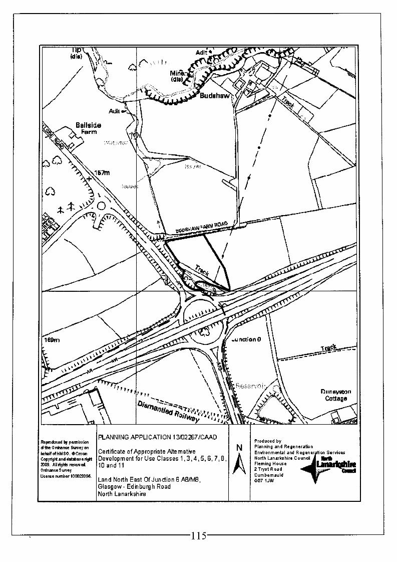
PLANNING APPLICATION 13&2267/CA4D !pmdwced b, permission the O&nte Sunray on halfdHM$O, BcroaRI Certificate ofAppropriate Alternative ~pytigHanddatd3ascrigft Development for Use Classes 1,3,4,5,6,7,8, D9. Alltights reserved. 10 and 1 1 dnanre Surwy erne number 100023396. Land North East OfJunction 6 A8IM8,
Glasgow- Edinburgh Road No rth Lanarkshire
Produced by Planning and Regeneration Environmental and Regenergtion Services North Lanarkshire Council Flcming House 2 Tryst Road Cumbernauld 087 I JW v

Refuse Certificate of Appropriate Alternative Development for Class 1 (Shops), Class 3 (Food and Drink), Class 4 (Business)? Class 5 (General Industry), Class 6 (Storage and Distribution)? Class 7 (Hotel and Hostels) and Class 8 (Residential Institutions)
1. That a Certificate of Appropriate Alternative Development be refused for Use Classes 1 (Shops), 3 (Food and Drink), Class 4 (Business), Class 5 (General Industry), 6 (Storage and Distribution), 7 (Hotel and Hostels) and 8 (Residential Institution) as:
i) The site was designated as GB1 (Restrict Development in the Green Belt) within the Monklands District Local Plan (the relevant local plan at the date of the Compulsory Purchase Order) which restricted development in this area to new houses for full time workers in connection with forestry or agriculture, non residential development in connection with forestry or agriculture, uses requiring a rural location or areas identified as having substantial development potential. Any development within the proposed use classes would not have met the requirements of this policy and therefore would have been considered contrary to the development plan without any material justification being apparent for a development plan departure.
Issue Certificate of Appropriate Alternative Development in respect of Classes 10 (Non- Residential Institution) and Class 11 (Assembly and Leisure) of the Town and Country Planning (Use Classes) (Scotland) Order 1997
2. That planning permission would have been granted for the development which the land has been acquired for and appropriate educational/ tourist development associated with agriculture, forestry or the rural and natural setting within Class 10 of the Town and Country Planning (Use Classes) (Scotland) Order 1997 and appropriate rural leisure development within Class 11 of the Town and Country Planning (Use Classes) (Scotland) Order 1997.
Reason: To define the use classes appropriate for this location.
3. For the avoidance of doubt, any planning permission for this area of land would have been restricted to a leisure pursuit (Class 11) appropriate for a rural location including a golf course or equestrian activity. Planning permission would not have been granted for a cinema, concert hall, casino or other similarly urban use.
Reason: To define the use of this area of land.
4. For the avoidance of doubt, any planning permission for this area of land would have been restricted to an educational/ tourist (Class 10) facility associated with agricultural or forestry or appropriate for a rural and natural setting.
Reason: To define the use of this area of land.
5. That the permission would have had no effect before further information was submitted to the Planning Authority in respect of the following matters:-
(a) The siting, design and external appearance of all buildings and other structures; (b) the means of access to the site; (c) the layout of the site, including all roads, footways, parking and turning areas; (d) the design and location of all boundary walls and fences; (e) the provision for drainage works; (f) the disposal of sewage; (9) details of existing trees, shrubs and hedgerows to be retained, and (h) details of existing and proposed site levels.
Reason: To enable the Planning Authority to consider these aspects in detail.
116

6. That the permission would have had no effect before further information was submitted to the Planning Authority in respect of the proposed topographical design of the golf course and the associated greens being submitted to and approved in writing by the Planning Authority.
Reason: To enable the Planning Authority to consider these aspects in detail.
7. That the permission would have had no effect before further information was submitted to the Planning Authority in respect of full details of the location and design of the surface water drainage scheme to be installed within the application site and for the avoidance of doubt the scheme would require to be certified by a qualified civil engineer as being appropriate for the site and in compliance with requirements of Scottish Water and the Scottish Environmental Protection Agency in terms of their principles of Sustainable Drainage Systems.
Reason: To ensure that the drainage scheme complies with best SUDS practice to protect adjacent watercourses and groundwater and in the interests of the amenity and wellbeing of existing and future residents adjacent to and within the development site.
8. That before the development started on the application site, unless otherwise agreed in writing with the Planning Authority, a comprehensive site investigation report would have been submitted to the said Authority for approval. The investigation would need to have been carried out in accordance with current best practice advice, such as BS 101 75: 'The Investigation of Potentially Contaminated Sites' or CLR 11. The report should have included a site specific risk assessment of all relevant pollution linkages and a conceptual site model. Depending on the results of the investigation, a detailed Remediation Strategy may have been required.
To establish whether or not site decontamination is required in the interests of the amenity and wellbeing of future residents.
9. That before development started any remediation works identified by the site investigation would have been carried out to the satisfaction of the Planning Authority. A certificate (signed by a chartered Environmental Engineer) would have been submitted to the Planning Authority confirming that any remediation works have been carried out in accordance with the terms of the Remediation Strategy.
Reason: To ensure that the site is free of contamination in the interests of the amenity and wellbeing of future residents.
10. That, notwithstanding the terms of Condition 2, before the final design and scale of the development could be agreed a Transport Assessment would have been required to justify the scale and access position for the development.
Reason: To consider the impact of the development in terms of traffic management and safety.
That, notwithstanding the terms of Condition 2, before the final design and scale of the development could be agreed a Protected Species and Habitat Survey for the site and surrounding area would have been required to ensure protected species and valuable habitats were adequately protected. Any mitigation identified in this survey would have been required to be carried out prior to development starting.
11.
Reason: To ensure the development adequately considers protected species and e c o I o g y .
12. That, notwithstanding the terms of Condition 2, the design, scale and layout of the development should take cognisance of its proximity and position to the adjacent motorway in terms of nuisance and risk to road users.
117
Reason: To ensure there is no adverse impact on the road network from this leisure pursuit.
13. That before any works started on site agreement with Scottish Power would have been required as to any works needed to protect or re-route the overhead power lines on site.
Reason: To protect the utility infrastructure in the area.
118

Backaround Papers:
Contact Information:
Any person wishing to inspect these documents should contact Mr William Shand at 01 236 632499
Report Date:
7th January 201 4
119

APPLICATION NO. 13/02267/CAAD
REPORT
1.
1.1
2.
2.1
2.2
3.
3.1
3.2
Site Description
The site for which this application relates is an area of open land to the north east of junction 6 of the A8/ M8 Glasgow - Edinburgh Road south of Chapelhall. The area of land forms part of an agricultural field which appears to have the main function of grazing land. To the south of the land is the A8/ M8 dual carriageway, to the west is the A73 dual carriageway and the site is surrounded by further agricultural fields to the east and north. Further to the north west is the southern edge of Chapelhall. There is an existing field access off the roundabout at junction 6 and further access could reasonably be taken from the access road to the neighbouring Budshaw Farm to the north. The land rises in a southerly direction towards the A8/ M8. Overhead power lines also run through the site.
Proposed Development
This is an application for a Certificate of Appropriate Alternative Development (CAAD) under the Land Compensation (Scotland) Act 1963 as amended. This application seeks a CAAD for uses within classes 1, 3, 4, 5, 6, 7, 8, 10 and 11 of the Town and Country Planning (Use Classes)(Scotland) Order 1997. The aim of this type of application is to consider appropriate uses for land which are subject of a Compulsory Purchase Order (CPO) to aid the land valuation process. This land is subject of a CPO from the Scottish Government (Transport Scotland) as part of the A8/ M8 upgrade works. The Planning Authority must consider the application against local plan policy at the time of the CPO which in this instance was November 2007.
An applicant is required to propose land uses which they consider appropriate for the site. In this instance the applicant has indicated that the site could accommodate a mixed use development including a hotel (Class 7) along with shops (Class 1) and food and drink (Class 3). Alternatively given the location of the land next to the A8/M8 corridor the applicant suggests that Class 4 (Business), Class 5 (General Industry) and Class 6 (Storage and Distribution) would also be appropriate. Given the countryside location it is also suggested that class 8 (residential institution) educational facilities for recreation and outdoor pursuit, crematorium (Class 10) or golf course (Class 11) would also be appropriate. No specific development details have been submitted.
Applicant’s Supportinq Information
The applicant has submitted a supporting statement with the application outlining arguments supporting the proposed use classes and their appropriateness for this location. This document outlines the previous planning policy for the site which indicates that in the draft and adopted Monklands District Local Plan 1991 this area of land was designated as green belt. In the current Adopted North Lanarkshire Local Plan the applicant indicates that the land is designated as Policy ED12 B ‘Transport Development’ (M8 widening). As the neighbouring land use designation is NBE 3 (Assessing Development in the Green Belt), the applicant has provided justification for development in the green belt as well as outlining acceptability with development strategy policies.
In terms of specific classes and development the applicant has indicated that tourist development in the form of a hotel (Class 7) and service station mixed use type development would be appropriate in this location due to the proximity of the site to the A8/ M8. This could include an element of retail (Class 1) and food and drink (Class 3). The statement includes an assessment of compatibility of such a proposal with the development strategy policies DSP1 and DSP 2 of the Adopted North Lanarkshire Local Plan. The applicant has received offers for the land for this specific
120

mixed use purpose. Due to the sites location and proximity to the A8/ M8 and other industrial uses there is a suggestion that the land could be used for use Classes 4 (Business), 5 (General Industry) and 6 (Storage and Distribution). The Council has previously considered that employment use may be acceptable in this location in the M8/ A8 Corridor Interim Land Use Strategy although this has never been brought through in land use terms. The applicant considers that Class 8 (Residential Institutions) would also be appropriate in the green belt as educational facilities are considered appropriate along with outdoor recreation and tourism facilities. Class 10 (Non Residential Institutions) has also been suggested in the form of a crematorium which the applicant states is often deemed acceptable in green belt locations. The final use class applied for is Class 11 (Assembly and Leisure). The applicant has identified a golf course as being appropriate either in isolation or in combination with a hotel.
4. Site Historv
4.1 There is no specific planning history for this location although a separate CAAD application has been made by the same applicant for an area of land on the west side of the A73 and that application is also being considered on this agenda.
5. Development Plan
5.1 As the Compulsory Purchase Order was made in 2007 the CAAD should be considered against development plan policy at that time. In this case the relevant development plan at that time was the Monklands District Local Plan 1991. The currently Adopted North Lanarkshire Local Plan was only a consultation draft in 2007.
5.2 The application site is located in an area which was designated as GBI (Restrict Development in the Green Belt) within the Monklands District Local Plan 1991. This policy restricted any development apart from those associated within agriculture and forestry or to those uses requiring a rural location such as to avoid nuisance to neighbours or as they required large areas of land such as golf courses. No reference is made to the A8/ M8 upgrade in the policy map.
5.3 For reference the policy designation for the site with the Consultation Draft North Lanarkshire Local Plan was ENV 6 (Assessing Development in the Green Belt). The area of land is also shown as part of the A8/ M8 upgrade works in this plan.
6. Consultations
6.1 No consultations were undertaken as part of this application.
7. Representations
7.1 Neighbour notification is not carried out as part of this application although all interested parties to the land are notified by the applicant. No letters of representation have been received.
0. Plannina Assessment
8.1 Under Section 25 of the Land Compensation (Scotland) Act 1963 the CAAD procedure requires that the Planning Authority certifies the alternative development for which planning permission would have been granted for the land if it were not to be acquired by compulsory purchase powers. If the Planning Authority is of a view that one or more classes of development would be acceptable on the site, they would issue a certificate to that effect, listing any conditions which would be required were any such development to be approved. A negative CAAD decision should not be made solely on development plan grounds. The planning authority must not refuse a certificate solely on the grounds that it would be contrary to policies which have no purpose beyond the scheme for which the compulsory acquisition is being promoted
I 121

(in this instance the A8/ M8 upgrade). Broader policies which would prevent any of the Classes of Use proposed can, however, be taken into account. Account can, therefore, be taken of policies unrelated to the background compulsory purchase scheme and other material considerations may also be considered.
8.2 The CAAD procedures require that the application is assessed as at November 2007 as this is the date that the applicant has provided as being the date of the promotion of the Compulsory Purchase Order. The relevant development plan at the date that the Compulsory Purchase Order was promoted is the Monklands District Local Plan 1991. The policy designation for this site does not relate to the proposed upgrade works for the A8/ M8 and therefore offers specific policy for which to consider this proposal against. The site was designated as GBI (Restrict Development within the Green Belt) within this local plan.
Hotel DeveloPment (Class 71, ShoDs (Class 1 ) and Food and Drink (Class 31
8.3 Policy GB1 (Restrict Development within the Green Belt) of the Monklands District Local Plan 1991 did not outline hotel development or indeed for shops or restaurants as being acceptable development within the green belt. It is noted that the area of land lies adjacent to the A73 and A81 M8 which are major routes in the area. This however in itself would not justify the release of green belt land for the uses proposed. The creation of a hotel mixed use development in this location would have required significant justification and locational need for a departure from green belt policy and the supporting information supplied by the applicant does not provide sufficient justification. It is recommended that there does not appear to be sufficient material considerations in this instance to outweigh the local plan policy at that time. It is therefore recommended that a CAAD for Classes 1, 3 and 7 should be refused.
Business (Class 4). General lndustrv (Class 5) and Storaae and Distribution (Class 6)
Policy GB1 (Restrict Development in the Green Belt) restricted development to those associated with agriculture and forestry or those which require a rural location. It is not considered that there was policy support for these proposed use classes within this policy. The applicant has argued that the M8/ A8 corridor has been identified previously by North Lanarkshire Council as having significant potential for employment opportunities and that there are other similar uses in this corridor. The Council may have identified this corridor as an important place to promote employment opportunities but this has not been promoted in the local plan in this location. This area of land is isolated from other similar uses and is relatively isolated from other development including Chapelhall with the site being separated from the settlement by the A73 and intervening land. The site is also surrounded by mostly rural land. The local plan policy designation therefore would not have supported these three land uses and it is not considered that there is sufficient material weight from other considerations to outweigh the policy designation at that time. It is recommended that a CAAD for Classes 4, 5 and 6 is refused.
8.4
Residential Institution (Class 8) - Educational use
8.5 Class 8 of the Town and Country Planning (Use Classes) (Scotland) Order 1997 contains development which provide residential accommodation other than dwellings such as accommodation with care, hospitals or residential schools. Policy GBI (Restrict Development in the Green Belt) did not support residential development other than those associated with agriculture, forestry or leisure. This policy would not have supported the residential institutions found within use class 8. It is recommended that there does not appear to be sufficient material considerations in this instance to outweigh the local plan policy at that time. It is therefore recommended that a CAAD for class 8 should be refused.
Crematorium [Class 10 -Non-residential Institution1
122

8.6 The applicant has argued that crematoriums are appropriate developments within the green belt and that crematoriums have been approved in the green belt previously. Any crematorium previously approved in the green belt would have required a specific locational need which has not been provided in this instance. There was no policy support for this type of development within the Monklands District Local Plan 1991 given the GBI (Restrict Development in the Green Belt) policy designation. There appears to be no specific locational need for a crematorium to be positioned in this location although the applicant does indicate that they have been approached previously by a developer wishing to buy the land for this purpose. Development of this site for this purpose would likely have been seen as sporadic development in the green belt with the land being detached from Chapelhall and other areas of development. This position is supported by planning history in the Monklands District local plan area with a crematorium being refused in the green belt south of Calderbank (00/00459/FUL) for being contrary to policy GBI (Restrict Development in the Green Belt) in 2001. It is noted that there is a crematorium a relatively short distance to the south in an area which when proposed was designated green belt within the Adopted Northern Area Local Plan at that time. That crematorium was different however as it was within a different Local Plan area and there was an updated policy position with the Finalised Draft Southern Area Local Plan which had designated the site as suitable for a crematorium rather than green belt. Thereby although a crematorium was contrary to the adopted local plan in that area there was support from a finalised draft. This is not the case for the site of this application. This type of use would therefore have been considered inappropriate for this green belt location and there appears to be no material considerations that would outweigh the policy designation. It is recommended that a CAAD for this use within Class 10 uses is refused.
Educational and Tourist Facilitv (Class 10 - Non - Residential Institution)
The use of the area of land for an educational facility and tourist facility without residential accommodation has also been considered. In terms of policy GB1 (Restrict Development in the Green Belt) there may have been justification for a development of this type if it could have been shown that it was either associated with forestry or agriculture or required a rural location. Educational and tourist facilities do exist which are associated with agriculture, forestry and rural enhancement (such as biodiversity and ecology). Although policy GB1 does not specifically promote this land use it is noted that there would be sufficient justification for this type of use within the criteria of the policy subject to the development being of appropriate scale and design and subject to other impact criteria. This type of development has been promoted in the green belt in the current Adopted North Lanarkshire Local Plan. It is therefore considered that policy GB1 (Restrict Development in the Green Belt) in the Monklands District Local Plan 1991 would support a CAAD for Class 10 (Non- Residential Institutions) with restrictions to a facility associated with agricultural or forestry or required for a rural location and natural setting. Any CAAD issued for this class should restrict the use in this way.
8.7
Leisure Facilitv (Class 11 - Assemblv and Leisure)
8.8 The final use proposed by the applicant is that of Class 11 (Assembly and Leisure) and more specifically those related to green belt locations such as golf courses either in isolation or in combination with another development like a hotel. It is noted that policy GB1 (Restrict Development in the Green Belt) did provide support to uses which require rural locations such as riding stables or golf courses. These types of leisure uses usually require larger areas of ground or require the rural benefits of the area. This area of land may not have been sufficient to fully accommodate a golf course but may have formed a significant element of this. It is considered that should this land use have been applied for at the time of the CPO there would have been sufficient policy support within the Monklands District Local Plan 1991 to approve planning permission subject to other detailed matters. It is recommended therefore that a CAAD for Class 11 (Assembly and Leisure) with restrictions to leisure uses
123

8.9
8.10
9.
9.1
appropriate for a rural location and natural setting be issued. There appear to be no other material matters on the site that would have restricted this development. It should be noted that Class 11 (Assembly and Leisure) includes a variety of uses including casinos and cinemas which would not be appropriate for this location. The CAAD should be restricted to certain types of uses within Class 11.
Other Material Considerations: Section 25 (5) of the Land Compensation (Scotland) Act 1963 as amended requires that should any conditions have been applied to any grant of planning permission for the proposed use then these should be specified in the Certificate. For this site, apart from the restrictive conditions proposed previously and general conditions with regards to the detail of the proposal, the other main considerations for the site would relate to the overhead power lines on the land, the potential for protected species, access, drainage and distance from the motorway. Details of how these were considered in the design and layout of any development would have been required in any application and appropriate conditions should be added in this regard.
The application originally included coal extraction, energy generation and telecommunication development. These types of development are not considered appropriate for consideration through a CAAD process as they do not fall easily within any use class, have no specific land use designation within the local plan and are deemed appropriate in most locations subject to detailed information. The applicant has therefore agreed to remove these elements from the submission.
Conclusions
Taking the foregoing into consideration it is considered that the proposed land uses within Class 1 (Shops), Class 3 (Food and Drink), Class 4 (Business), Class 5 (General Industry), Class 6 (Storage and Distribution), Class 7 (Hotels and Hostels) and Class 8 (Residential Institutions) would not have been appropriate for this location. These land uses would have been contrary to policy GB1 (Restrict Development in the Green Belt) within the Monklands District Local Plan 1991 which was the relevant local plan at the time of CPO and would have lead to sporadic urban development in the green belt. There appears to be no material considerations that would have outweighed the policy designation in this instance. It is recommended that a Certificate of Appropriate Alternative Development is refused for these use classes. The other suggested land uses within Class 10 (Non- Residential Institutions) and Class 11 (Assembly and Leisure) are considered appropriate for this location and would likely have been supported by policy GB1 (Restrict Development in the Green Belt) in the Monklands District Local Plan 1991. These use classes however would have been restricted to specific development associated to agriculture, forestry or the rural location. It is therefore recommended that a Certificate of Appropriate Alternative Development be approved for Class 10 (Non- Residential Institutions) and Class 11 (Assembly and Leisure) subject to the conditions that would have been relevant to any planning application or planning permission and subject to conditions restricting the specific uses appropriate from each use class.
124

Proposed Development: Application No:
13/02268/CAAD Certificate of Appropriate Alternative Development for Use Classes 1 3,4, 5, 6, 7, 8, 10 and 11
Site Address:
Land North West Of Junction 6 A8/M8 Glasgow - Edinburgh Road North Lanarkshire
Date Registered:
27th November 201 3
Applicant: Mr W H Sawyers Brownhill Farm Cleland Motherwell
Application Level: Other Application Level
Agent: Houghton Planning Ltd 102 High Street Dunblane Stirling FK15 OER
Contrary to Development Plan: No
Ward: Representations: 11 Airdrie South Councillors Agnes Coyle, Michael Coyle, Thomas Curley and David Fagan
No letters of representation received.
Recommendation: Refuse in Part for the Following Reason (1) and Issue in Part subject to the following Conditions (2- 12)
Reasoned Justification : The proposed land uses within classes 1 3, 4, 5, 6, 7 and 8 would not have been considered appropriate land uses for this area as development within these use classes would have been contrary to policy GBI (Restrict Development in the Green Belt) of the Adopted Monklands Local Plan 1991 which was the most relevant local plan in 2007 (that being the date of the Compulsory Purchase Order). The use of the land for a Golf Course or similarly appropriate rural leisure use (Class 11) and an educational facility (Class 10) associated with agriculture or forestry and appropriate for a natural setting would have had support from policy GB1 (Restrict Development in the Green Belt) within the Monklands District Local Plan and a Certificate for Appropriate Alternative Development is issued for Class 1 1 (with restrictions) and Class 10 (with restrictions) only.
125

rpmdueed by petmission theorchance S w e y on
,pyrigtt and database tigM 109. All rights resenrei.
: e m number 100oP3%.
!haWdHMSO. @ C r ~ c ~ n
dnatlte Sunrey
126
I PLANNING APPLICATION 13/U2268/CMD I I Certificate o f App ro pria te Alte mative Development for Use Classes 1,3,4, 5,6,7,8,10 and 11
Land North West Of Junction 6 #/M8 Glasgow- Edinburgh Road North Lanarkshire
Produced by Planning and Regeneration Environmental and Regene North Lanarkshire Council Flaming House 2 Tryst Road Cumbernauld 587 IJW

Refuse Certificate of Appropriate Alternative Development for Class 1 (Shops), Class 3 (Food and Drink), Class 4 (Business), Class 5 (General Industry), Class 6 (Storage and Distribution), Class 7 (Hotel and Hostels) and Class 8 (Residential Institutions)
1. That a Certificate of Appropriate Alternative Development be refused for Use Classes 1 (Shops), 3 (Food and Drink), Class 4 (Business), Class 5 (General Industry), 6 (Storage and Distribution), 7 (Hotel and Hostels) and 8 (Residential Institution) as:
i) The site was designated as GB1 (Restrict Development in the Green Belt) within the Monklands District Local Plan (the relevant local plan at the date of the Compulsory Purchase Order) which restricted development in this area to new houses for full time workers in connection with forestry or agriculture, non residential development in connection with forestry or agriculture, uses requiring a rural location or areas identified as having substantial development potential. Any development within the proposed use classes would not have met the requirements of this policy and therefore would have been considered contrary to the development plan without any material justification being apparent for a development plan departure.
Issue Certificate of Appropriate Alternative Development in respect of Classes 10 (Non- Residential Institution) and Class 11 (Assembly and Leisure) of the Town and Country Planning (Use Classes)(Scotland) Order 1997
2. That planning permission would have been granted for the development which the land has been acquired for and appropriate educational/ tourist development associated with agriculture, forestry or the rural and natural setting within Class 10 of the Town and Country Planning (Use Classes)(Scotland) Order 1997 and appropriate rural leisure development within Class 11 of the Town and Country Planning (Use Classes)(Scotland) Order 1997.
Reason: To define the use classes appropriate for this location.
3. For the avoidance of doubt, any planning permission for this area of land would have been restricted to a leisure pursuit (Class 11) appropriate for a rural location including a golf course or equestrian activity. Planning permission would not have been granted for a cinema, concert hall, casino or other similarly urban use.
Reason: To define the use of this area of land.
4. For the avoidance of doubt, any planning permission for this area of land would have been restricted to an educational/ tourist (Class 10) facility associated with agricultural or forestry or appropriate for a rural and natural setting.
Reason: To define the use of this area of land.
5. That the permission would have had no effect before further information was submitted to the Planning Authority in respect of the following matters:-
(a) the siting, design and external appearance of all buildings and other structures; (b) the means of access to the site; (c) the layout of the site, including all roads, footways, parking and turning areas; (d) the design and location of all boundary walls and fences; (e) the provision for drainage works; (f) the disposal of sewage; (9) details of existing trees, shrubs and hedgerows to be retained, and (h) details of existing and proposed site levels.
Reason: To enable the Planning Authority to consider these aspects in detail.
127

6. That the permission would have had no effect before further information was submitted to the Planning Authority in respect of the proposed topographical design of the golf course and the associated greens being submitted to and approved in writing by the Planning Authority.
Reason: To enable the Planning Authority to consider these aspects in detail.
7. That the permission would have had no effect before further information was submitted to the Planning Authority in respect of full details of the location and design of the surface water drainage scheme to be installed within the application site and for the avoidance of doubt the scheme would require to be certified by a qualified civil engineer as being appropriate for the site and in compliance with requirements of Scottish Water and the Scottish Environmental Protection Agency in terms of their principles of Sustainable Drainage Systems.
Reason: To ensure that the drainage scheme complies with best SUDS practice to protect adjacent watercourses and groundwater and in the interests of the amenity and wellbeing of existing and future residents adjacent to and within the development site.
8. That before the development started on the application site, unless otherwise agreed in writing with the Planning Authority, a comprehensive site investigation report would have been submitted to the said Authority for approval. The investigation would need to have been carried out in accordance with current best practice advice, such as BS 101 75 : 'The Investigation of Potentially Contaminated Sites' or CLR 11. The report should have included a site specific risk assessment of all relevant pollution linkages and a conceptual site model. Depending on the results of the investigation, a detailed Remediation Strategy may have been required.
Reason: To establish whether or not site decontamination is required in the interests of the amenity and wellbeing of future residents.
9. That before development started any remediation works identified by the site investigation would have been carried out to the satisfaction of the Planning Authority. A certificate (signed by a chartered Environmental Engineer) would have been submitted to the Planning Authority confirming that any remediation works have been carried out in accordance with the terms of the Remediation Strategy.
Reason: To ensure that the site is free of contamination in the interests of the amenity and wellbeing of future residents.
That, notwithstanding the terms of Condition 2, before the final design and scale of the development could be agreed a Transport Assessment would have been required to justify the scale and access position for the development.
Reason: To consider the impact of the development in terms of traffic management and safety.
10.
11. That, notwithstanding the terms of Condition 2, before the final design and scale of the development could be agreed a Protected Species and Habitat Survey for the site and surrounding area would have been required to ensure protected species and valuable habitats were adequately protected. Any mitigation identified in this survey would have been required to be carried out prior to development starting.
Reason: To ensure the development adequately considers protected species and ecology.
12. That, notwithstanding the terms of Condition 2, the design, scale and layout of the development should take cognisance of its proximity and position to the adjacent motorway in terms of nuisance and risk to road users.
128

Reason: To ensure there is no adverse impact on the road network from this leisure pursuit.
129
Backaround PaDers:
Consultation Responses:
Contact information:
Any person wishing to inspect these documents should contact Mr William Shand at 01236 632499
Report Date:
7th January 201 4
130

APPLICATION NO. 13/02268/CAAD
REPORT
1.
1.1
2.
2.1
2.2
3.
3.1
3.2
Site Description
The site for which this application relates is an area of open land to the north west of junction 6 of the A8/ M8 Glasgow - Edinburgh Road south of Chapelhall. The land forms part of a large area of open space to the south of Chapelhall and appears to be agricultural in nature. To the south of the land is the A8/ M8 dual carriageway, to the east is the A73 dual carriageway and the site is surrounded by un-kept open land to the west and north, Beyond the open land to the north is the southern edge of Chapelhall. The land appears landlocked from direct vehicular access although it is noted that there is a spur from the roundabout to the open land to the north and there is a track to the west of the site. The land rises in a southerly direction towards the A8/ M8 with the land being steep in incline directly before the dual carriageway.
Proposed Development
This is an application for a Certificate of Appropriate Alternative Development (CAAD) under the Land Compensation (Scotland) Act 1963. This application seeks a CAAD for uses within classes 1, 3, 4, 5, 6, 7, 8, 10 and 11 of the Town and Country Planning (Use Classes)(Scotland) Order 1997. The aim of this type of application is to consider appropriate uses for areas of land which are subject of a Compulsory Purchase Order (CPO) to aid the land valuation process. This land is subject of a CPO from the Scottish Government (Transport Scotland) as part of the A8/ M8 upgrade works. The Planning Authority must consider the application against development plan policy at the time of the CPO which in this instance was November 2007.
An applicant is required to propose land uses which they consider appropriate for the site. In this instance the applicant has indicated that the site could accommodate a mixed use development including a hotel (Class 7) along with shops (Class 1) and food and drink (Class 3). Alternatively given the location of the land next to the A8/M8 corridor the applicant suggests that Class 4 (Business), Class 5 (General Industry) and Class 6 (Storage and Distribution) would also be appropriate. Given the countryside location it is also suggested that class 8 (residential institution) educational facilities for recreation and outdoor pursuit, crematorium (Class 10) or golf course (Class 11) would also be appropriate. No specific development details have been submitted.
Applicant’s Supportinu Information
The applicant has submitted a supporting statement with the application outlining arguments supporting the proposed use classes and their appropriateness for this location. This document outlines the previous planning policy for the site which indicates that in the draft Monklands District Local Plan 1991 this area of land was designated for tourist use under policy TO 8/2. This was removed before adoption. In the current Adopted North Lanarkshire Local Plan the applicant indicates that the site is designated as Policy ED12 B ‘Transport Development’ (M8 widening). As they consider the neighbouring land use designation to be NBE 3 (Assessing Development in the Green Belt), the applicant has also provided justification for development in the green belt as well as outlining acceptability with development strategy policies.
An outline of the history of this site has also been given. This includes a previous planning application which was submitted in 1999 for a large mixed use development including hotel, public house and service station. This was later withdrawn and no application has ever been resubmitted. The applicant has also provided information of a previous CPO exercise (in 1995) on adjacent land whereby the District Valuer concluded that the land had commercial value and compensated accordingly even
131
although the land was designated as green belt at that time. The suggestion is that compensation was given at commercial rates due to hope value for the area.
In terms of specific classes and development the applicant has indicated that tourist development in the form of a hotel (Class 7) and service station mixed use type development would be appropriate in this location due to the proximity of the site to the A8/ M8. This could include an element of retail (Class 1) and food and drink (Class 3). The statement includes an assessment of compatibility of such a proposal with the development strategy policies DSP1 and DSP 2 of the Adopted North Lanarkshire Local Plan. The applicant has received offers for the land for this specific mixed use purpose. Due to the site’s location and proximity to the A8/ M8 and other industrial uses there is a suggestion that the land could be used for use classes 4 (Business), 5 (General Industry) and 6 (Storage and Distribution). The Council has previously considered that employment use may be acceptable in this location in the M8/ A8 Corridor Interim Land Use Strategy. The applicant considers that Class 8 (Residential Institutions) would also be appropriate in the green belt as educational facilities are considered appropriate along with outdoor recreation and tourism facilities. Class 10 (Non Residential Institutions) has also been suggested in the form of a crematorium which the applicant states is often deemed acceptable in green belt locations. The final use class applied for is Class 11 (Assembly and Leisure). The applicant has identified golf courses as being appropriate either in isolation or in combination with a hotel.
3.3
4. Site History
4.1 As noted in section 3.2 this area has a planning history of planning applications for proposed uses similar to those applied for in this application. An application was submitted in 1997 (97/0501O/OUT) for a factory outlet and retail mall over a large area of land north of the A8/ M8 which included the land of this application. This application was later withdrawn on 17 May 1999. Another planning application (99/00677/FUL) was submitted for the land to the north accessed from the spur on the roundabout on the A73 at the junction with Lancaster Avenue for a petrol filling station, fast food restaurant, hotel and public house and restaurant. This was withdrawn on 1 1 December 2000. Another application (99/01016/OUT) for a similar development of a mixed use development incorporating a public house/ restaurant, hotel, petrol filling station and fast food restaurant with drive through and access was submitted on 27 July 1999 by another applicant. This was later withdrawn on 18 July 2000 and no further application has been received.
4.2 Another separate CAAD application 13/02267/CAAD has been submitted by the same applicant for an area of land on the east side of the A73 and this is also being presented to committee on this agenda.
5. DeveloDment Plan
5.1 As the Compulsory Purchase Order was made in 2007 the CAAD should be considered against development plan policy at that time. In this case the relevant development plan at that time was the Monklands District Local Plan 1991. The currently Adopted North Lanarkshire Local Plan was only at a consultation draft in 2007.
5.2 The application site is located in an area which was designated as GB1 (Restrict Development in the Green Belt) within the Monklands District Local Plan 1991. This policy restricted any development apart from those associated within agriculture and forestry or to those uses requiring a rural location such as to avoid nuisance to neighbours or as they required large areas of land such as golf courses. No reference is made to the A8/ M8 upgrade in the policy map.
132
5.3
6.
6.1
7.
7.1
8.
8. I
8.2
8.3
For reference the policy designation for the site within the Consultation Draft North Lanarkshire Local Plan was ENV 6 (Assessing Development in the Green Belt). The area of land is also shown as part of the A8/ M8 upgrade works in this plan.
Consultations
No consultations were undertaken as part of this application.
Neighbour notification is not carried out as part of this application although all interested parties to the land are notified by the applicant. No letters of representation have been received.
Plannina Assessment
Under Section 25 of the Land Compensation (Scotland) Act 1963 the CAAD procedure requires that the Planning Authority certifies the alternative development for which planning permission would have been granted for the land if it were not to be acquired by compulsory purchase powers. If the Planning Authority is of a view that one or more classes of development would be acceptable on the site, they would issue a certificate to that effect, listing any conditions which would be required were any such development to be approved. A negative CAAD decision should not be made solely on development plan grounds. The planning authority must not refuse a certificate solely on the grounds that it would be contrary to policies which have no purpose beyond the scheme for which the compulsory acquisition is being promoted (in this instance the A8/ M8 upgrade). Broader policies which would prevent any of the Classes of Use proposed can, however, be taken into account. Account can, therefore, be taken of policies unrelated to the background compulsory purchase scheme and other material considerations may also be considered.
The CAAD procedures require that the application is assessed as at November 2007 as this is the date that the applicant has provided as being the date of the promotion of the Compulsory Purchase Order. The relevant development plan at the date that the Compulsory Purchase Order was promoted is the Monklands District Local Plan 1991. The policy designation for this site does not relate to the proposed upgrade works for the A8/ M8 and therefore offers specific policy for which to consider this proposal against. The site was designated as GBI (Restrict Development within the Green Belt) within this local plan.
Hotel DeveloDment (Class 7). Shops (Class 1) and Food and Drink (Class 3)
Policy GBI (Restrict Development within the Green Belt) of the Monklands District Local Plan 1991 offered no specific support to a hotel development or indeed for shops or restaurants. It is noted that the area of land lies adjacent to the A73 and A81 M8 which are major routes in the area. This however in itself would not have justified the release of green belt land for the uses proposed. The planning history for the site and neighbouring land is noted, particularly the applications for mixed use development as these relate to the current proposal. As these applications were withdrawn, these offer little in justification for the site being suitable for these proposed uses. The creation of a hotel mixed use development in this location would have required significant justification and locational need for a departure from green belt policy and the supporting information supplied by the applicant does not provide sufficient justification. It is recommended that there does not appear to be sufficient material considerations in this instance to outweigh the local plan policy at that time. It is therefore recommended that a CAAD for Classes 1, 3 and 7 should be refused.
Business (Class 4), General lndustrv (Class 5) and Storaae and Distribution (Class 6)
133

8.4 Policy GB1 (Restrict Development in the Green Belt) restricted development to those associated with agriculture and forestry or development which required a rural location. It is not considered that there was support for Classes 4, 5 and 6 within this policy. The applicant has argued that the M8/ A8 corridor has been identified previously by North Lanarkshire Council as having significant potential for employment opportunities and that there are other similar uses in this corridor. The Council may have identified this corridor as an important place to promote employment opportunities but this was not promoted in the Monklands District Local Plan in this location. It is noted that industrial land was promoted to the west and south however this area of land remained green belt. As the industrial allocation within this local plan was never fully built out in this location, this area of land would have been isolated from other industrial uses in the wider area. The local plan policy designation therefore would not have supported these three land uses and it is not considered that there is sufficient material weight from other considerations to outweigh the policy designation at that time. It is recommended that a CAAD for Classes 4, 5 and 6 is refused.
Residential Institution (Class 8) - Educational use
8.5 Class 8 of the Town and Country Planning (Use Classes) (Scotland) Order 1997 contains development which provide residential accommodation other than dwellings such as accommodation with care, hospitals or residential schools. Policy GB1 (Restrict Development in the Green Belt) did not support residential development other than those associated with agriculture, forestry or leisure. This policy would not have supported the residential institutions found within use class 8. It is recommended that there does not appear to be sufficient material considerations in this instance to outweigh the local plan policy at that time. It is therefore recommended that a CAAD for class 8 should be refused.
Crematorium (Class 10 -Non-residential Institution)
8.5 The applicant has argued that crematoriums are appropriate developments within the green belt and that crematoriums have been approved in the green belt previously. Any crematorium previously approved in the green belt would have required a specific locational need which has not been provided in this instance. There was no policy support for this type of development within the Monklands District Local Plan 1991 given the GB1 (Restrict Development in the Green Belt) policy designation. There appears to be no specific locational need for a crematorium to be positioned in this location although the applicant does indicate that they have been approached previously by a developer wishing to buy the land for this purpose. This position is supported by planning history in the Monklands District local plan area with a crematorium being refused in the green belt south of Calderbank (00/00459/FUL) for being contrary to policy GB1 (Restrict Development in the Green Belt) in 2001. It is noted that there is a crematorium a relatively short distance to the south in an area which when proposed was designated green belt within the Adopted Northern Area Local Plan at that time. That crematorium was different however as it was within a different Local Plan area and there was an updated policy position with the Finalised Draft Southern Area Local Plan which had designated the site as suitable for a crematorium rather than green belt. Thereby although a crematorium was contrary to the adopted local plan in that area there was support from a finalised draft. This is not the case for the site of this application. This type of use would therefore have been considered inappropriate for this green belt location and there appears to be no material considerations that would outweigh the policy designation. It is recommended that a CAAD for this particularly use class within Class 10 is refused.
Educational and Tourist Facility (Class 10 - Non - Residential Institution1
8.7 The use of the area of land for an educational facility and tourist facility without residential accommodation has also been considered. In terms of policy GB1 (Restrict Development in the Green Belt) there may have been justification for a
134

development of this type if it could have been shown that it was either associated with forestry or agriculture or required a rural location. Educational and tourist facilities do exist which are associated with agriculture, forestry and rural enhancement (such as biodiversity and ecology). Although policy GB1 did not specifically promote this land use it is noted that there would have been sufficient justification under the criteria of the policy for this type of use subject to the development being of appropriate scale and design for the rural location and subject to other impact criteria. This type of development has been promoted in the green belt in the currently Adopted North Lanarkshire Local Plan. This site would have been constrained in its likely usage given that the immediate neighbouring land is not utilised for agriculture or forestry. Other types of educational facilities possibly connected with ecological resources would have been more likely. This however does not deny that in principle the site could have been considered favourably for this use under the Monklands District Local Plan 1991. It is therefore considered that policy GB1 (Restrict Development in the Green Belt) in the Monklands District Local Plan 1991 would support a CAAD for Class 10 (Non - Residential Institutions) with restrictions to a facility associated with agricultural or forestry or required for a rural location and natural setting. Any CAAD issued for this class should restrict the use in this way.
Leisure Facilitv (Class 11 - Assemblv and Leisure)
8.8 The final use proposed by the applicant is that of Class 11 (Assembly and Leisure) and more specifically those related to green belt locations such as a golf course either in isolation or in combination with another development like a hotel. Policy GB1 (Restrict Development in the Green Belt) did indicate that leisure uses which required large areas of land or required the benefits of the rural environment such as golf courses or riding stables was supported by this policy. This area of land may not be sufficient alone to fully accommodate a golf course but may have formed a significant element of this. Alternatively other golf related developments such as a driving range may have been considered. It is considered that should this land use have been applied for at the time of the CPO there would have been sufficient policy support within the Monklands District Local Plan 1991 to approve planning permission subject to other detailed matters. It is recommended therefore that a CAAD for Class 11 (Assembly and Leisure) with restrictions to leisure uses appropriate for a rural location and natural setting be issued. There appear to be no other material matters on the site that would have restricted this development. It should be noted that Class 11 (Assembly and Leisure) includes a variety of uses including casinos and cinemas which would not be appropriate for this location. The CAAD should be restricted to certain types of uses within Class 11.
8.9 Other Material Considerations: Section 25 (5) of the Land Compensation (Scotland) Act 1963 as amended requires that should any conditions have been applied to any grant of planning permission for the proposed use then these should be specified in the Certificate. For this site, apart from the restrictive conditions proposed previously and general conditions with regards to detail of the proposal, the other main considerations for the site would relate to the access, the potential for protected species and distance from the motorway. It is noted that the site appears to be used for grazing however the surrounding area is less disturbed and may be suitable habitat for species of interest. A habitat survey would therefore have been required with the application. The site is relatively close to the motorway and consideration of the impact of any use on the motorway would have required supporting information particularly if lighting was involved or a golf course was proposed. Transport Scotland would have been a statutory consultee. A significant issue for the site would have been access. This area of land is currently land locked and it is unknown how far the applicants land extends and where access could have been taken however there are several options available for sufficient access. It is unlikely that this would have completely restricted development of the site. Conditions in this regards should be added to any certificate issued.
8.1 0 The application originally included coal extraction, energy generation and
135

telecommunication development. These types of development are not considered appropriate for consideration through a CAAD process as they do not fall easily within any use class, have no specific land use designation within the local plan and are deemed appropriate in most locations subject to detailed information. The applicant has therefore agreed to remove these elements from the submission.
9. Conclusions
9.1 Taking the foregoing into consideration it is considered that the proposed land uses within Class 1 (Shops), Class 3 (Food and Drink), Class 4 (Business), Class 5 (General Industry), Class 6 (Storage and Distribution), Class 7 (Hotels and Hostels) and Class 8 (Residential Institutions) would not have been appropriate for this location. These land uses would have been contrary to policy GBI (Restrict Development in the Green Belt) within the Monklands District Local Plan 1991 which was the relevant local plan at the time of CPO and would have lead to sporadic urban development in the green belt. There appears to be no material considerations that would have outweighed the policy designation in this instance. It is recommended that a Certificate of Appropriate Alternative Development is refused for these use classes. The other suggested land uses within Class 10 (Non- Residential Institutions) and Class 11 (Assembly and Leisure) are considered appropriate for this location and would likely have been supported by policy GB1 (Restrict Development in the Green Belt) in the Monklands District Local Plan 1991. These use classes however would have been restricted to specific development associated to agriculture, forestry or the rural location. It is therefore recommended that a Certificate of Appropriate Alternative Development be approved for Class 10 (Non - Residential Institutions) and Class 11 (Assembly and Leisure) subject to the conditions that would have been relevant to any planning application or planning permission and subject to conditions restricting the specific uses appropriate from each use class.
136

Application No:
13/02331/FUL
Proposed Development:
Installation of Gas Central Heating Comprising Gas Meter and Boiler Flue Site Address:
2 Dalzell House Dalzell Drive Motherwell
Date Registered:
10th December 201 3
Applicant: Mrs Carolynne Coole 2 Dalzell Motherwell
Application Level: Local Application
Agent: Craig Dunn 60 Rossendale Road Glasgow
Contrary to Development Plan: No
Ward: Representations: 01 8 Motherwell South East And Ravenscraig Kaye Harmon, Thomas Lunny, Gary O'Rorke, Alan Valentine,
No letters of representation received.
Recommendation: Approve Subject to Conditions
Reasoned Justification:
The proposed development meets the criteria set out in the relevant policies of the North Lanarkshire Local Plan 201 2 in that the gas central heating system could be accommodated without detriment to the character and setting of Dalzell House and is therefore considered to be acceptable.
137

Cricket Ground
N Reproduced by permission of the Ordnance Survey on behalf of HMSO. @Crown Copyright and database right 2339. All rights reserved. Ordnance Survey Licence number 100023396.
Produced by Planning and Regeneration Environmental and Regeneration Services North Lanarkshire Counci Fleming House mhire 2 Tryst Road cowdl Curnbernauld G67 1JW
PLANNING APPLICATION 13/02331/FUL
Installation of Gas Central Heating Comprising Gas Meter and Boiler Flue
2 Dalzell House, Dalzell Drive, Motherwell ML12SJ
138

Proposed Conditions:-
1. That except as may otherwise be agreed in writing by the Planning Authority, the development shall be implemented in accordance with the plans stamped approved as part of this permission.
Reason: To clarify the drawings on which this approval of permission is founded.
139

Backaround Paoers:
Consultation Responses:
None
Contact Information:
Any person wishing to inspect these documents should contact Mr Graham Smith at 01236 632493
Report Date:
20th December 201 3
140

APPLICATION NO. 13/02331/FUL
REPORT
1.
1.1
2.
2.1
2.2
3.
3.1
4.
4.1
4.2
5.
5.1
6.
6.1
7.
7.1
8.
8.1
Site Description
The application property was originally stables associated with Dalzell House which is an A listed building that was converted into residential accommodation in the 1980s. The property is L-shaped and has accommodation over two floors and is located on the northern end of the main building fronting into a private courtyard area.
Proposed Development
Permission is sought to install a gas supply to enable the applicant to have central heating. Gas pipes would be installed underneath the courtyard leading to the front door where a concealed gas meter box would be installed. The only other external alteration would be a boiler flue on the rearhorth elevation.
A separate listed building consent application has been submitted (reference: 13/02332/LBC) for the proposal.
Applicant's Sumortina Information
A design statement describing the proposal with photographs and plans demonstrating the impact has been attached with the application.
Site History
Permission was granted for the installation of a Woodburning Stove on the 2nd May 2006 (reference: 06/0001 6/LBC).
Other flats within Dalzell House (2,6 and 12) have been granted permission for new central heating systems in the past. It should be noted that an application for gas central heating at 11 Dalzell House was recently withdrawn (reference: 13/01 206/FUL) following concerns raised over the external impact of the flue.
Development Plan
The site is zoned as NBE 3A (Green Belt), NBE 1 B2c (Listed Buildings) and NBE 1 A4a (Sites of Importance for Nature Conservation) in the North Lanarkshire Local Plan 2012.
Historic Scotland raised no objections to the proposal.
Representations
No letters of representation were received following the neighbour notification.
Plannina Assessment
In accordance with Section 25 of the Town & Country Planning (Scotland) Act 1997, planning decisions must be made in accordance with the development plan unless material considerations indicate otherwise. The proposal raises no strategic issues and as such requires to be assessed against Local Plan Policies. In this instance the North Lanarkshire Local Plan 2012 is relevant. The site is zoned as NBE 3A (Green Belt), NBE 1 B2c (Listed Buildings) and NBE 1 A4a (Sites of Importance for Nature Conservation).
141

8.2 The policies NBE 3A and NBE 1 A4a identify the building as being located in a green belt location with a setting that is important for nature conservation and recognised as being an outstanding landscape. The scale of the proposal is such that it is not contrary to these policies. The Local Plan does, however, require such proposals such as this to be assessed in detail against the criteria of NBE 1 B2c (Listed Buildings) and DSP 4 (Quality of Developments).
8.3 NBE 1 B2c specifies that the layout, design, materials, scale and siting of any development must be appropriate to the character and appearance of the listed building and its setting. It is considered that this proposal could be accommodated with minimal visual impact given that the flue can be sited in a discreet area of the roof on the northern elevation which is well screened by an area of woodland. The flue itself is not large and this along with its position is such that it would not have an adverse impact on the character or amenity of the listed building. Similarly on the private courtyard elevation, the concealed meter box would be discreetly positioned next to the entrance and would not be visually prominent. In relation to the interior impact of the proposals the inside of this house is modern and does not have any of the ornate historical features that other flats within this development have. It is therefore considered that the central heating system could be accommodated without detracting from the original character of the building and its setting and the proposal meets NBE I B2c.
8.4 DSP 4 requires an appraisal to be carried out on the existing character and features of the site and its setting and seeks to safeguard and enhance features of historic interest by integrating developments successfully into the local area. The applicant has clearly taken into consideration the context and has sought to minimise the impact which, as described above in paragraph 8.3, is considered to be acceptable. As such the proposal accords with policy DSP4.
9. Conclusions
9.1 In conclusion, following detailed assessment of the application, it is considered that the proposed development is acceptable in terms of the criteria set out in the relevant policies of the North Lanarkshire Local Plan 2012. It is considered that the central heating system could be accommodated without detriment to the character and setting of the listed building and it is therefore recommended that planning permission be granted.
142