Embed Size (px)
Citation preview

����
THE MAIDSTONE BOROUGH COUNCIL
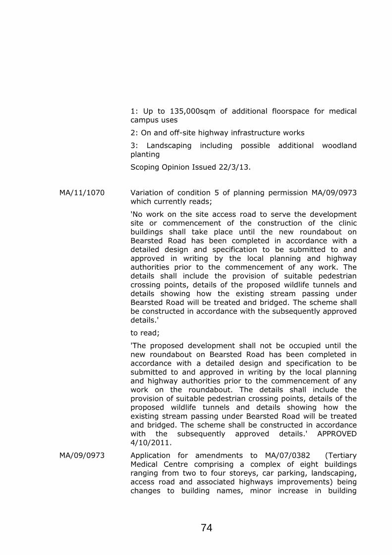
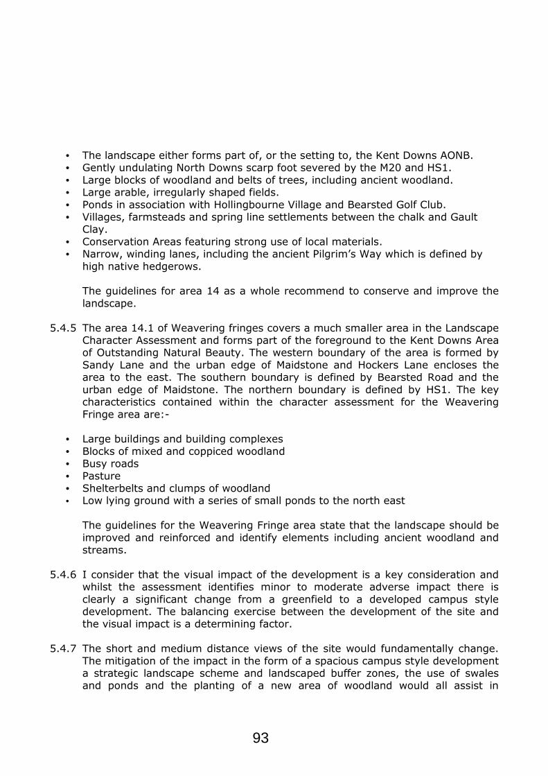
PLANNING APPLICATION NUMBER: MA/13/1163 GRID REF: TQ7856/7857
This copy has been produced specifically for Planning and BuildingControl Purposes only. No further copies may be made. Reproducedfrom the Ordance Survey mapping with the permission of the Controllerof Her Majesty's Stationary Office ©Crown Copyright. Unauthorised reproduction infringes Crown Copyright and may lead to prosecution orcivil proceedings.The Maidstone Borough Council No. 100019636, 2013.Scale 1:5000
Rob Jarman
Head of Planning and Development
LAND SOUTH OF KENT INSTITUTE OF MEDICINE AND SURGERY,
NEWNHAM PARK, MAIDSTONE.
Pond
Pond
Track
Pond
Newnham Court Inn
The
Oas
ts
Pond
El
Drain
Ponds
(PH)
Sub Sta
Clinic
Veterinary
Spreads
Newnham Court
Pond
Horish Wood
Dra
in
Works
10
0
Pond
106
Pond
Pond
CR
FF
Def
FF
Pope's Wood
Path
GP
Hill Side
Roughways
CR
Tanglewood
Wents Wood
12
Path
Cottage
4
67.5m
BEARSTED ROAD
Lavender
CottagePrimrose
ASH TREE GARDENS
1
El S
ub S
ta
Holly House
10
13
14
5
4
1
Five Acre Wood
3
EX
TO
N G
AR
DE
NS
29
HARROW WAY
55
31
30
48
37
40
ED
& W
ard
Bdy
Abbotsleigh
Kismet
Whitethorn
Bangor
66.8m
Woodville
Bletchingley
WEN
TS W
OO
D 1
47
6
TH
E H
ED
GE
RO
W
44
45
8
12
28
21
39
1
37
7
15
35
2
SA
DD
LER
S C
LOS
E
20
25
32
31
SHEPHERD
S GATE DRIVE
36
35
34
27
22
25 4 1
28
25
12
15
17
HO
RS
ES
HO
E C
LO
SE
11
HARROW WAY
22
11
20
10
6
18
15
10
3
8
Fenwynd
Dawn Cottage
Fre
sh
wo
od
s
65.0m
BEARSTED ROAD 1
Gidd's Pond Cottages
56.6m
Gidd's Pond
Farm
Gidd's Pond
10
1
7
6
1
GROVEWOOD DRIVE NORTH
El Sub Sta
Playground
8
29
8
12
10
13
10
141
9
14
SH
EP
HE
RD
S
111
2
9
15
4
6 4
1
2
13
GA
TE
DR
I VE
12
Grove Wood
6
28
1
26
23
2
30
24
VIEWCOPPICE
32
HE
NLE
Y F
IELD
S
6
13
2
1
BRIAR
FIELDS
4
11
33
NE
W C
UT
RO
AD
16
41
35
31
22
40
34
5
14
TH
E M
ALTIN
GS
NE
W C
UT
RO
AD 10
6
FB
2
1
Lodge Cottage
59.7m
Court
TCB
Newnham
Farm
26
28
21
11
5
1AV
ON
DALE
CO
UR
T
Holly House
Kent Institute ofMedicine and Surgery
4
1
3
2
Primrose
Cottage
Lavender
Cottage
3
2
Vinters Business Park
4
5
Agenda Item 18
72

ZCRD Rev Mar 12
APPLICATION: MA/13/1163 Date: 1 July 2013 Received: 2 July 2013
APPLICANT: Maidstone Medical Campus Ltd
LOCATION: LAND SOUTH OF KENT INSTITUTE OF MEDICINE AND SURGERY, NEWNHAM PARK, MAIDSTONE, KENT
PARISH:
Boxley, Detling
PROPOSAL: Outline application for the development of a medical campus comprising up to 98,000sqm of additional floor space (including additional hospital facilities, clinics, consultation rooms and a
rehabilitation centre (classes C2/D1); education and training facilities with residential accommodation (class C2/D1); key worker
accommodation for nurses and doctors (class C3); pathology laboratories (class B1); business uses (class B1); ancillary retail services (class A1, A2, A3)); and up to 116 class C2 neuro-
rehabilitation accommodation units; internal roads and car parks, including car park for residents of Gidds Pond Cottages; hard and
soft landscaping including creation of new woodland area with access for consideration and all other matters reserved for future
consideration. AGENDA DATE:
CASE OFFICER:
31st October 2013
Peter Hockney
The recommendation for this application is being reported to Committee for decision because:
● it is a departure from the Development Plan and has been advertised as such
1. POLICIES
• Maidstone Borough-Wide Local Plan 2000: ENV28, ENV31, ENV33, ENV34, ENV49, H26, T13, T21, T23, CF1, CF16
• Government Policy: National Planning Policy Framework 2012 • Interim Policy: SS4
2. HISTORY
MA/13/0218 Scoping opinion sought in respect of an Environmental Statement to be submitted in relation to a proposed development being:-
73
1: Up to 135,000sqm of additional floorspace for medical campus uses
2: On and off-site highway infrastructure works
3: Landscaping including possible additional woodland
planting
Scoping Opinion Issued 22/3/13.
MA/11/1070 Variation of condition 5 of planning permission MA/09/0973 which currently reads;
'No work on the site access road to serve the development site or commencement of the construction of the clinic buildings shall take place until the new roundabout on
Bearsted Road has been completed in accordance with a detailed design and specification to be submitted to and
approved in writing by the local planning and highway authorities prior to the commencement of any work. The details shall include the provision of suitable pedestrian
crossing points, details of the proposed wildlife tunnels and details showing how the existing stream passing under
Bearsted Road will be treated and bridged. The scheme shall be constructed in accordance with the subsequently approved
details.'
to read;
'The proposed development shall not be occupied until the
new roundabout on Bearsted Road has been completed in accordance with a detailed design and specification to be
submitted to and approved in writing by the local planning and highway authorities prior to the commencement of any work on the roundabout. The details shall include the
provision of suitable pedestrian crossing points, details of the proposed wildlife tunnels and details showing how the
existing stream passing under Bearsted Road will be treated and bridged. The scheme shall be constructed in accordance with the subsequently approved details.' APPROVED
4/10/2011.
MA/09/0973 Application for amendments to MA/07/0382 (Tertiary
Medical Centre comprising a complex of eight buildings ranging from two to four storeys, car parking, landscaping, access road and associated highways improvements) being
changes to building names, minor increase in building
74

footprints, changes to building functional requirements, changes to approach and parking, changes to energy plant
and oxygen plant, improvements to the environment and development of elevation materials APPROVED 15/10/2009.
MA/07/0382 Tertiary Medical Centre comprising a complex of eight buildings ranging from two to four storeys, car parking, landscaping, access road and associated highways
improvements: APPROVED 01/08/2008.
3. CONSULTATIONS 3.1 Boxley Parish Council raise no objections to the application stating:-
“Do not wish to object however the parish council has concerns over;
• The increase in traffic and the ability of the local area to cope with this. • Insufficient on-site parking provision in the outline plan. • Water run-off and any adverse impact on the stream that runs through the site and
which serves Vinters Valley Nature Reserve. It also wishes to highlight; • The impact on the park & ride and the need to improve public transport to the area. • The need for sustainability and the lack of renewable energy suggestions for the site.”
3.2 Detling Parish Council have no comments to make on the application
3.3 The Highways Agency have commented a number of times including with a Holding Direction that was due to expire on 3 October and have been working
with the applicants for some time regarding the Strategic Road Network (SRN) implications of the above proposed development and are considering the latest proposals. Following the initial Holding Direction additional comments were
received stating:-
“Consequently in order to protect the Secretary of State's (DfT) interests, it is necessary to issue a further Holding Direction, a copy of which is attached. The Holding Direction remains extant until 30 October, but can be replaced at any
time by a form TR110 specifying conditions to be attached to any planning permission granted by your Council.”
Further comments have been received that state:- “You will see that a Departure requirement has been identified. A few other
comments have also been noted, but most appear capable of being sorted out at a later stage. Equally, the design may need to be amended in accordance with
the Road Safety Audit.”
75

3.4 Kent Highway Services (following receipt of additional information) raise no objections to the application stating:-
“The applicant has confirmed that the differences in the total development mode shares between the time of the Scoping Assessment and the final Transport Assessment have arisen from a change in the development composition and mix during that period. Whilst the floor space relating to the nurse/doctor accommodation and student accommodation has remained the same, the overall floor space for the other development elements has changed. This has resulted in the observed reduction of the overall single occupancy vehicle mode share.
The very high level of walking trips per unit of measure for nurse/doctor and student accommodation within the TRICS database is likely to be the result of the survey sites being on a campus or hospital site, where there is no incentive for staff and students to drive to their place of work or study. On the proposed Medical Campus, these trips would also be entirely internal to the site but also act to disproportionately increase the mode share of pedestrian external trips for the individual land uses and the site as a whole.
It should also be noted that the junction capacity modelling reported in the Transport Assessment assumes a 'worst case' scenario of zero modal shift arising from the proposed site-wide Travel Plan. Moreover, the modelling assumes a total development floor area of 138,177 square metres Gross Floor Area but the final submitted planning application floor space equates to 98,000 square metres Gross Floor Area. The floor space being applied for is therefore over 29% less than that which has been assessed in the model.
I can confirm that provided the following requirements are secured by condition or planning obligation, then I would raise no objection on behalf of the local highway authority:-
1. The provision, by way of a Section 278 Agreement between the applicant and
KCC Highways and Transportation, of the off-site highway mitigation works to the M20 Junction 7, Bearsted Road Roundabout and New Cut Roundabout, as identified in the Transport Assessment, at a trigger point to be agreed with the Local Planning and Highway Authorities.
2. The provision of an extension to the Sittingbourne Road Park and Ride bus
service to serve the site, at a trigger point to be agreed with the Local Planning and Highway Authorities. As a minimum, the service should provide a 10-12 minute peak time and 15 minute off-peak frequency between the site and Maidstone Town Centre until 6pm and an hourly frequency between 6pm and 10pm on Mondays to Saturdays. A minimum 30 minute frequency service should operate on Sundays.
76

3. The provision, by way of a Section 278 Agreement between the applicant and
KCC Highways and Transportation, of accessibility improvements to the northbound and southbound bus stops located closest to the site on Hampton Road, at a trigger point to be agreed with the Local Planning and Highway Authorities. These should include the provision of raised kerbs to permit level boarding and shelters.
4. The preparation and submission of a site-wide Car Parking Management Plan
for approval by the Local Planning and Highway Authorities. 5. The preparation and submission of a site-wide Framework Travel Plan for
approval by the Local Planning and Highway Authorities, together with a Travel Plan Monitoring Fee of £10,000.”
3.5 Natural England have commented as follows:-
Landscape – No comment on the Kent Downs Area of Outstanding Natural Beauty.
Ancient Woodland – We welcome the recognition of the importance of this
valuable habitat and the proposal to reinforce the woodland block by creating new woodland on site.
Bats – Natural England does not object to the proposed development. On the basis of the information available to us, our advice is that the proposed
development is likely to affect bats through damage or destruction of a breeding site or resting place. We are satisfied however that the proposed mitigation is broadly in accordance with the requirements of the Bat mitigation guidelines and
should maintain the population identified in the survey report.
Great crested newts – Natural England does not object to the proposed development. On the basis of the information available to us, our advice is that the proposed development is likely to affect great crested newts through
disturbance of a European protected species. We are satisfied however that the proposed mitigation is broadly in accordance with the requirements of the Great
crested newt mitigation guidelines and should maintain the population identified in the survey report.
3.6 Kent Wildlife Trust have submitted a holding objection as there is no evaluation of the effectiveness of the site as a wildlife corridor and an
assessment of the impact of the development on this function. 3.7 KCC Ecology raise no objections to the application stating:-
77

“We are satisfied that there has been an adequate level of assessment of the
potential for ecological impacts arising as a result of the proposed development. Much of the site comprises improved and semi-improved grassland of low ecological interest but without mitigation there is potential for ecological impacts to several protected species – great crested newts, bats, badgers; and to the ancient woodlands and Local Wildlife Site that are adjacent to the site.
The proposal outlines the measures that will be used to protect and enhance the
ecology of the site and we are satisfied with these principles. With particular reference to European protected species, in respect of which
Maidstone BC must have regards to the requirements of the EU Habitats Directive, it is acknowledged that there will be a need to carry out the works under a European protected species mitigation licence (EPSML) to ensure that no offences against great crested newts arise. We advise that there is no reason to conclude that a licence would not be likely to be granted on ecological grounds. Under the current proposals, the bat roost that has been identified will not be directly affected, and bat-sensitive lighting has been proposed to minimise indirect impacts to bat foraging and commuting; there would be no requirement to secure a EPSML in relation to bat presence.
Detailed strategies, including a Construction Environmental Management Plan,
and Landscape and Ecology Management Plan will be required at reserved matters/detailed design to satisfy Maidstone BC of the appropriateness and achievability of the mitigation and enhancement measures.”
3.8 Environment Agency have no objection to the proposal at this location subject
to the imposition of a condition in relation to the drainage strategy.
3.9 Southern Water raise no objections, however, they state that there is currently
inadequate capacity in the local network to provide foul sewage disposal to service the proposed development. An informative is recommended to be attached to any approval for the applicant/developer to enter into a formal
agreement with Southern Water to provide the necessary sewerage infrastructure. This would be secured under Section 98 of the Water Industry Act
1991. 3.10 UK Power Networks have no objections to the proposed works
3.11 Scottish Gas – no response
3.12 Kent Police raise no objections to the application on the grounds of crime
prevention he comments:-
78

“I note from the on line Design and Access Statement (D&AS) that the developer
has included a security section and mentions Secure By Design which is to be commended, however the developer has not contacted the CPDA Team to discuss this application and we would welcome the opportunity to do so. This is particularly important where Secured By Design (SBD) certification and/or Codes for Sustainable Homes (CfSH) code points are required.”
3.13 Kent County Council have requested the following contributions:-
• Primary school – new School build costs at £1000 per applicable flat & £4000 per
applicable house (‘applicable’ means: all dwellings except 1 bed of less than
56sqm GIA, and sheltered accommodation). • Primary school – land cost contribution of £675.41 per ‘applicable’ flat &
£2701.63 per ‘applicable’ house. A contribution towards land acquisition costs is sought until such time as the Borough Council gives a written undertaking or declares as Plan Policy that both of the new school sites will be transferred into
KCC’s ownership at nil or nominal cost. Until then, the financial risk to KCC must be covered. If not required, such land costs will either be returned to the
developer(s) as a condition of the s106 Agreement or simply not pursued if there is an intent to complete an agreement.
• Secondary school – £589.95 per applicable flat & £2359.80 per applicable house. • Libraries – £73.67 per household. • Adult Education – £30.70 per household.
• Youth – £8.44 per household. • Social Services – £47.44 per household.
3.14 NHS Healthcare No response
3.15 Civil Aviation Authority – no response
3.16 MBC Landscape Officer does not raise any objections to the application stating:-
“The site provides a foreground setting to AONB. There are longer views from locations within the Area of Outstanding Natural Beauty into the site and on which the Kent Downs AONB will provide more detailed comments. There are also short views into the site from the Bearsted Road, the northern end of New Cut Road and from the open space at Shepherds Gate Drive.
TPO No. 13 of 2011 protects Horish Wood to the north of the site, 2 individuals,
1 group and 2 additional small areas of woodland. TPO No. 1 of 2001 protects individual trees along existing access into Newnham Court.
79

Horish Wood, the northern part of Pope's Wood and Lower Fullingpits Wood, south of Gidd’s Pond Farm, are designated as Ancient Woodland. Horish Wood consists of a combination of Semi Natural Ancient Woodland and Replanted Ancient Woodland.
Horish Wood & Pope's Wood are also designated as a Local Wildlife Site. There are no important hedgerows on the site The existing KIMS approval includes wide landscape belt adjacent to Bearsted
Road and includes selective thinning/reduction of the Poplars adjacent to the watercourse and their replanting with native species to allow more light.
Whilst the applicant has provided a ‘Landscape and Visual Impact Assessment’
(LVIA), it has not been updated using the recently published third version of the LVIA guidance and, more specifically, it does not fully consider the impacts, effects and significance of the development on the landscape due to lack of detail on building heights and levels etc.
I would also comment that it appears that the indicated minimum 15m buffer to
the Ancient Woodland boundary is likely to be compromised at a number of points where building footprints breach the buffer. It is also impossible to ascertain, without arboricultural survey details and a tree constraints plan in accordance with BS5837: 2012, whether any construction activity is likely to impinge on the root protection areas of adjacent trees.”
Additional comments have been received stating:-
“I have not carried out a detailed site appraisal but clearly building heights, mass and scale are key to how a development proposal will fit into the landscape. In terms of building heights they should be no higher (and no more prominent) than the existing KIMS building/s but acceptable heights will depend on where and how they are sited, for example, whether they are set into the landscape and frame long views rather than obscuring them. The topography clearly excludes development on the higher/more prominent parts of the site, particularly the open high land to the northeast of the site which is visible from the AONB and which should be kept clear of development. It is also key that there is mitigation of the impact on the AONB and its setting through the retention and enhancement of existing planting together with new structural landscaping.
The importance of having development located within an appropriate and sympathetic structural landscape scheme rather than superficial landscaping designed around the development cannot be underestimated. This landscaping
80

should be contiguous with the proposed landscape buffers to protect AW and both sides of the stream, thereby also increasing connectivity within the site. There should also be a significant landscape buffer to soften the impact of the development from the south of the site along the Bearsted Road frontage linking through to the proposed area of parkland to the southeast of the site.
In terms of the LCA (Area 14, Thurnham Vale, which has been further subdivided into detailed LCA area 14.1, Weavering Fringes) it is stated that south of the M20, at Junction 7, is a pocket of development which is particularly out of character with the rest of the area and that, although the M20 is largely within a cutting, other sections of major infrastructure, are strong urban edge influences which are encroaching on the landscape. It is a sensitive location in that the landscape provides the setting to the Kent Downs AONB to the north. It is an area with few traditional elements where many buildings are out of scale or do not relate to the surrounding, more traditional landscape. The three key summary of actions in relation to the context of this site are:
1. Improve and reinforce the more distinctive and characteristic elements, e.g.
ancient woodland, streams, traditional buildings and open landscape at Newnham Court Farm, which strengthen the setting of the Kent Downs AONB
2. Avoid significant encroachment of the urban edge where it would detract from the open foreground to the Kent Downs AONB
3. Consider views towards any proposals from the elevated North Downs scarp”
3.17 MBC Conservation Officer raises objections to the application on the grounds
that the proposal would result in considerable harm to the setting and significance of the listed Newnham Court Inn:-
“…I agree with this assessment and would go further to say that, given the erosion of the setting which has already taken place to the west and north west, the protection of the remaining open setting to the east is particularly important as its loss would remove all historic contextual setting for the listed building, to the detriment of its significance. English Heritage has produced guidance on the setting of heritage assets and in Section 2.4 of this document it states:-
“Where the significance of a heritage asset has been compromised in the past by
unsympathetic development affecting its setting...consideration still needs to be given to whether additional change will further detract from...the significance of the asset. Negative change could include severing the last link between an asset and its original setting...”
This is exactly what would occur if the currently proposed development were to
go ahead. It is proposed to erect a very substantial complex of buildings,
81

including some of 4 storeys in height, which would substantially fill the views to the east and north, removing almost all of the agricultural setting of the former farmhouse. Again, this is acknowledged in the Historic Environment Assessment which at Paragraph 7.2.1 states that the development would have an “...adverse impact on its historic setting, effectively eliminating what is left of it...The site of the proposed development represents the last surviving fragment of the open land historically associated with the building.” In its conclusion, at Paragraph 8.1.6, the Historic Environment Assessment concedes that “It is not thought that the...adverse impact of the proposed development on the setting of Newnham Court Farm could be mitigated.”
I therefore consider that this proposal would cause considerable harm to the
setting and significance of the listed Newnham Court Inn.”
3.18 MBC Environmental Health Manager raises no objections to the application concluding:-
“No objections concerning noise issues, providing the advice discussed in chapter
9 is followed. The air quality assessment in chapter 11 and appendix 11.1 is satisfactory
subject to a further condition, i.e. an emissions reduction plan should be submitted.
The contamination phase 1 report and conclusion is acceptable, subject to the
following condition.” 3.19 MBC Economic Development Manager supports the proposal. He states in
relation to job creation:-
“The application outlines development proposals for an 18 ha Medical Campus (MMC), near to Newnham Court and Junction 7 M20. The proposal seeks to maximise the opportunity presented by the Kent Institute for Medicine and Surgery due to open in April 2014. A mix of complimentary uses are proposed including hospital & medical treatment uses, offices including research & development linked to medical and healthcare innovation , university and education provision, a ‘Neurovillage’ incorporating care assisted houses and a day centre, 116 Units plus 12,100m2 day centre and associated facilities, nurses and medical student accommodation and ancillary retail/café and other facilities.
The application will create 38,216 sq m of office and Research and Development (R&D) space plus 12,045 sq m of communal, administration and clinical/rehabilitation space within the neuro-rehabilitation village.
82
In considering the economic benefits of the proposal it is important to consider it with the context of the Government’s Industrial Strategy, the support for the Lifesciences sector (in which this proposal would sit), how the proposal fits with Kent’s business sector focus and the benefits to the local economy of Maidstone Borough. (N.B. the significance of the health care element of the application and its alignment with Kent Primary Care Trust Strategies and health organisations is made in the applicants planning statement and not considered here.)
Maidstone Economic Development Strategy
Maidstone has a broad based economy with some sector strengths such as in construction but no specialisms. Specialisation and clustering in an area gives a local economy a competitive advantage, encourages high productivity, stimulates inward investment and knowledge exchange, and attracts skilled labour to the area. The absence of specialisms is therefore a weakness.
However the Borough, compared to national and regional averages, has proportionally more people working in the ‘Health and Social Work’ sector. According to the 2011 Census over 9,000 Maidstone residents worked in this field and the UK Business Survey 2012 identified 420 businesses classified as being in the Health industry.
The scale of MMC, building upon the local skills base in health together with health related companies could help create a sector cluster around medical and health related industries, training and education. The nearby Eclipse Business Park, which has planning permission for 4 office blocks might also benefit from attracting medical related businesses.
Employment prospects
Whilst the Borough’s economy remains the largest in Kent (outside of Medway) in terms of Gross Value Added (GVA), number of employees and businesses, the short to medium term trend is one of contraction. Between 2003 and 2008 the number of private sector jobs available in the Borough fell by 5% (source: Location metrics for Regional Growth Fund 4) with employment growth largely coming from the public sector. Between 2008 and 2010 the number of all employees in the Borough fell by a further 3000 jobs (source: Kent County Council, Research & Evaluation, Business Strategy & Support, Business Register and Employment Survey ). GVA has fallen slightly over the last few years. Job Seeker Allowance claimants stand at 2.1% but the underlying number of unemployed residents is in the region of 5400 people (Source Nomis 2013).
Employment opportunities in the Borough are also under pressure due to the Government’s proposed reductions in public sector spending and this will inevitably mean job losses. The Borough is highly dependent on public sector employment which provides approximately 30% of all jobs, one of the highest percentages in the South East. It is estimated that between 2011 and 2015
83

around 2000 direct and indirect jobs will be lost in Maidstone, which supports the case to encourage more private sector jobs in the short to medium term (source: Kent County Council Public sector dependency and an assessment of the effects of public sector job cuts in Kent).
MMC will be developed over 10 years and have the potential to create over 800 construction jobs and between 3000 - 4000 direct and indirect jobs should the development be built out as proposed. This could make a significant contribution to the Borough’s current and medium to long term employment need.”
He concludes:-
“Maidstone Medical Campus offers the Borough a significant opportunity to
promote Maidstone on regional, national and international level as an investment location for the medical and healthcare sectors and centre for excellence with the life sciences sector. The sector of life sciences is strongly supported by the government’s industrial sector strategy, has high growth potential and creates skilled, high value employment.”
3.20 MBC Parks and Open Space confirm that there would be no request for off site provision or contributions towards open space. The open space proposed on site
would be adequate provision. 4. REPRESENTATIONS
4.1 8 Letters of objection have been received on the following grounds:-
• The impact of a 4 storey building close to Bearsted Road. • Impact on traffic towards the M20 and the surrounding areas.
• Parking for Gidds Pond Cottages could create further problems. • No improvement for pedestrian safety.
• No need for the development. • New woodland should merge with the existing. • Pedestrian access to community woodland.
• Lack of public consultation. • Impact of the development on the foreground of the Kent Downs Area of
Outstanding Natural Beauty. • Impact on residential amenity. • Loss of property value.
• Increased pollution. • Views from residential properties in the wider area.
• Impact on the Human Rights of nearby occupiers. • More landscaping required.
84

4.2 Locate in Kent have written in support of the application stating:-
“In summary this scheme offers a wide range of investment, employment and construction opportunities, all of which will benefit the Maidstone & Kent economies. It is our view that the proposals will certainly put Maidstone and Kent on the “Medical Map” and we urge you to support this application.”
4.3 Kent Downs Area of Outstanding Natural Beauty Unit state that most of the J7 allocation site can be developed with only modest impact on the AONB,
but that development should be avoided at its north east end. We also recommend that height restrictions should be placed on buildings at other higher elevations within the allocation site to avoid interfering unduly with views from
the AONB. However, they raise objections to the application on the grounds that there are no photomontages available that show the buildings in the context
of the views from the AONB. (Officer comment – there are no photomontages of the buildings as there are no
final designs or indeed basic heights. Therefore a photomontage showing buildings and their heights would be meaningless at this stage).
5. CONSIDERATIONS
5.1 Site Description
5.1.1 The application site is located on land to the north of Bearsted Road, within Boxley Parish and is to the east of the existing Newnham Court complex. To the
north west is the Kent Institute of Medicine and Surgery (KIMS) medical buildings that are in the process of being constructed following the earlier permissions. The KIMS buildings are set in a dry valley which significantly
reduces their visual impact. The permissions include a collection of buildings between two and four storeys in height. The site is bounded to the north (Horish
Wood) and east (Pope’s Wood) by woodland and to the south by a row of cottages (Gidds Pond Cottages) and Bearsted Road. Horish Wood and other areas of trees on the site are covered by TPO 13 of 2011.
5.1.2 The application site amounts to 18.74ha in area. Access to the site would be from the recently upgraded roundabout on Bearsted Road that serves the KIMS
buildings, which are under construction.
5.1.3 The site is currently undeveloped agricultural land and therefore a ‘greenfield’ site. A small stream and line of trees runs north to south in the centre of the site, with land rising either side to the east and west, the stream passes under
both Bearsted Road and New Cut Road and then into the Vinters Valley Park Nature Reserve south west of the roundabout. An access road serving KIMS
85
follows a curved alignment through the site from Bearsted Road to the south, west of the stream. This forms a junction with the New Cut roundabout, which
has recently been enlarged and realigned. The site lies outside the defined urban boundary and is therefore part of the countryside. It lies within the Maidstone-
Medway Strategic Gap and is also designated as part of the North Downs Special Landscape Area.
5.1.4 To the west of the site lies the Newnham Court shopping complex, which is a retail centre comprising a ‘Notcutts’ garden centre and a number of other retail
units, a veterinary centre, offices, childrens’ day nursery and a restaurant/public house. The Newnham Court Inn (the public house) is a Grade II Listed building. West of the site is Newnham Court a substantial detached dwelling.
5.1.5 A short distance to the north west of the site, beyond Newnham Court, lies
Junction 7 of the M20 Motorway with the A249. 5.1.6 Immediately to the north of the site lies Horish Wood. This is a substantial area
of Woodland that separates the site from the M20 motorway and the High Speed One railway-line both of which cut through the northern part of Horish Wood.
The woodland wraps around the north east corner of the site and links to Pope’s Wood further to the east. Both areas of woodland have been designated as Ancient Woodland as defined by Natural England and as Local Wildlife Sites
(LWS) by the Kent Wildlife Trust.
5.1.7 Bearsted Road forms the southern boundary of the site. There is an existing roundabout at the end of New Cut Road immediately outside the site, which has been upgraded following the commencement of development of KIMS.
Westwards from the roundabout, Bearsted Road links to the A249 and eastwards to the northern part of the settlement of Weavering/Grove Green and ultimately
Bearsted village. Some 150m east of the roundabout, lies a small group of dwellings including Gidds Pond Cottages. There are designated on-street parking
bays outside and immediately to the west of these cottages. Bearsted Road bends and rises sharply immediately to the east of the cottages.
5.1.8 New Cut Road also rises steeply away from the roundabout towards the area of Grove Green a housing area developed in the 1980s and 1990s. To the east of
New Cut Road on significantly higher land than Bearsted Road lies an area of public open space now known as Weavering Heath and fronting this, housing (with front elevations facing northwards) on Shepherds Gate Drive.
5.1.9 In terms of topography the site is located to the south and west of two valleys.
The site rises gently from Bearsted Road where the existing KIMS development is approximately 10m higher. On the northern side there is a gradual fall towards Horish Wood and the M20 motorway beyond. There is a plateau area in the north
86

east part of the site that is a more prominent part of the site from longer distance views.
5.1.10 The site is visible from Bearsted Road to the east of the site in the vicinity of
Ash Tree Gardens (further towards Bearsted than Gidds Pond Cottages) and from Weavering Heath at Grove Green to the north of Shepherds Gate Drive. There are also views of the site from a public footpath on higher ground close to
the A249 at Detling, north of the Jade’s Crossing footbridge.
5.2 Proposal 5.2.1 The application is an outline application for the construction of a mixed use
medical campus development with the detail of access for consideration at this time and all other matters reserved for future consideration.
5.2.2 The medical campus would comprise up to 98,000 m2 of additional floorspace
(including additional hospital facilities, clinics, consultation rooms and a
rehabilitation centre (classes C2/D1); a university campus providing education and training facilities with residential accommodation (class C2/D1); residential
accommodation for nurses and doctors (class C3); pathology laboratories (class B1); business uses (class B1); ancillary retail services (class A1, A2, A3)); and
up to 116 class C2 neuro-rehabilitation accommodation units; internal roads and car parks, including car park for residents of Gidds Pond Cottages; hard and soft landscaping including creation of new woodland area.
5.2.3 As part of the development of the campus, although there are no firm proposals
and the application is in outline form it is envisaged that a number of aspects would be brought forward. The lack of certainty of uses at this stage is a function of the fact that no consent is in place. Without a planning consent securing
certain funding is not possible. The indicated uses include the following, a Children’s Hospital with a paediatric outpatient department, children’s dentist
and orthodontist department, surgical theatre, treatment rooms and inpatient paediatric ward. A Women’s Hospital including obstetrics outpatient service, birthing unit, infertility clinic, maternity ward, women’s clinic, outpatient
gynaecology services, cancer treatments, dental treatments. A Neuro-rehabilitation Village Specialist rehabilitation services and accommodation for
people with Multiple Sclerosis, Dementia and traumatic brain injuries. This would include specialist accommodation designed for people who can no longer cope with entirely independent living and require medical assistance close by. This
would not just be a standard retirement home, not only because the facilities are designed to provide a higher level of medical care, but also because they are designed to accommodate other family members, allowing patients to continue
to live with their partners. Education and training facilities to provide postgraduate medical training facilities to train doctors and other medical staff
87

from across the UK. Pathology laboratories to provide a central facility for use by Kent hospitals. Ancillary Services could be provided to support other uses on
site, for example overnight accommodation, childcare and small scale shopping and restaurant facilities to serve the needs of site users. Research and
development/B1 employment uses to provide a range of medical-related businesses and research and development functions. These could include clinical research and treatment, and biomedical and biotech research organisations who
would want to be located close to KIMS. Nurses’/Junior doctors’ accommodation for staff working on site. An area of new woodland created on the easternmost
part of the site, which is currently an open field. 5.2.4 The proposed development includes a broad range of medical related facilities
which will seek to deliver state of the art tertiary and other forms of healthcare to supplement existing provision in the Borough and elsewhere in the region. The facilities and health services proposed are supplementary and
complementary to existing services in the area, including Maidstone Hospital. They will offer further choice for referrals, and a more sustainable choice than
having to travel to London, and will thus not affect the secondary healthcare service provided at Maidstone Hospital or other primary healthcare services in the area. Whilst the development will be privately funded, as with KIMS, those
elements that provide direct healthcare services will include a large proportion of NHS provision in the same way NHS patients are currently referred to London for specialist treatments. This could be secured through a legal agreement.
5.2.5 The application seeks a maximum quantum of development of 98,000 m2 of built
development and 116 residential units as part of the neuro-rehabilitation village. The buildings would be between 2 and 4 storeys in height with the final details being the subject of a reserved matters application. An indicative masterplan has
been produced to provide an illustration of how the site could be built out whilst respecting the proposed scale parameters. Subsequent details of reserved matters would build upon the general principles of this masterplan in terms of
the campus layout and landscape strategy. The masterplan indicates that with the proposed level of built development there would still be approximately 60%
of the site ‘green’. The table below indicates the prospective levels of floorspace proposed in each of the zones identified on the masterplan.
Zone Floorspace (m2) Units Indicative Uses
A 18,345 Offices, Research & Development,
Pathology labs
B 4,862 Women’s & Children’s Hospital
C 8,692 Research & Development
D 11,179 Research & Development
E 13,918 350 units Doctors’/Nurses’ Accommodation
F 28,682 300 students University campus & halls of residence
88

G 12,045 116 units Neuro-rehabilitation village
Total 97,722
5.2.6 Although no firm proposals for building design are put forward in this outline
application there is a sustainability statement, which indicates how a range of credits can be achieved in order to achieve a BREEAM ‘Very Good’ standard for
non residential buildings and for the residential units to achieve level 4 on the Code for Sustainable Homes. Furthermore, it is proposed that surface water drainage would follow sustainable drainage principles with the masterplan
including features such as swales, green roofs and permeable paving. The proposed swales and green roofs would also offer opportunities for biodiversity enhancements.
5.3 Principle of Development
5.3.1 The site is located in the open countryside in an area designated as a Special
Landscape Area and part of the identified Strategic Gap. Policy ENV28 seeks to
prevent inappropriate development in the countryside, ENV34 gives priority to the landscape in Special Landscape Areas and ENV31 seeks to prevent
development that significantly extends the defined urban area. As a result, the adopted policies of the Maidstone Borough-Wide Local Plan (2000) do not allow for development in this location.
5.3.2 The National Planning Policy Framework (The Framework) was published in 2012
and replaced the Government’s PPGs and PPSs. The Framework promotes sustainable development and to this end includes three dimensions being an economic role, a social role and an environmental role. The Framework defines
these as:-
An economic role – contributing to building a strong, responsive and competitive economy, by ensuring that sufficient land of the right type is available in the right places and at the right time to support growth and
innovation; and by identifying and coordinating development requirements, including the provision of infrastructure;
A social role – supporting strong, vibrant and healthy communities, by
providing the supply of housing required to meet the needs of present and future
generations; and by creating a high quality built environment, with accessible local services that reflect the community’s needs and support its health, social
and cultural well-being; and
An environmental role – contributing to protecting and enhancing our natural, built and historic environment; and, as part of this, helping to improve
89

biodiversity, use natural resources prudently, minimise waste and pollution, and mitigate and adapt to climate change including moving to a low carbon economy.
5.3.3 The emerging Local Plan includes a strategic allocation for the site as a medical
campus interim policy SS4 relates to this allocation. However, the Local Plan is very much at an early stage and although there has been some consultation for the principle of the site as such an allocation, a further two rounds of public
consultation are scheduled before the examination by an Inspector. Therefore I give the emerging policy little weight in the consideration of this application.
5.3.4 Section 38(6) of the Planning and Compulsory Purchase Act 2004 states that
planning applications must be determined in accordance with the development
plan unless material considerations indicate otherwise. The saved policies of the Maidstone Borough-Wide Local Plan (2000) constitute the development plan in
Maidstone and whilst policy ENV28 does allow as one of the exceptions for the provision of public or institutional uses for which a rural location is justified I do not consider that the proposal complies with this policy or other policies of the
development plan. 5.3.5 Therefore the considerations for this application relates to the balancing of other
material considerations, including the guidance contained within The Framework, to see if those material considerations indicate otherwise.
5.3.6 The Framework encourages sustainable development. The KIMS facility currently
under construction will offer high quality medical facilities to the population of
Kent and the surrounding area. The facilities and health services proposed are tertiary and other forms of healthcare which would supplement existing provision in the Borough and elsewhere in the region. The facilities would be
supplementary and complementary to existing services in the area, including Maidstone Hospital. They will offer further choice for referrals (that could be
secured by way of a legal agreement), and would not affect the secondary healthcare service provided at Maidstone Hospital or other primary healthcare services in the area. The contribution to the health of the community of the
Borough and the wider region will seek to part achieve the ‘social role’ element of The Framework’s sustainable development definition.
5.3.7 The current proposals seek to build on the previous KIMS approval particularly in relation to additional medical facilities and associated uses such as research and
development, further education facilities and a neuro rehabilitation village. These associated uses would benefit from a close relationship with the original KIMS site and the proposed additional medical facilities and the mutual benefits for the
individual elements without (in some cases) national and international separation would assist in developing a strong, responsive and competitive economy in Maidstone. The development would involve a significant investment in the
90

Borough and the jobs created, not only in the final uses but also the construction of the development, would be significant. There would be an approximate 800
jobs created in the construction and between 3000 and 4000 jobs created directly and indirectly from the finished development. These levels of
employment would be a significant level of job creation within the Borough. The development would seek to support growth and innovation to achieve the ‘economic role’ element of The Framework’s sustainable development definition.
In addition to the general thrust of acceptance of these benefits, the Council’s Economic Development Manager strongly supports the application stating that:-
“Maidstone Medical Campus offers the Borough a significant opportunity to
promote Maidstone on regional, national and international level as an investment location for the medical and healthcare sectors and centre for excellence with the life sciences sector. The sector of life sciences is strongly supported by the government’s industrial sector strategy, has high growth potential and creates skilled, high value employment.”
5.3.8 Further support has been received from Locate in Kent with their chief executive stating:-
“In summary this scheme offers a wide range of investment, employment and
construction opportunities, all of which will benefit the Maidstone & Kent economies. It is our view that the proposals will certainly put Maidstone and Kent on the “Medical Map” and we urge you to support this application.”
5.3.9 With regard to the ‘environmental role’ this is more complex as there a
compelling argument for a do nothing approach to development on this site
would maintain a greenfield site in the countryside, Special Landscape Area and Strategic Gap as well as maintaining the setting of a Grade II listed building. However, I do not consider that to follow the ‘environmental role’ element of the
sustainable development would eliminate the development of all greenfield sites outside of defined boundaries. To my mind the key aspects of the ‘environmental
role’ are helping to improve biodiversity, use natural resources prudently, minimise waste and pollution, and mitigate and adapt to climate change including moving to a low carbon economy. So that when development is
approved environmental benefits are secured alongside.
5.3.10 A further material consideration is the fact there is approval for the original KIMS development and at that time the Council considered that the benefits outweighed the harm caused, although I appreciate that this development is set
into a dry valley and the visual impact was considerably less than the proposed scheme. Whilst that application was considered on its merits, as this one has to
be, the previous approval of the KIMS site is a material consideration to be given weight in this decision. Furthermore, although at an embryonic stage the
91

emerging policy SS4 clearly shows the Council’s latest thinking for this site and proposes to identify this site as a medical campus.
5.3.11I consider that the principle of development secures some support through
Government guidance in The Framework, particularly the social role and economic role, and the previous KIMS consent and emerging policy give further weight to the acceptance of the principle of a medical campus. However, the
policies of the development plan in relation to countryside protection and landscape character prevent development on this site and furthermore, the
aspects of The Framework in relation to the environmental role also weigh against the development. It will be the detail of how the environmental impacts are dealt with that will be key in the final balancing exercise.
5.4 Visual Impact
5.4.1 The visual impact of the development is a key consideration in the determination
of this application. Whilst there are no details in terms of the building heights,
bulk or design it is clear that permission is sought for a range of buildings between 2 and 4 storeys in height. The total quantum of development can be
limited by condition and the masterplan indicates a maximum floorspace of 98,000m2. The visual impact of the development would be significantly different
to the existing KIMS development. 5.4.2 There would be clear short and medium range views from Bearsted Road and
areas of Grove Green estate. Long distance views of the development would be possible from footpaths to the north in the Kent Downs Area of Outstanding
Natural Beauty. 5.4.3 As part of the Environmental Statement a Landscape and Visual Impact
Assessment has been carried out. The assessment concludes that there would be some visual impact caused by the development of the greenfield site. It
identifies that some of the site and resultant development would be screened by the existing woodland areas. The level of harm identified by the assessment would be minor to moderate adverse impact at their greatest.
5.4.4 The site lies within the Thurnham Vale area, specifically the Weavering Fringes,
as identified by the Council’s Landscape Character Assessment 2012. The Thurnham Vale, which is situated to the north east of Maidstone and severed by the M20 and HS1. The landsape forms the scarp foot to the Kent Downs Area of
Outstanding Natural Beauty and is gently undulating. The northern boundary to the designation is the Pilgrim’s Way with the eastern and western boundaries are
marked by Hollingbourne Hill and the A249 respectively. The key characteristics of the area, as identified in the character assessment, are:-
92
• The landscape either forms part of, or the setting to, the Kent Downs AONB. • Gently undulating North Downs scarp foot severed by the M20 and HS1.
• Large blocks of woodland and belts of trees, including ancient woodland. • Large arable, irregularly shaped fields.
• Ponds in association with Hollingbourne Village and Bearsted Golf Club. • Villages, farmsteads and spring line settlements between the chalk and Gault
Clay.
• Conservation Areas featuring strong use of local materials. • Narrow, winding lanes, including the ancient Pilgrim’s Way which is defined by
high native hedgerows.
The guidelines for area 14 as a whole recommend to conserve and improve the
landscape.
5.4.5 The area 14.1 of Weavering fringes covers a much smaller area in the Landscape Character Assessment and forms part of the foreground to the Kent Downs Area of Outstanding Natural Beauty. The western boundary of the area is formed by
Sandy Lane and the urban edge of Maidstone and Hockers Lane encloses the area to the east. The southern boundary is defined by Bearsted Road and the
urban edge of Maidstone. The northern boundary is defined by HS1. The key characteristics contained within the character assessment for the Weavering
Fringe area are:-
• Large buildings and building complexes
• Blocks of mixed and coppiced woodland • Busy roads
• Pasture • Shelterbelts and clumps of woodland • Low lying ground with a series of small ponds to the north east
The guidelines for the Weavering Fringe area state that the landscape should be
improved and reinforced and identify elements including ancient woodland and streams.
5.4.6 I consider that the visual impact of the development is a key consideration and whilst the assessment identifies minor to moderate adverse impact there is
clearly a significant change from a greenfield to a developed campus style development. The balancing exercise between the development of the site and the visual impact is a determining factor.
5.4.7 The short and medium distance views of the site would fundamentally change.
The mitigation of the impact in the form of a spacious campus style development a strategic landscape scheme and landscaped buffer zones, the use of swales and ponds and the planting of a new area of woodland would all assist in
93

reducing the visual impact of the development. In this case these aspects are not finalised due to the application being in outline form but the application
identifies how this could be achieved.
5.4.8 There would be long distance views of the development particularly from footpaths in the Kent Downs Area of Outstanding Natural Beauty. The site appears as a green space at the edge of the urban area. Much of the green area
would be retained as part of the campus style development and whilst there would be a change in appearance and character the specific impact cannot be
confirmed until the building designs, etc are confirmed in reserved matters application(s). The prominent plateau area in the north east of the site is shown to be free of buildings in order to prevent them dominating longer distance
views. Further reduction in visual impact is achieved through the existing Horish Wood and the proposed additional landscape buffer adjacent to the woodland as
well as incorporating green roofs into the final design of the buidlings. In addition, the development would be seen from these footpaths against the backdrop of the urban area. Views from the Kent Downs Area of Outstanding
Natural Beauty include other developments that catch the eye for example the town centre high rise office buildings, Eclipse Park development and the
Newnham Court shopping centre. The proposed development at between 2 and 4 storeys would not appear dominant from these views and the other larger
developments would still draw the eye more than this spacious development. 5.4.9 The Landscape Officer comments of the Landscape and Visual Impact
Assessment by stating that:-
“Whilst the applicant has provided a ‘Landscape and Visual Impact Assessment’ (LVIA), it has not been updated using the recently published third version of the LVIA guidance and, more specifically, it does not fully consider the impacts, effects and significance of the development on the landscape due to lack of detail on building heights and levels etc.”
5.4.10 I agree that a full LVIA would not be possible until final details of layout and the
scale of the buildings are produced in the reserved matters application(s).
However, it is clear that there would be some significant development visible from short and medium range views and also there would be a change in the
long distance views from the Kent Downs Area of Outstanding Natural Beauty. 5.4.11 The supplementary comments from the Landscape Officer indicate how the
development of the site should be undertaken through the development of the reserved matters. She states:-
“The topography clearly excludes development on the higher/more prominent parts of the site, particularly the open high land to the northeast of the site
94

which is visible from the AONB and which should be kept clear of development. It is also key that there is mitigation of the impact on the AONB and its setting through the retention and enhancement of existing planting together with new structural landscaping.
The importance of having development located within an appropriate and sympathetic structural landscape scheme rather than superficial landscaping designed around the development cannot be underestimated. This landscaping should be contiguous with the proposed landscape buffers to protect AW and both sides of the stream, thereby also increasing connectivity within the site. There should also be a significant landscape buffer to soften the impact of the development from the south of the site along the Bearsted Road frontage linking through to the proposed area of parkland to the southeast of the site.”
The above recommendations should be used to shape the reserved matters and should be included as a requirement within any recommended conditions in order to provide adequate mitigation for the visual impact of the development.
5.4.12 The mitigation in the form of matters such as a spacious campus style
development a strategic landscape scheme and landscaped buffer zones, the use of swales and ponds and the planting of a new area of woodland would reduce
the impact. In addition, the fact that long distance views of the site would be set against the backdrop of the town and the eye would be equally drawn to the large town centre offices, the Newnham Court development, Eclipse Park
development would ensure that long distance visual impact would be reduced. Overall, there would be some visual impact caused but this impact would be
reduced to a level that the economic and social benefits of the scheme (in the context of The Framework) would outweigh the visual impact of the development.
5.5 Residential Amenity
5.5.1 The closest dwellings to the application site are those at Gidds Pond Cottages. In
terms of direct residential impact this would be limited by the separation
distance between the properties and the closest building. Although layout is not for consideration at this stage the indicative masterplan shows that there would
be a minimum gap of 50m between the dwellings and the nearest building. This distance combined with the woodland belt between the properties and the new development would ensure that there would be limited direct impact on the
residential amenity of the occupiers of these cottages.
5.5.2 The dwelling at Newnham Court would be relatively close to the proposed development in the same way as the existing KIMS development. the indicative plan shows a separation distance of approximately 75m between the dwelling
95

and the new development. This distance would be adequate to prevent any significant impact on residential amenity, although further consideration would
have to be given to this aspect when the final heights and layout of the development are know at the reserved matters stage.
5.5.3 As part of the proposal there would be an off street car parking area provided for
the occupiers of Gidds Pond Cottages to prevent them having to park on the
road. This would provide some benefit to the occupiers of the cottages but in my view carries little weight in the determination of the application.
5.5.4 There would be some impact on amenity during the construction phase of the
development. Any statutory nuisance would be dealt with through Environmental
Health Legislation, however, the existence of the roundabout and access would ensure that construction traffic can be kept away from the cottages and not
parked along Bearsted Road. Therefore, the construction element can be adequately dealt with on site with limited disturbance.
5.6 Highways
5.6.1 The access for the site is for consideration at this stage and it is important to assess the likely traffic impacts arising from the proposed quantum of
development. The application is accompanied by a Transport Assessment as part of the Environmental Statement. This details the likely trip generation of the development, measures the traffic capacity and proposes mitigation for the
traffic impacts. The assessment not only takes into consideration the proposed development but also other committed but yet unimplemented permissions at
Eclipse Park and Maidstone Studios. 5.6.2 The predicted effects of the development would naturally be greatest closest to
the development and dispersing further away. The assessment concludes that the impact of the proposed development on traffic on the local and strategic
network without any mitigation would be minor adverse to insignificant. Minor impact equates to between 30% and 59% change in traffic.
5.6.3 In order to overcome the traffic impact of the proposed development a number of mitigation measures are proposed. These are:-
• Signalisation of 3 arms of M20 Junction 7 and widening of the coast bound off slip;
• Signalisation of M20 link road, Bearsted Road roundabout and widening of approaches;
• Enlarging New Cut roundabout and widening of approaches;
• Provision of a new signal pedestrian crossing just west of New Cut roundabout and also the A249 north/south route;
96

• Widening of foot ways on Bearsted Road to form a combined foot/cycle way, improvements to other local foot way links, foot/cycle ways on the site access
road; • Implementation of a new bus link to the town centre, pump primed for a period
of 5 years; • Car park charging for certain site users; and • A Framework Travel Plan, incorporating measures and incentives to reduce
single occupancy vehicle travel to and from the site; • A S106 contribution for highway capacity enhancements to M2 junction 5.
The highway works package has undergone a full Road Safety Audit and technical approval process with the Highways Agency, and agreement in
principle has been given to the improvements subject to the final details being completed prior to the issue of the planning permission. However, these would
not be required until the development is approximately 75% complete (in approximately 2020). It is envisaged that the bus pump priming would bring the best long term results if implemented at approximately the 50% development
completion mark, whereby after the 5 year period the service should be self-sustaining. The contribution to the M2 junction 5 is currently assessed at
£50,000; however, this is subject to some additional modelling work and final agreement with the Highways Agency.
5.6.2 Walking and cycling measures are also proposed with the development, including new pedestrian and cycle crossings and upgrades to walking routes. Further
sustainable transport measures are proposed through the extension of the 506 Park and Ride bus service to serve the site. Discussions have been undertaken with the service operator, Arriva, who have confirmed that such an extension is
feasible with no or minimal impact on existing Park & Ride users. This will provide a high frequency bus service to the site, there may also be slight benefits in relation to the viability of the existing service and some benefits for
the town centre through an increase in weekday evening service duration to 10pm, and Sunday operation.
5.6.3 The application includes a draft travel plan, which includes measures to
encourage sustainable travel. This draft travel plan includes the promotion of
walking and cycling, public transport initiatives and a car sharing initiative. The draft travel plan would be built upon as the detail of the scheme progresses through the reserved matters stage. In order that local residential parking is
protected a contribution of £20,000 is being made (through S106) for future parking controls to be implemented on the highway, should parking over spill
become evident. This fund will be under the control of the Council’s Parking Manager.
97

5.6.4 The application has been assessed by Kent Highway Services and they consider that the additional traffic impact can be adequately mitigated and raise no
objections to the application. The mitigation required includes off-site highway mitigation works to the M20 Junction 7, Bearsted Road Roundabout and New Cut
Roundabout, as identified in the Transport Assessment, at a trigger point to be agreed with the Local Planning and Highway Authorities. The provision of an extension to the Sittingbourne Road Park and Ride bus service to serve the site,
at a trigger point to be agreed with the Local Planning and Highway Authorities. accessibility improvements to the northbound and southbound bus stops located
closest to the site on Hampton Road, at a trigger point to be agreed with the Local Planning and Highway Authorities. These should include the provision of raised kerbs to permit level boarding and shelters. The preparation and
submission of a site-wide Car Parking Management Plan and Framework Travel Plan for approval by the Local Planning and Highway Authorities, together with a
Travel Plan Monitoring Fee of £10,000. These improvements and additional assessments would be required in order for the development and the associated traffic impact to be considered acceptable. Upon implementation of the works
the junctions are forecast to operate at a better level of capacity than in the ‘Do Nothing’ scenario, therefore offering a good degree of planning gain.
5.6.5 The Highways Agency have been consulted and issued an Article 14 Directive
preventing the granting of planning permission until the impact on the junctions
have been dealt with to their satisfaction. Further negotiations have occurred with the applicant’s transport consultant and the Highways Agency and the
principle of the mitigation measures have been agreed with only the finer details to be finalised.
5.6.6 The creation of the parking area for Gidds Pond Cottages has been assessed by Kent Highway Services and they consider that the use of the parking area would
not result in a hazard to highway safety. 5.7 Landscaping and Ecology
5.7.1 The existing woodland of Horish Wood and Pope’s Wood are strong features on
the boundaries of the site and are classified as Semi-natural ancient woodland in the 2012 Borough-wide inventory of Ancient Woodland. They are also designated as a Local Wildlife Site. As part of the reserved matters application(s) it will
therefore be important to ensure the boundaries with the woodland are enhanced through additional landscape buffer areas and to ensure a minimum
15m buffer to the boundaries of the ancient woodland that would be free from development and provide further woodland edge planting to enhance the
woodland areas. Furthermore, the reserved matters application(s) would need to be accompanied by an arboricultural survey that will ensure development does
98

not unacceptably encroach into root protection areas of trees within the site and around the site’s boundaries that are considered worthy of retention.
5.7.2 The draft Local Plan policy seeks a buffer of 30m for the existing woodland.
However, this element has not yet been through a public consultation period and therefore currently carries little weight. There is an established best practice of a minimum 15m buffer planted with woodland edge species and this has been
confirmed through a number of appeal decisions throughout the country.
5.7.3 The application proposes a minimum of a 15m buffer with the woodland. The revised illustrative layout now indicates this is significantly greater in some areas. This is particularly the case in the NE corner of the site where previously
proposed development has been deleted and the separation proposed is now considerably in excess of 30m and elsewhere on the eastern boundary where a
25-30m separation has also now been provided. It is acknowledged the application lacks specific planting details in this regard due to the fact that landscaping is a reserved matter.
5.7.4 No objections have been received from Natural England, Kent Wildlife Trust or
KCC Ecology on the lack of a 30m buffer to the ancient woodland and given the fact that the emerging policy currently holds little weight, this has lead me to
conclude that the provision of a minimum 15m buffer with the greater separation achieved as indicated on the revised illustrative layout is acceptable.
5.7.5 The watercourse is another important ecological feature of the site. This has been assessed as part of the ecological chapter of the Environmental Statement
and specific mitigation is proposed for the treatment of water within the site including pollution control such as use of oil interceptors and silt traps. Similar measures have been approved and put in place for KIMS Phase 1 including
specific measures for the construction phase to reduce/prevent silt/mud from the site entering the stream and subsequently the Vinters Valley Nature Reserve.
5.7.6 In addition, a 15m buffer to each side of the stream to offer further protection from development and general disturbance is proposed. These buffer areas
would be used to introduce additional water edge planting to encourage the enhancement of the stream’s habitat. This approach has also been used with KIMS phase 1 where the approved landscaping details show a mix of planting
heights and locations, with areas adjacent to the stream kept open or only provided with lower or ground cover planting with planting heights increasing away from the stream banks to ensure appropriate levels of natural light enter
the stream and to provide habitat for reptiles etc. close to the stream.
5.7.7 The majority of the site area is however, relatively sterile from an ecological point of view, being closely mown improved or semi-improved grassland which
99

covers large portions of the site. So although the site is a greenfield site, it is not particularly ecologically diverse or important. Development of the site without
appropriate mitigation has the potential however, to impact several protected species. In my view it is important to seek to secure appropriate mitigation and
enhancement to offset the potential impact of the development. 5.7.8 I do consider that there are significant opportunities for the enhancement of
habitat on the site. This would be secured particularly through the new area of woodland that would be planted and would supplement the existing woodland at
Pope’s Wood offering a larger woodland habitat and greater connectivity. Measures to improve the quality of the landscaping and environment of the existing stream will also provide important benefits. In addition, the latest
indicative site layout has removed and kept free from development a significantly larger area in the NE corner of the site close to Horish/Popes Wood.
This can be appropriately managed and planted providing increased opportunity for enhancement.
5.7.9 Great Crested Newts have been found in a pond within 20m of the site boundary and this is located approximately 170m from the closest point of the proposed
development (as indicated on the revised masterplan). The revised illustrative layout indicates that approximately 1.8ha of poor quality terrestrial habitat would be lost within 250m of the off-site pond (previously approximately
2.77ha) and approximately 4.75ha between 250m and 500m (approximately 4.94ha previously). However, the provision of the vegetated buffer would reduce
the impact within the site as would the design of the soft landscaping and the road network. In addition, the creation of high quality terrestrial habitat and the provision of two new ponds within the new woodland habitat some 250m to the
south of the pond would result in a further benefit in terms of the local Great Crested Newt habitat and population.
5.7.10 With particular reference to European protected species, in respect of which the Council must have regards to the requirements of the EU Habitats Directive. To
comply with the Habitats Regulations duty when considering a planning application, the local planning authority needs to assess:
(i) whether offences against EPS will arise; and if so (ii) whether a licence is likely to be granted by Natural England.
The assessment of point (ii) requires consideration of the three Habitats
Directive 'derogation tests':
(a) the development must be for one of the reasons listed in regulation 53(2) of the
2010 Regulations. This includes imperative reasons of overriding public interest of a social or economic nature or of a public health and safety nature;
100
(b) there must be no satisfactory alternative; and (c) favourable conservation status of the European protected species in their natural
range must be maintained.
5.7.11 It is acknowledged that there will be a need to carry out the works under a European Protected Species Mitigation Licence (EPSML) to ensure that no offences against Great Crested Newts arise. KCC Ecology have advised that there
is no reason to conclude that a licence would not be likely to be granted on ecological grounds. Under the current proposals, the bat roost that has been
identified will not be directly affected, and bat-sensitive lighting has been proposed to minimise indirect impacts to bat foraging and commuting. There would be no requirement to secure a EPSML in relation to bat presence.
5.7.12 I concur with this view. The development is seeking in part to provide enhanced
medical facilities and related research facilities and other significant social and economic benefits that I consider to be of overriding public interest and there is no satisfactory alternative. The proposals indicate provision for enhanced habitat
through the indicated mitigation and habitat enhancement such that favourable conservation status of the European protected species can be maintained.
5.7.13 The provision of green roofs of an appropriate design and species mix using a
local seed source rather than just a sedum mat (which can be secured by an appropriate condition) as part of the final design would not only reduce visual impact but would also offer biodiversity enhancement in terms of flora and insect
habitat.
5.7.14 The application is accompanied by a Landscape and Ecology Management Plan, detailing the proposed landscape and ecological mitigation and enhancement works for the site (in outline form) and how these will be implemented,
maintained, managed and monitored in the long-term. It is imperative that this plan is secured and the works undertaken and to this end, I would propose securing it through a Section 106 agreement rather than as a planning condition.
5.7.15 I note the objection from the Kent Wildlife Trust on the potential ecological
impact on the wider area. However, Vinters Park as a Local Nature Reserve has been identified within the ecology element of the Environmental Statement and no objections have been received from KCC ecological advisors, who are satisfied
that the elements have been adequately assessed.
5.7.16 Given the revised illustrative site layout which has increased separation from the Ancient Woodland and the ecological mitigation and enhancement measures proposed as part of the application, which can be secured by means of
appropriate conditions and through the S106 agreement as outlined above, I
101

raise no objections to the development on the grounds of impact on ecology and landscape.
5.8 Other Matters
5.8.1 The development would have an impact on the Grade II listed pub at Newnham
Court Inn. The Conservation Officer has objected on the grounds that the
development would affect its setting by enclosing it on the only open side left. I consider that it is unfortunate that the setting of the listed building has been
compromised over the years in particular by the development in the Newnham Court shopping complex and the pub car park that surrounds the building. Whilst the setting has already been significantly compromised I do not feel that
‘anything goes’ in terms of the remainder of the setting and the development will undoubtedly affect the setting further. The setting of the listed building whilst
further enclosed on the eastern side would be assisted by the fact that the development would be spacious and a significant element of the site left ‘green’ and therefore some of the setting would be maintained. However, whilst the
setting of the Grade II listed building would be affected I consider that the wider benefits of the scheme would outweigh this harm.
5.8.2 There is some C3 key worker dwellings proposed for doctors and nurses working
at the hospital. These units would be only occupied by those employed directly in the medical services on the site (secured through a legal agreement). Kent County Council are seeking contributions towards education (primary, secondary
and adult), library, youth and social services to deal with the additional demand on services created by the occupation of the units. These contributions would
appear reasonable and would meet the tests of a legal agreement and should be secured.
5.8.3 Matters have been raised with regard to the impact on nearby residents Human Rights and their right to private life and to enjoy property. I do not consider that
the Human Rights of occupiers would be interfered with and whilst there would be disturbance, particularly during the construction period, this in itself would not breach their Human Rights. In any case these rights are qualified rights and
have to be balanced against the public benefit and it is my view that the wider benefits would outweigh any slight impact.
5.8.4 The phasing of the development is important with those elements that create
most benefit to the Borough in economic and social terms should be secured for
delivery. I consider these elements to be the Womens and Childrens hospital, the research and development and pathology labs. The phasing clause of the
Section 106 is important and require further negotiation with the applicant, who does not want to prevent the commencement of certain aspects of the development until other elements are completed.
102

5.8.5 A legal agreement would be signed to ensure that appropriate elements are
secured. These clauses have to comply with the requirements of paragraph 204 of The Framework which states:-
Planning obligations should only be sought where they meet all of the following tests:-
• necessary to make the development acceptable in planning terms; • directly related to the development; and • fairly and reasonably related in scale and kind to the development.
The matters contained in the recommendation section below are to be secured as part of a legal agreement and along with the necessary highway mitigation
comply with the above guidance, which in turn replicates the Community Infrastructure Levy Regulations.
5.8.6 The loss of property value has been raised as an issue. However, this is not a planning consideration that can be given any weight in the determination of the
application.
5.8.7 The applicant held a public exhibition prior to the submission of the application for nearby residents to express their views. However, objections have been raised on the grounds that this was insufficient. I consider that there was
meaningful public consultation prior to the application and that in any case this could not be used as a reason for refusal.
5.8.8 How the private parking area for Gidds Pond Cottages will be allocated and/or
managed is a civil matter between the applicant and the owners of the cottages.
6. CONCLUSION
6.1 The site is located in the countryside and designated as a Special Landscape
Area and in the foreground of the Kent Downs Area of Outstanding Natural
Beauty. There are significant areas of ancient woodland bounding the site, a stream running through the site from north to south and a number of residential
properties in the immediate vicinity. 6.2 The application is in outline form and for a new medical campus with a range of
uses totalling a maximum of 98,000m2 in terms of floorspace in buildings ranging from two to four storeys in height.
6.3 There will be economic and social benefits in terms of the creation of medical
facilities, further education, medical research and development and rehabilitation
103

care areas. The benefits of these elements are significant both for the Borough and the Region.
6.4 The environmental impact of the development would be considerable as the
proposal would involve the development of a greenfield site. There would be some impact on long range views from the Kent Downs Area of Outstanding Natural Beauty, however, I do not consider the harm to be significant in this
case. The impact on short and medium range views would be significant, however, mitigation is proposed in terms of the spacious layout the creation of a
woodland area and a strategic landscaping proposal across the site. This greenfield development would generally be unacceptable, however, the benefits of the scheme outweigh the relatively local environmental impact.
6.5 The traffic impact has been addressed to the satisfaction of Kent Highway
Services and, subject to some detailed confirmation, to the Highways Agency. The proposed mitigation would ensure that the traffic generated from the proposed development would be adequately dealt with without creating
significant adverse impact on the motorway junctions or the surrounding road network.
6.6 The development would result in significant biodiversity and landscape
enhancements that would be secured through a management plan in a legal agreement and further detailed measures though the landscape reserved matter.
6.7 Overall, the impact of the development environmentally would be outweighed by the benefits of the scheme to the economy and the offer of additional health
facilities to the region. 7. RECOMMENDATION
SUBJECT TO:
1. The final details of highway mitigation and trigger points to be agreed and
secured by the most appropriate method through either a legal agreement or by
way of a condition in conjunction with the Kent Highway Services and the Highways Agency.
2. The completion of further negotiations with the applicant to secure the
satisfactory phasing of development to ensure the delivery of the most beneficial
aspects of the proposals and for this phasing to be included as a clause in the legal agreement.
3. The prior completion of a legal agreement, in such terms as the Borough
Solicitor may advise, to secure the following;
104

• The provision of a minimum level of medical facilities and services (including
research and training) on the site for a period of five years and to ensure that insofar as the NHS may require to ‘purchase’ services, the applicants commit to
make such provision available to the NHS to a level of at least 25%. • The occupation of the neuro-rehabilitation village to be restricted to those signed
up to at least a minimum level care package.
• The limitation of any residential (C3) units to those key workers directly employed in the medical services on the site.
• The occupation of the research and development/office buildings to be limited to occupiers directly related to the provision of medical services.
• A site-wide Framework Travel Plan including the minimising of car parking,
together with a Travel Plan Monitoring Fee of £10,000. • The provision of an extension to the Sittingbourne Road Park and Ride bus
service to serve the site, at a trigger point to be agreed with the Local Planning and Highway Authorities. As a minimum, the service should provide a 10-12 minute peak time and 15 minute off-peak frequency between the site and
Maidstone Town Centre until 6pm and an hourly frequency between 6pm and 10pm on Mondays to Saturdays. A minimum 30 minute frequency service should
operate on Sundays. • The implementation, maintenance, management and monitoring of the proposed
landscape and ecology mitigation and enhancement works through the Landscape and Ecology Management Plan.
• A contribution of £20,000 for future parking controls to be implemented on the
highway, should parking over spill become evident. • Primary school contributions for the residential (C3) elements – new School build
costs at £1000 per applicable flat & £4000 per applicable house (‘applicable’ means: all dwellings except 1 bed of less than 56sqm GIA, and sheltered accommodation).
• Primary school contributions for the residential (C3) elements – land cost contribution of £675.41 per ‘applicable’ flat & £2701.63 per ‘applicable’ house.
• Secondary school contributions for the residential (C3) elements – £589.95 per applicable flat & £2359.80 per applicable house.
• Library contributions for the residential (C3) elements – £73.67 per household.
• Adult Education contributions for the residential (C3) elements – £30.70 per household.
• Youth contributions for the residential (C3) elements – £8.44 per household. • Social Services contributions for the residential (C3) elements – £47.44 per
household.
• The establishment of a Monitoring Committee to review all aspects of the development.
I BE DELEGATED POWER TO GRANT PLANNING PERMISSION SUBJECT TO THE FOLLOWING CONDITIONS:
105

1. The development shall not commence until approval of the following reserved matters has been obtained in writing from the Local Planning Authority:-
a. Layout b. Scale c. Appearance d. Landscaping
Application for approval of the reserved matters shall be made to the Local Planning Authority before the expiration of three years from the date of this
permission.
The development hereby permitted shall be begun before the expiration of two years from the date of approval of the last of the reserved matters to be approved;
Reason: No such details have been submitted and in accordance with the
provisions of Section 92 of the Town and Country Planning Act 1990.
2. The reserved matters submission shall include the following:-
1. No more than 98,000m2 of floorspace in the areas shown on drawing number
DHA/9640/09 Rev G.
2. No building in excess of four storeys in height.
3. Any building of 3 or 4 storeys must be designed so as to reduce the visual impact of its scale.
4. Incorporate biodiversity enhancements in relation to the construction of the buildings including green roofs being a wildlfower mix of local prominence rather than sedum mat and bat and bird mitigation.
5. No more than 28,700m2 of floorspace shall be for university campus and halls of residence.
6. No more than 14,000m2 of floorspace shall be for doctors/nurses accommodation.
7. A landscaped buffer of a minimum of 15m from the boundary of the ancient
woodland areas containing native woodland edge species shall be maintained.
8. A development free buffer of a minimum of 15m on each side of the stream shall
be maintained.
9. No development on the grassy knoll at the eastern boundary, which shall have strategic tree planting.
106

10. 'Fingers' of woodland penetrating the site from the eastern edge of the site.
Reason: To ensure a satisfactory appearance to the development.
3. The reserved matters shall represent a high quality design and layout that
reflects the rural quality of the site and respects the land levels. The finishes to the development shall be of a high standard and utilise local materials including ragstone;
Reason: To ensure the delivery of a high quality development in this sensitive
location.
4. The development shall not commence until, written details and samples of the materials to be used in the construction of the external surfaces of the
building(s) hereby permitted have been submitted to and approved in writing by the Local Planning Authority and the development shall be constructed using the
approved materials; Reason: To ensure a satisfactory appearance to the development.
5. Prior to the commencement of the development, a detailed surface water drainage design shall be submitted to the local planning authority for approval.
The submitted details shall inter-alia, follow the principles established in the submitted Flood Risk Assessment and Sustainable Drainage Scheme and include
detailed measures to prevent silt, mud and other forms of surface run-off entering the stream adjacent to the site during construction and to prevent pollution from the site including hardstanding and car park areas entering the
stream following completion of the development. The development shall thereafter take place entirely in accordance with the subsequently approved
details. Reason: To ensure the additional run-off generated from this development does
not adversely affect neighbouring properties or result in the pollution of adjacent habitats and water features in the interests of ecology and biodiversity.
6. The development shall not commence until details of the proposed materials to be used in the surfacing of all access roads, parking and turning areas and pathways within the site, and the design of kerb-stones/crossing points which
shall be of a wildlife friendly design, have been submitted to and approved by the local planning authority. The development shall thereafter be undertaken in
accordance with the subsequently approved details. Reason: To ensure a high quality external appearance to the development.
107
7. Parking areas shall be kept to a minimum and shall not use a tarmac surface treatment for the entire area;
Reason: To ensure a high quality external appearance to the development.
8. Details of any external lighting to be provided within the site or on the proposed buildings shall be submitted to and approved by the local planning authority prior to their provision. The submitted details shall include details of the
direction, spread and intensity of the proposed lighting and shall include measures as appropriate to prevent light pollution and the spread of lighting into
areas where lighting is not necessary and appropriate measures to prevent the spillage of light. The development shall thereafter be carried out in accordance with the subsequently approved details.
Reason: To ensure a satisfactory appearance to the development and to prevent
unacceptable light pollution.
9. No development shall take place, including any works of demolition, until a Construction Method Statement has been submitted to, and approved in writing
by, the local planning authority. The approved Statement shall be adhered to throughout the construction period. The Statement shall provide for:
i. the parking of vehicles of site operatives and visitors ii. loading and unloading of plant and materials
iii. storage of plant and materials used in constructing the development iv. the erection and maintenance of security hoarding including decorative displays and facilities for public viewing, where appropriate
v. wheel washing facilities vi. measures to control the emission of dust and dirt during construction
vii. a scheme for recycling/disposing of waste resulting from demolition and construction works
Reason: To prevent harm to amenity during the construction phase.
10. The development shall not commence until details of foul drainage have been
submitted to and approved by the local planning authority. The development shall thereafter be carried out in accordance with the approved details.
Reason: In the interest of pollution and flood prevention.
11. Prior to the commencement of the development, details of all fencing, walling
and other boundary treatments shall be submitted to and approved in writing by the Local Planning Authority. Any significant boundaries shall only be ragstone walls. The development shall be carried out in accordance with the approved
details before the first occupation of the building(s) or land and maintained
108

thereafter;
Reason: To ensure a satisfactory appearance to the development.
12. No development shall take place until the applicant, or their agents or successors
in title, has secured the implementation of: (i) archaeological field evaluation works in accordance with a specification and
written timetable which has been submitted to and approved by the Local Planning Authority; and
(ii) following on from the evaluation, any safeguarding measures to ensure preservation in situ of important archaeological remains and/or further archaeological investigation and recording in accordance with a specification and
timetable which has been submitted to and approved by the Local Planning Authority.
Reason: To ensure appropriate assessment of the archaeological implications of any development proposals and the subsequent mitigation of adverse impacts
through preservation in-situ or by record.
13. The development shall not commence until, details of the proposed slab levels of
the buildings and the existing site levels have been submitted to and approved in writing by the Local Planning Authority and the development shall be completed
strictly in accordance with the approved levels; Reason: In order to secure a satisfactory form of development having regard to
the topography of the site.
14. Where buildings are to be constructed on sloping land they shall be designed as
a terrace into the slope taking into account the nature of the land and the context within the site and not excavated to a single development platform;
Reason: To respect the topography within the site and safeguard its character.
15. No development shall take place until an independently verified report has been
submitted to and approved in writing by the Local Planning Authority showing that the development will be constructed to a minimum BREEAM standard of a VERY GOOD rating. The submitted report shall include inter-alia, confirmation of
the extent and type of rainwater harvesting to be included within the development. Each building within the site shall thereafter be provided strictly in
accordance with the approved report before it is occupied. Reason: To ensure a sustainable and energy efficient form of development.
109
16. The dwellings shall achieve at least Level 4 of the Code for Sustainable Homes. Once works have completed on site, a certificate showing compliance with level
4 shall be submitted to the Local Planning Authority.
Reason: to ensure a sustainable and energy efficient form of development.
17. Notwithstanding the provisions of the Town and Country Planning (General Permitted Development) Order 1995 as amended by the Town and Country
Planning (General Permitted Development) (Amendment) (England) Order 2008 and the Town and Country Planning (General Permitted Development)
(Amendment) (No.2) (England) Order 2008 (or any order revoking and re-enacting that Order with or without modification), no development within Schedule 2, Part 1, Classes A, B, C, D, E and F shall be carried out without the
permission of the Local Planning Authority;
Reason: To safeguard the character and appearance of the development and the enjoyment of their properties by existing and prospective occupiers.
18. The occupation of the research and development/office buildings hereby
permitted shall be limited to those occupiers directly related to the provision of medical services.
Reason: To prevent unrestricted business use in the countryside.
19. Prior to the commencement of any works which may affect bats and or their habitat, a detailed mitigation and monitoring strategy should be submitted to, and approved in writing by the local planning authority. All works should then
proceed in accordance with the approved strategy with any amendments agreed in writing.
Reason: In the interests of biodiversity.
20. Prior to the commencement of any works which may affect great crested newts
and or their habitat, a detailed mitigation and monitoring strategy should be submitted to, and approved in writing by the local planning authority. All works
should then proceed in accordance with the approved strategy with any amendments agreed in writing.
Reason: In the interests of biodiversity.
21. No development shall commence until the developer has developed a scheme
detailing and where possible quantifying what measures or offsetting schemes are to be included in the development which will reduce the transport related air pollution of the development when in occupation. The report should be
110
submitted to and approved by the Local planning authority, prior to development.
The developer should have regard to the DEFRA guidance from the document
Low Emissions Strategy -using the planning system to reduce transport emissions January 2010.
Reason: In the interests of air quality.
22. If during the works contamination is encountered, works shall cease and the site
fully assessed to enable an appropriate remediation plan to be developed. Works shall not re-commence until an appropriate remediation scheme has been submitted to, and approved in writing by, the Local Planning Authority and the
remediation has been completed.
Upon completion of the building works, this condition shall not be discharged until a closure report has been submitted to and approved in writing by the Local Planning Authority. The closure report shall include details of;
a) Details of any sampling and remediation works conducted and quality
assurance certificates to show that the works have been carried out in full in accordance with the approved methodology.
b) Details of any post-remedial sampling and analysis to show the site has reached the required clean-up criteria shall be included in the closure report
together with the necessary documentation detailing what waste materials have been removed from the site.
c) If no contamination has been discovered during the build then evidence (e.g. photos or letters from site manager) to show that no contamination was
discovered should be included.
Reason: In the interests of human health.
Informatives set out below
Attention is drawn to Sections 60 & 61 of the COPA 1974 and to the Associated
British Standard COP BS 5228: 2009 for noise control on construction sites. Statutory requirements are laid down for control of noise during works of
construction and demolition and you are advised to contact the Environmental Health Manager regarding noise control requirements.
There shall be no burning on site.
111

Plant and machinery used for demolition and construction shall only be operated within the application site between 0800 hours and 1900 hours on Mondays to
Fridays and between 0800 hours and 1300 hours on Saturdays and at no time on Sunday and Bank Holidays.
Vehicles may only arrive, depart, be loaded or unloaded within the general site between the hours of 0800 hours and 1900 Mondays to Fridays and 0800 to 1300 hours on Saturdays and at no time on Sundays and Bank Holidays.
Adequate and suitable provision in the form of water sprays should be used to reduce dust from the site.
Adequate and suitable measures should be carried out for the minimisation of asbestos fibres during demolition, so as to prevent airborne fibres from affecting workers carrying out the work, and nearby properties. Only contractors licensed
by the Health and Safety Executive should be employed.
It is advisable that underground development (including cellars and basement
areas) are tested for the presence of radon gas. Test kits for the presence of radon gas can be obtained, along with further information, from the Health Protection Agency.
The developer may be required to produce a Site Waste Management Plan in accordance with Clean Neighbourhoods and Environment Act 2005 Section 54.
As described in the Act and the Site Waste Management Plans Regulations 2008, this should be available for inspection by the Local Authority at any time prior to
and during the development.
In order to help minimize the cumulative impact of traffic emissions in the area and potentially reduce carbon emissions, the applicant is advised to investigate
the use of low emission vehicles and/or fuels for deliveries. This may also be of financial benefit to the business.
In the opinion of the Council and subject to appropriate planning obligations and conditions, the impact of the development on the surrounding countryside is capable of appropriate and sufficient mitigation and there are proposals to
enhance biodiversity have been secured. A medical need for the facility and the associated residential accommodation and potential economic benefit arising
from the development have been demonstrated. It is therefore considered that these factors are of sufficient weight to override normal countryside restraint policies.
112