Embed Size (px)
Citation preview
Agenda Item
3.1
Report No
HC 038/18
HIGHLAND COUNCIL
Committee: Highland Council
Date: 23 October 2018
Report Title: 18/00760/FUL: Scottish Hydro Electric Transmission plc.
Land 325m SW of Whitebridge Cottage, Auchteraw, Fort Augustus.
Report By: Area Planning Manager – South
Purpose / Executive Summary
Description: Extend substation, creation of two platforms in phases, for gas insulated substation buildings, plant, access tracks, associated landscaping and other ancillary equipment.
Ward: 12 - Aird and Loch Ness
Development category: National Development.
Pre –Determination hearing: Yes
Pre meeting Site Visit: Yes
Reason referred to Council: National Development.
All relevant matters have been taken into account when appraising this application. It is considered that the proposal accords with the principles and policies contained within the Development Plan and is acceptable in terms of all other applicable material considerations.
Recommendation
Members are asked to agree the recommendation to Grant planning permission as set out in Section 11 of the report.

1. PROPOSED DEVELOPMENT
1.1 The proposal is for the expansion of the existing electricity substation at Auchteraw, Fort Augustus in two phases. Given the scale and nature of the proposed works it falls to be processed as a National Development – (Category 4, 2, b – new and / or upgraded onshore substation directly linked to the electricity transmission cabling of or in excess of 132kv).
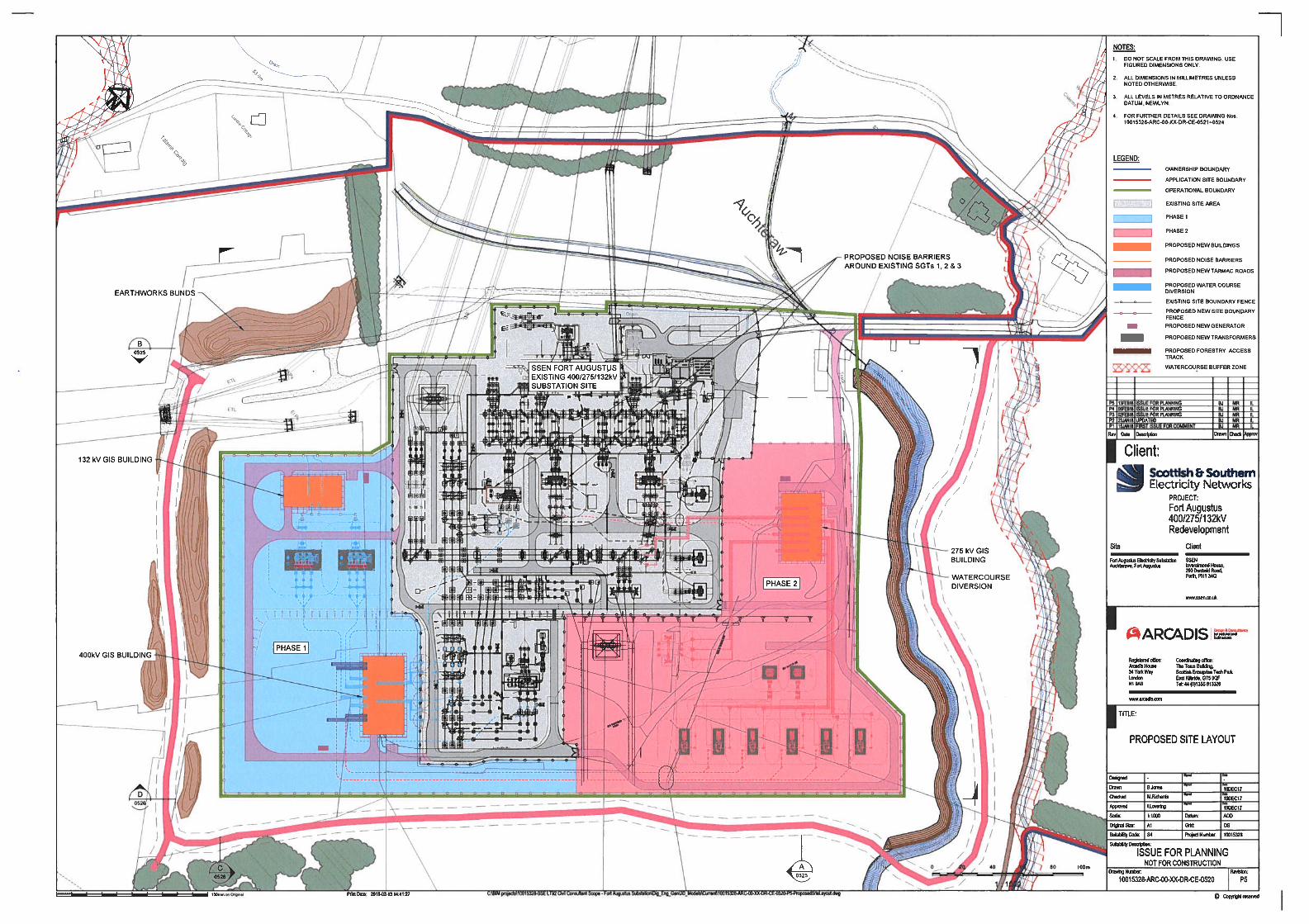
1.2 Phase One comprises works to install equipment including two additional 132kV / 400kV transformers to allow for improved arrangements / connections for the Bhlaraidh and Beinneun wind farms. These works are located primarily on the south western boundaries of the existing substation comprise the following main elements: -
Earthworks / platform;
Access tracks;
Two Gas Insulated Switchgear (GIS) buildings for the 132kV and 400kV switchgear;
Two 132 kV / 400kV super grid transformers;
New above ground equipment including gas insulated bus-bars;
New buried cable connections;
Security fencing;
Sustainable Urban Drainage Systems (SUDS).
1.3 Phase Two allows for the interconnection of the 275kV bus-bar with the 400kV double bus-bar arrangements via two additional 400 / 275kV transformers. This solution also provides additional wider network benefits of interconnecting the 275kV and 400kV systems. These works are predominately on the north eastern boundaries of the existing substation and comprises the following main elements: -
Earthworks / Platform;
Access tracks;
One GIS building for the 275kV switchgear;
Two 275kV / 400kV super grid transformers;
New above ground equipment including gas insulated bus-bars;
New buried cable connections;
Security fencing;
Sustainable Urban Drainage Systems (SuDS).
1.4 Access to the site is via the existing unclassified public road from Jenkins Park (Assessed Route 5). A package of mitigation is proposed for this road. The road needs to be suitable for the transportation of electrical plant items which are large and heavy (abnormal loads), maintenance vehicles and to accommodate any emergency vehicles which may need to access the site. Such traffic will use the access from the A82(T) road from Inchnacardoch via the U1671 (Great Glen Way) and U1663 (Jenkins Park and Auchteraw Road). The route was previously upgraded in 2011 to accommodate the Beauly Denny 400kV project.
1.5 The application includes a watercourse diversion to address site layout provisions, management of surface water and flood risk.
1.6 A landscape plan for the proposed development adopts a phased approach to help minimise the visual impact of the construction works and development from local housing. Screening is achieved by a combination of planting and earth bunds. This

includes a forestry management plan. This presents a felling and replanting approach whereby the trees are removed and replaced slowly over a period of 15 years. This piecemeal approach seeks to avoid periods where a complete loss of screening would occur. Species mix has been selected to include native mixed broad leaved tree and shrub species to replace the felled commercial conifers. Tree planting works are currently underway within the area of the substation to enhance the screening of the existing infrastructure.
1.6 Ancillary works areas are temporarily required during the construction periods for the laydown of materials and for the contractor's compound with welfare facilities for site staff. Construction activities audible at the site boundary would be undertaken between 8.00am and 19:00pm on Monday to Friday and on Saturday between 8:00am and 13.00 pm. Construction outwith these hours are likely to include electrical and mechanical fit out. The applicant has highlighted that any variation to these working hours (audible works) would be agreed in advance with the Planning Authority. During operation the substation would be unmanned with operations being controlled remotely from the SSEN's control centre in Perth.
1.8 The application was the subject of pre-application discussion with the Planning Service and statutory consultees. Key issues highlighted at that early stage included impact upon local residents (noise); flood risk; access road capacity; woodland management; and natural, built and cultural heritage interests in the wider area. A number of supporting documents are presented including: -
Environmental Assessment;
Schedule of Mitigation – See appended to this report;
Forestry Management Plan;
Landscape Plan;
Landscape Assessment;
Habitat Plan;
Traffic and Transportation Plan;
Outdoor Access Plan;
Surface Water Management Plan;
Air Quality Management Plan;
Noise Impact Assessment;
Construction Noise Monitoring Plan;
Soil Management Plan;
Peat Depth Plan;
Flood Risk Assessment;
1.9 No variations to the submitted plans have been tabled. However it is noted that additional information required by consultees has been added to the case file in support of the flood risk assessment, noise assessment and road improvements.
2. SITE DESCRIPTION
2.1 The site is defined by the existing substation which is screened by the surrounding woodland from the wider landscape. The applicant has already acquired the land around its existing operational substation. This presents some 50.35ha of land within the application site boundary. The land around the existing substation is currently considered to be in woodland / agricultural use. The trees form part of commercial woodland of Sitka Spruce, Lodge Pole Pine, Douglas Fir and Norway Spruce.
2.2 It lies approximately 3km south west of Fort Augustus to the north side Great Glen. The existing substation is visible from the local Auchteraw road that runs to the north side of the application site. Conifers bound the site to the west and provide a woodland buffer to houses at Auchteraw. The land immediately to the east is open for several hundred metres before being fringed by woodland. To the south lies an open area with scattered woodland. The nearest noise sensitive receptors (NSRs) have been identified as Aultfearn (approximately 325m from the site), Old Farm (approximately 360m from the site), Ach-na-Cloich (approximately 425m from the site), and Forest Lodge (approximately 477m from the site).
2.3 The site is relatively low lying with ground levels varying between approximately 43.2m and 38.4m AOD, with the gradient of the land generally sloping from the north-west down to the south-east. It sits within a water catchment area which drains from the south facing slopes of Carn Tarsuinn (536m AOD) through several unnamed watercourses, the Auchteraw Burn and the Allt na Fearna Burn before joining the River Oich and discharging into Loch Ness, at Fort Augustus. The application site is partly within the medium likelihood (0.5% annual probability or 1 in 200 year) flood extent of the SEPA flood maps and may therefore be at medium to high risk of flooding.
2.4 To assist understand the size of existing and proposed buildings and structures on site the following dimensions are highlighted: -
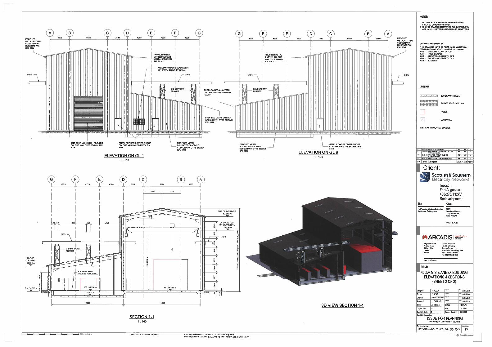
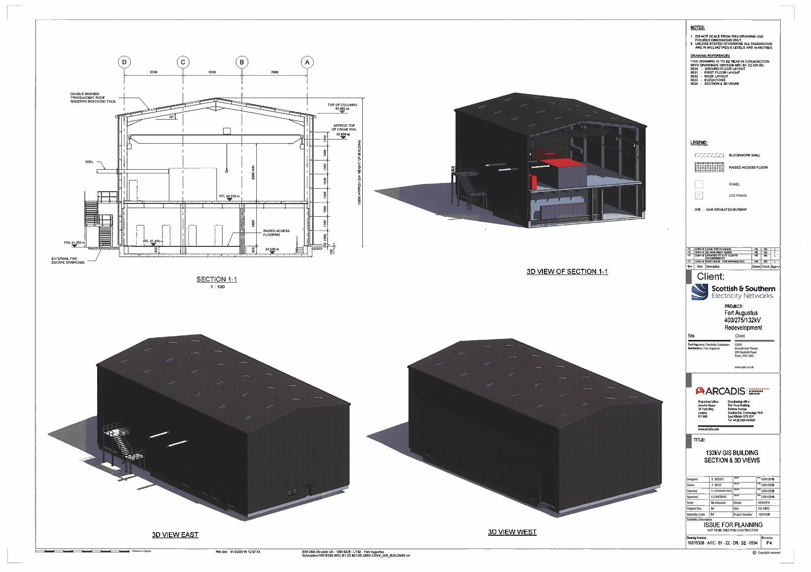
a) Original substation building: 9m high, 16m long and 10.3m wide. b) Adjacent brown steel clad building: 9m long, 8.6m wide (Height unknown). c) Proposed 400kV GIS building: 14.5m high, 26.3m wide and 50.6m long. d) Proposed 132kV GIS building: 15m high, 19.6m wide and 37.5m long. e) Proposed 275kV GIS building: 14.5m high, 25m wide and 43.5m long. f) Older 132kV grid lines towers: 28m high. g) Beauly Denny 275 / 400kV towers: 45m high. h) Trees west of the substation: 30m high (max).
2.5 The site is surrounded to the north, south and east by plantation forestry, with broad overhead line transmission wayleaves cut through this wood to the north and south. On its western side, the valley floor is comprised of open fields, with residential properties located along the public road. However, this area is separated from the existing substation by an area of plantation forest (varying from 200m to 300m in width) cut through by some narrow transmission wayleaves.
3. PLANNING HISTORY
3.1 02.06.2017 Expand the existing grid substation in two phases, creating of two platforms (Phase 1 - 2.9 hectares) and (Phase 2 - 3.1 hectares) for gas insulated substation buildings' plant and other equipment (17/02661/PAN).
PAN
3.2 31.07.2017 Expansion of existing grid substation in two phases to meet future electrical demand requirements - 17/02554/PREAPP.
PREAPP
3.3 18.08.2017 Environmental Impact Assessment - Screening of two phase expansion of the substation. Phase one comprises a 132 kV/400 kV
Screened Out.
substation. Phase two comprises a 275 kV/400 kV substation. This is a GIS substation with the majority of plant and equipment contained within buildings.
3.4 06.01.2010. Beauly - Denny line project - 400kV steel tower double circuit overhead electricity transmission line with associated works (including substation expansion) (05/01034/S37IN).
Consented.
4. PUBLIC PARTICIPATION
4.1 Advertised: Unknown Neighbours
Date Advertised: 15.03.2018
Representation deadline: 06.04.2018
Timeous representations: 9 representations (9 against).
Late representations: None.
4.2 Material considerations raised in objection are summarised as follows:
a) Conflict with nearby Auchteraw residents / rural community. b) Alternative options at site are more favourable. c) Detrimental visual impact (industrial scale development). d) Over-development / cumulative impact of substation expansion. e) Screening at site will not be effective. f) Adverse environmental impact (Gas – insulation). g) Adverse impact to the safety of road users. h) Under-reporting of accidents on this road. i) Prolonged construction at the substation (negative impact on community). j) Construction noise.
4.3 All letters of representation are available for inspection via the Council’s eplanning portal which can be accessed through the internet www.wam.highland.gov.uk/wam.
5. CONSULTATIONS
5.1 Fort Augustus & Glenmoriston Community Council has concerns and highlights the following key matters:
1. Visual impact of the height of two gas insulated (16m+) structures. 2. Length of the construction period (5 to 6 years) which is a very long time for the
local residents to endure the eyesore of the construction site on a daily basis making the need for temporary and permanent screening a priority.
3. Request a traffic plan that delivers -
a speed limit of 20mph on all construction traffic using the unclassified roads from A82 (T) to the road end beyond Auchteraw farm.
No construction traffic to the substation after 19.00hrs and on Sundays.
No construction HGVs or vans permitted to use Bunoich Brae.
Reduce the stated daily vehicle journeys by doubling up personnel in cars and light vehicles and use mini buses to transport workforce.
Ensure sub contactors conform with the Traffic Plan rules.
Adequate passing places to ensure safe vehicle movements.

5.2 Access Officer has no objections to the application.
5.3 Forestry Officer has no objection to the application. There will be a need to ensure compensatory planting if and when the extent of permanent woodland lost is clearly identified.
5.4 Archaeology Team has no objections to the application. There is no sensitivity here with regard to the historic environment.
5.5 Environmental Health has no objection to the application. A request is made for conditions to any approval to manage noise, dust and construction working hours.
5.7 Flood Management Team has no objection to the application. A request is made for conditions to any approval to confirm flooding and drainage interests.
5.8 Transport Planning Team has no objections to the application. The application highlights a significant package of mitigation that needs to be secured by legal agreement or planning condition.
5.9 Transport Scotland has no objections to the application. Request for planning conditions and informatives to be attached to any decision to grant planning permission.
5.11 Scottish Environmental Planning Agency (SEPA) has no objections to the application. It has requested a number of planning conditions to be attached to any grant of planning permission.
6. DEVELOPMENT PLAN POLICY
The following policies are relevant to the assessment of the application
6.1 Highland Wide Local Development Plan 2012
28 - Sustainable Design 29 - Design Quality & Place-making 30 - Physical Constraints 31 - Developer Contributions. 32 - Development in the wider countryside 51 - Trees and Development 52 - Principle of Development in Woodland 55 - Peat and Soils 57 - Natural, Built & Cultural Heritage 58 - Protected Species 59 - Other important Species 60 - Other Importance Habitats 61 - Landscape 62 - Geodiversity 63 - Water Environment 64 - Flood Risk 65 - Waste Water Treatment 66 - Surface Water Drainage 69 - Electricity Transmission Infrastructure 72 - Pollution 73 - Air Quality

77 - Public Access
6.2 Highland Council Adopted Supplementary Guidance
Flood Risk & Drainage Impact Assessment (Jan 2013)
Highland's Statutorily Protected Species (March 2013)
Physical Constraints (March 2013)
Special Landscape Area Citations (June 2011)
Trees, Woodlands and Development (Jan 2013)
6.3 Inverness Local Plan 2012 (as continued in force)
No site specific allocations.
6.4 Inner Moray Firth Local Development Plan 2015
No site specific allocations.
7. OTHER MATERIAL CONSIDERATIONS
7.1 Scottish Government Planning Policy and Guidance
National Planning Framework (NPF - 3) (2014)
Scottish Planning Policy (2014) - including policies for: -
A Low Carbon Place o Delivering heat and electricity. o Support for strategic energy infrastructure.
A Natural Resilient Place o Valuing the natural environment. o Promoting responsible extraction of resources. o Managing flood risk and drainage
Scottish Energy Strategy (2017)
7.2 The Council has set out further advice on delivery of major developments in a number of documents. This guidance, adopted by the Council, includes : -
Construction Environmental Management Process for Large Scale Projects (2010).
8. PLANNING APPRAISAL
8.1 Section 25 of the Town and Country Planning (Scotland) Act 1997 requires planning applications to be determined in accordance with the development plan unless material considerations indicate otherwise.
Determining Issues
8.2 This means that the application requires to be assessed against all policies of the Development Plan relevant to the application, all national and local policy guidance and all other material considerations relevant to the application.

Planning Considerations
8.3 The key considerations in this case are:
a) Development plan / other planning policy. b) National policy. c) Planning history. d) Layout and design. e) Landscape and visual impact. f) Access and traffic impact. g) Water and drainage including flood risk. h) Trees / woodland / landscaping. i) Ecology / nature conservation. j) Noise. k) Construction impact. l) Economic impact. m) Other material considerations.
Development plan/other planning policy
8.4 The Development Plan comprises both the adopted Highland-wide Local Development Plan (HwLDP) and Inner Moray Firth Local Development Plan. The latter plan recognises the settlement boundary of Fort Augustus and future land allocations for development around the settlement. These allocations lie away to the east of and south of this site.
8.5 The Development Plan must be read as a whole, with applications then assessed against all of the policies relevant to the proposed development and its location. Conformity with a single policy or element of the plan does not necessarily indicate that a proposal is acceptable. There are no site specific policies affecting this application site within the Inner Moray Firth Local Development Plan. The HwLDP adopted in April 2012, with its subject specific policies, is more relevant.
8.6 The principal HwLDP policy on which the application needs to be determined is Policy 69 - Electricity Transmission Infrastructure. Other policies listed at 6.2 of this report are also relevant and the application must be assessed against these also; for example Policy 61 - Landscape. These matters are assessed in full within a number of material considerations examined within this report. These include matters raised within the submissions from public representations.
8.7 The Development Plan supports the broad principle of energy development. Policy 69 specifically highlights that the “Council will have regard to their level of strategic significance in transmitting electricity from areas of generation to areas of consumption.” “It will support proposals which are assessed as not having unacceptable impact on the environment including natural, built and cultural heritage features.” Where development is assessed as not having unacceptable significant impact on the environment, then the proposal would accord with the Development Plan.
National policy
8.8 Scotland’s Third National Planning Framework (NPF- 3) sets out the government’s thoughts on how best to achieve a more successful country through increasing sustainable economic growth. It includes plans for infrastructural investment

including a high voltage electricity transmission network deemed vital in meeting national targets for electricity generation, statutory climate change targets and security of energy supplies. The current application falls into the category of National Development. Whist this establishes a need for the project all necessary assessments and consents are still required for such development. Appropriate levels of mitigation would still be expected to help avoid or reduce environmental effects and demonstrate “no adverse effect” on the integrity of European protected sites.
8.9 An aim of the planning system is to achieve the right development in the right place; not to allow development at any cost. SPP introduces a presumption in favour of development that contributes to sustainable development. The connection of approved renewable energy projects to the grid, which would be enhanced by this project, advances its sustainable development credentials. The expansion of the grid transmission network in the north of Scotland not only is a short term economic construction boost, but also a long term infrastructural benefit to the area. A priority of the Scottish Energy Strategy (2107) is to champion Scotland’s renewable energy potential, creating new jobs and supply chain opportunities.
8.10 Further advice is provided in SPP in respect of potential impacts on the natural environment and the need to protect and enhance Scotland’s key natural resources including landscape, ecology, habitats and biodiversity. The impacts on these resources have been presented within the supporting information and are considered in more detail within this assessment. The policies and content of Scottish Planning Policy is a material consideration that carries significant weight, but it is for the decision maker to determine the appropriate weight in each case. If there are no significant impacts on valued resources the development can be supported.
Planning history
8.11 The electricity substation at Auchteraw has developed incrementally over a number of years and as a result of a range of development projects its role has changed significantly. Grid lines through Auchteraw run north and south (Beauly – Denny), as well as linking with Fort William, Skye and beyond. The development of wind power projects (e.g. such as Bhlaraidh and Beinneun) and hydro (e.g. Glendoe) has generated considerable additional power in the locality and the Beauly - Denny line upgrade has enhance grid connectivity and transmission capacity particularly to the south.
8.12 As demands for electricity grow in places such as Fort William and Skye, together with yet more development projects (e.g. Coire Glas pump store), the expansion of Auchteraw is of considerable importance. The substation site has accepted expansion from projects in the past (e.g. the Beauly - Denny substation project and Glendoe connection) and future development continues to recognise capacity at the site to evolve. The EIA framework and planning conditions set for the Beauly - Denny project offers recent experience of expectations both for the applicant and statutory consultees. It provided at that time a fresh approach to project Construction and Environmental Management Plan (CEMPs) at that time, which continues to apply to many largescale projects today and within current Council guidelines.

8.13 The substation was expanded to accommodate 275 and 400 kV equipment as part of the Beauly to Denny Line project in 2014. Following this upgrade, a further 240 MVA 400/132kV Efacec SGT (SGT4) and associated 60 MVAr ABB reactor (Reactor 4) were installed and energised in December 2016. The three Tamini reactors recently installed were replacements for three Tironi reactors which, upon energisation, displayed numerous issues. This in particular included operational noise levels that were far in excess of the levels specified during factory acceptance testing (FAT).
8.14 It is noteworthy that SSE has considerable permitted development rights within operational land and across transmission corridors. It will therefore be important to recognise within any positive decision in support of this application what land is identified as falling within operational needs, as distinct from areas of enhanced woodland / landscaping which fall outwith proposed operational areas as highlighted within plan 10015328-ARC-00-XX-DR-CE-0504 Revision 6 dated 19 December 2017. Furthermore SHE Transmission undertakes periodic repair and replacement works, for example as is currently happening on the Auchteraw – Ft William line. This can include wayleave / woodland clearance activities.
Layout and design
8.15 Development at the substation has focused on two potential design options Air Insulated Switching Gear (AIS) and Gas Insulated Switchgear (GIS). Progress has been made on the latter option only as GIS layouts allow for electrical equipment to be placed more closely together. It also ensures that considerable equipment is housed within buildings rather than being open to the air, as at present. In this regard the proposed buildings offer a degree of design options to fit with the landscape, particularly colour.
8.16 GIS systems are not regarded as having an adverse environmental impact as highlighted within public representations. They are however large structures, a matter also raised within objections. They are still smaller in height than the Beauly - Denny transmission towers (approx. 45m), but are nevertheless large, in relation to local housing, but can be contained within the local landscape. The plans highlight the dimensions of the two GIS buildings as: -
1. GIS 132kV building – approximately 37.5m x 19.6 x 15m (high). 2. GIS 400kV building – approximately 43.5m x 25m x 14.5m (high).
8.17 Access to the whole development is from the north eastern corner of the site as already established. Phase 1 comprises the expansion of the substation to the south/south-west to accommodate two 400/132 kV SGTs together with a 132 kV GIS Building and a 400 kV GIS Building. Phase 2 would commence following completion of Phase 1 and comprises the expansion of the substation to the west to accommodate two 400/275 kV SGTs, two 22 kV Reactors and a 275 kV GIS Building. Figure 8.2 shows the Phase 1 development in blue and the Phase 2 development in red. The layout is largely dictated by electrical engineering requirements, existing transmission infrastructure and constraints (flooding) which limit the options for alternative designs. Given past land acquisitions by SSE surrounding the existing substation the proposals will be set apart from other land holdings.
8.18 The low lying nature of the site and separation of the development from nearby properties helps to diminish the impact of the development, a key concern raised
within representations. The initial phasing of the works will create the level platforms upon which the electrical works will be accommodated. Surplus material from these earthworks is to be used to create bunds which in addition to the forestry plantings will help screen the development from nearby residents. The existing woodland and wider topography (steep sided hills) helps to ensure that the development, despite its size and scale is relatively unseen from the wider community (Ft Augustus) and the many travellers through the Great Glen.
8.19 Colour options for the buildings include Van Dyke Brown or Dark Green, the latter of which would be more consistent with surrounding forestry. The applicant has requested a planning condition to be applied to allow the final details of chosen materials to be submitted and approved by the planning authority at a later stage. This is considered to be an appropriate request for a development of this nature and the lead in timescales for final plans which evolves through design phases. At this stage however it is recommended that the GIS buildings be advanced using the dark green colour option.
8.20 The operational substation will be surrounded with a 2.4m high palisade fence to ensure no un-authorised access in accordance with the Electricity Safety, Quality and Continuity Regulations 2002. Substations by their nature are operational developments of a type that are not generally accessed by the public. An Outdoor Access Plan has been developed which provides a framework for how outdoor access within the surrounding area will be managed during the construction period. The site will be managed as a dark site, ensuring that external lighting will be minimal when staff are not on site.
8.21 A further aspect of the development at the site is the requirement for the felling of trees to the west of the substation. Some felling is required as part of Phase 1 of the development, but additional felling is required regardless of the proposed development due to the trees being diseased. SHE Transmission has engaged forestry consultants to produce a design for the felling works that would avoid clear felling. The design was submitted to support the planning application. The felling and replanting programme will be carried out over a number of years to ensure a degree of landscaping around the site. This is to assist with reducing visual impact as well as some noise attenuation.
8.22 Past Bunding and planting has been undertaken in the recent past to the south side of the Auchteraw road, adjacent to the substation. The purpose of these works has been to screen the substation from the roadside. A balance however has to be struck between the provision of screening and maintaining clearance from overhead wires. To date the works are considered acceptable and in line with expectations. It will however be important to ensure the design and mitigation from past developments is maintained.
Landscape and visual impact.
8.23 The development does not lie within a designated landscape. It falls within the Great Glen south of Fort Augustus, within which the historic and still active Caledonian Canal passes to the south (>1km). This landscape is not associated with any particular landscape designation. In a local context there are areas within this floor of the Great Glen that are valued for their amenity, cultural heritage and recreational purposes. However in landscape terms the value of this site and its immediate surrounds are considered to be “low-medium”.

8.24 Given the presence of surrounding commercial woodland within this low lying area of the glen, the development site does not have high visibility to the surrounding landscape. In the wider area landscape designations include the Council’s Loch Ness and Duntelchaig Special Landscape Area (SLA). The impact of the development on the SLA is considered to be quite limited, indeed negligible.
8.25 The applicant’s assessment highlights that the majority of receptors within the surrounding area of the proposal would not experience significant visual effects from the proposed development. This is due to the presence of the existing substation and overhead lines which reduce sensitivity to change; and the effects of distance and screening from existing forestry and proposed landscape mitigation, including the Forestry Management Plan (FMP) proposals and the proposed additional landscape works.
8.26 Furthermore potential receptors in the area are not great in number given the location of the development and the fact that most residents in Fort Augustus for example lie away from the development or travel on the A82(T) with limited views of the site. There are small number of residents and visitors to the area that utilise local woodland paths or “bed and breakfast” services in local housing.
8.27 The most significant visual impacts of the development both in construction and operation are those receptors who live and work close-by Auchteraw (1km). These individuals will already be aware of the existing transmission lines and substation impact. Whilst the development will increase their visual experience, given the proposed design and mitigation set out in the proposal, the anticipated change being brought about should not be so significant as to adversely affect these parties. The mitigation will seek to ensure forestry buffers and new landscape buffers are established between the extended substation and local housing.
Access and traffic impact
8.28 At the operational stage, access to the site will be quite limited and infrequent. Such personnel will use the existing road network. However construction traffic for both phases of development proposed are to access the site from the A82(T) road from Inchnacardoch, through Jenkins Park, to the site. This routeway was previously improved to cater for the 2011 extension of the sub-station under the Beauly - Denny 400kv line project.
8. 29 The Draft Construction Traffic Management Plan (CTMP) anticipates the total number of vehicle movements generated during the peak period of construction is subsequently estimated to be 140 two-way trips (70 one-way trips) consisting of 40 two-way HGV trips and 100 two-way light vehicle trips (cars/ light vans). Furthermore abnormal loads (transformers) will arrive via the Port of Invergordon, via Dingwall, Beauly and Drumnadrochit. A Route Evaluation Report within the CTMP considered road options for routing such abnormal loads to the site and the practicality of barging such units on Loch Ness. The report says that further work will be required to get a clearer picture of what can be achieved by road and water (Canal / Barge) in terms of deliveries to site. It also recognises that additional confirmation may be required regarding the suitability of structures along the intended abnormal load routes following confirmation of the final vehicle type.
8.30 Given the above noted uncertainty it is recommended that should the permission be granted it includes a suitably worded condition requiring approval of the final

routing of Abnormal Loads to the site and any mitigation / improvement works needed to accommodate the abnormal load routes be submitted to and agreed by the Planning Authority, in consultation with the relevant Roads Authorities, prior to works commencing. This is required to ensure there is a viable route for moving abnormal loads to the site and to ensure that such movements will not have any detrimental impact on the public road network.
8.31 Transport Scotland is content with the application, subject to planning conditions and informatives as recommended being attached to any consent. These are to ensure that as all transport requirements are finalised, including the needs of any abnormal loads, any alterations to the trunk road network, including signage, are authorised to ensure the safety and free flow of traffic on the network.
8.32 The Transport Planning team is also generally satisfied with the applicant's appraisal of traffic and transport associated with the proposed development, but highlights a number of concerns given the above noted uncertainties. Furthermore, and notwithstanding the previous construction project in 2011, the existing local road network is in need of considerable mitigation since it was last used for substation construction. Following a walk–through exercise in May 2018 details have been offered by the applicant to safely accommodate construction traffic, whilst also protecting the ongoing integrity of the carriageway.
8.33 In addition, and in recognition of the expected inconvenience to existing local road users, SHET has offered to extend road improvements to the west of its site access. It proposes to extend its road surface overlay beyond their site access to a small bridge structure outside the property thought to be known as "The Old Farmhouse", a wooden rectangular building situated on the left before you reach the track down to Ach-Na-Cloich. Transport Planning has advised such additional improvements are welcomed and, from site investigations, they do focus on the section of that route currently suffering the worst rutting and surface cracking.
8.34 The existing timber bridge at the limit of the proposed overlay would also benefit from some improvements and the remaining road west of that bridge is experiencing some deterioration that would benefit from surface dressing. The Area Roads Office has advised it could undertake the works for a cost in the region of £18k. Transport Planning has advised it would welcome such improvements be undertaken, if possible, through this development. However, it would not want these improvements to be delivered at the expense of the works needed along this route between the site access and the A82(T) road. A package of road improvements by the applicant to the local road network has been accepted in principle by Transport Planning and would need to finalised and implemented prior to the commencement of construction on site.
8.35 The applicant’s Draft Construction Traffic Management Plan (CTMP) recognises site operating hours and the likely impact on local traffic especially school bus route and school start and finish times. It advises it would seek to manage construction deliveries to avoid peak periods. Transport Planning has confirmed the need to avoid school start and finishing times.
8.36 Furthermore in noting “that the management team for this project will monitor peak periods and respond accordingly where vehicle conflicts arise” it is recommended that the performance of the measures being taken to avoid construction deliveries conflicting with busy periods on the roads in the local area should be reported to and reviewed by a local community liaison group established for the project. Such

groups are commonly requested for large scale construction projects such as this requiring the formation of a local community liaison group on the lead up to project commencement and continue throughout the duration of the proposed works. This can be applied by condition should the application be supported.
Water and drainage, including flood risk
8.37 The application does not require a new or altered water supply for this site. Foul water will be produced in small quantities during construction and this will be contained on site and removed for disposal off site. This raises no concerns.
8.38 The proposal requires the re-routing of an existing watercourse that runs to the east of the development area. SEPA has welcomed the design which takes a natural form. The proposal will require a simple licence under CAR and it is satisfied that the proposals to re-route the watercourse are capable of being authorised. However it may be the case that the final design will have to be informed by a hydro-morphological assessment which needs to be covered / requested by planning condition. Further it has highlighted that the proposal for the new watercourse crossing to the site is a box culvert. To ensure best practice SEPA requests a further condition that the new access crossings be achieved by way of a bottomless culvert or traditional style bridge demonstrated to be large enough to accommodate a 1 in 200 year flood event.
8.39 Groundwater is anticipated to migrate through the development site because of the permeable nature of the top soils (peat and sandy gravels). The applicant has produced a Surface Water Management Plan which has influenced the proposed layout. It has informed a framework for surface water management systems for the prevention and mitigation of various sources of pollution affecting surface water and ground water flowing into and from the development during and after the construction process is completed. A permanent site drainage plan has been developed to cope with 1 in 200 (0.5% likelihood) year event, + 30% climate change with temporary drainage designed to accommodate a 1:100 year event.
8.40 The applicant has also submitted a Soil Management Plan (SMP) in support of the application. The cut and fill balance calculations shows an overall deficit and materials will need to be imported to assist with the creation of the level platforms required at the site. However, the applicant has advised that as there is an overall land take required for the works, it is envisaged that sufficient topsoil and subsoil may be available for works associated with the restoration of areas of temporary land take and creating suitable growing media on landscape bunds. The successful implementation of this SMP will be critical in achieving “no import of topsoil” for the development. Mitigation measures pertinent to managing drainage on site are set out in the SMP.
8.41 SEPA has recognised the development could fall within the classification 'essential infrastructure'. This type of development may be acceptable in a flood risk area provided it is constructed to remain operational during floods, not impede water flow, an alternative lower-risk location is not available and any loss of flood capacity mitigated to achieve a neutral or better outcome. Justification has been provided with the application that the location is essential for operational reasons and an alternative location is not available. The justification has been accepted by consultees.

8.42 SEPA welcomes the fact that the proposal generally avoids development in the vicinities of the watercourses to the east and west of the site with all development located away from those watercourses and buffer zones provided. Both watercourses have been assessed in the Flood Risk Assessment for their contribution to existing flood risk to the site. Some associated development is proposed close to these watercourses which are seen as part of the flood risk mitigation works (flood embankments to increase flood plain capacity).
8.43 A watercourse diversion has been proposed to address flooding and site layout constraints from the third watercourse - the engineered drain - which passes through the centre of the site. SEPA considers this acceptable which in this case presents no increased flood risk downstream, although the final design remains to be designed, requiring a condition as highlighted earlier.
8.44 SEPA has also advised that it welcomes the commitment of the Surface Water Management Plan that the transformer bunds and storage area drainage is designed in order to meet the requirements of its agreement with the company. In view of the fact that all elements (pollution prevention) are not shown on the related plan SEPA asks that a condition is applied requiring a finalised plan to be submitted for approval.
8.45 The Flood Risk Management Team, taking account of requirements outlined in Scottish Planning Policy (SPP) and The Highland Council’s Supplementary Guidance: Flood Risk and Drainage Impact Assessment, has raised no objection to the development. It has requested a number of planning conditions should the application be supported. It requests that the final design of the compensatory storage bund and relief culverts be submitted for review and approval. It is important that the detailed design includes baseline and compensatory storage scenarios for a range of return periods (up to the 1:200 year plus climate change) to demonstrate that there will be no increase in flood risk at different return periods. It further notes that the bund and the outfall culvert are located within the site boundary and would remain under the control and responsibility of the applicant. It requests that an inspection and maintenance schedule is adopted and that the name and contact details of the party responsible for the drainage infrastructure is provided to the Council. This is with a view to ensuring that the compensatory storage remains in place and operating as designed in the future.
Trees / Woodland/ Landscaping
8.46 The applicant owns a substantial land holding around its operational (current and proposed) substation which is in agricultural / forestry use. Its intention is to manage the non-operational ground as amenity woodland, as distinct from commercial woodland (rotational cropping). That said commercial cropping of the existing woodland is proposed (on account of tree maturity; existing wind blow; presence of disease; etc.) within a phased programme of landscape mitigation including ‘bunding’ to assist with site screening and the planting of amenity woodland, including hedges.
8.47 Given that the site is already in the ownership of the applicant early progress is proposed through the current management of its holding regardless of the determination of the application. The woodland works are currently the subject of a Felling Licence application with proposals for 100%replacement of the clear felled areas. These works will form part of the landscaping works associated with the

current planning application. The intent to establish, particularly on the western boundary, a wooded buffer between existing residential properties and the current substation and the proposed phased one extension. The species choice for new planting is to include a mixture of conifer and deciduous trees to ensure all year round screening. Woodland will require deer fencing.
8.48 In considering the application there is a need to consider the Scottish Woodland Policy that requires sufficient compensatory planting in relation to woodland loss which at this stage (pre planning approval) would requires a felling licence. Should the application be supported on the basis of the current submission woodland in excess of 9ha is likely to be lost to development with 13ha being retained under woodland management / landscaping. Some of the later ground is wet in nature and thereby not entirely suited to restocking, but for the most part the existing holdings, not required for development, can be replanted (11.52ha). In this manner compensatory planting in line with Scottish Government and Council policy will be secured.
Ecology / Nature Conservation
8.49 The applicant has submitted a range of information highlighting its proposed infrastructure and the area of existing ecological interest in and around the site. In addition to watercourse and habitat assessment surveys were undertaken to identify for the presence of Otter; Wildcat; Red squirrel; Pine marten; Water vole; Badger; and Bats. The conclusions drawn highlighted that although no signs of protected mammal species were identified during the course of surveys, there appears to be suitable habitat for badger, with woodland edges, scrub and extensive areas of grassland suitable for shelter and foraging. Conifer plantations provide suitable habitat for Red squirrel and Pine marten. There was limited suitable habitat for Otter or Water vole within the site boundary.
8.50 Potential impacts resulting from the proposed development are likely to include disturbance (noise, lighting, vehicular movements) and displacement to animals breeding, foraging or resting within the proposed development area; and mortality or injury to individual animals active near works during the construction phase. The applicant has offered active mitigation to limit and further minimise potential impacts on ecological features across the site including a site specific Construction Environmental Management Plan (CEMP) and best practice pollution control measures, with reference to SEPA and COSHH guidelines. This will also detail how transport, works and waste disposal will be controlled during the construction phase.
8.51 SEPA has accepted that the development will not have a significant effect on GWDTE habitats. However it has highlighted that the forest planting proposals and related access works outlined in the Forest Management Plan however have not taken into consideration the presence of GWDTE. It therefore requests all forestry works controlled via planning that a condition is applied requiring a finalised planting plan to be agreed in consultation with SEPA. Such plan should clearly demonstrate that there is no new planting on M6 flushes, only native species within 20m and on M25 rush pasture this to only be planted with low density native species which enhance wetland habitat.

Noise
8.52 The applicant has recognised the potential noise nuisance that can arise from operational substations and the need to ensure that this is limited in respect of existing Noise Sensitive Properties (NSPs - houses nearby). In view of this it has submitted a Noise Impact Assessment (NIA) report (Feb 2018), which then was updated (July 2018) on account of the recent replacement of the Tamini Reactors 1, 2 and 3. The assessment methodology is based on a comparison of the anticipated increase in the level of noise from the site due to the proposed development compared to the predicted baseline data. The principal being that if the sound levels do not increase from the pre-existing level then the impact would not be expected to increase.
8.53 The Council’s Environmental Health Service, whilst not objecting to the application, has highlighted several issues that it wishes be managed through planning conditions should the application be approved. These elements are considered in turn.
8.54 To ensure that the outcome of the NIA is accurate, it is essential that the current baseline noise level is correct. Consequently the EHO requested the additional baseline noise survey was carried out to verify that the predicted future baseline levels included in the NIA are consistent with the actual measured noise levels following the reactor replacement. Whilst the NIA (July 2018 edition) does include details of the noise monitoring survey which was carried out at the NSPs, it does not provide any comparison between the modelled data for the predicted future baseline level and the results of the noise monitoring survey. Consequently it has not provided verification that the modelled predicted baseline noise data is consistent with the measured noise levels at the NSP as requested.
8.55 In view of this the EHO would request a condition to require a comparison between the predicted future baseline survey and the measured ambient noise level following the reactor replacement. If the results of the noise monitoring survey are not consistent with the predicted future baseline survey as detailed in the submitted NIA, the outcome of the NIA shall be reviewed. Thereafter, details of any further mitigation measures required including the effect of the mitigation methods on the noise levels shall be submitted to the Planning Authority for approval.
8.56 The revised NIA (July) included a 1/3 octave measurement data for each of noise sensitive properties, as requested. However, it has not included any frequency analysis at the noise sensitives property for future baseline, phase 1 phase 2 and following mitigation scenario 4. Furthermore there is no assessment of the frequency analysis particularly 100Hz) to determine that there is no increase of 5dB or greater in the levels following the competition of the proposed development and mitigation measures which was requested.
8.57 The EHO therefore would recommend a condition to ensure that a predicted frequency analysis of the noise including a 100Hz shall be undertaken at the noise sensitive properties identified in the NIA for each of the modelled scenarios i.e. future baseline, phase 1 phase 2 and following mitigation scenario 4”. If the frequency analysis identifies an increase in any frequency (particularly 100Hz) which is not consistent with changed in the overall broadband noise or there is a 5dB or greater increase at any frequency, the outcome of the NIA must be reviewed and further mitigation measures submitted to the Planning Authority for

approval.
8.58 The principal purpose of the noise assessment is to ensure that there was no increase in noise from the site and the proposed extension. Therefore in order to ensure the amenity of the existing residents is protected and there is no increase in the existing noise levels from phase 1 and phase 2 of the extension of the Auchteraw Substation, the EHO Service would advise conditions are included in any consent to require that the as built / operation noise level shall comply with the pre-existing levels as details in the revised NIA (July 2018).
Construction Impacts
8.59 The development of a project of this scale will have considerable “temporary” impacts including for example construction traffic as assessed earlier in this report but also construction noise, dust, waste, etc. Such impacts are expected intermittently through the 4 /5 years of construction (Phase 1 2019 – 21; and Phase 2 completion by 2023). It is for these reasons that the applicant has a commitment toward a project specific Construction and Environmental Management Plan approach, the finalised details of which, following appointment of the project contractor, would require approval of the planning authority in consultation relevant consultees. In addition such an approach recognises the value of the appointment of an Ecological Clerk of Works (ECOW) post is made. This can usefully dovetail with a Planning Monitoring Officer role to monitor compliance with the conditions attached to any consent.
8.60 The EHO has highlighted potential disturbance to local residents in respect of construction noise and vibration. Accordingly there is expectation that any appointed contractor would adopt best practical means to limit the degree and timings of such impacts. This requires limitation on construction hours as offered by the applicant, timing of deliveries types (HGV’s and abnormal loads). Other controls including Dust Management Plans, Pollution Prevention Plans, Waste Management Plans, Surface Water Management, etc. would also be expected within a project specific Construction and Environmental Management Plan.
Economic Impact
8.61 The development of grid infrastructure has been identified as a national priority together within investment in renewable energy. The development of substation projects as presented within this application not only are beneficial in strengthening the robustness of the country’s grid network, further job and investment opportunities are created through the development of associated supply chains. The development is required to facilitate the connection of wind farms / hydro-schemes to the national grid, which will allow the export of electricity generated to consumers. The relationship of the development to the economic and social benefits of renewable energy developments is therefore relevant, in a positive way.
8.62 The Highlands is currently experiencing a construction boom, with significant construction activity in the transmission network. The approval of the current application will have similar short term (4 - 5 years) construction economic impact, although significantly less impact at the operational stage. This weighs in favour of the development.
8.63 The design, landscaping and limited visual impact of the development beyond the initial 1,500m, means the impacts of the development are not anticipated to have

adverse impact on the local economy, particularly tourism. Its impact, at a more local level, equally is not anticipated to significantly impact on existing businesses or recreational interests (Forest Walks / Great Glen Way / Caledonian Canal).
Other material considerations
8.64 There are no other material considerations.
Matters to be secured by Legal Agreement
8.65 a) A wear and tear agreement covering use of the local road network during all construction periods associated with this development.
8.66 The applicant has four months from the date that the Council's solicitor writes to the Applicant / Applicant's solicitor indicating the terms of the legal agreement, to deliver to the Council a signed legal agreement. Should an agreement not be delivered within four months, the application shall be refused under delegated powers.
9.0 CONCLUSION
9.1 The Scottish Government and the Council each have policies in support of projects which increase the capacity of the grid network to serve the community and in particular the significant level of investment in renewable energy. NPF3 justifies the need for such investment highlighting such development as of national importance.
9.2 Highland has been successful in attracting inward investment in renewables, enabled in part by a matching level of investment in the improvement of the grid transmission system. This success has lead to the Highlands having a good understanding of this type of project and this Council having appropriate policies and guidance to assist in its assessment and to effectively manage their implementation on the ground. For example, the use of Construction and Environmental Management Documents “CEMD”, a particular approach to assist with the implementation / management of such largescale projects with a focus on environmental protection. There are investment benefits too that favour these projects, not just from the short term construction but a continued stream of investment assisting with apprenticeships schemes and partnership networks with local companies.
9.3 Statutory and other consultees responding to this application are generally supportive. No significant adverse impacts have been identified with this project following assessment by statutory consultees. Some have requested planning conditions to be attached to any grant of planning permission to effectively ensure that their specific interests are secured.
9.4 The application has raised some objections from the public. These elements are considered in the assessment. It is considered that there are no issues that merit the proposal to be re-configured. It is accepted that both phases of the proposed development present a sizable enlargement of an existing large substation. Considerable discussion between the applicant and consultees has focussed on safeguarding the water environment / flood risk; woodland management; noise and impact on the local road network. On all these matters particular attention has been made to ensure no greater impact arising from the existing substation in

respect of flood risk and noise, but also substantive investment in amenity woodland to provide effective long term screening and to the road network which will benefit of existing residents in the longer term.
9.5 There are clear impacts that might be expected from this development, particularly in its construction. These can be managed through best practice construction management techniques to ensure surrounding interests, particularly road access and the amenity of local housing are safeguarded from the key impacts of the development, by planning conditions to strengthen and clarify the plans and supporting information as submitted by the applicant.
9.6 The application can be supported in the context of the Council’s Development Plan and in particular it’s Policy 69 on Electricity Transmission Infrastructure and the underlying support for renewable energy development which is consented in this area. All relevant matters have been taken into account when appraising this application. It is considered that the proposal accords with the principles and policies contained within the Development Plan and on balance is acceptable in terms of all other applicable material considerations.
10. IMPLICATIONS
10.1 Resource: Not applicable
10.2 Legal: Not applicable
10.3 Community (Equality, Poverty and Rural): Not applicable
10.4 Climate Change/Carbon Clever: Not applicable
10.5 Risk: Not applicable
10.6 Gaelic: Not applicable
11. RECOMMENDATION
Action required before decision issued Y
Notification to Scottish Ministers N
Conclusion of Legal Agreement Y
Revocation of previous permission N
Subject to the above, it is recommended that planning permission be GRANTED subject to the following:
Conditions and Reasons
1. The development hereby approved must be carried out in accordance with the approved plans; as set out in the application’s supporting information; the submitted schedule of mitigation unless otherwise agreed in writing with the planning authority and in compliance with the conditions attached to this planning permission.
Reason: To identify the extent and terms of the development consent.

2. For the avoidance of any doubt the increased operational area associated with this substation shall be as identified within Plan 10015328-ARC-00-XX-DR-CE-0504 Revision 6 dated 19 December 2017.
Reason: To identify where Permitted Development Rights under Town and Country Planning (Scotland) Act 1997 that are available to the operator of the substation developed under this planning permission apply.
3. Prior to the commencement of any development of the Phase 1 works, and then the Phase 2 works, final design details of the GIS substation buildings to be used within each phase shall be submitted for approval to the Planning Authority.
Reason: To ensure that the final building design details are formally considered and approved in the interests of the local amenity.
4. Prior to the commencement of any development on site full details of the required improvements to the trunk road network to accommodate abnormal roads shall be submitted for the approval of the Planning Authority, after consultation with Transport Scotland. The approved works shall then be implemented prior to the arrival of any abnormal loads to site.
Reason: To ensure that the transportation of abnormal loads will not have any detrimental effect on the trunk road network.
5. Prior to the commencement of the development a finalised Construction Traffic Management Plan shall be submitted for the approval of the Planning Authority, in consultation with relevant Road Authorities. The plan shall set out all mitigation measures to be implemented and traffic management to be deployed for the construction of the approved development.
Reason: In the interests of road safety and to ensure adequate road safety measures are in place including measures to minimise conflict with School Bus Services and local events (e.g. Loch Ness Cycling).
6. Prior to the commencement of any development on site the local road network shall be upgraded in compliance with the package of mitigation for Route 5 as generally agreed with the Council, unless otherwise approved in writing with the Planning Authority, in consultation with the local Roads Authority. The works are as set out in the submitted Fort Augustus Route Assessment Project No S114001 ECR 019 Issue 001 and supporting plans with the following amendments: -
a) Point 40 – Jcn to Forestry Commission Building (Drg 123) - The priority at this location is to widen the carriageway between the two accesses (Forestry Commission and Cemetery) to get two-way operation along the whole length of Auchteraw Road in front of and between those accesses. Parking adjacent to the trees reverts back to SSE’s previous proposals for side-in parking below the trees using no-dig construction.
b) Point 20a) – Ch2310 (Drg 107) - the existing passing place sign to be removed and for all the work recommended in our response dated 10 September 2018 to be included in the final package of proposals.
c) Proposals at the Jenkins Park junction shown on Drawing No. S114001-TG-GEN-19-DR-CH-0110 Rev P04 for strengthening the existing priority giveway and extending the footway further west are enhanced following a final review.
For the avoidance of any doubt a “wear and tear” agreement must also have been
secured with the Council covering the use of the local road network for all construction traffic associated with the works hereby approved. Furthermore that the mitigation works to the road network shall extend west of the site access as agreed with the Council.
Reason: To ensure the road is enhanced and thereafter maintained to safely accommodate the increased traffic arising from the construction traffic associated with this development and existing road users.
7 Prior to the commencement of development the applicant shall submit a plan for the approval of the Planning Authority to establish and manage a Community Liaison Group (CLG). The purpose of the CLG shall be to discuss the progress of the construction of the development and in its initial years of operation following energisation. The CLG shall sustain an open invitation to representatives of Fort Augustus Community Council and resident’s within1km of the development site. The approved plan shall thereafter be implemented as agreed, including a general timetable to ensure meetings are held in advance of critical periods of construction activity or on a reasonably regular basis to facilitate purposeful community engagement.
Reason: To provide for effective community consultation on the development and operation of the substation in its early years.
8. Prior to the commencement of development the applicant shall submit a finalised Flood Risk Plan highlighting the flood management and other flood mitigation measures to be deployed on site for the approval of the Planning Authority, in consultation with SEPA and the Flood Team. The works set out in the approved Flood Risk Plan shall then be implemented as agreed. The measures should demonstrate:
a) The finalised design of the compensatory storage bund and relief culverts and includes baseline and compensatory storage scenarios for a range of return periods (up to the 1 : 200 year plus climate change) to demonstrate that there will be no increase in flood risk at different return periods.
b) An inspection and maintenance schedule to be adopted is adopted for the compensatory storage provisions and that the name and contact details of the party responsible for the drainage infrastructure is provided.
c) Details of the new forestry track crossing to incorporate a bottomless culvert design or traditional style bridge demonstrated to be large enough to accommodate the 1 in 200 year flood event.
d) Finalised details of the SUDS Plan to be deployed across the site. Where appropriate this should be supported by a table outlining the Pollution Hazard level of the area of development and demonstrate how the proposals meet the Simple Index Approach out outlined by the current CIRIA SUDS Manual.
Reason: - to ensure no increase in flood risk outwith and downstream of the application site.
9. Prior to the commencement of development the applicant shall submit a finalised Surface Water Management Plan shall be submitted approval of the Planning Authority, in consultation with SEPA. The works set out in the approved Plan shall then be implemented as agreed. The measures should demonstrate:
1) An alarm will be fitted to each transformer to indicate any significant and/or rapid loss of oil.

2) A reinforced concrete bund designed to accommodate a minimum of 110% of oil in the transformer (bund will be designed to comply with SEPA's published requirements) will be provided.
3) The bund wall will designed to include a small weir immediately above an external gully so that in the event of an oil contaminated water over topping the bund wall, it will be directed via the gully directly (on the surface and visible for all to see) into the Full Retention Separator.
4) The bund, weir, and all surfaces used to transport the oil to the interceptor will be impermeable to oil.
5) There should be two oil detection bund pumps located within each bund. These pumps would allow rainwater to be pumped out of the bund, therefore maintaining maximum capacity of the bund at all times during normal usage. Each of these pumps will be fitted with sensors that ensure that they do not pump oil if present.
6) The oil detection bund pumps must also be fitted with an alarm (each). Should the pumps fail, the alarm should notify SSE immediately of the failure by telemetry.
7) The pump unit must be set to pump out only water and leave any hydrocarbons, including emulsified hydrocarbons, in the bunded area.
8) An impermeable roadway with raised kerbs and ramps will be used to protect the delivery area during transfer of oil to the transformer. This area will act as a delivery storage area. This discharge from this area must also drain via an interceptor.
9) Should spill occur during transfer, the oil should automatically shut off, thereby preventing a discharge.
10. Prior to the commencement of development, a finalised Construction and Environmental Management Document (CEMD) must be submitted to and approved by the Planning Authority, in consultation with SEPA. The CEMD must as a minimum provide for the following: -
The employment of a suitably qualified and experienced Ecological Clerk of Works, or equivalent, for the construction project, with specific responsibility for environmental management and the authority to take action when required, including advising operations to be stopped and implementing mitigation measures as set out in the Environmental Assessment – Schedule of Mitigation or as otherwise agreed in writing with the Planning Authority.
The employment of a suitably qualified and experienced professional as a Planning Monitoring Officer, to discharge and to monitor compliance with the conditions attached to this consent, including provision of a quarterly compliance report to the Council.
A programme for environmental auditing and monitoring in and around the Site, before and during construction and for 18 months after the development completion date, to include the establishment of an environmental checklist, to monitor and input into the planning of construction activities and ensure implementation of all environmental mitigation measures.
Confirmation of the plans for the removal off site of forest waste from the built development areas.
Confirmation of measures to protect Ground Water Dependent Terrestrial Ecosystems impacted by the forest access track.
Finalised Environmental Plans detailing measures to manage, control and monitor key impacts. It is expected this will take the form of site plans highlighting all measures particularly buffers : -

o Construction Noise and Vibration Management Plan. o Construction Dust Management Plan. o Construction Waste Management Plan. o Construction Pollution Prevention Plan (including managing the handling
storage and use of hazardous chemicals and fuels. o Construction Surface Water Management Plan o Construction Soil Management Plan o Protected species and habitat management Plan, including pre-
commencement surveys to finalise all proposed mitigation. o Construction Outdoor Access Management Plan.
Reason: - to ensure protection of surrounding environmental interests and general amenity.
11. Prior to the commencement of any development on site the developer shall submit a revised Noise Impact Assessment (NIA) for approval of the Planning Authority to confirm conclusions presented with the application including:
a) a comparison between the predicted future baseline survey and the measured noise level following the reactor replacement. The comparison should verify that the modelling data for the predict baseline noise level is consistent with the current measured noise levels at the nearest noise sensitive properties. If the results of the noise monitoring survey are not consistent with the predicted future baseline survey, the applicant shall submit a revised NIA with a revised baseline noise level, details of any further mitigation measures required including the effect of the mitigation methods on the noise level.
b) a predicted frequency analysis of the noise (including at 100Hz) at the noise sensitive properties identified in the NIA for each of the modelled scenarios i.e. future baseline, phase 1 phase 2 and following mitigation scenario 4. If the frequency analysis identifies an increase in any frequency (particularly 100Hz) which is not consistent with change in the overall broadband noise or there is a 5dB or greater increase at any frequency, the applicant shall submit a further revised NIA including details of the outcome of the assessment and any further mitigation measures required including the effect of the mitigation methods on the noise levels.
The finalised Noise Impact Assessment and all associated mitigation approved by the Planning Authority shall thereafter be implemented in full and on an agreed timetable to the satisfaction of the Planning Authority.
Reason: To ensure that the Noise Impact Assessment submitted for this development is accurate and provides sufficient mitigation to ensure the amenity of the nearby residents.
12 The noise level arising from the plant, machinery or equipment installed or operated within the operational land of the Fort Augustus Substation (as details as the application site boundary location plan 1001528-ARC-00-XX-CE-0502) must not exceed the existing noise pre-extension noise levels at the nearest noise sensitive properties, Ach-na-cloich, Aultfearn, Old Farm and Forest Lodge. The noise level shall comply with the pre-existing level as details in the revised NIA July 2018* (Table 3 Baseline Scenario) and detailed in Table 1 below.
Table 1

Receptor Sound Pressure Level LAeq(15min)
Ach-na- Cloich 26
Aultfearn 35
Forest Lodge 27
Old Farm 30
* Or as detailed in any subsequent revised NIA which may have been submitted.
Reason: In order to ensure the amenity of the residents are protected.
13 Within a period of 6 weeks from the completion of Phase 1 and again within 6 weeks after the completion of phase 2 of the development here by permitted, a noise monitoring survey and assessment shall be undertaken to verify compliance with Condition12 above. The results of the noise monitoring survey and assessment shall be submitted to and approved in writing by the Planning Authority. If the noise assessment shows that the sub-station does not comply with condition 12 above, a scheme of mitigation, including timescales for the implementation of the mitigation, shall be submitted to the Planning Authority within 8 weeks from the date of submission of each noise assessment. Thereafter the mitigation shall be implemented in accordance with the approved scheme and timescales.
Reason: In order to ensure the amenity of the residents are protected.
14 Prior to commencement of development a finalised Landscape / Woodland Management Plan covering the whole of the application must be submitted for the approval of the Planning Authority. The plan must outline proposals addressing woodland management in phases in a manner to maximise screening of the expanded substation from existing housing and demonstrate the level of compensatory tree planting to be achieved on site in line with Scottish Government policy on control of woodland removal.
Reason: To ensure adequate tree planting is achieved and maintained on site.
REASON FOR DECISION It is considered that the proposal accords with the principles and policies contained within the Development Plan and on balance is acceptable in terms of all other applicable material considerations. TIME LIMIT FOR THE IMPLEMENTATION OF THIS PLANNING PERMISSION In accordance with Section 58 of the Town and Country Planning (Scotland) Act 1997 (as amended), the development to which this planning permission relates must commence within THREE YEARS of the date of this decision notice. If development has not commenced within this period, then this planning permission shall lapse. FOOTNOTE TO APPLICANT Initiation and Completion Notices The Town and Country Planning (Scotland) Act 1997 (as amended) requires all developers to submit notices to the Planning Authority prior to, and upon completion of, development. These are in addition to any other similar
requirements (such as Building Warrant completion notices) and failure to comply represents a breach of planning control and may result in formal enforcement action. 1. The developer must submit a Notice of Initiation of Development in accordance
with Section 27A of the Act to the Planning Authority prior to work commencing on site.
2. On completion of the development, the developer must submit a Notice of
Completion in accordance with Section 27B of the Act to the Planning Authority.
Copies of the notices referred to are attached to this decision notice for your convenience.
Accordance with Approved Plans & Conditions You are advised that development must progress in accordance with the plans approved under, and any conditions attached to, this permission. You must not deviate from this permission without consent from the Planning Authority (irrespective of any changes that may separately be requested at the Building Warrant stage or by any other Statutory Authority). Any pre-conditions (those requiring certain works, submissions etc. prior to commencement of development) must be fulfilled prior to work starting on site. Failure to adhere to this permission and meet the requirements of all conditions may invalidate your permission or result in formal enforcement action
Flood Risk
It is important to note that the granting of planning permission does not imply there is an unconditional absence of flood risk relating to (or emanating from) the application site. As per Scottish Planning Policy (paragraph 259), planning permission does not remove the liability position of developers or owners in relation to flood risk.
Scottish Water
You are advised that a supply and connection to Scottish Water infrastructure is dependent on sufficient spare capacity at the time of the application for connection to Scottish Water. The granting of planning permission does not guarantee a connection. Any enquiries with regards to sewerage connection and/or water supply should be directed to Scottish Water on 0845 601 8855.
Septic Tanks & Soakaways
Where a private foul drainage solution is proposed, you will require separate consent from the Scottish Environment Protection Agency (SEPA). Planning permission does not guarantee that approval will be given by SEPA and as such you are advised to contact them direct to discuss the matter (01349 862021).
Local Roads Authority Consent

In addition to planning permission, you may require one or more separate consents (such as road construction consent, dropped kerb consent, a road openings permit, occupation of the road permit etc.) from the Area Roads Team prior to work commencing. These consents may require additional work and/or introduce additional specifications and you are therefore advised to contact your local Area Roads office for further guidance at the earliest opportunity.
Failure to comply with access, parking and drainage infrastructure requirements may endanger road users, affect the safety and free-flow of traffic and is likely to result in enforcement action being taken against you under both the Town and Country Planning (Scotland) Act 1997 and the Roads (Scotland) Act 1984.
Further information on the Council's roads standards can be found at: http://www.highland.gov.uk/yourenvironment/roadsandtransport
Application forms and guidance notes for access-related consents can be downloaded from:
http://www.highland.gov.uk/info/20005/roads_and_pavements/101/permits_for_working_on_public_roads/2
Mud & Debris on Road
Please note that it an offence under Section 95 of the Roads (Scotland) Act 1984 to allow mud or any other material to be deposited, and thereafter remain, on a public road from any vehicle or development site. You must, therefore, put in place a strategy for dealing with any material deposited on the public road network and maintain this until development is complete.
Construction Hours and Noise-Generating Activities: You are advised that construction work associated with the approved development (incl. the loading/unloading of delivery vehicles, plant or other machinery), for which noise is audible at the boundary of the application site, should not normally take place outwith the hours of 08:00 and 19:00 Monday to Friday, 08:00 and 13:00 on Saturdays or at any time on a Sunday or Bank Holiday in Scotland, as prescribed in Schedule 1 of the Banking and Financial Dealings Act 1971 (as amended).
Work falling outwith these hours which gives rise to amenity concerns, or noise at any time which exceeds acceptable levels, may result in the service of a notice under Section 60 of the Control of Pollution Act 1974 (as amended). Breaching a Section 60 notice constitutes an offence and is likely to result in court action.
If you wish formal consent to work at specific times or on specific days, you may apply to the Council's Environmental Health Officer under Section 61 of the 1974 Act. Any such application should be submitted after you have obtained your Building Warrant, if required, and will be considered on its merits. Any decision taken will reflect the nature of the development, the site's location and the proximity of noise sensitive premises. Please contact [email protected] for more information.
Trunk Road Network.
The granting of planning consent does not carry with it the right to carry out works within the trunk round boundary and that permission must be granted by Transport Scotland Trunk Road and Bus Operations. Where any works are required on the trunk road, contact details are provided on Transport Scotland's response to the

planning authority which is available on the Council's planning portal
Trunk road modification works shall, in all respects, comply with the Design Manual for Roads and Bridges and the Specification for Highway Works published by HMSO. The developer shall issue a certificate to that effect, signed by the design organisation.
Trunk road modifications shall, in all respects, be designed and constructed to arrangements that comply with the Disability Discrimination Act: Good Practice Guide for Roads published by Transport Scotland. The developer shall provide written confirmation of this signed by the design organisation.
In accordance with Condition 1 of this response, the applicant's contractor must liaise with the relevant Transport Scotland Area Manager to agree the full details of these improvements and to ensure that all appropriate traffic management measures are implemented at the A82/ Jenkins Park and Auchteraw Road junction to accommodate the levels of construction traffic identified in the Draft Construction Traffic Management Plan (February 2018) prepared by ARCADIS.
Protected Species – Halting of Work
You are advised that work on site must stop immediately, and Scottish Natural Heritage must be contacted, if evidence of any protected species or nesting/breeding sites, not previously detected during the course of the application and provided for in this permission, are found on site. For the avoidance of doubt, it is an offence to deliberately or recklessly kill, injure or disturb protected species or to damage or destroy the breeding site of a protected species. These sites are protected even if the animal is not there at the time of discovery. Further information regarding protected species and developer responsibilities is available from SNH: www.snh.gov.uk/protecting-scotlands-nature/protected-species
Signature: Nicola Drummond
Designation: Area Planning Manager – South/Major Developments
Author: Ken McCorquodale, Principal Planner.
Background Papers: Documents referred to in report and in case file.
Relevant Plans:
Plan 1 - 10015328-ARC-00-XX-DR-CE-0502 REV P5 – Location Plan
Plan 2 - 10015328-ARC-00-XX-DR-CE-0514 P2 – Proposed Overall Site Layout.
Plan 3 - 10015328-ARC-00-XX-DR-CE-0520 REV P5 – Proposed Site layout.
Plan 4 - 10015328-ARC-00-XX-DR-CE-0505 – Access Layout Phase 1
Plan 5 - 10015328-ARC-00-XX-DR-CE-0506 REV P5 – Access Layout Phase 2
Plan 6 - 10015328-ARC-00-XX-DR-CE-0513 – Drainage Layout Plan
Plan 7 - 10015328-ARC-00-XX-DR-CE-0525 REV P3 – Sectional Elevations
Plan 8 - 10015328-ARC-00-XX-DR-CE-0526 REV P3 – Sectional Elevations.
Plan 9 - 10015328-ARC-00-ZZ-DR-SE-0541 REV P4 – Roof Plan
Plan 10 - 10015328-ARC-B1-ZZ-DR-DE-0530 REV P4 – Ground Floor Plan
Plan 11 - 10015328-ARC-B1-ZZ-DR-DE-0531 REV P5 First Floor Plan

Plan 12 - 10015328-ARC-B1-ZZ-DR-DE-0533 REV P4 Elevation Plan
Plan 13 - 10015328-ARC-B1-ZZ-DR-SE-0532 REV P4 Roof Plan
Plan 14 - 10015328-ARC-B2-ZZ-DR-DE-0540 REV P5 Ground Floor Plan
Plan 15 - 10015328-ARC-B2-ZZ-DR-SE-0542 REV P4 Elevation Plan
Plan 16 - 10015328-ARC-B2-ZZ-DR-SE-0543 REV P4 Elevation Plan
Plan 17 - 10015328-ARC-ZZ-DR-DE-0534 REV P4 Section Plan
Plan 18 - 117032-D-B2-1.0.0 Section Plan AA
Plan 19 - 17032-D-B3-1.0.0 Section Plan BB
Plan 20 - 117032-D-LV2C-1.0.0 Landscape and VIA Plan
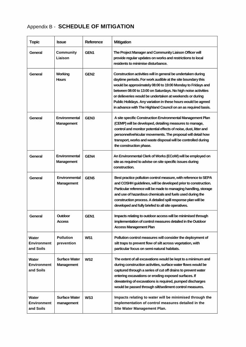
Appendix B - SCHEDULE OF MITIGATION
Topic Issue Reference Mitigation
General Community
Liaison
GEN1 The Project Manager and Community Liaison Officer will
provide regular updates on works and restrictions to local
residents to minimise disturbance.
General Working
Hours
GEN2 Construction activities will in general be undertaken during
daytime periods. For work audible at the site boundary this
would be approximately 08:00 to 19:00 Monday to Fridays and
between 08:00 to 13:00 on Saturdays. No high noise activities
or delieveries would be undertaken at weekends or during
Public Holidays. Any variation in these hours would be agreed
in advance with The Highland Council on an as required basis.
General Environmental
Management
Environmental
Management
GEN3 A site specific Construction Environmental Management Plan
(CEMP) will be developed, detailing measures to manage,
control and monitor potential effects of noise, dust, litter and
personnel/vehicular movements. The proposal will detail how
transport, works and waste disposal will be controlled during
the construction phase.
General GEN4 An Environmental Clerk of Works (ECoW) will be employed on
site as required to advise on site specific issues during
construction.
General Environmental
Management
GEN5 Best practice pollution control measure, with reference to SEPA
and COSHH guidelines, will be developed prior to construction.
Particular reference will be made to managing handling, storage
and use of hazardous chemicals and fuels used during the
construction process. A detailed spill response plan will be
developed and fully briefed to all site operatives.
General Outdoor
Access
GEN1 Impacts relating to outdoor access will be minimised through
implementation of control measures detailed in the Outdoor
Access Management Plan
Water
Environment
and Soils
Pollution
prevention
WS1 Pollution control measures will consider the deployment of
silt traps to prevent flow of silt across vegetation, with
particular focus on semi-natural habitats.
Water
Environment
and Soils
Surface Water
Management
WS2 The extent of all excavations would be kept to a minimum and
during construction activities, surface water flows would be
captured through a series of cut off drains to prevent water
entering excavations or eroding exposed surfaces. If
dewatering of excavations is required, pumped discharges
would be passed through silt/sediment control measures.
Water
Environment
and Soils
Surface Water
management
WS3 Impacts relating to water will be minimised through the
implementation of control measures detailed in the
Site Water Management Plan.

Topic Issue Reference Mitigation
Water
Environment
and Soils
Surface water
Management
WS4 Pipes/culverts will be used to manage and control all
flushes and watercourses across the site, employed
according to SEPA guidelines, with care taken to minimise
disturbance to bed and banks of watercourses.
Water
Environment
and Soils
Soil Handling WS5 Impacts relating to soils will be minimised through the
implementation of control measures detailed in the soil
management plan.
Water
Environment
and Soils
Soil Handling WS6 Excavated material will be stored according to best practice
taking care to separate, as far as is reasonable, turves,
topsoils, soil layers and boulders. Reinstatement will ensure
that turves are replaced on the surface, to recreate the
former habitat as far as is possible;
Landscap
e and
Visual
Landscaping
and
Screening
LV1 Landscape mitigation measures comprising planting and
the creation of planted earth bunds have been developed
and will be implemented.
I-- Ecology Protected
Species
ECO1 The workforce will be briefed on the potential for protected
mammals to be present in the general area, the legislative
context and potential signs of activity. SHET SPPs will be
followed throughout the works.
Ecology Protected
Species
ECO2 Pre-construction and pre-felling checks will be undertaken of
all affected areas buffered to 50 metres to determine the
presence of any protected species shelters and levels of
activity in the area.
Ecology Protected
Species
ECO3 In the event of any significant signs of mammal activity being
found, works should cease immediately in that area, and
advice sought from a professional ecologist, and if necessary
the local SNH office.
Omithology Timing of
Construction
Activities
ORN1 Where possible, site clearance should be timed to take place
outwith the bird breeding season (late March to the end of
July inclusive) to avoid disturbance or potential destruction of
wild bird's nests. Where this is not possible, pre-construction
checks should be undertaken by a qualified
ecologist/omithologist to identify, and mitigate for, the
presence of breeding bird species.
Ornithology Protected
Species
ORN2 If tree removal is required, pre-construction checks will be
undertaken by a qualified ornithologist prior to forestry activity
scheduled during the breeding season (early April — late
July). Further to this survey appropriate mitigation will be
applied as required to minimise risks of possible disturbance,
subject to consultation with SNH and the RSPB.
Ornithology Protected
Species
ORN3 Should a nest of any bird species be located during the course
of construction activities, works will be stopped within 30m of

Topic issue Reference Mitigation
the nest and advice sought from a qualified
ecologist/omithologist, and if necessary local SNH staff.
Forestry Woodland
Management
FOR1 Impacts to forestry will be minimised by completing works in
accordance with the woodland management plan.
Noise Construction
Noise and
Vibration
N011 Works to be completed in accordance with 'best practice'
guidelines and the specific control measures detailed in
the Construction Noise Management Plan.
Traffic and
Transportation
Traffic
Management
TT1 Impacts relating to an increase in general construction
traffic will be minimised through the implementation of
control measures detailed in the Traffic Management Plan.
Traffic and
Transportation
Road
Condition and
Deterioration
TT2 It is proposed that road condition surveys are completed pre-
construction and post-construction to identify whether
additional traffic has created any identifiable deterioration in
the road infrastructure condition within the study area. Any
deterioration agreed as attributable to the Development will be
repaired and returned to the condition observed prior to
construction.

THE HIGHLAND COUNCIL
PLANNING APPLICATIONS HEARING PROCEDURE
The following procedure shall be adopted for all Committee meetings (including Council meetings) at which a pre-determination hearing is to be held in respect of a planning application. There are two types of hearing:
Discretionary pre-determination hearings where a hearing is requested by a Planning Applications Committee prior to the Committee determining a planning application, and
Non-discretionary pre-determination hearings where a hearing is required by the Town and Country Planning (Scotland) Act 1997 prior to the Council determining a planning application.
A. Prior to a Hearing a) The Planning and Development Service shall agree with the Chair of the Committee (or Convener of the Council, as appropriate) whether the hearing should take place at a scheduled Committee meeting (or scheduled Council meeting as appropriate) or at a special meeting and will identify an appropriate venue for the meeting. b) In complex cases the Planning and Development Service, in consultation with the clerk, may hold a “procedural meeting” to advise the parties about the procedures, to encourage them to co-ordinate their responses to avoid repetitious statements and to agree the order of speaking. c) The Planning and Development Service will circulate the hearing procedure and inform parties of the date, time and venue of the hearing.
B. At the Hearing
1) If possible and practical to do so, the clerk or the administrator will identify those parties present who wish to participate in the hearing and will distribute copies of this hearing procedure. A list of participants will be passed to the Chair/Convener.
2) The Chair/Convener will open the hearing by welcoming those parties present and will ask for confirmation (1) of the identity of those parties present who wish to participate in the hearing (if it has not proven possible to identify them beforehand), (2) that all persons wishing to participate in the hearing have a copy of this hearing procedure and (3) that all participants understand the procedure. The Chair/Convener will indicate, by name, the order in which the parties taking part will address the Committee/Council.
3) The Chair/Convener will remind parties to focus their comments on the views which they have already expressed in writing. New information should only be presented for the purposes of clarification and if this happens the other parties to the hearing will be allowed to respond to this new information.
4) The planning officer will introduce the application, giving a brief description of the proposed development and the application site, the planning policies against which the application is to be assessed and any other material considerations relevant to the application.
5) The applicants will have the opportunity to present their case (in no more than 10 minutes). Applicants may allot part of their overall time to supporters of the application who have submitted timeous written representations in support of the application (this may include a community council). After the applicants’ presentation members of the Committee/Council may ask questions of the applicants.
6) Where a community council has objected to the proposal it will have the opportunity to present its case (in no more than 5 minutes in total). After the community council’s presentation Members of the Committee/Council may ask questions of the community council representative(s).

7) Third parties who have submitted timeous written objections to the proposal will have the opportunity to make their representations (in no more than 10 minutes in total). After the third parties’ presentation members of the Committee/Council may ask questions of the third parties.
8) The Chair/Convener will ask whether there are any other members of the public who have made timeous objections and have given notice that they wish to speak who have not yet been called. Any such members of the public will have the opportunity to speak for such period as the Chair/Convener permits and the Committee/Council will have an opportunity to ask questions.
9) If appropriate, and at the Committee’s/Council’s request, any other relevant officer of the Council or statutory consultee present will have an opportunity to identify any concerns or issues they wish to raise.
10) The applicants will be given the opportunity to respond to issues raised by members, officers or third parties which were not covered in the applicants’ original presentation.
11) After all parties have concluded their presentations the Chair/Convener will establish whether the Committee/Council has had its requirement for information met. The Chair/Convener will also ask if the parties are satisfied with the way in which the hearing has been conducted and their responses will be included in the minute of the meeting.
Thereafter the Chair/Convener will indicate that the hearing has been completed and all parties will return to the public gallery. The planning officer will detail the appraisal of, and present the recommendation on, the application, after which the Committee/Council will consider and determine the application. Guidance Notes
Applications subject to hearings will normally be scheduled first on a Committee agenda to minimise waiting time by the parties involved.
Applicants and objectors are expected to take a maximum of 10 minutes to make their presentations – this timeslot being divided among those wishing to speak for each party. Community Councils presenting their objections are expected to do so within 5 minutes. If any party wishes longer than these periods then they should indicate this prior to the presentations commencing. The Committee/Council shall decide whether to allow a longer period. Any extension of time should not exceed 5 minutes.
Where there are a number of objectors wishing to speak, they are encouraged to appoint a spokesperson(s) to present their views as experience has shown that this focuses on the main matters of concern and avoids repetition.
Any party wishing to use PowerPoint during their presentation MUST notify the clerk at least two clear working days before the date of the meeting so that arrangements can be made.
Finally, it should be noted that if a hearing has been arranged and all the interested parties (i.e. applicant, objector(s) and any third parties) have been invited to attend or be represented, then the hearing will proceed irrespective of the absence of any of the invited parties when the application comes to be considered. Should a party invited to attend a hearing be unable to be present, that party may submit a short written statement summarising their views which will be read to the meeting by the clerk on their behalf at the appropriate stage in the proceedings. The Committee/Council will hear the parties present and then determine the application.
All parties who have made representations on an application will be advised by the Planning and Development Service of the Committee’s/Council’s decision on the application.
Legal Service/Planning and Development Service August 2012