Embed Size (px)
Citation preview
652 www.gsapubs.org | Volume 9 | Number 4 | LITHOSPHERE
Age and volcanic stratigraphy of the Eocene Siletzia oceanic plateau in Washington and on Vancouver Island
Michael P. Eddy1,*, Kenneth P. Clark2, and Michael Polenz3
1EARTH, ATMOSPHERIC AND PLANETARY SCIENCES DEPARTMENT, MASSACHUSETTS INSTITUTE OF TECHNOLOGY, 77 MASSACHUSETTS AVENUE, CAMBRIDGE, MASSACHUSETTS 02139, USA
2GEOLOGY DEPARTMENT, UNIVERSITY OF PUGET SOUND, 1500 N. WARNER STREET, TACOMA, WASHINGTON 98416, USA3WASHINGTON STATE DEPARTMENT OF NATURAL RESOURCES, DIVISION OF GEOLOGY AND EARTH RESOURCES, 1111 WASHINGTON STREET SE, MS 47007, OLYMPIA, WASHINGTON 98504, USA
ABSTRACT
Geophysical, geochemical, geochronologic, and stratigraphic observations all suggest that the basalts that underlie western Oregon and Washington (USA), and southern Vancouver Island (Canada) form a coherent terrane of Eocene age, named Siletzia. The total volume of basalt within Siletzia is comparable to that observed in large igneous provinces and several lines of evidence point toward the terrane’s origin as an accreted oceanic plateau. However, a thick sequence of continentally derived turbidites, named the Blue Mountain unit, has long been considered to floor the northern part of the terrane and its presence has led to alternative hypotheses in which Siletzia was built on the con-tinental margin. We present new high-precision U-Pb zircon dates from silicic tuffs and intrusive rocks throughout the basaltic basement of northern Siletzia, as well as detrital zircon age spectra and maximum depositional ages for the Blue Mountain unit to help clarify the volcanic stratigraphy of this part of the terrane. These dates show that northern Siletzia was emplaced between 53.18 ± 0.17 Ma and 48.364 ± 0.036 Ma, similar to the age and duration of magmatism in the central and southern parts of the terrane. Turbidites in the basal Blue Mountain unit have maximum depositional ages as young as 44.72 ± 0.21 Ma and are distinctly younger than the basaltic basement that forms Siletzia. This age relationship implies that they were thrust under the terrane after 44.72 ± 0.21 Ma along one or more enigmatic faults. The younger age for these sedimentary rocks no longer requires construction of Siletzia on the continental margin, and we consider our revised stratigraphy to provide further support for the origin of the terrane as an accreted oceanic plateau.
LITHOSPHERE; v. 9; no. 4; p. 652–664; GSA Data Repository Item 2017232 | Published online 25 May 2017 https://doi.org/10.1130/L650.1
INTRODUCTION
Siletzia is a composite Eocene terrane, com-posed of the Siletz (Snavely et al., 1968) and Crescent (Babcock et al., 1994) terranes, that forms a thick basaltic basement under much of western Washington and Oregon (USA), as well as southern Vancouver Island (Canada; Fig. 1A). The thickness of the terrane ranges from 10 km in the extreme north to 20–30 km throughout the rest of Siletzia, and estimates for the volume of erupted basalt are comparable to those seen in large igneous provinces (Trehu et al., 1994). Geochemical data further suggest that Siletzia includes basalts with isotopic compositions indicative of a plume-like mantle source (Pyle et al., 2009, 2015; Phillips et al., 2017). These
observations have led to the hypothesis that the terrane represents an accreted oceanic plateau or chain of seamounts (Duncan, 1982; Murphy et al., 2003; McCrory and Wilson, 2013; Wells et al., 2014; Murphy, 2016). Such an origin is further supported by evidence for Eocene-aged regional shortening on Vancouver Island (John-ston and Acton, 2003), western and central Wash-ington (Tabor et al., 1984; Johnson, 1985; Eddy et al., 2016; Miller et al., 2016), and southern Oregon (Wells et al., 2000), as well as geophysi-cal studies that show that Siletzia is connected with subducted oceanic crust (Gao et al., 2011; Schmandt and Humphreys, 2011). However, the hypothesis that Siletzia is an accreted oceanic terrane remains controversial, in part because a thick (>1–2 km) section of continentally derived turbidites is considered to underlie and interfin-ger with the northern part of the terrane (Tabor and Cady, 1978a, 1978b; Einarsen, 1987; Bab-cock et al., 1992; Brandon et al., 2014). The pres-ence of these sedimentary rocks suggests that the basalts were erupted on the continental margin,
and several studies have proposed alternative tectonic settings for the construction of Silet-zia, including a marginal rift (Wells et al., 1984; Babcock et al., 1992; Brandon et al., 2014) or near-trench magmatism related to ridge-trench interaction (Haeussler et al., 2003).
We present new high-precision U-Pb zircon geochronologic data from throughout the north-ern part of the Siletzia terrane that help us to better constrain the depositional and eruptive history of this area. These dates indicate that the basalts that form much of northern Siletzia were built between 53.18 ± 0.17 Ma and 48.364 ± 0.036 Ma, similar to the age and duration of magmatism within central and southern Siletzia (Wells et al., 2014). Detrital zircon data from the Blue Mountain unit provide maximum deposi-tional ages that range between 47.775 ± 0.057 Ma and 44.72 ± 0.21 Ma, indicating that these sedimentary rocks are distinctly younger than Siletzia and that they were thrust under the ter-rane after 44.72 ± 0.21 Ma. This revised stra-tigraphy no longer requires that the terrane was
© 2017 Geological Society of America. For permission to copy, contact [email protected]
Michael Eddy http://orcid.org /0000 -0003 -0907 -5108
*Present Address: Department of Geosciences, Princeton University, Guyot Hall, Princeton, New Jer-sey 08544, USA
Downloaded from https://pubs.geoscienceworld.org/gsa/lithosphere/article-pdf/9/4/652/2316144/652.pdfby Central Washington University useron 20 May 2019
LITHOSPHERE | Volume 9 | Number 4 | www.gsapubs.org 653
U-Pb zircon geochronology from northern Siletzia | RESEARCH
B
S. S
iletz
iaN
. Sile
tzia
Cen
tral
Sile
tzia
Roseburg
200 km
B
0
Portland
Vancouver
Seattle
LRF
WSF
A
123˚122˚
48˚
47˚
48˚
A A’
Olympic Subduction Complex
Siletzia ForearcSedimentary Rocks
Juan de Fuca Plate
C
Blue Mtn. UnitHurricane Ridge Fault
0 25 km
N
NWCTS
Quaternary Deposits
Eoc.-Mi. Olympic Subduction Complex
Eoc.-Mi. Forearc Sedimentary Rocks
Eoc. Shallow Marine & Subaerial Basalt Flows
Eoc. Submarine Basalt Flows
Eoc. Blue Mtn. Unit
Mesozoic Accreted Terranes
Contact FaultDated SamplesVolc., MDA, Int., ,
Metchosin Complex
BremertonComplex
Black HillsBasalts
BM
U
LC UC
LC
UC
BMU
BMU
Olympic SubductionComplex
Bremerton
Olympia
Victoria
DungenessTransect
Cushman-WynoocheeTransect
DosewallipsTransect
AA’
LRF
LEFSP
LBF
CF
SouthwardContinuation?
LEFHRF
HRF
HR
F
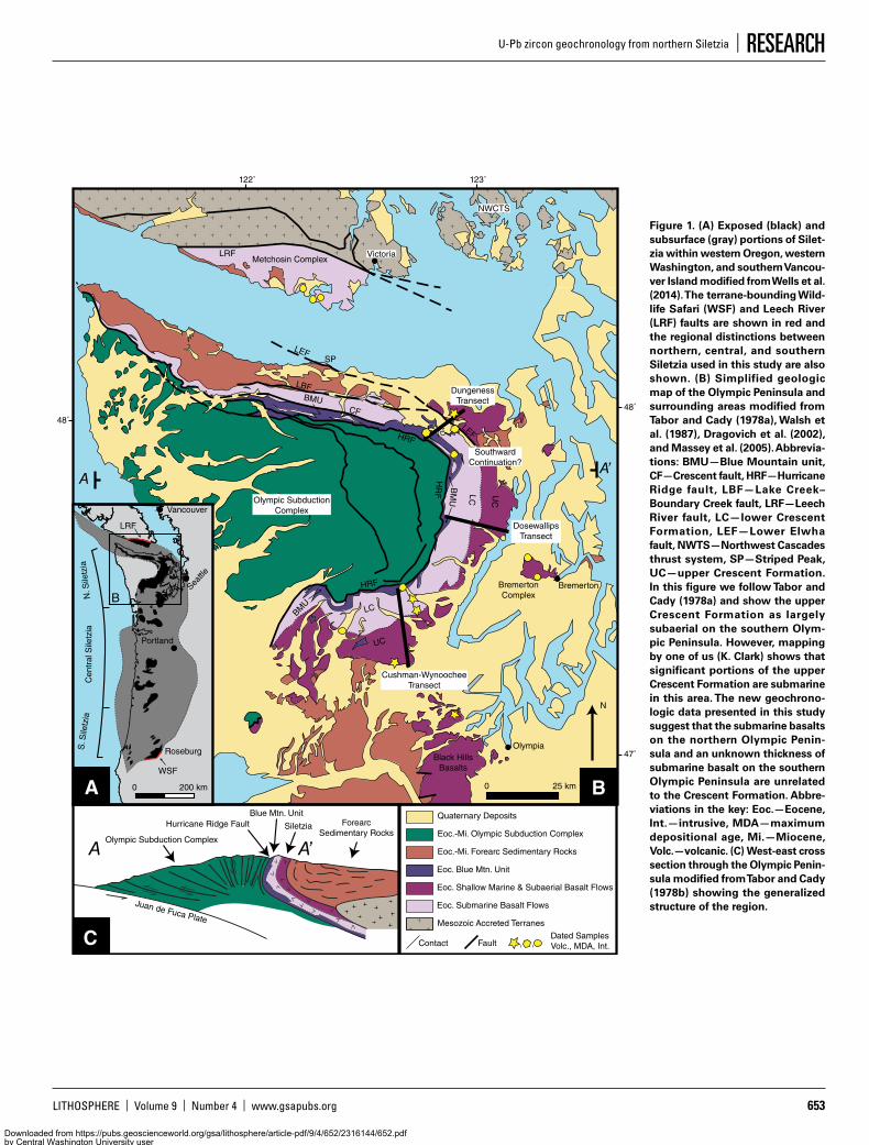
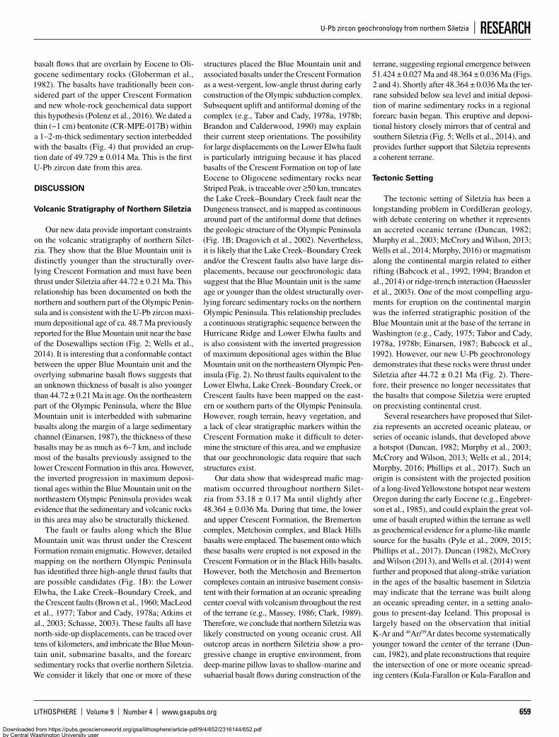
Figure 1. (A) Exposed (black) and subsurface (gray) portions of Silet-zia within western Oregon, western Washington, and southern Vancou-ver Island modified from Wells et al. (2014). The terrane-bounding Wild-life Safari (WSF) and Leech River (LRF) faults are shown in red and the regional distinctions between northern, central, and southern Siletzia used in this study are also shown. (B) Simplified geologic map of the Olympic Peninsula and surrounding areas modified from Tabor and Cady (1978a), Walsh et al. (1987), Dragovich et al. (2002), and Massey et al. (2005). Abbrevia-tions: BMU—Blue Mountain unit, CF—Crescent fault, HRF—Hurricane Ridge fault, LBF—Lake Creek–Boundary Creek fault, LRF—Leech River fault, LC—lower Crescent Formation, LEF—Lower Elwha fault, NWTS—Northwest Cascades thrust system, SP—Striped Peak, UC—upper Crescent Formation. In this figure we follow Tabor and Cady (1978a) and show the upper Crescent Formation as largely subaerial on the southern Olym-pic Peninsula. However, mapping by one of us (K. Clark) shows that significant portions of the upper Crescent Formation are submarine in this area. The new geochrono-logic data presented in this study suggest that the submarine basalts on the northern Olympic Penin-sula and an unknown thickness of submarine basalt on the southern Olympic Peninsula are unrelated to the Crescent Formation. Abbre-viations in the key: Eoc.—Eocene, Int.—intrusive, MDA—maximum depositional age, Mi.—Miocene, Volc.—volcanic. (C) West-east cross section through the Olympic Penin-sula modified from Tabor and Cady (1978b) showing the generalized structure of the region.
Downloaded from https://pubs.geoscienceworld.org/gsa/lithosphere/article-pdf/9/4/652/2316144/652.pdfby Central Washington University useron 20 May 2019
EDDY ET AL.
654 www.gsapubs.org | Volume 9 | Number 4 | LITHOSPHERE
built on the continental margin and we consider our data to support the hypothesis that Siletzia is an accreted oceanic plateau.
GEOLOGIC SETTING
Exposures of Siletzia occur throughout the Coast Ranges of Washington and Oregon and along the southern tip of Vancouver Island (Fig. 1A). The terrane’s eastern boundary is exposed as the Leech River fault on Vancouver Island (Figs. 1A, 1B; Groome et al., 2003) and the Wildlife Safari fault in southern Oregon (Fig. 1A; Wells et al., 2000), both of which place Mesozoic metasedimentary rocks over the ter-rane (Wells et al., 2000; Groome et al., 2003). Between these two faults the boundary is cov-ered by middle Eocene and younger sedimentary and volcanic rocks. However, aeromagnetic data (Wells et al., 1998), ambient noise tomography (Gao et al., 2011), and body wave tomography (Schmandt and Humphreys, 2011) suggest that the terrane is continuous beneath this cover and that it is connected to a hanging slab of sub-ducted oceanic crust in the upper mantle beneath eastern Washington and Oregon. To the west, the terrane is underthrust by the accretionary com-plex for the modern Cascade arc (e.g., Clowes et al., 1987; Trehu et al., 1994; Fleming and Trehu, 1999). This boundary is exposed on the Olympic Peninsula as the Hurricane Ridge fault (Fig. 1B; Cady, 1975; Tabor and Cady, 1978a, 1978b) and is traceable offshore to the north (Clowes et al., 1987) and south (Trehu et al., 1994; Fleming and Trehu, 1999).
Wells et al. (2014) used geochronologic, bio-stratigraphic, and paleomagnetic data to pro-duce a sedimentary and volcanic stratigraphy of Siletzia; they showed that it consists of a thick basaltic basement that transitions from subma-rine to subaerial flows upsection. The basalts are predominantly mid-oceanic ridge basalt–like (MORB) with subordinate oceanic island basalt–like (OIB) and alkaline basalts that contain Pb, Sr, Nd, He, Hf, and Os isotopic compositions consistent with their derivation from a plume-like mantle source (Pyle et al., 2009, 2015; Phil-lips et al., 2017). Eruption of these basalts likely started by 56 Ma in the south and by 53 Ma in the central and northern parts of the terrane, based on available 40Ar/39Ar dates, while the transi-tion to subaerial eruption is constrained between 52 ± 1 Ma and 49 ± 0.8 Ma by U-Pb zircon dates of silicic tuffs in central Siletzia (Wells et al., 2014). Following the transition to subaerial eruptions, southern Siletzia was deformed into a west-vergent (following restoration of ~80° of clockwise rotation) fold-thrust belt that is best documented near Roseburg, Oregon (Fig. 1A; Wells et al., 2000). Biostratigraphic constraints
as well as maximum depositional ages for non-deformed sedimentary rocks that overlie the basaltic basement in this area require that defor-mation occurred prior to 48 Ma (Dumitru et al., 2013; Wells et al., 2014). A similar fold-thrust belt has not been recognized in central and north-ern Siletzia. However, Tabor et al. (1984) and Johnson (1985) documented shortening in non-marine Eocene sedimentary sequences through-out central and western Washington that Eddy et al. (2016) constrained to have occurred between 51.309 ± 0.024 Ma and 49.933 ± 0.059 Ma. Sim-ilarly, Johnston and Acton (2003) documented a period of shortening on southern Vancouver Island ca. 50 Ma, and Wells et al. (2014) docu-mented folding in central Siletzia between 49.0 ± 0.8 Ma and ca. 48 Ma.
Deposition of sedimentary rocks that belong to a regional forearc sedimentary basin began soon after Siletzia was shortened, and these rocks blanket the terrane. Biostratigraphic data and maximum depositional ages from detrital zircons in these rocks constrain the transition to have occurred by 50–48 Ma in southern Ore-gon (Dumitru et al., 2013; Wells et al., 2014) and the reestablishment of east-west paleoflow following regional shortening in nonmarine sedimentary rocks of central Washington by 45.910 ± 0.021 Ma may provide a minimum date for this transition in Washington (Eddy et al., 2016). Subsidence of this forearc basin was nearly continuous from the middle Eocene to the Miocene (e.g., Babcock et al., 1994; Ryu et al., 1996), when the basin was inverted during uplift of the modern accretionary prism. Interbedded with the basin’s sedimentary rocks are isolated and geochemically diverse basaltic magmatic centers that range between 48 and 34 Ma in age. These centers include the basalt of Hem-bre Ridge, Tillamook Volcanics, Grays River volcanics, and Yachats Head volcanics (Wells et al., 2014), some of which contain isotopic evidence for derivation from plume-like mantle (e.g., Chan et al., 2012).
The northernmost exposures of Siletzia occur on southern Vancouver Island and in western Washington (Fig. 1B). This area has a stratigra-phy similar to that of central and southern Silet-zia and consists of a basaltic basement overlain by middle Eocene to Miocene forearc sedi-mentary rocks (Fig. 1B; Babcock et al., 1994; Wells et al., 2014). Outcrops of the basaltic base-ment occur as the Crescent Formation, Metcho-sin complex, Bremerton complex, and Black Hills basalt. Existing geochronology (Duncan, 1982; Clark, 1989; Babcock et al., 1992, 1994; Hirsch and Babcock 2009; Polenz et al., 2012a, 2012b, 2016) shows that the timing of mag-matism and initial deposition of the overlying sedimentary rocks is similar to that in central
and southern Siletzia (Wells et al., 2014). How-ever, a >1–2-km-thick section of continentally derived turbidites known as the Blue Mountain unit has been interpreted as the base of Silet-zia in Washington (Fig. 1B; Tabor and Cady, 1978a, 1978b; Einarsen, 1987; Babcock et al., 1992, 1994). The presence of these sedimentary rocks is difficult to reconcile with the hypothesis that Siletzia represents an accreted oceanic ter-rane and it has spurred alternative hypotheses that consider it to have formed on the continen-tal margin as a marginal rift (Wells et al., 1984; Babcock et al., 1992; Brandon et al., 2014), or as near-trench magmatism (Haeussler et al., 2003). Nevertheless, the stratigraphy of northern Silet-zia has never been rigorously tested using high-precision geochronology.
U-Pb ZIRCON GEOCHRONOLOGY
Previous geochronology from northern Silet-zia largely consists of whole-rock K-Ar and 40Ar/39Ar dates (Duncan, 1982; Clark, 1989; Babcock et al., 1992, 1994; Hirsch and Babcock 2009; Polenz et al., 2012a, 2012b, 2016). These data have helped establish that this part of the terrane is early Eocene in age, but they are rela-tively imprecise and largely prevent fine tempo-ral correlations between isolated outcrop areas. Furthermore, variable metamorphism (Timpa et al., 2005; Hirsch and Babcock, 2009) and alteration of basalts and gabbros within north-ern Siletzia make it difficult to unambiguously interpret whole-rock K-Ar and 40Ar/39Ar dates as crystallization ages. U-Pb zircon geochronol-ogy circumvents these problems, but existing data are limited.
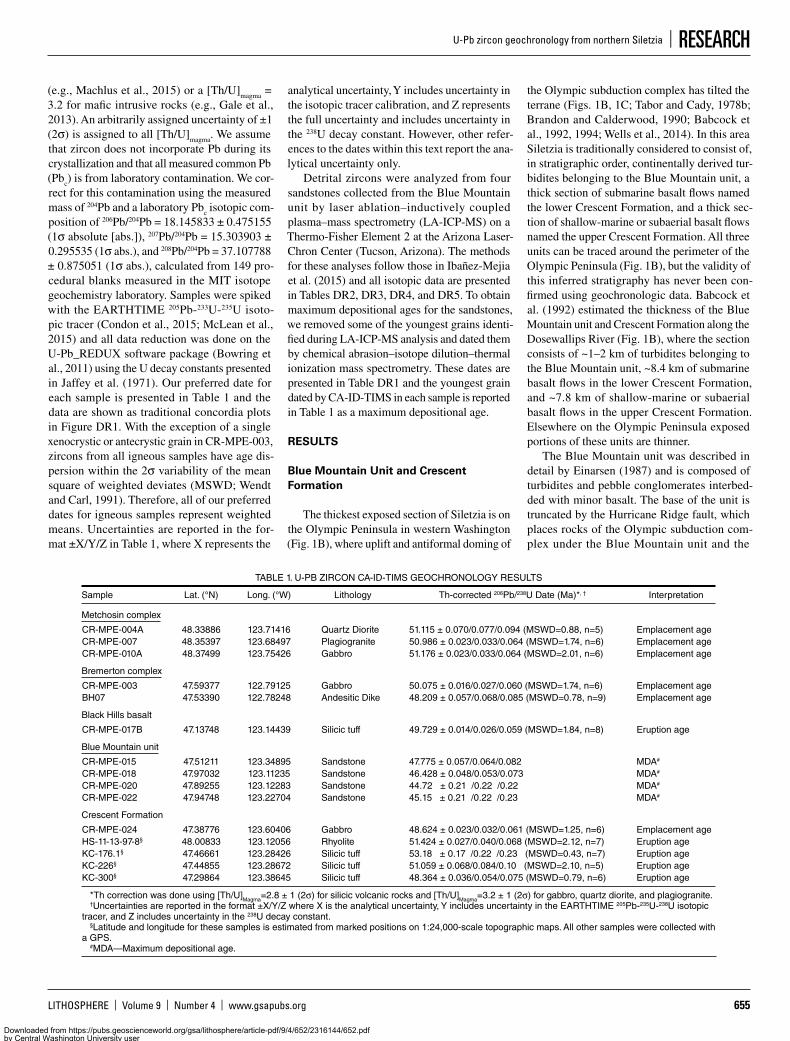
We present 11 new U-Pb zircon chemical abrasion–isotope dilution–thermal ionization mass spectrometry (CA-ID-TIMS) dates from throughout northern Siletzia that help better constrain the regional stratigraphy. The methods for this procedure are slightly modified from Mattinson (2005) and are described in detail in Eddy et al. (2016, Appendix A therein). All iso-topic ratios were measured on either the VG Sec-tor 54 or Isotopx X62 thermal ionization mass spectrometers at the Massachusetts Institute of Technology (MIT) and the data are presented in Table DR11. We use the 206Pb/238U date for all of our interpretations because it offers the most precise date for rocks of this age, and we correct for preferential exclusion of 230Th during zircon crystallization using the calculated [Th/U]
zircon
and assuming a [Th/U]magma
= 2.8 for silicic tuffs
1 GSA Data Repository Item 2017232, U-Pb isotopic data and concordia plots, is available at http://www .geosociety.org /datarepository /2017, or on request from [email protected].
Downloaded from https://pubs.geoscienceworld.org/gsa/lithosphere/article-pdf/9/4/652/2316144/652.pdfby Central Washington University useron 20 May 2019
LITHOSPHERE | Volume 9 | Number 4 | www.gsapubs.org 655
U-Pb zircon geochronology from northern Siletzia | RESEARCH
(e.g., Machlus et al., 2015) or a [Th/U]magma
= 3.2 for mafic intrusive rocks (e.g., Gale et al., 2013). An arbitrarily assigned uncertainty of ±1 (2σ) is assigned to all [Th/U]
magma. We assume
that zircon does not incorporate Pb during its crystallization and that all measured common Pb (Pb
c) is from laboratory contamination. We cor-
rect for this contamination using the measured mass of 204Pb and a laboratory Pb
c isotopic com-
position of 206Pb/204Pb = 18.145833 ± 0.475155 (1σ absolute [abs.]), 207Pb/204Pb = 15.303903 ± 0.295535 (1σ abs.), and 208Pb/204Pb = 37.107788 ± 0.875051 (1σ abs.), calculated from 149 pro-cedural blanks measured in the MIT isotope geochemistry laboratory. Samples were spiked with the EARTHTIME 205Pb-233U-235U isoto-pic tracer (Condon et al., 2015; McLean et al., 2015) and all data reduction was done on the U-Pb_REDUX software package (Bowring et al., 2011) using the U decay constants presented in Jaffey et al. (1971). Our preferred date for each sample is presented in Table 1 and the data are shown as traditional concordia plots in Figure DR1. With the exception of a single xenocrystic or antecrystic grain in CR-MPE-003, zircons from all igneous samples have age dis-persion within the 2σ variability of the mean square of weighted deviates (MSWD; Wendt and Carl, 1991). Therefore, all of our preferred dates for igneous samples represent weighted means. Uncertainties are reported in the for-mat ±X/Y/Z in Table 1, where X represents the
analytical uncertainty, Y includes uncertainty in the isotopic tracer calibration, and Z represents the full uncertainty and includes uncertainty in the 238U decay constant. However, other refer-ences to the dates within this text report the ana-lytical uncertainty only.
Detrital zircons were analyzed from four sandstones collected from the Blue Mountain unit by laser ablation–inductively coupled plasma–mass spectrometry (LA-ICP-MS) on a Thermo-Fisher Element 2 at the Arizona Laser-Chron Center (Tucson, Arizona). The methods for these analyses follow those in Ibañez-Mejia et al. (2015) and all isotopic data are presented in Tables DR2, DR3, DR4, and DR5. To obtain maximum depositional ages for the sandstones, we removed some of the youngest grains identi-fied during LA-ICP-MS analysis and dated them by chemical abrasion–isotope dilution–thermal ionization mass spectrometry. These dates are presented in Table DR1 and the youngest grain dated by CA-ID-TIMS in each sample is reported in Table 1 as a maximum depositional age.
RESULTS
Blue Mountain Unit and Crescent Formation
The thickest exposed section of Siletzia is on the Olympic Peninsula in western Washington (Fig. 1B), where uplift and antiformal doming of
the Olympic subduction complex has tilted the terrane (Figs. 1B, 1C; Tabor and Cady, 1978b; Brandon and Calderwood, 1990; Babcock et al., 1992, 1994; Wells et al., 2014). In this area Siletzia is traditionally considered to consist of, in stratigraphic order, continentally derived tur-bidites belonging to the Blue Mountain unit, a thick section of submarine basalt flows named the lower Crescent Formation, and a thick sec-tion of shallow-marine or subaerial basalt flows named the upper Crescent Formation. All three units can be traced around the perimeter of the Olympic Peninsula (Fig. 1B), but the validity of this inferred stratigraphy has never been con-firmed using geochronologic data. Babcock et al. (1992) estimated the thickness of the Blue Mountain unit and Crescent Formation along the Dosewallips River (Fig. 1B), where the section consists of ~1–2 km of turbidites belonging to the Blue Mountain unit, ~8.4 km of submarine basalt flows in the lower Crescent Formation, and ~7.8 km of shallow-marine or subaerial basalt flows in the upper Crescent Formation. Elsewhere on the Olympic Peninsula exposed portions of these units are thinner.
The Blue Mountain unit was described in detail by Einarsen (1987) and is composed of turbidites and pebble conglomerates interbed-ded with minor basalt. The base of the unit is truncated by the Hurricane Ridge fault, which places rocks of the Olympic subduction com-plex under the Blue Mountain unit and the
TABLE 1. U-PB ZIRCON CA-ID-TIMS GEOCHRONOLOGY RESULTS
Sample Lat. (°N) Long. (°W) Lithology Th-corrected 206Pb/238U Date (Ma)*, † Interpretation
Metchosin complex
CR-MPE-004A 48.33886 123.71416 Quartz Diorite 51.115 ± 0.070/0.077/0.094 (MSWD=0.88, n=5) Emplacement ageCR-MPE-007 48.35397 123.68497 Plagiogranite 50.986 ± 0.023/0.033/0.064 (MSWD=1.74, n=6) Emplacement ageCR-MPE-010A 48.37499 123.75426 Gabbro 51.176 ± 0.023/0.033/0.064 (MSWD=2.01, n=6) Emplacement age
Bremerton complex
CR-MPE-003 47.59377 122.79125 Gabbro 50.075 ± 0.016/0.027/0.060 (MSWD=1.74, n=6) Emplacement ageBH07 47.53390 122.78248 Andesitic Dike 48.209 ± 0.057/0.068/0.085 (MSWD=0.78, n=9) Emplacement age
Black Hills basalt
CR-MPE-017B 47.13748 123.14439 Silicic tuff 49.729 ± 0.014/0.026/0.059 (MSWD=1.84, n=8) Eruption age
Blue Mountain unit
CR-MPE-015 47.51211 123.34895 Sandstone 47.775 ± 0.057/0.064/0.082 MDA#
CR-MPE-018 47.97032 123.11235 Sandstone 46.428 ± 0.048/0.053/0.073 MDA#
CR-MPE-020 47.89255 123.12283 Sandstone 44.72_ ± 0.21_/0.22_/0.22_ MDA#
CR-MPE-022 47.94748 123.22704 Sandstone 45.15_ ± 0.21_/0.22_/0.23_ MDA#
Crescent Formation
CR-MPE-024 47.38776 123.60406 Gabbro 48.624 ± 0.023/0.032/0.061 (MSWD=1.25, n=6) Emplacement ageHS-11-13-97-8§ 48.00833 123.12056 Rhyolite 51.424 ± 0.027/0.040/0.068 (MSWD=2.12, n=7) Eruption ageKC-176.1§ 47.46661 123.28426 Silicic tuff 53.18_ ± 0.17_/0.22_/0.23_ (MSWD=0.43, n=7) Eruption ageKC-226§ 47.44855 123.28672 Silicic tuff 51.059 ± 0.068/0.084/0.10_ (MSWD=2.10, n=5) Eruption ageKC-300§ 47.29864 123.38645 Silicic tuff 48.364 ± 0.036/0.054/0.075 (MSWD=0.79, n=6) Eruption age
*Th correction was done using [Th/U]Magma=2.8 ± 1 (2σ) for silicic volcanic rocks and [Th/U]Magma=3.2 ± 1 (2σ) for gabbro, quartz diorite, and plagiogranite.†Uncertainties are reported in the format ±X/Y/Z where X is the analytical uncertainty, Y includes uncertainty in the EARTHTIME 205Pb-235U-238U isotopic
tracer, and Z includes uncertainty in the 238U decay constant.§Latitude and longitude for these samples is estimated from marked positions on 1:24,000-scale topographic maps. All other samples were collected with
a GPS.#MDA—Maximum depositional age.
Downloaded from https://pubs.geoscienceworld.org/gsa/lithosphere/article-pdf/9/4/652/2316144/652.pdfby Central Washington University useron 20 May 2019
EDDY ET AL.
656 www.gsapubs.org | Volume 9 | Number 4 | LITHOSPHERE
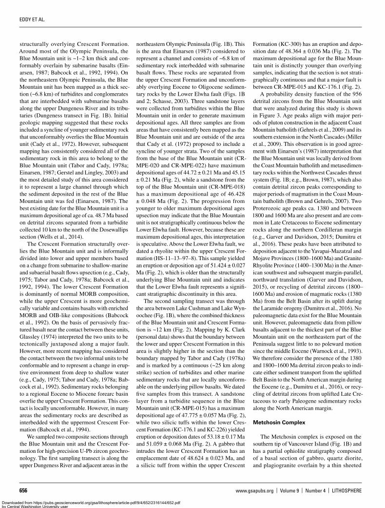
structurally overlying Crescent Formation. Around most of the Olympic Peninsula, the Blue Mountain unit is ~1–2 km thick and con-formably overlain by submarine basalts (Ein-arsen, 1987; Babcock et al., 1992, 1994). On the northeastern Olympic Peninsula, the Blue Mountain unit has been mapped as a thick sec-tion (~6.8 km) of turbidites and conglomerates that are interbedded with submarine basalts along the upper Dungeness River and its tribu-taries (Dungeness transect in Fig. 1B). Initial geologic mapping suggested that these rocks included a syncline of younger sedimentary rock that unconformably overlies the Blue Mountain unit (Cady et al., 1972). However, subsequent mapping has consistently considered all of the sedimentary rock in this area to belong to the Blue Mountain unit (Tabor and Cady, 1978a; Einarsen, 1987; Gerstel and Lingley, 2003) and the most detailed study of this area considered it to represent a large channel through which the sediment deposited in the rest of the Blue Mountain unit was fed (Einarsen, 1987). The best existing date for the Blue Mountain unit is a maximum depositional age of ca. 48.7 Ma based on detrital zircons separated from a turbidite collected 10 km to the north of the Dosewallips section (Wells et al., 2014).
The Crescent Formation structurally over-lies the Blue Mountain unit and is informally divided into lower and upper members based on a change from submarine to shallow-marine and subaerial basalt flows upsection (e.g., Cady, 1975; Tabor and Cady, 1978a; Babcock et al., 1992, 1994). The lower Crescent Formation is dominantly of normal MORB composition, while the upper Crescent is more geochemi-cally variable and contains basalts with enriched MORB and OIB-like compositions (Babcock et al., 1992). On the basis of pervasively frac-tured basalt near the contact between these units, Glassley (1974) interpreted the two units to be tectonically juxtaposed along a major fault. However, more recent mapping has considered the contact between the two informal units to be conformable and to represent a change in erup-tive environment from deep to shallow water (e.g., Cady, 1975; Tabor and Cady, 1978a; Bab-cock et al., 1992). Sedimentary rocks belonging to a regional Eocene to Miocene forearc basin overlie the upper Crescent Formation. This con-tact is locally unconformable. However, in many areas the sedimentary rocks are described as interbedded with the uppermost Crescent For-mation (Babcock et al., 1994).
We sampled two composite sections through the Blue Mountain unit and the Crescent For-mation for high-precision U-Pb zircon geochro-nology. The first sampling transect is along the upper Dungeness River and adjacent areas in the
northeastern Olympic Peninsula (Fig. 1B). This is the area that Einarsen (1987) considered to represent a channel and consists of ~6.8 km of sedimentary rock interbedded with submarine basalt flows. These rocks are separated from the upper Crescent Formation and unconform-ably overlying Eocene to Oligocene sedimen-tary rocks by the Lower Elwha fault (Figs. 1B and 2; Schasse, 2003). Three sandstone layers were collected from turbidites within the Blue Mountain unit in order to generate maximum depositional ages. All three samples are from areas that have consistently been mapped as the Blue Mountain unit and are outside of the area that Cady et al. (1972) proposed to include a syncline of younger strata. Two of the samples from the base of the Blue Mountain unit (CR-MPE-020 and CR-MPE-022) have maximum depositional ages of 44.72 ± 0.21 Ma and 45.15 ± 0.21 Ma (Fig. 2), while a sandstone from the top of the Blue Mountain unit (CR-MPE-018) has a maximum depositional age of 46.428 ± 0.048 Ma (Fig. 2). The progression from younger to older maximum depositional ages upsection may indicate that the Blue Mountain unit is not stratigraphically continuous below the Lower Elwha fault. However, because these are maximum depositional ages, this interpretation is speculative. Above the Lower Elwha fault, we dated a rhyolite within the upper Crescent For-mation (HS-11–13–97–8). This sample yielded an eruption or deposition age of 51.424 ± 0.027 Ma (Fig. 2), which is older than the structurally underlying Blue Mountain unit and indicates that the Lower Elwha fault represents a signifi-cant stratigraphic discontinuity in this area.
The second sampling transect was through the area between Lake Cushman and Lake Wyn-oochee (Fig. 1B), where the combined thickness of the Blue Mountain unit and Crescent Forma-tion is ~12 km (Fig. 2). Mapping by K. Clark (personal data) shows that the boundary between the lower and upper Crescent Formation in this area is slightly higher in the section than the boundary mapped by Tabor and Cady (1978a) and is marked by a continuous (~25 km along strike) section of turbidites and other marine sedimentary rocks that are locally unconform-able on the underlying pillow basalts. We dated five samples from this transect. A sandstone layer from a turbidite sequence in the Blue Mountain unit (CR-MPE-015) has a maximum depositional age of 47.775 ± 0.057 Ma (Fig. 2), while two silicic tuffs within the lower Cres-cent Formation (KC-176.1 and KC-226) yielded eruption or deposition dates of 53.18 ± 0.17 Ma and 51.059 ± 0.068 Ma (Fig. 2). A gabbro that intrudes the lower Crescent Formation has an emplacement date of 48.624 ± 0.023 Ma, and a silicic tuff from within the upper Crescent
Formation (KC-300) has an eruption and depo-sition date of 48.364 ± 0.036 Ma (Fig. 2). The maximum depositional age for the Blue Moun-tain unit is distinctly younger than overlying samples, indicating that the section is not strati-graphically continuous and that a major fault is between CR-MPE-015 and KC-176.1 (Fig. 2).
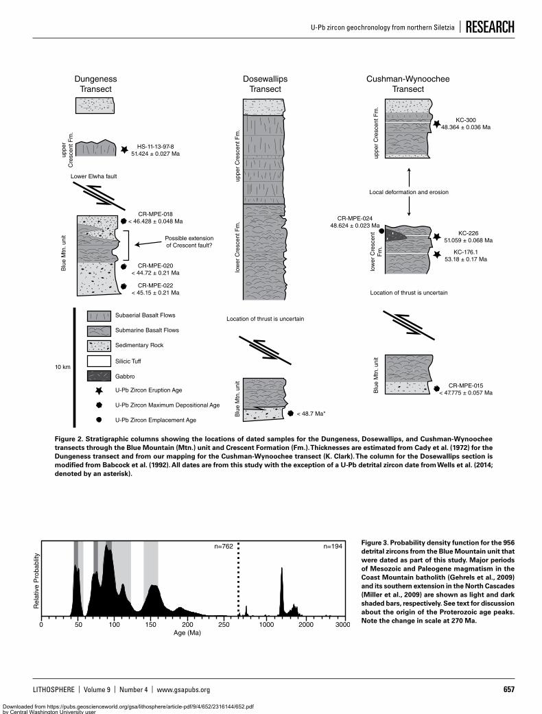
A probability density function of the 956 detrital zircons from the Blue Mountain unit that were analyzed during this study is shown in Figure 3. Age peaks align with major peri-ods of pluton construction in the adjacent Coast Mountain batholith (Gehrels et al., 2009) and its southern extension in the North Cascades (Miller et al., 2009). This observation is in good agree-ment with Einarsen’s (1987) interpretation that the Blue Mountain unit was locally derived from the Coast Mountain batholith and metasedimen-tary rocks within the Northwest Cascades thrust system (Fig. 1B; e.g., Brown, 1987), which also contain detrital zircon peaks corresponding to major periods of magmatism in the Coast Moun-tain batholith (Brown and Gehrels, 2007). Two Proterozoic age peaks ca. 1380 and between 1800 and 1600 Ma are also present and are com-mon in Late Cretaceous to Eocene sedimentary rocks along the northern Cordilleran margin (e.g., Garver and Davidson, 2015; Dumitru et al., 2016). These peaks have been attributed to deposition adjacent to the Yavapai-Mazatzal and Mojave Provinces (1800–1600 Ma) and Granite-Rhyolite Province (1400–1300 Ma) in the Amer-ican southwest and subsequent margin-parallel, northward translation (Garver and Davidson, 2015), or recycling of detrital zircons (1800–1600 Ma) and erosion of magmatic rocks (1380 Ma) from the Belt Basin after its uplift during the Laramide orogeny (Dumitru et al., 2016). No paleomagnetic data exist for the Blue Mountain unit. However, paleomagnetic data from pillow basalts adjacent to the thickest part of the Blue Mountain unit on the northeastern part of the Peninsula suggest little to no poleward motion since the middle Eocene (Warnock et al., 1993). We therefore consider the presence of the 1380 and 1800–1600 Ma detrital zircon peaks to indi-cate either sediment transport from the uplifted Belt Basin to the North American margin during the Eocene (e.g., Dumitru et al., 2016), or recy-cling of detrital zircons from uplifted Late Cre-taceous to early Paleogene sedimentary rocks along the North American margin.
Metchosin Complex
The Metchosin complex is exposed on the southern tip of Vancouver Island (Fig. 1B) and has a partial ophiolite stratigraphy composed of a basal section of gabbro, quartz diorite, and plagiogranite overlain by a thin sheeted
Downloaded from https://pubs.geoscienceworld.org/gsa/lithosphere/article-pdf/9/4/652/2316144/652.pdfby Central Washington University useron 20 May 2019
LITHOSPHERE | Volume 9 | Number 4 | www.gsapubs.org 657
U-Pb zircon geochronology from northern Siletzia | RESEARCH
Figure 3. Probability density function for the 956 detrital zircons from the Blue Mountain unit that were dated as part of this study. Major periods of Mesozoic and Paleogene magmatism in the Coast Mountain batholith (Gehrels et al., 2009) and its southern extension in the North Cascades (Miller et al., 2009) are shown as light and dark shaded bars, respectively. See text for discussion about the origin of the Proterozoic age peaks. Note the change in scale at 270 Ma.
0 30001000 200050 100 150 200 250
Rel
ativ
e P
roba
blity
n=762 n=194
Age (Ma)
Figure 2. Stratigraphic columns showing the locations of dated samples for the Dungeness, Dosewallips, and Cushman-Wynoochee transects through the Blue Mountain (Mtn.) unit and Crescent Formation (Fm.). Thicknesses are estimated from Cady et al. (1972) for the Dungeness transect and from our mapping for the Cushman-Wynoochee transect (K. Clark). The column for the Dosewallips section is modified from Babcock et al. (1992). All dates are from this study with the exception of a U-Pb detrital zircon date from Wells et al. (2014; denoted by an asterisk).
10 km
U-Pb Zircon Eruption Age
U-Pb Zircon Maximum Depositional Age
Submarine Basalt Flows
Subaerial Basalt Flows
Sedimentary Rock
Silicic Tuff
Gabbro
U-Pb Zircon Emplacement Age
CR-MPE-022< 45.15 ± 0.21 Ma
CR-MPE-018< 46.428 ± 0.048 Ma
HS-11-13-97-851.424 ± 0.027 Ma
CR-MPE-020< 44.72 ± 0.21 Ma
Lower Elwha fault
DungenessTransect
< 48.7 Ma*
Location of thrust is uncertain
DosewallipsTransect
Possible extensionof Crescent fault?
CR-MPE-015< 47.775 ± 0.057 Ma
KC-176.153.18 ± 0.17 Ma
KC-22651.059 ± 0.068 Ma
KC-30048.364 ± 0.036 Ma
CR-MPE-02448.624 ± 0.023 Ma
Location of thrust is uncertain
Cushman-WynoocheeTransect
Local deformation and erosion
Blu
e M
tn. u
nit
Blu
e M
tn. u
nit
Blu
e M
tn. u
nit
low
er C
resc
ent F
m.
uppe
r C
resc
ent F
m.
low
er C
resc
ent
Fm
.up
per
Cre
scen
t Fm
.
uppe
rC
resc
ent F
m.
Downloaded from https://pubs.geoscienceworld.org/gsa/lithosphere/article-pdf/9/4/652/2316144/652.pdfby Central Washington University useron 20 May 2019

EDDY ET AL.
658 www.gsapubs.org | Volume 9 | Number 4 | LITHOSPHERE
dike complex and ~2.5 km of basalt flows that transition from submarine to subaerial upsec-tion (Fig. 4; Massey, 1986). The lower part of the complex is not exposed. However, seismic reflection data suggest that it is truncated by sedimentary rocks belonging to the accretion-ary prism of the modern Cascade arc along a major thrust fault (Clowes et al., 1987). The Metchosin complex was thrust under Meso-zoic metasedimentary rocks during the Eocene along the Leech River fault (Fig. 1B; Groome et al., 2003) and records metamorphic grades between prehnite-actinolite and amphibolite facies that are likely related to this event (Timpa et al., 2005). Exhumation to the surface was complete by the late Eocene and is marked by the unconformable deposition of sedimentary rocks belonging to the Carmanah group above the complex (Muller, 1977). The only previous U-Pb zircon date for the Metchosin complex is a poorly documented 52 ± 2 Ma date from a gabbro (personal commun. from R. Zartman to M.T. Brandon, cited in Massey, 1986). We dated three samples from the intrusive part of
the Metchosin complex (Fig. 4): a quartz dio-rite (CR-MPE-004B), a plagiogranite (CR-MPE-007), and a gabbro (CR-MPE-010A). All three samples were emplaced between 51.176 ± 0.023 Ma and 50.986 ± 0.023 Ma and are in good agreement with the previously published U-Pb date for the complex.
Bremerton Complex
The Bremerton complex is exposed in a structural uplift near Bremerton, Washington (Fig. 1B). It has a partial ophiolite stratig-raphy, similar to the Metchosin complex, and includes a basal section of gabbro and plagi-ogranite overlain by a thin section of sheeted dikes and <1.4 km of basalt flows that transi-tion from submarine to subaerial upsection (Clark, 1989). Gravity and magnetic surveys suggest that ultramafic rocks may exist imme-diately below these exposures (Haeussler and Clark, 2000; Tabor et al., 2011), indicating that a nearly complete ophiolite stratigraphy exists in this area. The upper contact of the complex is
not exposed. However, hornblende dacite dikes with an adakite-like composition cut all of the exposed units and provide a constraint on the end of basaltic magmatism (Tepper et al., 2004). A date of 50.4 ± 0.6 Ma from a leucogabbro is the only previously published U-Pb zircon date for the Bremerton complex (Haeussler and Clark, 2000; Tabor et al., 2011). We dated two samples from the area (Fig. 1B). A sample of pegmatitic gabbro within the intrusive part of the complex yielded an emplacement date of 50.075 ± 0.016 Ma and overlaps within uncer-tainty of the previously published U-Pb zircon date. A hornblende dacite dike gave an emplace-ment date of 48.209 ± 0.057 Ma and provides a minimum age constraint on the construction of the complex (Fig. 4).
Black Hills Basalts
The Black Hills basalts are exposed west and south of Olympia, Washington (Fig. 1B). The total thickness of this section is >600 m and it consists of mixed submarine and subaerial
Black Hills BasaltLeech River fault
CR-MPE-004A51.115 ± 0.070 Ma
CR-MPE-00750.986 ± 0.023 Ma
CR-MPE-010A51.176 ± 0.023 Ma
Bremerton Complex
BH0748.209 ± 0.057 Ma
CR-MPE-00350.075 ± 0.016 Ma
Metchosin Complex
CR-MPE-017B49.729 ± 0.014 Ma
1 km
U-Pb Zircon Eruption Age
Submarine Basalt Flows
Subaerial Basalt Flows
Sedimentary Rock
Silicic Tuff
Gabbro
Basaltic Dikes
U-Pb Zircon Emplacement Age
Andesite Dike
n = 99 n = 74
Orientation of Metchosincomplex sheeted dikes
Orientation of Bremertoncomplex sheeted dikes
Figure 4. Generalized stratigraphic columns for the Metchosin complex, Bremerton complex, and Black Hills basalts that show unit thick-nesses and the locations of dated samples. The columns for the Metchosin and Bremerton complexes are modified from Massey (1986) and Clark (1989), respectively. Rose diagrams of dike orientations within the Metchosin and Bremerton complexes are shown below their respective stratigraphic columns and use data from Massey (1986) and Clark (1989). The heavy arrows show the implied extensional direc-tion for both areas. All dates are from this study.
Downloaded from https://pubs.geoscienceworld.org/gsa/lithosphere/article-pdf/9/4/652/2316144/652.pdfby Central Washington University useron 20 May 2019
LITHOSPHERE | Volume 9 | Number 4 | www.gsapubs.org 659
U-Pb zircon geochronology from northern Siletzia | RESEARCH
basalt flows that are overlain by Eocene to Oli-gocene sedimentary rocks (Globerman et al., 1982). The basalts have traditionally been con-sidered part of the upper Crescent Formation and new whole-rock geochemical data support this hypothesis (Polenz et al., 2016). We dated a thin (~1 cm) bentonite (CR-MPE-017B) within a 1–2-m-thick sedimentary section interbedded with the basalts (Fig. 4) that provided an erup-tion date of 49.729 ± 0.014 Ma. This is the first U-Pb zircon date from this area.
DISCUSSION
Volcanic Stratigraphy of Northern Siletzia
Our new data provide important constraints on the volcanic stratigraphy of northern Silet-zia. They show that the Blue Mountain unit is distinctly younger than the structurally over-lying Crescent Formation and must have been thrust under Siletzia after 44.72 ± 0.21 Ma. This relationship has been documented on both the northern and southern part of the Olympic Penin-sula and is consistent with the U-Pb zircon maxi-mum depositional age of ca. 48.7 Ma previously reported for the Blue Mountain unit near the base of the Dosewallips section (Fig. 2; Wells et al., 2014). It is interesting that a conformable contact between the upper Blue Mountain unit and the overlying submarine basalt flows suggests that an unknown thickness of basalt is also younger than 44.72 ± 0.21 Ma in age. On the northeastern part of the Olympic Peninsula, where the Blue Mountain unit is interbedded with submarine basalts along the margin of a large sedimentary channel (Einarsen, 1987), the thickness of these basalts may be as much as 6–7 km, and include most of the basalts previously assigned to the lower Crescent Formation in this area. However, the inverted progression in maximum deposi-tional ages within the Blue Mountain unit on the northeastern Olympic Peninsula provides weak evidence that the sedimentary and volcanic rocks in this area may also be structurally thickened.
The fault or faults along which the Blue Mountain unit was thrust under the Crescent Formation remain enigmatic. However, detailed mapping on the northern Olympic Peninsula has identified three high-angle thrust faults that are possible candidates (Fig. 1B): the Lower Elwha, the Lake Creek–Boundary Creek, and the Crescent faults (Brown et al., 1960; MacLeod et al., 1977; Tabor and Cady, 1978a; Atkins et al., 2003; Schasse, 2003). These faults all have north-side-up displacements, can be traced over tens of kilometers, and imbricate the Blue Moun-tain unit, submarine basalts, and the forearc sedimentary rocks that overlie northern Siletzia. We consider it likely that one or more of these
structures placed the Blue Mountain unit and associated basalts under the Crescent Formation as a west-vergent, low-angle thrust during early construction of the Olympic subduction complex. Subsequent uplift and antiformal doming of the complex (e.g., Tabor and Cady, 1978a, 1978b; Brandon and Calderwood, 1990) may explain their current steep orientations. The possibility for large displacements on the Lower Elwha fault is particularly intriguing because it has placed basalts of the Crescent Formation on top of late Eocene to Oligocene sedimentary rocks near Striped Peak, is traceable over ≥50 km, truncates the Lake Creek–Boundary Creek fault near the Dungeness transect, and is mapped as continuous around part of the antiformal dome that defines the geologic structure of the Olympic Peninsula (Fig. 1B; Dragovich et al., 2002). Nevertheless, it is likely that the Lake Creek–Boundary Creek and/or the Crescent faults also have large dis-placements, because our geochronologic data suggest that the Blue Mountain unit is the same age or younger than the oldest structurally over-lying forearc sedimentary rocks on the northern Olympic Peninsula. This relationship precludes a continuous stratigraphic sequence between the Hurricane Ridge and Lower Elwha faults and is also consistent with the inverted progression of maximum depositional ages within the Blue Mountain unit on the northeastern Olympic Pen-insula (Fig. 2). No thrust faults equivalent to the Lower Elwha, Lake Creek–Boundary Creek, or Crescent faults have been mapped on the east-ern or southern parts of the Olympic Peninsula. However, rough terrain, heavy vegetation, and a lack of clear stratigraphic markers within the Crescent Formation make it difficult to deter-mine the structure of this area, and we emphasize that our geochronologic data require that such structures exist.
Our data show that widespread mafic mag-matism occurred throughout northern Silet-zia from 53.18 ± 0.17 Ma until slightly after 48.364 ± 0.036 Ma. During that time, the lower and upper Crescent Formation, the Bremerton complex, Metchosin complex, and Black Hills basalts were emplaced. The basement onto which these basalts were erupted is not exposed in the Crescent Formation or in the Black Hills basalts. However, both the Metchosin and Bremerton complexes contain an intrusive basement consis-tent with their formation at an oceanic spreading center coeval with volcanism throughout the rest of the terrane (e.g., Massey, 1986; Clark, 1989). Therefore, we conclude that northern Siletzia was likely constructed on young oceanic crust. All outcrop areas in northern Siletzia show a pro-gressive change in eruptive environment, from deep-marine pillow lavas to shallow-marine and subaerial basalt flows during construction of the
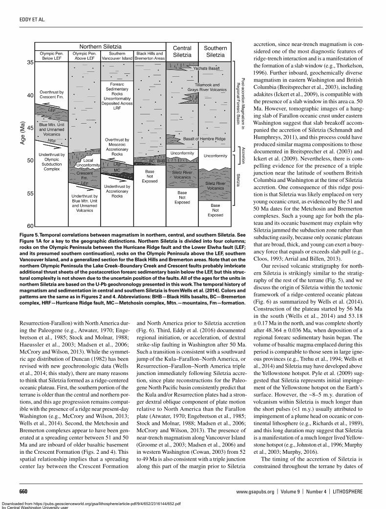
terrane, suggesting regional emergence between 51.424 ± 0.027 Ma and 48.364 ± 0.036 Ma (Figs. 2 and 4). Shortly after 48.364 ± 0.036 Ma the ter-rane subsided below sea level and initial deposi-tion of marine sedimentary rocks in a regional forearc basin began. This eruptive and deposi-tional history closely mirrors that of central and southern Siletzia (Fig. 5; Wells et al., 2014), and provides further support that Siletzia represents a coherent terrane.
Tectonic Setting
The tectonic setting of Siletzia has been a longstanding problem in Cordilleran geology, with debate centering on whether it represents an accreted oceanic terrane (Duncan, 1982; Murphy et al., 2003; McCrory and Wilson, 2013; Wells et al., 2014; Murphy, 2016) or magmatism along the continental margin related to either rifting (Babcock et al., 1992, 1994; Brandon et al., 2014) or ridge-trench interaction (Haeussler et al., 2003). One of the most compelling argu-ments for eruption on the continental margin was the inferred stratigraphic position of the Blue Mountain unit at the base of the terrane in Washington (e.g., Cady, 1975; Tabor and Cady, 1978a, 1978b; Einarsen, 1987; Babcock et al., 1992). However, our new U-Pb geochronology demonstrates that these rocks were thrust under Siletzia after 44.72 ± 0.21 Ma (Fig. 2). There-fore, their presence no longer necessitates that the basalts that compose Siletzia were erupted on preexisting continental crust.
Several researchers have proposed that Silet-zia represents an accreted oceanic plateau, or series of oceanic islands, that developed above a hotspot (Duncan, 1982; Murphy et al., 2003; McCrory and Wilson, 2013; Wells et al., 2014; Murphy, 2016; Phillips et al., 2017). Such an origin is consistent with the projected position of a long-lived Yellowstone hotspot near western Oregon during the early Eocene (e.g., Engebret-son et al., 1985), and could explain the great vol-ume of basalt erupted within the terrane as well as geochemical evidence for a plume-like mantle source for the basalts (Pyle et al., 2009, 2015; Phillips et al., 2017). Duncan (1982), McCrory and Wilson (2013), and Wells et al. (2014) went further and proposed that along-strike variation in the ages of the basaltic basement in Siletzia may indicate that the terrane was built along an oceanic spreading center, in a setting analo-gous to present-day Iceland. This proposal is largely based on the observation that initial K-Ar and 40Ar/39Ar dates become systematically younger toward the center of the terrane (Dun-can, 1982), and plate reconstructions that require the intersection of one or more oceanic spread-ing centers (Kula-Farallon or Kula-Farallon and
Downloaded from https://pubs.geoscienceworld.org/gsa/lithosphere/article-pdf/9/4/652/2316144/652.pdfby Central Washington University useron 20 May 2019
EDDY ET AL.
660 www.gsapubs.org | Volume 9 | Number 4 | LITHOSPHERE
Resurrection-Farallon) with North America dur-ing the Paleogene (e.g., Atwater, 1970; Enge-bretson et al., 1985; Stock and Molnar, 1988; Haeussler et al., 2003; Madsen et al., 2006; McCrory and Wilson, 2013). While the symmet-ric age distribution of Duncan (1982) has been revised with new geochronologic data (Wells et al., 2014; this study), there are many reasons to think that Siletzia formed as a ridge-centered oceanic plateau. First, the southern portion of the terrane is older than the central and northern por-tions, and this age progression remains compat-ible with the presence of a ridge near present-day Washington (e.g., McCrory and Wilson, 2013; Wells et al., 2014). Second, the Metchosin and Bremerton complexes appear to have been gen-erated at a spreading center between 51 and 50 Ma and are inboard of older basaltic basement in the Crescent Formation (Figs. 2 and 4). This spatial relationship implies that a spreading center lay between the Crescent Formation
and North America prior to Siletzia accretion (Fig. 6). Third, Eddy et al. (2016) documented regional initiation, or acceleration, of dextral strike-slip faulting in Washington after 50 Ma. Such a transition is consistent with a southward jump of the Kula–Farallon–North America, or Resurrection–Farallon–North America triple junction immediately following Siletzia accre-tion, since plate reconstructions for the Paleo-gene North Pacific basin consistently predict that the Kula and/or Resurrection plates had a stron-ger dextral oblique component of plate motion relative to North America than the Farallon plate (Atwater, 1970; Engebretson et al., 1985; Stock and Molnar, 1988; Madsen et al., 2006; McCrory and Wilson, 2013). The presence of near-trench magmatism along Vancouver Island (Groome et al., 2003; Madsen et al., 2006) and in western Washington (Cowan, 2003) from 52 to 49 Ma is also consistent with a triple junction along this part of the margin prior to Siletzia
accretion, since near-trench magmatism is con-sidered one of the most diagnostic features of ridge-trench interaction and is a manifestation of the formation of a slab window (e.g., Thorkelson, 1996). Further inboard, geochemically diverse magmatism in eastern Washington and British Columbia (Breitsprecher et al., 2003), including adakites (Ickert et al., 2009), is compatible with the presence of a slab window in this area ca. 50 Ma. However, tomographic images of a hang-ing slab of Farallon oceanic crust under eastern Washington suggest that slab breakoff accom-panied the accretion of Siletzia (Schmandt and Humphreys, 2011), and this process could have produced similar magma compositions to those documented in Breitsprecher et al. (2003) and Ickert et al. (2009). Nevertheless, there is com-pelling evidence for the presence of a triple junction near the latitude of southern British Columbia and Washington at the time of Siletzia accretion. One consequence of this ridge posi-tion is that Siletzia was likely emplaced on very young oceanic crust, as evidenced by the 51 and 50 Ma dates for the Metchosin and Bremerton complexes. Such a young age for both the pla-teau and its oceanic basement may explain why Siletzia jammed the subduction zone rather than subducting easily, because only oceanic plateaus that are broad, thick, and young can exert a buoy-ancy force that equals or exceeds slab pull (e.g., Cloos, 1993; Arrial and Billen, 2013).
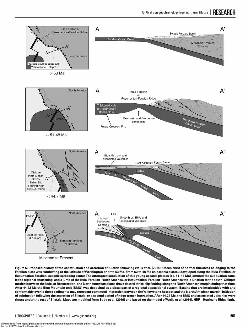
Our revised volcanic stratigraphy for north-ern Siletzia is strikingly similar to the stratig-raphy of the rest of the terrane (Fig. 5), and we discuss the origin of Siletzia within the tectonic framework of a ridge-centered oceanic plateau (Fig. 6) as summarized by Wells et al. (2014). Construction of the plateau started by 56 Ma in the south (Wells et al., 2014) and 53.18 ± 0.17 Ma in the north, and was complete shortly after 48.364 ± 0.036 Ma, when deposition of a regional forearc sedimentary basin began. The volume of basaltic magma emplaced during this period is comparable to those seen in large igne-ous provinces (e.g., Trehu et al., 1994; Wells et al., 2014) and Siletzia may have developed above the Yellowstone hotspot. Pyle et al. (2009) sug-gested that Siletzia represents initial impinge-ment of the Yellowstone hotspot on the Earth’s surface. However, the ~8–5 m.y. duration of volcanism within Siletzia is much longer than the short pulses (<1 m.y.) usually attributed to impingement of a plume head on oceanic or con-tinental lithosphere (e.g., Richards et al., 1989), and this long duration may suggest that Siletzia is a manifestation of a much longer lived Yellow-stone hotspot (e.g., Johnston et al., 1996; Murphy et al., 2003; Murphy, 2016).
The timing of the accretion of Siletzia is constrained throughout the terrane by dates of
Figure 5. Temporal correlations between magmatism in northern, central, and southern Siletzia. See Figure 1A for a key to the geographic distinctions. Northern Siletzia is divided into four columns; rocks on the Olympic Peninsula between the Hurricane Ridge fault and the Lower Elwha fault (LEF; and its presumed southern continuation), rocks on the Olympic Peninsula above the LEF, southern Vancouver Island, and a generalized section for the Black Hills and Bremerton areas. Note that on the northern Olympic Peninsula the Lake Creek–Boundary Creek and Crescent faults probably imbricate additional thrust sheets of the postaccretion forearc sedimentary basin below the LEF, but this struc-tural complexity is not shown due to the uncertain position of the faults. All of the ages for the units in northern Siletzia are based on the U-Pb geochronology presented in this work. The temporal history of magmatism and sedimentation in central and southern Siletzia is from Wells et al. (2014). Colors and patterns are the same as in Figures 2 and 4. Abbreviations: BHB—Black Hills basalts, BC—Bremerton complex, HRF—Hurricane Ridge fault, MC—Metchosin complex, Mtn.—mountains, Fm—formation.
Downloaded from https://pubs.geoscienceworld.org/gsa/lithosphere/article-pdf/9/4/652/2316144/652.pdfby Central Washington University useron 20 May 2019
LITHOSPHERE | Volume 9 | Number 4 | www.gsapubs.org 661
U-Pb zircon geochronology from northern Siletzia | RESEARCH
Figure 6. Proposed history of the construction and accretion of Siletzia following Wells et al. (2014). Ocean crust of normal thickness belonging to the Farallon plate was subducting at the latitude of Washington prior to 53 Ma. From 53 to 48 Ma an oceanic plateau developed along the Kula-Farallon, or Resurrection-Farallon, oceanic spreading center. The attempted subduction of this young oceanic plateau (ca. 51–48 Ma) jammed the subduction zone, led to regional shortening, and a jump of the Kula–Farallon–North America, or Resurrection–Farallon–North America triple junction to the south. Oblique motion between the Kula, or Resurrection, and North American plates drove dextral strike-slip faulting along the North American margin during that time. After 44.72 Ma the Blue Mountain unit (BMU) was deposited as a distal part of a regional depositional system. Basalts that are interbedded with and conformably overlie these sediments may represent continued interaction between the Yellowstone hotspot and the North American margin, initiation of subduction following the accretion of Siletzia, or a second period of ridge-trench interaction. After 44.72 Ma, the BMU and associated volcanics were thrust under the rest of Siletzia. Maps are modified from Eddy et al. (2016) and based on the model of Wells et al. (2014). HRF—Hurricane Ridge fault.
Downloaded from https://pubs.geoscienceworld.org/gsa/lithosphere/article-pdf/9/4/652/2316144/652.pdfby Central Washington University useron 20 May 2019
EDDY ET AL.
662 www.gsapubs.org | Volume 9 | Number 4 | LITHOSPHERE
deformed and nondeformed rocks. In the north, accretion is bracketed between 51.309 ± 0.024 and 49.933 ± 0.059 Ma by shortening in the nonmarine Swauk forearc sedimentary basin in Washington (Eddy et al., 2016). In central Silet-zia, it is constrained between 49.0 ± 0.8 Ma and ca. 48 Ma by ages that bracket deformation within the upper part of the basaltic basement of Siletzia (Wells et al., 2014). In southern Silet-zia, it is constrained between ca. 53 Ma and ca. 50–48 Ma by the youngest basalts involved in the fold-thrust belt exposed near Roseburg, Oregon, and the age of overlying nondeformed forearc sedimentary rocks (Dumitru et al., 2013; Wells et al., 2014). The close similarity in the timing of deformation along the length of the terrane suggests that buoyant oceanic crust entered the subduction zone simultaneously over a wide area. The tight brackets on deformation also imply that regional shortening was very brief and that accretion occurred while construction of the plateau was ongoing. The transition to subaerial and shallow-marine eruptions in northern and central Siletzia is coeval with accretion, indicat-ing that it may be a result of tectonic uplift rather than the emergence of a volcanic edifice above sea level due to thermal buoyancy, as suggested by Murphy et al. (2003) and Wells et al. (2014).
Duncan (1982) and McCrory and Wilson (2013) suggested that Siletzia represents a com-posite terrane composed of a captured piece of the Farallon plate in the south and a captured piece of the Kula or Resurrection plate to the north. These interpretations were based on a systematic younging trend in available age con-straints that converged near the Black Hills. New geochronologic data have complicated this age trend by recognizing that magmatism was rela-tively long lived throughout the terrane (Wells et al., 2014; this study). Thus, the reported age, or age range, of different outcrop areas within Siletzia is likely dependent on the level of expo-sure and is not necessarily representative of the age of the underlying oceanic crust. Neverthe-less, there is some evidence from the Metcho-sin and Bremerton complexes that the northern part of the terrane represents a captured piece of the Kula or Resurrection plate. Both complexes preserve sheeted dikes with similar north-north-east–south-southwest orientations (Fig. 4) that we consider to record the primary extensional direction, because paleomagnetic data from the Metchosin complex demonstrate that it has undergone little to no postaccretion vertical-axis rotation (Irving and Massey, 1990). The implied spreading direction from these dike orientations is west-northwest–east-southeast, and the dif-ference in age between the ca. 51 Ma Metcho-sin complex and ca. 50 Ma Bremerton complex would indicate that the spreading center that
generated these complexes was near Bremer-ton at the time of accretion. If so, then most of northern Siletzia west and north of Bremerton represents part of the oceanic plateau that devel-oped on the Kula or Resurrection plates, while central and southern Siletzia represents parts of the oceanic plateau developed on the Farallon plate. The Yakutat terrane in southern Alaska is of similar age and has a similar stratigraphy to Siletzia, and several researchers have pro-posed that it represents a displaced fragment of the Siletzia oceanic plateau (e.g., Davis and Plafker, 1986; Wells et al., 2014). If so, it likely represents an additional fragment of the plateau that developed on the Kula or Resurrection plate.
Following Siletzia accretion, the terrane sub-sided below sea level and a new forearc sedi-mentary basin was established (Figs. 5 and 6). Given that our maximum depositional ages for the Blue Mountain unit are comparable to the oldest sedimentary rocks in this regional forearc basin, we envision deposition of the unit as a distal portion of this sedimentary system prior to its incorporation in the Olympic subduction complex. The basalts that overlie and are inter-bedded with the Blue Mountain unit are similar in age to the volcanic centers interbedded with the regional forearc basin in southwestern Wash-ington and western Oregon (Fig. 5) and likely represent a manifestation of the same process. Wells et al. (2014) attributed these volcanic cen-ters to continued interaction between the North American margin and the Yellowstone hotspot, and the basalts associated with the Blue Moun-tain unit may be the northernmost documented expression of this postaccretion forearc mag-matism. Alternatively, they may be related to the formation of a new subduction zone follow-ing Siletzia accretion or the northward migra-tion of the Kula–Farallon–North America triple junction, or the Resurrection–Farallon–North America triple junction, after the middle Eocene, as required by our model (Fig. 6).
CONCLUSIONS
Our U-Pb zircon dates from throughout northern Siletzia place new constraints on the ter-rane’s volcanic stratigraphy. They show that the basaltic basement in this area was constructed between 53.18 ± 0.17 Ma and 48.364 ± 0.036 Ma, similar to the rest of the terrane. Further-more, we show that the continentally derived tur-bidites of the Blue Mountain unit are younger than the basaltic basement of Siletzia and must have been thrust under the terrane after 44.72 ± 0.21 Ma. These rocks have long been con-sidered to floor the terrane and have been used to argue for emplacement of Siletzia along the continental margin. However, our revised age for
the Blue Mountain unit no longer necessitates such an interpretation. Instead, we interpret the stratigraphy of northern Siletzia to be compat-ible with its origin as an accreted oceanic plateau possibly developed above a long-lived Yellow-stone hotspot.
ACKNOWLEDGMENTSWe thank Hank Schasse and Jeff Tepper for sharing samples, Bob Miller for reading an early version of this manuscript, and Mitchell Allen, Dylan Vasey, Margaret Carpenter, and Fiona Paine for field assistance. Eddy also thanks Sam Bow-ring for his support and encouragement during the initial phases of this project. Financial support for this research was provided by National Science Foundation grant EAR-1118883 to Sam Bowring and a Geological Society of America graduate student research grant to Eddy. This manuscript benefited from the editorial handling of L. Godin and thought-ful reviews by Ray Wells and Derek Thorkelson.
REFERENCES CITEDArrial, P., and Billen, M.I., 2013, Influence of geometry and
eclogitization on oceanic plateau subduction: Earth and Planetary Science Letters, v. 363, p. 34–43, doi: 10 .1016 /j .epsl .2012 .12 .011.
Atkins, V.D., Molinari, M.P., and Burk, R.L., 2003, Quaternary geology of the Lower Elwha River Valley, Clallam County, Washington: Geological Society of America Abstracts with Programs, v. 35, no. 6, p. 80.
Atwater, T., 1970, Implications of plate tectonics for the Ce-nozoic tectonic evolution of North America: Geological Society of America Bulletin, v. 81, p. 3513–3536, doi: 10
.1130 /0016 -7606 (1970)81 [3513: IOPTFT]2 .0 .CO;2.Babcock, R.S., Burmester, R.R., Engebretson, D.C., Warnock,
A.C., and Clark, K.P., 1992, A rifted margin origin for the Crescent basalts and related rocks in the northern Coast Range Volcanic Province, Washington and British Colum-bia: Journal of Geophysical Research, v. 97, p. 6799–6821, doi: 10 .1029 /91JB02926.
Babcock, R.S., Suczek, C.A., and Engebretson, D.C., 1994, The Crescent “Terrane”, Olympic Peninsula and Southern Van-couver Island: Washington Division of Geology and Earth Resources Bulletin, v. 80, p. 141–157.
Bowring, J.F., McLean, N.M., and Bowring, S.A., 2011, Engi-neering cyber infrastructure for U-Pb geochronology: Tripoli and U-Pb_Redux: Geochemistry, Geophysics, Geo systems, v. 12, Q0AA19, doi: 10 .1029 /2010GC003479.
Brandon, M.T., and Calderwood, A.R., 1990, High-pressure metamorphism and uplift of the Olympic subduction complex: Geology, v. 18, p. 1252–1255, doi: 10 .1130 /0091
-7613 (1990)018 <1252: HPMAUO>2 .3 .CO;2.Brandon, M.T., Hourigan, J., and Garver, J.I., 2014, New evi-
dence for backarc basin interpretation for Eocene Coast Range terrane: Geological Society of America Abstracts with Programs, v. 46, no. 6, p. 657.
Breitsprecher, K., Thorkelson, D.J., Groome, W.G., and Dostal, J., 2003, Geochemical confirmation of the Kula-Farallon slab window beneath the Pacific Northwest in Eocene time: Geology, v. 31, p. 351–354, doi: 10 .1130 /0091 -7613 (2003)031 <0351: GCOTKF>2 .0 .CO;2.
Brown, E.H., 1987, Structural geology and accretionary his-tory of the Northwest Cascades system, Washington and British Columbia: Geological Society of America Bulle-tin, v. 99, p. 201–214, doi: 10 .1130 /0016 -7606 (1987)99 <201: SGAAHO>2 .0 .CO;2.
Brown, E.H., and Gehrels, G.E., 2007, Detrital zircon con-straints on terrane ages and affinities and timing of oro-genic events in the San Juan Islands and North Cascades, Washington: Canadian Journal of Earth Sciences, v. 44, p. 1375–1396, doi: 10 .1139 /E07 -040.
Brown, R.D., Jr., Gower, H.D., and Snavely, P.D., Jr., 1960, Ge-ology of the Port Angeles–Lake Crescent area, Clallam County, Washington: U.S. Geological Survey Oil and Gas Investigations Map OM-203, scale 1:62,500.
Cady, W.M., 1975, Tectonic setting of the Tertiary volcanic rocks of the Olympic Peninsula, Washington: U.S. Geological Survey Journal of Research, v. 3, p. 573–582.
Cady, W.M., Tabor, R.W., MacLeod, N.S., and Sorensen, M.L., 1972, Geologic map of the Tyler Peak quadrangle, Clallam
Downloaded from https://pubs.geoscienceworld.org/gsa/lithosphere/article-pdf/9/4/652/2316144/652.pdfby Central Washington University useron 20 May 2019
LITHOSPHERE | Volume 9 | Number 4 | www.gsapubs.org 663
U-Pb zircon geochronology from northern Siletzia | RESEARCH
and Jefferson counties, Washington: U.S. Geological Sur-vey Geologic Quadrangle Map GQ-970, scale 1:62,000.
Chan, C.F., Tepper, J.H., and Nelson, B.K., 2012, Petrology of the Grays River volcanics, southwest Washington: Plume-influenced slab window magmatism in the Casca-dia forearc: Geological Society of America Bulletin, v. 124, p. 1324–1338, doi: 10 .1130 /B30576 .1.
Clark, K.P., 1989, The stratigraphy and geochemistry of the Crescent Formation basalts and the bedrock geology of associated igneous rocks near Bremerton Washington [M.S. thesis]: Bellingham, Western Washington Univer-sity, 171 p.
Cloos, M., 1993, Lithospheric buoyancy and collisional oro-genesis: Subduction of orogenic plateaus, continental margins, island arcs, spreading ridges, and seamounts: Geological Society of America Bulletin, v. 105, p. 715–737, doi: 10 .1130 /0016 -7606 (1993)105 <0715: LBACOS>2 .3 .CO;2.
Clowes, R.M., Brandon, M.T., Green, A.G., Yorath, C.J., Suther-land, A., Kanasewich, E.R., and Spencer, C., 1987, LITHO-PROBE-southern Vancouver Island: Cenozoic subduction complex imaged by deep seismic reflections: Canadian Journal of Earth Sciences, v. 24, p. 31–51, doi: 10 .1139 /e87 -004.
Condon, D.J., Schoene, B., McLean, N.M., Bowring, S.A., and Parrish, R.R., 2015, Metrology and traceability of U-Pb isotope dilution geochronology (EARTHTIME tracer cali-bration part I): Geochimica et Cosmochimica Acta, v. 164, p. 464–480, doi: 10 .1016 /j .gca .2015 .05 .026.
Cowan, D.S., 2003, Revisiting the Baranof–Leech River hy-pothesis for early Tertiary coastwise transport of the Chugach–Prince William terrane: Earth and Planetary Science Letters, v. 213, p. 463–475, doi: 10 .1016 /S0012
-821X (03)00300 -5.Davis, A., and Plafker, G., 1986, Eocene basalts from the Ya-
kutat terrane: Evidence for the origin of an accreting ter-rane in southern Alaska: Geology, v. 14, p. 963–966, doi: 10
.1130 /0091 -7613 (1986)14 <963: EBFTYT>2 .0 .CO;2.Dragovich, J.D., Logan, R.L., Schasse, H.W., Walsh, T.J., Ling-
ley, W.S., Jr., Norman, D.K., Gerstel, W.J., Lapen, T.J., Schuster, E., and Meyers, K.D., 2002, Geologic map of Washington—Northwest quadrant: Washington Depart-ment of Natural Resources Geologic Map GM-50, scale 1:250,000, 72 p.
Dumitru, T.A., Ernst, W.G., Wright, J.E., Wooden, J.L., Wells, R.E., Farmer, L.P., Kent, A.J.R., and Graham, S.A., 2013, Eocene extension in Idaho generated massive sediment floods into Franciscan trench and into the Tyee, Great Val-ley, and Green River basins: Geology, v. 41, p. 187–190, doi: 10 .1130 /G33746 .1.
Dumitru, T.A., Elder, W.P., Hourigan, J.K., Chapman, A.D., and Graham, S.A., 2016, Four Cordilleran paleorivers that connected Sevier thrust zones in Idaho to depocenters in California, Washington, Wyoming, and, indirectly, Alaska: Geology, v. 44, p. 75–78, doi: 10 .1130 /G37286 .1.
Duncan, R.A., 1982, A captured island chain in the coast range of Oregon and Washington: Journal of Geo-physical Research, v. 87, p. 10,827–10,837, doi: 10 .1029 /JB087iB13p10827.
Eddy, M.P., Bowring, S.A., Umhoefer, P.J., Miller, R.B., McLean, N.M., and Donaghy, E.E., 2016, High-resolution temporal and stratigraphic record of Siletzia’s accretion and triple junction migration from nonmarine sedimentary basins in central and western Washington: Geological Society of America Bulletin, v. 128, p. 425–441, doi: 10 .1130 /B31335 .1.
Einarsen, J.M., 1987, The petrography and tectonic signif-icance of the Blue Mountain unit, Olympic Peninsula, Washington [M.S. thesis]: Bellingham, Western Wash-ington University, 175 p.
Engebretson, D.C., Cox, A., and Gordon, R.G., 1985, Relative motions between oceanic and continental plates in the Pacific basin: Geological Society of America Special Pa-per 206, 60 p., doi: 10 .1130 /SPE206 -p1.
Fleming, S.W., and Trehu, A.M., 1999, Crustal structure be-neath the central Oregon convergent margin from po-tential-field modeling: Evidence for a buried basement ridge in local contact with a seaward backstop: Journal of Geophysical Research, v. 104, p. 20,431–20,447, doi: 10 .1029 /1999JB900159.
Gale, A., Dalton, C.A., Langmuir, C.H., Su, Y., and Schilling, J., 2013, The mean composition of ocean ridge basalts: Geo-chemistry, Geophysics, Geosystems, v. 14, p. 489–518, doi: 10 .1029 /2012GC004334.
Gao, H., Humphreys, E.D., Yao, H., and van der Hilts, R.D., 2011, Crust and lithosphere structure of the northwestern U.S. with ambient noise tomography: Terrane accretion and Cascade arc development: Earth and Planetary Science Letters, v. 304, p. 202–211, doi: 10 .1016 /j .epsl .2011 .01 .033.
Garver, J.I., and Davidson, C.M., 2015, Southwestern Lauren-tian zircons in upper Cretaceous flysch of the Chugach–Prince William terrane in Alaska: American Journal of Science, v. 315, p. 537–556, doi: 10 .2475 /06 .2015 .02.
Gehrels, G., et al., 2009, U-Th-Pb geochronology of the Coast Mountains batholith in north-coastal British Columbia: Constraints on age and tectonic evolution: Geological Society of America Bulletin, v. 121, p. 1341–1361, doi: 10 .1130 /B26404 .1.
Gerstel, W.J., and Lingley, W.S., Jr., 2003, Geologic map of the Mount Olympus 1:100,000 quadrangle: Washington Division of Geology and Earth Resources Open File Re-port 2003–4, scale 1:100,000.
Glassley, W., 1974, Geochemistry and tectonics of the Cres-cent volcanic rocks, Olympic Peninsula, Washington: Geological Society of America Bulletin, v. 85, p. 785–794, doi: 10 .1130 /0016 -7606 (1974)85 <785: GATOTC>2 .0 .CO;2.
Globerman, B.R., Beck, M.E., Jr., and Duncan, R.A., 1982, Pa-leomagnetism and tectonic significance of Eocene ba-salts from the Black Hills, Washington Coast Range: Geo-logical Society of America Bulletin, v. 93, p. 1151–1159, doi: 10 .1130 /0016 -7606 (1982)93 <1151: PATSOE>2 .0 .CO;2.
Groome, W.G., Thorkelson, D.J., Friedman, R.M., Mortensen, J.K., Massey, N.W.D., Marschall, D.D., and Layer, P.W., 2003, Magmatic and tectonic history of the Leech River Complex, Vancouver Island, British Columbia: Evidence for ridge-trench intersection and accretion of the Cres-cent terrane, in Sisson, V.B., et al., eds., Geology of a transpressional orogen developed during ridge-trench interaction along the North Pacific margin: Geological Society of America Special Paper 371, p. 327–353, doi: 10 .1130 /0 -8137 -2371 -X .327.
Haeussler, P.J., and Clark, K.P., 2000, Geologic map of the Wildcat Lake 7.5′ quadrangle, Kitsap and Mason Counties Washington: U.S. Geological Survey Open-File Report 2000-356, scale 1:24,000.
Haeussler, P.J., Bradley, D.C., Wells, R.E., and Miller, M.L., 2003, Life and death of the Resurrection plate: Evidence for its existence and subduction in the northeastern Pa-cific in Paleocene–Eocene time: Geological Society of America Bulletin, v. 115, p. 867–880, doi: 10 .1130 /0016
-7606 (2003)115 <0867: LADOTR>2 .0 .CO;2.Hirsch, D.M., and Babcock, R.S., 2009, Spatially heteroge-
neous burial and high-P/T metamorphism in the Crescent Formation, Olympic Peninsula, Washington: American Mineralogist, v. 94, p. 1103–1110, doi: 10 .2138 /am .2009
.3187.Ibañez-Mejia, M., Pullen, A., Arenstein, J., Gehrels, G.E., Val-
ley, J., Ducea, M.N., Mora, A.R., Pecha, M., and Ruiz, J., 2015, Unraveling crustal growth and reworking processes in complex zircons from orogenic lower crust: The Pro-terozoic Putumayo orogen of Amazonia: Precambrian Research, v. 267, p. 285–310, doi: 10 .1016 /j .precamres
.2015 .06 .014.Ickert, R.B., Thorkelson, D.J., Marshall, D.D., and Ullrich, T.D.,
2009, Eocene adakitic volcanism in southern British Co-lumbia: Remelting of arc basalt above a slab window: Tectonophysics, v. 464, p. 164–185, doi: 10 .1016 /j .tecto .2007 .10 .007.
Irving, E., and Massey, N.W.D., 1990, Paleomagnetism of ocean layers 2 and 3: Evidence from the Metchosin com-plex, Vancouver Island: Physics of the Earth and Plan-etary Interiors, v. 64, p. 247–260, doi: 10 .1016 /0031 -9201 (90)90041 -U.
Jaffey, A.H., Flynn, K.F., Glendenin, L.E., Bentley, W.C., and Essling, A.M., 1971, Precision measurement of half-lives and specific activities of 235U and 238U: Physical Review C: Nuclear Physics, v. 4, p. 1889–1906, doi: 10 .1103 /PhysRevC
.4 .1889.Johnson, S.Y., 1985, Eocene strike-slip faulting and nonma-
rine basin formation in Washington, in Biddle, K.T., and Christie-Blick, N., eds., Strike-slip deformation, basin formation and sedimentation: Society of Economic Pa-leontologists and Mineralogists Special Publication 37, p. 283–302, doi: 10 .2110 /pec .85 .37 .0283.
Johnston, S.T., and Acton, S., 2003, The Eocene southern Vancouver Island orocline—A response to seamount
accretion and the cause of fold-and-thrust belt and exten-sional basin formation: Tectonophysics, v. 365, p. 165–183, doi: 10 .1016 /S0040 -1951 (03)00021 -0.
Johnston, S.T., Wynne, P.J., Francis, D., Hart, C.J.R., Enkin, R.J., and Engebretson, D.C., 1996, Yellowstone in the Yukon: The Late Cretaceous Carmacks Group: Geology, v. 24, p. 997–1000, doi: 10 .1130 /0091 -7613 (1996)024 <0997: YIYTLC>2 .3 .CO;2.
Machlus, M.L., Ramezani, J., Bowring, S.A., Hemming, S.R., Tsukui, K., and Clyde, W.C., 2015, A strategy for cross-calibrating U-Pb chronology and astrochronology of sedi-mentary sequences: An example from the Green River Formation, Wyoming, USA: Earth and Planetary Science Letters, v. 413, p. 70–78, doi: 10 .1016 /j .epsl .2014 .12 .009.
MacLeod, N.S., Tiffin, D.L., Snavely, P.D., Jr., and Currie, R.G., 1977, Geologic interpretation of magnetic and gravity anomalies in the Strait of Juan de Fuca, U.S.-Canada: Canadian Journal of Earth Sciences, v. 14, p. 223–238, doi: 10 .1139 /e77 -024.
Madsen, J.K., Thorkelson, D.J., Friedman, R.M., and Marshall, D.D., 2006, Cenozoic to recent plate configurations in the Pacific Basin: Ridge subduction and slab window magmatism in western North America: Geosphere, v. 2, p. 11–34, doi: 10 .1130 /GES00020 .1.
Massey, N.W.D., 1986, Metchosin igneous complex, southern Vancouver Island: Ophiolite stratigraphy developed in an emergent island setting: Geology, v. 14, p. 602–605, doi: 10 .1130 /0091 -7613 (1986)14 <602: MICSVI>2 .0 .CO;2.
Massey, N.W., MacIntyre, D.G., Desjardins, P.J., and Cooney, R.T., 2005, Geology of British Columbia: British Colum-bia Ministry of Energy, Mines, and Petroleum Resources Geoscience Map 2005–3, scale 1:1,000,000.
Mattinson, J.M., 2005, Zircon U-Pb chemical abrasion (“CA-TIMS”) method: Combined annealing and multi-step par-tial dissolution analysis for improved precision and ac-curacy of zircon ages: Chemical Geology, v. 220, p. 47–66, doi: 10 .1016 /j .chemgeo .2005 .03 .011.
McCrory, P.A., and Wilson, D.S., 2013, A kinematic model for the formation of the Siletz-Crescent forearc terrane by capture of coherent fragments of the Farallon and Res-urrection plates: Tectonics, v. 32, p. 718–736, doi: 10 .1002 /tect .20045.
McLean, N.M., Condon, D.J., Schoene, B., and Bowring, S.A., 2015, Evaluating uncertainties in the calibration of isoto-pic reference materials and multi-element isotopic trac-ers (EARTHTIME tracer calibration part II): Geochimica et Cosmochimica Acta, v. 164, p. 481–501, doi: 10 .1016 /j .gca .2015 .02 .040.
Miller, R.B., Paterson, S.R., and Matzel, J.P., 2009, Plutonism at different crustal levels: Insights from the ~5–40 km (paleodepth) North Cascades crustal section, Washing-ton, in Miller, R.B., and Snoke, A.W., eds., Crustal cross sections from the western North American Cordillera and elsewhere: Implications for tectonic and petrologic processes: Geological Society of America Special Paper 456, p. 125–149, doi: 10 .1130 /2009 .2456 (05).
Miller, R.B., Gordon, S.M., Bowring, S.A., Doran, B., McLean, N.M., Michels, Z., Shea, E.K., and Whitney, D.L., 2016, Linking deep and shallow crustal processes during re-gional transtension in an exhumed continental arc, North Cascades, northwestern Cordillera (USA): Geosphere, v. 12, p. 900–924, doi: 10 .1130 /GES01262 .1.
Muller, J.E., 1977, Evolution of the Pacific margin, Vancouver Island and adjacent areas: Canadian Journal of Earth Sci-ences, v. 14, p. 2062–2085, doi: 10 .1139 /e77 -176.
Murphy, J.B., 2016, The role of the ancestral Yellowstone plume in the tectonic evolution of the western United States: Geoscience Canada, v. 43, p. 231–250, doi: 10
.12789 /geocanj .2016 .43 .105.Murphy, J.B., Hynes, A.J., Johnston, S.T., and Keppie, J.D.,
2003, Reconstructing the ancestral Yellowstone plume from accreted seamounts and its relationship to flat slab subduction: Tectonophysics, v. 365, p. 185–194, doi: 10
.1016 /S0040 -1951 (03)00022 -2.Phillips, B.A., Kerr, A.C., Mullen, E.K., and Weis, D., 2017, Oce-
anic mafic magmatism in the Siletz terrane, NW North America: Fragments of an Eocene oceanic plateau?: Lithos, v. 274–275, p. 291–303, doi: 10 .1016 /j .lithos .2017
.01 .005.Polenz, M., Miller, B.A., Davies, N., Perry, B.B., Clark, K.P.,
Walsh, T.J., Carson, R.J., and Hughes, J.F., 2012a, Geo-logic map of the Hoodsport 7.5-minute quadrangle
Downloaded from https://pubs.geoscienceworld.org/gsa/lithosphere/article-pdf/9/4/652/2316144/652.pdfby Central Washington University useron 20 May 2019
EDDY ET AL.
664 www.gsapubs.org | Volume 9 | Number 4 | LITHOSPHERE
Mason county, Washington: Washington Division of Geology and Earth Resources Open File Report 2011–3, scale 1:24,000, 16 p.
Polenz, M., et al., 2012b, Geologic map of the Brinnon 7.5-min-ute quadrangle, Jefferson and Kitsap counties, Wash-ington: Washington Division of Geology and Earth Re-sources Map Series 2012–02, scale 1:24,000, 47 p.
Polenz, M., Allen, M.D., Paulin, G.L., Eungard, D.W., Cakir, R., Scott, S.P., and Mahan, S.A., 2016, Geologic map of the Shelton Valley 7.5-minute quadrangle, Mason County, Washington: Washington Division of Geology and Earth Resources Map Series 2016–02, scale 1:24,000, 45 p.
Pyle, D.G., Duncan, R.A., Wells, R.E., Graham, D.W., Harri-son, B.K., and Hanan, B.B., 2009, Siletzia: An oceanic large igneous province in the Pacific Northwest: Geo-logical Society of America Abstracts with Programs, v. 41, no. 7, p. 369.
Pyle, D.G., Duncan, R.A., Wells, R.E., Graham, D.W., Hanan, B.B., Harrison, B.K., and Haileab, B., 2015, Longevity of Yellowstone hotspot volcanism: Isotopic evidence linking the Siletzia LIP (56 Ma) and early Columbia River Basalt Group (17 Ma) mantle sources: American Geophysical Union fall meeting, abs. V31E–3060.
Richards, M.A., Duncan, R.A., and Courtillot, V.E., 1989, Flood basalts and hot-spot tracks: Plume heads and tails: Sci-ence, v. 246, p. 103–107, doi: 10 .1126 /science .246 .4926 .103.
Ryu, I.C., Niem, A.R., and Niem, W.A., 1996, Oil and gas po-tential of the southern Tyee basin, southern Oregon Coast Range: Oregon Department of Geology and Mineral In-dustries Oil and Gas Investigation 19, 141 p.
Schasse, H.W., 2003, Geologic map of the Washington portion of the Port Angeles 1:100,000 quadrangle: Washington Division of Natural Resources Open File Report 2003–6, scale 1:100,000.
Schmandt, B., and Humphreys, E., 2011, Seismically imaged relict slab from the 55 Ma Siletzia accretion to the north-west United States: Geology, v. 39, p. 175–178, doi: 10
.1130 /G31558 .1.Stock, J., and Molnar, P., 1988, Uncertainties and implications of
the Late Cretaceous and Tertiary position of North America
relative to the Farallon, Kula, and Pacific plates: Tectonics, v. 7, p. 1339–1384, doi: 10 .1029 /TC007i006p01339.
Snavely, P.D., MacLeod, N.S., and Wagner, H.C., 1968, Tho-leiitic and alkali basalts of the Eocene Siletz River Volca-nics, Oregon Coast Range: American Journal of Science, v. 266, p. 454–481, doi: 10 .2475 /ajs .266 .6 .454.
Tabor, R.W., and Cady, W.M., 1978a, Geologic map of the Olympic Peninsula, Washington: U.S. Geological Survey IMAP 994, scale 1:125,000.
Tabor, R.W., and Cady, W.M., 1978b, The structure of the Olym-pic Mountains, Washington: Analysis of a subduction zone: U.S. Geological Survey Professional Paper 1033, 38 p.
Tabor, R.W., Frizzell, V.A., Jr., Vance, J.A., and Naeser, C.W., 1984, Ages and stratigraphy of lower and middle Tertiary sedimentary and volcanic rocks of the central Cascades, Washington: Application to the tectonic history of the Straight Creek fault: Geological Society of America Bul-letin, v. 95, p. 26–44, doi: 10 .1130 /0016 -7606 (1984)95 <26: AASOLA>2 .0 .CO;2.
Tabor, R.W., Haugerud, R.A., Haeussler, P.J., and Clark, K.P., 2011, Lidar-revised geologic map of the Wildcat Lake 7.5′ quadrangle, Kitsap and Mason Counties, Washington: U.S. Geological Survey Scientific Investigations Map 3187, scale 1:24,000, 12 p.
Tepper, J.H., Clark, K.P., Asmerom, Y., and McIntosh, W.C., 2004, Eocene adakites in the Cascadia forearc: Implications for the position of the Kula-Farallon ridge: Geological Society of America Abstracts with Programs, v. 36, no. 4, p. 69.
Thorkelson, D.J., 1996, Subduction of diverging plates and the principles of slab window formation: Tectonophys-ics, v. 255, p. 47–63, doi: 10 .1016 /0040 -1951 (95)00106 -9.
Timpa, S., Gillis, K.M., and Canil, D., 2005, Accretion-related metamorphism of the Metchosin Igneous Complex, southern Vancouver Island, British Columbia: Canadian Journal of Earth Sciences, v. 42, p. 1467–1479, doi: 10 .1139 /e05 -043.
Trehu, A.M., Asudeh, I., Brocher, T.M., Luetgert, J.H., Mooney, W.D., Nabelek, J.L., and Nakamura, Y., 1994, Crustal archi-tecture of the Cascadia forearc: Science, v. 266, p. 237–243, doi: 10 .1126 /science .266 .5183 .237.
Walsh, T.J., Korosec, M.A., Phillips, W.M., Logan, R.L., and Schasse, H.W., 1987, Geologic map of Washington—South-west quadrant: Washington Division of Geology and Earth Resources Geologic Map GM-34, scale 1:250,000, 28 p.
Warnock, A.C., Burmester, R.F., and Engebretson, D.C., 1993, Paleomagnetism and tectonics of the Crescent Forma-tion, northern Olympic Mountains, Washington: Journal of Geophysical Research, v. 98, p. 11,729–11,741, doi: 10 .1029 /93JB00709.
Wells, R.E., Engebretson, D.C., Snavely, P.D., Jr., and Coe, R.S., 1984, Cenozoic plate motions and the volcano-tectonic evolution of western Oregon and Washington: Tectonics, v. 3, p. 275–294, doi: 10 .1029 /TC003i002p00275.
Wells, R.E., Weaver, C.S., and Blakely, R.J., 1998, Forearc mi-gration in Cascadia and its neotectonic significance: Ge-ology, v. 26, p. 759–762, doi: 10 .1130 /0091 -7613 (1998)026 <0759: FAMICA >2 .3 .CO;2.
Wells, R.E., Jayko, A.S., Niem, A.R., Black, G., Wiley, T., Bald-win, E., Molenaar, K.M., Wheeler, K.L., DuRoss, C.B., and Givler, R.W., 2000, Geologic map and database of the Roseburg 30 × 60’ quadrangle, Douglas and Coos Coun-ties, Oregon: U.S. Geological Survey Open-File Report 00-376, scale 1:100,000, 55 p.
Wells, R.E., Bukry, D., Friedman, R., Pyle, D., Duncan, R., Hae-ussler, P., and Wooden, J., 2014, Geologic history of Silet-zia, a large igneous province in the Oregon and Wash-ington Coast Range: Correlation to the geomagnetic polarity time scale and implications for a long-lived Yel-lowstone hotspot: Geosphere, v. 10, p. 692–719, doi: 10
.1130 /GES01018 .1.Wendt, I., and Carl, C., 1991, The statistical distribution of
the mean squared weighted deviation: Chemical Geol-ogy, v. 86, p. 275–285, doi: 10 .1016 /0168 -9622 (91)90010 -T.
MANUSCRIPT RECEIVED 24 JANUARY 2017 REVISED MANUSCRIPT RECEIVED 4 APRIL 2017 MANUSCRIPT ACCEPTED 27 APRIL 2017
Printed in the USA
Downloaded from https://pubs.geoscienceworld.org/gsa/lithosphere/article-pdf/9/4/652/2316144/652.pdfby Central Washington University useron 20 May 2019