Embed Size (px)
Citation preview

United Nations Regional Cartographic Conferencefor
Asia and the Pacific
Richard Wonnacott
Bangkok2 November 2012
AFREF: Concept and Progress

OverviewOverview
• Background
• Rationale for AFREF
• Objectives & Structure
• Progress
• Capacity building
• What Next?
• Challenges
• Conclusion

BackgroundBackground• In the 1980’s the Africa Doppler Survey (ADOS) was unde rtaken
driven primarily by the International Association of Geo desy.
• ADOS was designed to unify geodetic frames of Africa using Doppler to provide:– Zero order control for mapping; – Control datum for unification and strengthening of a continental
reference frame for Africa; and– Accurate geoid for Africa
• Project didn’t really meet it’s objectives:– Essential to have simultaneous observations – diffic ult without IGS
type infrastructure– Rationale not fully understood by participating cou ntries– Project planned entirely by IAG with little input f rom African
countries– No clear standards

Rationale for AFREFRationale for AFREF
• Over 50 countries in Africa each with their own geodet ic reference system and frame and some with 2 or more frame s.
• Although there are many areas of conflict there are also areas where peace has been restored and require a lot of de velopment.
• African Union has requested that countries resolve int ernationalboundary issues within next couple of years.
• It is known that many private commercial enterprises ar e settingup their own reference frames particularly in the oil and miningindustries.
• AFREF is, therefore, an African initiative to unify th e geodeticreference frames of Africa based on the ITRF through a network of GNSS base stations at a spacing such users will be at most within ~1000 km of a base station.

Objectives of AFREFObjectives of AFREF
Formally established with Windhoek Declaration in 2 002:
– To determine a continental reference frame for Afri ca consistent and homogeneous with the global referenc e frame of the ITRF as a basis for national 3-d refer ence networks.
– To realize a unified vertical datum and to support efforts to establish a precise African geoid.
– To establish a network of continuously operating, permanent GNSS base stations at a spacing such that the users will be within 1000km of a base station a nd that data is freely available to all nations.

– To determine the relationship between the existing national reference frames and the ITRF to preserve legacy information based on existing frames.
– To provide a sustainable development environment fo r technology transfer so that these activities will e nhance the national networks and other applications.
– Assist in establishing in-country expertise for implementation , operation, processing and analysis of modern geodetic techniques, primarily GNSS.
Objectives of AFREFObjectives of AFREF

Current AFREF StructureCurrent AFREF Structure
SAFREF
Sudan
Algeria
Egypt
Mauritania
Moro
cco
Libyan Arab Jamahirya
Tunis ia
Western Sahara
Mali Niger
Nigeria
Gh
a na
Guinea
Côte D'Ivoi re
Senegal
Burkina Faso
Be n
in
Liberia
TogoSierra Leone
Guinea-Bissau
Gambia
Chad
Congo
Cameroon
Gabon
Central African Republ ic
Equatorial Guinea
Sao Tome & Principe
Ethiopia
Tanzania
Dem. Rep. of the Congo
Kenya
Somalia
Madagascar
Uganda
Erit rea
Burundi
Rwanda
Comoros
SeychellesSouth Africa
Namibia
Zambia
Mozambique
Botswana
Zimbabwe
Ma
l awi
Lesotho
Swaziland
NAFREF WAFREF CAFREF EAFREF
AFREF Secretariat
UN
EC
AC
OD
IST
AFREF Steering CommitteeCo-Chairs: RCMRD & AOCRSRECTASRegional RepsIAG Sub-commission 1.3d (Africa)Dir Central Bureau IGS
CODIST - Committee on Development Information, Scie nce & Technology
Scientific advisory group

SAFREF
Sudan
Algeria
Egypt
Mauritania
Moro
cco
Libyan Arab Jamahirya
Tunis ia
Western Sahara
Mali Niger
Nigeria
Gh
a na
Guinea
Côte D'Ivoi re
Senegal
Burkina Faso
Be n
in
Liberia
TogoSierra Leone
Guinea-Bissau
Gambia
Chad
Congo
Cameroon
Gabon
Central African Republ ic
Equatorial Guinea
Sao Tome & Principe
Ethiopia
Tanzania
Dem. Rep. of the Congo
Kenya
Somalia
Madagascar
Uganda
Erit rea
Burundi
Rwanda
Comoros
SeychellesSouth Africa
Namibia
Zambia
Mozambique
Botswana
Zimbabwe
Mal a
wi
Lesotho
Swaziland
NAFREF WAFREF CAFREF EAFREF
Steering Committee
AMCOST
ScientificAdvisory Group
UNECA / AUCAFREF
Joint Secretariat
Proposed AFREF Structure Proposed AFREF Structure
AMCOST - African Ministerial Conference of Science & Technology
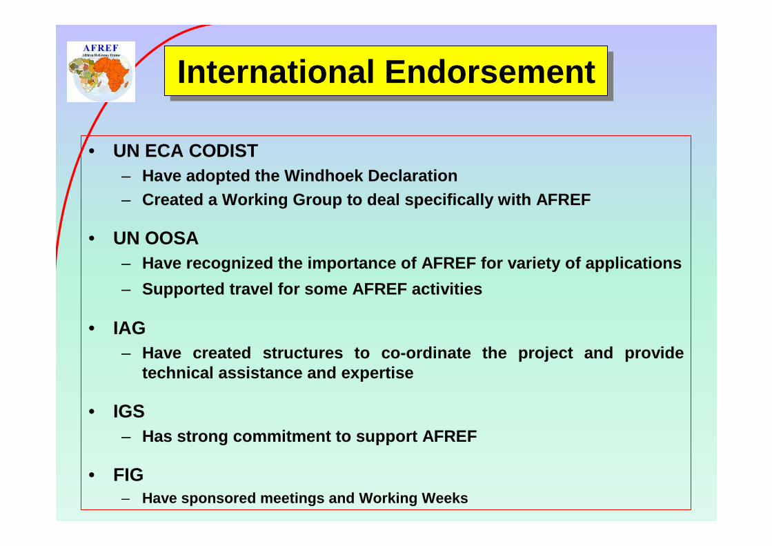
International EndorsementInternational Endorsement
• UN ECA CODIST– Have adopted the Windhoek Declaration– Created a Working Group to deal specifically with A FREF
• UN OOSA – Have recognized the importance of AFREF for variety of applications
– Supported travel for some AFREF activities
• IAG– Have created structures to co-ordinate the project and provide
technical assistance and expertise
• IGS– Has strong commitment to support AFREF
• FIG– Have sponsored meetings and Working Weeks

Various of activities underway in a number of countries to install permanent base stations or move towards ITRF:
Algeria AngolaBenin BotswanaCameroon EgyptEthiopia GhanaKenya LesothoMalawi MoroccoMozambique NamibiaNigeria RwandaSouth Africa SwazilandTanzania TunisiaUganda Zambia
Progress to DateProgress to Date

As agreed at CODIST I (April 2009), an AFREF Operationa l Data Centre (ODC) has been established.
– www.afrefdata.org or ftp.afrefdata.org
– Data from continuous stations brought together from number of data centres into one place. Data centres include:
• International GNSS Service (IGS Global Data Centres eg CDDIS)
• Hartebeesthoek Radio Astronomy Observatory (South A frica)
• National Geodetic Survey (USA)
• TrigNet (South Africa)
• UNAVCO (Africa Array)
• Nignet
• SEGAL
• etc
– ODC is recognised by IGS
Progress to DateProgress to Date
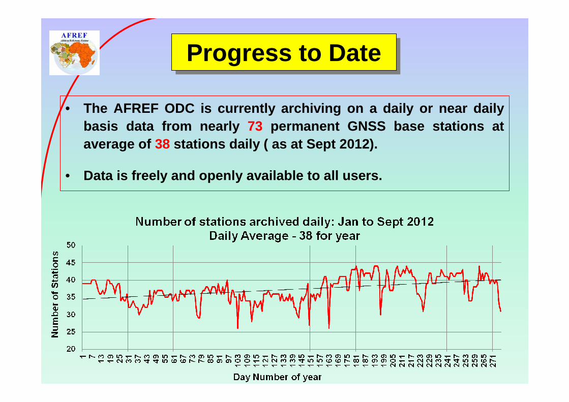
• The AFREF ODC is currently archiving on a daily or near daily basis data from nearly 73 permanent GNSS base stations at average of 38 stations daily ( as at Sept 2012).
• Data is freely and openly available to all users.
Progress to DateProgress to Date

Progress to DateProgress to Date
Active stations being archived at
AFREF Operational Data
Centre (May 2012)

More co-ordination required: MTWA & MTVE 3km apart! !!
Progress to DateProgress to Date

Inter-disciplinary CollaborationInter-disciplinary Collaboration
Number of disciplines make use of GNSS signal in space:
Geodesy: AFREFSeismology: Africa ArrayMeteorology: AMMA-GPSSpace weather: SCINDA

� Annual training courses at the technician level on the establishment of continuous reference stations and the processing of GNSS data are offered by RCMRD in Kenya and are well attended.
� On-going training on all aspects of satellite based mapping and positioning is conducted throughout the year at RECTAS in Nigeria.
� Meetings of the heads of NMAs are held from time to time to reinforce the importance permanent GNSS base stations and ITRF based National reference frames
Capacity BuildingCapacity Building

Project has reached the stage where the following c an be done:
1. At the Continent level:
– Computation of network of fiducial stations based o n well established stations with long term reliability and publically available data;
– An initial processing will provide set of co-ordina tes for use at National level - static set of co-ordinates;
– In addition must continue with ongoing processing t o maintain network, to provide a set of velocity vect ors and to make allowance for the addition of new stations;
– NB: GNSS is an observing tool that has to be calibrated from time to time - CORS station coordinates to be updated to reflect plate motion – co-ordinates derived from AFREF CORS will have to be transformed to AFREF sta tic co-ordinates.
What Next?What Next?

2. At the National level:
– Major objective of project is conversion of National geodetic networks to AFREF and hence ITRF ;
– NMAs will have to occupy and survey a number of strategically placed points whose co-ordinates are we ll established in the National frame using GNSS relative to AFREF/ IGS CORS;
– Processing could be as series of campaigns using permanent stations to convert or transform current National reference frame to AFREF.
What Next?What Next?

ChallengesChallenges

� Apparent lack of enthusiasm for project by NMA’s
– Lack of understanding?
– Lack of resources – capacity and financial?
� Political buy-in
– Again lack of understanding of benefits?
– Geodesy, Reference Frames etc doesn’t buy votes!
– AFREF talks a technical language
� Political instability and security
– Not much we can do about this
ChallengesChallenges

� Progress has been slow.
� Co-operation with other disciplines has been of ben efit to AFREF and the co-operating disciplines BUT;
� Greater co-ordination between countries and especially participating disciplines required.
� The proposed new structure to place AFREF within th e African Union (AU) structures, AMCOST, should bring the project closer to political leaders.
� AFREF is at stage where a provisional static ITRF based reference frame for Africa can be produced to be used by NMAs
ConclusionConclusion

Thank You
Websites for further information and data
www.afrefdata. org ftp.afrefdata.org


![07-Fernandes AFREF [Kompatibilitätsmodus]](https://img.pdfslide.us/doc/110x75/623213441e3f56489033cc95/07-fernandes-afref-kompatibilittsmodus.jpg)