Embed Size (px)
Citation preview

River otter
Affected Environment Introduction Physical Environment Biological Environment Cultural and Historical Resources Socioeconomic Environment Refuge Administration Refuge Public Use
Chapter 2
John
Whit
e


Physical Environment
Chapter 2. Affected Environment 2-1
Introduction
This chapter describes the physical, biological, cultural, and socioeconomic environment of
Montezuma NWR and the surrounding area. We provide descriptions and historical perspective
of the physical landscape of the refuge and region. We also describe current refuge
administration, refuge programs, and specific refuge resources.
Physical Environment
Major Historical Influences Shaping Landscape Vegetation
To evaluate future management options, it is useful to understand the historical types of natural
vegetation on the refuge. For Montezuma NWR, several factors have influenced the distribution
and composition of vegetation, including glaciation, ecological processes, and human
disturbance. Because habitats change over time and it is difficult to determine specific historic
habitat types, we describe a historical range of variation in habitats. This approach recognizes
that vegetative communities are not static and shift over time. Preserving biological diversity can
therefore best be attained by maintaining a range of habitat types, in different stages of
succession (Foster et al. 2003).
Glaciation
The Earth has experienced several glacial periods: the last, known as the Pleistocene Ice Age,
began about 2 million years ago. Glaciers advanced and retreated over time as temperatures
fluctuated. The most recent period to affect portions of New York was the Wisconsin Glaciation.
A 1-mile thick sheet of ice, known as the Laurentide Ice Sheet, covered the region until its retreat
northward. It left northern New York about 10,000 years ago (Smith 1985). As the glacier
retreated, it left behind piles or layers of sediments, rocks, and other debris; known as glacial
drift. These surface deposits over bedrock come in two types: glacial till and glaciofluvial.
Glacial till is a mixture of sand, silt, clay, and rock ground up by the glacier and dropped as it
retreated. It covers most of this region. Glaciofluvial drift develops from the transport, sorting,
and deposit of material by flowing glacial meltwater. Larger gravels and stones settle out at
higher gradients, while finer silts, sands, and clays settle out as the waters slow at valley bottoms
(Sperduto and Nichols 2004).
Glacial Lake Iroquois formed in the area of present day Lake Ontario when the Laurentide Ice
Sheet receded, but about 3 times larger. This glacial lake, along with several others, existed for
thousands of years and deposited layers of silt and clay in the Hudson River Valley.
In the Finger Lakes region of New York the receding glacier left behind a series of long, narrow
lakes that in time developed into extensive marshes at their shallower northern and southern
ends. At the north end of Cayuga Lake, on the old bed of one of these ancient lakes, a large
system of marshes developed through which the Seneca and Clyde Rivers meandered. The
extensive wetlands covered an area of over 80 square miles in a northerly direction from the head
of Cayuga Lake almost to Lake Ontario (USFWS 2008b).

Physical Environment
2-2 Montezuma National Wildlife Refuge Draft Comprehensive Conservation Plan and Environmental Assessment
The refuge lies within the heart of these wetland basins at the north end and the south end of the
“finger lakes,” intermingled with the oval-shaped hills (drumlins) region of the New York Great
Lakes Plain. These elongated hills are remnants of glacial activity and are generally oriented in a
north-south direction. The flat basins between the drumlin formations often provide wetland
habitats.
The New York State Canal System
Although the higher elevations were logged and farmed, there were no dramatic changes to the
wetlands in the Montezuma area until the development of the Erie Canal and its subsequent
expansions. The Erie Canal was first proposed in 1808 and completed in 1825, linking the
Hudson River in the east to Lake Erie in the west. The canal included 83 locks with a rise of 568
feet from the Hudson River to Lake Erie. A 10-foot wide towpath was built along the bank of the
canal for horses, mules, oxen, and their drivers. Since it was impractical to build an aqueduct
across the entire Montezuma lowlands, the canal went down into and up out of the wetlands.
Once the canal was operational, the wetlands caused many problems because it was a low point,
so water from both the east and west drained into the Seneca River at Montezuma (Kapell 2011
personal communication).
In hopes of changing these problems, the canal group first tried to lower the water level of the
Montezuma wetlands to reduce disease occurrence and create fertile farm land. This lowering
began 30 miles to the east, and over the span of nearly 75 years, the water level of the
Montezuma wetlands was lowered by approximately 12 feet. In the meantime, an aqueduct and
earth-fill embankment was built over part of the wetland, blocking flood flows from following
their natural course to the east, down the extremely low gradient Seneca River. Also, Keuka,
Seneca, and Cayuga Lakes drain into the Seneca River, which runs into the Montezuma wetland,
and the eastern Finger Lakes drain into the Seneca River downstream of Montezuma, creating a
massive bottleneck for high flows.
The Erie Canal was enlarged between 1836 and 1862 to handle larger boats and more traffic
(Whitford 1905). But it wasn’t until 1918, with the completion of the current New York State
Canal System (formerly known as the New York State Barge Canal; NYS Canal System), that
the Montezuma marshes were most affected. The 525-mile NYS Canal System is the successor
to the Erie Canal and other canals within New York, and it crosses the Montezuma NWR in
several places. It includes the Erie, Oswego, Cayuga-Seneca, and Champlain Canals. The
wetlands in the refuge have been most impacted by the Cayuga-Seneca Canal, which connects
Seneca and Cayuga Lakes to the Erie Canal.
The original Erie Canal was not built into the rivers and functioned like an earthen dam, stopping
the flow of water from the south and therefore increasing water levels in the vast flat area of the
Montezuma marshes. The marsh near the northern end of Cayuga Lake became known as the
Montezuma Marsh, and shortly thereafter the entire marsh and village area were referred to by
the name Montezuma (Gable 2004). When the canal was moved in the river system in 1907, the
water level was lowered. Construction of the Seneca and Cayuga extension of the NYS Canal
System began in 1818 and by 1828 boats passed from Geneva to the Erie Canal at the town of
Montezuma. This development had minor impact on the marshes because the river system was
largely unaltered.

Physical Environment
Chapter 2. Affected Environment 2-3
The hydrology was further altered in 1910 when a dam and lock were constructed at the north
end of Cayuga Lake. The canal system was moved into the Seneca and Clyde Rivers, which were
channelized (straightened and deepened), thus functioning as huge drainage ditches for the
marshes. However, they did not restore water levels in the wetlands to their original elevations.
These actions lowered the level of the Montezuma marshes by 10 feet (about 3 meters) (Kapell
2011 personal communication). Therefore the Montezuma wetlands are at the mercy of the
artificially managed water levels within the canal system, managed by the New York State Canal
Corporation (NYS Canal Corporation).
The canals are no longer used for commercial transport, but they are popular for fishing and
recreational boating and are of great historical interest.
Current Land Use
Historically, the lands at lower elevations in the vicinity of the refuge consisted of contiguous
wetland habitat. Following the development of the NYS Canal System in the early 1900s these
wetlands were lost, directly and indirectly, as a result of the lower water table and associated
ditching, tilling, and drainage for agriculture. Currently, agriculture is the primary land use
including croplands used to grow corn, potatoes, and soybeans. These lands have muck, or
organic soils, derived from drained wetlands. Typically, these areas flood every spring and
occasionally in the fall and winter months.
Muck soils are often favored for vegetable or root crop production due to their excellent friability
and water retention capability. However, they also carry risks of flooding and are prone to
subsidence due to oxidation and wind and water erosion. As these soils lose organic matter the soil
pH increases. This increase in pH has a negative effect on the availability of nutrients and the
suitability of the soils for growing root crops. Eventually, shallow muck soils lose their value for the
production of high value crops.
Most of the upland habitat is currently maintained in early successional stages, such as grassland
and shrub fields, by active management practices (USFWS 2008b). Most of the uplands
surrounding the refuge are forested. These habitats are managed to improve habitat and wildlife
diversity. Upland habitats adjacent to wetlands act as a buffer from the effects of crop
fertilization and crop runoff (Ducks Unlimited 2000).
Regional Land Use Patterns
Much of the lands in and around the MWC are in private ownership. The majority of these lands
are used for agriculture and are dominated by muck farms. The major crops are corn, potatoes,
onions, beans, wheat, and hay (Ducks Unlimited 2000). Muck is the organic soil from drained
swamplands, exposed across large areas when the canals were created during the height of
agriculture during the 1800s through 1900s. Muck farming was an important part of farming in
New York and other states. Onions, potatoes, celery, and carrots grow especially well on these
soils. Maintaining mucklands in agriculture is difficult, requiring constant drainage and wind
barriers, as the rich muck soils are extremely susceptible to erosion from wind (as muck becomes
wind borne when dry). In addition, oxidation of the rich organic material and subsidence have
substantially reduced the topsoil depth and hence lowered the fertility. On much of the muck, corn
has become the primary crop because it does not require deep rich soils. Given the nature of past

Physical Environment
2-4 Montezuma National Wildlife Refuge Draft Comprehensive Conservation Plan and Environmental Assessment
muck farming practices, high levels of pesticide residues are typically found on these sites
(Ducks Unlimited 2000).
The agricultural land uses surrounding the MWC contribute runoff to the wetlands. However, the
function and value of some of these restored agricultural lands may have lower wetland quality if
invasive plants become established or concentrations of agricultural chemicals are left
undetected. The opportunity for restoring abandoned or marginal agricultural lands to high
quality wetlands is great in this region.
Wetlands comprise the second largest land cover in the complex, after farmland. The most
common wetland type is forested. Forested wetlands are dominated by red maple (Acer rubrum),
silver maple (Acer saccharinum), green ash (Fraxinus pennsylvanica), and swamp white oak
(Quercus bicolor). Understory vegetation includes northern spicebush (Lindera benzoin),
winterberry (Ilex verticillata), sensitive fern (Onoclea sensibilis), skunk cabbage (Symplocarpus
foetidus), and arrow arum (Peltandra virginica). Nonforested wetlands are dominated by cattail
(Typha spp.), purple loosestrife (Lythrum salicaria), and sedges and rushes (Cyperus spp., Carex
spp., Eleocharis spp., Juncus spp.). Other less common wetlands include inland salt marshes and
nonvegetated mudflats.
Most of the uplands surrounding the refuge are forested. These forests are characterized
primarily by sugar maple (Acer saccharum), red maple, basswood (Tilia americana) and oak
species (Quercus spp.). Grassland habitats are comprised of cool and warm season grasses and
various forbes. Cool season grasslands are dominated by Timothy grass (Phleum pratense),
smooth brome (Bromus inermis), orchard grass (Dactylis glomerata), redtop (Agrostis gigantea),
and birds-foot trefoil (Lotus corniculatus). Warm season grasslands typically include switchgrass
(Panicum virgatum), big bluestem (Andropogon gerardii), little bluestem (A. scoparium),
sideoats grama (Bouteloua curtipendula), and Indiangrass (Sorghastrum nutans).
Open water surrounding the refuge consists of lakes, ponds, rivers, canals and streams that do not
show emergent vegetation. Floating and submerged aquatic vegetation species may include
duckweed (Lemna spp), coon’s tail (Ceratophyllum demersum), waterweed (Elodea canadensis),
water naiad (Najas flexilis), and pondweeds (Potamogeton spp.).
Ecosystem Context
Biophysical Region
The physical environment, expressed through climate, geology, topography or landform, and
soils, explains much about the patterns and distribution of biological diversity. These patterns
describe natural divisions, called biophysical regions or ecoregions, that inform our efforts to
understand, conserve, and manage wildlife and other biodiversity. Ecoregions are relatively large
geographic areas of land and water defined by common climate, geology, and vegetation
patterns. The Nature Conservancy classified New York into seven ecoregions (USFWS 2008b).
Montezuma NWR is in the Great Lakes Plain Ecoregion, a region formed during the last glacial
advance and characterized by gently rolling, low level landscapes and flat lake plains (NYSDEC
2005a). New York has approximately 2.4 million acres of wetlands (as of the mid 1990s). The
Lake Plains and the Adirondacks are the wettest portions, encompassing 74 percent of the State.

Physical Environment
Chapter 2. Affected Environment 2-5
The New York State Department of Conservation (2010) estimated the percent wetland type in
the Lake Plains region as forested−75.4 percent, scrub/shrub−14.2 percent, emergent marsh−7.9
percent, and open water wetland−3.3 percent.
Great Lakes Watershed
Montezuma NWR is in the southeastern corner of the 290,000-square mile Great Lakes
watershed, the largest freshwater ecosystem in the world (USFWS 2008b). The watershed
includes all tributary streams and inland lakes that are hydrologically connected to the five Great
Lakes: Superior, Michigan, Huron, Erie, and Ontario. Together these lakes hold 20 percent of the
world’s supply of surface freshwater and 95 percent of the United States’ supply. The climate
and hydrology of the Great Lakes create unique environmental conditions that support a diversity
of wildlife species and communities. The glacial and cultural history also has greatly influenced
the presence and distribution of biodiversity in this region (TNC 2000).
TNC has identified several threats to biodiversity in the Great Lakes ecoregion, including
development, invasive species, hydrologic alterations, incompatible forestry and agricultural
practices, and resource extraction (TNC 2003). Urban, residential, second home, and road
construction are causing loss, degradation, and fragmentation of important habitats. Purple
loosestrife, reed canary grass (Phalaris arundinacea), common reed (Phragmites australis),
swallow-wort (Cynanchum spp.), garlic mustard (Alliaria petiolata), common buckthorn
(Rhamnus cathartica), and zebra mussel (Dreissena polymorpha) are some of the invasive
species negatively impacting the Great Lakes region. Dams, diversions, dikes, groundwater
withdrawals, and other changes are affecting the natural flow regime of aquatic systems (TNC
2000).
Southeast Lake Ontario Basin
The refuge lies within the Southeast Lake Ontario (SELO) Basin (map 2.1) as described within
the New York State Comprehensive Wildlife Conservation Strategy (NYSDEC 2005a). The New
York State CWCS identified conservation priorities within the major watershed basins of the
State (NYSDEC 2005a). The watershed basin boundaries are taken from the USGS 4-digit
Hydrologic Unit Codes. The SELO Basin covers 4.3 million acres (all or part of 19 counties) in
west central New York, from Rochester east to the mouth of Stony Creek and south
encompassing the Finger Lakes. Important habitat types within the SELO include emergent
marshes, riparian forests, and grasslands. According to the EPA’s land classification, 50 percent
of the Southeast Lake Ontario Basin is forested. The rest of the land area is dominated by
agriculture, 24 percent in row crops and 16 percent in hay or pasture (table 2.1). Forty-five
percent of the 1.7 million people that live in the SELO Basin are in and around Syracuse. The
population of the Basin is expected to continue to decline (NYSDEC 2005a).

Physical Environment
2-6 Montezuma National Wildlife Refuge Draft Comprehensive Conservation Plan and Environmental Assessment
Table 2.1 Land Cover within the Southeast Lake Ontario
Basin of New York (NYSDEC 2005a).
Land Cover Classification Percent
Cover
Deciduous Forest 34.17
Row Crops 24.38
Pasture/Hay 15.53
Mixed Forest 11.01
Water 5.01
Wooded Wetlands 3.17
Low Intensity Residential 2.57
Evergreen Forest 1.32
Parks, Lawns, Golf Courses 1.07
High Intensity Commercial/Industrial 0.79
High Intensity Residential 0.60
Emergent Wetlands 0.24
Barren; Quarries, Strip Mines, Gravel Pits 0.11
NYSDEC (2005a) identified 129 species of greatest conservation need (SGCN) that currently
occur in the Basin and another 49 species that historically occurred in the Basin but are now
believed to be extirpated. The State believes that within the SGCN category, populations of 43
species are decreasing, 11 are increasing, 8 are stable, and 67 are of unknown status (NYSDEC
2005a).
Western Oswego River Watershed
The MWC is a part of the 5,100-square mile Western Oswego River watershed that largely
drains into Lake Ontario (USFWS 2008b). The primary surface-water is the easterly flowing
New York State Canal System, located mostly within the former natural channels of the Clyde
and Seneca Rivers. The MWC encompasses a 17.5-mile segment of the main canal. In an
unaltered system, the water levels in the Clyde and Seneca Rivers would fluctuate according to
natural weather events such as spring snowmelt/runoff, heavy spring rains/heavy runoff, and
heavy fall rains before the winter freeze. However, since these rivers have been channelized as
part of the NYS Canal System, the NYS Canal Corporation artificially maintains water levels for
navigational purposes and to minimize flood damage within the Oswego River Basin. Typically,
following the navigation season, the system’s water levels are lowered in the fall to provide
storage for spring snowmelt and storm runoff. The lowest water level on the system is
maintained in winter. Water levels are then raised gradually to predetermined safe levels for
summer use. Other waterways in the MWC include Black Brook, White Brook, and Crusoe
Creek.

Physical Environment
Chapter 2. Affected Environment 2-7
Map 2.1. Southeast Lake Ontario Basin.

Physical Environment
2-8 Montezuma National Wildlife Refuge Draft Comprehensive Conservation Plan and Environmental Assessment
Bird Conservation Region
As discussed in chapter 1, “Conservation Plans and Initiatives Guiding the Project,” Montezuma
NWR lies within BCR 13, the Lower Great Lakes/St. Lawrence Plain (map 2.2). BCR 13
encompasses the vast, low-lying lake plain region surrounding Lake Erie and Lake Ontario, the
St. Lawrence River Valley, low-lying regions between the Adirondack Mountains and the
Laurentian Highlands, and upper regions of the Hudson River Valley. In addition to important
lakeshore habitats and associated wetlands, this region was originally covered with a mixture of
oak-hickory, northern hardwood, and mixed-coniferous forests. Although once dominated by
forests, the landscape currently is largely agricultural with interspersed wetlands and remnant
forest stands. At one time or another, nearly 95 percent of the original habitat types have been
logged or converted to agriculture and/or urban development. BCR 13 was identified as playing
a critical role in providing important staging and migrating habitat for birds during the spring and
fall migration (ACJV 2007). In addition, about 16 percent of the global population of bobolink
(Dolichonyx oryzivorus) nests in the St. Lawrence Valley of northern New York (Rosenberg
2000).
Agriculture has been the major land use in BCR 13 for nearly 300 years. Today, this farmland
matrix contains scattered remnant forest and patches of wetlands and is interspersed with towns
and several large metropolitan areas. Within BCR 13, the agricultural lands comprise over 15
million acres (30 percent of the total land area) while hay and pasture (10 million acres) account
for 21 percent of the total area. Approximately one third of BCR 13 is now covered with upland
forest, consisting of deciduous (21.8 percent), mixed (8.6 percent), and coniferous (3.4 percent)
stands. Urban areas make up 5 percent of the land area, and the remaining land cover consists of
open water (5.5 percent), forested wetland (2.6 percent), and less than 1 percent open wetland
(ACJV 2007). Heinselman (1981) describes the presettlement BCR 13 region as a forest belt,
transitioning between the boreal forests of Canada and the deciduous forests of the eastern U.S.
Historically, the St. Lawrence River Valley was dominated by sugar maple-beech-birch forest,
mesic oak hardwood forest, red maple-black ash swamp forest, and silver maple floodplain forest
(Rosenberg et al. 2000). The Lower Great Lakes Plain consisted primarily of either northern
hardwood forest or dry oak-hickory-ash forest (Dettmers and Rosenberg 2003). Historic
nonforest natural vegetation types of the region include pitch pine-scrub oak woodlands,
emergent freshwater marshes, and freshwater tidal marsh, as well as large river islands with beds
of reeds or grass (including wild rice) (Rosenberg 2000).
Partners in Flight Physiographic Regions
In 1990, Partners in Flight was established as a means to promote cooperative conservation to
address bird and habitat issues at a continental scale. The refuge lies within Area 15, the Lower
Great Lakes Plain (LGLP) physiographic area, which encompasses approximately 11,788,162
acres (map 2.3). LGLP covers the low-lying areas to the south of Lake Ontario in New York and
to the north of Lake Erie in southernmost Ontario in Canada. In addition to important lakeshore
habitats and associated wetlands, this region was historically covered with a mixture of oak-
hickory, northern hardwood, and mixed-coniferous forests. Roughly 74 percent of the land area
is in agricultural production. In addition, several medium-sized cities (Syracuse, Rochester,
Buffalo, Windsor, etc.) comprise over 800,000 acres of urban land, or 7.1 percent of the

Physical Environment
Chapter 2. Affected Environment 2-9
physiographic area. Priority bird species of the LGLP include Henslow’s sparrow (Ammodramus
henslowii), bobolink, upland sandpiper (Bartramia longicauda), golden-winged warbler
(Vermivora chrysoptera), American woodcock (Scolopax minor), cerulean warbler (Dendroica
cerulean), and red-headed woodpecker (Melanerpes erythrocephalus). Specific conservation
recommendations for this physiographic area include
intensive survey and monitoring for high-priority species to identify most important areas
in need of protection;
increased protection of forest and lakeshore habitats critical to cerulean warblers and
migrant passerines;
increased management on protected and private lands to provide habitat for Henslow’s
sparrow and golden-winged warbler; and,
integration of land bird population and habitat objectives with those for wetland species
and game species such as American woodcock.
Ecological Role of Fire in the Region
Wildfire has not played a major role as a natural disturbance in shaping the ecosystems of BCR
13, with the possible exception of certain uncommon habitats, such as open grasslands,
shrublands, or savannah found on rocky barrens (e.g., limestone bedrock) or other areas with
shallow, drought-prone soils. Brown and Smith (2000) estimate that historically the region was
subjected mainly to mixed severity fires (i.e., fires which vary between understory and stand
replacement impacts, or cause selective tree mortality) at intervals of greater than 500 years.
Runkle (1990) indicates in a generalized scheme for the Eastern U.S. that the historic, major
disturbance in the deciduous forest of the Great Lakes region were “gaps” (mainly single tree
death), rather than frequent wildfires or large wind events.
Therefore, the role of fire in restoring historic ecological conditions, such as on a large-scale in
forested, wilderness areas, is limited in BCR 13. Prescribed fire is more appropriately used on
national wildlife refuges in BCR 13 for small-scale habitat manipulation. Refuges in the region
have primarily used prescribed fire to manipulate vegetation in freshwater impoundments and
post-agricultural, successional habitats (USFWS 2009a).

Physical Environment
2-10 Montezuma National Wildlife Refuge Draft Comprehensive Conservation Plan and Environmental Assessment
Map 2.2. Bird Conservation Region 13.

Physical Environment
Chapter 2. Affected Environment 2-11
Map 2.3. Partners in Flight Physiographic Regions.

Physical Environment
2-12 Montezuma National Wildlife Refuge Draft Comprehensive Conservation Plan and Environmental Assessment
Climate
The weather in the Great Lakes watershed is affected by the location and size of each lake, air
masses from other regions, and the location within a large continental landmass. Each of the
Great Lakes acts as a heat sink, absorbing heat when the air is warm and releasing it when the air
is cold. This results in more moderate temperatures at areas near the shore than other locations at
similar latitudes. The influence of external air masses varies seasonally. In the summer, the
region is influenced mainly by warm humid air from the Gulf of Mexico, whereas in winter the
weather is influenced more by Arctic and Pacific air masses (USEPA and Government of Canada
1995).
Lake Ontario provides the source of significant winter precipitation as it is very deep and almost
never freezes. Cold air flowing over the lake is quickly saturated and produces the cloudiness
and “lake effect” snow squalls that are well-known features of winter weather in the vicinity of
the refuge. Snowfall is moderately heavy, with an annual average of approximately 66 inches.
Wind velocities are moderate, but during winter months there are numerous days with sufficient
winds to cause severe blowing and drifting of snow. The refuge area is generally cold and snowy
in winter with an average temperature of 27 degrees Fahrenheit (°F) and an average low of 19 °F
(see table 2.2). Summers are generally warm with an average temperature of 67 °F and an
average high of 80 °F. Average annual precipitation is 36 inches and is well-distributed during
the year (National Oceanographic and Atmospheric Administration [NOAA] 2010a).
Table 2.2. Average Temperature and Precipitation for 1971 to 2000 Around
Auburn, New York (Source: NOAA 2010a).
Month
Temperature Averages for Auburn,
NY 1971- 2000 50-Yr Average
Precipitation
Inches Average High
(°F)
Average Low
(°F)
January 31 14 1.39
February 34 16 1.26
March 44 24 2.26
April 56 35 2.97
May 72 47 3.04
June 77 55 3.36
July 81 60 3.48
August 79 58 3.28
September 79 51 3.53
October 59 40 3.23
November 48 32 3.22
December 35 20 1.98
Average Totals 57 38 32.98

Physical Environment
Chapter 2. Affected Environment 2-13
Climate Change
Secretarial Order 3226 (Amendment 1) requires that climate change impacts be considered and
analyzed when planning or making decisions within the Department of the Interior (U.S.
Secretary of the Interior 2009). This order serves as an opportunity for refuge system planners
and managers to incorporate climate change impacts into each refuge’s CCP.
There is consensus among the scientific community that global climate change, occurring in part
as a result of emissions of carbon dioxide and other greenhouse gases from human activities, will
lead to significant impacts across the U.S. (Wigley 2004). These may include increasing
temperatures, altered rainfall patterns, and sea level rise. The effect of climate change on wildlife
and habitats is expected to be variable and species specific, with a predicted general trend of
ranges shifting northward and to higher elevations (Shugart et al. 2003). Nonnative species will
likely increase (Walther et al. 2002). Within the Great Lakes region, substantial changes are
anticipated, and according to a regional report on projected climate change and impacts, by 2025,
spring and summer temperatures in the Great Lakes region are likely to be 3 to 4 °F above
current averages (Kling et al. 2003). The amount and seasonal distribution of precipitation is
expected to be altered as well; precipitation is expected to increase between 10 and 20 percent,
with winter and spring rain increasing and summer rain decreasing by up to 50 percent. These
changes in precipitation may result in more frequent floods and droughts. Uncertainty about the
future effects of climate change requires refuge managers to use adaptive management (e.g.,
adjusting regulations, shifts in active habitat management, or changing management objectives)
to maintain healthy ecosystems in light of unpredictability (Inkley et al. 2004). Refuge managers
can plan and respond to changing climate conditions. Options include managing for diverse and
extreme weather conditions (e.g., drought and flood); maintaining healthy, connected,
genetically diverse wildlife populations; and (where applicable) protecting coastal wetlands to
accommodate sea level rise (see Inkley et al. 2004 for more recommendations).
Hydrology
The refuge receives water from direct precipitation, runoff from the hilly areas bordering the
west side of the refuge, three streams originating to the west of the refuge, and several springs
within refuge boundaries. Two streams, Black Brook and White Brook, flow directly into
Tschache Pool. Black Brook is the major contributor to this impoundment with a drainage area
of 12,580 acres. White Brook has a drainage area of 5,760 acres. Esker Brook, with a drainage
area of 2,090 acres, flows into North Spring Pool (USFWS undated).
The refuge includes a salt spring located in Black Lake within the Main Pool. Inland salt marshes
are globally endangered plant communities (Eallonardo 2009 personal communication). The
Black Lake Salt Marsh, one of four in the MWC, was identified by Weigand and Eames in 1925
and is listed as a rare community by the New York Natural Heritage Program.
Surface water concerns include water quality, artificially maintained water levels generated by
the operation of the NYS Canal System and surface water supply for current and future wetland
impoundments. Ground water resources in the MWC are located in the consolidated (bedrock)
and unconsolidated glacial deposits. Nearly all the ground water in this area is derived from
precipitation that is absorbed by the bedrock. Unconsolidated sand and gravel deposits produce

Physical Environment
2-14 Montezuma National Wildlife Refuge Draft Comprehensive Conservation Plan and Environmental Assessment
the best yield of water for wells in the region. Overall, hydrological data for the MWC is lacking,
and more detailed information is needed (Ducks Unlimited 2000).
Geology and Topography
Post-glacial geologic features dominate the landscape surrounding the refuge. The topography is
represented by formations such as drumlins, eskers, kames, and kettles, and is gently sloping to
rolling. The refuge lies over an old, flat lakebed at the northern end of the Cayuga Lake Basin.
The broad, flat basins are interrupted by classic drumlin formations, oblong hills of 60 to 150
feet high with a north-south orientation resulting from glacial deposits. The flat basins below the
380-foot contours are the location of the existing and historical Montezuma Marshes (Ducks
Unlimited 2000).
Soils
The refuge region is generally underlain by a combination of limestone and limestone/shale
bedrock. These calcareous rocks result in the highly productive glacial till found throughout the
Montezuma wetlands area. Three major soil groups are found within the MWC. The largest
group is comprised of various types of muck (lake bottom and marsh organic materials)
occurring at or below the 380-foot contour interval. The Ontario soil association in the drumlin
zones and the Odessa-Schoharie Fulton-Lucal association found in the southwestern corner of
the MWC characterize the remaining area (Ducks Unlimited 2000).
A soil profile of the refuge wetlands would reveal an upper layer of deep Carlisle muck and
sedimentary peat over a Chara and shell marl. The subsoil in this area of the old lake basin is
compact blue clay. The upland soils are derived from calcareous glacial till. The well-drained sandy
loams include pockets of Palmyra gravelly loam, Ontario loam, Poygan silty clay loam, Schoharie
silty clay loam, and Wayland silty loam (U.S. Department of Agriculture [USDA] Soil
Conservation Service and Cornell University Agricultural Experiment Station 1972). Table 2.3 lists
refuge soils.
Table 2.3. Soil Types on Montezuma NWR.
Soil
Symbol Soil Name Description
CeB Cazenovia silt loam
(3 to 8 percent slopes)
Moderately well-drained, medium textured, and moderately
fine textured soils that formed in glacial till having a high
content of clayey shale and in calcareous glacial till in
which a deposit of lacustrine clay has been incorporated.
CIA Collamer silt loam
(0 to 2 percent slopes)
Moderately well-drained, medium textured soils that formed
in lacustrine deposits of alkaline or calcareous silt or very
fine sand that is high in content of silt.
Ed Edwards muck
(level or nearly level)
Organic soils that formed in mixed woody, grassy or sedgy
material underlain by white to light gray calcareous marl at
a depth of 10 to 40 inches.
Fn
Fonda mucky silty clay loam
(level or depressional)
Very poorly drained, moderately fine textured soils that
developed in lacustrine deposits of gray, brown, or reddish,
calcareous clay containing occasional bands of silt and very
fine sand.
LcA Lakemont silty clay loam
(0 to 2 percent slopes)
Poorly drained, moderately fine textured soils that formed
in calcareous, reddish, lacustrine clay and silty clay.

Physical Environment
Chapter 2. Affected Environment 2-15
Soil
Symbol Soil Name Description
LtB Lima silt loam
(3 to 8 percent slopes)
Deep, moderately well-drained soils that formed in strongly
calcareous, medium textured glacial till.
Ma Madalin and Odessa silty clay
loam (level or depressional)
Deep, poorly drained soils that formed in calcareous, gray
and brown clay and silty clay in glacial lakes.
Md Made land, tillable
Areas in which the original soil has been moved or
disturbed, and the original surface layer and subsoil are not
evident. Most areas consist of material that was dredged
during the straightening and deepening of the NYS Canal
System.
Mr Muck, deep
(0 to 1 percent slopes)
Organic soil formed in a mixture of wood, grass, or sedgy
material; strongly acid to alkaline; the organic layer ranges
from 40 inches to as much as 17 feet in depth. The organic
layer is underlain by mineral soil material or by white,
highly calcareous marl.
Ms Muck, shallow
(0 to 2 percent slopes)
Organic soil formed in a mixture of wood, grass, or sedgy
material; strongly acid to alkaline; the organic layer ranges
from 10 to 40 inches in depth.
OdA Odessa silt loam
(0 to 2 percent slopes)
Deep, somewhat poorly drained soils that formed in
calcareous, reddish, lacustrine clay and silt.
OnB Ontario loam
(2 to 8 percent slopes)
Deep, medium textured, well-drained soils that formed in
strongly calcareous, firm glacial till. The glacial till is
derived mainly from sandstone, limestone, and some shale,
and contains sufficient red sandstone or red shale to impart
a reddish hue.
OnC
Ontario loam
(8 to 15 percent slopes,
eroded)
Commonly occurs in long, narrow strips on the sides or tops
of drumlins. Seventy-five percent of most areas are so
eroded that the surface layer consists partly of material from
the subsoil.
OnD
Ontario loam
(15 to 28 percent slopes,
eroded)
Typical for the Ontario series but is generally thinner over
calcareous till. These soils typically occur on the sides of
drumlins. Most of the slopes are single, although a few are
hilly and complex.
OvA
and
OvB
Ovid silt loam
(0 to 3 percent slopes and 3 to
8 percent slopes)
Deep, somewhat poorly drained soils that have a moderately
fine textured subsoil. These soils formed in reddish glacial
till derived from mixed limestone and red alkaline or
calcareous clay shale or from appreciable amounts of
reworked red lacustrine clay mixed with limestone and
shale.
SeB Schoharie silt loam
(2 to 6 percent slopes)
Deep, moderately well-drained and well-drained soils
derived from calcareous reddish clay and silt. The surface
layer is commonly silt loam, but there are a few small areas
of very fine sandy loam.
Sn Sloan silt loam
(level or depressional)
Deep, poorly drained and very poorly drained, medium
textured and moderately fine textured soils that form in
slightly acid to mildly alkaline, recent alluvium. These soils
typically have little or no structure.
Source: USDA Soil Conservation Service and Cornell University Agricultural Experiment Station 1972

Physical Environment
2-16 Montezuma National Wildlife Refuge Draft Comprehensive Conservation Plan and Environmental Assessment
Air Quality
The EPA collects emissions data for three air pollutants—carbon monoxide, sulfur dioxide, and
particulate matter—and three precursors/promoters of air pollutants—volatile organic
compounds, nitrogen oxides, and ammonia. That data are summarized in the Air Quality System
database, the EPA repository of air pollutant monitoring data, which reports the number of days
when air quality was good, moderate, unhealthy for sensitive groups, or unhealthy (for
everyone), by counties with air quality monitoring stations. We are using data for Wayne
County, the nearest county which monitors air quality, for a general evaluation of air quality at
the refuge. The following data were collected in 2008: Wayne County—89 percent good, 10
percent moderate, and 1 percent unhealthy for sensitive groups (0 unhealthy days) (EPA 2008).
Water Quality
The Finger Lakes of New York are essential to the health, well-being, and economy of the
region. It is estimated that these lakes contain 8.1 trillion gallons of freshwater. Combined, their
watersheds are 2,630 square miles (Halfman and O’Neill 2009). These lakes are a source of
Class AA drinking water to the 1.5 million residents in the surrounding communities. Water
quality varies across the Finger Lakes. Skaneateles, Canandaigua, and Keuka Lakes are
oligotrophic and have the best water quality. Seneca, Owasco, Cayuga, Honeoye, and Otisco
Lakes are mesotrophic to eutrophic and have lower levels of water quality. Nutrient sources in
the watershed stem from both point and nonpoint sources, including wastewater treatment
facilities, erosion along stream banks, and agricultural runoff (Halfman and O’Neill 2009).
Water quality issues of concern within the Finger Lakes include water supply, swimming, and
fish consumption. Among pollutants of concern are nutrients, sediments, priority organics,
pathogens, and salts (Callinan 2001).
The refuge is closest to Cayuga Lake, the second largest of the Finger Lakes in volume, and has
the largest watershed. The lake is 38.2 miles in length, has a maximum width of 3.5 miles, and
contains 95.3 miles of shoreline. The drainage basin is 785 square miles. Cayuga Lake drains
through the Oswego River system into Lake Ontario. The quality of water in Cayuga Lake is
dependent on the quality of water that enters it from tributaries and runoff within the watershed.
Cayuga Lake is subject to contamination from both point and nonpoint sources that may enter
the lake through runoff from tributaries or directly into the lake itself (Genesee/Finger Lakes
Regional Planning Council and EcoLogic 2000).
Recommendations for Cayuga Lake include: (1) control of nutrient (particularly phosphorus) and
sediment loads within the Cayuga Lake watershed; (2) continuation of periodic monitoring of
aquatic biota for chlorinated organic chemicals; and (3) monitoring zebra mussels to understand
population dynamics and assess the ecological effects associated with this invasive exotic species
(Callinan 2001).

Physical Environment
Chapter 2. Affected Environment 2-17
Environmental Contaminants
A 1995 draft report summarized the existing contaminant information related to Montezuma
NWR (USFWS 1995). This summary included a list of baseline studies, nearby hazardous waste
sites, monitoring sites, and history of pesticide use on the refuge. The Service also has been
acquiring mucklands from willing sellers for restoration of wetland and upland habitats in the
MWC. Some surveys of these lands have detected the presence of contaminants.
Stoll (1988) sampled water quality, sediments, and wildlife species within refuge impoundments
and adjacent canals and streams to determine the presence and extent of contaminants.
Dichlorodiphenyltrichloroethane (DDT), Polychlorinated Biphenyls (PCBs), and dieldrin were
found in turtle and fish tissue samples. Although these compounds were not detected in sediment
samples, these chemicals and other pesticides were found in samples from some refuge tracts,
such as the Sandhill Crane Unit (USFWS 1999). It was concluded that levels of metals and
organics were not a cause for concern, although there is some evidence that adverse effects to
ecosystem function are occurring and levels of arsenic, zinc, and copper in agricultural
mucklands were above baseline conditions and in some place above the State’s “severe effect”
level (USFWS 1999). Contaminant uptake by wildlife is dependent on the contaminant, the other
contaminants present, the species involved, and the chemistry of the soil and water (NYSDEC
1998). Soils with a high carbon content and large proportions of fines in sediments (such as in
the mucklands) can bind a higher amount of contaminants and therefore have a higher capacity
of limiting the amount of contaminants available for uptake by wildlife. Thresholds suggested by
Long and Morgan (1990) may be more applicable to the mucklands than the Statewide
thresholds. The cumulative concentrations of arsenic, copper, and zinc show some correlation
with a decrease in algae species richness (USFWS 1999). To reduce the potential exposure of
trust resources to contaminants, a management strategy was drafted for muckland restoration and
acquisition related to contaminant issues (USFWS 1999).
Noise
The presence of high- and low-speed roadways scattered throughout the refuge results in some
traffic noise being within hearing distance of many refuge areas. Ambient noise levels on and
around the refuge are generally similar to other rural locations in central New York except for
along Interstate 90. The effect on wildlife from the noise generated on the NYS Thruway is
believed to be minimal due to its relative uniformity of volume and timing, although it negatively
affects visitors. Most areas on the refuge (e.g., Knox-Marsellus, Esker Brook Trail) are
sufficiently buffered from noise to allow visitors a pleasant experience.
Visual Resources
The refuge offers an excellent option for central New Yorkers seeking an aesthetically pleasing
landscape to visit. There is much to be gained from experiencing a picturesque sunrise or sunset
over the grasslands and marshes of Montezuma NWR. The abundance and diversity of wildlife
associated with these open spaces significantly enhances the outdoor experience.
Transportation and Utility Corridors
The refuge is intersected or adjacent to several major roads and utility corridors. The NYS
Thruway crosses the refuge at the Main Pool impoundment. In addition, several State highways,
as well as numerous county and town roads run through or along refuge lands. Two railroads

Physical Environment
2-18 Montezuma National Wildlife Refuge Draft Comprehensive Conservation Plan and Environmental Assessment
operate in the area, and the NYS Canal System and the Cayuga-Seneca Canal are two major
waterway transportation routes through the area. Utility corridors that transverse or border refuge
lands include four power lines (over 115 Kilo volt), three major underground telephone lines,
and several oil and gas pipelines.
Biological Environment
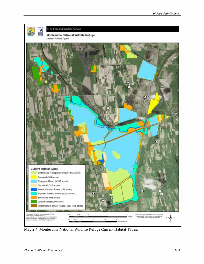
Habitat Types
The refuge supports the following habitats: emergent marsh, open water, mudflat, forested
wetland, upland forest, grassland, and early successional uplands and wetlands (table 2.4 and
map 2.4.
Table 2.4. Habitats on Montezuma NWR.
Habitat Type Acres Percent
Emergent Marsh 4,307 46.9
Bottomland Floodplain Forest 1,685 18.3
Riparian Forest Corridor 1,033 11.2
Scrub/Shrub 866 9.4
Upland Forest (all successional stages) 299 3.3
Cropland 183 2.0
Grassland 316 3.4
Ponds, Ditches, Rivers 179 1.9
Infrastructure (dikes, facilities, trails, etc.) 316 3.4
Total 9,184 100.0
Wetlands
The three major types of wetlands at Montezuma NWR, according to Cowardin et al. (1979), are
aquatic bed, emergent wetland, and forested wetland. Aquatic bed refers to wetlands and
deepwater habitats that are dominated by plants which grow primarily on or below the water
surface. Emergent wetlands are characterized by rooted herbaceous hydrophytes and usually
occur in calm, shallow water. Forested wetlands are dominated by various water-tolerant tree
species, with minimal understory. These habitat types provide numerous benefits, including
flood protection by acting as sponges which absorb excess water; improved water quality by
filtering toxins introduced by agricultural runoff; and diverse habitat for wildlife (EPA 2001).
Emergent Marsh, Open Water, and Shallow Water/Mudflats
The most common habitat type on the refuge is emergent marsh. Emergent marsh is a wetland
dominated by erect herbaceous plants such as cattails and smartweeds (Polygonum spp.).
Historically, habitat conditions in these marshes were dictated by the weather, which influenced
water levels and flow rates in the Seneca and Clyde Rivers. For example, a particularly wet
Biological Environment
Chapter 2. Affected Environment 2-19
Map 2.4. Montezuma National Wildlife Refuge Current Habitat Types.

Biological Environment
2-20 Montezuma National Wildlife Refuge Draft Comprehensive Conservation Plan and Environmental Assessment
season or a series of wet years, would have resulted in higher water levels in the marshes and
more open water relative to vegetative cover. Similarly, a drought year would have resulted in
lower water levels and more vegetative growth. The Seneca and Clyde Rivers have since been
dredged and straightened and continue to drain the historic marshes. The water levels and flow
rates are largely controlled by the NYS Canal Corporation rather than natural fluctuations. This
control has a consequence of moderating the variation and timing of high and low water. As a
result, habitats within the refuge would develop into more forested wetlands and uplands, and
less emergent marsh due to the lack of periodic flooding. It is for this reason that wetlands on the
refuge are impounded and refuge staff manipulate the water levels. The impounded wetlands are
managed to mimic natural hydrologic fluctuations and provide optimal habitat for species of
conservation concern.
This effort began in the late 1930s, when the U.S. Bureau of Biological Survey (the precursor to
the U.S. Fish and Wildlife Service) began acquiring the southern portion of the Montezuma
Marsh. Shortly after Montezuma NWR was established in 1938, the Civilian Conservation Corps
began work on a series of low dikes to reflood the main marsh (now called the Main Pool). In
1939, diking operations were continued to impound the flows of White and Black Brooks, to
reflood a small portion of the former marshes, and to create a water source to refill the Main
Pool, thus creating Tschache Pool. Today, the refuge has 14 manageable impoundments totaling
more than 4,000 acres of freshwater emergent marsh, open water, and mudflat habitat (table 2.5
and map 2.5).
Table 2.5. Emergent Marsh and Open Water/Mudflat Impoundments
on Montezuma NWR.
Impoundment Name Acres
Main Pool 1,657
Tschache Pool 1,160
Sandhill Crane Unit 448
Knox-Marsellus Marsh 236
Jackson 215
May’s Point Pool 199
Puddler Marsh 98
North Spring Pool 91
Millennium Marsh 69
Visitor Center Wetland 26
Benning Marsh 18
Shorebird Flats 18
Box Elder Bog 10
Lesser Yellowlegs Unit 8
Display Pool 2
Total 4,255
This dike system allows us to maintain many of our marsh units at “flood” stage for long periods
and through a range of weather conditions. However, biologists have learned that after prolonged
high water, emergent vegetation dies back and open water dominates. At this stage of the
marsh’s life, it is less productive and provides little habitat for wildlife (e.g., waterfowl,

Biological Environment
Chapter 2. Affected Environment 2-21
marshbirds, shorebirds, muskrats). Draining the water out of the marsh at this time mimics a
natural drought, exposes mudflats for shorebirds during their migration if timed properly, and
allows plants to grow. When the marsh is reflooded, the resulting habitat is ideal for a variety of
wildlife. Annual moist-soil vegetation is an important food source for migrating waterfowl, and
perennial vegetation provides important cover not only for waterfowl but also for breeding
marshbirds, such as rails, bitterns, and terns.
Forested Wetlands (Bottomland Hardwoods)
Bottomland hardwoods comprise 1,685 acres at Montezuma NWR. Most of the forest on
Montezuma NWR is forested wetland. Dominant vegetation includes red and silver maple,
American elm (Ulmus americana), green ash, and swamp white oak. The understory is sparse,
and includes common winterberry, northern spicebush, and highbush blueberry (Vaccinium
corymbosum). These understory shrubs are largely confined to hummocks. Species common to
the transitional zones between hummocks and vernal pools include sensitive fern, marsh fern
(Thelypteris palustris), skunk cabbage, and false nettle (Boehmeria cylindrical) (Ducks
Unlimited 2000).
The largest stand of forested wetland on the refuge includes two green tree reservoirs, the 344-
acre Unit 17 East and the 266-acre Unit 17 West, collectively called Unit 17. Unit 17 is south of
Routes 5 and 20 and separates the northern terminus of Cayuga Lake from the extensive
emergent marsh system on the refuge. The Service created these two green tree impoundments in
1965 to benefit nesting, resting, and feeding waterfowl. Flooding of these impoundments was
terminated in 1977 because extended flooding into the growing season resulted in damaging the
overstory (USFWS 2008b). Long periods of managed flooding stressed mature trees and
prevented germination and survival of seeds and seedlings. Water level management now
focuses on more closely following a natural hydrologic period for a bottomland forest
community in this region.
Uplands
Most of the upland habitat on Montezuma NWR is maintained in an early successional stage
(grassland or scrub-shrub fields) through active management. Succession is set back in these
areas through a variety of management techniques, including mowing, burning, disking, planting,
hydroaxing, and chemical treatment.
Grasslands
The refuge maintains four grassland units totaling 316 acres to support grassland-dependent
species. These units support warm season grasses, cool season grasses, some forbs, small shrubs,
and some woody species. These fields require long-term maintenance including frequent
mowing, herbicide applications, and prescribed burning to control invasive plants and other
nondesirable plants including woody shrubs. Common plant species include Timothy grass,
smooth brome, reed canary grass, Canada thistle (Cirsium arvense), goldenrod (Solidago spp.),
switchgrass, big bluestem, and Indiangrass.

Biological Environment
2-22 Montezuma National Wildlife Refuge Draft Comprehensive Conservation Plan and Environmental Assessment
Map 2.5. Impoundments and Water Control Structures on Montezuma NWR.

Biological Environment
Chapter 2. Affected Environment 2-23
Shrublands
Refuge shrublands are diverse from location to location with dominant plants including
goldenrod, gray dogwood (Cornus racemosa), Morrow’s honeysuckle (Lonicera morrowii), and
common buckthorn. Only two tracts on the refuge are actively maintained in this early
successional state. Other shrubland areas will need to be managed to set back succession.
Forests
Upland forested sites are mostly successional forests dominated by black walnut (Juglans nigra),
black willow (Salix nigra), and green ash occurring on former agricultural fields. Most of the
mature forested sites on the refuge are wetlands. However, good examples of mature upland forest
sites include the Beech-Maple Knoll Research Natural Area, the upland portions of the Cerulean
Forest, and the 176-acre Nash Forest (refer to USFWS 2008b for more details). These sites require
little to no maintenance but should be monitored for invasive plants and deer impacts.
Croplands
Newly acquired farmlands are frequently enrolled in the refuge’s cooperative farming program to
provide a smoother transition for both the farmer and the refuge. This is a means to keep fields
open and relatively free of invasive plants in preparation for conversion to native plants.
Cooperative farmers are not allowed to plant potatoes, as they require large amounts of
herbicides, fungicides, and pesticides. With prior approval, farmers are permitted to apply
fertilizers and herbicides, but genetically modified crops are prohibited.
Cooperative farmers provide other in-kind services including:
Mowing refuge grasslands to prevent brush encroachment.
Seeding refuge fields.
Plowing, disking, and cultipacking upland fields prior to planting permanent grass
cover.
Purchasing grass seed for planting in refuge upland fields.
Maintaining the tops and slopes of dikes.
Special Designations
Special designations on the refuge include Research Natural Areas (RNAs) and a National
Natural Landmark (NNL). Currently, the refuge does not contain designated wilderness.
Research Natural Areas
The refuge has two designated RNAs (map 2.6), approved in 1967. The Beech-Maple Knoll RNA
is an 8-acre tract located southwest of Tschache Pool. A prime example of a mature, northern
hardwood beech-maple forest cover type, the beech-maple association provides a unique habitat
type not found elsewhere on the refuge. Unfortunately, regeneration of this cover type has been
negatively impacted by heavy deer browsing in this area (Rawinski 2010 personal communication).
The Swamp Woods RNA is a tract of approximately 100 acres located southwest of the Main
Pool. It is an unusual stand because it is the last remaining undisturbed example of swamp
woodland on the refuge. It was once the common woodland type found on muck soils throughout
the historic Montezuma marshes, but has now become rare due to draining and clearing of

Biological Environment
2-24 Montezuma National Wildlife Refuge Draft Comprehensive Conservation Plan and Environmental Assessment
Map 2.6. Montezuma National Wildlife Refuge National Natural Landmark and Research
Natural Areas.

Biological Environment
Chapter 2. Affected Environment 2-25
muckland for farming. The vegetation of interest includes black ash (Fraxinus nigra), American
elm, red maple, and white oak (Quercus alba).
National Natural Landmark
In 1973, a 2,100-acre portion of the refuge was designated as the Montezuma Marshes NNL by
the National Park Service under the provisions of the Historic Sites Act of 1935 (map 2.6). The
refuge was incorporated in the registry because it possesses exceptional value in illustrating the
natural history of the U.S. A large section of the Main Pool, including Maple Island and Black
Lake, is representative of conditions in the original marsh in which broad expanses of cattail
marsh were interspersed with old river channels and ponds. This area serves as a resting and
feeding area for migrating waterfowl and provides nesting habitat for many species of ducks,
herons, other waterbirds, neotropical migrant songbirds, and bald eagles (Haliaeetus
leucocephalus). The Swamp Woods RNA is part of the Montezuma Marshes NNL. The New
York State Thruway forms the northern border of the landmark. Habitat fragmentation resulting
from the thruway and pipelines are the greatest threat to this NNL.
Plants and Animals
Birds
The bird list for Montezuma NWR includes 320 species that have been identified on the refuge
since its creation in 1938. Of these, 117 species of birds are known to nest on the refuge. The
New York Important Bird Area Program recognized the MWC for providing stopover and
foraging habitat for one of the largest concentrations of waterfowl in the Northeast. Wading birds
and shorebirds are also observed during spring and fall migration (National Audubon Society
2011). The MWC also harbors a suite of nesting bird species of conservation concern including
pied-billed grebe (Podilymbus podiceps), least bittern (Ixobrychus exilis), osprey (Pandion
haliaetus), bald eagle (Haliaeetus leucocephalus), black tern (Chlidonias niger), sedge wren
(Cistothorus platensis), and cerulean warbler (Dendroica cerulean). In addition, most of the
forested wetlands in this region were historically cleared or drained so the bird species that use
this habitat are of conservation concern. Montezuma NWR supports this habitat type along with
many breeding birds associated with these forests, including sharp-shinned hawk (Accipiter
striatus), black-billed cuckoo (Coccyzus erythropthalmus), eastern wood-pewee (Contopus
virens), wood thrush (Hylocichla mustelina), cerulean warbler, rose-breasted grosbeak
(Pheucticus ludovicianus), and Baltimore oriole (Icterus galbula).
The MWC was part of a national program called MAPS (Monitoring Avian Productivity and
Survivorship) from 1999 through 2004. The major objective of the MAPS program is to
contribute to the avian population monitoring system for North American landbird species by
providing data necessary to estimate population size, post-fledging productivity, adult
survivorship, and recruitment into the adult population. The Montezuma MAPS station was
located in early successional habitat (shrubland), and the most common species captured during
the breeding seasons in 1999, 2000, and 2001 were song sparrow (Melospiza melodia), yellow
warbler (Dendroica petechia), and gray catbird (Dumetella carolinensis).

Biological Environment
2-26 Montezuma National Wildlife Refuge Draft Comprehensive Conservation Plan and Environmental Assessment
Important Bird Area
The MWC has been identified as a globally significant Important Bird Area in New York State
by the National Audubon Society (2011). The IBA program is an international bird conservation
initiative to identify and conserve the most important places for birds. IBAs are identified
according to standardized, scientific criteria through a collaborative effort among state, national,
and international nongovernmental conservation organizations (NGOs), state and federal
government agencies, local conservation groups, academics, grassroot environmentalists, and
birders. IBAs are sites that provide essential habitat for one or more species of birds. They
include sites for breeding, wintering, and/or migrating birds, and may be a few acres or
thousands of acres, but usually they are discrete sites that stand out from the surrounding
landscape. IBAs may include public or private lands, or both, and they may be protected or
unprotected. The MWC IBA is noted for its diversity of habitats, hosting one of the largest
migratory concentrations of waterfowl in the Northeast, as one of the most significant stopover
and foraging locations for shorebirds in upstate New York, and as a site for many breeding at-
risk species.
In 1997 the NYSDEC established the Bird Conservation Area (BCA) Program modeled after the
IBA program. The BCA program safeguards and enhances bird populations and their habitats on
State-owned lands and waters. The Northern Montezuma Wildlife Management Area is a BCA
within the complex (Burger et al. 2005). This designation ensures that bird conservation
concerns are a priority in management plans.
Waterfowl
The Montezuma NWR supports one of the largest migratory concentrations of waterfowl in the
Northeast. On the refuge, impoundments are managed to provide optimal habitat for migrating
waterfowl. During fall migration, waterfowl require large amounts of carbohydrate-rich foods to
aid their migration and build up their energy reserves. The refuge periodically drains
impoundments in the spring to promote the growth of moist-soil vegetation; seeds of these plants
provide a readily available source of carbohydrates. In advance of fall migration, wetlands that
have been drawn down are reflooded in preparation for the arrival of waterfowl.
Spring migrant waterfowl require large amounts of protein-rich foods to prepare them for the
remainder of their northward migration. Invertebrate populations thrive on the residual annual
vegetation resulting from the previous year’s drawdown, and they emerge as soon as
temperatures rise sufficiently to melt the ice. Additionally, this protein-rich diet is supplemented
by carbohydrate-rich seeds produced by annual plants during previous years which are still
available the following spring to northward migrating waterfowl.
High counts of the most abundant waterfowl species of conservation concern on the refuge
reported by birders and volunteers for the years 1990 to 2010 are shown in table 2.6.

Biological Environment
Chapter 2. Affected Environment 2-27
Table 2.6. Peak Numbers of the Most Abundant Waterfowl Species of Conservation Concern on
Montezuma NWR from 1990 to 2010 (www.ebird.org and refuge unpublished data).
Species
Spring Migration Fall Migration
Approximate Peak
Date
Peak
Number
Approximate Peak
Date
Peak
Number
Tundra swan (Cygnus
columbianus)
Beginning of March 600 Late November 1,800
Canada goose (Branta
canadensis)
Beginning of March 18,500 Beginning of
December
31,300
Canvasback (Aythya
valisineria)
Mid-March 12,000 November 8,000
Green-winged teal (Anas
crecca)
Late April 2,514 Late October 7,043
Mallard (Anas
platyrhynchos)
Beginning of March 625 Late November 3,500
Northern pintail (Anas
acuta)
Beginning of March 2,650 Beginning of
December
4,000
Redhead (Aythya
americana)
Mid-March 5,000 Mid-October 250
Shorebirds
The Montezuma Marsh basin was historically the most significant migratory stopover site for
shorebirds in upstate New York and is still considered one of the most important inland
shorebird sites in the Northeast. On the refuge, water levels in some impoundments are managed
seasonally to provide exposed mudflats for foraging shorebirds (see the refuge’s habitat
management plan for additional details; USFWS 2008b). High counts of the most abundant
shorebirds on the refuge reported by birders and volunteers for the years 1990 to 2010 are shown
in table 2.7.
Table 2.7. Peak Numbers of the Most Abundant Shorebird Species on the Montezuma NWR
from 1990 to 2010 (www.ebird.org).
Species
Spring Migration Fall Migration
Approximate
Peak Date
Peak
Number
Approximate Peak
Date
Peak
Number
Semipalmated plover
(Charadrius semipalmatus)
Beginning of May 300 Beginning of August 273
Greater yellowlegs (Tringa
melanoleuca)
Late April 105 Late September 162
Lesser yellowlegs (T.
flavipes)
Beginning of May 200 Late July 800
Semipalmated sandpiper
(Calidris pusilla)
Beginning of June 555 Late August 558
Least sandpiper (C.
minutilla)
Beginning of May 1,701 Late July 1,350
Pectoral sandpiper (C.
melanotos)
Beginning of May 55 Late August 365
Dunlin (C. alpine) Late May 272 Mid-October 432
Short-billed dowitcher
(Limnodromus griseus)
Late May 50 Late August 350

Biological Environment
2-28 Montezuma National Wildlife Refuge Draft Comprehensive Conservation Plan and Environmental Assessment
Marsh and Wading Birds
Emergent marsh impoundments on the refuge support a diversity of marsh nesting birds.
Callback surveys conducted during 2009 and 2010 confirmed breeding by American bittern
(Botaurus lentiginosus), least bittern, pied-billed grebe, Virginia rail (Rallus limicola), sora
(Porzana carolina), American coot (Fulica americana), and common moorhen (Gallinula
chloropus).
Black terns produced approximately 500 young on the refuge in 1958. By the early 1990s, there
were none nesting on the refuge, probably due to the purple loosestrife invasion and declining
black tern populations Statewide because of habitat loss. By 1998, black terns were nesting on
the refuge again in low numbers. In 2009, 22 nesting pairs were observed on Tschache Pool
(USFWS 2008b).
A nesting colony of great blue herons (Ardea herodias) has been present on the refuge many
years throughout the history of the refuge. Nest colonies move, and the rookeries have been in
various locations on the refuge, including Maple Island, Tschache Pool, and Unit 17 East. Black-
crowned night-herons (Nycticorax nycticorax) also nested on the refuge in the 1980s.
Sandhill Crane
In the U.S., by the 1930s the sandhill crane (Grus canadensis) population was nearly decimated
across its range (USFWS 2008b). Sandhill cranes were first observed on the complex during
spring migration in 1999. In 2003, a few cranes were observed during migration and the first
confirmed breeding occurred. A pair with young was observed again in the 2004 through 2010
breeding seasons. Today the population has recovered to 650,000 birds and several states
including New York, Pennsylvania, Ohio, and Iowa, which are part of a range expansion
(USFWS 2008b).
Landbirds
One-day migration counts were conducted on the MWC in May from 1994 to 1997. The
following species of concern were observed: osprey, bald eagle, northern harrier (Circus
cyaneus), peregrine falcon (Falco peregrinus), sharp-shinned hawk, common nighthawk
(Chordeiles minor), chimney swift (Chaetura pelagica), northern flicker (Colaptes auratus),
horned lark (Eremophila alpestris), willow flycatcher (Empidonax traillii), wood thrush, brown
thrasher (Toxostoma rufum), blue-winged warbler (Vermivora cyanoptera), cerulean warbler,
prothonotary warbler (Protonotaria citrea), scarlet tanager (Piranga olivacea), rose-breasted
grosbeak, field sparrow (Spizella pusilla), bobolink, eastern meadowlark (Sturnella magna),
rusty blackbird (Euphagus carolinus), and Baltimore oriole.
Within the last 2 to 3 years, NYSDEC and the Service have been conducting winter raptor
surveys. Many raptors have been identified on the refuge including two State-listed species, the
short-eared owl and northern harrier. They were found to be using grasslands and marshes on the
refuge and in the MWC. Recent radio telemetry records of a short-eared owl show use of the
refuge’s Main Pool.
The Service also conducted a breeding bird survey on the refuge in 1995. The 10 most frequently
recorded species were song sparrow, American robin (Turdus migratorius), yellow warbler,

Biological Environment
Chapter 2. Affected Environment 2-29
common yellowthroat (Geothlypis trichas), red-winged blackbird (Agelaius phoeniceus), eastern
wood-pewee, brown-headed cowbird (Molothrus ater), swamp sparrow (Melospiza georgiana),
veery (Catharus fuscescens), and wood thrush.
Breeding bird surveys were conducted in Units 17 East and West and the Main Pool Forest from
2007 to 2010. The following species of concern at the time were detected: Baltimore oriole,
hooded merganser (Lophodytes cucullatus), northern flicker, rose-breasted grosbeak, scarlet
tanager, wood duck (Aix sponsa), song sparrow, willow flycatcher, and wood thrush. In 2007,
wood thrush was the third most abundant species found in all units combined, after American
robin and eastern wood-pewee, and was present at half of the points surveyed.
Breeding bird surveys focused on grassland breeding birds were conducted in four grassland
tracts from 2007 to 2010. The following grassland obligate species were detected: bobolink,
grasshopper sparrow (Ammodramus savannarum), sedge wren, vesper sparrow (Pooecetes
gramineus), eastern meadowlark, and savannah sparrow (Passerculus sandwichensis).
Breeding bird surveys focused on shrubland breeding birds were conducted in five shrubland
tracts in 2009 and 2010. The following species of conservation concern were detected: northern
flicker, rose-breasted grosbeak, song sparrow, willow flycatcher, savannah sparrow, black-billed
cuckoo, blue-winged warbler, Baltimore oriole, cerulean warbler, wood thrush, and field
sparrow.
Cerulean Warbler
The MWC is one of four sites in New York with exceptional numbers of cerulean warblers
recorded during the Cerulean Warbler Atlas Project. This warbler is among the highest priority
landbirds for conservation in the U.S. based on a small total population size and a significant
decline in Breeding Bird Survey (BBS) trend throughout its range (minus 4.2 percent per year
since 1966) (Rosenberg et al. 2000). On the Montezuma complex the cerulean warbler occurs in
riparian, forested wetlands. Despite the extensive agricultural landscape, the MWC supports the
second highest concentration of ceruleans in New York. The largest number of singing males
(87) was found at the Howland’s Island area, 77 males were found around and west of May’s
Point Pool, and 40 males were found in the Mud Lock area south of Routes 5 and 20. Cerulean
warblers also were found on Maple Island, in the Seneca Trail area, and along the Clyde River.
Bald Eagle
Prior to the 1950s more than 70 pairs of bald eagles nested in New York State, but by the 1960s
only one active nest remained. In the 1970s New York led the national recovery of the bald eagle
by reintroducing young wild birds into new artificial nest sites. Between 1976 and 1980, 23
young eagles were reintroduced and fledged at Montezuma NWR. After two released birds
successfully nested off the refuge in 1980, the program expanded to three more sites in New
York. The first wild pair of eagles nested again on Montezuma NWR in 1987, after a 30-year
absence. Two pairs nested on the refuge in 1994. Most of the eagle activity on the refuge occurs
around Tschache Pool, the site of two of the three active nesting territories. However, adult and
immature eagles use the refuge throughout the year. While the Main Pool was draining to
encourage vegetative growth in 2007, 59 bald eagles were counted in one morning in early June.

Biological Environment
2-30 Montezuma National Wildlife Refuge Draft Comprehensive Conservation Plan and Environmental Assessment
Mammals
The most commonly observed mammal species at Montezuma NWR include eastern cottontail
(Sylvilagus floridanus), woodchuck (Marmota monax), gray squirrel (Sciurus carolinensis), muskrat
(Ondatra zibethicus), red fox (Vulpes vulpes), raccoon (Procyon lotor), mink (Neovison vison),
beaver (Castor canadensis), and white-tailed deer (Odocoileus virginianus).
Recently, the New York River Otter Project has assisted in the expansion of the otter range into
western New York. Over 270 otters were released in the western regions of the State between
1995 and 2000. In fall 1995, the first year of the New York River Otter Project, 21 river otters
(Lontra canadensis) were released at 3 different locations in the northern MWC. Otters had been
missing from this area for more than 100 years because of habitat loss and overharvesting. Now
there are several otter territories on the refuge.
Small mammals, such as the meadow vole (Microtus pennsylvanicus), shrews, and moles are
abundant on managed grasslands and provide important prey items for other species of concern.
The importance of flooded forests and emergent wetlands on the refuge as summer bat habitat
has been recently documented through acoustic surveys in cooperation with NYSDEC.
Preliminary results suggest exceptionally high concentrations of big brown bats (Eptesicus
fuscus) along the Main Pool and tri-colored bats (Perimyotis subflavus) throughout the complex.
Reptiles and Amphibians
Sleggs (1997) conducted a baseline inventory of reptiles and amphibians on the refuge in 1995 and
1996 using various methods including evening audio surveys for frogs and toads, visual encounter
surveys, and live-trapping using pitfalls, drift fences, funnel traps, minnow traps, and aquatic hoop
traps. Frogs and toads recorded during this survey included American toad (Bufo americanus), gray
treefrog (Hyla versicolor), spring peeper (Pseudacris crucifer), western chorus frog (Pseudacris
triseriata), bullfrog (Rana catesbeiana), green frog (R. clamitans), wood frog (R. sylvatica), and
northern leopard frog (R. pipiens). Salamanders included mudpuppy (Necturus maculosus),
Jefferson/blue spotted salamander (Ambystoma jeffersonianum-laterale) hybrid, and northern two-
lined salamander (Eurycea bislineata). Spotted salamanders (Ambystoma maculatum) also have
been documented. Turtles observed during the survey included snapping turtle (Chelydra
serpentine), common musk turtle (Sternotherus oderatus), midland (Chrysemys picta marginata),
and eastern painted turtles (C. p. picta). Documented snakes include northern water snake (Nerodia
sipedon), northern brown snake (Storeria dekayi dekayi), and eastern garter snake (Thamnophis
sirtalis).
The refuge has potential habitat for a number of other reptile and amphibian species including
eastern newt (Notophthalmus viridescens), northern dusky salamander (Desmognathus fuscus),
Allegheny mountain dusky salamander (D. ochrophaeus), four-toed salamander (Hemidactylium
scutatum), eastern red-backed salamander (Plethodon cinereus), pickerel frog (Rana palustris),
spotted turtle (Clemmys guttata), wood turtle (Glyptemys insculpta), milksnake (Lampropeltis
triangulum), brown snake (Storeria dekayi), eastern ribbon snake (Thamnophis sauritus), and
smooth green snake (Liochlorophis vernalis) (Gibbs et al. 2007). The New York Natural
Heritage Program determined that habitat for the federally listed, threatened, State-endangered
bog turtle (Glyptemys muhlenbergii) does not exist on the refuge (Sechler 2008).

Biological Environment
Chapter 2. Affected Environment 2-31
Fish
Foust (2003) conducted a baseline inventory of fish on Montezuma NWR in July 2003; most
previous fisheries information for the refuge was anecdotal. Electrofishing and minnow traps
were used to sample fish in portions of the Erie and Cayuga-Seneca canal systems, Seneca River,
Old Seneca River, Main Pool, and numerous tributaries and ponds. The fish habitat within the
refuge consists of manmade canal systems with few natural water bodies. The canals provide a
relatively homogenous habitat that is typically turbid with minimal aquatic vegetation.
Foust captured 37 species, 26 genera, 15 families, and 10 orders of fish. Only one species, brown
bullhead (Ameiurus nebulosus), was present in all sample sites. The most commonly encountered
species were common carp (Cyprinus carpio), golden shiner (Notemigonus crysoleucas), bluegill
(Lepomis macrochirus), brown bullhead, and yellow perch (Perca flavescens). The most
abundant fish, common carp, represented 20 percent of the total catch within the refuge. The less
altered areas of the Seneca River provided the most diverse fish assemblage (24 species) with
bluegill being the most abundant. The most common species in the Main Pool was golden shiner
followed by goldfish (Carassius auratus auratus). The nutrient rich pool had an organic
substrate but the water was relatively clear, providing a nursery ground for golden shiners,
goldfish, brown bullhead, and yellow perch. Larger carp are denied access to the Main Pool by a
fish deterrent wheel at the outflow. Despite turbid conditions and few macrophytes, the Cayuga-
Seneca and Erie Canals support a relatively diverse fish population (Foust 2003).
Invertebrates
Invertebrates are abundant on the refuge and play an integral role as a food source and in
maintaining the ecological balance of several refuge ecosystems. The refuge has not yet
conducted a systemic inventory of all invertebrate species.
Threatened and Endangered Species (Federal and State)
The federally and State-listed endangered Indiana bat (Myotis sodalis) has been found on
Howland’s Island on the NYSDEC Northern Montezuma WMA and likely occurs on the refuge.
In addition to hundreds of relatively more common wildlife species, refuge habitats support
breeding or critical migratory populations of several other State-listed, endangered or threatened
species (i.e., lake sturgeon (Acipenser vulvescens), pied-billed grebe, bald eagle, black tern,
short-eared owl (Asio flammeus), northern harrier, least bittern, peregrine falcon, sedge wren,
and possibly common tern). The bald eagle is no longer federally listed, but remains State-listed
and under the protection of the Bald and Golden Eagle Protection Act, the Migratory Bird Treaty
Act, and the Lacey Act. State-listed species of special concern found during the breeding season
on the refuge also include cerulean warbler, red-shouldered hawk (Buteo lineatus), sharp-shinned
hawk, Cooper’s hawk (Accipiter cooperii), horned lark, vesper sparrow, grasshopper sparrow,
American bittern, osprey, and possibly blue-spotted and Jefferson salamanders, and spotted and
wood turtles.
In addition to the rare bird species, the New York Natural Heritage Program reported from the
refuge the blue-tipped dancer damselfly (Argia tibialis) as a rare invertebrate, and
holly-leaved naiad (Najas marina) as a State-listed endangered plant (Young 2010).

Biological Environment
2-32 Montezuma National Wildlife Refuge Draft Comprehensive Conservation Plan and Environmental Assessment
Rare Plants and Significant Ecological Communities
The New York Natural Heritage Program tracks rare species and rare or exemplary ecological
communities in the State. The program provided a list of rare plants and significant ecological
communities known to occur on or near the refuge (see appendix A). The New York Natural
Heritage Program considers three vegetation associations at Montezuma NWR to be significant
occurrences of natural communities: floodplain forest, silver maple-ash swamp, and red maple-
hardwood swamp (Edinger et al. 2002).
The Seneca River Montezuma Floodplain Forest extends 12 miles from the Howland’s Island
Unit of Northern Montezuma WMA south to the north end of Cayuga Lake. This floodplain
forest is considered significant due mainly to its extensive range. Patches at Montezuma NWR
occur between the Clyde River and Erie Canal, and along the Seneca River. Despite being
discontinuous, this floodplain forest remains one of the largest examples of floodplain forests in
the State.
The silver maple-ash swamp is a small example of what is an uncommon natural community
type in New York. This occurrence includes 102 acres of the Cerulean Forest Unit. This basin
swamp is dominated by silver maple and black ash with an understory dominated by northern
spicebush. This swamp is significant due to being in good condition, with good species and
structural diversity. Common buckthorn is present on the periphery of this swamp, and is a threat
to the ecological integrity. This swamp also has the potential to contain rare plant species such as
shellbark hickory (Carya laciniosa), a threatened S2 species of concern in New York.
The red maple-hardwood swamp is the 456-acre Main Pool Forest that contains the Swamp
Wood Natural Area. This swamp is dominated by red maple, with green ash present in the
canopy. The understory is dominated by northern spicebush, highbush blueberry, skunk cabbage,
and false nettle. There are very few exotics in this swamp, with only common buckthorn
occurring in significant abundance on the periphery (Sechler 2008).
Invasive Species
Invasive species are organisms that are introduced into a nonnative ecosystem and which cause,
or are likely to cause, harm to the economy, environment, or human health. Invasive species
affect native populations of animals and plants through various means, including competition,
predation, altered ecosystem processes, and new disease/parasite vectors, often resulting in
reduced biodiversity and requiring costly control efforts (Simberloff 2000, Pimental et al. 2004).
Invasive Plants
Table 2.8 lists invasive plant species occurring on and around Montezuma NWR.
Table 2.8. Invasive Plant Species On and Around Montezuma NWR.
Common Name Species Comment
Norway maple Acer platanoides
Tree of heaven Ailanthus altissima
Garlic mustard Alliaria petiolata
Burdock Arctium sp.

Cultural and Historical Resources
Chapter 2. Affected Environment 2-33
Common Name Species Comment
Japanese barberry Berberis thunbergii
Flowering rush Butomus umbellatus
Nodding plumeless thistle Carduus nutans
Occurs in Yates and Tompkins
Counties but not known to occur on
refuge.
Carline thistle Carlina vulgaris
Oriental bittersweet Celastrus orbiculatus
Knapweed Centaurea sp
Canada thistle Cirsium arvense
Bull thistle Cirsium vulgare
European (pale) swallow-wort Cynanchum rossicum
Autumn olive Elaeagnus umbellata
Giant hogweed Heracleum
mantegazzianum
Occurs in Cayuga and Wayne
Counties but not known to occur on
refuge.
Common (European) frogbit Hydrocharis morsus-ranae
Pale yellow Iris Iris pseudacorus
Nonnative bush honeysuckles Lonicera spp.
Purple loosestrife Lythrum salicaria Effectively managed with biological
control agents.
Yellow sweetclover Melilotus officinalis
Japanese stiltgrass Microstegium vimineum
Eurasian watermilfoil Myriophyllum spicatum
Princess tree Paulownia tomentosa Occurs in Tompkins County but not
known to occur on refuge.
Reed canary grass Phalaris arundinacea
Nonnative common reed Phragmites australis
Japanese knotweed Polygonum cuspidatum
Curly pondweed Potamogeton crispus
Fig buttercup Ranunculus ficaria Occurs in Cayuga County but not
known to occur on refuge.
Common buckthorn Rhamnus cathartica
Black locust Robinia pseudoacacia
Multiflora rose Rosa multiflora
Wine raspberry Rubus phoenicolasius
Occurs in Cayuga and Wayne
Counties but not known to occur on
refuge.
Water chestnut Trapa natans
Occurs in Seneca River on the
Northern Montezuma Wildlife
Management Area but not known to
occur on refuge.

Cultural and Historical Resources
2-34 Montezuma National Wildlife Refuge Draft Comprehensive Conservation Plan and Environmental Assessment
Invasive Animals
The most invasive animal species on the refuge is the common carp, which destroys wetland
vegetation and causes high turbidity in refuge wetlands. The round goby (Neogobius
melanostomus) has recently been documented within the MWC. This nonnative fish can displace
native fish, eat their eggs and young, and take over optimal habitat. The European starling
(Sturnus vulgaris) and the house sparrow (Passer domesticus) are the two most common
invasive bird species found on the refuge. They compete with native species for nest sites. Other
invasive wildlife species occurring on the refuge include the mute swan (Cygnus olor), feral and
free-roaming cats, and the Norway rat (Rattus norvegicus). Feral pigs are in Cortland and Wayne
Counties but have not been seen on the refuge. Trumpeter swans (Cygnus buccinator) currently
breeding on the refuge are the result of releases from captive breeding programs. Their status as
a native bird in New York State is unclear (McGowan 2008). However, their population is
increasing rapidly in the area, as a result of several human introductions. Their impact is
unknown at this time but warrants further monitoring or research. The number of resident
population Canada geese is increasing in the area. Their impact on refuge habitats may need to
be monitored.
Cultural and Historical Resources
To complement the CCP process, we commissioned an archaeological overview of Montezuma
NWR that was completed in 2010 (GAI Consultants 2010). The following is summarized from
this document.
Archaeological and Historical Resources
The archaeological record within the Montezuma NWR offers evidence of thousands of years of
settlement by Native Americans, and of later occupations by European-Americans during the
historical period. The variety within this record is indicated by previously documented
archaeological sites, although no comprehensive testing program has been completed at the
refuge. Within the approved acquisition boundary, the refuge contains nine known Native
American sites, all in the southeastern portion of the refuge. These sites represent occupations
that began as early as 8,000 years ago, and occurred until the period of European contact.
Historical map research suggests that there may be more than 100 European-American
archaeological sites within the approved acquisition boundary, which have the potential to
provide insights into settlement that occurred after the eighteenth century. Human settlement in
all periods was concentrated in the upland areas contiguous to the Montezuma Marsh. Human
activities most profoundly affected the lands within the refuge between the mid-nineteenth
century and the early twentieth century, with the construction of the Erie Canal and dredging for
a later canal system. These developments lowered the level of the Montezuma Marsh and opened
large new areas to farming.
Native American Archaeological Resources
The availability of natural resources influenced Native American settlement at Montezuma
NWR. The combination of resources was shaped over time by patterns in the geology and
ecology of the Finger Lakes region.

Socioeconomic Environment
Chapter 2. Affected Environment 2-35
The first human inhabitants of the region were the Paleo-Indians, who entered the Northeast
approximately 11,500 years ago. Organized in small bands, the Paleo-Indians were highly
mobile people who used a specialized toolkit of fluted spear points and distinctive scrapers. The
environment that they knew was cool and dry. Their landscape was vegetated in a white pine-oak
forest, and was populated by temperate terrestrial animals, which included many species still
seen in the region today. Some displaced boreal species may have been present as well.
The successors to the Paleo-Indians were the Native Americans of the Early Archaic period,
which occurred between about 9,500 and 8,000 years ago. These people knew a climate that was
increasingly warm and humid and an environment where woodlands were dominated by beech,
hickory, hemlock, birch, and oak. This change in vegetation was accompanied by shifts in animal
populations in the Finger Lakes region. The Native Americans modified their technologies in
response, adopting new forms of corner-notched and side-notched spear points, and using spear-
throwing devices to launch projectiles over greater distances than was possible by hand. As
forests of deciduous trees closed in over the landscape, previously barren zones offered attractive
resources, such as hazelnuts, hickory nuts, butternuts, and some tuberous plants. The innovative
subsistence strategies practiced by the people of the Early Archaic led them to adjust their
system of settlement, as they used longer-term occupations, and took advantage of resources that
were seasonally available and found in a wider variety of locations.
During the Middle Archaic period, between 8,000 and 5,000 years ago, a climatic warming trend
prevailed, marked by subepisodes that were moister or drier. Oak and hickory became the
dominant tree species, and by the end of the period, mixed deciduous forests prevailed, similar in
composition to those seen in the region today. Mass products, such as acorns and nuts, were both
nutritious and easily stored, and became a key source of food. Native Americans of the Middle
Archaic period devised a variety of contracting-stem and side-notched projectile points that were
suitable for hunting and fishing, and supplemented their tool kits with grinding and milling
stones, ground-stone axes, drills, and wood-working tools such as adzes and celts.
Archaeological evidence for Middle Archaic settlement has been recorded at the refuge.
Between 5,000 and 3,000 years ago, Native American populations grew in size and social
complexity, and the settlement system became more sedentary. There was a profusion of artifact
styles, as projectile points included broad spear variants, notched broad spears, and narrow-
bladed, stemmed forms. Stone bowls were fashioned from steatite. Distinct cultural groups, or
traditions, emerged throughout the region during the Late Archaic, and the people of these
traditions adopted contrasting settlement systems.
The greater Woodland period, which archaeologists divide into three subperiods, began
approximately 3,000 years ago and continued until the era of first contact with Euro-Americans.
The Early Woodland period, between about 3,000 and 2,300 years ago, saw the introduction of
fired clay pottery and the Native American occupation of large villages located in the floodplains
of major rivers. The use of storage pits and larger habitation structures indicates that these larger
settlements supported long-term occupations. People evidently used smaller sites in upland
settings for specialized and seasonal purposes, such as hunting for deer and turkey, and
harvesting nuts and wild plant foods. There was considerable continuity in settlement locations
between the Early Woodland period and the Middle Woodland period, which occurred between

Cultural and Historical Resources
2-36 Montezuma National Wildlife Refuge Draft Comprehensive Conservation Plan and Environmental Assessment
about 2,300 and 1,200 years ago, indicating that Native American subsistence strategies and
settlement systems persisted during a time of climatic stability. Several sites at the refuge were
occupied during the Early and Middle Woodland periods.
The Late Woodland period, from 1,200 to 500 years ago, marked the final centuries before
contact between Native Americans and European explorers. The Owasco culture flourished in
south-central New York. Starting about A.D. 900, maize horticulture was adopted by Native
American societies in the region. Hunting, gathering, and fishing remained important subsistence
activities, which shaped the annual cycle. After A.D. 1300, the storage of surplus crops enabled
the establishment of permanent hamlets and larger villages. An increase in the Native American
population between A.D. 1300 and 1400 may have led to competition between neighboring
groups. Nucleated settlements were frequently enclosed in palisades, indicating that territorial
conflicts may have flared. Village sites were marked by deep cultural deposits and many storage
pits, suggesting the accumulation of surplus crops and increased sedentism. The population of
Iroquois tribes apparently grew dramatically after A.D. 1450.
Located within the eastern side of the Montezuma approved acquisition boundary, Kipp Island
was one of the most important Native American settlement locations ever identified in New York
State. The site contained evidence of a large village, burial mound, and an extensive burial
ground, and was occupied between 500 and 5,000 years ago. During the Contact period, the
Cayuga Tribe of the Iroquois Nation occupied the vicinity of the refuge, and apparently had a
settlement on Kipp Island during the mid-seventeenth century.
In summary, the inventory of pre-Contact Native American settlement locations at the refuge
includes nine sites, with evidence of occupation as early as 8,000 years ago. Several of the sites
were reoccupied multiple times during different time periods, suggesting that they offered access
to natural resources that remained important over time. These sites are not well understood
archaeologically and most have never been subject to systematic subsurface testing, so their
dimensions, integrity, and levels of significance are unknown. Numerous additional Native
American sites likely await discovery within the approved acquisition boundary.
Historic Archaeological Resources
Jesuit missionaries were active in Iroquois territory during the middle and late seventeenth
century. During the eighteenth century, however, the lands that would form Cayuga County were
a backwater from the colonial perspective. Shortly before 1790, the Cayuga were formally
divested of their territory, and the lands were organized into townships. Many properties were
given to veterans of the Continental Army as payment for military service.
The European settlement of the counties surrounding the refuge had various effects on the
landscape after 1800. The first settlement occurred in the uplands adjoining the vast expanse of
the Montezuma Marsh. Upland forests were cleared to create fertile farm fields. Farmers
produced potatoes and wheat, and established apple orchards. Local watercourses were dammed
for small sawmills and grist mills. The leaves of the cattail plant were harvested for paper
production in local mills. The Montezuma Marsh itself, however, was considered a “waste of
swamp” with tracts of “stagnant waters” that remained “unredeemed.”

Socioeconomic Environment
Chapter 2. Affected Environment 2-37
This changed by the mid-nineteenth century, when the exploitation and draining of the marshes
began in earnest. Construction of the New York State Canal System had a lasting influence in the
Seneca Basin. The Erie Canal ushered in a canal boom in the 1820s, and several lateral canals
were opened. The canal network was enlarged between 1835 and the mid-twentieth century to
accommodate heavier barge and boat traffic. Between 1905 and 1918, engineers decided to
abandon much of the original artificial channel. Rivers that the canal had been constructed to
avoid were now channelized. Moreover, engineers created a lock-and-dam system. When it
opened in 1918, the complex was renamed the New York State Barge Canal. The Barge Canal
construction lowered the water level in the Montezuma Marsh by an average of 2 feet, enabling
the fertile marsh muck to be farmed. This new agricultural land was highly productive, but it was
difficult to cultivate and was subject to flooding. Farmers tended to maintain homesteads in the
adjacent uplands, and there was little residential settlement within the dredged marsh zones.
Recent research referring to historical maps suggests that there may be more than 100 European-
American archaeological sites within the Montezuma approved acquisition boundary, which
have the potential to provide insights into European-American settlement that occurred after the
eighteenth century. The existence of archaeological deposits has not been verified. Historical
features related to the Erie Canal, including a canal segment and a canal viaduct, have been
recorded within the refuge.
As with possible Native American resources, it is likely that a program of systematic
archaeological survey that addressed the refuge as a whole would identify numerous additional
sites.
European Settlement
The name “Montezuma” was first used in 1806 when Dr. Peter Clark named his hilltop home
“Montezuma” after the Mexico City palace of the Aztec Emperor by the same name. Eventually
the Marsh, the Village, and the refuge all acquired the name.
Europeans did not extensively settle the New York portion of the Lower Great Lakes Plain until
after the American Revolution. Settlers discovered large areas of potentially productive
farmland. Clearing of the presettlement forests in area uplands for farming and fuelwood
occurred in the early to mid-1800s. By the end of the 19th century, less than 20 percent of the
original forest remained in many of the landscapes within this region (Zipperer et al. 1990).
Forest cover began to increase in the early 1900s as farms were abandoned.
Socioeconomic Environment
For the purposes of this environmental assessment, the socioeconomic area of interest (AOI)
includes Cayuga, Seneca, and Wayne Counties.
Population Demographics
The refuge is at the north end of Cayuga Lake in the Finger Lakes region of New York State.
Although the population of New York grew by approximately 8 percent between 1990 and 2009
(table 2.9), the counties in the area of interest had relatively slow population growth or their

Socioeconomic Environment
2-38 Montezuma National Wildlife Refuge Draft Comprehensive Conservation Plan and Environmental Assessment
population declined over a similar timeframe. Seneca County grew by approximately 1 percent
between 1990 and 2009, while Wayne County increased by about 5 percent between 1990 and
2000, but then experienced a decrease of 2.6 percent from 2000 to 2009 (U.S. Census Bureau
2010). The population of Cayuga County declined by about 3 percent during that timeframe.
These trends mirror those seen in much of the rural areas of the State and across the nation
(Johnson 2006).
Table 2.9. Population Changes Between 1990 and 2009 in Area of Interest.
1990 2000 2009
Cayuga County 82,313 81,963 79,526
Seneca County 33,683 33,342 34,049
Wayne County 89,123 93,765 91,291
State of New York 17,990,455 18,976,457 19,541,453 Source: US Census Bureau 2010
Employment rates in Seneca and Wayne Counties decreased by approximately 2 percent between
2000 and 2009, while they increased slightly in Cayuga County and across the State of New
York (U.S. Census Bureau 2010). The average per capita income in 2009 for Cayuga, Seneca,
and Wayne Counties is $22,593, or 30 percent less than the average per capita income for the
State.
According to the U.S. Census Bureau (2010), approximately 5 percent of the population in
Cayuga, Seneca, and Wayne Counties is 5 years of age or younger; approximately 20 percent of
the population is between the ages of 5 and 19; approximately 77 percent is age 18 years or
older; and about 14 percent of the area’s population is 65 years or older.
The percentage of nonwhite and/or Hispanic populations in Cayuga, Seneca, and Wayne
Counties ranges from 6.5 to 8 percent, with African Americans comprising about 4 percent,
Asians comprising less than 1 percent, and Hispanics comprising close to 3 percent (U.S. Census
Bureau 2010). Minority populations have increased slightly since 2000, while the percentage of
populations identified as White has declined by more than 1 percent (U.S. Census Bureau 2010).
Regional population trends show a pattern of population decline in upstate New York. On
average, the population of the Finger Lakes region has declined by about 3.9 percent between
1990 and 2000 (New York State Comptroller’s Office 2004). Based on these trends, it is
anticipated that minority populations will continue to grow slowly in the region.
The average household income in the area ranges from $45,571 to $52,351, with Wayne County
at the higher end. Single female parents with children under 18 years of age comprise about 7
percent of households in the area. From a transportation perspective, the majority of commuters
(approximately 80 percent) rely on a personal vehicle, whereas only about 1 percent use public
transportation (U.S. Census Bureau 2010).
Economic Activity
In terms of economic activity, the three counties are very similar. The major industries are
education, healthcare, and manufacturing, accounting for at least 20 percent of the jobs in each
county. Retail trade and construction make up approximately 12 percent and 6 percent,

Socioeconomic Environment
Chapter 2. Affected Environment 2-39
respectively in each county. Agriculture, forestry, mining and other related activities only make
up about 3 percent of jobs in these three counties (U.S. Census Bureau 2010).
Land use in the tri-county area is dominated by agriculture. In Cayuga County, more than 1,010
farms cover over 60 percent of Cayuga County, with approximately 259,300 acres under
cultivation. Livestock, dairy, and cash crops are the primary products (Cayuga County Chamber
of Commerce 2010). For Seneca County, in 2003 there were 127,000 acres in farms, 61 percent
of the county’s total 207,944 acres. The leading products sold were: dairy products, grains and
dry beans, cattle and calves, fruits and nuts, and hogs and pigs (Cornell University Cooperative
Extension 2010). In 2007, Wayne County had 938 farms on 168,000 acres, or 45 percent of the
county’s land area. Apples are among the primary crop, with other important products including
cherries and other tree fruit, onions and potatoes produced on the county’s mucklands, dairy
products, grain and vegetables (Wayne County Agricultural Development Board 2009).
County-specific data regarding the economics of wildlife-related recreational opportunities were
not available during the preparation of this report. However, the Service has prepared several
reports (the latest in 2006; USFWS and U.S. Department of Commerce 2006), which summarize
the expenditures associated with various wildlife-related activities. Most participants engaged in
wildlife watching (84 percent), followed by fishing (25 percent), and hunting (12 percent). (Note:
the sum of these exceeds 100 percent as many participants engaged in more than one activity.)
During 2006, State residents and nonresidents spent $3.5 billion on wildlife recreation in New
York. The majority of that total was spent on equipment ($1.6 billion), followed by trip-related
expenditures ($1.5 billion), licenses, contributions, land ownership and leasing, and other items
($491 million). Roughly one-third of all people engaged in wildlife activities in New York were
nonresidents. Compared to 1996, the number of participants engaged in fishing and hunting
declined, as did associated expenditures. During that same 10-year period, wildlife watching
increased, but associated expenditures declined. Full reports (1996, 2001, and 2006) can be
viewed online at: http://www.census.gov/prod/www/abs/fishing.html.
Oil and Gas Development
The U.S. has a long history of oil and gas development. In the last ten years, innovations in
horizontal drilling and hydraulic fracturing have made extracting natural gas reserves from
previously known shale formations (or shale plays) more economical (EIA 2011). There are at
least two shale plays in New York that are thought to be major sources of natural gas: Marcellus
Shale and Utica Shale (EIA 2012). Marcellus Shale stretches from West Virginia to southern
New York State (USGS Marcellus Shale Assessment Team 2011), ending south of the refuge. Of
more concern to Montezuma NWR is the Utica Shale formation. This formation is larger and
deeper than the Marcellus Shale formation. It stretches from northeast Kentucky to central New
York State (including the refuge), and west to include most of Ohio (Ryder 2008).
Oil and gas reserves are currently extracted from shale using horizontal drilling and hydraulic
fracturing (also called fracking) (see EIA 2012 for a more thorough discussion of how oil and
gas are produced from shale). Environmental effects of these methods are not well documented
at this time; however, there are concerns about potential effects particularly related to water
resources. USGS (2009) has identified three major concerns related to hydraulic fracturing: 1) it
requires substantial amounts of water for well construction, 2) movement of heavy equipment

Socioeconomic Environment
2-40 Montezuma National Wildlife Refuge Draft Comprehensive Conservation Plan and Environmental Assessment
during well construction in rural areas can degrade small watersheds, and 3) large quantities of
potentially contaminated water and fluids recovered from wells need to be disposed of safely. In
addition, there is some concern that injection of wastewater from hydraulic fracturing into deep
wells (one method of disposal) can cause earthquakes large enough to be felt and cause damage
(USGS 2009). As with more conventional oil and gas operations, there are also concerns about
potential negative effects from gas well blowouts, infrastructure development, and water and soil
contamination from transport, storage, and disposal of chemicals and waste (Zoback et al. 2010).
The Federal Bureau of Land Management administers an active oil and gas project which
involves a Farmers Home Administration property currently managed by the refuge. The drill
site is located outside of the property, but subsurface resources underneath the property are
within the project’s affected area (see chapter 3, Monitoring Oil and Gas Development for
additional information).
In New York State, installation of new natural gas wells has slowed dramatically while
NYSDEC prepares a general environmental impact statement to address statewide effects of
drilling for natural gas in Marcellus Shale (NYSDEC 2012). NYSDEC is expected to release the
final environmental impact statement and associated regulations soon.
Employment and Per Capita Personal Income
Levels of employment and personal income provide important indications of the economic
condition of an area. In terms of employment levels, Cayuga and Wayne Counties were very
similar in 2008 (table 2.10). The number of jobs in Seneca County was roughly half of those
estimated in Cayuga County and Wayne County, respectively. Total employment in the AOI was
slightly less than 1 percent of those estimated in the State during 2008. Between 2000 and 2008,
employment levels shifted most dramatically in Seneca County (a 27 percent decline) and
Wayne County (a 56 percent increase). Overall, the AOI exhibited a 12 percent increase in the
number of jobs since 2008, which was similar to what was seen across the State. It should be
noted that these data represent information that was collected during the early stages of the
economic recession, and current data are likely to show lower employment rates than those
depicted for 2008 in table 2.10. Median personal incomes were relatively similar for each of the
three counties in the AOI. The difference between the counties is how per capita income levels
changed since 2000. Personal incomes increased 41 percent in Cayuga County, and a dramatic
114 percent in Seneca County. Personal incomes declined in Wayne County by 12 percent
during the 8-year timeframe. Overall, personal incomes in the AOI increased, albeit less than the
State (27 percent versus 41 percent), as seen in table 2.10.

Refuge Administration
Chapter 2. Affected Environment 2-41
Table 2.10. Employment and Personal Income Statistics for Cayuga, Seneca, and Wayne
Counties, New York in 2008.
Region Employment Median Personal Income
Jobs Percent Change Since 2000 $ Percent Change
Since 2000
Cayuga County 37,733 +8 31,820 +41
Seneca County 16,790 -27 31,286 +114
Wayne County 38,548 +56 34,353 -12
Area Total 93,071 +12
New York State 11,289,001 +9 48,809 +41
Source: U.S. Department of Commerce 2010
Refuge Administration
Staffing
Presently, staffing on the refuge consists of eight permanent, full-time positions: a refuge
manager, deputy refuge manager, park ranger (visitor services manager), park ranger (visitor
services), wildlife biologist, administrative officer, tractor operator, and maintenance worker
(refer to appendix C). In addition, up to three temporary positions (biological technicians and
park rangers) may be filled on a seasonal basis.
Funding
The funding for the refuge is allocated via the Service’s Northeast Regional Office located in
Hadley, Massachusetts. Operational funding includes salaries, supplies, utilities, fuel, surveys,
management activities and all other operational activities that are not funded by special projects.
Base maintenance funds that are used to repair vehicles, equipment, and facilities generally have
been stable over the past 5 years. The replacement of vehicles, larger pieces of equipment (e.g.,
tractor, backhoe), or larger facilities (buildings) are funded as projects. Annual funding fluctuates

Refuge Public Use
2-42 Montezuma National Wildlife Refuge Draft Comprehensive Conservation Plan and Environmental Assessment
according to the number and size of special projects funded that year (e.g., vehicle or equipment
replacement, visitor service enhancements, and facility improvements).
Facilities and Infrastructure
Facilities include the refuge headquarters, visitor contact station, maintenance shop, vehicle barn,
equipment shed, public restrooms, and several other support buildings. The refuge maintains 3.5
miles of paved roads, and approximately 30 miles of unpaved roads. In addition, several miles of
berms and numerous water control structures are maintained. Public use facilities include the
visitor contact station, as well as two viewing towers, three viewing platforms, three pulloffs
(overlooks), and approximately 5.5 miles of trails.
Volunteers
Volunteers, through their contributions of time, skills, and efforts, are an integral component of
the success of the refuge. Volunteers staff the visitor contact station, store, and information
booths at festivals. In addition, they serve as roving naturalists and participate in Montezuma
Alliance for the Restoration of Species and Habitats (MARSH!) work days (invasive plant
control and native plant establishment). Other tasks performed include gardening, wildlife
surveys, duck banding, maintenance, and data entry. For volunteers that spend several days or
weeks working on refuge projects (such as college interns), there are two camper pads with
hookups and a bunkhouse. Volunteer efforts have increased significantly during the last few
years, from 3,609 hours logged in 2008 to 8,323 hours in 2010.
Distributing Refuge Revenue Sharing Payments
Since 1935, the Service has made refuge revenue sharing payments to counties or towns
containing lands under its administration. The actual amount of the payments is determined by
formulas specified in the Revenue Sharing Act (16 U.S.C. 715s) and annual funding appropriated
by Congress. The formulas used to determine payments to local municipalities are based on the
number of acres in each municipality and the appraised value of refuge lands in their jurisdiction.
Currently for Montezuma NWR, we make revenue sharing payments to Cayuga County, and the
towns of Seneca Falls, Tyre, Clyde, Galen, and Savannah. Between fiscal years 2005 and 2009,
combined payments to all municipalities have averaged about $14,500 per year.
Refuge Public Use
Special Use Permits, Including Research
Special use permits (SUPs) are issued to individuals, organizations, and agencies that request the
use of refuge facilities or resources beyond what is available to the public. In order to ensure that
wildlife disturbance is minimized, special conditions and restrictions are identified for each
request. Since 2002, the refuge has issued an average of 13 permits per year, with specified
periods ranging from 1 day to 1 year, depending on the nature of the request. Each request is
individually reviewed.
The refuge supports research activities when they are compatible with the refuge purposes, and
help gain knowledge and understanding to benefit management goals and objectives. Refuge

Refuge Public Use
Chapter 2. Affected Environment 2-43
staff, graduate students, conservation organizations, and others have conducted numerous
research projects on the refuge.
Land Protection and Conservation
The refuge is actively engaged in land protection efforts, having acquired over 1,100 acres since
1999 (see table 1.1 in chapter 1). Lands being targeted are in the MWC, as they become available
from willing sellers. In addition to obtaining lands in fee title, the refuge has purchased several
conservation easements. This land protection strategy is an alternative way of protecting wildlife
habitat without purchasing the land outright. A conservation easement allows the refuge to
protect wildlife habitat on a property that remains in private ownership. The refuge, for example,
may purchase rights from the property owner that restrict certain uses. However, other activities,
such as farming, forestry, hunting and fishing, could continue when they are consistent with
conservation goals.
Partnerships
Throughout most of its history, the refuge has combined its resources with others to form a wide
array of outstanding partnerships to advance common conservation objectives, including land
acquisition, control of exotics, threatened and endangered species recovery, research,
interpretation and education, and enhanced wildlife observation and photography opportunities.
These partners include New York State Department of Environmental Conservation, Audubon
New York and the Montezuma Audubon Center, Ducks Unlimited, The Nature Conservancy,
The Friends of the Montezuma Wetlands Complex (Friends), Cayuga Lake Scenic Byway,
Montezuma Winery, USDA agencies, US DOI agencies, NYS Canal Corporation, NYS Thruway
Authority, New York State Department of Transportation (NYSDOT), local and county
government offices within Seneca, Wayne and Cayuga Counties, regional sportsmen’s clubs and
bird clubs, local school districts, private landowners and individual volunteers. The refuge has
worked very closely with a broad array of regional universities to host student and faculty
research projects on the refuge and establish various partnerships. The colleges and universities
that the refuge has worked with the most include: Cornell University, SUNY Environmental
Science and Forestry, Finger Lakes Community College, Rochester Institute of Technology, and
Hobart and William Smith College.
Visitor Services
The purpose of the visitor services program is to provide opportunities for appropriate and
compatible wildlife-dependent recreation to enable the public to enjoy the refuge. Between 2006
and 2010, the refuge has averaged 143,000 annual visits per year. Visitors to the refuge can
observe and photograph wildlife, fish, hunt, and participate in environmental education and
interpretation. See map 3.2 for major public use facilities, such as observation towers, trails, etc.
Table 2.11 illustrates the number of visits for the six major public uses that are provided on the
refuge. In 2006 the Service’s Northeast Region identified areas of emphasis for all of its refuges
(USFWS 2006a). Wildlife observation, photography, and environmental interpretation were
identified as areas of emphasis for the Montezuma NWR. For additional information on how the
Service administers public uses on the refuge, please see appendix B, Findings of
Appropriateness and Compatibility Determinations.

Refuge Public Use
2-44 Montezuma National Wildlife Refuge Draft Comprehensive Conservation Plan and Environmental Assessment
Table 2.11. Visits1 to Montezuma National Wildlife Refuge Between 2006 and 2010.
Type of Visit2 2006 2007 2008 2009 2010
Visitor Contact Station 11,696 15,525 14,846 15,234 16,938
Waterfowl Hunt 600 563 352 152 355
Big Game Hunt 1,351 1,371 1,909 1,893 1,897
Fishing 4,072 4,224 3,972 3,922 3,937
Wildlife Observation and Photography 112,720 116,600 117,021 127,790 123,404
Environmental Education 524 1,986 854 949 818
Interpretive Program 480 612 922 1,450 702
Special Events - 480 493 715 1,040
Total 131,443 141,361 140,369 152,105 149,091 1 A refuge visit is defined as, “the entry of one person onto a Refuge System station to engage in one recreational
or educational activity. …One visitor could account for several visits” (USFWS 2005a). 2 Visitor numbers are based on direct counts by refuge staff, volunteers, a traffic counter, and a counter at the
visitor contact station. Some estimation and professional judgment is used to determine visits for wildlife
observation and photography, interpretation, and fishing using methods in chapter 2 of the National Wildlife
Refuge System Visitation Estimation Workbook (USFWS 2005a).
Wildlife Observation and Photography Opportunities
The refuge offers numerous opportunities for wildlife observation and photography, including a
3-mile long Wildlife Drive, a photography blind, nearly 4 miles of walking trails, a floating boat
dock, and several observation areas (see map 3.2). Visitors have the opportunity to view and
photograph a variety of habitats and wildlife. In addition, there is currently an annual
photography contest coordinated by the Friends.
Hunting
Hunting at Montezuma NWR is guided by a Hunting Plan written in 2005 and by an Annual
Hunt Program document. Refuge hunting is limited to white-tailed deer and waterfowl hunting
and generally follows regulations set by the New York State Department of Environmental
Conservation. Detailed hunting rules and regulations are included in the Code of Federal
Regulations (50 CFR) and in handouts prepared by refuge staff on an annual basis. White-tailed
deer hunting occurs on 95 percent of refuge upland and forest habitats and is conducted through
the issuance of self-serve refuge permits. The refuge waterfowl hunt is managed through a
reservation system and is partially administered by the Friends. The refuge determines the
seasons, locations, and regulations of the hunt and the Friends are responsible for administering
the hunt and collecting the waterfowl hunt fee.
Fishing
Access to fishing spots from refuge lands is limited. Fishing follows New York State seasons and
regulations. The refuge has one universally accessible fishing pier at May’s Point, along the
Seneca River (also known as the Cayuga-Seneca Canal), with parking for about 10 cars.
Additionally, the refuge provides access to the NYSDEC-owned Seneca River fishing site on
Route 20, across from the refuge headquarters entrance. Fishing opportunities are not provided in
impoundments on the refuge. The refuge does not have jurisdiction over canal waters, but can
provide access to the canals for the purpose of fishing.

Refuge Public Use
Chapter 2. Affected Environment 2-45
Environmental Education and Interpretation
Environmental education is currently not an area of emphasis for Montezuma NWR, and with
limited staff the focus is on providing opportunities for wildlife observation, photography and
environmental interpretation. Staff and volunteers accommodate groups requesting programs
when time permits. The refuge partners with the MAC which has a focus on environmental
education. Refuge staff work with MAC environmental educators to create programs for visitors
and school groups throughout the MWC.
Environmental interpretation is an area of emphasis on the refuge, second to wildlife
observation. Interpretive panels and the complexwide “Guide by Cell” cellphone tour (funded by
the Friends), along with the refuge’s Wildlife Watching Guide, convey not only orientation
information, but also refuge messages about its history and management. Special guest speaker
programs are offered every other month as part of the Nature of Montezuma Series, in
cooperation with the MAC, and supported by the Friends. Guided interpretive bus tours are given
by refuge staff upon request and as part of the Wildflowers and Wine Festival in June and the
National Wildlife Refuge Week Celebration in October. Winter program series, such as the
Montezuma Book Club and Eco-Chat, have also been used as platforms for environmental
interpretation.