Embed Size (px)
DESCRIPTION
Smart Growth, Urban Regeneration, Public Private Partnership, Transit Oriented Development, Value Capture
Citation preview
PROCEEDINGS
Organization Committee
Conference Chairs
Sofia Morgado
João Rafael Santos
Conference Manager
Inês Moreira
Workshop Coordinators
Maria Manuela Mendes
Miguel Baptista-Bastos
Inês Simões
José Beirão
Support team
Ana Branco
Catarina Castro
Cláudia Rosete
Diogo Silvestre
Inês Cabaça
Inês Mota
Manuel Vieira
Maria Amélia Ferreira, Cláudia Gomes, Ana Cotrim FA.UTL Offices
Scientific Committee
Dulce Loução, FA.UTL, Portugal
Fernando Moreira da Silva, FA.UTL, Portugal
Gabriella Esposito Di Vita, CNR, Italy
João Paulo Martins, FA.UTL, Portugal
João Pedro Costa, FA.UTL, Portugal
João Sousa Morais, FA.UTL, Portugal
Jorge Spencer, FA.UTL, Portugal
Marcello Magoni, DiaP, Polimi, Italy
Matej Niksic, UPIRS, Slovenia
Pedro George, FA.UTL, Portugal
Sabine Knierbein, SKuOr, TU Wien, Austria
Track Chairs
Alexander Wandl, TU Delft, The Netherlands
Magdalena Rembeza, GUT, Poland
Manuela Mendes, FAUTL, Portugal
Rossella Salerno, DiAP Polimi, Italy
Sara Santos Cruz, CITTA/FEUP, Portugal
Sara Sucena, U.F. Pessoa, Portugal
Publication Credits
[inclusive of proceedings book, full papers and any other document included in the CD-ROM]
Sofia Morgado & João Rafael Santos Coordinators
Inês Moreira Contents organisation
Authors of abstracts and papers; others, where referred
ISBN: 978-972-9346-28-6 CD-ROM
Faculdade de Arquitectura, Universidade Técnica de Lisboa Editor
Lisboa, 2012

Institutional partners:
Sponsors:
5
THE TOPIC 11
KEYNOTE SPEAKERS 12
Ali Madanipour 12 Carlos Dias Coelho 12 Frank Eckardt 13 José Pinto Duarte 13
SCHEDULE 15
NOT FOR TOURISTS WALKING WORKSHOP 19
Workshop 1 - Urban patchwork 19
Workshop 2 - Shared spaces, crossing cultures 20
Workshop 3 - Hills, valleys and climbing machines 21
Workshop’s get-together and the AESOP Thematic Group Public Spaces and Urban Cultures meeting 22
THE DEBATE 25
EMPTY CITIES 25
How uncertain is this project? instability and future of “Arco Ribeirinho Sul” project 28
Ana Brandão 28
Urban cohesion: a guiding concept for new urban realities 30 Ana Júlia Pinto 30 Antoni Remesar 30
Redefining the border between public and private in ambiguous modernist areas: The case of Amsterdam Nieuw West 32
Birgit Hausleitner 32
Facing the Abandonment of Public Places: the case of the historical artisanal market area of Naples “Città Bassa” 33
Claudia Trillo 33 Gabriella Esposito Di Vita 33 Stefania Oppido 33
Creating Futures: Unpacking Scarcity 35 Deljana Iossifova 35
Occupied abandoned buildings. Informalization as a revitalization factor of the city 36
João Amaral 36
The demographic decline within the arco ribeirinho sul area 38 José Vargas 38
Policy planning proposal for Chittagong, Bangladesh region to impede increase human and sex trafficking of children 40
Florina Dutt 40 Subhajit Das 40
The dynamic Polish suburban landscape created by SME sector 41 Justyna Martyniuk-Pęczek 41 Olga Martyniuk 41
The future of compact and empty cities 43
6
M. Francisca Lima 43
Event Infrastructure – Short-lived or Forever? 44 Małgorzata Kostrzewska 44 Magdalena Rembeza 44
Integrated model for the regeneration of historical urban space in Naples (Italy) 45 Marina Rigillo 45 Cristina Vigo Majello 45
Our School – an old space with a new role in the city 47 Sónia Rafaela Salgueiro 47
COLLECTIVE SPACES 49
Public Spaces, Private art? Expressions of power through the contexts of production of art in public spaces 51
Ágata Dourado Sequeira 51
Whose public goods? Public spaces and social change in Naples, Italy 52 Andrea Varriale 52
Gentrifying Diversity? What future for Mouraria? 54 Beatriz Padilla 54 Tiago Chaves 54
Community Planning in Contested Public Places: the case of Belfast 55 Gabriella Esposito Di Vita 55 Claudia Trillo 55 Alona Martinez-Perez 55
Collective or exclusive spaces? How Vienna’s culture-led image frames its future urban development paths 56
Johannes Suitner 56
Ambivalent subjectivities in a Secular Age 58 Jorge Rivera 58
Networks for a Necessary Public Space: Intervention around the Circunvalación Road of the Cerro de Santa Catalina, Jaen (Spain) 59
Juan Luis Rivas Navarro 59 Belén Bravo Rodríguez 59
Nature and the landscape of informal spaces. A new urban paradigm? 61 Maria João Matos 61
Using Publicness as a public space transdisciplinary analysis tool 62 Miguel Lopes 62 Sara Santos Cruz 62 Paulo Pinho 62
(Un)public places. on shopping centres and public space in the contemporary city 63
Miguel Silva Graça 63
Changing ’inclusivity‘ of an urban park in the ambivalent historic urbanscape of Ankara 65
Oya Memlük 65 Müge Akkar Ercan 65
Toward a German Mosque 66 Ossama Hegazy 66
New Urban Landscapes between materials structures and digital representation 67 Rossella Salerno 67
LIVING INFRASTRUCTURES 69
The centrality of a peripheral route – the Taveiro node`s case 71 Ana Margarida Tavares 71
7
Territories-in-Between Across Europe: Comparing the Permeability and Accessibility of Green Spaces 73
Alexander Wandl 73
The role of Public Private Partnership (PPP) in a spatial configuration of new urban poles defined by the Transit Oriented Development (TOD) rationale. The case studies of Concord and Somerville in Massachusetts 74
Carmelina Bevilacqua 74 Carla Maione 74 Luciano Zingali 74
Approaches for sustainable landscape urban structure formation of the linear city 76
Elina Krasilnikova, 76 Yulia Ivanitskaya 76
PROXIMITY AND SEGREGATION. The ambivalent relation between the infrastructural network and the development of Lisbon’s metropolitan territory 78
Inês de Castro Luís Lopes Moreira 78
Interfacing and infrastructural development in Lisbon metropolis (2001-2012) 80 João Rafael Santos 80
Mobility Infrastructures, Ambivalent Spaces? A morphological approach 82 João Silva Leite 82
To WISH and to HAVE – the dilemmas of achieving good quality public spaces in contemporary Poland. 84
Justyna Martyniuk-Pęczek 84 Grzegorz Pęczek 84
The ambivalent zone between sea and city –a new approach to collective spaces based on maritime identity of the cities by the sea 85
Massimo Clemente 85 Eleonora Giovene di Girasole 85
The Tower: a brief architectural interpretation 87 Miguel Baptista-Bastos 87
The public space in the restructuring of the Portuguese metropolitan city: the Metro do Porto case 89
Rodrigo Coelho 89
The Águas Livres Aqueduct. Patterns of a living infrastructure. 90 Teresa Marat-Mendes 90 Andreia Bastos Silva 90
INDEX 93

8

9
THE TOPIC

10
11
THE TOPIC
Ambivalence stands for the simultaneously contradictory and
opposing perception of a given phenomenon, which despite disorienting
in its manifestations, may be regarded as a condition from which to build
renewed frameworks of analysis and criticism.
Recent trends in spatial, social and cultural processes show a
growing sense of this ambivalence – in the coexisting patterns of spatial
polarization and shrinkage, in the informal public spaces patched under
recombining networks of individual and collective exchange, in the
increasingly difficult access to social and physical infrastructures that
(used to) support modern cities. These are the landscapes of a changing
urban Europe. No longer confined to the City, however even more
dependent on stronger spaces of citizenship.
Ambivalent landscapes are the common ground and the
opportunity to address public space and urban culture in the face of an
open and transdisciplinary perspective. Three tracks were designed to
bringing together different approaches into a shared topic: Empty Cities,
Collective spaces, Living infrastructures.
This is an invitation to scholars to participate with original
papers on a multiple disciplinary basis – architecture and urbanism,
social sciences and landscape, design and technology.
Welcome to Lisbon and enjoy a lively and plural debate on
Public spaces and Urban Cultures!
The Conference Chairs
Sofia Morgado and João Rafael Santos
12
KEYNOTE SPEAKERS
Ambivalence of the in-between
Ali Madanipour Professor of Urban Design, Director, Global Urban Research Unit, School of Architecture, Planning and Landscape, Newcastle University
The current global crisis and the longer term structural changes
in urban societies have created spatial and temporal gaps, which are
ambivalent in nature, as they can be used as vehicles for moving
simultaneously in different economic and social directions.
The ambivalence of the in-between, of emptiness and
ephemerality, may be used pragmatically, to focus on the mismatch
between demand and supply of space, filling the gaps as an interim
measure, or as a stepping stone to more stable arrangements. It can also
be used as a transformative possibility, rethinking the character of urban
space, developing a critique of the status quo, questioning fixed identities
and arrangements, becoming a catalyst for change, and facilitating
experimentation and innovation. Meanwhile, transience is reasserted as
an inherent feature of modern urban life.
The Morphological Atlas of the Portuguese City and the Studies on Urban Form
Carlos Dias Coelho Professor of Urban Design, Coordinator of the PhD Programme in Urbanism at the Faculty of Architecture, Technical University of Lisbon
The studies on urban form, which were tackled systematically
from the interwar period, gained a particular importance for the
discipline of Urbanism with the contribution of works done by architects
such as Robert Auzelle or Saverio Muratori, who used urban morphology
as a tool not only for understanding the city but also for its production.
The development of the methodologies that were explored then
may be an effective basis for the interpretation of emerging urban
phenomena, many of which unrecognizable according to the stabilized
concepts on urban form. Aiming to contribute to the study of the
13
Portuguese city specifically, the research group Forma Urbis lab has
undertaken the Morphological Atlas of the Portuguese City project as a
database that allows the development of operative research on the
formal dynamics of the city in Portugal.
Ambivalent Landscapes: Researching the Unknown City
Frank Eckardt Professor of urban sociology, Institute for European Urban Studies, Bauhaus-University Weimar/Germany
In the mid of deep crisis of the European economy, growing
social problems and uncounted ecological challenges, the nostalgia of the
European City as a success model for economic prosperity, social
cohesion and the democracy of close relations becomes strong. Looking
back to the different models of urban development nevertheless delivers
a more balanced appreciation of the city as we have known it so far. By
comparison, the European City can be contrasted with the fordist and the
post-modern city. By discussion these models paradigmatically
explained with the examples of Los Angeles and Detroit, we can identify
the specific notion of European urban life. Our understanding of the
cities in Europe however is challenged again by profound changes in the
European societies. So, what will come next? In this presentation, the
concept of the “authentic city” will be carefully discussed as a new
reading of the current urban dynamic.
Architecture in the Digital era: research, teaching, and practice
José Pinto Duarte Professor of Architecture and Dean of the Faculty of Architecture, Technical University of Lisbon
The integration of computational resources in architecture has
not been exactly peaceful. The meaning of the term itself is ambiguous
and tends to fall in a simplistic way to the computer. The issue divides, so
educators and professionals in general tend to position themselves at
opposite poles. On one side we have those who attribute a central role to
14
the computer and on the other, those who refuse to give him any
function. The reality, however, demonstrates that the computer can be
instrumental in solving certain problems or project can be an obstacle in
resolving other. Time and experience, however, allow you to categorize
the problems and identify appropriate ways to use the computational
resources in the design process. The presentation will describe briefly a
set of examples of proper use of those means in research, teaching and
professional practice in the realms of architecture, urban planning, and
design. The underlying idea is that more than support or replace the
designer, the use of computational resources can profoundly change the
way in which we design.
15
SCHEDULE
6th of December 09.00 Registration
Faculty of
Architecture
10.00 10.30
President of the Faculty of Architecture, Director of CIAUD, Director of DPAUD and Conference Chairs
10.30 12.00
Keynote Speakers - Ali Madanipour - José Pinto Duarte
Lunch (free; several options within the campus; please refer to map) 14.00 Meeting point – Martim Moniz Plaza
Mouraria/Lisbon
14.30 17.30
Walking Workshops [3 themes] Urban patchwork Shared spaces, crossing cultures Hills, valleys and climbing machines
17.30 18.30
AESOP Thematic Group Meeting [Coming together and Debate at Grupo Desportivo da Mouraria]
Evening Typical “not for Tourists” Conference Dinner at Grupo Desportivo da Mouraria
7th of December 09.30 11.00
Parallel sessions Session 1.1 Session 2.1 Session 3.1
Faculty of
Architecture
Coffee break 11.30 13.00
Keynote Speakers - Frank Eckardt - Carlos Dias Coelho
Lunch (free; several options within the campus; please refer to map) 14h30 16h00
Parallel sessions Session 1.2 Session 2.2 Session 2.3
Coffee break 16h30 18h00
Parallel sessions Session 3.1 Session 3.2 Session 3.3
Coffee break 18h30 19.00
Closing Conference Chairs
[FYI: Slight changes may occur; for the detailed schedule please refer to registration’s documents available during the Conference]

16

17
NOT FOR TOURISTS WALKING WORKSHOP

18
19
NOT FOR TOURISTS WALKING WORKSHOP
WORKSHOP 1 - URBAN PATCHWORK
Tutors
Miguel Baptista-Bastos
Faculty of Architecture, Technical University of Lisbon
Nikolai Roskamm
Technical University of Berlin
Inês Moreira
Faculty of Architecture, Technical University of Lisbon
Avenue Almirante Reis offers a cross-section overview of
Lisbon’s urban spatial development. Running through one of the main
valleys of the city, from downtown to the mid-20th century districts of
Areeiro, this axis is the common ground to a highly diverse mosaic of
urban fabric and architecture. The valley of Almirante Reis bears a
distinct character as a popular and often mislooked mirror of some of the
most celebrated spaces Lisbon’s urban history. Since the medieval
resettlement of the Moorish population in the valley and skirts of
adjacent hills until the early 20th century fast growing and dense
bourgeois development, this valley embeds the thresholds and in-
betweens in which everyday practices shape the city.
The challenge of the Walking Workshop theme 1 – Urban
patchwork – is to find the fabrics around the valleys, its hidden spaces
and an intertwined storyline of Lisbon’s urban shaping. The walk starts
at Martim Moniz and follows the old waterline and path of Regueirão dos
Anjos, as it crosses through the strait axis of Almirante Reis, up until
Alameda, we have a glimpse over the transition to the 1930's and 1940's
formal approach to urban design.
20
WORKSHOP 2 - SHARED SPACES, CROSSING CULTURES
Tutors
Manuela Mendes
Faculty of Architecture, Technical University of Lisbon
Nuno Franco
ARM- Associação Renovar a Mouraria
The relationship between Mouraria, Martim Moniz and the rest
of the city of Lisbon is involved in a “historical fog” that goes back to the
principle of its own existence. Their ethnic and cultural multiplicity
comes from its marginal and peripheral status, compared to the rest of
Lisbon. After the Christian conquest, the Moors were excluded and
relocated outside the city limits of the wall that surrounded the
metropolis: Mouraria. Located on the northern slopes and less appealing
city, Mouraria deleted and omitted, by contrast, functioned as a site
suitable for alternative cultures and social expressions - this
characteristic remained submerged for centuries in this area, until today.
The second theme of the Walking Workshop – Shared spaces,
crossing cultures – challenges us to discover Mouraria and Martim
Moniz’s diversity, multiculturalism and multiple origins of people,
products and cultural services. They can be considered a "urban ethnic
place" (Lin, 2011), configured as a local crossroads worlds, where it
combines paradoxical dimensions, the typical neighbourhood, historic,
cosmopolitan and exotic, but also segregated space and defamed, living
in present times a rapid transformation. In this context, this visit will
wonder around streets, alleys and corners of the neighbourhood,
providing contact with key actors (Associação Renovar a Mouraria and
Largo - Residências Artísticas e Turísticas) and projects of urban
intervention (AiMouraria) betting not only on physical intervention, but
also on the social fabric.
21
WORKSHOP 3 - HILLS, VALLEYS AND CLIMBING MACHINES
Tutors
João Rafael Santos
Faculty of Architecture, Technical University of Lisbon
Justyna Martyniuk-Pęczek
Gdansk University of Technology, Faculty of Architecture, Gdansk
Małgorzata Kostrzewska
Gdansk University of Technology, Faculty of Architecture, Gdansk
Known as the city of seven hills, Lisbon’s unique urban character
comes from the way how the city’s shaped open spaces – plazas, streets,
walled sites – bear the interplay of the river Tagus with the exuberant
topography around downtown and the valleys to the north. At the same
that infrastructure and modern technology allowed for the city to grow
beyond the boundaries of the seven hills, new possibilities to facilitate
flow and movement were also introduced through a number of climbing
machines: elevators, tramways, mechanical escalators, some of them
classified as National Monuments. Recent programs for urban
regeneration in the historical districts include new mobility links,
renewing buildings and public facilities, promoting a three-dimensional
interlocking between pedestrian movement, urban activities, transport
interfaces and outstanding landscape features.
The Walking Workshop theme 3 - Hills, valleys and climbing
machines – traces the public realm shaped by the several layers of
technological apparatus that make the contemporary city. The path will
run between the hills of the Castle and Chiado, looking for the street
patterns between them and the climbing machines which are now
embedded in the urban landscape.
22
WORKSHOP’S GET-TOGETHER AND THE AESOP THEMATIC GROUP PUBLIC SPACES AND URBAN
CULTURES MEETING
Discussants
Ceren Sezer Gabriella Esposito Di Vita Inês Moreira João Meneses João Rafael Santos Manuela Mendes Miguel Baptista-Bastos Nikolai Roskamm Sabine Knierbein Sofia Morgado
The AESOP (Association of European Schools of Planning)
Thematic Group on Public Spaces and Urban Cultures has been initiated
in 2009 by Sabine Knierbein, Ceren Sezer and Chiara Tornaghi after the
Annual Meeting of AESOP in Liverpool (UK) in 2009. In April 2010 the
initiative has been recognized as a new Thematic Group Public Spaces
and Urban Cultures by AESOP.
The aim of the group is to settle the research and design focus
on Public Space and Urban Cultures as well in other related disciplines.
The Thematic Group brings together research in the following themes:
Issues of artistic and intellectual practices and urban planning
Emerging urban cultures and socio-spatial practices in public
spaces
Academic education approaches regarding urban cultures and
public spaces that challenge sectorial rationalities of particular
disciplines
The first day’s workshop and meeting, the 6th December, are
dedicated to discussing several of these issues in a plural way.
The group invites researchers and scholars to join and
contribute to this crosscutting debate.
Welcome!

73
TERRITORIES-IN-BETWEEN ACROSS EUROPE: COMPARING THE PERMEABILITY AND ACCESSIBILITY
OF GREEN SPACES
Alexander Wandl TU Delft / Department of Urbanism Chair of Spatial Planning and Strategy, Delft, the Netherlands [email protected]
Many Europeans wish to live in the green; this individual desire
is in conflict with societal aim of protecting the landscape around cities.
This conflict is especially visible in large metropolitan landscapes where
areas that blend urban and rural features are dominant. But also
historically predominantly rural areas are more and more spatially
characterised by a dispersed urban development. In both, Territories-in-
between (TIB), areas where new functions, uses and lifestyles arise as a
result of the on-going interaction of urban and rural elements (Garreau
1991; Sieverts & Bölling 2004; Viganò 2001), are more and more visible.
TiB cannot solely be explained as an intensification of urban functions in
the rural environment, but have specific spatial and programmatic
features that set them apart. This spatial phenomena was named
Zwischenstadt (Sieverts, 2001), Tussenland (Frijters & Ruimtelijk
Planbureau, 2004), City Fringe (Louis, 1936), Città Diffusa (Secchi, 1997),
territories of a new modernity (Viganò, 2001), Stadtlandschaft (Passarge,
1968), Shadowland (Harmers in Andexlinger et al., 2005) Spread City
(Webber, 1998) and Annähernd Perfekte Peripherie (Campi et al., 2000)
from different researches across Europe. This variety of names is an
indication of the diversity of TiB, which has to be considered when
investigating this spatial phenomenon.
So far comparative studies of dispersed urban development in
Europe didn’t exceed morphological (Xaveer de Geyter Architecten,
2002) or land use studies (Couch, Leontidou, & Gerhard, 2007; Kasanko
et al., 2006).This article adds a relational aspect because, the urban
landscape we live in is an interconnected tissues, where function and
uses are not a question of scale or vicinity but a matter of connectivity.
74
Therefore, the study uses two concepts, accessibility and permeability, to
describe, measure and compare the spatial quality of TiB. Accessibility
describes if certain areas and services are accessible, for whom they are
accessible and in which quality. This means it describes a quality of a
node to node relationship. Permeability describes the property of a
territory to allow flows trespassing it. This means it describes the quality
of a material.
This paper presents two indicators: Accessibility of green open
space and landscape fragmentation. Those two indicators were chosen
as they describe the conflict between living in the green and the
ecological connectivity of the landscape. Therefore, together they are a
measure of ecological and social qualities of a TiB. To achieve this, the
paper explains first the role of TiB in sustainable regional development
and the most important regional planning tasks related to it. Secondly,
the paper investigates the role of indicators in regional strategic
planning. Thereafter an adapted version of Dupuy’s network urbanism
approach is introduced to define relational criteria for the selection of
the indicators. Landscape fragmentation and accessibility of green open
spaces, described and their operability for regional planning and design
is tested in two cases, South Holland (NL) and The Tyrol (A). Finally the
adapted indicators are applied to ten case studies across Europe and the
results are compared and discussed.
THE ROLE OF PUBLIC PRIVATE PARTNERSHIP (PPP) IN A SPATIAL CONFIGURATION OF NEW URBAN
POLES DEFINED BY THE TRANSIT ORIENTED DEVELOPMENT (TOD) RATIONALE. THE CASE STUDIES
OF CONCORD AND SOMERVILLE IN MASSACHUSETTS
Carmelina Bevilacqua Università degli Studi Mediterranea di Reggio Calabria, Salita Melissari, Reggio Calabria, Italy [email protected]
Carla Maione Università degli Studi Mediterranea di Reggio Calabria, Salita Melissari, Reggio Calabria, Italy [email protected]
Luciano Zingali Università degli Studi Mediterranea di Reggio Calabria, Salita Melissari, Reggio Calabria, Italy [email protected]
The paper intends to investigate how a new spatial
configuration characterized by a functional adaptation of transit services
to the urban form jointed with a mixing land uses and activities could be
75
empowered by different forms of public private partnership based both
on community activation and local economic development
implementation.
In the era of globalization, the urban systems are facing an
increase of local specialization, mostly in the supply of so-called
advanced services. The effect is easily recognizable in new geographical
taxonomies in which new urban centers acquire the role of hub services
(Bevilacqua, Moraci 2007).
The theoretical framework in which the new spatial
configurations arise comes from the principles of Smart Growth. The
Smart Growth paradigm - born in United States and implemented
through the Transit Oriented Development (TOD) tool rationale – is now
becoming a paradigm to be followed also in Europe (EC 2010). The TOD
is a ”mixed-use community, that encourages people to live near transit
services and to decrease dependence on their driving” (Still 2002,
Bernick and Cervero 1997, p. 5), and also the practice of developing or
intensifying residential land use near rail stations and housing, along
with complementary public uses, jobs, retail and services, are
concentrated in mixed-use developments at strategic points along the
regional transit systems. (Cathorpe 1993, Boarnet and Crane 1998,
Salvensen 1996).
The aim is to recognize the TOD potential as catalysts for
investment, which together with the PPP becomes the real force of
change that raises property values by encouraging the transformation of
the existing, in this context, governments, local governments and small
private get benefits, both in raising revenues related to direct taxes, but
also on subsequent choices for the community, resulting in a
strengthening of the suburban districts, facilitating direct contact
between people, and creating a more diverse social and cultural
environment. (Duaney et al. 2001; Calthorpe and Fulton 2001).
Based on some insights coming from the CLUDs project under
7FP Irses 2010, the paper intends to highlight two case studies about
two important suburbs in Massachusetts, Concord and Somerville in
76
which the TOD rationale is successfully implemented. Concord and
Sommerville are two urban HUB interacting at different levels, from
global to local ones, playing the role of places in which the skills needed
to ensure both new business and social services for a better quality of
life, are empowered through strong partnership1.
APPROACHES FOR SUSTAINABLE LANDSCAPE URBAN STRUCTURE FORMATION OF THE LINEAR CITY
Elina Krasilnikova, VRPO “Association of Landscape Architects, Russian Federation, [email protected]
Yulia Ivanitskaya Volgograd State Architectural and Civil Engineering University (VSUACE), Russian Federation [email protected]
XXI century – is the century of landscape urbanism. The most
ambitious large-scale urban projects are related with the urban
structures of different hierarchical levels of interaction with the
environment. Modern problems of urban development are becoming
more closely linked with the need of comfortable living environment
creation, because of inability of existing functional spatial organization of
the territory to meet manifold demands of society.
Analysis of the planning structure evolution allows to determine
not only the main stages of the planning changes dynamics in the city
structure, but also to identify the causes of these changes in order to
understand the opportunities and ways of its perspective development.
Today Volgograd is a city-planning structure, elongated the
banks of the Volga river more than 90 km and 9 km in width. Nowadays
Volgograd is a complex urban planning structure. We can notice its
1 Acknowledgements: This presentation draws from the activities of the Cluds Research Program, funded within the framework of the EU IRSES MARIE CURIE 7FP. the research is led by Pau-University Mediterranea of Reggio Calabria (Italy) and the participants are: FOCUS-university of Rome La Sapienza (Italy); SOBE-University of Salford (uk); Aalto University (Finland); Northeastern University of Boston (Usa); and San Diego State University (USA).
93
INDEX
Ágata Dourado Sequeira, 51 Alexander Wandl, 2, 69, 73 Ali Madanipour, 12, 15 Alona Martinez-Perez, 55 Ana Branco, 2 Ana Brandão, 28 Ana Júlia Pinto, 30 Ana Margarida Tavares, 71 Andrea Varriale, 52 Andreia Bastos Silva, 90 Antoni Remesar, 30 Beatriz Padilla, 54 Belén Bravo Rodríguez, 59 Birgit Hausleitner, 32 Carla Maione, 74 Carlos Dias Coelho, 12, 15 Carmelina Bevilacqua, 74 Catarina Castro, 2 Ceren Sezer, 22 Cláudia Rosete, 2 Claudia Trillo, 33, 55 Cristina Vigo Majello, 45 Deljana Iossifova, 35 Diogo Silvestre, 2 Dulce Loução, 2 Eleonora Giovene di Girasole,
85 Elina Krasilnikova, 76 Fernando Moreira da Silva, 2 Florina Dutt, 40 Frank Eckardt, 13, 15 Gabriella Esposito Di Vita, 2, 22,
33, 55 Grzegorz Pęczek, 84 Inês Cabaça, 2 Inês de Castro Luís Lopes
Moreira, 78 Inês Moreira, 2 Inês Mota, 2 Inês Simões, 2 João Amaral, 36 João Meneses, 22 João Paulo Martins, 2 João Pedro Costa, 2 João Rafael Santos, 2, 11, 21, 22,
80 João Silva Leite, 82
João Sousa Morais, 2 Johannes Suitner, 56 Jorge Rivera, 58 Jorge Spencer, 2 José Beirão, 2 José Pinto Duarte, 13, 15 José Vargas, 38 Juan Luis Rivas Navarro, 59 Justyna Martyniuk-Pęczek, 21,
41, 84 Luciano Zingali, 74 M. Francisca Lima, 43 Magdalena Rembeza, 2, 25, 44 Małgorzata Kostrzewska, 21, 44 Manuel Vieira, 2 Manuela Mendes, 2, 20 Marcello Magoni, 2 Maria João Matos, 61 Maria Manuela Mendes, 2, 49 Marina Rigillo, 45 Massimo Clemente, 85 Matej Niksic, 2 Miguel Baptista-Bastos, 2, 19,
87 Miguel Lopes, 62 Miguel Silva Graça, 63 Müge Akkar Ercan, 65 Nikolai Roskamm, 19, 22 Nuno Franco, 20 Olga Martyniuk, 41 Ossama Hegazy, 66 Oya Memlük, 65 Paulo Pinho, 62 Pedro George, 2 Rodrigo Coelho, 89 Rossella Salerno, 2, 49, 67 Sabine Knierbein, 2, 22 Sara Santos Cruz, 2, 25, 62 Sara Sucena, 2, 69 Sofia Morgado, 2, 11, 22 Sónia Rafaela Salgueiro, 47 Stefania Oppido, 33 Subhajit Das, 40 Teresa Marat-Mendes, 90 Tiago Chaves, 54 Yulia Ivanitskaya, 76
1
AMBIVALENT LANDSCAPES Sort ing out the present by des ign ing the future
Public Spaces – Urban Cultures Conference | FAUTL | Lisbon, 6th and 7th December 2012
The role of Public Private Partnership (PPP) defined by the Transit Oriented Development
(TOD) rationale. The case studies of Concord and Somerville in Massachusetts
Carmelina Bevilacqua*, Carla Maione**, Luciano Zingali***
* … Assistent professor in Urban Planning, Università degli Studi Mediterranea di Reggio Calabria, Department PAU, Salita Melissari, Reggio Calabria, (IT), 0965809506, +393358085836 [email protected]
** Phd Candidate “Urban Planning“, Università degli Studi Mediterranea di Reggio Calabria, Salita Melissari, Reggio Calabria, (IT), [email protected]
*** Phd “Urban Planning“ Università degli Studi Mediterranea di Reggio Calabria, Salita Melissari, Reggio Calabria, (IT), [email protected]
ABSTRACT
The paper intends to investigate how a new spatial configuration, characterized by a functional
adaptation of transit services to the urban form jointed with a mixing land uses and activities, could
be empowered by different forms of Public Private Partnership based both on community activation
and local economic development implementation.
The aim is to recognize TODs and Public Private Partnerships (PPP) as the real force of change that
raises property values by encouraging the transformation of deprived urban areas.
In the era of globalization, the urban systems are facing an increase of local specialization, mostly in
the supply of so called advanced services. The effect is easily recognizable in new geographical
taxonomies in which new urban centers acquire the role of hub services (Bevilacqua, Moraci 2007).
The theoretical framework is based on Smart Growth priciples. The Smart Growth paradigm, born in
United States and implemented through the Transit Oriented Development (TOD) rationale, is
becoming a paradigm to drive the new strategies of Europe 2020 (European Community 2010).
The aim is to recognize the TOD potential as catalysts for investment. The PPP becomes the real force
of change that raises property values by encouraging the transformation of deprived urban areas. In
this context, local governments and small medium enterprises get benefits, both in raising revenues
related to direct taxes, but also on subsequent choices for the community, resulting in a
strengthening of the suburban districts, facilitating direct contact between people, and creating a
more diverse social and cultural environment. (Duaney et al. 2001; Calthorpe and Fulton 2001).
Based on some insights coming from the CLUDs project under 7FP Irses 2010, the paper intends to
highlight two case studies about two important suburbs in Massachusetts, Concord and Somerville in
2
AMBIVALENT LANDSCAPES Sort ing out the present by des ign ing the future
Public Spaces – Urban Cultures Conference | FAUTL | Lisbon, 6th and 7th December 2012
which the TOD rationale is successfully implemented. Concord and Sommerville are two urban HUB
interacting at different levels, from global to local ones, playing the role of places in which the skills
needed to ensure both new business and social services for a better quality of life, are empowered
through strong partnership.
KEYWORDS Smart Growth, Urban Regeneration, Public Private Partnership, Transit Oriented Development, Value
Capture
3
AMBIVALENT LANDSCAPES Sort ing out the present by des ign ing the future
Public Spaces – Urban Cultures Conference | FAUTL | Lisbon, 6th and 7th December 2012
INTRODUCTION
The paper aims at recognizing the join role of local public transport and Public Private Partnerships,
as a founding element of the new geographical taxonomies, olso throught the news process of
economic localization (Krugmann,1990).
The paper intends to highlight how the polycentrism, based on new urban hierarchies and spatial
polarity in which the nodes acquire the role of hub services, is able to produce local economic
services and value captures, attractive for the private investors and therefore useful to arouse
interest in Public‐Private Partnerships.
Peter Calthorpe (1993) pioneered the Transit Oriented Development model. Calthorpe viewed TODs
as a constellation of co‐dependent centers inter‐linked throughout a region by high‐capacity fixed‐
guideway transit services (Wolfe, 2009).
The TOD is, by definition, a ”mixed‐use community, that encourages people to live near transit
services and to decrease dependence on their driving” (Still 2002, Bernick and Cervero 1997, p. 5),
and also the way of developing or intensifying residential land use near rail stations and housing,
along with complementary public uses, jobs, retail and services, are concentrated in mixed‐use
developments at strategic points along the regional transit systems. (Cathorpe 1993, Boarnet and
Crane 1998, Salvensen 1996).
The paper considers the TODs potential as catalysts for investment by encouraging the creation of
“Transit Village District”, "a neighborhoods centered around a transit station planned and designed
so that residents, workers, shoppers, and others find it convenient and attractive to patronize
transit" (Transit Village Development Planning Act, Government of California,1994).
Transit Village Districts are portion of area subject to “Effect Cluster”, that make them be “ a
geographically proximate group of interconnected companies and associated institutions in a
particular field, linked by commonalities and complementarities” (Porte, 1998). The Transit Village
Districts come from the creation of productive system specialized in a network of goods and services,
and where the urban form becomes the result of the interaction between demand and supply of
people, information and goods mobility.
This process, implemented in specific urban areas, is generator to "Socialization of Profits", not as the
classic concept of neo‐liberalism based on the "privatization of profits and socialization of losses". By
contrast, it consists in the impact of the interaction between TOD and PPPs tool in local system,
distributing benefits at the whole community.
4
AMBIVALENT LANDSCAPES Sort ing out the present by des ign ing the future
Public Spaces – Urban Cultures Conference | FAUTL | Lisbon, 6th and 7th December 2012
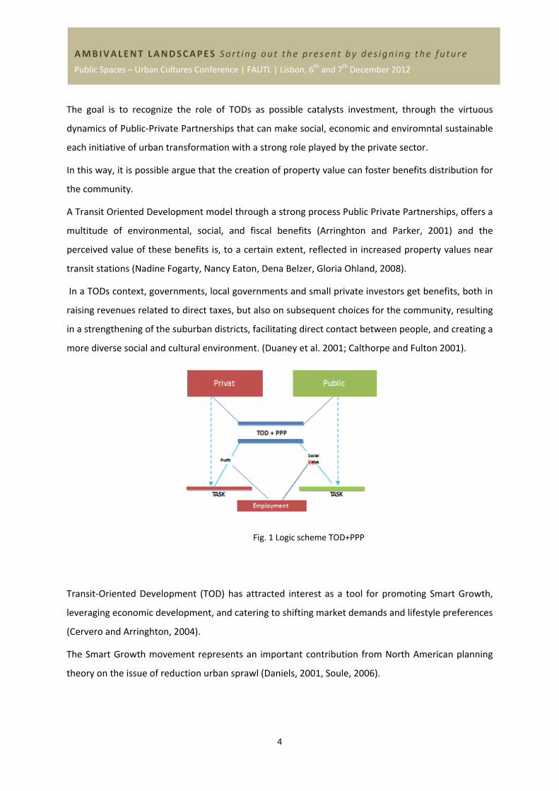
The goal is to recognize the role of TODs as possible catalysts investment, through the virtuous
dynamics of Public‐Private Partnerships that can make social, economic and enviromntal sustainable
each initiative of urban transformation with a strong role played by the private sector.
In this way, it is possible argue that the creation of property value can foster benefits distribution for
the community.
A Transit Oriented Development model through a strong process Public Private Partnerships, offers a
multitude of environmental, social, and fiscal benefits (Arringhton and Parker, 2001) and the
perceived value of these benefits is, to a certain extent, reflected in increased property values near
transit stations (Nadine Fogarty, Nancy Eaton, Dena Belzer, Gloria Ohland, 2008).
In a TODs context, governments, local governments and small private investors get benefits, both in
raising revenues related to direct taxes, but also on subsequent choices for the community, resulting
in a strengthening of the suburban districts, facilitating direct contact between people, and creating a
more diverse social and cultural environment. (Duaney et al. 2001; Calthorpe and Fulton 2001).
Fig. 1 Logic scheme TOD+PPP
Transit‐Oriented Development (TOD) has attracted interest as a tool for promoting Smart Growth,
leveraging economic development, and catering to shifting market demands and lifestyle preferences
(Cervero and Arringhton, 2004).
The Smart Growth movement represents an important contribution from North American planning
theory on the issue of reduction urban sprawl (Daniels, 2001, Soule, 2006).
5
AMBIVALENT LANDSCAPES Sort ing out the present by des ign ing the future
Public Spaces – Urban Cultures Conference | FAUTL | Lisbon, 6th and 7th December 2012
In the last two decades, Smart Growth implemented in almost all American States by the Transit
Oriented Development rationale tool becomes also in Europe a paradigm to be followed. (European
Community 2010).
Smart Growth, is the umbrella (Robert H. Freilich, Neil M. Popowitz, 2010) where different
approaches and theories can find a sort of protection, which share a common thread as revisiting the
link‐density public transport in view of the pursuit of sustainable urban.
The TODs model is divided into two principal schools of thought. The first is that of transportation by
Robert Cervero through qualitative analyzes show a link between public transport and urban form,
and the second, of the New Urbanism with Peter Calthorpe, which highlights the role of urban
density as a factor for the configuration of space assets useful to encourage the use of public
transport, and testing models of reference purely morphological, neglecting the quantitative aspects
of the phenomenon.
Two different schools of thought, but both point to the correlation between re‐ configuration space
of the system of urban center and public transport, recalling the well‐known models of Christaller
(1933).
The paper is articulated into three different sections. The first provides an overview of the
international literature on TODs in relation to the influence that they determine the formation of
value capture, and in relation to the stresses that cause the real estate market encouraging the
construction of Public‐Private Partnerships.
The second part of the literature review aims to bring out the key factors which affect the
construction of new urban centers that, in virtue of their specific spatial conformation, are capable to
support the construction of balanced and livable communities.
The third section, through the support of case studies, located in Massachusetts, in the metropolitan
area of Boston, Concord and Somerville, discusses the activate factors of these dynamics in two very
different contexts and offers an interesting discussion on the benefits at the community.
1.1 Transit Oriented Development and Public Private Partnership, that affecting on the new
community urban?
In the late 1990s and early 2000s, several books have made a link between TODs and sustainability
principles.
6
AMBIVALENT LANDSCAPES Sort ing out the present by des ign ing the future
Public Spaces – Urban Cultures Conference | FAUTL | Lisbon, 6th and 7th December 2012
The TOD theory is developed using an approach capable of integrating the urban and territorial
transformation with instances of socio‐economic development, it acts on the spatial configuration of
urban systems and defines new polarities, derived from the interaction with the economic processes
of "localization" of services, according to the principles of the new economic geography (Krugmann,
1990).
In 1826 the first studies on Location Theory, as the connection between spatial variation and
economic return, are by Johann Heinrich Von Thünen, which was the first to propose an association
between improved transportation and higher property values.
The actions proposed from TODs models in specific urban areas of the stations are aimed at
encouraging development "compact", throught the Public Private Partnerships, that to increase the
economic return on investment in the transport system and to maximize the use of existing stations.
The scientific litterature show that, “The key to success of the TODs are the Public Private
Partnership”(John Stainback e Renata Simril, in 2001).
In 1989, The National Council for Urban Economic Development in USA, argues that the Public
Private Partnerships are, “designed to decrease the costs of operating or constructing public
transportation systems, stations or improvements through creative public‐private financing
arrangements”, it are also “…real estate transactions involving the development of private projects
on publicly owned land or air rights” (Sedway Kotin Mouchly Group 1996).
The need to attract business and industry along with reduced public resources has led to the
communion of public‐private partnerships and urban regeneration.
Today in urban regeneration policies, the concept of community is combined with that of
partnerships, they are able to provide social services, but also to support the business and the
agenda of governments (MacLeavy July, 2009: p.849).
It is also recognized that in societies of people and communities, local authorities and private
entrepreneurs have the power to direct their interest towards negotiation.
However, according to Collin (1998), the PPPs tool can allow a public operator to have access to
specific skills or to create a strong antagonism to improve competition in the local market.
The PPPs tool, especially in the field of urban planning, has a number of complex variables that make
the application of these procedures complex, but three factors seem to be relevant: the context, the
actors and the balance between the partners.
7
AMBIVALENT LANDSCAPES Sort ing out the present by des ign ing the future
Public Spaces – Urban Cultures Conference | FAUTL | Lisbon, 6th and 7th December 2012
Indeed, the PPPs depending on the context and according to the different laws in different
continents, it is influenced by different cultures, as well at the different levels of democracy.
For this reason, it is recommended a difference use on the urban system, between the PPPs in
Europe (mainly used for the construction of infrastructure) and the United States (also used to
enhance the urban economy and regeneration processes).
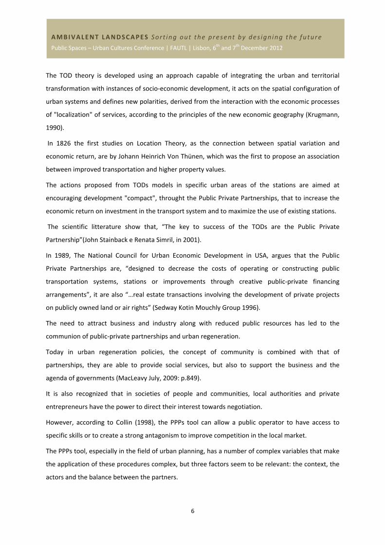
Fig. 2 Scheme employment TOD and PPP
In the United States in recent years, different No Profit Organization for example, Reconnecting
America, in collaboration with Local Government, which aims to promote "the integration of
transport systems with urban communities" (Reconnecting America, 2007), has demonstrated how
benefits are generated, particularly in the areas of travel behavior and property value.
Several positive effects are related to TOD (Arrington and Parker, 2001), in part for the benefit of
public transportation agencies and local governments, where growth has a displacement of iron,
resulting in a direct increase of earnings for transport companies, is also demonstrated by several
studies (Cervero and Duncan, 2002; Huang, 1996) as this type of intervention can generate processes
of capturing value in the areas of influence of stations, or to increase property values and land for
different uses, resulting in a potential increase in revenues to local governments through the
municipal tax base.
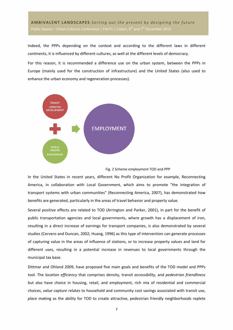
Dittmar and Ohland 2009, have proposed five main goals and benefits of the TOD model and PPPs
tool. The location efficiency that comprises density, transit accessibility, and pedestrian friendliness
but also have choice in housing, retail, and employment, rich mix of residential and commercial
choices, value capture relates to household and community cost savings associated with transit use,
place making as the ability for TOD to create attractive, pedestrian friendly neighborhoods replete
8
AMBIVALENT LANDSCAPES Sort ing out the present by des ign ing the future
Public Spaces – Urban Cultures Conference | FAUTL | Lisbon, 6th and 7th December 2012
with high‐quality civic spaces, similar to European cities, and the resolution of the tension between
node and place, by Luca Bertolini and Tejo Spit, who evaluated the redevelopment of rail station
precincts across Europe.
Fig. 3 The Goal of TOD
The principal benefits that TODs provide for communities are increases “location efficiency” so
people can walk, biking, and take transit. Boosting the transit ridership and minimized the impact of
traffic, provides a rich mix of housing, jobs, shops, and recreational choices, provides value for the
public and private sectors, and for new and existing residents.
1.2 TOD and Value Capture: what are the benefits for the community?
TODs are considerated a niche market in America. (John L. Renne, Keith Bartholomew, and Patrick
Wontor, 2008).
Numerous studies have demostated – forges partnerships that unlock the value of premium real
estate near transit (Ian Carlton, Transact 2011) ‐, and the impact of transit on surrounding real
estate, and have discovered that transit can generate a significant amount of value capture for
nearby property owners.
By a definition by Callies, David L. 1979, Robert M. Patricelli, “Although we cannot yet say that value
capture will be unfailingly successful in defraying the capital costs of development in all U.S. cities, it
offers a major untapped source of transit revenue.”
An important article, by John Landis and Robert Cervero, 1990, introduced the concept joint
development in the TOD theory ‐ the concept of Transit‐Joint Development (TJD) implies a quid pro
quo between the public sector and private developer. Usually they are transit agencies and private
9
AMBIVALENT LANDSCAPES Sort ing out the present by des ign ing the future
Public Spaces – Urban Cultures Conference | FAUTL | Lisbon, 6th and 7th December 2012
developers that work together under a common vision in order to create a successful economic
development.
TOD projects could be facilitated through joint development and value capture and that the public
sector can reduce risk for developers (John Renne 2009 and Peter Newman, 1997).
During the development phases, the public sector can help to expedite the approval process, provide
oversight of the development, and begin transit service, and lease or sell building space (which
depends on the agreement). The private sector should build the project and sell or lease buildings.
A value capture mechanism can be linked to density bonuses, rate increases, tax increment
financing, and a rail trust fund from parking revenue.
In Planning Process, the principle “Benefits Received” are positively capitalized into higher land
values, from particular infrastructure or service in the context of public transit, provision of or
enhancements to public transit systems accrue a accessibility‐related benefits to the neighboring
properties, (Shishir Mathur, Adam Smith 2012).
The Public Sector the increased land value, that can be captured through various mechanisms, for
example property tax revenues, the sale or joint development of public land in proximity to the
transit system, lease or sale of air rights above transit stations, levy of special assessments,
imposition of public transit impact fees, land‐value taxation, and capture of property tax increments
through Tax Incrementing Financing. (Shishir Mathur, Adam Smith 2012)
So, the role of the private sector is to establish goals, create a strong partnership with the local
government, create a new system and analyze market flexibility, develop winning strategies with the
public sector’s goals.
Land‐based initiatives, assembly, swaps, land banking, and the sale or lease of development rights, in
the respect to zoning, incentives such as density bonuses, performance zoning, inclusionary zoning,
interim zoning, floating zones, planned unit development, specific plans, and transfer of
development rights are all noted as important tools for TODs.
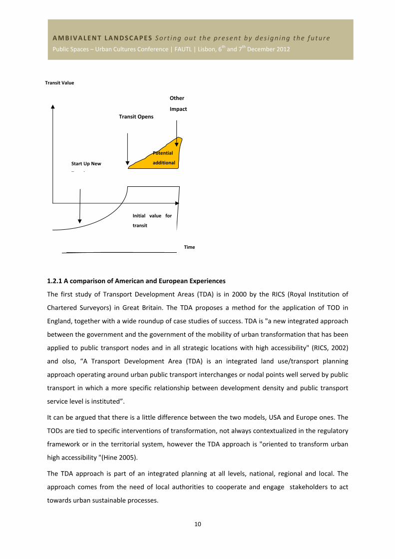
In figure 3, represent a hypothetical example that illustrates how property values might increase over
time as a result of new transit service, which is the estimated amount that a property owner near a
new transit station could expect to realize with a good value capture strategy.
10
AMBIVALENT LANDSCAPES Sort ing out the present by des ign ing the future
Public Spaces – Urban Cultures Conference | FAUTL | Lisbon, 6th and 7th December 2012
1.2.1 A comparison of American and European Experiences
The first study of Transport Development Areas (TDA) is in 2000 by the RICS (Royal Institution of
Chartered Surveyors) in Great Britain. The TDA proposes a method for the application of TOD in
England, together with a wide roundup of case studies of success. TDA is "a new integrated approach
between the government and the government of the mobility of urban transformation that has been
applied to public transport nodes and in all strategic locations with high accessibility" (RICS, 2002)
and olso, “A Transport Development Area (TDA) is an integrated land use/transport planning
approach operating around urban public transport interchanges or nodal points well served by public
transport in which a more specific relationship between development density and public transport
service level is instituted”.
It can be argued that there is a little difference between the two models, USA and Europe ones. The
TODs are tied to specific interventions of transformation, not always contextualized in the regulatory
framework or in the territorial system, however the TDA approach is "oriented to transform urban
high accessibility "(Hine 2005).
The TDA approach is part of an integrated planning at all levels, national, regional and local. The
approach comes from the need of local authorities to cooperate and engage stakeholders to act
towards urban sustainable processes.
Time
Start Up New
T i
Transit Opens
Other
Impact
Initial value for
transit
Transit Value
Potential
additional
b f
11
AMBIVALENT LANDSCAPES Sort ing out the present by des ign ing the future
Public Spaces – Urban Cultures Conference | FAUTL | Lisbon, 6th and 7th December 2012
In the last few years, in Europe, for example in France and Bodensee, in Oberschwaben (Germany), in
Stedenbaan (Holland), it’s so prevalent the need to use transit stations to connect a multipolar
system for regional economic development.
Dino Barri and Fiorenzo Ferlanino argue how this new division of rail transport has redesigned the
urban geography and planning, facilitating the establishment of new communities around the areas
of the existing stations, bringing improved public transport services, and integration between the
stations and the urban environment, through also bike‐sharing services, and the creation of
greenways and pedestrian access, and also introducing structures devoted to business.
1.3 Research Methodology
The discussion of the literature proposed in the previous section showed how the theory of TODs
enables the development of a potentially successful approach, not only to catalyze the interest of
private investors in urban transformation, due to the increase in land values, but also in encouraging
community building balanced and livable, with its emphasis on factors such as the social and
functional mixitè the basis of morphological principles underlying the design of urban TODs.
In order to see how the theory of TOD act as a activate in positive interaction between stress in the
housing market and construction of new urban communities, were examined two case studies, both
located in the metropolitan area of Boston, characterized by different situations.
The selection of the two cases has been directed to identify two urban contexts characterized by
poor conditions or deprivation in which it was possible analysed how physical transformation has
been implemented and embarked to improve physical environment and also socio‐economic
regeneration.
The case of Concord is located in a second metropolitan ring, and is served by a railway line, which
connects to the city center and in particular to the metro line that connects the station to Harvard.
The case of Somerville is located in the environs of the city center, in an area that started a
regeneration process that was emblematically defined "Slumville".
Both cases have in common from having focused on the implementation of the theory of TOD as a
catalyst for sustainable regeneration, in both cases, the successful implementation of initiatives
designed was the result of an effective synergy between the public and private sectors.
The study is part of a larger research project, the CLUDs project, which unfolds over a period of three
years and involves several European and U.S. units. The first year, just completed, this project has
12
AMBIVALENT LANDSCAPES Sort ing out the present by des ign ing the future
Public Spaces – Urban Cultures Conference | FAUTL | Lisbon, 6th and 7th December 2012
been focused on the study of the functioning of Public‐Private Partnerships in urban regeneration, by
analyzing thirteen case studies in the Boston area. The two case studies referred to in this paper are
included in this selection.
The analysis of the case studies was conducted with a primarily qualitative methodology, through the
analysis of secondary sources and through direct surveys.
First of all, it was carried out a systematic analysis of planning documents and planning involving the
two areas over the past decade.
Were collected and analyzed the main socio‐economic indicators and real estate market of the area
in question, properly compared with those of the wider context. An extract of the indicators analyzed
is shown in the discussion of case studies. Were administered semi‐structured interviews with key
stakeholders involved in the process of urban regeneration, following a strict protocol in line with the
ethical issues of the host institution.
In the description of case studies, whenever we refer to a given taken from the interviews. Finally,
analyzes were conducted several times on the field going places and conducting a thorough
photographic survey, which aims to record not only the physical environment but also the behavior
of the users. On the occasion of visits, were held short informal conversations with users of the sites.
1.3.1 Description Case Study
Concord Commons Commuter Rail
Concord Commons Commuter Rail, is a model of Transit Oriented Development, a mixed‐use
community that encourages people to live near transit services and to decrease dependence on their
driving” (Still 2002, Bernick and Cervero 1997, p. 5). The success key of the TOD are Public Private
Partnership, “designed to decrease the costs of operating or constructing public transportation
systems, stations or improvements through creative public private financing arrangements” (The
National Council for Urban Economic Development 1989 transit facility” (Cervero et al. 1991). The
strategy is Local property owners and developers have always worked with local government, and,
today, the resulting Concord Common development comprises three mixed use buildings with retail
space, office space, a 180 seat restaurant, and 20 rental apartments. With the final agreement
between the Town and Developer, required that he provide four affordable units at another location
in the Town, allowing all the units at the station to be rented at market rates, with the purpose to
13
AMBIVALENT LANDSCAPES Sort ing out the present by des ign ing the future
Public Spaces – Urban Cultures Conference | FAUTL | Lisbon, 6th and 7th December 2012
encourage the small retail and hinder the Global Market, and to keeps rents of the local stable in the
time.
Somerville
The Assembly Square district is Somerville’s largest commercial and industrial district with the
greatest potential for redevelopment. Over the past two years, the City undertook an aggressive
planning and redevelopment effort designed to convert this former industrial district to a transit
oriented mixed use “urban village”. The City completed a planning study of the district that
recommended a total build out over 20 years of at least 6 million square feet of commercial and
residential uses. Various public improvements are planned, including a new Orange Line MBTA
station within the district, roadway improvements, renovations and expansion of a waterfront park,
and improvements to pedestrian and bicycle access. The planning and redevelopment strategy for
Assembly Square is to reduce reliance on retail use by encouraging higher density office, R&D, and
residential uses. The aim of the project is to revitalize an area that is of particular importance in the
development plan of the city. Its proximity to Boston and Cambridge make Somerville a gravitational
center capable of attracting tourism and new investment. This is the goal to achieve with this project,
which not only create a new district but also a new use and capable of generating new functions for
the city needed for its management and the possibility of developing through specific programs, the
infrastructures that will enable the city to become a truly strategic hub in the Boston metropolitan
area. The Public Private Partnership between the city and Develop allowed to share a journey to
reach this goal within a few years that will change the face of the whole area. The resulting plan
envisions a vibrant, mixed use, urban neighborhood and commercial center providing significant local
and regional benefits including 19,000 new jobs, increased tax revenues, market rate and affordable
housing, improved access to transportation.
Furthermore, the proximity to the shores of the Mystic River, allows ownership by the citizens of new
recreational spaces opening the city to its waterfront.
The key industries in Somerville are health services, retail, business services and creative design.
Somerville's local economic base is heavily influenced by three factors: its dense residential
population, the nature of its commercial and industrial building stock, and its proximity to Boston.
1.3.2 Discussion of case study
Through statistical surveys analysed on two empirical case studies, Concord and Somerville, we can
say that in this last decade, in this context, there have been many benefits for the community.
14
AMBIVALENT LANDSCAPES Sort ing out the present by des ign ing the future
Public Spaces – Urban Cultures Conference | FAUTL | Lisbon, 6th and 7th December 2012
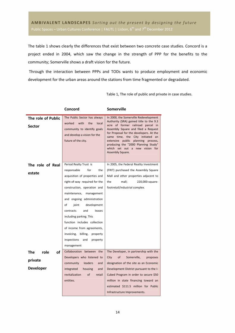
The table 1 shows clearly the differences that exist between two concrete case studies. Concord is a
project ended in 2004, which saw the change in the strength of PPP for the benefits to the
community; Somerville shows a draft vision for the future.
Through the interaction between PPPs and TODs wants to produce employment and economic
development for the urban areas around the stations from time fragmented or degradated.
Table 1, The role of public and private in case studies.
Concord Somerville
The role of Public
Sector
The Public Sector has always
worked with the local
community to identify goals
and develop a vision for the
future of the city.
In 2000, the Somerville Redevelopment Authority (SRA) gained title to the 9.3 acre of former railroad parcel in Assembly Square and filed a Request for Proposal for the developers. At the same time, the City initiated an extensive public planning process, producing the "2000 Planning Study" which set out a new vision for Assembly Square.
The role of Real
estate
Period Realty Trust is
responsable for the
acquisition of properties and
right‐of‐way required for the
construction, operation and
maintenance, management
and ongoing administration
of joint development
contracts and leases
including parking. This
function includes collection
of income from agreements,
invoicing, billing, property
inspections and property
management
In 2005, the Federal Reality Investment
(FRIT) purchased the Assembly Square
Mall and other properties adjacent to
the mall; 220,000‐square‐
footretail/industrial complex.
The role of
private
Developer
Collaboration between the
Developers who listened to
community leaders and
integrated housing and
revitalization of retail
entities.
The Developer, in partnership with the
City of Somerville, proposes
designation of the site as an Economic
Development District pursuant to the I‐
Cubed Program in order to secure $50
million in state financing toward an
estimated $111.5 million for Public
Infrastructure Improvements.
15
AMBIVALENT LANDSCAPES Sort ing out the present by des ign ing the future
Public Spaces – Urban Cultures Conference | FAUTL | Lisbon, 6th and 7th December 2012
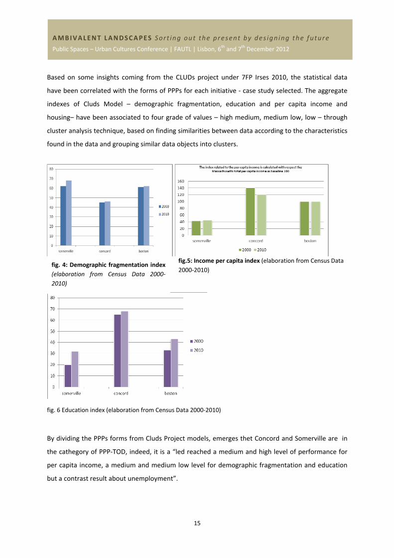
Based on some insights coming from the CLUDs project under 7FP Irses 2010, the statistical data
have been correlated with the forms of PPPs for each initiative ‐ case study selected. The aggregate
indexes of Cluds Model – demographic fragmentation, education and per capita income and
housing– have been associated to four grade of values – high medium, medium low, low – through
cluster analysis technique, based on finding similarities between data according to the characteristics
found in the data and grouping similar data objects into clusters.
fig.5: Income per capita index (elaboration from Census Data
2000‐2010)
fig. 6 Education index (elaboration from Census Data 2000‐2010)
By dividing the PPPs forms from Cluds Project models, emerges thet Concord and Somerville are in
the cathegory of PPP‐TOD, indeed, it is a “led reached a medium and high level of performance for
per capita income, a medium and medium low level for demographic fragmentation and education
but a contrast result about unemployment”.
fig. 4: Demographic fragmentation index
(elaboration from Census Data 2000‐
2010)
16
AMBIVALENT LANDSCAPES Sort ing out the present by des ign ing the future
Public Spaces – Urban Cultures Conference | FAUTL | Lisbon, 6th and 7th December 2012
In Conclusion, through investigation and analysis on case studies, we can say that the results are
divided into three points:
Increased competitiveness urban through the application of a TOD model.
Increased capitalization of investments for private, and it is generator to "Socialization of
Profits", and consists mainly in the distribution of positive impact for the whole community.
Increased the role of transport, which have the task of maximizing the cost‐effectiveness of
services, adding value to local entrepreneurs, so that increases the retail sale of products
local.
Experience in this case studies have demonstrated that implementing TOD can result in significant
benefits to individuals, communities and entire regions by improving the quality of life for people of
all ages and abilities to live, work, shop, learn and play. Conventional development often consumes
acres of land, requires extensive investments in infrastructure, and perpetuates dependence on
private vehicles. TOD reduces travel time, shortens journeys and provides no motorized trip options,
helping to reduce our reliance on the automobile. The case studies have illustrated how transit
supportive policies, planning and coordinated investment in land use and transportation, and the
Public Private Partnerships, can create opportunities and benefits for the community.
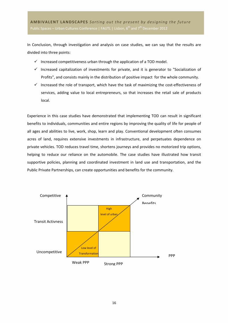
Competitive
Uncompetitive PPP
Transit Activness
Weak PPP Strong PPP
Community
Benefits
Low level of
Transformation
High
level of urban
17
AMBIVALENT LANDSCAPES Sort ing out the present by des ign ing the future
Public Spaces – Urban Cultures Conference | FAUTL | Lisbon, 6th and 7th December 2012
So, the papers want to recognize the TODs potential as catalysts for investment, in any urban context
the European and American, throught a strong Public Private Parthnership, and supported by an
integrated planning, they becomes the real force of change, that raises property values by
encouraging the transformation of the existing, with the goal of obtaining as positive impact a
“Socialization of Profits” and distribute equally of rhe services.
ACKNOWLEDGEMENTS
This presentation draws from the activities of the Cluds Research Program, funded within the
framework of the EU IRSES MARIE CURIE 7FP. The research is led by Pau‐University Mediterranea of
Reggio Calabria (Italy) and the participants are: FOCUS‐university of Rome La Sapienza (Italy); SOBE‐
University of Salford (uk); Aalto University (Finland); Northeastern University of Boston (Usa) and San
Diego State University (USA).
REFERENCES
(journal article)
1000 Friends of Oregon (1993). “The Pedestrian Environment Model Modifications”. Vol. 4A and Vol.
6. Portland, OR: LUTRAQ
Bertolini L, Dijst M (2003) Mobility environments and network cities, Journal of Urban Design, 8,
1:23‐43
Boarnet M, Crane R (1998) Public Finance and Transit Oriented Planning: New Evidence from
Southern California Journal of Planning Education and Research 17:206‐219
Boarnet M.G. and Compin N. S. (1999). “Transit‐Oriented Development in San Diego County. The
incremental Implementation of a Planning Idea”, Journal of American Planning Association, Winter
1999, N. 65, pp. 80‐95
Cervero R. and Kockelmann K. (1997). “Travel demand and the 3 Ds: density, diversity and design”,
Transportation Research, Part D2, 2 (3), 199‐219
Cervero R. (2002). “Built environments and mode choice: toward a normative framework”,
Transportation Research Part D: Transport and Environment, Vol. 7 (4), pp. 265‐284
18
AMBIVALENT LANDSCAPES Sort ing out the present by des ign ing the future
Public Spaces – Urban Cultures Conference | FAUTL | Lisbon, 6th and 7th December 2012
Davidoff P. (1965) “Advocacy and Pluralism in Planning”, Journal of the American Institute of
Planners, 31, 4, November
Dematteis G. and Governa F. (2002) “Grandi infrastrutture e sistemi locali. Il valore aggiunto
territoriale delle infrastrutture di trasporto”, Scienze Regionali Italian Journal of Regional Science,
Vol. 3/2002, Franco Angeli, Milano
Krizek K.J. (2005). “Book Review: The New Transit Town: Best Practices in Transit‐Oriented
Development”, Journal of Planning Literature, Vol. 19, pp. 349‐ 350
Lund H. (2006). “Reasons for Living in a Transit‐Oriented Development, and Associated Transit‐Use”,
Journal of American Planning Association, Vol. 72, pp. 357‐366
Peter Newman&Jeffrey Kenworthy,(2006)Urban Design to Reduce Automobile Dependence, An
International Journal of Suburban and Metropolitan Studies, : Vol. 2: No. 1, Article 3.
Renne, J. (2009). “From transit‐adjacent to transit‐oriented development”, Local Environment Vol.
14, N. 1, January, pp. 1‐15
(conference paper)
Belzer D. and Autler G. (2002). Transit Oriented Development: moving from Rhetoric to Reality .
Washington D.C.: The Brookings Institution Center on Urban and Metropolitan Policy and The Great
American Station Foundation
Bernick, Michael and Peter Hall. (1990). Land Use Law and Policy for Maximizing Use of
CaliforniaÕs New Inter‐Regional Rail Lines. IURD Working Paper number 523.
Berkeley, California: University of California IURD. http://www.uctc.net/papers/343.pdf
Bernick, Michael and Michael Carroll. (1991). A Study of Housing Built Near Rail Transit
Stations: Northern California. IURD Working Paper number 582. Berkeley,
California: University of California IURD.
Bernick, Michael and Peter Hall. (1992). The New Emphasis on Transit‐Based Housing
throughout the United States. IURD Working Paper number 580. Berkeley,
California: University of California IURD.
Bernick, Michael, Peter Hall, and R. Shaevitz. (1992). New Planning Strategies for
Transit‐Based Housing in Northern California. IURD Working Paper number 582.
19
AMBIVALENT LANDSCAPES Sort ing out the present by des ign ing the future
Public Spaces – Urban Cultures Conference | FAUTL | Lisbon, 6th and 7th December 2012
Berkeley, California: University of California IURD
Curtis C., Renee J. and Bertolini L. (2009). Transit Oriented Development. Making it Happen. Surrey,
UK: Ashgate
Hale C. and Charles P. (2007), “A Step‐by‐Step Approach to Transit Oriented Development Project
Delivery”, 11th World Conference on Transport Research University of California, Berkeley, 24‐28
June
Landis, John, Robert Cervero and Peter Hall. (1991). Transit Joint Development in the USA: An
Inventory and Policy Assessment. Environment and Planning C:Government and Policy 9: 431‐452.
Rullani E., (2001),"Il distretto industriale come sistema adattivo complesso", paper presentato in
occasione degli Incontri pratesi "Lo sviluppo locale", Villa medicea di Artimino, 10‐14 settembre
2001, p. 6. I.R.I.S.
TABUCHI, Takatoshi & THISSE, Jacques‐François, (2003). "Regional specialization, urban hierarchy,
and commuting costs," CORE Discussion Papers 2003060, Université catholique de Louvain, Center
for Operations Research and Econometrics (CORE).
Luisa Debernardi, (2005), Distretto della cultura, dello sport e del loisir della citta’ di torino e delle
sue valli alpine, uno sguardo alla teoria e alla letteratura Working paper n. 1/
(book)
Ache P. and Andersen H.T. (2008) “Cities Between Competitiveness and Cohesion: Discourses,
Realities and Implementation”, in: Ache A., Andersen H.T., Raco M. and Taşan‐Kok T. (eds.) Cities
between Competitiveness and Cohesion, Springer, London
Ball M. (2003), Synergy in Urban Regeneration Partnerships: Property Agents’ Perspectives, Urban
Studies, Vol. 40, No. 11 pp. 2239–2253
Bernick, Michael. (1990). The Promise of CaliforniaÕs Rail Transit Lines in the Siting of
New Housing. Report to the California Senate Transportation Committee and the
Senate Housing and Urban Affairs Committee.
Bertolini L. (2008) Station areas as nodes and places in urban networks: An analytical tool and
alternative development strategies, in Bruinsma et al. (eds.) Railway Development: Impacts on Urban
Dynamics, Physica‐Verlag a Springer Company
20
AMBIVALENT LANDSCAPES Sort ing out the present by des ign ing the future
Public Spaces – Urban Cultures Conference | FAUTL | Lisbon, 6th and 7th December 2012
Bevilacqua C., (2001)Politiche di sviluppo e pianificazione territoriale, tra innovazione e prassi
ordinaria, collana diretta da Enrico Costa, Roma, Gangemi Editore,.
Borri D. e Ferlaino Fiorenzo,(2009) Crescita e sviluppo regionale: strumenti, sistemi, azioni, editore
Franco Angeli, Milano
Cervero R. and Bernick M. (1997). Transit Villages in the 21st Century. New York: McGraw‐Hill
Cervero R. (1989). America’s Suburban Activity Centers: The Land Use‐ Transportation Link. Boston:
Unwin‐Hyman.
Dematteis G., (2000)"Per una geografia della territorialità attiva e dei valori territoriali" in P. Bonora
(a cura di), SLOT quaderno 1 – Progetto nazionale di ricerca sui sistemi locali nei processi di sviluppo
territoriale, Torino, Baskerville,.
Dematteis G. e Bonavero P. (a cura di), (1997) Il sistema urbano italiano nello spazio
unificatoeuropeo, Bologna, Il Mulino.
De Matteis G. Governa F. (eds) (2001) Contesti Locali e Grandi Infrastrutture. Politiche e Progetti in
Italia e in Europa, Franco Angeli, Milano
Di Bernard H. Ross,Myron A. Levine, (2004) “Urban Politics: Cities and Suburbs in a Global Age”,
seventh edition,
Dittmar H and Ohland G (2004). The New Transit Town. Washington, D.C: Island Press
Dunphy R.T., Cervero R., Dock F.C., McAvey M., Porter D.R. and Swenson C.J. (2004). Developing
Around Transit. Strategies and Solutions That Work. Washington D.C.: Urban Land Institute.
Grimsey D., Lewis M. (2007), Public Private Partnerships: the worldwide revolution in infrastructure
provision and project finance, Edward Elgar Publishing.
Lowry I. S. (1964) Modello di una metropoli, traduzione e commento di A. Fadini e F. Forte, Guida
Editori,Napoli.
Martinotti Guido, (1993), Metropoli. La nuova morfologia sociale della città, Il Mulino,Bologna.
Marvin Splintering Urbanism: Networked Infrastructures, Technological Mobilities and the Urban
Condition
Moraci F. e Bevilacqua C. , (2007) Strategie in città. La riorganizzazione dell'offerta dei servizi nei
processi di trasformazione, Officina Edizioni, Roma.
Pushkarev, Boris S. and Jeffrey M. Zupan. (1977). Public Transportation and Land Use
21
AMBIVALENT LANDSCAPES Sort ing out the present by des ign ing the future
Public Spaces – Urban Cultures Conference | FAUTL | Lisbon, 6th and 7th December 2012
Policy. Bloomington, IN: Indiana University Press.
Ortuzar, Juan de D. and Luis G. Willumsen. (1994). Modeling Transport. New York:
John Wiley and Sons.
Porter M.E. (1998)On competition, Boston: HBS Press..
Pucci P., (1996) I nodi infrastrutturali: luoghi e non luoghi metropolitani, Franco Angeli, Milano
Putman, Stephen H. (1983). Integrated Urban Models: Policy Analysis of Transportation and Land
Use. London: Pion Limited.
Enzo Rullani (2004)Economia della conoscenza. Creatività e valore nel capitalismo delle reti,di ‐
Carocci, Roma
Enzo Rullani E Aldo Bonomi, (2005) Piccole imprese crescono. Fare rete in un'area metropolitana di ‐
EGEA, Milano
Sassen S., (1991), The Global City: New York, London, Tokyo,Princeton University Press
Sforzi F., (1987) “L’identificazione spaziale”, in Becattini G. (a cura di), Mercato e forze locali: il
distretto industriale, Il Mulino, Bologna,
Sforzi F., (1997)"Il cambiamento economico nel sistema urbano italiano", in Dematteis G. Bonavero
P. (a cura di), Il sistema urbano italiano nello spazio unificato europeo, Bologna, Il Mulino, , p. 206 –
207.
Smith, David A. and Michael F. Timberlake. (2001). "World City Networks and Hierarchies, 1977‐
1997." American Behavioral Scientist 44 (10): 1656‐1678.
Wellman, Barry. (2001). "The Rise of Networked Individualism." in Community Networks Online,
edited by Leigh Keeble. London: Taylor & Francis
Report Aecom An Affiliate Of Dmjm Harris, (2007) Case Studies of Transportation Public‐Private
Partnerships around the Consult, Report.
Arrington G.B., Parker T. (2001) Factors for Success in California’s Transit‐Oriented Development.
Sacramento: California Department of Transportation, Statewide
Transit‐Oriented Development Study.
22
AMBIVALENT LANDSCAPES Sort ing out the present by des ign ing the future
Public Spaces – Urban Cultures Conference | FAUTL | Lisbon, 6th and 7th December 2012
Bertolini L. (1996) Il ruolo delle stazioni ferroviarie nel sistema policentrico Olandese, Atti del
seminario“L’interconnessione e il ruolo dei nodi nella pianificazione del territorio”, Politecnico di
Milano
Boarnet M.G. and Crane R. (2001). Travel by Design. The influence of Urban Form on Travel. New
York: Oxford University Press Calthorpe Associates. Transit‐Oriented Design Guidelines, 1990.
Calthorpe P. and Fulton W. (2001). The Regional City. Planning for the End of Sprawl. Washington
D.C.: Island Press
Cervero R. (1998). The Transit Metropolis. A global Inquiry. Washington D.C.: Island Press
Cervero R., Ferrell C., Murphy S. , (2002)Transit‐Oriented Development and Joint Development in the
United States:A Literature Review, TCRP REPORT 102, Sponsored by the Federal Transit
Administration.
Curtis C. and James B. (2004). “An Institutional Model for Land Use and Transport Integration”, Urban
Policy and Research, Vol. 22, N. 3, September, pp. 277‐297
Dematteis G., (2005) “Verso un policentrismo europeo: metropoli, città reticolari, reti di città”, in:
Urbanistica Dossier 75/.
DTFTA (Department of Transportation Federal Transit Administration) and DHUD (Department of
Housing and Urban Development) (2008). Better Coordination of Transportation and Housing
Programs to Promote Affordable Housing Near Transit. Washington, DC: U.S. Department of Housing
and Urban Development Office of Policy Development and Research
Frank L.D. and Pivo G. (1994). “Relationship Between Land Use and Travel Behavior”, in: The Puget
Sound Region. Olympia, WA: Washington State Department of Transportation
Handy S. (2005). “Smart Growth and the Transportation‐ Land Use Connection: what Does the
Research Tell Us?”, International Regional Science Review, Vol. 28, N. 2, pp. 146‐167
Losch A. (1940)Die Raumliche Ordnung der Wirtschaft Jena, traduzione in inglese di W. H. Woglom e
W.F. Stopler (1954): “The Economics of Location” New Haven: Yale University Press.
Middleton W (1967) The time of the trolley Milwaukee WI Kalmbach Publishing
Migliorini F. (2003) Urbanistica e trasporti, Relazione presentata al XXIV Congresso INU, Milano
23
AMBIVALENT LANDSCAPES Sort ing out the present by des ign ing the future
Public Spaces – Urban Cultures Conference | FAUTL | Lisbon, 6th and 7th December 2012
Moses S., Lewis C.A. and Lastrape K. (2009). Moving Toward Implementation: An Examination of the
Organizational and Political Structures of Transit‐Oriented Development. Houston, Texas: Center for
Transportation Training and Research Texas Southern University
Nelson D., Niles J. and Hibshoosh A. (2001). A New Planning Template for Transit‐Oriented
Development. San Jose (CA): Mineta Transportation Institute
Nelson D. and Nygaard D. (1995). “Land use and Transit Demand: the Transit Orientation Index”, in:
Primary Transit Network Study. Portland, OR: Tri‐Met
Pill, Juri. (1988). Toronto: Thirty Years of Transit Development. In Transit, Land Use, and Urban Form.
Wayne Attoe, ed. Austin, Texas: School of Architecture, University of Texas at Austin.
Pushkarev B.S. and Zupan J.M. (1982). “Where Transit works: Urban Densities for Public
Transportation”, in: Urban Transportation: Perspective and Prospects, ed. By H.S. Levinson and R.A.
Weant, Westport, CT: Eno Foundation
− RICS Policy Unit (2002) Land Values and Public Transport: stage 1‐ summary of findings.
S. Mark White. James B. McDaniel, TRB Counsel for Legal Research Projects, (1999), The Zoning And
Real estate Implications of Transit Oriented Development , TCRP REPORT 102, Sponsored by the
Federal Transit Administration.
Smith J.J. and Gihring T.A. (2006). Financing Transit Systems Through Value Capture. An Annotated
Bibliography. Victoria Transport Policy Institute, September
Takatoshi Tabuchi & Jacques‐François Thisse, (2006). "Regional Specialization, Urban Hierarchy, And
Commuting Costs," International Economic Review, Department of Economics, University of
Pennsylvania and Osaka University Institute of Social and Economic Research Association, vol. 47(4),
pages 1295‐1317, November.
Transit Cooperative Research Program (1996). Transit and Urban Form. Washington D.C.: National
Academy Press
Transit Cooperative Research Program (2004). Report 102, Transit‐Oriented Development in the
United States: Experiences, Challenges, and Prospects. Washington D.C.: www.TRB.org
Transportation Research Board, Smart Growth and Transportation (2002). Issues and Lessons
Learned. Conference Proceedings 32, September 8‐10. Baltimore, Maryland
24
AMBIVALENT LANDSCAPES Sort ing out the present by des ign ing the future
Public Spaces – Urban Cultures Conference | FAUTL | Lisbon, 6th and 7th December 2012
Transit Cooperative Research Program, TCRP Project J‐5, “Legal Aspects of Transit and Intermodal
Transportation Programs,” (AUGUST 2011), John L. Renne, Ph.D., AICP; Keith Bartholomew, J.D.; and
Patrick Wontor. James B. McDaniel, TRB
(book and book chapter)
Becattini G. (a cura di Carlo Carboni) , Modelli locali di sviluppo. Il Mulino, Bologna 1989.
Calavita, Nico. (1993). A Little Bit of Seaside Comes to Southern California. Planning 59,
9: 24‐25.
Calthorpe P. (1993). The next American Metropolis. Ecology, Community, and the American Dream.
New York: Princeton Architectural Press
Camagni R., (1992)Economia Urbana, Roma, NIS.
Camagni R., (1993)Principi di economia urbana e territoriale, Carocci.
Camagni R.P., De Blasio G. (1993)Le reti di città: teoria, politiche e analisi nell’area padana, Angeli,
Milano.
Cervero R. and Bernick M. (1997). Transit Villages in the 21st Century. New York: McGraw‐Hill
(Website)
http://www.bart.gov/docs/planning/TOD_Guidlines.pdf
http://www.mass.gov/envir/smart_growth_toolkit/pages/how‐to‐SG.html, consult the 02/2012
http://www.mass.gov/envir/smart_growth_toolkit/pages/CS‐tod‐concord.html, consult the 12/2011
http://www.concordma.gov/Pages/ConcordMA_Bylaws/index, consult the 12/2011
http://www.regional‐studies‐assoc.ac.uk/events/2012/may‐delft/papers/pdfs/bevilacqua‐et‐al.pdf,
consult the 06/2012
http://www.sedcinc.org/about/docs/mar09/Item8b_Proposotion_1C.pdf
http://www.state.nj.us/transportation/community/village/index.shtml
http://www.fhwa.dot.gov/ipd/pdfs/us_ppp_case_studies_final_report_7‐7‐07.pdf
http://www.jacobscenter.org/about.html
http://www.sandiego.gov/planning/community/profiles/encanto/
http://www.planning.dot.gov/documents/casestudy/cities/returning_city.htm#sd
25
AMBIVALENT LANDSCAPES Sort ing out the present by des ign ing the future
Public Spaces – Urban Cultures Conference | FAUTL | Lisbon, 6th and 7th December 2012
http://reconnectingamerica.org/resource‐center/books‐and‐reports/2010/performance‐based‐
transit‐oriented‐development‐typology‐guidebook/
http://jcmc.indiana.edu/vol8/issue3/wellman.html