Embed Size (px)
Citation preview

Office of Airspace Regulation Page 1 of 33
Aeronautical Study of Cairns August 2014 Version: 1.0
Aeronautical Study of
Cairns August 2014

Office of Airspace Regulation Page 2 of 33
Aeronautical Study of Cairns August 2014 Version: 1.0
DOCUMENT SPONSOR: OFFICE OF AIRSPACE REGULATION
PROJECT NUMBER: 12 – 7 2012
TRIM REFERENCE: D14/417397
FILE REF: EF12/3566
Document control:
Version Issue/Nature of Revision Date 0.1 Draft August 2012 0.2 Draft with review comments March 2013 0.3 Additional comments incorporated June 2013 0.4 Incorporates Management comments January 2014 0.5 Movement data updated August 2014 1.0 Incorporate Industry Feedback September 2014

Office of Airspace Regulation Page 3 of 33
Aeronautical Study of Cairns August 2014 Version: 1.0
1 EXECUTIVE SUMMARY
This aeronautical study was commissioned in response to the Government’s expectation for the Civil Aviation Safety Authority (CASA1) to undertake regular and ongoing studies to meet its obligations under Section 13 of the Airspace Act 2007 (Act). The Office of Airspace Regulation (OAR) undertakes a risk based approach in determining which locations are studied. The purpose of this aeronautical study was to conduct a review of the airspace classification within 50 Nautical Miles (NM) of Cairns aerodrome, Queensland. Particular emphasis is placed on the safety of Passenger Transport2 (PT) operations. 1.1 Operational Context Cairns aerodrome is situated approximately seven kilometres north of the Cairns Central Business District. Cairns aerodrome (hereafter referred to as Cairns) is a certified aerodrome operated by Cairns Airport Pty Ltd. The aerodrome caters for more than four million domestic and international passengers annually. The airspace within 50 NM of Cairns is used by PT operators, the Department of Defence (Defence), Emergency Services, flying training organisations, charter companies, private pilots, helicopter operators, skydiving operators, seaplane operators, sightseeing operations, balloon operators, hang gliders and recreational (ultralight and microlight) pilots. The airspace surrounding Cairns from the surface to Flight Level (FL) 180 comprises:
a. Class C Control Zone; b. Class C Control Area; c. Class G non-controlled airspace; d. Restricted Areas; and e. Danger Areas.
All of the Air Traffic Services within the study airspace are provided by Airservices Australia (Airservices). Electronic surveillance for the Cairns airspace is delivered from two radar sites, the first radar site is located a few hundred metres to the north of the aerodrome at Redden Creek. The Redden Creek radar was refurbished and commissioned in 2012. The facility incorporates a Primary Surveillance Radar and a Mode S Secondary Surveillance Radar. The Redden Creek radar provides surveillance for the Cairns Terminal Control Unit. The second radar site is also a Secondary Surveillance Radar, it provides enroute surveillance located approximately 55 kilometres to the west of Cairns in the Hann Tablelands. Automatic Dependent Surveillance – Broadcast (ADS-B) ground stations3 support the Cairns based radar sites to provide high altitude transcontinental electronic surveillance across Australia outside radar coverage.
1 A full list of acronyms and abbreviations used within this report can be found at Annex A. 2 For the purposes of this study, PT services can be defined as activities involving Regular Public Transport and all non- freight-only Charter operations. 3 http://www.airservicesaustralia.com/wp-content/uploads/adsb_at_30000ft_GM.jpg

Office of Airspace Regulation Page 4 of 33
Aeronautical Study of Cairns August 2014 Version: 1.0
1.2 Issues The key issues raised by airspace users during the generative interviews, questionnaires and stakeholder forums have been identified as follows:
• The current Runway 15 Standard Instrument Departures, in their initial phases, are not Procedures for Air Navigation Services – Aircraft Operations (PANS-OPs) compliant. The 190 knot (kt) speed restriction is less than the PANS-OPs minimum speed of 204 kt for this operation and the minimum bank angle of 25 degrees is 10 degrees greater than the PANS-OPs maximum for this operation. This issue has been drawn to CASA’s attention in the past and approval to its continued use was provided to Airservices.
• Cairns airport closed runway 12/30. The primary purpose of runway 12/30 was to support light aircraft operations, this reduced the overall traffic demands on runway 15/33. While runway 12/30 remains closed, traffic operating on runway 15/33 has increased placing attention on flow management resulting in Air Traffic Control (ATC) to closely monitor aircraft runway occupancy times.
1.3 Findings / Conclusions • The development of a Required Navigation Performance (RNP) departure to
the south from runway 15 may provide an increase in safety, and may provide additional efficiencies to aircraft operations.
• As a result of the closure to runway 12/30, the amount of runway incursions to runway 15/33 has decreased.
• Aircraft occupancy times on runway 15/33 and the follow on effects to traffic flow are being monitored by ATC for the possible development of rapid-exit taxiways.
• The current Cairns airspace architecture works well for the volume and mix of traffic.
1.4 Recommendations It is important to note that the study may make recommendations based on existing data. CASA applies a precautionary approach when conducting aeronautical studies and therefore the following recommendations are made:
1. Airservices should consider the provision of a RNP departure to the south of Cairns from runway 15.
2. The current airspace structure works well for the current traffic level and should be retained.

Office of Airspace Regulation Page 5 of 33
Aeronautical Study of Cairns August 2014 Version: 1.0
Contents
1 EXECUTIVE SUMMARY ..................................................................................... 3
2 INTRODUCTION ................................................................................................. 6
3 AERODROME ..................................................................................................... 8
4 AIRSPACE ........................................................................................................... 8
5 AIRSPACE USERS AND AERONAUTICAL INFORMATION………….…………12
6 CONSULTATION ............................................................................................... 13
7 TRAFFIC DATA ................................................................................................. 15
8 INCIDENT AND ACCIDENT DATA .................................................................... 17
9 AIRSPACE REFORM ........................................................................................ 18
10 AIRSPACE RISK AND OTHER MATTERS ....................................................... 21
11 SUMMARY OF ISSUES ..................................................................................... 23
12 FINDINGS AND CONCLUSIONS ...................................................................... 24
13 CASA RECOMMENDATIONS ........................................................................... 24
14 REFERENCES………………………………………………………………………...25
ANNEX A - ACRONYMS AND ABBREVIATIONS….……………………………..……26
ANNEX B - AUSTRALIAN AIRSPACE STRUCTURE .............................................. 27
ANNEX C - STAKEHOLDERS ................................................................................. 28
ANNEX D - STAKEHOLDER CONSULTATION / FEEDBACK REGISTER…………30
Office of Airspace Regulation Page 6 of 33
Aeronautical Study of Cairns August 2014 Version: 1.0
2 INTRODUCTION
The Office of Airspace Regulation (OAR) within the Civil Aviation Safety Authority (CASA) has carriage of the regulation of Australian-administered airspace, in accordance with section 11 of the Airspace Act 2007 (Act). Section 12 of the Act requires CASA to foster both the efficient use of Australian-administered airspace and equitable access to that airspace for all users. CASA must also take into account the capacity of Australian-administered airspace to accommodate changes to its use. In exercising its powers and performing its functions, CASA must regard the safety of air navigation as the most important consideration4. Section 3 of the Act states that ‘the object of this Act is to ensure that Australian-administered airspace is administered and used safely, taking into account the following matters:
a. protection of the environment; b. efficient use of that airspace; c. equitable access to that airspace for all users of that airspace; d. national security.’
2.1 Overview of Australian Airspace In line with the International Civil Aviation Organization (ICAO) Annex 11, Australian airspace is classified as Class A, C, D, E and G depending on the level of service required to manage traffic safely and effectively. Class B and F are not currently used in Australia. The classification determines the category of flights permitted and the level of Air Traffic Service (ATS) provided. Annex B provides details of the classes of airspace used in Australia. Within this classification system aerodromes are either controlled (i.e. Class C or Class D) or non-controlled. Non-controlled aerodromes in Australia are subject to Common Traffic Advisory Frequency procedures. Pilots of aircraft operating at all registered, certified, Military and CASA designated aerodromes are required to carry and use a Very High Frequency (VHF) radio. Further information about aircraft operations at non-controlled aerodromes can be found on the CASA website. 2.2 Purpose The purpose of this aeronautical study was to conduct a review of the airspace within 50 Nautical Miles (NM) of Cairns aerodrome, Queensland. Particular emphasis is placed on the safety of Passenger Transport5 (PT) operations. The study forms part of the OAR program of work to review Australia’s airspace as required by the Act. The outcome of the study is to demonstrate that all sensible and practicable precautions are in place to reduce the risk to acceptable levels. For the purpose of this study, a multifaceted approach was used including quantitative and qualitative analysis consisting of:
• Stakeholder interviews;
• Incident analysis;
• Review of movement data; and 4 Civil Aviation Act 1988, Section 9A – Performance of Functions 5 For the purposes of this study, PT services can be defined as activities involving Regular Public Transport and all non- freight-only Charter operations.

Office of Airspace Regulation Page 7 of 33
Aeronautical Study of Cairns August 2014 Version: 1.0
• Site visit.
2.3 Scope The scope of the study includes identification and consultation with stakeholders to gather necessary data and information related to airspace issues around the Cairns aerodrome. As a minimum, this includes consultation with Airservices Australia (Airservices), PT operators, Charter operators, Flying Training Schools, Department of Defence (Defence), Emergency Services operators and the Aerodrome Operator. The scope of this study is not intended to examine aerodrome facilities and infrastructure issues beyond what is necessary to determine any weakness or failings that have a significant impact on the safety of airspace operations in the vicinity of Cairns. 2.4 Objective The objective of this study is to examine the airspace within 50 NM of Cairns aerodrome to determine the appropriateness of the current airspace classification. This was accomplished by:
a. Investigating through stakeholder consultation the appropriateness of the current airspace classification, access issues, instrument approach design6 issues, expected changes to the current traffic levels and mix of aircraft operations within the existing airspace;
b. Assessing the opportunity to adopt proven international best practice airspace systems adapted to benefit Australia’s aviation environment;
c. Analysis of current traffic levels and mix of aircraft operations within the existing airspace in relation to the level of services provided;
d. Identifying any threats to the operations; focussing as a priority on the safety and protection of PT services;
e. Identifying appropriate and acceptable risk mitigators to the known threats; f. Reviewing extant Aeronautical Information Publication (AIP) entries for
applicability; g. Ensuring that the issues are passed onto the relative stakeholder group for
their consideration; and h. Providing assurance to the Executive Manager, Airspace and Aerodrome
Regulation Division of the levels of airspace risk associated with operations at Cairns.
The OAR issues a review of its Permanent Legislative Instruments on a bi-annual basis. Any changes to airspace determined by this study with respect to airspace classifications, air routes, prohibited, restricted or danger areas will be reflected in these Instruments.
6 Refer to Civil Aviation Safety Regulation (CASR) Manual of Standards (MOS) Part 173.

Office of Airspace Regulation Page 8 of 33
Aeronautical Study of Cairns August 2014 Version: 1.0
3 AERODROME
3.1 Cairns Aerodrome Cairns aerodrome (hereafter referred to as Cairns) is a certified aerodrome operated by Cairns Airports Pty Ltd under a 99 year lease from the Federal Government. Over the 12 month period ending December 2013 the aerodrome catered for 4,563,6117 passengers (International and Domestic) and approximately 93,9978 aircraft movements. Cairns Tower operates 24 hours a day, seven days a week. Cairns currently has one active runway designated as 15/33 which is 3,196 metres long and 45 metres wide. At the time of this aeronautical study, runway 12/30 was unavailable for operational reasons and a Notice to Airmen (NOTAM) has been issued to inform pilots. Refer to Figure 1.
Figure 1: Cairns aerodrome chart – AIP 29 May 2014.
4 AIRSPACE
4.1 Airspace Structure The airspace within 50 NM of Cairns from the surface to Flight Level (FL) 180 is a mix of controlled and non-controlled airspace, refer to Figure 2. The airspace contains a number of Restricted Areas (RAs) and Danger Areas (DAs). RAs and DAs applicable to the study area are discussed at 4.3 and 4.4 respectively.
7 Passenger and aircraft movement data extracted from Airservices December 2013 Airspace Research Application 8 Ibid.

Office of Airspace Regulation Page 9 of 33
Aeronautical Study of Cairns August 2014 Version: 1.0
Figure 2: Cairns airspace, Cairns Visual Terminal Chart (VTC) - effective 29 May 2014.
4.2 Cairns Control Zone The Cairns Control Zone (CTR) is Class C airspace from the surface to 1,500 feet (ft) Above Mean Sea Level (AMSL). The CTR was designed to protect arriving and departing aircraft operating from Cairns. Above the CTR are Class C airspace steps with differing lower limits. The eastern boundary of the CTR is referenced from the Cairns Aerodrome Reference Point, whilst the western boundary’s position is a historical placement due to topography. The northern boundary is referenced from the threshold of runway 15 whilst the southern boundary is referenced from the threshold of runway 33. Refer to Figure 3. There is significant high level terrain to the west of Cairns that provides challenges to pilots and ATC. When aircraft are transiting the western VFR route or operating in the circuit, pilots need to maintain good situational awareness in areas out of visual sight of ATC and in areas of limited radar surveillance.

Office of Airspace Regulation Page 10 of 33
Aeronautical Study of Cairns August 2014 Version: 1.0
Figure 3: Cairns CTR. Cairns VTC - effective 29 May 2014.
4.3 Restricted Areas The declaration of a RA creates airspace of defined dimensions within which the flight of aircraft is restricted in accordance with specified conditions. Clearances to fly through an active RA are generally only withheld when activities hazardous to the aircraft are taking place, or when military activities require absolute priority. RAs are mainly declared over areas where military operations occur. In order to assist with shared use of airspace, all restricted areas have been allocated an “RA status”. This status will give an indication as to the likelihood of obtaining a clearance to fly through the airspace. NOTAMs may be issued to indicate changes to the RA status, which should be checked during flight planning.
Explanation of a RAs conditional status: RA1. Pilots may flight plan through the RA and under normal circumstances expect a clearance from Air Traffic Control (ATC). RA2. Pilots must not flight plan through the RA unless on a route specified in the En Route Supplement Australia or under agreement with the Department of Defence, however a clearance from ATC is not assured. Other tracking may be offered through the RA on a tactical basis. RA3. Pilots must not flight plan through the RA and clearances will not be available.

Office of Airspace Regulation Page 11 of 33
Aeronautical Study of Cairns August 2014 Version: 1.0
Additional information regarding RAs is available on the Airservices website9. There are four RAs within 50 NM of Cairns. Defence is the controlling authority for three of the areas and the Great Barrier Reef Marine Park Authority is the controlling authority for the other area. No issues were raised by stakeholders with regard to the RAs around Cairns. 4.4 Danger Areas The declaration of a DA defines airspace within which activities dangerous to the flight of aircraft may exist at specified times. Approval for flight through a DA outside controlled airspace is not required. However, pilots are expected to maintain a high level of vigilance when transiting DAs. DAs are primarily established to alert aircraft operators on the following:
• Flying training areas where student pilots are learning to fly and/or aircraft gather in large numbers;
• Gliding areas where communications with airborne gliders might be difficult;
• Blasting on the ground at mine sites;
• Parachute operations;
• Gas discharge plumes; and
• Small arms fire from rifle ranges. There are six DAs within 50 NM of Cairns. Airservices is the controlling authority for one, CASA (OAR) for two and Defence for three. No issues were raised by stakeholders with regard to the DAs around Cairns. 4.5 Airspace Management ATS in the Cairns area are provided by the Cairns Tower, Cairns Terminal Control Unit (TCU) and Brisbane Centre 24 hours a day, 7 days a week. TCU staff are based in a building adjacent the Cairns Tower. Within the Class G airspace, a traffic information service is provided by controllers to aircraft operating under Instrument Flight Rules (IFR). A flight following service (Surveillance Information Service) is available for aircraft operating under Visual Flight Rules (VFR) where surveillance is available, depending on controller workload.
4.6 Surveillance Figure 4 illustrates the surveillance coverage at 10,000 ft AMSL surrounding Cairns. Lower level surveillance provided by the Redden Creek radar to the west of Cairns is reduced due to mountainous terrain disrupting radar signals. Clear of the mountain range surveillance is available to the surface.
9 http://www.airservicesaustralia.com/publications/
Office of Airspace Regulation Page 12 of 33
Aeronautical Study of Cairns August 2014 Version: 1.0
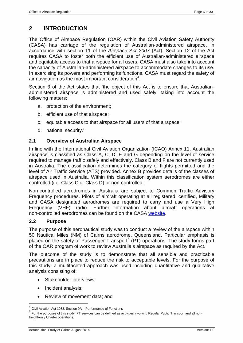
Figure 4: Surveillance coverage surrounding Cairns at 10,000 ft AMSL – Airservices.
Automatic Dependent Surveillance – Broadcast (ADS-B) technology complements the existing radar infrastructure and provides Airservices with transcontinental surveillance of suitably equipped aircraft.
4.7 Surrounding aerodromes Within 50 NM (the third outside circle depicted in Figure 4) of Cairns there are numerous aerodromes servicing the Cairns region, however there are three regional aerodromes within the Cairns area, they are:
• Atherton aerodrome (uncertified);
• Innisfail aerodrome (registered); and
• Mareeba aerodrome (certified). The OAR reviewed the movement data for the three aerodromes. Mareeba aerodrome has experienced a slight increase in aircraft movements due to increases in flight training and other associated operations. Atherton and Innisfail aircraft movement numbers are steady and do not directly impact operations at Cairns. During the quantitative and qualitative phases of this aeronautical study, no significant airspace issues were identified or communicated by stakeholders concerning operations from outlying aerodromes or authorised landing areas. The current airspace architecture out to 50 NM from Cairns works well for the volume of aircraft movements and mix of traffic.
5 AIRSPACE USERS AND AERONAUTICAL INFORMATION
5.1 Airspace Users The following airlines and aircraft operators regularly operate out of, or provide domestic PT services into Cairns:
• Hinterland Aviation operates to Cooktown;
• Jetstar operate to Adelaide, Brisbane, Gold Coast, Melbourne, Perth, Sydney;

Office of Airspace Regulation Page 13 of 33
Aeronautical Study of Cairns August 2014 Version: 1.0
• Qantas operate to Alice Springs, Ayers Rock, Brisbane, Darwin, Gladstone, Gove, Hamilton Island, Horn Island, Mackay, Melbourne, Sydney, Townsville and Weipa;
• Skytrans operate to Aurukun, Coen, Edward River, Kowanyama, Lockhart River, Mt Isa, Normanton, Northern Peninsula, Palm Island; and
• Virgin Australia operates to Brisbane, Melbourne, Sydney and Townsville. At the time of compiling this aeronautical study the following airlines and aircraft operators regularly operate international PT services into and out of Cairns:
• Air New Zealand operates to Auckland;
• Air Niugini operates to Port Moresby;
• Airlines Papa New Guinea operates to Port Moresby;
• Cathy Pacific operates to Hong Kong;
• China Eastern operates to Shanghai;
• China Southern operates to Guangzhou;
• Jetstar operates to Auckland, Narita/Tokyo, Osaka and Singapore (via Darwin);
• QantasLink operates to Port Moresby;
• Virgin Australia code shares with Air New Zealand to Auckland; and
• United Airlines operates to Guam. Chartered and short notice specialised flights can occur at any time and are provided by, but not limited to the following companies:
• Alliance Airlines; • Australian Air Express; • Royal Flying Doctor Service; • Cobham; • Heavylift Airlines; • Network Aviation; • Skytraders; • Toll Aviation; and • West Wing.
6 CONSULTATION
OAR representatives sought input from operators and stakeholders who operate at and around Cairns. Stakeholders invited to provide input for the study are listed in Annex C. 6.1 CASA CASA employs Aviation Safety Advisors (ASAs) throughout Australia as an integral mechanism for providing safety promotion, training and educational material to the various industry segments. ASAs liaise with local operators, and discuss airspace

Office of Airspace Regulation Page 14 of 33
Aeronautical Study of Cairns August 2014 Version: 1.0
issues. Consultation was conducted with CASA Flying Operations Inspectors (FOIs) who oversee local operations. Feedback from the ASAs and FOIs has been considered during compilation of this study. Feedback from internal CASA subject matter experts provided that the current Runway 15 Standard Instrument Departures, in their initial phases are not Procedures for Air Navigation Services – Aircraft Operations (PANS-OPs) compliant. The 190 knot (kt) speed restriction is less than the PANS-OPs minimum speed of 204 kt for this operation and the minimum bank angle of 25 degrees is 10 degrees greater than the PANS-OPs maximum for this operation. This issue has been drawn to CASA’s attention in the past and approval for its continued use was provided to Airservices. 6.2 Aerodrome Operator The aerodrome operator did not present any concerns with the Cairns airspace, however they stated their strong commitment to the monitoring of aircraft noise. Any flight path deviations, increases in night time operations or proposed changes to flight paths are closely monitored by the aerodrome operator. Other issues highlighted by the Cairns aerodrome operator were considered and where applicable incorporated into this aeronautical study. 6.3 Air Navigation Service Provider Airservices is the sole Air Navigation Service Provider for the Cairns area. Interviews were conducted with staff from the Cairns TCU and Cairns Tower. The following issues were raised:
• Operators that previously used runway 12/30 have adapted to the change in operational conditions associated with the use of runway 15/33;
• Prior to the closure of runway 12/30, sequencing arriving traffic to runway 12, which crosses the arrival path for runway 15, was demanding for both the aerodrome controller and the approach controller, this required close coordination and monitoring;
• General Aviation (GA) aircraft are provided equal access to runway 15/33 as operational conditions allow;
• Since the temporary closure of runway 12/30, greater focus is placed on monitoring runway 15/33 aircraft occupancy times; this is conducted as part of aircraft flow management by tower staff;
• The development of a full length parallel taxiway for runway 15/33 and/or rapid exit taxiways would aid flow management; and
• Departures from runway 15 to the south using Area Navigation (RNAV) Required Navigation Performance (RNP) procedures and reduced noise technologies should be explored. This type of departure could provide additional safety measures and increase aircraft and aerodrome efficiency.
6.4 Airspace Users OAR representatives sought input from other airspace users. Meetings with various operators occurred and no major airspace issues were raised. The OAR received stakeholder feedback outlining their desire to conduct operator specific, runway 15 departures utilising modern ICAO accepted RNAV RNP procedures. Supporting arguments were that RNP departures from runway 15 would:

Office of Airspace Regulation Page 15 of 33
Aeronautical Study of Cairns August 2014 Version: 1.0
• Initially be conducted on a trial basis following community consultation;
• Be limited to aircraft fitted with the appropriate avionics;
• Be limited to aircraft fitted with aircraft noise mitigating technology;
• Occur only during daylights hours;
• Negate the immediate left turn at low altitude which may improve aircraft safety;
• Allow an increase in aircraft movement numbers thereby increasing aerodrome, aircraft and airspace efficiency; and
• Provide better tracking options for the missed approach to runway 15 than the current published procedures.
General stakeholder comments:
• During non-noise abatement periods Airservices should investigate the use of appropriately equipped aircraft conducting approaches and missed approaches from runway 15 using RNP technology;
• To achieve better traffic flow management and reduce track miles for each operation it should be possible to use RNP procedures including; standard instrument departures; and standard arrival routes; and
• A full length parallel taxiway would be an improvement, even if it were only for the most used runway, runway 15. The wait for a full length departure off runway 15 can be approximately 15 minutes.
6.5 Defence Defence were contacted for their comment regarding any issues concerning the airspace surrounding Cairns. Defence advised that they had no issues with the airspace. 6.6 Emergency Services Emergency service providers were contacted for comment regarding the airspace surrounding Cairns. At the time of publication no response had been received.
7 TRAFFIC DATA
To make an accurate evaluation of the airspace it is important that all reasonable precautions have been taken to ensure that the data being reviewed is correct and reliable. Data for this study has been gathered from a number of sources. These sources include, but are not limited to:
• Airservices; and
• Airline schedules. Airspace Research Application (ARA) Airservices ARA database was developed to enhance their situational awareness of traffic at aerodromes throughout Australia and identify locations of interest that may trigger further research. CASA obtains ARA data from Airservices to assist in the analysis of collision risk at aerodromes that are under review. ARA data consists of aircraft movements, passenger numbers and aircraft incidents from sources such as Avdata Australia (Avdata), Australian Transport Safety Bureau (ATSB), submitted

Office of Airspace Regulation Page 16 of 33
Aeronautical Study of Cairns August 2014 Version: 1.0
flight plans and location specific intelligence reports. The following ARA reports were sourced from Airservices:
a. Trigger Criteria Summary Report – records total aircraft movements, air transport movements (aircraft with a maximum take-off weight of two tonnes or above) and passenger numbers at all aerodromes in Australia over a 12 month period. An aerodrome is flagged if, for the 12 month period: i) total passenger numbers exceed 350,000; ii) total aircraft movements exceed 80,000; or iii) total air transport movements exceed 15,000.
b. Aircraft Types by Port – This report identifies aircraft by type arriving and departing from the port during a selected period10. The data is used to estimate the proportion of aircraft types that are utilising an aerodrome. This report is also used to identify VFR and IFR traffic by analysing the aircraft seating capacity and the number of movements per aircraft type. Generally all rotary winged aircraft are considered to be VFR traffic as well as aircraft that have approximately three or less seating capacity.
c. Data Validation Reports – This report is used to validate the trigger report; identify the number of circuits flown per annum and add VFR traffic.
7.1 Traffic Data The Cairns aerodrome has experienced an increase in passenger numbers whilst experiencing a decline in aircraft moments. The increase in passenger numbers could be attributed to the Cairns area’s appeal as an international tourist destination. The decrease in aircraft movement numbers may reflect a decrease in flight training operations and small aircraft operators relocating to other aerodromes in the Cairns region. There is also a worldwide shift in passenger aircraft operators fleets towards larger aircraft types, larger aircraft types provide improved operational flexibility and an increase in passenger capacity. The ARA data illustrates an approximate decrease of 5% in aircraft movements and an increase in passenger numbers during the 12 months from December 2012 to December 2013. Refer to figure 5.
Figure 5: Passenger and aircraft movement data for Cairns December 2012 – December 2013
Airservices April 2014.
10 This data is extracted from the aircraft register database (maintained by CASA) using the aircraft callsign only, therefore there may be some inaccuracies.

Office of Airspace Regulation Page 17 of 33
Aeronautical Study of Cairns August 2014 Version: 1.0
8 INCIDENT AND ACCIDENT DATA
8.1 Aviation Safety Incident Reports (ASIRs) All accidents and incidents involving Australian registered aircraft, or foreign aircraft in Australian airspace must be reported to the ATSB. The ATSB receives incident information via pilot reports, Airservices’ reports and the Royal Australian Air Forces’ Aircraft Safety Occurrence Reports. The ATSB maintains its own database, the Safety Investigation Information Management System (SIIMS), in which all reported occurrences are logged, assessed, classified and recorded. The information contained within SIIMS is dynamic and subject to change based on additional and/or updated data. Each individual report is known as an ASIR and for identification purposes is allocated its own serial number. For the period 02 January 2012 to 06 January 2014 the OAR analysed 263 ASIRs that occurred within 50 NM surrounding Cairns and were applicable to the scope of the Cairns aeronautical study. These incidents have been divided into the following groups:
Type of Incident Number of Incidents Airspace Infringement11 (AI) 41 Breakdown of Coordination 16 Breakdown of Separation NIL Operational non compliance 160 Loss of Separation Assurance 46 Traffic Alert and Collision Avoidance System Resolution Advisory NIL
Table 1: ASIRs at Cairns (02 January 2012 to 06 January 2014).
With reference to Table 1, Operational non-compliance, which is a failure to comply with ATS instructions, is the largest reported type of incident. Analysis of the incidents indicates that failure to comply with ATS instructions is primarily the result of pilots unfamiliar with the Cairns airspace and specific procedures. The location, causation and distribution of airspace infringements were reviewed. After reviewing and considering the comments included in the incident reports, the single largest reason is a lack of situational awareness by pilots inadvertently entering the Class C control steps surrounding Cairns. Most pilots reported that they were trying to operate in Class G airspace and were unaware of their close proximity to the Class C airspace. As contained in the AIP Enroute 1.1 – 40 19.12 Avoiding Controlled Airspace; ‘The pilot in command of an aircraft operating in Class G airspace, or to the VFR in Class E airspace, must apply appropriate tolerances to the flight path to ensure that controlled airspace, or restricted areas, are not infringed.’
This is a pilot educational matter rather than an airspace design issue and is covered by CASA Aviation Safety Advisors in Aviation Safety Seminars.
11 Previously known as a Violation of Controlled Airspace.

Office of Airspace Regulation Page 18 of 33
Aeronautical Study of Cairns August 2014 Version: 1.0
9 AIRSPACE REFORM
This study takes into account the Government’s requirement that CASA will continue the reform of Australia’s airspace and move towards closer alignment with the ICAO system and adoption of international best practice. This includes adopting proven international airspace systems adapted to benefit Australia’s aviation environment. 9.1 International Comparison Whilst no two aerodromes are exactly alike, this study has endeavoured to find aerodromes with comparable movement figures and environment to a medium hub aerodrome with small satellite aerodromes close by. International comparisons with Cairns proved difficult due to Cairns relative isolation from other large population centres and their modern aviation facilities. However, the study identified two aerodromes with similar passenger and aircraft movement numbers. The OAR investigated the airspace architecture surrounding:
• LA/Ontario, United States of America; and • Winnipeg, Canada.
9.2 Los Angeles/Ontario Federal Aviation Regulations Part 71 Designation of Class A, B, C, D, and E Airspace Areas, Part 73 Special Use Airspace, Part 77 Safe, Efficient Use and Preservation of the Navigable Airspace and Part 91 General Operating and Flight Rules were reviewed to determine if the airspace system used in the vicinity of LA/Ontario aerodrome would benefit the aviation environment in the vicinity of Cairns. LA/Ontario International Airport (hereafter referred to as LA/Ontario) is located 32 NM east of the Los Angeles Central Business District. The majority of traffic at the aerodrome consists of domestic and international scheduled PT and charter flights. ATS is available 24 hours a day. In 2013 LA/Ontario recorded 83,08712 annual aircraft operations; this figure includes all commercial aircraft, air taxi, alternates, military and GA aircraft. In the same year LA/Ontario recorded 3,969,974 passengers, compared with 93,99713 aircraft movements and 4,563,61114 passengers at Cairns. Unlike Cairns, LA/Ontario is an integral element in the airfreight network and is serviced by most (FedEx and UPS) of the major freight operators. Both Cairns and LA/Ontario’s airspace is tailored to provide a separation service for arriving and departing aircraft. The LA/Ontario surface area (similar to a CTR in Australia) is Class C from the surface to 5,000 ft Mean Sea Level (MSL) with the outer area from 2,700 ft MSL to 5,000 ft MSL. Unlike Cairns, LA/Ontario has Class E airspace that overlays the Class C airspace and extends to the base of the Class A airspace at FL180. Similar to Cairns, Class A airspace at LA/Ontario exists from FL180 and above. The surface area and outer area are depicted in Figure 6, below.
12 http://www.lawa.org/welcome_ont.aspx?id=810 13 Passenger and aircraft movement data extracted from Airservices December 2013 Airspace Research Application 14 ibid

Office of Airspace Regulation Page 19 of 33
Aeronautical Study of Cairns August 2014 Version: 1.0
Figure 6: LA/Ontario airspace structure. FAA VFR Chart Number 95 Effective 26 June 2014.
LA/Ontario has two runways, designated as 08L/26R and 08R/26L. The airspace is tailored in a keyhole fashion similar to Cairns that ensures protection of the instrument approaches. Figure 7 illustrates that within 20 NM of LA/Ontario there are seven GA aerodromes, one international airport and one Air Force Reserve Base. This contrasts starkly with the three regional aerodromes surrounding Cairns.
Figure 7: LA/Ontario International Airport location and surrounding aerodromes – Google Earth
Whilst Cairns and LA/Ontario share broadly similar traffic and passenger numbers, the complexity of the wider airspace and traffic patterns surrounding LA/Ontario presents a far different operational context than Cairns.

Office of Airspace Regulation Page 20 of 33
Aeronautical Study of Cairns August 2014 Version: 1.0
9.3 Winnipeg The airspace classification and airspace architecture in the Nav Canada AIP were reviewed to determine if the airspace system used in the vicinity of Winnipeg airport, Manitoba, would benefit Cairns. Winnipeg James Armstrong Richardson International airport (hereafter referred to as Winnipeg) is located 3.5 NM north east of Winnipeg city. The majority of traffic at Winnipeg consists of domestic and international scheduled PT and charter flights. ATS is available 24 hours a day. Winnipeg recorded 125,26615 total itinerant and local aircraft movements and 3,483,89816 terminal and transit passengers for 2013 compared with 93,997 aircraft movements and 4,563,611 passengers at Cairns for 2013. Winnipeg has two runways, designated as 13/31 and 18/36. Figure 8 illustrates the Winnipeg VFR Terminal Chart, the control zone is Class D from the surface to 3,000 ft Above Sea Level (ASL). The terminal control area is Class D from 3,000 ft ASL to 12,500 ft ASL.
Figure 8: Winnipeg VFR Terminal Area Chart – Navigation Canada 13 January 2011.
Figure 9 illustrates that within 20 NM of Winnipeg Airport there are two GA aerodromes, Winnipeg St. Andrews and Lyncrest.
15 http://www.statcan.gc.ca/pub/51-209-x/51-209-x2014001-eng.pdf 16 http://www.waa.ca/waa/about/publications Winnipeg Airports Authority 2012 Annual Report.

Office of Airspace Regulation Page 21 of 33
Aeronautical Study of Cairns August 2014 Version: 1.0
Figure 9: Winnipeg Airport location and surrounding GA aerodromes.
9.4 International Comparison Conclusion The current airspace architecture surrounding Cairns has evolved over a period of time and works well for the surrounding topography, traffic volumes, aircraft operational requirements and mix of aircraft types. Due to the availability of electronic surveillance from the surface to upper level airspace in the immediate vicinity of Cairns aerodrome, adoption of the Winnipeg Class D airspace would not provide the current level of ATS and may increase risk. The LA/Ontario airspace model is similar to Cairns, they both have Class C services and the airspace is designed to protect passenger services. The LA/Ontario model does not appear to provide an increase in safety or efficiency for Cairns that would justify its adoption. It should also be noted that the two International aerodromes lack the significant terrain and environmental issues that support the current airspace model at Cairns.
10 AIRSPACE RISK AND OTHER MATTERS
Section 3 of the Act states that ‘the object of this Act is to ensure that Australian-administered airspace is administered and used safely, taking into account the following matters:
a. protection of the environment; b. efficient use of that airspace; c. equitable access to that airspace for all users of that airspace;

Office of Airspace Regulation Page 22 of 33
Aeronautical Study of Cairns August 2014 Version: 1.0
d. national security.’ This section addresses the requirements of Section 3 of the Act. 10.1 Safety The OAR may conduct airspace modelling to ascertain areas of concern when required. After reviewing the Cairns’ movements, traffic mix and incident data, it was decided that modelling was not required for the following reasons:
• A review of stakeholder consultation supported the decision not to undertake airspace modelling as no major issues were raised;
• ASIR data and incident causation were reviewed with no indication of unacceptable risk caused by the current airspace design;
• Cairns ATC felt that aircraft movement numbers were manageable and there were no significant issues;
• There is broad area electronic surveillance with good coverage which mitigates risk; and
• Cairns has Class C airspace with the corresponding level of ATC services provided from the Cairns control tower, TCU and the Airservices’ Brisbane air traffic services centre.
10.2 Environment The Cairns airspace was reviewed to consider if there are current adverse aircraft environment impacts associated with:
• Noise;
• Gaseous emissions;
• Interactions with birds and wildlife; and
• Environment Protection and Biodiversity Conservation Act 1999. Should an Airspace Change Proposal be an outcome of this aeronautical study, which results in changes in aircraft traffic patterns and procedures, the above environment issues will require assessment. Noise Due to the relative close proximity of Cairns airport and the township, the Cairns central business district, apartment/tourist complexes adjacent to the extended runway centreline, aircraft noise is a community concern and any new RNP departure procedure from runway 15 would have noise sensitive implications. Airservices have installed a Noise and Flight Path Monitoring System17 that continuously collects noise and flight path data. The information collected is used to:
• Determine the contribution of aircraft to overall noise;
• Detect occurrences of excessive noise levels from aircraft operations; and
• Assist in planning of airspace usage. Three permanently installed Noise Monitoring Terminals are strategically located around Cairns to monitor and record aircraft noise:
17 For further information refer to: http://www.airservicesaustralia.com/aircraftnoise/monitoring-aircraft-noise/

Office of Airspace Regulation Page 23 of 33
Aeronautical Study of Cairns August 2014 Version: 1.0
• Cairns North (located approximately 1.2 kilometres (kms) south of Cairns aerodrome);
• Holloways (located approximately 2.2 kms north of Cairns aerodrome); and
• Yorkeys Knob (located approximately 6.8 kms north of Cairns aerodrome). The Noise Monitoring Terminals are a system that is connected to the Secondary Surveillance Radar at Redden Creek, this connection enables the system to acquire flight track information on aircraft operating into and out of Cairns. This system allows for accurate monitoring and reporting of aircraft noise. Gaseous emissions Aircraft fuel efficiency and associated gaseous emissions are influenced by the current airspace. The current departure profile off runway 15 creates increased gaseous emissions if compared to a RNP departure procedure to the south due to increased track miles. Bird and wildlife aircraft interaction and Environmental Protection and Biodiversity Conservation Act 1999 (EPBC) issues The airspace within the review area is from the surface to FL180, there would be no negative bird and wildlife interactions and EPBC issues resulting from the current airspace design. 10.3 Efficient use of the Airspace Efficient use of the airspace and equitable access for all users are important considerations and must be taken into account when managing airspace. RNP departures to the south from runway 15 may provide an increase in safety and operators may realise additional efficiencies to aircraft operations through the reduction of track miles flown. However, whilst this departure may increase airspace efficiency, stakeholder feedback indicates that it would have an undesirable noise impact to the Cairns CBD as per 10.2 Noise. 10.4 Equitable Access No concerns were raised by stakeholders regarding access to the controlled airspace surrounding Cairns.
11 SUMMARY OF ISSUES
The key issues raised by airspace users during the generative interviews, questionnaires and stakeholder forums have been identified as follows:
• The current Runway 15 Standard Instrument Departures, in their initial phases, are not PANS-OPs compliant. The 190 kt speed restriction is less than the PANS-OPs minimum speed of 204 kt for this operation and the minimum bank angle of 25 degrees is 10 degrees greater than the PANS-OPs maximum for this operation. This issue has been drawn to CASA’s attention in the past and approval to its continued use was provided to Airservices.
• The primary purpose of runway 12/30 was to support light aircraft operations, this reduced the overall traffic demands on runway 15/33. While runway 12/30 remains closed, traffic operating on runway 15/33 has increased placing attention on flow management resulting in ATC to closely monitor aircraft runway occupancy times.

Office of Airspace Regulation Page 24 of 33
Aeronautical Study of Cairns August 2014 Version: 1.0
12 FINDINGS AND CONCLUSIONS
The following findings / conclusions are made:
• The development of a RNP departure to the south from runway 15 may provide an increase in safety, and may provide additional efficiencies to aircraft operations.
• As a result of the closure to runway 12/30, the amount of runway incursions to runway 15/33 has decreased.
• Aircraft occupancy times on runway 15/33 and the follow on effects to traffic flow are being monitored by ATC for the possible development of rapid-exit taxiways.
• The current Cairns airspace architecture works well for the volume and mix of traffic.
13 CASA RECOMMENDATIONS
It is important to note that the study may make recommendations based on existing data. CASA applies a precautionary approach when conducting aeronautical studies and therefore the following recommendations are made:
1. Airservices should consider the provision of a RNP departure to the south of Cairns from runway 15.
2. The current airspace structure works well for the current traffic level and should be retained.

Office of Airspace Regulation Page 25 of 33
Aeronautical Study of Cairns August 2014 Version: 1.0
14 REFERENCES
• Airspace Act, 2007 http://www.comlaw.gov.au/Details/C2007A00038
• Airspace Regulations http://www.comlaw.gov.au/ComLaw/Legislation/Act1.nsf/0/CBB21AA3AFCE9CA7CA2573070008AB2F/$file/0382007.pdf
• Aeronautical Information Publication – effective 29 May 2014. • Cairns departure and approach charts – effective 29 May 2014. • Designated Airspace Handbook – effective 29 May 2014. • En Route Supplement Australia – effective 29 May 2014. • Cairns Visual Terminal Chart – effective 29 May 2014. • Cairns Visual Navigation Chart – effective 29 May 2014. • CASA Performance Based Navigation booklet
http://www.casa.gov.au/wcmswr/_assets/main/lib100178/pbn-booklet.pdf • Federal Aviation Administration Required Navigation Performance Guide
http://www.faa.gov/about/office_org/headquarters_offices/avs/offices/afs/afs400/afs470/media/NAS.pdf
• Cairns Airport website, arrivals and departure timetables http://www.cairnsairport.com.au/
• Cairns Airport Noise Management website http://www.cairnsairport.com.au/corporate/airport-noise/
• Cairns Airport Land Use Plan http://www.cairnsairport.com.au/?s=+Cairns+Airport+Land+Use+Plan+
• Qantas website http://www.qantas.com.au/travel/airlines/home/au/en • Virgin Australia website http://www.virginaustralia.com/au/en/ • SkyVector Aeronautical Charts http://skyvector.com/ • LA/Ontario Airport Information webpage
http://www.lawa.org/welcome_ont.aspx?id=810 • Aircraft Movement Statistics; NAV Canada Annual Report 2013
http://www.statcan.gc.ca/pub/51-209-x/51-209-x2014001-eng.pdf • Winnipeg Airports Authority 2013 Annual Report
http://www.waa.ca/waa/about/publications • Airservices 2013 Cairns Aircraft Noise Information Report Q1, Q2, Q3 and
Q4 http://www.airservicesaustralia.com/publications/noise-reports/noise-reports/
• Airservices Airspace Research Application Trigger Criteria Summary Report ending December 2013.
ANNEXES:
Annex A - Acronyms and Abbreviations Annex B - Australian Airspace Structure Annex C - Stakeholders Annex D – Stakeholder Feedback / Register

Office of Airspace Regulation Page 26 of 33
Aeronautical Study of Cairns August 2014 Version: 1.0
ANNEX A – ACRONYMS AND ABBREVIATIONS
Abbreviation Explanation Act Airspace Act 2007 ADS-B Automatic Dependent Surveillance-Broadcast AI Airspace Infringement AIP Aeronautical Information Publication Airservices Airservices Australia AMSL Above Mean Sea Level ARA Airspace Research Application ASIR Aviation Safety Incident Report ASL Above Sea Level ATC Air Traffic Control ATS Air Traffic Service ATSB Australian Transport Safety Bureau Avdata Avdata Australia CASA Civil Aviation Safety Authority CASR Civil Aviation Safety Regulation 1998 CTA Control Area CTR Control Zone DA Danger Area Defence Department of Defence EPBC Act Environment Protection and Biodiversity Conservation Act 1999 FL Flight Level FOI Flight Operations Inspectors ft Feet NFPMS Noise and Flight Path Monitoring System GA General Aviation GPS Global Positioning System IAS Indicated Air Speed ICAO International Civil Aviation Organization IFR Instrument Flight Rules Kms Kilometers kt knot ILS Instrument Landing System MSL Mean Sea Level NM Nautical Miles NOTAM Notice to Air Men OAR Office of Airspace Regulation PANS – OPS Procedures for Air Navigation Services – Aircraft Operations PT Passenger Transport RA Restricted Area RNAV Area Navigation RNP Required Navigation Performance RPT Regular Public Transport SIIMS Safety Investigation Information Management System SIS Surveillance Information Service SVFR Special Visual Flight Rules TCU Terminal Control Unit VFR Visual Flight Rules VHF Very High Frequency VMC Visual Meteorological Conditions VTC Visual Terminal Chart VOR Very High Frequency Omnidirectional Radio Range

Office of Airspace Regulation Page 27 of 33
Aeronautical Study of Cairns August 2014 Version: 1.0
ANNEX B – AUSTRALIAN AIRSPACE STRUCTURE Class Description Summary of Services/Procedures/Rules
A All airspace above Flight Level (FL) 180 (east coast) or FL 245
Instrument Flight Rules (IFR) only. All aircraft require a clearance from Air Traffic Control (ATC) and are separated by ATC. Continuous two-way radio and transponder required. No speed limitation.
B IFR and VFR flights are permitted. All flights are provided with ATS and are separated from each other. Not currently used in Australia.
C
In control zones (CTRs) of defined dimensions and control area steps generally associated with controlled aerodromes
All aircraft require a clearance from ATC to enter airspace. All aircraft require continuous two-way radio and transponder.
IFR separated from IFR, VFR and Special VFR (SVFR) by ATC with no speed limitation for IFR operations. VFR receives traffic information on other VFR but are not separated from each other by ATC. SVFR are separated
from SVFR when visibility (VIS) is less than Visual Meteorological Conditions (VMC). VFR and SVFR speed limited to 250 knots (kt) Indicated Air Speed (IAS) below 10,000 feet (ft) Above Mean Sea
Level (AMSL)*.
D
Towered locations such as Bankstown, Jandakot, Archerfield, Parafield and Alice Springs.
All aircraft require a clearance from ATC to enter airspace. For VFR flights this may be in an abbreviated form. As in Class C airspace all aircraft are separated on take-off and landing. All aircraft require continuous two-way radio and are speed limited to 200 kt IAS at or below 2,500 ft within 4 NM of the primary Class D aerodrome and 250 kt IAS in the remaining Class D airspace.
IFR are separated from IFR, SVFR, and are provided with traffic information on all VFR. VFR receives traffic on all other aircraft but are not separated by ATC. SVFR are separated from SVFR when VIS is less than VMC.
E Controlled airspace not covered in classifications above
All aircraft require continuous two-way radio and transponder. All aircraft are speed limited to 250 kt IAS below 10,000 ft AMSL*,
IFR require a clearance from ATC to enter airspace and are separated from IFR by ATC, and provided with traffic information as far as practicable on VFR.
VFR do not require a clearance from ATC to enter airspace and are provided with a Flight Information Service (FIS). On request and ATC workload permitting, a Surveillance Information Service (SIS) is available within surveillance coverage.
F Not currently used in Australia.
G Non-controlled
Clearance from ATC to enter airspace not required. All aircraft are speed limited to 250 kt IAS below 10,000 ft AMSL*.
IFR require continuous two-way radio and receive a FIS, including traffic information on other IFR. VFR receive a FIS. On request and ATC workload permitting, a SIS is available within surveillance coverage. VHF
radio required above 5,000 ft AMSL and at aerodromes where carriage and use of radio is required. * Not applicable to military aircraft. **If traffic conditions permit, ATC may approve a pilot's request to exceed the 200 kt speed limit to a maximum limit of 250 kt unless the pilot informs ATC a higher minimum speed is required.

Office of Airspace Regulation Page 28 of 33
Aeronautical Study of Cairns August 2014 Version: 1.0
ANNEX C – STAKEHOLDERS
Position Organisation
Administration Office Aircraft Owners and Pilots Association of Australia
Chief Executive Officer Airlines PNG
Chief Executive Officer Air Niugini
ATC Tower Manager Airservices
Line Manager Airservices
Terminal Control Unit Staff Airservices
Flight Operations Manager Alliance Airlines
Administration Office Australian Airports Association
Administration Office Australian and International Pilots Association
Manager Australasian Aviation Group - Cairns Committee
Aerodrome Operations Manager Cairns Airport PTY LTD
Deputy Chief Pilot Cobham Aviation Services
Chief Pilot Cape York Helicopters
Flying Operations Inspector (FOI) CASA, Operations Division
Aviation Safety Advisor (ASA) CASA, Safety Analysis & Education Division
Manager Daintree Air Services
Military Manager Defence / OAR
Administration Office Gliding Federation of Australia
Managing Director and Chief Pilot Great Barrier Reef Helicopters
Chief Pilot Heli Charters Cairns
Chief Pilot Hinterland Aviation
Chief Pilot Hot Air Cairns & Gold Coast
Aerodrome and Airways Manager Jetstar Airways

Office of Airspace Regulation Page 29 of 33
Aeronautical Study of Cairns August 2014 Version: 1.0
Chief Pilot Queensland Police Air Wing
Secretariat Regional Airspace and Procedures Advisory Committee
Administration Office Regional Aviation Association of Australia
Head of Flying Operations Queensland Section Royal Flying Doctor Service
Manager SkyRentals (Australasian Aircraft Rentals)
A/Manager Safety & Quality Systems Skytrans
Head of Training and Checking Tiger Airways
Manager ATM & Meteorology Virgin Australia

Office of Airspace Regulation Page 30 of 33
Aeronautical Study of Cairns August 2014 Version: 1.0
ANNEX D – STAKEHOLDER CONSULTATION / FEEDBACK REGISTER
No. Stakeholder / Commentator
Reference Comment CASA Response Action Response
1 Airservices Australia
Recommendation 1 Airservices does not support this recommendation as the constraining factor for redesign is the low over-flight of the Cairns CBD at take-off power and the resulting vigorous community opposition.
This was evident in previous RNP AR trials at Cairns where an RNP SID for runway 15 was trialled and flight tested, however, the adverse community reaction saw the withdrawal of the trial.
Additionally, Cairn’s Airport did not support the introduction of the procedure at the time. Airservices notes comments by the aerodrome operator in Section 6.2 regarding flight path deviations.
Noted. Nil. No.
2 Airservices Australia
Section 1.2 dot point 2
The report should note that the closure of Runway 12/30 was a Cairn’s airport decision.
Additionally, the report infers an increase in workload as a result of the runway closure but does not provide the alternate view that prior to its closure sequencing arriving traffic to Runway 12, which crosses the arrival path for Runway 15, was demanding on both the aerodrome controller and the approach controller and required close coordination and monitoring .
Single runway arrivals have simplified the sequencing.
Noted. Report amended.
No.
3 Airservices Australia
Aerodrome Comparisons
It should be noted that the comparison aerodromes lack the significant terrain and environment issues which are compelling
Noted. Report amended.
No.

Office of Airspace Regulation Page 31 of 33
Aeronautical Study of Cairns August 2014 Version: 1.0
reasons for the current airspace model.
This is of importance in relations to the non-compliance of the SWIFT SID to meet PANSOPS requirements.
Terrain and performance factors of legacy aircraft have led to the development of the current SID.
While the development of an RNP Departure would offer benefit to modern aircraft, legacy aircraft would still be limited to a SID, similar to the current SWIFT SEVERN SID.
4 Airservices Australia
Section 4.4 Danger Areas
Danger Area D762 is a Danger Area within controlled airspace. Airservices understands that the establishment of Danger Areas within controlled airspace is an issue under review by the Office of Airspace Regulation.
Noted. Report amended.
No.
5 Airservices Australia Section 10.3 Efficient
Use of Airspace This section references and RNP departure for Runway 15 but does not link back to Section 1.2 – Environment. For completeness, Airservices suggest this link should be made as commentary from stakeholders makes it quite clear that this departure is likely to have noise sensitive implications.
Noted. Report amended.
No.
6 Skyrental Manager and Industry
Convenor for North QLD RAPAC
Page 3, section 1.1, 2nd paragraph
Is this generic text or specific to the Cairns area? The respondent is not aware of any gliding activity within 50 nm of Cairns.
Noted. Report amended.
Acknowledged all comments
by email.
7 Skyrental Manager and Industry
Convenor for North QLD RAPAC
Page 6, section 2.1, 2nd paragraph
In recent times, non-controlled aerodromes have been further delineated by whether they appear on official aeronautical charts (described as "charted") or not ("uncharted"). Refer NOTAM C119/14.
Noted. Report amended.
8 Skyrental Manager and Industry
Convenor for North
Page 6, section 2.1, hyperlink
The target page address is incorrect or out of date. There is new educational material as a result of non-controlled aerodromes being
Noted. Link amended

Office of Airspace Regulation Page 32 of 33
Aeronautical Study of Cairns August 2014 Version: 1.0
QLD RAPAC delineated as "charted" and "uncharted". Refer NOTAM C119/14.
9 Skyrental Manager and Industry
Convenor for North QLD RAPAC
Page 9, section 4.2 It could be mentioned that the terrain to the immediate west of the airport is significant in that aircraft flying a visual circuit on the western side lose sight of the runways.
Noted. Report amended.
10 Skyrental Manager and Industry
Convenor for North QLD RAPAC
Page 9, section 4.2 There is no mention of the VFR lane that provides northern and southern access and guidance along the western side of CTA.
The southern route has a radar coverage blind spot, and the northern route near Palm Cove puts aircraft very close to rising terrain in order to stay west of the main highway.
It begs the question: Is the lane compliant? Twice I've been asked to make a right-hand orbit whilst southbound on the northern route, and have had to advise the Approach Controller that to comply will mean crashing into a mountain.
Noted. Report amended.
11 Skyrental Manager and Industry
Convenor for North QLD RAPAC
Page 9, section 4.2 There is no mention of the adjacent and underlying broadcast area CTAF just to the north and east of Cairns on 127.0.
This is known locally as the "Marlin CTAF" but the name is not shown on any charts or in ERSA.
Noted. Nil.
12 Skyrental Manager and Industry
Convenor for North QLD RAPAC
Section 4.4, 2nd bullet point
Is this generic text, or specific to the Cairns area? The respondent is not aware of any gliding activity within 50 nm of Cairns.
Generic Text. Nil.
13 Skyrental Manager and Industry
Convenor for North QLD RAPAC
Section 4.7, 2nd paragraph
The text refers to aircraft movements. Did the study also consider changes in radio traffic levels (due to changes in movements), or the traffic mix (e.g. VFR vs IFR, training v non-training)?
The data was not analysed in detail as there were no safety issues that required
such an action.
Nil.

Office of Airspace Regulation Page 33 of 33
Aeronautical Study of Cairns August 2014 Version: 1.0
14 Skyrental Manager and Industry
Convenor for North QLD RAPAC
Section 6.3, 2nd bullet point
Not mentioned was the option of not using runway 12/30 for any arrivals, but only in addition to 15/33 for [i] GA departures, and also [ii] to inject GA traffic into the 15/33 circuit pattern.
During jet take-offs, this option would allow for faster take-off clearances for GA aircraft by not having to wait (either by lining up or backtracking on 15/33) for wake turbulence periods.
Perhaps this is a matter that the North Queensland RAPAC may wish to discuss.
Nil.
15 Skyrental Manager and Industry
Convenor for North QLD RAPAC
Section 7.1, 2nd paragraph
Many small aircraft operators have relocated from Cairns due to the aerodrome operator introducing higher annual parking charges, e.g. for the respondent's aircraft, from $132 per year to over $8,000.
Noted. NIL.
16 Skyrental Manager and Industry
Convenor for North QLD RAPAC
Page 26, explanation of GPS
I had read somewhere (possibly in a CASA AWB) that 'GNSS' was replacing 'GPS' unless referring specifically to the USA's version of the satellite system.
Noted. Nil.