Embed Size (px)
Citation preview

AERIAL SURVEY OFTHE THREATS TOMT. KILIMANJAROFORESTS
January 2002
A collaborative effort of:

Christian LambrechtsPolicy and Programme OfficerDivision of Early Warning and AssessmentUnited Nations Environment Programme
Bongo WoodleySenior WardenMt. Kenya National Park and National ReserveKenya Wildlife Service
Andreas HempAssociate ResearcherDepartment of Plant PhysiologyUniversity of Bayreuth
Claudia HempAssociate ResearcherDepartment of Animal Ecology IIUniversity of Bayreuth
Paul NnyitiConservation OfficerWildlife Conservation Society of Tanzania
The GEF Small Grants ProgrammeUnited Nations Development ProgrammeZanaki Street / Samora AvenueP.O. Box 9182Dar es SalaamTanzaniaE-mail: [email protected]: www.tz.undp.org January 2002
AERIAL SURVEY OFTHE THREATS TOMT. KILIMANJAROFORESTS

TABLE OF CONTENTS
FOREWORD .................................................................................................................................................5
ACKNOWLEDGEMENTS .............................................................................................................. ...............6
I. BACKGROUND .................................................................................................................. ....................7
II. GOAL AND OBJECTIVES ........................................................................................................ .................8
III. BRIEF DESCRIPTION OF MT. KILIMANJARO FORESTS .......................................................................8A. Overall description ........................................................................................................................................8B. Water catchment ...........................................................................................................................................8C. Biodiversity ................................................................................................................................................9D. Medicinal and cultural benefits .........................................................................................................................11E. World Heritage Site ......................................................................................................... .................................11
IV. A BRIEF ON THE FOREST SECTOR ........................................................................................................12A. Overview ....................................................................................................................................................12B. Management ...............................................................................................................................................12
V. METHODOLOGY .................................................................................................................................13A. Reconnaissance flights.....................................................................................................................................13B. Survey blocks.................................................................................................................................................14C. Selection of flight paths ....................................................................................................................................14D. Data recording ...............................................................................................................................................15E. Photo records ..................................................................................................................................................15F. Data processing in the field .............................................................................................................................16G. Data interpretation and analysis ........................................................................................................................16
VI. RESULTS OF THE AERIAL SURVEY ............................................................................................... ...........16A. Overall description of current threats to the forests .............................................................................................16B. Logging of indigenous trees .............................................................................................................................17C. Burnt forest areas ...........................................................................................................................................20D. Charcoal production ......................................................................................................................................21E. Forest villages ...............................................................................................................................................22F. Shamba (Taungya) system practices ..................................................................................................................24G. Livestock grazing .........................................................................................................................................25H. Small cultivated fields in the indigenous forest ..................................................................................................26I. Landslides ....................................................................................................................................................26
VII. DISCUSSION OF THE RESULTS ................................................................................................ .............27A. Introduction ..................................................................................................................................................27B. Logging of indigenous trees ...........................................................................................................................27C. Burnt forest areas / charcoal production ...............................................................................................................28D. Quarries .....................................................................................................................................................28E. “Forest villages” and Shamba-system practices ..................................................................................................28F. Livestock grazing ..........................................................................................................................................28G. Small cultivated fields in the indigenous forest ..................................................................................................29H. Landslides ..................................................................................................................................................29I. Other threats, not recorded during the aerial survey ..........................................................................................29J. Forest areas outside the Forest Reserve ..............................................................................................................29
VIII. CONCLUSIONS ........................................................................................................................................30
ABBREVIATIONS ................................................................................................................. ..........................31
REFERENCES ................................................................................................................................................32
ANNEX: MAPS 1 TO 14 ........................................................................................................... ......................33
3

FOREWORD
This aerial survey report highlights some destruction of natural resources on Mt. Kilimanjaro.The report shows the type and extent of forest destruction that has taken place so far in theForest Reserve, most of which are directly attributable to human activities.
The following categories of forest destruction, which threaten the whole ecosystem of Africa’shighest Mountain and one of the World Natural Heritage Sites, were recorded during thesurvey: logging of indigenous trees, fires, charcoal production and shamba system practices.Others include: quarries, livestock grazing, “Forest Villages” (squatters), cultivation of smallfields and landslides.
The findings of this aerial survey should remind all of us in Tanzania that we have a duty andconcern to conserve Mt. Kilimanjaro for the pride of our country and the internationalcommunity at large. For continued degradation of the Mountain’s natural resources willobviously lead to loss of critical products and services provided by the Mountain. This willinclude loss of biodiversity, drying up of rivers that originate from the Mountain and declineof agricultural activities that depend on water and favorable climate from the Mountain, lossof hydropower and stifling of the tourist industry. The sum total of all these losses isretrogression of poverty reduction drive that the people and Government of Tanzania arepainstakingly spearheading.
On behalf of the Government of Tanzania, I wish to commend UNDP and the UnitedNations Foundation for launching the COMPACT project around Mt. Kilimanjaro. TheGovernment believes that the support that will be provided through the COMPACT projectwill go a long way towards empowering local communities to participate effectively in reversingextractive pressures that impact adversely on the Mountain’s natural resources.
May I also use this opportunity to pay glowing tribute to the survey team that was drawnfrom UNEP, KWS, University of Bayreuth, Germany, and the Wildlife Conservation Societyof Tanzania for their excellent and highly professional work. Let me assure the team that allstakeholders of Mt. Kilimanjaro will use their findings and recommendations with the viewto promote the conservation of Mt. Kilimanjaro.
Thank You.
Philemon LuhanjoPermanent Secretary
Ministry of Natural Resources and Tourism
5

5
ACKNOWLEDGEMENTS
The request for the aerial survey of the forests of Mt. Kilimanjaro was originally presented by UNDP/GEF SmallGrants Programme, New York. The objective was to identify the type, extent and location of the threats to theforests and provide a baseline assessment for the newly developed Community Management of Protected AreasConservation Project (COMPACT). UNDP in collaboration with the United Nations Foundation (UNF) establishedthe COMPACT project in order to promote community participation in the conservation of Mt. Kilimanjaro,which is one of the World Natural Heritage Sites (WHNS). The request was inspired by a similar aerial survey thatwas undertaken for the forests of Mt. Kenya in 1999 by Kenya Wildlife Service with support from UNEP, andwhich has been instrumental for the implementation of the COMPACT project in Mt. Kenya.
Mr. Philemon Luhanjo, Permanent Secretary, Ministry of Natural Resources and Tourism, endorsed the idea of theaerial survey and expressed full support on behalf of the Ministry. Mr. Lota Melamari, Director-General, TanzaniaNational Parks, repeatedly provided encouragement and support to the survey team. Mr. Patrick Akitanda, Re-gional Catchment Officer, Division of Forestry and Beekeeping shared maps and information that have been usedextensively during the survey and the preparation of the report. The endorsement and support by the Tanzanianauthorities have been critical to the successful undertaking of the survey and are very much appreciated.
The survey would not have been possible without the support of Mr. Nehemiah Rotich, former Director of KenyaWildlife Service and Dr. Timothy W. Foresman, Director of the Division of Early Warning and Assessment, UNEP,who agreed to detach Mr. Bongo Woodley and Mr. Christian Lambrechts, respectively, to Tanzania to undertakethe survey flights and allocate them the time required for the production of the report.
The continuous support by Mr. Nehemiah Murusuri, GEF Small Grants Programme, UNDP-Tanzania, greatlyhelped the survey team, particularly in liaising with various stakeholders and coordinating with the Tanzanianauthorities.
The Global Environment Facility and the United Nations Foundation provided the much needed funds for thesurvey, the preparation of the vegetation map and printing of the report.
Finally, we wish to thank Ms. Sheila Edwards, Programme Officer, United Nations Environment Programme, whokindly edited the text of the report.
The Survey Team

6
I. BACKGROUND
In the year 2000, the GEF Small Grants Programme implemented by UNDP, in collaboration with the UnitedNations Foundation (UNF), launched the Community Management of Protected Areas Conservation Project(COMPACT).
The main objective of COMPACT is to demonstrate, by complementing and adding value to existing conservationprogrammes, how community-based initiatives can significantly increase the effectiveness of biodiversity conservationin and around World Natural Heritage Sites (WNHS).
The project also aims at (i) enhancing the capacities of local organizations and NGOs whose existence and futureprospects are closely linked to these protected areas; (ii) increasing local awareness of, and concern for, the protectionof WNHS, (iii) promoting and supporting communication and cooperation among park management personneland other concerned groups, particularly local communities, (iv) increasing general understanding of the synergiesbetween community development and the role of globally significant protected areas in contributing to sustainabledevelopment, and (v) drawing lessons from project experience that can be shared widely at local, national andinternational levels.
Mount Kilimanjaro is one of six World Natural Heritage Sites on three continents participating in COMPACT.Others include: Mt. Kenya National Park; Mornes Trois Pitons National Park in Dominica; Sian Ka’an BiosphereReserve in Mexico; Puerto Princesa Subterranean National Park in the Philippines; and the Belize Barrier ReefSystem in Belize.
A common methodology to prioritize COMPACT interventions in the six sites has been developed. It involves aparticipatory approach to identify the main threats to the protected area, and to assess the types of activities thatmay be carried out by local communities to address those threats while improving their quality of life and livelihoods.This planning process involves a wide range of stakeholders of Mt. Kilimanjaro: community-based organizations,local and national NGOs, local and national authorities with management responsibilities of the mountain, andother programmes and projects present in the area.
The aerial survey, carried out in partnership with UNEP, Wildlife Conservation Society of Tanzania, the Universityof Bayreuth and the Kenya Wildlife Service, is an extremely valuable tool to determine priorities for interventionsto conserve Mt. Kilimanjaro. The results of the survey, together with the findings of a socio-economic assessmentrecently completed, will help the stakeholders both determine the future and shape of COMPACT and measurethe collective progress in conserving the mountain.
The process to carry out the survey and prepare the report is already a major COMPACT achievement. In additionto providing current and accurate information on the threats to the mountain forests, this exercise has fostereddialogue between a large number of organizations, including the protected area authorities of Mt. Kenya and Mt.Kilimanjaro, allowing for a valuable exchange of experiences.
It is expected that the wealth of information generated through the aerial survey will be made accessible to lowlandcommunities. It is essential to share and validate the findings of the report with local stakeholders if they are tocontribute the solutions to address the threats.
The survey report and the maps are certainly powerful awareness-raising instruments. Hopefully their effect willtranscend national borders, attracting additional funds to support local community initiatives and conserve thebiodiversity of Mt. Kilimanjaro.

7
II. GOAL AND OBJECTIVESThe main goal of the aerial survey was to provide factual information on the type, magnitude and location of themain threats to the forests of Mt. Kilimanjaro. It will help stakeholders in Mt. Kilimanjaro forest ecosystem todetermine the effectiveness and weakness of current management practices and to adopt new policy and managementdecisions for the long-term conservation of the forests. The specific objectives were to:
(a) Categorise the type, magnitude and location of the threats, in particular destructive activities, in the forests ofMt. Kilimanjaro;
(b) Provide a well documented, systematic and factual assessment of the current threats to the forests that could beuseful for improved management;
(c) Enhance awareness of the current threats to the forests and the value of the mountain ecosystems.
III. BRIEF DESCRIPTION OF MT. KILIMANJARO FORESTSA. Overall description
Mt. Kilimanjaro is located 300 km south of the Equator in Tanzania, on the border with Kenya, between 2º45’and 3º25’ S and 37º00’ and 37º43’ E. It is the highest mountain in Africa, composed of three extinct volcanoes,Kibo, Mawenzi and Shira, which reach, respectively, altitudes of 5,895, 5,149 and 3,962 metres. Kilimanjaro isalso the world’s highest free standing mountain, looming 5,000 metres above an open undulating plain thataverages around 800 metres above sea level. The mountain’s topography features very deep V-shaped radial valleys,particularly on the western and southern slopes, as well as major barrancos south of Kibo and east of Mawenzi(TANAPA/AWF, 1987). In the cultivated areas on the lower slopes, these valleys, together with some secondaryvents, create important refuge areas for natural flora and fauna.
The climate of Mt. Kilimanjaro is characterised by two rainy seasons - from March to June, and during Novemberand December. Rainfall varies with altitude and exposure to the dominant wind from the Indian Ocean, butreaches a maximum of around 3,000 mm annually at 2,100 metres on the central southern slope in the lower partof the forest belt (Hemp, A, 2001a). Rainfall decreases at higher elevations: at 2,400, 2,700 and 3,000, some 90,70 and 50 per cent, respectively, of this maximum were observed. The northern lee slopes of the mountain receivemuch less annual rainfall.
Various vegetation zones can be distinguished on Kilimanjaro, including the savanna zone, the densely populatedagro-forest area, the forest belt, the sub-alpine and alpine vegetation. The forest belt covers a major part of themountain. Most of the forest is gazetted as Kilimanjaro Forest Reserve. The upper forest zone that lies above the2,700 metres contour falls within Kilimanjaro National Park.
The forest belt of Mt. Kilimanjaro is characterised by a high diversity of forest types, because of the wide altitudinalrange (from 1,300 m to 3,300 m) and the climatic differences between the slopes.
B. Water Catchment
Mt. Kilimanjaro is a critical water catchment for bothTanzania and Kenya. High rainfall and extensive forests give Mt.Kilimanjaro its high catchment value. About 96 per cent of the water flowing from Mt. Kilimanjaro originates from theforest belt.
The southern and the south-eastern forested slopes form the main upper catchments of the Pangani River, one ofTanzania’s largest rivers, which drains into the Indian Ocean near Tanga. Its course provides water to the hydropowerplants of Nyumba ya Mungu (8 MW), Hale (17 MW) and Pangani Falls (66 MW), which generate some 20 percent of Tanzania total electricity output. Fishing in Nyumba ya Mungu dam yields a maximum catch of approximately4,000 tonnes annually. The river also supplies the large scale South-East Moshi rice scheme. The southern slopesalso provide water to Arusha Chini sugarcane plantation. The north-eastern slopes form the catchment of the TsavoRiver, a tributary of the Galana River, one of Kenya’s major rivers.

8
Water is also piped from the forest to supply traditional furrow irrigation systems that provide water to the villages,coffee and banana plantations of the densely populated areas of the southern slopes, which have a population ofover one million inhabitants. There are also major springs, most of them in Moshi District such as Kiwaramu,Nkotima, Nkamakoe and Nkwakundi.
In Kenya, the Amboseli ecosystem derives from the hydrology of Mt. Kilimanjaro and includes the wetlands of OlTukai and Kimana, which support Maasai pastoralists and an abundance of wildlife. Further afield, it is likely thatthe mountain has an effect on Ol Turesh swamp and possibly Mzima Springs, whose primary catchment is theChyulu hills. Lake Chala, in the southern foothills of Mt. Kilimanjaro, receives subterrannean inflow from themountain, as well as Lake Jipe, which is mainly fed by the Pare mountains.
Mt. Kilimanjaro is the single most important hydrogeographical feature in the region, and its catchment influ-ences the unique dynamics of the semi-arid lands that surround it.
C. Biodiversity
Ecosystems
Mt. Kilimanjaro has a rich diversity of ecosystems, particularly of vegetation types (see Table 2) that result mainlyfrom a large range in altitude and rainfall (Map 1).
Vegetation
Savanna bushland with Acacia, Terminalia, Combretum,grassland and pasture with Cyperus niveus, Bothriochloainsculpta, Eragrostis superbaAgriculture (maize, wheat, sunflowers)
Densely populated Chagga home gardens (agroforestrysystem) with a sparse tree layer of Albizia schimperiana,Markhamia lutea covering bananas, coffee, vegetables;remnants of natural gorge forest in deep valleys withMitragyna rubrostipulata, and Newtonia buchananii
Ocotea-Agauria forest, consisting of Ocotea usambarensisassociated with Agauria salicifolia, Macarangakilimandscharica and Polyscias fulva
Ocotea-Podocarpus forest, consisting of Ocoteausambarensis associated with Podocarpus latifolius andthe tree fern Cyathea manniana
Podocarpus-Ocotea forest with prevailing Podocarpuslatifolius
Croton-Calodendron forest with Olea europaea ssp.africana, Croton megalocarpus, Calodendrum capense andDiospyros abyssinica
Cassipourea forest with Cassipourea malosana, Tecleasimplicifolia, Fagaropsis angolensis and Olea capensis
Hagenia-Podocarpus forest with Podocarpus latifolius,Hagenia abyssinica and Prunus africana
Juniperus-Podocarpus forest with Juniperus procera,Podocarpus latifolius and Hagenia abyssinica
Erica forest consisting of pure stands of Erica excelsa
Altitudinal zone
colline
submontane
lower montane
middle montane
upper montane
submontane
lower and middlemontane
subalpine
subalpine
subalpine
Altitude (m asl)
700 – 1,000 (south)1,400 – 1,600 (north)
1,000 – 1,700
1,600 – 2,100
2,100 – 2,400
2,400 – 2,800
1,300 – 1,6001,600 – 2,000
1,600 – 2,2002,000 – 2,400
2,800 – 3,100
2,400 – 2,800
2,800 – 3,500
Location
All aroundthe mountain
South/ East
South /South East
South /South East
South /South East
WestNorth
WestNorth
South /South East
NorthAround the
mountain
Fore
st R
eser
ve*
Nat
iona
l Pa
rk*
Table 2: Mt. Kilimanjaro major vegetation types
* The allocation of the different vegetation types between the Forest Reserve and the NationalPark is merely indicative and does not reflect the exact boundaries of the Forest Reserve or the National Park.
9
Flora
The forest belt is the most important habitat of Mt. Kilimanjaro in terms of ecosystem and species diversity. Onthe southern slopes, nearly 740 plant species were recorded in the forest alone, representing some 50 per cent of allrecorded plant species in the vegetation zones of the southern slopes (over 1,600 species, Hemp, A, 2001a). Intotal there may be over 900 species in the forest belt and 2,500 species for the whole mountain. The diversity ofthe flora in the Forest Reserve is greatest at 1900 m on the southern slope (nearly 300 species), whereas the highestdiversity of vascular plants on the southern slopes of the mountain occurs at 1,300 metres, with about 750 species.
There are about 130 tree species from 100 genera and 50 families in the forests of Mt. Kilimanjaro (Hemp, A.,unpublished data). The most common species are Xymalos monospora, Ocotea usambarensis, Podocarpus latifolius,Ilex mitis and Rapanea melanophloeos. Maximum tree species diversity is found between 1,800 and 2,000 metres.There are nearly 170 shrub species in the forests, belonging to over 100 genera and 40 families. Most widespreadare Psychotria cyathicalyx, Lasianthus kilimandscharicus, Galiniera saxifraga, Dracaena afromontana and Pauridianthapaucinervis. In addition, there are 140 species of epiphytes in the forests (Hemp, A., 2001b), mostly pteridophytesof the genera Asplenium (Aspleniaceae), Elaphoglossum (Lomariopsidaceae) and Hymenophyllum (Hymenophyllaceae),followed by orchids mostly belonging to the genus Polystachia. Epiphytes are most abundant on the wet southernslopes. There are over 100 climbing species from 80 genera and 46 families in the forests of Mt. Kilimanjaro. Themost common lianas are Senecio syringifolius, Rourea thomsonii, Schefflera volkensii, S. myriantha and Begonia meyeri-johannis. Ferns are also abundant in the forests, especially on the southern slopes where humidity is high. Over140 taxa of pteridophytes occur on the mountain, mostly (over 90 per cent) in the forests (Hemp, A., 2001a, inpress). These constitute about 35 per cent of the pteridophyte flora of Tanzania.
Fauna
The most comprehensive description of Mt. Kilimanjaro´s fauna was published nearly a hundred years ago followingan expedition led by the Swedish naturalist Sjöstedt (1909).
More recent studies are available for mammals. Grimshaw et al. (1995) recorded about 140 species of mammals forMt. Kilimanjaro, a number far exceeding the diversity known for Mt. Kenya (Gathaara 1999). Among them, 87species are regarded as being pure forest species. Black Rhinoceros is now extinct in the area, as possibly arereedbuck and klipspringer. Twenty four antelope species are recorded in the area, as well as 25 species of carnivoresand 7 species of primates.The forest is home to the largest known population of Abbot’s duiker, which is globallythreatened. There are also 25 species of bats (Chiroptera).
Sjöstedt (1909) listed 405 bird species in his expedition report for Mt. Meru and Mt. Kilimanjaro, while Grimshaw(1996) gives a number of 179 highland bird species inhabiting Mt. Kilimanjaro. In an ethno-zoological study, 82bird species were recorded on the southern slopes in the area of the Chagga home gardens, mostly from an altitudeof 1,400 m (Hemp et al. 1999) reflecting the high diversity of bird habitats.
Sjöstedt recorded 1,310 species of beetles (Coleoptera), 594 Hymenoptera, 447 bugs and allies (Hemiptera), and537 butterflies and moths (Lepidoptera) species for the area including Mt. Meru, but with a main focus on Mt.Kilimanjaro. The insect materials collected highlighted the diversity of Mt. Kilimanjaro and the large number ofendemic species: 47 of the 107 known Homoptera species were endemic to the mountain, as well as 27 of the 57recorded Darkling beetles (Tenebrionidae). A high rate of endemism was also recorded for the Rove beetles(Staphylinidae, 39 per cent endemism) and Scarab beetles (Scarabaeidae, 25 per cent endemism) and derived forthe long-horned beetles (Cerambycidae, 36 per cent endemism in the mountain among all species known in EastAfrica (Forchhammer & Breuning 1986; Hemp & Winter 1999; Hemp, C., 2001).
Grasshoppers and locusts (Saltatoria) have been well studied on Mt. Kilimanjaro;. 140 species of Acridoidea havebeen collected around the mountain in the past 10 years (Hemp & Hemp, in press), which represents 33 per centof the species found in the whole of Tanzania according to a list published by Johnsen & Forchhammer (1975).Together with the Ensifera, about 190 species of Saltatoria are recorded on the mountain, of which 12 species are

10
only known from Mt. Kilimanjaro localities (Hemp, C., in press), and three species are still undescribed, repre-senting 8 per cent endemism in this insect group.
D. Medicinal and cultural benefits
An ethnobotanical study (Hemp, A. 1999) showed that the Chagga make use of their plant environment in a greatvariety of ways, and consequently there is a large vocabulary of plant names. The plants serve as forage for householdand agricultural purposes, and many are used in medicinal applications, as drugs and for “magic” purposes.Traditionally, the Chagga hut, the so-called bee-hive hut, was made from local material; specific tree types for theposts, with walls of flexible branches from young trees and shrubs, fixed together using lianas. The roofs were madeof grass thatch. These houses are now rarely seen.
The montane forest is the home of many plants with old cultural and magical values, including several species ofthe dragon tree genus Dracaena. D. cf. steudneri is wide spread over the whole submontane plantation belt alongcompound boundaries - but it occurs naturally only in submontane gorge forests. It is now rare since most of thisforest type has been cleared. Dracaena hedges are protected as they serve also as burial grounds. Olea capensis (EastAfrican Olive) is also a mystical tree. Because of its very hard, compact wood, which is heavier than water, this treewas worshipped by the old Chagga as the home of their gods.
Bee-keeping is important on Mt. Kilimanjaro. Two bee species are kept: the bigger, stinging honey-bee Apismellifera monticola and a small stingless bee of the genus Meliponula. The more thermophilic Meliponula bee iskept in lower altitudes, mostly in the plantation belt, while the bee-hives of Apis mellifera monticola can be foundup to the upper forest border at about 2,800 m.
In former times the forest also provided an important source of meat, hides and other animal parts and derivatives.Pigs and antelopes were caught in pits, while smaller animals such as Hyrax were hunted with snares. The horns ofthe Greater Kudu were used as traditional music instruments, while the skin of Hyrax and Colobus monkey servedfor the traditional clothing of the Chagga. Although illegal today, such exploitation of forest products is stillpractised in many areas.
The area of Old Moshi contains 176 plant species with medicinal properties used in the treatment of thegastrointestinal tract, coughs, dermatological problems and veterinary uses. Haemostatic and dental ointments arealso made. The knowledge of medicinal plants is still largely found among the older people.
E. World Heritage Site
The World Heritage Convention, adopted in 1972, aims to conserve cultural and natural heritage sites that areconsidered to be of outstanding universal value. While cultural heritage is an indispensable part of human identity,diversity of species in natural heritage sites is considered as a life-supporting base for mankind. Concerted efforts atlocal, national and global levels are necessary to ensure that World Heritage sites are conserved for present andfuture generations.
Mt. Kilimanjaro is the oldest protected area in Africa and was first declared as a game reserve by the Germancolonial government in the early part of the 20th century. The area was further gazetted as a forest reserve in 1921.This designation was confirmed by the legislation of subsequent administrations. The area above the main forestline (2,700 metres) was reclassified in 1973 by the Tanzanian Government to form a NationalPark, covering 75,353 hectares, surrounded by a Forest Reserve of 107,828 hectares. Mt. Kilimanjaro NationalPark was inscribed on the World Heritage list in 1987, the seventh World Heritage Site in Tanzania. The others areNgorongoro Conservation Area, Serengeti National Park and the Selous Game Reserve, and the world culturalheritage sites of the ruins of Kilwa Kisiwani and Songo Mnara, and Zanzibar Stone Town.

11
IV. A BRIEF ON THE FOREST SECTORA. OVERVIEW
Tanzania has about 33.5 million hectares of forest and woodland, constituting 38 per cent of the total land area inthe mainland. The forests are unique natural ecosystems, and offer habitat for wildlife, beekeeping and geneticresources. They form an important economic base for the country’s development.
About 13 million hectares of forest have been gazetted as forest reserves. They include 1.6 million hectares ofstrategic forests (providing vital services, such as water catchment) and mangroves, as well as 80,000 hectares ofindustrial plantations. Non-reserved forests cover some 19 million ha (see Table 1).
Most of the “forest” in Table 1 is woodland. Closed forests cover only 1,141,000 hectares. Among them, montaneclosed forests are of particular importance in view of the critical environmental services that they provide, such aswater catchment, soil protection, food and timber supply. Worldwide they are hotspots of biodiversity and endemism.The 3% of Tanzania’s forests contributed by Mt. Kilimanjaro are thus much more important than this numberindicates.
B. Management
Forest management falls under two main authorities: the Ministry of Natural Resources and Tourism, the maincustodian; and the President’s Office, which is responsible for regional administration and local governments.Within the Ministry of Natural Resources and Tourism, the Forestry and Beekeeping Division is the main entity incharge of forest management. The forest areas that are included in national parks, however, fall under the jurisdictionof the Tanzania National Parks (TANAPA).
The ongoing administrative and sectoral reforms aimed at improving the institutional set-up focus on decentrali-zation and devolution of forest management to local governments, communities and the private sector. A majorshift is also anticipated when executive agency(ies) take over management of central government forests. In thiscontext, such partnership initiatives as joint forest management and community based forest
Forest type
Forests (other than mangrove forests)Mangrove forestsWoodlands
Use of forest land
Production forest areaProtection forest area (mostly catchment areas)
Legal status
Forest reservesForest/woodlands in national parks, etc.Non-reserved forest land
1,000 ha %Table 1: Distribution of forest area area by type, use and legal status
Total
Total
Total
1,141115
32,29933,555
23,8109,745
33,555
12,517 2,00019,03833,555
3.40.3
96.3100.0
71.029.0
100.0
37.36.0
56.7100.0
12
management are now institutionalized through the Forest Policy, Forest Act (under revision) and the NationalForest Programme.
On the southern and eastern edges of Mt. Kilimanjaro Forest Reserve, a buffer zone, called the half-mile forest stripwas demarcated in 1941 to provide local communities with fuelwood, animal fodder, building poles and otherwood products. Although located within the Forest Reserve, the zone is managed by the district councils of Hai,Moshi Rural and Rombo.
V. METHODOLOGYThe methodology for the aerial survey of the forests was derived from the long experience gained by East Africanwildlife departments in counting animal numbers from aircraft following set transects, further adapted as a resultof the first ever forest survey of its kind of Mt. Kenya in 1999 (Gathaara, 1999). The principal difference was thatthe occurence of forest destruction often had to be viewed from vertically overhead, necessitating a series of con-tinuous loops either side of the transect, in a “figure-of-eight” pattern.
The aircraft used was a tandem-seat Aviat Husky, based at Moshi airport. The crew consisted of a pilot and a rear-seat observer (RSO) who were accommodated at Old Moshi - Kidia Lutheran Mission, some 15 kilometres north-east of Moshi.
The aircraft was equipped with a Global Positioning System (GPS) Trimble Pathfinder Plus receiver, able to trackthe flight path of the aircraft on a “rover file”, and was set to record position every 10 seconds. This recorded adetailed and accurate map of the actual flight paths and included the exact flight pattern each time the aircraft leftthe transect in order to get a better look at the extent of damage or observed threat. The exact position of eachobservation was recorded as a waypoint in the GPS waypoint file that was later downloaded into a GeographicalInformation System (GIS) database. The data from the survey is deposited in the office of the COMPACT projectat Himo, Moshi. Copies will be deposited at the Institute of Resource Assessment of the University of Dar esSalaam.
The types of damages and threats to the forest were recorded as follows:
• Logging of indigenous trees:- Camphor (Ocotea usambarensis)- Cedar (Juniperus procera)
• Logging of other indigenous tree species• Burnt forest areas• Charcoal production• Forest villages• Shamba (Taungya) system practices• Livestock grazing• Small cultivated fields in the indigenous forest• Landslides• Quarries
A. Reconnaissance flights
Prior to the aerial survey, reconnaissance flights familiarized the crew with the forest areas to be surveyed. Thesereconnaissance flights involved Drs. Andreas and Claudia Hemp, of the University of Bayreuth, who have beenstudying the forests of Mt. Kilimanjaro for the last 10 years. On the basis of these flights, the crew became familiarwith the topography of the area. Pre-assessments of the level of disturbances were made to help select the mostappropriate flight paths for each area (see below section C), and the most targeted tree species were identified.
13
Additional flights involving Dr. Inyang Ebong-Harstrup, UNDP Acting Resident Representative, Mr. PatrickAkitanda, Regional Catchment Officer, Division of Forestry and Beekeeping, and Mr. Ole Meikasi, Deputy War-den, Kilimanjaro National Park, TANAPA, introduced them to the methodology and demonstrated some of thethreats to the forests.
B. Survey blocks
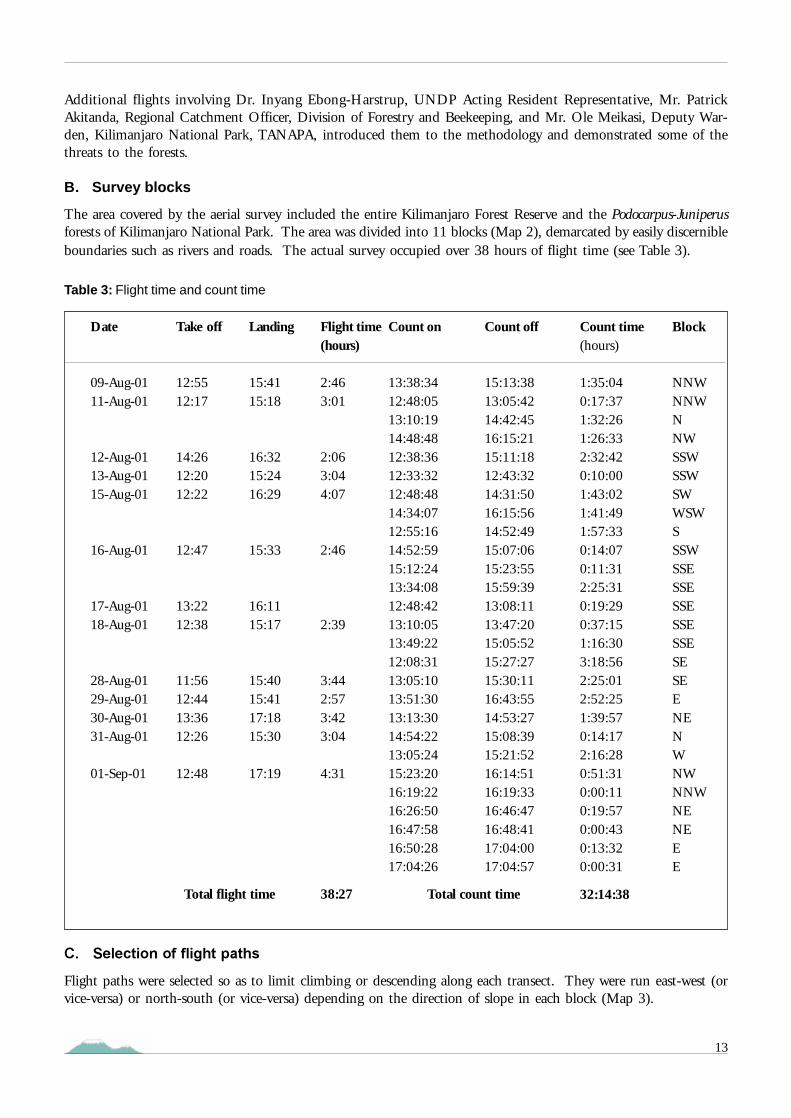
The area covered by the aerial survey included the entire Kilimanjaro Forest Reserve and the Podocarpus-Juniperusforests of Kilimanjaro National Park. The area was divided into 11 blocks (Map 2), demarcated by easily discernibleboundaries such as rivers and roads. The actual survey occupied over 38 hours of flight time (see Table 3).
C. Selection of flight paths
Flight paths were selected so as to limit climbing or descending along each transect. They were run east-west (orvice-versa) or north-south (or vice-versa) depending on the direction of slope in each block (Map 3).
Table 3: Flight time and count time
Date
09-Aug-0111-Aug-01
12-Aug-0113-Aug-0115-Aug-01
16-Aug-01
17-Aug-0118-Aug-01
28-Aug-0129-Aug-0130-Aug-0131-Aug-01
01-Sep-01
Take off
12:5512:17
14:2612:2012:22
12:47
13:2212:38
11:5612:4413:3612:26
12:48
Landing
15:4115:18
16:3215:2416:29
15:33
16:1115:17
15:4015:4117:1815:30
17:19
Flight time(hours)
2:463:01
2:063:044:07
2:46
2:39
3:442:573:423:04
4:31
Count on
13:38:3412:48:0513:10:1914:48:4812:38:3612:33:3212:48:4814:34:0712:55:1614:52:5915:12:2413:34:0812:48:4213:10:0513:49:2212:08:3113:05:1013:51:3013:13:3014:54:2213:05:2415:23:2016:19:2216:26:5016:47:5816:50:2817:04:26
Count off
15:13:3813:05:4214:42:4516:15:2115:11:1812:43:3214:31:5016:15:5614:52:4915:07:0615:23:5515:59:3913:08:1113:47:2015:05:5215:27:2715:30:1116:43:5514:53:2715:08:3915:21:5216:14:5116:19:3316:46:4716:48:4117:04:0017:04:57
Count time(hours)
1:35:040:17:371:32:261:26:332:32:420:10:001:43:021:41:491:57:330:14:070:11:312:25:310:19:290:37:151:16:303:18:562:25:012:52:251:39:570:14:172:16:280:51:310:00:110:19:570:00:430:13:320:00:31
32:14:38
Block
NNWNNWNNWSSWSSWSWWSWSSSWSSESSESSESSESSESESEENENWNWNNWNENEEE
Total flight time 38:27 Total count time

14
D. Data recording
The pilot navigated and recorded each observation into the GPS receiver. The RSO took photographs, and recordedthe information related to each observation on a data sheet in consultation with the pilot. Both crew attempted tospot and assess disturbance in the forest.
GPS positions of observed disturbances are affected by in-built imprecision of the GPS system and the time lapsebetween eye observation and subsequent logging of the actual position into the GPS. As a result, GPS position ofdisturbances may be slightly off the actual position on the ground; the GPS positions of disturbances on the edgesof the forest reserves may appear on the maps slightly outside the boundaries.
The recording of disturbance was restricted by aircraft aerial visibility, since disturbance concealed by the canopywas not seen. Tall trees, deep valleys, obscured angles and sunlit tree tops that enhanced dark shadows all affectedwhat was actually seen and recorded. As a result, the recorded observations provide an indication of the extent ofthe actual disturbance rather than a complete and accurate picture.
For each observation, the following data were recorded:
• Waypoint number as indicated on the GPS• Type and extent of disturbance• Frame numbers• Comment made by the pilot or the RSO
The extent of the disturbances was estimated in hectares for the small cultivated fields on the southern slopes, onthe basis of counting the number of football pitches (0.5 hectare) that could fit in each of the fields under observation.
E. Photo records
Most observations are illustrated by photographs. In particular, each Shamba-system area and each “forest village”are documented by at least one photograph. Photographs were taken with a digital still camera Fujifilm model4700.
Transects were spaced from be-tween 0.5 to 1 kilometre apart,depending on the extent of forestdamage witnessed. In areas wheredisturbances were not recent,transects were one kilometre apart.In areas moderately disturbed, thetransects were 500 metres apartin order to document the distur-bance activities in the forest moreprecisely. In heavily disturbedareas, figures of eight were carriedout on either side of the transectsto enable a more thorough surveyof the disturbances (Figure 1). Inthe latter case, however, thetransects were one kilometre apart(and not 500 metres) in order toavoid overlap between twoadjacent transects while flying thefigure of “eight”.
Figure 1: figures of “eight” over the south eastern slopes

15
F. Data processing in the field
Immediately on landing, the RSO down-loaded the digital photographs, the GPS rover files and the observationwaypoint files into a lap-top computer using Trimble Pathfinder software. Maps of the flight lines and the observationwaypoints were then printed to identify any double observations within each block and to cross check with theflight lines as to whether or not the area to be surveyed had been completely covered.
G. Data interpretation and analysis
Further analysis was carried out in Nairobi. All data were copied from the data-sheets to an Excel spreadsheetwhere they were merged with the GPS data (position, date and time). All the MS-Excel data records were thentransferred into a GIS using the ArcView v.3.2 software. The boundaries of the Forest Reserve and the half-mileforest strip that are incorporated in the GIS were based on the 1972 map “Kilimanjaro Forest Reserve”, preparedby the Forestry and Beekeeping Division, of the Ministry of Natural Resources and Tourism. Digital photographswere used to cross check the information recorded on the data sheets.
VI. RESULTS OF THE AERIAL SURVEYA. Overall description of current threats to the forests
Mt. Kilimanjaro forests are heavily impacted by illegal logging of indigenous trees in most areas below 2,500metres on the western, southern and eastern slopes, fire occurrences on the south eastern slopes, and the establishmentof forest villages in the western and northern slopes (Map 3).
Southern slopes of Mt. Kilimanjaro
Logging activities affect the entire broadleaved mixed forests below an altitude of 2,500 metres. The moist Ocoteaforests that cover most of the southern slopes are undergoing serious destruction caused by the intensive illegallogging of camphor trees. During the survey, over 2,100 recently-logged camphor trees were counted. On thelower slopes bordering the half-mile forest strip, there was no recent logging of camphor trees as these areas havealready been depleted, but other indigenous tree species were being targeted; some 4,300 recently-logged indigenoustrees were recorded. There was evidence of 57 landslides in the heavily impacted Ocotea forests.
The south western slopes are significantly impacted by forest fires; there were 37 areas of burnt forest on theseslopes. To the east, above Marangu, 19 cleared fields have been opened up in the forest, and a large number oflivestock was seen up to 8 kilometres deep into the forest.
There were fewer observations recorded in the half-mile forest strip because the zone is virtually denuded ofindigenous trees. Some areas have been completely clearfelled.
Northern slopes of Mt. Kilimanjaro
Logging activities also impact heavily on the east and west sides of the northern slopes; 574 recently-logged cedartrees were counted, as well as over 800 other indigenous trees.
Large tracks of indigenous forests on the north-western and northern slopes have been converted into forest plantation,using fast growing exotic tree species, such as pine (Pinus patula) and cypress (Cupressus lusitanica). On the northwestern slopes, the expansion of the forest plantations has reduced the indigenous forest belt to a width of less thanone kilometre. The majority of the clear felled compartments within the forest plantations have not been replantedas required by the normal rotation management.

16
B. Logging of indigenous trees
The survey recorded recent loggingof indigenous trees in the naturalforest (Maps 5, 6 and 7). Two of themost targeted species were identifiedseparately: camphor (Ocoteausambarensis) and cedar (Juniperusprocera). The others are grouped un-der the category “other indigenoustree species” (Table 4).
A number of large “forest villages”, some the size of a town, are found in the Forest Reserve. Their presence andlikely future expansion pose a threat to the integrity of the narrow forest belt of Mt. Kilimanjaro.
Photograph 1: Logging of camphor on the south eastern slopes
Tree species
Camphor
Cedar
Other indigenous tree species
Total
Number of trees
2,111
574
5,183
7,868
Table 4: Logging of indigenous trees

17
Photograph 2: Logging of camphor on the south western slopes
Photograph 3: Logging of camphor on the south western slopes

18
Photograph 4: Logging of cedar on the eastern slopes
Photograph 5: Logging of indigenous trees on the south eastern slopes

19
C. Burnt forest areas
The survey recorded 65 burntindigenous forest areas (Map 8).The fires had usually taken placesome time ago. The majority ofthese areas were found on thesouth western slopes of Mt.Kilimanjaro (Table 5).
Photograph 6: Burnt forest on the south western slopes
Fires are also a common phenomenon in the forests of the subalpine zone, with the result that the Podocarpus,Hagenia and Juniperus forests have been replaced by Erica forests and bushlands in many areas (Hemp & Beck2001). Fires devastate several hundreds hectares of Erica bush every year, but since they occur mostly above theforest line, they were not counted in the survey.
Number of burnt forest areas
37
18
10
65
Location
South western slopes
Eastern slopes
Others
Total
Table 5 : Burnt forest areas

20
D. Charcoal production
Some 125 charcoal kilns werespotted in the natural forest of Mt.Kilimanjaro (Map 9). All the kilnswere located on the south easternslopes (Table 6).
Photograph 7 : Charcoal kilns on the eastern slopes
Table 6 : Charcoal production
South eastern slopes
Elsewhere
Total
125
0
125
Location Number of charcoal kilns

21
E. Forest villages
The survey counted 18 “forestvillages”. Forest villages are per-manent urban settlementsvarying in size from smallhomesteads to medium-sizedtowns (Table 7). All of themwere found amid the forestplantations within the ForestReserve. They were up to 4kilometres into the forest on thenorth western and northernslopes (Map 10). The size ofthese forest villages is based onan interpretation of twomosaiced Landsat 7 satellite im-ages taken on January-February2000. A false colour composi-tion (bands 4, 3 and 2) wasused for the interpretation.These forest villages aredensely populated. Photograph 8: Small “forest village” within the Forest Reserve on the
western slope
Northern slopes
Northern slopes
Northern slopes
Western slopes
Western slopes
Londorossi Glades (north western slopes)
Tarakia (north eastern slopes)
Tarakia (north eastern slopes)
Northern slopes
Northern slopes
Nduimet Estates (north western slopes)
Sesana Glade (western slopes)
North eastern slopes
Sesana Glade (western slopes)
Wasendo Glade (western slopes)
Sesana Glade (western slopes)
North eastern slopes
Northern slopes
Nalemoru
Rongai
Morudit
Londorossi
Forest Industries Training Institute
(*)
(*)
(*)
Kamwanga
Endonet
(*)
(*)
Kasirwa
(*)
(*)
(*)
Kasirwa
(*)
Location Name of the“forest village”
41.5
34.8
30.5
26.8
19.9
13.5
12.7
10.3
9.4
6.5
6.4
5.9
5.8
5.1
4.0
3.4
2.8
2.4
Size(hectares)
Table 7: Forest villages
* Name not known to the survey team

22
Photograph 9: “Forest village” within the Forest Reserve on the north western slopes
Photograph 10: Zoom into photograph 9

23
F. Shamba (Taungya) system practices
Forest plantations in Tanzania have usually been established by allowing local farmers to inter-crop annual agricul-tural crops with tree seedlings in forest plantation areas until the third year of tree growth. By the third year, theyoung tree canopy casts too much shade for the normal growth of agricultural crops. At this point farmers moveout and are allocated another plot, if available. This Shamba system is based on the successful experience ofestablishing teak plantations in Burma (Myanmar) since the middle of the 19th century. It was identified as ameans of providing cheap labour, even free, for establishing forest plantations, contributing to national food pro-duction and the creation of rural employment.
The survey recorded the sta-tus of forest plantation areasunder the Shamba-system(Map 11). Three differentcategories were identified: ar-eas not planted with treeseedlings, those partiallyplanted, and planted areas(Table 8).
Table 8: Shamba-system practices
Status of Shamba-system areas
Not planted with tree seedlings
Partially planted with tree seedlings
Planted with tree seedlings
Total
Number of areas
22
10
10
42
Photograph 11: Shamba-system area not planted with tree seedlings on the north eastern slopes

24
Photograph 12: Shamba-system area not planted with tree seedlings on the north western slopes
G. Livestock grazing
Large herds of livestock were found on the northern slopes of Mt. Kilimanjaro. On the southern slopes, livestockwas found predominantly above Marangu up to eight kilometres deep into the forest (Map 12). In total, 814 headof livestock were counted; goats and sheep were grouped together as “shoats”, and cattle were counted separately(Table 9).
Livestockgrazing
Northern slopes South western slopes South eastern slopes Total
No. ofHeads
Average No.heads/herd
Average No.heads/herd
No. ofHeads
No. ofHeads
Average No.heads/herd
45
34
41
73
34
107
18
11
15
231
26
257
8
13
9
619
195
814
Table 9 : Livestock grazing
Cattle
Goats
Total
315
135
450

25
H. Small cultivated fields in the indigenous forest
Small open cultivated fields were found in the indigenous forest on the southern slopes north of Kidia and Marangu(Map 13); 19 cultivated fields totalled an area of approximately four hectares.
Photograph 13: Small Taro field (Colocasia esculenta) on the south eastern slopes
I. Landslides
In total, 88 landslides were spotted in theforest (Map 14), mainly in the Ocotea for-ests on the southern slopes, in heavilylogged areas (Table 10).
Photograph 14: Landslide on the southeastern slopes
Location
Ocotea forest
Elsewhere
Total
Table 10. Landslides
Number oflandslides
57
31
88

26
VII. DISCUSSION OF THE RESULTS
A. Introduction
The forest destruction recorded during the survey fell under eight categories: logging of indigenous trees, fires,charcoal production, shamba-system practices, quarries, livestock grazing, cultivation of small fields and land-slides. All categories of destruction, apart from landslides, are directly human induced.
Each type of forest destruction is discussed against ground data collected before the survey by the University ofBayreuth.
B. Logging of indigenous trees
Camphor (Ocotea usambarensis)
The magnitude of forest destruction through logging of indigenous trees is very high. The camphor tree is the mosttargeted indigenous tree species. Of 7,868 felled indigenous trees, about 2,111 were camphors. Logging of camphorwas found throughout the Ocotea forests of the moist southern and eastern slopes. It has opened up the forestcanopy and threatens the integrity of these forests.
The highest levels of logging were observed above Machame and Kidia (block SSW and east part of block SSE) withless activities between block S and the west part of block SSE. Ground data revealed that exploitation in the fifties,sixties and seventies had reduced the camphor stand significantly.
There was almost no logging of camphor seen between Marangu and Mkuu (east part of block SE), even althoughthe natural Ocotea forest belt extends eastwards above Mkuu. Again ground data show that the camphor stand inthat area has been depleted. Similarly, only a few recently-logged camphor trees were seen on the lower forest zoneon the southern slopes (blocks SW to SE). According to ground observations, this forest zone is dominated bypioneer tree species, such as Polyscias fulva and Macaranga kilimandscharica, and the liana Rourea thomsonii. Thisindicates that the forest was opened up when camphor trees were extracted some decades ago. In the forest zoneabove 2,400-2,500 metres on the southern slopes, untouched montane forests still exist.
Cedar (Juniperus procera)
Cedar was identified separately as it is easily distinguished from the air. Of the 7,868 felled indigenous trees, about574 were cedar trees. The major recent felling activities were located above Rongai (block NE) and Nanjara (blockE). On the northern slopes (blocks NW and N), few cut cedar trees were recorded, although the main distributionof Juniperus procera stretches across the northern slopes above 2,400 metres from block NW to block E. Groundsurveys revealed that until the early 1990s the forests in blocks NW, NNW and N have been heavily exploited;most of the cedar and other valuable timber trees have been removed.
Other indigenous trees
In the category “other indigenous trees”, about 5,183 recently-logged trees were counted. The other valuabletimber trees that had been logged included Syzygium guineense, Fagaropsis angolensis, Podocarpus latifolius (Podo),Aningeria altissima, Newtonia buchananii, Olea capensis (East African Olive) and Prunus africana. But nearly all treespecies occurring on the mountain (around 130) were recorded as being cut more or less often for firewood duringthe same ground surveys.
Ground surveys on the southern slopes in the Ocotea forests below 2,000 metres revealed the frequent logging ofSyzygium guineense. Above 2,000 metres in the middle and upper montane zone Podocarpus latifolius increases indensity, and is being logged especially in areas where Ocotea has been depleted (blocks SE and E). The same holdsfor the subalpine Podocarpus forests above the camphor forests of the southern slopes, where the rare Prunus africanais also targeted.

27
On the western, northern and eastern slopes in the submontane Croton-Calodendron forests and montane Cassipoureaforests, the main targeted species are Fagaropsis angolensis, Olea capensis and, more seldom, Prunus africana.
In the submontane gorge forests of the southern slopes outside the Forest Reserve, e. g. in the Mrusunga valley westof Kidia (block SSE - see section J below) Newtonia buchananii, Syzygium guineense, Olea capensis and Aningeriaaltissima are being extracted.
C. Burnt forest areas/Charcoal production
About 65 burnt forest areas/fires were observed, particularly on the south western slopes in the submontane andlower montane Croton-Calodendron and Cassipourea forests between 1,300 and 2,000 metres and on the easternslopes. In the central montane zone of the southern slopes between 2,100 and 2,400 metres, fire is uncommon dueto very high precipitation. Fire is frequent, however, in the subalpine heath zone of the mountain, but as theyoccur mostly above the forest line, they were not recorded in the survey. Towards the end of the dry season(February/March) the whole ericaceous belt is usually so dry that it is easily set on fire by people or by lightning.In 1996 and 1997, fires destroyed nearly 90 km
2 of the Erica forests and shrub land on the southern slopes of Mt.Kilimanjaro (Hemp & Beck 2001).
The fires in the forests of Mt. Kilimanjaro are mostly set by people. On the lower slopes along the forest boundarymost fires are lit by farmers in their fields; the fires can spread into the neighbouring forest. Deeper inside the forestbelt fires are often caused by careless honey collectors, animals hunters and pit-sawyers.
The 125 recorded charcoal kilns were mainly found east of Marangu above Mwika (block SE). Traditional charcoalproduction poses a considerable fire risk to the forest ecosystems, and charcoal kilns above Mwika were surroundedby burnt forest areas, Erica excelsa forest patches and large openings covered by grasslands as a result of recurringfires.
D. Quarries
Three quarries were observed in the Forest Reserve. Although their extent does not pose a major threat to the forestecosystem, their existence is incompatible with forest conservation and management.
E. “Forest villages” and Shamba (Taungya) system practices
The Forest Reserve contains a recorded 18 medium to large size “forest villages”, covering a total area of about 215hectares. All are found among the forest plantations on the western and northern slopes (blocks W, NW, N andNE).
Based on Landsat imagery, the area allocated to forest plantation is around 13,000 hectares, representing some 12per cent of Kilimanjaro Forest Reserve. In West Kilimanjaro (block NW) these plantations extend nearly to themoorland boundary, hence dividing the natural forest belt. Only approximately 44 per cent of the area allocated toforest plantations is actually planted with trees, the remaining being under the Shamba-system. The aerial surveyrevealed that over 50 per cent of the Shamba-system areas is not under tree growing, either replanting was notsuccessful or was not undertaken at all.
F. Livestock grazing
Some 814 livestock were counted grazing in the forest of which the majority were cattle (76 per cent). The impactof grazing is clearly greatest in the areas where it most occurs. Above Marangu (block SE) and to a lesser degreeabove Kibosho (block S) the forest is now park-like with a similarly aged tree layer and short-cut, pasture-like herblayer, but with no shrubs and young trees. The forest structure in some areas on north Kilimanjaro (blocks NNWand N) indicates that grazing happens there quite regularly.

28
G. Small cultivated fields in the indigenous forest
Unlike on Mt. Kenya, no fields planted with marijuana (Cannabis sativa) were observed, but small fields withinthe forest planted with crops such as Taro (Colocasia esculenta) or beans, were found in blocks SSE and SE. Althoughsmall in number (19) and size (mostly less than 0.2 ha), these cultivated fields could be the focus of furtherexpansion and, hence, should be removed completely.
H. Landslides
Based on ground observations it appears that the occurrence of the 88 landslides recorded is linked to three factors:precipitation, the steepness of the slopes and the intensity of the logging activity. Of the landslides 65 per centoccurred in the Ocotea forest zone, where rainfall exceeds 3,000 mm per year. In this zone, areas heavily affected byrecent logging activities show a significant concentration of landslides.
I. Other threats, not recorded during the aerial survey
Forest disturbance, caused by ancient logging activities could not be recorded during the aerial survey, nor thedisturbance by big game, such as buffalo and elephants, that has a significant impact on the forests in the westernand northern slopes. Their browsing opens the forest and inhibits regeneration. Nevertheless, the large number ofelands at higher altitudes on the southern slopes, especially in blocks SW and SSW, does not significantly affect theforest structure and regeneration.
Hunting is common on Mt. Kilimanjaro. In higher zones above 2,600 metres large numbers of traps for pigs andsnares for smaller animals were found, especially between Mweka and Marangu, in blocks SSE and SE. Beekeepingis also widespread and is the cause of many forest fires (see section C above). The collecting of fodder on thesouthern and eastern slopes and the cutting of grass in clearings and on the forest floor also constrain forestregeneration by destroying tree seedlings and young trees.
J. Forest areas outside the Forest Reserve
Near Natiro, west of Kidia (block SSE - see Map 1) natural forest reaches down to about 1,500 metres in theMrusunga valley. This forest patch is one of the most interesting forest types on Mt. Kilimanjaro, as it links theforest flora of Mt. Kilimanjaro with the submontane forests of the Pare and Usambara mountains. Many forestspecies, formely only known from the Eastern Arc Mountains, were found during ground surveys in that forestpatch. One fern species is found nowhere else in Tanzania (Hemp 2001a). This forest area is under high pressurefrom logging activities. This unique ecosystem deserves urgent attention and should be included in the protectedarea for better protection and conservation.

29
VIII. CONCLUSIONSThe whole forest belt of Mt. Kilimanjaro is disturbed by human activities. The highest impact is caused by thelogging of indigenous trees either recently or during the last decades. Logging activities in the camphor zone seemto have increased during the last 10 years. Pristine montane forests remain only above 2,400-2,500 metres on thesouthern slope , whereas no undisturbed forest plot could be found below 1,800 metres. In contrast, on thenortheastern and western slopes, recently logged trees were recorded in the higher slopes, even above 2,700 metres.
The area allocated to forest plantations has increased since the 1950, and now covers approximately 12 per cent ofthe Forest Reserve. Together with the “forest villages”, planted forests represent a major threat to the integity of themontane forest ecosystem on the western and northern slopes. The half-mile forest strip, although meant fortimber production to reduce the pressure on the natural forest, is not used effectively. Fires are an important causeof forest degradation inside the forest belt, in particular on the south eastern slopes and in the Erica zone.
The current level of threats to the forest belt of Mt. Kilimanjaro is very high. Prompt actions are required to put ahalt to on-going forest destruction, if the products and invaluable services that the mountain provides to the regionand the whole nation are to be maintained.

30
ABBREVIATIONS
AWF: African Wildlife Foundation
COMPACT: Community Management of ProtectedAreas Conservation Project
GEF: Global Environment Facility
GIS: Geographical Information System
GPS: Global Positioning System
KWS: Kenya Wildlife Service
RSO: Rear seat observer
TANAPA: Tanzania National Parks
UNDP: United Nations Development Programme
UNEP: United Nations Environment Programme
UNF: United Nations Foundation
WCST: Wildlife Conservation Society of Tanzania
WNHS: World Natural Heritage Sites

31
REFERENCES
Forchhammer, P., Breuning, S. (1986): Annotated list of Cerambycidae, subfamily Lamiinae collected inTanzania, Zambia and Botswana 1969-80 with description of 86 new taxa. Natura Jutlandica 22(1): 1-72.
Gathaara, G. N. (1999): Aerial survey of the destruction of Mt. Kenya, Imenti and Ngare Ndare ForestReserve. Kenya Wildlife Service. 26 pp.
Grimshaw, J. M., Cordeiro, N. J., Foley, C. A. H. (1995): The mammals of Kilimanjaro. Journal of EastAfrican Natural History 84: 105-139.
Grimshaw, J. M. (1996): Aspects of the ecology and biogeography of the forest of the northern slope of Mt.Kilimanjaro, Tanzania. Thesis, University of Oxford. 377 pp + appendices.
Hemp, A. (1999): An ethnobotanical study of Mt. Kilimanjaro. Ecotropica 5: 147-165.
Hemp, A. (in press): Ecology of the pteridophytes on the southern slopes of Mt. Kilimanjaro. Part I:Altitudinal distribution. Plant Ecology.
Hemp, A. (2001a): Ecology of the pteridophytes on the southern slopes of Mt. Kilimanjaro. Part II:Habitat selection. Plant Biology 3: 493-523.
Hemp, A. (2001b): Life forms and strategies of forest ferns on Mt. Kilimanjaro. Life forms and dynamics intropical forests. Dissertationes Botanicae 346: 95-130.
Hemp, A., Beck, E. (2001): Erica excelsa as a fire resistant component of Mt. Kilimanjaro’s forests.Phytocoenologia 31/4: 449-475.
Hemp, C. (2001): Ethnozoological Research on invertebrates on Mt. Kilimanjaro, Tanzania. Ecotropica 7:139-149.
Hemp, C. (in press): Comparison of the endemic Saltatoria fauna (Orthoptera) of Mt. Kilimanjaro,Mt. Meru and the Monduli Range. Journal of East African Natural History.
Hemp, C. & Hemp, A. (in press): Saltatoria cenoses of high altitude grasslands on Mt. Kilimanjaro,Tanzania (Orthoptera: Saltatoria). Ecotropica.
Hemp, C., Winter, J. C. (1999): Ethnozoologische Feldforschung am Kilimanjaro. Arthropoda. BayreutherForum Ökologie 64: 167-199.
Hemp, C., Winter, J. C., Scheuerlein, A. (1999): Ethnozoologische Feldforschung am Kilimanjaro.Säugetiere, Vögel, Reptilien und Amphibien. Bayreuther Forum Ökologie 64: 149-165.
Johnsen, P., Forchhammer, P. (1975): Checklist of the Acridomorpha of Tanzania. Natura Jutlandica 18:26-52.
Sjöstedt, Y. (1909)(Ed.): Wissenschaftliche Ergebnisse der Schwedischen Zoologischen Expedition nachdem Kilimanjaro, dem Meru und den umgebenden Massaisteppen Deutsch-Ostafrikas 1905-1906.
TANAPA / AWF (1987). “Kilimanjaro National Park”. Tanzania National Parks; African Wildlife Foundation.July 1987.

32
ANNEX: MAPS 1 TO 14
Map 1: Vegetation types
Map 2: Survey blocks
Map 3: Flight lines
Map 4: Overall threats to the forests
Map 5: Logging of Camphor
Map 6: Logging of Cedar
Map 7: Logging of other indigenous trees
Map 8: Burnt forest areas
Map 9: Charcoal production
Map 10: Forest villages
Map 11: Shamba system practices
Map 12: Livestock grazing
Map 13: Small cultivated fields in the indigenous forest
Map 14: Landslides

Map 1.

Background to thevegetation map
The map is the result of asupervised classification using thesoftware IDRISIS 3.2.The classification is based on:• 328 sites selected among over
1,100 surveyed sites by Dr.Andreas Hemp,University of Bayreuth;
• A mosaiced image based ontwo Landsat ETM 7 imagestaken on 29 January and 21February 2000. The bands1, 2, 3, 4, 5 and 7 were used.

Map 2.

Map 3.

Map 4.

Map 5.

Map 6.

Map 7.

Map 8.

Map 9.

Map 10.

Map 11.

Map 12.

Map 13.

Map 14.

48