Embed Size (px)
Citation preview
Geoforum 2/1970 19
Aerial Photography: A Diversified Tool
Die Luftphotographie: ein vielfiiltiges Hilfsmittel
La photographie akienne: un outil conventionnel
L. W. BOWDEN and W. G. BROONER, Riverside, Calif.*
Abstract: An aerial photograph is a vital and useful tool and may contain more than 8 x lo9 bits of information.
In the past 100 years aerial photography has advanced to a highly sophisticated state. Although regarded as the most
conventional and standard of the remote sensors, optimum use and application of aerial photography has yet to
be fully reached. The deductive process of photo-interpretation is a multidisciplinary “tool science” that demands
the viewer look at all aspects of the terrain and extract data for his particular needs and applications. An aerial
photograph’s overall view provides the interpreter with a perception of space and areal comparisons rarely available by
other means. With continuing research and application of photographic and interpretation techniques, use of aerial photo-
graphy in the visible and near visible ranges (approximately 350 to 1200 millimicrons) is bound to increase as more
individuals realize the benefits. The only limitation is man’s imagination and his ability to obtain and exploit imagery.
Zusammenfassung: Ein Luftbild kann mehr als 8 x lo9 einzelne wichtige Informationen enthalten. Im Lauf der letzten
100 Jahre hat sich die Aerophotographie zu einer aui3erordentlichen Hohe entwickelt. Obwohl sie als herkomm-
lichste aller Methoden der Fernerkundung angesehen wird, ist ihre optimale Anwendung noch lange nicht erreicht. Den
deduktiven Weg der Bildinterpretation beschreiten heute viele Wissenschaftszweige, die fur ihre spezifischen Bediirfnisse
Informationen aus dem Photo sammeln. Auf Anbieb gibt em Luftbild dem Bescbauer eme rlumliche Vergleichsmijglichkeit,
die hochst selten auf anderem Weg erreicht wird. Je melu sich die Photographie und die Tech&en der Bildinterpretation
entwickeln, wird der Gebrauch von Luftbildern im Bereich des Sichtbaren und im nahen IR und UV (etwa 350 bis 1200 mu)
zunehmen. Nur des Menschen Einbildungskraft und seine Fahigkeit, Bildinhalte auszuschopfen, konnen hier Grenzen setzen.
Resume: Une photographie aerienne est un outil essentiel et utile, et peut contcnir plus dc 8 . IO9 informations.
Durant les 100 demieres an&es, la photographic aerienne a progress6 jusqu’a un stade tres sophistiqu& Bien qu’elle
soit consider&e comme le capteur a distance le plus conventionnel et le plus classique, on doit encore atteindre une
utilisation et une application optimales de la photographie aerienne. Le processus deductif de la photo-interpretation est
une ((science-outil> pluridisciplinaire, qui exige de l’utilisateur de considerer tous les aspects du terrain et d’en retirer des
informations pour ses besoins et ses applications particuliers’ La couverture globale d’une photographie aerienne fournit
a l’utilisateur une perception de l’espace et des comparaisons aeriennes rarement procurees par d’autres moyens. Avec la
poursuitc des recherches et de l’application des techniques de photographie et d’interpretation, l’utilisation de la photographie
aerienne dans les plages visibles et presque visibles (environ 350 a 1200 millimicrons) est vouee i se d&lopper au fur et a mesure que des utilisateurs particuliers se rendront compte de ses avantages. La seule limitc reside dans l’imagination de
l’homme et dans son aptitude i obtenir et a exploiter les images.
Introduction
Recent computations performed at the Livermore Labora- tory, University of California, USA, estimate nearly 1016 bits of information on a single aerial photograph. The di- versity and uniqueness of aerial photography as a remote data gatherer has yet to be equalled in any other sensor or any other part of the electromagnetic spectrum for
* Leonard W. BOWDEN, Ph. D., and William G. BROONER,
M. A., Department of Geography, University of California,
Riverside, Calif., 92502, USA.
providing information to earth scientists of many discip lines. The objects and conditions that are recorded with aerial films and cameras in both the visible and near visible photographic ranges provide - once the interpreter is in-
doctrinated to the aerial prospective - a most amazing and useful tool. In the hands of specialists and laymen alike, an aerial photograph is a time saving information giver and a utilitarian perception enhancer.
The mating of camera, film, and an airborne platform is not new. In both Europe and the United States, experi- ments were conducted in the mid-nineteenth century.
20 Geoforum 211970
During the United States’ Civil War, for example, balloons were used as camera platforms to record the scene below and around and to provide strategic military reconnaissance. One suspects that as soon as man devised a means to be- come airborne he desired ways to record and capture the overall view below’). Advances in cameras and platforms, films and filters, and interpretation systems and techniques have followed the pace of technological progress. Dramatic
examples are the color and color infrared photographs returned from space in the past decade and a half.
“Photo~terpretation is a tool science”2). Interpretation of aerial photographs can be used to obtain information in many physical, earth, social and engineering sciences. The application of aerial reconnaissance is limited only by man’s imagination and his ability to obtain photography and to exploit it for the wealth of information which it records. tier the past several years, new research and testing em- phasis has been directed toward color, infrared, and multi- band photography (i. e., the use of filters to record reflected
light in only narrow portions of the photographic region) as additional tools to the panchromatic image. The result has been continuing diversification of application when in- terpreting the conventions comb~ations of aerial cameras
and films.
Why Aerial Photography?
Car1 STRANDBERG (1967a) summarizes five reasons why aerial photographs, when properly interpreted, pro- vide an effective way of discovering many obscured or hid- den facts about the world around us. 1) They offer a van- tage point of improved observation unobtainable by the ground based observer. From the air the observer’s field
of view is increased many fold. And the higher he (or the sensor) rises, the more landscape is observable and integrated into a single scene. Although there are restrictions due to atmospheric clarity, fti resolution and lighting conditions, the observer may be able to detect and interpret objects many kilometers away (when all conditions are proper). 2) Modern sensors offer better resolution than the unaided human eye (which can resolve about 4.5 lines per milli-
meter at a contrast ratio of 2: 1 while modern photographic
‘7 DAGUERRE - the father of photography - succeeded in making positive prints by using silver compounds in the early 19th century. NADAR, a French balloonist, is believed to be the fist aerial photographer when he ascended with a camera in 1857 or 1858. In 1860, J. W. BLACK, took a balloon aerial photograph of Boston and Union General G. B. MCCLELLAN used balloon photography for aerial reconnaissance near Frs dericksburg during the American Civil War.
*) For more detailed information see STRANDBERG, Carl H., Aerial Discover canal, John Wiley and Sons, Inc., New York, London & Sydney, 1967 or AVERY, T. Eugene, Interpretation ofAerial Photographs, 2nd Edition, Burgess Publishing Com- pany, Minneapolis, 1968.
systems can resolve several hundred lines per millimeter at a 2: 1 contrast ratio). Objects invisible to a human may still be recorded photographically. 3) Human vision is spectrally limited and extends from about 400 to 700 millimicrons while the photographic spectrum is from somewhere around 320 to 1200 m~l~icrons, or almost twice as broad. 4) When the camera shutter is tripped, recorded objects are immobilized and they may then be studied at leisure. (The great advantage of aerial photo- graphy as an historical document cannot be overempha- sized; however, on-time continuous recording systems in the same spectral range, i.e., TV scan, can be very useful in monitoring or analyzing such phenomena as traffic or weather conditions.) 5) The geometric fideiity of the components of images makes possible the determination of distances, vectors, and areas with a higher degree of accuracy than is usually possible by ground obse~ations ‘).
State of the art photographic systems have greater resolu- tion capabilities than optical-mechanical scanners or tele- vision systems. Geometrical distortions are minimal and
excellent spatial orientation can be achieved with precision aerial cameras. Additional advantages of aerial photography, when compared to other remote sensing systems, include, 1) greater ease of perception by human interpreters, 2) re- latively more simple means of operation and processing (i.e., little or no circuitry or pretest equipment), 3) more compactness and less weight, and 4) lower cost and inter- pretation requirements.
One must always be aware, however, of limitations in ob- taining and using aerial photographs. Some of the critically limiting factors are: 1) requirement for clear weather and adequate sunlight, 2) delay time between exposure and processing - photography is not a real time system as is television, 3) the mass of data stored on the image requiries many man-hours to extrapolate, because automatic scann- ing, storing and computing are not yet fully developed, and 4) photographic sensors are limited to only the visible and near-visible portions of the electromagnetic spectrum and do not provide broad spectral data. Any photograph, regardless of origin or type of image displayed, is nothing more nor less than a historic document and graphic record of visible or near-visible conditions at one point in time.
Of course, therein lies some of the great advantages to aerial photography for conventiona use in our dynamic world.
‘1 The Manual of Photographic Interpretation published in 1960 by the American Society of Photogrammetry is recommended as a detailed and comprehensive coverage of the many uses to which aerial photographs can be applied. The Manual of Color Aerial Photography, published by the same society in 1968, deals with color inputs primarily during the 1960’s. At present (1970) the Society is preparing a two volume work titled Manual of Remote Sensing to be published in 1972.
Geoforum 2/l 970
Elements of Photo-interpretation
Photographic interpretation is a deductive process. Most interpretation manuals stress image or target identification and go into detail on how size, shape, shadow, tone, pattern and texture are critical elements of extractable informa- tion. As the interpreter progresses site, situation, and environmental relationships become an integral part of the interpretation process.
Before the elements of photo-interpretation are further discussed, it is useful to consider the photo-interpreter himself. Although many volumes have been written on both military and civil use of aerial photography, each interpreter employs aerial photography for his own spe- cific application. Among the millions of people who have at one time or another looked at aerial or space photo- graphs, there are four general categories of interpreters. The first is the layman who is a “gee-whiz” user. The “gee-whiz” user looks at a photograph and says “I can see my house, my farm or aR the cars in Manhattan” (depending on the photo). That is as far as it goes. The second user is the target examiner, military or civilian, and he looks for a tree type, a rocket installation, a fault line or a traffic intersection and then does detailed analysis of the identified target. The third user is the discipline or subject interpreter, e.g., the soil scientist who examines the total photograph for a specific soils class, the hydro- logist examining drainage patterns, or the photogramme- trist drawing topographic contours. A fourth type is the overviewer, who examines spatial relationships and patterns,
e.g., the industrialist seeking a site location for a new
plant, the forester classifying timber stands, or the geo-
grapher examining the integrated patterns on the photo graphic landscape. Naturally many of the above categories overlap but in general they are identifiable users. Many disciplines have developed their own highly specialized interpretation techniques, equipment, and applications for utilizing aerial photography.
Regardless of interpreter or diversified applications, the basic elements affecting photo-interpretation are linear features and geometric shape, size, tone, and texture. (Plate la). Symmetrical, straight or perpendicular features are rare in nature. With few exceptions, linear features indicate man’s influence on the face of the earth. Occas- sionally a fault scarp, flood or fire damage, or animal trails will be linear, but usually the presence of linear shapes indicates cultural activity. Furthermore, linear features are most obvious phenomena on aerial photo- graphs, including highways and streets, railroads, trails, canals, power lines, pipe lines, fence and field boundar- ies, and walls. Naturally, the ease of interpreting linear features provides a clue or surrogate to other extractable data.
Geometric shape ranks second to linear features as an element of aerial interpretation. Depending on photogra-
phic scale (i. e., map scale) the detectable shape may range from an individual tree to a total city or geologic feature. The Richat structure in Mauritania was more accurately interpreted when space photography indicated its pre- viously unmapped shape. The shape of tree crowns in combination with the profile of shadows is often a clue to tree species on low altitude photography. In urban analysis, shape is an indicator of residential class, industrial or commercial activity, transportation facilities, a key to zoning laws and land use regulation, to name but a few.
Closely related to geometric shape is the element of size. Size may be determined relative to surrounding or known phenomena or photogrammetrically by measurement when photographic scale or ground data are known. It almost goes without saying that distance and height can be measured - easily when vertical stereoscopic photo- graphy is used, with difficulty when oblique or non stereo is used. Most air photo manuals describe the photogram- metric techniques to be employed.
Tone conveys more information to the alert interpreter than any other single element of a photograph. Tonal contrasts reveal complex patterns and their spatial rela- tionships on the landscape. In recent years with the trend toward using positive transparencies with back lighting, the combination of hue, chroma and saturation in a color or false color (as in color infrared) photograph creates a great aid to photo analysis. In black and white photo- graphy the tone is a shade of gray. Relative tone can be
quantified by microdensitometric measurements of the
amount of light passing through a transparency. The analysis of such tone or color measurements may allow future interpretation of various terrain objects or condi-
tions with a high degree of automation.
In addition to tone or color, similar objects, areas, or terrain conditions exhibit similar texture characteristics.
A dense forest stand, for example, may have a unique textural pattern on an aerial photograph due to the ar- rangement of tones and shadows. Photographic texture is often expressed as “fine, medium, coarse”, etc., and is somewhat analogous to cloth or fabric textures.
Having briefly reviewed the basic elements of aerial photo- interpretation, it is necessary to add a note about the
quality of photographs used for interpretation. Photo- graphic quality is largely dependent on a particular inter- preter’s needs or application. The primary characteristics governing quality, however, are the same. These, according to COLWELL (ASP, 1960), are tone contrast (the differ- ence in brightness between image and background), image sharpness (the abruptness with which tone or color con- trasts change), and stereoscopic parallax (the displacement of apparent position of terrain objects with respect to a terrain reference point due to a shift in camera position).
22 Geoforum 211970
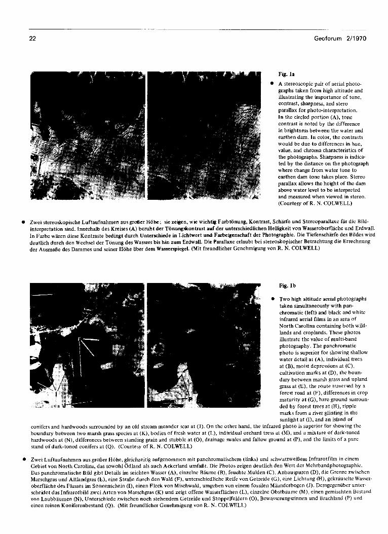
Fig. la
l A stereoscopic pair of aerial photo-
graphs taken from high altitude and
illustrating the importance of tone, contrast, sharpness, and stero
parallax for photo-interpretation.
In the circled portion (A), tone
contrast is noted by the difference
in brightness between the water and
earthen dam. In color, the contrasts
would be due to differences in hue, value, and chroma characteristics of
the photographs. Sharpness is indica-
ted by the distance on the photograph
where change from water tone to
earthen dam tone takes place. Stereo
parallax allows the height of the dam above water level to be interpreted
and measured when viewed in stereo.
(Courtesy of R. N. COLWELL)
Zwei stereoskopische Luftaufnahmen aus gr&er Hohe; sie zelgen, wie wichtig Farbtonung, Kontrast, Sch%rfe und Stereoparallaxe fur die Bild-
interpretation sind. Innerhalb des Kreises (A) beruht der Tonungskontrast auf der unterschiedlichen Helligkeit von Wasseroberflache und Erdwall.
In Farbe waren d&e Kontraste bedingt durch Unterschiede in Lichtwert und Farbeigenschaft der Photographie. Die TiefenschLfe des Bildes wird
deutlich durch den Wechsel der Tonung des Wassers bis hin zum Erdwall. Die Parallaxe erlaubt bei stereoskopischer Betrachtung die Errechnung
der Ausmr&e des Dammes und seiner Hohe iiber dem Wasserspiegel. (Mit freundlicher Genehmigung von R. N. COLWELL)
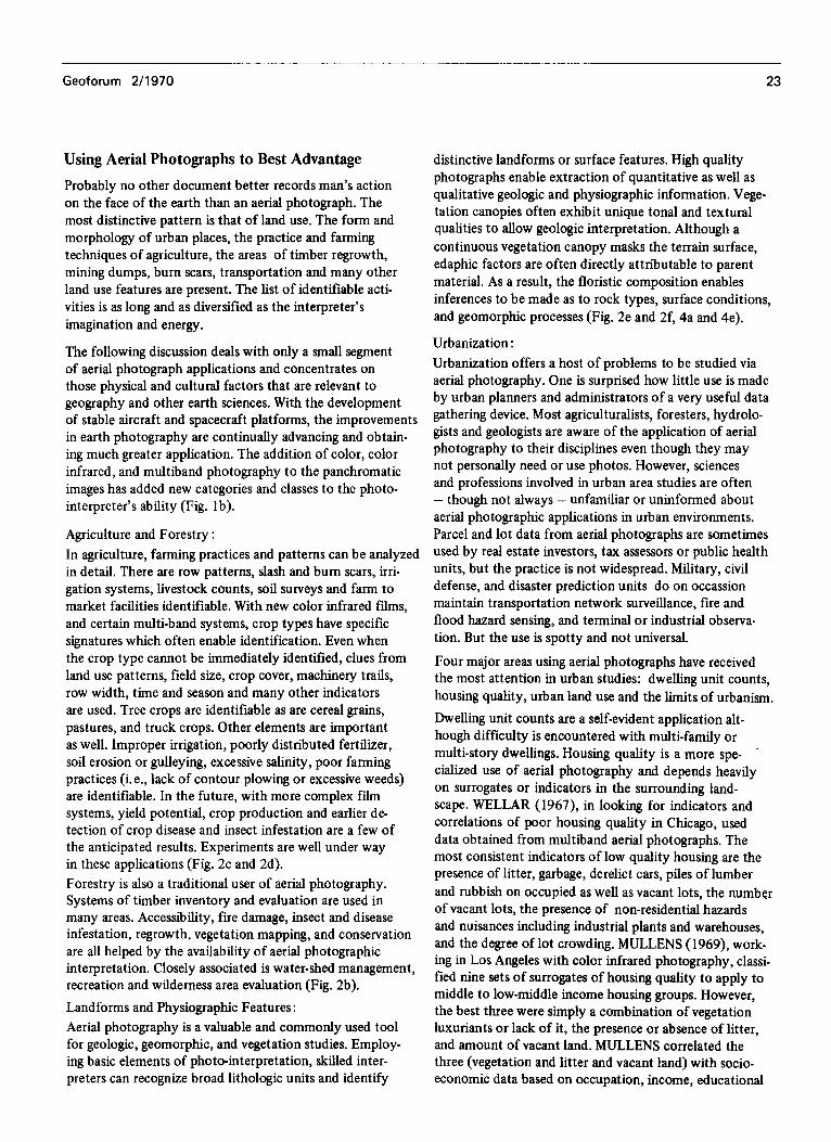
Fig. lb
l Two high altitude aerial photographs
taken simultaneously with pan-
chromatic (left) and black and white
infrared aerial films in an area of
North Carolina containing both wild-
lands and croplands. These photos
illustrate the value of multi-band
photography. The panchromatic
photo is superior for showing shallow
water detail at (A), individual trees
at (B), moist depressions at (C),
cultivation marks at (D), the boun-
dary between marsh grass and upland
grass at (E), the route traversed by a
forest road at (F), differences in crop
maturity at (G), bare ground surroun-
ded by forest trees at (H), ripple
marks from a river glinting in the
sunlight at (I), and an island of conifers and hardwoods surrounded by an old stream meander scar at (J). On the other hand, the infrared photo is superior for showing the
boundary between two marsh grass species at (K), bodies of fresh water at (L), individual orchard tress at (M), and a mixture of dark-toned
hardwoods at (N), differences between standing grain and stubble at (0), drainage swales and fallow ground at (P), and the limits of a pure
stand of dark-toned conifers at (Q). (Courtesy of R. N. COLWELL)
l Zwei Luftaufnahmen aus groi3er Hohe, gleichzeitig aufgenommen mit panchromatischem (links) und schwarzweil3em Infrarotfilm in einem Gebiet von North Carolina, das sowohl edland als such Ackerland umfal3t. Die Photos zeigen deutlich den Wert der Mehrbandphotographic.
Das panchromatische Bild gibt Details im seichten Wasser (A), einzelne Baume (B), feuchte Mulden (C), Anbauspuren (D), die Grenze zwischen
Marschgras und Altlandgras (E), eine StrBe durch den Wald (F), unterschiedliche Reife von Getreide (G), eine Lichtung &I), gekrauselte Wasser- oberfllche des Flusses im Sonnenschein (I), einen Fleck von Mischwald, umgeben von einem fossilen Maanderbogen (J). Demgegeniber unter-
scheidet das Infrarotbild zwei Arten von Marschgras (K) und zeigt offene Wasserflachen (L), einzelne Obstbaume (M), einen gemischten Bcstand von Laubbaumen (IV), Unterschiede zwischen noch stehendem Getreide und Stoppelfeldern (O), Bewasserungsrinnen und Brachland (P) und
einen reinen Koniferenbestand (Q). (Mit freundlicher Genehmigung von R. N. COLWELL)
Geoforum 2/1970 23
Using Aerial Photographs to Best Advantage
Probably no other document better records man’s action on the face of the earth than an aerial photograph. The most distinctive pattern is that of land use. The form and morphology of urban places, the practice and farming techniques of agriculture, the areas of timber regrowth, mining dumps, burn scars, transportation and many other land use features are present. The list of identifiable acti- vities is as long and as diversified as the interpreter’s imagination and energy.
The following discussion deals with only a small segment of aerial photograph applications and concentrates on those physical and cultural factors that are relevant to geography and other earth sciences. With the development of stable aircraft and spacecraft platforms, the improvements in earth photography are continually advancing and obtain- ing much greater application. The addition of color, color infrared, and multiband photography to the panchromatic images has added new categories and classes to the photo- interpreter’s ability (Fig. lb).
Agriculture and Forestry :
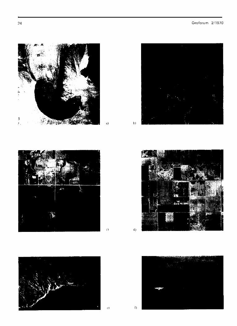
In agriculture, farming practices and patterns can be analyzed in detail. There are row patterns, slash and bum scars, irri- gation systems, livestock counts, soil surveys and farm to market facilities identifiable. With new color infrared films, and certain multi-band systems, crop types have specific signatures which often enable identification. Even when the crop type cannot be immediately identified, clues from land use patterns, field size, crop cover, machinery trails, row width, time and season and many other indicators are used. Tree crops are identifmble as are cereal grains, pastures, and truck crops. Other elements are important as well. Improper irrigation, poorly distributed fertilizer, soil erosion or gulleying, excessive salinity, poor farming practices (i.e., lack of contour plowing or excessive weeds) are identifiable. In the future, with more complex film systems, yield potential, crop production and earlier de- tection of crop disease and insect infestation are a few of the anticipated results. Experiments are well under way in these applications (Fig. 2c and 2d).
Forestry is also a traditional user of aerial photography. Systems of timber inventory and evaluation are used in many areas. Accessibility, fire damage, insect and disease infestation, regrowth, vegetation mapping, and conservation are all helped by the availability of aerial photographic interpretation. Closely associated is water-shed management, recreation and wilderness area evaluation (Fig. 2b).
Landforms and Physiographic Features :
Aerial photography is a valuable and commonly used tool for geologic, geomorphic, and vegetation studies. Employ- ing basic elements of photo-interpretation, skilled inter- preters can recognize broad lithologic units and identify
distinctive landforms or surface features. High quality photographs enable extraction of quantitative as well as qualitative geologic and physiographic information. Vege- tation canopies often exhibit unique tonal and textural qualities to allow geologic interpretation. Although a continuous vegetation canopy masks the terrain surface, edaphic factors are often directly attributable to parent material. As a result, the floristic composition enables inferences to be made as to rock types, surface conditions, and geomorphic processes (Fig. 2e and 2f, 4a and 4e).
Urbanization :
Urbanization offers a host of problems to be studied via aerial photography. One is surprised how little use is made by urban planners and administrators of a very useful data gathering device. Most agriculturalists, foresters, hydrolo- gists and geologists are aware of the application of aerial photography to their disciplines even though they may not personally need or use photos. However, sciences and professions involved in urban area studies are often - though not always - unfamiliar or uninformed about aerial photographic applications in urban environments. Parcel and lot data from aerial photographs are sometimes used by real estate investors, tax assessors or public health units, but the practice is not widespread. Military, civil defense, and disaster prediction units do on occassion maintain transportation network surveillance, fire and flood hazard sensing, and terminal or industrial observa- tion. But the use is spotty and not universal.
Four major areas using aerial photographs have received the most attention in urban studies: dwelling unit counts, housing quality, urban land use and the limits of urbanism.
Dwelling unit counts are a self-evident application alt- hough difficulty is encountered with multi-family or multi-story dwellings. Housing quality is a more spe- cialized use of aerial photography and depends heavily on surrogates or indicators in the surrounding land- scape. WELLAR (1967), in looking for indicators and correlations of poor housing quality in Chicago, used data obtained from multiband aerial photographs. The most consistent indicators of low quality housing are the presence of litter, garbage, derelict cars, piles of lumber and rubbish on occupied as well as vacant lots, the number of vacant lots, the presence of non-residential hazards and nuisances including industrial plants and warehouses, and the degree of lot crowding. MULLENS (1969), work- ing in Los Angeles with color infrared photography, classi- fied nine sets of surrogates of housing quality to apply to middle to low-middle income housing groups. However, the best three were simply a combination of vegetation luxuriants or lack of it, the presence or absence of litter, and amount of vacant land. MULLENS correlated the three (vegetation and litter and vacant land) with socio- economic data based on occupation, income, educational
c)
Geoforum 2/l 970
d)
Geoforum 2/ 1970 25
Fig. 2
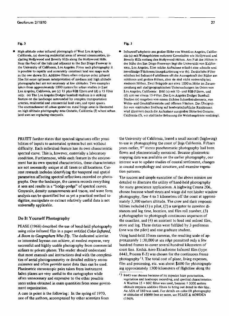
l On a late summer color infrared photograph of Cascade Glacier, Washin~on (a) there is evidence of meltwater rivulets (A), crevasses and fractures (B), and near vertical terminus cliffs (C) on the ice surface, meltwater lake (D) with displaced iceberg (E), and vege- tation (C) indicating past positions of glacier terminus. Color in- frared photographs of forested areas (b), San Bernardino Mountains, California, provide studies including tree counts, species identificat- ion, and crown densities. Agricultural land use studies include crop identifi~tion as on (c) in Douglas County, Kansas, field sizes and patterns, and farming practices. Irrigated fields in the Coachella Valley, California (d) include vineyard, orchard, and field crops. Photos (e) and (f) are obliques recently obtained along the coastline of Baja California. Preliminary interpretation reveals a wealth of data yet to be analyzed. Photo (e), located on the west coast south of Ensenada, exhibits striking contrasts between non-vegetated plung- ing cliffs on the left side of the bay and vegetated cliffs and terraces on the right side, deeply dissected valleys with pronounced riverine vegetation, and sedimentation patterns in the water are indicated by differences in hue. Photo (f), located on the east coast and south of Punta San Fermin, exhibits a highly dissected basalt plateau in the background and volcanic shield cone in the foreground, saline deposition to the left and within the cone, as well as several prom~ent fault scarps.
level, mental health, death rates and arrests. Vegetation has proved to be the most indicative clue to urban condi- tions and at present color infrared photography is the superior urban area sensor. (Fig. 3c and 3d).
Urban land use and the extent of urbanism are traditional uses of conventional black and white low altitude photo- graphy. Recently, however, color, color infrared, and some multiband photography have been successfully used. High altitude panoramic and mapp~ photo~phs in color in- frared has allowed land use mapping and rural-urban fringe detection at greater degrees of accuracy than was previously believed. In fact, Apollo 6 and 9 space photographs of Phoenix and Dallas-Fort Worth (where the total urban complex appears on a single frame) are very useful in study- ing changes at the city’s edge. Remote sensing from space presents a very applicable tool in the above respect.
Transportation Studies :
Updating or identifying transportation routes and networks in both well developed regions and remote areas is a con- stant need that photography can help fulfill. Present methods rely on costly field studies and only random air photo co- verage. SIMONETT (1969) states, “It has been widely sug- gested that high altitude (aerial) photography and space photography may be used for updating maps of transporta- tion networks.” In preliminary studies in the Dallas-Fort
Fig. 2
* Eine spiitsommerliche Infrarot-Aufnahme vom Cascade Gletscher, Washin~on, (a) zelgt deuthch Schme~a~~nnen (A), Spalten und Brilche (B) und einen fast senkrechten Abbruch an der Gletscher- stirn (C), ferner einen Schmelzwassersee (D) mit einem Eisberg (E), Vegetation (G), die die frtihere Ausdehnung des Gletschers anzeigt. Die Infrarot-Farbaufnahme einer bewaldeten Gegend (b), San Ber- nardino Mountains, California, erlaubt Untersuchungen bis hin zum Z%hlen der B&me, zur Spezie~est~mung und zur Ermittlung der Bau~ronendichte. Studien zur L~dnu~ung umfassen die Bestim- mung der Anbaufrllchte wie auf(c) in Douglas County, Kansas, ferner Feldgrofie, Flurformen und Anbaumethoden. Auf Bewasse- rungsfeklern im Coachella Valley, California (d), stehen Weinstocke, Obstbaume und Feldfrilchte. Photos (e) und (f) sind jiingste Schrag- aufnahmen von der Kiiste Niederkaliforniens. Eine vorlaufige Aus- wertung h&t erkennen, welche Fiille von Daten noch der endgiiltigen Analyse harren. Bild (e) von der Westkiiste siidlich Ensenada zeigt deutlich den scharfen Gegensatz von vegetationsfreier Steilktiste auf der linken Seite der Bucht zu den bewachsenen Kliffs und Terrassen auf der rechten; tief eingeschnittene Taler mit ausgepriigter Tal- vegetation sowie Sedimentablagerungen vor der Kiiste sind durch unterschiedliche Farbtiinung klar ersichtlich. Bild (f) von der Ost- kiiste tidlich Punta San Fermin zeigt ein stark zerklilftetes Basalt- plateau im Hinter~~ und den Kegel eines Vulkans im Vordergrund, Salzablagerungen links davon und im Krater seibst, und einige Steil- abbriiche von Verwerfungen.
Worth, Texas, area, for example, SIMONETT has suggested that roads 30 to 90 meters wide can be consistently detected on space photography. The problem2 presented and resolu- tion required are under study, but as stated earlier, linear features are some of the most easily identifiable. One must, however, be able to differentiate among pipelines, auto roads, railroads, power transmission routes, canals, etc. A single persistent problem is that of recording or analyzing dynamic events such as inter-city and intracity “rush hour” traffic in order to effectively contribute to better means of urban transportation.
Information Systems
Evelyn PRUITT (1970) uses photointerpretation as an example of the potential input to an automated informa- tion system. PRUITT states, “The human interpreter of photography . . . . . finds clues in the recorded sizes, shapes, tones, textures, positions and associations. If these properties can be properly dissected, a machine may also use them to arrive at an inte~retation that can be stored in an informa- tion system.” Size and shape are relatively easy to store in an information system providing they have uniform internal properties with sharp boundaries and distinctly different backgrounds. Unfortunately such properties are rare.
26 Geoforum 2/1970
&‘. ,. ,&, ,’ :
,&+ : U&l+ MAP OF WEST LOS ANGELES AREA
a) b)
d)
Geoforum 2/l 970 27
Fig. 3 Fig. 3
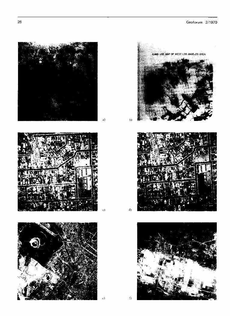
l High altitude color infrared photograph of West Los Angeles, 0 Infrarot-Farbphoto aus grol3er Hohe von West-Los Angeles, Califor- California, (a) showing residential areas of several communities, in- nia (a) mit Wohngebieten mehrerer Gemeinden wie Hollywood und cluding Hollywood and Beverly Hills along the Hollywood Hills. Beverly Hills entlang den Hollywood-Hohen. Am Fu5 der Hohen in Near the foot of the hills and adjacent to the San Diego Freeway is der N&he des San Diego Freeways liegt die Universitlt von Kalifor- the University of California, Los Angeles. From such photography it nien, Los Angeles. Eine s&he Aufnahme erlaubt eine schnelle und is possible to rapidly and accurately construct land use maps such zuverllssige FDchennutzungskartierung wie (b). Zusatzhche Filter as the one shown fb). Additive filters often enhance color infrared erhohen bei Infrarot-Farbfihnen oft die Aussagekraft der Bilder aus fihn for more optimum interpretation of medium and high altitude mittleren und grol3en Hohen, aber sie sind nicht notwendig bei photographs but are not necessary at low altitudes. Two examples niederen Hohen. Zwei Beispiele aus etwa 1OOOm Hohe im Zusam- taken from approximately 1000 meters for urban studies in East menhang mit stadtgeographischen Untersuchungen im Osten von Los Angeles, California, are (c) 15 plus 80B filters and (d) a 15 filter Los Angeles, California: Bild (c) mit 15- und IOB-Filtem, und only. (e) The Los Angeles Dodger baseball stadium is a striking (d) mit nur einem 15-Filter. Das Los Angeles Dodger Baseball feature on the landscape surrounded by complex transportation Stadion (e) umgeben von einem dichten SchnellstMennetz, von arteries, residential and commercial land uses, and open spaces. Wohn- und Geschaftsvierteln und offenen FBchen. Das Ubergrei- The encroachment of urban sprawl on rural fringe areas is illustrated fen von stadtischer Siedlung auf landwirtschaftliche Randzonen on high altitude photography near Ontario, California (f) where urban wird illustriert durch die Aufnahme aus groaer Hohe bei Ontario, land uses are replacing vineyards. California (f), wo stldtische Bebauung die Weinbaugebiete verdrangt.
PRUITT further states that spectral signatures offer possi- bilities of inputs to automated systems but not without difficulty. Each individual feature has its own characteristic spectral curve. This is, however, essentially a laboratory condition. Furthermore, while each feature in the environ- ment has its own spectral characteristics, these characteristics are not necessarily unique at all times or all locations. Cur- rent research includes identifying the temporal and spatial parameters affecting spectral reflections recorded on photo- graphs. Over the landscape, the camera records everything it sees and results in a “hodge-podge” of spectral curves. Grayscale, density measurements and traces, and wave form analysis can be quantified but as yet a practical method to digitize, manipulate or extract relatively useful data is not universally applicable.
Do It Yourself Photography
PEASE (1968) described the use of hand-held photography using color infrared fihn in a paper entitled Color Infrared, A Boon to Geographers Who Fly. The dedicated scientist or interested layman can achieve, at modest expense, very successful and highly usable photography from commercial airlines or private planes. The reader should understand that most manuals and instructions deal with the complexi- ties of aerial photogrammetry or detailed military recon- naissance and often provide more data than can be used. Planimetric stereoscopic pairs taken from instrument laden planes are very useful to the cartographer while often unnecessary and expensive to the other possible
users unless obtained in mass quantities from some govern- ment organization.
A case in point is the following : In the spring of 1970, one of the authors, accompanied by other scientists from
the University of California, leased a small aircraft (highwing) to use in photographing the coast of Baja California. Fifteen years earlier, 9” stereo panchromatic photography had been flown and planimetrically mosaiced. Because planimetric mapping data was available on the earlier photography, our interest was to update studies of coastal settlement, changes in coastal morphology and structure, and examine vegeta- tion patterns.
The success and simple execution of the above mission are detailed to illustrate the utility of hand-held photography
for many geoscience applications. A highwing Cessna 206, chosen because wheel struts and wings did not hinder window photography, flew 4 to 5 kilometers off the coast at approxi-
mately 3,300 meters altitude. The crew and their responsi- bilities included (1) a pilot, (2) a navigator to monitor di- stances and log time, location, and fihn roll number, (3) a photographer to photograph continuous sequences of the coastline, and (4) an assistant to load and unload film, store and log. These duties were fulfilled by 3 professors (one was the pilot) and one graduate student.
Using hand-held 35mm cameras, the resulting scale of ap- proximately 1:30,000 at sea edge permitted only a few hundred frames to cover several hundred kilometers of coast line. Kodak Aero Ektachrome Infrared film (type 8443, Process E-3) was chosen for the continuous frame photography ‘). The total cost of plane, living expenses, film and processing, etc. was about $600 for phtotograph- ing approximately 1300 kilometers of flightline along the
‘1 8443 was chosen because of its superior haze penetration, vegetation and landscape recording, and spectral characteristics. A Wratten 15 + 80C filter was used, because * 3000 meters altitude requires additive filters to bring out detail in this film. An ASA of 160 was used. For details on color IR photography at altitudes of 10,000 feet or more, see PEASE & BOWDEN (1969).
28 Geoforum 2/l 970
Geoforum 2/1970 29
Fig. 4 Fig. 4
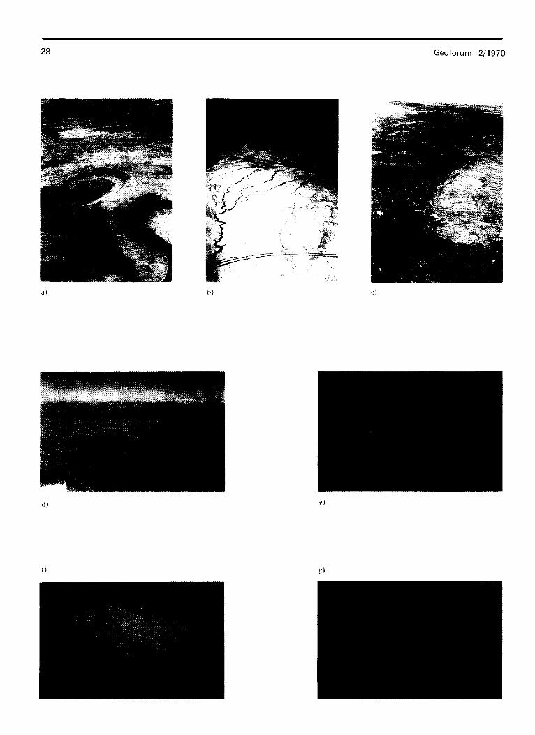
0 The examples are hand-held 35 mm oblique color infrared aerial photographs. (a) San Juan River, UtahColorado; a number of geo- morphic features and processes, including the entrenched meander and abandoned ox-bow, backcutting, uplift, and erosional patterns are evident. (b) AU-American Canal, California; infrared reflec tance from riverine vegetation outlines water seepage patterns from an unlined section of the canal along the edge of the Salton Trough. (c) Boulder, Colorado, along the Front Range of the Rocky Moun- tains; this photograph shows late winter atmospheric penetration potential of color infrared photography-Laramie, Wyoming, in the upper left corner, is a distance of almost 320 km. (d) San Gabriel Valley, California; single family residential patterns can be distin- guished, as well as commercial centers, vacant land, orange groves, vineyards, and grazing land. Geologic features of the Grand Canyon, Arizona (e) are particularly pronounced as well as differences in reflectance of coniferous forests on the North rim (top) and pin- yon juniper conifer on the south rim. Temporal differences in in- frared reflectance can be seen on two photographs of Ahunosa, Colorado, taken in December (f) with a snow cover and in July (g) where unimproved, cultivated, and flood-plain vegetation areas are well defined.
l Alle Beispiele sind von Hand aufgenommene 35 mm Schragbilder auf Infrarot-Farbfilm. (a) San Juan River, Utah/Colorado; zahl- reiche geomorphologische Erscheinungen wie eingeschnittener FluOlauf, und abgeschnittener M&uler, rildcschreitende Erosion sowie andere Abtragungsformen und Hebung des Gebietes slnd er- kennbar. (b) All-American Canal, California; das Infrarot der Ve- getation in Kanalnahe zeigt deutlich eine Wasserversickerung an, die am Rand der Salton Rinne stattfindet. (c) Boulder, Colorado, mit Blick nach Norden entlang den Rocky Mountains; die spat- winterliche Aufnahme demonstriert die miigliche Fernerkundung mit Infrarot-Farbfilmen: Laramie, Wyoming, in der linken oberen Bildecke liegt 320 km entfernt. (d) San Gabriel Valley, California; Siedlungsbereiche mit Einfamilienhiiusern konnen ebenso ausge- macht werden wie Einkaufszentren, freies Land, Orangenhame, Weinanbauflichen und Weideland. Geologische Erscheinungen im Grand Canyon, Arizona, (e) lreten ebenso hervor wie die unter- schiedliche Reflexion der Nadelwllder auf dem Nordrand (oben) und der Wachoklervegetation auf dem Slldrand. Saisonal unter- schiedliche Infrarot-Reflexion ist ersichtlich aus zwei Photos von Alamosa, Colorade, vom Dezember (fl mit Schneedecke und Juli (g), auf dem Kulturland und Schwemmlandvegetation deutlich unter- schieden sind.
Baja California coastline. Although the resultant photo- graphy was not high resolution, planimetrically perfect, nor of continuous stereo coverage (whose use can often be justified only by the photogrammetrist or cartographer), the modest cost of up-to-date aerial photography (in an unaccessible area asBaja) is invaluable. Commercial mapping
quality photography of the same area would have cost approximately $15,000 for black-and-white and almost $20,000 for color infrared.
By choosing the proper film and filter combinations, useful piuctres can be acquired from commercial airliners flying
as high as 56,000 kilometers. Kodak’s Aero Ektachrome Infrared has been used successfully and one suspects the Soviet manufactured S-2 infrared would provide similar results. Haze, air pollution, and high altitude have discouraged both scientists and tourists from photographing from airline windows with normal color or black and white films. Fig. 4
ihustrates some of the possibilities when certain film and filter combinations are used.
Regional Analysis
Nearly every scientific discipline concerned with some aspect of the earth can find use of aerial photography. Quality aerial photographs are fascinating in details of natural environment and human occupancy which they contain. Each user who repeatedly employs medium and large scale aerial photography discovers it to be a relatively
inexpensive, highly precise, and extremely versatile tool as a source of geoscience data extraction.
A geographer has the interest and motive to synthesize and integrate his own data and observations with those of other scientific disciplines within the framework of geo-
graphical regions. The region may be natural, man-made, micro or macro, but always a working unit whose analysis
considers many elements of the region’s landscape. LU- KEIXMAN (Itek, 196 1) has said :
“Recognizing and delineating regions is a difficult problem which geographers discuss in spirited and sometimes acrimonious fashion. If the geographic idea of the “total region” or “Lands&aft,” hitherto generally regarded as a theoretical entity, has any reality, [aerial] photography will surely reveal it . . . In most subject fields small photo scales have been tolerated as a means of getting cheap photography, complete coverage, or some other advantage; they are not merely tolerated but positively welcomed by regional geo- graphers, who already value scale reduction as a method of gene ralization.”
Efforts to manage and conserve natural and cultural re- sources, which often cross both minor and major political boundaries, require regional analysis and planning. Further- more, such analysis requires understanding of the relation- ships between physical, climatic, biologic, human, and other elements comingled on the landscape. Need it be stated that aerial photographs provide a powerful tool for this analysis? And herein lies an important application of very high altitude, small scale aerial and spacecraft photo- graphy which has become increasingly available to the regional geo-scientist in the past decade.
30 Geoforum 2/l 970
Conclusion
There is an ever increasing demand for inventory, planning, and management data regarding natural and cultural re- sources of the world. With this demand there has been continuing development of photographic and other remote sensors. Although the most conventional of remote sensors, aerial photography’s fundamental elements and techniques for acquisition and interpretation provide a most versatile and valuable reconnaissance tool for the earth scientist. Information that is permanently recorded on an aerial photograph commonly finds many uses, in many disciplines,
in scientific evaluation and development of the earth’s resources and in planning for the earth’s human occupancy.
Acknowledgement
Photographic acknowledgements are given to R. N. COLWELL (la, lb) ; R. A. MINNICH (4e) ; R. W. PEASE (4b) ; NASA (2a, 3a, 3c, 3d, 3f). Research support by U. S. Geological Survey and Office of Naval Research.
References
ALEXANDER, R. H., L. BOWDEN, D. MOORE (1968): Remote Sensing of Urban Environments; Proceedings of the Fifth Symposium on Remote Sensing of Environment. Ann Arbor: The University of Michigan. 888-912.
American Society of Photogrammetry (1960): Nunuul of Photo- graphic Interpretation. Menasha, Wisconsin: George Banta Publishing Co.
American Society of Photogrammetry (1966) : Manual of Photo- grammetry, Volume I and II. Washington, D. C. : American Society of Photogmmmetry, Inc.
American Society of Photogrammetry. (1968): Manual of Color Aerial Photography. Menasha, Wisconsin: George Banta Publishing Co.
ANSON, Abraham (1966): Color Photo Comparison; Photogramm Engng XXX& 3,286-297.
AVERY, T. Eugene (1968) : Interpretation of Aerial Phorographs. 2nd ed. Minneapolis: Burgess Publishing Co.
BAKER, R. D. (1967) : Aerial Photographs in the Forest ; Photo- gramm. Engng XXXIII, 12,1373-1376.
BAWDEN, M. G. (1967) : Applications of Aerial Photography in Land System Mapping; Photogramm. Rec., V, 30,461-464.
BECKING, R. W. (1959): Forestry Application of Aerial Color Photography, Photogramm. Engng XXV, 4,559-564.
BOESCH, H. H. and D. E. BRUNNSCHWEILER (1960) : Seasonal Changes of Agricultural Landscape Interpreted from Aerial Photographs, Geographica helv. XVI, 257-261.
BOMBACK, E. S. (1966): Manual of Color Photography. Cranbury, New Jersey: A. S. Barnes Publishing Co.
BOWDEN, L. W. (1968) : Multi-Sensor Analysis of Urban Morpho- logy, Evolution, and Function. Riverside: Department of Geography, University of California, Riverside.
BROCK, G. C. (1967): The Physical Aspects of Aerial Photography. New York : Dover Publications, Inc.
BROONER, W. G. (1969) : Agricultuml Crop Discrimination wirh Color Znfrared Photography: A Study in Douglas County, Kansas. M. A. Thesis. Lawrence : University of Kansas.
BRUNNSCHWEILER, Dieter (1957): Seasonal Changes of the Agricultural Pattern: A Study in Comparative Airphoto Inter- pretation: Photogramm. EngngXVII, 5,759-771.
BRUNT, M. (1961): Aerial Photography and Land Use Planning; Papers of Technical Conference of Directors of Agriculture and Agricultural Institutions. London: Department of Technical Cooperation.
BURINGH, P. (1954) : The Analysis and Interpretation of Aerial Photographs in Soil Survey and Land Classification; Nerh. J. agric. Sci. II, 1, 16-24.
BURINGH, P. and A. P. A. VINK (1962): Aerinl Photo Znterpre- ration in Land Use Surveys, Delft : Int. Training Centre for Aerial Survey. (Mimeograph)
CARNEGGIE, D. M. and D. T. LAUER (1966) : Uses of Multi- band Remote Sensing in Forest and Range Inventory; Phoro- grammetria, XXI, 115,141.
CHARIN, N. G. (1962): New Methods of Vegetation Deciphering on Airphotos ; Principy i Merody Geobotaniceskogo Kartogra- firovanija. Moskva: Leningrad Izdatelstovo Akademii Nauk USSR. 232-236.
CHARTER: Steven (1959): An Introduction to Infrared Aerial Photography in Agriculture : Agriculture and Food Chemistry VII, 8,536-539.
CHAVES, J. R. and R. L. SCHUSTER (1968): Color Photos for Highway Engineering: Photogramm. Engng XXXIV, 4,375.
COLWELL, R. N. (1960): Some Uses and Limitations of Aerial Color Photography in Agriculture ; Photogramm. Engng XXVI, 2,220-222.
COLWELL, R. N. (1961): Some Practical Applications of Multiband Spectral Reconnaissance: Am. Scient. XLIX, 1,9-36.
COLWELL, R. N. et. al. (1963) : Basic Matter and Energy Rela- tionships Involved in Remote Reconnaissance: Photogram. Engng XXIX, 5,761-799.
COLWELL, R. N. (1964): Aerial Photography - A Valuable Sensor for the Scientist; Am. Scient. LII, 16-49.
COLWELL, R. N. (1966): Uses and Limitations of Multispectrai Remote Sensing ; Proceedings of rhe Fourth Symposium on Remote Sensing of Environment. Ann Arbor. Michigan. 7 l- 100.
COLWELL, R. N. (1968): Remote Sensing of Natural Resources; Scienr. Am. CCXVIII, 1,54-69.
CURRENT, Ira B. (1967): Sensitometry in Color Aerial Photo- graphy;Photogramm. EngngXXXIII, 10,1143-1151.
DILL, Henry W. Jr. (1959): Use of the Comparison Method in Agricultural Airphoto Interpretation; Photogramm. Engng xxv, 1,44-49.
DILL, H. W. (1967) : Worldwide Use of Airphoros in Agriculture. Agricultural Handbook, No. 344, Washington, D. C. : U. S. Department of Agriculture.
DUDDEK, M. (1968): Practical Experiences with Aerial Color Photography; Phorogramm. Engng XXXIV, 1117-1125.
DURST, A. (1958): Die Technischen Grundkzgen der Lufrbild- interpretation; M. A. These am Geographischen Institut der Universitiit Ziirich, Karten.
EINEVOLL, 0. (1958) : Airphotos in Mountain Region Grassland Surveying; Tidsskr. norske Landbr. (English Summary). LXV, 101-134.
FISCHER, W. A. (1958): Color Aerial Photography in Photogeo- logic Interpretation; Photogramm. Engng XXIV, 4,545-549.
Geoforum 2/1970 31
FRITZ, Norman L. (1967) : Optimum Methods for Using Infrared- Sensitive Color Film ; Photogramm. Engng.
FROST, Robert E. (1962): Aerial Photography: A Reappraisal of the Terrain ;Proceedings of the First Symposium of Remote
Sensing of Environment. Ann Arbor, Michigan. 61-68.
HAEFNER, H. (1963): Vegetation und Wirtschaft der oberen Subalpinen und Alpinen Stufe im Luftbild; Landeskundliche Luftbildauswertung im Mitteleuropiiischen Raum, VI. Bad Godesberg : Selbtverlag Bundesanstalt fur Landeskunde und Raumforschung.
HAEFNER, H. (1967): Airphoto Interpretation of Rural Land Use in Western Europe; Photogrammetria. XXII, 143-152.
HAGEN, T. (1950): Wissenschaft Luftbild-Interpretation. Ein Methodischer Versuch; Geographica helv. V, 209-276.
HANNAH, _I. W. (1968) : A Feasibility Study for the Application of Remote Sensors to Selected Urban and Regional Land Use Planning Studies. Johnson City, Tennessee: East Tennessee State University Remote Sensing Institute.
HELLER, R. C. (1969) : Photographic Imagery: Principe de la Detection d Distance et Application a I’Etude des Ressources Terrestres. Paris: Centre National D’Etudes Spatiales, 187-244.
HONEA, R. B. and V. L. PRENTICE (1968): Selected Bibliography of Remote Sensing. Washington, D. C. : U. S. Geological Survey.
HOWE, G. M. (1951): A Note on the Application of Air Photo- graphy to the Agricultural Geography of North-West Cardigan- shire; Geography. XXXVI, 15-20.
Itek Corporation (1961) : Peaceful Uses of a Survey Satellite.
JOHNSON, C. W. (1969) : A System of Regional Agricultural Land Use Mapping Tested Against Small Scale Apollo 9 Color Infrared Photography of the Imperial Valley (California). Riverside : Department of Geography, University of California, Riverside.
LARMORE, L. (1965) : Introduction to Photographic Principles. New York : Dover Publications, Inc.
LATHAM, J. P. (1966) : Remote Sensing of Environment: Geogrl Rev. LVI, 2, 288-291.
LENT, Jerry, D. and Gene A. THORLEY (1969) : Some Observa- tions on the Use of Multiband Spectral Reconnaissance for the Iventory of Wildland Resources; Journal of Remote Sensing of Environment. I, 1.
LEUDER, D. R. (1959) : Aerial Photographic Interpretation - Principles and Applications. New York : McGraw-HilI Book Co., Inc.
LYON, R. J. P. (1969) : Geological Remote Sensing : A Critical Evaluation and Prognosis ; Principe de la Detection b Distance et Application a I’Etude des Ressources Terrestres. Paris: Centre National D’Etudes Spatiales. 349-402.
MANJI, A. S. (1968): Uses of Conventional Aerinl Photography in Urban Areas: Review and Bibliography. Department of Geography, Northwestern University, Evanston, Illinois.
MEIENBERG, P. (1966): Die Landnutzungskartierung nach Pan- Infrarot und Farbluftbildern. (Ein Beitrag zur agrargeographischen Luftbildinterpretation und zu den’M@lichkeiten der Luftbild- photographie), Miinchner Studien zur Sozlal- und Wirtschafts geographie, 1, Regensburg : Michael Lassleben, KalImiinz.
MEYER, M. P. and D. W. FRENCH, (1967): Detection of Diseased Trees; Phtotogramm Engng XXXIII, 9, 1035-1040.
MINNICH, R. A. (1968): Mappingbfontane Vegetation with Color fnfrared Imagery. Riverside : Department of Geography, Unk
MONIER, R. B. and N. E. GREEN (1957): Report on Current Research in Aerial Photography Interpretation as Related to Urban Geographic Studies; Ann. Ass. Am. Geogr. XXXXVIII, 2, 172.
MOTT, P. G. (1966) : Some Aspects of Colour Aerial Photography in Practice and Its Applications; Photogramm. Rec. V, 28.
MULLENS, R. H. Jr. (1969): Analysis of Urban Residentinl En- vironments Using Color Infrared Aerial Photography: An Examination of Socioeconomic Variables and Physical Charac- teristics of Selected Areas in the Los Angeles Basin. Riverside and Los Angeles: Department of Geography, University of California, Riverside and Los Angeles.
NORTON, C. L. (1968) : Aerial Cameras for Color ; Photogramm. Engng XXXIV, 1,36-42.
OLSON, C. E. Jr. (1963) : Photographic Interpretation in the Earth Sciences, Photogramm. Engng XXIX, 6,968-978.
OLSON, C. E. Jr. (1969): Applications of Remote Sensing in Agriculture, Including Forestry ; Principe de la Detection a Distance et Application a I’Etude des Ressources Terrestres. Paris: Centre National D’Etudes Spatiales. 245-348.
O’NEILL, H. T. (1953) : Keys for Interpreting Vegetation from Air Photographs; Photogramm. Engng XIX, 3,422-424.
PEASE, R. W. (1969) : Color Infrared Fihn - A Boon to Geogra- phers Who Fly ; Proceedings of the Association of American Geographers, Washington, D. C.
PEASE, R. W. and L. W. BOWDEN (1969) : Making Color Infrared Film a More Effective High Altitude Remote Sensor;Remote Sensing of Environment, I, 1, 23-30.
PHILLPOTTS, L. E. (1963) Aerial Photo Interpretation of Land- Use Changes. Ontario : Ontario Agricultural College, Depart- ment of Agricultural Economics.
PRUITT, E. L. (1970) : Thoughts on Inputs to Information Systems; Prof Geogr. XXII, 1, 12-14.
PRYOR, W. T. (1964): Evaluation of Aerial Photography and Mapping in Highway Development ; Photogramm. Engng XXX, l,lll-123.
REICH, Hanns. (1967): The World from Above. New York: Hill and Wang.
SCHMIDT-KRAEPELINE, E. (1958, 1959, 1960): Methodische Fortschritte der wissenschaftlichen Luftbild-Interpretation; Erdkunde. 12,81-107; 13,201-213; 14,99-115.
SCHMIDT-KRAEPELIN, E. and S. SCHNEIDER (1966): Luft- bildinterpretation in der Agrarlandschaft ; Luftbildauswertung im Mitteleuropci’ischen Raum, 7, Bad Godesberg, West Germany: Schriftenfolge des Instituts fiir Landeskunde in der Bundesan stalt fur Landeskunde und Raumforschung.
SCHNEIDER, S. (1962): Die Stellung der Luftbildinterpretation in der Landesforschung ; Berich te zur Deu tschen Landeskunde, XXX, 1,73-84.
SCHNEIDER, Wm. J. (1968): Color Photographs for Water Re sources Studies; Photogramm. Engng XXXIV, 3,257-262.
SIMONETT, D. S. (1969): Remote Sensing Studies in Geography: A Review: Principe de la Detection a Distance et Application
a’l’Etude des Ressources Terrestres. Paris: Centre National D’Etudes SpatiaIes. 467-498.
SMITH, J. T. (1963): Color - A New Dimension in Photogramme- try ; Photogramm. Engng XXlX, 6.
SOREM, A. L. (1967): Principles of Aerial Color Photography; versity of California, Riverside. Photogramm. Engng XXXIII, 9, 1008-1018.
32
STEINER, Dieter (1962): Zur Technik und Methodik der Land- nutzungs-interpretation von Luftbildern; Berichte zur Deutschen Landeskunde, XXIX, 1, 99-130.
STEINER, Dieter (1965) : Use of Air Photographs for Interpreting and Mapping Rural Land Use in the United States;Photogram- metti. XX, 65-80.
STEINER, Dieter (1967): Index to the Use ofAerial Phofographs for Rural Land Use Studies. Bad Godesberg: Institut fti Lan- deskunde.
STRANDBERG, C. H. (1967a): Aerial Discovery Manual. New York: John Wiley and Sons, Inc.
STRANDBERG, C. H. (1967b): Photoarchaeology ; Photogramm. EngngXXXIII, 10, 1152-1157.
TARKINGTON, R. G. and A. L. SOREM (1963) : Color and False Color Films for Aerial Photography; Photogramm. Engng. XXIX, 88-95.
TOLBOT, W. J. (1963): Land Utilization Surveys by Field Mapping and by Air Photo Interpretation; South African Journal of Photogrammetry, II, 5-12.
TOMLINSON, R. F. and G. E. BROWN (1962): The Use of Vega tation Analysis in the Photo Interpretation of Surface Material; Photogramm. Engng XXVIII, 4.
University of Michigan (1962) : Proceedings of the First Symposium on Remote Sensing OfEnvironment. Report No. 4864-l-X. Ann Arbor: The University of Michigan, Institute of Science and Technology, Willow Run Laboratories.
University of Michigan (1963) : Proceedings of the Second Symp@ sium on Remote Sensing of Environment. Report No. 4864- 3-X. Ann Arbor: The University of Michigan, Institute of Science and Technology, Willow Run Laboratories.
Geoforum 2/1970
Universiety of Michigan (1965): Proceedings of the Third Sym- posium on Remote Sensing of Environment. Report Nor. 4864- 9-X. Ann Arbor: The University of Michigan, Institute of Science and Technology, Willow Run Laboratories.
University of Michigan (1966) : Proceedings of the Fourth Sym- posium on Remote Sensing of Environment. Report No. 4864-11-X. Ann Arbor: The University of Michigan. Insti- tute of Science and Technology, Willow Run Laboratories.
University of Michigan (1968) : Proceedings of the Fifth Sympo- sium on Remote Sensing of Environment. Report No. 4864- 18-X. Ann Arbor: The University of Michigan, Institute of Science and Technology, Willow Run Laboratories.
University of Michigan (1969) : Proceedings of the Sixth Symposium on Remote Sensing of Environment. Ann Arbor: The Univer- sity of Michigan, Institute of Science and Technology, Willow Run Laboratories. In Press.
WANLESS, Harold R. (1969): Aerial Stereo Photographs. North- brook, Illinois : Hubbard Press.
WELLER, Berry (1967): Generalization of Housing Quality Data from Multiband Aerial Photographs. Evanston, Illinois: North- western University, Department of Geography.
WINOGRADOW, B. W. (1961) : ObjektiveMethoden ftir die Ana- lyse der Vegetationswiedergabe auf Luftbildern. Ubersetzung aus dem Russischen, Zitiert bei Haefner 1963; aus: Ispol’ zovanie aerometodov pri issledovanii priorduych resursov 5- 15. Moskau/Leningrad: Laboratorija Aerometodov, Akademija Nauk USSR.
WOODROW, H. C. (1967): The Use of Colour Photography for LargeScale Mapping, Photogramm. Rec. V, 30, 433-460.