Embed Size (px)
Citation preview
DRAFT
MSHCP BIOLOGICAL RESOURCES TECHNICAL REPORTFOR ALBERHILL SYSTEM PROJECT,
RIVERSIDE COUNTY, CALIFORNIA
Submitted to:
Southern California EdisonNatural and Cultural Resources Group
1218 South Fifth AvenueMonrovia, California 91016
Submitted by:
AECOM, Inc.901 Via Piemonte, 5th Floor
Ontario, California 91764
October 2014
1
Southern California EdisonDraft MSHCP Biological Resources Technical Report forAlberhill System ProjectOctober 2014
EXECUTIVE SUMMARY
Southern California Edison (SCE) proposes to construct the Alberhill System Project (Alberhill Project) to serve current and projected demand for electricity and maintain electric system reliability in portions of southwestern Riverside County. The Alberhill Project would relieve the Valley South 115-kilovolt (kV) System by transferring electrical demand from this system to the new Alberhill System.
The Draft Environmental Impact Report (DEIR) for the Alberhill Project is pending completion by the California Public Utilities Commission (CPUC) in compliance with the California Environmental Quality Act. There will be a 45-day period for public and regulatory entities to comment on the DEIR. The Final Environmental Impact Report will include responses to comments received during the DEIR public comment period and any text changes resulting from the comments submitted to the CPUC.
On behalf of SCE, AECOM, Inc. (AECOM) conducted biological resource assessments and focused species surveys for the Alberhill Project between 2008 and 2014. The purpose of this report is to summarize the results of biological studies that have been conducted to date within the Alberhill Project area and to demonstrate project consistency with the Western Riverside County Multiple Species Habitat Conservation Plan (MSHCP). This report supports SCE’s application to become a Participating Special Entity (PSE) in the MSHCP, specifically for the Alberhill Project.
The Alberhill Project is located within the coverage area of MSHCP as implemented by the Regional Conservation Authority (RCA). The Alberhill Project area passes through disjunct Criteria Areas/Cells in three MSHCP area plans: Elsinore, Temescal Canyon, and Sun City/Menifee Valley. Further, the Alberhill Project is located within the MSHCP Burrowing Owl (Athene cunicularia, BUOW) Survey Area, Criteria Area Species Survey Area (CASSA), and Narrow Endemic Plant Species Survey Area (NEPSSA). Based on biological resource assessments, the Riverside County Integrated Project Conservation Report Generator, and maps of MSHCP survey areas, it was determined that the following studies would be required for the Alberhill Project’s consistency with the MSHCP:
Focused plant surveys including MSHCP Narrow Endemic Plant Species (NEPS) and MSHCP Criteria Area Plant Species (CAPS) in their respective survey areas;
Focused surveys for Riverside fairy shrimp (Streptocephalus woottoni) and vernal pool fairy shrimp (Branchinecta lynchi);
Focused surveys for BUOW;
Focused surveys for the least Bell’s vireo (Vireo bellii pusillus, LBV) and southwestern willow flycatcher (Empidonax traillii extimus, SWFL);
A delineation of jurisdictional waters/wetlands including MSHCP riparian/riverine and vernal pool habitats.
It should be noted that per the MSHCP Implementing Agreement, SCE understands that “take” for Stephens’ kangaroo rat (Dipodomys stephensi; SKR) is not available through the MSHCP as the Project also lies within the SKR Habitat Conservation Plan (HCP) boundaries. As such, for the 146 species covered by the MSHCP, SCE understands that the MSHCP will only be granting PSE status for the Alberhill Project for 145 of the Covered species. As of 15 October 2012, SCE finalized an SKR HCP
Page ES-1
1
2345
678910
111213141516
1718192021222324
2526
2728
29
3031
3233
3435363738
Southern California EdisonDraft MSHCP Biological Resources Technical Report forAlberhill System ProjectOctober 2014
Implementation Agreement with the Riverside County Habitat Conservation Agency. This Agreement provides a process through which SCE may obtain take authorization of SKR pursuant to the SKR HCP.
The Alberhill Project would require that an approximate 6.5-mile portion of the Valley-Ivyglen (VIG) 115-kV subtransmission line be double-circuited between the Alberhill Substation site and the intersection of Third Street and Collier Avenue (VIG Phase 2 overlap area or overlap area). Construction of the VIG Phase 2 Subtransmission Line Project will occur in the overlap area prior to construction of the Alberhill Project. Further, the Alberhill Project will remain within the same disturbance footprint of the VIG Phase 2 Project. As such, the VIG Phase 2 Project addresses the survey requirements in the overlap area. On behalf of SCE, AMEC Earth and Environmental, Inc. conducted biological resource assessments and focused species surveys for the proposed VIG Phase 2 overlap area between 2006 and 2014. The MSHCP project consistency for the VIG Phase 2 overlap area is addressed within the MSHCP Biological Resources Technical Report (BTR) for the VIG Phase 2 Project. To ensure a complete project analysis, biological information collected within the VIG Phase 2 overlap area is also presented in this BTR (Alberhill Project) by referencing the VIG Phase 2 BTR for specific details concerning MSHCP participation and additional mitigation requirements for incidental take of MSHCP-Covered species within the VIG Phase 2 overlap area.
Vegetation Communities: Vegetation communities within the Alberhill Project study area are primarily developed disturbed land (residential/urban/exotic), nonnative grassland, and Riversidian sage scrub (RSS). Previous and current development, agriculture, grazing, fire suppression, and invasion of nonnative plant species have contributed to the disturbed condition of many vegetation communities within the Alberhill Project vicinity.
Sensitive Vegetation Communities: Pursuant to the MSHCP, two upland communities are considered sensitive in the Alberhill Project area: RSS and Riversidian alluvial fan scrub (RAFS).
Under California regulations and policies, RSS is an upland community and is considered a sensitive habitat. RSS is listed in the California Natural Diversity Database (CNDDB) with a global ranking of G3 (21 to 80 Element Occurrences [EOs] or 3,000 to 10,000 individuals or 10,000 to 50,000 acres) and a State Ranking of S3.1 (very threatened). Upon SCE being granted PSE status, impacts to RSS communities would be permitted by the MSHCP without further mitigation being required; however, clearing or grubbing of RSS communities must be conducted outside the coastal California gnatcatcher (Polioptila californica californica; CAGN) breeding season (15 February through 15 August).
Under California regulations and policies, RAFS is considered a sensitive habitat. RAFS is listed in the CNDDB with a global ranking of G1 (Extremely endangered: fewer than 6 viable occurrences (EOs) or fewer than 1,000 individuals, or less than 2,000 acres of occupied habitat) and a State Ranking of S1.1 (very threatened). Per RCA and pursuant to MSHCP Rough Step requirements set forth in Section 6.7 of the MSHCP, RAFS is monitored annually within the MSHCP area for habitat losses and gains associated with public and private development projects. If the Rough Step rule for any of the monitored vegetation types, including RAFS, is not met during the most recent annual analysis for Rough Step Units 3, 7, and 8 (wherein the Alberhill Project occurs), then additional mitigation for permanent impacts to RAFS may be required at the discretion of RCA. (Note: the Alberhill Project itself cannot result in the MSHCP being out of Rough Step for RAFS.) This monitored vegetation type has been determined sufficient to meet the goals and objectives of the MSHCP, but should it be determined to be out of Rough Step before the Alberhill PSE submittal, additional mitigation could be required. If additional mitigation for RAFS is required, it may include purchase of replacement land at a 1:1 ratio and/or restoration at a 2:1 ratio in an off-site location to be determined. Whether additional mitigation for RAFS will be required will be
Page ES-2
12
345678910111213141516
1718192021
2223
24252627282930
3132333435363738394041424344
Southern California EdisonDraft MSHCP Biological Resources Technical Report forAlberhill System ProjectOctober 2014
determined by RCA during the PSE review process. Per communication with RCA, RAFS is currently the only sensitive vegetation type monitored by RCA that could require additional mitigation by the Project if RAFS is determined to be out of Rough Step. No other mitigation for RSS is anticipated.
Sensitive wetland vegetation communities within the Alberhill Project study area are those that are generally related to Collier Marsh, Temescal Wash, San Jacinto River, and their tributaries. Under California regulations and policies, cismontane alkali marsh (G1 [extremely endangered], S1.1 [very threatened]), valley freshwater marsh (G3 [restricted range], S2.1 [very threatened]), southern cottonwood/willow riparian forest (G3 [restricted range], S3.2 [threatened]), and southern willow scrub (G3 [restricted range], S2.1 [very threatened]) habitats are considered sensitive habitats. Mitigation related to potential impacts to these communities will be coordinated separately through the MSHCP’s riparian/riverine policies (Section 6.1.2) detailed below.
MSHCP Additional Reserve Lands (ARL): Pursuant to the MSHCP, ARL are defined as the additional 153,000 acres needed for MSHCP Reserve Assembly. Currently, three Alberhill Project areas are located within MSHCP ARL. One area of a proposed 500-kV transmission line tower R14X, where temporary work areas and tower access will be located, occurs on ARL. As part of the construction of 500-kV transmission line tower R14X, the Alberhill Project will potentially temporarily impact approximately 2.18 acres and permanently impact approximately 0.03 acre of ARL. Two areas of an existing SCE line (Fogarty-Ivyglen) are within the VIG Phase 2 overlap area that occurs on ARL: one area is north of and parallel to Nichols Road, and the other is west of and parallel to Lake Street. The VIG Phase 2 Project will potentially temporarily impact approximately 3.47 acres and permanently impact approximately 1.53 acres of ARL.
Construction of the VIG Phase 2 Project will occur in the overlap area prior to construction of the Alberhill Project. The VIG Phase 2 Project will propose equivalent or superior replacement land to offset potential impacts to ARL in these two areas and demonstrate that there will be no impacts to the functions and values of the ARL nor will the project impede any of the goals and objectives of the MSHCP. The Alberhill Project will only be adding another line to the poles installed by the VIG Phase 2 Project and will therefore remain within the same disturbance footprint as the one approved for the VIG Phase 2 Project. For the separate impacts at tower R14X, the Alberhill Project will follow the same process as the VIG Phase 2 Project by proposing equivalent or superior replacement land. Temporary impacts to ARL will be restored to the greatest extent practicable using vegetation and plant species present prior to disturbance. Further, the Alberhill Project will ensure that construction and operations do not result in changes in hydrology or water quality and will recontour affected areas as needed.
MSHCP Section 6.1.2 Riparian/Riverine and Vernal Pools Habitats: The Alberhill Project was designed to avoid jurisdictional waters to the greatest extent possible, including resources that would be considered riparian/riverine under the MSHCP. These resources would also be regulated in part pursuant to the U.S. Army Corps of Engineers (USACE) jurisdiction over Clean Water Act (CWA) Section 404, the Regional Water Quality Control Board (RWQCB) jurisdiction over CWA Section 401, and the California Department of Fish and Wildlife (CDFW) jurisdiction over Section 1600 of the California Fish and Game Code (CFGC). Impacts described in relation to these jurisdictions are further described below in Section 6.2.2.2.
Riparian habitats, as defined by Section 6.1.2 of the MSHCP, are lands that contain habitat dominated by trees, shrubs, persistent emergents, or emergent mosses and lichens and, which occur close to, or that depend upon, soil moisture from a nearby freshwater source; or unvegetated ephemerals that transport water supporting downstream resources in the MSHCP Conservation Area. Riverine areas, for this report,
Page ES-3
123
4567891011
12131415161718192021
2223242526272829303132
3334353637383940
41424344
Southern California EdisonDraft MSHCP Biological Resources Technical Report forAlberhill System ProjectOctober 2014
are defined as stream channels with freshwater flow during all or portions of the year, but primarily include small, unvegetated, ephemeral channels that flow for a short period during major storm events. As mentioned above, the Alberhill Project traverses several wetland, riparian, and wash habitats that meet these definitions.
The Alberhill Project alignment spans several drainages that meet the definition of riparian/riverine areas and vernal pools as presented in Section 6.1.2 of the MSHCP. The Alberhill Project was also designed to avoid vernal pools. Highly disturbed seasonal depressions occur in the VIG Phase 2 overlap area of the Alberhill Project as sparsely vegetated depressions in existing roadways, fallow fields, and periodically disked areas. An additional highly disturbed seasonal depression occurs in a vacant field north of the Newcomb Substation. Hydrology of the seasonal depressions is related to soil saturation as a result of significant precipitation events. The sheet flow is collected in these depressions and retained for several weeks to months during the rainy season. The Alberhill Project was designed to avoid the disturbed seasonal depressions, and no permanent or temporary impacts to their functions or values will occur. New roadways and pole locations near the seasonal depressions will not redirect or inhibit the hydrology.
Although the Project has been designed to avoid jurisdictional waters to the extent possible, some temporary and permanent impacts to jurisdictional/riparian/riverine areas will result from substation construction, dirt access road construction (e.g., grading existing and new roads), and the use of proposed work areas (e.g., pole siting, 500-kV tower construction, stringing setup sites, and guard structures).
Temporary impacts to riparian areas will result from working within or in proximity to riparian features and include an approximate total 0.19 acre of temporary impacts.
Temporary impacts to riverine areas will result from working within or in proximity to riverine features and include an approximate total 1.49 acres of temporary impacts.
Temporarily impacted riparian/riverine areas will be restored to pre-construction conditions upon completion of the Alberhill Project. On-site restoration will involve hydroseeding with native seed mixture similar to what is in place in adjacent areas, establishing temporary erosion controls, and monitoring those revegetated areas for 3 years post construction, or until successful revegetation by native species is confirmed by a qualified biologist.
Permanent impacts to riparian areas will result from the construction of one culvert crossing and substation construction (i.e., permanent grading) and include approximately 0.76 acre of permanent impacts, including approximately 0.30 acres jurisdictional under USACE.
Permanent impacts to riverine areas will result from grading and lightweight steel (LWS) pole construction and include an approximate total 0.10 acre of permanent impacts, including approximately 0.03 acre jurisdictional under USACE.
Permanent impacts due to construction of culverted and non-culverted crossings in riparian/riverine areas will not disturb the existing functions of the drainage to pass freshwater during storm events. Permanent impact to riparian areas due to hand trimming of trees for power line clearance would not adversely affect the functions and values of the habitat. In coordination with the resource agencies, mitigation for permanent impacts will likely involve purchase of land that encompasses riparian/riverine resources along the Temescal Wash area at an expected ratio of 3:1. It is anticipated that this land will be dedicated for
Page ES-4
1234
567891011121314
1516171819
2021
2223
2425262728
293031
323334
353637383940
Southern California EdisonDraft MSHCP Biological Resources Technical Report forAlberhill System ProjectOctober 2014
conservation by donation to the Riverside-Corona Resource Conservation District for restoration and management.
Sensitive Plant Species: Thirteen sensitive plant species were detected within the Alberhill Project study area during botanical field studies that have been conducted to date (2008–2014). Descriptions of each as they pertain to the MSHCP are provided below:
MSHCP Adequately Conserved Species. Three plant species that are MSHCP Covered Species and are Adequately Conserved were identified within the Alberhill Project area: small-flowered morning-glory (Convolvulus simulans), long-spined spineflower (Chorizanthe polygonoides var. longispina), and Palmer’s grapplinghook (Harpagonella palmeri). Incidental take of these species would be granted through participation in the MSHCP.
MSHCP Table 9-3 Covered Species (potentially requiring additional mitigation). Three additional plant species identified within the Alberhill Project area that are Covered by the MSHCP, however, are not Adequately Conserved and include Parry’s spineflower (Chorizanthe parryi var. parryi), small-flowered microseris (Microseris douglasii var. platycarpha), and Coulter's matilija poppy (Romneya coulteri). Per Section 2.1.4 of the MSHCP, these species are three of the 28 Covered Species that will be considered Adequately Conserved when certain conservation requirements are met as identified in the species-specific conservation objectives for those species. Species-specific conservation objectives, which are identified in Table 9-3 of the MSHCP, are satisfied by RCA and the Permittees (not the MSHCP PSE applicant) for Parry’s spineflower, small-flowered microseris, and Coulter’s matilija poppy to become Adequately Conserved Covered Species. As a PSE, no additional mitigation or further action is required.
MSHCP Section 6.3.2 –CAPS. Portions of the Alberhill Project alignment fall into CASSA 1. The CAPS required to be surveyed for in CASSA 1 are tiny mousetail (Myosurus minimus), smooth tarplant (Centromadia pungens ssp. laevis), and round-leaved filaree (California macrophylla). For CAPS populations identified as part of the designated CASSA survey process, impacts to 90 percent of those portions of the property that provide for long-term conservation value of the identified CAPS shall be avoided until it is demonstrated that species-specific conservation objectives for the particular species are met. Findings of equivalency shall be made to demonstrate that the 90-percent standard has been met. If it is determined that the 90-percent threshold cannot be met and achievement of overall MSHCP conservation goals for the particular species have not yet been demonstrated, the Permittee(s) must prepare and implement a Determination of Biologically Equivalent or Superior Preservation (DBESP). Smooth tarplant was observed within the VIG Phase 2 overlap area of the Alberhill Project; therefore, if conservation of this species is determined to be required, it will be addressed as part of the VIG Phase 2 Project during the MSHCP PSE process.
Four CAPS, round-leaved filaree, Coulter’s goldfields (Lasthenia glabrata ssp. coulteri), San Jacinto Valley crownscale (Atriplex coronata var. notatior), and smooth tarplant, were observed outside designated CASSAs within the vicinity of the Alberhill Project. Because the observed CAPS fall outside the CASSA, incidental take of these species would be granted through participation in the MSHCP, and no additional mitigation is required.
MSHCP Section 6.1.3 –NEPS. Portions of the Alberhill Project alignment fall into NEPSSA 1, 3, and 4. The NEPS required to be surveyed for in NEPSSAs 1 and 4 are Munz’s onion (Allium munzii), San Diego ambrosia (Ambrosia pumila), slender-horned spineflower (Dodecahema
Page ES-5
12
345
678910
1112131415161718192021
2223242526272829303132333435
3637383940
414243
Southern California EdisonDraft MSHCP Biological Resources Technical Report forAlberhill System ProjectOctober 2014
leptoceras), many-stemmed dudleya (Dudleya multicaulis), California Orcutt grass (Orcuttia californica), and Wright’s trichocoronis (Trichocoronis wrightii var. wrightii). San Diego ambrosia was observed within NEPSSA 1. For NEPS populations identified within designated NEPSSAs as part of the survey process, impacts to 90 percent of those portions of the property that provide for long-term conservation value of the identified NEPS shall be avoided until it is demonstrated that species-specific conservation objectives for the particular species are met. Findings of equivalency shall be made to demonstrate that the 90-percent standard has been met. If it is determined that the 90-percent standard cannot be met and achievement of overall MSHCP conservation goals for the particular species have not yet been demonstrated, SCE must prepare and implement a DBESP. San Diego ambrosia was observed within the VIG Phase 2 overlap area of the Alberhill Project; therefore, if impacts to this species would result from the VIG Phase 2 Project, this will be addressed during the MSHCP PSE process.
Non-MSHCP Covered Sensitive Plant Species. Three California Native Plant Society watch list plants were also detected that are not covered by the MSHCP: paniculate tarplant (Deinandra paniculata) (List 4.2), Robinson’s peppergrass (Lepidium virginicum var. robinsonii) (List 1B.2), and chaparral sand verbena (Abronia villosa var. aurita) (List 1B.1). Paniculate tarplant and Robinson’s peppergrass were identified as widespread throughout the Alberhill Project area.
SCE’s intent is to avoid all sensitive plants to the greatest extent possible. Should it be determined that avoidance of MSHCP Covered plants is not possible, SCE will comply with MSHCP mitigation requirements as a PSE (i.e., a DBESP will be prepared and submitted as part of the MSHCP PSE process). CAPS and NEPs were observed within the VIG Phase 2 overlap area of the Alberhill Project; impacts to these species will be addressed during the VIG Phase 2 Project MSHCP PSE process. Further, for non-MSHCP Covered species, mitigation has been included to address impacts to these sensitive plant species as well. Construction activities associated with the Alberhill Project will remain in the same disturbance footprint approved for the VIG Phase 2 overlap area. Mitigation for sensitive plants included in this BTR would address all impacts with or without SCE’s PSE status for the Alberhill Project, and would ensure that impacts are less than significant. However, once PSE status is achieved, additional mitigation for MSHCP-Covered plants, over and above the MSHCP requirements, is not required.
Native Oak and Other Protected Trees: The County of Riverside, Roadside Tree Ordinance 12.08 and Tree Removal Ordinance 12.24, requires permits for tree removal and trimming within county highway rights-of-way (Riverside County 1993). In addition, the County of Riverside requires that any future development in an identified sensitive vegetation area (including oak woodlands) must be evaluated individually and cumulatively for potential impact on vegetation (Riverside County 1993).
Oak trees are known to occur within the vicinity of the Alberhill Project, and the removal of two coast live oak (Quercus agrifolia) trees is expected. Some trimming of oak trees is also anticipated. Removal and trimming of oaks will be done in accordance with the above listed ordinances.
The Lake Elsinore Palm Tree Preservation Program (City Ordinance No. 1044) is designed to protect and preserve the City’s significant palms. Impacts to palm trees within the City of Lake Elsinore as a result of the Alberhill Project are not anticipated.
Wildlife Species: The Alberhill Project area supports a low to moderate diversity of wildlife species due to the high level of disturbance and development in the vicinity. Many of the wildlife species observed or detected in the Alberhill Project area are commonly found in the urban interface or in disturbed habitat.
Page ES-6
123456789101112
1314151617
181920212223242526272829
3031323334
353637
383940
414243
Southern California EdisonDraft MSHCP Biological Resources Technical Report forAlberhill System ProjectOctober 2014
MSHCP Section 6.1.2 Species. Focused fairy shrimp habitat assessments and surveys were conducted within seasonal depressions in the Alberhill Project area. No federally listed fairy shrimp were identified during these surveys.
Surveys for the LBV and SWFL were conducted, as required, in suitable habitat from 2009 through 2014. No SWFL were detected. Three LBV territories were present in the same locations of the Temescal Wash, San Jacinto River, and tamarisk scrub along Mission Trail during all survey years. No LBV habitat will be impacted within these areas; however, construction activities, including minimal tree-top trimming, will be conducted outside the LBV breeding season (generally 15 March through 15 September).
MSHCP Section 6.2.3 Criteria Area Species: Burrowing Owl. Extensive habitat and burrows suitable for occupation by BUOW are present in the Alberhill Project area. A general habitat assessment and protocol-level focused surveys have been conducted from 2009 through 2014. Five separate owl populations were found along the 115-kV subtransmission alignment in surveys from 2011 through 2014. Per MSHCP requirements, a pre-construction survey of all suitable habitat will be conducted 30 days or less prior to the initiation of construction. No direct or indirect impacts to BUOW are anticipated, and construction will be avoided during nesting periods for owl where owls are observed within the Alberhill Project area.
MSHCP Adequately Conserved Species. CAGN and its associated habitat (sage scrub) have been detected within the Alberhill Project area. CAGN is a Covered Species and is Adequately Conserved under the MSHCP. No additional mitigation is required; however, no suitable habitat for the gnatcatcher will be removed within the breeding season, generally 15 February through 15 August.
MSHCP Table 9-3 Covered Species (Potentially requiring additional mitigation). One wildlife species, Lincoln’s sparrow (Melospiza lincolnii), identified within the Alberhill Project area is covered by the MSHCP; however, it is not considered Adequately Conserved. Per Section 2.1.4 of the MSHCP, this species is 1 of the 28 Covered Species that will be considered Adequately Conserved when certain conservation requirements are met as identified in the species-specific conservation objectives for those species. Species-specific conservation objectives, which are identified in Table 9-3 of the MSHCP, must be satisfied by RCA and the Permittees for Lincoln’s sparrow to become Adequately Conserved Covered Species. As a PSE, no additional mitigation or further action is required.
Migratory Bird Species. Additional birds protected by the federal Migratory Bird Treaty Act (MBTA) and related provisions in the CFGC could also occur along the Alberhill Project alignment. Active nests subject to the MBTA must not be directly or indirectly impacted such that nest abandonment resulting in death of eggs or young occurs. If construction activities cannot be conducted outside the breeding season for MBTA species (varies per species, but generally 15 February through 1 September), a qualified biologist shall conduct a nest clearance survey prior to such activities to determine when it is safe to commence construction activities. SCE shall prepare a Nesting Bird Management Strategy specific to the Alberhill Project detailing the monitoring activities and establishment of appropriate buffers to ensure no impacts to active nests will occur. Additionally, SCE’s new transmission lines are designed to be raptor safe. Increases in noise, construction traffic, and human activities during construction activities may temporarily deter movement of wildlife within the Alberhill Project vicinity. Impacts to wildlife corridors or nursery sites are not expected from construction or operational activities of the Alberhill Project.
Page ES-7
123
456789
1011121314151617
1819202122
232425262728293031
32333435363738394041424344
Southern California EdisonDraft MSHCP Biological Resources Technical Report forAlberhill System ProjectOctober 2014
As with any project during construction, the possibility exists that sensitive species, including those Adequately Conserved or those with additional mitigation requirements, could be encountered that were not previously found or were found during surveys but have since increased in population after issuance of the MSHCP Certificate of Inclusion. Issuance of the MSHCP Certificate of Inclusion is based on the project demonstrating consistency with all species objectives, survey requirements, and mitigation at that time, As such, even if additional Covered species or larger populations of Covered species appear after the Certificate of Inclusion is issued, no additional mitigation (over and above what was already proposed and approved) is required for those species covered by the MSHCP, with the exception of BUOW. As mentioned above, BUOW still requires some additional action if found during pre-construction surveys.
MSHCP Assembly Consistency: The MSHCP Conservation Area is composed of various existing and proposed cores, extensions of existing cores, linkages, constrained linkages, and noncontiguous habitat blocks. One existing core (Core C), one proposed core (Proposed Core 1), one proposed extension of a core (Proposed Extension of Existing Core 2), two proposed linkages (Proposed Linkages 2 and 8), and one proposed constrained linkage (Proposed Constrained Linkage 6) are located within the Alberhill Project area. Based on the nature of the Alberhill Project being primarily overhead in the areas where the notable proposed Linkages and Cores are located, no impact will occur to the proposed Cores and Linkages within the Alberhill Project area. The Alberhill Project is consistent with the Reserve Assembly goals and project relationship within each of the two MSHCP area plans wherein the Alberhill Project lies. The Alberhill Project is consistent with the Reserve Assembly requirements of the MSHCP.
Further, the Alberhill Project would not impede any of the functions and values or the goals and objectives of the MSHCP. Therefore, the Alberhill Project as proposed is consistent with the MSHCP.
Page ES-8
123456789
10111213141516171819
2021
Southern California EdisonDraft MSHCP Biological Resources Technical Report forAlberhill System ProjectOctober 2014
TABLE OF CONTENTS
Page
EXECUTIVE SUMMARY............................................................................................................................. 1
1.0 INTRODUCTION......................................................................................................................... 1-1
1.1 PROJECT LOCATION AND STUDY AREA...............................................................................1-51.2 PROJECT DESCRIPTION.........................................................................................................1-5
1.2.1 Proposed Alberhill Substation.........................................................................................1-51.2.1.1 Alberhill Substation Description........................................................................1-9
1.2.1.1.1 Substation Access..........................................................................1-91.2.1.1.2 Substation Lighting.........................................................................1-91.2.1.1.3 Substation Perimeter......................................................................1-9
1.2.1.2 Substation Site Preparation............................................................................1-101.2.1.3 Substation Borrow Site...................................................................................1-101.2.1.4 Substation Drainage.......................................................................................1-111.2.1.5 Telecommunications Improvements...............................................................1-11
1.2.1.5.1 Microwave System........................................................................1-111.2.1.5.2 Fiber-Optic Cable.........................................................................1-11
1.2.1.6 Telecommunications Construction.................................................................1-111.2.1.6.1 Microwave System Construction..................................................1-121.2.1.6.2 Fiber-Optic System Construction..................................................1-12
1.2.2 500-kV Transmission Line Segments...........................................................................1-121.2.2.1 500-kV Transmission Line Description...........................................................1-121.2.2.2 Access Roads and Spur Roads......................................................................1-131.2.2.3 500-kV Tower Site Preparation......................................................................1-131.2.2.4 Helicopter and Airstrip Use.............................................................................1-141.2.2.5 Tower Foundations.........................................................................................1-141.2.2.6 Tower Assembly.............................................................................................1-151.2.2.7 Wire-Stringing Operations..............................................................................1-151.2.2.8 Lake Mathews/Estelle Mountain Reserve......................................................1-17
1.2.2.8.1 Grounding and Conductor Snubbing: Core Reserve Access........1-171.2.2.8.2 Grounding.....................................................................................1-171.2.2.8.3 Conductor Snubbing.....................................................................1-181.2.2.8.4 Core Reserve Access...................................................................1-19
1.2.3 115-kV Subtransmission Line.......................................................................................1-191.2.3.1 115-kV Subtransmission Line Description......................................................1-19
1.2.3.1.1 Double-Circuit an Existing Single-Circuit 115-kV Subtransmission Line without Structure Replacement..................1-21
1.2.3.1.2 Double-Circuit an Existing Single-Circuit 115-kV Subtransmission Line with Structure Replacement......................1-211.2.3.1.2.1 Valley-Elsinore-Ivyglen 115-kV
Subtransmission Line................................................1-211.2.3.1.2.2 Ivyglen-Newcomb-Skylark and Elsinore-Skylark
115-kV Subtransmission Lines..................................1-211.2.3.1.2.3 Valley-Newcomb-Skylark 115-kV
Subtransmission Line................................................1-221.2.3.1.2.4 New Poles at Existing I-15 Freeway Crossing
and Line Separation at 500-kV Crossing...................1-221.2.3.1.3 New 115-kV Subtransmission Lines.............................................1-22
1.2.3.2 Site Preparation and Grading.........................................................................1-221.2.3.3 Lightweight Steel Pole Installation..................................................................1-23
Page i
1
2
3
4
567891011121314151617181920212223242526272829303132333435363738394041424344454647484950
Southern California EdisonDraft MSHCP Biological Resources Technical Report forAlberhill System ProjectOctober 2014
1.2.3.4 Tubular Steel Pole Installation........................................................................1-231.2.3.5 Subtransmission Wire-Stringing Activities and Guard Structures...................1-231.2.3.6 Removal of Existing Subtransmission Structures...........................................1-24
1.2.4 Operations and Maintenance........................................................................................1-241.2.4.1 Energizing the Constructed 500-kV Transmission and 115-kV
Subtransmission Lines...................................................................................1-241.2.4.2 Post Construction Cleanup.............................................................................1-241.2.4.3 Project Operations and Management.............................................................1-25
1.2.4.3.1 Roads...........................................................................................1-251.2.4.3.2 Poles.............................................................................................1-251.2.4.3.3 Tree Pruning and Vegetation Removal.........................................1-261.2.4.3.4 Emergency Repairs......................................................................1-261.2.4.3.5 SCE’s Environmental Screening Process for O&M......................1-261.2.4.3.6 Future O&M Work Not Covered under this PSE Approval............1-27
2.0 REGIONAL LAND USE AND CONSERVATION PLANS...........................................................2-1
2.1 MSHCP RESERVE ASSEMBLY ANALYSIS.............................................................................2-12.1.1 Area Plans, Subunits and Criteria Cells..........................................................................2-1
2.1.1.1 Elsinore Area Plan – Subunit 1: Estelle Mountain/Indian Canyon....................2-12.1.1.2 Elsinore Area Plan - Subunit 2: Alberhill...........................................................2-32.1.1.3 Elsinore Area Plan Subunit 3: Elsinore.............................................................2-62.1.1.4 Elsinore Area Plan Subunit 4: Sedco Hills........................................................2-62.1.1.5 Temescal Canyon Area Plan Subunit 3: Temescal Wash West.......................2-82.1.1.6 Sun City/Menifee Area Plan.............................................................................2-9
2.1.2 Cores and Linkages within Conservation Area...............................................................2-92.1.3 Public/Quasi-Public Conserved Lands..........................................................................2-102.1.4 Additional Reserve Lands.............................................................................................2-13
2.2 MSHCP SURVEY REQUIREMENTS.......................................................................................2-132.2.1 MSHCP Section 6.........................................................................................................2-132.2.2 MSHCP Table 9-3 Requirements to Be Met For 28 Species Prior To Including
Those Species on the List of Covered Species Adequately Conserved.......................2-192.2.3 Requirements for Participating Special Entities............................................................2-19
3.0 SURVEY METHODS................................................................................................................... 3-1
3.1 DATABASE AND LITERATURE REVIEW.................................................................................3-13.2 FIELD SURVEY OVERVIEW.....................................................................................................3-4
3.2.1 Sensitive Plant Species Survey Methods.......................................................................3-83.2.1.1 Oak Impact Analysis.........................................................................................3-8
3.2.2 Sensitive Wildlife Species Survey Methods..................................................................3-103.2.2.1 General Wildlife Species Surveys..................................................................3-103.2.2.2 Focused Wildlife Species Surveys.................................................................3-10
3.2.2.2.1 Special Status Riparian Birds.......................................................3-103.2.2.2.2 Federally Listed Fairy Shrimp.......................................................3-11
3.2.2.2.2.1 Literature Review and Database Search...................3-113.2.2.2.2.2 Habitat Assessment and Survey...............................3-11
3.2.2.2.3 Burrowing Owl..............................................................................3-123.2.2.2.3.1 BUOW – Habitat Assessment...................................3-123.2.2.2.3.2 BUOW – Focused Burrow Survey.............................3-133.2.2.2.3.3 BUOW - Focused Burrowing Owl Survey..................3-13
3.2.3 Jurisdictional Waters and Wetlands..............................................................................3-143.2.3.1 Presurvey Investigations................................................................................3-143.2.3.2 Delineation of Federal Waters........................................................................3-14
Page ii
1234567891011121314
15
16171819202122232425262728293031
32
333435363738394041424344454647484950
Southern California EdisonDraft MSHCP Biological Resources Technical Report forAlberhill System ProjectOctober 2014
3.2.3.2.1 Methodology One: Delineations for Waters of the United States in the Form of Wetlands....................................................3-153.2.3.2.1.1 Hydrophytic Vegetation.............................................3-153.2.3.2.1.2 Hydric Soil.................................................................3-163.2.3.2.1.3 Wetland Hydrology....................................................3-17
3.2.3.2.2 Methodology Two: Delineations for Potential Jurisdictional Waters of the United States in the Form of Other Waters.............3-18
3.2.3.3 Delineation of State Waters............................................................................3-193.2.3.3.1 CDFW Methodologies...................................................................3-193.2.3.3.2 RWQCB Methodologies................................................................3-20
4.0 EXISTING CONDITIONS............................................................................................................4-1
4.1 CLIMATE.................................................................................................................................... 4-14.2 TOPOGRAPHY.......................................................................................................................... 4-14.3 HYDROLOGY............................................................................................................................ 4-14.4 SOILS......................................................................................................................................... 4-24.5 FLORA AND VEGETATION COMMUNITIES............................................................................4-3
4.5.1 Residential/Urban/Exotic................................................................................................4-34.5.2 Grove/Orchard................................................................................................................4-34.5.3 Field/Croplands...............................................................................................................4-44.5.4 Nonnative Grassland......................................................................................................4-44.5.5 Riversidian Sage Scrub..................................................................................................4-54.5.6 Chamise Chaparral.........................................................................................................4-54.5.7 Mixed Chaparral.............................................................................................................4-54.5.8 Coast Live Oak Woodland Upland..................................................................................4-64.5.9 Cismontane Alkali Marsh................................................................................................4-64.5.10 Valley Freshwater Marsh................................................................................................4-64.5.11 Open Water.................................................................................................................... 4-64.5.12 Mulefat Scrub.................................................................................................................. 4-74.5.13 Riversidian Alluvial Fan Sage Scrub...............................................................................4-74.5.14 Southern Cottonwood/Willow Riparian Forest................................................................4-74.5.15 Southern Sycamore Alder Riparian Forest.....................................................................4-74.5.16 Southern Willow Scrub...................................................................................................4-84.5.17 Tamarisk Scrub...............................................................................................................4-84.5.18 Coast Live Oak Woodland Riparian................................................................................4-8
5.0 SURVEY RESULTS.................................................................................................................... 5-1
5.1 SENSITIVE VEGETATION COMMUNITIES..............................................................................5-15.2 MSHCP RIPARIAN/RIVERINE AND VERNAL POOL HABITATS.............................................5-1
5.2.1 Riparian/Riverine............................................................................................................5-15.2.2 Vernal Pools and Fairy Shrimp.......................................................................................5-2
5.2.2.1 Results of the 2010 Focused Habitat Assessment Survey...............................5-25.2.2.2 Results of the 2012 Habitat Suitability Survey..................................................5-35.2.2.3 Results of a 2012 and 2013 Habitat Assessment of Seasonal
Depression North of the Existing Newcomb Substation...................................5-45.3 FLORA....................................................................................................................................... 5-4
5.3.1 Sensitive Plants..............................................................................................................5-45.3.1.1 Chaparral sand verbena (Abronia villosa var. aurita).......................................5-65.3.1.2 San Diego ambrosia (Ambrosia pumila)...........................................................5-65.3.1.3 San Jacinto Valley crownscale (Atriplex coronata var. notatior).......................5-75.3.1.4 Parry’s spineflower (Chorizanthe parryi var. parryi)..........................................5-75.3.1.5 Long-spined spineflower (Chorizanthe polygonoides var. longispina)..............5-75.3.1.6 Small-flowered morning-glory (Convolvulus simulans).....................................5-7
Page iii
12345678910
11
1213141516171819202122232425262728293031323334
35
36373839404142434445464748495051
Southern California EdisonDraft MSHCP Biological Resources Technical Report forAlberhill System ProjectOctober 2014
5.3.1.7 Paniculate tarplant (Deinandra paniculata)......................................................5-85.3.1.8 Round-leaved filaree (California macrophylla).................................................5-85.3.1.9 Palmer’s grapplinghook (Harpagonella palmeri)...............................................5-85.3.1.10 Smooth tarplant (Hemizonia pungens ssp. laevis)...........................................5-85.3.1.11 Coulter’s goldfields (Lasthenia glabrata ssp. coulteri)......................................5-95.3.1.12 Small-flowered microseris (Microseris douglasii spp. platycarpha)..................5-95.3.1.13 Coulter's matilija poppy (Romneya coulteri).....................................................5-95.3.1.14 Robinson’s peppergrass (Lepidium virginicum var. robinsonii)......................5-10
5.3.2 Oak Trees 5-105.4 FAUNA..................................................................................................................................... 5-10
5.4.1 Sensitive Wildlife...........................................................................................................5-105.4.1.1 Adequately Conserved Species.....................................................................5-105.4.1.2 MSHCP Section 6.1.2 Species.......................................................................5-10
5.4.1.2.1 Substation Pond...........................................................................5-135.4.1.2.2 Temescal Wash............................................................................5-13
5.4.1.2.2.1 VIG Overlap Area......................................................5-145.4.1.2.3 San Jacinto Crossing....................................................................5-145.4.1.2.4 Tamarisk Scrub West Side of Mission Trail..................................5-15
5.4.1.3 MSHCP Section 6.2.3 Criteria Area Species..................................................5-165.4.1.4 MSHCP Table 9-3 Covered Wildlife Species.................................................5-185.4.1.5 Non-MSHCP Wildlife Species........................................................................5-18
6.0 IMPACT ANALYSIS AND MITIGATION MEASURES................................................................6-1
6.1 THRESHOLDS FOR DETERMINING POTENTIAL SIGNIFICANCE.........................................6-16.2 DIRECT IMPACTS..................................................................................................................... 6-2
6.2.1 Construction-Related Impacts.........................................................................................6-26.2.2 Vegetation Communities.................................................................................................6-2
6.2.2.1 Sensitive Communities.....................................................................................6-46.2.2.2 Riparian/Riverine Communities........................................................................6-6
6.2.2.2.1 Temporary Impacts to Riparian Areas............................................6-66.2.2.2.1.1 115 kV Transmission Line Work Areas.......................6-66.2.2.2.1.2 500 kV Transmission Line Roads................................6-7
6.2.2.2.2 Temporary Impacts to Riverine Areas............................................6-76.2.2.2.2.1 115 kV Transmission Line Work Areas.......................6-76.2.2.2.2.2 500 kV Roads..............................................................6-76.2.2.2.2.3 Staging Yards..............................................................6-76.2.2.2.2.4 500 kV Towers............................................................6-8
6.2.2.2.3 Permanent Impacts to Riparian Areas............................................6-86.2.2.2.3.1 500 kV Roads..............................................................6-86.2.2.2.3.2 Substation...................................................................6-8
6.2.2.2.4 Permanent Impacts to Riverine Areas............................................6-86.2.2.2.4.1 115 kV Transmission Line...........................................6-86.2.2.2.4.2 500 kV Transmission Line Roads................................6-96.2.2.2.4.3 500 kV Transmission Line Tower................................6-9
6.2.2.2.5 Vernal Pools...................................................................................6-96.2.2.2.6 Regulated Waters Compliance.....................................................6-10
6.2.3 Additional Reserve Land...............................................................................................6-116.2.4 Special Status Plant Species........................................................................................6-12
6.2.4.1 MSHCP NEPS and CAPS..............................................................................6-126.2.4.2 MSHCP Table 9-3 Plant Species...................................................................6-166.2.4.3 Plant Species Not Covered by the MSHCP....................................................6-16
6.2.5 Native Oak and Other Protected Trees.........................................................................6-176.2.6 Common and Special Status Wildlife Species..............................................................6-18
6.2.6.1 Common and MSHCP Adequately Conserved Species.................................6-18
Page iv
123456789101112131415161718192021
22
23242526272829303132333435363738394041424344454647484950515253
Southern California EdisonDraft MSHCP Biological Resources Technical Report forAlberhill System ProjectOctober 2014
6.2.6.2 Sensitive Species Related to Section 6.1.2 of the MSHCP............................6-196.2.6.3 MSHCP Section 6.2.3 Criteria Area Species..................................................6-196.2.6.4 Non-MSHCP Covered Wildlife Species..........................................................6-206.2.6.5 Special Status Avian Species.........................................................................6-216.2.6.6 Migratory Bird Species...................................................................................6-22
6.2.7 Wildlife Movement........................................................................................................6-236.2.8 Indirect Impacts............................................................................................................6-23
6.2.8.1 Runoff, Erosion, and Siltation.........................................................................6-236.2.8.2 Nonnative Weed Establishment.....................................................................6-246.2.8.3 Noise and Human Presence..........................................................................6-246.2.8.4 Lighting...........................................................................................................6-256.2.8.5 Toxic Substances...........................................................................................6-256.2.8.6 Fugitive Dust..................................................................................................6-256.2.8.7 Wildlife Entrapment........................................................................................6-26
6.2.9 Cumulative Impacts......................................................................................................6-26
7.0 MSHCP CONSISTENCY DETERMINATION..............................................................................7-1
7.1 PROJECT CONSISTENCY WITH MSHCP AREA PLANS........................................................7-17.1.1 Elsinore Area Plan – Subunit 1: Estelle Mountain/Indian Canyon...................................7-17.1.2 Elsinore Area Plan – Subunit 2: Alberhill........................................................................7-27.1.3 Elsinore Area Plan – Subunit 3: Elsinore........................................................................7-27.1.4 Elsinore Area Plan – Subunit 4: Sedco Hills...................................................................7-27.1.5 Temescal Canyon Area Plan Subunit 3: Temescal Wash West.....................................7-27.1.6 Sun City/Menifee Area Plan............................................................................................7-3
7.2 PROJECT CONSISTENCY WITH CORES AND LINKAGES WITHIN THE CONSERVATION AREA............................................................................................................7-3
7.3 PUBLIC/QUASI-PUBLIC LANDS...............................................................................................7-37.4 ADDITIONAL RESERVE LANDS...............................................................................................7-37.5 MSHCP SECTION 6.1.2 – PROTECTION OF SPECIES ASSOCIATED WITH
RIPARIAN/RIVERINE AND VERNAL POOL RESOURCES......................................................7-47.5.1 Temporary Impacts to Riparian Areas............................................................................7-4
7.5.1.1 115 kV Transmission Line Work Areas............................................................7-47.5.1.2 500 kV Transmission Line Roads.....................................................................7-5
7.5.2 Temporary Impacts to Riverine Areas............................................................................7-57.5.2.1 115 kV Transmission Line Work Areas............................................................7-57.5.2.2 Staging Yards...................................................................................................7-57.5.2.3 500 kV Roads...................................................................................................7-57.5.2.4 500 kV Towers.................................................................................................7-5
7.5.3 Permanent Impacts to Riparian Areas............................................................................7-57.5.3.1 500-kV Roads...................................................................................................7-67.5.3.2 Substation........................................................................................................7-6
7.5.4 Permanent Impacts to Riverine Areas............................................................................7-67.5.4.1 115 kV Transmission Line................................................................................7-67.5.4.2 500 kV Transmission Line Roads.....................................................................7-67.5.4.3 500 kV Transmission Line Tower.....................................................................7-6
7.6 MSHCP SECTION 6.1.3 – PROTECTION OF NARROW ENDEMIC PLANT SPECIES...........7-87.7 MSHCP SECTION 6.3.2 – ADDITIONAL SURVEY NEEDS AND PROCEDURES...................7-8
7.7.1 Criteria Area Plant Surveys.............................................................................................7-87.7.2 Burrowing Owl................................................................................................................7-8
7.8 MSHCP TABLE 9-3 REQUIREMENTS TO BE MET FOR 28 SPECIES PRIOR TO INCLUDING THOSE SPECIES ON THE LIST OF COVERED SPECIES ADEQUATELY CONSERVED...................................................................................................7-9
7.9 MSHCP SECTION 6.1.4 – URBAN WILDLANDS INTERFACE GUIDELINES........................7-107.10 RIVERSIDIAN SAGE SCRUB REMOVAL...............................................................................7-11
Page v
123456789101112131415
16
17181920212223242526272829303132333435363738394041424344454647484950515253
Southern California EdisonDraft MSHCP Biological Resources Technical Report forAlberhill System ProjectOctober 2014
7.11 RIVERSIDIAN ALLUVIAL FAN SCRUB REMOVAL................................................................7-117.12 MIGRATORY BIRD TREATY ACT COMPLIANCE..................................................................7-11
8.0 SUMMARY OF APPLICANT-PROPOSED MEASURES, FEIR MITIGATION MEASURES, AND MSHCP MITIGATION MEASURES AND BMPS.........................................8-1
8.1 APPLICANT-PROPOSED MEASURES.....................................................................................8-18.2 FEIR MITIGATION MEASURES................................................................................................8-3
9.0 MSHCP BMPS AND MITIGATION MEASURES........................................................................9-1
10.0 CERTIFICATION....................................................................................................................... 10-1
11.0 REFERENCES..........................................................................................................................11-1
Page vi
12
34
56
7
8
9
10
Southern California EdisonDraft MSHCP Biological Resources Technical Report forAlberhill System ProjectOctober 2014
LIST OF TABLES
Page
Table 1 Typical 115-kV Subtransmission Structure Dimensions......................................................1-20Table 2 Western Riverside County Multiple Species Habitat Conservation Plan Area within
the Project............................................................................................................................. 2-2Table 3 Elsinore Area Plan – Subunit 1: Estelle Mountain/Indian Canyon, Criteria Cells
That Occur within the Project Area........................................................................................2-3Table 4 Elsinore Plan – Subunit 2: Alberhill, Criteria Cells That Occur within the Project Area..........2-4Table 5 Elsinore Area Plan – Subunit 3: Elsinore, Criteria Cells That Occur within the
Project Area........................................................................................................................... 2-7Table 6 Elsinore Area Plan – Subunit 4: Elsinore, Criteria Cells That Occur within the
Project Area........................................................................................................................... 2-8Table 7 Temescal Canyon Area Plan – Subunit 3: Temescal Wash West, Criteria Cells
That Occur within the Project Area......................................................................................2-10Table 8 Cores and Linkages within the Project Area........................................................................2-11Table 9 MSHCP Project Review Checklist.......................................................................................2-16Table 10 MSHCP Section 6 Species List...........................................................................................2-17Table 11 Survey Locations, Personnel, Dates, and Purpose...............................................................3-5Table 12 Monthly Precipitation (Inches)...............................................................................................4-1Table 13 Alberhill Project Watershed Units..........................................................................................4-2Table 14 Existing Vegetation Communities Present within the Study Area..........................................4-4Table 15 Sensitive Plants Observed within the Project Study Area......................................................5-5Table 16 MSHCP Adequately Conserved Wildlife Species................................................................5-11Table 17 Alberhill System Project Land Disturbance............................................................................6-3Table 18 Vegetation Communities and Impacts within the Project Area..............................................6-5Table 19 MSHCP Riparian/Riverine Impacts within the Project Area...................................................6-7Table 20 Summary of Impacts to Jurisdictional Waters of the U.S. and State...................................6-11Table 21 Potentially Unavoidable Impacts to Sensitive Plants...........................................................6-13Table 22 LBV within Alberhill Project Footprint..................................................................................6-19Table 23 Applicant Proposed Measures...............................................................................................8-1Table 24 Proposed Alberhill Project Mitigation Measures....................................................................8-4Table 25 MSHCP BMPs and Species-Specific MMs............................................................................9-1
Page vii
1
2
3456789101112131415161718192021222324252627282930313233
Southern California EdisonDraft MSHCP Biological Resources Technical Report forAlberhill System ProjectOctober 2014
LIST OF FIGURES
Page
Figure 1 Alberhill System Project Overview MSHCP Biological Resources Technical Report for the Alberhill System Project Riverside County, California...........................................................1-3
Figure 2 Alberhill System Project Location MSHCP Biological Resources Technical Report for the Alberhill System Project Riverside County, California...........................................................1-7
Figure 3 Narrow Endemic Plant Species Survey Area, Criteria Area Species Survey Area, and Burrowing Owl Survey Area MSHCP Biological Resources Technical Report for the Alberhill System Project Riverside County, California.......................................................................2-15
Page viii
1
2
345678910
Southern California EdisonDraft MSHCP Biological Resources Technical Report forAlberhill System ProjectOctober 2014
LIST OF APPENDICES
APPENDIX A - DETAILED MAPS OF THE STUDY AREA....................................................................A-1
A1 - 115-KV SUB T/L MAP BOOK.....................................................................................................A-3A2 - 500-KV T/L MAP BOOK...........................................................................................................A-47A3 - PROPOSED SUBSTATION MAP............................................................................................A-55
APPENDIX B - ASSESSOR PARCEL NUMBERS.................................................................................B-1
B1 - 115-KV SUB T/L APN LIST........................................................................................................B-3B2 - 500-KV T/L APN LIST..............................................................................................................B-12B3 - PROPOSED SUBSTATION APN LIST....................................................................................B-14
APPENDIX C - MSHCP CRITERIA AREAS AND CELLS......................................................................C-1
APPENDIX D - SPECIES THAT HAVE POTENTIAL TO OCCUR WITHIN THE PROJECT AREA.......D-1
D1 – PLANTS.................................................................................................................................... D-3D2 – WILDLIFE............................................................................................................................... D-17
APPENDIX E - SPECIES OBSERVED WITHIN THE PROJECT AREA.................................................E-1
E1 – PLANTS.................................................................................................................................... E-3E2 – WILDLIFE................................................................................................................................E-15
APPENDIX F - FOCUSED SPECIES SURVEY REPORTS.....................................................................F-1
F1 – 2009 FOCUSED SPECIES SURVEY REPORTS......................................................................F-3F2 – 2010 FOCUSED SPECIES SURVEY REPORTS..................................................................F-162F3 – 2011 FOCUSED SPECIES SURVEY REPORTS..................................................................F-416F4 – 2012 FOCUSED SPECIES SURVEY REPORTS..................................................................F-846F5 – 2013 FOCUSED SPECIES SURVEY REPORTS................................................................F-1336F6 – 2014 FOCUSED SPECIES SURVEY REPORTS................................................................F-1359
APPENDIX G - PRELIMINARY JD FORMS...........................................................................................G-1
APPENDIX H - STUDY AREA SOILS.....................................................................................................H-1
H1 - 115-KV SUB-T/L SOIL MAP......................................................................................................H-3H2 - SUBSTATION AND 500-KV T/L SOIL MAP..............................................................................H-7
APPENDIX I - PHOTOGRAPHIC EXHIBITS............................................................................................ I-1
Page ix
1
2
345
6
789
10
11
1213
14
1516
17
181920212223
24
25
2627
28
29
30
Southern California EdisonDraft MSHCP Biological Resources Technical Report forAlberhill System ProjectOctober 2014
ACRONYMS AND ABBREVIATIONS
ABC American Bird Conservancy ACSR aluminum conductor steel reinforced AECOM AECOM, Inc.Alberhill Project Alberhill System ProjectAMEC AMEC Earth & Environmental, Inc.amsl above mean sea levelAPM Applicant Proposed MeasureAPNs Assessor Parcel NumbersARL Additional Reserve LandsBCC USFWS Birds of Conservation ConcernBMP Best Management PracticeBTR Biological Resources Technical ReportBUOW burrowing owl(s)CAGN coastal California gnatcatcher(s)CAISO California Independent System OperatorCalEPA California Environmental Protection Agency CAPS Criteria Area Plant SpeciesCASSA Criteria Area Species Survey AreaCCR California Code of RegulationsCDFG California Department of Fish and GameCDFW California Department of Fish and WildlifeCEHS Corporate Environmental Health and SafetyCEQA California Environmental Quality ActCESA California Endangered Species ActCETAP Community and Environmental Transportation Acceptability ProcessCFGC California Fish and Game CodeCFR Code of Federal RegulationsCNDDB California Natural Diversity DatabaseCNPS California Native Plant SocietyCPUC California Public Utilities CommissionCRPR California Rare Plant RanksCWA Clean Water ActCWN California Watershed NetworkDBESP Determination of Biologically Equivalent or Superior PreservationDBH diameter at breast heightDEIR Draft Environmental Impact ReportDRSS disturbed Riversidian sage scrubEO Element OccurrenceESA Endangered Species ActEVMWD Elsinore Valley Municipal Water DistrictFAC FacultativeFACW Facultative WetlandFEIR Final Environmental Impact Report
Page x
1
Southern California EdisonDraft MSHCP Biological Resources Technical Report forAlberhill System ProjectOctober 2014
ACRONYMS AND ABBREVIATIONS (Continued)
FP CDFW Fully ProtectedG. O. General OrderGIS Geographic Information SystemGPS Global Positioning SystemHCP Habitat Conservation PlanHMMP Habitat Mitigation and Management PlanI-15 Interstate 15 IEEE Institute of Electrical and Electronics EngineersJD Jurisdictional DeterminationkV kilovolt(s)LBV least bell’s vireo(s)LWS lightweight steelMBTA Migratory Bird Treaty ActMM Mitigation MeasureMSHCP Multiple Species Habitat Conservation PlanMVA megavolt ampereNBMS Nesting Bird Management StrategyNEPS Narrow Endemic Plant SpeciesNEPSSA Narrow Endemic Plant Species Survey AreaNOAA National Oceanic and Atmospheric AdministrationNRCS National Resource Conservation ServiceNTCHS National Technical Committee for Hydric SoilsNWP Nationwide PermitO&M operations and maintenanceOBL Obligate WetlandOHGW overhead groundwireOHWM ordinary high water markOPGW optical groundwirePFM Petition for ModificationPQP Public/Quasi-PublicPSE Participating Special EntityRAFS Riversidian alluvial fan scrubRCA Regional Conservation AuthorityRCHCA Riverside County Habitat Conservation AgencyRCRCD Riverside-Corona Resource Conservation DistrictRCIP Riverside County Integrated ProjectRCRCD Riverside-Corona Resource Conservation DistrictRGL Regulatory Guidance LetterROW right-of-wayRSS Riversidian sage scrubRWQCB Regional Water Quality Control BoardSCE Southern California EdisonSKR Stephens’ kangaroo rat(s)
Page xi
12
Southern California EdisonDraft MSHCP Biological Resources Technical Report forAlberhill System ProjectOctober 2014
ACRONYMS AND ABBREVIATIONS (Continued)
SSC Species of Special ConcernSSURGO Soil Survey Geographic DatabaseSWFL southwestern willow flycatcher(s)SWPPP Storm Water Pollution Prevention PlanTSP tubular steel poleUCR University of California RiversideUSACE U.S. Army Corps of EngineersUSDA U.S. Department of AgricultureUSEPA U.S. Environmental Protection AgencyUSFWS U.S. Fish and Wildlife ServiceUSGS U.S. Geological SocietyUWIG Urban/Wildlands Interface Guidelines VIG Valley-IvyglenWEAP Worker Environmental Awareness ProgramWIFL willow flycatcher(s)WL CDFW Watch ListWLBCC WatchList of Birds of Conservation ConcernWRCC Western Region Climate Centerº F degrees Fahrenheit
Page xii
12
3
Southern California EdisonDraft MSHCP Biological Resources Technical Report forAlberhill System ProjectOctober 2014
THIS PAGE INTENTIONALLY LEFT BLANK
Page xiii
Southern California EdisonDraft MSHCP Biological Resources Technical Report forAlberhill System ProjectOctober 2014
1.0 INTRODUCTIONSouthern California Edison (SCE) proposes to implement the Alberhill System Project (Alberhill Project) to serve current and projected demand for electricity and maintain electric system reliability in portions of southwestern Riverside County including the cities of Lake Elsinore, Canyon Lake, Perris, Menifee, Murrieta, Murrieta Hot Springs, Temecula, and Wildomar, as well as the surrounding unincorporated portions of Riverside County (Figure 1). The Alberhill Project would relieve the Valley South 115-kilovolt (kV) System by transferring electrical demand from this system to the new Alberhill System.
The Alberhill Project would also improve electrical reliability and operational flexibility in southwestern Riverside County.
The Alberhill Project would include the following major components:
Construction of a new 1,120-megavolt ampere (MVA) 500/115-kV substation to increase electrical service capacity to the area presently served by the Valley South 115-kV System.
Construction of two new 500-kV transmission line segments to connect the new substation to SCE’s existing Serrano-Valley 500-kV transmission line.
Construction of a new 115-kV subtransmission line (approximately 3 miles in length) and modifications to four existing 115-kV subtransmission lines to transfer power between five existing 115/12-kV substations (Ivyglen, Fogarty [expected to be constructed in 2014], Elsinore, Skylark, and Newcomb substations) presently served by the Valley South 115-kV System to the new Alberhill 500/115-kV Substation.
Installation of telecommunications improvements to connect the new facilities to SCE’s telecommunications network.
The Draft Environmental Impact Report (DEIR) for the Alberhill Project is pending completion by the California Public Utilities Commission (CPUC) in compliance with the California Environmental Quality Act (CEQA). There will be a 45-day period for the public and regulatory entities to comment on the DEIR. The Final Environmental Impact Report (FEIR) will include responses to comments received during the DEIR public comment period and any text changes resulting from the comments submitted to the CPUC.
The Alberhill Project is located within the Western Riverside County Multiple Species Conservation Plan (MSHCP or Plan) area. The MSHCP is a comprehensive, multi-jurisdictional plan focusing on the conservation of species and their associated habitats in western Riverside County. SCE will be acquiring Project coverage under the MSHCP as a Participating Special Entity (PSE) with the Regional Conservation Authority (RCA) providing the MSHCP consistency review.
Page 1
1
234567
89
10
1112
1314
1516171819
2021
2223242526
2728293031
Southern California EdisonDraft MSHCP Biological Resources Technical Report forAlberhill System ProjectOctober 2014
THIS PAGE INTENTIONALLY LEFT BLANK
Page 2
Southern California EdisonDraft MSHCP Biological Resources Technical Report forAlberhill System ProjectOctober 2014
Page 3
Southern California EdisonDraft MSHCP Biological Resources Technical Report forAlberhill System ProjectOctober 2014
THIS PAGE INTENTIONALLY LEFT BLANK
Page 4
Southern California EdisonDraft MSHCP Biological Resources Technical Report forAlberhill System ProjectOctober 2014
Accordingly, this report provides an analysis of the Alberhill Project pursuant to the MSHCP. It provides the results of habitat assessments and focused studies that were conducted by AECOM between 2008 and 2014. It also includes an examination of proposed impacts to biological resources as a result of project implementation and provides avoidance, minimization, and mitigation measures [referred to as Applicant Proposed Measures (APMs) and Mitigation Measures (MMs)] that are proposed for resource protection and compensation.
Per the MSHCP, there are specific biological resources that, if impacted, a Determination of Biologically Equivalent or Superior Preservation (DBESP) analysis shall be prepared and implemented in order to provide the necessary information required for RCA to make a MSHCP consistency determination. The DBESP analysis is provided to ensure replacement of any affected functions and values necessary for the success of species and their habitats pursuant to MSHCP requirements. A DBESP will be prepared for the Alberhill Project for potential impacts to riparian/riverine resources and least Bell’s vireo (Vireo bellii pusillus, LBV), and burrowing owl (Athene cunicularia, BUOW). The DBESPs will be included as part of the MSHCP PSE application submittal.
1.1 PROJECT LOCATION AND STUDY AREAThe Alberhill Substation would be constructed in unincorporated Riverside County. Construction of the 500-kV transmission line segments between the Alberhill Substation and the existing Serrano-Valley 500-kV transmission line would occur in unincorporated Riverside County and within the northwestern boundary of the City of Lake Elsinore. The new and modified 115-kV subtransmission lines would be constructed in unincorporated Riverside County and the cities of Lake Elsinore, Wildomar, and Menifee (Figure 1). The Alberhill Project is mapped on the Lake Mathews, Alberhill, Elsinore, Romoland, and Wildomar, California, United States Geological Society (USGS) 7.5-minute series topographic quadrangles.
The biological survey study area for the Alberhill Project consists of a 400-foot-wide corridor for the right-of-way (ROW) (200 feet buffer on each side of the proposed centerline) and a 200-foot buffer surrounding the proposed Alberhill Substation. An exception to this was made during avian surveys (i.e., BUOW, LBV, and southwestern willow flycatcher [SWFL]), in which a 1,000-foot-wide corridor (500-foot buffer on each side of the proposed centerline) and a 500-foot buffer surrounding the proposed Alberhill Substation was used. Figure 2 provides an overview of the Alberhill Project area, and Appendix A provides a detailed map book of the study area with various design and construction components. Appendix B presents the Assessor Parcel Numbers (APNs) that are traversed by the Alberhill Project alignment.
1.2 PROJECT DESCRIPTIONSCE proposes to construct the Alberhill Project utilizing the Substation Site, 500-kV transmission line, and 115-kV subtransmission Line segment (Figure 2). The Alberhill Project will be installed in an existing SCE ROW, where available, and new land rights would be required for the proposed transmission/subtransmission facilities and access roads where needed. A description of construction and operation activities related to the implementation of the Alberhill Project is presented below.
1.2.1 Proposed Alberhill Substation
The following sections describe the Alberhill Substation components and the activities associated with construction of the substation.
Page 5
123
123456
7891011121314
15
1617181920212223
2425262728293031
32
3334353637
38
3940
Southern California EdisonDraft MSHCP Biological Resources Technical Report forAlberhill System ProjectOctober 2014
THIS PAGE INTENTIONALLY LEFT BLANK
Page 6
123

Southern California EdisonDraft MSHCP Biological Resources Technical Report forAlberhill System ProjectOctober 2014
Page 7
123
Southern California EdisonDraft MSHCP Biological Resources Technical Report forAlberhill System ProjectOctober 2014
THIS PAGE INTENTIONALLY LEFT BLANK
Page 8
123
Southern California EdisonDraft MSHCP Biological Resources Technical Report forAlberhill System ProjectOctober 2014
1.2.1.1 Alberhill Substation Description
The proposed Alberhill Substation would be an unstaffed, automated, 1,120-MVA 500/115-kV substation capable of an ultimate buildout of 1,680 MVA. The dimensions of the proposed Alberhill Substation would be approximately 1,680 feet by 980 feet, or approximately 34 acres. The substation property would be approximately 124 acres.
1.2.1.1.1 Substation Access
Primary access to the substation would be from Temescal Canyon Road along Love Lane. The present location of Love Lane is within the footprint of Alberhill Substation and it would have to be relocated prior to substation construction.
Love Lane would be relocated to the western boundary of the substation property and would serve as the primary access to the substation’s main gate. The relocated Love Lane would become a 36-foot-wide paved road extending approximately 250 feet north of Temescal Canyon Road. At that point, a 30-foot-wide paved substation access driveway would connect to the main substation gate. The remainder of the relocated Love Lane would be unpaved and would extend to the north, joining with the existing unpaved Love Lane, approximately 400 feet north of the substation entrance.
The substation entrance would have an electrically operated gate for two-way traffic access into the substation. A similar secondary access gate would be located on Temescal Canyon Road. A third manually operated gate located at the eastern end of the substation would provide access to the 500-kV transmission line corridors. All access gates would be a minimum of 8 feet in height. The primary and secondary gates would be approximately 40 feet wide, while the transmission line access gate would be 24 feet wide. In addition, SCE would install a walk-in gate within the substation wall for additional access into the substation.
Within the substation enclosure, one 45-foot-wide driveway and a series of 30-foot-wide driveways would facilitate vehicular movement around the substation equipment. In addition, a 7,600-square-foot parking area would be constructed within the substation enclosure for vehicular parking.
1.2.1.1.2 Substation Lighting
The proposed substation would have access and maintenance lighting. The access lighting would be low-intensity and controlled by a photoelectric sensor. Maintenance lights would be controlled by a manual switch and would normally be in the “off” position. Maintenance lights would be used only when required for maintenance outages or emergency repairs occurring at night. The lights would be located in the switchracks, around the transformer banks, and in areas of the substation where maintenance activity may take place and would be directed downward and shielded to reduce glare outside the facility.
Each gate at the substation would have a beacon light installed for safety and security purposes. It would be illuminated only while the gate is open or in motion. Typically, SCE utilizes double flash strobe lights as beacon lights on substation gates.
1.2.1.1.3 Substation Perimeter
An 8-foot-high perimeter wall would surround the substation. The wall would be made of concrete panels or decorative block, consistent with safety standards for major electrical facilities, and consistent with
Page 9
123
1
2345
6
789
101112131415
16171819202122
232425
26
272829303132
333435
36
3738

Southern California EdisonDraft MSHCP Biological Resources Technical Report forAlberhill System ProjectOctober 2014
surrounding community standards (subject to the requirements of SCE). At a minimum, a band of at least three strands of barbed wire would be affixed near the top of the perimeter wall inside the substation and would not be visible from the outside.
Landscaping and irrigation would be installed after the substation wall is constructed. Prior to the start of the substation construction, SCE would develop a landscaping and irrigation plan that is consistent with surrounding community standards.
1.2.1.2 Substation Site Preparation
The substation site would be prepared by clearing existing vegetation and installing a temporary chain-link fence to surround the construction site. The site would be graded in accordance with a grading plan developed in consultation with Riverside County. The area to be enclosed by the perimeter wall would be graded to a slope that varies between 1 and 2 percent and compacted to 90 percent of the maximum dry density. The areas outside the substation wall that would be used as a buffer would be graded in a manner consistent with the overall site drainage design as described in Section 1.2.1.4, Substation Drainage. The buffer would be a 10-foot-wide belt around the entire exterior perimeter of the wall and would exclude any improvements that could be climbed and used as a bridge to the top of the substation perimeter wall. The area would also exclude the use of trees, bushes, and other plants large enough to hide a potential intruder attempting to scale the substation perimeter wall by means of a ladder or other climbing devices.
After the substation site is graded, below grade facilities would be installed. Below grade facilities include a ground grid, trenches, building foundations, equipment foundations, utilities, and the base of the substation wall. The design of the ground grid would be based on soil resistivity measurements collected during a geotechnical investigation that would be conducted prior to construction. Above grade installation of substation facilities (i.e., buses, capacitors, circuit breakers, transformers, steel support structures, and the control building) would commence after the below grade structures are in place.
The transformers would be delivered by heavy-transport vehicles and offloaded on-site by large cranes with support trucks. A traffic control service may be used for transformer delivery, if necessary.
An existing 30-inch gravity agricultural water line owned and operated by the Elsinore Valley Municipal Water District (EVMWD) currently crosses through the proposed substation site. Relocation of this water line would be required prior to any substation grading or construction. The relocation of this line is not expected to have any impact on local water service.
The new water line alignment would begin with a connection to the existing pipe at the southeast corner of the substation site near Temescal Canyon Road, continue in a northwest direction to follow the relocated Love Lane, and connect to the existing water line at the northwest corner of the substation site. On average, the trench excavated to install the new water line would be approximately 4 feet wide and 6 feet deep and would be approximately 1,700 feet long. SCE would consult with EVMWD prior to construction and would build the new water line to EVMWD specifications. The existing pipe would be removed and disposed of off-site.
1.2.1.3 Substation Borrow Site
Approximately 80,000 cubic yards of imported soil would be needed during construction of Alberhill Substation. SCE proposes to grade approximately 5.2 acres of the area just northeast of the proposed substation to obtain the needed soil.
Page 10
123
123
456
7
89101112131415161718
192021222324
2526
27282930
31323334353637
38
394041
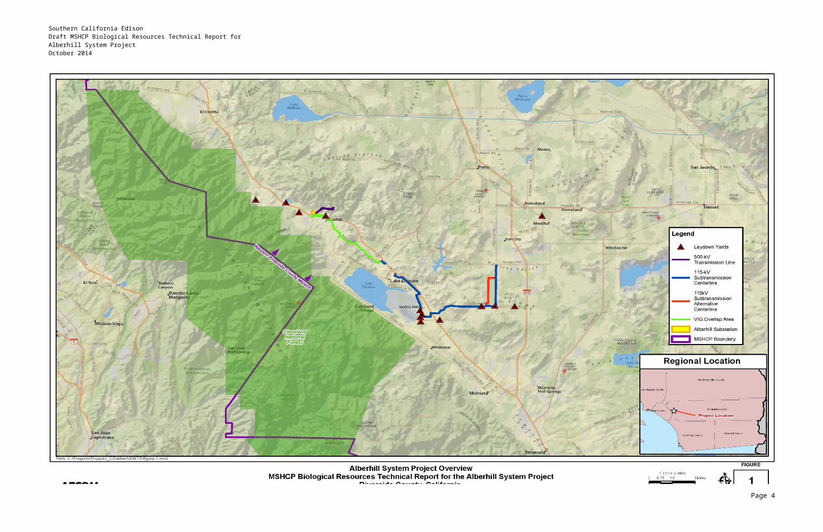
Southern California EdisonDraft MSHCP Biological Resources Technical Report forAlberhill System ProjectOctober 2014
1.2.1.4 Substation Drainage
The substation site would be graded to a slope between 1 and 2 percent and compacted to 90 percent of the maximum dry density. Construction of the substation would interrupt the existing drainage patterns throughout the site and would require diversion around the substation to areas where percolation would continue or through channels and pipes to be installed to the existing discharge point at the Temescal Wash along the southwest corner of the substation property. Several drainage features are being proposed and include 3-, 4-, and 5-foot-wide V-ditches (1:1 slope [45 degrees]) and 9-foot-wide channels with at least one side at a 2:1 slope (26.6 degrees). SCE would consult with Riverside County prior to finalizing the substation drainage design.
1.2.1.5 Telecommunications Improvements
The Alberhill Substation requires the installation of new telecommunication infrastructure to protect the transmission and subtransmission lines and provide protective relaying, data transmission, and telephone services to the substations served by the Alberhill 115-kV System. These new facilities include modifications to the existing SCE microwave system and the addition of new fiber-optic cable.
1.2.1.5.1 Microwave System
To connect the Alberhill Substation to SCE’s microwave communications system, a 120-foot-tall antenna tower would be built at the Alberhill Substation to provide line-of-sight communication with an antenna tower at Santiago Peak Communications Site, approximately 7 miles to the southwest.
In total, three new microwave dish antennas would be installed on existing tower structures: two at Santiago Peak Communications Site (one directed at the Alberhill Substation and one directed at Serrano Substation); and one at Serrano Substation and directed at the Santiago Peak Communications Site. Typical microwave dish antennas are approximately 10 feet in diameter.
New microwave radios and new channel equipment would also be installed inside the existing telecommunications control rooms at Santiago Peak Communications Site and Serrano Substation and the new telecommunications control room to be installed at Alberhill Substation.
1.2.1.5.2 Fiber-Optic Cable
Alberhill Substation would be connected to an existing fiber-optic system serving Valley, Mira Loma, and Serrano Substation. In addition, the five 115/12-kV substations that would be transferred to the new Alberhill System would be connected by new and existing fiber-optic cable. New telecommunications equipment would be installed within the telecommunications rooms at Serrano, Barre, Walnut, Mira Loma, Valley, Ivyglen, Fogarty, Newcomb, Tenaja, and Skylark substations to facilitate the new connections. In addition to optical groundwire (OPGW) that would be installed on each segment of the 500-kV transmission line, approximately 8.5 miles of overhead cable and 3,900 feet of underground cable would be installed on 115-kV structures as part of the Alberhill Project. This distance and location are subject to change as the surrounding area develops, space on or within existing facilities is put to use by other utilities, and new facilities become available for SCE’s use.
1.2.1.6 Telecommunications Construction
The following sections provide detail on the construction activities associated with the telecommunications improvements.
Page 11
123
1
23456789
10
11121314
15
161718
19202122
232425
26
27282930313233343536
37
3839

Southern California EdisonDraft MSHCP Biological Resources Technical Report forAlberhill System ProjectOctober 2014
1.2.1.6.1 Microwave System Construction
A 120-foot microwave tower would be installed at Alberhill Substation. All tower material would be delivered by truck and would be staged within a laydown area at the substation site. After the tower foundation is installed, each tower section would be assembled on-site and erected using a 120-foot crane and a 120-foot lifting (bucket) truck.
The microwave dish antennas at Alberhill Substation, Santiago Peak Communications Site, and Serrano Substation would be installed on the towers using a bucket truck.
1.2.1.6.2 Fiber-Optic System Construction
The fiber-optic system construction would include the installation of overhead facilities, underground facilities, and new telecommunications equipment at Serrano, Barre, Walnut, Mira Loma, Valley, Ivyglen, Fogarty, Newcomb, Tenaja, and Skylark substations. The overhead telecommunications cable would be installed by attaching cable to structures in a manner similar to that described above for subtransmission wire stringing. The underground telecommunications cable would require excavating a trench approximately 18 inches wide and 36 inches in depth.
1.2.2 500-kV Transmission Line Segments
The following sections describe the 500-kV transmission line segments and the activities associated with their construction.
1.2.2.1 500-kV Transmission Line Description
Two new 500-kV transmission line segments would connect the Alberhill Substation to the existing Serrano-Valley 500-kV transmission line. To reliably operate the Alberhill Project, two 500-kV transmission line segments on separate structures are required to interconnect the substation to the Serrano-Valley 500-kV transmission line. The northern segment is approximately 1.6 miles long, and the southern segment is approximately 1.7 miles long.
Construction of the two 500-kV transmission line segments would require approximately two double-circuit and 10 single-circuit lattice towers. Each segment would utilize approximately one double-circuit tower and five single-circuit towers. At the connection points on the Serrano-Valley 500-kV transmission line, two of the existing structures would be replaced by two of the new structures mentioned above.
Based on preliminary designs, the towers would have a dull galvanized steel finish and would range in height from approximately 95 to 190 feet, with span lengths between towers ranging between approximately 400 to 2,100 feet. Lattice steel structures require four excavated holes typically 3 to 6 feet in diameter and 20 to 45 feet deep. On average, each foundation would extend above the ground from approximately 1 to 4 feet.
The towers used for the 500-kV transmission line segments would support 2,156-thousand circular mils non-specular aluminum conductor steel reinforced (ACSR) conductors, polymer insulators, and two overhead groundwires (OHGWs) for shielding.
Each structure site would require 24-hour vehicular access during operation of the Alberhill Project for emergency and maintenance activities.
Page 12
123
1
2345
67
8
91011121314
15
1617
18
1920212223
24252627
2829303132
333435
3637

Southern California EdisonDraft MSHCP Biological Resources Technical Report forAlberhill System ProjectOctober 2014
1.2.2.2 Access Roads and Spur Roads
Transmission line roads are classified into two groups: access roads and spur roads. Access roads are through roads that run between tower sites along an ROW and serve as the main transportation route along transmission line ROWs. Spur roads are roads that lead from line access roads and terminate at one or more of the structure sites. It is anticipated that most of the roads constructed to accommodate construction of the Alberhill Project would be left in place to facilitate future access for operations and maintenance (O&M) purposes. Gates would be installed where required at fenced property lines to restrict general and recreational vehicular access to ROW roads.
All access roads and spur roads (new and existing) would first be cleared and grubbed of vegetation. Roads would be blade-graded to remove potholes, ruts, and other surface irregularities and recompacted to provide a smooth and dense riding surface capable of supporting heavy construction equipment. The graded road would vary from approximately 16 feet wide to 26 feet wide (including shoulders) depending on terrain, curves, drainage, and turnaround requirements. The hilly terrain within which the proposed 500-kV lines would be installed is anticipated to require additional grading and temporary disturbance areas for vehicle turnaround and positioning during access road construction. In some locations, the permanent, graded disturbance areas may be as wide as 200 feet, and the temporary disturbance areas may be as wide as 500 feet. Excess soils and vegetation from access road construction would be distributed within the permanent, graded disturbance areas adjacent to the proposed access roads.
In addition, drainage structures (e.g., wet crossings, water bars, overside drains, pipe culverts, and energy dissipaters) may be installed along roads to protect the road from the effects of uncontrolled water flow. Slides, washouts, and other slope failures would be repaired and stabilized along the roads by installing gabion retaining walls or other means necessary to prevent future failures. Gabion retaining walls are being proposed along access roads to towers R7 and R8, R11 and R12, and R13. The type of drainage structure or earth-retaining structure to be used would be based on site-specific conditions and final engineering of the Alberhill Project.
1.2.2.3 500-kV Tower Site Preparation
The new tower pad locations would first be graded and/or cleared to provide a reasonably level and vegetation-free surface for footing construction. Sites would be graded such that water would run toward the direction of the natural drainage and prevent ponding and erosive water flows that could cause damage to the tower footings. The graded area would be compacted to at least 90 percent relative density and would be capable of supporting heavy vehicular traffic.
Each tower site would typically require a laydown area of approximately 200 feet by 200 feet. In locations where the terrain in the laydown area is already reasonably level, only vegetation removal would be required to prepare the site for construction. In locations where a level surface is not present, both vegetation clearing and grading would be necessary to prepare the laydown area for construction.
Tower installation may also require establishment of a crane pad to allow an erection crane to set up approximately 60 feet from the centerline of each structure. The crane pad would be located transversely from each applicable structure location. In most cases, this crane pad would be located within the laydown area used for structure assembly. If a separate pad is required, it would occupy an area of approximately 50 feet by 50 feet. The decision to use a separate crane pad would be determined by the final engineering for the Alberhill Project and the selection of the appropriate construction methods to be used by SCE or its contractor.
Page 13
123
1
2345678
9101112131415161718
19202122232425
26
2728293031
32333435
36373839404142
Southern California EdisonDraft MSHCP Biological Resources Technical Report forAlberhill System ProjectOctober 2014
In mountainous areas, benching may be required to provide access for footing construction, assembly, erection, and wire-stringing activities during line construction. Benching is a technique in which a tracked earth-moving vehicle excavates a terraced access to excavation areas in extremely steep and rugged terrain. Benching would be used on an as-needed basis in areas to help ensure the safety of personnel during construction activities and to control costs in situations where potentially hazardous, manual excavations would be required.
1.2.2.4 Helicopter and Airstrip Use
Where the proposed 500-kV transmission line towers would be located on terrain on which a crane could not be used or other equipment and materials could not be delivered by truck, the applicant would use a helicopter to facilitate construction. For all sections of the 500-kV transmission lines, helicopters would also be used for sock-line threading—the stringing of a light-weight pilot line (a sock line) between power line structures. After securing the sock line to the conductor-pulling cable, the sock line, along with the conductor-pulling cable, are threaded through the structures.
The applicant does not anticipate that helicopters would be used for 115-kV subtransmission line construction with the exception of line stringing along a section of 115-kV Segment 5 between Lost Road and Bundy Canyon Road. For all other 115-kV segments, the applicant would install conductor on the proposed 115-kV subtransmission lines using a line truck to string the sock line instead of a helicopter.
Helicopters would be used in accordance with the applicant’s specifications, which are similar to the methods detailed in the Institute of Electrical and Electronics Engineers (IEEE) 1951-1996 Standard, Guide to the Assembly and Erection of Metal Transmission Structures, Section 9, Helicopter Methods of Construction (IEEE 1997). The applicant may need to submit a Congested Area Plan to the Federal Aviation Administration 30 to 60 days prior to start of construction for helicopter external-load operations over populated areas or areas congested with structures or objects. The applicant would consult with the Federal Aviation Administration prior to start of construction to determine if a Congested Air Plan is necessary.
The type of helicopter used for transmission line construction would be determined during final engineering design for the proposed project. Further, the type of helicopter used would depend on the helicopters and contract helicopter services available at the time of construction. For the purpose of analysis in this BTR, the applicant has indicated that the following helicopter would be used for wire stringing:
Hughes 500E (369E) helicopter with a Rolls Royce 250-C20B engine.
Best Management Practices (BMPs) that the applicant would employ to minimize impacts caused by the use of helicopters include using helicopters with low-emitting engines to the extent practical; efficiently maximizing flight times; designating flight paths away from residential areas; identifying sensitive receptors that might be disturbed by construction noise and providing advance notice of helicopter work; and obtaining variances from local noise ordinances as required. The applicant would not use helicopters for construction at night. Helicopters would only be used during daylight hours consistent with applicable laws and regulations.
1.2.2.5 Tower Foundations
Structure foundations for the towers would typically be drilled concrete piers. Each tower would be constructed on four drilled concrete foundations. The foundation process would start with the auguring of
Page 14
123
123456
7
8910111213
14151617
1819202122232425
2627282930
31
32333435363738
39
4041

Southern California EdisonDraft MSHCP Biological Resources Technical Report forAlberhill System ProjectOctober 2014
the holes for each tower. The holes would be bored using truck or track-mounted excavators with various diameter augers to match diameter requirements of the foundation sizes.
Foundations in soft or loose soil that extend below the groundwater level may require that the borehole be stabilized with mud slurry during drilling. If this is the case, a mud slurry would be mixed and pumped into the borehole after drilling to prevent the sidewalls from sloughing. The concrete for the foundation would then be pumped to the bottom of the hole, displacing the mud slurry. The mud slurry brought to the surface is typically collected in a pit adjacent to the foundation and then pumped out of the pit to be reused or discarded at an off-site disposal facility in accordance with all applicable laws.
Following excavation for the foundation, steel-reinforced cages and stub angles would be installed; and the concrete would then be placed. Steel-reinforced cages and stub angles would be assembled at laydown yards and delivered to each structure location by flatbed truck. A typical tower would require 25 to 100 cubic yards of concrete delivered to each structure location. Concrete samples would be drawn at time of pour and tested to ensure engineered strengths were achieved. A normally specified SCE concrete mix typically takes approximately 20 working days to cure to an engineered strength. This strength is verified by controlled testing of sampled concrete. Once this strength has been achieved, crews would be permitted to commence erection of steel.
Conventional construction techniques would generally be used as described above for new footing installation. In certain cases, equipment and material may be deposited at structure sites using helicopters or by workers on foot; and crews may prepare the footings using hand labor assisted by hydraulic or pneumatic equipment or other methods.
1.2.2.6 Tower Assembly
Each tower would be assembled at laydown areas at its location and then erected and bolted to the foundations. Tower assembly would begin with hauling and stacking bundles of steel at a tower location per engineering drawing requirements. This activity requires use of several tractors with 40-foot trailers and a rough terrain forklift. After steel is delivered and stacked, crews would proceed with the assembly of leg extensions, body panels, boxed sections, and the bridges. The assembled tower sections would be lifted into place with a minimum 80-ton all-terrain or rough terrain crane. The steel work would be completed by a combined erection and torqueing crew with a boom crane. The construction crew may opt to install insulators and wire rollers (travelers) for the conductor installation at this time.
1.2.2.7 Wire-Stringing Operations
Wire-stringing includes all activities associated with the installation of conductors onto the structure. This activity includes the installation of primary conductor and OPGW or groundwire, vibration dampeners, weights, spacers, and suspension and dead-end hardware assemblies. Wire-stringing activities would be conducted in accordance with SCE specifications, which is similar to process methods detailed in IEEE Standard 524-2003, Guide to the Installation of Overhead Transmission Line Conductors. A standard wire-stringing plan includes a sequenced program of events starting with determination of wire pulls and wire pull equipment set-up positions. Advanced planning determines circuit outages, pulling times, and safety protocols needed for ensuring that safe and quick installation of wire is accomplished.
Wire pulls are the length of any given continuous wire installation process between two selected points along the line. Typically, wire pulls occur every 15,000 to 18,000 feet on flat terrain and at shorter intervals in rugged terrain. Wire splices typically occur every 7,500 to 9,000 feet on flat terrain and at shorter intervals in rugged terrain. Wire pulls are selected, where possible, based on availability of
Page 15
123
12
345678
910111213141516
17181920
21
2223242526272829
30
3132333435363738
39404142
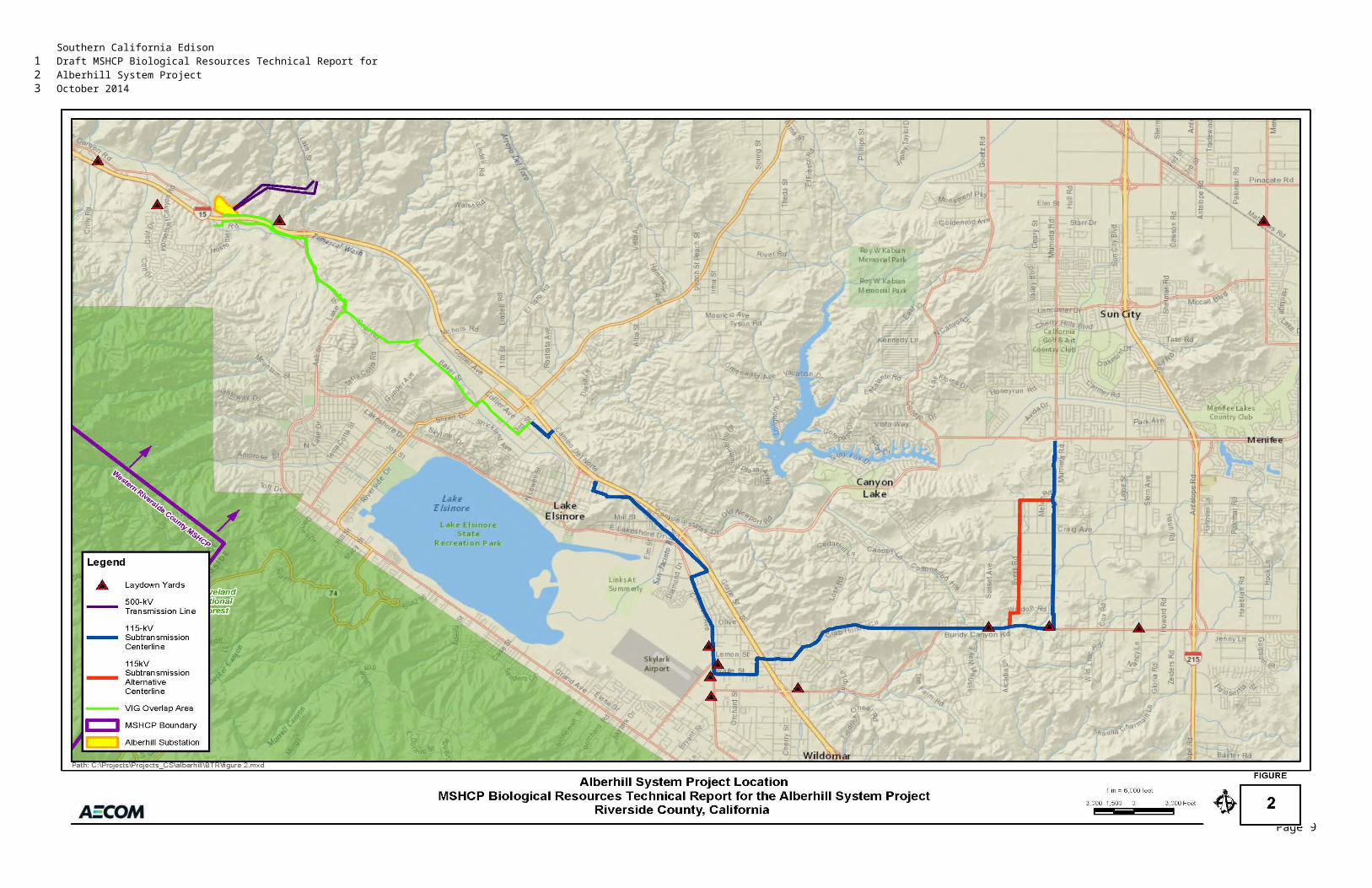
Southern California EdisonDraft MSHCP Biological Resources Technical Report forAlberhill System ProjectOctober 2014
dead-end structures at the ends of each pull and geometry of the line as affected by points of inflection, terrain, and suitability of stringing and splicing equipment setups. To ensure the safety of workers and the public, safety devices such as traveling grounds, guard structures, and radio-equipped public safety roving vehicles and linemen would be in place prior to the initiation of wire-stringing activities.
The following four steps describe the wire installation activities proposed by SCE:
Sock Line Threading: A helicopter would fly a lightweight sock line from tower to tower, which would be threaded through the wire rollers in order to engage a cam-lock device that would secure the pulling sock in the roller. This threading process would continue between all towers through the rollers of a particular set of spans selected for a conductor pull.
Pulling: The sock line would be used to pull in the conductor pulling cable. The conductor pulling cable would be attached to the conductor using a special swivel joint to prevent damage to the wire and to allow the wire to rotate freely to prevent complications from twisting as the conductor unwinds off the reel. A piece of hardware known as a running board would be installed to properly feed the conductor into the roller; this device keeps the conductor from wrapping during installation.
Splicing, Sagging, and Dead-ending: After the conductor is pulled in, all mid-span splicing would be performed. Once the splicing has been completed, the conductor would be sagged to proper tension and dead-ended to structures.
Clipping-in: After a conductor is dead-ended, the conductors would be attached to all structures; a process called clipping in.
The dimensions of the area needed for the stringing setups associated with wire installation are variable and depend upon terrain. The preferred minimum size needed for tensioning equipment set-up sites is an area of 500 feet by 150 feet; the preferred minimum size needed for pulling equipment set-up sites is an area of 300 feet by 150 feet; the preferred minimum size needed for splicing equipment set-up sites is an area 150 feet by 100 feet. Crews can work from within slightly smaller areas when space is limited. Each stringing operation would include one puller positioned at one end and one tensioner and wire reel stand truck positioned at the other end. Splicing sites would be strategically located to support the stringing operations; splicing sites include specialized support equipment such as skidders and wire crimping equipment.
The puller, tensioner, and splicing set-up locations are used to remove temporary pulling splices and install permanent splices once the conductor is strung through the rollers located on each tower and are necessary because the permanent splices that join the conductor together cannot travel through the rollers. For stringing equipment that cannot be positioned at either side of a dead-end transmission tower, field snubs (i.e., anchoring and dead-end hardware) would be temporarily installed to sag conductor wire to the correct tension.
The puller, tensioner, and splicing set-up locations require level areas to allow for equipment maneuvering. When possible, these locations would be located on existing level areas and existing roads to minimize the need for grading and cleanup. Temporary wire-stringing areas would be restored to previous conditions following completion of pulling and splicing activities. The number and locations of the puller, tensioner, and splicing sites will be determined by the final engineering for the Alberhill Project and the construction methods chosen by SCE or its contractor.
Page 16
123
1234
5
6789
1011121314
151617
1819
202122232425262728
293031323334
353637383940

Southern California EdisonDraft MSHCP Biological Resources Technical Report forAlberhill System ProjectOctober 2014
An OHGW would be installed on the transmission towers for shielding. The OHGW would be installed in the same manner as the conductor; it is typically installed in continuous segments of 11,000 feet or less, depending upon various factors including line direction, inclination, and accessibility.
1.2.2.8 Lake Mathews/Estelle Mountain Reserve
The existing Serrano–Valley 500-kV Transmission line ROW is adjacent to land managed by the Bureau of Land Management and traverses areas managed by the Riverside County Habitat Conservation Agency within the Lake Mathews/Estelle Mountain Core Reserve (Core Reserve). Along the Serrano–Valley 500-kV Transmission line ROW, construction of the proposed project would occur within existing ROW with the exception of areas near the proposed sites for 500-kV towers R15X and R17X and existing 500-kV tower sites M13-T4, M13-T3, and M13-T2. Pulling and tensioning equipment and vehicles may be required to back up onto an existing access road and other areas within the Core Reserve adjacent to proposed tower sites R15X and R17X and existing tower site M13-T4 as shown in Appendix A. Land managed by the Bureau of Land Management within the Core Reserve would not be disturbed for construction uses other than by construction vehicles that would drive on an existing access road to tower sites M13-T3 and M13-T2 that traverses Bureau of Land Management land for a few hundred feet. In addition, construction vehicles would drive on existing access roads that traverse Bureau of Land Management land adjacent to tower sites M13-T3 and M13-T2.
1.2.2.8.1 Grounding and Conductor Snubbing: Core Reserve Access
The proposed 500-kV transmission line alignments and new 500-kV towers that would connect Alberhill Substation to the Serrano–Valley 500-kV Transmission line would not be located within the boundary of the Lake Mathews/Estelle Mountain Core Reserve. Grounding and conductor snubbing, however, would be required during construction of the proposed project at towers M14-T2 and M14-T1, which are located within the Core Reserve boundary. Equipment would not be located within land managed by the Bureau of Land Management.
1.2.2.8.2 Grounding
To ensure worker safety during construction within the applicant’s Serrano–Valley 500-kV Transmission line ROW, the applicant would ground the Serrano–Valley 500-kV Transmission line at four existing 500-kV tower sites: M14-T2, M14-T1, M13-T3, and M13-T2. No equipment other than pickup trucks, clamps, and grounding cables would be required for grounding the two towers located within the Core Reserve. At the other tower sites, additional equipment, e.g., bucket trucks for lifting workers, may be used. No grounding cables or rods would be installed into the ground and no ground disturbance would be required for grounding at any of the existing or proposed 500-kV tower sites.
To access the tower sites, the applicant estimates that construction crews would drive to towers M14-T2 and M14-T1 (about 2.5 miles roundtrip) using pickup trucks on existing access and maintenance roads located within the Core Reserve. Access to towers M13-T3 and M13-T2 would require the applicant to drive on existing access roads located within the Core Reserve. The applicant anticipates that the towers would be accessed twice for grounding during the wire snubbing process: once to install the grounds and once to remove them. The foundations would be constructed prior to wire snubbing. Access to the tower sites adjacent to or within the Core Reserve could occur twice a day during the foundation installation; once to install grounds and once to remove them. The existing access and maintenance roads that would be used are shown in Appendix A.
Page 17
123
123
4
567891011121314151617
18
192021222324
25
26272829303132
333435363738394041
Southern California EdisonDraft MSHCP Biological Resources Technical Report forAlberhill System ProjectOctober 2014
After de-energizing the Serrano–Valley 500-kV Transmission line, workers would climb each of the four 500-kV lattice steel towers to install grounding clamps. Two clamps would be installed to the bridge of the towers for each of the three conductor phases1 supported by the 500-kV towers (two conductors per phase, six clamps per tower). The clamps would be connected by grounding cables to the 500-kV conductors. Once connected to the towers, the lattice steel towers would ground the transmission line conductors—providing a path from the transmission line conductors to the earth. If lightning strikes a transmission line conductor or tower or electricity otherwise energizes the 500-kV transmission line after it has been grounded, the electricity would be sent down the lattice steel towers and into the earth. Workers would be able to safely work at existing tower site M13-T4 and proposed tower sites R15X and R17X (Appendix A), which would be located between four grounded towers (M14-T2, M14-T1, M13-T3, and M13-T2). This grounding technique, which creates a safe area between grounds along a transmission line, is called bracket grounding.
1.2.2.8.3 Conductor Snubbing
Conductor snubbing would be required for each of the three 500-kV transmission line conductor phases, which would be separated from the existing 500-kV lattice steel tower (M13-T4) and extended to the two proposed towers (500-kV towers R15X and R17X) within the existing 500-kV ROW. The term conductor snubbing refers to removing conductor from the insulators and securing them to the bridge of towers. Insulators are located between each of the three constructor phases and the bridge of each tower. Snubbing ensures that transmission line conductor is secured in such a manner that when it is separated (cut), it does not fall to the earth.
Conductor snubbing would occur at 500-kV towers M14-T2, M14-T1, M13-T3, and M13-T2 and the proposed 500-kV towers VA6 and SA6. Between one and two conductor phases (two conductors each) would be snubbed to towers M14-T2, M14-T1 and M13-T3, or M13-T2. Multiple towers would be used for snubbing to ensure that the weight of the conductors does not damage any of the towers along the 500-kV transmission line. Conductor would also be snubbed as needed to the other proposed 500-kV towers (R1-R2, R4-R5, R7-R8, and R11-R14) during conductor and OHGW installation from the proposed substation, upslope to the Serrano–Valley 500-kV Transmission line.
Rough-terrain cranes, a man lift (e.g., bucket or boom truck), and crew truck would be used for conductor snubbing at the 500-kV tower sites, including towers M14-T2 and M14-T1 within the Core Reserve. Grips would be installed on each conductor by workers raised by a man lift to the bridge level of the towers. The grips would be connected to a hoist device that attaches to the tower. The conductors would be removed from the insulators, and the crane would be used to raise the conductors to the tower bridge where they would be snubbed—affixed.
Access to the Core Reserve for snubbing would be required twice: first to snub the conductors and OHGW and then to remove the snubs. Snubbing would take approximately 1 workday. Snub removal would also take approximately 1 workday. The 500-kV transmission line would be grounded for the duration of the snubbing period. Once snubbed, the conductor and OHGW snubs would not be removed until conductor and OHGW installation for proposed 500-kV Line SA and 500-kV Line VA is completed. The process of pulling, tensioning, and splicing to install conductor on the 500-kV towers is described in Section 1.2.2.7.
1 Three-phase, alternating-current electrical transmission systems use at least three conductors to transmit electricity. For the Valley–Serrano 500-kV Transmission Line, each of the three phases use two conductors. Each of the two side-by-side conductor cables are referred to as conductor bundles. Six conductor cables (i.e., three conductor bundles) are used to transmit electricity along the Valley–Serrano 500-kV Transmission Line.
Page 18
123
123456789101112
13
14151617181920
21222324252627
282930313233
34353637383940
4567
Southern California EdisonDraft MSHCP Biological Resources Technical Report forAlberhill System ProjectOctober 2014
1.2.2.8.4 Core Reserve Access
If equipment is required to be placed outside the existing Serrano–Valley 500-kV Transmission line ROW, it would be placed on an existing access road. If pulling and tensioning equipment must be located within or partially within the Core Reserve (Section 1.2.2.8), the equipment would be backed up onto the existing access road or other areas within the Core Reserve while monitored by a qualified biologist. The applicant anticipates that pulling and tensioning equipment and associated vehicles would be required to back up onto existing access roads or other areas within the Core Reserve adjacent to the proposed sites for 500-kV Tower R15X and R17X or adjacent to existing tower sites M13-T4, M13-T3, and M13-T2.
To avoid or minimize locating equipment within the Lake Mathews/Estelle Mountain Core Reserve or on land managed by the Bureau of Land Management, slack spanning would be utilized. Typically, wire-pulling locations are set up behind transmission line structures (in-line with/parallel to transmission line alignments); however, in this case, wire-pulling locations would be placed offset to the transmission line alignments within the Serrano–Valley 500-kV Transmission line ROW. The same wire stringing process and equipment is used when slack spanning. The difference is that slack spanning is utilized only on short wire pulls in areas where stringing sites are minimal and where shorter conductor leads and lesser tensions are applied so that tower loading specifications are not exceeded.
1.2.3 115-kV Subtransmission Line
The following sections describe the 115-kV subtransmission line and the activities associated with their construction.
1.2.3.1 115-kV Subtransmission Line Description
The Alberhill Project would require modification of existing 115-kV subtransmission facilities and construction of new 115-kV subtransmission facilities. The modification of existing 115-kV facilities includes:
Double-circuit an existing single-circuit 115-kV subtransmission line without structure replacement (approximately 6.5 miles)
Double-circuit an existing single-circuit 115-kV subtransmission line with structure replacement (approximately 8 miles)
Replace two existing poles with new poles at an existing Interstate 15 (I-15) crossing.
In addition, the Alberhill Project would require the following new facilities:
Construct a new 115-kV subtransmission line (approximately 3 miles)
Install new 115-kV subtransmission structures at the Alberhill Substation site
Install new 115-kV subtransmission structures within SCE’s existing Serrano-Valley 500-kV corridor.
These components are described in detail in the sections below.
Page 19
123
1
2345678
910111213141516
17
1819
20
212223
2425
2627
28
29
30
31
3233
34
Southern California EdisonDraft MSHCP Biological Resources Technical Report forAlberhill System ProjectOctober 2014
Construction of the new and modified 115-kV subtransmission lines would utilize lightweight steel (LWS) poles, tubular steel poles (TSPs), and H-frames. Each structure would support polymer insulators, stranded aluminum conductor, and a single 4/0-ACSR conductor for grounding. If needed, 954-ACSR ground conductors would be used at locations requiring higher tension. The dimensions of these structures are summarized in Table 1. Because the Alberhill Project is located in a raptor concentration area, all 115-kV subtransmission structures would be designed to be consistent with the Suggested Practices for Raptor Protection on Power Lines: the State of the Art in 2006.2
LWS poles would be direct-buried and extend approximately 65 to 91 feet above ground. The diameter of LWS poles is typically 1.5 to 2 feet at the base, tapering to approximately 1 foot at the top of the pole. Approximately 304 LWS poles would be utilized for the Alberhill Project.
Table 1Typical 115-kV Subtransmission Structure Dimensions
Pole Type
Approximate
Diameter
Approximate Height
Above Ground
Approximate Auger
Hole Depth
ApproximateAuger
DiameterLightweight Steel (LWS)† Between 1.5
and 2.5 feetBetween 65 and 91 feet
Between 7 and 10 feet
Between 2 and 3 feet
Tubular Steel Pole (TSP) Between 2 and 4 feet
Between 70 and 100 feet
Not applicable Not applicable
TSP Concrete Foundation Between 5 to 8 feet
2 feet Between 20 and 40 feet
Between 5 and 8 feet
Notes:
a. Specific pole height and spacing would be determined upon final engineering and would be constructed in compliance with CPUC General Order 95.
† The H-frames would utilize two LWS poles approximately 12 feet apart
The TSPs are used in areas where the length and strength of LWS poles are inadequate, such as freeway crossings, turning points, and other locations where extra structure strength is required. The TSPs utilized for the Alberhill Project would extend between 70 feet and 115 feet above ground, and the tallest poles would be used at crossings of I-15. The TSPs would be attached to a concrete foundation approximately 5 to 8 feet in diameter that extends between approximately 20 to 40 feet below ground and may extend up to 2 feet above ground. Approximately 40 TSPs would be utilized for the Alberhill Project.
H-frame structures would also be used for the Alberhill Project. H-frames are used in areas where extra structure strength is required. These structures would range in height from approximately 65 feet to 75 feet above ground. Approximately 10 H-frames would be utilized for the Alberhill Project.
2 Suggested Practices for Raptor Protection on Power Lines: the State of the Art in 2006 is published by the Edison Electric Institute and the Avian Power Line Interaction Committee in collaboration with the Raptor Research Foundation.
Page 20
123
1234567
8910
111213141516
171819
45
Southern California EdisonDraft MSHCP Biological Resources Technical Report forAlberhill System ProjectOctober 2014
1.2.3.1.1 Double-Circuit an Existing Single-Circuit 115-kV Subtransmission Line without Structure Replacement
SCE will be constructing a new 115-kV subtransmission line between Valley Substation and Ivyglen Substation as part of the Valley-Ivyglen (VIG)/Fogarty Project (CPUC Application Nos. A.07-01-031 and A.07-04-028).
The Alberhill Project would require that an approximately 6.5-mile portion of the VIG 115-kV subtransmission line be double-circuited between the Alberhill Substation site and the intersection of Third Street and Collier Avenue. Because the new VIG 115-kV subtransmission line has been designed to support two circuits, it is not anticipated that additional structures or structure replacement would be required. This portion of the Alberhill 115-kV subtransmission line modifications would require the addition of crossarms, anchors, insulators, and 954-conductors to existing structures.
The double-circuiting of an existing single-circuit subtransmission line without structure replacement would begin at the Alberhill Substation and follow Concordia Ranch Road to its terminus, cross I-15 to Temescal Canyon Road, and then follow Temescal Canyon Road to Lake Street. From that point, the line would be located along the new Valley-Ivyglen subtransmission line as currently proposed along Lake Street and Nichols Road. The line would follow Nichols Road, then turn southeast on Baker Street to Riverside Avenue (State Route 74). The route crosses a drainage channel and continues southeast on Pasadena Avenue, then turns northeast on Third Street to the intersection of Third Street and Collier Avenue (see Figure 2). The final route of this portion of the subtransmission modifications would be dependent on final approval of the VIG Phase 2 Project by CPUC.
1.2.3.1.2 Double-Circuit an Existing Single-Circuit 115-kV Subtransmission Line with Structure Replacement
Portions of four existing single-circuit 115-kV subtransmission lines would need to be removed, and new structures capable of supporting a double-circuit subtransmission line would need to be installed.
1.2.3.1.2.1 Valley-Elsinore-Ivyglen 115-kV Subtransmission Line
An approximately 0.3-mile section of the existing Valley-Elsinore-Ivyglen 115-kV subtransmission line in the City of Lake Elsinore, between the intersection of Third Street and Collier Avenue and the intersection of Second Street and Camino del Norte, would require new structures to support a second circuit. This section would rebuild an existing crossing of I-15 and require the removal of approximately 12 existing structures and the installation of approximately 11 new LWS poles and three TSPs.
1.2.3.1.2.2 Ivyglen-Newcomb-Skylark and Elsinore-Skylark 115-kV Subtransmission Lines
Approximately 4.5 miles of existing 115-kV subtransmission lines in the cities of Lake Elsinore and Wildomar between the intersection of East Hill Street and Flint Street and Skylark Substation would require new structures to support a second circuit. Three poles paralleling East Hill Street on the Ivyglen-Newcomb-Skylark 115-kV subtransmission line would be replaced, and approximately 104 poles of the existing Elsinore-Skylark 115-kV subtransmission line along Franklin Street, Auto Center Drive, Casino Drive, Malaga Road, and Mission Trail to Skylark Substation would be replaced. This section would include removal of approximately 114 existing structures and the installation of approximately 102 new LWS poles and approximately 10 new TSPs.
Page 21
123
12
345
67891011
121314151617181920
2122
2324
25
2627282930
31
3233343536373839
Southern California EdisonDraft MSHCP Biological Resources Technical Report forAlberhill System ProjectOctober 2014
1.2.3.1.2.3 Valley-Newcomb-Skylark 115-kV Subtransmission Line
An approximately 5.5-mile section of the existing Valley-Newcomb-Skylark 115-kV subtransmission line between Skylark Substation and the intersection of Scott Road and Murrieta Road in the cities of Wildomar and Menifee would require new structures to support a second circuit. From Skylark Substation, this section of line follows Waite Street, turns north on Almond Street, turns east on Lemon Street, and crosses I-15. The line then follows Lost Road and generally follows Crab Hollow Circle to Beverly Street, where it then follows Bundy Canyon Road to the three-way intersection with Scott Road and Murrieta Road. This section would require the removal of approximately 140 existing structures and installation of approximately 110 new LWS poles, nine new TSPs, and 10 new H-frame structures.
A second section of the Valley-Newcomb-Skylark 115-kV subtransmission line in the City of Menifee would be modified as part of the Alberhill Project. An approximately 0.2-mile section of the existing Valley-Newcomb-Skylark 115-kV subtransmission line between Newcomb Substation and the intersection of Newport Road and Murrieta Road would need to be replaced with structures capable of supporting a double circuit. This section would require the removal of approximately six existing structures and installation of approximately seven new LWS poles and approximately two new TSPs.
1.2.3.1.2.4 New Poles at Existing I-15 Freeway Crossing and Line Separation at 500-kV Crossing
Two existing 115-kV subtransmission poles would be replaced at the existing I-15 crossing immediately south of the Alberhill Substation site.
The existing Valley-Newcomb 115-kV subtransmission line would be physically and electrically separated by disconnecting existing jumper loop wires at the 500-kV crossing.
1.2.3.1.3 New 115-kV Subtransmission Lines
A distribution line approximately 3 miles long between the intersection of Newport Road and Murrieta Road and Murrieta Road and Bundy Canyon Road would be rebuilt as a single-circuit 115-kV subtransmission line, and the existing distribution line would be transferred to the new 115-kV structures below the 115-kV circuit. This section would require the removal of approximately 66 existing poles and installation of approximately 98 new LWS poles.
Approximately 11 new TSPs would be installed at the Alberhill Substation site and Concordia Ranch Road to facilitate the 115-kV subtransmission connection from the Alberhill Substation to existing 115-kV subtransmission lines along Concordia Ranch Road.
In addition, a connection between the VIG 115-kV subtransmission line on the north side of the Serrano-Valley 500-kV corridor and the Valley-Newcomb 115-kV subtransmission line located on the south side of the corridor would be made. This section is approximately 300 feet long and would require removal of at least one existing structure and installation of approximately three LWS poles and three TSPs. An access road would also be installed.
1.2.3.2 Site Preparation and Grading
The new LWS pole and TSP locations would first be graded and/or cleared to provide a reasonably level and vegetation-free surface for footing construction. An approximately 150-by-75-foot area around each 115-kV LWS pole and an approximately 200-by-100-foot area around each 115-kV TSP would be cleared
Page 22
123
1
23456789
101112131415
16
1718
1920
21
2223242526
272829
3031323334
35
363738
Southern California EdisonDraft MSHCP Biological Resources Technical Report forAlberhill System ProjectOctober 2014
of vegetation to provide a safe working area during construction. Any TSPs replacing existing wood poles would be installed as closely as possible to the original structure and would require new excavations to set the poles. Depending on their location, the assembly and erection of some of the new TSPs may require that a new crane pad, approximately 50 feet by 50 feet, be prepared to allow an erection crane to set up 60 feet from each TSP. The crane pad would be located transversely from each applicable TSP location.
Assembly of LWS poles and TSPs typically would require a laydown area of approximately 200 feet by 100 feet. In locations where the terrain in the laydown area is already reasonably level, only vegetation removal would be required to prepare the site for construction. In locations where a level surface is not present, both vegetation clearing and grading would be necessary to prepare the laydown area for construction.
1.2.3.3 Lightweight Steel Pole Installation
LWS poles would be installed in the native soil in holes bored approximately 2 to 3 feet in diameter and 7 to 10 feet deep. LWS poles are normally shipped in sections with slip joints to the laydown yard and then jacked together at the new pole location. LWS poles are normally installed using a line truck. Once the LWS poles are set in place, bore spoils (material from holes drilled) would be used to backfill the hole. If the bore spoils are not suitable for backfill, imported clean fill material, such as clean dirt and/or base material, would be used. Excess bore spoils would be distributed at each pole site and used as backfill for the holes left after removal of existing structures or disposed of off-site in accordance with all applicable laws.
1.2.3.4 Tubular Steel Pole Installation
Structure foundations for the TSPs would typically be drilled concrete piers. The TSPs would be installed on top of cylindrical concrete foundations approximately 5 to 8 feet in diameter and approximately 20 to 40 feet deep (approximately 35 cubic yards would be removed) in a method similar to that described above for the installation of 500-kV transmission tower foundations. A crane would be used to position each pole base section onto the foundation. When the base section is secured, the top section would be placed above the base section. The two sections would be bolted together and may be spot welded together for additional stability.
1.2.3.5 Subtransmission Wire-Stringing Activities and Guard Structures
Conductor would be installed on the LWS poles and TSPs as similarly described above for the 500-kV transmission wire-stringing activities, except that a line truck would drive from location to location to string the sock line, rather than using a helicopter.
Guard structures may be installed at transportation, flood control, and utility crossings. Guard structures are temporary facilities designed to stop the movement of a conductor should it momentarily drop below a conventional stringing height. Temporary netting could be installed to protect some types of under-built infrastructure. Typical guard structures are standard wood poles, 60 to 80 feet tall. Depending on the width of the conductor being constructed, the number of guard poles installed on either side of a crossing would be between two and four. The guard structures are removed after the conductor is secured in place. In some cases, the wood poles could be substituted for guard structures with the use of specifically equipped boom-type trucks with heavy outriggers staged to prevent the conductor from dropping. Approximately 104 guard structures would be used for installing the 115-kV subtransmission lines.
Page 23
123
123456
7891011
12
1314151617181920
21
22232425262728
29
303132
333435363738394041
Southern California EdisonDraft MSHCP Biological Resources Technical Report forAlberhill System ProjectOctober 2014
Public agencies differ on their policies for preferred methods to protect public safety during conductor stringing operations. For highway and open channel aqueduct crossings, SCE would work with the applicable agency to secure the necessary permits to string conductor across the applicable infrastructure. For major roadway crossings, typically one of the following four methods is employed to protect the public:
Erection of a highway net guard structure system;
Detour of all traffic off a highway at the crossing position;
Implementation of a controlled continuous traffic break while stringing operations are performed; or
Strategic placement of special line trucks with extension booms on the highway deck.
Some agencies may require the use of a secondary safety take-out sling at highway crossings.
1.2.3.6 Removal of Existing Subtransmission Structures
After the existing subtransmission, distribution lines, and telecommunication lines are transferred (where applicable) to the new subtransmission poles, the existing structures would be completely removed (including the below-ground portion) and the hole would be backfilled using imported fill in combination with fill that may be available as a result of excavation for the installation of the new TSPs. Depending on their condition and original chemical treatment, any wood poles removed may be reused by SCE, returned to the manufacturer, disposed of in a Class I hazardous waste landfill, or disposed of in the lined portion of a Regional Water Quality Control Board (RWQCB)-certified municipal landfill.
1.2.4 Operations and Maintenance
1.2.4.1 Energizing the Constructed 500-kV Transmission and 115-kV Subtransmission Lines
The final step in completing construction of the 500-kV transmission line segments and new and modified 115-kV subtransmission lines involves energizing the new conductor. To accomplish this, the existing lines in service would be de-energized and the connections between the new and modified lines would be made. De-energizing and connecting the new lines to the existing system would typically occur when electrical demand is low in order to reduce the need for electric service outages. Once the connection is complete, the existing lines would be returned to service, and the new facilities would be energized.
1.2.4.2 Post Construction Cleanup
SCE would restore all areas that were temporarily disturbed by construction of the Alberhill Project (including temporary material staging yards and conductor pull/tension/splicing sites) to as close to pre-construction conditions as possible or to the conditions agreed upon between the landowner and SCE following the completion of construction of the Alberhill Project. Any damage to existing roads as a result of construction would be repaired once construction is complete in accordance with local requirements.
In addition, all construction materials and debris would be removed from the area and recycled or properly disposed of off-site. SCE would conduct a final inspection to ensure that cleanup activities were successfully completed.
Page 24
123
12345
6
7
8
9
10
11
12131415161718
19
20
212223242526
27
2829303132
333435
Southern California EdisonDraft MSHCP Biological Resources Technical Report forAlberhill System ProjectOctober 2014
1.2.4.3 Project Operations and Management
The O&M activities described herein are consistent with SCE’s O&M Plan, which describes required activities to operate and maintain safe and reliable electric and communication facilities throughout SCE’s service territory. Furthermore, the subtransmission lines would be maintained in a manner consistent with CPUC General Order (G. O.) 95 and G. O. 128 as applicable. Operation of the lines would be controlled remotely through SCE control systems and manually in the field, as required. SCE inspects subtransmission facilities in a manner consistent with CPUC G. O. 165. That frequency calls for inspection at a minimum of once per year via ground and/or aerial observation, but may occur more frequently based on system reliability. Maintenance would occur as needed and could include activities such as repairing conductors, washing or replacing insulators, repairing or replacing other hardware components, replacing poles, tree trimming, brush and weed control, and access road maintenance. Most regular O&M activities for overhead facilities would be performed from existing dirt access roads with minimal surface disturbance. Repairs not conducted from access roads would typically occur in approved disturbed areas or undisturbed areas that have been surveyed and do not encompass sensitive biological resources. All attempts would be made to utilize these areas for O&M activities.
1.2.4.3.1 Roads
Routine dirt access road maintenance is conducted on an annual and/or as-needed basis. Road maintenance includes maintaining a vegetation-free corridor (to facilitate access and for fire prevention) and blading to smooth over washouts, eroded areas, and washboard surfaces, as needed. Further, access road maintenance would typically include brush clearing (i.e., trimming or removal of shrubs) approximately 2 to 5 feet beyond the road’s edge when necessary to keep vegetation from intruding into the roadway. However, within sensitive areas of the Alberhill Project, future access road maintenance will occur within the footprint approved during the MSHCP PSE process, which includes a minimal drivable width of 14 feet and an additional 2 feet of shoulder on each side. Road maintenance would also include cleaning ditches, moving and establishing berms (only where berms were approved as part of the approved project but not where the roads need to stay in a flattened profile), clearing drainages to allow for unobstructed flow to culverts, culvert repair, clearing and establishing water bars, and cleaning and repairing over-side drains. Access road maintenance may also include the repair, replacement, and installation of storm water diversion devices on an as-needed basis.
1.2.4.3.2 Poles
Poles could require replacement if damaged. Pole replacement locations and/or laydown areas outside of previously disturbed areas would be surveyed to ensure that they do not encompass sensitive biological resources. Attempts would be made to utilize approved permanent disturbed areas, to the greatest extent possible.
Insulators could require periodic washing with water to prevent the buildup of contaminants (dust, salts, bird droppings, smog, condensation, etc.) and reduce the possibility of electrical arcing, which can result in circuit outages and potential fire. Frequency of insulator washing is region-specific and based on local conditions and buildup of contaminants. Replacement of insulators, hardware, and other components is performed as needed to maintain circuit reliability. This activity typically involves remaining on existing access roads but may involve parking the maintenance vehicle(s) on the disturbed area directly adjacent to the pole.
Page 25
123
1
23456789101112131415
16
17181920212223242526272829
30
31323334
35363738394041
Southern California EdisonDraft MSHCP Biological Resources Technical Report forAlberhill System ProjectOctober 2014
Conductors could require repair or replacement if damaged. If conductor replacement is necessary, stringing locations are generally in line with the existing overhead conductors at a distance approximately three times the height of the pole. This activity would stay within existing access roads to the extent possible, but due to the height of the poles and the need to be in line with the existing pole line, this activity may occur off of the access road. Conductor replacement work outside of approved disturbed areas would be surveyed to ensure that it does not impact sensitive biological resources. Other conductor repair would generally occur in approved disturbed areas.
Wood pole testing and treating is a necessary maintenance activity conducted to evaluate the condition of wood structures both above and below ground level. Inspections may require the temporary removal of soil around the base of the pole, usually to a depth of approximately 12 to 18 inches, to check for signs of deterioration. Existing roads and previously disturbed areas are utilized for access to poles. To minimize impacts, all soil removed for intrusive inspections would be replaced and compacted at completion of the testing.
1.2.4.3.3 Tree Pruning and Vegetation Removal
Regular tree pruning may be performed to ensure compliance with existing state and federal laws, rules, and regulations and is crucial for maintaining reliable service, especially during severe weather or natural disasters. Tree pruning standards for distances from overhead lines have been set by the CPUC (G. O. 95, Rule 35), California Public Resources Code 4293, California Code of Regulations Title 14, Article 4, and other government and regulatory agencies. SCE’s standard approach to tree pruning is to remove at least the minimum required by law plus 1 year’s growth (species dependent).
In addition to maintaining vegetation-free access roads and clearances around electrical lines, clearance of brush and weeds around the base of poles is necessary for fire protection. Brush and weeds would be hand cleared at pole locations where sensitive habitat or species are present, as determined by pre-activity surveys. Large-diameter brush and tree trimmings would be reduced using a mechanical chipper and scatters at site locations. Debris would not be placed on sensitive resources, such as sensitive plant populations or streams. Alternatively, large trimmings could be removed to a permitted disposal location. A 10-foot radial clearance around nonexempt poles (as defined by California Code of Regulations Title 14, Article 4) will be maintained in accordance with Public Resources Code 4292.
1.2.4.3.4 Emergency Repairs
In addition to regular O&M activities, SCE may conduct a wide variety of emergency repairs in response to emergency situations such as damage resulting from high winds, storms, fires, and other natural disasters and accidents. Such repairs could include replacement of downed poles or conductors. Emergency repairs could be needed at any time.
1.2.4.3.5 SCE’s Environmental Screening Process for O&M
Prior to each ground- and or vegetation-disturbing O&M activity occurring, an environmental screening form is required to be submitted for review by SCE’s Corporate Environmental Health and Safety (CEHS) department. CEHS reviews each activity for biological and cultural resource impacts, and conducts surveys/sweeps/monitoring where necessary. In some cases, modifications to the O&M activity are requested to avoid or minimize impacts to sensitive resources. O&M activities are also reviewed for ongoing and past mitigation implementation related to capital project approval. SCE can provide multiple examples of successful implementation of capital project mitigation carried over to O&M activities.
Page 26
123
1234567
8910111213
14
151617181920
2122232425262728
29
30313233
34
35363738394041
Southern California EdisonDraft MSHCP Biological Resources Technical Report forAlberhill System ProjectOctober 2014
In addition, certain activities, such as line clearing, are generally not permitted during bird nesting season unless pre-activity surveys determine the absence of nesting birds. If these activities must occur during the nesting season, monitors are authorized to redirect O&M activities to areas with less nesting sensitivity.
In the case of emergency repairs (e.g., damaged, including downed, pole replacement), which may have to occur within the same day or over a weekend to resolve power outages, SCE CEHS is notified and consulted, but the formal environmental screening process may not be prudent in all situations. For example, if emergency repairs result in the need to alter an existing bed and bank or cause the discharge/fill of regulated waters, CEHS’s water permitting group would submit “emergency repair” regulated waters notifications/permit applications after the work is done.
1.2.4.3.6 Future O&M Work Not Covered under this PSE Approval
O&M activities that differ from the above description and/or are not approved as part of the MSHCP PSE process, or could potentially impact MSHCP Covered resources or the Core Reserve would require additional consultation with RCA. RCA would determine if additional Wildlife Agency concurrence is needed. Additional consultation with RCA would be handled through the CEHS environmental screening process and tracked as part of the hand-off process from capital projects to O&M.
Page 27
123
1234
5678910
11
1213141516
Southern California EdisonDraft MSHCP Biological Resources Technical Report forAlberhill System ProjectOctober 2014
THIS PAGE INTENTIONALLY LEFT BLANK
Page 28
123
Southern California EdisonDraft MSHCP Biological Resources Technical Report forAlberhill System ProjectOctober 2014
2.0 REGIONAL LAND USE AND CONSERVATION PLANS
The Alberhill Project area occurs primarily within developed land, undeveloped land, or along existing roadways within Lake Elsinore, Wildomar, and Menifee. It contains a combination of agricultural, municipal, private, and reserve land, most with previous disturbance.
The Alberhill Project is located within the boundaries of the MSHCP. The MSHCP allows for the Permittees within the MSHCP area to manage local land-use decisions and maintain a strong economic climate while addressing the requirements of the California Endangered Species Act (CESA) and federal Endangered Species Act (ESA). Rather than address sensitive species on an individual basis, the MSHCP focuses on the conservation of 146 species, proposing a reserve system of approximately 500,000 acres and a mechanism to fund and implement the reserve system (Riverside County 2003c). Take of Stephens’ kangaroo rat (Dipodomys stephensi, SKR) will be processed directly through the SKR Habitat Conservation Plan (HCP), leaving the MSHCP to cover incidental take, as needed, for 145 species potentially impacted by the Alberhill Project.
The importance of the MSHCP to the Alberhill Project and other projects within its boundaries is that it streamlines the environmental review and permitting processes for projects that affect biological resources. This is accomplished by having established survey and analysis requirements that directly support the identified conservation goals and objectives of the MSHCP. The goals and objectives of the MSHCP ultimately result in the development of a comprehensive reserve system for biological resources, providing long-term conservation of biological resources. The overall benefit to a project proponent is the use of existing state and federal take permits for listed species, with built-in MMs, so that individual applicants need not seek their own permits from the U.S. Fish and Wildlife Service (USFWS) and California Department of Fish and Wildlife (CDFW) (formerly California Department of Fish and Game [CDFG]) in accordance with the federal ESA and CESA take authorizations.
2.1 MSHCP RESERVE ASSEMBLY ANALYSIS2.1.1 Area Plans, Subunits and Criteria Cells
The Alberhill Project area passes through the Elsinore, Temescal Canyon, and Sun City/Menifee Valley MSHCP Area Plans (Table 2). Area Plans are further divided into subunits that contain criteria cells that are targeted for conservation. Target conservation acreages have been established along with a description of the planning species, biological issues and considerations, and criteria for each subunit within the MSHCP. In some areas, cells that have a common habitat goal are combined to form a cell group. The design for conservation involves core areas of habitat, blocks of habitat, and linkages between the core and block areas. A description of each Area Plan and subunit and the criteria cells that occur within the Alberhill Project area are provided below, as well as their associated reserve assembly goals. Appendix C illustrates the location of these areas relative to the Alberhill Project.
2.1.1.1 Elsinore Area Plan – Subunit 1: Estelle Mountain/Indian Canyon
The Project area traverses the Estelle Mountain/Indian Canyon Subunit (Subunit 1) of the Elsinore Area Plan. The following specific target planning species and conservation goals are included within the biological considerations for this subunit:
Page 1
123
1
2
345
67891011121314
15161718192021222324
25
26
272829303132333435
36
373839
Southern California EdisonDraft MSHCP Biological Resources Technical Report forAlberhill System ProjectOctober 2014
Planning Species: Bell’s sage sparrow (Artemisiospiza belli belli), coastal California gnatcatcher (Polioptila californica californica, CAGN), Cooper’s hawk (Accipiter cooperii), LBV, loggerhead
Page 2
123
12

Southern California EdisonDraft MSHCP Biological Resources Technical Report forAlberhill System ProjectOctober 2014
Table 2Western Riverside County Multiple Species Habitat Conservation Plan Area
within the Project
Alberhill Substation
VA 500-kV Study Area
SA 500-kV Study Area
Proposed 115-kV
Study Area
Alternative 115-
kV Segment
Study Area
Area Plan
Elsinore and Temescal Canyon Elsinore Elsinore Elsinore
Sun City/ Menifee Valley
Subunit
Estelle Mountain/Indian Canyon (SU1 –
Elsinore Area Plan) and Temescal
Wash West (SU3 – Temescal Canyon
Area Plan)
Estelle Mountain/Indian Canyon (SU1)
Estelle Mountain/Indian Canyon (SU1)
Estelle Mountain/Indian Canyon (SU1), Alberhill (SU2), Elsinore (SU3),
Sedco Hills (SU4)
Not a part
Criteria Cell In Portions are in Portions are in Portions are in Not In
Source: Riverside County 2003c.
shrike (Lanius ludovicianus), mountain quail (Oreortyx pictus), southwestern willow flycatcher (Empidonax traillii extimus, SWFL), white-tailed kite (Elanus leucurus), yellow-breasted chat (Icteria virens), yellow warbler (Dendroica petechia brewsteri), bobcat (Lynx rufus), mountain lion (Puma concolor), SKR, many-stemmed dudleya (Dudleya multicaulis), and Munz’s onion (Allium munzii).
Provide connection between Santa Ana Mountains, Temescal Wash, and foothills north of Lake Elsinore.
Conserve wetlands, including Temescal Wash.
Conserve clay soils supporting many-stemmed dudleya and Munz’s onion.
Conserve foraging habitat for raptors, providing a sage scrub-grassland ecotone.
Maintain core area for bobcat.
Maintain core and linkage habitat for mountain lion and SKR east of I-15.
Maintain core and linkage habitat for Quino checkerspot butterfly (Euphydryas editha quino).
Maintain connection to mountains to provide movement opportunities for mountain quail.
Conserve habitat for CAGN and other coastal sage scrub and chaparral species.
Page 3
123
12345
67
8
9
10
11
12
13
14
15
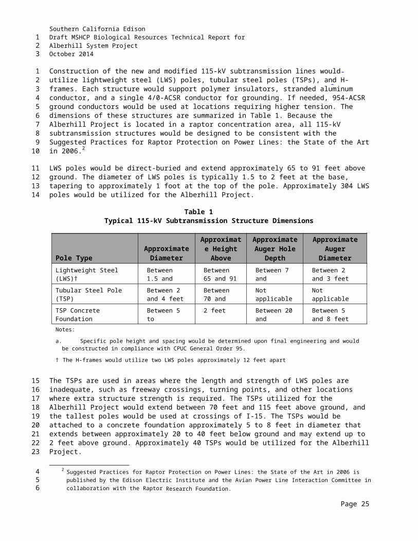
Southern California EdisonDraft MSHCP Biological Resources Technical Report forAlberhill System ProjectOctober 2014
Specifically within this subunit, the Alberhill Project traverses Criteria Cells 3649, 3650, 3651, 3653, 3749, 3750, and 3751 (refer to Appendix C). Goals for each criteria cell/cell group are provided in Table 3.
Table 3Elsinore Area Plan – Subunit 1: Estelle Mountain/Indian Canyon, Criteria Cells That
Occurwithin the Project Area
Cell Grou
pCriteria
Cell Criteria
H 3649, 3749
Conservation within this cell group will contribute to assembly of Proposed Constrained Linkage 6. Conservation within this cell group will focus on riparian habitat associated with Temescal Wash. Areas conserved within this cell group will be connected to riparian habitat proposed for conservation in Cell Group I to the east and in Cell #3748 to the west. Conservation within this cell group will range from 5%–15% of the cell group, focusing in the southern portion of the cell group.
I 3650, 3750
Conservation within this cell group will contribute to assembly of Proposed Constrained Linkage 6. Conservation within this cell group will focus on riparian habitat associated with Temescal Wash. Areas conserved within this cell group will be connected to riparian habitat proposed for conservation in Cell Group J to the east and in Cell Group H to the west. Conservation within this cell group will be approximately 5% of the cell group, focusing in the southern portion of the cell group.
J 3651, 3653, 3751
Conservation within this cell group will contribute to assembly of Proposed Core 1. Conservation within this cell group will focus on coastal sage scrub, chaparral, grassland, and riparian scrub, woodland, and forest habitats. Areas conserved within this cell group will be connected to upland habitat proposed for conservation in Cell #3853 and #3855, and Cell Group O all to the south, to coastal sage scrub habitat proposed for conservation in Cell Group L to the east, to riparian habitat proposed for conservation in Cell Group I to the west and to existing Public/Quasi-Public (PQP) Lands to the north and west. Conservation within this cell group will range from 75%–85% of the cell group, focusing in the western and northern portions of the cell group.
Source: Riverside County 2003c
2.1.1.2 Elsinore Area Plan - Subunit 2: Alberhill
The Alberhill Project area traverses through the Alberhill Subunit (Subunit 2) of the Elsinore Area Plan. The following specific target planning species and conservation goals are included within the biological considerations for this subunit:
Planning Species: Bell’s sage sparrow, cactus wren (Campylorhynchus brunneicapillus sandiegensis), CAGN, Cooper’s hawk, downy woodpecker (Picoides pubescens), LBV, SWFL, tree swallow (Tachycineta bicolor), tri-colored blackbird (Agelaius tricolor), white-tailed kite, yellow-breasted chat, yellow warbler, Quino checkerspot butterfly, Riverside fairy shrimp (Streptocephalus woottoni), bobcat, mountain lion, SKR, Coulter’s goldfields (Lasthenia glabrata ssp. coulteri), many-stemmed dudleya, Munz’s onion, San Diego ambrosia (Ambrosia pumila), and vernal barley (Hordeum intercedens).
Provide core areas for CAGN within suitable habitat east and west of I-15.
Page 4
123
12
3456
7
8910
11121314151617
18
Southern California EdisonDraft MSHCP Biological Resources Technical Report forAlberhill System ProjectOctober 2014
Provide northwest-southeast connection along the hills between Estelle Mountain and Sedco Hills, primarily for CAGN, but also for other sage scrub species.
Conserve alkali soils supporting sensitive plants including San Diego ambrosia, vernal barley, and Coulter’s goldfields.
Conserve clay soils supporting sensitive plants including Munz’s onion, many-stemmed dudleya, small-flowered morning-glory (Convolvulus simulans), and Palmer’s grapplinghook (Harpagonella palmeri).
Conserve wetlands including Temescal Wash and Alberhill Creek.
Maintain upland habitats in Alberhill and provide connection north to Estelle Mountain, North Peak, and Bureau of Land Management lands.
Conserve Engelmann oak (Quercus engelmannii) woodlands. Conserve foraging habitat for raptors, providing a sage scrub-grassland ecotone. Maintain core and linkage habitat for bobcat. Maintain core and linkage habitat for mountain lion and SKR east of I-15. Maintain core area for Riverside fairy shrimp. Maintain opportunities for core and linkage habitat for Quino checkerspot butterfly.
Specifically within this subunit, the Alberhill Project traverses Criteria Cells 3854, 3855, 3953, 3954, 4056, 4057, 4060, and 4157 (Appendix C). Goals for each criteria cell/cell group are provided in Table 4.
Table 4Elsinore Plan – Subunit 2: Alberhill, Criteria Cells That Occur within the Project
Area
Cell GroupCriteria Cell Criteria
T 3953
Conservation within this cell group will contribute to assembly of Proposed Core 1. Conservation within this cell group will focus on chaparral and coastal sage scrub habitats. Areas conserved within this cell group will be connected to chaparral and adjacent habitat proposed for conservation in Cell #4054 to the west, to coastal sage scrub habitat proposed for conservation in Cell #4155 to the south, and to chaparral and coastal sage scrub habitat proposed for conservation in Cell Group U to the east. Conservation within this cell group will range from 50%–60% of the cell group, focusing in the southeastern portion of the cell group.
U 3954, 4056
Conservation within this cell group will contribute to assembly of Proposed Core 1. Conservation within this cell group will focus on chaparral and recovery of coastal sage scrub habitat. Areas conserved within this cell group will be connected to chaparral and coastal sage scrub habitat proposed for conservation in Cell Group T to the west and in Cell #4156 to the south, and to chaparral and grassland habitat proposed for conservation in Cell #4057 to the east. Conservation within this cell group will range from 40%–50% of the cell group, focusing in the western and central portions of the cell group.
Page 5
123
12
34
567
8
910
111213141516
1718
Southern California EdisonDraft MSHCP Biological Resources Technical Report forAlberhill System ProjectOctober 2014
Table 4Elsinore Plan – Subunit 2: Alberhill, Criteria Cells That Occur within the Project
Area
Cell GroupCriteria Cell Criteria
W 4060
Conservation within this cell group will contribute to assembly of Proposed Core 1. Conservation within this cell group will focus on riparian scrub, woodland, and forest habitats associated with Alberhill Creek, and adjacent coastal sage scrub and grassland habitat. Areas conserved within this cell group will be connected to coastal sage scrub, riparian scrub, woodland, and forest habitat proposed for conservation in Cell #3964 to the north; to coastal sage scrub habitat proposed for conservation in Cell #4057 to the west; and to grassland, riparian scrub, woodland, and forest habitat proposed for conservation in Cell #4166 to the south. Conservation within this cell group will range from 80%–90% of the cell group, focusing in the northwestern portion of the cell group.
-- 3854
Conservation within this cell will contribute to assembly of Proposed Core 1. Conservation within this cell will focus on recovery of coastal sage scrub habitat. Areas conserved within this cell will be connected to coastal sage scrub habitat proposed for conservation in Cell Group J to the north and in Cell #3855 to the east. Conservation within this cell will range from 10%–20% of the cell, focusing in the northeastern portion of the cell.
-- 3855
Conservation within this cell will contribute to assembly of Proposed Core 1. Conservation within this cell will focus on recovery of coastal sage scrub habitat. Areas conserved within this cell will be connected to coastal sage scrub, riparian scrub, woodland, and forest habitat proposed for conservation in Cell Group J to the north. Conservation within this cell will range from 25%–35% of the cell focusing in the northern portion of the cell.
-- 4057
Conservation within this cell will contribute to assembly of Proposed Core 1. Conservation within this cell will focus on coastal sage scrub, chaparral, and grassland habitats. Areas conserved within this cell will be connected to chaparral habitat proposed for conservation in Cell Group U to the west, to chaparral and grassland habitat proposed for conservation in Cell #4157 to the south, and to coastal sage scrub habitat proposed for conservation in Cell Group W to the east. Conservation within this cell will range from 80%–90% of the cell, focusing in the southeastern portion of the cell.
-- 4157
Conservation within this cell will contribute to assembly of Proposed Core 1. Conservation within this cell will focus on coastal sage scrub, chaparral, and grassland habitats. Areas conserved within this cell will be connected to coastal sage scrub and chaparral habitats proposed for conservation in Cell #4156 to the west and to chaparral and grassland habitats proposed for conservation in Cell #4057 to the north. Conservation within this cell will range from 45%–55% of the cell, focusing in the western half of the cell.
Source: Riverside County 2003c
Page 6
123
Southern California EdisonDraft MSHCP Biological Resources Technical Report forAlberhill System ProjectOctober 2014
2.1.1.3 Elsinore Area Plan Subunit 3: Elsinore
The Alberhill Project area traverses through the Elsinore Subunit (Subunit 3) of the Elsinore Area Plan. The following specific target planning species and conservation goals are included within the biological considerations for this subunit:
Planning Species: American bittern (Botaurus lentiginosus), Bell’s sage sparrow, black-crowned night heron (Nycticorax nycticorax), double-crested cormorant (Phalacrocorax auritus), LBV, loggerhead shrike, mountain plover (Charadrius montanus), northern harrier (Circus cyaneus), osprey (Pandion haliaetus), SWFL, white-faced ibis (Plegadis chihi), white-tailed kite, Quino checkerspot butterfly, Riverside fairy shrimp, bobcat, southwestern pond turtle (Emys marmorata), Munz’s onion, San Diego ambrosia, and smooth tarplant (Centromadia pungens ssp. laevis).
Conserve wetlands including Temescal Wash, Collier Marsh, Alberhill Creek, Lake Elsinore, and the floodplain east of Lake Elsinore (including marsh habitats) and maintain water quality.
Conserve clay soils supporting Munz’s onion.
Conserve Travers-Willow-Domino soil series.
Conserve foraging habitat for raptors, providing a sage scrub-grassland ecotone.
Conserve grassland habitat for mountain plover.
Conserve breeding habitat for northern harrier.
Maintain linkage area for bobcat.
Conserve San Diego ambrosia at Alberhill and Nichols Road or find new populations that would allow for loss of known populations.
Maintain core and linkage habitat for southwestern pond turtle.
Maintain core area for Riverside fairy shrimp.
Maintain opportunities for core and linkage habitat for Quino checkerspot butterfly.
Specifically within this subunit, the Alberhill Project traverses Criteria Cells 4166, 4266, 4646, and 4743 (refer to Appendix C). Goals for each criteria cell/cell group are provided in Table 5.
2.1.1.4 Elsinore Area Plan Subunit 4: Sedco Hills
The Alberhill Project area traverses through the Sedco Hills Subunit (Subunit 4) of the Elsinore Area Plan. The following specific target planning species and conservation goals are included within the biological considerations for this subunit:
Planning Species: Bell’s sage sparrow, CAGN, LBV, loggerhead shrike, southern California rufous-crowned sparrow (Aimophila ruficeps canescens), SWFL, quino checkerspot butterfly, bobcat, SKR, southwestern pond turtle
Page 7
123
1
234
5678910
1112
13
14
15
16
17
18
1920
21
22
23
2425
26
272829
303132
Southern California EdisonDraft MSHCP Biological Resources Technical Report forAlberhill System ProjectOctober 2014
Table 5Elsinore Area Plan – Subunit 3: Elsinore, Criteria Cells That Occur within the
Project Area
Cell Group
Criteria Cell Criteria
4166
Conservation within this cell will contribute to assembly of Proposed Linkage 2. Conservation within this cell will focus on meadow, marsh, riparian scrub, woodland, and forest habitats along Alberhill Creek and adjacent grassland habitat. Areas conserved within this cell will be connected to riparian scrub, woodland, forest and grassland habitats proposed for conservation in Cell Group W to the north and to meadow, marsh, and grassland habitat proposed for conservation in Cell #4169 to the east. Conservation within this cell will range from 15%–25% of the cell, focusing in the northeastern portion of the cell.
4266
Conservation within this cell will contribute to assembly of Proposed Linkage 2. Conservation within this cell will focus on meadow, marsh, riparian scrub, woodland, and forest habitats along Alberhill Creek and adjacent grassland habitat. Areas conserved within this cell will be connected to meadow, marsh, and grassland habitats proposed for conservation in Cell #4169 to the north. Conservation within this cell will range from 30%–40% of the cell, focusing in the western portion of the cell.
4646
Conservation within this cell will contribute to assembly of Proposed Linkage 8. Conservation within this cell will focus on riparian scrub, woodland, and forest habitats along the San Jacinto River. Areas conserved within this cell will be connected to riparian scrub, woodland, and forest habitats proposed for conservation in Cell #4743 to the south and Cell #4647 to the east. Conservation within this cell will be approximately 5% of the cell, focusing in the southeastern portion of the cell.
4743
Conservation within this cell will contribute to assembly of Proposed Extension of Existing Core 3 and Proposed Linkage 8. Conservation within this cell will focus on riparian scrub, woodland, forest, and grassland habitats associated with the San Jacinto River. Areas conserved within this cell will be connected to riparian scrub, woodland, and forest habitats proposed for conservation in Cell #4646 to the north and to grassland habitat proposed for conservation in Cell #4742 to the west and Cell #4846 to the south. Conservation within this cell will range from 45%–55% of the cell, focusing in the southern and northeastern portions of the cell.
Source: Riverside County 2003c
Provide a northwest-southeast connection along the hills between Estelle Mountain and Sedco Hills, primarily for CAGN, but also for other sage scrub species
Conserve habitat in Sedco Hills to maintain connection between Granite Hills and Bundy Canyon Road
Conserve wetlands in lower San Jacinto River
Provide upland linkage connecting Sedco Hills to Wildomar
Conserve foraging habitat for raptors, providing a sage scrub-grassland ecotone
Maintain core and linkage habitat for bobcat and SKR
Maintain linkage area for southwestern pond turtle
Maintain opportunities for linkage area for quino checkerspot butterfly.
Page 8
123
123
45
67
8
9
10
11
12
13
Southern California EdisonDraft MSHCP Biological Resources Technical Report forAlberhill System ProjectOctober 2014
Specifically within this subunit, the Alberhill Project traverses Criteria Cells 4838, 4946, 4951, 5044, 5045, 5046, and 5049 (refer to Appendix C). Goals for each criteria cell/cell group are provided in Table 6.
Table 6Elsinore Area Plan – Subunit 4: Elsinore, Criteria Cells That Occur within the
Project Area
Cell Group
Criteria Cell Criteria
G 5044
Conservation within this cell group will contribute to assembly of Proposed Linkage 8. Conservation within this cell group will focus on chaparral and coastal sage scrub habitats. Areas conserved within this cell group will be connected to chaparral and coastal sage scrub habitats proposed for conservation in Cell Groups F to the west, E to the north, and H to the east. Conservation within this cell group will range from 65%–75% of the cell group, focusing in the northern portion of the cell group.
H 4946, 5045
Conservation within this cell group will contribute to assembly of Proposed Linkage 8. Conservation within this cell group will focus on chaparral and coastal sage scrub habitats. Areas conserved within this cell group will be connected to chaparral and coastal sage scrub habitats proposed for conservation in Cell Groups G to the west and I to the east. Conservation within this cell group will range from 60%–70% of the cell group, focusing in the northern portion of the cell group.
I 4951, 5049
Conservation within this cell group will contribute to assembly of Proposed Linkage 8. Conservation within this cell group will focus on chaparral and coastal sage scrub habitats. Areas conserved within this cell group will be connected to chaparral and coastal sage scrub habitats proposed for conservation in Cell Group H to the west and to chaparral habitat proposed for conservation in Cell #5149 to the south and in Cell Group J to the east. Conservation within this cell group will range from 50%–60% of the cell group, focusing in the southern portion of the cell group.
J 5046
Conservation within this cell group will contribute to assembly of Proposed Linkage 8. Conservation within this cell group will focus on chaparral, coastal sage scrub, grassland, woodland, and forest habitats. Areas conserved within this cell group will be connected to chaparral habitat proposed for conservation in Cell Group I and in Cell #5149, both to the west, and to chaparral, woodland, and forest habitats proposed for conservation in Cell Group K to the east. Conservation within this cell group will range from 50%–60% of the cell group, focusing in the northern portion of the cell group.
4838
Conservation within this cell will contribute to assembly of Proposed Linkage 8. Conservation within this cell will focus on chaparral and coastal sage scrub habitats. Areas conserved within this cell will be connected to chaparral and coastal sage scrub habitats proposed for conservation in Cell #4745 to the north and in Cell Group F to the east. Conservation within this cell will range from 15%–25% of the cell, focusing in the northeastern portion of the cell.
Source: Riverside County 2003c
2.1.1.5 Temescal Canyon Area Plan Subunit 3: Temescal Wash West
The Alberhill Project area traverses the Temescal Wash West Subunit (Subunit 3) of the Temescal Canyon Area Plan. The following specific target planning species and conservation goals are included within the biological considerations for this subunit:
Planning Species: Bell’s sage sparrow, CAGN, Cooper’s hawk, downy woodpecker, LBV, loggerhead shrike, southern California rufous-crowned sparrow, SWFL, white-tailed kite, yellow-breasted chat, yellow warbler, bobcat, mountain lion, SKR, Coulter’s matilija poppy (Romneya coulteri), long-spined spineflower (Chorizanthe polygonoides var. longispina), many-stemmed
Page 9
123
12
345
6
789
10111213
Southern California EdisonDraft MSHCP Biological Resources Technical Report forAlberhill System ProjectOctober 2014
dudleya, Munz’s onion, Palmer’s grapplinghook, peninsular spineflower (Chorizanthe leptotheca), small-flowered microseris (Microseris douglasii var. platycarpha), small-flowered morning-glory, and smooth tarplant
Conserve existing wetlands in Temescal Wash with focus on conservation of existing riparian, woodland, coastal sage scrub, alluvial fan scrub, and open water habitats
Conserve upland habitat adjacent to Temescal Wash to augment existing upland conservation in the Lake Mathews/Estelle Mountain Reserve areas and provide for contiguous connection of upland habitat blocks from the existing reserve to Temescal Wash. Conservation should focus on blocks of existing upland habitat east of Temescal Wash connecting to the Lake Mathews/Estelle Mountain Reserve
Conserve habitat for LBV and SWFL along Temescal Wash
Conserve clay soils supporting sensitive plant species known to occur in the Temescal Area Plan, including Munz’s onion, Palmer’s grapplinghook, small-flowered morning-glory, long-spined spineflower, small-flowered microseris, and many-stemmed dudleya
Conserve floodplain areas supporting sensitive plant species known to occur in the Temescal Area Plan including peninsular spineflower, smooth tarplant, and Coulter’s matilija poppy
Provide for and maintain a continuous linkage along Temescal Wash from the southern boundary of the Temescal Area Plan to the Santa Ana River. It is recognized that the connection from the northern boundary of the criteria area along Temescal Wash to the Santa Ana River generally consists of a concrete channel. This channel will remain in its existing condition with implementation of the MSHCP.
Maintain core and linkage habitat for bobcat
Maintain linkage area for mountain lion
Maintain linkage area for SKR along Temescal Wash.
Specifically within this subunit, the Alberhill Project lies on Criteria Cell 3039 (refer to Appendix C). Goals for this criteria cell are provided in Table 7.
2.1.1.6 Sun City/Menifee Area Plan
The eastern portion of the Alberhill Project alignment traverses the Sun City/Menifee Area Plan. The Alberhill Project is not included in subunits or criteria cells within this plan area (Appendix C) that provide specific planning species, biological issues, and considerations and criteria for each subunit. The target conservation acreage range for the Sun City/Menifee Area Plan is 1,545 to 2,010 acres; it is composed of approximately 425 acres of existing Public/Quasi-Public (PQP) lands and 1,120 to 1,585 acres of Additional Reserve Lands (ARL).
2.1.2 Cores and Linkages within Conservation Area
The MSHCP Conservation Area is composed of a variety of existing and proposed cores, extensions of existing cores, linkages, constrained linkages, and noncontiguous habitat blocks. These features are
Page 10
123
123
45
678910
11
121314
1516
1718192021
22
23
24
2526
27
282930313233
34
3536
Southern California EdisonDraft MSHCP Biological Resources Technical Report forAlberhill System ProjectOctober 2014
Table 7Temescal Canyon Area Plan – Subunit 3: Temescal Wash West, Criteria Cells That
Occurwithin the Project Area
Cell Grou
pCriteria Cell Criteria
F 3039
Conservation within this cell group will contribute to assembly of Proposed Extension of Existing Core 2. Conservation within this cell group will focus on coastal sage scrub and Riversidian alluvial fan sage scrub in a mosaic of upland habitat, and water and riparian scrub, woodland, and forest habitats. Areas conserved within this cell group will be connected to a variety of uplands and wetlands proposed for conservation in Cell Group E to the north, Cell Group G to the south, and to coastal sage scrub habitat proposed for conservation in Cells #2937 and #2935 in the Lake Mathews Area Plan to the north. Conservation within this cell group will range from 65%–75% of the cell group, focusing on the central and eastern portions of the cell group.
Source: Riverside County 2003c
generally referenced as cores and linkages. A core is a block of habitat of appropriate size, configuration, and vegetation characteristics to generally support the life history requirements of one or more MSHCP Covered species. Although a more typical definition is population related and refers to a single species, in the MSHCP this term is habitat related because of the multi-species nature of the MSHCP. An MSHCP linkage is defined as a connection between core areas with adequate size, configuration, and vegetation characteristics to generally provide for “live-in” habitat and/or provide for genetic flow for identified planning species. A constrained linkage is a constricted connection expected to provide for movement of identified planning species between core areas, where options for assembly of the connection are limited due to existing patterns of use. Areas identified as linkages in MSHCP may provide movement habitat, but not live-in habitat, for some species, thereby functioning more as movement corridors.
The Alberhill Substation is not within an MSHCP Conservation Area; however, one of the associated laydown yards falls within a proposed extension of a core (Proposed Extension of Existing Core 2). The 500-kV alignment is located in one existing core (Core C) and one proposed core (Proposed Core 1). The 115-kV alignment is within one proposed core (Proposed Core 1), two proposed linkages (Proposed Linkages 2 and 8), and one proposed constrained linkage (Proposed Constrained Linkage 6). Table 8 provides details regarding the proposed linkages as well as the associated planning species for each within the Alberhill Project area.
2.1.3 Public/Quasi-Public Conserved Lands
The MSHCP acknowledges that future facilities are necessary to support planned development (refer to MSHCP Section 7.3.9). Future facilities that are carried out by a PSE and/or Third Parties Granted Take Authorization will be considered “covered activities” under the MSHCP. Future facilities, including electrical facilities such as the Alberhill Project, are permitted within existing PQP lands provided the applicant proposes equivalent replacement land to offset impacts to the PQP land and to the MSHCP resources. Impacts (permanent) to habitats within existing PQP lands shall be compensated by purchase and dedication into the MSHCP Conservation Area of land at not less than a ratio of 1:1. The project would be subject to a finding of equivalency by RCA with concurrence by USFWS and CDFW.
Page 11
123
12345678910
11121314151617
18
1920212223242526
Southern California EdisonDraft MSHCP Biological Resources Technical Report forAlberhill System ProjectOctober 2014
Table 8Cores and Linkages within the Project Area
Linkage Description
Existing Core C
Existing Core C consists of public lands in the Lake Mathews/Estelle Mountain area in the northwestern region of the Plan Area, originally assembled as a core reserve for the SKR Habitat Conservation Plan. Connections to other MSHCP conserved lands exist to the east (Proposed Linkage 3) and west (Proposed Extension of Existing Core 2). This core is somewhat constrained by existing agriculture to the north and south; however, some natural lands remain along the border of the core. A large portion of the western border of Existing Core C is contiguous with Proposed Extension of Existing Core 2, which markedly decreases amount of exposed edge and results in a lower actual perimeter-to-area (P/A) ratio. This core provides live-in habitat for a large number of species as well as linkage area for species moving from the Gavilan Hills area to Temescal Wash. In addition to SKR, the Lake Mathews/Estelle Mountain Reserve contains habitat for other species with requirements for high-quality habitat, such as quino checkerspot butterfly and CAGN.
Planning Species: southern California rufous-crowned sparrow, Bell’s sage sparrow, burrowing owl, cactus wren, northern harrier, white-tailed kite, loggerhead shrike, CAGN, SKR, bobcat, mountain lion, Munz’s onion, slender-horned spineflower, and many-stemmed dudleya
Proposed Core 1
Proposed Core 1 is located approximately in the east-central region of the Plan Area. This core area consists largely of private lands in the Alberhill area but also contains small pieces of PQP lands. The core exists in two blocks, one east and one west of I-15. Connections are made from the core to Proposed Linkage 1, Proposed Linkage 2 (Alberhill Creek), Proposed Linkage 3, and Existing Core C (Lake Mathews/Estelle Mountain). The core provides habitat for species and also provides for movement of species. Key populations of CAGN, Munz’s onion, many-stemmed dudleya, cactus wren, tri-colored blackbird, and yellow warbler are supported in this core area. The core likely provides for movement of common mammals such as bobcat.
Planning Species: CAGN, cactus wren, tri-colored blackbird, SWFL, Munz’s onion, and many-stemmed dudleya
Proposed Extension of Existing Core 2
Proposed Extension of Existing Core 2 (Lake Mathews/Estelle Mountain Extension) consists of private lands located in the western region of the Plan Area. This extension is contiguous with Existing Core C (Lake Mathews/Estelle Mountain) along the length of its eastern border and serves to extend the habitat in the Lake Mathews/Estelle Mountain area and smooth out edges along the border of this core. Proposed Extension of Existing Core 2 is also connected to Proposed Constrained Linkage 4 (North Temescal Wash) in the north; and Proposed Linkage 1 and Proposed Constrained Linkages 3, 5 (Horsethief Canyon), and 6 (Temescal Wash south) in the south. The extension provides habitat for species and also provides for movement of species. The Lake Mathews/Estelle Mountain Extension supports populations of CAGN; thus, high-quality, connected habitat must be maintained in this area, which is surrounded by city (Corona), and community development planned land uses. In addition, the proposed Hemet to Corona/Lake Elsinore CETAP Corridor Alternative 1B intersects the extension and may contribute to edge effects, if chosen. Guidelines pertaining to urban/wildlands interface for the management of edge factors such as lighting, urban runoff, toxics, and domestic predators are presented in Section 6.2.8 of this document.
Planning Species: Cooper’s hawk, southern California rufous-crowned sparrow, Bell’s sage sparrow, yellow warbler, white-tailed kite, SWFL, yellow-breasted chat, loggerhead shrike, downy woodpecker, CAGN, LBV, SKR, bobcat, mountain lion, Munz’s onion, long-spined spineflower, and many-stemmed dudleya
Page 12
123
Southern California EdisonDraft MSHCP Biological Resources Technical Report forAlberhill System ProjectOctober 2014
Table 8Cores and Linkages within the Project Area
Linkage Description
Proposed Linkage 2
Proposed Linkage 2 is composed of wetland habitat associated with Collier Marsh in the City of Lake Elsinore. It supports key populations of the following species: yellow-breasted chat, San Diego ambrosia, downy woodpecker, least Bell's vireo, yellow warbler, and SWFL. Maintenance of wetland functions and values and water quality of Collier Marsh is important for these species.
Planning Species: American bittern, mountain plover, SWFL, black-crowned night heron, osprey, double-crested cormorant, white-faced ibis, and least Bell's vireo
Proposed Constrained Linkage 6
Proposed Constrained Linkage 6 is located approximately in the east-central region of the Plan Area and consists of a portion of Temescal Wash. This linkage connects Proposed Core 1 (Alberhill), Proposed Extension of Existing Core 2 (Lake Mathews/Estelle Mountain Extension), and Proposed Linkage 1. Private lands comprise the entirety of the Linkage, which provides important upland and riparian habitat for species such as those listed in the table below. High-quality riparian habitat must be maintained within the core and along the edges for species such as Cooper’s hawk, yellow warbler, white-tailed kite, yellow-breasted chat, and least Bell’s vireo, which have key populations located in or along the wash. Since existing agricultural use completely constrains this linkage, and the linkage is partially surrounded by community development planned land use, treatment and management of edge conditions along this linkage will be necessary to ensure that it provides habitat and movement functions for species using the linkage. Guidelines pertaining to urban/wildlands interface for the management of edge factors such as lighting, urban runoff, toxics, and domestic predators are presented in Section 6.2.8 of the MSHCP.
Planning Species: Cooper’s hawk, yellow warbler, white-tailed kite, southwestern willow flycatcher, yellow-breasted chat and least Bell’s vireo
Proposed Linkage 8
Proposed Linkage 8 (Sedco Hills/Wildomar) is composed largely of upland habitat in the Sedco Hills and Wildomar area. This linkage is a major component of one of the two main east-west connections between core areas in Lake Mathews/Estelle Mountain, Alberhill, and Cleveland National Forest in the western portion of the MSHCP Plan Area and core areas in French Valley, Johnson Ranch, Diamond Valley Lake, and San Jacinto Mountains in the eastern portion of the MSHCP Plan Area. This linkage provides live-in habitat for over 50 pairs of CAGN, as well as a connection to other key populations of gnatcatcher known to occur in Alberhill, North Peak, and the Ramsgate area. Other planning species for which habitat is provided includes quino checkerspot butterfly, SKR, and bobcat. The grasslands occurring within this proposed linkage also provide foraging habitat for a number of raptors. Maintenance of large, intact, interconnected habitat blocks is important for these species. The northern portion of this linkage includes a portion of the lower San Jacinto River extending under I-15 to connect with Proposed Extension of Existing Core 3.
Planning Species: quino checkerspot butterfly, western pond turtle, southern California rufous-crowned sparrow, Bell’s sage sparrow, SWFL, loggerhead shrike, CAGN, LBV, SKR, and bobcat.
Source: Riverside County 2003c
The Alberhill Project crosses SKR Core Reserve, managed by PQP system (see Section 1.2.2.8 for project description). A small portion of the 500-kV alignment is included in the Lake Mathews/Estelle Mountain Reserve, but all impacts would be temporary. Specific guidelines for facilities within the PQP lands are presented in Section 7.3 of the MSHCP.
Page 13
123
1234

Southern California EdisonDraft MSHCP Biological Resources Technical Report forAlberhill System ProjectOctober 2014
2.1.4 Additional Reserve Lands
ARL are defined as the additional 153,000 acres needed for MSHCP Reserve Assembly and are part of the overall MSHCP Conservation Area providing current and future conservation of the Covered species. Currently, three project areas are located within an MSHCP ARL. One area of proposed 500-kV transmission line tower R14X, where temporary work areas and tower access will be located, occurs on ARL. Two areas of an existing SCE line (Fogarty-Ivyglen), within the VIG Phase 2 overlap area, occur on ARL: one area is north of and parallel to Nichols Road, and the other is west of and parallel to Lake Street. However, pursuant to MSHCP Implementing Agreement Section 11.8.2, in the event the proposed activity crosses the MSHCP Conservation Area, RCA staff can make a finding supported by adequate evidence that the activity will result in a biologically equivalent or superior alternative to the MSHCP Conservation Area prior to issuance of an MSHCP Certificate of Inclusion.
Construction of the VIG Phase 2 Project will occur in the overlap area prior to construction of the Alberhill Project. The VIG Phase 2 Project will propose equivalent or superior replacement land to offset potential impacts to ARL in these two areas and demonstrate that there will be no impacts to the functions and values of the ARL and it will not impede any of the goals and objectives of the MSHCP. The Alberhill Project will only be adding another line to the poles installed by the VIG Phase 2 Project and will therefore remain within the same disturbance footprint as the one approved for the VIG Phase 2 Project.
2.2 MSHCP SURVEY REQUIREMENTSMSHCP survey areas for the Alberhill Project were identified by conducting an initial search of the Riverside County Integrated Project (RCIP) Conservation Summary Report Generator (Riverside County 2014a. As a result, the study area was identified as located within the BUOW survey area, Criteria Area Species Survey Area (CASSA), and Narrow Endemic Species Survey Area (NEPSSA) (Figure 3). The Alberhill Project is located within areas identified as existing or proposed cores or linkages (see Table 8). Table 9 summarizes the MSHCP Project Review Checklist to determine conservation measures and surveys necessary for MSHCP compliance.
2.2.1 MSHCP Section 6
Section 6 of the MSHCP provides for MSHCP implementation. Three particular subsections of this section are relevant to the Alberhill Project:
6.1.2 Protection of Species Associated with Riparian/Riverine Areas and Vernal Pools
6.1.3 Protection of Narrow Endemic Plant Species
6.1.4 Guidelines Pertaining to the Urban/Wildlands Interface
6.3.2 Additional Survey Needs
The MSHCP covers 146 species, 40 of which require additional surveys if the Alberhill Project occurs in the specific survey area for a species. For the purposes of this Alberhill Project, SCE is not requesting take of SKR because SKR coverage is not permitted by the MSHCP when the project site also lies within the SKR HCP boundaries. SKR take will be obtained directly through the SKR HCP pursuant to an agreement with the Riverside County Habitat Conservation Agency (RCHCA). As noted above in Table 9 and illustrated in Figure 3, the Alberhill Project occurs within the NEPSSA, CAPSSA, and BUOW survey area.
Page 14
123
1
234567891011
121314151617
18
19202122232425
26
2728
29
30
31
32
33343536373839
Southern California EdisonDraft MSHCP Biological Resources Technical Report forAlberhill System ProjectOctober 2014
THIS PAGE INTENTIONALLY LEFT BLANK
Page 15
123
Southern California EdisonDraft MSHCP Biological Resources Technical Report forAlberhill System ProjectOctober 2014
Page 16
123
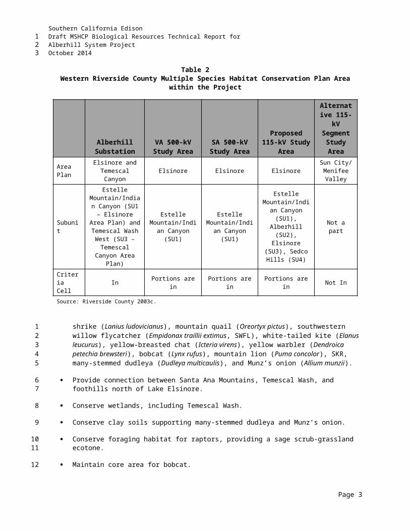
Southern California EdisonDraft MSHCP Biological Resources Technical Report forAlberhill System ProjectOctober 2014
THIS PAGE INTENTIONALLY LEFT BLANK
Page 17
123
Southern California EdisonDraft MSHCP Biological Resources Technical Report forAlberhill System ProjectOctober 2014
Table 9MSHCP Project Review Checklist
Checklist Yes NoIs the project located in a Criteria Area or PQP Land?
Is the project located in Criteria Area Plant Species Survey Area (CASSA)?
Is the project located in Criteria Area Amphibian Survey Area?
Is the project located in Criteria Area Mammal Survey Area?
Is the project located in Narrow Endemic Plant Species Survey Area (NEPSSA)?
Are riverine/riparian/wetland habitats or vernal pools present?
Is the project located in Burrowing Owl Survey Area?
Is the project located in a Special Linkage Area?
Based on biological resource assessments, the RCIP Conservation Report Generator, and maps of MSHCP survey areas, it was determined that surveys for riparian/riverine habitats, vernal pools, and associated species; Narrow Endemic Plan Species (NEPS); and Criteria Area Species (CAPS) are required pursuant to Sections 6.1.2, 6.1.3, and 6.3.2 of the MSHCP.
Section 6.1.3 of the MSHCP describes the 14 NEPS and procedures necessary for surveying, mapping, and documenting these species. In addition to the NEPS listed in Section 6.1.3, additional surveys may be needed for certain species listed in Section 6.3.2 in conjunction with Plan implementation in order to achieve coverage for these species. These species are referred to as “Criteria Area Species.” Associated survey areas have been identified for these species (see Figure 3 and Table 10). Furthermore, per Section 6.1.2 of the MSHCP, if potential riparian, riverine, and/or vernal pool habitat (as defined by the MSHCP) occurs within the Alberhill Project area, additional surveys are necessary for specific species that have potential to occur within these habitats. Table 10 lists the species that are to be surveyed per Section 6 of the MSHCP.
The MSHCP does not supersede existing federal and state regulations covering lakes, streams, vernal pools, and other wetland areas. Thus, projects must comply with existing regulations for these aquatic resources pursuant to the Clean Water Act (CWA) and the California Fish and Game Code (CFGC). However, pursuant to the MSHCP, an assessment of the potentially significant effects of projects on riparian/riverine areas and vernal pools as it relates to habitat functions and values for MSHCP-Covered species is required. If an avoidance alternative is not possible and a more practicable alternative is selected instead, a DBESP will be provided to ensure replacement of any lost functions and values of habitat as it relates to the needs of covered species that rely on that habitat.
Section 6.1.2 of the MSHCP defines riparian/riverine and vernal pool habitats as follows:
Riparian/Riverine Areas: are lands which contain habitat dominated by trees, shrubs, persistent emergents, or emergent mosses and lichens, which occur close to or which depend upon soil moisture from a nearby freshwater source; or unvegetated ephemerals that transport water supporting downstream resources in the MSHCP Conservation Area.
Vernal Pools: are seasonal wetlands that occur in depression areas that have wetlands indicators of all three parameters (soils, vegetation, and hydrology) during the wetter portion of the growing season but normally lack wetlands indicators of hydrology and/or vegetation during the drier portion of the growing season. Obligate hydrophytes and facultative wetlands (FACWs) plant species are normally dominant during the wetter portion of the growing season, while upland species (annuals) may be dominant during the drier portion of the growing season.
Page 18
123
12
3456
789101112131415
1617181920212223
24
25262728
293031323334
Southern California EdisonDraft MSHCP Biological Resources Technical Report forAlberhill System ProjectOctober 2014
Table 10MSHCP Section 6 Species List
MSHCP Section Species
Section 6.1.2Riparian/Riverine and Vernal Pools
Plants: Brand’s phacelia, California Orcutt grass, California black walnut, Coulter’s matilija poppy, Engelmann oak, Fish’s milkwort, graceful tarplant, lemon lily, Mojave tarplant, mud nama, ocellated Humboldt lily, Orcutt’s brodiaea, Parish’s meadowfoam, prostrate navarretia, San Diego button celery, San Jacinto Valley crownscale, San Miguel savory, Santa Ana River woolly-star, slender-horned spineflower, smooth tarplant, spreading navarretia, thread-leaved brodiaea, and vernal barley.Invertebrates: Riverside fairy shrimp and vernal pool fairy shrimpFish: Santa Ana suckerAmphibians: arroyo toad, mountain yellow-legged frog, and California red-legged frogBirds: bald eagle, LBV, peregrine falcon, SWFL, western yellow-billed cuckoo
Section 6.1.3Narrow Endemic
Plant Species
Brand's phacelia, California Orcutt grass, Hammitt's clay-cress, Johnston's rockcress, many-stemmed dudleya, Munz's mariposa lily, Munz's onion, San Diego ambrosia, San Jacinto Mountains bedstraw, San Miguel savory (Santa Rosa Plateau, Steele Rock), slender-horned spineflower, spreading navarretia, Wright's trichocoronis, and Yucaipa onion
Section 6.3.2Additional Survey
Needs and Procedures
Plants: Coulter's goldfields, Davidson's saltscale, heart-leaved pitcher sage, little mud nama, Nevin's barberry, Parish's brittlescale, prostrate navarretia, round-leaved filaree, San Jacinto Valley crownscale, smooth tarplant, thread-leaved brodiaea, and Vail Lake ceanothusAmphibians*: arroyo toad, mountain yellow-legged frog, and California red-legged frogBirds: burrowing owl Mammals*: Aguanga kangaroo rat, San Bernardino kangaroo rat, Los Angeles pocket mouse
Note: The Alberhill Project does not occur within the amphibian and mammal species survey areas.
In addition to mapping vernal pools, the MSHCP requires mapping of stock ponds, ephemeral pools, and other features that may be suitable habitat for Riverside fairy shrimp, vernal pool fairy shrimp (Brachinecta lynchi), and Santa Rosa fairy shrimp (Linderiella santarosae).
The MSHCP describes a strategy of impact avoidance, minimization, and mitigation for these resources and further requires that long-term conservation of these areas is ensured, and recommends that indirect impacts be reviewed to provide protection for these areas.
Section 6.1.4 of the MSHCP describes a process to ensure that projects located outside, but adjacent to, the Conservation Area do not undermine conservation planning objectives of the MSHCP. This process is called the Urban/Wildlands Interface Guidelines (UWIG).
“Future Development in proximity to the MSHCP Conservation Area may result in Edge Effects that will adversely affect biological resources within the MSHCP Conservation Area. To minimize such Edge Effects, the following guidelines shall be implemented in conjunction with review of individual public and private Development projects in proximity to the MSHCP Conservation Area.”
Specific elements to be considered in UWIG compliance include:
Drainage Toxics Lighting
Page 19
123
123
456
789
1011121314
15
161718
Southern California EdisonDraft MSHCP Biological Resources Technical Report forAlberhill System ProjectOctober 2014
Noise Invasives Barriers
Grading and land development.
As stated in the MSHCP:
“Existing local regulations are generally in place that address the issues presented in this section. Specifically, the County of Riverside and the 14 Cities within the MSHCP Plan Area have approved general plans, zoning ordinances and policies that include mechanisms to regulate the development of land. In addition, project review and impact mitigation that are currently provided through the CEQA process address these issues.”
UWIG compliance, therefore, relies heavily, among other things, on the application of BMPs during site development and project operation. These BMPs can be found in Appendix C of the MSHCP. Projects must accordingly demonstrate that they shall not adversely affect the Conservation Area and must adequately consider the elements listed above per the UWIG.
2.2.2 MSHCP Table 9-3 Requirements to Be Met For 28 Species Prior To Including Those Species on the List of Covered Species Adequately Conserved
Of the 146 Covered Species addressed in the MSHCP, 118 species are considered Adequately Conserved. The remaining 28 Covered Species will be considered Adequately Conserved when certain conservation requirements are met as identified in the species-specific conservation objectives for those species. These particular species-specific conservation objectives are identified in Table 9-3 of the MSHCP and must be satisfied by RCA and the Permittees to shift those particular species to the list of Covered Species Adequately Conserved. As a PSE, no addition mitigation or further action is required.
2.2.3 Requirements for Participating Special Entities
In addition to the survey and analysis requirements set forth in the MSHCP, PSEs shall also contribute to MSHCP implementation through payment of a mitigation fee. This fee is based upon a percentage of capital costs and temporary versus permanent impacts, and is applicable to all activities in the Plan Area. For Regional Utility Projects, such as the Alberhill Project, PSEs shall pay a fee in the amount of 5 percent of total capital costs for permanent impacts as determined in coordination with RCA. For portions and features of the Alberhill Project that result in temporary impacts and disturbance, PSEs shall pay a fee in the amount of 3 percent of total capital costs as determined in coordination with RCA.
Page 20
123
1234
5
678910
11121314
1516
171819202122
23
24252627282930
Southern California EdisonDraft MSHCP Biological Resources Technical Report forAlberhill System ProjectOctober 2014
THIS PAGE INTENTIONALLY LEFT BLANK
Page 21
123
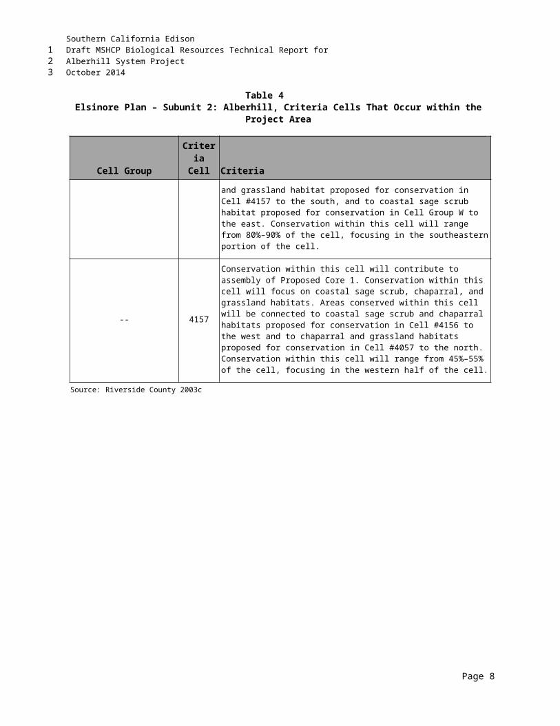
Southern California EdisonDraft MSHCP Biological Resources Technical Report forAlberhill System ProjectOctober 2014
3.0 SURVEY METHODSThis section provides an overview of methods used to evaluate biological resources within the Alberhill Project study area (see Figure 2 and Appendix A) between 2008 and 2014.
3.1 DATABASE AND LITERATURE REVIEWPrior to all field surveys and the preparation of reports, a review of available electronic databases, reports, and other sources were conducted. As part of the assessment, a comprehensive search was conducted to identify sensitive species data relevant to the study area and surrounding region. The following resources were used in background research and during field surveys:
Topographic maps (USGS 7.5-minute quadrangles)
Western Riverside Area, California Soil Survey (USDA 1971)
The Soil Survey of Western Riverside Area (Knecht 1971)
California Natural Diversity Database (CNDDB 2006–2014)
USFWS Species Occurrence GIS Data (CFWO 2009–2014)
California Native Plant Society (CNPS) Inventory of Rare and Endangered Plants of California (CNPS 2009–2014)
Volume 1, Parts I and II of the Western Riverside County Multiple Species Habitat Conservation Plan (MSHCP) (Riverside County 2003c)
County of Riverside Conservation Summary Report Generator (Riverside County 2014a)
County Wide Active GIS Data (Riverside County 2014b)
County Wide Static GIS Data (Riverside County 2014c)
Biological Constraint Analysis of the Alberhill Substation Site, Riverside County, California (AECOM 2008a)
Burrowing Owl Habitat Assessment for the Alberhill Substation Site, Riverside County, California (AECOM 2008b)
Final Biological Resources Technical Report for the Proposed Alberhill System Project, Volumes I and II, October (AECOM 2009a).
Proposed Alberhill System Project Biological Resources Technical Report for Alberhill Substation Study Area (AECOM 2009b)
Focused Rare Plant Surveys for the Alberhill Substation Site, Riverside County, California (AECOM 2009c)
Page 1
123
1
23
4
5678
9
10
11
12
13
1415
1617
18
19
20
2122
2324
2526
2728
2930
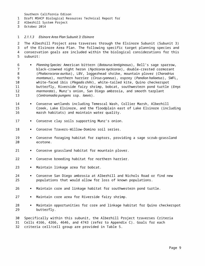
Southern California EdisonDraft MSHCP Biological Resources Technical Report forAlberhill System ProjectOctober 2014
Focused Burrowing Owl Burrow Surveys for the Alberhill Substation Site, Riverside County, California (AECOM 2009d,e)
Focused Sensitive Plant Surveys for the Alberhill Substation and 500/115-kV Study Areas, Riverside County, California (AECOM 2010a)
Focused Arroyo Toad Surveys for the Alberhill 115-kV Study Areas, Riverside County, California (AECOM 2010b)
Focused Least Bell’s Vireo and Southwestern Willow Flycatcher Surveys for the Alberhill Substation and 500/115-kV Study Areas, Riverside County, California (AECOM 2010c)
Focused Rare Plant Surveys for the Alberhill Substation and 500/115-kV Study Areas, Riverside County, California (AECOM 2011a)
Focused Least Bell’s Vireo and Southwestern Willow Flycatcher Surveys for the Alberhill Substation and 500/115-kV Study Areas, Riverside County, California (AECOM 2011b)
Focused Burrowing Owl Surveys for the Alberhill Substation and 500/115-kV Study Areas, Riverside County, California (AECOM 2011c)
Jurisdictional Delineation for the Alberhill Substation and 500/115-kV Study Areas, Riverside County, California (AECOM 2011d)
Fairy Shrimp Habitat Assessment for the Alberhill 115-kV Study Areas, Riverside County, California (AECOM 2012a)
Focused Least Bell’s Vireo and Southwestern Willow Flycatcher Surveys for the Alberhill Substation and 500/115-kV Study Areas, Riverside County, California (AECOM 2012b)
Oak Impact Report, Alberhill System Project (AECOM 2012c)
Jurisdictional Delineation for the Alberhill Substation and 500/115-kV Study Areas, Riverside County, California (AECOM 2013)
Focused Southwestern Willow Flycatcher, Least Bell’s Vireo, and CAGN Surveys for the Alberhill Substation Site, Riverside County, California (AMEC 2009a)
Focused Fairy Shrimp Surveys for the Alberhill Substation Site, Riverside County, California (AMEC 2009b)
Draft MSHCP Biological Resources Technical Report for VIG Subtransmission Line Project, Phase 2, Riverside County, California (AMEC 2013)
Jurisdictional Delineation for the Alberhill Substation Site, Riverside County, California (E. Read and Associates 2010a)
Fairy Shrimp Habitat Assessment for the Alberhill Substation and 115-kV Study Areas, Riverside County, California (E. Read and Associates 2010b)
Page 2
123
12
34
56
78
910
1112
1314
1516
1718
1920
21
2223
2425
2627
2829
3031
3233
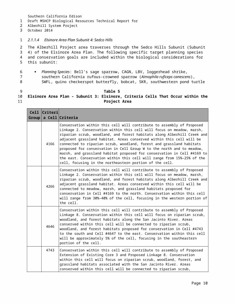
Southern California EdisonDraft MSHCP Biological Resources Technical Report forAlberhill System ProjectOctober 2014
Focused Quino Checkerspot Butterfly Surveys for the Alberhill Substation Site, Riverside County, California (Forensic Entomology Services 2009)
Focused Least Bell’s Vireo and Southwestern Willow Flycatcher Surveys for the Alberhill Substation and 500/115-kV Study Areas, Riverside County, California (Kidd Biological, Inc. 2013)
Focused Least Bell’s Vireo and Southwestern Willow Flycatcher Surveys for the Alberhill Substation and 500/115-kV Study Areas, Riverside County, California (Kidd Biological, Inc. 2014)
SKR Habitat Assessment for the Alberhill Substation and 500/115-kV Study Areas, Riverside County, California (Montgomery 2009)
SKR Trapping Effort for the Alberhill Substation and 500/115-kV Study Areas, Riverside County, California (Montgomery 2010a)
Results of a habitat assessment for the Los Angeles Pocket Mouse (Perognathus longimembris brevinasus) (LAPM) in a 400-foot-wide corridor (study area) along the proposed alignment for the SCE 115-kV subtransmission line in Western Riverside County (Montgomery 2010b)
Los Angeles Pocket Mouse and SKR Trapping for the Alberhill Substation and 500/115-kV Study Areas, Riverside County, California (Montgomery 2011)
SKR Trapping for the Alberhill 500/115-kV Study Area, Riverside County, California (Montgomery 2012)
The web-based National Hydrography Dataset (USGS 2013)
2012 aerial maps of the Project survey area (U.S. Department of Agriculture [USDA] National Agriculture Imagery Program) (USDA 2012)
The web-based National Wetlands Inventory Wetlands Mapper (USFWS 2013)
The web-based National List of Hydric Soils (NRCS 2013a)
The web-based Natural Resource Conservation Service (NRCS) Web Soil Survey (NRCS 2013b)
The web-based California Soil Resource Lab (U.C. Davis 2013)
The web-based California Watershed Portal (CalEPA 2013)
The web-based California Watershed Network (CWN 2013)
The web-based Digital Watershed (USEPA 2013)
The web-based Western Regional Climate Center (WRCC 2013)
The web-based National Weather Service Climate Office (NOAA 2013).
Page 3
123
12
34
56
78
910
111213
1415
1617
18
1920
21
22
23
24
25
26
27
28
29
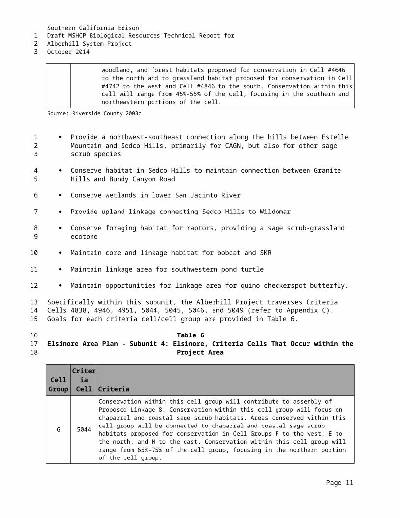
Southern California EdisonDraft MSHCP Biological Resources Technical Report forAlberhill System ProjectOctober 2014
Appendix D presents a list of special-status species that were determined to have potential to occur within the Alberhill Project area based on literature and database review, as well as initial habitat assessments.
3.2 FIELD SURVEY OVERVIEWThe general biological study area for the proposed ROW of the Alberhill Project consists of a 400-foot-wide corridor (200-foot buffer on each side of the proposed transmission line) and a 200-foot buffer surrounding the proposed Alberhill Substation. An exception to this was made during avian surveys (i.e., BUOW, LBV, and SWFL), in which a 1,000-foot-wide corridor (500 feet on each side of the proposed transmission line) and a 500-foot buffer surrounding the proposed Alberhill Substation were used. A number of biological resource assessments and focused surveys have been performed within the Alberhill Project area to date. General and focused biological surveys/habitat assessments were conducted to assess the following:
General biological characteristics of the Alberhill Project area;
Presence or potential presence of any listed, special status, or MSHCP species;
Vegetation communities;
Flora and fauna species inventories;
Habitat suitability for MSHCP NEPSSAs 1, 3, and 4;
Habitat suitability for MSHCP CASSA 1;
Habitat suitability for BUOW within MSHCP survey areas;
Presence or potential presence of species not covered by the MSHCP;
Presence or potential presence of MSHCP-defined fairy shrimp, Vernal Pool, and riparian/riverine habitats; and
Presence or potential presence of U.S. Army Corps of Engineers (USACE), RWQCB, and CDFW jurisdictional areas.
Data were collected in the field by numerous techniques, including the use of field notes, hand-held Global Positioning System (GPS) device, standardized data forms, photographs, and field maps. Field maps with an aerial view of the Alberhill Project area included the California Natural Diversity Database (CNDDB), USFWS, and MSHCP sensitive species data points. Potentially occurring habitats for special status species were identified prior to field investigations through aerial photo-interpretation and consultations with SCE staff biologists. Initial reconnaissance-level wildlife and botanical surveys were conducted in conjunction with vegetation mapping. The Alberhill Project area was traversed on foot and by vehicles, as needed.
Focused surveys were scheduled based on the results of the initial assessments. Lists of all vertebrate wildlife species and all plant species encountered within the entire Alberhill Project area are included in Appendices C1 and C2. Table 11 identifies all field work conducted within the Alberhill Project area between 2008 and 2014.
Page 4
123
12
3
4567891011
12
13
14
15
16
17
18
19
2021
2223
2425262728293031
32333435
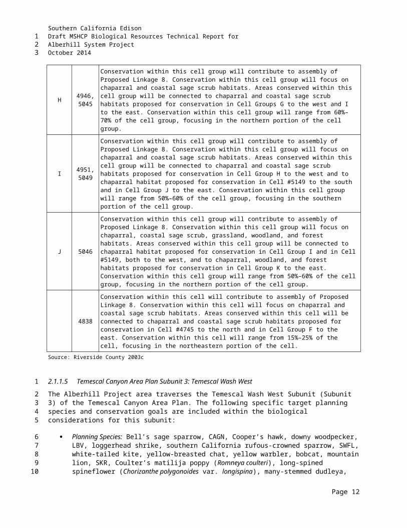
Southern California EdisonDraft MSHCP Biological Resources Technical Report forAlberhill System ProjectOctober 2014
Table 11Survey Locations, Personnel, Dates, and Purpose
Surveyor(s) Date(s) Purpose
2008MM, CR 17–19 Nov Biological Constraint Analysis of the Alberhill Substation
Site
MM, CR 17–18 Nov BUOW Habitat Assessment for the Alberhill Substation Site
2009
DF 6 Mar Quino Checkerspot Butterfly Site Assessment for the Alberhill Substation Site
DF 8, 16, 23, 29 Mar; 5, 11 Apr Focused Quino Checkerspot Butterfly Surveys for the Alberhill Substation Site
NS, JG 23 Mar Focused Fairy Shrimp Surveys for the Alberhill Substation Site
JG, CMG 9, 16, 27 Apr; 12, 22 May; 3, 22, 30 Jun; 13, 23 Jul
Focused SWFL, LBV, and CAGN Surveys for the Alberhill Substation Site
MM 14 Apr Focused BUOW Burrow Surveys for the Alberhill Substation Site
MM 15–17, 20–21 Apr; 12–15 May Focused Rare Plant Surveys for the Alberhill Substation Site
MM 24 Apr; 15, 18–19 May Focused BUOW Surveys for the Alberhill Substation Site
SM, DG 27 Jun SKR Site Reconnaissance Survey for the Alberhill Substation and 500/115-kV Study Areas
SM, DG 28 Jun–6 Jul, 30 Jul SKR Habitat Assessment for the Alberhill Substation and 500/115-kV Study Areas
MM, RP, DW, PDP 9–22 Jul Biological Assessment of the Alberhill 500/115-kV Study
Areas
2010AS, TS, KK, JW, MM
29, 31 Mar; 1, 2, 5–7, 23, 26, 27 Apr; 17–21 May; 1–3 Jun
Focused Sensitive Plant Surveys for the Alberhill Substation and 500/115-kV Study Areas
ER, AF 1 Apr Jurisdictional Delineation for the Alberhill Substation Site
AF, SC, ER 1, 28, 29 Apr; 5 May Fairy Shrimp Habitat Assessment for the Alberhill Substation and 115-kV Study Areas
DW 26, 28 Apr; 10, 24 May; 4, 16, 25 Jun; 1, 16, 26 Jul
Focused LBV and SWFL Surveys for the Alberhill Substation and 500/115-kV Study Areas
JN, JW 28 Apr Arroyo Toad Habitat Assessment for the Alberhill 115-kV Study Areas
SM 3, 4 Jun Los Angeles Pocket Mouse Habitat Assessment for the Alberhill 115-kV Study Areas
JN, JW, MM 28 Apr; 6, 13, 27 May; 10, 17 Jun Focused Arroyo Toad Surveys for the Alberhill 115-kV Study Areas
SR 13 Oct Bat Emergence Survey for the Alberhill Substation Site
Page 5
123
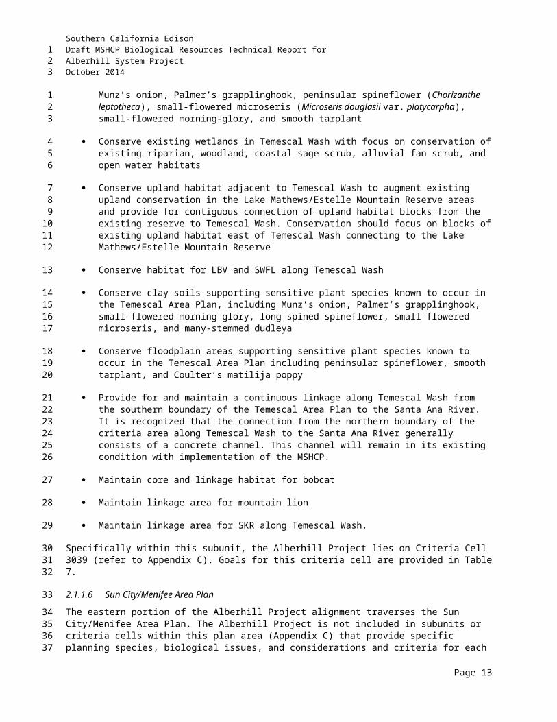
Southern California EdisonDraft MSHCP Biological Resources Technical Report forAlberhill System ProjectOctober 2014
Table 11Survey Locations, Personnel, Dates, and Purpose
Surveyor(s) Date(s) Purpose
2011TS, DC, TS(B), MM
6–8, 11–13, 15, 18–22, 25–26 Apr; 24, 26, 27, 31, 2, 3, 6, 7 Jun
Focused Rare Plant Surveys for the Alberhill Substation and 500/115-kV Study Areas
DW 18, 29 Apr; 9, 23 May; 13, 22 Jun; 1, 15, 26 Jul
Focused LBV and SWFL Surveys for the Alberhill Substation and 500/115-kV Study Areas
TS(B), DW 22, 25, 26, 27, 28 Apr; 31 May BUOW Habitat Assessment for the Alberhill Substation and 500/115-kV Study Areas
TS(B), DW 2, 3, 6, 7 Jun Focused BUOW Burrow Surveys for the Alberhill Substation and 500/115-kV Study Areas
TS(B), DW 8, 9, 17, 20, 21 Jun Focused BUOW Surveys for the Alberhill Substation and 500/115-kV Study Areas
TS(B), BC, MM 6, 13, 16 Jun Reptile Cover Board Placement for the Alberhill 500-kV
Study Area
BC, RM 13, 14, 15, 25, 26 Jul Jurisdictional Delineation for the Alberhill Substation and 500/115-kV Study Areas
SM 16, 17 JulLos Angeles Pocket Mouse and SKR Focused Habitat Assessment for the Alberhill Substation and 500/115-kV Study Areas
SM, DG, DML, PB 14, 15, 28 Jul; 6 Aug Los Angeles Pocket Mouse and SKR Trapping for the
Alberhill Substation and 500/115-kV Study AreasDW, TM 29, 30 Aug Nesting Bird Assessment for the Alberhill Substation Site
TM, CA 6, 8, 9, 12–14, 16 Sep Weed Abatement Monitoring for the Alberhill Substation Site
SR 12 Sep Bat Emergence Survey for the Alberhill Substation Site
MM, BA 23 Nov Alberhill System Project Due Diligence Winter Roosting Bat Clearance Survey
TJ, CA, MM 18 October – 29 November Alberhill System Project, Oak Impact Assessment
2012
CP 16 Feb Fairy Shrimp Habitat Assessment for the Alberhill 115-kV Study Areas
MM, TS(B), TM, CA, ML
5, 6, 12–14, 18–20, 23–26 Apr; 22–25, 29–31 May; 1, 4 Jun
Focused Rare Plant Surveys for the Alberhill Substation and 500/115-kV Study Areas
DW, MM 5–6, 9–10 Apr; 10–11 May; 6–8, 27–29 Jun
BUOW Habitat Assessment, Focused Burrow Surveys, and Focused BUOW Surveys for the Alberhill Substation and 500/115-kV Study Area
DW 12, 27 Apr; 14, 25 May; 5, 22 Jun; 2, 9, 23 Jul
Focused LBV and SWFL Surveys for the Alberhill Substation and 500/115-kV Study Areas
SM, DG 22–27 May SKR Trapping for the Alberhill Substation and 500/115-kV Study Area
Page 6
123
Southern California EdisonDraft MSHCP Biological Resources Technical Report forAlberhill System ProjectOctober 2014
Table 11Survey Locations, Personnel, Dates, and Purpose
Surveyor(s) Date(s) Purpose
2013MM, TS, TS(A)
27–29 March; 1–2, 4–5, 8, 10–12, 15–16 April 20–24, 28–31 May
Focused Rare Plant Surveys for the Alberhill Substation and 500/115-kV Study Areas
TS(B)25, 26, 29 Mar; 3, 4, 9, 10, 12 Apr; 14–16, 21 May; 10, 16-19, 23, 24 Jun
BUOW Habitat Assessment, Focused Burrow Surveys, and Focused BUOW Surveys for the Alberhill Substation and 500/115-kV Study Area
DW, JB, NK 12, 16, 23 Apr; 3, 15 May; 3, 24 Jun; 5, 16 Jul
Focused LBV and SWFL Surveys for the Alberhill Substation and 500/115-kV Study Areas
JZ, LC, LW 16 Apr; 17 Jun; Aug 7; 16 Oct Jurisdictional Delineation for the Alberhill Substation and 500/115-kV Study Areas
2014MM, TS, TS(A)
8–11, 14–18, 21–23 April; 19-23, 27–30 May; 2 June
Focused Rare Plant Surveys for the Alberhill Substation and 500/115-kV Study Areas
TS(B)7, 9–11, 14–15 April; 5, 7, 13-16 May; 18–20, 23–25 June; 12–13, 19, 25 August
BUOW Habitat Assessment, Focused Burrow Surveys, and Focused BUOW Surveys for the Alberhill Substation and 500/115-kV Study Area
JB 11, 21 April; 2, 15 May; 3, 23 June; 2, 15 July
Focused LBV and SWFL Surveys for the Alberhill Substation and 500/115-kV Study Areas
AF Andrew Forde, E. Read and Associates Biologist
AS Andy Sanders, UCR Herbarium BiologistBA Brent Adair, AECOM ScientistBC Bryan Chevillet, AECOM BiologistCA Chris Allen, AECOM BiologistCMG Chet McGaugh, AMEC BiologistCP Chris Powers, AECOM BiologistCR Carl Rykaczewski, AECOM Environmental
ScientistDC Dave Charlton, AECOM BiologistDF David Faulkner, Forensic Entomology Services
BiologistDG Dan Grout, SJM BiologistDML Dana McLaughlin, SJM BiologistDW Doug Willick, AECOM BiologistER Edith Read, E. Read and Associates BiologistJB J. Berkley, Kidd Biological, Inc. BiologistJG John Green, AMEC BiologistJN Julie Niceswanger, AECOM Biologist JW Jonas Winbolt, AECOM Biologist
JZ Joshua Zinn, AECOM Ecologist and Regulatory Specialist
KK Katie Kurtz, AECOM BiologistLC Lanika Cervantes, AECOM Wetland SpecialistLW Lance Woolly, AECOM BotanistML Mike Landers, AECOM BiologistMM Matthew Mallé, AECOM BiologistNK N. Kidd, Kidd Biological, Inc. BiologistNS Nicole Shorey, AMEC BiologistPB Phil Brykski, SJM BiologistPDP Patrick Del Pizzo, AECOM BiologistRM Robin Murray, AECOM BiologistRP Rachael Poston, AECOM BiologistSC Scott Cameron, E. Read and Associates BiologistSM Stephen Montgomery, SJM BiologistSR Stephanie Remington, BiologistTJ Thomas Juhasz AECOM BiologistTM Tsegaye Mengistu, AECOM BiologistTS Teresa Salvato, UCR Herbarium BiologistTS(A) Thomas Sullivan, AECOM Biologist TS(B) Tim Searl, Searl Biological Services
Page 7
123
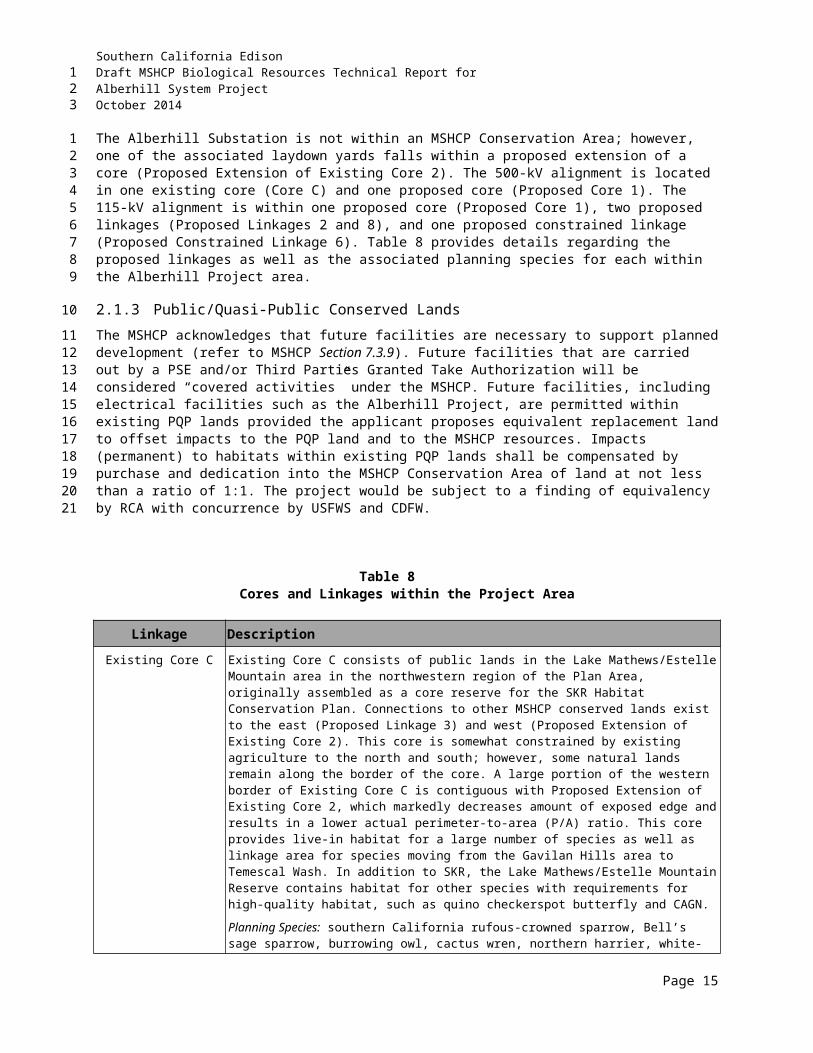
Southern California EdisonDraft MSHCP Biological Resources Technical Report forAlberhill System ProjectOctober 2014
3.2.1 Sensitive Plant Species Survey Methods
Botanical surveys of the proposed substation, transmission line, and subtransmission line segments were conducted from 2009 through 2014 following Guidelines for Conducting and Reporting Botanical Inventories for Federally Listed, Proposed and Candidate Species (USFWS 2000); Protocols for Surveying and Evaluation Impacts to Special Status Native Plant Populations and Natural Communities (CDFG 2009); and CNPS Botanical Survey Guidelines (CNPS 2001).
Prior to the field surveys, the AECOM biologists met University of California Riverside (UCR) Herbarium staff to study and become familiar with available target sensitive plant voucher specimens.
The Consortium of California Herbaria (online database) was used to locate and map several reference sites prior to field surveys. The reference sites were determined based on proximity to the Project area, number of species recorded at each location, and the date a voucher specimen was collected. The reference sites were visited 1 day prior to initiating both phases of field surveys.
Surveys were conducted in suitable habitats for species with potential to occur within the Alberhill Project area that were identified based on literature and database review and the initial habitat assessments. Appendix D presents a list of special status plant species that have potential to occur within the Alberhill Project area.
Surveys were conducted by systematically walking transects that were spaced so that taxa could be identified between survey transects (approximately 5 meters apart) within suitable habitat in order to maximize the likelihood of locating special status plant species and to ensure thorough coverage of the survey area. The survey was floristic in nature (e.g., every plant taxon that occurred on-site was identified to the taxonomic level necessary to determine rarity and listing status) and conducted at the time of year when most species were both evident and identifiable. Species that could not be identified immediately were brought into the laboratory for further investigation. Scientific and common names of plants followed The Jepson Manual: Higher Plants of California (Hickman 1993) or more recently published taxonomical revisions of genera. A comprehensive list of plant species observed within the survey area is presented in Appendix E.
A Trimble Juno SB utilizing ESRI’s ArcPad, a scaled-down mobile Geographic Information System (GIS) program, was used for data collection. Data layers uploaded onto the GPS included Alberhill Project component location data, survey areas, and historical localities of special status species from previous special status plant surveys. Special status plant species encountered were mapped and added to the Alberhill Project’s GIS database.
The Alberhill Project area is located within the MSHCP NEPSSA and CASSA. Sections 6.1.3 and 6.3.2 of the MSHCP outline specific NEPS and CAPS that are required to be surveyed within these areas (refer to Table 10). In addition to these species, focused surveys were conducted for other sensitive species that are not covered or addressed by the MSHCP.
3.2.1.1 Oak Impact Analysis
Oak trees were visually surveyed and tagged by certified arborist Thomas Juhasz (WE-8262A) in the field over several weeks from 18 October through 29 November 2011. The certified arborist conducting the field assessments carried the following equipment:
Page 8
123
1
23456
78
9101112
13141516
17181920212223242526
2728293031
32333435
36
373839
Southern California EdisonDraft MSHCP Biological Resources Technical Report forAlberhill System ProjectOctober 2014
Aerial maps, which included reference markers of the survey area; Trimble Juno SB units preloaded with Alberhill Project area data layers; Arboricultural field data sheets; Digital camera; and
Stainless steel tree diameter tape.
The trees were numbered and tagged with circular reinforced aluminum tags 1.5 inches in diameter that were generally placed on the north side of the trunk at breast height. Each tree was evaluated for a variety of health, structural, and aesthetic qualities. General data recorded for each individual oak included:
Date, address, site ownership, and previous assessments for each tree; Tree health; Site conditions; Tree defects (noted as applicable); Trunk diameter and location; and
Canopy coverage and extent.
The tree number, location, and canopy of each tree were mapped at a 100-scale (1 inch = 100 feet) on tree location maps.
Three measurements were taken for each oak tree: trunk diameter at breast height (DBH), canopy spread, and height. DBH was measured at approximately 4.5 feet (54 inches) above the natural grade. This measurement is typically utilized for trees with vertical growth forms. Oaks growing in their natural habitat frequently have asymmetrical growth forms, with large lateral branches diverging from the trunk at or near 4.5 feet. For trees that exhibited lateral branching at DBH, measurements were taken for all applicable branches/trunks with the height noted at the point of divergence on the trunk. For multi-trunk specimens, the number of trunks and the DBH of each trunk were recorded. When no physical connection was apparent between the oaks, each trunk was evaluated as an individual tree.
Tree canopies were measured at the point where the crown terminates, known as the dripline. The maximum crown diameter for each tree was mapped with a Trimble Juno unit along the dripline of the tree to ascertain the extent of the core root zone of each oak. This core root zone is essential to the survival of an oak. The protected zone of an oak as specified within Riverside County’s Oak Tree Management Guidelines (2003) extends 5 feet outward from this dripline. Tree height is estimated to 5-foot variance to complete general health assessments. Measured heights will be required for project-specific activities during the construction process (ratios for pruning, etc.).
Health assessments for oaks focused on the structural and biological integrity of each tree. Specific structural issues evaluated for each tree include the following:
Taper/form; Presence of co-dominants, forks; Included bark; Girdling, obstructions; Deadwood/cavities; Wounds/seams; and
Root structure
Page 9
123
12345
6789
101112131415
1617
1819202122232425
26272829303132
3334
35363738394041
Southern California EdisonDraft MSHCP Biological Resources Technical Report forAlberhill System ProjectOctober 2014
Specific biological issues evaluated for each tree include the following:
Foliage color; Presence of epicormic growth; Foliage density; Leaf size; Woundwood development; Vigor class; and
Major pests and diseases
3.2.2 Sensitive Wildlife Species Survey Methods
3.2.2.1 General Wildlife Species Surveys
Reconnaissance-level surveys were conducted to characterize wildlife habitat types and to evaluate the potential for occurrence of special status wildlife species in the Alberhill Project study area (refer to Appendix D for species list). The study area was traversed by foot and vehicle to survey each vegetation community for evidence of wildlife presence. All wildlife and wildlife signs observed within the study area, including tracks, fecal material, nests, and vocalizations, were noted. All sensitive wildlife species encountered were mapped and added to the Alberhill Project’s GIS database.
3.2.2.2 Focused Wildlife Species Surveys
Focused surveys for federally listed riparian birds (LBV and SWFL [Empidonax traillii extimus; SWFL]), listed fairy shrimp species, and BUOW were conducted within suitable habitat of the Alberhill Project area for presence, use, and potential use in compliance with the MSHCP. Details regarding each survey method are presented below, and focused reporting is provided in Appendix F.
3.2.2.2.1 Special Status Riparian Birds
Focused surveys for LBV and SWFL were conducted in 2009 (AMEC 2009a), 2010 (AECOM 2010c), 2011 (AECOM 2011b), 2012 (AECOM 2012b), 2013 (Kidd Biological, Inc. 2013) and 2014 (Kidd Biological, Inc. 2014) in accordance with the currently accepted survey protocols by USFWS permitted AMEC and AECOM ornithologists (refer to Table 11 for dates). Several riparian areas within the Alberhill Project area were identified as having suitable habitat for these species. These habitats generally occur along or near the San Jacinto River and Temescal Wash. Detailed maps of these areas are presented in Appendix F, which provides the focused survey reports that were submitted to USFWS per Recovery Permit guidelines.
The survey protocol for SWFL and LBV followed guidelines provided for these species by USFWS. For projects that may impact potential SWFL habitat, SWFL survey protocol, as revised in 2010, specifies a total of five site visits to areas of potential SWFL habitat. These visits are to be conducted during three consecutive time periods, with successive surveys at any site at least 5 days apart. The three time periods identified for SWFL surveys are as follows: Survey Period One: 15 through 31 May; Survey Period Two: 1 through 24 June; and Survey Period Three: 25 June through 17 July. A minimum of one survey is to be conducted during Survey Period One, with a minimum of two surveys during Survey Periods Two and Three. Four of the site visits are conducted during the last two survey periods, as this is the best period to verify the summer resident status of SWFL and eliminate the possibility of strictly transient (in southern California) subspecies of willow flycatcher (WIFL).
Page 10
123
1
2345678
9
10
111213141516
17
18192021
22
2324252627282930
31323334353637383940
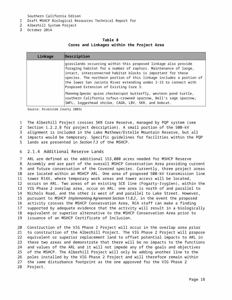
Southern California EdisonDraft MSHCP Biological Resources Technical Report forAlberhill System ProjectOctober 2014
The surveys were conducted by slowly moving through the habitat while listening for the songs and calls of the target species. During the surveys performed for SWFL, taped recordings of their vocalizations were broadcast, a method consistent with the protocol. During the SWFL surveys, recordings of their vocalizations were broadcast every 20 to 30 meters, as required by protocol. All bird species detected during these surveys were recorded in field notes and are presented in the focused reporting provided in Appendix F.
During the performance of the LBV/SWFL survey, attention was also given to other special status riparian birds that had potential to be present within the Alberhill Project’s survey areas. Based on habitat present in at least portions of the survey areas, other special status riparian birds with some potential to occur include yellow warbler and yellow-breasted chat. These species are considered by CDFW to be California Species of Special Concern (SSC).
3.2.2.2.2 Federally Listed Fairy Shrimp
3.2.2.2.2.1 Literature Review and Database Search
Documentation pertaining to the distribution and habitat requirements of fairy shrimp, particularly the Riverside fairy shrimp, the vernal pool fairy shrimp, and the Santa Rosa Plateau fairy shrimp was reviewed with specific reference to the Alberhill Project location. References reviewed and consulted included CDFG, CNDDB (2010 and 2012), the MSHCP, including Section 6.1.2 (Vernal Pools), USGS topographic maps, recent aerial photographs (Google Earth Pro), and the Soil Survey for Riverside County (USDA-NRCS 2008), as well as other species-specific reference materials.
AECOM prepared maps depicting the locations of the proposed Alberhill Project components. The maps also depicted soil polygons within the buffer zones. Soil types represented by the polygons include the Altamont, Auld, Bosanko, Domino, Porterville, Traver, and Willows series, which are designated by the MSHCP as sensitive soils, and the Chino, Fallbrook, Hanford, Honcut, Las Posas, Placentia, Ramona, Tujunga, Vista, Waukena, and Wyman series.
3.2.2.2.2.2 Habitat Assessment and Survey
The proposed substation site was surveyed on 1 April 2010 by A. Forde and E. Read (E. Read and Associates, Inc.) to determine the presence or absence of vernal pools, stock ponds, ephemeral pools, and other features that had potential to support Riverside fairy shrimp, vernal pool fairy shrimp, and/or the Santa Rosa Plateau fairy shrimp. No rain fell during the week prior to the Alberhill Substation assessment.
The proposed transmission alignments and buffer zones were surveyed on 28 and 29 April 2010 by A. Forde and S. Cameron (E. Read and Associates, Inc. 2010a). Rain fell prior to the surveys, over 4 days between 21 April and 27 April, for a total of more than 0.96 inch. After the general assessment, the focus of the surveys shifted to areas falling within soil polygons mapped by AECOM.
All field surveys for determination of habitat suitability focused on consideration of constituent habitat elements (USFWS 1996). These elements included actual pools, swales, adjacent upland features, flow patterns, and rim/basin geomorphology.
As a result of the 2010 survey, AECOM biologist Chris Powers (USFWS Permit No. TE-134337-0) conducted an additional site visit on 16 February 2012 to assess potential fairy shrimp habitat previously
Page 11
123
123456
7891011
12
13
141516171819
2021222324
25
26272829
30313233
343536
3738
Southern California EdisonDraft MSHCP Biological Resources Technical Report forAlberhill System ProjectOctober 2014
identified as Depression 1 and Depression 2 by E. Read & Associates, Inc., following USFWS protocol guidelines for listed vernal pool branchiopods (USFWS 1996).
It should be noted that the identification of potential fairy shrimp habitat was based on an analysis level only and did not include definitive surveys for the presence or absence of fairy shrimp. Such presence/absence surveys require notification to USFWS and consist of intensive aquatic sampling of ponded areas during the rainy season, followed by soil sampling and analysis during the subsequent dry season, or another year of aquatic sampling within 5 years from initiation of the protocol.
3.2.2.2.3 Burrowing Owl
The BUOW survey completed for the Alberhill Project by AECOM was conducted in accordance with survey guidelines provided for the BUOW by the MSHCP. Habitat assessments and focused surveys for BUOW in the MSHCP Plan Area must be conducted in accordance with the Burrowing Owl Survey Instructions for the Western Riverside Multiple Species Habitat Conservation Plan Area (Riverside County 2006) (Survey Instructions). These instructions detail the steps necessary and the methods to be employed to sufficiently assess a specified location for the presence or absence of BUOW. The MSHCP references the California Burrowing Owl Consortium’s “Burrowing Owl Survey Protocol and Mitigation Guidelines” (1993), which was also adopted by CDFW (in their “1995 Staff Report on Burrowing Owl Mitigation”). The MSHCP Survey Instructions, however, provide additional detail to ensure consistency with specific conservation requirements of the MSHCP. On 7 March 2012, CDFW provided a revised “Staff Report on Burrowing Owl Mitigation.” Prior to the beginning of this year’s BUOW survey for the Alberhill Project, AECOM biologists reviewed the new CDFW Staff Report. As during the 2011 BUOW survey for the Alberhill Project, AECOM attempted to incorporate CDFW guidance, where appropriate, into the 2012–2014 survey methods. The 2012–2014 BUOW surveys, for example, followed the revised survey timing and spacing guidelines identified in the revised CDFW Report, while still retaining consistency with the MSHCP BUOW Survey Instructions.
Weather conditions during these surveys were conducive to observing owls outside their burrows and detecting BUOW sign (e.g., no rain, high winds, or dense fog). In conformance with the MSHCP Survey Instructions, no rainfall events occurred during, or within 5 days prior to, the completion of the focused burrow surveys; and all surveys were conducted during the breeding season. The breeding season for BUOW in the MSHCP area, per the Survey Instructions, is defined as 1 March through 31 August.
Data were collected using various resources, such as hand-held GPS units, standardized data forms, photographs, and aerial imagery field maps. Biologists also used binoculars and spotting scopes, especially during the second and third phases of the survey (see further details of the survey components, as detailed below). In addition to noting suitable owl habitat, potential roosting/nesting sites, and the presence or absence of owls and/or their sign, the biologists recorded all species seen and heard, with birds as the primary focus.
The MSHCP Survey Instructions consist of three phases, or “steps” (i.e., the habitat assessment, the focused burrow survey, and the focused owl survey). These are described in the following subsections.
3.2.2.2.3.1 BUOW – Habitat Assessment
Prior to beginning the habitat assessment, the County’s BUOW Survey Area was overlain on maps of the Alberhill Project’s survey area. The result was a series of BUOW survey area polygons. Each polygon was assigned a subarea number for data collection purposes. Maps were then generated and referenced
Page 12
123
12
34567
8
9101112131415161718192021222324
2526272829
303132333435
3637
38
394041

Southern California EdisonDraft MSHCP Biological Resources Technical Report forAlberhill System ProjectOctober 2014
by the BUOW surveyors. These same maps were later revised based on results of the burrow survey to complete the final focused BUOW survey. Each BUOW survey area throughout the entire Alberhill Project was then assessed for potential suitability as BUOW habitat. Some areas were inaccessible by foot (e.g., too steep, private property, etc.); therefore, these areas were assessed from a short distance using binoculars and spotting scopes. For each potential BUOW survey area, general survey information was collected, such as Alberhill Project section, subarea number, observer, date, time, and weather conditions. Additionally, habitat characteristics were recorded for each subarea (including plant community type, vegetative cover and height, topography, degree of human disturbance, perch sites, etc.) and whether burrows or fossorial mammals were observed. Each subarea was then determined suitable or unsuitable based on the habitat characteristics.
Areas with potential BUOW habitat in the Alberhill Project’s survey area included the abandoned horse ranch, vacant lots and fallow fields, grasslands, pastures, fuel modification zones along roadways, areas with low open scrub, and lots that had been graded for future housing development. Potentially suitable habitat for BUOW is defined in the MSHCP as including, but not limited to:
Native and non-native grassland, interstitial grassland within shrub lands, shrub lands with low density shrub cover, golf-courses, drainage ditches, earthen berms, unpaved airfields, pastureland, dairies, fallow fields, and agricultural use areas.
3.2.2.2.3.2 BUOW – Focused Burrow Survey
A focused burrow survey was conducted in all areas of the Alberhill Project area that contained suitable habitat for BUOW that was identified during the habitat assessment. This phase of the survey examined all natural burrows or suitable man-made structures that could be used for burrows by owls. A systematic survey for burrows, including owl sign, was conducted by walking through all suitable habitat in the Alberhill Project area. To obtain a 100 percent visual inspection of the ground surface, transects were walked at 100-foot intervals, with transect widths reduced when necessary to account for irregular terrain or vegetative cover that limited ground surface visibility. The locations of all potentially suitable BUOW burrows, owl sign, and any owls observed were noted and mapped with a GPS unit. Examples of BUOW sign that may be present at burrow entrances or favored perch sites include owl pellets (“castings”), feathers, whitewash, or prey remains. In addition, BUOW are known to often “decorate” their burrow entrances with dried horse or cow manure, bits of fur, and occasionally pieces of trash.
Where no potential burrow sites were found in areas of otherwise potentially suitable BUOW habitat, no further surveys were conducted (this is consistent with the MSHCP Survey Instructions).
3.2.2.2.3.3 BUOW - Focused Burrowing Owl Survey
This last phase of the BUOW survey is the focused search for owls in areas that have been previously identified in Phases 1 and 2 as having appropriate habitat and the presence of suitable burrow sites. A complete owl survey consists of a minimum of four site visits to all appropriate areas. In compliance with survey instructions, the surveys were conducted during periods of the day when BUOW are most likely to be seen at or near burrows or perches. These time periods are identified as from 1 hour before sunrise to 2 hours after sunrise and from 2 hours before sunset to 1 hour after sunset. During this phase of the survey, all suitable BUOW habitat, potential perch sites, and burrow locations were examined by scanning with binoculars and/or spotting scopes and inspecting the areas on foot.
Page 13
123
12345678910
11121314
151617
18
1920212223242526272829
3031
32
3334353637383940
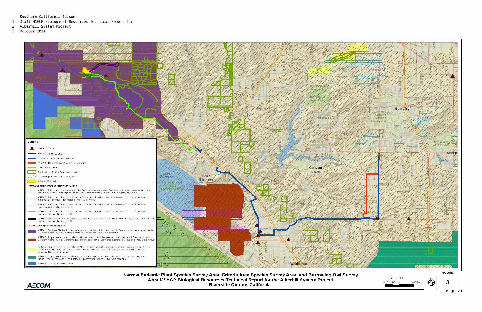
Southern California EdisonDraft MSHCP Biological Resources Technical Report forAlberhill System ProjectOctober 2014
3.2.3 Jurisdictional Waters and Wetlands
3.2.3.1 Presurvey Investigations
In 2010 and 2011, a field reconnaissance survey was completed for the entire Alberhill Project footprint. During that field effort, potential jurisdictional features were identified. In 2013, a jurisdictional delineation of potential waters of the United States and State (including wetlands) was conducted focusing only on the areas identified in 2010 and 2011 as potentially supporting jurisdictional waters. In addition, as the Alberhill Project footprint was modified, these additional areas were also delineated. The survey area for the delineation was predominately confined to the Alberhill Project footprint, but in some areas included a small buffer to adequately identify potential waters. Prior to conducting the field delineation for potential jurisdictional waters of the United States and State (including wetlands), AECOM ecologists reviewed historical land use of the survey area, local and regional climactic data, and areas with topographical configurations and vegetative signatures occurring within the survey area that may suggest the potential for, or presence of, jurisdictional waters of the United States and State at the time of the field survey. Post-delineation data were also compared and confirmed.
3.2.3.2 Delineation of Federal Waters
Jurisdictional waters of the United States include those waters listed in 33 Code of Federal Regulations (CFR) 328.3 (Definitions of Waters of the United States). All waters of the United States were delineated to their jurisdictional limits as defined by 33 CFR 328.4 (Limits of Jurisdiction). It was determined through pre-field surveys (remote analysis) that the survey area had the potential for the presence of, at a minimum, two types of federally defined regulated waters (wetlands and other waters) warranting field assessments as described below.
1. Delineations for waters of the United States in the form of wetlands were based on the three-parameter method. The three-parameter method for identifying and delineating wetlands is outlined in, and was done in accordance with, the latest federal guidance, methodologies, and procedures:
a. Corps of Engineers Wetlands Delineation Manual (1987 Manual) (Environmental Laboratory 1987)
b. Regional Supplement to the Corps of Engineers Wetland Delineation Manual: Arid West Region (Version 2.0) (2008 Supplement) (Environmental Laboratory 2008)
c. Wetland Plants of Specialized Habitats in the Arid West (Lichvar and Dixon 2007)
d. All applicable USACE Regulatory Guidance Letters (RGLs) and Special Public Notices
2. Delineations for waters of the United States in the form of other nonwetland waters based on field indicators to define and identify the jurisdictional lateral extent of the ordinary high water mark (OHWM), as defined by 33 CFR 238.3(e), federal guidance, methodologies, and procedures, including the following:
a. A Field Guide to the Identification of the Ordinary High Water Mark (OHWM) in the Arid West Region of the Western United States: A Delineation Manual (Lichvar and McColley 2008)
b. All applicable USACE RGLs for other waters
This jurisdictional delineation applied the two prescribed field methodologies in the routine delineation of waters of the United States, as described below.
Page 14
123
1
2
34567891011121314
15
161718192021
22232425
2627
2829
30
31
32333435
3637
38
3940

Southern California EdisonDraft MSHCP Biological Resources Technical Report forAlberhill System ProjectOctober 2014
3.2.3.2.1 Methodology One: Delineations for Waters of the United States in the Form of Wetlands
This jurisdictional delineation for federally defined wetlands was conducted in accordance with Part IV (Methods), Section D (Routine Determinations), Subsection 2 (Onsite Inspection Necessary) of the 1987 Manual’s “Routine Determinations for Areas Greater Than Five Acres in Size.” The routine determination method requires an examination for the presence of wetland indicators for hydrophytic vegetation, hydric soils, and wetland hydrology. With the exception of some atypical situations, USACE guidelines for delineating wetlands (e.g., 1987 Manual and 2008 Supplement) require co-occurrence of positive wetland indicators for each parameter (i.e., hydrophytic vegetation, wetland hydrology, and hydric soil).
A positive wetland determination was made for those observation points that exhibited positive wetland field indicators for each of the three parameters.
Although the 2008 Supplement also uses the three-criteria method outlined in the 1987 Manual, it identifies specific sections of the 1987 Manual that are replaced by 2008 Supplement guidance (see Table 1 of the 2008 Supplement) that must be used within applicable land resource regions, as outlined in the 2008 Supplement (the Alberhill Project area is within Region C [Mediterranean California]). Therefore, the 2008 Supplement takes precedence over the 1987 Manual for applications in the Arid West region and states the following in Chapter 3:
(Hydric) indicators are not intended to replace or relieve the requirements contained in the definition of a hydric soil. Therefore, a soil that meets the definition of a hydric soil is hydric whether or not it exhibits indicators.
In Chapter 4:
The Arid West is characterized by extended dry seasons in most years and by extreme temporal and spatial variability in rainfall even in “normal” years. Many wetlands in the region are dry for much of the year and, at those times, may lack hydrology indicators entirely. Therefore, lack of an indicator is not evidence for the absence of wetland hydrology. [Italics in the original.]
In Chapter 5:
In general, wetland determinations on difficult or problematic sites must be based on the best information available to the field inspector, interpreted in light of his or her personal experience, and knowledge of the ecology of wetlands in the region. [Italics in the original.]
In accordance with the 1987 Manual and the 2008 Supplement, the following wetland delineation criteria, primary field indicators, and best professional judgment were used for the survey area. Field data were recorded in the 2008 Supplement Wetland Determination Data Forms – Arid West Region (Version 2.0), which is appropriate for application of both the 1987 Manual and the 2008 Supplement “routine” method.
3.2.3.2.1.1 Hydrophytic Vegetation
Only those plant species that form hydrophytic plant communities within the survey area that are listed within the 2013 National Wetland Plant List (Arid West) (Lichvar 2013) or have the potential to be hydrophytic are addressed herein. The jurisdictional determination (JD) analysis uses the Holland Code Classification System (Holland 1986) as modified by Oberbauer (Oberbauer et al. 2008).
Page 15
123
1
2345678
910
111213141516
171819
20
21222324
25
262728
29303132
33
34353637
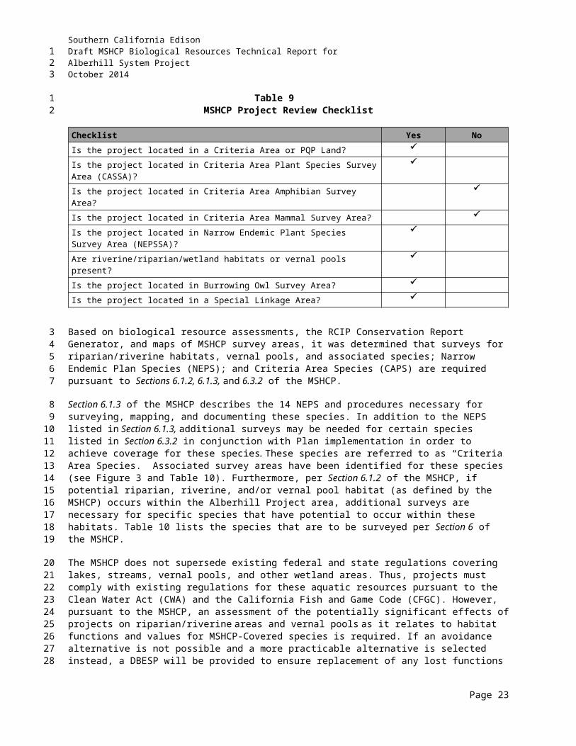
Southern California EdisonDraft MSHCP Biological Resources Technical Report forAlberhill System ProjectOctober 2014
An area was determined to support hydrophytic vegetation if more than 50 percent of the dominant species were listed as Obligate Wetland (OBL), FACW, or Facultative (FAC) species on the 2013 National Wetland Plant List (Arid West) (Lichvar 2013). Vegetation was assessed using the “50/20 Rule” to determine dominant species. By definition, dominant species are the most abundant plant species (when ranked in descending order of abundance and cumulatively totaled) that immediately exceed 50 percent of the total dominance measure (e.g., basal area or areal coverage) for the stratum, plus any additional species that individually make up 20 percent or more of the total dominance measure for the stratum (Tiner 1999). All observation points were also surveyed for the presence of surface wetland hydrological field indicators such as inundation, saturation, water marks, drift lines, drainage patterns, and sediment deposits occurring within a hydrophytic vegetation community.
3.2.3.2.1.2 Hydric Soil
AECOM consulted and field verified the Soil Survey of Western Riverside Area, California (Knecht 1971), and the USDA NRCS Soil Survey Geographic Database (SSURGO) within the study area. Guidance for using soil surveys in the Arid West region is found in the 2008 Supplement (Version 2.0): Chapter 3 (Hydric Soil Indicators), page 34, Use of Existing Soil Data; Soil Surveys, which emphasizes ground truthing to document the soil survey and field conditions.
Soil pits (field sample points for soil inspection and observation) were dug to a depth of 20 inches unless an obstruction (e.g., compaction and rock barriers) was encountered. Soil pits were located in potential wetland areas that exhibited both dominant hydrophytic vegetation and hydrology indicators to determine the presence or absence of hydric soil. Subsurface soil taken from soil pits was analyzed visually for redoximorphic features using Field Indicators of Hydric Soils in the United States: A Guide for Identifying and Delineating Hydric Soils, Version 6.0 (USDA 2006). A Munsell Color System was consulted to document and record soil color at the time of the subsurface investigations.
Only those soil(s) and soil land type(s) within the study area that are listed as hydric by NRCS (NRCS 2013a), have diagnostic hydric properties and/or features, have hydric inclusions, meet the criteria and/or definition of a hydric soil, or have the potential to be hydric by definition are addressed herein.
The National Technical Committee for Hydric Soils (NTCHS) defines a hydric soil as “a soil that formed under conditions of saturation, flooding, or ponding long enough during the growing season to develop anaerobic conditions in the upper part” (NRCS 2013c). The NTCHS definition identifies general soil properties that are associated with wetness. Additionally, specific criteria that identify those estimated soil properties unique to hydric soils have been established by NTCHS (NTCHS 1995). Therefore, hydric soils are either saturated or inundated long enough during the growing season to support the growth and reproduction of hydrophytic vegetation.
Hydric soil definitions and NTCHS-approved hydric soil criteria are used to generate hydric soil lists (Environmental Laboratory 2008). The National Hydric Soils List (NRCS 2013a), primarily used as an off-site assessment tool during presurvey investigations, contains a list of soils that have a probability of being hydric. Hydric soil indicators are primarily morphological indicators used for field identification of hydric soils and/or soils meeting the hydric soil definition. These hydric soil indicators are a subset of the NTCHS Field Indicators of Hydric Soils in the United States: A Guide for Identifying and Delineating Hydric Soils, Version 6.0 (USDA 2006). Hydric soil indicators are not intended to replace or relieve the requirements contained in the definition of a hydric soil. Therefore, a soil that meets the definition and/or criteria of hydric can be considered hydric whether or not it exhibits diagnostic field indicators (e.g., the
Page 16
123
12345678910
11
1213141516
17181920212223
242526
27282930313233
343536373839404142
Southern California EdisonDraft MSHCP Biological Resources Technical Report forAlberhill System ProjectOctober 2014
presence of mottles or gleying [redoximorphic features]) at the point of subsurface investigation. If hydric soil indicators are absent and indicators of understory and/or herbaceous hydrophytic vegetation and wetland hydrology are simultaneously present within an appropriate landscape setting, then, by definition, the presence of a problematic soil would be justified as meeting the criteria to be considered a hydric soil (Environmental Laboratory 2008).
3.2.3.2.1.3 Wetland Hydrology
Wetland hydrology is essentially a result of watershed-driven processes of hydrological inputs from precipitation that provide sufficient groundwater and/or surface flows to support hydrophytic plants. Areas with evident characteristics of wetland hydrology are those where the presence of water has an overriding influence on characteristics of vegetation and soils due to anaerobic and reducing conditions, respectively (Environmental Laboratory 1987). The formation, persistence, size, and function of wetlands are controlled by hydrologic processes within the watershed. Water sources from continual inputs (e.g., immediate proximity to a hydrological feature such as a lake, a river [including small intermittent stream features], the ocean, and/or a wet climate) and the ability to retain or slow down water flow are necessary for the creation and existence of wetlands. Distribution and differences in wetland type, vegetative composition, and soil type are caused primarily by geology, topography, and climate. Hydrologic processes occurring in wetlands are the same processes that occur in uplands and are collectively referred to as the hydrologic cycle. Major components of the hydrologic cycle are precipitation, surface-water retention, surface-water flow, groundwater flow, and evapotranspiration. Wetlands and uplands continually receive or lose water through exchange with the atmosphere, streams, and groundwater. Wetland hydrology is a result of a favorable topographic and geologic setting and an adequate or persistent supply of water (USGS 1996).
USACE has set a quantitative wetland hydrology threshold as it applies to all types of nontidal wetlands (Environmental Laboratory 1987). Specifically, an area has wetland hydrology if it is inundated or saturated to the surface continuously for at least 5 percent of the growing season in most years (50 percent probability of recurrence). Additionally, the hydrology requirements for a wetland can be defined as follows: On average, an area must be inundated or the soils saturated to the surface in more than half the years (1 out of 2, 5 out of 10, or 50 out of 100) for more than 5 percent of the growing season to conclude with reasonable certainty that the area has wetland hydrology. The Alberhill Project area is located in Region 0, where the growing season is year-round. By using this protocol, the hydrology of nontidal jurisdictional wetlands can often be empirically identified using a minimum of 10 years of climactic data (to represent normal conditions).
Specific wetland hydrology field indicators, as outlined by federal guidance documents (e.g., the 1987 Manual and 2008 Supplement), occurring within the survey area were surveyed for wetland hydrology factors such as stratigraphy (and groundwater levels), topography, soil permeability, and plant cover, in concert with available climactic data. All wetland hydrology indicators (both primary and secondary [per the 2008 Supplement]) were recorded when observed where adequate potential for surface water inundation, saturation, and retention occurred in exposed soil (e.g., unlined channels and/or swales or low topographic areas), per the guidance outlined within the 1987 Manual and 2008 Supplement. Areas that have hydrophytic vegetation and hydric soils generally also have wetland hydrology unless the hydrologic regime has changed due to natural events or human activities (National Research Council 1995).
Page 17
123
12345
6
78910111213141516171819202122
23242526272829303132
333435363738394041
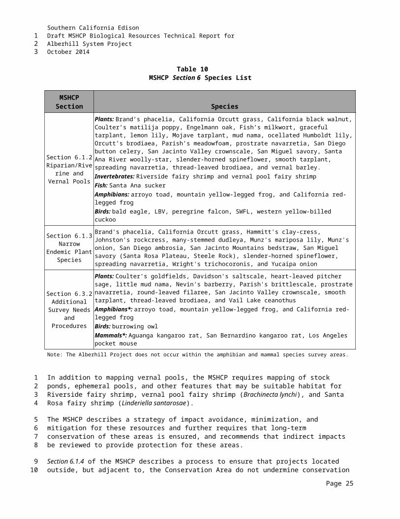
Southern California EdisonDraft MSHCP Biological Resources Technical Report forAlberhill System ProjectOctober 2014
3.2.3.2.2 Methodology Two: Delineations for Potential Jurisdictional Waters of the United States in the Form of Other Waters
OHWM indicators were used to delineate the lateral jurisdictional extent of potential nonwetland waters of the United States. Lateral jurisdictional limits were established for all features occurring within the survey area in conjunction with field verification for a determination of the OHWM, which provides an acceptable estimate for the lateral jurisdictional limits. The OHWM of the features was identified on the basis of one (or more) of the following:
water marks within their respective channel banks established by the fluctuations of water and indicated by physical characteristics such as clear, natural lines impressed on the banks;
scour and shelving, local deposition, distinct and indistinct terraces, and changes in the character of soil;
type, abundance, and relative age of vegetation and/or destruction of terrestrial vegetation and the presence or absence of litter and debris within the features;
intermittent channel configuration, estimated streamflow behavior, and other subtle geomorphic evidence indicative of regular flow levels;
consideration of precipitation patterns and lack of consistent flow; and/or
geomorphic OHWM indicators (e.g., surface relief, cobblebars, benches, crested ripples, particle size distribution, mud cracks, gravel sheets, desert pavement, and dunes).
The lateral limits of jurisdiction specified by a technically defensible method, such as the portion of the feature supporting an OHWM, would indicate a sufficiency to carry the mean annual flow, as determined through the extrapolation of field indicators and rainfall data. Lateral jurisdictional limits were established for the concrete channels and unvegetated channels occurring within the survey area, in conjunction with field verification for a determination of the OHWM, which provides an acceptable estimate for the lateral jurisdictional limits (and other potential waters of the United States existing within this limit).
The limits of waters of the United States in nontidal waters are defined in 33 CFR Part 328.4 (c)(1–3) as follows:
1. In the absence of adjacent wetlands, the jurisdiction extends to the OHWM; or
2. When adjacent wetlands are present, the jurisdiction extends beyond the OHWM to the limit of the adjacent wetlands; or
3. When the water of the United States consists only of wetlands, the jurisdiction extends to the limit of the wetland.
The criteria for frequency and duration of the OHWM have been defined under USACE guidance: A Field Guide to the Identification of the OHWM in the Arid West Region of the Western United States: A Delineation Manual (Lichvar and McColley 2008); therefore, this guidance, identifiable field indicators and characteristics of OHWM, best professional judgment, interpretation of 33 CFR 328.3(e), and appropriate RGLs were applied to determine the potential jurisdictional extent of OHWM within the survey area. OHWM and the limits of jurisdiction are discussed in the preamble to the USACE 13 November 1986
Page 18
123
12
34567
89
1011
1213
1415
16
1718
192021222324
2526
27
2829
3031
323334353637
Southern California EdisonDraft MSHCP Biological Resources Technical Report forAlberhill System ProjectOctober 2014
Final Rule, Regulatory Programs of the Corps of Engineers, Federal Register Volume 51, No. 219, page 41217, which discusses the proper interpretation of 33 CFR Part 328.4(c)(1) as follows:
Section 328.4: Limits of Jurisdiction. Section 328.4(c)(1) defines the lateral limit of jurisdiction in nontidal waters as the OHWM provided that the jurisdiction is not extended by the presence of wetlands. Therefore, it should be concluded that in the absence of wetlands, the upstream limit of [USACE] jurisdiction also stops when the OHWM is no longer perceptible.
In addition, RGL 88-06, issued 27 June 1988 discussed the OHWM as follows:
The OHWM is the physical evidence (shelving, debris lines, etc.) established by normal fluctuations of water level. For rivers and streams, the OHWM is meant to mark the within-channel high flows, not the average annual flood elevation that generally extends beyond the channel.
RGL 05-05, issued 7 December 2005 discusses the field practice and practicability of identifying, determining, and applying the OHWM for nontidal waters under Section 404 of the CWA (and under Sections 9 and 10 of the Rivers and Harbors Act of 1899), and states the following:
Where the physical characteristics are inconclusive, misleading, unreliable, or otherwise not evident, districts may determine OHWM by using other appropriate means that consider the characteristics of the surrounding areas, provided those other means are reliable. Such other reliable methods that may be indicative of the OHWM include, but are not limited to, lake and stream gage data, elevation data, spillway height, flood predictions, historic records of water flow, and statistical evidence.
Many stream channels in arid regions are dry for much of the year and, at times, may lack hydrology indicators entirely or exhibit relic OHWM features from exceptional hydrological events. RGL 05-05 further states the following:
When making OHWM determinations, districts should be careful to look at characteristics associated with ordinary high water events [that] occur on a regular or frequent basis. Evidence resulting from extraordinary events, including major flooding and storm surges, is not indicative of OHWM. For instance, a litter or wrack line resulting from a 200-year flood event would, in most cases, not be considered evidence of an OHWM.
3.2.3.3 Delineation of State Waters
3.2.3.3.1 CDFW Methodologies
Jurisdictional waters of the State include those waters listed in CFGC Section 1600 et seq. Section 1601(a) is based on Title 14 of the California Code of Regulations (CCR) 720, which designates waters of the State regulated by CDFW to be as follows:
“all rivers, streams, lakes, and streambeds in the State of California, including all rivers, streams, and streambeds which may have intermittent flows of water.”
In practice, CDFW usually extends its jurisdictional limit to the top of a stream, the bank of a lake, or the outer edge of the riparian vegetation, whichever is wider. Riparian habitats do not always have identifiable
Page 19
123
12
3456
7
891011
121314
151617181920
212223
2425262728
29
30
313233
3435
3637
Southern California EdisonDraft MSHCP Biological Resources Technical Report forAlberhill System ProjectOctober 2014
hydric soils or clear evidence of wetland hydrology as defined by USACE. Therefore, CDFW wetland boundaries often extend beyond USACE wetland boundaries, which sometimes include only portions of the riparian habitat adjacent to a river, stream, or lake. Jurisdictional boundaries under CFGC Section 1600 et seq. (CDFW’s Lake and Streambed Alteration Program) may encompass an area that is greater than that under the jurisdiction of USACE. Lateral jurisdictional extent for waters of the State were mapped either to the head of the bank or the edge of the riparian canopy (whichever was wider), as applicable.
In conjunction with adopting a wetlands policy on 9 March 1987, the California Fish and Game Commission assigned CDFW the task of recommending a wetlands definition. CDFW determined the USFWS wetland definition and classification system, which is based on Classification of Wetland and Deepwater Habitats of the United States (Cowardin et al. 1979) to be the most biologically valid. Therefore, CDFW requires the presence of only one parameter (e.g., wetland hydrology, hydric soils, or hydrophytic vegetation) for an area to qualify as a jurisdictional water of the State in the form of a wetland. The Cowardin method (Cowardin et al. 1979) requires care to avoid falsely positive conclusions (e.g., concluding that an area with no transitional relation to the aquatic system is a wetland based on presence of vegetation equally apt to be found in wetland or nonwetland circumstances).
3.2.3.3.2 RWQCB Methodologies
For jurisdictional water features occurring within the survey area, RWQCB jurisdiction was mapped identically as noted above for CDFW or USACE jurisdiction. For waters of the United States, RWQCB follows USACE’s guidances to determine the jurisdictional limits and therefore is consistent with the USACE jurisdiction. In addition, RWQCB jurisdiction was delineated based on the presence of aquatic features that simultaneously meet the definition for waters of the State (California Water Code Section 13050[e]) and present “beneficial use” as outlined in the Water Quality Control Plan for the Sana Ana River Basin (RWQCB 2008). Therefore, if it was determined that any type of aquatic and/or aquatic-related features occurring within the survey area would present “beneficial use,” the aquatic feature would be delineated (this would include swale features) and considered to be jurisdictional. As such, and for the purposes of this BTR, all delineated aquatic features occurring within the survey area are considered under RWQCB jurisdiction.
Page 20
123
1234567
8910111213141516
17
1819202122232425262728

Southern California EdisonDraft MSHCP Biological Resources Technical Report forAlberhill System ProjectOctober 2014
4.0 EXISTING CONDITIONSThis section provides the existing conditions of the study area, including the climate, topography, hydrological resources, soil types, and vegetation communities.
4.1 CLIMATEThe study area is located within a Mediterranean climate region consisting of warm, dry summers and mild, wet winters. In summer, temperatures often reach 100 degrees Fahrenheit (º F); and winter temperatures fall into the 30s, with an occasional freeze. Average annual temperature ranges are fairly moderate for the area, ranging from 49.3º F to 79.5º F.
The Elsinore, California Station (No. 042805) is the closest weather station to the Alberhill Project site with reliable monthly rainfall totals for the duration of the Alberhill Project (i.e., no missing days during this period). Rain season (September through May) precipitation data for the duration of biological studies are provided in Table 12. Average total precipitation for the area is approximately 12.06 inches per year (Western Regional Climate Center 2013). As indicated in Table 12, the 2009/2010 and 2010/2011 rain seasons experience the greatest total precipitation levels during the survey period (Western Regional Climate Center 2013).
Table 12Monthly Precipitation (Inches)
Rain Season Sept Oct Nov Dec Jan Feb Mar April May Total2007/2008 0.04 0.00 0.00 0.00 0.52 0.00 0.00 0.00 0.88 1.442008/2009 0.00 0.00 0.34 4.05 0.18 3.97 0.13 0.05 0.00 8.722009/2010 0.00 0.22 0.07 3.76 8.88 1.81 0.44 1.23 0.13 16.542010/2011 0.00 1.61 1.06 11.67 0.70 3.08 0.03 0.00 0.00 18.152011/2012 0.03 0.44 1.37 0.74 0.55 0.67 1.51 1.18 0.00 6.492012/2013 0.24 0.21 0.12 1.84 0.60 0.63 0.39 0.00 0.14 4.172013/2014 0.01 0.28 0.53 0.43 0.15 0.83 1.61 0.50 0.00 4.34
4.2 TOPOGRAPHYThe 500-kV study area and northern portion of the substation site lie within the Estelle Mountains that run alongside the Temescal Wash. Elevations in this area range from 1,200 to more than 2,200 feet above mean sea level (amsl). The southern portion of the substation site is located in the Temescal Wash, which is relatively flat and northwest-trending. The proposed 115-kV lines traverse portions of the Temescal Wash and developed portions of Lake Elsinore and Sedco Hills, running southeast. The 115-kV alignment then moves east across a series of low, gently rolling hills and/or rocky areas in the Sedco Hills for approximately 1.75 miles, traversing elevations from 1,600 to 2,100 feet amsl before dropping into Bundy Canyon at an elevation of approximately 1,700 feet amsl. At the eastern end of the 115-kV study area, the lines run north through gently sloping developed portions of Menifee and Sun City before ending in the relatively flat Perris Valley.
4.3 HYDROLOGYWestern Riverside County is dominated by ephemeral washes that flow south and west out of the hills toward Lake Elsinore. The Alberhill Project area traverses multiple drainages within the San Jacinto River
Page 1
123
1
23
4
5678
9101112131415
16
17181920212223242526
27
2829
Southern California EdisonDraft MSHCP Biological Resources Technical Report forAlberhill System ProjectOctober 2014
Valley, Santa Ana River, and Upper Santa Margarita River watersheds. Within the vicinity of the Alberhill Project, releases from the Railroad Canyon Reservoir flow to the San Jacinto River, which flows into Lake Elsinore. This in turn flows into the Temescal Wash during the periods of high lake levels (CPUC 2009). Although a potential hydrologic connection exists between Lake Elsinore and the Santa Ana River during extreme flooding events, these are usually considered distinct watersheds (RWQCB-R8 1994, 1995; SAWPA 2005; Tetra Tech/WRIME 2007).
The Alberhill Project overlays several watershed units as defined by the RWQCB-R8 and RWQCB-R9; these are shown in Table 13 along with their unit codes (RWQCB-R8 1994, 1995; RWQCB-R9 1994):
Table 13Alberhill Project Watershed Units
Project Area Hydrologic Unit Hydrologic AreaHydrologic Subarea(s)
Substation and 500-kV Alignment
Santa Ana River Hydrologic Unit (801.0)
Lake Mathews Hydrologic Area (801.30)
Lee Lake HydrologicSubareas (801.34)
115-kV Alignment San Jacinto River
Valley Hydrologic Unit (802.0)
Perris Hydrologic Area (802.10)
Elsinore Valley Hydrologic Area (802.30)
Menifee Hydrologic Subarea (802.12)
Elsinore and Railroad Canyon Hydrologic Subareas(802.31, 802.32)
115-kV Alignment San Margarita River
Hydrologic Unit (902.0)
Murrieta Hydrologic Area (902.30)
Wildomar Hydrologic Subarea (902.31)
Drainage basins are defined as the drainage area that flows directly into a homogeneous reach of a stream; Lichvar et al. (2003) and Smith (2003) mapped and evaluated, respectively, the drainage basins for the San Jacinto River Valley watershed (inclusive of Lake Elsinore). Numerous drainages will be spanned, many of which are small and normally dry.
The majority of waterways in the Alberhill Project area are minor ephemeral drainages containing water for short periods of time during large storm events. Larger waterways, including the San Jacinto River and the Temescal Wash, may be identified as seasonal waterways, containing water for longer periods on a seasonal basis, but not perennially.
4.4 SOILSSoils in the Alberhill Project area are primarily composed of Garretson, Honcut, Temescal, Hanford, Las Posas, Pachappa, and Yokohl, associations. These soils are characterized as very steep, well-drained soils.
The soils within the Alberhill Project area do not generally have a high clay component; however, “lenses” of clay soils occur in the Alberhill Project area. Clay lenses within the Alberhill Project area may also support federally listed threatened or endangered species including Munz's onion, thread-leaved brodiaea (Brodiaea filifolia), and San Diego button celery (Eryngium aristulatum var. parishii). Other sensitive plant species occurring on clay soils include Orcutt's brodiaea (Brodiaea orcuttii), long-spined spineflower, small-flowered morning-glory, many-stemmed dudleya, Palmer's grapplinghook, graceful tarplant (Holocarpha virgata ssp. elongata), and small-flowered microseris (Riverside County 2003c).
Page 2
123
123456
78
9101112
13141516
17
181920
21222324252627
Southern California EdisonDraft MSHCP Biological Resources Technical Report forAlberhill System ProjectOctober 2014
The MSHCP has identified that sensitive plant species are associated with particular soil types. Some of these soil types are required for Narrow/Endemic and Criteria Area plants species growth and survival and are considered a “sensitive” soil according to the MSHCP. These sensitive soil types include Altamont clay, Altamont cobbly clay, Auld clay, Auld cobbly clay, Bosanko clay, Clay Pits, Domino silt loam, Porterville clay, Traver fine sandy loam, Traver loamy fine sand, and Willows silty clay (Riverside County 2003c).
Several sensitive soil associations are mapped within the proposed 115-kV study area. Sensitive soils associations in the Alberhill Project area include Altamont, Clay Pit, Porterville, Traver, and Willows.
Soil series that occur within the study area are summarized in Appendix H.
4.5 FLORA AND VEGETATION COMMUNITIESAppendix E lists all floral species observed within the entire Alberhill Project area during the 6 years of field surveys (2009 through 2014). The vegetation communities within the study area are primarily grasslands, RSS, and developed disturbed land (ruderal habitat). Previous and current agriculture, grazing, fire suppression, and invasion of nonnative plant species have contributed to the disturbed condition of many vegetation communities within the study area.
Vegetation communities were mapped in general accordance with the nomenclature and definitions in the MSHCP (Riverside County 2003c), based on the vegetation communities presented in the Preliminary Descriptions of Terrestrial Natural Communities of California (Holland 1986). Vegetation communities were also compared to the MSHCP’s GIS vegetation community layers to the extent that a comparison could be made, as they are considerably broader than the detailed mapping conducted for this Alberhill Project. The MSHCP layers did not differ from mapping conducted for this Alberhill Project.
Vegetation communities identified within the study area are illustrated in Appendix A, and example photographs of observed vegetation communities are presented in Appendix I. Table 14 presents the acreage of each vegetation community present within the study area and a description of each community is provided below.
4.5.1 Residential/Urban/Exotic
This includes homes, businesses, parks, cemeteries, and similar developed lands, including their associated landscaping plantings. It may also include roads and lands that have been highly disturbed by past or current human activity. Some overlap with Field/Croplands (described below), where long-fallow agricultural lands become indistinguishable from lands disturbed by some other past activity.
This community is the dominant habitat type within the study area (2,705.09 acres).
4.5.2 Grove/Orchard
As the name suggests, this category refers to areas planted in orchard trees. Only one area along the 115-kV alignment was mapped with this designation (approximately 6.05 acres).
Page 3
123
123456
78
9
10
1112131415
161718192021
22232425
26
27282930
31
32
3334
Southern California EdisonDraft MSHCP Biological Resources Technical Report forAlberhill System ProjectOctober 2014
Table 14Existing Vegetation Communities Present within the Study Area
Vegetation Community Code AcresUpland CommunitiesResidential/Urban/Exotic RUE 2,705.09Grove/Orchard G/O 6.05Field/Croplands AGFC 33.16Nonnative Grassland NNG 502.70Riversidian Sage Scrub RSS 766.12Disturbed Riversidian Sage Scrub DRSS 87.81Chamise Chaparral CC 43.02Mixed Chaparral MC 174.54Coast Live Oak Woodland Upland CLOWU 3.37
Riparian/RiverineCismontane Alkali Marsh CAM 49.44Valley Freshwater Marsh VFM 58.12Open Water OW 10.24Mulefat Scrub MS 11.32Riversidian Alluvial Fan Sage Scrub RAFS 30.80Southern Cottonwood/Willow Riparian Forest CWR 65.29Southern Sycamore Riparian Forest SSR 8.67Southern Willow Scrub SWS 120.55Tamarisk Scrub TS 15.26Coast Live Oak Woodland Riparian CLOWR 18.98
TOTAL ACRES 4,710.53
4.5.3 Field/Croplands
Fields and croplands are either planted in crops and highly disturbed by disking and cultivating or are fallow with ruderal weedy plants. Active crops included production of wheat and alfalfa. Approximately 33.16 acres of Field/Cropland occurs within the study area.
4.5.4 Nonnative Grassland
Nonnative grassland is composed of introduced annual grass species with variable presence of other nonnative and native herbaceous species. Grasslands within the study area vary in quality and often intergrade into other communities. Some are annually disked, while others are relatively undisturbed and intermixed with native annuals. Nonnative grasses found within the study area included slender oat (Avena barbata), wild oat (Avena fatua), red brome (Bromus madritensis ssp. rubens), soft chess (Bromus hordeaceus), ripgut grass (Bromus diandrus), foxtail barley (Hordeum murinum), and English ryegrass (Lolium perenne). Herbaceous annual forbs present included nonnatives such as red-stemmed filaree (Erodium cicutarium), long-beaked filaree (E. botrys), mustards (Brassica spp.), short-pod mustard (Hirschfeldia incana), and common catchfly (Silene gallica); and disturbance-tolerant native species such as doveweed (Eremocarpus setigerus), vinegar weed (Trichostemma lanceolatum), and tarweeds (Hemizonia spp).
Page 4
123
1
234
5
678910111213141516
Southern California EdisonDraft MSHCP Biological Resources Technical Report forAlberhill System ProjectOctober 2014
Nonnative grassland is the third dominant community within the study area, comprising more than 502.70 acres (disturbed and undisturbed).
4.5.5 Riversidian Sage Scrub
Riversidian sage scrub (RSS) is dominated by low-stature shrubs. Characteristic species along the alignment included California sagebrush (Artemisia californica), California buckwheat (Eriogonum fasciculatum), and black sage (Salvia mellifera).
A disturbed qualifier was placed on coastal sage scrub (or any other native habitat) based on mechanical disturbance (e.g., brushing or clearing, off-road vehicle activity). The community was mapped as disturbed Riversidian sage scrub (DRSS) only when evidence was present of disturbance such as soil compaction, firebreak clearing, repeated burns, or other activities that have left a sparse, scattered cover of shrubs or introduced a cover of nonnative species that have become established as part of the community.
RSS is the second dominant species within the study area, comprising approximately 853.93 acres (disturbed and undisturbed).
Under California regulations and policies, Riversidian upland sage scrub is considered a sensitive habitat. RSS is listed in the CNDDB with a global ranking of G3 (21 to 80 Element Occurrences [EOs] or 3,000 to 10,000 individuals or 10,000 to 50,000 acres) and a State Ranking of S3.1 (very threatened). Several sensitive wildlife species are dependent upon coastal sage scrub including CAGN, coastal cactus wren, southern California rufous-crowned sparrow, coast horned lizard (Phrynosoma blainvillei), and orange-throated whiptail (Aspidoscelis hyperythra), as well as many sensitive plant species.
It should be noted that RSS is monitored by the MSHCP Rough Step requirements set forth in Section 6.7 of the MSHCP, for habitat losses and gains associated with public and private development projects.
4.5.6 Chamise Chaparral
The chamise chaparral plant community vegetation structure is open to dense and between 1 to 4 meters in height, with little litter and few understory species in mature stands. Recent studies describe this association as having greater than 60 percent cover of chamise (Adenostoma fasciculatum). Where another species occurs at greater than 30 percent cover but chamise remains the dominant cover, the stands have been described as a mixed series (e.g., chamise-bigberry manzanita, chamise-black sage, chamise-cupleaf ceanothus, chamise-Eastwood’s manzanita, chamise-hoaryleaf ceanothus, chamise-mission manzanita-woollyleaf ceanothus series, chamise-wedgeleaf ceanothus, and chamise-white sage).
Approximately 43.02 acres of this community occur within the study area.
4.5.7 Mixed Chaparral
In the western portion of the Western Riverside County Multiple Species Habitat Conservation Plan area (e.g., the Santa Ana Mountains, Agua Tibia Mountains) undifferentiated chaparral is dominated by chamise in drier habitats and by a more diverse mixture of species in more mesic areas (analogous to southern mixed chaparral) (Holland 1986). Species composition ranges from that described for chamise chaparral (see above) to more diverse shrub associations supporting hoary leaved ceanothus (Ceanothus crassifolius), birch-leaf mountain-mahogany (Cercocarpus betuloides), toyon (Heteromeles arbutifolia), sugar bush (Rhus ovata), holly-leaf redberry (Rhamnus ilicifolia), heart-leaved penstemon
Page 5
123
12
3
456
789101112
1314
151617181920
2122
23
2425262728293031
32
33
34353637383940
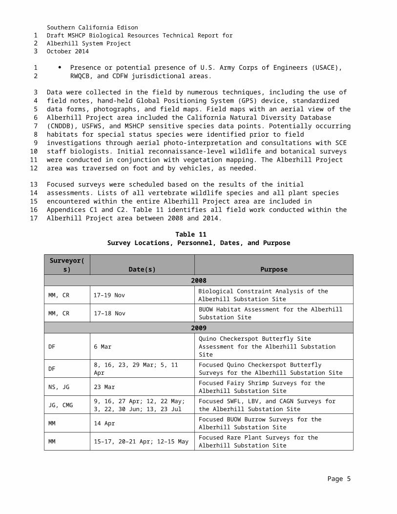
Southern California EdisonDraft MSHCP Biological Resources Technical Report forAlberhill System ProjectOctober 2014
(Keckiella cordifolia), southern honeysuckle (Lonicera subspicata), scrub oak (Quercus berberidifolia), black sage, and other species.
Approximately 174.54 acres of this community occur within the study area.
4.5.8 Coast Live Oak Woodland Upland
The coast live oak (Quercus agrifolia) woodland plant community occurs more frequently on cooler, steeper slopes. The coast live oak woodlands vary from savanna-like, with few to no woody associates, to dense woodlands. Coast live oak trees can reach a canopy height of 30 meters but usually vary from 9 to 22 meters. Canopy coverage varies between continuous to open.
Approximately 3.37 acres of this community occur within the study area.
4.5.9 Cismontane Alkali Marsh
Typical cismontane alkali marsh species include yerba mansa (Anemopsis californica), saltgrass (Distichlis spicata), alkali-heath (Frankenia salina), cattails (Typha spp.), common pickleweed (Salicornia virginica), rushes (Juncus spp.), marsh flea-bane (Pluchea odorata), and sedges (Carex spp.) (Holland 1986).
Approximately 49.44 acres of cismontane alkali marsh habitat occur within the Alberhill Project study area.
Under California regulations and policies, cismontane alkali marsh is considered a sensitive habitat. Cismontane alkali marsh is listed in the CNDDB with a global ranking of G1 (Extremely endangered: fewer than 6 viable occurrences (EOs) or fewer than 1,000 individuals, or less than 2,000 acres of occupied habitat) and a State Ranking of S1.1 (very threatened).
4.5.10 Valley Freshwater Marsh
Valley freshwater marsh typically is dominated by perennial monocots up to 2 meters in height (Riverside County 2003a). This habitat type includes cattails, bulrushes (Scirpus spp.), sedges, spike rushes (Eleocharis spp.), flatsedges (Cyperus spp.), smartweed (Polygonum spp.), watercress (Rorippa spp.), and yerba mansa (Riverside County 2003a). Rooted aquatic plant species with floating stems and leaves also may be present, such as pennywort (Hydrocotyle spp.), water smartweed (Polygonum amphibium), pondweeds (Potamogeton spp.), and water-parsley (Oenanthe sarmentosa) (Riverside County 2003a).
Approximately 58.12 acres of valley freshwater marsh habitat occur within the Alberhill Project study area.
Under California regulations and policies, valley freshwater marsh is considered a sensitive habitat. Valley freshwater marsh is listed in the CNDDB with a global ranking of G3 (Restricted range, rare: about 21 to 100 EOs, or 3,000 to 10,000 individuals, or 10,000 to 50,000 acres of occupied habitat) and a State Ranking of S2.1 (very threatened).
4.5.11 Open Water
Open water habitat typically is unvegetated due to a lack of light penetration; however, open water may contain suspended organisms such as filamentous green algae, phytoplankton (including diatoms), and desmids (Riverside County 2003a). Floating plants such as duckweed (Lemna spp.), water buttercup (Ranunculus aquatilis), and mosquito fern (Azolla filiculoides) also may be present (Riverside County 2003a).
Page 6
123
12
3
4
5678
9
10
11121314
1516
17181920
21
222324252627
28
29303132
33
3435363738
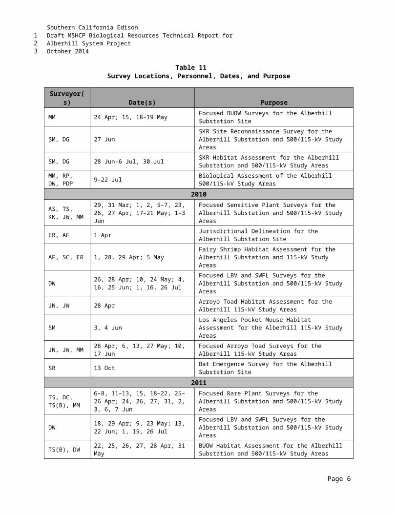
Southern California EdisonDraft MSHCP Biological Resources Technical Report forAlberhill System ProjectOctober 2014
Approximately 10.24 acres of open water habitat occur within the Alberhill Project study area.
4.5.12 Mulefat Scrub
Mulefat scrub is dominated by mulefat (Baccharis salicifolia) but also may include willows (Salix spp.), sedges, and stinging nettle (Urtica dioica) (Holland 1986; Sawyer and Keeler-Wolf 1995).
Approximately 11.32 acres of mulefat scrub habitat occur within the Alberhill Project study area.
4.5.13 Riversidian Alluvial Fan Sage Scrub
The only dominant species that has a strong fidelity to alluvial fan sage scrub is scalebroom (Lepidospartum squamatum), which is generally regarded as an indicator of Riversidian alluvial fan sage scrub (RAFS). Two sensitive annual species are endemic to alluvial fan sage scrub vegetation in the Plan Area: slender-horned spineflower (Dodecahema leptocerus) and Santa Ana River woolly-star (Eriastrum densifolium ssp. sanctorum).
Approximately 30.80 acres of this community occur within the study area.
Under California regulations and policies, RAFS is considered a sensitive habitat. RAFS is listed in the CNDDB with a global ranking of G1 (Extremely endangered: fewer than 6 viable occurrences (EOs) or fewer than 1,000 individuals, or less than 2,000 acres of occupied habitat) and a State Ranking of S1.1 (very threatened).
Pursuant to MSHCP Rough Step requirements set forth in Section 6.7 of the MSHCP, RAFS is monitored annually within the MSHCP area for habitat losses and gains associated with public and private development projects.
4.5.14 Southern Cottonwood/Willow Riparian Forest
Areas mapped as this community along the alignment are dominated by large willows, with Fremont cottonwood (Populus fremontii) and understory species such as Douglas’ mugwort (Artemisia douglasiana) and stinging nettle.
Approximately 65.29 acres of this community occur within the study area.
Under California regulations and policies, southern cottonwood/willow riparian forest is considered a sensitive habitat. Southern cottonwood/willow riparian forest is listed in the CNDDB with a global ranking of G3 (Restricted range, rare: about 21 to 100 EOs, or 3,000 to 10,000 individuals, or 10,000 to 50,000 acres of occupied habitat) and a State Ranking of S3.2 (threatened).
4.5.15 Southern Sycamore Alder Riparian Forest
Sycamore (Platanus racemosa) and alder (Alnus ssp.) often occur along seasonally-flooded banks (below 6,000 feet amsl); cottonwoods and willows also are often present (Riverside County 2003a). Poison oak (Toxicodendron diversilobum), mugwort, elderberry (Sambucus nigra ssp. caerulea), and wild raspberry (Rubus spp.) may be present in the understory (Riverside County 2003a). Sycamore and alder are both able to withstand long periods of flooding. The distribution of white alder (Alnus rhombifolia) is restricted to permanent streams and consistent saturation of the root zone by well-aerated, cool water (Riverside County 2003a).
Approximately 8.67 acres of this community occur within the study area.
Page 7
123
1
2
34
5
6
7891011
12
13141516
171819
20
212223
24
25262728
29
30313233343536
37
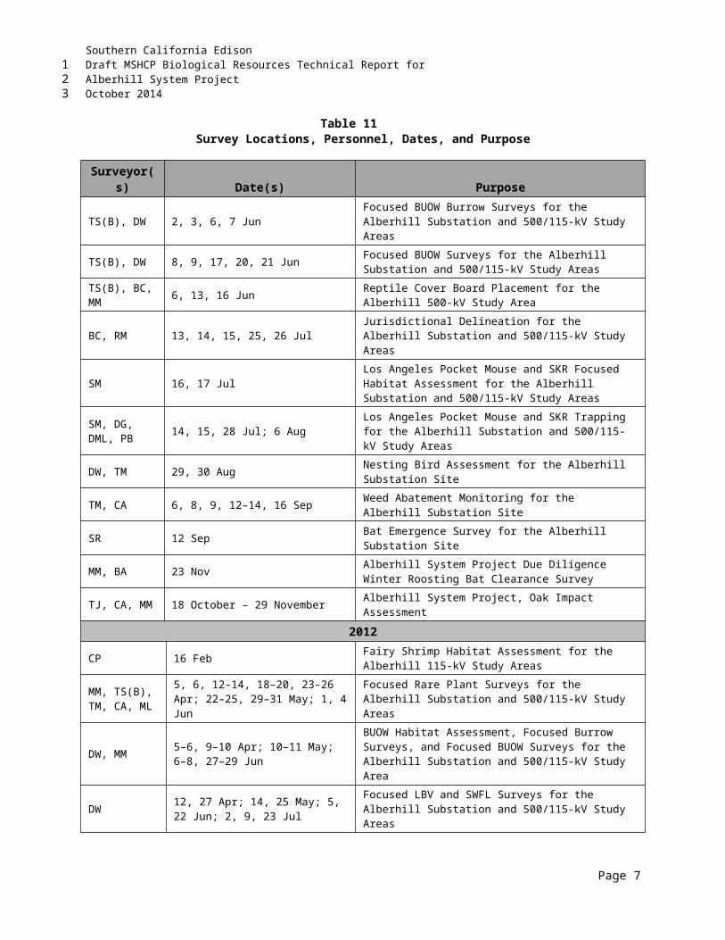
Southern California EdisonDraft MSHCP Biological Resources Technical Report forAlberhill System ProjectOctober 2014
4.5.16 Southern Willow Scrub
Southern willow scrub is dominated by shrub structure rather than a mature tree canopy. The willows in this community are young in age (roughly 1 to 10 years old) and create a middle layer within the riparian drainages that is difficult to walk through and is highly diverse in structure.
Approximately 120.55 acres of this community occur within the study area.
Under California regulations and policies, southern willow scrub is considered a sensitive habitat. Southern willow scrub is listed in the CNDDB with a global ranking of G3 (Restricted range, rare: about 21 to 100 EOs, or 3,000 to 10,000 individuals, or 10,000 to 50,000 acres of occupied habitat) and a State Ranking of S2.1 (very threatened).
4.5.17 Tamarisk Scrub
Tamarisk scrub is dominated by tamarisk (Tamarix spp.) but also may contain willows, salt bushes (Atriplex spp.), catclaw acacia (Acacia greggii), and salt grass (Distichlis spicata).
Approximately 15.26 acres of this community occur within the study area.
4.5.18 Coast Live Oak Woodland Riparian
The coast live oak woodland riparian plant community occurs on the terraces adjacent to the stream channels forming the interior of the woodland canopy.
Approximately 18.98 acres of this community occur within the study area.
Page 8
123
1
234
5
6789
10
1112
13
14
1516
17
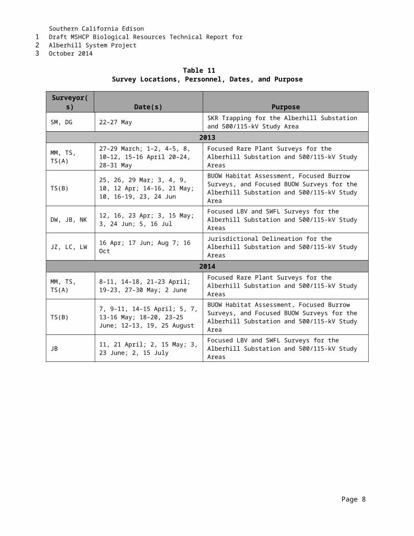
Southern California EdisonDraft MSHCP Biological Resources Technical Report forAlberhill System ProjectOctober 2014
5.0 SURVEY RESULTSThis section presents the result of habitat assessments and focused surveys that were conducted within the study area. Section 7 of this report describes how the survey results relate to MSHCP consistency.
5.1 SENSITIVE VEGETATION COMMUNITIESA variety of vegetation communities have been documented in the Alberhill Project study area (refer to Table 14 above). Vegetation communities that occur in the Alberhill Project study area and are considered sensitive or are subject to requirements such as limited season vegetation clearing include RSS, RAFS, and communities associated with riparian and riverine habitats. Descriptions of these communities are presented in Section 4.5 above.
The survey results indicate that RSS and DRSS occur within the Alberhill Project study area. Under California regulations and policies, Riversidian upland sage scrub is considered a sensitive habitat. Riversidean sage scrub is listed in the CNDDB with a global ranking of G3 (21 to 80 Element Occurrences [EOs] or 3,000 to 10,000 individuals or 10,000 to 50,000 acres) and a State Ranking of S3.1 (very threatened).
The survey results indicate that RAFS is present within the Alberhill Project study area. Under California regulations and policies, RAFS is considered a sensitive habitat. RAFS is listed in the CNDDB with a global ranking of G1 (Extremely endangered: fewer than 6 viable occurrences (EOs) or fewer than 1,000 individuals, or less than 2,000 acres of occupied habitat) and a State Ranking of S1.1 (very threatened).
Sensitive wetland vegetation communities within the Alberhill Project study area are those generally related to the Temescal Wash and San Jacinto River and their tributaries. Under California regulations and policies, cismontane alkali marsh (G1 [extremely endangered], S1.1 [very threatened]); valley freshwater marsh (G3 [restricted range], S2.1 [very threatened]); southern cottonwood/willow riparian forest (G3 [restricted range], S3.2 [threatened]); and southern willow scrub (G3 [restricted range], S2.1 [very threatened]) habitats are considered sensitive habitats. Survey results indicate that wetland and riparian vegetation communities are present within the Alberhill Project study area. A detailed description of the riparian/riverine and vernal pool communities that were identified during surveys, as defined by the MSHCP, is presented below in Section 5.2.
5.2 MSHCP RIPARIAN/RIVERINE AND VERNAL POOL HABITATS5.2.1 Riparian/Riverine
The delineation of jurisdictional waters identified several drainages within the Alberhill Project area that meet the definition of riparian/riverine per Section 6.1.2 of the MSHCP. Appendix A illustrates these drainages within the Alberhill Project area occurring within the Lee Lake, Menifee, Elsinore and Railroad Canyon, and Wildomar watersheds.
MSHCP riparian communities in the Alberhill Project area include alluvial scrub, cismontane alkali marsh, mulefat scrub, southern cottonwood/willow riparian forest, southern willow scrub habitats, and valley freshwater marsh primarily associated with the Temescal Wash and San Jacinto River and their tributaries (Appendix A).
Page 1
123
1
23
4
56789
1011121314
1516171819
202122232425262728
29
30
31323334
35363738
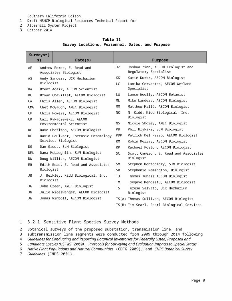
Southern California EdisonDraft MSHCP Biological Resources Technical Report forAlberhill System ProjectOctober 2014
MSHCP riverine areas, for this report, are defined as stream channels with freshwater flow during all or portions of the year. The majority of waterways in the Alberhill Project area are minor ephemeral drainages containing water for short periods of time during large storm events. Larger waterways, including the Temescal Wash and San Jacinto River, may be identified as seasonal waterways, containing water for longer periods of time on a seasonal basis but not perennially.
5.2.2 Vernal Pools and Fairy Shrimp
The focused habitat assessment in 2010 identified two depressions along the Alberhill Project alignment that had the potential to provide suitable habitat per Section 6.1.2 of the MSHCP. The depressions were highly disturbed and occur along Mission Trail and Bundy Canyon Road as sparsely vegetated depressions in existing fallow fields and periodically disked areas. In 2012, a habitat suitability assessment was performed at both depressions.
In late 2012 and early 2013, a large seasonal depression was observed in a vacant field north of the existing Newcomb Substation. A focused habitat assessment of the seasonal depression was conducted during December 2012 and January 2013.
5.2.2.1 Results of the 2010 Focused Habitat Assessment Survey
No vernal pools, ephemeral pools, or other features that could potentially support the fairy shrimp species of concern were observed at the Alberhill Substation site. Most of the south and southwest portions of the site were occupied by a horse ranch, while the remainder of the site has steep slopes dominated by upland scrub vegetation. A small constructed pond is present within a horse track. The presence of bulrush (Scirpus acutus) and mulefat indicate permanently saturated or moist soils, effectively preventing any fairy shrimp species from completing their life cycle(s).
Two potential ephemeral pools were observed within the ROW of the proposed Alberhill 115-kV subtransmission line. These are identified as Depression 1 and Depression 2.
Depression 1 is about 16 square feet in size, located west of Mission Trail near its intersection with Victorian Lane, upslope from a culvert about 100 feet west of the transmission centerline. This depression is located within MSHCP Criteria Area Cell 3954. Although no water was present on 29 April 2010, the soil appeared damp and had mud cracks. On 5 May 2010, the depression was no longer damp. Plant species associated with the depression include cressa (Cressa truxillensis), purple sand spurry (Spergularia rubra), an unidentified herb (possibly Lythrum sp.), and nonnative annual grasses (Polypogon monspeliensis, Avena sp., Lolium sp.). The two codominants, cressa (native forb) and Polypogon monspeliensis (nonnative grass), are both considered FACW species in California, with cressa often associated with low alkaline or saline soils and seasonally ponded conditions. The identity of the less frequently occurring herb could not be confirmed but is suspected to be in the genus Lythrum. Many of the species in this genus are associated with ditches and seasonally wet areas.
Depression 2 is about 200 square feet in size and located south of Bundy Canyon Road at its intersection with Harvest Way East, about 85 feet south of the transmission centerline. This depression is within MSHCP Criteria Area Cell 3970. On 29 April and 5 May 2010, water was present within two tire ruts situated within a larger area of fine sediment that appeared to have settled out from water backed up above a culvert. The tire ruts and patterns on the ground suggested disking in the recent past. Observed flow patterns indicate that, during rain events, sheet flow from Harvest Way East flows into the depression and then into a culvert at Bundy Canyon Road that is not well maintained. No vegetation was found within
Page 2
123
12345
6
7891011
121314
15
161718192021
2223
2425262728293031323334
35363738394041
Southern California EdisonDraft MSHCP Biological Resources Technical Report forAlberhill System ProjectOctober 2014
the tire ruts during the site visit, but these ruts were surrounded by dense nonnative annual grassland dominated by ryegrass (Lolium sp.) and oat (Avena sp.).
No other vernal pools, swales, ephemeral pools, or stock ponds were observed within the buffer zone of the proposed Alberhill 115-kV subtransmission line.
No vernal pools, swales, ephemeral pools, or stock ponds are located within the alignment or buffer zone of the proposed Alberhill 115-kV Alternative subtransmission line.
5.2.2.2 Results of the 2012 Habitat Suitability Survey
As a result of the 2010 focused habitat assessment survey, AECOM surveyed Depression 1 and Depression 2 to characterize the location during the wet season.
Depression 1 – The property was characterized as vacant and undeveloped land. At the time of the most recent habitat assessment, the entire property (including the area previously identified as potential habitat [Depression 1] and the area identified as a potential Subtrans Yard [Alternative B – APN 370-050-020]) was almost completely devoid of vegetation and appeared to have been recently disked. The plant species observed in the vicinity of Depression 1 during the prior assessment (purple sand spurry and nonnative annual grasses) and the sparse number of species observed during the most recent habitat assessment are all nonnative and not associated with vernal pool habitats. The cressa observed during the prior assessment is a native, FACW species; however, alkali weed is found in a variety of habitats (including upland areas, beaches, desert flats, and playas) and is not considered a vernal pool obligate species. Areas of inundation were observed along Mission Trail and the unimproved roadway to the south of the area of Depression 1 and were likely the result of the prior day’s rain event. These areas appeared to be located within gravelly substrate or on or adjacent to previously graded roadways and are not likely to hold standing water for an extended period of time. Soils underlying the property have been identified by USDA-NRCS as Ramona very fine sandy loam with 0 to 2 percent slopes (USDA-NRCS 2009b). The Ramona complex soils are formed in alluvium derived mostly from granitic and related rock sources. Typically, the surface layer is sandy to fine sandy loam about 23 inches thick, underlain by sandy clay loam and fine sandy loam. According to the Hydric Soils List of California (USDA-NRCS 2009a), Ramona very fine sandy loam does not meet the criteria for hydric soils.
Depression 2 – The property was characterized as vacant and undeveloped and consists of moderately sloping north-northeast-facing hillside (toward the Alberhill Project alignment). The majority of the property appeared to have been recently disked. Vegetation at the property was dominated by nonnative annual grasses, with a small number of native annuals present (fiddleneck [Amsinckia intermedia] and Lupinus sp.). Such species are not associated with vernal pool habitats. The two tire ruts identified in prior assessments were observed, but water was not present. No other areas of ponding were observed at the property. Soils underlying the property have been identified by the USDA-NRCS as Wyman loam with 2 to 8 percent slopes and Porterville clay, with 0 to 8 percent slopes (USDA-NRCS online database). The Wyman series consists of deep, well-drained soils that formed in alluvium from andesitic and basaltic rocks. Typically, the surface layer is silt loam about 5 inches thick, underlain by light clay to silty clay loam. Porterville series consists of deep, well-drained soils that formed in fine-textured alluvial material from basic and metabasic igneous rock. Typically, the surface layer is reddish-brown clay about 27 inches thick, underlain by dark brown clay. According to the Hydric Soils List of California (USDA-NRCS 2009a), neither the Porterville nor the Wyman complex meets the criteria for hydric soils.
Page 3
123
12
34
56
7
89
101112131415161718192021222324252627
2829303132333435363738394041
Southern California EdisonDraft MSHCP Biological Resources Technical Report forAlberhill System ProjectOctober 2014
Based on the results of the habitat suitability assessment, fairy shrimp have a low likelihood to occur in the two depressions.
5.2.2.3 Results of a 2012 and 2013 Habitat Assessment of Seasonal Depression North of the Existing Newcomb Substation
As a result of the late 2012 observation of the seasonal depression north of the existing Newcomb Substation, AECOM surveyed the feature to characterize the location during the wet season.
The property where the seasonal depression is located was vacant and undeveloped. At the time of the most recent visit (4 January 2013), the majority of the property appeared to have been recently disked. Vegetation at the property was dominated by nonnative annual grasses, and a population of smooth tarplant was observed within the southwest corner of the property. The perimeter of the seasonal depression was mapped on 18 December 2013 following approximately 0.75 inch of rainfall over the previous 6 days. A second visit to the site occurred 17 days later (4 January 2013) in which the receding, smaller perimeter of the seasonal depression was mapped again. Between the preliminary visit in December and the second visit in January, the area received an additional 0.70 inch of rainfall. No other areas of ponding were observed at the property. Soils underlying the property have been identified by the USDA-NRCS as Madera fine sandy loam, 2 to 5 percent slopes, eroded (USDA-NRCS online database). The Madera series consists of moderately deep to hardpan, well- or moderately well-drained soils that formed in old alluvium derived from granitic rock sources. Madera soils are on hummocky, gently sloping to undulating terraces at elevations of 10 to 250 feet amsl. Meandering drainageways and closed depressions fill with water to form vernal pools in the winter months. According to the Hydric Soils List of California (USDA-NRCS 2009a), the Madera complex meets the criteria for hydric soils.
Based on the results of the focused habitat assessment, fairy shrimp have a moderate likelihood to occur in the seasonal depression.
5.3 FLORAThe study area supports a high diversity of plant species due to the diversity of soils and disturbed and native vegetation communities present within the Alberhill Project vicinity. Appendix E presents a list of plant species identified within the study area during field investigation conducted between 2008 and 2014.
5.3.1 Sensitive Plants
Fourteen sensitive plant species were detected within the study area during botanical field studies that have been conducted to date (refer to Table 11 for dates): small-flowered morning-glory, long-spined spineflower, Parry’s spineflower (Chorizanthe parryi var. parryi), Coulter’s matilija poppy, Palmer’s grapplinghook, paniculate tarplant (Deinandra paniculata), Robinson’s peppergrass (Lepidium virginicum var. robinsonii), small-flowered microseris, smooth tarplant, round-leaved filaree (California macrophylla), Coulter’s goldfields, chaparral sand verbena (Abronia villosa var. aurita), San Diego ambrosia, and San Jacinto Valley crownscale (Atriplex coronata var. notatior).
Portions of the Alberhill Project alignment fall into Areas 1, 3, and 4 of the NEPSSA (see Appendix C). The species required to be surveyed for in Areas 1, 3, and 4 are Munz’s onion, San Diego ambrosia, slender-horned spineflower, many-stemmed dudleya, California Orcutt grass (Orcuttia californica), and Wright’s trichocoronis (Trichocoronis wrightii var. wrightii). Portions of the Alberhill Project alignment fall into Area 1 of the CASSA (see Appendix C). The species required to be surveyed for in Criteria Area 1
Page 4
123
12
34
56
789101112131415161718192021
2223
24
252627
28
29303132333435
3637383940
Southern California EdisonDraft MSHCP Biological Resources Technical Report forAlberhill System ProjectOctober 2014
are tiny mousetail (Myosurus minimus), smooth tarplant, and round-leaved filaree. Focused surveys were conducted for these species.
Table 15 provides the listing status of each species and identifies the map page(s) (from Appendix A) where each occurs within the Alberhill Project study area.
Table 15Sensitive Plants Observed within the Project Study Area
Species Listing StatusAppendix A Map Book and Page
chaparral sand verbena(Abronia villosa var. aurita)
USFWS: NoneState: NoneCNPS: 1B.1 (California endemic)MSHCP: None
Subtransmission: 36
San Diego ambrosia(Ambrosia pumila)
USFWS: Endangered 07/02/02State: NoneCNPS: 1B.1MSHCP: NEPS; Group 3
Subtransmission: 31, 34
San Jacinto Valley crownscale(Atriplex coronata var. notatior)
USFWS: EndangeredState: NoneCNPS: 1B.1MSHCP: CAPS; Group 3
Subtransmission: 31
smooth tarplant(Centromadia pungens ssp. Laevis)
USFWS: NoneState: NoneCNPS: 1B.1 (California endemic)MSHCP: CAPS; Group 3
Subtransmission: 3, 19, 20, 22, 27, 28, 31
Parry’s spineflower (Chorizanthe parryi var. parryi)
USFWS: NoneState: NoneCNPS: 1B.1 (California endemic)MSHCP: Covered Species (Table 9-3); Group 2
Subtransmission: 8, 9, 10, 11500-kV: 4
long-spined spineflower(Chorizanthe polygonoides var. longispina)
USFWS: NoneState: NoneCNPS: 1B.2 MSHCP: Covered Species; Group 2
Subtransmission: 10, 11500-kV: 1Substation: 1
small-flowered morning-glory(Convolvulus simulans)
USFWS: NoneState: NoneCNPS: 4.2 MSHCP: Covered Species; Group 2
Subtransmission: 29
paniculate tarplant(Deinandra paniculata)
USFWS: NoneState: NoneCNPS: 4.2 (California endemic)MSHCP: Not Covered
Subtransmission: 4, 6, 7, 8, 9, 10, 11, 12,13, 17, 18, 23, 24, 31500-kV: 1Substation: 1
round-leaved filaree (California macrophylla)
USFWS: NoneState: NoneCNPS: 2.1MSHCP: CAPS; Group 3
Subtransmission: 29
Page 5
123
12
34
Southern California EdisonDraft MSHCP Biological Resources Technical Report forAlberhill System ProjectOctober 2014
Table 15Sensitive Plants Observed within the Project Study Area
Species Listing StatusAppendix A Map Book and Page
Palmer’s grapplinghook(Harpagonella palmeri)
USFWS: NoneState: NoneCNPS: 4.2 MSHCP: Covered Species; Group 2
Subtransmission: 10, 11, 23500-kV: 1
Coulter’s goldfields (Lasthenia glabrata spp. Coulteri)
USFWS: NoneState: NoneCNPS: 1B.1MSHCP: CAPS; Group 3
Subtransmission: 31
Robinson’s peppergrass (Lepidium virginicum var. robinsonii)
USFWS: NoneState: NoneCNPS: 4.2MSHCP: Not Covered
Subtransmission: 13, 36500-kV: 1, 2, 3, 4, 5, 6Substation: 1
small-flowered microseris (Microseris douglasii ssp. Platycarpha)
USFWS: NoneState: NoneCNPS: 4.2MSHCP: Covered Species (Table 9-3); Group 2
Subtransmission: 10, 11, 29, 31Substation: 1
Coulter’s matilija poppy (Romneya coulteri)
USFWS: NoneState: NoneCNPS: 4.2MSHCP: Covered Species (Table 9-3); Group 1
Subtransmission: 35, 37, 38500-kV: 1, 3
5.3.1.1 Chaparral sand verbena (Abronia villosa var. aurita)
Chaparral sand verbena is an annual herb in the four o’clock family (Nyctaginaceae). Suitable habitat for this species includes chaparral, coastal scrub, and desert dunes that occur at elevations ranging from 75 to 1600 meters amsl. Chaparral sand verbena is threatened by nonnative plants, alteration of fire regimes, road maintenance, flood control activities, vehicles, and development (CNPS 2014. Chaparral sand verbena blooms from January through September (CNPS 2014).
Chaparral sand verbena was identified south of Temescal Canyon Road between Concordia Ranch Road and Bernard Street. This species is not a Covered species under the MSHCP.
5.3.1.2 San Diego ambrosia (Ambrosia pumila)
San Diego ambrosia is an herbaceous perennial that belongs to the sunflower family (Asteraceae). This species occurs at elevations below 415 meters amsl within chaparral, coastal scrub, valley and foothill grassland and vernal pool habitats of Riverside and San Diego counties. It may also be found in disturbed habitats such as fire breaks and roadways. In Riverside County, San Diego ambrosia is associated with open, gently sloped grasslands and is generally associated with alkaline soils (Riverside County 2003a). San Diego ambrosia is monoecious; the staminate and pistillate flowers occur in mixed clusters. Flowers are yellow or translucent and bloom from April through October. This species is known in California from fewer than 20 occurrences and is threatened by development, nonnative plants, road maintenance, and trampling (CNPS 2014).
Page 6
123
1
23456
78
9
101112131415161718
Southern California EdisonDraft MSHCP Biological Resources Technical Report forAlberhill System ProjectOctober 2014
San Diego ambrosia was identified east of Lake Street near Temescal Canyon Road and north and south of Nichols Road near Pierce Street within NEPSSA 1. San Diego ambrosia is listed on the NEPS list of the MSHCP. In accordance with Section 6.1.3 of the MSHCP, in order to achieve coverage for this species under the MSHCP, surveys for San Diego ambrosia are to be conducted as part of the project review process for public and private projects within the NEPSSA where suitable habitat is present (refer to Section 2.2.1 of this report).
5.3.1.3 San Jacinto Valley crownscale (Atriplex coronata var. notatior)
San Jacinto Valley crownscale is an annual herb in the goosefoot family (Chenopodiaceae) that blooms from April through August (CNPS 2014). In Riverside County, San Jacinto Valley crownscale occurs primarily in floodplains (seasonal wetlands) dominated by alkali scrub, alkali playas, vernal pools, and, to a lesser extent, alkali grasslands. San Jacinto Valley crownscale is restricted to highly alkaline, silty-clay soils in association with the Traver-Domino-Willows soil association; the majority (approximately 80 percent) of the populations being associated with the Willows soil series (Riverside County 2003a).
San Jacinto Valley crownscale was identified, outside a designated CASSA identified as an area of concern for the species, north of Baker Street near Pierce Street.
5.3.1.4 Parry’s spineflower (Chorizanthe parryi var. parryi)
Parry’s spineflower is an annual herb in the buckwheat family (Polygonaceae). Parry’s spineflower is known to occur within chaparral, cismontane woodland, coastal scrub, and grassland habitats at elevations ranging from 275 to 1220 meters amsl. Parry’s spineflower blooms from April through June (CNPS 2014).
Multiple populations of Parry’s spineflower were identified north and northeast of the proposed substation and 500-kV study areas; west of Byers Road, south of Ajder Street; north of Bundy Canyon Road, between Debon Street and Waldon Road; and north and south of Bundy Canyon Road near Murrieta Road. As described in Section 2.1.4 of the MSHCP, Parry’s spineflower is one of the 28 Covered species that will be considered to be Adequately Conserved when certain conservation requirements are met as identified in the species-specific conservation objectives for those species.
5.3.1.5 Long-spined spineflower (Chorizanthe polygonoides var. longispina)
Long-spined spineflower is an annual herb in the buckwheat family (Polygonaceae). Potential habitat for long-spined spineflower is considered to be southern needlegrass grassland and openings in coastal sage scrub and chaparral that occur on clay or rocky clay soils of the following series: Altamont, Auld, Bosanko, Claypit, and Porterville (Riverside County 2003a) at elevations ranging from 30 to 1530 meters amsl. Long-spined spineflower blooms from April through July (CNPS 2014).
Several locations of long-spined spineflower were identified north, east, and northeast of the proposed substation and 500-kV study areas; east of Terra Cotta Road near Coal Avenue; south of Beverly Street near Bundy Canyon Road; west of Byers Road, south of Ajder Street; and south of Bundy Canyon Road between Harvest Way and Wright Road. This species is an Adequately Conserved species by the MSHCP.
5.3.1.6 Small-flowered morning-glory (Convolvulus simulans)
Small-flowered morning-glory is an annual herb in the morning-glory family (Convolvulaceae). Potential habitat for small flowered-morning-glory is considered chaparral openings, coastal scrub, and valley and
Page 7
123
123456
7
8910111213
1415
16
17181920
212223242526
27
2829303132
3334353637
38
3940
Southern California EdisonDraft MSHCP Biological Resources Technical Report forAlberhill System ProjectOctober 2014
foothill grasslands that occur in clay and serpentine seeps (CNPS 2014). This species occurs at elevations ranging from 30 to 700 meters. Small-flowered morning-glory blooms from March through July.
Small-flowered morning-glory was observed north and south of Baker Street, west of Bunker Street. This species is an Adequately Conserved species by the MSHCP.
5.3.1.7 Paniculate tarplant (Deinandra paniculata)
Paniculate tarplant is known to occur within coastal scrub, grasslands, and vernal pools at elevations ranging from 25 to 940 meters amsl and blooms from April through November (CNPS 2014). Paniculate tarplant is locally common within the study area. This species is not a Covered species under the MSHCP.
5.3.1.8 Round-leaved filaree (California macrophylla)
Round-leaved filaree is an herbaceous annual in the geranium family (Geraniaceae) that is found throughout California, southern Oregon, and northern Baja California. It typically grows in heavy clay soils within valley and foothill grasslands and cismontane woodland habitats at elevations ranging from 15 to 1,200 meters amsl (CNPS 2014). The showy white flowers of this species bloom from March through May (Hickman 1993; CNPS 2014). Round-leaved filaree is threatened by urbanization, vehicles, grazing, and nonnative plants (CNPS 2014).
Round-leaved filaree was identified south of Baker Street near Bunker Street. It has not been identified within this area during subsequent surveys. Round-leaved filaree is a species on the Additional Survey Needs and Procedures (Section 6.3.2 of the MSHCP) list.
5.3.1.9 Palmer’s grapplinghook (Harpagonella palmeri)
Palmer’s grapplinghook is an annual herb in the borage family (Boraginaceae). Palmer’s grapplinghook is associated with clay and cobbly clay soils in chaparral, coastal sage scrub, valley and foothill grasslands, and scrub oak woodlands below 500 meters amsl (Riverside County 2003a). It blooms from March through May (CNPS 2014).
Palmer’s grapplinghook was identified northeast of the proposed substation and 500-kV study areas; north of East Franklin Street; south of Beverly Street near Bundy Canyon Road; and south of Bundy Canyon Road between Harvest Way and Lynx Road. This species is an Adequately Conserved species by the MSHCP.
5.3.1.10 Smooth tarplant (Hemizonia pungens ssp. laevis)
Smooth tarplant is an annual herb belonging to the sunflower family (Asteraceae) that occurs in alkaline soils of chenopod scrub, playas, riparian woodland, meadows, seeps and valleys, and foothill grassland habitats at elevations less than 480 meters amsl (CNPS 2014). The majority of the populations in western Riverside County are associated with alkali vernal plains (Riverside County 2003a). Smooth tarplant produces large, showy yellow flowers that bloom from April through September.
Smooth tarplant was identified outside a designated CASSA, north of Nichols Road near Coal Road; north of Pasadena Avenue between Riverside Drive and Central Avenue; south of the Pasadena Avenue and 3rd Street intersection; west of Mission Trail between Vine Street and Corydon Road; west of Murrieta Road, south of Newport Avenue; and north of the Newcomb Substation. Smooth tarplant is a species on the Additional Survey Needs and Procedures (Section 6.3.2 of the MSHCP) list.
Page 8
123
12
34
5
6789
10
111213141516
171819
20
21222324
25262728
29
3031323334
3536373839
Southern California EdisonDraft MSHCP Biological Resources Technical Report forAlberhill System ProjectOctober 2014
5.3.1.11 Coulter’s goldfields (Lasthenia glabrata ssp. coulteri)
Coulter’s goldfields is a perennial herb in the sunflower family (Asteraceae) that is known to occur in the counties of Orange, Riverside, Ventura, Santa Barbara, San Diego, and San Luis Obispo, as well as on Santa Rosa Island and in Baja California. Coulter’s goldfields occur in vernal pools, playas, marshes, and swamps at elevations ranging from 1 to 1,220 meters amsl. In Riverside County, Coulter’s goldfields occur primarily in floodplains dominated by alkali scrub, alkali playas, vernal pools, and alkali grasslands associated with the Traver-Domino-Willows soils series (Riverside County 2003a). Coulter’s goldfields produce orange-yellow ray flowers that may be seen from February through June (CNPS 2014; Hickman 1993).
Coulter’s goldfields were identified along Baker Street, east of Pierce Street. Soils within this area are characterized as alkali clay soils belonging to the Altamont cobbly clay, 8 to 35 percent slopes and Willows silty clay, saline alkali soil associations.
Coulter’s goldfields is a species on the Additional Survey Needs and Procedures (Section 6.3.2 of the MSHCP) list.
5.3.1.12 Small-flowered microseris (Microseris douglasii spp. platycarpha)
Small-flowered microseris is an annual herb in the sunflower family (Asteraceae) that blooms from March through May. It is associated with clay and cobbly clay soils in chaparral, coastal sage scrub, and grasslands at elevations below 955 meters amsl. Douglas’ microseris is declining due to urban development and competition from nonnative plants (CNPS 2014).
Small-flowered microseris was identified north of the proposed substation area, south and north of Baker Street between Pierce Street and Bunker Street; south of Beverly Street near Bundy Canyon Road; and south of Bundy Canyon Road, between Harvest Way and Waldon Road. For MSHCP Group 2 species, take coverage is warranted based on regional or landscape-level considerations with the addition of site-specific conservation and management requirements that are clearly identified in the MSHCP for species that are generally well distributed but that have core habitats that require conservation. As described in Section 2.1.4 of the MSHCP, small-flowered microseris is one of the 28 Covered species that will be considered to be Adequately Conserved when certain conservation requirements are met, as identified in the species-specific conservation objectives for those species.
5.3.1.13 Coulter's matilija poppy (Romneya coulteri)
Coulter’s matilija poppy is a rhizomatous herb in the poppy family (Papaveraceae) that blooms from March through July. It occurs in dry washes and canyons below 1,200 meters amsl in open, mildly disturbed sage scrub and chaparral and along rocky drainages. Mature chaparral and sage scrub may limit expansion of this species (Riverside County 2003a). Coulter’s matilija poppy is threatened by urbanization, flood control, road widening, and road maintenance (CNPS 2014).
Several populations of Coulter’s matilija poppy were documented within coastal sage scrub habitats north, east, and northeast of the proposed substation; west of Horsethief Canyon Road, and within the 500-kV study area.
As described in Section 2.1.4 of the MSHCP, Coulter’s matilija poppy is one of the 28 Covered species that will be considered to be Adequately Conserved when certain conservation requirements are met, as identified in the species-specific conservation objectives for those species.
Page 9
123
1
23456789
101112
1314
15
16171819
202122232425262728
29
3031323334
353637
383940
Southern California EdisonDraft MSHCP Biological Resources Technical Report forAlberhill System ProjectOctober 2014
5.3.1.14 Robinson’s peppergrass (Lepidium virginicum var. robinsonii)
Robinson’s peppergrass is an annual herb in the mustard family (Brassicaceae) that blooms from January through July. It is associated with chaparral and coastal sage scrub habitats at elevations below 885 meters amsl (CNPS 2014).
Robinson’s peppergrass is locally common within coastal sage scrub habitats north, east, and northeast of the proposed substation and within the 500-kV study area. This species is not a Covered species under the MSHCP.
5.3.2 Oak Trees
In addition, the County of Riverside requires that any future development in an identified sensitive vegetation area (including oak woodlands) must be evaluated (Riverside County 1993).
Several stands of coast live oak are located within the eastern portion of the Alberhill Project area 115-kV transmission line alignment and 500 kV transmission line study areas (Appendix A). Oakwood lands associated with these areas are generally associated with roadside drainages and in a few instances are planted as ornamental trees. Two coast live oaks likely planted as ornamental trees are located on the proposed Alberhill Substation site.
5.4 FAUNAThe Alberhill Project area supports a low to moderate diversity of wildlife species due to the high level of disturbance and development in the vicinity. Many of the wildlife species observed or detected in the study area (refer to Appendix E) are commonly found in the urban interface or on disturbed habitat.
Characteristic avian species detected include mourning dove (Zenaida macroura), common raven (Corvus corax), American crow (Corvus brachyrhynchos), and horned lark (Eremophila alpestris actia). Mammal species detected during the general biological survey include California ground squirrel (Spermophilus beecheyi), Botta’s pocket gopher (Thomomys bottae), raccoon (Procyon lotor), and bobcat. Appendix E lists all wildlife species detected within the Alberhill Project area.
5.4.1 Sensitive Wildlife
5.4.1.1 Adequately Conserved Species
Seventeen MSHCP Covered and Adequately Conserved sensitive wildlife species were detected within the Alberhill Project study area during wildlife field studies (refer to Table 11) conducted to date. Table 16 provides the listing status of each species and identifies the map page(s) (from Appendix A) where each occurs within the Alberhill Project study area.
Concerning the above Adequately Conserved species, participation in the MSHCP would provide incidental take for these species. Although these species are Adequately Conserved, the intent of the Alberhill Project is to avoid impacts on biological resources that occur within its boundaries where feasible.
5.4.1.2 MSHCP Section 6.1.2 Species
Two species observed within or near the study area that relate to consistency with Section 6.1.2 of the MSHCP include the WIFL and LBV. These species and their presence within the Alberhill Project area are further described below. In addition to these species, Adequately Conserved species identified within
Page 10
123
1
234
567
8
910
1112131415
16
171819
2021222324
25
26
27282930
31323334
35
363738
Southern California EdisonDraft MSHCP Biological Resources Technical Report forAlberhill System ProjectOctober 2014
Table 16MSHCP Adequately Conserved Wildlife Species
Species Listing Status
Appendix AMap Book and
PageHerpswestern spadefoot(Scaphiopus hammondii)
USFWS: NoneState: SSCMSHCP: Covered Species
Subtransmission: 32
Belding’s orange-throated whiptail(Aspidoscelis hyperythrus)
USFWS: NoneState: SSCMSHCP: Covered Species
Subtransmission: 12, 13, 22500-kV: 1, 2, 3, 4, 5, 6Substation: 1
northern red-diamond rattlesnake(Crotalus ruber ruber)
USFWS: NoneState: SSCMSHCP: Covered Species
500-kV: 1, 2, 4 Substation: 1
BirdsCooper’s hawk (Accipiter cooperii)
USFWS: NoneState: WLMSHCP: Covered Species
Subtransmission: 19
tri-colored blackbird(Agelaius tricolor)
USFWS: BCCState: SSCMSHCP: Covered Species
–
southern California rufous-crowned sparrow (Aimophila ruficeps canescens)
USFWS: NoneState: WLMSHCP: Covered Species
Subtransmission: 31, 32, 33, 36500-kV: 3, 5
Bell’s sage sparrow (Artemisiospiza belli belli)
USFWS: BCCState: SSCMSHCP: Covered Species
–
golden eagle(Aquila chrysaetos)
USFWS: BCCState: FPMSHCP: Covered Species
500-kV: 2
northern harrier (Circus cyaneus)
USFWS: NoneState: SSCMSHCP: Covered Species
–
yellow warbler (Dendroica petechia brewsteri)
USFWS: NoneState: NoneMSHCP: Covered Species
Subtransmission: 19, 22, 27, 34, 35, 37500-kV: 1Substation: 1
white-tailed kite(Elanus leucurus)
USFWS: NoneState: FPMSHCP: Covered Species
Substation: 1
California horned lark (Eremophila alpestris actia)
USFWS: NoneState: WLMSHCP: Covered Species
Subtransmission: 27
Peregrine falcon (Falco peregrinus)
USFWS: DelistedState: DelistedMSHCP: Covered Species
Subtransmission: 27
Page 11
123
Southern California EdisonDraft MSHCP Biological Resources Technical Report forAlberhill System ProjectOctober 2014
Table 16MSHCP Adequately Conserved Wildlife Species
Species Listing Status
Appendix AMap Book and
Pageosprey (Pandion haliaetus)
USFWS: NoneState: WLMSHCP: Covered Species
–
coastal California gnatcatcher (Polioptila californica ssp. californica)
USFWS: ThreatenedState: SSCMSHCP: Covered Species
Subtransmission: 11500-kV: 1, 4Substation: 1
Mammalsnorthwestern San Diego pocket mouse(Chaetodipus fallax fallax)
USFWS: CSCState: NoneMSHCP: Covered Species
Subtransmission and 500-kV
Dulzura kangaroo rat(Dipodomys simulans)
USFWS: NoneState: SSCMSHCP: Covered Species
Subtransmission, 500-kV and Substation
San Diego black-tailed jackrabbit (Lepus californicus bennettii)
USFWS: NoneState: SSCMSHCP: Covered Species
Subtransmission: 7, 23, 27, 29, 30, 32
San Diego desert woodrat (Neotoma lepida intermedia)
USFWS: NoneState: SSCMSHCP: Covered Species
Subtransmission: 12, 13500-kV: 1, 2, 3, 5, 6
Notes:
SSC = California Species of Special Concern, BCC = USFWS Birds of Conservation Concern, WL = CDFW Watch List, FP = CDFW Fully Protected
the Alberhill Project area (listed above) that are associated within riparian/riverine habitats include western spadefoot toad, Cooper’s hawk, osprey, white-tailed kite, downy woodpecker, and yellow warbler.
Southwestern willow flycatcher (Empidonax traillii extimus) is a federally and state listed endangered species and MSHCP Covered species. The willow flycatcher breeds in dense riparian habitats near surface water or saturated soil. Plant composition and structure of occupied sites vary greatly depending on the site, but willows often make up much of the understory. Dense patches of understory vegetation are a critical component of occupied habitat (Sogge et al. 2010).
Focused surveys for SWFL were conducted 2009 through 2014. No nesting SWFL were detected at any of the survey areas. A willow flycatcher was observed during the first of the focused surveys for SWLF on 15 May 2014 within proximity to the Auto Center Drive crossing of the San Jacinto River crossing. An additional willow flycatcher detection was made during surveys of the VIG Phase 2 overlap area, east of the Lake Street and Temescal Canyon Road. Because these birds were not detected during subsequent surveys and did not breed on-site, they can only be classified to the species level: Empidonax traillii. It is assumed these individuals were migrating through the Alberhill Project area.
Least Bell’s vireo (Vireo bellii pusillus) is a federally and state listed endangered species and MSHCP Group 2 migratory member of the vireo family (Vireonidae). It is the westernmost subspecies, breeding
Page 12
123
12
34567
891011121314
1516
Southern California EdisonDraft MSHCP Biological Resources Technical Report forAlberhill System ProjectOctober 2014
entirely within California and northern Baja California. LBV primarily occupy riverine riparian habitats that typically feature dense cover within 1 to 2 meters of the ground and a dense, stratified canopy. It inhabits low, dense riparian growth along water or along dry parts of intermittent streams. Typically, it is associated with southern willow scrub, cottonwood forest, mulefat scrub, sycamore alluvial woodland, coast live oak riparian forest, arroyo willow riparian forest, wild blackberry, or mesquite in desert localities. Generally LBV arrive from their Mexican wintering areas by end of March to early April and depart by the end of September (Riverside County 2003c).
Focused surveys for LBV were conducted 2009 to 2014. All suitable habitats for LBV were surveyed within the Alberhill Project area. However, the Temescal Wash area was not surveyed during 2012 and 2014 survey efforts because this area was assumed to be occupied based on previous Alberhill survey efforts and several non-project-related CNDDB occurrences along Temescal Wash, south of the proposed Alberhill Substation Site and at Lee Lake (approximately 1.4 miles northwest of the proposed Alberhill Substation Site).
LBV territories were located within, or adjacent to, three of the survey areas that were included in the 2009 to 2014 LBV/SWFL focused surveys (Substation Pond, Temescal Wash, San Jacinto River crossing, and tamarisk scrub on west side of Mission Trail). A summary of the survey results for each survey area are described below.
5.4.1.2.1 Substation Pond
This survey area is located north of I-15 and Temescal Canyon Road, approximately 1.5 miles southeast of Lee Lake.
The survey area supports a small patch of riparian habitat associated with a pond inside a horse track of an abandoned horse ranch/training facility. This pond was likely artificially irrigated with well or municipal water and likely holds water after large rain events and in years of high rainfall. During the surveys, the area held little to no water. The vegetation is composed mostly of ornamentals such as Mexican fan palms (Washingtonia robusta), coral trees (Erythrina sp.) and tree of heaven (Ailanthus sp.); however, there are also areas of willows and mulefat as well as some wetland vegetation such as bulrush and cattails. Although the habitat here is generally marginal, the proximity to Temescal Wash makes the possibility of riparian bird species to use this area likely during years of high nesting production.
This survey area is only marginally suitable for the LBV. This site is likely only suitable for “overflow” individual LBV from the nearby Temescal Wash during years of high-productivity. Bird activity was usually high in this area as the mature trees provide good nesting and foraging habitat for a variety of species. A single male LBV was detected during the sixth survey on 23 June 2014. The individual was not detected on subsequent surveys. It is assumed this bird did not breed within the substation site habitat.
5.4.1.2.2 Temescal Wash
The Temescal Wash survey area lies outside the Alberhill Project’s direct limits of disturbance, although the biological buffer area included a segment of Temescal Wash that occurs immediately west of the proposed Alberhill Substation site. Most of the Temescal Wash riparian habitat within this survey area lies south of Temescal Canyon Road, although a small portion of the wash north of the road was also included in this site. This survey area is composed of mature, relatively dense woodland, including native
Page 13
123
1234567
8910111213
14151617
18
1920
212223242526272829
303132333435
36
3738394041
Southern California EdisonDraft MSHCP Biological Resources Technical Report forAlberhill System ProjectOctober 2014
riparian trees such as Goodding’s willow (Salix goodingii) and Fremont cottonwood, as well as a fairly substantial percentage of eucalyptus (Eucalyptus sp.) south of Temescal Canyon Road. The understory component was mixed, being dominated by mulefat and young trees in areas with a more open canopy, while being quite sparse in areas with a closed canopy of mature trees. The dominant tree, in terms of height, was primarily eucalyptus. Temescal Creek conveyed water, though limited, through the entire survey period each year.
During the 2011 surveys, two territorial male LBV were observed in habitat associated with Temescal Wash. The first of the two territories, involving a singing male that was encountered on all but the last site visit, appeared restricted to the extensive grove of riparian and eucalyptus woodland south of Temescal Canyon Road. This bird ranged over a distance, east to west, of up to 600 feet. This bird was observed on only a few occasions, as it was generally heard an estimated 100 to 200 feet south of Temescal Canyon Road in relatively dense habitat. Due to limited visual encounters with this LBV, it could not be determined if the bird was paired. The second male LBV was first heard singing along Temescal Creek approximately 500 feet northeast of Temescal Canyon Road. This second LBV was encountered intermittently during the survey period. As this male seemed to be wandering a large area, it was suspected of being a bachelor male. Due to the apparent absence of this bird during the majority of the visits, the actual extent and delineation of the second male LBV’s territory along Temescal Creek was poorly known. Temescal Wash was assumed occupied during 2012–2014 surveys and was not surveyed during these years.
5.4.1.2.2.1 VIG Overlap Area
Focused surveys for LBV and other listed riparian birds were conducted in 2007, 2010, 2011, 2013, and 2014 within suitable habitats that occur within 500 feet of the ROW (refer to Appendix F for focused survey reports) in the area of the Project that overlaps with the VIG Phase 2 Project. These surveys were conducted by AMEC, the biological consultant for the VIG Phase 2 Project. The areas of suitable habitat include the Temescal Wash (discussed above), a tributary to Temescal Wash that follows Lake Street, and Collier Marsh located along Baker Street at Riverside Drive. LBV was identified within the Temescal Wash, including two individual occurrences along the tributary, and Collier Marsh. Only singing males were detected during these surveys; breeding success was not determined. The precise number of territories is not possible to ascertain within the constraints of presence/absence survey protocols.
5.4.1.2.3 San Jacinto Crossing
This survey area is located just west of where I-15 crosses over the San Jacinto River and southwest past the Auto Center Drive bridge to the Lakeshore Drive bridge. It is south of State Route 74 and approximately 1.5 miles east of Lake Elsinore.
The survey area is a relatively mature willow and cottonwood riparian woodland, which occurs in somewhat narrow stands bordering the San Jacinto River, immediately upstream of Auto Center Drive. The San Jacinto River along this stretch was carrying running water through most of the survey periods each year (i.e., approximately April through June). This survey area, along with the riparian woodland continuing upstream of Auto Center Drive, was considered of relatively good quality for riparian birds due to well-developed structure, understory component, and minimal amounts of nonnative vegetation. Its primary limitation is the narrowness of the riparian corridor and the proximity of development that borders the river at this location.
Page 14
123
123456
78910111213141516171819
20
212223242526272829
30
313233
3435363738394041
Southern California EdisonDraft MSHCP Biological Resources Technical Report forAlberhill System ProjectOctober 2014
The survey area downstream of Auto Center Drive is a broader and more open section of the San Jacinto River and appears as a significantly more disturbed riparian community. Although it still supports a few mature willow trees, it is dominated by nonnative vegetation, including salt cedar and giant reed. The upper banks of this survey area were dominated by ruderal vegetation (e.g., mustard [Brassica sp.], tocalote [Centaurea melitensis], and castor bean [Ricinus communis]).
During the 2010–2014 surveys, an LBV territory was present in relatively mature willow-cottonwood riparian habitat immediately upstream of the Alberhill Project’s intersection (Auto Center Drive) with the San Jacinto River. On 9 May 2011, an LBV pair was discovered to have an active nest at least 250 feet upstream of the survey area. The nest contained one LBV egg and one brown-headed cowbird (Molothrus ater) egg. During the next visit (23 May 2011), it was determined that the nest had been abandoned. No evidence of disturbance, such as from a nest predator, was observed, so it is quite possible the adults abandoned the nest due to cowbird parasitism. No LBV were seen again at the nest site, even though the nest remained intact. Also on 23 May 2011, a male LBV was observed singing very close to the Auto Center Drive bridge crossing within the survey area. During the 2012 surveys, at least one LBV, generally a singing male, was recorded on most site visits. The survey area was determined to be occupied by a breeding pair, as during at least three of the site visits a second LBV was observed, often in proximity to the singing male (as seen on 27 April 2012). During the 5 June 2012 site visit, the singing male was making repeat visits to a clump of oleander (Nerium oleander) that was high up on the slope north of the San Jacinto River riparian habitat. This was only 30 feet from the edge of the adjacent auto dealership and at least 200 feet from the riparian habitat where it generally would be present. This behavior was atypical for the LBV individuals at this location and may well have been indicative of adults attending to recently fledged young that were beginning to wander. On 2 July 2012, a second territorial male was heard singing immediately upstream (i.e., east) of the I-15 bridge. During the 2013 surveys, one pair of LBV was detected on all but the last survey. It was determined that at least one nest successfully fledged young, as an adult male, female, and single juvenile were observed within the survey area. During the 2014 surveys, bird activity was high during all of the surveys and one pair of LBV was detected on all but the last survey. It was determined that at least one nest successfully fledged young, as an adult male, female, and single juvenile were observed within the survey area.
5.4.1.2.4 Tamarisk Scrub West Side of Mission Trail
The Mission Trail survey area is located west of I-15 and Mission Trail Road, approximately 1.5 miles south of Diamond Drive/Railroad Canyon and 0.5 mile north of Corydon Street, near the south end of Lake Elsinore. The Mission Trail survey area is a fairly extensive riparian scrub habitat, characterized by a mix of young to moderate-aged willows and large stands of salt cedar. This riparian scrub habitat did not appear associated with any noticeable drainage, but rather is remnant vegetation from the historic Lake Elsinore shoreline. The habitat quality of this survey area was considered moderate to poor, due to the limited amount of native riparian vegetation, relatively dry nature of the area, disturbance associated with homeless encampments, proximity to a recreational off-road vehicle facility, and illegal dumping.
During the 2010 surveys, a territorial male was detected on the 14 May and 22 June site visits. During these visits, the LBV was generally observed within the riparian scrub habitat west of the Vine Street and Mission Trail intersection. This was in the same general area where an apparent bachelor male LBV was present for part of the 2012 survey season. On the 22 June 2012 visit, an LBV was detected quietly foraging in salt cedar within the survey area. During the 2013 surveys of the tamarisk scrub on the west side of Mission Trail, two male LBV were detected on all but the last two surveys. No evidence of nesting or females was observed during any of the survey years. It is presumed that the observed males at this
Page 15
123
12345
678910111213141516171819202122232425262728
29
3031323334353637
38394041424344
Southern California EdisonDraft MSHCP Biological Resources Technical Report forAlberhill System ProjectOctober 2014
location were unmated. During 2014 surveys, two male LBV were detected on the third and fourth surveys on 2 and 15 May. Only a single male was detected on the other surveys. No evidence of nesting or females was observed. It is presumed that these two males were unmated.
5.4.1.3 MSHCP Section 6.2.3 Criteria Area Species
Burrowing owl (Athene cunicularia) is a federal and state SSC and MSHCP Group 3 species found in open, dry grasslands and agricultural and range lands, as well as desert habitats with low-growing vegetation. BUOW are often associated with other burrowing animals. The BUOW resides in burrows primarily created, then abandoned by, species such as California ground squirrels and coyotes (Canis latrans).
Active BUOW burrows and nests were identified within five areas located within the northeast and central portions of the proposed 115-kV study area during the 2013 and 2014 surveys (Murrieta Road at Newport Road, La Piedra Road, and Craig Avenue and Mission Trail at Bundy Canyon Road and Waite Street) (Appendix A, Subtransmission Map Book, Pages 3, 4, 6, 17, and 18). A summary of the survey results for each survey area are described below.
5.4.1.3.1 Murrieta Road and Newport Road
The Murrieta Road and Newport Road survey area is fenced and consists of low-growing nonnative annual grassland vegetation, southwest of the Newport Road and Murrieta Road intersection. Two adults and one juvenile were observed perched on a boulder and near a burrow in June and August 2014.
5.4.1.3.2 Murrieta Road and La Piedra Road
The Murrieta Road and La Piedra Road survey area was east of Murrieta Road and north of its junction with La Piedra Road. Two occupied BUOW burrows, approximately 450 feet apart, were noted at this location on 7 June 2011. One of the occupied burrows was approximately 100 feet east of Murrieta Road. It was situated along an east-facing manufactured earthen berm separating Murrieta Road from several acres of graded earthen pads and paved roads that appear to be the site of a future tract home development. This burrow site was occupied by a lone adult owl. During the course of the focused BUOW surveys, this site was again visited on 8, 17, 20, and 21 June, and each time only one adult owl was seen. The second BUOW observation at this location involved a family group of two adults and four juvenile owls. This group was using a cluster of burrows on a north-facing manufactured berm just north of La Piedra Road. This site was approximately 450 feet southeast of the lone adult owl location and about 250 feet outside the survey area. The family group was observed during the four focused BUOW survey visits.
During 2012 surveys, two adult owls were observed within this general area during the habitat assessment phase of BUOW surveys; however, during focused burrow and BUOW surveys the owls were not seen and scattered remains of what appeared to be BUOW were observed near a burrow entrance located near the 2011 BUOW family group burrow.
5.4.1.3.3 Murrieta Road and Craig Avenue
The Murrieta Road and Craig Avenue survey area was located within low-growing nonnative annual grassland on the east side of Murrieta Road, between Musick Road and Craig Avenue. During 2012 (May) BUOW surveys, a single adult male was observed flying south, away from a burrow. One occupied burrow was detected. The occupied burrow location was disked for weed abatement during the same
Page 16
123
123
4
56789
1011121314
15
161718
19
2021222324252627282930
31323334
35
36373839
Southern California EdisonDraft MSHCP Biological Resources Technical Report forAlberhill System ProjectOctober 2014
month. Despite the disking activity, two adult BUOW and six fairly mature juveniles were observed within the vicinity of the occupied burrow (nest burrow). The male adult was observed perched approximately 25 feet east of the nest burrow, while the adult female and six chicks were observed entering/exiting the nest burrow and perched outside the nest burrow entrance.
During 2013 BUOW surveys, two adult BUOW were observed at this location utilizing two burrow entrances approximately 10 meters apart. Four chicks were observed at this location in May 2013; however, on all subsequent visits in June and July 2013 only three chicks were observed. On 16 July 2013, a lone BUOW in adult plumage was observed within this territory, but at a burrow location approximately 50 meters away from the family group described above. The family group and the lone adult BUOW were not observed interacting.
During 2014 BUOW surveys, a single adult BUOW was observed at this location consistently throughout the first three 2014 BUOW surveys and, in August 2014, a single adult and a juvenile were observed during the final BUOW survey.
5.4.1.3.4 Mission Trail and Bundy Canyon Road
The Mission Trail and Bundy Canyon Road survey area includes two separate BUOW observations.
The first observation was made during the 2013 BUOW surveys and included two adult BUOW within a recently disked field on the east side of Mission Trail between Bundy Canyon Road and Canyon Drive. This field had been surveyed previously in March, April, and May 2013 and no BUOW were detected. On the final survey visit in July 2013, no BUOW were detected at the location.
The second observation was made during the 2014 BUOW surveys. The survey area was located within a low-growing nonnative grassland, southwest of the Bundy Canyon Road and Mission Trail (west side of Mission Trail). Two adult BUOW were observed in April 2014 and three additional juvenile BUOW were observed through June 2014. These owls were not detected at this location during the final BUOW surveys conducted in August 2014.
5.4.1.3.5 Mission Trail and Waite Street
The Mission Trail and Waite Street survey area was located within a low-growing nonnative annual grassland west of Mission Trail and east of Corydon Street between Bundy Canyon Road and Waite Street. In April and May 2013, two adult BUOW were observed perched at a burrow entrance. On 17 June 2013, a portion of this area had been recently disked, thus collapsing the burrow, and no BUOW were observed at this location. In July 2013, five BUOW, all in adult plumage, were detected within proximity to the previously identified occupied BUOW burrow. The BUOW were using three different burrow locations in an area not disked in June. All five BUOW were observed interacting with each other.
During 2014 BUOW surveys, two occupied BUOW burrows were detected at this location (August 2014): one burrow with a single adult and the other burrow with an adult and three juveniles. These owls were not detected during BUOW surveys conducted earlier in 2014 and were suspected to be the BUOW from the Mission Trail and Bundy Canyon Road survey area.
No BUOW or BUOW signs were observed in any other areas of the Alberhill Project.
Page 17
123
1234
5678910
111213
14
15
16171819
2021222324
25
26272829303132
33343536
37
Southern California EdisonDraft MSHCP Biological Resources Technical Report forAlberhill System ProjectOctober 2014
5.4.1.4 MSHCP Table 9-3 Covered Wildlife Species
Lincoln’s sparrow (Melospiza lincolnii) is one of the 28 Covered species that is not currently, but will be, considered Adequately Conserved when particular species-specific conservation objectives, which are identified in Table 9-3 of the MSHCP, are satisfied to shift those particular species to the list of Covered Species Adequately Conserved. This species is known to breed in high meadows of the San Jacinto Mountains. Thus, the birds documented within the Alberhill Project study area were wintering birds, as no breeding habitat occurs.
5.4.1.5 Non-MSHCP Wildlife Species
Several special-status species were detected within the study area that are not covered by the MSHCP or are not covered in this area within the MSHCP. These species are described below.
Stephens’ kangaroo rats (Dipodomys stephensi) and associated burrows were identified within the study area. Technically, SKR surveys are not required by the SKR HCP, and therefore were not conducted for the Alberhill Project except in 2009, 2011, and 2012, before the SKR HCP Implementing Agreement was finalized.
Vaux’s swift (Chaetura vauxi) was observed within the Alberhill Project area. Vaux’s swift is not covered by the MSHCP. This species is a CDFW SSC with a CNDDB Conservation Rank of S3 (Vulnerable in the jurisdiction due to a restricted range, relatively few populations or occurrences, recent and widespread declines, or other factors making it vulnerable to extirpation) (CDFG 2011). Vaux’s swift nesting habitat is hollow redwood and Douglas-fir trees. It may nest in chimneys and buildings. It is a summer resident in northern California and winters in Mexico and Central America. It is fairly common in spring and fall migration throughout the state (CDFG 1988-1990).
Vaux’s swift was documented as a migratory observation over a portion of the survey area south of Holland Road and east of Byers Road during 2011 riparian bird surveys.
Rufous and Allen’s hummingbird (Selasphorus rufus/sasin) were potentially observed within the Alberhill Project area. Identification between the two species is difficult, and observations during Alberhill Project surveys could not distinguish species. Rufous and Allen’s hummingbirds are not covered by the MSHCP. Allen’s hummingbird is on the American Bird Conservancy (ABC) WatchList of Birds of Conservation Concern (WLBCC) and both hummingbirds are a USFWS Bird of Conservation Concern (BCC) (CDFG 2011).
Rufous and Allen’s hummingbirds were documented as an incidental observation within the Alberhill Project survey area during 2009 riparian bird and CAGN surveys.
Costa’s hummingbird (Calypte costae) was observed within the Alberhill Project area. Costa’s hummingbirds are not covered by the MSHCP. Costa’s hummingbird is on the ABC WLBCC and is a USFWS BCC (CDFG 2011).
Costa’s hummingbirds were detected as an incidental observation within the Alberhill Project survey area during 2014 riparian bird surveys.
Lawrence’s goldfinch (Carduelis lawrencei) was observed within the Alberhill Project area. Lawrence’s goldfinch is not covered by the MSHCP. This species is a USFWS BCC as well as a CDFW “Special Animal” with a CNDDB Conservation Rank of S3 (CDFG 2011). Lawrence's goldfinch breeds across a
Page 18
123
1
234567
8
910
11121314
15161718192021
2223
242526272829
3031
323334
3536
373839
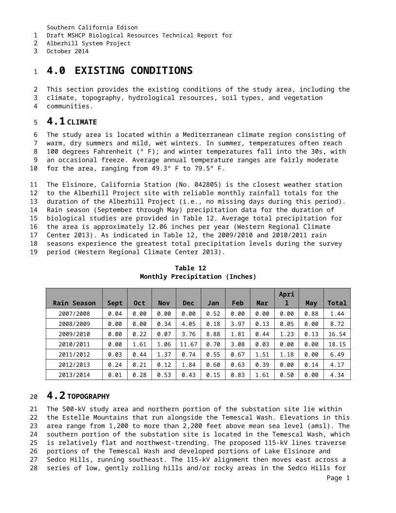
Southern California EdisonDraft MSHCP Biological Resources Technical Report forAlberhill System ProjectOctober 2014
small range in the woodlands of California and Baja California. The typical nesting habitat is dry and open woods that are near both brushy areas and fields of tall annual weeds, usually within 0.5 mile (0.8 km) of a small body of water. It may nest in other habitats, including rural residential areas, but not in deserts or dense forests. Outside the nesting season it occurs in many open habitats including deserts, suburbs, and city parks (Davis 2001).
Lawrence’s goldfinch was documented as an incidental observation within the Alberhill Project survey area during 2010, 2011, and 2014 riparian bird and 2011 BUOW surveys. In 2014, this species was detected by AMEC as an incidental observation within the VIG overlap area east of the Lake Street and Temescal Canyon Road intersection.
Oak titmouse (Baeolophus inornatus) was observed within the Alberhill Project area. Oak titmouse is not covered by the MSHCP. This species is an ABC WLBCC and a USFWS BCC with a CNDDB Conservation Rank of S3 (CDFG 2011). Oak titmouse often breeds near water. The typical nest is usually built of grass, moss, mud, hair, feathers, and fur in a woodpecker hole, natural cavity, or nest box. It is a yearlong resident and prefers open woodlands of oak and pine (CDFG 1988-1990).
Oak titmouse was documented as an incidental observation within the Alberhill Project survey area during 2009 habitat assessment surveys.
Marsh wren (Cistothorus palustris) was also observed within the Alberhill Project area. Marsh wren is not covered by the MSHCP. Clark’s marsh wren is a CDFW SSC with a CNDDB Conservation Rank of S2/S3 (CDFG 2011). Marsh wren breeds in tall, straight-stemmed emergent vegetation. It typically nests in cattails, bulrush, or sedge in emergent wetland habitat. It is a summer resident in southern California and requires standing water below the nest (CDFG 1988-1990). The incidental observations of marsh wren were not confirmed as the sensitive subspecies; however, based on known range and the time of year the observations were made, Clark’s marsh wren has potential to occur. The marsh habitat associated with the Collier wetlands provides suitable breeding habitat for the marsh wren.
Marsh wren was documented as an incidental observation within the Alberhill Project survey area during 2009 habitat assessment surveys.
Nuttall’s woodpecker (Picoides nuttallii) was observed within the Alberhill Project area. Nuttall’s woodpecker is not covered by the MSHCP. This species is an ABC WLBCC and a USFWS BCC with a CNDDB Conservation Rank of SNR (National or subnational conservation status not yet assessed) (CDFG 2011). Nuttall’s woodpecker nests mostly in riparian habitat in dead trunks or limbs of willow, sycamore, cottonwood, or alder. It is a yearlong resident and prefers a mix of deciduous riparian and adjacent oak habitats (CDFG 1988-1990).
Several Nuttall’s woodpecker observations were documented as incidental within the Alberhill Project survey area during 2009 habitat assessment and riparian bird surveys and 2010, 2011, and 2014 riparian bird surveys.
Page 19
123
12345
6789
1011121314
1516
1718192021222324
2526
272829303132
333435
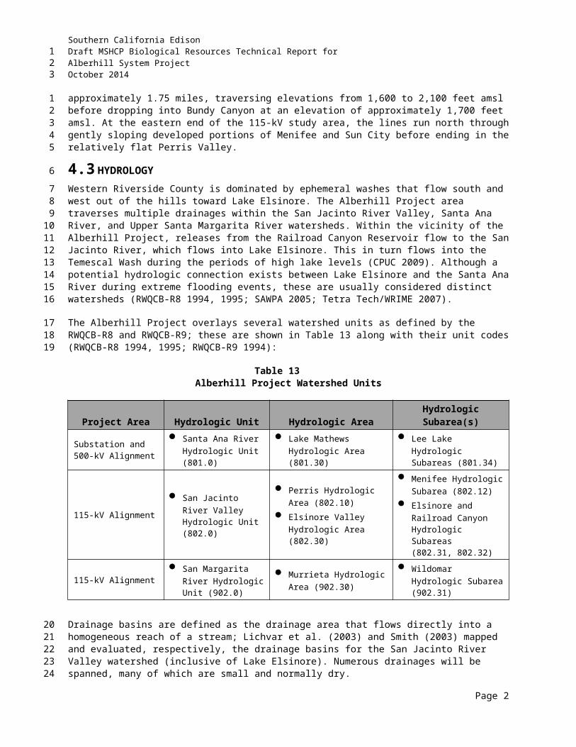
Southern California EdisonDraft MSHCP Biological Resources Technical Report forAlberhill System ProjectOctober 2014
THIS PAGE INTENTIONALLY LEFT BLANK
Page 20
123
Southern California EdisonDraft MSHCP Biological Resources Technical Report forAlberhill System ProjectOctober 2014
6.0 IMPACT ANALYSIS AND MITIGATION MEASURES
This section provides an analysis of impacts to biological resources anticipated to potentially occur from the construction and operation of the Alberhill Project, including both direct and indirect impacts. Impacts are defined as activities that destroy, damage, alter, or otherwise affect biological resources in a project area. Impacts are characterized as five types and are described below.
1. Direct impacts occur when biological resources are altered, disturbed, destroyed, or removed during the course of project implementation. Examples of direct impacts are loss of habitat as a result of grading or filling, or “take” of a sensitive species.
2. Indirect impacts occur when project-related activities affect biological resources in a manner other than direct. Examples of indirect impacts include fragmentation; pollination interruption; increased environmental toxins; increased invasion and competition by nonnative animals and plants; and increased noise, human activity, or light levels.
3. Permanent impacts result in the irreversible loss of biological resources. Examples include the permanent removal of vegetation or habitat through placement of a concrete foundation or a paved road.
4. Temporary impacts are reversible with the implementation of MMs. Examples include short-term noise events associated with project operations or clearance of vegetation during temporary construction activities.
5. Cumulative impacts are the sum of all impacts from this and other local projects on the biological resources of a region.
6.1 THRESHOLDS FOR DETERMINING POTENTIAL SIGNIFICANCEGuidelines under CEQA provide guidance and interpretation for implementing CEQA statutes. CEQA significance entails any impact to plant and wildlife species listed by federal or state agencies as threatened or endangered or of regional or local significance. A significant impact to listed or sensitive species could be direct or indirect, with impacts to rare or sensitive habitats also considered significant.
In general, the Alberhill Project could result in a potentially significant impact to the environment if it would:
Have a substantial adverse effect, either directly or through habitat modifications, on any species identified as a candidate, sensitive, or special species in local or regional plans, policies, or regulations, or by CDFW or USFWS;
Have a substantial adverse effect on any riparian habitat or other sensitive natural community identified in local or regional plans, policies, and regulations or by USFWS, USACE, CDFW, RWQCB, and/or RCA;
Have a substantial adverse effect on federally protected wetlands as defined by Section 404 of the CWA (including, but not limited to, marsh, vernal pool, coastal, etc.) through direct removal, filling, hydrological interruption, or other means;
Page 1
123
1
2
3456
789
10111213
141516
171819
2021
22
23242526
2728
293031
323334
353637
Southern California EdisonDraft MSHCP Biological Resources Technical Report forAlberhill System ProjectOctober 2014
Interfere substantially with the movement of any native resident or migratory fish or wildlife species or with established native resident or migratory wildlife corridors, or impede the use of native wildlife nursery sites;
Conflict with the provisions of an adopted HCP; Natural Community Conservation Planning; or other approved local, regional, or state habitat conservation plan;
Introduce land use within an area immediately adjacent to the MSHCP Conservation Area that would result in substantial edge effects; or
Conflict with any local policies or ordinances protecting biological resources, such as a tree preservation policy or ordinance.
Mitigation and conservation recommendations to address each impact to biological resources are identified below. Participation in the MSHCP and implementation of conservation and additional MMs would compensate for impacts that would occur as a result of Alberhill Project implementation.
6.2 DIRECT IMPACTSDirect impacts would result from construction activities, including tower/pole installation, access road maintenance and creation, creation of temporary work areas, and underground cable installation. Proposed transmission and subtransmission lines, towers, and poles would be placed in an existing SCE ROW, where available, and in several small new areas where easements have been obtained from willing landowners in already developed areas. The Alberhill Project was designed to avoid sensitive resources to the greatest extent possible. During the last few years, the Alberhill Project has gone through multiple redesign iterations resulting in the movement of poles and roads and/or reduction in the number of the smaller new easements within already developed areas. As such, some temporary and permanent impacts have been reduced while others continue to result from the Alberhill Project and are addressed in this section.
6.2.1 Construction-Related Impacts
For a detailed description of construction features, refer to Section 1.2 of this report. Approximate land disturbance calculations that would result from construction activities are provided in Table 17.
6.2.2 Vegetation Communities
Permanent impacts to vegetation communities that occur within the Alberhill Project footprint would result from disturbance associated with permanent roads and structures (e.g., towers and poles). Temporary impacts to vegetation communities would occur due to clearing of areas required for temporary access roads, stringing sites, pole removal and installation areas, and other temporary work and staging areas.
Clearing and grading associated with construction of roads and grading areas may result in the alteration of soil conditions, including the loss of native seed bank and changes to the topography and drainage of a site such that the capability of the habitat to support native vegetation is impaired. Grading may also remove rocks, large shrubs, and other objects from the soil surface. Table 18 identifies proposed impacts to vegetation communities.
Page 2
123
123
45
67
89
101112
13
14151617181920212223
24
2526
27
28293031
3233343536
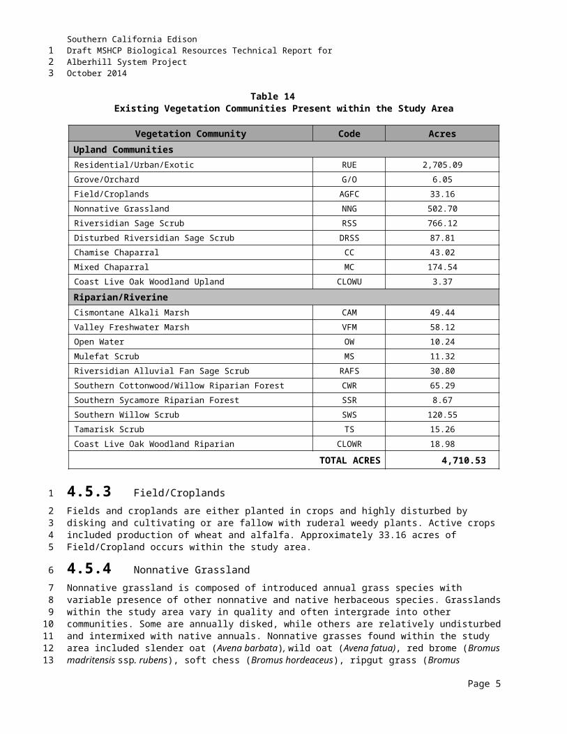
Southern California EdisonDraft MSHCP Biological Resources Technical Report forAlberhill System ProjectOctober 2014
Table 17Alberhill System Project Land Disturbance
FeatureQuantit
y
Disturbed Acreage
Calculation (L x W)
Acres Disturbed
during Constructi
on
Acres to Be Returned to
Existing Condition
(Temporary)
Acres Permanen
tly Disturbed (Permane
nt)Alberhill 115-kVGuard Structures 93 50 x 75 7.66 7.66 --Demolition Areas 258 50 x 50 11.99 11.99 --Pulling Sites 110 50 x 100 10.86 10.86 --Work Area 350 Varies 71.70 71.70 --Telecom Pulling Sites 72 Varies 0.99 0.99 --LWS Construction -- 2.39 -- 2.39TSP Construction -- 0.99 -- 0.99
Alberhill Substation and 500-kVAlberhill Substation (Grading) 1 Substation Yard 42.54 -- 42.54Alberhill Substation 1 Disturbance 4.21 4.21 --New Access Roads 5 14' width 3.29 -- 3.29Grading Limits 8 Varies 6.99 -- 6.99Temporary Road Disturbance 9 Varies 31.96 31.96 --Stringing Setup Site 2 Varies 3.30 3.30 --Pulling Sites 8 Varies 1.73 1.73 --Structure Work Area 16 200 ft x 200 ft 8.23 8.23 --Tower Disturbance Area 12 100 ft x 100 ft 2.34 -- 2.34
Construction Material YardsBP Alt - 1 1 Varies 7.41 7.41 --BP - 1 1 Varies 19.29 19.29 --ST - A1 1 Varies 6.22 6.22 --ST - A2 1 Varies 6.10 6.10 --ST - 1 1 Varies 3.73 3.73 --ST - A4 1 Varies 7.22 7.22 --ST - A5 1 Varies 4.95 4.95 --ST - 2 1 Varies 10.49 10.49 --ST - A3 1 Varies 4.78 4.78 --ST - A7 1 Varies 4.46 4.46 --ST - A6 1 Varies 7.27 7.27 --BP - A3 1 Varies 4.09 4.09 --BP - Alt Helo yard 1 Varies 6.68 6.68 --BP - A2 1 Varies 5.15 5.15 --
TOTALS 309.01 250.47 58.54
Page 3
123
Southern California EdisonDraft MSHCP Biological Resources Technical Report forAlberhill System ProjectOctober 2014
Table 17Alberhill System Project Land Disturbance
Notes/Assumptions:
a. Includes structure assembly and erection, conductor installation; area to be restored after construction. Portion of ROW within 25 ft of the TSP or H-frame, and within 10 ft of LWS pole, to remain cleared of vegetation. Permanently disturbed areas for TSP=0.06 acre and LWS=0.05 acre.
b. Based on 6,500-ft conductor reel lengths, number of circuits, and route design.
c. The disturbed acreage calculations are estimates based upon SCE’s preferred area of use for the described project feature, the width of the existing ROW, or the width of the proposed ROW; calculations do not include any new access/spur road information and are subject to revision based upon field determinations, biological resources present within the project area, and final engineering and review of the project by SCE's Construction Manager and/or Contractor awarded project.
d. Footing/Base Volume and Area Calculations:
Average TSP depth 30 ft deep, 7 ft diameter, qty 1 per TSP: earth removed for footing = 42.8 cu. yds; surface area = 38.5 sq. ft.
Average LWS depth 12 ft deep, 2.5 ft diameter, qty 1 per LWS: earth removed for pole base = 2.2 cu. yds; surface area = 4.9 sq. ft.
e. Additional puller and tensioner sites may be necessary based on field determinations.f. Based on approximate length of road in miles x road width of 14 ft.
g. Guard structures estimates provided above are maximum estimates, some areas will not be necessary as paved roads will be utilized where available.
h. Impact dimensions are based on estimates and may be reduced based on biological resources present within the vicinity of impact areas.
i. All work areas shall be under the oversight of qualified biological monitor to ensure that sensitive biological resources are not impacted within the project area.
Source: (SCE 2013b)
6.2.2.1 Sensitive Communities
Sensitive upland vegetation communities that may potentially be impacted within the Alberhill Project area include RSS and RAFS. Sensitive wetland and riparian vegetation communities that may be impacted within the Alberhill Project area are associated with riparian/riverine habitats. These communities include cismontane alkali marsh, valley freshwater marsh, southern cottonwood/willow riparian forest, and southern willow scrub habitats. Descriptions of vegetation communities that occur within the Alberhill Project study area are presented in Section 4.5, and a description of riparian/riverine communities, as defined by the MSHCP, is presented in Section 5.2.
Although the Alberhill Project was designed to avoid sensitive upland communities (RSS and RAFS) to the greatest extent possible, any unavoidable impacts would be addressed in accordance with the provisions set forth in the MSHCP.
RSS habitat is considered a sensitive habitat due to the sensitive species, including CAGN, which rely on this community. Approximately 15.42 acres of RSS (disturbed and undisturbed) could potentially be permanently impacted by the Alberhill Project, and approximately 57.33 acres of this habitat could potentially be temporarily impacted by construction activities. Upon SCE being granted PSE status, impacts to RSS would be fully covered by the MSHCP; however, clearing or grubbing of these community types must be conducted outside the CAGN breeding season (15 February through 15 August). Should SCE be granted PSE status, Alberhill Project impacts to this community type would be covered under the MSHCP; however, per the MSHCP, any clearing or grubbing of this community type must be completed outside the breeding season for CAGN and other sensitive sage scrub nesting species (15 February through 15 August).
Page 4
123
1
2345678
91011
12131415161718192021
Southern California EdisonDraft MSHCP Biological Resources Technical Report forAlberhill System ProjectOctober 2014
Table 18Vegetation Communities and Impacts within the Project Area
Vegetation Community CodeExisting Acreage
Permanent Impact (Acres)
Temporary Impact (Acres)
Upland HabitatsResidential/Urban/Exotic RUE 2,705.09 36.42 131.41Grove/Orchard G/O 6.05 0.02 0.79Field/Croplands AGFC 33.16 -- --Nonnative Grassland NNG 502.70 5.32 50.61Riversidian Sage Scrub RSS 766.12 15.42 47.72Disturbed Riversidian Sage Scrub DRSS 87.81 -- 9.61Chamise Chaparral CC 43.02 0.05 1.27Mixed Chaparral MC 174.54 0.22 5.65Coast Live Oak Woodland Upland CLOWU 3.37 <0.01 0.34
Riparian/Riverine HabitatsCismontane Alkali Marsh CAM 49.44 -- --
Valley Freshwater Marsh VFM 58.12 -- 0.04
Open Water OW 10.24 -- --
Mulefat Scrub MFS 11.32 -- 0.32
Riversidian Alluvial Fan Sage Scrub RAFS 30.80 -- --
Southern Cottonwood/Willow Riparian Forest CWR 65.29 -- <0.01
Southern Sycamore Riparian Forest SSR 8.67 0.24 0.34
Southern Willow Scrub SWS 120.55 0.80 0.85
Tamarisk Scrub TS 15.26 0.03 0.58
Cost Live Oak Woodland Riparian CLOWR 18.98 0.02 0.95
TOTAL ACRES 4,710.53 58.55 250.49Notes/Assumptions:
a. The permanent and temporary disturbed acreage calculations are estimates based upon SCE’s preferred area of use within each vegetation community. These calculations are subject to revision based upon field determinations, biological resources present within the project area, and final engineering and review of the project by SCE's Construction Manager and/or Contractor awarded project.
RAFS habitat is considered a sensitive habitat in part due to two sensitive annual species that are endemic to alluvial scrub vegetation in the MSHCP area: slender-horned spineflower and Santa Ana River woolly-star. No permanent or temporary impacts to RAFS associated with construction activities (disturbed and undisturbed) are anticipated as a result of the Alberhill Project.
Pursuant to MSHCP Rough Step requirements set forth in Section 6.7 of the MSHCP, RAFS and RSS are monitored annually within the MSHCP area for habitat losses and gains associated with public and private development projects. If the Rough Step rule for any of the monitored vegetation types is not met during the most recent annual analysis for Units 3, 7, and 8 (wherein the Alberhill Project occurs), then additional mitigation for impacts may be required at the discretion of RCA. Further, the Alberhill Project itself will not result in the MSHCP being out of Rough Step for any monitored vegetation type. Per communication with
Page 5
123
1234
5678910
Southern California EdisonDraft MSHCP Biological Resources Technical Report forAlberhill System ProjectOctober 2014
RCA, the RAFS vegetation type has been determined in various years to be out of Rough Step. However, currently, this monitored vegetation type has been determined sufficient to meet the goals and objectives of the MSHCP, but should it be determined to be out of Rough Step before the Alberhill PSE submittal, additional mitigation could be required. If additional mitigation for RAFS is required, it may include purchase of replacement land at a 1:1 ratio and/or restoration at a 2:1 ratio in an off-site location to be determined. Whether additional mitigation for RAFS will be required will be determined by RCA during the PSE review process. Per communication with RCA, the RSS vegetation type is currently meeting the Rough Step rule, and no further action regarding RSS is required.
All sensitive upland vegetation communities that are temporarily impacted would be returned to pre-construction conditions. Where appropriate, recontouring to pre-construction conditions may be necessary, as well as revegetation with native species that were present prior to construction. The following measures will be implemented to avoid and/or minimize potential impacts to sensitive communities resources as described in Section 8.0, including BIO-APM 1, BIO-APM 3, BIO-APM 4, BIO-APM 5, BIO-APM 6, BIO-APM 7, BIO-APM 8, BIO-APM 9, BIO-APM 10, MM BIO 1-a, MM BIO 1-b, AES-SCE-1, and MSHCP CAGN-1). These measures include the use of a qualified biologist to train project personnel on environmental restrictions; minimize disturbance footprint; avoid placement of equipment and material in waterways; avoid breeding and other sensitive seasons in wildlife habitat if species are found to be present; designate areas for equipment storage, staging, and fueling; avoid placement of erodible materials in water courses; monitor during clearing and grubbing, grading, excavation, and soil movement activities; avoid and/or minimize removal of native vegetation to the maximum extent practicable and return temporary impacts to preexisting contours and revegetate with appropriate native species; avoid special status plant species to the maximum extent practicable; and avoid clearing RSS habitat during CAGN breeding season (15 February through 15 August).
6.2.2.2 Riparian/Riverine Communities
The Alberhill Project was designed to avoid riparian/riverine areas by spanning those resources to the greatest extent possible; however, minimal temporary and permanent impacts would result from land disturbance activities associated with Alberhill Project construction activities. Table 19 provides the estimated impacts to riparian/riverine habitats as defined by and pursuant to the MSHCP. Impacts to riparian/riverine features were estimated based on anticipated impacts to delineated jurisdictional features. Appendix A illustrates these potentially jurisdictional features (ASP 1-14) within the Alberhill Project area.
6.2.2.2.1 Temporary Impacts to Riparian Areas
Temporary impacts to riparian areas would result from working within or in proximity to riparian features and include approximately 0.19 acre.
6.2.2.2.1.1 115 kV Transmission Line Work Areas
Trimming of branches in order to access pole locations, stringing setup sites, and pulling/tensioning locations (area south of proposed Alberhill Substation [ASP-14] [southern willow scrub] and Bundy Canyon Road west of Edwards Road [ASP-3] [south coast live oak riparian]) would result in approximately 0.10 acre of temporary impact. These areas would be impacted only temporarily, since they would be trimmed only once for construction access.
Page 6
123
12345678
91011121314151617181920212223
24
25
2627
28
2930313233
Southern California EdisonDraft MSHCP Biological Resources Technical Report forAlberhill System ProjectOctober 2014
Table 19MSHCP Riparian/Riverine Impacts within the Project Area
MSHCP Habitat Permanent Impacts(acres)
Temporary Impacts(acres)
Riparian0.76
(1 culvert crossing and grading of 1 feature)
0.19(1 culvert crossing and working within proximity to 2 features)
Riverine
0.10(1 culvert crossing and grading and the
construction of LWS poles within portions of 2 riverine features)
1.49(1 culvert crossing and grading and
working within proximity to 11 features)
TOTAL 0.86 1.68Notes/Assumptions:
a. Impact acreage is subject to change based on final engineering, additional field review, and ongoing efforts to avoid/minimize sensitive biological resources.
b. Permanent impacts are based on a 25-foot radius for each pole placement. In sensitive areas, the permanent radius of the pole would be reduced accordingly to avoid/minimize impacts.
6.2.2.2.1.2 500 kV Transmission Line Roads
Access road construction associated with 500-kV tower R13 [ASP-8] would result in approximately 0.09 acre of temporary impacts to riparian (southern riparian woodland) and wetland (disturbed wetland) vegetation.
6.2.2.2.2 Temporary Impacts to Riverine Areas
Temporary impacts to riverine areas would result from working within or in proximity to riverine features and include approximately 1.49 acres of temporary impacts.
6.2.2.2.2.1 115 kV Transmission Line Work Areas
The use of temporary work areas within six 115 kV transmission line project areas (area south of proposed Alberhill Substation [ASP-14]; Auto Center Drive, at the San Jacinto River crossing [ASP-6]; Bundy Canyon Road, west of Edwards Road [ASP-3]; Camino Del Norte, northeast of I-15 crossing [ASP-7]; Lost Road, at Gafford Road [ASP-4]; and west side of Murrieta Road, between Melido Street and Wickerd Road [ASP-1]) would result in approximately 0.57 acre of temporary impact.
6.2.2.2.2.2 500 kV Roads
Grading associated with new road construction in riverine areas would result in approximately 0.03 acre of temporary impact (associated with R13 access road culvert construction [ASP-8]). The use of temporary work areas, including proposed access to R7 and R8 via existing Black Powder Road (ASP-12) would result in less than approximately 0.01 acre of temporary impact.
6.2.2.2.2.3 Staging Yards
The use of three proposed laydown yards (BP-1 [ASP-9], ST-3 [ASP-5], and ST-4[ASP-2]) would result in approximately 0.71 acre of temporary impact.
Page 7
123
12
3
456
7
89
10
1112131415
16
17181920
21
2223
Southern California EdisonDraft MSHCP Biological Resources Technical Report forAlberhill System ProjectOctober 2014
6.2.2.2.2.4 500 kV Towers
Grading associated with the construction of a 500-kV tower (R5) (ASP-11) in riverine areas would result in approximately 0.03 acre of temporary impact. Grading associated with the construction of a new 500-kV tower (R8) access road (ASP-10) in riverine areas would result in approximately 0.14 acre of temporary impact.
Temporarily impacted riparian/riverine areas will be restored to pre-construction conditions upon completion of the Alberhill Project. On-site restoration would involve hydroseeding with native seed mixture similar to what is in place in adjacent areas, establishing temporary erosion controls, and monitoring of those revegetated areas for 3 years3 post-construction, or until successful revegetation by native species is confirmed by a qualified biologist.
6.2.2.2.3 Permanent Impacts to Riparian Areas
Permanent impacts to riparian areas would result from the construction of one culvert crossing and grading and include approximately 0.76 acre of permanent impacts.
6.2.2.2.3.1 500 kV Roads
The construction of a culvert associated with the 500-kV tower (R13) access road (ASP-8) would result in approximately 0.05 acre (jurisdictional under CDFW), including approximately 0.02 acre (jurisdictional under USACE) of permanent impacts to riparian areas.
6.2.2.2.3.2 Substation
Grading activities associated with the construction of the proposed Alberhill Substation (ASP-13) would result in approximately 0.71 acre (jurisdictional under CDFW), including 0.28 acre (jurisdictional under USACE) of permanent impacts to riparian areas.
6.2.2.2.4 Permanent Impacts to Riverine Areas
Permanent impacts to riverine areas would result from grading and LWS pole construction and include an approximate total 0.10 acre of permanent impact.
6.2.2.2.4.1 115 kV Transmission Line
Installation of three LWS poles (west side of Murrieta Road, between Melido Street and Wickerd Road [ASP-1]) within riverine areas would result in less than approximately 0.01 acre (jurisdictional under CDFW) of permanent impact.
6.2.2.2.4.2 500 kV Transmission Line Roads
Grading associated with new road construction (R13 access road culvert crossing at a small ephemeral drainage [ASP-8]) in riverine areas would result in approximately 0.03 acre (jurisdictional under CDFW), including 0.02 acre (jurisdictional under USACE) of permanent impact.
3 The 3-year post-construction monitoring requirement for on-site restoration of impacts to regulated waters and associated vegetation is a typical requirement in 1602 Streambed Alteration Agreements issued by CDFW.
Page 8
123
1
2345
678910
11
1213
14
151617
18
192021
22
2324
25
262728
29
303132
45
Southern California EdisonDraft MSHCP Biological Resources Technical Report forAlberhill System ProjectOctober 2014
6.2.2.2.4.3 500 kV Transmission Line Tower
Grading associated with the construction of a 500-kV tower (R5) (ASP-11) in riverine areas would result in approximately 0.06 acre (jurisdictional under RWQCB) of permanent impact.
Permanent impacts due to construction of culverted crossings (ASP-8) in riparian/riverine areas (0.08 acre) will not disturb the existing functions of the drainage to pass freshwater during storm events. Permanent impact to riparian areas due to hand trimming of trees for power line clearance would not adversely affect the functions and values of the habitat. In coordination with the resource agencies, mitigation for permanent impacts will likely involve purchase of land that encompasses riparian/riverine resources along the Temescal Wash area at an expected ratio of 3:1. It is anticipated that this land will be dedicated for conservation by donation to the Riverside-Corona Resource Conservation District (RCRCD) for restoration and management. Additional details regarding mitigation are provided in Regulated Waters Compliance below.
Although an effort has been made to avoid sensitive habitats within the Alberhill Project area, any unavoidable impacts would be mitigated in accordance with the provisions set forth by MSHCP Section 6.1.2, and/or where associated with regulated waters through USACE, CDFW, and RWQCB permitting requirements. In addition, per Section 6.1.2 of the MSHCP, a DBESP must be prepared to ensure that all impacts to riparian/riverine habitats and their associated species have been fully addressed. The DBESP must demonstrate that if these resources cannot be avoided by 90 percent, the functions and values of these sensitive habitats will be replaced equivalent or superior to these resources existing prior to the Project. The DBESP will be prepared as part of the MSHCP PSE application submittal.
6.2.2.2.5 Vernal Pools
The Alberhill Project was designed to avoid Vernal Pools (disturbed and higher quality) in the Alberhill Project area, and no permanent or temporary impacts to their functions or values will occur.
Construction activities associated with the Alberhill 115-kV subtransmission line have a low likelihood to impact Depressions 1 and 2 located along asphalt-paved Mission Trail and Bundy Canyon Road, respectively, because they are situated on opposite sides of the streets from the proposed work areas. In addition, construction activities associated with the proposed Subtrans Yard (Alternative B – APN 370-050-020) are also not likely to impact Depression 1 because the depression (and its associated micro-watershed) is located approximately 175 feet north of the northern boundary of the proposed Subtrans Yard footprint and north of an unimproved/gravel road situated at a higher elevation from the watershed.
The location of the seasonal depression, located north of the existing Newcomb Substation, the proposed Alberhill 115-kV subtransmission alignment, and associated work areas, was provided to the SCE engineering group in order to adjust engineering to avoid the greatest lateral extent of the depressional feature. Work areas associated with the existing Newcomb Substation and the proposed Alberhill 115-kV subtransmission alignment will not redirect or inhibit the floodplain hydrology of the seasonal depression located north of the Newcomb Substation. Work areas will occur south of the depression hydrology source and will not impede the flow of water through the area; proposed work areas will remain level with existing elevations and contours; and no berms will be created that could affect water flow. Protocol level surveys for the fairy shrimp have not been conducted. If it is determined the seasonal depression cannot be avoided, protocol surveys for fairy shrimp will be completed. A focused map presenting the seasonal depression and proposed work areas is presented in Appendix A.
Page 9
123
1
23
456789101112
1314151617181920
21
2223
24252627282930
3132333435363738394041
Southern California EdisonDraft MSHCP Biological Resources Technical Report forAlberhill System ProjectOctober 2014
6.2.2.2.6 Regulated Waters Compliance
Along with the providing a breakdown of riparian/riverine and vernal pool resources pursuant to the MSHCP, the Alberhill Project will require a Streambed Alteration Agreement from CDFW under Section 1602 of the CFGC and a permit from RWQCB to fulfill requirements of Section 401 of the CWA. Furthermore, SCE proposes to construct the Alberhill Project under USACE Nationwide Permit (NWP) 12 for utility line activities under Section 404 of the CWA. SCE intends to facilitate the permit process by submitting a preliminary JD form with permit applications rather than requesting an approved JD subject to additional approvals by USACE and the U.S. Environmental Protection Agency (USEPA). A completed preliminary JD form is included in Attachment G. Permit applications will be submitted to each of these agencies after the DEIR is released for public review.
As a linear project, each regulated water feature location, as discussed in Section 6.2.2.2 above, would be considered a single and complete project under the CWA Section 404 NWP program (33 CFR 330) because impacts to jurisdictional waters would occur at separate and distinct locations. Therefore, based on the combined impacts presented in Table 19, each separate feature location would be permitted under NWP 12 (Utility Line Activities)4,5 because each feature location meets the NWP threshold (i.e., a loss greater than 0.5 acre is not authorized). Individual impacts at each potential jurisdictional feature type are summarized in Table 20.
SCE proposes to mitigate on-site and off-site at up to a 3:1 ratio for permanent impacts to 0.86 acre of jurisdictional waters caused by new structures and fill activities, including pole placement and road construction. Mitigation for all permanent impacts would be provided as discussed above in Section 6.2.2.2, and is expected to also serve as mitigation for impacts to MSHCP riparian/riverine resources. Mitigation would involve purchase of land that encompasses regulated waters (i.e., riparian/riverine resources) along the Temescal Wash area at an expected ratio of 3:1. It is anticipated that this land will be dedicated for conservation by donation to the RCRCD for restoration and management. The property would become part of the RCA preserve system and conserved in perpetuity.
Mitigation on this land will involve reestablishment/rehabilitation of riparian habitat and preservation within the Temescal Wash. It is anticipated that RCRCD would handle the reestablishment and rehabilitation activities, which may include nonnative plant removal (i.e., giant reed [Arundo donax]), and native plant installation. It is anticipated that a Habitat Mitigation and Management Plan (HMMP) would be prepared by RCRCD further providing detailed descriptions and methods of nonnative plant control, planting of native plants, irrigation, maintenance, monitoring, and reporting requirements. The HMMP may include
4 NWP 12 is based on the Reissuance of Nationwide Permits (Final Notice, 77 Federal Register 34 [February 21, 2012]) and is predicated on the assumption that this proposed project and the related activities occurring within federally regulated waters meet all terms and conditions of the 2012 NWP program.
5 It is at the discretion of USACE to assign the type of NWP(s) that it determines to qualify for a project based on the information submitted as part of a Pre-Construction Notification.
Page 10
123
1
2345678910
11121314151617
1819202122232425
262728293031
456
78
Southern California EdisonDraft MSHCP Biological Resources Technical Report forAlberhill System ProjectOctober 2014
Table 20Summary of Impacts to Jurisdictional Waters of the U.S. and State
Potential Jurisdictional Waters of the U.S. and State
USACE (acres/linear feet)a,b
RWQCB (acres/linear feet)a,b
CDFW (acres/linear feet)a,b
Permanent
Impacts
Temporary
Impacts
Permanent
Impacts Temporary Impacts
Permanent
Impacts Temporary Impacts
Wetland 0.29/30 0.01/5 0.29/30 0.01/5 0.73/30 0.01/5Riparian - - - - 0.03 0.18Other Watersc 0.02/165 0.42/1,862 0.08/496 0.90/3,175 0.03/171 1.40/2,813Total 0.31/195 0.43/1,867 0.38/526 0.91/3,180 0.80/201 1.59/2,818Note: Impact acreage is subject to change based on final engineering, additional field review, and ongoing efforts to avoid/minimize sensitive biological resources.
a. Jurisdictional waters acreage of the survey area was determined by using ArcGIS. All acreages are rounded to the nearest hundredth (which may account for minor rounding error).
b. USACE only uses the measurement of linear feet for impacts to stream/riverine features. Therefore, only stream features will have acreage and linear feet provided as a component of measurement for established features and potential projected impacts occurring within the project boundary.
c. This includes swale features under the exclusive purview of CDFW and/or RWQCB.
descriptions of herbivory control, including rodent populations, to ensure survival of established plants. Monitoring, maintenance, and reporting would occur for a minimum of 3 years to ensure proper establishment of the native riparian community.
In addition to what is being proposed as off-site mitigation, measures will be implemented to avoid and/or minimize impacts to riparian/riverine resources and may also be required as conditions in one or more of the aforementioned permits. Measures are described in the tables presented in Section 8.0 of this document, including BIO-APM 1, BIO-APM 3, BIO-APM 4, BIO-APM 6, BIO-APM 7, BIO-APM 8, BIO-APM 9, BIO-APM 10, HYDRO-APM 1, HYDRO-APM 3, HYDRO-APM 4, MM BIO 1-a [Item c], MM BIO 1-c, MM BIO 2a, MM BIO 2b, MM HYD-5a, MM HYD-7a, MSHCP BMP-4, and MSHCP BMP-7. These measures include the use of a qualified biologist for training, minimizing disturbance footprints, and monitoring construction activities to avoid impacts to sensitive species and habitats; implementation of a Storm Water Pollution Prevention Plan (SWPPP) and hazardous material handling procedures; and use of proper BMPs when diverting streams or dewatering.
6.2.3 Additional Reserve Land
Pursuant to the MSHCP, ARL are defined as the additional 153,000 acres to be acquired for MSHCP Reserve Assembly. Currently, three Alberhill Project areas are located within MSHCP ARL. One area proposed is the 500-kV transmission line tower R14X where temporary work areas and permanent tower access will be located. As part of the construction of 500-kV transmission line tower R14X, the Alberhill Project will potentially temporarily impact approximately 2.18 acres and permanently impact approximately 0.03 acre of ARL. Construction of the VIG Phase 2 Project will occur in two areas along the existing SCE line (Fogarty-Ivyglen) that are within ARL in the VIG Phase 2 overlap area: one area is north of and parallel to Nichols Road, and the other is west of and parallel to Lake Street. The VIG Phase 2 Project will potentially temporarily impact approximately 3.47 acres and permanently impact approximately 1.53 acres of ARL.
Page 11
123
123
45678910111213
14
15161718192021222324
Southern California EdisonDraft MSHCP Biological Resources Technical Report forAlberhill System ProjectOctober 2014
Construction of the VIG Phase 2 Project will occur prior to construction of the Alberhill Project. The VIG Phase 2 Project will propose equivalent or superior replacement land to the MSHCP ARL, which will offset potential impacts to ARL in the two areas (Nichols Road and Lake Street) and demonstrate that there will be no impacts to the functions and values of the ARL nor will the project impede the goals and objectives of the MSHCP.
Temporary impacts to ARL will be restored to the greatest extent practicable using vegetation and plant species present prior to disturbance. Further, the Alberhill Project will ensure that construction and operations do not result in changes in hydrology or water quality and will recontour affected areas as needed.
To address permanent impacts, SCE will prepare an ARL equivalency analysis to be included as part of the MSHCP PSE application submittal. This equivalency analysis will compare the potential effects on the ARL to the benefits of proposed replacement land being dedicated to the MSHCP Conservation Area, including ensuring compensation for potentially lost conservation functions and values. The analysis will consider specific project design features, siting and design, and MSHCP BMPs, as well as address effects on covered species and habitats, core areas, linkages, constrained linkages, MSHCP Conservation Area configuration and management, and ecotones. The ARL replacement land ratio is anticipated to be not less than 3:1 within MSHCP Core 1, but the ratio and any additional mitigation requirements will ultimately be determined through the MSHCP PSE consistency review process and findings made by RCA, with review and concurrence by USFWS and CDFW.
The Alberhill Project will only be adding another line to the poles installed by the VIG Phase 2 Project and will remain within the same disturbance footprint in the two areas as the footprint approved for the VIG Phase 2 Project. For the separate impact area at tower R14X, the Alberhill Project will follow the same process as the VIG Phase 2 Project by proposing equivalent or superior replacement land as described above.
6.2.4 Special Status Plant Species
Thirteen sensitive plant species were detected within the study area during botanical field studies that have been conducted to date (refer to Section 5.3.1 above for a description of each). The Alberhill Project has been designed to avoid/minimize impacts to sensitive plant species to the greatest extent possible; however, based on current design, avoidance/minimization may not be possible with respect to 46 sensitive plant occurrences within the Alberhill Project footprint (Table 21).
6.2.4.1 MSHCP NEPS and CAPS
As currently designed, San Diego ambrosia (NEPS) and smooth tarplant (CAPS) could potentially be impacted by Alberhill Project construction activities. Since densities of plant populations fluctuate temporally due to physical conditions that vary from year to year (e.g., rainfall, temperature, etc.), it is difficult to determine the exact number of individuals that may be potentially impacted at the time of Alberhill Project construction. The Alberhill Project has been designed to avoid/minimize these species to the greatest extent possible; however, if impacts are unavoidable at the time of construction, the measures presented in Section 8.0, which include adhering to MSHCP policies and procedures for NEPS and CAPS, will be followed. As such, a DBESP shall be prepared that details mitigation efforts for impacts to San Diego ambrosia and will include a tiered approach as summarized in MM BIO-1b (able 24). The
Page 12
123
12345
6789
10111213141516171819
2021222324
25
2627282930
31
323334353637383940
Southern California EdisonDraft MSHCP Biological Resources Technical Report forAlberhill System ProjectOctober 2014
Table 21Potentially Unavoidable Impacts to Sensitive Plants
Species
Potential Impact
(Approximate # of individuals
and/or acreage of impacts) MSHCP Status
Project Feature Causing Impact
MSHCP CAPS
smooth tarplant
430/0.36
CAPS; Requires additional mitigation if located within a
designated CASSA
Pull Site, 115-kV TSP demolition and new TSP work area, and
new fence line associated with area north of the Newcomb
Substation (outside a designated CASSA)
1/<0.01
115-kV new LWS work area (outside a designated CASSA)
(north of La Piedra, west of Murrieta Road)
915/3.7 Laydown Yard ST-A2 (outside a designated CASSA)
Adequately Conserved
Parry’s spineflower
5/<0.01(Table 9-3 of MSHCP); No
additional mitigation required
115-kV new LWS work areas (east of Murrieta Road, north of
Bundy Canyon Road)
5/<0.01115-kV new LWS work areas
(east of Debon Street, north of Bundy Canyon Road)
long-spined spineflower
35/0.13No additional mitigation
required
115-kV wood pole demolition and new LWS work areas (north of
Beverly Street)
125/0.21500-kV access road (R5) grading limit and associated disturbance
area
Palmer’s grapplinghook15/0.12
No additional mitigation required
115-kV wood pole demolition and new LWS work areas (north of
Beverly Street)
5/<0.01 500-kV access road (R8) disturbance area
Coulter’s matilija poppy 10/0.01 (Table 9-3 of MSHCP); No additional mitigation required
500-kV access road (R12) disturbance area
Species Not Covered by the MSHCPPaniculate tarplant
5/0.05
Not Covered;CRPR 4.2; Requires
minimization
115-kV new LWS work area and guard pole area (south of Puerto
Vallarta Way, east of Murrieta Road)
45/0.21 115-kV new LWS work areas (two separate) (south of Craig
Avenue, east of Murrieta Road)
Page 13
123
Southern California EdisonDraft MSHCP Biological Resources Technical Report forAlberhill System ProjectOctober 2014
Table 21Potentially Unavoidable Impacts to Sensitive Plants
Species
Potential Impact
(Approximate # of individuals
and/or acreage of impacts) MSHCP Status
Project Feature Causing Impact
5/0.01115-kV new LWS work area
(north of Wickerd Road, west of Murrieta Road)
225/3.4 Laydown Yard ST-A7645/5.70 Laydown Yard ST-A4
20/0.04115-kV new LWS work areas
(north of Bundy Canyon Road, east of Springtown Road)
5/<0.01115-kV new LWS work areas
(south of Bundy Canyon Road, west of Springtown Road)
15/<0.01115-kV new LWS work area
(south of Bundy Canyon Road, east of Springtown Road)
25/0.13
Two 115-kV wood pole demolition and new LWS work areas (south of Bundy Canyon
Road, east of Lynx Road)
1/<0.01
115-kV wood pole demolition work area (north of Bundy
Canyon Road, west of Waldon Road)
350/1.21 Laydown Yard ST-A5
85/0.20115-kV wood pole demolition and
new LWS work areas (North of Beverly Street)
1/<0.01 115-kV LWS H-frame demolition work area
50/0.06 115-kV LWS H-frame demolition and new H-frame work area
70/0.10 Laydown Yard ST-1
110/0.58
115-kV wood pole demolition areas, new LWS work areas, and pull sites (north of East Franklin
Street)
10/<0.01 Alberhill Substation construction disturbance area
1/<0.01 BP-Alt-Helicopter yard
Page 14
123

Southern California EdisonDraft MSHCP Biological Resources Technical Report forAlberhill System ProjectOctober 2014
Table 21Potentially Unavoidable Impacts to Sensitive Plants
Species
Potential Impact
(Approximate # of individuals
and/or acreage of impacts) MSHCP Status
Project Feature Causing Impact
Robinson’s peppergrass
105/0.32
Not Covered; CRPR 4.2 Requires minimization
500-kV tower (R17X) disturbance area
135/0.05500-kV (R13) tower construction
and access road grading limit and associated disturbance area
205/0.25
500-kV tower construction (R14) grading limit, associated
disturbance area, access road, and pull site.
75/0.19 500-kV access road (R11 and R12) disturbance area
5/<0.01500-kV tower (R7) structure work
area and access road disturbance area
35/0.04 500-kV access road (R8) disturbance area
55/0.11500-kV (R5) tower construction and access road grading limit
and associated disturbance area
25/0.08 Alberhill Substation and associated disturbance area
Notes:
a. These impacts are estimates only and are subject to change based upon final engineering, additional field reviews, and ongoing efforts to avoid/minimize impacts to sensitive biological resources during construction.
b. Parry’s spineflower, Coulter’s matilija poppy, and small-flowered microseris are three of the 28 Covered Species that will be considered Adequately Conserved by RCA when certain conservation requirements are met as identified in the species-specific conservation objectives for those species. It is unlikely the additional mitigation would be required by RCA for these species at this time; however, this will not be determined until the PSE review process.
c. Not included in the impacts listed above, temporary impacts to approximately 695 individuals of paniculate tarplant and permanent impacts to 87 individuals and temporary impacts to 513 individuals (0.02 acre) of San Diego ambrosia are located on Castle & Cooke lands. For the purposes of this report, it is assumed that C&C will address all biological impacts and obtain all regulated waters permits and incidental take of listed species, as necessary. Depending on the outcome of ongoing negotiations with C&C, the VIG Phase 2 Project will address these species as needed because this area falls within the overlap area and VIG Phase 2 construction will occur prior to construction of the Alberhill Project.
DBESP is required as part of the MSHCP PSE submittal and subject to the review and approval of RCA, with concurrence from USFWS and CDFW.
San Diego ambrosia was observed within the VIG Phase 2 overlap area of the Alberhill Project; impacts to this species will be addressed during the VIG Phase 2 Project MSHCP PSE process. Construction activities associated with the Alberhill Project planned within proximity to San Diego ambrosia will remain
Page 15
123
12
345
Southern California EdisonDraft MSHCP Biological Resources Technical Report forAlberhill System ProjectOctober 2014
in the same disturbance footprint approved for the VIG Phase 2 overlap area. Therefore, no additional impacts to this species would result from construction of the Alberhill Project.
Smooth tarplant was observed within the VIG Phase 2 overlap area of the Alberhill Project; impacts to this species will be addressed during the VIG Phase 2 Project MSHCP PSE process. Construction activities associated with the Alberhill Project planned within proximity to smooth tarplant will remain in the same disturbance footprint approved for the VIG Phase 2 overlap area. Therefore, no additional impacts to this species would result from construction of the Alberhill Project. All other smooth tarplant observations made within the vicinity of the Alberhill Project were located outside designated CASSAs. Because the observed smooth tarplant was outside the CASSA, incidental take would be granted through participation in the MSHCP, and no additional mitigation for smooth tarplant is required.
Specific MMs for these species may include, but are not limited to, the following.
6.2.4.2 MSHCP Table 9-3 Plant Species
Small-flowered microseris, Parry’s spineflower and Coulter’s matilija poppy could potentially be impacted by Alberhill Project construction activities. Occurrences of these plants are located within access road disturbance and new pole work areas. Temporary impacts to these species could include crushing due to the use of construction vehicles within the work areas. These species are three of the 28 Covered species that will be considered Adequately Conserved when particular species-specific conservation objectives, which are identified in Table 9-3 of the MSHCP, are satisfied by RCA and the Permittees for Parry’s spineflower, small-flowered microseris, and Coulter’s matilija poppy to become Adequately Conserved Covered Species. Coulter's matilija poppy is known to occur in dry washes and canyons, which may support wetlands; thus, this species is additionally protected pursuant to Section 6.1.2, Protection of Species Associated with Riparian/Riverine Areas and Vernal Pools of the MSHCP. As a PSE, no additional mitigation or further action is required.
6.2.4.3 Plant Species Not Covered by the MSHCP
Paniculate tarplant and Robinson’s peppergrass are California Rare Plant Ranks species that are not covered by the MSHCP. As currently designed, approximately 11.75 acres of paniculate tarplant and 1.05 acres of Robinson’s peppergrass could potentially be impacted as a result of Alberhill Project construction. Potential direct and indirect impacts to these species would occur as a result of temporary LWS work areas, access road and construction disturbance areas, the use of proposed laydown yards, and permanent access roads and the proposed Alberhill Substation. SCE will offset impacts to these species by implementing measures presented in Section 8.0, which include but are not limited to topsoil salvage and replacement of seed bank. Efforts associated with direct and indirect impacts to these species shall be developed in consultation with and approved by CDFW as described in MMs listed below.
The following measures will be implemented to avoid and/or minimize potential impacts to sensitive plant species resources as described in Section 8.0 including BIO-APM 1, BIO-APM 3, BIO-APM 6, BIO-APM 8, BIO-APM 9, BIO-APM 10, MM BIO 1-a, MM BIO 1-b, MM BIO 1-c, MSHCP BMP-12, MSHCP CONST-12, and MSHCP CONST-17. These measures include the use of a qualified biologist for training, minimizing disturbance footprints, and monitoring construction activities to avoid impacts to sensitive species and habitats.
Based on the described construction activities and implementation of MMs as identified, impacts to sensitive plant species would be less than significant.
Page 16
123
12
345678910
11
12
1314151617181920212223
24
25262728293031323334
353637383940
4142
Southern California EdisonDraft MSHCP Biological Resources Technical Report forAlberhill System ProjectOctober 2014
6.2.5 Native Oak and Other Protected Trees
If any oak tree removal or trimming is determined necessary, it will be done in accordance with the County of Riverside, Roadside Tree Ordinance 12.08, Tree Removal Ordinance 12.24, and Riverside County Oak Tree Management Guidelines, including implementation of required mitigation and/or guidance. In addition, the County of Riverside requires that any future development in an identified sensitive vegetation area (including oak woodlands) must be evaluated individually and cumulatively for potential impact on vegetation (Riverside County 1993).
Several stands of oak trees (coast live oak), associated with 22.35 acres of coast live oak woodland habitat, are located within the Alberhill Project area.
The grubbing and grading required to create the proposed Alberhill Substation pad will require the removal of two young oaks (AECOM 2012c). In addition, some trimming of oak trees is anticipated within the 115-kV subtransmission line survey area. Project activities will be minimized to the greatest extent possible.
Avoidance would preclude most direct and encroachment impacts to coast live oaks. Preventive measures must be taken during construction activities to minimize impacts in the protected zone. The protected zone of each tree shall commence from a point 5 feet outside the dripline and extend inward to the trunk of the tree. All approved work in the protected zone of trees will be done using hand implements; the use of mechanized tools is prohibited except where absolutely necessary. All work conducted within the protected zone of oak trees shall be performed in the presence of a certified arborist.
Under the direction of a certified arborist, SCE will relocate the two oaks currently located within the boundary of the Alberhill Substation to suitable habitat outside the area of anticipated impact. If the applicant cannot feasibly relocate either of the two impacted oaks, at least four minimum-15-gallon oaks will be planted within the appropriate habitat to replace impacted trees (2:1 ratio). These replacement trees shall consist of indigenous coast live oaks that have been grown in a natural form (no topping, street tree forming). The applicant shall be responsible for monitoring and maintaining the relocated or replacement trees for a minimum of 2 years.
Recommended avoidance and minimization measures described below are aimed at reducing potential impacts from construction-related activities on protected oak trees.
Equipment, materials, and vehicles shall not be stored, parked, or operated within the protected zone of an oak tree, except on sites approved for this use by an oak tree consultant.
Removal of the natural leaf mulch within the protected zone of oak trees is prohibited except where absolutely necessary.
All trees not approved for removal shall be fenced in accordance with County of Riverside Oak Tree Management Guidelines (2003) prior to commencement of any heavy equipment operation. Encroachment trees shall also be fenced until the actual encroachment work is performed. At that time, the fencing shall be moved to the limit of the encroachment.
Any pruning, including removal of dead wood, shall be performed in compliance with the latest ANSI pruning standards by a certified arborist (or certified tree worker).
Page 17
123
1
234567
89
10111213
141516171819
20212223242526
2728
2930
3132
33343536
3738
Southern California EdisonDraft MSHCP Biological Resources Technical Report forAlberhill System ProjectOctober 2014
Any root-pruning required within the protected zone of an oak shall be reduced to the minimum amount that is absolutely necessary. All roots pruned shall consist of clean, 90-degree angle cuts utilizing sharp hand tools. Any major roots (2 inches or greater in diameter) encountered shall be preserved to the extent possible and wrapped in moist burlap until the soil is replaced. Soil shall be replaced around preserved roots as soon as possible.
The Lake Elsinore Palm Tree Preservation Program (City Ordinance No. 1044) is designed to protect and preserve the City’s significant palms. Impacts to palm trees within the City of Lake Elsinore as a result of the Alberhill Project are not anticipated.
Based on the mitigation and avoidance and minimization measures described within this section and implementation of MMs as identified in Section 8.0, impacts to special status plants species would be less than significant.
6.2.6 Common and Special Status Wildlife Species
Although the Alberhill Project has been designed to protect biological resources to the maximum extent possible, construction and implementation of the Alberhill Project could potentially impact common and sensitive wildlife species and their associated habitats that occur within the Alberhill Project study area. Descriptions of species that may potentially be impacted by the Alberhill Project are discussed below, as they relate to the MSHCP.
6.2.6.1 Common and MSHCP Adequately Conserved Species
Wildlife species that are Covered species and Adequately Conserved by the MSHCP and that were detected within the study area during habitat assessment and focused surveys include Cooper’s hawk, tri-colored blackbird, southern California rufous-crowned sparrow, Bell’s sage sparrow, golden eagle (Aquila chrysaetos), great blue heron (Ardea herodias), turkey vulture (Cathartes aura), northern harrier, yellow warbler, California horned lark, black-crowned night heron, MacGillivray’s warbler (Oporornis tolmiei), osprey, double-crested cormorant, downy woodpecker, white-faced ibis, CAGN, tree swallow, Wilson’s warbler (Wilsonia pusilla), coyote, northwestern San Diego pocket mouse (Chaetodipus fallax fallax), Dulzura kangaroo rat (Dipodomys simulans), San Diego black-tailed jackrabbit (Lepus californicus bennettii), San Diego desert woodrat (Neotoma lepida intermedia), coastal western whiptail (Aspidoscelis tigris stejnegeri), Belding’s orange-throated whiptail (Aspidoscelis hyperythrus), and granite spiny lizard (Sceloporus orcuttii) and their associated habitats.
As Adequately Conserved species, participation in the MSHCP would provide take coverage for these species. However, the intent of the Alberhill Project is to avoid and/or minimize impacts to sensitive biological resources that occur within its boundaries to the greatest extent possible. The following measures will be implemented to avoid and/or minimize potential impacts to common and Adequately Conserved MSHCP wildlife species resources as described in Section 8.0, including BIO-APM 1, BIO-APM 3, BIO-APM 5, BIO-APM 8, BIO-APM 10, BIO-APM 15, BIO-APM 17, BIO-APM 18, MM BIO 1-e, MM BIO-1f, MM BIO-1h, MM BIO-1i, MM NOISE-1a, MSHCP CAGN-1, MSHCP BMP-12, and MSHCP BMP-13. These measures include the use of a qualified biologist for training, minimizing disturbance footprints, and monitoring construction activities to avoid impacts to sensitive species and habitats. Qualified biologists will conduct pre-construction surveys and relocate sensitive reptiles; implement measures to avoid impacts to active nests (with eggs or young) of any protected bird; flag and establish construction buffers around BUOW sites; and ensure that construction noise does not exceed the nest disturbance or noise level threshold established in the Nesting Bird Management Strategy
Page 18
123
12345
678
91011
12
1314151617
18
1920212223242526272829
30313233343536373839404142
Southern California EdisonDraft MSHCP Biological Resources Technical Report forAlberhill System ProjectOctober 2014
(NBMS) during the general nesting period. The project will avoid clearing Riversidian sage scrub habitat during CAGN breeding season (15 February through 15 August).
Based on the described construction activities and implementation of MMs as identified, impacts to common and Adequately Conserved MSHCP wildlife species would be less than significant.
6.2.6.2 Sensitive Species Related to Section 6.1.2 of the MSHCP
Least Bell’s Vireo – Several occupied breeding LBV territories have been identified within the Alberhill Project study area within mulefat scrub, southern willow scrub, and southern cottonwood/willow riparian habitats that occur within the Alberhill Project footprint (Table 22).
Table 22LBV within Alberhill Project Footprint
Habitat Appendix A Map Page/StreetSouthern willow scrub, and southern cottonwood/willow riparian habitats
Subtransmission Map 34 and 36 and Substation Map 1/Temescal Wash South, Southeast, and West of Alberhill Substation
Southern cottonwood/willow riparian woodland Subtransmission Maps 27-30/Collier Wetlands, between Nichols Road and 3rd Street
Southern cottonwood/willow riparian woodland Subtransmission Map 22/San Jacinto River Crossing, North of Auto Center Drive to I-15
Tamarisk scrub and southern willow scrub Subtransmission Map 19/Area west of Mission Trail, between Olive Street and Victorian Lane
The Alberhill Project has been designed to avoid impacts to riparian and wetland habitats within the Alberhill Project area to the greatest extent possible; however, potential direct impacts to LBV may result from clearing of suitable habitats, tree trimming, and/or pole placement. However, these impacts would not be considered significant with the implementation of avoidance and minimization measures described in Section 8.0, including BIO-APM 1, BIO-APM 3, BIO-APM 5, BIO-APM 7, BIO-APM 8, BIO-APM 9, BIO-APM 10, NOISE-APM 1, MM BIO 1-e, MM BIO-1g, MM BIO-1h, and MM NOISE-1a. These measures include the implementation of an NBMS, which consists of construction avoidance buffers during nesting season (March 1 through August 31) and the implementation of biological monitors during clearing and grubbing, tree trimming, grading, excavation, and soil movement activities. Adhering to policies and procedures for Section 6.1.2 of the MSHCP, a DBESP will be prepared for impacts associated with riparian/riverine habitats, including those where LBV territories occur. Impacts to LBV would be less than significant.
In addition to the LBV, additional wildlife species detected within the Alberhill Project area that are Adequately Conserved and are associated with riparian/riverine and vernal pool habitats include the western spadefoot toad, Cooper’s hawk, osprey, downy woodpecker, yellow-breasted chat, and yellow warbler. The conservation measures provided for wildlife species and their habitats also provide protective measures for these species. Impacts to these species would be less than significant.
6.2.6.3 MSHCP Section 6.2.3 Criteria Area Species
Burrowing Owl – Focused surveys for BUOW were completed in accordance with the applicable survey protocol as discussed above in Section 3.0, Survey Methods. Several locations of occupied suitable
Page 19
123
12
34
5
678
91011121314151617181920
2122232425
26
2728
Southern California EdisonDraft MSHCP Biological Resources Technical Report forAlberhill System ProjectOctober 2014
BUOW habitat have been identified in the Alberhill Project study area. BUOW is a species known for its ability to move into and out of areas across seasons and years. The Alberhill Project was designed to avoid known BUOW locations to the greatest extent possible; however, direct and indirect temporary impacts could result from land disturbance activities associated with Alberhill Project construction activities. Two locations where BUOW were observed, Mission Trail at Bundy Canyon Road and Waite Street, have been identified as potential locations for temporary laydown yards. In addition, other areas where BUOW were detected are adjacent to proposed 115-kV alignment work areas. Project construction and use of occupied laydown yards may temporarily affect the movement of BUOW and/or their breeding success. Their active nests may be directly or indirectly impacted such that nest abandonment resulting in death of eggs or young occurs. Disturbance from construction activities, such as noise, human presence, and habitat alteration or temporary loss of habitat due to the clearing of vegetation and use of occupied habitat as laydown yards, could affect nesting and year-round resident BUOW.
Impacts to BUOW would not be considered significant with the implementation of the avoidance and minimization measures described in Section 8.0, including BIO-APM 1, BIO-APM 3, BIO-APM 5, BIO-APM 8, BIO-APM 10, MM BIO 1-e (revised), MM BIO-1f. Measures include qualified biologists conducting pre-construction BUOW surveys and establishing avoidance buffers if active burrows are identified, as well as the use of biological monitors during construction activities. It should be noted that, per the MSHCP, if protocol-level BUOW surveys are conducted within a project study area, as was done for this Project and BUOW are not found, the MSHCP does not require additional focused surveys specific to BUOW with the exception of conducting a standard pre-construction surveys. SCE would implement avoidance/minimization measures if BUOW are encountered in the Project area prior to construction.
Adhering to policies and procedures for Section 6.3.2 of the MSHCP and because BUOW have been observed close to the alignment, RCA may require that a DBESP be prepared to address potential direct and indirect impacts to BUOW. Should BUOW be encountered within or adjacent to the alignment during pre-construction BUOW surveys, contingency measures in the DBESP would be implemented to ensure that impacts to BUOW would be less than significant.
Lincoln’s sparrow is one of the 28 Covered species that is not currently conserved but will be considered Adequately Conserved when particular species-specific conservation objectives are met. These objectives are identified in Table 9-3 of the MSHCP and are the responsibility of RCA and the Permittees. This species is known to breed in high meadows of the San Jacinto Mountains. Thus, the birds documented within the Alberhill Project study area were wintering birds, as no breeding habitat occurs on the Project site. Disturbance from construction activities, such as noise, human presence, and habitat alteration due to the trimming of trees and clearing of native vegetation, could affect this species; however, impacts would be minimal and temporary. As a PSE, no additional mitigation or further action is required, and impacts would be less than significant.
6.2.6.4 Non-MSHCP Covered Wildlife Species
Seven additional special status species were detected within the study area that are not covered by the MSHCP. These species are described below.
Stephens’ kangaroo rat - SKR and associated burrows were identified within the Alberhill Project footprint. Activities that could potentially impact SKR include the use of existing dirt roads for access to new and existing tower locations and tower construction activities. Project construction may temporarily affect the movement of SKR. SKR may be directly impacted by vehicle use of existing dirt roads resulting
Page 20
123
123456789101112
131415161718192021
2223242526
272829303132333435
36
3738
39404142
Southern California EdisonDraft MSHCP Biological Resources Technical Report forAlberhill System ProjectOctober 2014
in mortality. SKR may be indirectly impacted by disturbance from construction activities such as noise, human presence, and temporary habitat alteration due to flattening or crushing of vegetation.
Technically, SKR is covered by the MSHCP, but not in areas that fall within both the SKR HCP and the MSHCP boundaries. The Alberhill Project falls within the boundaries of both plans. In this situation, take authorization for this federally listed endangered and state listed threatened species is obtained through the SKR HCP (federal and state permit approvals issued May 1996).
On 15 October 2012, SCE finalized the SKR HCP Implementation Agreement with the RCHCA for the Alberhill Project. This Agreement provides a process through which SCE may obtain take authorization of SKR through the SKR HCP for SCE’s Alberhill Project. This take authorization is in accordance with the terms and conditions in the USFWS Management Authorization (or USFWS’ Federal Permit), the SKR HCP, and the SKR HCP Implementation Agreement. USFWS and CDFW provided a joint letter of support, stating the RCHCA has the authority under the SKR HCP to enter into this Agreement and provide SKR take authorization to SCE. To complete the SKR take authorization process prior to the start of construction, SCE will obtain an SKR HCP Certificate of Inclusion from the RCHCA specific to the Alberhill Project. Impacts to SKR are fully covered under this process, and no additional mitigation is required. As such, impacts to SKR would be fully mitigated and considered less than significant.
6.2.6.5 Special Status Avian Species
Project construction may temporarily affect the movement of the following bird species and/or their breeding success. Their active nests may be directly or indirectly impacted such that nest abandonment resulting in death of eggs or young occurs. Disturbance from construction activities, such as noise, human presence, and habitat alteration due to the trimming of trees and clearing of native vegetation, could affect the nesting habits these bird species.
Vaux’s swift is an uncommon migrant that was documented within the Alberhill Project area near marsh and riparian habitats. Vaux’s swift is not covered by the MSHCP; however, due to this species’ migrant status, impacts to Vaux’s swift would be considered less than significant with the implementation of minimization and avoidance measures proposed in Sections 6.2.6.1 and 6.2.6.6.
Rufous and Allen’s hummingbirds are generally migrants in the Alberhill Project area and were documented within urban and riparian habitats. Identification between the two species is difficult, and observations during Alberhill Project surveys could not be determined. Neither species is covered by the MSHCP. Impacts to either species would be considered less than significant with the implementation of minimization and avoidance measures proposed in Sections 6.2.6.1 and 6.2.6.6.
Costa’s hummingbirds are fairly common spring and summer breeders in the Alberhill Project area and were documented within urban and riparian scrub habitats. Costa’s hummingbirds are not covered by the MSHCP. Impacts to Costa’s hummingbird would be considered less than significant with the implementation of minimization and avoidance measures proposed in Sections 6.2.6.1 and 6.2.6.6.
Lawrence’s goldfinch was documented in the Alberhill Project area near scrub and riparian habitats. Lawrence’s goldfinch is not covered by the MSHCP. Impacts to Lawrence’s goldfinch would be considered less than significant with the implementation of minimization and avoidance measures proposed in Sections 6.2.6.1 and 6.2.6.6.
Page 21
123
12
3456
78910111213141516
17
1819202122
23242526
2728293031
32333435
36373839
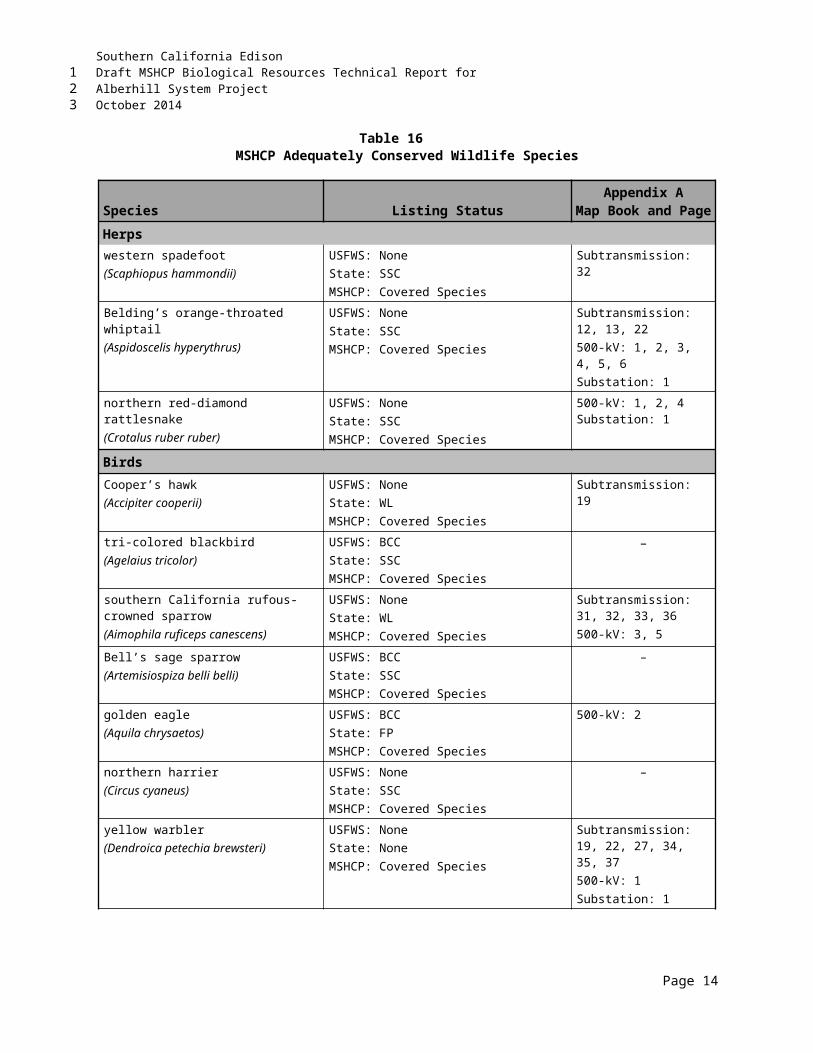
Southern California EdisonDraft MSHCP Biological Resources Technical Report forAlberhill System ProjectOctober 2014
Oak titmouse was documented in the Alberhill Project area near oak woodlands and riparian areas. Oak titmouse is not covered by the MSHCP. Impacts to oak titmouse would be considered less than significant with the implementation of minimization and avoidance measures proposed in Sections 6.2.6.1 and 6.2.6.6.
Marsh wren was documented within the Alberhill Project area near marsh habitats. Marsh wren is not covered by the MSHCP. Impacts to marsh wren would be considered less than significant with the implementation of minimization and avoidance measures proposed in Sections 6.2.6.1 and 6.2.6.6.
Nuttall’s woodpecker was documented within the Alberhill Project area near woodland habitats. Nuttall’s woodpecker is not covered by the MSHCP. Impacts to Nuttall’s woodpecker would be considered less than significant with the implementation of minimization and avoidance measures proposed in Sections 6.2.6.1 and 6.2.6.6.
6.2.6.6 Migratory Bird Species
Project construction may temporarily affect the movement of migratory bird species and their breeding success. Their active nests may be directly or indirectly impacted such that nest abandonment resulting in death of eggs or young occurs. Disturbance from construction activities, such as noise, human presence, and habitat alteration due to the trimming of trees and clearing of native vegetation, could affect the nesting habits of the special status and migratory bird species. However, these impacts would not be considered significant with the implementation of avoidance and minimization measures described in Section 8.0, including BIO-APM 1, BIO-APM 3, BIO-APM 5, BIO-APM 7, BIO-APM 8, BIO-APM 9, BIO-APM 10, NOISE-APM 1, MM BIO 1-e, MM BIO-1h, and MM NOISE-1a.
Generally, both blasting and helicopter use would occur outside the nesting season (February 15 through September 1). APMs and MMs allow for construction to either be limited to outside the nesting seasons for special status and migratory birds, or require that exclusion zones be established by a qualified biologist around occupied nests during the nesting season or around other species that could be affected by these activities.
SCE will conduct project-wide raptor nest surveys to identify the locations of active nesting behavior prior to construction. This will reduce the potential for significant breeding impacts on birds covered by the MBTA. The locations identified and mapped during the surveys will be considered in scheduling construction work times and locations. Should SCE need to remove an inactive nest for the purposes of safety of the raptor, they will consult with CDFW before taking any action.
If other active nests are found, a biological monitor with expertise in bird behavior would establish a species-specific buffer around the nest and no activities would be allowed within the buffer until the young have fledged from the nest or the nest fails. A project-specific NBMS will be prepared to establish buffers based on, but not limited to, the following: the bird species (some species are more tolerant of disturbance while other are less tolerant), location of nest building and active nests, threshold for nesting disturbance taking into account bird behavior (including signs of agitation), continuous focused nest monitoring by qualified biologists, background noise, type of construction activity, and dust emissions and noise levels from construction.
Buffers would be adjusted based on no exceedance of an established threshold of behavioral agitation and other signs indicating disruption of nesting behavior. Buffers may be increased or decreased based on the opinion of the biologist with expertise in bird behavior to ensure that impacts to nesting birds would
Page 22
123
1234
567
891011
12
1314151617181920
2122232425
2627282930
3132333435363738
394041
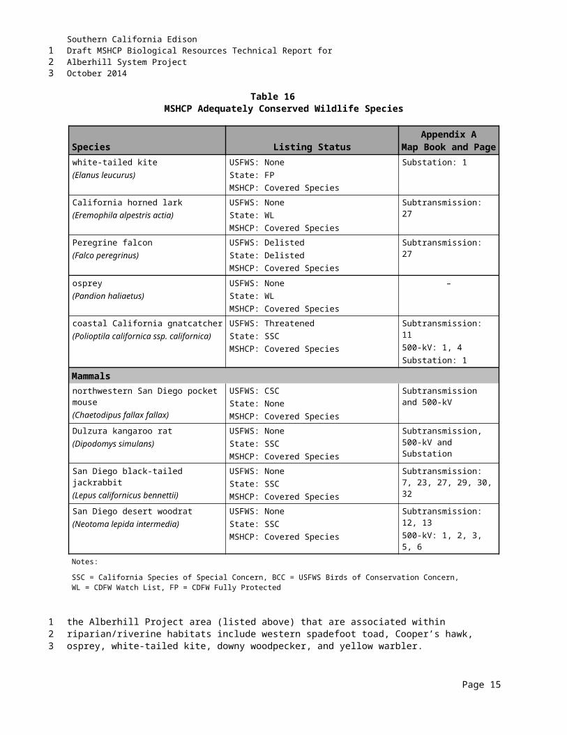
Southern California EdisonDraft MSHCP Biological Resources Technical Report forAlberhill System ProjectOctober 2014
not occur. The NBMS establishes a communication and reporting protocol involving SCE; biological monitors; and CPUC, CDFW, and USFWS. The NBMS is subject to the approval of CDFW (pursuant to the CFGC) and USFWS (pursuant to the MBTA).
Implementation of the avoidance and minimization measures as described would ensure that impacts to migratory bird species would be less than significant.
6.2.7 Wildlife Movement
Increases in noise, construction traffic, and human activities during construction activities may temporarily deter movement of wildlife within the Alberhill Project vicinity. Impacts to wildlife species are considered significant if they interfere substantially with the movement of any native resident or migratory fish or wildlife species or with established native resident or migratory wildlife corridors, or impede the use of native wildlife nursery sites. Indirect, adverse, substantial effects on movement of wildlife, or impediments to the use of wildlife corridors or nursery sites are not expected from construction or operational activities of the Alberhill Project.
As with any project during construction, there is a possibility that sensitive species, including those Adequately Conserved or those with additional mitigation requirements, could be encountered if they move into or adjacent to the Project site. However, for the 145 MSHCP-covered species, once an MSHCP Certificate of Inclusion is issued, other than BUOW, no additional mitigation is required for those species considered covered by the MSHCP that appear after the MSHCP PSE process is complete.
Construction of a retaining wall may be needed to ensure slope stabilization near one or more of the 500-kV towers. Should it be determined during final engineering that a retaining wall(s) is necessary; walls will be sited, designed, and oriented to minimize impacts to movement of native resident wildlife species and established wildlife corridors, in coordination with RCA, USFWS, and CDFW. Implementation of avoidance and minimization measures described in Section 8.0, including BIO-APM 1, BIO-APM 3, BIO-APM 5, BIO-APM 8, BIO-APM 10, BIO-APM 17, NOISE-APM 1, and MM NOISE-1a, would ensure that impacts to wildlife movement would be less than significant.
6.2.8 Indirect Impacts
It is anticipated that some indirect impacts will result from the Alberhill Project and its proximity to sensitive habitat and sensitive species. Potential indirect impacts include increased noise, human activity, and light levels as described below. For each of the indirect impacts described below, an action(s) or measure(s) is described to ensure that these potential indirect impacts can be maintained at less than significant levels.
6.2.8.1 Runoff, Erosion, and Siltation
Siltation and erosion resulting from the proposed activities are potentially significant indirect impacts associated with the Alberhill Project because of the proximity of the proposed work area to wetlands and other sensitive habitats. Surface water quality could be diminished as a result of (1) excavation due to installation of poles and guard structures; (2) scraping and grading, and material laydown at stringing sites/laydown areas; (3) constructing culverts in ephemeral creeks; and (4) grading to construct new access roads. As such, erosion from these activities can remove topsoil necessary for plant growth both in the graded areas and in lower areas affected by increased runoff. The eroded soil can be deposited as silt and alluvium in the drainages. Siltation from these activities can damage wetlands and aquatic habitats and bury vegetation or topsoil. Implementation of avoidance and minimization measures
Page 23
123
123
45
6
78910111213
1415161718
19202122232425
26
2728293031
32
333435363738394041

Southern California EdisonDraft MSHCP Biological Resources Technical Report forAlberhill System ProjectOctober 2014
described in Section 8.0, including BIO-APM 2, BIO-APM 6, BIO-APM 7, BIO-APM 8, BIO-APM 10, BIO-APM 17, NOISE-APM-1, MM NOISE-1a, HYDRO-APM 1, HYDRO-APM 3, HYDRO-APM 4, MM BIO1a [Item c], MM BIO-2a, MM Bio-2b, MM BIO-4a, MM GEO-2a, MM HYD-5a, MM HYD-7a, MSHCP BMP-7, MSHCP CONST-1, MSHCP CONST-2, MSHCP CONST-3, MSHCP CONST-4, MSHCP CONST-5, MSHCP CONST-6, and MSHCP CONST-7. These measures include the use of qualified biologists for monitoring construction activities, minimizing project footprints, and implementation of an effective SWPPP that employs appropriate BMPs to avoid or limit runoff, erosion, and siltation. With these measures, Project-related runoff, erosion, and siltation impacts would be considered less than significant.
6.2.8.2 Nonnative Weed Establishment
The loss of topsoil from grading or as a result of overland flow may increase the likelihood of exotic plant establishment in native communities. Nonnatives may out-compete native species, suppress native recruitment, alter community structure, degrade or eliminate habitat for native wildlife, and provide food and cover for undesirable nonnative wildlife. The introduction of nonnative plant species into a community as a result of soil disturbance and erosion can increase the competition for resources such as water, minerals, and nutrients between native and nonnative species as well as alter the hydrology and sedimentation rates. In addition, if the nonnative plants form a continuous ground cover, an increase in the natural fire regime may occur, further eliminating any remaining native vegetation, and causing a type conversion to a disturbed/nonnative habitat type. The establishment of nonnative weeds could affect endangered species associated with the surrounding habitat and could therefore be considered potentially significant if not mitigated. Implementation of avoidance and minimization measures described in Section 8.0, including BIO-APM 1, MM BIO-1c, and MSHCP BMP-12, will reduce potential impacts from Project-related impacts due to nonnative species. These measures include the use of a qualified biologist for training, avoiding introduction and/or spread of invasive plant species, and the removal exotic species that displace target sensitive plant species.
6.2.8.3 Noise and Human Presence
Indirect and temporary impacts to wildlife movement due to construction noise, including presence of humans, would be expected during construction of the Alberhill Project. Noise can adversely affect wildlife by frightening or repelling individuals, masking communication, and impairing foraging success and predator detection. These effects are significant when they adversely affect the lifecycle of sensitive species, or constrain wildlife movement through a wildlife corridor; however, these impacts would not be considered significant if the activities were temporary in nature and of short duration.
Construction noise has the potential to impact the lifecycle of sensitive wildlife species known to occur within the Alberhill Project vicinity or that have a high potential to occur on-site. Generally, for this project, noise would have the most impact to avian species, including sage scrub nesters such as the CAGN, Bell's sage sparrow, and southern California rufous-crowned sparrow or riparian-nesting birds such as the yellow warbler, yellow-breasted chat, LBV, and SWFL. If construction were to occur outside the breeding season for these species, noise impacts would not be considered significant. Indirect noise impacts to other nesting migratory birds, including raptors, if present, could be adverse but not necessarily significant because of the lower sensitivity status of these species. Implementation of the Alberhill Project is not expected to have a substantial indirect effect on special-status biological resources from increased noise and human presence; however, implementation of avoidance and minimization measures described in Section 8.0, including BIO-APM 1, BIO-APM 8, BIO-APM 14, NOISE-APM 1, and MM NOISE 1a, will reduce potential impacts from excess levels of noise and human presence. With these practices in
Page 24
123
12345678
9
101112131415161718192021222324
25
262728293031
323334353637383940414243
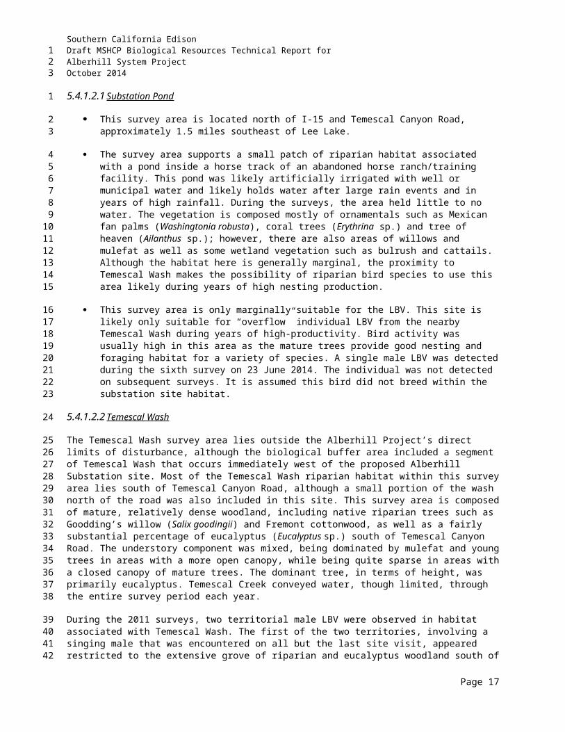
Southern California EdisonDraft MSHCP Biological Resources Technical Report forAlberhill System ProjectOctober 2014
places, noise and human presence from construction activities would not be an adverse significant impact.
Further, helicopter use and blasting activities could temporarily impact special status wildlife. Helicopters would generally be used to transport materials and crewmembers, to support conductor-stringing operations, and to transport and install poles in areas where the terrain would require extensive grading to allow access by conventional equipment. In areas where conventional construction equipment cannot excavate due to the presence of rock, SCE would use blasting or fracturing to facilitate excavation. Blasting may occur during the construction of new access roads, site preparation, and excavation/foundation work activities. If blasting occurs in the proximity of nesting birds, increased noise levels could affect nesting behavior. SCE anticipates that blasting would be necessary only in a limited area, but this is subject to change and is partially dependent on results of the geotechnical investigation.
6.2.8.4 Lighting
If used during night construction, lighting entering adjacent wildlife habitat could temporarily impact sensitive wildlife species and movement of nocturnal species. These temporary impacts would likely be considered adverse but not significant. These impacts could be avoided if night work did not occur during construction of the Alberhill Project near sensitive areas or where nocturnal species could be affected. However, if required in or adjacent to the wildlife habitats, pre-construction surveys and daily biological sweeps would provide additional information to determine if any wildlife species are present that could be affected by night work. Further, should night work be necessary, lighting would be temporary, shielded, and directed away from the adjacent wildlife areas as needed.
The proposed substation would have access and maintenance lighting. The access lighting would be low-intensity and controlled by a photoelectric sensor. Maintenance lights would be controlled by a manual switch and would normally be in the “off” position. Maintenance lights would be used only when required for maintenance outages or emergency repairs occurring at night. The lights would be located in the switchracks, around the transformer banks, and in areas of the substation where maintenance activity may take place and would be directed downward and shielded to reduce glare outside the facility.
6.2.8.5 Toxic Substances
Toxic substances can kill wildlife and plants or prevent new growth where soils or water are contaminated. Toxic substances can be released into the environment through several scenarios including planned or accidental releases, leaching from stored materials, pesticide or herbicide use, or fires, among others. No intentional releases of toxic substances are planned as part of the Alberhill Project. Accidental releases could occur from several sources such as leaking equipment or fuel spills during the course of the construction. The implementation of BMPs during construction will reduce the risk of leaks and fuel spills below a level of significance. A spill contingency plan, written by the construction contractor and approved prior to construction, will be in effect during all phases of construction activities.
6.2.8.6 Fugitive Dust
Trenching, grading, and vehicle operations associated with the construction of the Alberhill Project may produce fugitive dust. Excessive dust can damage or degrade vegetation by blocking leaf exposure to sunlight. Implementation of dust control measures, as part of BMPs during construction, will reduce fugitive dust emissions to below a level of significance. Dust control measures can include spraying work or driving areas with water and careful operation of equipment.
Page 25
123
12
34567891011
12
1314151617181920
212223242526
27
2829303132333435
36
3738394041
Southern California EdisonDraft MSHCP Biological Resources Technical Report forAlberhill System ProjectOctober 2014
6.2.8.7 Wildlife Entrapment
During construction open holes, trenches or excavations may entrap wildlife (e.g., reptiles and small mammals). Fencing will be maintained around covered holes, trenches, and excavations at night. A qualified biologist will clear open holes, trenches, and excavated areas for wildlife at the end of each day (prior to covering) and again prior to resuming work the following day.
The proposed v-ditches and channels to be constructed as part of the proposed Alberhill Substation (Section 1.2.1.4, Substation Drainage) have the potential to intercept and disrupt movement of small terrestrial animals (mammals, reptiles, and amphibians). Project channels and v-ditches have been designed with sloped sides, 1:1 (45 degrees)-2:1 (26.6 degrees), so wildlife intercepted by these drainage features have the ability to exit. If necessary, the concrete sloped walls of the v-ditches and channels can be textured to further allow wildlife egress. In addition, SCE will consult with the County of Riverside prior to finalizing the substation drainage design.
6.2.9 Cumulative Impacts
The following is a discussion of potential cumulative impacts resulting from the Alberhill Project:
Riverside County is expected to experience a dramatic increase in residential and commercial development over the next 20 years. Such development will involve many large-scale construction projects, which may encroach on biological resources, potentially impacting sensitive communities, special status species, and biological diversity.
For the purpose of this analysis, the geographic scope will comprise the habitat areas directly and indirectly affected by the construction and operation of the Alberhill Project. The Alberhill Project passes through various sensitive habitats, impacting both wildlife and vegetation. Urbanization and development in the area impact the ability of certain plant and animal species to forage, breed, and develop in their natural habitat. A cumulative impact would occur if the Alberhill Project substantially contributed to the cumulative degradation of biological resources caused by recent, current, and planned development.
The Alberhill Project is located within the coverage area of the MSHCP. This conservation planning effort with the overall goal of maintaining biological diversity in rapidly urbanizing areas provides a Conservation Area for 146 special status species, requiring incidental take permits for projects impacting these species. The Alberhill Project would contribute to significant cumulative impacts to biological resources if it violated a conservation plan such as the MSHCP. MM BIO-5a of the FEIR (refer to Section 8.0) requires that the Alberhill Project comply with all MSHCP regulations, including but not limited to the payment of relevant fees, compliance with acquisition processes, and compliance with policies protecting various plants and animals. In following all the regulations set forth by the MSHCP, the Alberhill Project would not substantially contribute to cumulative impacts to biological resources in violation of conservation plans.
Construction and operation of the Alberhill Project can potentially result in the permanent loss of, or temporary disturbance to, sensitive plant and wildlife communities through grading, drilling, clearing brush, or other construction and maintenance activities. To protect sensitive biological resources, MM BIO-1a (refer to Section 8.0) requires that a botanist precede construction crews and mark sensitive areas so that the areas might be avoided by construction crews and protected from construction activities. The same measures will be taken to protect special status plant species, special status terrestrial species, and the BUOW as required by MMs BIO-1e, -1f, and -1b,
Page 26
123
1
2345
6789101112
13
14
15161718
19202122232425
26272829303132333435
36373839404142
Southern California EdisonDraft MSHCP Biological Resources Technical Report forAlberhill System ProjectOctober 2014
respectively (refer to Section 8.0). Monitoring of these areas will continue for a year following the completion of the Alberhill Project. Should any significant impacts occur, the MMs include provisions for relocation of disturbed species and reintroduction of impacted species. Construction activities may also impact avian species by disturbing active nests, trimming trees, or removing vegetation. MM BIO-1d mandates that construction activities either be limited to nonbreeding season or a certified wildlife botanist conduct a pre-construction focused nesting survey. Additionally, construction noise may impact both migratory and nesting birds; MM BIO-1h regulates ambient noise levels to minimize the impact to birds nesting within or passing through construction areas. With the implementation of MMs BIO-1a through 1f, construction of the Alberhill Project would not substantially contribute, either directly or through habitat modification, to adverse cumulative effects on candidate, sensitive, or special status species (refer to Section 8.0).
Construction of the Alberhill Project will result in permanent and temporary disturbance to riparian/riverine areas through grading and clearing vegetation, exposing topsoil to weathering, impacting drainage, and impeding plant growth. In a rapidly developing area, these impacts would contribute to the cumulative degradation of these habitats. MM BIO-2a minimizes the impact of construction and operation of the Alberhill Project on wetlands by avoiding sensitive areas and requiring the restoration of temporarily disturbed areas. Additional conditions and minimization measures may be applied to the Alberhill Project during permit acquisition from USACE, RWQCB, and CDFW. The applicant will minimize the effects of erosion and the hydrologic impacts through such measures as the installation of sediment control structures and the use of water bars, silt fences, stalked straw bales, and mulching in disturbed areas. By avoiding wetlands and riparian habitats where possible and employing prevention and preservation measures when necessary, the Alberhill Project will not substantially contribute to the cumulative damage to these habitats.
The Alberhill Project falls under the jurisdiction of local policies and ordinances regarding trees. To install poles, the Alberhill Project requires the construction of access roads and the removal of vegetation at construction sites, permanently and directly damaging trees. The DEIR requires the applicant to adopt MM BIO-4a and obtain a permit for removal prior to construction. By complying with the permit process, the Alberhill Project will not significantly contribute to the cumulative impact on local tree populations.
Composite development has the potential to interfere with the movement of migratory animals by physically interfering with the migratory corridor. New roadways, construction activities, and introduced structures can act as barriers to migration. The Alberhill Project would require the installation of roadways for maintenance purposes. These roadways would be infrequently used and therefore would not interfere significantly in migration patterns. Construction activities could potentially impact migration patterns but are considered temporary. Given the distribution of the structures and the low volume of traffic required to maintain the Alberhill Project, the Alberhill Project would not significantly contribute to cumulative obstacles to migratory wildlife.
Page 27
123
1234567891011
121314151617181920212223
242526272829
3031323334353637
Southern California EdisonDraft MSHCP Biological Resources Technical Report forAlberhill System ProjectOctober 2014
THIS PAGE INTENTIONALLY LEFT BLANK
Page 28
123
Southern California EdisonDraft MSHCP Biological Resources Technical Report forAlberhill System ProjectOctober 2014
7.0 MSHCP CONSISTENCY DETERMINATIONThis section evaluates the consistency of the Alberhill Project with the MSHCP.
The Alberhill Project must comply with the following MSHCP requirements:
Project Consistency with MSHCP Reserve Assembly (MSHCP Section 3.2.3 and Section 3.3)
Guidelines for facilities within the PQP Lands (MSHCP Section 7.5).
Species Associated with Riparian/Riverine Areas and Vernal Pool guidelines (MSHCP Section 6.1.2)
Narrow Endemic Plant Species guidelines (MSHCP Section 6.1.3)
Additional Survey Needs and Procedures (MSHCP Section 6.3.2)
Requirements To Be Met For 28 Species Prior To Including Those Species On The List Of Covered Species Adequately Conserved (MSHCP Table 9-3)
Urban Wildlands Interface Guidelines (MSHCP Section 6.1.4)
Riversidian Sage Scrub Removal
Riversidian Alluvial Fan Scrub Removal
Migratory Bird Treaty Act Compliance.
7.1 PROJECT CONSISTENCY WITH MSHCP AREA PLANSThe Alberhill Project area passes through criteria areas/cells in two area plans: Temescal Canyon and Elsinore (Appendix C). Reserve assembly goals and project relationship for each of these areas are presented in Section 2.1.1 of this report.
7.1.1 Elsinore Area Plan – Subunit 1: Estelle Mountain/Indian Canyon
The Alberhill Project area traverses through the Estelle Mountain/Indian Canyon Subunit (Subunit 1) of the Elsinore Area Plan. Several of the specific target planning species (refer to Section 2.1.1.1) within this subunit were identified during biological surveys conducted for the Alberhill Project. The Alberhill Project will not impede the conservation goals and biological considerations that have been developed for this subunit.
Within this subunit, the Alberhill Project is adjacent to busy I-15. The highway and the development along it are the major obstacles to reserve assembly in this area. Overhead power lines and associated poles will not impede cores and linkages proposed for this subunit. The effect of Alberhill Project implementation here will be negligible, at worst removing minimal amounts of roadside habitat for pole footprints and access.
Page 1
123
1
2
3
4
5
67
8
9
1011
12
13
14
15
16
171819
20
2122232425
2627282930
Southern California EdisonDraft MSHCP Biological Resources Technical Report forAlberhill System ProjectOctober 2014
7.1.2 Elsinore Area Plan – Subunit 2: Alberhill
The Alberhill Project area traverses through the Alberhill Subunit (Subunit 2) of the Elsinore Area Plan. Several of the specific target planning species (refer to Section 2.1.1.2) within this subunit were identified during biological surveys conducted for the Alberhill Project. The Alberhill Project will not impede the conservation goals and biological considerations that have been developed for this subunit.
Within this subunit, the Alberhill Project is adjacent to busy I-15. The highway and the development along it are the major obstacles to reserve assembly in this area. Overhead power lines and associated poles will not impede cores and linkages proposed for this subunit. The effect of Alberhill Project implementation here will be negligible, at worst removing minimal amounts of roadside habitat for pole footprints and access.
7.1.3 Elsinore Area Plan – Subunit 3: Elsinore
The Alberhill Project area traverses the Elsinore Subunit (Subunit 3) of the Elsinore Area Plan. Several of the specific target planning species (refer to Section 2.1.1.3) within this subunit were identified during biological surveys conducted for the Alberhill Project. The Alberhill Project will not impede the conservation goals and biological considerations that have been developed for this subunit.
Within this subunit, the Alberhill Project is adjacent to busy I-15. The highway and the development along it are the major obstacles to reserve assembly in this area. Overhead power lines and associated poles will not impede cores and linkages proposed for this subunit. The effect of Alberhill Project implementation here will be negligible, at worst removing minimal amounts of roadside habitat for pole footprints and access.
7.1.4 Elsinore Area Plan – Subunit 4: Sedco Hills
The Alberhill Project area traverses the Sedco Hills Subunit (Subunit 4) of the Elsinore Area Plan. Several of the specific target planning species (refer to Section 2.1.1.4) within this subunit were identified during biological surveys conducted for the Alberhill Project. The Alberhill Project will not impede the conservation goals and biological considerations that have been developed for this subunit.
Within this subunit, the Alberhill Project is adjacent to busy Bundy Canyon Road. The road and the development along it are the major obstacles to reserve assembly in this area. Overhead power lines and associated poles will not impede cores and linkages proposed for this subunit. The effect of Alberhill Project implementation here will be negligible, at worst removing minimal amounts of roadside habitat for pole footprints and access.
7.1.5 Temescal Canyon Area Plan Subunit 3: Temescal Wash West
A laydown yard is proposed within the Temescal Wash West Subunit (Subunit 3) of the Temescal Canyon Area Plan. The Alberhill Project will not impede the conservation goals and biological considerations that have been developed for this subunit. Within this subunit, the Alberhill Project is adjacent to the busy I-15. The highway and the development along it are the major obstacles to reserve assembly in this area. Overhead power lines and associated poles will not impede cores and linkages proposed for this subunit. The effect of Alberhill Project implementation here will be negligible, at worst involving the temporary use of already disturbed habitat for material and equipment storage and access. In addition, impacts to Temescal Wash will be avoided to the greatest extent possible.
Page 2
123
1
2345
678910
11
12131415
1617181920
21
22232425
2627282930
31
3233343536373839
Southern California EdisonDraft MSHCP Biological Resources Technical Report forAlberhill System ProjectOctober 2014
7.1.6 Sun City/Menifee Area Plan
The eastern portion of the Alberhill Project alignment traverses the Sun City/Menifee Area Plan; however, the Alberhill Project area is not included in subunits or criteria cells within this plan area (Appendix C). Based on the overhead nature of the Alberhill Project in this area, no impact will occur to this area plan.
7.2 PROJECT CONSISTENCY WITH CORES AND LINKAGES WITHIN THE CONSERVATION AREA
MSHCP Conservation Area is composed of a variety of existing and proposed cores, extensions of existing cores, linkages, constrained linkages, and noncontiguous habitat blocks. These features are generally referenced as cores and linkages. The proposed Alberhill Substation is not within MSHCP Conservation Area; however, one of the associated laydown yards falls within Proposed Extension of Existing Core 2. Proposed work areas associated with the 500-kV alignment are located in existing Core C and Proposed Core 1. Portions of the 115-kV alignment are located in Proposed Core 1, Proposed Linkages 2 and 8, and Proposed Constrained Linkage 6. Based on the nature of the Alberhill Project being primarily overhead in the areas where the notable proposed linkages and cores are located, no impact will occur to the proposed cores and linkages within the Alberhill Project area as identified in Section 8.0 of this report. As such, the Alberhill Project is consistent with the Reserve Assembly requirements of the MSHCP.
7.3 PUBLIC/QUASI-PUBLIC LANDSThe MSHCP acknowledges that future facilities are necessary to support planned development (refer to MSHCP Section 7.3.9). Future facilities that are carried out by a PSE and/or Third Parties Granted Take Authorization will be considered “covered activities” under the MSHCP. Future facilities, including electrical facilities such as the Alberhill Project, are permitted within existing PQP lands provided the applicant proposes equivalent replacement land to offset impacts to the PQP land and to the MSHCP resources.
The Alberhill Project crosses SKR Core Reserve, which is part of the PQP system (see Section 1.2.2.8 for project description). A small portion of the existing 500-kV alignment is included in the Lake Mathews/Estelle Mountain Reserve, but all impacts would be only temporary. Further, USFWS and CDFW have provided concurrence that SCE should be able to access their existing facilities within SKR Core Reserve.
7.4 ADDITIONAL RESERVE LANDSCurrently, three Alberhill Project areas are located within an MSHCP Conservation Area. One area is adjacent to proposed 500-kV transmission line tower R14X, where temporary work areas and tower access will be located. As part of the construction of 500-kV transmission line tower R14X, the Alberhill Project will potentially temporarily impact approximately 2.18 acres and permanently impact approximately 0.03 acre of ARL. Two areas of an existing SCE line (Fogarty-Ivyglen) are within the VIG Phase 2 overlap area that occurs on ARL: one area north of and parallel to Nichols Road, and another area west of and parallel to Lake Street. The VIG Phase 2 Project will potentially temporarily impact approximately 3.47 acres and permanently impact approximately 1.53 acres of ARL.
Temporary impacts to ARL will be restored to the greatest extent practicable using vegetation and plant species present prior to disturbance. Further, SCE will ensure that the Alberhill Project does not result in changes in hydrology or water quality, and will recontour affected areas as needed.
Page 3
123
1
234
56
7891011121314151617
18
192021222324
2526272829
30
3132333435363738
394041
Southern California EdisonDraft MSHCP Biological Resources Technical Report forAlberhill System ProjectOctober 2014
To address permanent impacts, SCE will dedicate biologically equivalent or superior replacement land to the MSHCP Conservation Area. To determine the equivalent or superior nature of the replacement land, SCE will prepare an ARL equivalency analysis to be included as part of the MSHCP PSE application submittal. This equivalency analysis will compare the potential effects on the ARL to the benefits of proposed replacement land being dedicated to the MSHCP Conservation Area, including ensuring compensation for potentially lost conservation functions and values. The analysis will consider specific Alberhill Project design features, siting and design, and MSHCP BMPs, as well as address effects on covered species and habitats, core areas, linkages, constrained linkages, MSHCP Conservation Area configuration and management, and ecotones. The replacement land ratio is anticipated to be not less than 3:1 within MSHCP Core 1; but the ratio and any additional mitigation requirements will ultimately be determined through the MSHCP consistency review and findings made by RCA, with review and concurrence by USFWS and CDFW. The Alberhill Project is required to demonstrate consistency with the MSHCP before it can be granted PSE status. As such, the ARL replacement land (equivalency analysis) proposal is also required to be consistent with the MSHCP.
Construction of the VIG Phase 2 Project will occur in the overlap area prior to construction of the Alberhill Project. The VIG Phase 2 Project will propose equivalent or superior replacement land to offset potential impacts to ARL in these two areas and demonstrate that there will be no impacts to the functions and values of the ARL nor will it impede any of the goals and objectives of the MSHCP. The Alberhill Project will only be adding another line to the poles installed by the VIG Phase 2 Project and will therefore remain within the same disturbance footprint as the one approved for the VIG Phase 2 Project. For the separate impacts at tower R14X, the Alberhill Project will follow the same process as the VIG Phase 2 Project by proposing equivalent or superior replacement land as described above.
7.5 MSHCP SECTION 6.1.2 – PROTECTION OF SPECIES ASSOCIATED WITH RIPARIAN/RIVERINE AND VERNAL POOL RESOURCES
As described in Section 2 of this report, MSHCP Section 6.1.2 requires that all Vernal Pool, Riverine, and Riparian habitat must be mapped, documented, and avoided. If habitat avoidance is not practical, species surveys must be completed to assess the presence or absence of Covered species within these habitat areas (refer to Table 11 for list of species surveys). Avoided habitats, or the demonstrated lack of species presence within surveyed suitable habitats, will constitute consistency with the MSHCP. Unavoidable take of vernal pool, riverine, or riparian Covered species will be permitted under the MSHCP only through Wildlife Agency approval of a DBESP as stated in Section 6.11 of the MSHCP.
7.5.1 Temporary Impacts to Riparian Areas
Temporary impacts to riparian areas would result from working within or in proximity to riparian features and include approximately 0.19 acre.
7.5.1.1 115 kV Transmission Line Work Areas
Trimming of branches in order to access pole locations, stringing setup sites, and pulling/tensioning locations (area south of proposed Alberhill Substation [ASP-14] [southern willow scrub] and Bundy Canyon Road west of Edwards Road [ASP-3] [south coast live oak riparian]) would result in approximately 0.10 acre of temporary impact. These areas would be impacted only temporarily, since they would be trimmed only once for construction access.
Page 4
123
1234567891011121314
1516171819202122
2324
25262728293031
32
3334
35
3637383940
Southern California EdisonDraft MSHCP Biological Resources Technical Report forAlberhill System ProjectOctober 2014
7.5.1.2 500 kV Transmission Line Roads
Access road construction associated with 500-kV tower R13 [ASP-8] would result in approximately 0.09 acre of temporary impacts to riparian (southern riparian woodland) and wetland (disturbed wetland) vegetation.
7.5.2 Temporary Impacts to Riverine Areas
Temporary impacts to riverine areas would result from working within or in proximity to riverine features and include approximately 1.49 acres of temporary impacts.
7.5.2.1 115 kV Transmission Line Work Areas
The use of temporary work areas within six 115 kV transmission line project areas (area south of proposed Alberhill Substation [ASP-14]; Auto Center Drive, at the San Jacinto River crossing [ASP-6]; Bundy Canyon Road, west of Edwards Road [ASP-3]; Camino Del Norte, northeast of I-15 crossing [ASP-7]; Lost Road, at Gafford Road [ASP-4]; and west side of Murrieta Road, between Melido Street and Wickerd Road [ASP-1]) would result in approximately 0.57 acre of temporary impact.
7.5.2.2 Staging Yards
The use of three proposed laydown yards (BP-1 [ASP-9], ST-3 [ASP-5], and ST-4[ASP-2]) would result in approximately 0.71 acre of temporary impact.
7.5.2.3 500 kV Roads
Grading associated with new road construction in riverine areas would result in approximately 0.03 acre of temporary impact (associated with R13 access road culvert construction [ASP-8]). The use of temporary work areas, including proposed access to R7 and R8 via existing Black Powder Road (ASP-12) would result in less than approximately 0.01 acre of temporary impact.
7.5.2.4 500 kV Towers
Grading associated with the construction of a 500-kV tower (R5) (ASP-11) in riverine areas would result in approximately 0.03 acre of temporary impact. Grading associated with the construction of a new 500-kV tower (R8) access road (ASP-10) in riverine areas would result in approximately 0.14 acre of temporary impact.
Temporarily impacted riparian/riverine areas will be restored to pre-construction conditions upon completion of the Alberhill Project. On-site restoration would involve hydroseeding with native seed mixture similar to what is in place in adjacent areas, establishing temporary erosion controls, and monitoring of those revegetated areas for 3 years6 post-construction, or until successful revegetation by native species is confirmed by a qualified biologist.
7.5.3 Permanent Impacts to Riparian Areas
Permanent impacts to Riparian areas would result from the construction of one culvert crossing and grading and include approximately 0.76 acre of permanent impacts.
6 The 3-year post-construction monitoring requirement for on-site restoration of impacts to regulated waters and associated vegetation is a typical requirement in 1602 Streambed Alteration Agreements issued by CDFW.
Page 5
123
1
234
5
67
8
910111213
14
1516
17
18192021
22
23242526
2728293031
32
3334
45

Southern California EdisonDraft MSHCP Biological Resources Technical Report forAlberhill System ProjectOctober 2014
7.5.3.1 500-kV Roads
The construction of a culvert associated with the 500-kV tower (R13) access road (ASP-8) would result in approximately 0.05 acre (jurisdictional under CDFW), including approximately 0.02 acre (jurisdictional under USACE) of permanent impacts to Riparian areas.
7.5.3.2 Substation
Grading activities associated with the construction of the proposed Alberhill Substation (ASP-13) would result in approximately 0.71 acre (jurisdictional under CDFW), including 0.28 acre (jurisdictional under USACE) of permanent impacts to Riparian areas.
7.5.4 Permanent Impacts to Riverine Areas
Permanent impacts to riverine areas would result from grading and LWS pole construction and include an approximate total 0.10 acre of permanent impact.
7.5.4.1 115 kV Transmission Line
Installation of three LWS poles (west side of Murrieta Road, between Melido Street and Wickerd Road [ASP-1]) within riverine areas would result in less than approximately 0.01 acre (jurisdictional under CDFW) of permanent impact.
7.5.4.2 500 kV Transmission Line Roads
Grading associated with new road construction (R13 access road culvert crossing at a small ephemeral drainage [ASP-8]) in riverine areas would result in approximately 0.03 acre (jurisdictional under CDFW), including 0.02 acre (jurisdictional under USACE), of permanent impact.
7.5.4.3 500 kV Transmission Line Tower
Grading associated with the construction of a 500-kV tower (R5) (ASP-11) in riverine areas would result in approximately 0.06 acre (jurisdictional under RWQCB) of permanent impact.
Permanent impacts due to construction of culverted crossings in riparian/riverine areas (0.08 acre) will not disturb the existing functions of the drainage to pass freshwater during storm events. Permanent impact to riparian areas due to hand trimming of trees for power line clearance would not adversely affect the functions and values of the habitat. In coordination with the resource agencies, mitigation for permanent impacts will likely involve purchase of land that encompasses riparian/riverine resources along the Temescal Wash area at an expected ratio of 3:1. It is anticipated that this land will be dedicated for conservation by donation to the RCRCD for restoration and management.
Although an effort has been made to avoid sensitive habitats within the Alberhill Project area, any unavoidable impacts would be mitigated in accordance with the provisions set forth by MSHCP Section 6.1.2, and/or where associated with regulated waters through USACE, CDFW, and RWQCB permitting requirements. In addition, per Section 6.1.2 of the MSHCP, a DBESP must be prepared to ensure that all impacts to riparian/riverine habitats and their associated species have been fully addressed. The DBESP must demonstrate that if these resources cannot be avoided by 90 percent, the functions and values of these sensitive habitats will be replaced equivalent or superior to these resources existing prior to the Project. The DBESP will be prepared as part of the MSHCP PSE application submittal.
Page 6
123
1
234
5
678
9
1011
12
131415
16
171819
20
2122
23242526272829
3031323334353637
Southern California EdisonDraft MSHCP Biological Resources Technical Report forAlberhill System ProjectOctober 2014
Trimming of tree tops for construction, particularly when being done outside the LBV breeding season, will not result in permanent or temporary loss of habitat functions and values.
The Alberhill Project was designed to avoid vernal pools (disturbed and higher quality) in the Alberhill Project area, and no permanent or temporary impacts will occur to their functions or values.
Per Section 6.1.2 of the MSHCP, if an avoidance alternative is not feasible and a practicable alternative is instead selected as set forth above, a DBESP shall be prepared and submitted by the Permittee to ensure replacement of any lost functions and values of habitat as it relates to Covered species. As such, the Alberhill Project is consistent with MSHCP Section 6.1.2.
Surveys were conducted within all suitable riparian/riverine and vernal pool habitat areas of the Alberhill Project for species presented in Section 6.1.2 of the MSHCP (refer to Table 11 for list of species surveys) that have potential to occur within the Alberhill Project area. As such, focused surveys were conducted for the following species
LBV SWFL western yellow-billed cuckoo Riverside fairy shrimp Santa Rosa Plateau fairy shrimp
vernal pool fairy shrimp
Several occupied breeding LBV territories have been identified within the Alberhill Project study area: Within Temescal Wash, west and south of the proposed Alberhill Substation and South of Collier Avenue (between Nichols Road and State Route 74), north of Auto Center Drive at the San Jacinto River crossing, and within an area west of Mission Trail in the vicinity of Vine Street (Map 7, Appendix A). No impacts are anticipated within this area as a result of Alberhill Project implementation. Potential indirect impacts could occur as described in Section 6.2.6.2 of this report; however, these impacts would be considered insignificant with the implementation of minimization and avoidance measures presented in Section 8.0 for the protection of this species. As such, the Alberhill Project is consistent with MSHCP Section 6.1.2.
The Alberhill Project was designed to avoid vernal pools (disturbed and higher quality) in the Alberhill Project area, and no permanent or temporary impacts will occur to their functions or values. Work areas associated with the existing Newcomb Substation and the proposed Alberhill 115-kV subtransmission alignment will not redirect or inhibit the floodplain hydrology of the seasonal depression located north of the Newcomb Substation. Work areas will occur south of the depression hydrology source and will not impede the flow of water through the area; proposed work areas will remain level with existing elevations and contours; and no berms will be created that could affect water flow.
Within the VIG Phase 2 overlap area, fairy shrimp surveys were conducted during the 2008/2009, 2009/2010, and 2013/2014 wet-seasons per USFWS wet-season guidelines (USFWS 1996), all depressions that held water and had potential to support vernal pool endemic species were mapped during surveys (refer to Appendix A). Although the majority of inundated areas were not considered to meet the definition of a vernal pool, they do provide fairy shrimp habitat. No protected fairy shrimp species were detected during the 2 years of surveys; however, the common versatile fairy shrimp (Branchinecta lindahli) was present in many pools and depressions. No sensitive vernal pool plants were identified during focused surveys of inundated areas.
Page 7
123
12
34
5678
9101112
131415161718
192021222324252627
28293031323334
3536373839404142
Southern California EdisonDraft MSHCP Biological Resources Technical Report forAlberhill System ProjectOctober 2014
7.6 MSHCP SECTION 6.1.3 – PROTECTION OF NARROW ENDEMIC PLANT SPECIESPortions of the Alberhill Project alignment fall into Areas 1, 3, and 4 of the NEPSSA (see Appendix C). The species required to be surveyed for in Areas 1, 3, and 4 are Munz’s onion, San Diego ambrosia, slender-horned spineflower, many-stemmed dudleya, California Orcutt grass, and Wright’s trichocoronis. Focused surveys were conducted for these species.
San Diego ambrosia was observed within the VIG Phase 2 overlap area within the NEPSSA 1(refer to Table 11 for list of surveys). Mitigation for impacts to San Diego ambrosia will be addressed through a DBESP as part of the VIG Phase 2 project PSE consistency review and shall be determined in consultation with CDFW, USFWS, and RCA. Measures may include the salvage and translocation of this species, as studies have shown (SERG 1999) that this species successfully transplants. Construction activities associated with the Alberhill Project planned within proximity to San Diego ambrosia will remain in the same disturbance footprint approved for the VIG Phase 2 overlap area. Therefore, no additional impacts to this species would result from construction of the Alberhill Project. With the implementation of such measures, the Alberhill Project is consistent with MSHCP Section 6.1.3.
7.7 MSHCP SECTION 6.3.2 – ADDITIONAL SURVEY NEEDS AND PROCEDURES7.7.1 Criteria Area Plant Surveys
Portions of the Alberhill Project alignment fall into Area 1 of the CASSA (see Appendix C). The species required to be surveyed for in Criteria Area 1 are tiny mousetail, smooth tarplant, and round-leaved leaved filaree.
Smooth tarplant was observed within the VIG Phase 2 overlap area within CASSA 1 during field surveys that have been conducted to date (refer to Table 11 for list of surveys). Adhering to policies and procedures for MSHCP CAPS species, a DBESP shall be prepared as part of the VIG Phase 2 project PSE consistency review that details mitigation efforts for impacts to these species and will include a tiered approach as summarized in MM BIO-1b (refer to Section 8.0) and shall be determined in consultation with CDFW, USFWS, and RCA. Construction activities associated with the Alberhill Project planned within proximity to smooth tarplant will remain in the same disturbance footprint approved for the VIG Phase 2 overlap area. As such, the Alberhill Project is consistent with MSHCP Section 6.3.2.
7.7.2 Burrowing Owl
The Alberhill Project is located within the BUOW survey area of the MSHCP. Focused surveys for BUOW were completed in accordance with the applicable survey protocol. This species has been observed in and adjacent to the Alberhill Project study area. The Alberhill Project was designed to avoid known BUOW locations to the greatest extent possible, and minimal direct and indirect temporary impacts would result from land disturbance activities associated with Alberhill Project construction activities. Two locations where BUOW were observed, Mission Trail at Bundy Canyon Road and Waite Street, have been identified as potential locations for temporary laydown yards. In addition, other areas where BUOW were detected are adjacent to proposed 115-kV alignment work areas. Project construction and use of occupied laydown yards may temporarily affect the movement of BUOW and/or their breeding success. Their active nests may be directly or indirectly impacted such that nest abandonment resulting in death of eggs or young occurs. Disturbance from construction activities such as noise, human presence, and
Page 8
123
12
3456
789101112131415
1617
18
192021
2223242526272829
30
3132333435363738394041
Southern California EdisonDraft MSHCP Biological Resources Technical Report forAlberhill System ProjectOctober 2014
habitat alteration or temporary loss of habitat due to the clearing of vegetation and use of occupied habitat as laydown yards could affect nesting and year-round resident BUOW.
Impacts to BUOW would not be considered significant with the implementation of the avoidance and minimization measures described in Section 8.0. It should be noted that, per the MSHCP, if protocol-level BUOW surveys are conducted within a project study area, as was done for this Project and BUOW are not found, the MSHCP does not require additional focused surveys specific to BUOW with the exception of conducting a standard pre-construction surveys. SCE would implement avoidance/minimization measures if BUOW are encountered in the Project area prior to construction.
Adhering to policies and procedures for Section 6.3.2 of the MSHCP, and because BUOW have been observed close to the alignment, RCA may require that a DBESP be prepared to address potential direct and indirect impacts to BUOW. Should BUOW be encountered within or adjacent to the alignment during pre-construction BUOW surveys, contingency measures in the DBESP would be implemented to ensure that impacts to BUOW would be less than significant.
7.8 MSHCP TABLE 9-3 REQUIREMENTS TO BE MET FOR 28 SPECIES PRIOR TO
INCLUDING THOSE SPECIES ON THE LIST OF COVERED SPECIES ADEQUATELY CONSERVED
Table 9-3 of the MSHCP lists goals for 28 species that must be met before they are considered Adequately Conserved. AECOM identified three of these plant species during focused plant surveys: Coulter’s matilija poppy (Subtransmission Map Book, pages 35, 37, and 38 and 500-kV Map Book, pages 1 and 3, Appendix A), Parry's spineflower (Subtransmission Map Book, pages 8, 9, 10, and 11 and 500-kV Map Book, page 4, Appendix A), and small-flowered microseris (Subtransmission Map Book, pages 10, 11, 29, and 31 and Substation Map Book, page 1, Appendix A), and one wildlife species, Lincoln’s sparrow, as an incidental observation during wildlife surveys.
There are no designated survey areas or project requirements for these species in the MSHCP. Species-specific conservation objectives, which are described below, must be satisfied by RCA and the Permittees for these species to be considered Adequately Conserved Covered Species.
Species-specific objectives for Coulter’s matilija poppy per Table 9-3 of the MSHCP state “In order for this species to become a Covered Species Adequately Conserved, the following conservation must be demonstrated: Within the MSHCP Conservation Area, confirm 30 localities (locality in this sense is not smaller than one quarter section).”
Species-specific objectives for Parry’s spineflower and small-flowered microseris are identical per Table 9-3 of the MSHCP, which states “In order for this species to become a Covered Species Adequately Conserved, the following conservation must be demonstrated: Within the MSHCP Conservation Area, confirm 10 localities (locality in this sense is not smaller than one quarter section) with at least 1,000 individuals (unless a smaller population has been demonstrated to be self-sustaining).”
Specific MSHCP conservation objectives for Lincoln’s sparrow state “Within the MSHCP Conservation Area, maintain occupancy within 3 large Core Areas (100 percent) in at least 1 year out of any 5 consecutive-year period. In order for this species to become a Covered Species Adequately Conserved, the following conservation must be demonstrated: Include within the MSHCP Conservation Area at least 100 acres in 3 Core Areas. Core Areas may include the following: (1) Tahquitz Valley; (2)
Page 9
123
12
345678
910111213
14151617
18192021222324
252627
28293031
3233343536
3738394041
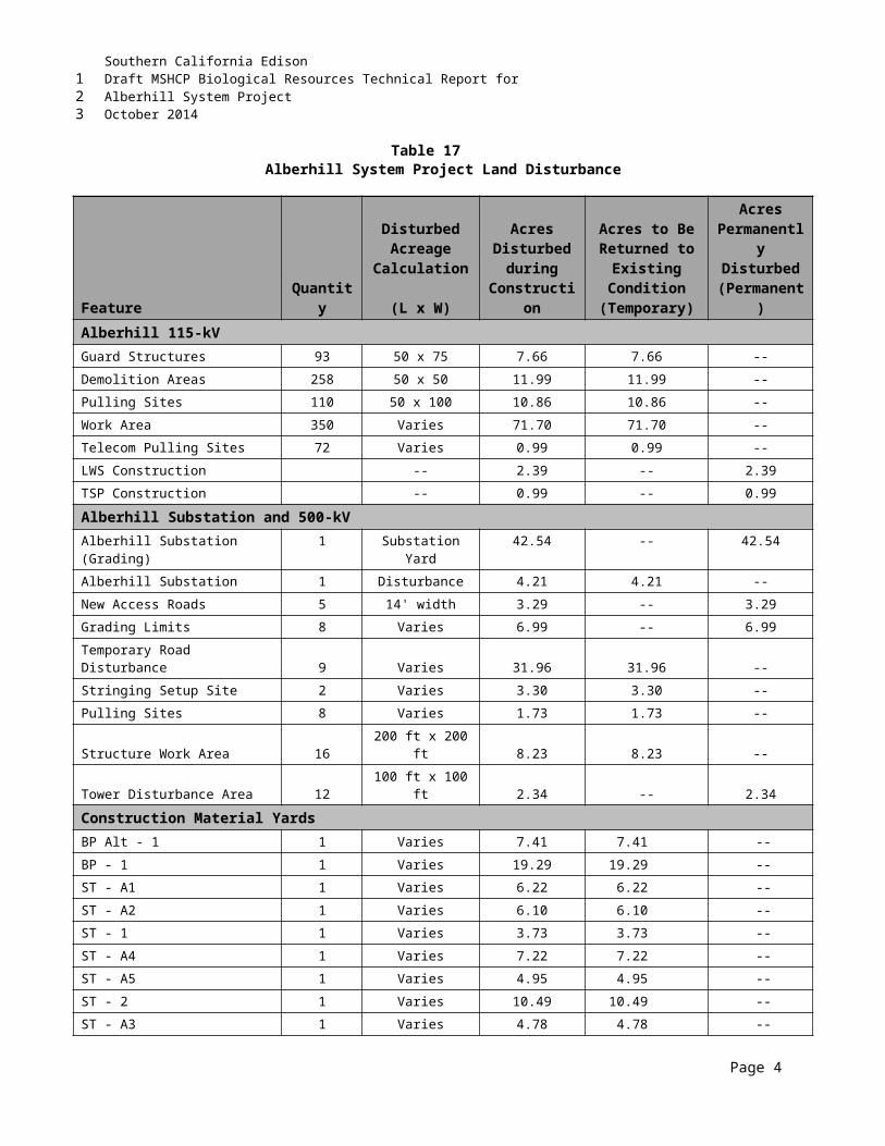
Southern California EdisonDraft MSHCP Biological Resources Technical Report forAlberhill System ProjectOctober 2014
Round Valley; (3) Garner Valley. The three Core Areas will be large, consisting of a minimum of 50 acres of montane meadow, wet montane meadow, and edges of montane riparian or riparian scrub. The Core Areas will be demonstrated to support at least 20 Lincoln's sparrow pairs with evidence of successful reproduction within the first 5 years after permit issuance. Successful reproduction is defined as a nest which fledged at least one known young.” Lincoln’s sparrow is known to breed in high meadows of the San Jacinto Mountains. The birds documented within the Alberhill Project study area were wintering birds, as no breeding habitat occurs. It is unlikely that additional mitigation would be required by RCA for this species at this time
Although it is SCE’s intent is to avoid all sensitive species to greatest extent possible, as currently designed, direct and indirect impacts to these species could potentially result from Alberhill Project construction-related activities. Minimization and avoidance measures as presented in Section 8.0 will be implemented for the protection of these species. As a PSE, no addition mitigation or further action is anticipated.
7.9 MSHCP SECTION 6.1.4 – URBAN WILDLANDS INTERFACE GUIDELINESThe guidelines presented in Section 6.1.4 of the MSHCP are intended to address indirect effects associated with development in proximity to the MSHCP Conservation Area (i.e., the portions of the criteria cells, which will be, or have been, conserved). While portions of the Alberhill Project will occur along the urban/wildlands interface, this linear project will be installed on or near existing access roads, in most cases within or adjacent to existing ROWs. Thus, relatively few new impacts will occur to any existing or future portions of the Conservation Area as a result, and such impacts will be minor. The Alberhill Project will adhere to the UWIG and, therefore, is consistent with this section of the MSHCP. Below is a summary of the UWIG and their relationship to the Alberhill Project:
Drainage – It is not anticipated that any project-related runoff will occur or that the Alberhill Project will adversely impact existing runoff conditions. Where any such impacts could occur, measures consistent with Section 8.0 will be taken to ensure that the quantity and quality of runoff will be comparable to existing conditions.
Toxics – It is not anticipated that the Alberhill Project will use chemicals or generate bioproducts that are potentially toxic or may adversely affect wildlife species, habitat, or water quality. If use of chemicals or generation of bioproducts is anticipated, measures such as those employed to address drainage issues will be implemented.
Lighting – No nighttime work is anticipated; however, if such work is required in or adjacent to the Conservation Area, lighting would be temporary, shielded, and directed away from the Conservation Area to the extent possible. No permanent lighting will be installed in or near the Conservation Area.
Noise – Although some noise will be generated by project activities in or adjacent to the Conservation Area, it will be of short duration in any given location as the Alberhill Project moves forward from pole to pole and will be kept as low as possible. Wildlife within the Conservation Area should not be subject to noise that would exceed residential noise standards. The implementation of avoidance and minimization measures as presented in Section 8.0 shall be implemented to minimize impact to species.
Invasives – No project-related landscaping will occur within or adjacent to the Conservation Area, so invasive nonnative plant species listed in Table 6-2 of Section 6.1.4 of the MSHCP will not be used.
Page 10
123
12345678
910111213
14
1516171819202122
23242526
27282930
313233
3435363738
3940
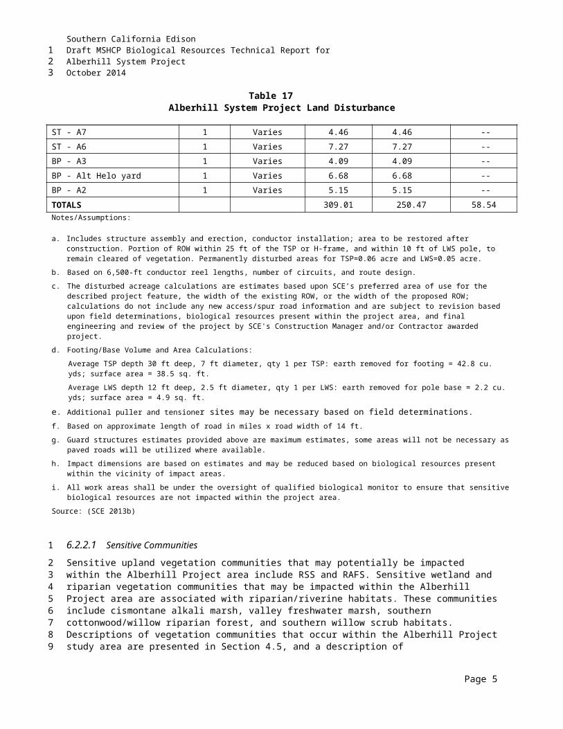
Southern California EdisonDraft MSHCP Biological Resources Technical Report forAlberhill System ProjectOctober 2014
Furthermore, minimization and avoidance measures as presented in Section 8.0 of this report shall be implemented to avoid the spread of invasive species within the Alberhill Project area.
Barriers – No new barriers are planned, as the Alberhill Project does not involve a major change of land use, only the building of a new line in an existing corridor. Access is currently restricted in some areas and would be expected to remain that way.
Grading/Land Development – No manufactured slopes will be created for the Alberhill Project. Gabion retaining walls are being proposed along access roads to towers R7 and R8, R11 and R12, and R13. The type of earth-retaining structure to be used would be based on site-specific conditions and final engineering of the Alberhill Project. Retaining walls will be sited, designed, and oriented to minimize impacts to movement of native resident wildlife species and established wildlife corridors, in coordination with RCA, USFWS, and CDFW.
7.10 RIVERSIDIAN SAGE SCRUB REMOVALThe USFWS permit (2004) for the MSHCP requires that sage scrub habitat occupied by the CAGN cannot be cleared during the breeding season in MSHCP Criteria Areas or in PQP lands. This would also extend to ARL, as ARL are included in the overall MSHCP Conservation Area.
Because only partial focused surveys have been conducted for CAGN within the Alberhill Project area, any sage scrub within Criteria Areas, PQP lands, and ARL will be assumed occupied by the CAGN and vegetation clearing will be limited to the nonbreeding season only. The breeding season for CAGN is defined by the USFWS MSHCP permit as 1 March through 15 August. Limiting removal of suitable CAGN habitat to outside the breeding season of this species ensures the Alberhill Project is consistent with the MSHCP.
7.11 RIVERSIDIAN ALLUVIAL FAN SCRUB REMOVALNo permanent or temporary impacts associated with construction activities to RAFS (disturbed and undisturbed) are anticipated as a result of the Alberhill Project.
Pursuant to MSHCP Rough Step requirements set forth in Section 6.7 of the MSHCP, RAFS habitat within the MSHCP is annually monitored for habitat losses and gains associated with public and private development projects, as part of the MSHCP Rough Step Analysis process. If the Rough Step rule is not met during the most recent annual analysis for Units 3, 7, and 8 (wherein the Alberhill Project occurs), then under the discretion of RCA, mitigation for permanent impacts to RAFS scrub will be mitigated pursuant to the MSHCP as determined by the MSHCP PSE process. Further, the Alberhill Project itself will not result in the MSHCP being out of Rough Step for RAFS. This monitored vegetation type has been determined sufficient to meet the goals and objectives of the MSHCP; however, should it be determined to be out of Rough Step before the Alberhill PSE submittal, additional mitigation could be required. If additional mitigation for RAFS is required, it may include purchase of replacement land at a 1:1 ratio and/or restoration at a 2:1 ratio in an off-site location to be determined. Whether additional mitigation for RAFS will be required will be determined by RCA during the PSE review process. No other vegetation type (e.g., RSS) is currently of concern as it relates to the Rough Step rule.
7.12 MIGRATORY BIRD TREATY ACT COMPLIANCEPursuant to MSHCP Section 14.13, the Section 10(a) Permit issued for the MSHCP constitutes a Special Purpose Permit under 50 CFR section 21.27, for the Take of Covered Species Adequately Conserved
Page 11
123
12
345
67891011
12
131415
161718192021
22
2324
25262728293031323334353637
38
3940
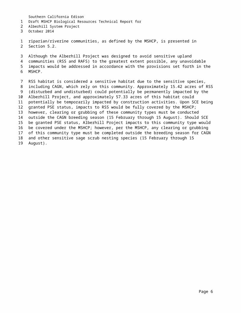
Southern California EdisonDraft MSHCP Biological Resources Technical Report forAlberhill System ProjectOctober 2014
listed under the federal ESA and which are also listed under the MBTA of 1918, as amended (16 U.S. Code §§ 703-712), in the amount and/or number specified in the MSHCP, subject to the terms and conditions specified in the Section 10(a) Permit. Any such take will not be in violation of the MBTA. The MBTA Special Purpose Permit will extend to Covered Species Adequately Conserved listed under the ESA and also under the MBTA, valid for a period of 3 years from its Effective Date, provided the Section 10(a) Permit remains in effect for such period. The Special Purpose Permit shall be renewed pursuant to the requirements of the MBTA, if needed, to be valid for a period of 3 additional years.
As noted above, if outside the criteria areas and outside the Conservation Area, occupied CAGN habitat can be cleared at any time of the year. It cannot be cleared, however, if other birds protected by the federal MBTA but not covered by Section 14.13 of the MSHCP are nesting there at the time. Further, multiple bird species covered by Section 14.13 nest in the Alberhill Project alignment. Impacts to these species are not permitted in any part of the MSHCP area. The period from approximately 15 February through 31 August covers the breeding season for most birds in the Alberhill Project area, but unseasonal active nests must also be avoided if encountered.
Although minimal direct impacts are anticipated in habitats for nesting birds, nesting in lightly traveled areas may suffer indirect impacts from project activity, such as disturbance-related nest abandonment. In these areas, work should be conducted in the nonbreeding season when possible. If project activity must be conducted during the breeding season, a qualified biologist should check for nesting birds prior to such activity. Implementation of the NBMS and other avoidance/minimization measures presented in Section 8.0 would ensure that migratory and/or nesting bird species would not be impacted by the Alberhill Project. As it relates to nesting birds covered under MSHCP Section 14.13, the Alberhill Project is consistent with the MSHCP.
Page 12
123
1234567
891011121314
1516171819202122
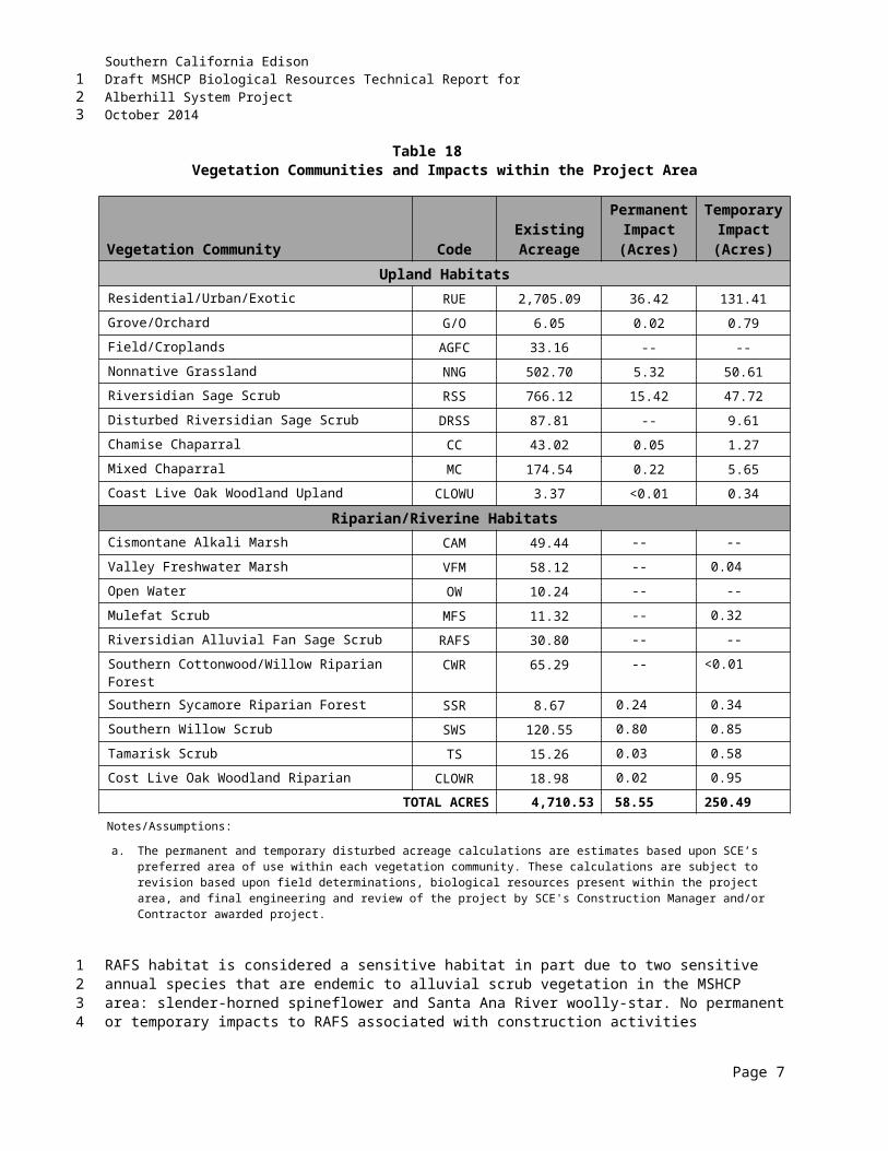
Southern California EdisonDraft MSHCP Biological Resources Technical Report forAlberhill System ProjectOctober 2014
8.0 SUMMARY OF APPLICANT-PROPOSED MEASURES, FEIR MITIGATION MEASURES, AND MSHCP MITIGATION MEASURES AND BMPS
This section provides the measures to avoid, minimize, and/or compensate for the proposed impacts to biological resources presented in Section 6.0. Implementation of these measures, as proposed, ensures compliance and consistency with the MSHCP and FEIR.
8.1 APPLICANT-PROPOSED MEASURESAPMs are conservation measures that have been designed by SCE to reduce impacts of the Alberhill Project on biological resources. These APMs are incorporated into the project description and are considered part of the Alberhill Project. APMs are separate from MMs, which are proposed in addition to the project description for the purpose of mitigating significant impacts. Table 23 presents a list of the APMs related to biological resources for the Alberhill Project.
Table 23Applicant Proposed Measures
Number MeasureAES-APM-1 Implement a revegetation program that will help restore the visual quality of segments along State
Scenic Highways.
BIO-APM 1
A qualified biologist will conduct a training session for project personnel prior to grading. The training shall include a description of the species of concern and its habitats, the general provisions of applicable environmental regulations, the need to adhere to the provisions of the regulations, the penalties associated with violating the provisions of the regulations, the general measures that are being implemented to conserve the species of concern as they relate to the Project, and the access routes to and project site boundaries within which the Project activities must be accomplished.
BIO-APM 2 Water pollution and erosion control plans shall be developed and implemented in accordance with RWQCB requirements.
BIO-APM 3 The footprint of disturbance shall be minimized to the maximum extent feasible. Access to sites shall be via preexisting access routes to the greatest extent possible.
BIO-APM 4Projects should be designed to avoid the placement of equipment and personnel within stream channels or on sand and gravel bars, banks, and adjacent upland habitats used by target species of concern.
BIO-APM 5 Projects that cannot be conducted without placing equipment or personnel in wildlife habitats would be timed to avoid breeding and other sensitive seasons if these species are found to be present.
BIO-APM 6
Equipment storage, fueling, and staging areas shall be located on upland sites with minimal risks of direct drainage into riparian areas or other sensitive habitats. These designated areas shall be located in such a manner as to prevent any runoff from entering sensitive habitat. Necessary precautions shall be taken to prevent the release of cement or other toxic substances into surface waters. Project-related spills of hazardous materials shall be reported to appropriate entities including but not limited to applicable jurisdictional city, USFWS, CDFW, and RWQCB and shall be cleaned up immediately and contaminated soils removed to approved disposal areas.
BIO-APM 7 Erodible fill material shall not be deposited into watercourses. Brush, loose soils, or other similar debris shall not be stockpiled within the stream channel or on its banks.
Page 1
123
1
2
3
4
567
8
910111213
Southern California EdisonDraft MSHCP Biological Resources Technical Report forAlberhill System ProjectOctober 2014
Table 23Applicant Proposed Measures
Number Measure
BIO-APM 8A qualified biologist shall monitor clearing and grubbing, grading, excavation, and soil movement activities for the Project to ensure that all practicable measures are being employed to avoid incidental disturbance of habitat and species of concern outside the Project footprint.
BIO-APM 9The removal of native vegetation shall be avoided and minimized to the maximum extent practicable. Temporary impacts shall be returned to preexisting contours and revegetated with appropriate native species.
BIO-APM 10
Construction employees shall strictly limit their activities, vehicles, equipment, and construction materials to the project footprint and designated staging areas and routes of travel. The construction area(s) shall be the minimal area necessary to complete the Project and shall be specified in the construction plans. Construction limits will be demarcated with staking, signs, flagging, or fence to provide clear visibility of worksite boundaries and will be maintained until the completion of all construction activities. Employees shall be instructed that their activities are restricted to the construction areas.
BIO-APM 11The Permitter shall have the right to access and inspect any sites of approved projects including any restoration/enhancement area for compliance with project approval conditions including these BMPs.
BIO-APM12All subtransmission poles would be designed to be raptor-safe in accordance with the Suggested Practices for Raptors on Power Lines: State of the Art in 2006 (Avian Power Line Interaction Committee 2006.
BIO-APM13Prior to installation of the poles, a survey would be conducted to locate any raptor or raven nests occurring on the existing poles. If nests are found on poles planned for replacement or modification, the Applicant would suspend work until the nests are inactive.
BIO-APM 14
Construction work plans/schedules will be designed to minimize construction-related noise in sensitive areas when feasible. In addition, all construction equipment will maintain functional exhaust/muffler systems and idling of motors shall be limited, except as necessary (e.g., concrete mixing trucks).
BIO-APM 15
Mitigation will be implemented through payment of fees pursuant to the Riverside County Habitat Conservation Agency (RCHCA) Stephens’ Kangaroo Rat Habitat Conservation Plan Agreement approved by the RCHCA on September 20, 2012 and with concurrence by USFWS and CDFW. Prior to start of construction, SCE will obtain a Certificate of Inclusion from the RCHCA for the project.
BIO-APM 16
Temporary impacts to MSHCP ARLs will be restored to greatest extent practicable using species present prior to disturbance. Should any permanent impacts to ARL result during construction, the Applicant will dedicate biologically equivalent or superior land to the MSHCP. The Applicant will prepare an ARL equivalency analysis to be included as part of the MSHCP PSE submittal. This equivalency analysis will compare the potential effects on the ARL to the benefits of proposed replacement land, including compensation for potentially lost conservation functions and values. The analysis will consider specific project design features, siting and design, and MSHCP BMPs, as well as address effects on covered species and habitats, core areas, linkages, constrained linkages, MSHCP Conservation Area configuration and management, and ecotones. The replacement land ratio is anticipated to be not less than 2:1 within MSHCP Core 1 but will ultimately be determined through MSHCP consistency findings made by RCA, CDFW and USFWS concurrence as part of the MSHCP PSE process.
BIO-APM 17 In the event that retaining walls or some other method of slope stabilization would be needed, walls will be sited, designed, and oriented to minimize impacts to movement of native resident wildlife species and established wildlife corridors, in coordination with the RCA, USFWS, and CDFW.
Page 2
123
Southern California EdisonDraft MSHCP Biological Resources Technical Report forAlberhill System ProjectOctober 2014
Table 23Applicant Proposed Measures
Number Measure
BIO-APM 18
Conduct Pre-construction Surveys and Relocate Sensitive Reptiles. SCE shall retain a qualified biologist to conduct pre-construction surveys for sensitive reptiles. The qualified biologist must have an appropriate scientific collecting permit to handle sensitive species likely to occur in the Project area. The biologist will be present during all ground disturbance and construction activities immediately adjacent to or within aquatic or terrestrial habitats that support populations of sensitive reptiles. If sensitive species are detected in the work area during the surveys, the biologist will capture and relocated individuals to suitable undisturbed habitat out of harm’s way. All wildlife moved during project activities will be documented by SCE and documentation shall be provided to the CPUC. Any sensitive reptiles killed during construction activities shall be salvaged and deposited in the Santa Barbara Museum of Natural History, Vertebrate Zoology Division collections (contact: Paul Collins, Curator, [805] 682-4711, x-154).
HYDRO-APM 1 The SWPPP would be submitted to Riverside County along with grading permit applications. Implementation of the SWPPP would help stabilize graded areas and waterways, and reduce erosion and sedimentation. The plan would designate BMPs that would be adhered to during construction activities. Erosion-minimizing efforts such as wattles, water bars, covers, silt fences, and sensitive area access restrictions (for example, flagging) would be installed before clearing, grading, and blasting began. Mulching, seeding, or other suitable stabilization measures would be used to protect exposed areas during construction activities. During construction activities, measures would be in place to ensure that contaminants are not discharged from construction sites. The SWPPP would define areas where hazardous materials would be stored, where trash would be in-place, where rolling equipment would be parked; where helicopters would be landed, fueled and serviced,; and where construction materials such as reinforcing bars and structural steel members would be stored. Erosion control during grading of the construction sites and during subsequent construction would be in-place and monitored as specified by the SWPPP. A silting basin(s) would be established, as necessary, to capture silt and other materials, which might otherwise be carried from the site by rainwater surface runoff.
HYDRO-APM 3 The SWPPP would include procedures for quick and safe cleanup of accidental spills during construction. This plan would be submitted to Riverside County with the grading permit application. The SWPPP would prescribe hazardous materials handling procedures for reducing the potential for a spill during construction and would include an emergency response program to ensure quick and safe cleanup of accidental spills. The plan would identify areas where refueling and vehicle maintenance activities and storage of hazardous materials, if any, would be permitted.
HYDRO-APM 4 Dewatering operations would be performed if groundwater is encountered while excavating or constructing the proposed subtransmission line, telecommunications line, or Alberhill Substation. These operations would include, as applicable, the use of sediment traps and sediment basins in accordance with BMP NS-2 (Dewatering Operations) from the California Storm water Quality Association’s (CASQA) California Storm water BMP Handbook.
NOISE-APM 1
All construction and general maintenance activities, except in an emergency, shall be limited to the hours of 7:00 a.m. to 7:00 p.m. and prohibited on Sundays and all legally proclaimed holidays. If the CAISO and/or Caltrans require that conductor stringing over freeways or highways occur at after 7:00 p.m. or on a Sunday, SCE would obtain variances from the applicable jurisdictional agencies.
8.2 FEIR MITIGATION MEASURESMMs are proposed below based on MMs previously approved in the VIG FEIR (CPUC 2010), MMs revised as part of the VIG Petition for Modification (PFM) (SCE 2014), and the Fogarty PFM (CPUC 2014). If the Alberhill Project is approved, these MMs or some version thereof, in addition to the APMS identified above, would be monitored for proper implementation by the biological monitors during Alberhill Project construction. able 24 provides the anticipated FEIR MMs as well as any other actions that will be implemented by SCE.
Page 3
123
1
234567
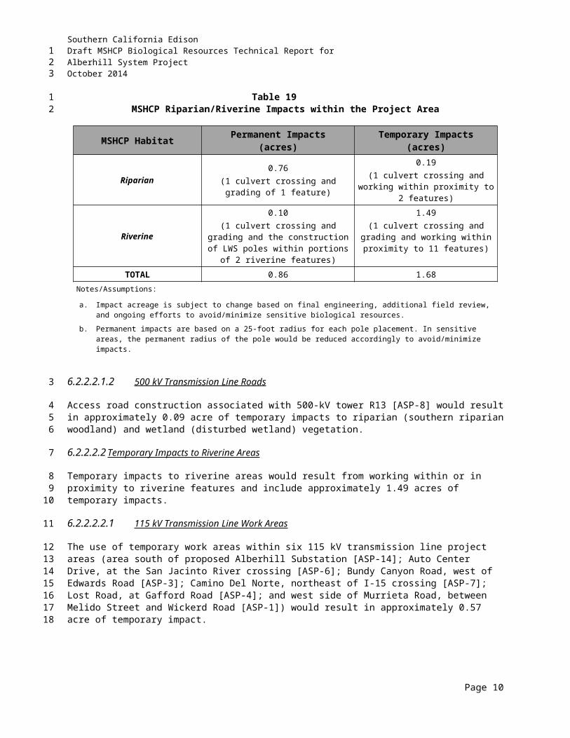
Southern California EdisonDraft MSHCP Biological Resources Technical Report forAlberhill System ProjectOctober 2014
Table 24Proposed Alberhill Project Mitigation Measures
Number Mitigation Measure Action RequiredBIO-1a(Enviro.Sensitive Areas)
The Applicant shall reduce impacts to the habitat of the special status species listed in Tables D.4-27 and D.4-38 by engineering the Project so that it minimizes impacts to special status species. This can be accomplished by siting permanent project elements (i.e., roads and poles) away from known locations of special status species and communities. Environmentally sensitive areas such as rare plant populations or specific breeding habitat will be identified in the field to minimize the possibility of inadvertent encroachment using the following avoidance methods:
a) A qualified botanist (i.e., a person with at least an undergraduate degree in biology, ecology, or a related field, with botany training and a minimum of 3 years’ professional field experience within the region or working under the direct supervision of a professional botanist with at least 6 years of field experience in the region) will flag or otherwise mark special status plant species. Construction crews will avoid direct or indirect impacts to these flagged areas and be instructed to avoid intrusion beyond these marked areas.
b) A qualified botanist will monitor the known locations of special status plant populations that might be found prior to or during the construction period. Monitoring will occur during construction and for one year following construction to assess the effectiveness of protection measures.
c) The Applicant will limit removal of native vegetation communities, including intact coastal sage scrub, riparian vegetation, wetland habitat, and mature trees. An on-site qualified biologist (i.e., a person with at least an undergraduate degree in biology, ecology, or a related field, with a minimum of 3 years’ professional field experience within the region or working under the direct supervision of a professional biologist with at least 6 years of field experience in the region) with local knowledge of the area will be consulted for identification, flagging of individuals or boundaries of vegetation communities (see MM BIO-2a and 2b for flagging of wetland boundaries), and assessment of sensitive vegetation habitats within the construction footprint. The biologist will provide oversight to ensure compliance of this measure.
SCE has designed and redesigned project to avoid known biological resources to the extent practicable. Biological monitors will flag and avoid known biological resources as well as continually assess all areas during construction for additional biological resources to ensure there are no impacts.
SCE will submit biologists’ resumes as needed. Preconstruction surveys will be conducted and SCE will
arrange for monitoring during construction in all areas of disturbance. Biological monitoring will occur full-time during construction as well as after for one year to assess the effectiveness of protection measures. Areas subject to long-term (one year) monitoring will include only areas that have been restored pursuant to jurisdictional waters permitting (404, 401, and 1602) and MSHCP mitigation requirements (e.g., San Jacinto River area).
Vegetation removal will be limited only to the extent approved during the MSHCP PSE review process and allowable pursuant to the jurisdictional waters permits. The biological monitors will have knowledge of what is required pursuant the MSHCP and allowable pursuant to the permits.
7 Refers to Table D.4-2: Special Status Wildlife Species Known to Occur or with the Potential to Occur within the Project Area in the Final EIR
8 Refers to Table D.4-3: Special Status Plant Species Known to Occur or with the Potential to Occur within the Project Area in the Final EIR
Page 4
123
4
5
Southern California EdisonDraft MSHCP Biological Resources Technical Report forAlberhill System ProjectOctober 2014
Table 24Proposed Alberhill Project Mitigation Measures
Number Mitigation Measure Action Requiredd) Temporary impacts to Riversidian Alluvial Fan Sage Scrub (RAFS)
shall be restored to pre-construction conditions using species similar to those present prior to disturbance. Permanent impacts to RAFS will be mitigated pursuant to the MSHCP as determined by the MSHCP Participating Special Entity (PSE) process. This may include purchase of replacement land at a 1:1 ratio and/or restoration at a 2:1 ratio in an off-site location to be determined. All mitigation is subject to review and approval by the RCA with United States (U.S.) Fish and Wildlife Service (USFWS) and California Department of Fish and Wildlife (CDFW) concurrence.
In the unlikely event that SCE does not to participate in the MSHCP, the project’s overall restoration monitoring and reporting plan will include RAFS restoration, subject to review and approval by USFWS and CDFW. The restoration plan will include, but is not limited to, identification of responsible parties, restoration details and schedule, monitoring and maintenance, and success criteria.
Page 5
123
Southern California EdisonDraft MSHCP Biological Resources Technical Report forAlberhill System ProjectOctober 2014
Table 24Proposed Alberhill Project Mitigation Measures
Number Mitigation Measure Action RequiredBIO-1b(Special Status Plant Species)
Pre-construction surveys will be conducted by a qualified botanist for all special status plant species as defined by Table D.4-3.9 The limits of populations of special status plant species shall be flagged or otherwise marked by a qualified botanist to ensure construction crews will avoid direct impacts to these populations.A minimum buffer of 25 feet around these flagged plant populations shall be maintained to protect any special status plant seedbank that may be dormant in the sensitive soils. However, should the Applicant participate in the MSHCP as intended, avoidance, minimization, and mitigation would be handled for each plant species pursuant to the MSHCP. Some species do not require an avoidance buffer while others would be subject to mitigation in the form of a Determination of Biological or Superior Preservation (DBESP).The Applicant will also report geo-referenced special status plant locations to the CDFW and USFWS. The Applicant will implement avoidance measures including, but not limited to, the following: No construction work (e.g., vegetation clearing, ground disturbance) will be
authorized to begin until pre-construction surveys have been completed and results submitted to the CDFW and USFWS.
The Applicant will avoid the flagged areas and will not drive vehicles, go by foot, or place equipment or materials in any area with special status plants.
The Applicant will maintain a minimum distance of 25 feet from the flagged boundary of special status plants for equipment staging and fueling and fill stockpile areas from special status plant populations.
Overhead installation of telecommunication lines will be accomplished by crews on foot as necessary to negotiate around flagged sensitive resources. This will also occur in areas where there is no established access road within the ROW and sensitive resources have been flagged during pre-construction surveys.
Trenching to install telecommunications will be conducted a minimum of 25 feet from the flagged boundary of special status plant populations.
If special status plants are present in an area where trenching to install telecommunications or other equipment would be required to connect to an existing subtransmission structure, the Applicant will identify and connect to
The biologists/botanists have surveyed the entire route starting in 2008, and surveys are ongoing during summer 2014 as required by the MSHCP. If needed, buffers will be established pursuant to the MSHCP. The biologist will install exclusion fencing and conduct monitoring to ensure that sensitive plants are avoided throughout construction.
SCE will report the geo-referenced special location of sensitive plants during the MSHCP PSE review process. USFWS and CDFW are part of this review process.
Pre-construction clearance surveys shall be conducted not more than 14 days prior to construction. Survey results shall be submitted to the CPUC’s bio consultant not more than 5 days prior to construction to obtain the proper field validation of the results.
Monitoring and avoidance of sensitive bio resources will be ongoing during construction.
Pursuant to the MSHCP, consultation with USFWS and CDFW would only be required up until the Certificate of Inclusion is issued by the RCA. From that point forward, unless otherwise required (e.g., MBTA), all consultation and subsequent review and requests would be handled by the RCA with notification to the CPUC.
Impacts during construction of the Alberhill Project are not expected to occur to any of the sensitive plants not fully covered by the MSHCP (i.e., NEPS and CAPS). Regardless, should it be determined that impacts to these plant species could occur, the Applicant will comply with the MSHCP.
9 Refers to Table D.4-3: Special Status Plant Species Known to Occur or with the Potential to Occur within the Project Area in the Final EIR
Page 6
123
4
Southern California EdisonDraft MSHCP Biological Resources Technical Report forAlberhill System ProjectOctober 2014
Table 24Proposed Alberhill Project Mitigation Measures
Number Mitigation Measure Action Requiredan alternate structure where disturbance of special status plants can be avoided. This may require the Applicant to extend the length of the trench to reach the alternate structure or to avoid underground trenching in certain areas.
TSP and line positioning and installation activities will avoid and span all flagged resources.
If the Applicant cannot avoid direct and/or indirect impacts to special status plants, then as a PSE under the MSHCP, the Applicant will consult with the CDFW, USFWS, and RCA, and follow the provisions set forth in the MSHCP, including but not limited to:
1. Submittal to the RCA of required documentation, including quantitative evaluations for the DBESP, as needed.
2. Adhering to policies and procedures in MSHCP Section 6.1.2 (Riparian/Riverine/Vernal Pool Policy), Section 6.1.3 (Narrow Endemic Plant Species Policy), and Section 6.3.2 (Additional Survey Needs and Procedures for Criteria Area Species).
3. Proposing and implementing mitigation measures developed in consultation with and approved by the CDFW, USFWS, and RCA.
As specifically applies to plants covered under MSHCP policies 6.1.3 and 6.3.2, the Applicant shall implement avoidance and mitigation measures to reduce impacts on special status plant species to a less than significant level as consistent with provisions set forth in the MSHCP. Mitigation shall include a tiered approach as summarized below and any other measures determined in consultation with the CDFW, USFWS, and RCA:
1. Avoid 90% of the plant populations with long-term conservation value found within suitable habitat within the project area. If 90% conservation cannot be maintained, then a DBESP will be prepared according to MSHCP provisions.
2. The known locations of special status plant populations within the project footprint found prior to or during the construction period will be monitored during ground disturbing construction activities by a qualified botanist. The Applicant will submit a post-construction report/technical memo to the CPUC within 60 days post-construction reporting on the effectiveness of protection measures.
3. Mitigation for impacted special status plants shall include restoration,
Page 7
123
Southern California EdisonDraft MSHCP Biological Resources Technical Report forAlberhill System ProjectOctober 2014
Table 24Proposed Alberhill Project Mitigation Measures
Number Mitigation Measure Action Requiredconservation, and compensation measures, and may be on-site and/or off-site. As some special status plants such as Munz’s onion and San Diego Ambrosia cannot be successfully salvaged and restored, mitigation shall include purchase of credits in an established mitigation bank as approved by the Resource Agencies. Expected mitigation ratios shall be a minimum of 1:1 for plant populations that are restored or conserved on-site, and 2:1 for plant populations that are preserved or conserved off-site. The Applicant will prepare a Habitat Mitigation and Monitoring Plan that will be submitted to and approved by the RCA and the CDFW and USFWS prior to initiating ground disturbance activities in areas where special status plants will be impacted. The plan will outline restoration and conservation activities, locations, monitoring requirements, and criteria to measure mitigation success.
4. Conservation measures shall include preservation of portions of the impacted on-site plant populations, where possible. The Applicant will establish conservation easements within one year of construction implementation on any on-site (where possible) and off-site mitigation site(s) to protect the populations in perpetuity.
In the event that SCE does not participate in the MSHCP, or if the project may impact a particular special-status plant species that is not covered by the MSHCP, SCE would implement a similar level of mitigation as would have been required by the MSHCP (i.e., as otherwise required by MM BIO-1b) to ensure that impacts to special-status plants are reduced to less-than-significant levels. Such mitigation may include, but not be limited to, restoration, conservation, and compensation measures, and may be on-site and/or off-site. It is expected that all special-status plant species and seedbank (in the topsoil) can be successfully salvaged and restored directly back into the area of disturbance after construction is completed. In the unlikely event that plants and seedbank (in topsoil) cannot be directly restored in the same area as the disturbance, mitigation shall include purchase of credits in an established mitigation bank or implementation of other mitigation strategies subject to the approval of the USFWS and CDFW. Expected mitigation ratios shall be a minimum of 1:1 for plant populations that are restored or conserved on-site, and 2:1 for plant populations that are preserved or conserved off-site. The Applicant would prepare a Habitat Mitigation and Monitoring Plan (for those special-status plants that cannot be salvaged and directly restored) that would be submitted to and approved by the USFWS and CDFW, as appropriate, prior to initiating ground
Page 8
123
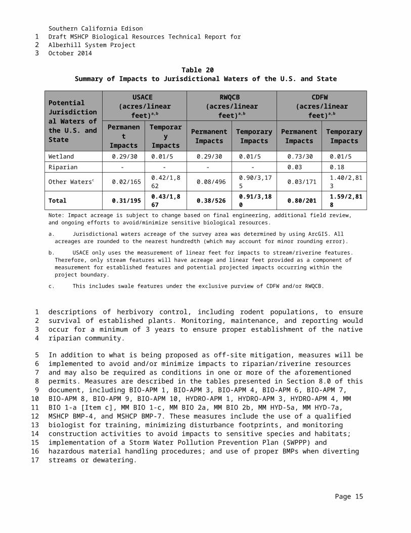
Southern California EdisonDraft MSHCP Biological Resources Technical Report forAlberhill System ProjectOctober 2014
Table 24Proposed Alberhill Project Mitigation Measures
Number Mitigation Measure Action Requireddisturbance activities in areas where special-status plants would be impacted. The plan would outline restoration and conservation activities, locations, monitoring requirements, and criteria to measure mitigation success.
BIO-1c (Invasive Plant Species)
The Applicant will use standard BMPS to avoid the introduction and/or spread of controllable invasive plant species such as tamarisk (Tamarix sp.) and giant reed (Arundo donax). Proper handling during construction shall include the following: All vehicles and equipment will be cleaned prior to arrival at the work site.
Vehicle washing will concentrate on tracks or tires, on the undercarriage, and on the front bumper/brush guard assemblies.
Crews, with construction inspector oversight, will ensure that vehicles and equipment are free of soil and debris capable of transporting noxious weed seeds, roots or rhizomes before the vehicles and equipment are allowed use of access roads.
Straw or hay bales used for sediment barrier installations or mulch distribution will be obtained from state-cleared sources that are free of invasive weeds.
The Worker Environmental Awareness Program (WEAP) training will include information regarding a requirement that all personal vehicles shall be washed prior to entering the construction site, concentrating on tracks or tires, on the undercarriage, and on the front bumper/brush guard assemblies. This would also apply to construction equipment that enters and exits the site throughout the construction phase. For construction equipment remaining on the site throughout construction, it will be washed prior to entering the site for the first time. All vehicles and construction equipment will be inspected by the construction site representative, biological monitors or miscellaneous monitor prior to entering the site to ensure that they are free of all soil and debris capable of transporting noxious weeds.
SCE will ensure that straw or hay bales used for sediment barrier installations or mulch distribution will be obtained from state-cleared sources that are free of invasive weeds. This is included as part of the SWPPP BMPs.
BIO-1d(Special Status Wildlife Species)
Preconstruction surveys will be conducted by a qualified wildlife biologist for all special status species as defined by Table D.4-2 (of the FEIR) prior to commencement of construction activities. The locations of any special status species and their habitats shall be marked and avoided during final project design and construction. A qualified wildlife biologist will be on-site to conduct biological monitoring for special status wildlife species including, but not limited to, those found in Table D.4-2 (of the FEIR) during construction in areas where special status wildlife and occupied habitat have been identified.
The biologists have surveyed the entire route starting in 2006, and surveys are ongoing during Summer 2014 as appropriate. Preconstruction surveys will be conducted as described in MM BIO-1-b with a focus on special status species presented in the EIR and pursuant to the MSHCP. If needed, buffers will be established pursuant to the MSHCP. The biologist will mark and conduct monitoring to ensure that special status wildlife and occupied habitat are avoided throughout construction.
Page 9
123
Southern California EdisonDraft MSHCP Biological Resources Technical Report forAlberhill System ProjectOctober 2014
Table 24Proposed Alberhill Project Mitigation Measures
Number Mitigation Measure Action RequiredBIO-1e(Pre-Con Nesting Bird Surveys)
To avoid the impacts to active nests (with eggs or young) of any protected bird, the Applicant shall implement one of the following:a. Conduct all construction activity (including vegetation pruning or removal)
during the non-breeding season (generally between August 31 and February 1) for most special status and non-special status migratory birds.
b. If construction activities are scheduled to occur during the breeding season (February through August), a qualified biologist with knowledge of local wildlife resources will conduct pre-construction focused nesting surveys no more than 30 days prior to any ground disturbing activity or vegetation trimming or removal activities. These surveys shall be conducted up to a distance of 500 feet from the centerline of the subtransmission line and 500 feet from existing and new (i.e., Fogarty) substations. If active nests are found, a biological monitor with expertise in bird behavior would establish a species-specific buffer around the nest and no activities would be allowed within the buffer until the young have fledged from the nest or the nest fails. A project-specific Nesting Bird Management Strategy has been prepared to establish buffers based on, but not limited to, the following: the bird species (some species are more tolerant of disturbance while other are less tolerant), location of nest building and active nests, threshold for nesting disturbance taking into account bird behavior, including signs of agitation, continuous focused nest monitoring by qualified biologists, background noise, type of construction activity, and dust emissions and noise levels from construction. Buffers would be adjusted based on no exceedance of an established threshold of behavioral agitation and other signs indicating disruption of nesting behavior. Buffers may be increased or decreased based on the opinion of the biologist with expertise in bird behavior to ensure that impacts to nesting birds would not occur. The Nesting Bird Management Strategy establishes a communication and reporting protocol involving SCE, biological monitors, and the CPUC, CDFW, and USFWS. The Nesting Bird Management Strategy was prepared by the Project’s Lead Biologist and was subject to the approval of the CDFW (pursuant to the California Fish and Game Code) and USFWS (pursuant to the Migratory Bird Treaty Act).
c. During active construction, the qualified biologist will monitor and assess any nesting birds within the specified buffer ranges to determine whether disturbance is impacting the birds. The qualified biologist will have the authority to halt construction in the area of disturbance impacting the birds,
It is anticipated that construction will occur within one or more nesting seasons. Pursuant to the MSHCP, removal of sage scrub is not permitted during coastal California gnatcatcher breeding season (generally March 1 to July 1). Further, SCE intends to avoid any riparian vegetation removal or work in these areas potentially suitable for least Bell’s vireo during its breeding season. Removal of other vegetation types during nesting season will only be done to the extent allowable under the MSHCP.
Preconstruction surveys will include an appropriate search for nesting behavior and active nests.
Depending on the location of construction activities, biological monitoring will be full-time during nesting season. The qualified biologist will continuously monitor the entire site and surrounding area as appropriate for nesting behavior and active nests.
Should an active nest be identified, a species-specific buffer will be implemented that is protective of the species, and is also reasonable to allow for construction to continue if possible without the likelihood of “take.” A biological monitor with expertise in ornithology and bird behavior will monitor nesting birds for signs of nest disruption. A “nest buffer modification plan” (plan) has been established in coordination with CPUC and CDFW. The plan provides guidance for appropriate buffers for each species group dependent upon the type of work being performed as well as includes a communication and reporting protocol involving SCE, CPUC, and CDFW. While impacts to nesting birds pursuant to the MBTA are unlikely, USFWS will be notified in the event of “take” of a nest under this federal regulation. The “buffer modification plan” is subject to change at any time based on the opinion of CPUC and CDFW, and will ensure that impacts to nesting birds do not occur.
The “Nest Monitoring and Management Strategy” Is currently in preparation.
Page 10
123
Southern California EdisonDraft MSHCP Biological Resources Technical Report forAlberhill System ProjectOctober 2014
Table 24Proposed Alberhill Project Mitigation Measures
Number Mitigation Measure Action Requiredand will immediately contact the Applicant’s Lead Biologist. The Applicant’s Lead Biologist will notify the CPUC, USFWS and CDFW and consult on an appropriate course of action.
Page 11
123
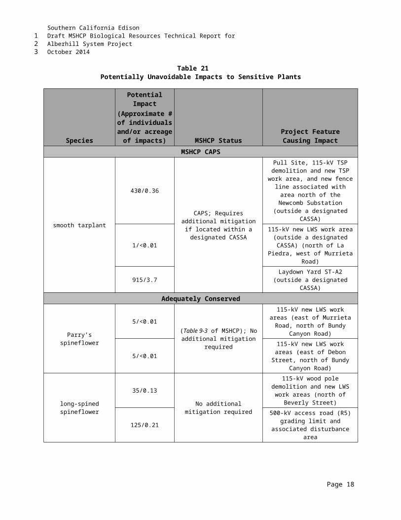
Southern California EdisonDraft MSHCP Biological Resources Technical Report forAlberhill System ProjectOctober 2014
Table 24Proposed Alberhill Project Mitigation Measures
Number Mitigation Measure Action Required
BIO-1f(Burrowing Owl)
If BUOW are found during the pre-construction surveys, occupied burrows will be flagged and construction buffers will be established to avoid direct and indirect impacts to active nests, as follows: 160 feet from occupied burrows during non-nesting season 500 feet from occupied burrows during the nesting season (1 February
through 31 August). Should this buffer not be able to be maintained, the closest distance allowable will be 300 feet, and the qualified biologist shall monitor the owls for signs of stress and/or other behavioral changes to determine if construction should be halted and discussions initiated with CPUC, USFWS and CDFW on an appropriate course of action.
For lands under the MSHCP, as a PSE, the Applicant will follow procedures in MSHCP policy 6.3.2, and as outlined in the Applicant prepared DBESP.For lands not under the MSHCP, if the appropriate buffers cannot be maintained and impacts on the burrowing owl and/or their habitat (i.e., occupied burrows) are unavoidable, the Applicant will develop and implement a Burrowing Owl Compensation Plan, as approved by the CDFG that is consistent with mitigation guidelines as outlined in the California Burrowing Owl Consortium Protocol. The plan will describe the compensatory measures that will be undertaken to address the loss of burrowing owl burrows within the project area. This will include preservation of 6.5 acres of on-site foraging habitat contiguous with occupied burrow sites per breeding pair or single bird, unless otherwise determined in consultation with the CDFG. If avoidance of burrows cannot be maintained, on-site passive relocation of owls will be preferred over active relocation. To compensate for loss of burrows, the Applicant will provide one alternate natural (enlarged or cleared of debris) or artificial burrow in nearby contiguous foraging habitat for each occupied collapsed burrow within the project area. Prior to collapsing burrows vacated through passive relocation, the Applicant’s biological monitor will conduct daily monitoring for up to a one-week period to confirm that the alternate burrows provided are being used by the owls. The Applicant will not conduct active relocation unless the attempt at passive relocation has failed after one week. The Applicant will obtain approval from the CDFG before initiating any activities that have the potential to adversely impact burrowing owls.
Biologists have surveyed the route starting in 2009, and surveys are ongoing during Summer 2014 as appropriate.
No BUOW or their signs were discovered during focused surveys in 2006 and 2008 within and adjacent to the project area. However, in 2011, two burrows with what appeared to be old sign were found within the buffer of the project alignment. Further focused surveys did not detect owls, but this area will be given special attention during the pre-construction survey and during construction.
At this point, no impacts are expected and no DBESP is required. However, if needed, buffers and/or other mitigation will be established pursuant to the MSHCP, and in cooperation with the RCA and CPUC. It is SCE’s intent to avoid any disturbance to burrows suitable for BUOW, regardless of known occupancy.
BIO-1g(LBV / SWFL)
The Applicant will avoid construction activities during the nesting season (1 March through 31 August) in areas that provide suitable habitat for the LBV and SWFL, as determined by a qualified biologist and including those areas
Focused surveys for LBV conducted 2009 to 2014 have detected several LBV territories with no SWFL detected in any portion of the Alberhill Project. SCE intends to avoid
Page 12
123
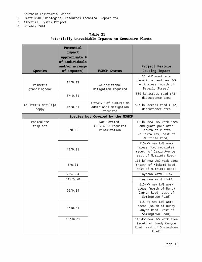
Southern California EdisonDraft MSHCP Biological Resources Technical Report forAlberhill System ProjectOctober 2014
Table 24Proposed Alberhill Project Mitigation Measures
Number Mitigation Measure Action Requiredalready identified from the Project surveys (AECOM 2011b and 2012b and Kidd Biological, Inc. 2013 and 2014 surveys). The Applicant will avoid construction activities within riparian habitat occupied by these two species, as determined from Project surveys (AECOM 2011b and 2012b and Kidd Biological, Inc. 2013 and 2014 surveys). If avoidance of these occupied areas is not possible for MSHCP-covered lands, mitigation will be performed in accordance with MSHCP policy 6.1.2.
construction in suitable habitat during LBV nesting season. This intent has also been expressed to the RCA and Wildlife Agencies and will be reiterated in the DBESP prepared for riparian/riverine impacts.
BIO-1h(Noise Control)
The Applicant will avoid impacts to migratory and special status bird species protected under federal or state regulations by ensuring that construction or operational noise does not exceed the nest disturbance threshold and/or the noise level threshold established in the Nesting Bird Management Strategy during the general nesting period. This will be accomplished through 1) work scheduling (i.e., scheduling construction to avoid segments where occupied nests are found) and 2) having properly functioning mufflers on construction vehicles. No vehicles, chain saws, or heavy equipment will be operated within the exclusion zones established within the Nesting Bird Management Strategy until the nesting season is over or until a qualified wildlife biologist has determined that nesting is finished and the young have fledged. If a qualified wildlife biologist determines that any particular construction, operation, or maintenance activities pose a high risk of disturbing an active nest, the biologist will halt work in the particular area of impact and/or recommend additional, feasible measures to minimize the risk of nest disturbance. If work activities are found to result in harm to nesting birds, destruction of an active nest, or nest abandonment prior to fledging, the biologist will report this to the CDFW and USFWS.
The on-site biological monitor will determine ambient noise levels and note any exceedance of those levels.
As it relates to exclusion zones, please see above response to BIO-1e regarding buffers from active nests.
Should there be any “take” of active nests under the MBTA or California Fish and Game Code; the Wildlife Agencies will be notified.
BIO-1i(Wildlife Entrapment)
At the end of each workday during construction, the Applicant will cover all open holes, trenches or excavations, or provide escape ramps, to prevent the entrapment of wildlife (e.g., reptiles and small mammals). The Applicant will maintain fencing around the covered holes, trenches and excavations at night. The Applicant’s qualified biologist will clear open holes, trenches, and excavated areas for wildlife at the end of each day and again prior to resuming work the following day.
The biological monitor will implement as directed, including conducting a “biological sweep” prior to construction each day as well as clearing all holes/trenches at the end of the day before they are covered.
BIO-2a(Wetlands Avoidance and Restoration)
Before construction work will start on Project, the Applicant’s qualified wetland biologist will flag the boundaries of wetland resources based on prior surveys (AECOM 2013). The wetland biologist shall be a person with at least an undergraduate degree in biology, ecology, or a related field, with U.S. Army
The Alberhill Project has been designed and redesigned to avoid impacts to jurisdictional waters, including vernal pools, to the extent feasible.
Permit applications (404, 401, and 1602) will be submitted
Page 13
123
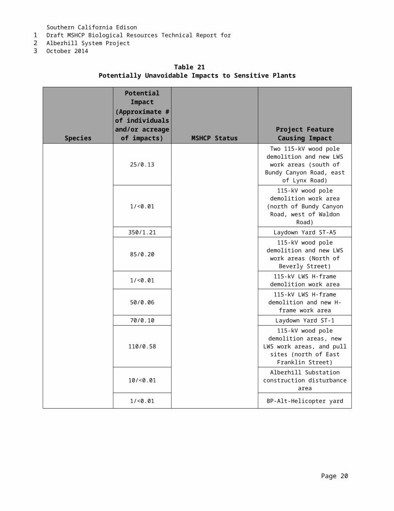
Southern California EdisonDraft MSHCP Biological Resources Technical Report forAlberhill System ProjectOctober 2014
Table 24Proposed Alberhill Project Mitigation Measures
Number Mitigation Measure Action RequiredCorps of Engineers (USACE) training and a minimum of 3 years’ professional field experience within the region or working under the direct supervision of a professional wetland biologist with USACE training and at least 6 years of field experience in the region. For vernal pool wetlands, habitat will be flagged based on the vernal pool watershed (i.e., the internal drainage into the wetland system from the surrounding watershed based on hydrographic breaks) not the wet basin.
The Applicant’s construction crews will not cross non-culverted drainages with vehicles, nor conduct construction activities or placement of equipment or supplies within the bed, bank, or riparian zone of any drainage, wetland, or water body. Many of the larger creeks flow through culverts beneath existing roads and will not be directly impacted. However, smaller creeks and resources may flow across the ROW and would be affected. Project infrastructure will be designed to avoid all sensitive aquatic resources, including spanning drainages and vernal pools with transmission lines.
If construction activities require placement of fill, crews, or equipment in sensitive aquatic resources, or require disturbance to a riparian area or vernal pool watershed, then the Applicant will do the following:
Where avoidance of riparian and wetland areas is not feasible and work is required within jurisdictional wetlands, drainages, and other wetland habitats, or where non-culverted drainages must be crossed to access work sites, the Applicant will obtain and comply with all necessary USACE and CDFW permits under the Clean Water Act and CDFW 1600 regulations. A wetland delineation report will be prepared and submitted to the USACE and CDFW for verification as part of this permit process.
Restore temporarily impacted wetlands, riparian zones, and other aquatic resources to pre-construction conditions, and monitor during and after disturbance. Include aquatic resource restoration efforts in the Habitat Mitigation and Monitoring Plan (MM BIO-1b) that will be developed as part of the regulated waters permitting and/or the DBESP that will be prepared as part of MSHCP PSE compliance for riparian/riverine impacts. Any mitigation/restoration plans shall also be submitted to and approved by the RCA, USACE, USFWS, CDFW, and the CPUC prior to initiating any mitigation activities. The plan will outline restoration and conservation activities, locations, monitoring requirements, and criteria to measure mitigation success.
following publication of the DEIR. Impacts to jurisdictional waters were calculated based upon an updated delineation conducted in 2013.
Pursuant to the MSHCP, a DBESP will be prepared identifying impacts to and mitigation for riparian/riverine habitat, including vernal pool watershed areas. The MSHCP biotech report and DBESP will demonstrate that pole and access road placement in the vernal pool watershed will not directly or indirectly impact the vernal pool wet basin.
Crews will not conduct construction activities nor place equipment within any jurisdictional water body. Further, crews will not cross non-culverted drainages that are not already part of an existing access road currently used by area residents or are designated access roads currently used by SCE O&M.
Page 14
123
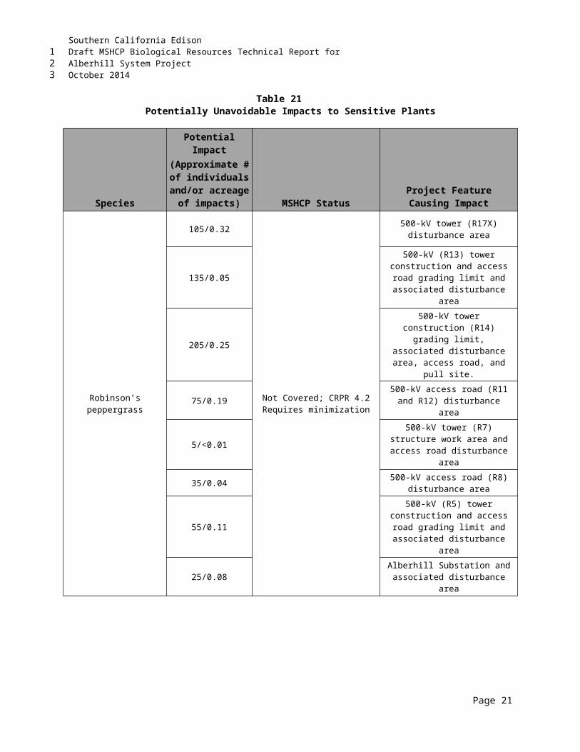
Southern California EdisonDraft MSHCP Biological Resources Technical Report forAlberhill System ProjectOctober 2014
Table 24Proposed Alberhill Project Mitigation Measures
Number Mitigation Measure Action Required Mitigate for permanent impacts on wetlands and riparian areas caused by
new structures and fill activities, prior to impact activities. At a minimum, mitigation ratios will be a 1:1 ratio for wetlands and riparian areas. High quality riparian zones, as determined by a qualified wetland biologist in consultation with the CPUC and the RCA, USACE, CDFW, and USFWS will be mitigated at a minimum of 2:1 ratio. Mitigation may include compensation and conservation of in-kind, off-site areas at a minimum ratio of 1:1.
BIO-2b(BMPs)
BMPs to be prescribed by the SWPPP (APM-BIO 2, Hydro-SCE-1) will include but are not limited to the following:
The Applicant will not stockpile brush, loose soils, excavation spoils, or other similar debris material within sensitive habitats.
The Applicant will maintain minimum distance of 100 feet for equipment staging, fueling, hazardous material storage/use, and fill stockpile areas from the flagged boundaries of riparian areas and wetlands.
If visible dust is present during construction activities, standard dust suppression techniques (e.g., water spraying) will be used in all ground disturbance areas.
The BMPs included in the SWPPP will be implemented during construction to minimize indirect impacts associated with erosion and dust generation. The SWPPP will be reviewed and approved by the Santa Ana RWQCB prior to construction commencement (MM HYD-1a).
SCE will comply with all SWPPP provisions and SCAQMD requirements.
Page 15
123
Southern California EdisonDraft MSHCP Biological Resources Technical Report forAlberhill System ProjectOctober 2014
Table 24Proposed Alberhill Project Mitigation Measures
Number Mitigation Measure Action Required
BIO-4a(Tree Removal)
Obtain a Tree Removal Permit from the County of Riverside. The County of Riverside, Roadside Tree Ordinance 12.08 requires permits for tree removal within county highway ROWs (Riverside County 2004). In addition, the County of Riverside requires that any future development in an identified sensitive vegetation area (including oak woodlands) must be evaluated individually and cumulatively for potential impact on vegetation (Riverside County 1993). Mitigation will be coordinated, as required, with the appropriate public and resource agencies once tree removal permits or approvals for lost significant trees are obtained. Mitigation for lost trees may not be implemented within the ROW due to fire safety concerns and instead may be implemented in an alternative agency approved location.
Two coast-live oak trees will be removed from the proposed Alberhill Substation site. A tree removal permit will be obtained from the County of Riverside. Mitigation will be coordinated, as required, with the appropriate public and resource agencies once tree removal permits or approvals for lost significant trees are obtained.
MM HYD-5a SCE will obtain Construction General Permit coverage through the State Water Resources Control Board. Verification of approval shall be provided to the CPUC at least 60 days before construction.
MM HYD-7a Aboveground project features such as the TSPs, poles, underground conduit, and substation shall be placed outside the flow path of watercourses unless an engineering analysis, reviewed by the CPUC, demonstrates that watercourse avoidance is not practicable, and that appropriate flood avoidance measures, such as raising foundations, have been taken to identify and prevent potential flooding and erosion hazards. The Applicant shall provide documentation to the CPUC at least 30 days before the start of the construction regarding which structures would be in flow paths and what protective measures, such as design specifications, are proposed.
MM Noise 1a The Applicant shall stop all construction work within 300 feet of sensitive receptors within Riverside County at 6:00 pm unless the California Independent System Operator (CAISO) and/or California Department of Transportation (Caltrans) require that conductor stringing over freeways or highways occur after 6:00 p.m. SCE would obtain an exception from the Riverside County Director of Building and Safety.
MM GEO-2a An erosion and sedimentation control plan shall be incorporated into the SWPPP for Project construction activities to minimize on-site soil erosion and off-site sedimentation. The plan shall include site maps, identification of construction activities, and measures for providing erosion and sediment control. Compliance with this measure shall be documented to the CPUC at least 60 days before construction.
Page 16
123
Southern California EdisonDraft MSHCP Biological Resources Technical Report forAlberhill System ProjectOctober 2014
THIS PAGE INTENTIONALLY LEFT BLANK
Page 17
123
1
Southern California EdisonDraft MSHCP Biological Resources Technical Report forAlberhill System ProjectOctober 2014
9.0 MSHCP BMPS AND MITIGATION MEASURESBMPs (Appendix C of the MSHCP), Construction Guidelines (MSHCP Section 7.5.3), and MMs specific to species must be implemented by the Alberhill Project as part of MSHCP PSE compliance. These measures are presented in detail in Table 25.
Table 25MSHCP BMPs and Species-Specific MMs
MSHCP BMPs (MSHCP Vol. I, Appendix C)
MSHCP BMP-1
A condition shall be placed on grading permits requiring a qualified biologist to conduct a training session for project personnel prior to grading. The training shall include a description of the species of concern and its habitats, the general provisions of the ESA and the MSHCP, the need to adhere to the provisions of the ESA and the MSHCP, the penalties associated with violating the provisions of the ESA, the general measures that are being implemented to conserve the species of concern as they relate to the project, and the access routes to and project site boundaries within which the project activities must be accomplished.
MSHCP BMP-2 Water pollution and erosion control plans shall be developed and implemented in accordance with RWQCB requirements.
MSHCP BMP-3 The footprint of disturbance shall be minimized to the maximum extent feasible. Access to sites shall be via pre-existing access routes to the greatest extent possible.
MSHCP BMP-4The upstream and downstream limits of projects disturbance plus lateral limits of disturbance on either side of the stream shall be clearly defined and marked in the field and reviewed by the biologist prior to initiation of work.
MSHCP BMP-5Projects should be designed to avoid the placement of equipment and personnel within the stream channel or on sand and gravel bars, banks, and adjacent upland habitats used by target species of concern.
MSHCP BMP-6Projects that cannot be conducted without placing equipment or personnel in sensitive habitats should be timed to avoid the breeding season of riparian identified in MSHCP Global Species Objective No. 7.
MSHCP BMP-7
When stream flows must be diverted, the diversions shall be conducted using sandbags or other methods requiring minimal instream impacts. Silt fencing of other sediment trapping materials shall be installed at the downstream end of construction activity to minimize the transport of sediments off-site. Settling ponds where sediment is collected shall be cleaned out in a manner that prevents the sediment from reentering the stream. Care shall be exercised when removing silt fences, as feasible, to prevent debris or sediment from returning to the stream.
MSHCP BMP-8
Equipment storage, fueling, and staging areas shall be located on upland sites with minimal risks of direct drainage into riparian areas or other sensitive habitats. These designated areas shall be located in such a manner as to prevent any runoff from entering sensitive habitat. Necessary precautions shall be taken to prevent the release of cement or other toxic substances into surface waters. Project related spills of hazardous materials shall be reported to appropriate entities including but not limited to applicable jurisdictional city, FWS, and CDFW, RWQCB and shall be cleaned up immediately and contaminated soils removed to approved disposal areas.
MSHCP BMP-9 Erodible fill material shall not be deposited into watercourses. Brush, loose soils, or other similar debris material shall not be stockpiled within the stream channel or on its banks.
MSHCP BMP-10The qualified project biologist shall monitor construction activities for the duration of the project to ensure that practicable measures are being employed to avoid incidental disturbance of habitat and species of concern outside the project footprint.
MSHCP BMP-11The removal of native vegetation shall be avoided and minimized to the maximum extent practicable. Temporary impacts shall be returned to pre-existing contours and revegetated with appropriate native species.
Page 1
123
1
234
Southern California EdisonDraft MSHCP Biological Resources Technical Report forAlberhill System ProjectOctober 2014
Table 25MSHCP BMPs and Species-Specific MMs
MSHCP BMPs (MSHCP Vol. I, Appendix C)
MSHCP BMP-12 Exotic species that prey upon or displace target species of concern should be permanently removed from the site to the extent feasible.
MSHCP BMP-13To avoid attracting predators of the species of concern, the project site shall be kept as clean of debris as possible. All food related trash items shall be enclosed in sealed containers and regularly removed from the site(s).
MSHCP BMP-14
Construction employees shall strictly limit their activities, vehicles, equipment, and construction materials to the proposed project footprint and designated staging areas and routes of travel. The construction area(s) shall be the minimal area necessary to complete the project and shall be specified in the construction plans. Construction limits will be fenced with orange snow screen. Exclusion fencing should be maintained until the completion of all construction activities. Employees shall be instructed that their activities are restricted to the construction areas.
MSHCP BMP-15The Permittee shall have the right to access and inspect any sites of approved projects including any restoration/enhancement area for compliance with project approval conditions including these BMPs.
MSHCP Construction Guidelines (MSHCP Section 7.5.3)
MSHCP-CONST-1
Plans for water pollution and erosion control will be prepared for all Discretionary Projects involving the movement of earth in excess of 50 cubic yards. The plans will describe sediment and hazardous materials control, dewatering or diversion structures, fueling and equipment management practices, use of plant material for erosion control. Plans will be reviewed and approved by the County of Riverside and participating jurisdiction prior to construction.
MSHCP-CONST-2Timing of construction activities will consider seasonal requirements for breeding birds and migratory non-resident species. Habitat clearing will be avoided during species active breeding season defined as 1 March to 30 June.
MSHCP-CONST-3 Sediment and erosion control measures will be implemented until such time soils are determined to be successfully stabilized.
MSHCP-CONST-4 Short-term stream diversions will be accomplished by use of sand bags or other methods that will result in minimal instream impacts. Short-term diversions will consider effects on wildlife.
MSHCP-CONST-5 Silt fencing or other sediment trapping materials will be installed at the downstream end of construction activities to minimize the transport of sediments off-site.
MSHCP-CONST-6
Settling ponds where sediment is collected will be cleaned in a manner that prevents sediment from re-entering the stream or damaging/disturbing adjacent areas. Sediment from settling ponds will be removed to a location where sediment cannot re-enter the stream or surrounding drainage area. Care will be exercised during removal of silt fencing to minimize release of debris or sediment into streams.
MSHCP-CONST-7 No erodible materials will be deposited into watercourses. Brush, loose soils, or other debris material will not be stockpiled within stream channels or on adjacent banks.
MSHCP-CONST-8 The footprint of disturbance will be minimized to the maximum extent Feasible. Access to sites will occur on pre-existing access routes to the greatest extent possible.
MSHCP-CONST-9 Equipment storage, fueling and staging areas will be sited on non-sensitive upland Habitat types with minimal risk of direct discharge into riparian areas or other sensitive Habitat types.
MSHCP-CONST-10The limits of disturbance, including the upstream, downstream and lateral extents, will be clearly defined and marked in the field. Monitoring personnel will review the limits of disturbance prior to initiation of construction activities.
MSHCP-CONST-11During construction, the placement of equipment within the stream or on adjacent banks or adjacent upland Habitats occupied by Covered Species that are outside of the project footprint will be avoided.
MSHCP-CONST-12 Exotic species removed during construction will be properly handled to prevent sprouting or regrowth.
MSHCP-CONST-13 Training of construction personnel will be provided.
Page 2
123
Southern California EdisonDraft MSHCP Biological Resources Technical Report forAlberhill System ProjectOctober 2014
Table 25MSHCP BMPs and Species-Specific MMs
MSHCP BMPs (MSHCP Vol. I, Appendix C)
MSHCP-CONST-14 Ongoing monitoring and reporting will occur for the duration of the construction activity to ensure implementation of BMPs.
MSHCP-CONST-15
When work is conducted during the fire season (as identified by the Riverside County Fire Department) adjacent to coastal sage scrub or chaparral vegetation, appropriate fire-fighting equipment (e.g., extinguishers, shovels, water tankers) shall be available on the site during all phases of project construction to help minimize the chance of human-caused wildfires. Shields, protective mats, and/or other fire preventative methods shall be used during grinding, welding, and other spark-inducing activities. Personnel trained in fire hazards, preventative actions, and responses to fires shall advise contractors regarding fire risk from all construction-related activities.
MSHCP-CONST-16 Active construction areas shall be watered regularly to control dust and minimize impacts to adjacent vegetation.
MSHCP-CONST-17
All equipment maintenance, staging, and dispensing of fuel, oil, coolant, or any other toxic substances shall occur only in designated areas within the proposed grading limits of the project site. These designated areas shall be clearly marked and located in such a manner as to contain run-off.
MSHCP-CONST-17 Waste, dirt, rubble, or trash shall not be deposited in the Conservation Area or on native habitat.
MSHCP Species/Habitat Specific Measures
MSHCP-CAGN Riversidian sage scrub habitat will not be cleared during the CAGN breeding season 15 February to 15 August. Clearing must be limited to the non-breeding season.
MSHCP-BUOW
If BUOW are detected on the project site then the action(s) taken will be as follows:If the site is within the Criteria Area, then at least 90 percent of the area with long-term conservation value will be included in the MSHCP Conservation Area. Otherwise:If the site contains, or is part of an area supporting less than 35 acres of suitable habitat or the survey reveals that the site and the surrounding area supports fewer than 3 pairs of BUOW, then the on-site BUOW will be passively or actively relocated following accepted protocols.If the site (including adjacent areas) supports three or more pairs of BUOW, supports greater than 35 acres of suitable habitat and is non-contiguous with MSHCP Conservation Area lands, at least 90 percent of the area with long-term conservation value and BUOW pairs will be conserved on-site.
MSHCP-Riparian (for tree trimming impacts)
SCE shall plant 50 willow native willow cuttings (collected from the vicinity of the planting areas) within their easement located within the Temescal Wash and/or tributary that occurs near Temescal Canyon Road (wherein LBV have been documented). Refer to Maps 6 and 7 of Appendix A for potential locations of proposed willow planting activities. The exact location of willow cutting planting (within the SCE easement) shall be determined in the field and placed in areas determined to be most effective and that will not be impacted by O&M activities, thus protected in perpetuity. SCE shall prepare a Habitat Mitigation and Monitoring Plan (refer to MM-BIO2a), which shall detail the planting locations. SCE shall monitor the willow planting areas for duration of three (3) years.
Note: For MMs related to LBV refer to FEIR MM-BIO-1g above.
Page 3
123
Southern California EdisonDraft MSHCP Biological Resources Technical Report forAlberhill System ProjectOctober 2014
10.0 CERTIFICATIONI hereby certify that the statements furnished above and in the attached exhibits present data and information required for this biological evaluation and that the facts, statements, and information presented are true and correct to the best of my knowledge and belief.
Matthew MalléBiologist/Project Manager Date
Page 1
123
1
234
Southern California EdisonDraft MSHCP Biological Resources Technical Report forAlberhill System ProjectOctober 2014
THIS PAGE INTENTIONALLY LEFT BLANK
Page 2
123
Southern California EdisonDraft MSHCP Biological Resources Technical Report forAlberhill System ProjectOctober 2014
11.0 REFERENCESAECOM. 2008a. Biological Constraint Analysis of the Alberhill Substation Site, Riverside County,
California.
AECOM. 2008b. Burrowing Owl Habitat Assessment for the Alberhill Substation Site, Riverside County, California.
AECOM. 2009a. Final Biological Resources Technical Report for the Proposed Alberhill System Project, Volumes I and II, October.
AECOM. 2009b. Proposed Alberhill System Project Biological Resources Technical Report for Alberhill Substation Study Area. Dated October.
AECOM. 2009c. Focused Rare Plant Surveys April and May 2009: Proposed Alberhill Substation Site, Lake Elsinore, CA. 28 May 2009.
AECOM. 2009d. Focused Burrowing Owl Habitat Survey, Proposed Alberhill Substation Site, Lake Elsinore, CA.
AECOM. 2009e. Focused Burrowing Owl Burrow and Burrowing Owl Survey, Proposed Alberhill Substation Site, Lake Elsinore, CA.
AECOM. 2010a. Alberhill System Project, 2010 Sensitive Plant Survey Report, July.
AECOM. 2010b. Alberhill System Project Arroyo Toad Habitat Assessment and Survey Report, September.
AECOM. 2010c. Revised Final Alberhill System Project, 2010 Focused Surveys for Least Bell’s Vireo and Southwestern Willow Flycatcher, October.
AECOM. 2011a. Alberhill System Project, 2011 Sensitive Plant Survey Report, August.
AECOM. 2011b. Draft Alberhill System Project, Least Bell’s Vireo and Southwestern Willow Flycatcher Survey Report, August.
AECOM. 2011c. Draft Burrowing Owl Focused Survey Report for the Alberhill System Project, Riverside County, California, August.
AECOM. 2011d. Draft Alberhill System Project, Jurisdictional Delineation Report, August.
AECOM. 2011e. Reptile Cover Board Production and Placement Effort in Support of the Alberhill System Project, Letter Report, September.
AECOM. 2011f. Pre-weed Abatement and Building Demolition Nesting Bird Assessment for the Alberhill Substation, 1 September.
AECOM. 2011g. Alberhill System Project—Weed Abatement and Building Demolition After-Action Summary Report.
Page 1
123
1
23
45
67
89
1011
1213
1415
16
1718
1920
21
2223
2425
26
2728
2930
3132
Southern California EdisonDraft MSHCP Biological Resources Technical Report forAlberhill System ProjectOctober 2014
AECOM. 2012a. Alberhill System Project, Fairy Shrimp Habitat Assessment, February.
AECOM. 2012b. Draft Alberhill System Project, Least Bell’s Vireo and Southwestern Willow Flycatcher Survey Report.
AECOM. 2012c. Draft Alberhill System Project, 2011 Oak Tree Impact Report.
AECOM. 2013. Draft Jurisdictional Delineation Report for Waters of the United States and State, November.
AMEC Earth & Environmental, Inc. (AMEC). 2009a. Alberhill Substation Project, Focused Surveys for the Southwestern Willow Flycatcher, Least Bell’s Vireo, and Coastal California Gnatcatcher.
AMEC Earth & Environmental, Inc. (AMEC). 2009b. Fairy Shrimp Habitat Assessment for the Alberhill Substation Project in Riverside County, California.
AMEC Earth & Environmental, Inc. (AMEC). 2013. Draft MSHCP Biological Resources Technical Report for VIG Subtransmission Line Project, Phase 2, Riverside County, California.
Burrowing Owl Consortium (BOC). 1993. Burrowing Owl Survey Protocol and Mitigation Guidelines. Available at http://www.dfg.ca.gov/wildlife/nongame/docs/boconsortium.pdf.
California Department of Fish and Game. 1988-1990. CWHR Life History Accounts. California Wildlife Habitat Relationship System. California Interagency Wildlife Task Group [web page]. Available at http://www.dfg.ca.gov/biogeodata/cwhr/cawildlife.aspx. Accessed 9 August 2013.
California Department of Fish and Game (CDFG). 2009. Protocols for Surveying and Evaluation Impacts to Special Status Native Plant Populations and Natural Communities.
California Department of Fish and Wildlife (CDFG). 2011. Special Animals (898 taxa). Biogeographic Data Branch. California Natural Diversity Database [web page]. Available at http://www.dfg.ca.gov/biogeodata/cnddb/pdfs/spanimals.pdf. Accessed 9 August 2013.
California Environmental Protection Agency (CalEPA). 2013. California Watershed Portal. Available at http://cwp.resources.ca.gov/. Accessed June 2013.
California Native Plant Society (CNPS). June 2001. CNPS Botanical Survey Guidelines.
California Native Plant Society (CNPS). 2014. CNPS Online Inventory of Rare and Endangered Plants [web application]. Available at http://cnps.web.aplus.net/cgi-bin/inv/inventory.cgi. Accessed at various times between 2009 and 2014.
California Natural Diversity Database (CNDDB). 2014. RareFind3™. Natural Heritage Division, California Department of Fish and Wildlife, Sacramento, California. Database accessed various times between 2008 and 2014.
California Public Utilities Commission (CPUC). 2009. Draft Environmental Impact Report Valley-Ivyglen Subtransmission Line and Fogarty Substation Project. State Clearinghouse Number: 2008011082. Available at http://www.cpuc.ca.gov/Environment/info/ene/ivyglen/DEIR/DEIR_Index.htm.
Page 2
123
1
23
4
56
78
910
1112
1314
151617
1819
202122
2324
25
262728
293031
32333435
Southern California EdisonDraft MSHCP Biological Resources Technical Report forAlberhill System ProjectOctober 2014
California Public Utilities Commission (CPUC). 2010. Final Environmental Impact Report Valley-Ivyglen Subtransmission Line and Fogarty Substation Project. State Clearinghouse Number: 2008011082.
California Public Utilities Commission (CPUC). 2014. Decision Modifying Decision 10-08-009 and Approving Modification to the Fogarty Substation Project. 2 September 2014.
California Watershed Network (CWN). 2013. Available at http://www.watershednetwork.org/. Accessed June 2013.
Collins, Paul W. 1999. Rufous-crowned Sparrow (Aimophila ruficeps), The Birds of North America Online (A. Poole, Ed.). Ithaca: Cornell Lab of Ornithology; Retrieved from the Birds of North America Online [web page]. Available at http://bna.birds.cornell.edu/bna/species/472.
Consortium of California Herbaria. 2014. Available at http://ucjeps.berkeley.edu/consortium/.
Cowardin, L., V. Carter, F. Golet, and E. LaRoe. 1979. Classification of Wetlands and Deepwater Habitats of the United States. U.S. Department of Interior. U.S. Fish and Wildlife Service. FWS/OBS-79/31. December.
Davis, Jeff N. 2001. “A Closer Look: Lawrence's Goldfinch.” Birding (American Birding Association) 33 (3): 212–221, June.
Environmental Laboratory. 1987. Corps of Engineers Wetlands Delineation Manual, Technical Report Y-87-1, U.S. Army Engineer Waterways Experimental Station, Vicksburg, Mississippi.
Environmental Laboratory. 2008. Regional Supplement to the Corps of Engineers Wetland Delineation Manual: Arid West Region (Version 2.0). September.
Environmental Systems Research Institute (ESRI). 2009. ArcGIS 9.3 [software]. Redlands, CA.
E. Read & Associates, Inc. 2010a. Alberhill System Project, Riverside County (Alberhill Substation, Existing 115 kV, & Alternative 115kV), Fairy Shrimp Habitat Assessment, 23 June.
E. Read & Associates, Inc. 2010b. Assessment of Potential Federal and State Jurisdictional Streambeds and Wetlands, Proposed SCE Alberhill Substation Site, 23 June.
Federal Register. 2007. Reissuance of Nationwide Permits; Notice. Vol. 72, No. 47, Pages 11092-11198. U.S. Army Corps of Engineers. Available at http://www.usace.army.mil/cw/cecwo/reg/nwp/nwp_2007_final.pdf.
Federal Register. 2008. Compensatory Mitigation for Losses of Aquatic Resources; Final Rule. Vol. 71, No. 59, Pages 15520-15556. U.S. Army Corps of Engineers and U.S. Environmental Protection Agency.
Forensic Entomology Services. 2009. Alberhill Substation 2009 Quino Checkerspot Surveys.
Hickman, J.C. Ed. 1993. The Jepson Manual: Higher Plants of California. Berkley and Los Angeles University of California Press.
Page 3
123
123
45
67
8910
11
121314
1516
1718
1920
21
2223
2425
262728
293031
32
3334
Southern California EdisonDraft MSHCP Biological Resources Technical Report forAlberhill System ProjectOctober 2014
Holland, R.F. 1986. Preliminary Descriptions of the Terrestrial Natural Communities of California. State of California, The Resources Agency, Nongame Heritage Program, Dept. Fish & Game, Sacramento, Calif. 156 p.
Institute of Electrical and Electronics Engineers (IEEE). 1997. 1951-1996 Standard, Guide to the Assembly and Erection of Metal Transmission Structures.
Kidd Biological, Inc. 2013. 2013 Least Bell’s Vireo & Southwestern Willow Flycatcher Survey Results for the Alberhill System Project.
Kidd Biological Consultants. 2014. 2014 Least Bell’s Vireo & Southwestern Willow Flycatcher Survey Results for the Alberhill System Project.
Lichvar, R.W. 2013. The National Wetland Plant List: 2013 Wetland Ratings (Arid West). Phytoneuron 2013-49:1–241.
Lichvar, R.W. and L. Dixon. 2007. Wetland Plants of Specialized Habitats in the Arid West. USACE ERDC/CRREL TR-07-8. June.
Lichvar, R.W. and M. Ericsson. 2003. Map series of aquatic resources for San Jacinto and portions of the Santa Margarita watersheds. ERDC/CRREL Technical Report, No. ERDC/CRREL-TR-03-10. U.S. Army Corps of Engineers, Engineer Research and Development Center, Hanover, NH. 513p. May. Available at https://rsgis.crrel.usace.army.mil/vegmap/westriverside.watershedMenu_pk#.
Lichvar, R.W. and S.M. McColley. 2008. A Field Guide to the Identification of the Ordinary High Water Mark (OHWM) in the Arid West Region of the Western United States. A Delineation Manual. U.S. Army Corps of Engineers, Engineer Research and Development Center. Technical report ERDC/CRREL TR-08-12.
Montgomery, S.J. 2009. Results of a habitat assessment for the federally endangered Stephens’ kangaroo rat (Dipodomys stephensi) (SKR) at the 521-acre Alberhill study site, (Riverside County, California) for the purpose of evaluating proposed alternatives for a Southern California Edison 500kV substation and associated transmission lines. Prepared for AECOM. Colton, California.
Montgomery, S.J. 2010a Results of a trapping study to confirm presence/absence of the federally endangered Stephens’ kangaroo rat (Dipodomys stephensi) (SKR) at the 521-acre SCE Alberhill study site, (Riverside County, California) for the purpose of evaluating proposed alternatives for a Southern California Edison 500kV substation and associated transmission lines. Prepared for AECOM. Colton, California.
Montgomery, S.J. 2010b Results of a habitat assessment for the Los Angeles Pocket Mouse (Perognathus longimembris brevinasus) (LAPM) in a 400-foot-wide corridor (study area) along the proposed alignment for the Southern California Edison 115 kV sub-transmission line (sub T/L) in Western Riverside County. Prepared for AECOM. Colton, California.
Montgomery, S.J. 2011. Results of a 2011 final habitat assessment and follow-up trapping surveys for the federally endangered Stephens’ kangaroo rat (Dipodomys stephensi) (SKR) and State Sensitive Los Angeles pocket mouse (Perognathus longimembris brevinasus) (LAPM) at the Southern California Edison (SCE) Alberhill System Project 115kv Sub-transmission Line (hereafter “115kv”)
Page 4
123
123
45
67
89
1011
1213
14151617
18192021
2223242526
2728293031
32333435
36373839
Southern California EdisonDraft MSHCP Biological Resources Technical Report forAlberhill System ProjectOctober 2014
and Substation and 500kv Transmission Line (hereafter “Substation”) project areas, in Riverside County, California. August.
Montgomery, S.J. 2012. Results of a May 2012 live-trapping survey for the federally endangered Stephens’ kangaroo rat (Dipodomys stephensi) (SKR) in the part of the Southern California Edison (SCE) Alberhill System Project 500kV Transmission Line alignment that occurs within the Riverside County Habitat Conservation Association (RCHCA) Estelle Mountain - Lake Mathews Ecological Reserve, in Riverside County, California.
National Oceanic and Atmospheric Administration (NOAA). 2013. National Weather Service Forecast Office. Available at http://www.nws.noaa.gov/climate/index.php?wfo=sgx. Accessed October 2013.
National Research Council (NRC). 1995. Wetlands: Characteristics and Boundaries. National Academy Press, Washington, D.C.
Natural Resource Conservation Service (NRCS). 2013a. National List of Hydric Soils. Available at http://soils.usda.gov/use/hydric/. Accessed June 2013.
Natural Resource Conservation Service (NRCS). 2013b. Web Soil Survey. Available at http://websoilsurvey.nrcs.usda.gov/app/HomePage.htm. Accessed June 2013.
Natural Resource Conservation Service (NRCS). 2013c. Hydric Soil Technical Note 1. Available at http://soils.usda.gov/use/hydric/ntchs/tech_notes/note1.html. Accessed July 2013.
National Technical Committee for Hydric Soils (NTCHS). 1995. Criteria for Hydric Soils, USDA-NRCS Hydric Soils of the United States. Introduction. Available at http://www.statlab.iastate.edu/soils/hydric/intro.html. Accessed July 2013.
Oberbauer, Thomas, Meghan Kelly, and Jeremy Buegge. 2008. Draft Vegetation Communities of San Diego County. Based on Preliminary Descriptions of the Terrestrial Natural Communities of California, Robert F. Holland, October 1986. Department of Planning and Land Use County of San Diego, San Diego, California, 75 pp. March.
Regional Water Quality Control Board, Santa Ana Region (RWQCB). 2008. Water Quality Control Plan for the Santa Ana River Basin-Region 8 (as amended). Available at http://www.waterboards.ca.gov/santaana/water_issues/programs/basin_plan/index.shtml Accessed October 2013.
Riverside County. 1993. Riverside County Oak Management Guidelines. Revised September 1999. Available at http://www.rctlma.org/planning/content/devproc/guidelines/oak_trees/oak_trees.html.
Riverside County. 2003a. Western Riverside County Multiple Species Habitat Conservation Plan (MSHCP). Volume II-Section C, Habitat Accounts.
Riverside County. 2003b. County of Riverside General Plan - Hearing Draft, Elsinore Area Plan. Available at www.rcip.org/Documents/general_plan/vol1/elsinore/i_03.pdf.
Riverside County. 2003c. Western Riverside County Multiple Species Habitat Conservation Plan (MSHCP). Volume I: The Plan. Accessed at http://www.tlma.co.riverside.ca.us/mshcp/volume1
Page 5
123
12
34567
8910
1112
1314
1516
1718
192021
22232425
26272829
3031
3233
3435
3637
Southern California EdisonDraft MSHCP Biological Resources Technical Report forAlberhill System ProjectOctober 2014
Riverside County. 2003d. Western Riverside County Multiple Species Conservation Plan (MSHCP) Conservation Area Description. Volume II, Appendix A, Section 3.4 Soils. Available at http://www.rctlma.org/mshcp/volume2/AppendixA.html#3.4.
Riverside County. 2006. Burrowing Owl Survey Instructions for the Western Riverside County Multiple Species Habitat Conservation Plan. Environmental Programs Department. Accessed at: http://www.rctlma.org/epd/documents/surveyprotocols/burrowingowlsurveyinstructions.pdf.
Riverside County. 2014a. RCIP Conservation Summary Report Generator. Available at http://www.rctlma.org/online/content/rcip_report_generator.aspx.
Riverside County. 2014b. County Wide Active GIS Data. Available at http://www.rctlma.org/gisstore/p-39-county-wide-active-gis-data.aspx.
Riverside County. 2014c. County Wide Static GIS Data. Available at http://www.rctlma.org/gisstore/p-40-county-wide-static-gis-data.aspx.
Riverside County Flood Control. 2010a. Year to Date Summary of Lake Elsinore Station, Station Number 067, July 2009 to June 2010. Available at http://www.floodcontrol.co.riverside.ca.us/data/067.txt.
Riverside County Flood Control. 2010b. Year to Date Summary of Lake Elsinore Station, Station Number 067, July 2010 to June 2011. Available at http://www.floodcontrol.co.riverside.ca.us/data/067.txt.
Riverside County Flood Control. 2011. Year to Date Summary of Lake Elsinore Station, Station Number 067, July 2011 to June 2012. Available at http://www.floodcontrol.co.riverside.ca.us/data/067.txt.
Riverside County Flood Control. 2012. Year to Date Summary of Lake Elsinore Station, Station Number 067, July 2011 to June 2012. Available at http://www.floodcontrol.co.riverside.ca.us/data/067.txt.
Riverside County Flood Control. 2013. Year to Date Summary of Lake Elsinore Station, Station Number 067, July 2011 to June 2012. Available at http://www.floodcontrol.co.riverside.ca.us/data/067.txt.
Riverside County Flood Control. 2014. Year to Date Summary of Lake Elsinore Station, Station Number 067, July 2011 to June 2012. Available at http://www.floodcontrol.co.riverside.ca.us/data/067.txt.
Riverside County Planning Department (RCPD). 2003. Oak Tree Management Guidelines [web page]. Available http://www.rctlma.org/planning/content/devproc/guidelines/oak_trees/oak_ trees.html. Accessed 7 August 2009.
Riverside County Transportation Land Management Agency (RTLA). 2006. Burrowing Owl Survey Instructions for the Western Riverside Multiple Species Habitat Conservation Plan Area.
Riverside County Transportation Land Management Agency (RTLA). 2008. Riverside County and Western Riverside Multiple Species Habitat Conservation Plan GIS Data Layers.
Sanders, Andrew C. 2011. Personal communication between Sanders and Teresa B. Salvato regarding germination and identification of Lepidium virginicum. 23 May 2011.
Page 6
123
123
456
78
910
1112
1314
1516
1718
1920
2122
2324
252627
2829
3031
3233
Southern California EdisonDraft MSHCP Biological Resources Technical Report forAlberhill System ProjectOctober 2014
Santa Ana Regional Water Quality Control Board (RWQCB-R8). 1994. Watershed Management Initiative. Revised November 2004. Available at http://www.waterboards.ca.gov/santaana/wmi/2004WMI-RB8-execsum.pdf.
Santa Ana Regional Water Quality Control Board (RWQCB-R8). 1995. Water Quality Control Plan (Basin Plan) for the Santa Ana River Basin (Region 8) [webpage]. Available at http://www.waterboards.ca.gov/santaana.
Santa Ana Regional Water Quality Control Board (RWQCB-R9). 1994. Water Quality Control Plan (Basin Plan) for the San Diego Basin (Region 9) [webpage]. Available at http://www.waterboards.ca.gov/sandiego;http://www.waterboards.ca.gov/sandiego/water_issues/programs/basin_plan/index.shtml.
Santa Ana Watershed Project Authority (SAWPA). 2005. San Jacinto Watershed Component of the Santa Ana Integrated Watershed Plan [web page]. Available at http://www.sawpa.org/sjrwc. Accessed October 2013.
Sawyer, John O. and Todd Keeler-Wolf. 1995. A Manual of California Vegetation. Sacramento: California Native Plant Society.
Sibley, David Allen. 2001. The Sibley Guide to Birds.
Smith, R.D. 2003. Assessment of Riparian Ecosystem Integrity: San Jacinto and Upper Santa Margarita River Watersheds, Riverside County, CA. Report prepared for the U.S. Army Corps of Engineers, Los Angeles District, Regulatory Branch [now Division]. U.S. Army Engineer Research and Development Center, Waterways Experiment Station [now ERDC]. January. 79p. Available at https://rsgis.crrel.usace.army.mil/vegmap/westriverside.watershedMenu_pk#.
Sogge, M.K., D. Ahlers, and S.J. Sferra. 2010. A Natural History Summary and Survey Protocol for the Southwestern Willow Flycatcher. U.S. Geological Survey Techniques and Methods 2A-10, 38 pp.
Soil Ecology Group (SERG). 1999. Ambrosia Pumila-Monitoring, Outplanting, and Salvage. Updated 13 December. Available at http://www.sci.sdsu.edu/SERG/restorationproj/chaparraland/ambrosia.html.
Southern California Edison (SCE). 2013a. 500 and 115 kV Study Area, Transmission Line, Corridors, and Pole Locations GIS Data.
Southern California Edison (SCE). 2013b. Alberhill System Project Land Disturbance Table.
Southern California Edison (SCE). 2014. Valley-Ivyglen Subtransmission Line, Petition for Modification. 23 May 2014.
Tetra Tech, Inc. and WRIME, Inc. (Tetra Tech/WRIME). 2007. San Jacinto River Integrated Watershed Management Plan. Report prepared for: San Jacinto River Watershed Council. 31 December. 134p. Available at http://www.cityofcanyonlake.com/assets/irwmp/SanJacintoIRWMP_EntireDocument.pdf.
Tiner, R. 1999. Wetland Indicators. A Guide to Wetland Identification, Delineation, Classification, and Mapping. Lewis Publishers, Boca Raton, Florida.
Page 7
123
123
456
78910
111213
1415
16
1718192021
2223
2425
2627
28
2930
31323334
3536
Southern California EdisonDraft MSHCP Biological Resources Technical Report forAlberhill System ProjectOctober 2014
University of California at Davis (U.C. Davis). 2013. California Soil Resource Lab NRCS-NRCS SSURGO and STATSGO digital soil survey data. Available at http://casoilresource.lawr.ucdavis.edu/drupal/. Accessed October 2013.
U.S. Army Corps of Engineers (USACE). 2001. Final Summary Report: Guidelines for Jurisdictional Determinations for Waters of the United States in the Arid Southwest. Issued June 2001.
U.S. Army Corps of Engineers (USACE). 2004. Final Mitigation Guidelines and Monitoring Requirements, including Appendix A: Wetlands and Other Waters of the United States within the Los Angeles District. Available at http://www.spl.usace.army.mil/regulatory/mmg_2004.pdf.
U.S. Department of Agriculture (USDA). 1971. Soil survey, Western Riverside Area California. Soil Conservation Service, Washington, D.C. November 1971. Available at http://soils.usda.gov/survey/online_surveys/california/w_riverside/ca_w_riverside.pdf.
U.S. Department of Agriculture (USDA). 2006. Field Indicators of Hydric Soils in the United States: A Guide for Identifying and Delineating Hydric Soils, Version 6.0. Washington, D.C.
U.S. Department of Agriculture (USDA). 2012. National Agricultural Imagery Program.
U.S. Department of Agriculture, Natural Resources Conservation Service (USDA-NRCS). 2008. Soil Survey of Western Riverside Area, California, Version 5, 3 January 2008.
U.S. Department of Agriculture, Natural Resources Conservation Service (USDA-NRCS). 2009a. Hydric Soils-Criteria and 2009 State List for California. Available at http://soils.usda.gov/use/hydric/criteria.html.
U.S. Department of Agriculture, Natural Resources Conservation Service (USDA-NRCS). 2009b. Web Soil Survey. Available http://websoilsurvey.nrcs.usda.gov/; http://websoilsurvey.nrcs.usda.gov/app/HomePage.htm.
U.S. Environmental Protection Agency (USEPA). 2013. Digital Watershed. Available at http://www.iwr.msu.edu/dw/. Accessed October 2013.
U.S. Fish and Wildlife Service (USFWS). 1996. Interim Survey Guidelines to Permittees for Recovery Permits under Section 10(a)(1)(A) of the Endangered Species Act for the Listed Vernal Pool Branchiopods. 19 April.
U.S. Fish and Wildlife Service (USFWS). 2000. Guidelines for Conducting and Reporting Botanical Inventories for Federally Listed, Proposed and Candidate Species. January.
U.S. Fish and Wildlife Service, Carlsbad Fish and Wildlife Office (CFWO). 2009-2014. Species Occurrence GIS Data.
U.S. Fish and Wildlife Service (USFWS). 20014. Critical Habitat Portal. Available at http://criticalhabitat.fws.gov/.
U.S. Fish and Wildlife Service (USFWS). 2011. Website. National Wetlands Inventory-Wetlands On-Line Mapper. Available at http://wetlandsfws.er.usgs.gov/wtlnds/launch.html; http://wetlandsfws.er.usgs.gov/NWI/codes.html.
Page 8
123
123
45
678
91011
1213
14
1516
171819
202122
2324
252627
2829
3031
3233
343536
Southern California EdisonDraft MSHCP Biological Resources Technical Report forAlberhill System ProjectOctober 2014
U.S. Fish and Wildlife Service (USFWS). 2013. National Wetlands Inventory Interactive Wetlands Mapper. Available at http://www.nwi.fws.gov. Accessed October 2013.
U.S. Fish and Wildlife Service and National Marine Fisheries Service. (USFWS/NMFS). 1998. Endangered Species Consultation Handbook: Procedures for Conducting Consultation and conference Activities Under Section 7 of the Endangered Species Act.
U.S. Geological Survey (USGS). 1979. Romoland 7.5-minute Quadrangle.
U.S. Geological Survey (USGS). 1988a. Alberhill 7.5-minute Quadrangle.
U.S. Geological Survey (USGS). 1988b. Lake Elsinore 7.5-minute Quadrangle.
U.S. Geological Survey (USGS). 1996. U.S. Geological Survey Water-Supply Paper 2425. National Water Summary on Wetland Resources: Wetland Hydrology, Water Quality, and Associated Functions.
U.S. Geological Survey (USGS). 2013. National Hydrography Dataset. Available at http://nhd.usgs.gov/. Accessed June 2013.
Western Regional Climate Center (WRCC). 2013. Available at http://www.wrcc.dri.edu/cgi-bin/cliMAIN.pl?ca7111. Accessed December 2013.
Western Riverside County Regional Conservation Authority (RCA). Reserves [web page]. Accessed on 28 July 2009. Available at http://www.RCA.org/reserves.asp.
Page 9
123
12
345
6
7
8
910
1112
1314
1516
Southern California EdisonDraft MSHCP Biological Resources Technical Report forAlberhill System ProjectOctober 2014
THIS PAGE INTENTIONALLY LEFT BLANK
Page 10
123
Southern California EdisonDraft MSHCP Biological Resources Technical Report forAlberhill System ProjectOctober 2014
APPENDIX ADETAILED MAPS OF THE STUDY AREA
A1-115-kV Sub T/L Map Book
A2-500-kV T/L Map Book
A3-Proposed Substation Map
123
12
3
4
5
6
7
Southern California EdisonDraft MSHCP Biological Resources Technical Report forAlberhill System ProjectOctober 2014
THIS PAGE INTENTIONALLY LEFT BLANK
123
Southern California EdisonDraft MSHCP Biological Resources Technical Report forAlberhill System ProjectOctober 2014
A1115-KV SUB T/L MAP BOOK
123
12
Southern California EdisonDraft MSHCP Biological Resources Technical Report forAlberhill System ProjectOctober 2014
THIS PAGE INTENTIONALLY LEFT BLANK
123
1
Southern California EdisonDraft MSHCP Biological Resources Technical Report forAlberhill System ProjectOctober 2014
A2500-KV T/L MAP BOOK
123
12
3
Southern California EdisonDraft MSHCP Biological Resources Technical Report forAlberhill System ProjectOctober 2014
THIS PAGE INTENTIONALLY LEFT BLANK
123
Southern California EdisonDraft MSHCP Biological Resources Technical Report forAlberhill System ProjectOctober 2014
A3PROPOSED SUBSTATION MAP
123
12
Southern California EdisonDraft MSHCP Biological Resources Technical Report forAlberhill System ProjectOctober 2014
THIS PAGE INTENTIONALLY LEFT BLANK
123
1
Southern California EdisonDraft MSHCP Biological Resources Technical Report forAlberhill System ProjectOctober 2014
APPENDIX BASSESSOR PARCEL NUMBERS
B1-115-kV Sub T/L APN List
B2-500-kV T/L APN List
B3-Proposed Substation APN List
123
12
3
4
5
6
Southern California EdisonDraft MSHCP Biological Resources Technical Report forAlberhill System ProjectOctober 2014
THIS PAGE INTENTIONALLY LEFT BLANK
123
Southern California EdisonDraft MSHCP Biological Resources Technical Report forAlberhill System ProjectOctober 2014
B1115-KV SUB T/L APN LIST
123
12
Southern California EdisonDraft MSHCP Biological Resources Technical Report forAlberhill System ProjectOctober 2014
THIS PAGE INTENTIONALLY LEFT BLANK
123
1
Southern California EdisonDraft MSHCP Biological Resources Technical Report forAlberhill System ProjectOctober 2014
B2500-KV T/L APN LIST
123
12
Southern California EdisonDraft MSHCP Biological Resources Technical Report forAlberhill System ProjectOctober 2014
THIS PAGE INTENTIONALLY LEFT BLANK
123
1
Southern California EdisonDraft MSHCP Biological Resources Technical Report forAlberhill System ProjectOctober 2014
B3PROPOSED SUBSTATION APN LIST
123
12
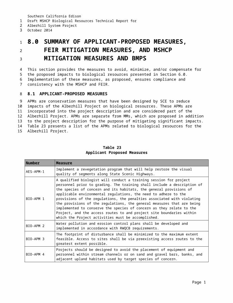
Southern California EdisonDraft MSHCP Biological Resources Technical Report forAlberhill System ProjectOctober 2014
THIS PAGE INTENTIONALLY LEFT BLANK
123
1
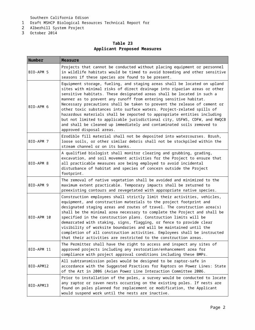
Southern California EdisonDraft MSHCP Biological Resources Technical Report forAlberhill System ProjectOctober 2014
APPENDIX CMSHCP CRITERIA AREAS AND CELLS
123
12

Southern California EdisonDraft MSHCP Biological Resources Technical Report forAlberhill System ProjectOctober 2014
THIS PAGE INTENTIONALLY LEFT BLANK
123
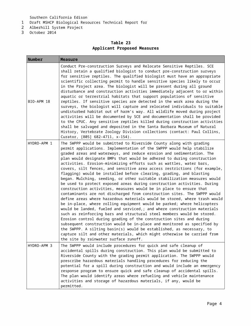
Southern California EdisonDraft MSHCP Biological Resources Technical Report forAlberhill System ProjectOctober 2014
APPENDIX DSPECIES THAT HAVE POTENTIAL TO OCCUR WITHIN THE PROJECT AREA
D1-Plants
D2-Wildlife
123
12
3
4
5
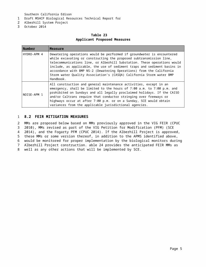
Southern California EdisonDraft MSHCP Biological Resources Technical Report forAlberhill System ProjectOctober 2014
THIS PAGE INTENTIONALLY LEFT BLANK
123
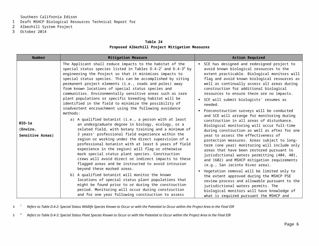
Southern California EdisonDraft MSHCP Biological Resources Technical Report forAlberhill System ProjectOctober 2014
D1
PLANTS
123
1
2
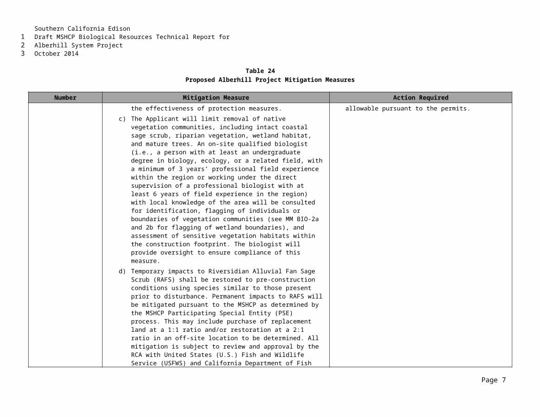
Southern California EdisonDraft MSHCP Biological Resources Technical Report forAlberhill System ProjectOctober 2014
THIS PAGE INTENTIONALLY LEFT BLANK
123
1
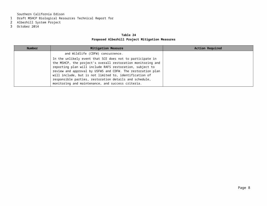
Southern California EdisonDraft MSHCP Biological Resources Technical Report forAlberhill System ProjectOctober 2014
D2WILDLIFE
123
12
Southern California EdisonDraft MSHCP Biological Resources Technical Report forAlberhill System ProjectOctober 2014
THIS PAGE INTENTIONALLY LEFT BLANK
123
Southern California EdisonDraft MSHCP Biological Resources Technical Report forAlberhill System ProjectOctober 2014
APPENDIX ESPECIES OBSERVED WITHIN THE
PROJECT AREA
E1-Plants
E2-Wildlife
123
123
4
5
6
Southern California EdisonDraft MSHCP Biological Resources Technical Report forAlberhill System ProjectOctober 2014
THIS PAGE INTENTIONALLY LEFT BLANK
123
Southern California EdisonDraft MSHCP Biological Resources Technical Report forAlberhill System ProjectOctober 2014
E1PLANTS
123
12
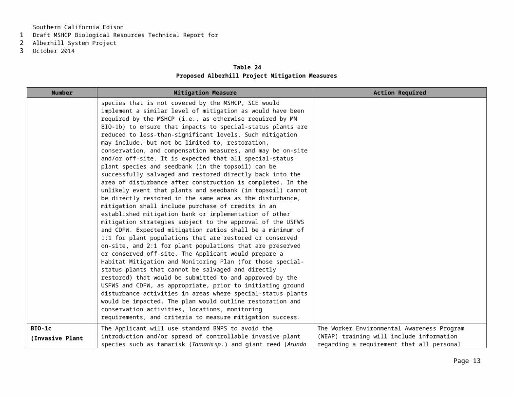
Southern California EdisonDraft MSHCP Biological Resources Technical Report forAlberhill System ProjectOctober 2014
THIS PAGE INTENTIONALLY LEFT BLANK
123
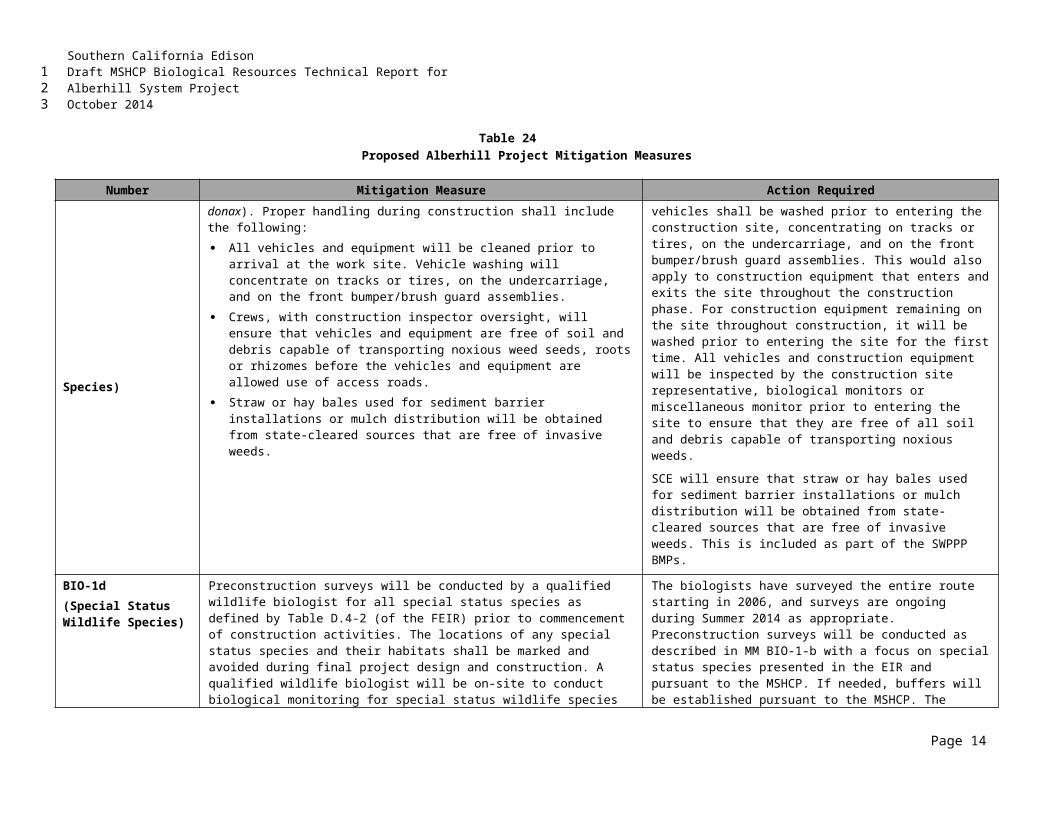
Southern California EdisonDraft MSHCP Biological Resources Technical Report forAlberhill System ProjectOctober 2014
E2WILDLIFE
123
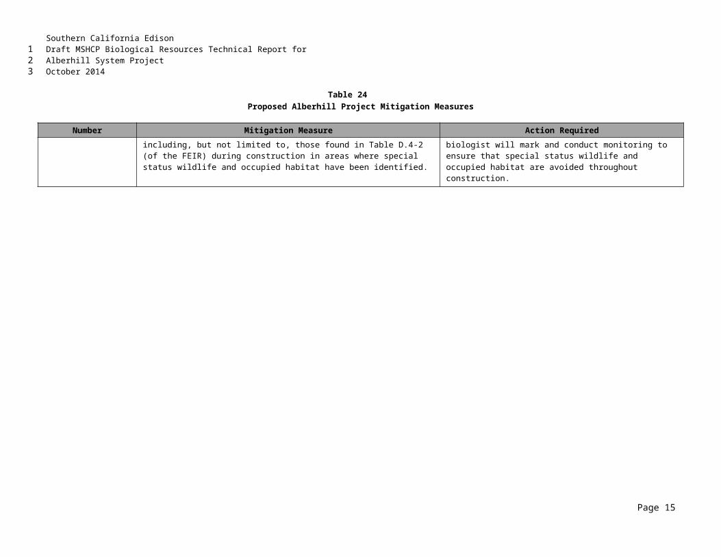
Southern California EdisonDraft MSHCP Biological Resources Technical Report forAlberhill System ProjectOctober 2014
THIS PAGE INTENTIONALLY LEFT BLANK
123
1
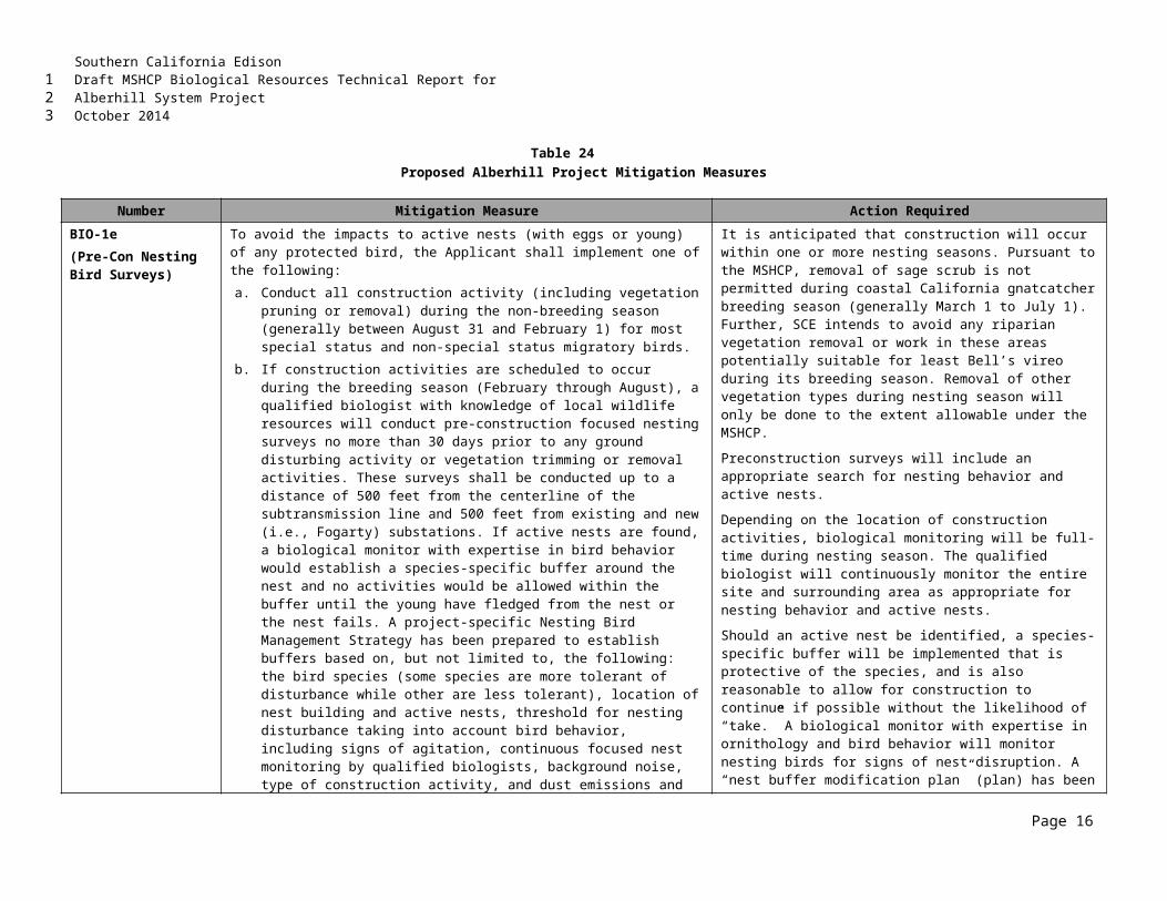
Southern California EdisonDraft MSHCP Biological Resources Technical Report forAlberhill System ProjectOctober 2014
APPENDIX FFOCUSED SPECIES SURVEY REPORTS
F1-2009 Focused Species Survey Reports
F2-2010 Focused Species Survey Reports
F3-2011 Focused Species Survey Reports
F4-2012 Focused Species Survey Reports
F5-2013 Focused Species Survey Reports
F6-2014 Focused Species Survey Reports
123
12
3
4
5
6
7
8
Southern California EdisonDraft MSHCP Biological Resources Technical Report forAlberhill System ProjectOctober 2014
THIS PAGE INTENTIONALLY LEFT BLANK
123
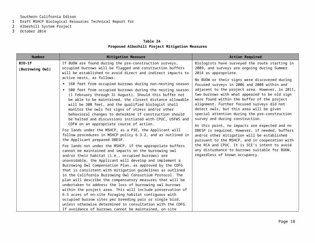
Southern California EdisonDraft MSHCP Biological Resources Technical Report forAlberhill System ProjectOctober 2014
F12009 FOCUSED SPECIES SURVEY REPORTS
123
12
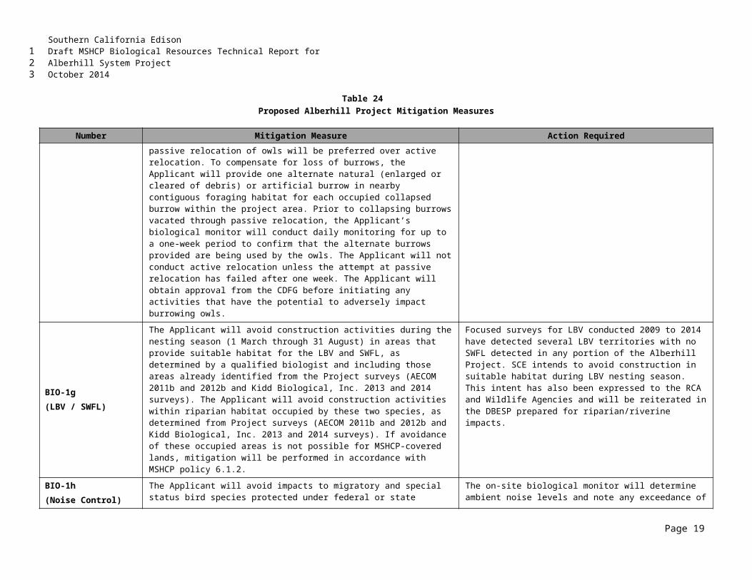
Southern California EdisonDraft MSHCP Biological Resources Technical Report forAlberhill System ProjectOctober 2014
THIS PAGE INTENTIONALLY LEFT BLANK
123
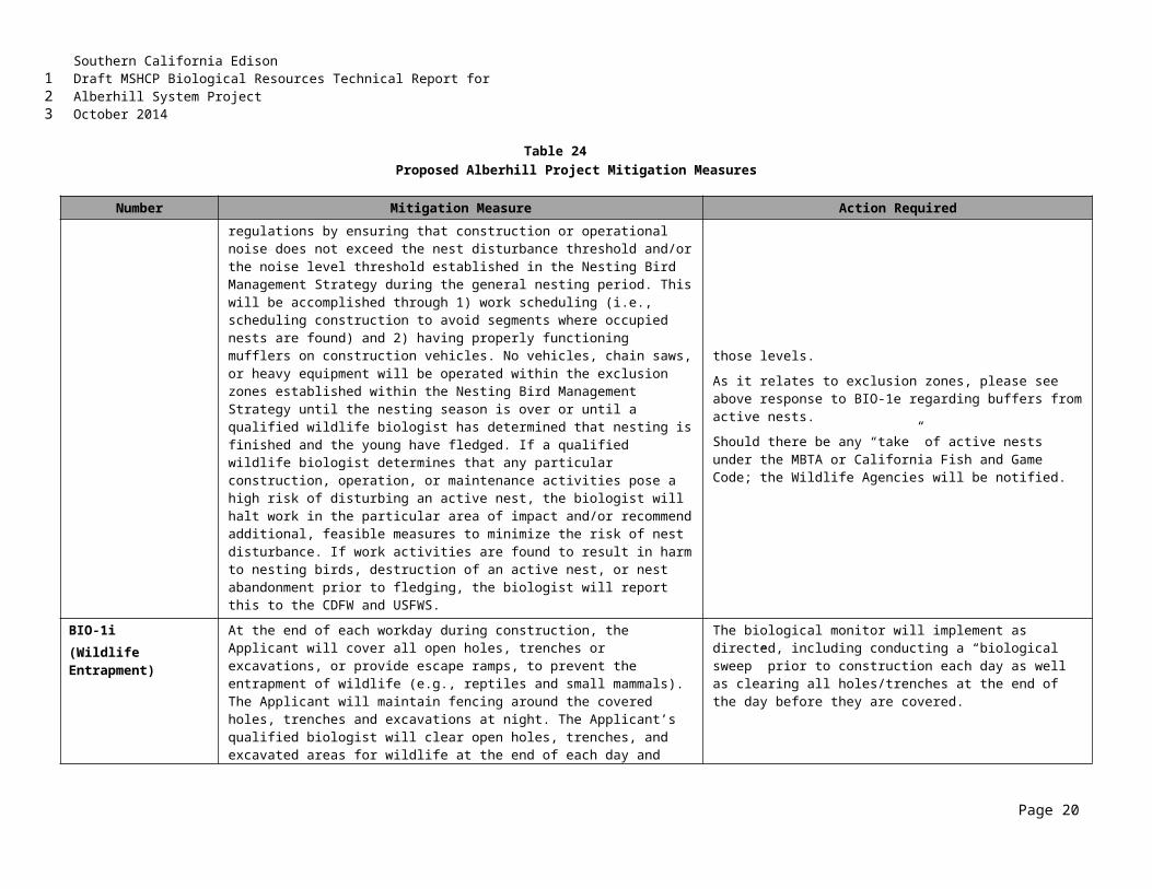
Southern California EdisonDraft MSHCP Biological Resources Technical Report forAlberhill System ProjectOctober 2014
F22010 FOCUSED SPECIES SURVEY REPORTS
123
12
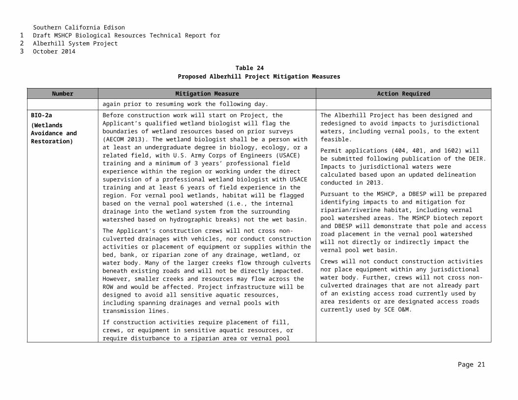
Southern California EdisonDraft MSHCP Biological Resources Technical Report forAlberhill System ProjectOctober 2014
THIS PAGE INTENTIONALLY LEFT BLANK
123
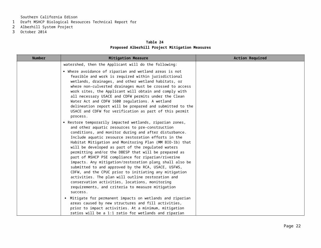
Southern California EdisonDraft MSHCP Biological Resources Technical Report forAlberhill System ProjectOctober 2014
F32011 FOCUSED SPECIES SURVEY REPORTS
123
12
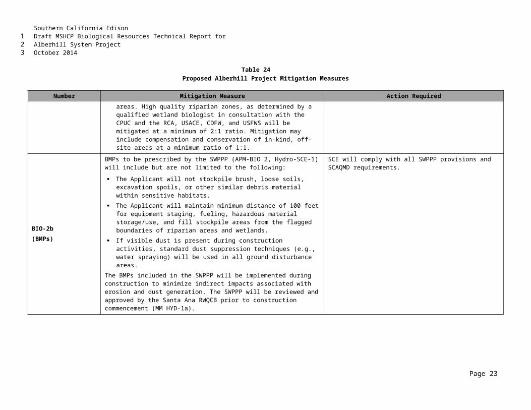
Southern California EdisonDraft MSHCP Biological Resources Technical Report forAlberhill System ProjectOctober 2014
THIS PAGE INTENTIONALLY LEFT BLANK
123
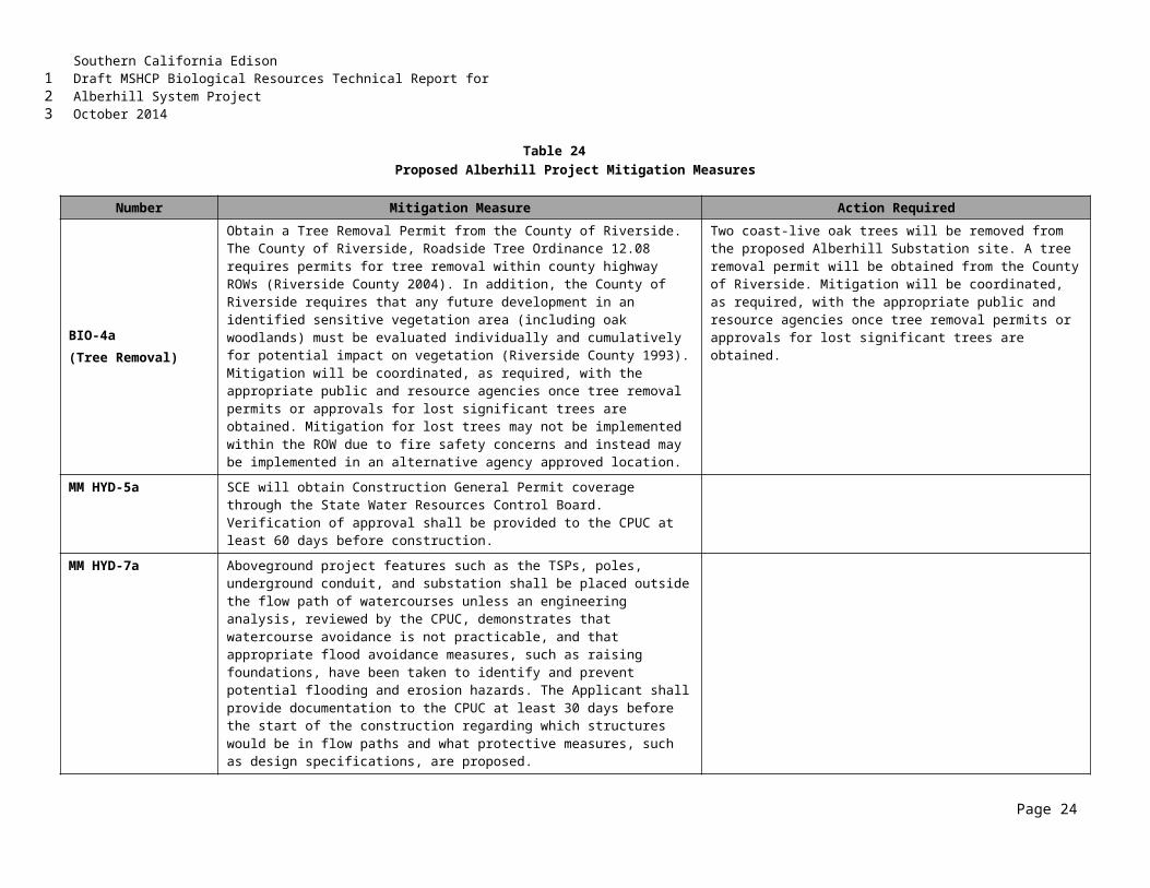
Southern California EdisonDraft MSHCP Biological Resources Technical Report forAlberhill System ProjectOctober 2014
F42012 FOCUSED SPECIES SURVEY REPORTS
123
12
Southern California EdisonDraft MSHCP Biological Resources Technical Report forAlberhill System ProjectOctober 2014
THIS PAGE INTENTIONALLY LEFT BLANK
123
Southern California EdisonDraft MSHCP Biological Resources Technical Report forAlberhill System ProjectOctober 2014
F52013 FOCUSED SPECIES SURVEY REPORTS
123
12
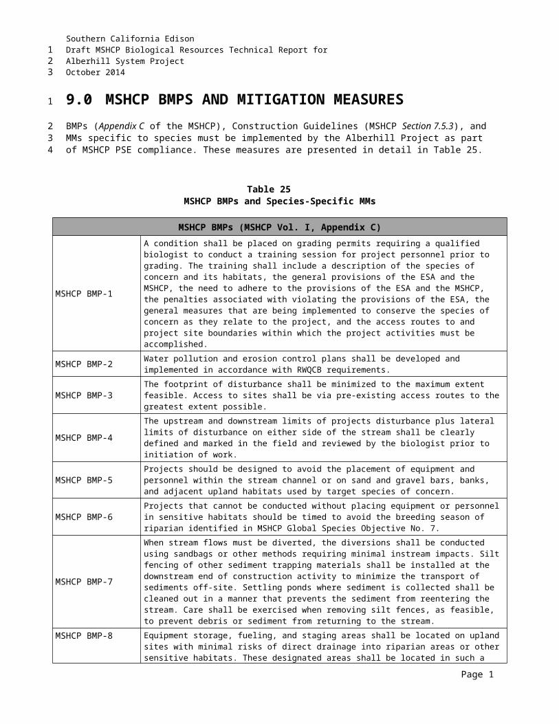
Southern California EdisonDraft MSHCP Biological Resources Technical Report forAlberhill System ProjectOctober 2014
THIS PAGE INTENTIONALLY LEFT BLANK
123
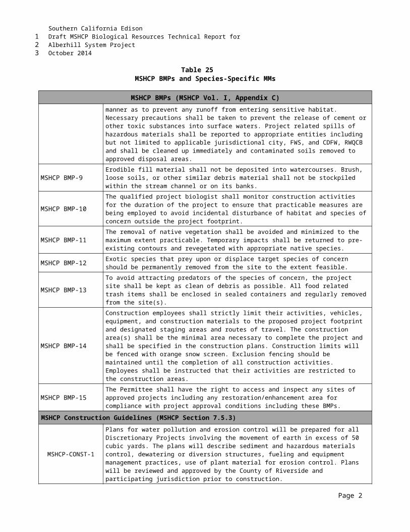
Southern California EdisonDraft MSHCP Biological Resources Technical Report forAlberhill System ProjectOctober 2014
F62014 FOCUSED SPECIES SURVEY REPORTS
123
12
3
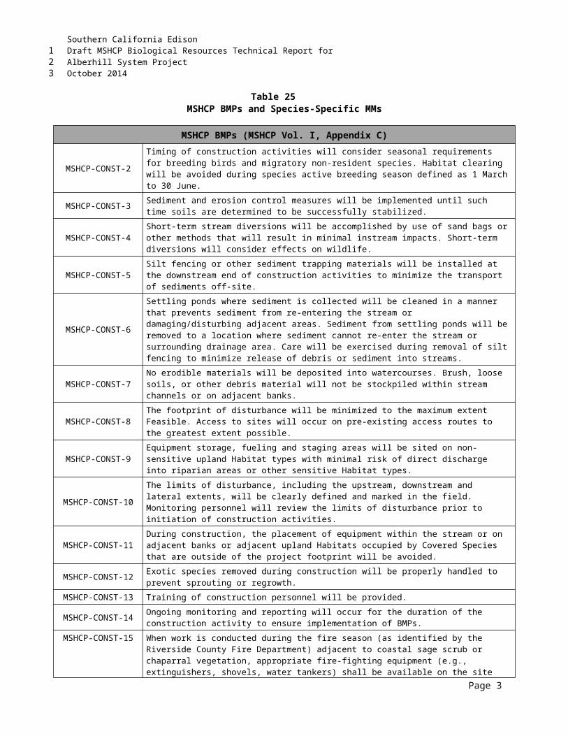
Southern California EdisonDraft MSHCP Biological Resources Technical Report forAlberhill System ProjectOctober 2014
THIS PAGE INTENTIONALLY LEFT BLANK
123
1
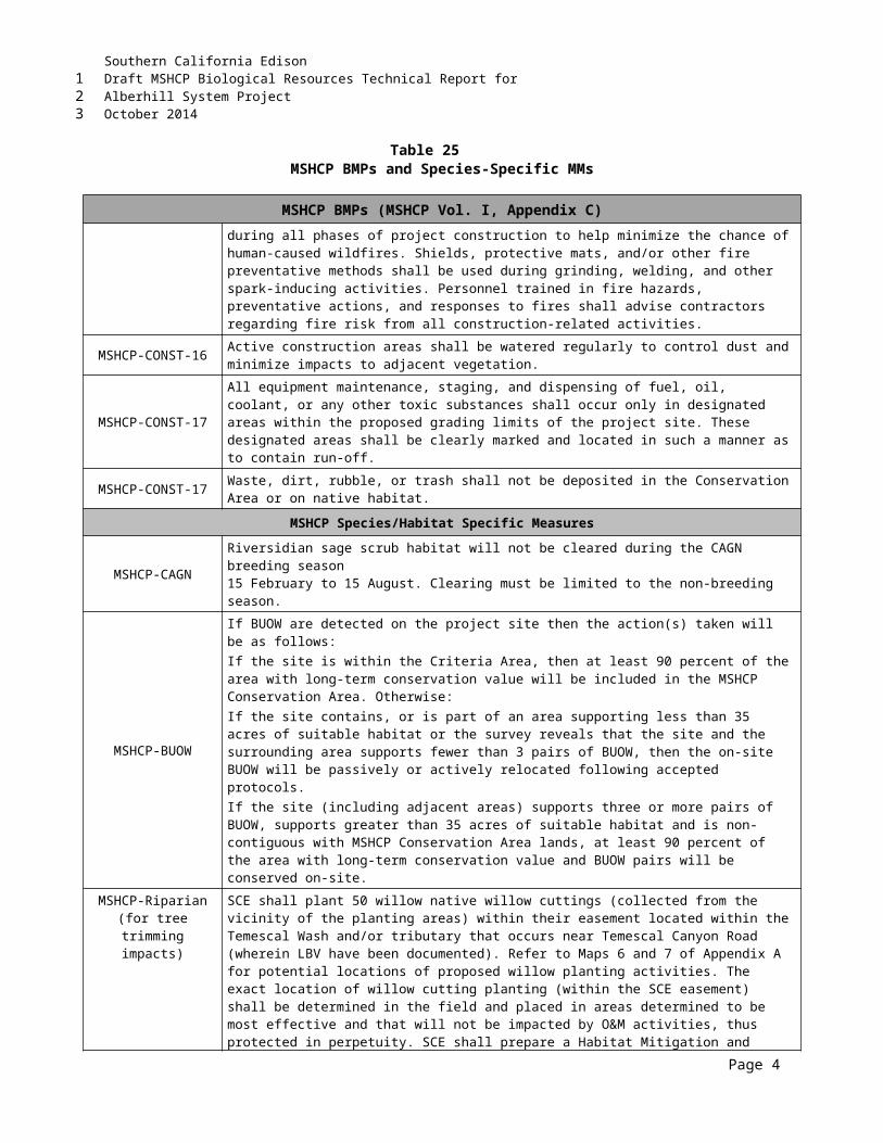
Southern California EdisonDraft MSHCP Biological Resources Technical Report forAlberhill System ProjectOctober 2014
APPENDIX GPRELIMINARY JD FORMS
123
12
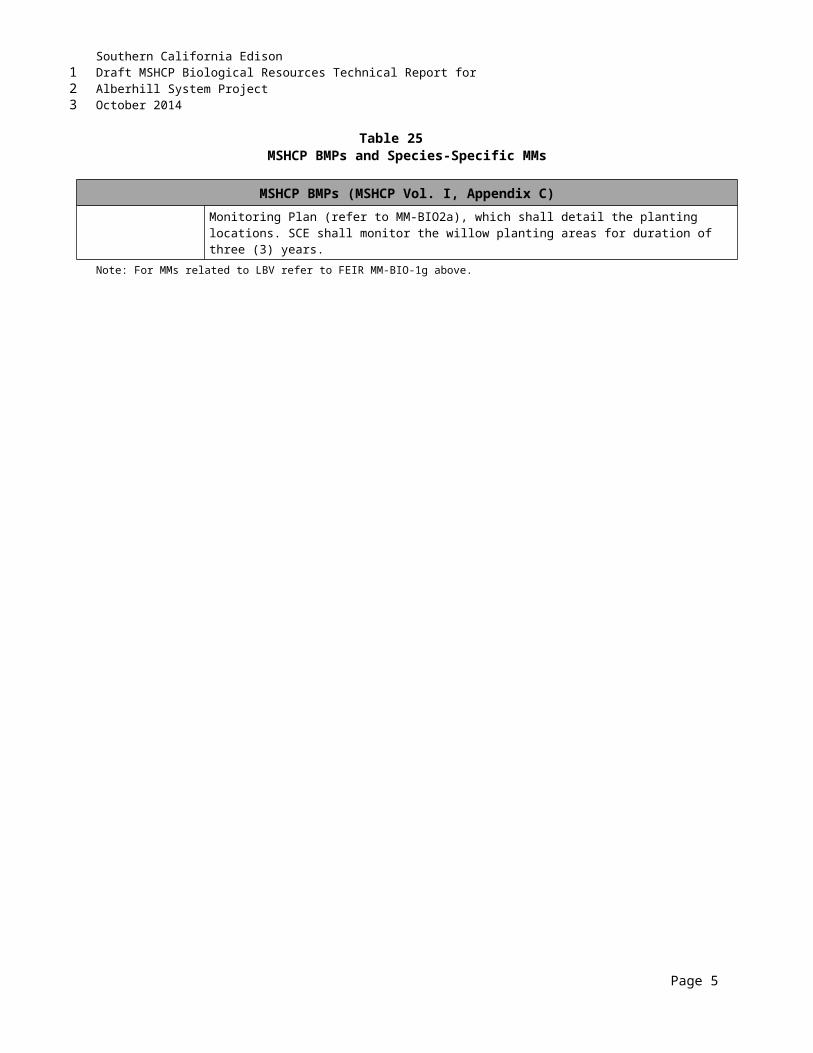
Southern California EdisonDraft MSHCP Biological Resources Technical Report forAlberhill System ProjectOctober 2014
THIS PAGE INTENTIONALLY LEFT BLANK
123
Southern California EdisonDraft MSHCP Biological Resources Technical Report forAlberhill System ProjectOctober 2014
APPENDIX HSTUDY AREA SOILS
H1-115-kV Sub-T/L Soil Map
H2-Substation and 500-kV T/L Soil Map
123
12
3
4
5

Southern California EdisonDraft MSHCP Biological Resources Technical Report forAlberhill System ProjectOctober 2014
THIS PAGE INTENTIONALLY LEFT BLANK
123
Southern California EdisonDraft MSHCP Biological Resources Technical Report forAlberhill System ProjectOctober 2014
H1115-KV SUB-T/L SOIL MAP
123
12
Southern California EdisonDraft MSHCP Biological Resources Technical Report forAlberhill System ProjectOctober 2014
THIS PAGE INTENTIONALLY LEFT BLANK
123
Southern California EdisonDraft MSHCP Biological Resources Technical Report forAlberhill System ProjectOctober 2014
H2SUBSTATION AND 500-KV T/L SOIL MAP
123
12
Southern California EdisonDraft MSHCP Biological Resources Technical Report forAlberhill System ProjectOctober 2014
THIS PAGE INTENTIONALLY LEFT BLANK
123
1

Southern California EdisonDraft MSHCP Biological Resources Technical Report forAlberhill System ProjectOctober 2014
APPENDIX IPHOTOGRAPHIC EXHIBITS
123
12
Southern California EdisonDraft MSHCP Biological Resources Technical Report forAlberhill System ProjectOctober 2014
THIS PAGE INTENTIONALLY LEFT BLANK
123
1