Embed Size (px)
Citation preview
Western Vaughan Transportation Improvements Individual Environmental Assessment
Executive Summary
E-1
Th
e R
eg
ion
al
Mu
nic
ipa
lity
of
Yo
rk
1. Introduction
The western portion of the City of Vaughan (City) currently experiences traffic congestion during the morning
and afternoon rush hour along most of its arterial roads. Over the next 20 years, traffic congestion along
these roads is expected to worsen due to anticipated population and employment growth.
The Regional Municipality of York‟s (York Region) 2002 Transportation Master Plan (TMP) and its more
recent November 2009 update adopted by Regional Council, recommended improvements to the arterial
roads within Western Vaughan as a means of improving transportation mobility. The Western Vaughan
Transportation Improvements Individual Environmental Assessment (IEA) builds upon the recommendations
from the 2002 and 2009 TMPs to identify the specific improvements required to address transportation
mobility within Western Vaughan. The first phase of this IEA began in 2005 when York Region, in concert
with the City of Vaughan, began preparing the required Terms of Reference (ToR) under the Ontario
Environmental Assessment Act (EA Act). The first phase of this IEA was completed on February 13, 2006
when the ToR was approved by the Minister.
In November 2007, York Region commenced the second phase of the IEA, which is the environmental
assessment phase. This report documents the planning and decision-making process undertaken as part of
the IEA which identifies transportation improvements within the western portion of the City.
1.1 Proponent
Although the City of Vaughan initiated the Schedule „C‟ Municipal Class EA Study and was a co-proponent
with York Region during preparation of the Western Vaughan Transportation Improvements IEA ToR, the
City withdrew from the project before the IEA was initiated. Therefore, York Region is the sole proponent for
the Western Vaughan Transportation Improvements IEA.
1.2 Ontario Environmental Assessment Act Requirements
As required by subsection 6.1(2) of the EA Act, the Project Team prepared the Western Vaughan
Transportation Improvements IEA in accordance with the ToR that was prepared and approved by the
Minister with amendments on February 13, 2006.
1.3 Overview of Western Vaughan Transportation Improvements IEA Process
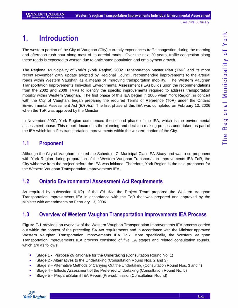
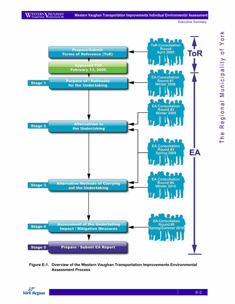
Figure E-1 provides an overview of the Western Vaughan Transportation Improvements IEA process carried
out within the context of the preceding EA Act requirements and in accordance with the Minister approved
Western Vaughan Transportation Improvements IEA ToR. More specifically, the Western Vaughan
Transportation Improvements IEA process consisted of five EA stages and related consultation rounds,
which are as follows:
Stage 1 - Purpose of/Rationale for the Undertaking (Consultation Round No. 1)
Stage 2 - Alternatives to the Undertaking (Consultation Round Nos. 2 and 3)
Stage 3 – Alternative Methods of Carrying Out the Undertaking (Consultation Round Nos. 3 and 4)
Stage 4 – Effects Assessment of the Preferred Undertaking (Consultation Round No. 5)
Stage 5 – Prepare/Submit IEA Report (Pre-submission Consultation Round)
Western Vaughan Transportation Improvements Individual Environmental Assessment
Executive Summary
E-2
Th
e R
eg
ion
al
Mu
nic
ipa
lity
of
Yo
rk
Figure E-1. Overview of the Western Vaughan Transportation Improvements Environmental
Assessment Process
Western Vaughan Transportation Improvements Individual Environmental Assessment
Executive Summary
E-3
Th
e R
eg
ion
al
Mu
nic
ipa
lity
of
Yo
rk
2. Purpose of / Rationale for the Undertaking
2.1 Purpose of the Undertaking
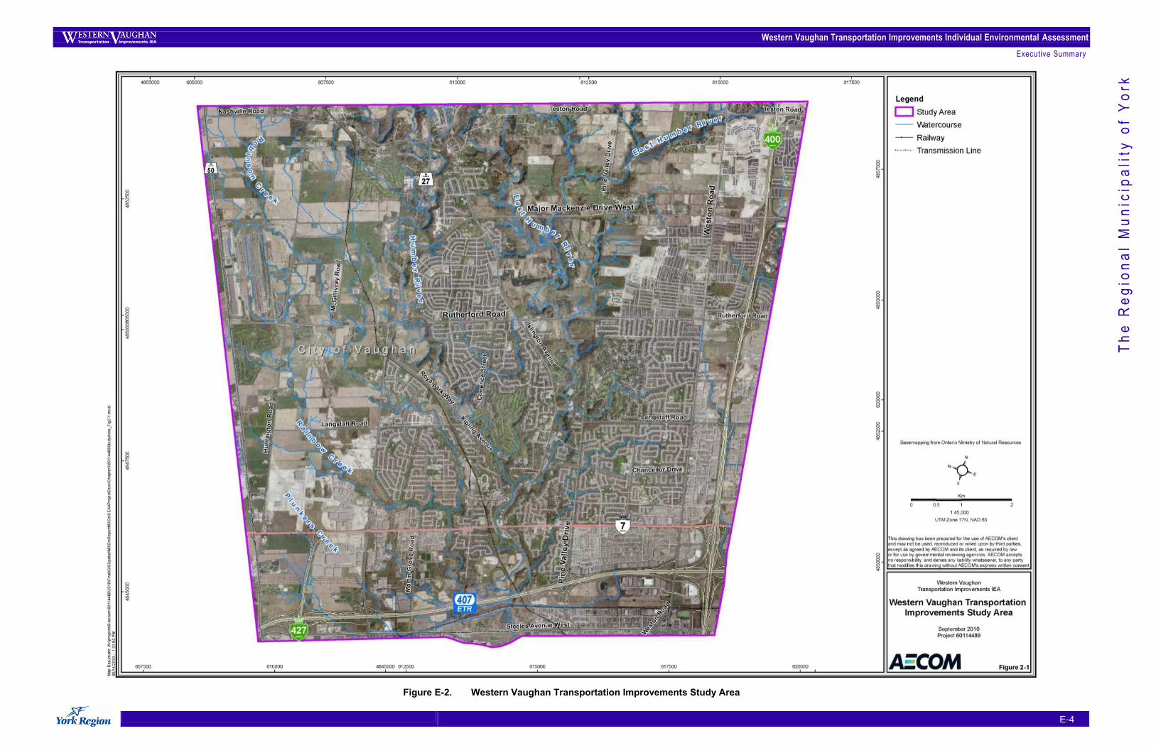
The purpose of the undertaking is to improve transportation mobility and facilitate more convenient and
reliable transportation choices within the Western Vaughan Transportation Improvements Study Area (see
Figure E-2) as new provincially-approved growth occurs over the next 25 years.
Improving transportation mobility means moving people by many different and efficient means. Enhancing
transportation mobility in the Study Area requires thinking beyond car-based travel and developing more
innovative strategies that make better use of York Region‟s infrastructure. Moreover, York Region seeks a
solution that adheres to the principles of sustainability, as identified in the November 2009 TMP adopted by
Regional Council and:
1. Preserves and enhances the sustainable environment;
2. Supports economic vitality; and
3. Encourages healthier neighbourhoods and communities.
2.2 Rationale for the Undertaking
In anticipation of future population and employment growth, York Region recognizes the need to manage
congestion more efficiently and sustainably, ensuring that its transportation system can accommodate new
growth in all of the Region‟s municipalities – including the City of Vaughan. York Region is projected to
experience a more than 60% increase in population by 2031 to nearly 1.5 million residents. While there are
limited areas in Western Vaughan that will support new growth, the area‟s population is nonetheless
expected to grow by 25% by 2031 to over 125,000 residents. Future employment in York Region is
projected to increase nearly 80% over that same time span, while more than doubling in Western Vaughan
as a result of anticipated business growth.
If practical solutions are not implemented, there will be several foreseeable challenges to the future operation
of Western Vaughan‟s transportation system, including: high levels of traffic congestion. In 2006, the
majority of the Study Area (nearly two-thirds) did not experience congestion in 2006, with moderate to severe
congestion experienced only on freeways and arterials, including Highway 50, sections of Highway 27 and
Weston Road. By 2021, the level of road congestion is projected to exceed those that experience generally
free-flowing conditions, and by 2031 a majority of the roadways (60%) are projected to be congested.
Discontinuous roads, including a significant jog in Major Mackenzie Drive at Highway 27, low vehicle
occupancy rates, limited transit service, and heavy truck traffic also contribute to future operation challenges
of the transportation system in Western Vaughan.
Western Vaughan Transportation Improvements Individual Environmental Assessment
Executive Summary
E-4
Th
e R
eg
ion
al
Mu
nic
ipa
lity
of
Yo
rk
Figure E-2. Western Vaughan Transportation Improvements Study Area
Western Vaughan Transportation Improvements Individual Environmental Assessment
Executive Summary
E-5
Th
e R
eg
ion
al
Mu
nic
ipa
lity
of
Yo
rk
3. Alternatives to the Undertaking
3.1 Description and Rationale of Alternatives to the Undertaking and Confirmation of the “Short-List” of Alternatives
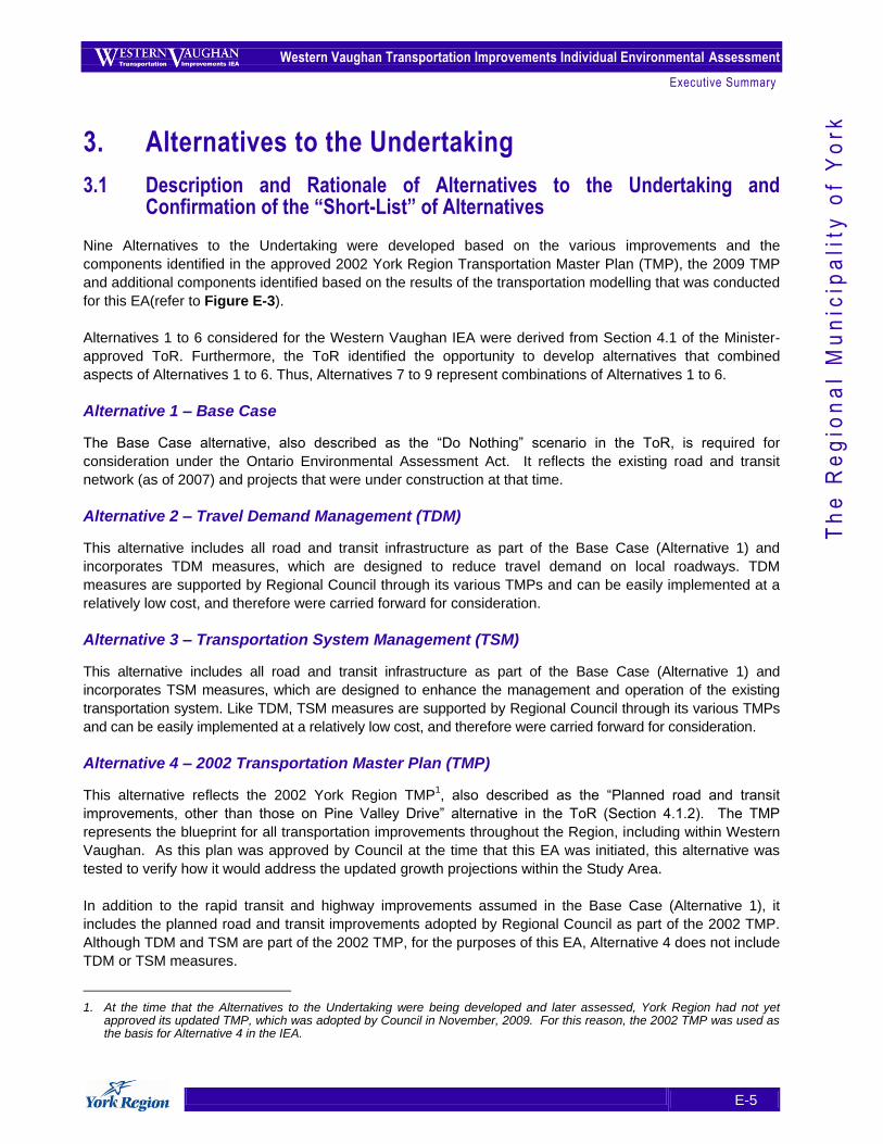
Nine Alternatives to the Undertaking were developed based on the various improvements and the
components identified in the approved 2002 York Region Transportation Master Plan (TMP), the 2009 TMP
and additional components identified based on the results of the transportation modelling that was conducted
for this EA(refer to Figure E-3).
Alternatives 1 to 6 considered for the Western Vaughan IEA were derived from Section 4.1 of the Minister-
approved ToR. Furthermore, the ToR identified the opportunity to develop alternatives that combined
aspects of Alternatives 1 to 6. Thus, Alternatives 7 to 9 represent combinations of Alternatives 1 to 6.
Alternative 1 – Base Case
The Base Case alternative, also described as the “Do Nothing” scenario in the ToR, is required for
consideration under the Ontario Environmental Assessment Act. It reflects the existing road and transit
network (as of 2007) and projects that were under construction at that time.
Alternative 2 – Travel Demand Management (TDM)
This alternative includes all road and transit infrastructure as part of the Base Case (Alternative 1) and
incorporates TDM measures, which are designed to reduce travel demand on local roadways. TDM
measures are supported by Regional Council through its various TMPs and can be easily implemented at a
relatively low cost, and therefore were carried forward for consideration.
Alternative 3 – Transportation System Management (TSM)
This alternative includes all road and transit infrastructure as part of the Base Case (Alternative 1) and
incorporates TSM measures, which are designed to enhance the management and operation of the existing
transportation system. Like TDM, TSM measures are supported by Regional Council through its various TMPs
and can be easily implemented at a relatively low cost, and therefore were carried forward for consideration.
Alternative 4 – 2002 Transportation Master Plan (TMP)
This alternative reflects the 2002 York Region TMP1, also described as the “Planned road and transit
improvements, other than those on Pine Valley Drive” alternative in the ToR (Section 4.1.2). The TMP
represents the blueprint for all transportation improvements throughout the Region, including within Western
Vaughan. As this plan was approved by Council at the time that this EA was initiated, this alternative was
tested to verify how it would address the updated growth projections within the Study Area.
In addition to the rapid transit and highway improvements assumed in the Base Case (Alternative 1), it
includes the planned road and transit improvements adopted by Regional Council as part of the 2002 TMP.
Although TDM and TSM are part of the 2002 TMP, for the purposes of this EA, Alternative 4 does not include
TDM or TSM measures.
1. At the time that the Alternatives to the Undertaking were being developed and later assessed, York Region had not yet approved its updated TMP, which was adopted by Council in November, 2009. For this reason, the 2002 TMP was used as the basis for Alternative 4 in the IEA.
Western Vaughan Transportation Improvements Individual Environmental Assessment
Executive Summary
E-6
Th
e R
eg
ion
al
Mu
nic
ipa
lity
of
Yo
rk
Figure E-3. Alternatives to the Undertaking
Western Vaughan Transportation Improvements Individual Environmental Assessment
Executive Summary
E-7
Th
e R
eg
ion
al
Mu
nic
ipa
lity
of
Yo
rk
Alternative 5 – 2002 TMP and More Transit (Extended Transit Priority Network (TPN))
Alternative 5 was developed to identify and test additional transit opportunities along major corridors in
Western Vaughan that would complement planned transit network improvements. This alternative would
enable greater transit connectivity and result in increased inter-regional and intra-regional ridership.
Alternative 5 builds upon the transit component of the 2002 TMP by adding a TPN along the following
corridors, which would be widened to 6 lanes to accommodate the high occupancy vehicle (HOV) lanes for
transit and carpoolers:
Major Mackenzie Drive from Weston Road to Highway 50;
Rutherford Road from Highway 27 to Highway 50; and,
Highway 27 from Rutherford Road to Major Mackenzie Drive.
The extended TPN is consistent with the recommendations of the 2009 TMP.
Alternative 6 – 2002 TMP and More Roads
This alternative is comprised of road and transit improvements adopted as part of York Region‟s 2002 TMP
(Alternative 4), plus additional road improvements designed to support future local and regional mobility
based on population and employment growth anticipated by 2031, as well as to provide enhanced access to
future development areas. The reason for including this alternative is to determine whether there is any
benefit to managing congestion from a roads-focused approach. Unlike the road improvements included in
Alternative 5, these additional road improvements would only support general purpose traffic and would not
include a separate HOV lane for transit and carpoolers.
Alternative 7 –TDM, TSM, 2002 TMP Transit Network and More Transit
This alternative represents a multi-modal approach to transportation that focuses on the need to reduce
travel demand, increase the efficiency of the existing road network and enhance transit opportunities in
Western Vaughan. Alternative 7 is based on the transit improvements proposed in Alternative 5. It was
developed to determine if this combination of transit and other multi-modal transportation improvements (i.e.,
TDM and TSM) would support population and employment growth and accommodate increased traffic
congestion through 2031 without relying on improvements to the road network.
Alternative 8 – All Improvements, Excluding New Roads Identified in Alternative 6
Alternative 8 comprises the road and transit improvements from Alternative 5 (including an extended TPN), plus
the multi-modal elements of Alternative 7 (TDM and TSM). This alternative excludes the additional road
improvements identified in Alternative 6 that were developed to support future local and regional mobility.
Alternative 8 was developed to determine if this combination of transit, road and other multi-modal
transportation improvements would support population and employment growth, and accommodate increased
traffic congestion through 2031, without relying on the full suite of road improvements proposed in Alternative 6.
Alternative 9 – All Improvements
Alternative 9 is a combination of all the alternatives. Alternative 9 was developed to determine if this
combination of all transit, road and other multi-modal transportation improvements (i.e., TDM and TSM)
would provide greater benefit to the transportation network in terms of supporting population and
employment growth, as well as accommodating increased traffic congestion through 2031.
Western Vaughan Transportation Improvements Individual Environmental Assessment
Executive Summary
E-8
Th
e R
eg
ion
al
Mu
nic
ipa
lity
of
Yo
rk
3.2 Screening of the Alternatives To the Undertaking
The Minister-approved ToR allowed for the list of Alternatives to the Undertaking to be “screened down” to a
“short-list” of alternatives considered reasonable for comparative evaluation. The screening process
determined which alternatives are capable of improving transportation mobility based on the following
questions:
1. How well does each alternative reduce congestion in Western Vaughan?
2. How well does each alternative reduce the time it takes to drive through Western Vaughan?
3. How well does each alternative increase the number of people who take transit?
As a result of applying the screening criteria, Alternatives 6, 8 and 9 were short-listed and carried forward for
further analysis. Conversely, the other six alternatives were screened out because they did not address the
purpose / rationale for the undertaking, which is the ability to improve the transportation mobility within the
Study Area, to the same level as Alternatives 6, 8, and 9.
The “short-list” of Alternatives to the Undertaking was presented to review agencies, First Nations and the
public for their input and feedback through Advisory Committee meetings, Public Consultation Centres,
newsletters, and other correspondence and was confirmed and subsequently carried forward for comparative
evaluation.
3.3 Description of the Potentially Affected Environment
This section describes the natural (aquatic and terrestrial), socio-economic and cultural environment
associated with the short-listed alternatives.
Natural Environment
Aquatic Environment
There are two main watersheds in the Study Area (total area 11,956 hectares), the Humber River
watershed (11,392 hectares in the Study Area) and the Don River watershed (564 hectares in the Study
Area). Within these two watersheds, 8 watercourses are present in the Study Area including: East
Robinson Creek, West Robinson Creek, Rainbow Creek, the Main Humber River, the East Humber
River, Purpleville Creek, Marigold Creek and Black Creek.
There are several areas within the Humber River watershed that have been identified as having high
quality fish habitat, presence of sensitive fish species or fish species that are listed under federal or
provincial endangered species legislation (Species at Risk). Water quality within the Humber River
varies considerably, with the highest quality water associated with the headwater area, and poorer
water quality associated with the lower reaches of the river.
There are no areas within the Don River watershed portion of the Study Area that have been identified
as having high quality fish habitat, uncommon fish species or Species at Risk. Water quality varies
considerably throughout the Don River watershed with the highest quality water associated with
groundwater inputs from the Oak Ridges Moraine (ORM), and the more degraded water quality
associated with the developed southern portion of the watershed.
Western Vaughan Transportation Improvements Individual Environmental Assessment
Executive Summary
E-9
Th
e R
eg
ion
al
Mu
nic
ipa
lity
of
Yo
rk
Terrestrial Environment:
Existing natural cover comprises approximately 2,618 hectares, or 22 percent of the total Study Area;
forest cover, at 13 % of the Study Area, falls below the minimum 30% cover recommended by
Environment Canada to achieve and maintain healthy forest ecosystems and watersheds. The few
remaining wetlands within the Study Area are associated with tributaries of the Don and Humber Rivers.
There are a total of three Life Science Areas of Natural and Scientific Interest (ANSI) within the Study
Area: Boyd Conservation Area and Adjacent Lands (Provincially designated), Kleinberg Woodlots
(Regionally designated) and Humber River (Regionally designated).
A total of 19 ESAs are found within the subject lands - 18 are considered to have ecological importance
and are therefore designated as Life Science sites and the remaining site has a geologically important
feature, and is thereby designated as an Earth Science Site. „
Hydrogeology
Multiple discontinuous aquifers of varying lateral extent exist throughout the Study Area.
Within the Study Area, over 70% of drilled wells are completed in overburden, indicating that the
overburden is an important aquifer for private wells. Wells that tap the bedrock comprise only 30% of
wells drilled in the Study Area.
Analyses of water wells located along different concession lines indicate that there are three aquifers
(deep, intermediate and shallow aquifers) in the Study Area at discrete elevations.
Socio-Economic Environment
The population of the City of Vaughan as of 2006 is approximately 250,000. Planned growth will take
the population to approximately 420,000 by 2031.
Within the Study Area, the City of Vaughan‟s Official Plan Amendment (OPA) 450 applies to lands at the
intersection of Weston Road and Highway 7. It includes two land use designations along the Corridor–
“Prestige Area” and “Employment Area General”. These designations permit a wide range of industrial,
office, business and civic uses.
The Major Mackenzie Drive, Rutherford Road (between Highway 50 and Highway 27) and Highway 27
study corridors are predominately rural, characterised mainly by natural areas and individual residences
and businesses. The lands along Highway 27 close to Highway 7 are largely industrial.
The Rutherford Road (Highway 27 and Weston Road), Weston Road and Pine Valley Drive study
corridors are predominately urban, characterised mainly by residential subdivisions and associated
community features, commercial buildings and plazas and light industrial uses.
The City of Vaughan‟s OPA 650 anticipates that Vellore Village District Centre will accommodate an
estimated 50,000 to 60,000 new residents and will become the major focus of commercial activity within
its community.
The City of Vaughan has recently completed an update of its Official Plan, which was approved by City
Council in September, 2010.
The Study Area consists of three distinct types of acoustic environments: urban areas (suburban / semi-
rural areas and rural areas. The majority of Western Vaughan would be classified as a Class 1 Sound
Level area, with sound levels of 55 dBA or greater.
Western Vaughan Transportation Improvements Individual Environmental Assessment
Executive Summary
E-10
Th
e R
eg
ion
al
Mu
nic
ipa
lity
of
Yo
rk
Cultural Environment
The Ontario Archaeological Site Database indicates 196 registered sites within 50 metres of the Study
Area.
A total of 289 cultural heritage resources have been previously identified in the Study Area through
designation under the Ontario Heritage Act and listing on the City of Vaughan‟s Inventory of Heritage
Properties; 25 additional cultural heritage resources units were identified through background historical
research and a review of historic mapping; 19 features have been designated under Part IV of the
Ontario Heritage Act; 124 features have been designated under Part V of the Ontario Heritage Act and
are located in the Kleinberg-Nashville Heritage Conservation District; 90 features are pending
designation under Part V of the Ontario Heritage Act and are a part of the Woodbridge Heritage
Conservation District Study.
3.4 Comparative Evaluation of the “Short-List” of Alternatives to the Undertaking
The “Short List” was comparatively evaluated in accordance with the Minister-approved ToR and based on
the existing environmental conditions related to the natural, socio-economic, and cultural environments, as
well as transportation and financial information. The comparative evaluation of the short-listed alternatives
was carried out through the following three steps:
Step 1: ..... Confirm Evaluation Criteria and Develop Indicators/Measures
Step 2: ..... Undertake Net Effects Analysis
Step 3: ..... Carry Out Comparative Evaluation Based on Net Effects
Based on the comparative evaluation and overall rankings for the three “short-listed”, the „Recommended
Alternative to the Undertaking‟ was identified as “Alternative 8 – All Improvements, Excluding New Roads
Identified in Alternative 6.” The rationale for this ranking is provided below.
Alternative 6 is the least preferred of the three short-listed alternatives. In terms of the Transportation, and
the Social and Cultural Environment factors, Alternative 6 will cause the greatest adverse net effects.
Alternative 9 is moderately preferred overall. Although it has greater benefits from a transportation
perspective in terms of congestion, public safety and accommodating transit, pedestrians and cyclists than
Alternative 6, and results in a more efficient transportation system than Alternative 8, it will provide fewer
benefits to transit users when compared with Alternative 8.
Alternative 8 is most preferred of the three alternatives. Although it was ranked moderately preferred in
terms of the Transportation factor, it was ranked most preferred for the Natural, Socio-Economic and Cultural
factors.
3.5 Identification of the Preferred Alternative
The Recommended Alternative to the Undertaking (Alternative 8) was confirmed as the Preferred Alternative
to the Undertaking based on consultation with review agencies and the public on the recommendation.
Western Vaughan Transportation Improvements Individual Environmental Assessment
Executive Summary
E-11
Th
e R
eg
ion
al
Mu
nic
ipa
lity
of
Yo
rk
4. Stage Three: Alternative Methods for Carrying Out the Undertaking
4.1 Identification and Description of Alternative Alignments
In the case of most roads identified for improvements pursuant to Alternative 8, the proposed alignment was
centred on the existing centreline, with the road widened equally to either side. In these locations, only one
alignment was recommended because other alignments were not considered reasonable due to existing
natural, social or cultural constraints. In these cases, the proposed alignment was simply subjected to a net
effects analysis.
In locations where a widening would affect an existing natural, social or cultural feature, alternative
alignments were developed to avoid or minimize effects on that feature. In addition, alternative alignments
were developed to eliminate the jog at Major Mackenzie Drive and Highway 27 and create a new road
through undeveloped land. In these cases, each alternative alignment was subjected to a net effects
analysis, after which a comparative evaluation was used to determine the preferred alternative alignment for
the segment.
In general, widening to six lanes to reflect York Region‟s approved transit / HOV cross-section requires a
minimum of 36 metres for the right-of-way, which would provide for two 3.3 metre wide general-purpose
lanes in each direction, one 5.0 metre wide transit and bicycle lane in each direction, sidewalks and an
associated boulevard in each direction, and a 6 metre wide centre median.
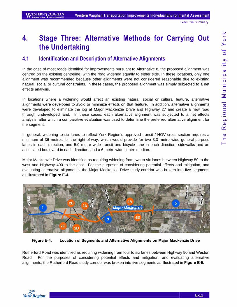
Major Mackenzie Drive was identified as requiring widening from two to six lanes between Highway 50 to the
west and Highway 400 to the east. For the purposes of considering potential effects and mitigation, and
evaluating alternative alignments, the Major Mackenzie Drive study corridor was broken into five segments
as illustrated in Figure E-4.
Figure E-4. Location of Segments and Alternative Alignments on Major Mackenzie Drive
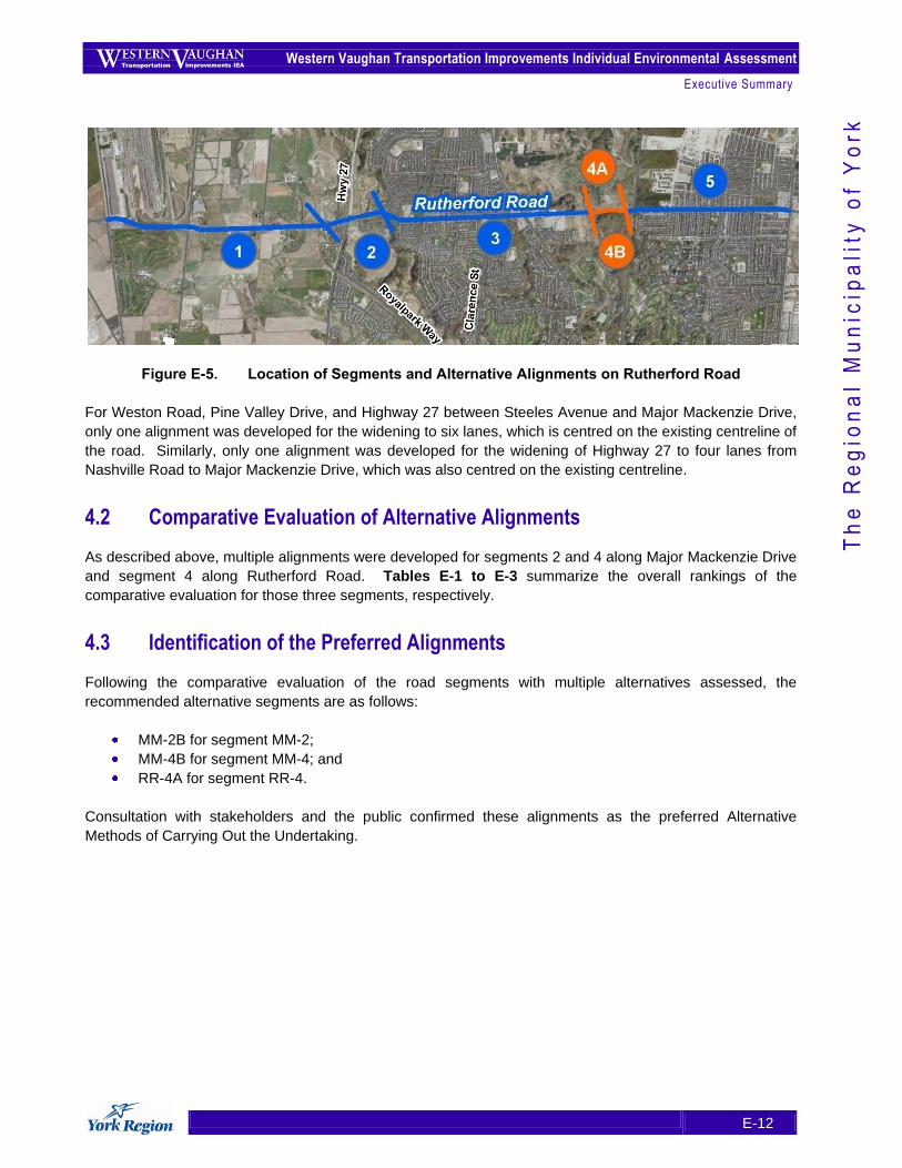
Rutherford Road was identified as requiring widening from four to six lanes between Highway 50 and Weston
Road. For the purposes of considering potential effects and mitigation, and evaluating alternative
alignments, the Rutherford Road study corridor was broken into five segments as illustrated in Figure E-5.
Western Vaughan Transportation Improvements Individual Environmental Assessment
Executive Summary
E-12
Th
e R
eg
ion
al
Mu
nic
ipa
lity
of
Yo
rk
Figure E-5. Location of Segments and Alternative Alignments on Rutherford Road
For Weston Road, Pine Valley Drive, and Highway 27 between Steeles Avenue and Major Mackenzie Drive,
only one alignment was developed for the widening to six lanes, which is centred on the existing centreline of
the road. Similarly, only one alignment was developed for the widening of Highway 27 to four lanes from
Nashville Road to Major Mackenzie Drive, which was also centred on the existing centreline.
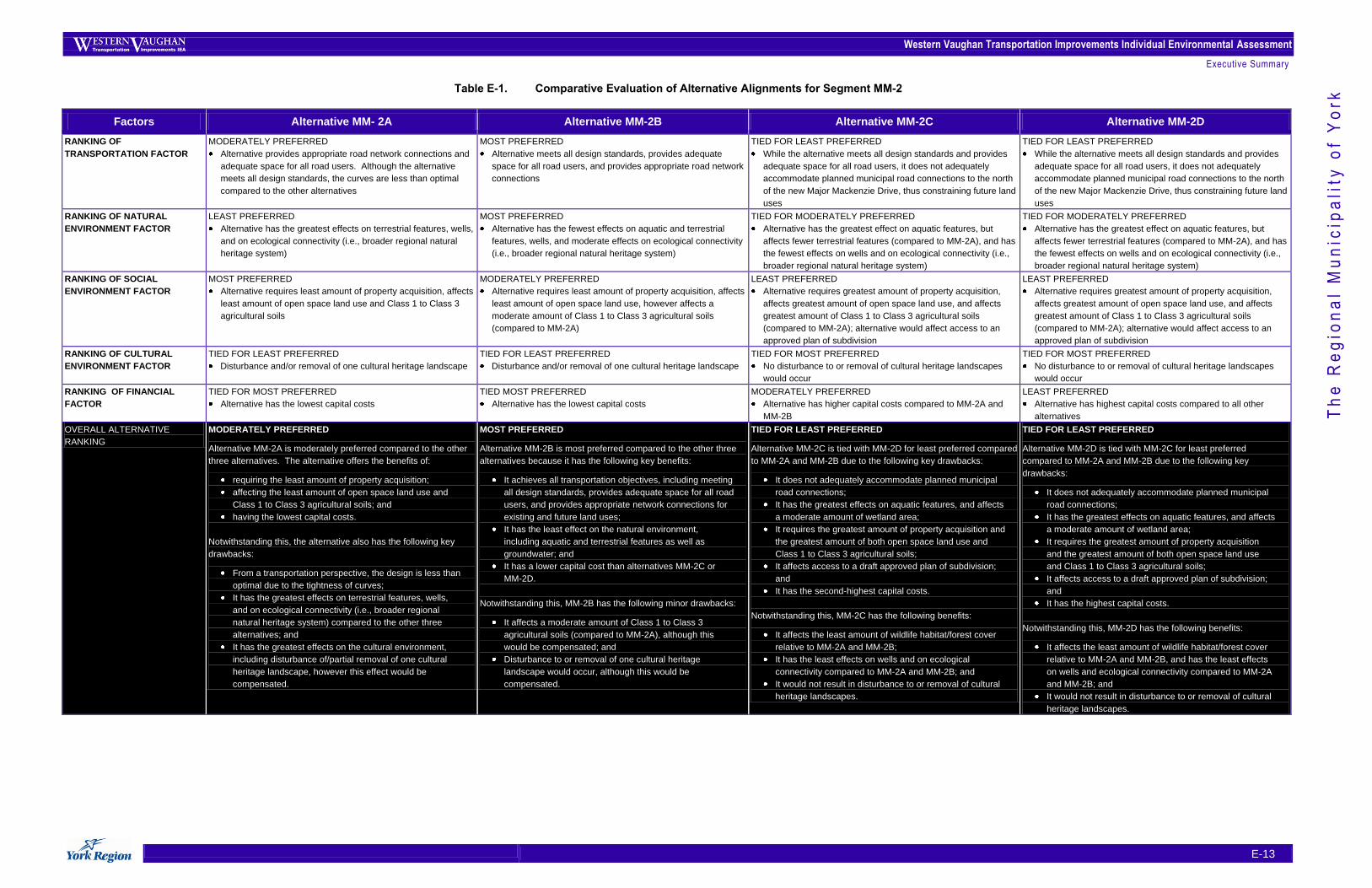
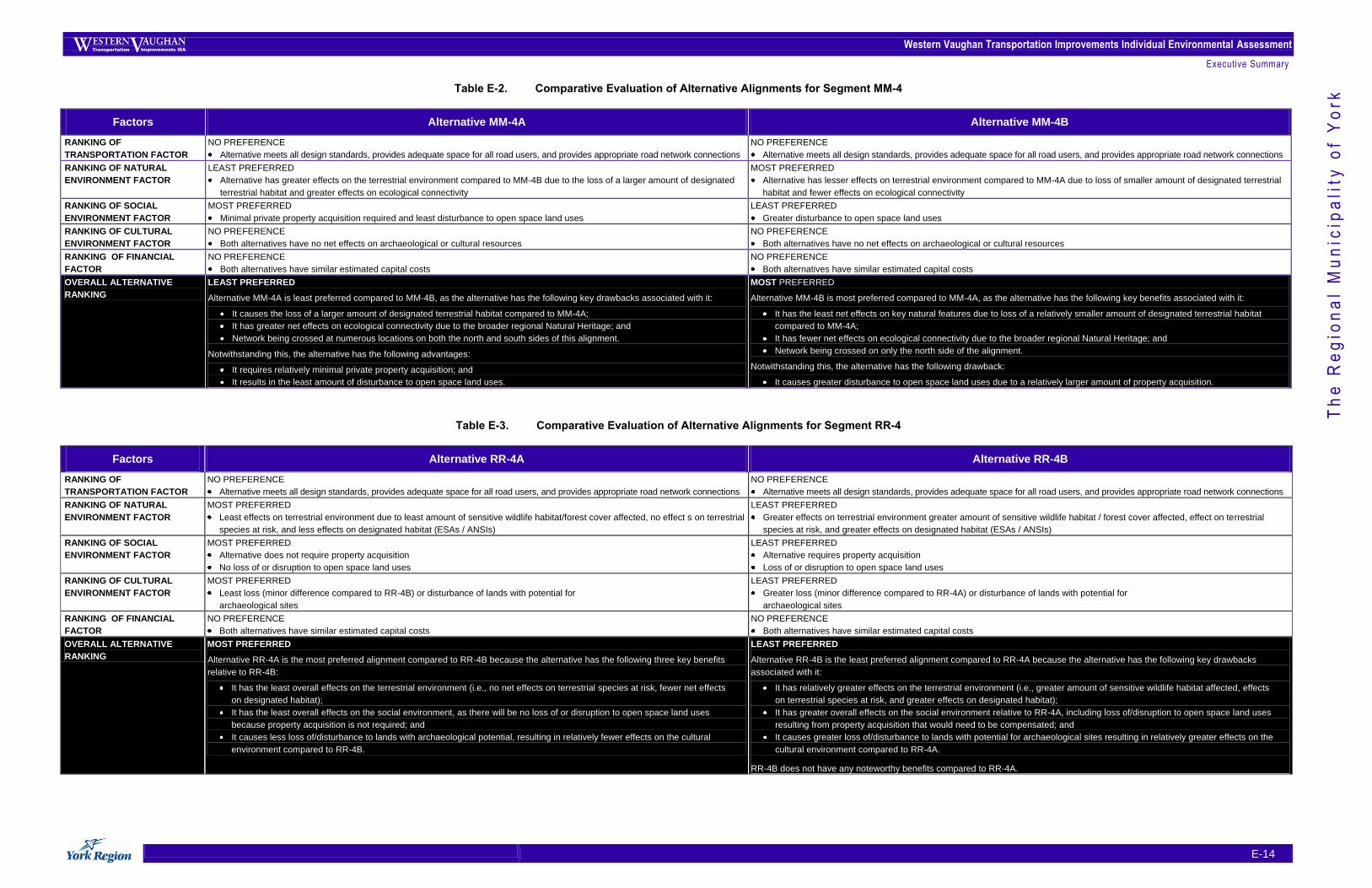
4.2 Comparative Evaluation of Alternative Alignments
As described above, multiple alignments were developed for segments 2 and 4 along Major Mackenzie Drive
and segment 4 along Rutherford Road. Tables E-1 to E-3 summarize the overall rankings of the
comparative evaluation for those three segments, respectively.
4.3 Identification of the Preferred Alignments
Following the comparative evaluation of the road segments with multiple alternatives assessed, the
recommended alternative segments are as follows:
MM-2B for segment MM-2;
MM-4B for segment MM-4; and
RR-4A for segment RR-4.
Consultation with stakeholders and the public confirmed these alignments as the preferred Alternative
Methods of Carrying Out the Undertaking.
Western Vaughan Transportation Improvements Individual Environmental Assessment
Executive Summary
E-13
Th
e R
eg
ion
al
Mu
nic
ipa
lity
of
Yo
rk Table E-1. Comparative Evaluation of Alternative Alignments for Segment MM-2
Factors Alternative MM- 2A Alternative MM-2B Alternative MM-2C Alternative MM-2D
RANKING OF
TRANSPORTATION FACTOR
MODERATELY PREFERRED
Alternative provides appropriate road network connections and
adequate space for all road users. Although the alternative
meets all design standards, the curves are less than optimal
compared to the other alternatives
MOST PREFERRED
Alternative meets all design standards, provides adequate
space for all road users, and provides appropriate road network
connections
TIED FOR LEAST PREFERRED
While the alternative meets all design standards and provides
adequate space for all road users, it does not adequately
accommodate planned municipal road connections to the north
of the new Major Mackenzie Drive, thus constraining future land
uses
TIED FOR LEAST PREFERRED
While the alternative meets all design standards and provides
adequate space for all road users, it does not adequately
accommodate planned municipal road connections to the north
of the new Major Mackenzie Drive, thus constraining future land
uses
RANKING OF NATURAL
ENVIRONMENT FACTOR
LEAST PREFERRED
Alternative has the greatest effects on terrestrial features, wells,
and on ecological connectivity (i.e., broader regional natural
heritage system)
MOST PREFERRED
Alternative has the fewest effects on aquatic and terrestrial
features, wells, and moderate effects on ecological connectivity
(i.e., broader regional natural heritage system)
TIED FOR MODERATELY PREFERRED
Alternative has the greatest effect on aquatic features, but
affects fewer terrestrial features (compared to MM-2A), and has
the fewest effects on wells and on ecological connectivity (i.e.,
broader regional natural heritage system)
TIED FOR MODERATELY PREFERRED
Alternative has the greatest effect on aquatic features, but
affects fewer terrestrial features (compared to MM-2A), and has
the fewest effects on wells and on ecological connectivity (i.e.,
broader regional natural heritage system)
RANKING OF SOCIAL
ENVIRONMENT FACTOR
MOST PREFERRED
Alternative requires least amount of property acquisition, affects
least amount of open space land use and Class 1 to Class 3
agricultural soils
MODERATELY PREFERRED
Alternative requires least amount of property acquisition, affects
least amount of open space land use, however affects a
moderate amount of Class 1 to Class 3 agricultural soils
(compared to MM-2A)
LEAST PREFERRED
Alternative requires greatest amount of property acquisition,
affects greatest amount of open space land use, and affects
greatest amount of Class 1 to Class 3 agricultural soils
(compared to MM-2A); alternative would affect access to an
approved plan of subdivision
LEAST PREFERRED
Alternative requires greatest amount of property acquisition,
affects greatest amount of open space land use, and affects
greatest amount of Class 1 to Class 3 agricultural soils
(compared to MM-2A); alternative would affect access to an
approved plan of subdivision
RANKING OF CULTURAL
ENVIRONMENT FACTOR
TIED FOR LEAST PREFERRED
Disturbance and/or removal of one cultural heritage landscape
TIED FOR LEAST PREFERRED
Disturbance and/or removal of one cultural heritage landscape
TIED FOR MOST PREFERRED
No disturbance to or removal of cultural heritage landscapes
would occur
TIED FOR MOST PREFERRED
No disturbance to or removal of cultural heritage landscapes
would occur
RANKING OF FINANCIAL
FACTOR
TIED FOR MOST PREFERRED
Alternative has the lowest capital costs
TIED MOST PREFERRED
Alternative has the lowest capital costs
MODERATELY PREFERRED
Alternative has higher capital costs compared to MM-2A and
MM-2B
LEAST PREFERRED
Alternative has highest capital costs compared to all other
alternatives
OVERALL ALTERNATIVE
RANKING
MODERATELY PREFERRED
Alternative MM-2A is moderately preferred compared to the other
three alternatives. The alternative offers the benefits of:
requiring the least amount of property acquisition;
affecting the least amount of open space land use and
Class 1 to Class 3 agricultural soils; and
having the lowest capital costs.
Notwithstanding this, the alternative also has the following key
drawbacks:
From a transportation perspective, the design is less than
optimal due to the tightness of curves;
It has the greatest effects on terrestrial features, wells,
and on ecological connectivity (i.e., broader regional
natural heritage system) compared to the other three
alternatives; and
It has the greatest effects on the cultural environment,
including disturbance of/partial removal of one cultural
heritage landscape, however this effect would be
compensated.
MOST PREFERRED
Alternative MM-2B is most preferred compared to the other three
alternatives because it has the following key benefits:
It achieves all transportation objectives, including meeting
all design standards, provides adequate space for all road
users, and provides appropriate network connections for
existing and future land uses;
It has the least effect on the natural environment,
including aquatic and terrestrial features as well as
groundwater; and
It has a lower capital cost than alternatives MM-2C or
MM-2D.
Notwithstanding this, MM-2B has the following minor drawbacks:
It affects a moderate amount of Class 1 to Class 3
agricultural soils (compared to MM-2A), although this
would be compensated; and
Disturbance to or removal of one cultural heritage
landscape would occur, although this would be
compensated.
TIED FOR LEAST PREFERRED
Alternative MM-2C is tied with MM-2D for least preferred compared
to MM-2A and MM-2B due to the following key drawbacks:
It does not adequately accommodate planned municipal
road connections;
It has the greatest effects on aquatic features, and affects
a moderate amount of wetland area;
It requires the greatest amount of property acquisition and
the greatest amount of both open space land use and
Class 1 to Class 3 agricultural soils;
It affects access to a draft approved plan of subdivision;
and
It has the second-highest capital costs.
Notwithstanding this, MM-2C has the following benefits:
It affects the least amount of wildlife habitat/forest cover
relative to MM-2A and MM-2B;
It has the least effects on wells and on ecological
connectivity compared to MM-2A and MM-2B; and
It would not result in disturbance to or removal of cultural
heritage landscapes.
TIED FOR LEAST PREFERRED
Alternative MM-2D is tied with MM-2C for least preferred
compared to MM-2A and MM-2B due to the following key
drawbacks:
It does not adequately accommodate planned municipal
road connections;
It has the greatest effects on aquatic features, and affects
a moderate amount of wetland area;
It requires the greatest amount of property acquisition
and the greatest amount of both open space land use
and Class 1 to Class 3 agricultural soils;
It affects access to a draft approved plan of subdivision;
and
It has the highest capital costs.
Notwithstanding this, MM-2D has the following benefits:
It affects the least amount of wildlife habitat/forest cover
relative to MM-2A and MM-2B, and has the least effects
on wells and ecological connectivity compared to MM-2A
and MM-2B; and
It would not result in disturbance to or removal of cultural
heritage landscapes.
Western Vaughan Transportation Improvements Individual Environmental Assessment
Executive Summary
E-14
Th
e R
eg
ion
al
Mu
nic
ipa
lity
of
Yo
rk Table E-2. Comparative Evaluation of Alternative Alignments for Segment MM-4
Factors Alternative MM-4A Alternative MM-4B
RANKING OF
TRANSPORTATION FACTOR
NO PREFERENCE
Alternative meets all design standards, provides adequate space for all road users, and provides appropriate road network connections
NO PREFERENCE
Alternative meets all design standards, provides adequate space for all road users, and provides appropriate road network connections
RANKING OF NATURAL
ENVIRONMENT FACTOR
LEAST PREFERRED
Alternative has greater effects on the terrestrial environment compared to MM-4B due to the loss of a larger amount of designated
terrestrial habitat and greater effects on ecological connectivity
MOST PREFERRED
Alternative has lesser effects on terrestrial environment compared to MM-4A due to loss of smaller amount of designated terrestrial
habitat and fewer effects on ecological connectivity
RANKING OF SOCIAL
ENVIRONMENT FACTOR
MOST PREFERRED
Minimal private property acquisition required and least disturbance to open space land uses
LEAST PREFERRED
Greater disturbance to open space land uses
RANKING OF CULTURAL
ENVIRONMENT FACTOR
NO PREFERENCE
Both alternatives have no net effects on archaeological or cultural resources
NO PREFERENCE
Both alternatives have no net effects on archaeological or cultural resources
RANKING OF FINANCIAL
FACTOR
NO PREFERENCE
Both alternatives have similar estimated capital costs
NO PREFERENCE
Both alternatives have similar estimated capital costs
OVERALL ALTERNATIVE
RANKING
LEAST PREFERRED
Alternative MM-4A is least preferred compared to MM-4B, as the alternative has the following key drawbacks associated with it:
It causes the loss of a larger amount of designated terrestrial habitat compared to MM-4A;
It has greater net effects on ecological connectivity due to the broader regional Natural Heritage; and
Network being crossed at numerous locations on both the north and south sides of this alignment.
Notwithstanding this, the alternative has the following advantages:
It requires relatively minimal private property acquisition; and
It results in the least amount of disturbance to open space land uses.
MOST PREFERRED
Alternative MM-4B is most preferred compared to MM-4A, as the alternative has the following key benefits associated with it:
It has the least net effects on key natural features due to loss of a relatively smaller amount of designated terrestrial habitat
compared to MM-4A;
It has fewer net effects on ecological connectivity due to the broader regional Natural Heritage; and
Network being crossed on only the north side of the alignment.
Notwithstanding this, the alternative has the following drawback:
It causes greater disturbance to open space land uses due to a relatively larger amount of property acquisition.
Table E-3. Comparative Evaluation of Alternative Alignments for Segment RR-4
Factors Alternative RR-4A Alternative RR-4B
RANKING OF
TRANSPORTATION FACTOR
NO PREFERENCE
Alternative meets all design standards, provides adequate space for all road users, and provides appropriate road network connections
NO PREFERENCE
Alternative meets all design standards, provides adequate space for all road users, and provides appropriate road network connections
RANKING OF NATURAL
ENVIRONMENT FACTOR
MOST PREFERRED
Least effects on terrestrial environment due to least amount of sensitive wildlife habitat/forest cover affected, no effect s on terrestrial
species at risk, and less effects on designated habitat (ESAs / ANSIs)
LEAST PREFERRED
Greater effects on terrestrial environment greater amount of sensitive wildlife habitat / forest cover affected, effect on terrestrial
species at risk, and greater effects on designated habitat (ESAs / ANSIs)
RANKING OF SOCIAL
ENVIRONMENT FACTOR
MOST PREFERRED
Alternative does not require property acquisition
No loss of or disruption to open space land uses
LEAST PREFERRED
Alternative requires property acquisition
Loss of or disruption to open space land uses
RANKING OF CULTURAL
ENVIRONMENT FACTOR
MOST PREFERRED
Least loss (minor difference compared to RR-4B) or disturbance of lands with potential for
archaeological sites
LEAST PREFERRED
Greater loss (minor difference compared to RR-4A) or disturbance of lands with potential for
archaeological sites
RANKING OF FINANCIAL
FACTOR
NO PREFERENCE
Both alternatives have similar estimated capital costs
NO PREFERENCE
Both alternatives have similar estimated capital costs
OVERALL ALTERNATIVE
RANKING
MOST PREFERRED
Alternative RR-4A is the most preferred alignment compared to RR-4B because the alternative has the following three key benefits
relative to RR-4B:
It has the least overall effects on the terrestrial environment (i.e., no net effects on terrestrial species at risk, fewer net effects
on designated habitat);
It has the least overall effects on the social environment, as there will be no loss of or disruption to open space land uses
because property acquisition is not required; and
It causes less loss of/disturbance to lands with archaeological potential, resulting in relatively fewer effects on the cultural
environment compared to RR-4B.
LEAST PREFERRED
Alternative RR-4B is the least preferred alignment compared to RR-4A because the alternative has the following key drawbacks
associated with it:
It has relatively greater effects on the terrestrial environment (i.e., greater amount of sensitive wildlife habitat affected, effects
on terrestrial species at risk, and greater effects on designated habitat);
It has greater overall effects on the social environment relative to RR-4A, including loss of/disruption to open space land uses
resulting from property acquisition that would need to be compensated; and
It causes greater loss of/disturbance to lands with potential for archaeological sites resulting in relatively greater effects on the
cultural environment compared to RR-4A.
RR-4B does not have any noteworthy benefits compared to RR-4A.
Western Vaughan Transportation Improvements Individual Environmental Assessment
Executive Summary
E-15
Th
e R
eg
ion
al
Mu
nic
ipa
lity
of
Yo
rk
5. Stage Four: Effects Assessment of the Preferred Undertaking
5.1 Overview of the Preferred Undertaking
The road and transit improvements assessed in accordance with the Minister-approved ToR, along with
Travel Demand Management (TDM) and Transportation System Management (TSM), make up the Preferred
Undertaking, as described below.
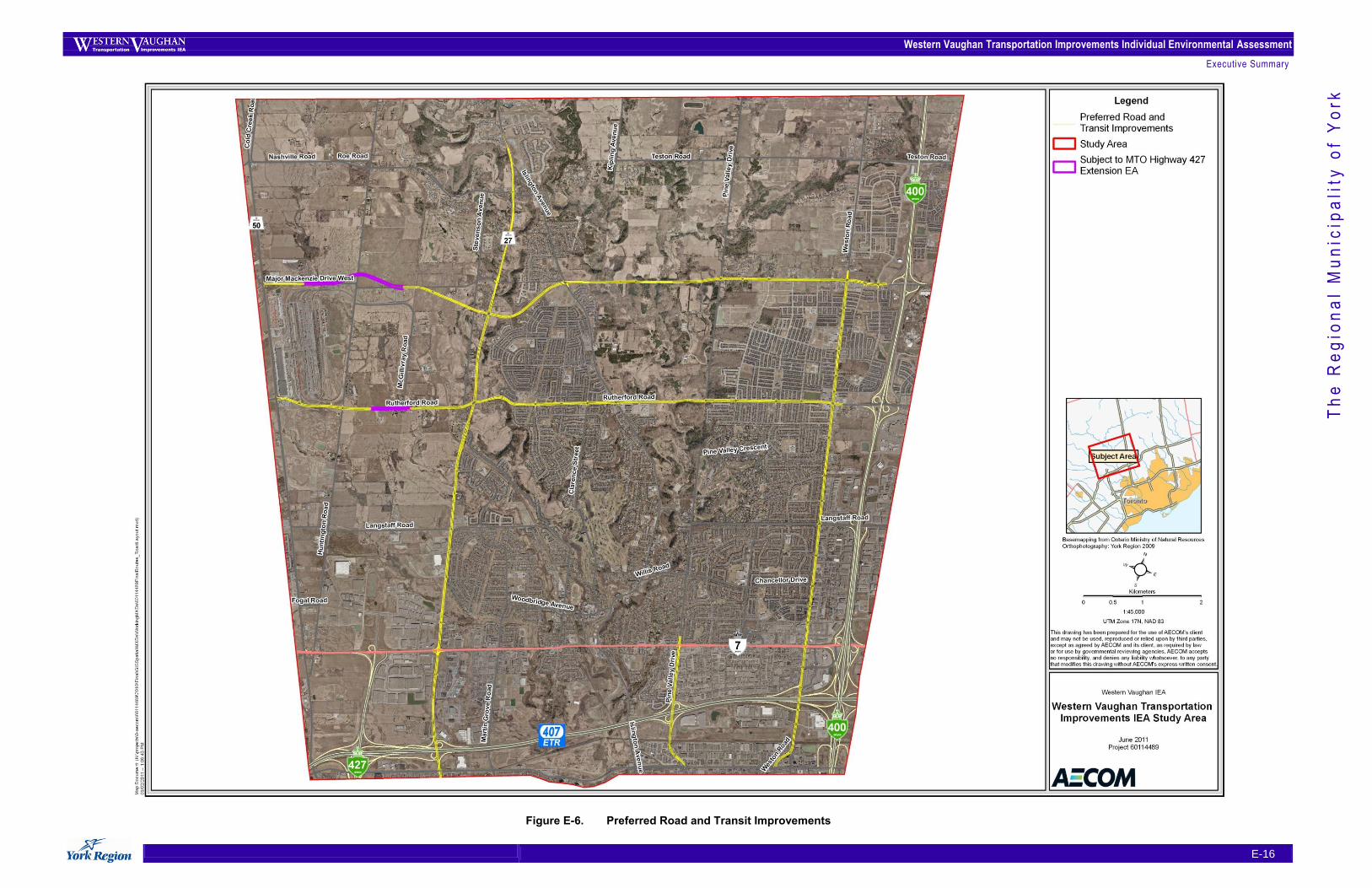
Road and Transit Improvements
The following road and transit improvements are proposed as part of the preferred transportation network
(refer to Figure E-6):
Expansion to six lanes of motor vehicle traffic including two dedicated transit / high occupancy
vehicle lanes, and the addition of two bicycle lanes on:
Major Mackenzie Drive between Highway 50 and Highway 400 (currently two lanes);
Rutherford Road between Highway 50 and Weston Road (currently four lanes);
Highway 27 between Major Mackenzie Drive and Steeles Avenue (currently four lanes);
Pine Valley Drive between Highway 7 and Steeles Avenue (currently four lanes); and
Weston Road between Major Mackenzie Drive and Steeles Avenue (currently four
lanes).
Expansion to four lanes of motor vehicle traffic on Highway 27 between Nashville Road and
Major Mackenzie Drive (currently two lanes); and
Elimination of the jog at Major Mackenzie Drive and Highway 27.
Travel Demand Management (TDM) Improvements
In the context of the Preferred Undertaking, TDM has been addressed by providing a dedicated high-
occupancy vehicle (HOV) lane in each direction for carpoolers (i.e., two or more individuals in a vehicle) and
transit users for every road that is being widened to six lanes. These HOV lanes will be clearly signed so that
road users are aware of the restrictions for single occupancy vehicles. Additional TDM measures, supported
in the Region‟s recently approved Transportation Master Plan Update (November, 2009), will also be
considered during the detailed design and operation of the road network.
Transportation System Management (TSM) Improvements
In the context of the Preferred Undertaking, HOV lanes are one of the main components of TSM as they help
to improve the efficiency of the road network by increasing its people-carrying capacity. Another TSM
measure that is addressed through the design involves changing access to the Regional roads that are being
improved through the installation of a centre median. The median improves the efficiency of the roads by
permitting left turns only at intersections. Additional TSM measures, supported in the Region‟s recently
approved Transportation Master Plan Update (November, 2009), will also be considered during the detailed
design and operation of the road network.
Western Vaughan Transportation Improvements Individual Environmental Assessment
Executive Summary
E-16
Th
e R
eg
ion
al
Mu
nic
ipa
lity
of
Yo
rk
Figure E-6. Preferred Road and Transit Improvements
Western Vaughan Transportation Improvements Individual Environmental Assessment
Executive Summary
E-17
Th
e R
eg
ion
al
Mu
nic
ipa
lity
of
Yo
rk
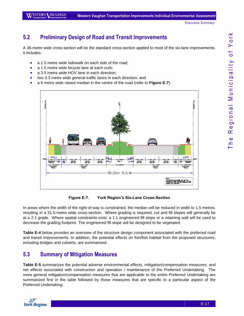
5.2 Preliminary Design of Road and Transit Improvements
A 36-metre wide cross-section will be the standard cross-section applied to most of the six-lane improvements.
It includes:
a 1.5 metre wide sidewalk on each side of the road;
a 1.5 metre wide bicycle lane at each curb;
a 3.5 metre wide HOV lane in each direction;
two 3.3 metre wide general traffic lanes in each direction; and
a 6 metre wide raised median in the centre of the road (refer to Figure E-7).
Figure E-7. York Region’s Six-Lane Cross-Section
In areas where the width of the right-of-way is constrained, the median will be reduced in width to 1.5 metres,
resulting in a 31.5-metre wide cross-section. Where grading is required, cut and fill slopes will generally be
at a 2:1 grade. Where spatial constraints exist, a 1:1 engineered fill slope or a retaining wall will be used to
decrease the grading footprint. The engineered fill slope will be designed to be vegetated.
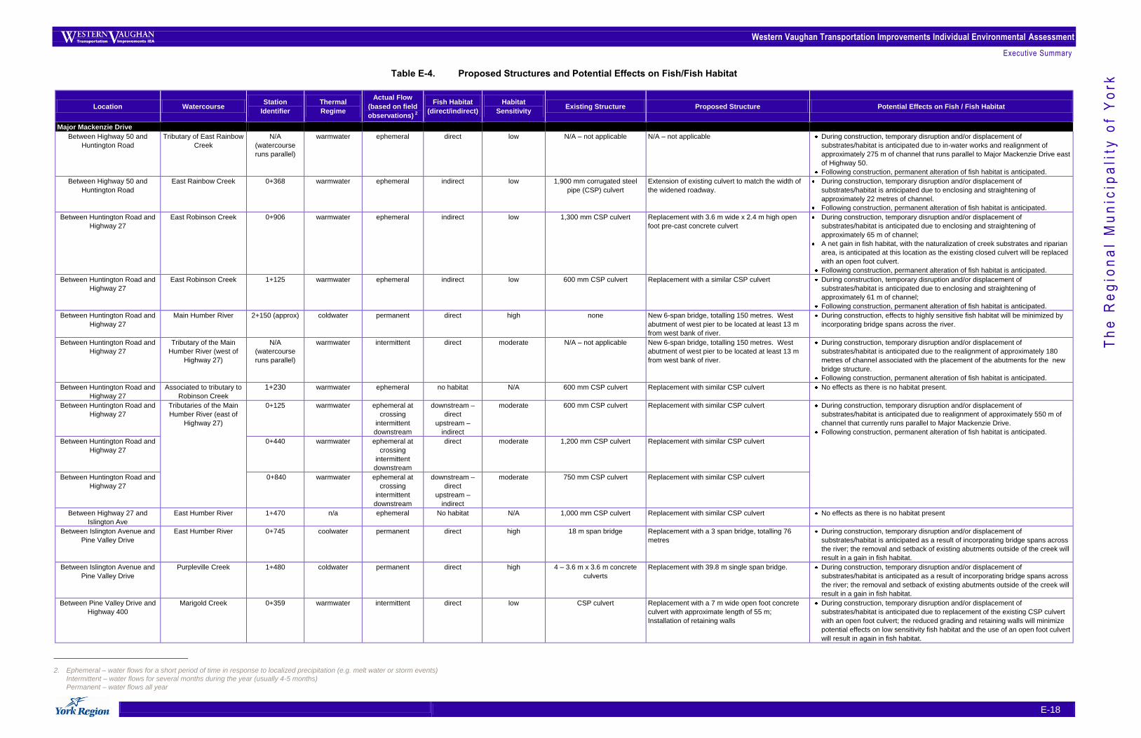
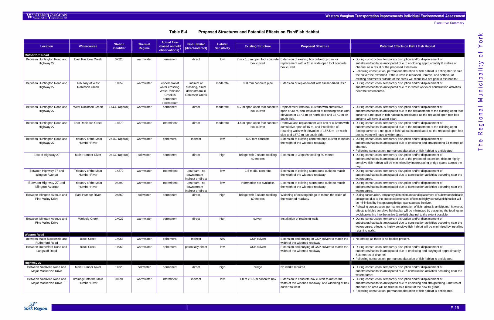
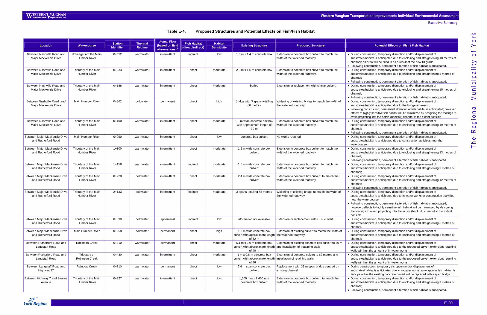
Table E-4 below provides an overview of the structure design component associated with the preferred road
and transit improvements. In addition, the potential effects on fish/fish habitat from the proposed structures,
including bridges and culverts, are summarized.
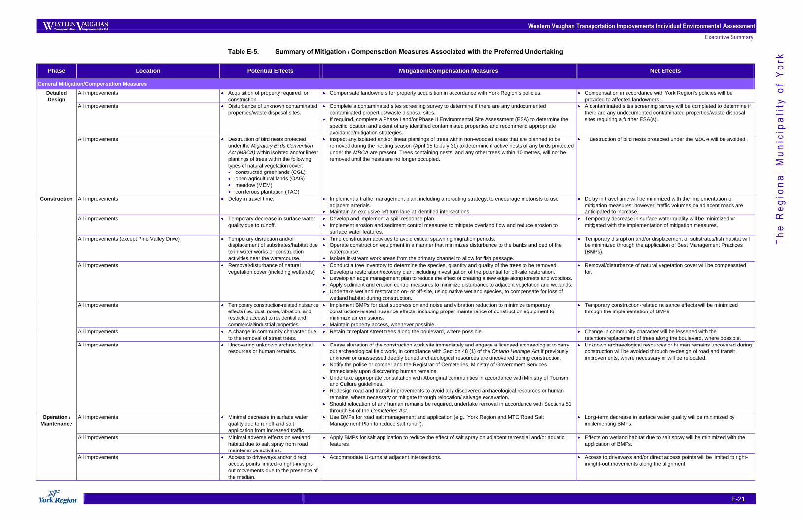
5.3 Summary of Mitigation Measures
Table E-5 summarizes the potential adverse environmental effects, mitigation/compensation measures, and
net effects associated with construction and operation / maintenance of the Preferred Undertaking. The
more general mitigation/compensation measures that are applicable to the entire Preferred Undertaking are
summarized first in the table followed by those measures that are specific to a particular aspect of the
Preferred Undertaking.
Western Vaughan Transportation Improvements Individual Environmental Assessment
Executive Summary
E-18
Th
e R
eg
ion
al
Mu
nic
ipa
lity
of
Yo
rk Table E-4. Proposed Structures and Potential Effects on Fish/Fish Habitat
Location Watercourse Station
Identifier
Thermal
Regime
Actual Flow
(based on field
observations) 2
Fish Habitat
(direct/indirect)
Habitat
Sensitivity Existing Structure Proposed Structure Potential Effects on Fish / Fish Habitat
Major Mackenzie Drive
Between Highway 50 and
Huntington Road
Tributary of East Rainbow
Creek
N/A
(watercourse
runs parallel)
warmwater ephemeral direct low N/A – not applicable N/A – not applicable During construction, temporary disruption and/or displacement of
substrates/habitat is anticipated due to in-water works and realignment of
approximately 275 m of channel that runs parallel to Major Mackenzie Drive east
of Highway 50.
Following construction, permanent alteration of fish habitat is anticipated.
Between Highway 50 and
Huntington Road
East Rainbow Creek 0+368 warmwater ephemeral indirect low 1,900 mm corrugated steel
pipe (CSP) culvert
Extension of existing culvert to match the width of
the widened roadway.
During construction, temporary disruption and/or displacement of
substrates/habitat is anticipated due to enclosing and straightening of
approximately 22 metres of channel.
Following construction, permanent alteration of fish habitat is anticipated.
Between Huntington Road and
Highway 27
East Robinson Creek 0+906 warmwater ephemeral indirect low 1,300 mm CSP culvert Replacement with 3.6 m wide x 2.4 m high open
foot pre-cast concrete culvert
During construction, temporary disruption and/or displacement of
substrates/habitat is anticipated due to enclosing and straightening of
approximately 65 m of channel;
A net gain in fish habitat, with the naturalization of creek substrates and riparian
area, is anticipated at this location as the existing closed culvert will be replaced
with an open foot culvert.
Following construction, permanent alteration of fish habitat is anticipated.
Between Huntington Road and
Highway 27
East Robinson Creek 1+125 warmwater ephemeral indirect low 600 mm CSP culvert Replacement with a similar CSP culvert During construction, temporary disruption and/or displacement of
substrates/habitat is anticipated due to enclosing and straightening of
approximately 61 m of channel;
Following construction, permanent alteration of fish habitat is anticipated.
Between Huntington Road and
Highway 27
Main Humber River 2+150 (approx) coldwater permanent direct high none New 6-span bridge, totalling 150 metres. West
abutment of west pier to be located at least 13 m
from west bank of river.
During construction, effects to highly sensitive fish habitat will be minimized by
incorporating bridge spans across the river.
Between Huntington Road and
Highway 27
Tributary of the Main
Humber River (west of
Highway 27)
N/A
(watercourse
runs parallel)
warmwater intermittent direct moderate N/A – not applicable New 6-span bridge, totalling 150 metres. West
abutment of west pier to be located at least 13 m
from west bank of river.
During construction, temporary disruption and/or displacement of
substrates/habitat is anticipated due to the realignment of approximately 180
metres of channel associated with the placement of the abutments for the new
bridge structure.
Following construction, permanent alteration of fish habitat is anticipated.
Between Huntington Road and
Highway 27
Associated to tributary to
Robinson Creek
1+230 warmwater ephemeral no habitat N/A 600 mm CSP culvert Replacement with similar CSP culvert No effects as there is no habitat present.
Between Huntington Road and
Highway 27
Tributaries of the Main
Humber River (east of
Highway 27)
0+125 warmwater ephemeral at
crossing
intermittent
downstream
downstream –
direct
upstream –
indirect
moderate 600 mm CSP culvert Replacement with similar CSP culvert During construction, temporary disruption and/or displacement of
substrates/habitat is anticipated due to realignment of approximately 550 m of
channel that currently runs parallel to Major Mackenzie Drive.
Following construction, permanent alteration of fish habitat is anticipated.
Between Huntington Road and
Highway 27
0+440 warmwater ephemeral at
crossing
intermittent
downstream
direct moderate 1,200 mm CSP culvert Replacement with similar CSP culvert
Between Huntington Road and
Highway 27
0+840 warmwater ephemeral at
crossing
intermittent
downstream
downstream –
direct
upstream –
indirect
moderate 750 mm CSP culvert Replacement with similar CSP culvert
Between Highway 27 and
Islington Ave
East Humber River 1+470 n/a ephemeral No habitat N/A 1,000 mm CSP culvert Replacement with similar CSP culvert No effects as there is no habitat present
Between Islington Avenue and
Pine Valley Drive
East Humber River 0+745 coolwater permanent direct high 18 m span bridge Replacement with a 3 span bridge, totalling 76
metres
During construction, temporary disruption and/or displacement of
substrates/habitat is anticipated as a result of incorporating bridge spans across
the river; the removal and setback of existing abutments outside of the creek will
result in a gain in fish habitat.
Between Islington Avenue and
Pine Valley Drive
Purpleville Creek
1+480 coldwater permanent direct high 4 – 3.6 m x 3.6 m concrete
culverts
Replacement with 39.8 m single span bridge. During construction, temporary disruption and/or displacement of
substrates/habitat is anticipated as a result of incorporating bridge spans across
the river; the removal and setback of existing abutments outside of the creek will
result in a gain in fish habitat.
Between Pine Valley Drive and
Highway 400
Marigold Creek 0+359 warmwater intermittent direct low CSP culvert Replacement with a 7 m wide open foot concrete
culvert with approximate length of 55 m;
Installation of retaining walls
During construction, temporary disruption and/or displacement of
substrates/habitat is anticipated due to replacement of the existing CSP culvert
with an open foot culvert; the reduced grading and retaining walls will minimize
potential effects on low sensitivity fish habitat and the use of an open foot culvert
will result in again in fish habitat.
2. Ephemeral – water flows for a short period of time in response to localized precipitation (e.g. melt water or storm events)
Intermittent – water flows for several months during the year (usually 4-5 months)
Permanent – water flows all year
Western Vaughan Transportation Improvements Individual Environmental Assessment
Executive Summary
E-19
Th
e R
eg
ion
al
Mu
nic
ipa
lity
of
Yo
rk Table E-4. Proposed Structures and Potential Effects on Fish/Fish Habitat
Location Watercourse Station
Identifier
Thermal
Regime
Actual Flow
(based on field
observations) 2
Fish Habitat
(direct/indirect)
Habitat
Sensitivity Existing Structure Proposed Structure Potential Effects on Fish / Fish Habitat
Rutherford Road
Between Huntington Road and
Highway 27
East Rainbow Creek 0+220 warmwater permanent direct low 7 m x 1.8 m open foot concrete
box culvert
Extension of existing box culvert by 8 m, or
replacement with a 15 m wide open foot concrete
box culvert.
During construction, temporary disruption and/or displacement of
substrates/habitat is anticipated due to enclosing approximately 8 metres of
channel as a result of the proposed extension.
Following construction, permanent alteration of fish habitat is anticipated should
the culvert be extended. If the culvert is replaced, removal and setback of
existing abutments outside of the creek will result in a net gain in fish habitat.
Between Huntington Road and
Highway 27
Tributary of West
Robinson Creek
1+059 warmwater ephemeral at
water crossing,
West Robinson
Creek is
permanent
downstream
indirect at
crossing, direct
downstream in
Robinson Creek
moderate 800 mm concrete pipe Extension or replacement with similar-sized CSP During construction, temporary disruption and/or displacement of
substrates/habitat is anticipated due to in-water works or construction activities
near the watercourse.
Between Huntington Road and
Highway 27
West Robinson Creek 1+430 (approx) warmwater permanent direct moderate 6.7 m span open foot concrete
box culvert
Replacement with box culverts with cumulative
span of 30 m, and installation of retaining walls with
elevation of 187.5 m on north side and 187.0 m on
south side.
During construction, temporary disruption and/or displacement of
substrates/habitat is anticipated due to the replacement of the existing open foot
culverts; a net gain in fish habitat is anticipated as the replaced open foot box
culverts will have a wider span. Between Huntington Road and
Highway 27
East Robinson Creek 1+570 warmwater intermittent direct moderate 4.5 m span open foot concrete
box culvert
Removal and replacement with box or culverts with
cumulative span of 15 m, and installation of
retaining walls with elevation of 187.5 m on north
side and 187.0 m on south side.
During construction, temporary disruption and/or displacement of
substrates/habitat is anticipated due to the replacement of the existing open
footing culverts; a net gain in fish habitat is anticipated as the replaced open foot
box culverts will have a wider span.
Between Huntington Road and
Highway 27
Tributary of the Main
Humber River
2+160 (approx) warmwater ephemeral indirect low 600 mm concrete Extension of existing concrete pipe culvert to match
the width of the widened roadway.
During construction, temporary disruption and/or displacement of
substrates/habitat is anticipated due to enclosing and straightening 14 metres of
channel.
Following construction, permanent alteration of fish habitat is anticipated.
East of Highway 27 Main Humber River 0+130 (approx) coldwater permanent direct high Bridge with 2 spans totalling
42 metres
Extension to 3 spans totalling 80 metres During construction, temporary disruption and/or displacement of
substrates/habitat is anticipated due to the proposed extension; risks to highly
sensitive fish habitat will be minimized by incorporating bridge spans across the
river.
Between Highway 27 and
Islington Avenue
Tributary of the Main
Humber River
1+270 warmwater intermittent upstream –no
downstream –
indirect or direct
low 1.5 m dia. concrete Extension of existing storm pond outlet to match
the width of the widened roadway
During construction, temporary disruption and/or displacement of
substrates/habitat is anticipated due to construction activities occurring near the
watercourse.
Between Highway 27 and
Islington Avenue
Tributary of the Main
Humber River
0+390 warmwater intermittent upstream –no
downstream –
indirect or direct
low Information not available. Extension of existing storm pond outlet to match
the width of the widened roadway.
During construction, temporary disruption and/or displacement of
substrates/habitat is anticipated due to construction activities occurring near the
watercourse.
Between Islington Avenue and
Pine Valley Drive
East Humber River 0+860 coldwater permanent direct high Bridge with 3 spans totalling
69 metres
Widening of existing bridge to match the width of
the widened roadway
During construction, temporary disruption and/or displacement of substrates/habitat is
anticipated due to the proposed extension; effects to highly sensitive fish habitat will
be minimized by incorporating bridge spans across the river.
Following construction, permanent alteration of fish habitat is anticipated; however,
effects to highly sensitive fish habitat will be minimized by designing the footings to
avoid projecting into the active (bankfull) channel to the extent possible.
Between Islington Avenue and
Pine Valley Drive
Marigold Creek 1+027 warmwater permanent direct high culvert Installation of retaining walls During construction, temporary disruption and/or displacement of
substrates/habitat is anticipated due to construction activities occurring near the
watercourse; effects to highly sensitive fish habitat will be minimized by installing
retaining walls.
Weston Road
Between Major Mackenzie and
Rutherford Road
Black Creek 1+058 warmwater ephemeral Indirect N/A CSP culvert Extension and burying of CSP culvert to match the
width of the widened roadway
No effects as there is no habitat present.
Between Rutherford Road and
Langstaff Road
Black Creek 1+963 warmwater ephemeral potentially direct low CSP culvert Extension and burying of CSP culvert to match the
width of the widened roadway
During construction, temporary disruption and/or displacement of
substrates/habitat is anticipated due to enclosing and burying of approximately
518 metres of channel;
Following construction, permanent alteration of fish habitat is anticipated.
Highway 27
Between Nashville Road and
Major Mackenzie Drive
Main Humber River 1+323 coldwater permanent direct high bridge No works required During construction, temporary disruption and/or displacement of
substrates/habitat is anticipated due to construction activities occurring near the
watercourse;
Between Nashville Road and
Major Mackenzie Drive
drainage into the Main
Humber River
0+691 warmwater intermittent indirect low 1.8 m x 1.5 m concrete box Extension to concrete box culvert to match the
width of the widened roadway. and widening of box
culvert to west
During construction, temporary disruption and/or displacement of
substrates/habitat is anticipated due to enclosing and straightening 5 metres of
channel; an area will be filled in as a result of the new fill grade.
Following construction, permanent alteration of fish habitat is anticipated.
Western Vaughan Transportation Improvements Individual Environmental Assessment
Executive Summary
E-20
Th
e R
eg
ion
al
Mu
nic
ipa
lity
of
Yo
rk Table E-4. Proposed Structures and Potential Effects on Fish/Fish Habitat
Location Watercourse Station
Identifier
Thermal
Regime
Actual Flow
(based on field
observations) 2
Fish Habitat
(direct/indirect)
Habitat
Sensitivity Existing Structure Proposed Structure Potential Effects on Fish / Fish Habitat
Between Nashville Road and
Major Mackenzie Drive
drainage into the Main
Humber River
0+552 warmwater intermittent indirect low 1.8 m x 1.4 m concrete box Extension to concrete box culvert to match the
width of the widened roadway
During construction, temporary disruption and/or displacement of
substrates/habitat is anticipated due to enclosing and straightening 10 metres of
channel; an area will be filled in as a result of the new fill grade.
Following construction, permanent alteration of fish habitat is anticipated.
Between Nashville Road and
Major Mackenzie Drive
Tributary of the Main
Humber River
0+333 warmwater intermittent direct moderate 2.0 m x 1.6 m concrete box Extension to concrete box culvert to match the
width of the widened roadway.
During construction, temporary disruption and/or displacement of
substrates/habitat is anticipated due to enclosing and straightening 5 metres of
channel;
Following construction, permanent alteration of fish habitat is anticipated.
Between Nashville Road and
Major Mackenzie Drive
Tributary of the Main
Humber River
0+188 warmwater intermittent direct moderate buried Extension or replacement with similar culvert During construction, temporary disruption and/or displacement of
substrates/habitat is anticipated due to enclosing and straightening 15 metres of
channel;
Following construction, permanent alteration of fish habitat is anticipated.
Between Nashville Road and
Major Mackenzie Drive
Main Humber River 0+362 coldwater permanent direct high Bridge with 3 spans totalling
60 metres
Widening of existing bridge to match the width of
the widened roadway
During construction, temporary disruption and/or displacement of
substrates/habitat is anticipated due to the bridge extension;
Following construction, permanent alteration of fish habitat is anticipated; however,
effects to highly sensitive fish habitat will be minimized by designing the footings to
avoid projecting into the active (bankfull) channel to the extent possible
Between Nashville Road and
Major Mackenzie Drive
Tributary of the Main
Humber River
0+100 warmwater intermittent direct moderate 1.8 m wide concrete box box
with approximate length of
30 m
Extension to concrete box culvert to match the
width of the widened roadway.
During construction, temporary disruption and/or displacement of
substrates/habitat is anticipated due to enclosing and straightening 19 metres of
channel;
Following construction, permanent alteration of fish habitat is anticipated.
Between Major Mackenzie Drive
and Rutherford Road
Main Humber River 0+090 warmwater intermittent direct low concrete box culvert No works required During construction, temporary disruption and/or displacement of
substrates/habitat is anticipated due to construction activities near the
watercourse.
Between Major Mackenzie Drive
and Rutherford Road
Tributary of the Main
Humber River
1+300 warmwater intermittent direct moderate 1.5 m wide concrete box
culvert
Extension to concrete box culvert to match the
width of the widened roadway
During construction, temporary disruption and/or displacement of
substrates/habitat is anticipated due to enclosing and straightening 13 metres of
channel;
Following construction, permanent alteration of fish habitat is anticipated.
Between Major Mackenzie Drive
and Rutherford Road
Tributary of the Main
Humber River
1+158 warmwater intermittent indirect moderate 1.5 m wide concrete box
culvert
Extension to concrete box culvert to match the
width of the widened roadway
During construction, temporary disruption and/or displacement of
substrates/habitat is anticipated due to enclosing and straightening 9 metres of
channel;
Between Major Mackenzie Drive
and Rutherford Road
Tributary of the Main
Humber River
0+220 coldwater intermittent direct moderate 2.4 m wide concrete box
culvert
Extension to concrete box culvert to match the
width of the widened roadway
During construction, temporary disruption and/or displacement of
substrates/habitat is anticipated due to enclosing and straightening 12 metres of
channel;
Following construction, permanent alteration of fish habitat is anticipated.
Between Major Mackenzie Drive
and Rutherford Road
Tributary of the Main
Humber River
2+133 coldwater intermittent indirect moderate 3 spans totalling 58 metres Widening of existing bridge to match the width of
the widened roadway
During construction, temporary disruption and/or displacement of
substrates/habitat is anticipated due to in-water works or construction activities
near the watercourse.
Following construction, permanent alteration of fish habitat is anticipated;
however, effects to highly sensitive fish habitat will be minimized by designing
the footings to avoid projecting into the active (bankfull) channel to the extent
possible.
Between Major Mackenzie Drive
and Rutherford Road
Tributary of the Main
Humber River
0+030 coldwater ephemeral indirect low Information not available. Extension or replacement with CSP culvert During construction, temporary disruption and/or displacement of
substrates/habitat is anticipated due to enclosing and straightening 5 metres of
channel.
Between Major Mackenzie Drive
and Rutherford Road
Main Humber River 0+958 coldwater permanent direct high 1.8 m wide concrete box
culvert with approximate length
of 52 m
Extension of existing culvert to match the width of
the widened roadway
During construction, temporary disruption and/or displacement of
substrates/habitat is anticipated due to enclosing and straightening 5 metres of
channel;
Between Rutherford Road and
Langstaff Road
Robinson Creek 0+810 warmwater permanent direct moderate 6.1 m x 3.0 m concrete box
culvert with approximate length
of 40 m
Extension of existing concrete box culvert to 50 m
and installation of retaining walls
During construction, temporary disruption and/or displacement of
substrates/habitat is anticipated due to the proposed culvert extension; retaining
walls will limit the amount of in-water works.
Between Rutherford Road and
Langstaff Road
Tributary of
Robinson Creek
0+430 warmwater intermittent direct moderate 1 m x 0.8 m concrete box
culvert with approximate length
of 46 m
Extension of concrete culvert to 62 metres and
installation of retaining walls
During construction, temporary disruption and/or displacement of
substrates/habitat is anticipated due to the proposed culvert extension; retaining
walls will limit the amount of in-water works.
Between Langstaff Road and
Highway 27
Rainbow Creek 0+710 warmwater permanent direct low 7.6 m span concrete box
culvert
Replacement with 35 m span bridge centred on
existing channel
During construction, temporary disruption and/or displacement of
substrates/habitat is anticipated due to in-water works; a net gain in fish habitat, is
anticipated as the existing concrete culvert will be replaced with a span bridge.
Between Highway 7 and Steeles
Avenue
Tributary of the Main
Humber River
0+927 warmwater intermittent direct low 1,600 mm x 2,400 mm
concrete box culvert
Extension to concrete box culvert to match the
width of the widened roadway
During construction, temporary disruption and/or displacement of
substrates/habitat is anticipated due to enclosing and straightening 9 metres of
channel;
Following construction, permanent alteration of fish habitat is anticipated.
Western Vaughan Transportation Improvements Individual Environmental Assessment
Executive Summary
E-21
Th
e R
eg
ion
al
Mu
nic
ipa
lity
of
Yo
rk Table E-5. Summary of Mitigation / Compensation Measures Associated with the Preferred Undertaking
Phase Location Potential Effects Mitigation/Compensation Measures Net Effects
General Mitigation/Compensation Measures
Detailed
Design
All improvements Acquisition of property required for
construction.
Compensate landowners for property acquisition in accordance with York Region‟s policies. Compensation in accordance with York Region‟s policies will be
provided to affected landowners.
All improvements Disturbance of unknown contaminated
properties/waste disposal sites.
Complete a contaminated sites screening survey to determine if there are any undocumented
contaminated properties/waste disposal sites.
If required, complete a Phase I and/or Phase II Environmental Site Assessment (ESA) to determine the
specific location and extent of any identified contaminated properties and recommend appropriate
avoidance/mitigation strategies.
A contaminated sites screening survey will be completed to determine if
there are any undocumented contaminated properties/waste disposal
sites requiring a further ESA(s).
All improvements Destruction of bird nests protected
under the Migratory Birds Convention
Act (MBCA) within isolated and/or linear
plantings of trees within the following
types of natural vegetation cover:
constructed greenlands (CGL)
open agricultural lands (OAG)
meadow (MEM)
coniferous plantation (TAG)
Inspect any isolated and/or linear plantings of trees within non-wooded areas that are planned to be
removed during the nesting season (April 15 to July 31) to determine if active nests of any birds protected
under the MBCA are present. Trees containing nests, and any other trees within 10 metres, will not be
removed until the nests are no longer occupied.
Destruction of bird nests protected under the MBCA will be avoided.
Construction All improvements Delay in travel time. Implement a traffic management plan, including a rerouting strategy, to encourage motorists to use
adjacent arterials.
Maintain an exclusive left turn lane at identified intersections.
Delay in travel time will be minimized with the implementation of
mitigation measures; however, traffic volumes on adjacent roads are
anticipated to increase.
All improvements Temporary decrease in surface water
quality due to runoff.
Develop and implement a spill response plan.
Implement erosion and sediment control measures to mitigate overland flow and reduce erosion to
surface water features.
Temporary decrease in surface water quality will be minimized or
mitigated with the implementation of mitigation measures.
All improvements (except Pine Valley Drive) Temporary disruption and/or
displacement of substrates/habitat due
to in-water works or construction
activities near the watercourse.
Time construction activities to avoid critical spawning/migration periods.
Operate construction equipment in a manner that minimizes disturbance to the banks and bed of the
watercourse.
Isolate in-stream work areas from the primary channel to allow for fish passage.
Temporary disruption and/or displacement of substrates/fish habitat will
be minimized through the application of Best Management Practices
(BMPs).
All improvements Removal/disturbance of natural
vegetation cover (including wetlands).
Conduct a tree inventory to determine the species, quantity and quality of the trees to be removed.
Develop a restoration/recovery plan, including investigation of the potential for off-site restoration.
Develop an edge management plan to reduce the effect of creating a new edge along forests and woodlots.
Apply sediment and erosion control measures to minimize disturbance to adjacent vegetation and wetlands.
Undertake wetland restoration on- or off-site, using native wetland species, to compensate for loss of
wetland habitat during construction.
Removal/disturbance of natural vegetation cover will be compensated
for.
All improvements Temporary construction-related nuisance
effects (i.e., dust, noise, vibration, and
restricted access) to residential and
commercial/industrial properties.
Implement BMPs for dust suppression and noise and vibration reduction to minimize temporary
construction-related nuisance effects, including proper maintenance of construction equipment to
minimize air emissions.
Maintain property access, whenever possible.
Temporary construction-related nuisance effects will be minimized
through the implementation of BMPs.
All improvements A change in community character due
to the removal of street trees.
Retain or replant street trees along the boulevard, where possible. Change in community character will be lessened with the
retention/replacement of trees along the boulevard, where possible.
All improvements Uncovering unknown archaeological
resources or human remains.
Cease alteration of the construction work site immediately and engage a licensed archaeologist to carry
out archaeological field work, in compliance with Section 48 (1) of the Ontario Heritage Act if previously
unknown or unassessed deeply buried archaeological resources are uncovered during construction.
Notify the police or coroner and the Registrar of Cemeteries, Ministry of Government Services
immediately upon discovering human remains.
Undertake appropriate consultation with Aboriginal communities in accordance with Ministry of Tourism
and Culture guidelines.
Redesign road and transit improvements to avoid any discovered archaeological resources or human
remains, where necessary or mitigate through relocation/ salvage excavation.
Should relocation of any human remains be required, undertake removal in accordance with Sections 51
through 54 of the Cemeteries Act.
Unknown archaeological resources or human remains uncovered during
construction will be avoided through re-design of road and transit
improvements, where necessary or will be relocated.
Operation /
Maintenance
All improvements Minimal decrease in surface water
quality due to runoff and salt
application from increased traffic
Use BMPs for road salt management and application (e.g., York Region and MTO Road Salt
Management Plan to reduce salt runoff).
Long-term decrease in surface water quality will be minimized by
implementing BMPs.
All improvements Minimal adverse effects on wetland
habitat due to salt spray from road
maintenance activities.
Apply BMPs for salt application to reduce the effect of salt spray on adjacent terrestrial and/or aquatic
features.
Effects on wetland habitat due to salt spray will be minimized with the
application of BMPs.
All improvements Access to driveways and/or direct
access points limited to right-in/right-
out movements due to the presence of
the median.
Accommodate U-turns at adjacent intersections. Access to driveways and/or direct access points will be limited to right-
in/right-out movements along the alignment.
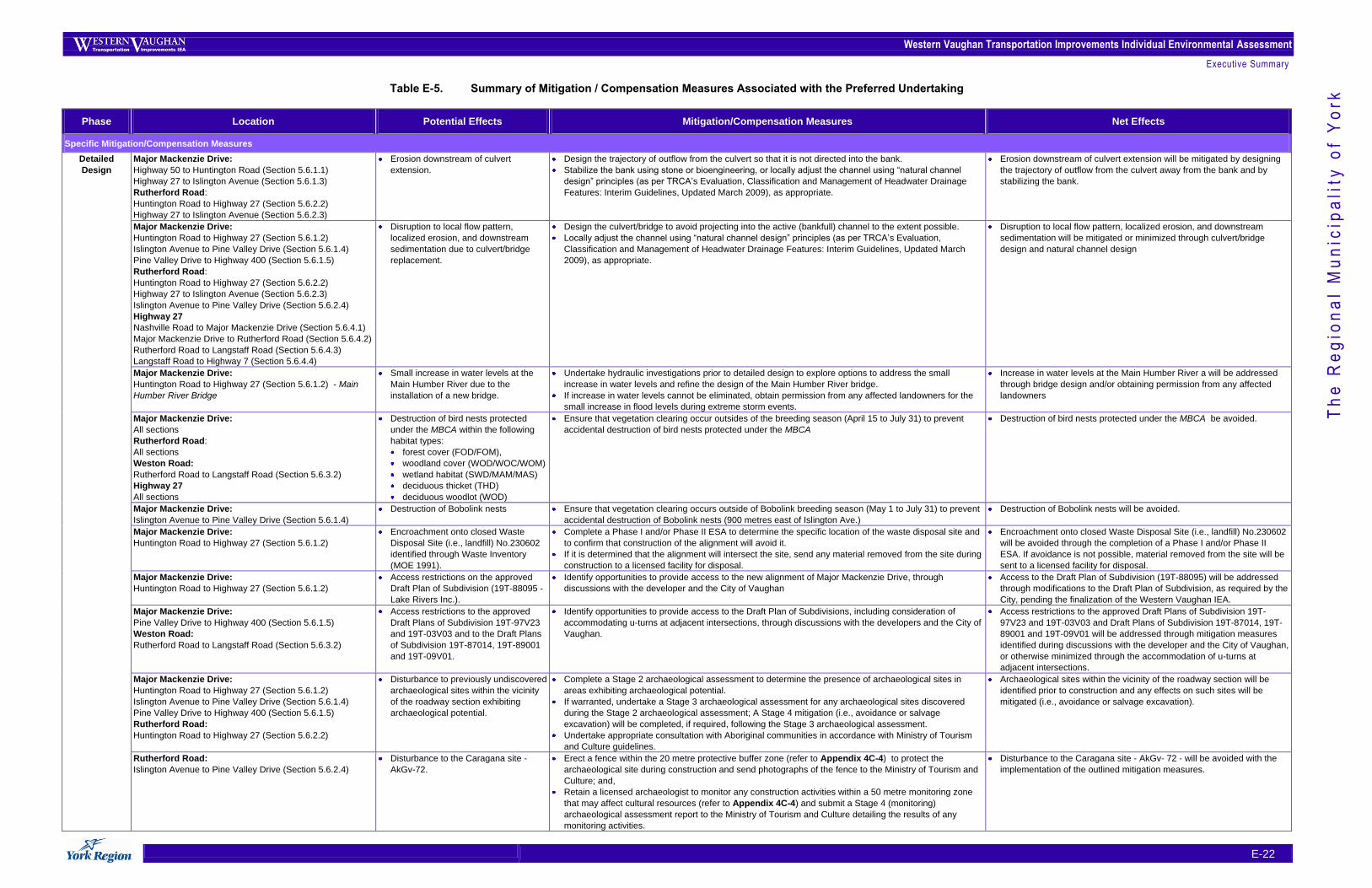
Western Vaughan Transportation Improvements Individual Environmental Assessment
Executive Summary
E-22
Th
e R
eg
ion
al
Mu
nic
ipa
lity
of
Yo
rk Table E-5. Summary of Mitigation / Compensation Measures Associated with the Preferred Undertaking
Phase Location Potential Effects Mitigation/Compensation Measures Net Effects
Specific Mitigation/Compensation Measures
Detailed
Design
Major Mackenzie Drive:
Highway 50 to Huntington Road (Section 5.6.1.1)
Highway 27 to Islington Avenue (Section 5.6.1.3)
Rutherford Road:
Huntington Road to Highway 27 (Section 5.6.2.2)
Highway 27 to Islington Avenue (Section 5.6.2.3)
Erosion downstream of culvert
extension.
Design the trajectory of outflow from the culvert so that it is not directed into the bank.
Stabilize the bank using stone or bioengineering, or locally adjust the channel using “natural channel
design” principles (as per TRCA‟s Evaluation, Classification and Management of Headwater Drainage
Features: Interim Guidelines, Updated March 2009), as appropriate.
Erosion downstream of culvert extension will be mitigated by designing
the trajectory of outflow from the culvert away from the bank and by
stabilizing the bank.
Major Mackenzie Drive:
Huntington Road to Highway 27 (Section 5.6.1.2)
Islington Avenue to Pine Valley Drive (Section 5.6.1.4)
Pine Valley Drive to Highway 400 (Section 5.6.1.5)
Rutherford Road:
Huntington Road to Highway 27 (Section 5.6.2.2)
Highway 27 to Islington Avenue (Section 5.6.2.3)
Islington Avenue to Pine Valley Drive (Section 5.6.2.4)
Highway 27
Nashville Road to Major Mackenzie Drive (Section 5.6.4.1)
Major Mackenzie Drive to Rutherford Road (Section 5.6.4.2)
Rutherford Road to Langstaff Road (Section 5.6.4.3)
Langstaff Road to Highway 7 (Section 5.6.4.4)
Disruption to local flow pattern,
localized erosion, and downstream
sedimentation due to culvert/bridge
replacement.
Design the culvert/bridge to avoid projecting into the active (bankfull) channel to the extent possible.
Locally adjust the channel using “natural channel design” principles (as per TRCA‟s Evaluation,
Classification and Management of Headwater Drainage Features: Interim Guidelines, Updated March
2009), as appropriate.
Disruption to local flow pattern, localized erosion, and downstream
sedimentation will be mitigated or minimized through culvert/bridge
design and natural channel design
Major Mackenzie Drive:
Huntington Road to Highway 27 (Section 5.6.1.2) - Main
Humber River Bridge
Small increase in water levels at the
Main Humber River due to the
installation of a new bridge.
Undertake hydraulic investigations prior to detailed design to explore options to address the small
increase in water levels and refine the design of the Main Humber River bridge.
If increase in water levels cannot be eliminated, obtain permission from any affected landowners for the
small increase in flood levels during extreme storm events.
Increase in water levels at the Main Humber River a will be addressed
through bridge design and/or obtaining permission from any affected
landowners
Major Mackenzie Drive:
All sections
Rutherford Road:
All sections
Weston Road:
Rutherford Road to Langstaff Road (Section 5.6.3.2)
Highway 27
All sections
Destruction of bird nests protected
under the MBCA within the following
habitat types:
forest cover (FOD/FOM),
woodland cover (WOD/WOC/WOM)
wetland habitat (SWD/MAM/MAS)
deciduous thicket (THD)
deciduous woodlot (WOD)
Ensure that vegetation clearing occur outsides of the breeding season (April 15 to July 31) to prevent
accidental destruction of bird nests protected under the MBCA
Destruction of bird nests protected under the MBCA be avoided.
Major Mackenzie Drive:
Islington Avenue to Pine Valley Drive (Section 5.6.1.4)
Destruction of Bobolink nests Ensure that vegetation clearing occurs outside of Bobolink breeding season (May 1 to July 31) to prevent
accidental destruction of Bobolink nests (900 metres east of Islington Ave.)
Destruction of Bobolink nests will be avoided.
Major Mackenzie Drive:
Huntington Road to Highway 27 (Section 5.6.1.2)
Encroachment onto closed Waste
Disposal Site (i.e., landfill) No.230602
identified through Waste Inventory
(MOE 1991).
Complete a Phase I and/or Phase II ESA to determine the specific location of the waste disposal site and
to confirm that construction of the alignment will avoid it.
If it is determined that the alignment will intersect the site, send any material removed from the site during
construction to a licensed facility for disposal.
Encroachment onto closed Waste Disposal Site (i.e., landfill) No.230602
will be avoided through the completion of a Phase I and/or Phase II
ESA. If avoidance is not possible, material removed from the site will be
sent to a licensed facility for disposal.
Major Mackenzie Drive:
Huntington Road to Highway 27 (Section 5.6.1.2)
Access restrictions on the approved
Draft Plan of Subdivision (19T-88095 -
Lake Rivers Inc.).
Identify opportunities to provide access to the new alignment of Major Mackenzie Drive, through
discussions with the developer and the City of Vaughan
Access to the Draft Plan of Subdivision (19T-88095) will be addressed
through modifications to the Draft Plan of Subdivision, as required by the
City, pending the finalization of the Western Vaughan IEA.
Major Mackenzie Drive:
Pine Valley Drive to Highway 400 (Section 5.6.1.5)
Weston Road:
Rutherford Road to Langstaff Road (Section 5.6.3.2)
Access restrictions to the approved
Draft Plans of Subdivision 19T-97V23
and 19T-03V03 and to the Draft Plans
of Subdivision 19T-87014, 19T-89001
and 19T-09V01.
Identify opportunities to provide access to the Draft Plan of Subdivisions, including consideration of
accommodating u-turns at adjacent intersections, through discussions with the developers and the City of
Vaughan.
Access restrictions to the approved Draft Plans of Subdivision 19T-
97V23 and 19T-03V03 and Draft Plans of Subdivision 19T-87014, 19T-
89001 and 19T-09V01 will be addressed through mitigation measures
identified during discussions with the developer and the City of Vaughan,
or otherwise minimized through the accommodation of u-turns at
adjacent intersections.
Major Mackenzie Drive:
Huntington Road to Highway 27 (Section 5.6.1.2)
Islington Avenue to Pine Valley Drive (Section 5.6.1.4)
Pine Valley Drive to Highway 400 (Section 5.6.1.5)
Rutherford Road:
Huntington Road to Highway 27 (Section 5.6.2.2)
Disturbance to previously undiscovered
archaeological sites within the vicinity
of the roadway section exhibiting
archaeological potential.
Complete a Stage 2 archaeological assessment to determine the presence of archaeological sites in
areas exhibiting archaeological potential.
If warranted, undertake a Stage 3 archaeological assessment for any archaeological sites discovered
during the Stage 2 archaeological assessment; A Stage 4 mitigation (i.e., avoidance or salvage
excavation) will be completed, if required, following the Stage 3 archaeological assessment.
Undertake appropriate consultation with Aboriginal communities in accordance with Ministry of Tourism
and Culture guidelines.
Archaeological sites within the vicinity of the roadway section will be
identified prior to construction and any effects on such sites will be
mitigated (i.e., avoidance or salvage excavation).
Rutherford Road:
Islington Avenue to Pine Valley Drive (Section 5.6.2.4)
Disturbance to the Caragana site -
AkGv-72.
Erect a fence within the 20 metre protective buffer zone (refer to Appendix 4C-4) to protect the
archaeological site during construction and send photographs of the fence to the Ministry of Tourism and
Culture; and,
Retain a licensed archaeologist to monitor any construction activities within a 50 metre monitoring zone
that may affect cultural resources (refer to Appendix 4C-4) and submit a Stage 4 (monitoring)
archaeological assessment report to the Ministry of Tourism and Culture detailing the results of any
monitoring activities.
Disturbance to the Caragana site - AkGv- 72 - will be avoided with the
implementation of the outlined mitigation measures.
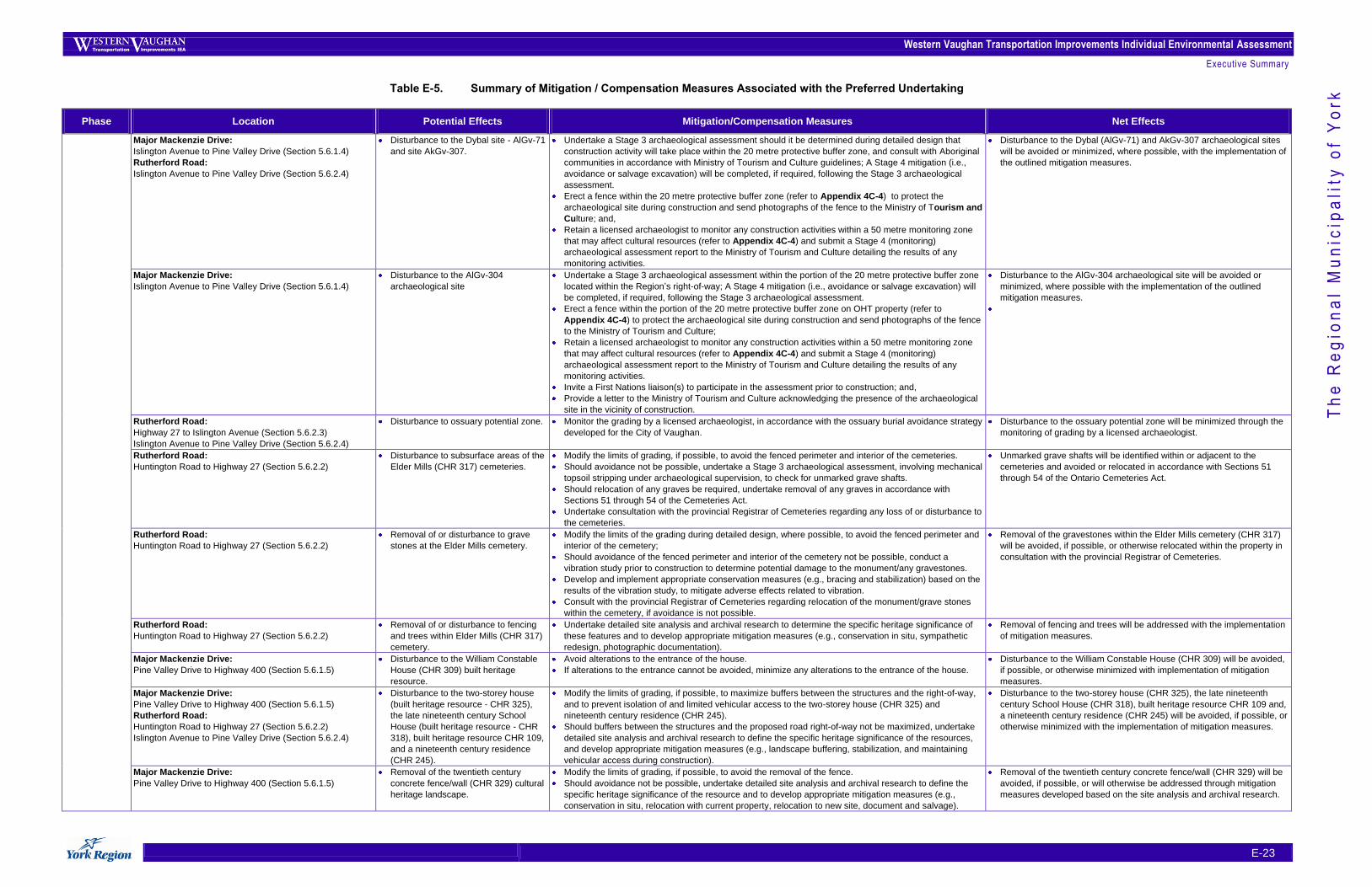
Western Vaughan Transportation Improvements Individual Environmental Assessment
Executive Summary
E-23
Th
e R
eg
ion
al
Mu
nic
ipa
lity
of
Yo
rk Table E-5. Summary of Mitigation / Compensation Measures Associated with the Preferred Undertaking
Phase Location Potential Effects Mitigation/Compensation Measures Net Effects
Major Mackenzie Drive:
Islington Avenue to Pine Valley Drive (Section 5.6.1.4)
Rutherford Road:
Islington Avenue to Pine Valley Drive (Section 5.6.2.4)
Disturbance to the Dybal site - AlGv-71
and site AkGv-307.
Undertake a Stage 3 archaeological assessment should it be determined during detailed design that
construction activity will take place within the 20 metre protective buffer zone, and consult with Aboriginal
communities in accordance with Ministry of Tourism and Culture guidelines; A Stage 4 mitigation (i.e.,
avoidance or salvage excavation) will be completed, if required, following the Stage 3 archaeological
assessment.
Erect a fence within the 20 metre protective buffer zone (refer to Appendix 4C-4) to protect the
archaeological site during construction and send photographs of the fence to the Ministry of Tourism and
Culture; and,
Retain a licensed archaeologist to monitor any construction activities within a 50 metre monitoring zone
that may affect cultural resources (refer to Appendix 4C-4) and submit a Stage 4 (monitoring)
archaeological assessment report to the Ministry of Tourism and Culture detailing the results of any
monitoring activities.
Disturbance to the Dybal (AlGv-71) and AkGv-307 archaeological sites
will be avoided or minimized, where possible, with the implementation of
the outlined mitigation measures.
Major Mackenzie Drive:
Islington Avenue to Pine Valley Drive (Section 5.6.1.4)
Disturbance to the AlGv-304
archaeological site
Undertake a Stage 3 archaeological assessment within the portion of the 20 metre protective buffer zone
located within the Region‟s right-of-way; A Stage 4 mitigation (i.e., avoidance or salvage excavation) will
be completed, if required, following the Stage 3 archaeological assessment.
Erect a fence within the portion of the 20 metre protective buffer zone on OHT property (refer to
Appendix 4C-4) to protect the archaeological site during construction and send photographs of the fence
to the Ministry of Tourism and Culture;
Retain a licensed archaeologist to monitor any construction activities within a 50 metre monitoring zone
that may affect cultural resources (refer to Appendix 4C-4) and submit a Stage 4 (monitoring)
archaeological assessment report to the Ministry of Tourism and Culture detailing the results of any
monitoring activities.
Invite a First Nations liaison(s) to participate in the assessment prior to construction; and,
Provide a letter to the Ministry of Tourism and Culture acknowledging the presence of the archaeological
site in the vicinity of construction.
Disturbance to the AlGv-304 archaeological site will be avoided or
minimized, where possible with the implementation of the outlined
mitigation measures.
Rutherford Road:
Highway 27 to Islington Avenue (Section 5.6.2.3)
Islington Avenue to Pine Valley Drive (Section 5.6.2.4)
Disturbance to ossuary potential zone. Monitor the grading by a licensed archaeologist, in accordance with the ossuary burial avoidance strategy
developed for the City of Vaughan.
Disturbance to the ossuary potential zone will be minimized through the
monitoring of grading by a licensed archaeologist.
Rutherford Road:
Huntington Road to Highway 27 (Section 5.6.2.2)
Disturbance to subsurface areas of the
Elder Mills (CHR 317) cemeteries.
Modify the limits of grading, if possible, to avoid the fenced perimeter and interior of the cemeteries.
Should avoidance not be possible, undertake a Stage 3 archaeological assessment, involving mechanical
topsoil stripping under archaeological supervision, to check for unmarked grave shafts.
Should relocation of any graves be required, undertake removal of any graves in accordance with
Sections 51 through 54 of the Cemeteries Act.
Undertake consultation with the provincial Registrar of Cemeteries regarding any loss of or disturbance to
the cemeteries.
Unmarked grave shafts will be identified within or adjacent to the
cemeteries and avoided or relocated in accordance with Sections 51
through 54 of the Ontario Cemeteries Act.
Rutherford Road:
Huntington Road to Highway 27 (Section 5.6.2.2)
Removal of or disturbance to grave
stones at the Elder Mills cemetery.
Modify the limits of the grading during detailed design, where possible, to avoid the fenced perimeter and
interior of the cemetery;
Should avoidance of the fenced perimeter and interior of the cemetery not be possible, conduct a
vibration study prior to construction to determine potential damage to the monument/any gravestones.
Develop and implement appropriate conservation measures (e.g., bracing and stabilization) based on the
results of the vibration study, to mitigate adverse effects related to vibration.
Consult with the provincial Registrar of Cemeteries regarding relocation of the monument/grave stones
within the cemetery, if avoidance is not possible.
Removal of the gravestones within the Elder Mills cemetery (CHR 317)
will be avoided, if possible, or otherwise relocated within the property in
consultation with the provincial Registrar of Cemeteries.
Rutherford Road:
Huntington Road to Highway 27 (Section 5.6.2.2)
Removal of or disturbance to fencing
and trees within Elder Mills (CHR 317)
cemetery.
Undertake detailed site analysis and archival research to determine the specific heritage significance of
these features and to develop appropriate mitigation measures (e.g., conservation in situ, sympathetic
redesign, photographic documentation).
Removal of fencing and trees will be addressed with the implementation
of mitigation measures.
Major Mackenzie Drive:
Pine Valley Drive to Highway 400 (Section 5.6.1.5)
Disturbance to the William Constable
House (CHR 309) built heritage
resource.
Avoid alterations to the entrance of the house.
If alterations to the entrance cannot be avoided, minimize any alterations to the entrance of the house.
Disturbance to the William Constable House (CHR 309) will be avoided,
if possible, or otherwise minimized with implementation of mitigation
measures.
Major Mackenzie Drive:
Pine Valley Drive to Highway 400 (Section 5.6.1.5)
Rutherford Road:
Huntington Road to Highway 27 (Section 5.6.2.2)
Islington Avenue to Pine Valley Drive (Section 5.6.2.4)
Disturbance to the two-storey house
(built heritage resource - CHR 325),
the late nineteenth century School
House (built heritage resource - CHR
318), built heritage resource CHR 109,
and a nineteenth century residence
(CHR 245).
Modify the limits of grading, if possible, to maximize buffers between the structures and the right-of-way,
and to prevent isolation of and limited vehicular access to the two-storey house (CHR 325) and
nineteenth century residence (CHR 245).
Should buffers between the structures and the proposed road right-of-way not be maximized, undertake
detailed site analysis and archival research to define the specific heritage significance of the resources,
and develop appropriate mitigation measures (e.g., landscape buffering, stabilization, and maintaining
vehicular access during construction).
Disturbance to the two-storey house (CHR 325), the late nineteenth
century School House (CHR 318), built heritage resource CHR 109 and,
a nineteenth century residence (CHR 245) will be avoided, if possible, or
otherwise minimized with the implementation of mitigation measures.
Major Mackenzie Drive:
Pine Valley Drive to Highway 400 (Section 5.6.1.5)
Removal of the twentieth century
concrete fence/wall (CHR 329) cultural
heritage landscape.
Modify the limits of grading, if possible, to avoid the removal of the fence.
Should avoidance not be possible, undertake detailed site analysis and archival research to define the
specific heritage significance of the resource and to develop appropriate mitigation measures (e.g.,
conservation in situ, relocation with current property, relocation to new site, document and salvage).
Removal of the twentieth century concrete fence/wall (CHR 329) will be
avoided, if possible, or will otherwise be addressed through mitigation
measures developed based on the site analysis and archival research.
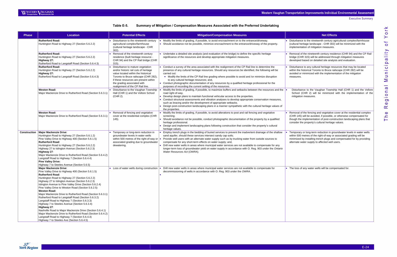
Western Vaughan Transportation Improvements Individual Environmental Assessment
Executive Summary
E-24
Th
e R
eg
ion
al
Mu
nic
ipa
lity
of
Yo
rk Table E-5. Summary of Mitigation / Compensation Measures Associated with the Preferred Undertaking
Phase Location Potential Effects Mitigation/Compensation Measures Net Effects
Rutherford Road:
Huntington Road to Highway 27 (Section 5.6.2.2)
Disturbance to the nineteenth century
agricultural complex/farmhouse
(cultural heritage landscape - CHR
302).
Modify the limits of grading, if possible, to avoid encroachment on to the entrance/driveway.
Should avoidance not be possible, minimize encroachment to the entrance/driveway of the property.
Disturbance to the nineteenth century agricultural complex/farmhouse
(cultural heritage landscape - CHR 302) will be minimized with the
implementation of mitigation measures.
Rutherford Road:
Huntington Road to Highway 27 (Section 5.6.2.2)
Highway 27:
Rutherford Road to Langstaff Road (Section 5.6.4.3)
Removal of the nineteenth century
residence (built heritage resource -
CHR 94) and the CP Rail bridge (CHR
315).
Undertake a detailed site analysis (and evaluation of the bridge) to define the specific heritage
significance of the resources and develop appropriate mitigation measures.
Removal of the nineteenth century residence (CHR 94) and the CP Rail
bridge (CHR 315) will be addressed through mitigation measures
developed based on detailed site analysis and evaluation.
Rutherford Road:
Huntington Road to Highway 27 (Section 5.6.2.2)
Highway 27:
Rutherford Road to Langstaff Road (Section 5.6.4.3)
Disturbance to mature vegetation
and/or historic rail cuts of heritage
value located within the historical
Toronto to Bruce railscape (CHR 282),
if these resources are present within
the grading associated with
realignment of the CP Rail line.
Conduct a survey of the area associated with the realignment of the CP Rail line to determine the
presence of any cultural heritage resources. Should any resources be identified, the following will be
carried out:
Modify the limits of the CP Rail line grading where possible to avoid and /or minimize disruption
to any cultural heritage resources; and,
Conduct photographic documentation of any resources by a qualified heritage professional for the
purposes of recording the current setting of the resources.
Disturbance to any cultural heritage resources that may be located
within the historical Toronto to Bruce railscape (CHR 282) will be
avoided or minimized with the implementation of the mitigation
measures.
Weston Road:
Major Mackenzie Drive to Rutherford Road (Section 5.6.3.1)
Disturbance to the Vaughan Township
Hall (CHR 1) and the Vellore School
(CHR 2).
Modify the limits of grading, if possible, to maximize buffers and setbacks between the resources and the
road right-of-way.
Develop design plans to maintain functional vehicular access to the properties.
Conduct structural assessments and vibration analyses to develop appropriate conservation measures,
such as bracing and/or the development of appropriate setbacks.
Design post-construction landscaping plans in a manner sympathetic with the cultural heritage values of
the properties.
Disturbance to the Vaughan Township Hall (CHR 1) and the Vellore
School (CHR 2) will be minimized with the implementation of the
mitigation measures.
Weston Road:
Major Mackenzie Drive to Rutherford Road (Section 5.6.3.1)
Removal of fencing and vegetative
cover at the residential complex (CHR
145).
Modify the limits of grading, if possible, to avoid alterations to post and rail fencing and vegetative
screening;
Should avoidance not be possible, conduct photographic documentation of the property by a qualified
heritage professional.
Design and implement landscaping plans following construction that consider the property‟s cultural
heritage values.
Removal of the fencing and vegetative cover at the residential complex
(CHR 145) will be avoided, if possible, or otherwise compensated for
though the implementation of post-construction landscaping plans that
consider the property‟s cultural heritage values.
Construction
Major Mackenzie Drive:
Huntington Road to Highway 27 (Section 5.6.1.2)
Pine Valley Drive to Highway 400 (Section 5.6.1.5)
Rutherford Road:
Huntington Road to Highway 27 (Section 5.6.2.2)
Highway 27 to Islington Avenue (Section 5.6.2.3)
Highway 27:
Major Mackenzie Drive to Rutherford Road (Section 5.6.4.2)
Langstaff Road to Highway 7 (Section 5.6.4.4)
Pine Valley Drive:
Highway 7 to Steeles Avenue (Section 5.6.5)
Temporary or long-term reduction in
groundwater levels in water wells
within 500 metres of the right-of-way or
associated grading due to groundwater
dewatering.
Employ trench plugs in the bedding of buried services to prevent the inadvertent drainage of the shallow
sand aquifer, should these services intersect sandy cap soils;
Provide well users with an alternate water supply such as by trucking water from outside sources to
compensate for any short-term effects on water supply; and,
Drill new water wells in areas where municipal water services are not available to compensate for any
longer-term loss of groundwater yield on water supply in accordance with O. Reg. 903 under the Ontario
Water Resources Act (OWRA).
Temporary or long-term reduction in groundwater levels in water wells
within 500 metres of the right-of-way or associated grading will be
minimized by installing trench plugs and compensated for by providing
alternate water supply to affected well users.
Major Mackenzie Drive:
Pine Valley Drive to Highway 400 (Section 5.6.1.5)
Rutherford Road:
Huntington Road to Highway 27 (Section 5.6.2.2)
Highway 27 to Islington Avenue (Section 5.6.2.3)
Islington Avenue to Pine Valley Drive (Section 5.6.2.4)
Pine Valley Drive to Weston Road (Section 5.6.2.5)
Weston Road:
Major Mackenzie Drive to Rutherford Road (Section 5.6.3.1)
Rutherford Road to Langstaff Road (Section 5.6.3.2)
Langstaff Road to Highway 7 (Section 5.6.3.3)
Highway 7 to Steeles Avenue (Section 5.6.3.4)
Highway 27:
Nashville Road to Major Mackenzie Drive (Section 5.6.4.1)
Major Mackenzie Drive to Rutherford Road (Section 5.6.4.2)
Langstaff Road to Highway 7 (Section 5.6.4.4)
Highway 7 to Steeles Ave (Section 5.6.4.5)
Loss of water wells during construction Drill new water wells in areas where municipal water services are not available to compensate for
decommissioning of wells in accordance with O. Reg. 903 under the OWRA.
The loss of any water wells will be compensated for.
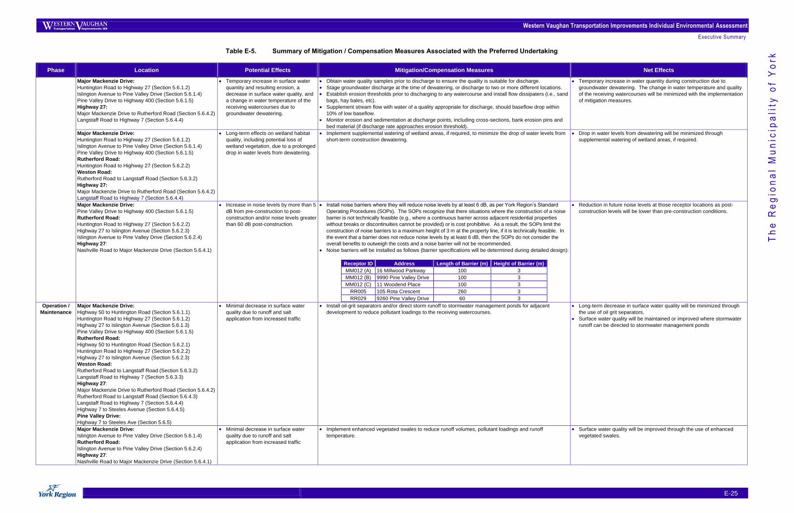
Western Vaughan Transportation Improvements Individual Environmental Assessment
Executive Summary
E-25
Th
e R
eg
ion
al
Mu
nic
ipa
lity
of
Yo
rk Table E-5. Summary of Mitigation / Compensation Measures Associated with the Preferred Undertaking
Phase Location Potential Effects Mitigation/Compensation Measures Net Effects
Major Mackenzie Drive:
Huntington Road to Highway 27 (Section 5.6.1.2)
Islington Avenue to Pine Valley Drive (Section 5.6.1.4)
Pine Valley Drive to Highway 400 (Section 5.6.1.5)
Highway 27:
Major Mackenzie Drive to Rutherford Road (Section 5.6.4.2)
Langstaff Road to Highway 7 (Section 5.6.4.4)
Temporary increase in surface water
quantity and resulting erosion, a
decrease in surface water quality, and
a change in water temperature of the
receiving watercourses due to
groundwater dewatering.
Obtain water quality samples prior to discharge to ensure the quality is suitable for discharge.
Stage groundwater discharge at the time of dewatering, or discharge to two or more different locations.
Establish erosion thresholds prior to discharging to any watercourse and install flow dissipaters (i.e., sand
bags, hay bales, etc).
Supplement stream flow with water of a quality appropriate for discharge, should baseflow drop within
10% of low baseflow.
Monitor erosion and sedimentation at discharge points, including cross-sections, bank erosion pins and
bed material (if discharge rate approaches erosion threshold).
Temporary increase in water quantity during construction due to
groundwater dewatering. The change in water temperature and quality
of the receiving watercourses will be minimized with the implementation
of mitigation measures.
Major Mackenzie Drive:
Huntington Road to Highway 27 (Section 5.6.1.2)
Islington Avenue to Pine Valley Drive (Section 5.6.1.4)
Pine Valley Drive to Highway 400 (Section 5.6.1.5)
Rutherford Road:
Huntington Road to Highway 27 (Section 5.6.2.2)
Weston Road:
Rutherford Road to Langstaff Road (Section 5.6.3.2)
Highway 27:
Major Mackenzie Drive to Rutherford Road (Section 5.6.4.2)
Langstaff Road to Highway 7 (Section 5.6.4.4)
Long-term effects on wetland habitat
quality, including potential loss of
wetland vegetation, due to a prolonged
drop in water levels from dewatering.
Implement supplemental watering of wetland areas, if required, to minimize the drop of water levels from
short-term construction dewatering.
Drop in water levels from dewatering will be minimized through
supplemental watering of wetland areas, if required.
Major Mackenzie Drive:
Pine Valley Drive to Highway 400 (Section 5.6.1.5)
Rutherford Road:
Huntington Road to Highway 27 (Section 5.6.2.2)
Highway 27 to Islington Avenue (Section 5.6.2.3)
Islington Avenue to Pine Valley Drive (Section 5.6.2.4)
Highway 27:
Nashville Road to Major Mackenzie Drive (Section 5.6.4.1)
Increase in noise levels by more than 5
dB from pre-construction to post-
construction and/or noise levels greater
than 60 dB post-construction.
Install noise barriers where they will reduce noise levels by at least 6 dB, as per York Region‟s Standard
Operating Procedures (SOPs). The SOPs recognize that there situations where the construction of a noise
barrier is not technically feasible (e.g., where a continuous barrier across adjacent residential properties
without breaks or discontinuities cannot be provided) or is cost prohibitive. As a result, the SOPs limit the
construction of noise barriers to a maximum height of 3 m at the property line, if it is technically feasible. In
the event that a barrier does not reduce noise levels by at least 6 dB, then the SOPs do not consider the
overall benefits to outweigh the costs and a noise barrier will not be recommended.
Noise barriers will be installed as follows (barrier specifications will be determined during detailed design):
Receptor ID Address Length of Barrier (m) Height of Barrier (m)
MM012 (A) 16 Millwood Parkway 100 3
MM012 (B) 9990 Pine Valley Drive 100 3
MM012 (C) 11 Woodend Place 100 3
RR005 105 Rota Crescent 260 3
RR029 9260 Pine Valley Drive 60 3
Reduction in future noise levels at those receptor locations as post-
construction levels will be lower than pre-construction conditions.
Operation /
Maintenance
Major Mackenzie Drive:
Highway 50 to Huntington Road (Section 5.6.1.1)
Huntington Road to Highway 27 (Section 5.6.1.2)
Highway 27 to Islington Avenue (Section 5.6.1.3)
Pine Valley Drive to Highway 400 (Section 5.6.1.5)
Rutherford Road:
Highway 50 to Huntington Road (Section 5.6.2.1)
Huntington Road to Highway 27 (Section 5.6.2.2)
Highway 27 to Islington Avenue (Section 5.6.2.3)
Weston Road:
Rutherford Road to Langstaff Road (Section 5.6.3.2)
Langstaff Road to Highway 7 (Section 5.6.3.3)
Highway 27:
Major Mackenzie Drive to Rutherford Road (Section 5.6.4.2)
Rutherford Road to Langstaff Road (Section 5.6.4.3)
Langstaff Road to Highway 7 (Section 5.6.4.4)
Highway 7 to Steeles Avenue (Section 5.6.4.5)
Pine Valley Drive:
Highway 7 to Steeles Ave (Section 5.6.5)
Minimal decrease in surface water
quality due to runoff and salt
application from increased traffic
Install oil-grit separators and/or direct storm runoff to stormwater management ponds for adjacent
development to reduce pollutant loadings to the receiving watercourses.
Long-term decrease in surface water quality will be minimized through
the use of oil grit separators.
Surface water quality will be maintained or improved where stormwater
runoff can be directed to stormwater management ponds
Major Mackenzie Drive:
Islington Avenue to Pine Valley Drive (Section 5.6.1.4)
Rutherford Road:
Islington Avenue to Pine Valley Drive (Section 5.6.2.4)
Highway 27:
Nashville Road to Major Mackenzie Drive (Section 5.6.4.1)
Minimal decrease in surface water
quality due to runoff and salt
application from increased traffic
Implement enhanced vegetated swales to reduce runoff volumes, pollutant loadings and runoff
temperature.
Surface water quality will be improved through the use of enhanced
vegetated swales.
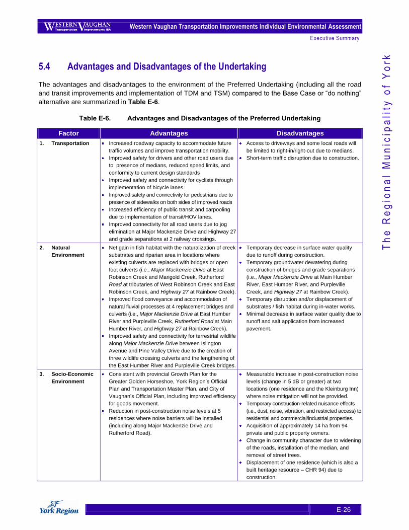
Western Vaughan Transportation Improvements Individual Environmental Assessment
Executive Summary
E-26
Th
e R
eg
ion
al
Mu
nic
ipa
lity
of
Yo
rk
5.4 Advantages and Disadvantages of the Undertaking
The advantages and disadvantages to the environment of the Preferred Undertaking (including all the road
and transit improvements and implementation of TDM and TSM) compared to the Base Case or “do nothing”
alternative are summarized in Table E-6.
Table E-6. Advantages and Disadvantages of the Preferred Undertaking
Factor Advantages Disadvantages
1. Transportation Increased roadway capacity to accommodate future
traffic volumes and improve transportation mobility.
Improved safety for drivers and other road users due
to presence of medians, reduced speed limits, and
conformity to current design standards
Improved safety and connectivity for cyclists through
implementation of bicycle lanes.
Improved safety and connectivity for pedestrians due to
presence of sidewalks on both sides of improved roads
Increased efficiency of public transit and carpooling
due to implementation of transit/HOV lanes.
Improved connectivity for all road users due to jog
elimination at Major Mackenzie Drive and Highway 27
and grade separations at 2 railway crossings.
Access to driveways and some local roads will
be limited to right-in/right-out due to medians.
Short-term traffic disruption due to construction.
2. Natural
Environment
Net gain in fish habitat with the naturalization of creek
substrates and riparian area in locations where
existing culverts are replaced with bridges or open
foot culverts (i.e., Major Mackenzie Drive at East
Robinson Creek and Marigold Creek, Rutherford
Road at tributaries of West Robinson Creek and East
Robinson Creek, and Highway 27 at Rainbow Creek).
Improved flood conveyance and accommodation of
natural fluvial processes at 4 replacement bridges and
culverts (i.e., Major Mackenzie Drive at East Humber
River and Purpleville Creek, Rutherford Road at Main
Humber River, and Highway 27 at Rainbow Creek).
Improved safety and connectivity for terrestrial wildlife
along Major Mackenzie Drive between Islington
Avenue and Pine Valley Drive due to the creation of
three wildlife crossing culverts and the lengthening of
the East Humber River and Purpleville Creek bridges.
Temporary decrease in surface water quality
due to runoff during construction.
Temporary groundwater dewatering during
construction of bridges and grade separations
(i.e., Major Mackenzie Drive at Main Humber
River, East Humber River, and Purpleville
Creek, and Highway 27 at Rainbow Creek).
Temporary disruption and/or displacement of
substrates / fish habitat during in-water works.
Minimal decrease in surface water quality due to
runoff and salt application from increased
pavement.
3. Socio-Economic
Environment
Consistent with provincial Growth Plan for the
Greater Golden Horseshoe, York Region‟s Official
Plan and Transportation Master Plan, and City of
Vaughan‟s Official Plan, including improved efficiency
for goods movement.
Reduction in post-construction noise levels at 5
residences where noise barriers will be installed
(including along Major Mackenzie Drive and
Rutherford Road).
Measurable increase in post-construction noise
levels (change in 5 dB or greater) at two
locations (one residence and the Kleinburg Inn)
where noise mitigation will not be provided.
Temporary construction-related nuisance effects
(i.e., dust, noise, vibration, and restricted access) to
residential and commercial/industrial properties.
Acquisition of approximately 14 ha from 94
private and public property owners.
Change in community character due to widening
of the roads, installation of the median, and
removal of street trees.
Displacement of one residence (which is also a
built heritage resource – CHR 94) due to
construction.
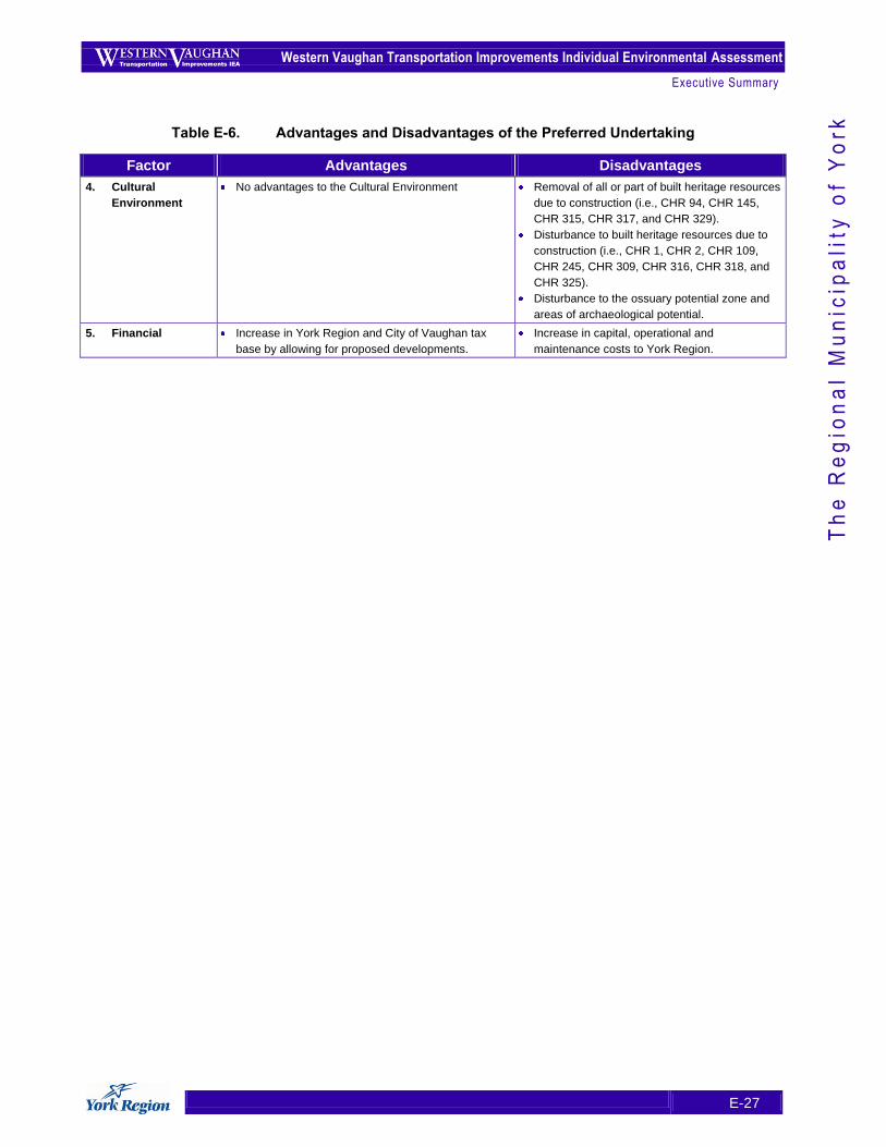
Western Vaughan Transportation Improvements Individual Environmental Assessment
Executive Summary
E-27
Th
e R
eg
ion
al
Mu
nic
ipa
lity
of
Yo
rk
Table E-6. Advantages and Disadvantages of the Preferred Undertaking
Factor Advantages Disadvantages
4. Cultural
Environment
No advantages to the Cultural Environment Removal of all or part of built heritage resources
due to construction (i.e., CHR 94, CHR 145,
CHR 315, CHR 317, and CHR 329).
Disturbance to built heritage resources due to
construction (i.e., CHR 1, CHR 2, CHR 109,
CHR 245, CHR 309, CHR 316, CHR 318, and
CHR 325).
Disturbance to the ossuary potential zone and
areas of archaeological potential.
5. Financial Increase in York Region and City of Vaughan tax
base by allowing for proposed developments.
Increase in capital, operational and
maintenance costs to York Region.
Western Vaughan Transportation Improvements Individual Environmental Assessment
Executive Summary
E-28
Th
e R
eg
ion
al
Mu
nic
ipa
lity
of
Yo
rk
6. Monitoring and Commitments for the Undertaking
6.1 Environmental Effects Monitoring
An environmental effects monitoring strategy and schedule was developed, based on the effects
assessments carried out for the Preferred Undertaking, to ensure:
that the predicted net negative effects are not exceeded;
that any unexpected negative effects are addressed; and
that the predicted benefits are realized.
The type and frequency of environmental effects monitoring to be carried out in relation to the mitigation and
compensation measures for the Preferred Undertaking are described in this strategy, and address effects on
the natural environment (including terrestrial and aquatic features, surface water and groundwater), the
socio-economic environment (including noise and vibration), and the cultural environment (including
archaeological and cultural heritage resources).
6.2 EA Commitments and Compliance Monitoring
A monitoring strategy and schedule was developed to ensure that the commitments made during the
Western Vaughan Transportation Improvements IEA will be fulfilled prior to and during the construction,
operation, and maintenance of the Preferred Undertaking.
In accordance with the Code of Practice for Preparing and Reviewing Environmental Assessments in
Ontario, November 2008, Table E-7 lists each of these commitments along with the following information:
timing of the commitment (i.e., when the commitment will be implemented);
location within the Study Area (i.e., where the commitment will be implemented)
section of the EA Report where the commitment is mentioned in greater detail;
source of the commitment; and
how the commitment will be monitored for compliance (i.e., fulfilled).
Annual compliance reports will be submitted to the Ministry to report on compliance with the commitments
listed in Table E-7, along with any other conditions imposed by the Minister as part of EA approval.
6.3 Updating Provisions for the Preferred Undertaking
It is presently anticipated that the Preferred Undertaking will be implemented over a relatively long period of
time (possibly more than twenty years). If the period of time from the Notice of Approval to Proceed with the
Undertaking to the start of detailed design for the improvements, or sections of improvements, exceeds ten
years, York Region will review the purpose and rationale for the approved improvement and environmental
setting to ensure that the approved improvement and associated mitigation / compensation measures are
still valid given the context at the time.
The updates will be documented and provided to the MOE‟s Environmental Assessment and Approvals
Branch for inclusion in the public record file within the Ministry for information purposes.
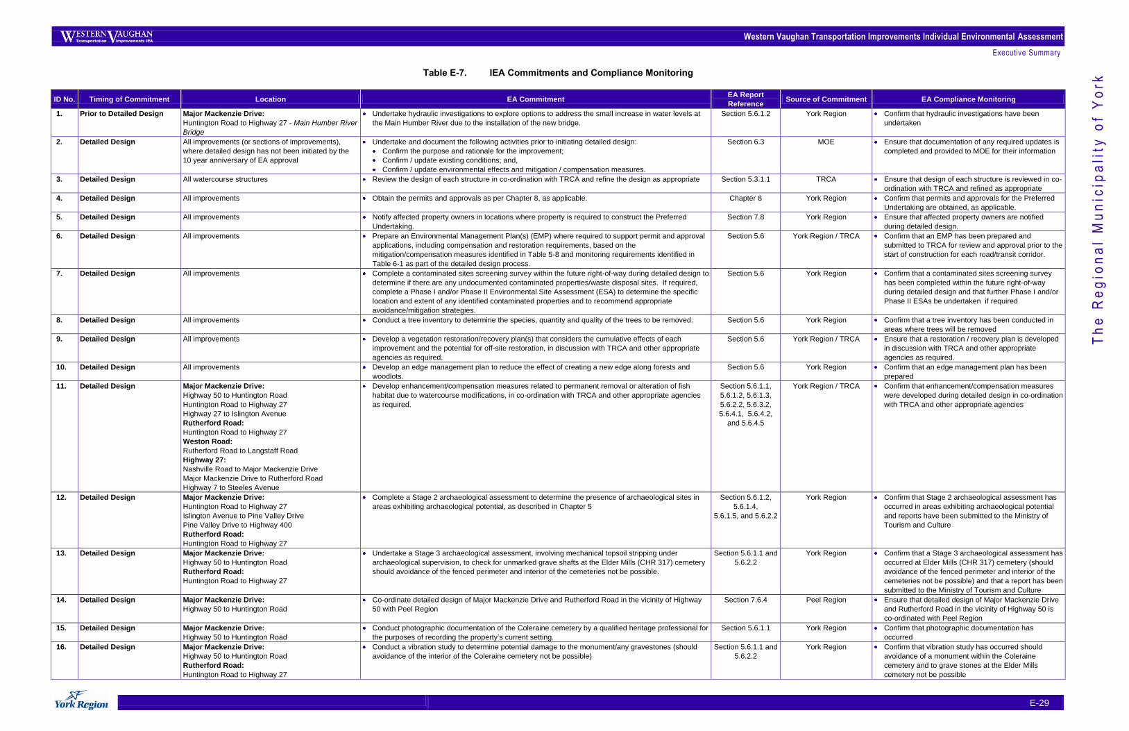
Western Vaughan Transportation Improvements Individual Environmental Assessment
Executive Summary
E-29
Th
e R
eg
ion
al
Mu
nic
ipa
lity
of
Yo
rk Table E-7. IEA Commitments and Compliance Monitoring
ID No. Timing of Commitment Location EA Commitment EA Report
Reference Source of Commitment EA Compliance Monitoring
1. Prior to Detailed Design Major Mackenzie Drive:
Huntington Road to Highway 27 - Main Humber River
Bridge
Undertake hydraulic investigations to explore options to address the small increase in water levels at
the Main Humber River due to the installation of the new bridge.
Section 5.6.1.2 York Region Confirm that hydraulic investigations have been
undertaken
2. Detailed Design All improvements (or sections of improvements),
where detailed design has not been initiated by the
10 year anniversary of EA approval
Undertake and document the following activities prior to initiating detailed design:
Confirm the purpose and rationale for the improvement;
Confirm / update existing conditions; and,
Confirm / update environmental effects and mitigation / compensation measures.
Section 6.3 MOE Ensure that documentation of any required updates is
completed and provided to MOE for their information
3. Detailed Design All watercourse structures Review the design of each structure in co-ordination with TRCA and refine the design as appropriate Section 5.3.1.1 TRCA Ensure that design of each structure is reviewed in co-
ordination with TRCA and refined as appropriate
4. Detailed Design All improvements Obtain the permits and approvals as per Chapter 8, as applicable. Chapter 8 York Region Confirm that permits and approvals for the Preferred
Undertaking are obtained, as applicable.
5. Detailed Design All improvements Notify affected property owners in locations where property is required to construct the Preferred
Undertaking.
Section 7.8 York Region Ensure that affected property owners are notified
during detailed design.
6. Detailed Design All improvements Prepare an Environmental Management Plan(s) (EMP) where required to support permit and approval
applications, including compensation and restoration requirements, based on the
mitigation/compensation measures identified in Table 5-8 and monitoring requirements identified in
Table 6-1 as part of the detailed design process.
Section 5.6 York Region / TRCA Confirm that an EMP has been prepared and
submitted to TRCA for review and approval prior to the
start of construction for each road/transit corridor.
7. Detailed Design All improvements Complete a contaminated sites screening survey within the future right-of-way during detailed design to
determine if there are any undocumented contaminated properties/waste disposal sites. If required,
complete a Phase I and/or Phase II Environmental Site Assessment (ESA) to determine the specific
location and extent of any identified contaminated properties and to recommend appropriate
avoidance/mitigation strategies.
Section 5.6 York Region Confirm that a contaminated sites screening survey
has been completed within the future right-of-way
during detailed design and that further Phase I and/or
Phase II ESAs be undertaken if required
8. Detailed Design All improvements
Conduct a tree inventory to determine the species, quantity and quality of the trees to be removed. Section 5.6 York Region Confirm that a tree inventory has been conducted in
areas where trees will be removed
9. Detailed Design All improvements
Develop a vegetation restoration/recovery plan(s) that considers the cumulative effects of each
improvement and the potential for off-site restoration, in discussion with TRCA and other appropriate
agencies as required.
Section 5.6 York Region / TRCA Ensure that a restoration / recovery plan is developed
in discussion with TRCA and other appropriate
agencies as required.
10. Detailed Design All improvements
Develop an edge management plan to reduce the effect of creating a new edge along forests and
woodlots.
Section 5.6 York Region Confirm that an edge management plan has been
prepared
11. Detailed Design Major Mackenzie Drive:
Highway 50 to Huntington Road
Huntington Road to Highway 27
Highway 27 to Islington Avenue
Rutherford Road:
Huntington Road to Highway 27
Weston Road:
Rutherford Road to Langstaff Road
Highway 27:
Nashville Road to Major Mackenzie Drive
Major Mackenzie Drive to Rutherford Road
Highway 7 to Steeles Avenue
Develop enhancement/compensation measures related to permanent removal or alteration of fish
habitat due to watercourse modifications, in co-ordination with TRCA and other appropriate agencies
as required.
Section 5.6.1.1,
5.6.1.2, 5.6.1.3,
5.6.2.2, 5.6.3.2,
5.6.4.1, 5.6.4.2,
and 5.6.4.5
York Region / TRCA Confirm that enhancement/compensation measures
were developed during detailed design in co-ordination
with TRCA and other appropriate agencies
12. Detailed Design Major Mackenzie Drive:
Huntington Road to Highway 27
Islington Avenue to Pine Valley Drive
Pine Valley Drive to Highway 400
Rutherford Road:
Huntington Road to Highway 27
Complete a Stage 2 archaeological assessment to determine the presence of archaeological sites in
areas exhibiting archaeological potential, as described in Chapter 5
Section 5.6.1.2,
5.6.1.4,
5.6.1.5, and 5.6.2.2
York Region Confirm that Stage 2 archaeological assessment has
occurred in areas exhibiting archaeological potential
and reports have been submitted to the Ministry of
Tourism and Culture
13. Detailed Design Major Mackenzie Drive:
Highway 50 to Huntington Road
Rutherford Road:
Huntington Road to Highway 27
Undertake a Stage 3 archaeological assessment, involving mechanical topsoil stripping under
archaeological supervision, to check for unmarked grave shafts at the Elder Mills (CHR 317) cemetery
should avoidance of the fenced perimeter and interior of the cemeteries not be possible.
Section 5.6.1.1 and
5.6.2.2
York Region Confirm that a Stage 3 archaeological assessment has
occurred at Elder Mills (CHR 317) cemetery (should
avoidance of the fenced perimeter and interior of the
cemeteries not be possible) and that a report has been
submitted to the Ministry of Tourism and Culture
14. Detailed Design Major Mackenzie Drive:
Highway 50 to Huntington Road
Co-ordinate detailed design of Major Mackenzie Drive and Rutherford Road in the vicinity of Highway
50 with Peel Region
Section 7.6.4 Peel Region Ensure that detailed design of Major Mackenzie Drive
and Rutherford Road in the vicinity of Highway 50 is
co-ordinated with Peel Region
15. Detailed Design Major Mackenzie Drive:
Highway 50 to Huntington Road
Conduct photographic documentation of the Coleraine cemetery by a qualified heritage professional for
the purposes of recording the property‟s current setting.
Section 5.6.1.1 York Region Confirm that photographic documentation has
occurred
16. Detailed Design Major Mackenzie Drive:
Highway 50 to Huntington Road
Rutherford Road:
Huntington Road to Highway 27
Conduct a vibration study to determine potential damage to the monument/any gravestones (should
avoidance of the interior of the Coleraine cemetery not be possible)
Section 5.6.1.1 and
5.6.2.2
York Region Confirm that vibration study has occurred should
avoidance of a monument within the Coleraine
cemetery and to grave stones at the Elder Mills
cemetery not be possible
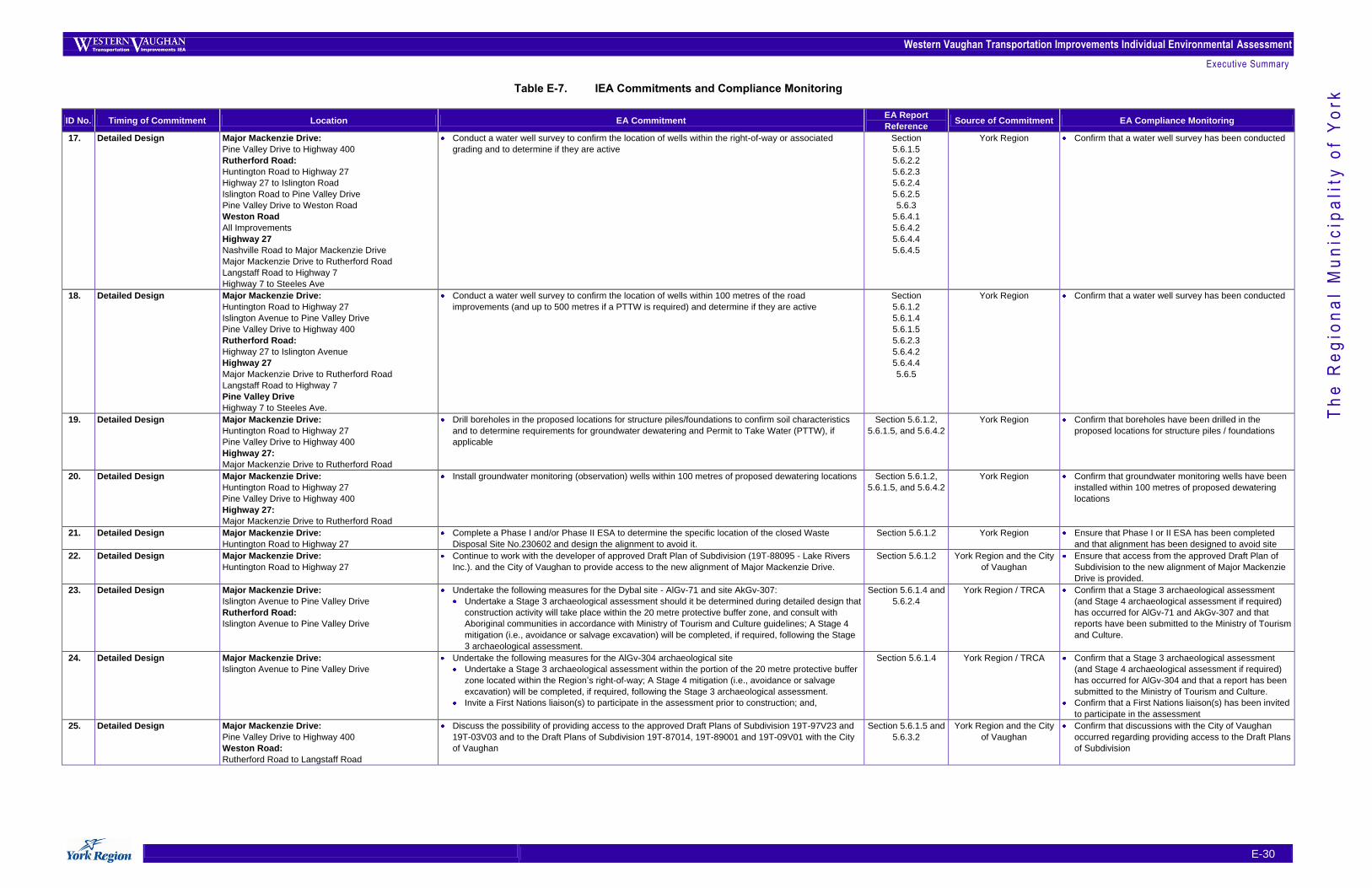
Western Vaughan Transportation Improvements Individual Environmental Assessment
Executive Summary
E-30
Th
e R
eg
ion
al
Mu
nic
ipa
lity
of
Yo
rk Table E-7. IEA Commitments and Compliance Monitoring
ID No. Timing of Commitment Location EA Commitment EA Report
Reference Source of Commitment EA Compliance Monitoring
17. Detailed Design Major Mackenzie Drive:
Pine Valley Drive to Highway 400
Rutherford Road:
Huntington Road to Highway 27
Highway 27 to Islington Road
Islington Road to Pine Valley Drive
Pine Valley Drive to Weston Road
Weston Road
All Improvements
Highway 27
Nashville Road to Major Mackenzie Drive
Major Mackenzie Drive to Rutherford Road
Langstaff Road to Highway 7
Highway 7 to Steeles Ave
Conduct a water well survey to confirm the location of wells within the right-of-way or associated
grading and to determine if they are active
Section
5.6.1.5
5.6.2.2
5.6.2.3
5.6.2.4
5.6.2.5
5.6.3
5.6.4.1
5.6.4.2
5.6.4.4
5.6.4.5
York Region Confirm that a water well survey has been conducted
18. Detailed Design Major Mackenzie Drive:
Huntington Road to Highway 27
Islington Avenue to Pine Valley Drive
Pine Valley Drive to Highway 400
Rutherford Road:
Highway 27 to Islington Avenue
Highway 27
Major Mackenzie Drive to Rutherford Road
Langstaff Road to Highway 7
Pine Valley Drive
Highway 7 to Steeles Ave.
Conduct a water well survey to confirm the location of wells within 100 metres of the road
improvements (and up to 500 metres if a PTTW is required) and determine if they are active
Section
5.6.1.2
5.6.1.4
5.6.1.5
5.6.2.3
5.6.4.2
5.6.4.4
5.6.5
York Region Confirm that a water well survey has been conducted
19. Detailed Design Major Mackenzie Drive:
Huntington Road to Highway 27
Pine Valley Drive to Highway 400
Highway 27:
Major Mackenzie Drive to Rutherford Road
Drill boreholes in the proposed locations for structure piles/foundations to confirm soil characteristics
and to determine requirements for groundwater dewatering and Permit to Take Water (PTTW), if
applicable
Section 5.6.1.2,
5.6.1.5, and 5.6.4.2
York Region Confirm that boreholes have been drilled in the
proposed locations for structure piles / foundations
20. Detailed Design Major Mackenzie Drive:
Huntington Road to Highway 27
Pine Valley Drive to Highway 400
Highway 27:
Major Mackenzie Drive to Rutherford Road
Install groundwater monitoring (observation) wells within 100 metres of proposed dewatering locations Section 5.6.1.2,
5.6.1.5, and 5.6.4.2
York Region Confirm that groundwater monitoring wells have been
installed within 100 metres of proposed dewatering
locations
21. Detailed Design Major Mackenzie Drive:
Huntington Road to Highway 27
Complete a Phase I and/or Phase II ESA to determine the specific location of the closed Waste
Disposal Site No.230602 and design the alignment to avoid it.
Section 5.6.1.2 York Region Ensure that Phase I or II ESA has been completed
and that alignment has been designed to avoid site
22. Detailed Design Major Mackenzie Drive:
Huntington Road to Highway 27
Continue to work with the developer of approved Draft Plan of Subdivision (19T-88095 - Lake Rivers
Inc.). and the City of Vaughan to provide access to the new alignment of Major Mackenzie Drive.
Section 5.6.1.2 York Region and the City
of Vaughan
Ensure that access from the approved Draft Plan of
Subdivision to the new alignment of Major Mackenzie
Drive is provided.
23. Detailed Design Major Mackenzie Drive:
Islington Avenue to Pine Valley Drive
Rutherford Road:
Islington Avenue to Pine Valley Drive
Undertake the following measures for the Dybal site - AlGv-71 and site AkGv-307:
Undertake a Stage 3 archaeological assessment should it be determined during detailed design that
construction activity will take place within the 20 metre protective buffer zone, and consult with
Aboriginal communities in accordance with Ministry of Tourism and Culture guidelines; A Stage 4
mitigation (i.e., avoidance or salvage excavation) will be completed, if required, following the Stage
3 archaeological assessment.
Section 5.6.1.4 and
5.6.2.4
York Region / TRCA Confirm that a Stage 3 archaeological assessment
(and Stage 4 archaeological assessment if required)
has occurred for AlGv-71 and AkGv-307 and that
reports have been submitted to the Ministry of Tourism
and Culture.
24. Detailed Design Major Mackenzie Drive:
Islington Avenue to Pine Valley Drive
Undertake the following measures for the AlGv-304 archaeological site
Undertake a Stage 3 archaeological assessment within the portion of the 20 metre protective buffer
zone located within the Region‟s right-of-way; A Stage 4 mitigation (i.e., avoidance or salvage
excavation) will be completed, if required, following the Stage 3 archaeological assessment.
Invite a First Nations liaison(s) to participate in the assessment prior to construction; and,
Section 5.6.1.4 York Region / TRCA Confirm that a Stage 3 archaeological assessment
(and Stage 4 archaeological assessment if required)
has occurred for AlGv-304 and that a report has been
submitted to the Ministry of Tourism and Culture.
Confirm that a First Nations liaison(s) has been invited
to participate in the assessment
25. Detailed Design Major Mackenzie Drive:
Pine Valley Drive to Highway 400
Weston Road:
Rutherford Road to Langstaff Road
Discuss the possibility of providing access to the approved Draft Plans of Subdivision 19T-97V23 and
19T-03V03 and to the Draft Plans of Subdivision 19T-87014, 19T-89001 and 19T-09V01 with the City
of Vaughan
Section 5.6.1.5 and
5.6.3.2
York Region and the City
of Vaughan
Confirm that discussions with the City of Vaughan
occurred regarding providing access to the Draft Plans
of Subdivision
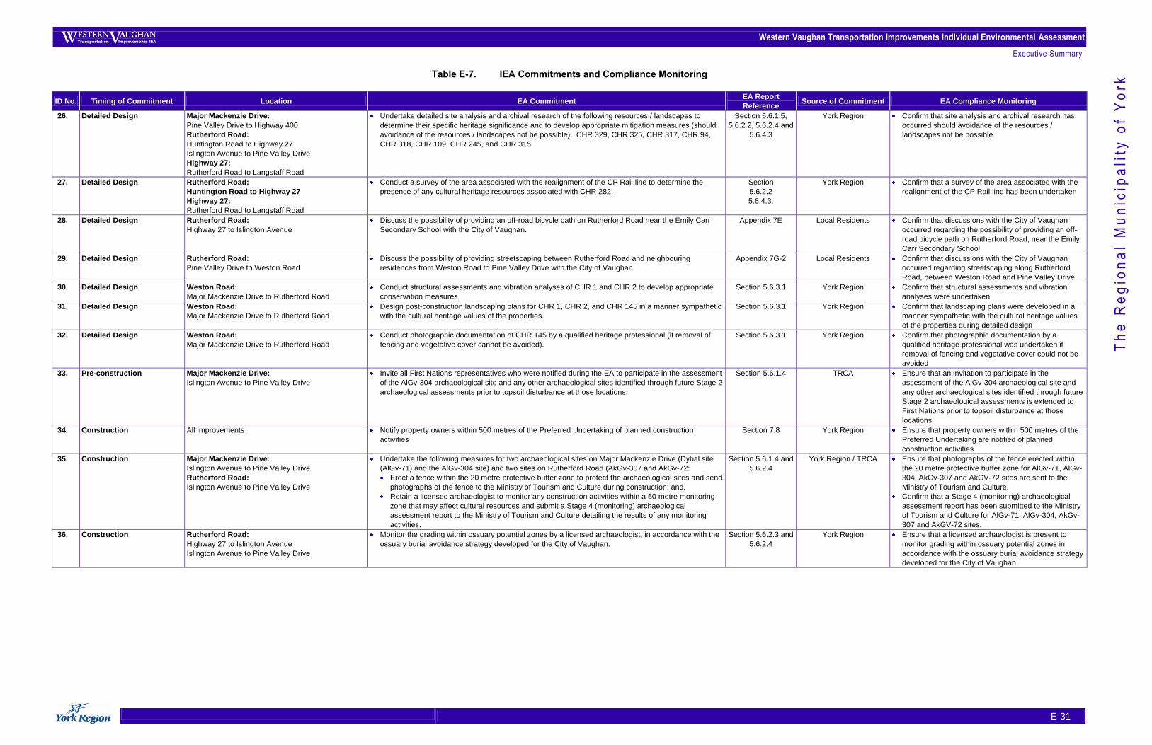
Western Vaughan Transportation Improvements Individual Environmental Assessment
Executive Summary
E-31
Th
e R
eg
ion
al
Mu
nic
ipa
lity
of
Yo
rk Table E-7. IEA Commitments and Compliance Monitoring
ID No. Timing of Commitment Location EA Commitment EA Report
Reference Source of Commitment EA Compliance Monitoring
26. Detailed Design Major Mackenzie Drive:
Pine Valley Drive to Highway 400
Rutherford Road:
Huntington Road to Highway 27
Islington Avenue to Pine Valley Drive
Highway 27:
Rutherford Road to Langstaff Road
Undertake detailed site analysis and archival research of the following resources / landscapes to
determine their specific heritage significance and to develop appropriate mitigation measures (should
avoidance of the resources / landscapes not be possible): CHR 329, CHR 325, CHR 317, CHR 94,
CHR 318, CHR 109, CHR 245, and CHR 315
Section 5.6.1.5,
5.6.2.2, 5.6.2.4 and
5.6.4.3
York Region Confirm that site analysis and archival research has
occurred should avoidance of the resources /
landscapes not be possible
27. Detailed Design Rutherford Road:
Huntington Road to Highway 27
Highway 27:
Rutherford Road to Langstaff Road
Conduct a survey of the area associated with the realignment of the CP Rail line to determine the
presence of any cultural heritage resources associated with CHR 282.
Section
5.6.2.2
5.6.4.3.
York Region Confirm that a survey of the area associated with the
realignment of the CP Rail line has been undertaken
28. Detailed Design Rutherford Road:
Highway 27 to Islington Avenue
Discuss the possibility of providing an off-road bicycle path on Rutherford Road near the Emily Carr
Secondary School with the City of Vaughan.
Appendix 7E Local Residents Confirm that discussions with the City of Vaughan
occurred regarding the possibility of providing an off-
road bicycle path on Rutherford Road, near the Emily
Carr Secondary School
29. Detailed Design Rutherford Road:
Pine Valley Drive to Weston Road
Discuss the possibility of providing streetscaping between Rutherford Road and neighbouring
residences from Weston Road to Pine Valley Drive with the City of Vaughan.
Appendix 7G-2 Local Residents Confirm that discussions with the City of Vaughan
occurred regarding streetscaping along Rutherford
Road, between Weston Road and Pine Valley Drive
30. Detailed Design Weston Road:
Major Mackenzie Drive to Rutherford Road
Conduct structural assessments and vibration analyses of CHR 1 and CHR 2 to develop appropriate
conservation measures
Section 5.6.3.1
York Region Confirm that structural assessments and vibration
analyses were undertaken
31. Detailed Design Weston Road:
Major Mackenzie Drive to Rutherford Road
Design post-construction landscaping plans for CHR 1, CHR 2, and CHR 145 in a manner sympathetic
with the cultural heritage values of the properties.
Section 5.6.3.1
York Region Confirm that landscaping plans were developed in a
manner sympathetic with the cultural heritage values
of the properties during detailed design
32. Detailed Design Weston Road:
Major Mackenzie Drive to Rutherford Road
Conduct photographic documentation of CHR 145 by a qualified heritage professional (if removal of
fencing and vegetative cover cannot be avoided).
Section 5.6.3.1 York Region Confirm that photographic documentation by a
qualified heritage professional was undertaken if
removal of fencing and vegetative cover could not be
avoided
33. Pre-construction Major Mackenzie Drive:
Islington Avenue to Pine Valley Drive
Invite all First Nations representatives who were notified during the EA to participate in the assessment
of the AlGv-304 archaeological site and any other archaeological sites identified through future Stage 2
archaeological assessments prior to topsoil disturbance at those locations.
Section 5.6.1.4 TRCA Ensure that an invitation to participate in the
assessment of the AlGv-304 archaeological site and
any other archaeological sites identified through future
Stage 2 archaeological assessments is extended to
First Nations prior to topsoil disturbance at those
locations.
34. Construction All improvements Notify property owners within 500 metres of the Preferred Undertaking of planned construction
activities
Section 7.8 York Region Ensure that property owners within 500 metres of the
Preferred Undertaking are notified of planned
construction activities
35. Construction Major Mackenzie Drive:
Islington Avenue to Pine Valley Drive
Rutherford Road:
Islington Avenue to Pine Valley Drive
Undertake the following measures for two archaeological sites on Major Mackenzie Drive (Dybal site
(AlGv-71) and the AlGv-304 site) and two sites on Rutherford Road (AkGv-307 and AkGv-72:
Erect a fence within the 20 metre protective buffer zone to protect the archaeological sites and send
photographs of the fence to the Ministry of Tourism and Culture during construction; and,
Retain a licensed archaeologist to monitor any construction activities within a 50 metre monitoring
zone that may affect cultural resources and submit a Stage 4 (monitoring) archaeological
assessment report to the Ministry of Tourism and Culture detailing the results of any monitoring
activities.
Section 5.6.1.4 and
5.6.2.4
York Region / TRCA Ensure that photographs of the fence erected within
the 20 metre protective buffer zone for AlGv-71, AlGv-
304, AkGv-307 and AkGV-72 sites are sent to the
Ministry of Tourism and Culture.
Confirm that a Stage 4 (monitoring) archaeological
assessment report has been submitted to the Ministry
of Tourism and Culture for AlGv-71, AlGv-304, AkGv-
307 and AkGV-72 sites.
36. Construction Rutherford Road:
Highway 27 to Islington Avenue
Islington Avenue to Pine Valley Drive
Monitor the grading within ossuary potential zones by a licensed archaeologist, in accordance with the
ossuary burial avoidance strategy developed for the City of Vaughan.
Section 5.6.2.3 and
5.6.2.4
York Region Ensure that a licensed archaeologist is present to
monitor grading within ossuary potential zones in
accordance with the ossuary burial avoidance strategy
developed for the City of Vaughan.
Western Vaughan Transportation Improvements Individual Environmental Assessment
Executive Summary
E-32
Th
e R
eg
ion
al
Mu
nic
ipa
lity
of
Yo
rk
7. Public and Stakeholder Consultation
7.1 Consultation with the Public and Review Agencies
During the Western Vaughan IEA, York Region provided the following opportunities for residents,
stakeholders, and review agencies to get involved in the EA process including:
A project website;
Five rounds of Public Consultation Centres (PCCs), which consisted of 11 meetings with the
public and interested stakeholders;
Six Community Stakeholders Advisory Committee meetings comprised of local residents,
business owners, environmental and transportation organizations and property owners;
A project newsletter;
Neighbourhood meetings;
Meetings with property owners;
Six Review Agency Advisory Committee meetings including representatives from nine
agencies/corporations (MOE, MTO, GO Transit, TRCA, Peel Region, City of Vaughan, CEAA,
CP Rail and 407 ETR); and,
Additional meetings with individual review agencies.
7.2 Consultation with First Nations and other Aboriginal Communities
Consultation with First Nations and other Aboriginal communities was undertaken in accordance with the
Minister-approved ToR. The following First Nations and Aboriginal communities were invited to participate in
a separate but parallel consultation process:
Alderville First Nation;
Beausoleil First Nation;
Chippewas of Georgina Island;
Chippewas of Mnjikaning;
Curve Lake First Nation;
Hiawatha First Nation;
Iroquois Confederacy;
Kawartha Nishnawbe First Nation;
Métis Nation of Ontario;
Mississaugas of Scugog Island;
Mississaugas of the New Credit First Nation;
Mohawks of the Bay of Quinte;
Moose Deer Point First Nation;
Nation Huronne Wendat; and
Six Nations of the Grand River.
Two meetings were held with interested First Nations over the course of the EA. As part of these meetings,
a First Nation protocol was developed to guide consultation and communication activities with First Nations
and other Aboriginal communities during the EA and throughout the construction phases of the project.
Western Vaughan Transportation Improvements Individual Environmental Assessment
Executive Summary
E-33
Th
e R
eg
ion
al
Mu
nic
ipa
lity
of
Yo
rk
8. Approvals Required for the Undertaking
8.1 Municipal, Provincial and Federal Approvals
In addition to requiring EA Act approval, other municipal, provincial, and federal approvals are anticipated to
be required before implementation of the Preferred Undertaking can commence. These are summarized in
Table E-7 below.
Table E-8. Approvals Required for the Undertaking
Level of
Government Department/Ministry/ Municipality Authorizations/Approvals
Municipal City of Vaughan Tree by-laws
Noise by-laws
Property Agreements (easements, encroachment agreements)
Discharge to sewer permit
Fill and Topsoil disturbance by-law 265-2006
Utility Authorities Approval from the applicable local electrical authority in order to arrange
for temporary electrical power to be provided for construction purposes.
Provincial Ministry of the Environment Permit to Take Water (PTTW) under Ontario Water Resources Act
(OWRA)
Ministry of Culture Letter of Concurrence with Stage 2 Archaeological Assessment
Ontario Realty Corporation Class Environmental Assessment Process For the Ministry of Energy
and Infrastructure for Realty Activities other than Electricity Projects
(Category A Class EA for obtaining permanent and temporary easement
agreements may be required for the portions of Ontario Realty
Corporation (ORC) managed lands (hydro corridors) intersecting the new
road alignments
Toronto and Region Conservation
Authority
Ontario Regulation 166/06: Regulation of Development, Interference with
Wetlands and Alterations to Shorelines and Watercourses
Approvals in relation to temporary and permanent land requirements
Permits for storm sewer outfalls to watercourses
Ontario Heritage Trust (OHT) Approval for the purchase or exchange of land for areas of the right-of-
way that overlap with OHT-owned land.
Approvals from OHT will be required in relation to temporary land
requirements
Federal Department of Fisheries and Oceans Fisheries Act
Canadian Transportation Agency Canada Transportation Act
Transport Canada Navigable Waters Protection Act
National Energy Board National Energy Board Act
Western Vaughan Transportation Improvements Individual Environmental Assessment
Executive Summary
E-34
Th
e R
eg
ion
al
Mu
nic
ipa
lity
of
Yo
rk
9. Amending the EA
In recognition of the fact that there could be changes to the design of the Preferred Undertaking following its
approval by the Minister under the EA Act during detailed design and/or construction, York Region is
proposing an amendment procedure. York Region is proposing that any unforeseen changes to the design
of the Preferred Undertaking be first reviewed by Regional staff and then grouped into one of three
categories: (1) no amendment required; (2) a minor amendment required; or (3) a major amendment
required. As a result of this approach, two amendment procedures are being proposed: one associated with
minor amendments and one associated with major amendments.
If the significance of the change is determined to be negligible, then no amendment would be required and
York Region could proceed with implementing the change. If, however, the change was to result in an
increased net adverse effect (i.e., as a whole after considering potential benefits from the change), the
review will be documented by York Region and then categorized by York Region as either a potential minor
or major amendment, subject to discussions with the Ministry‟s Environmental Assessment and Approvals
Branch (EAAB) and concurrence from the Director.
9.1 Minor Amendment
Proposed changes to the approved IEA that would not alter the design of the Preferred Undertaking
significantly in terms of what would be built, where it would be built, and how it would be built but would result
in an increased net adverse effect would be categorized as minor amendments.
In the cases where the proposed change is categorized by York Region as a potential minor amendment,
York Region will discuss the proposed design change and categorization with staff at the MOE‟s EAAB. If
staff at the MOE‟s EAAB agrees that the proposed design change is a minor amendment, York Region will
prepare and distribute an amendment review document to directly affected stakeholders, MOE‟s EAAB and
the City of Vaughan for 30 calendar days for review and comment. York Region will attempt to address
comments received during the 30 calendar day review period, following which York Region will implement
the proposed change, subject to receiving concurrence from the Director of the MOE‟s EAAB that the
proposed change is a minor amendment.
In the case of a minor amendment, regardless of the changes proposed, the conclusion that the Preferred
Undertaking is required, and its status as the Preferred Undertaking in relation to the other alternatives
considered during the IEA, would not be affected or opened to re-evaluation.
9.2 Major Amendment
Proposed changes to the approved IEA of a much more significant nature would be categorized as major
amendments. In general, these proposed changes would alter the design of the Preferred Undertaking
significantly in terms of what would be built, where it would be built, and how it would be built.
In cases where the proposed change is determined to be a major amendment, York Region will conduct a
new IEA process for the major amendment that will either be considered, as applicable in the circumstances,
to be a new undertaking as per Section 12 of the EA Act as amended or an undertaking in accordance with
Western Vaughan Transportation Improvements Individual Environmental Assessment
Executive Summary
E-35
Th
e R
eg
ion
al
Mu
nic
ipa
lity
of
Yo
rk
the provisions of the Municipal Class Environmental Assessment (MEA October 2000, as amended)
established pursuant to Part II.1 of the EA Act or a transit undertaking in accordance with O. Reg. 231/08 -
Transit Projects and Greater Toronto Transportation Authority Undertakings.
In the case of a major amendment, regardless of the changes proposed, the conclusion that the Preferred
Undertaking is required, and its status as the Preferred Undertaking in relation to the other alternatives
considered during the IEA, would not be affected or opened to re-evaluation. Therefore, the scope of the
new IEA process would focus on the proposed change that is determined to be a major amendment.


![[2018] WASC 310 - Magistrates Court of Western Australia€¦ · [2018] WASC 310 VAUGHAN J Page 3 VAUGHAN J: Background and result 1 On 20 July 2018 I made a review order under s](https://img.pdfslide.us/doc/110x75/5f0793d37e708231d41dadae/2018-wasc-310-magistrates-court-of-western-australia-2018-wasc-310-vaughan.jpg)