Embed Size (px)
Citation preview
Advancing Access to Global Flood Modeling and Alerting using the PDC DisasterAWARE® Platform and Remote Sensing Technologies
PI: Margaret Glasscoe (Jet Propulsion Laboratory, California Institute of Technology)Co-Is:
Ronald Eguchi, Charlie Huyck (ImageCat, Inc)Marlon Pierce, Jun Wang (Indiana University)
ZhiQiang Chen (University of Missouri, Kansas City)Kristy Tiampo (University of Colorado, Boulder)
Douglas Bausch (Pacific Disaster Center)Bandana Kar (Oak Ridge National Laboratory)
Guy Schumann (Remote Sensing Solutions/Dartmouth Flood Observatory) Collaborators and other team members:
Chris Chiesa and Greg Hampe (Pacific Disaster Center)
© 2020. California Institute of Technology.All rights reserved.
GFP Virtual Conference - Global flood forecasting November 11, 2020
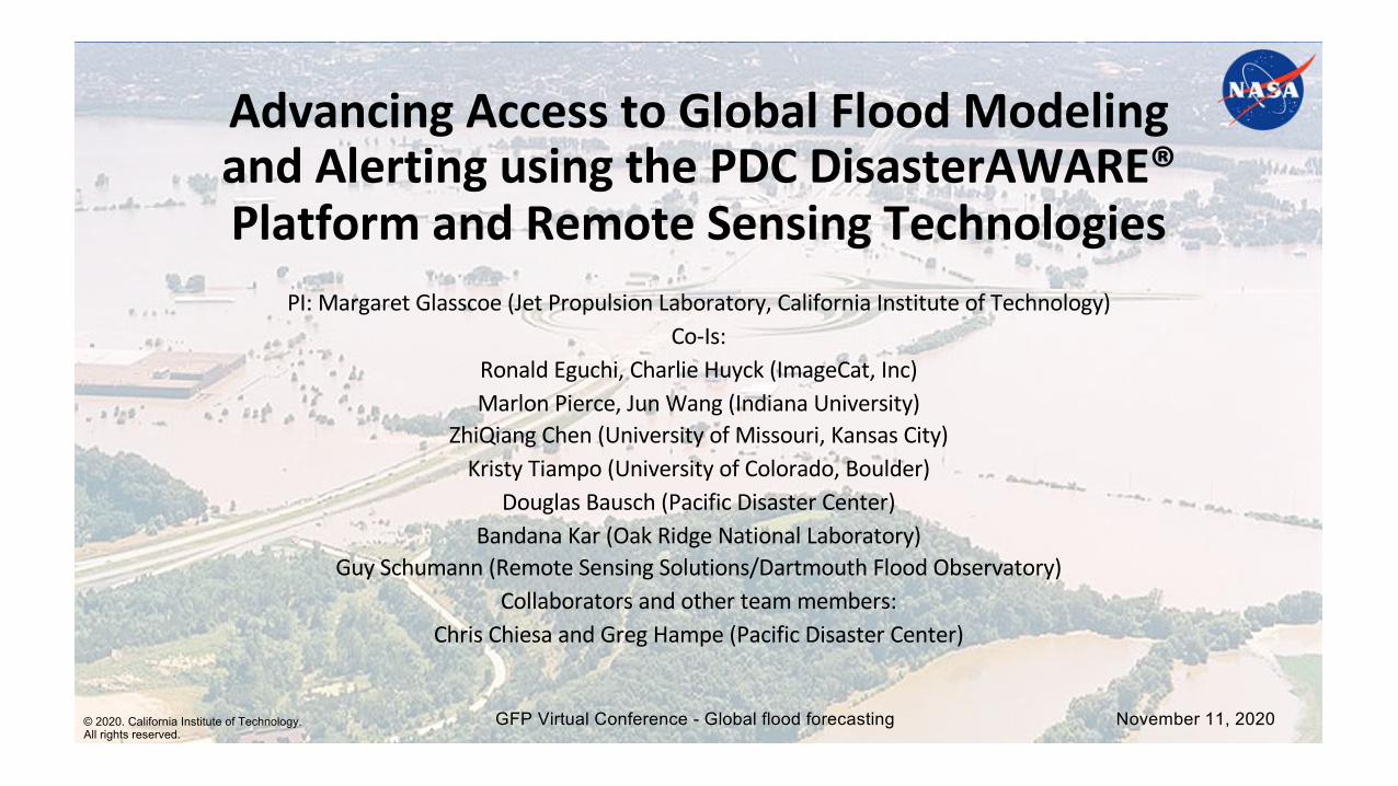
1Global Flood Statistics During 2000 – 2020. (1) Annual Flood Frequency; (2) Annual Flood Induced Financial Damage
Source: EM-DAT: The Emergency Events Database; Université Catholique de Louvain (UCL) – CRED, Online, http://www.emdat.be/.
(1) (2)
• Flooding is a frequent event responsible for significant societal and economic impactsworldwide.
• As of September 2020 there have already been 91 flooding events globally of varyingintensity.
• Since 2000, on average, 100 floods annually have occurred worldwide (Figure 1) thathave caused about $10 billion (USD) financial loss per annum (Figure 2).
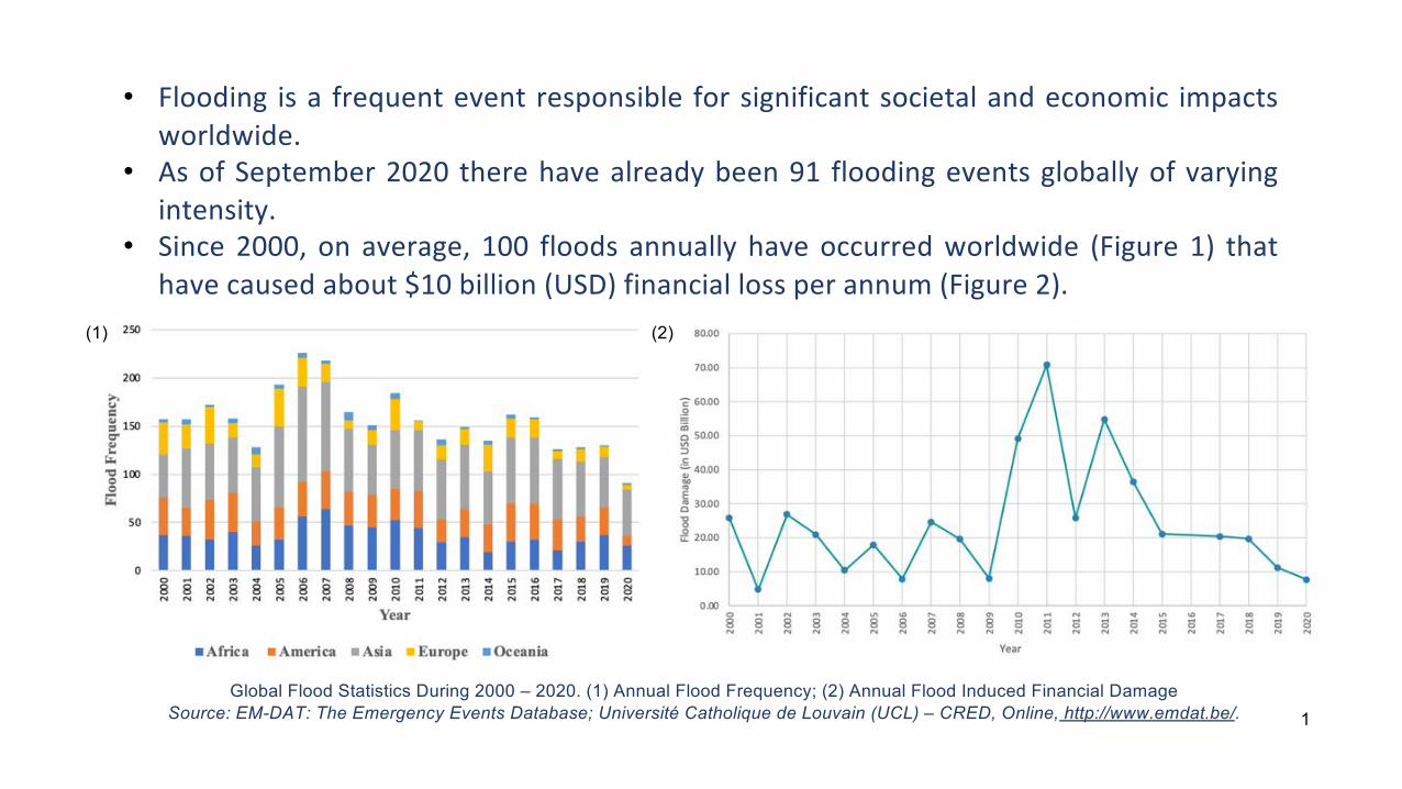
Project FocusUsing DisasterAWARE® - an open access, global flood alerting system – for effective dissemination of flood risks and potential impacts to aid with emergency response.
Central to the project is the incorporation of flood model outputs and remote sensing derived products from multiple platforms to help with flood risk mitigation and increase resilience of impacted communities.
Model of ModelsMoM to forecast flood severity at global scale by integrating flood outputs from two simulation models – GloFAS and GFMS in near real-time
Inundation OutputsDerived from Earth observation data sets in the MoM for validation and calibration
Machine learning based flood damage assessment
Pipeline to generate impact outputs for vulnerable locations
End-to-end pipelineIntegrates the above-mentioned components
01
02
03
04
Project Components
2
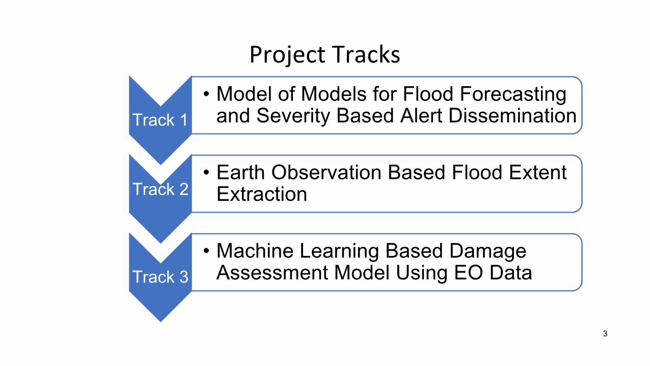
Project Tracks
Track 1• Model of Models for Flood Forecasting
and Severity Based Alert Dissemination
Track 2• Earth Observation Based Flood Extent
Extraction
Track 3• Machine Learning Based Damage
Assessment Model Using EO Data
3
1. Model of Models
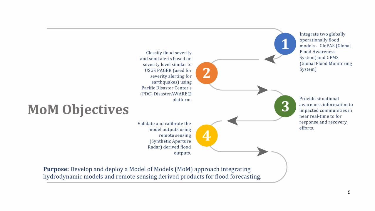
Integratetwogloballyoperationallyfloodmodels- GloFAS (GlobalFloodAwarenessSystem)andGFMS(GlobalFloodMonitoringSystem)
Providesituationalawarenessinformationtoimpactedcommunitiesinnearreal-timetoforresponseandrecoveryefforts.
Validateandcalibratethemodeloutputsusing
remotesensing(SyntheticApertureRadar)derivedflood
outputs.
ClassifyfloodseverityandsendalertsbasedonseveritylevelsimilartoUSGSPAGER(usedforseverityalertingforearthquakes)using
PacificDisasterCenter’s(PDC)DisasterAWARE®
platform.
MoMObjectives
Purpose: DevelopanddeployaModelofModels(MoM)approachintegratinghydrodynamicmodelsandremotesensingderivedproductsforfloodforecasting.
1
2
3
4
5
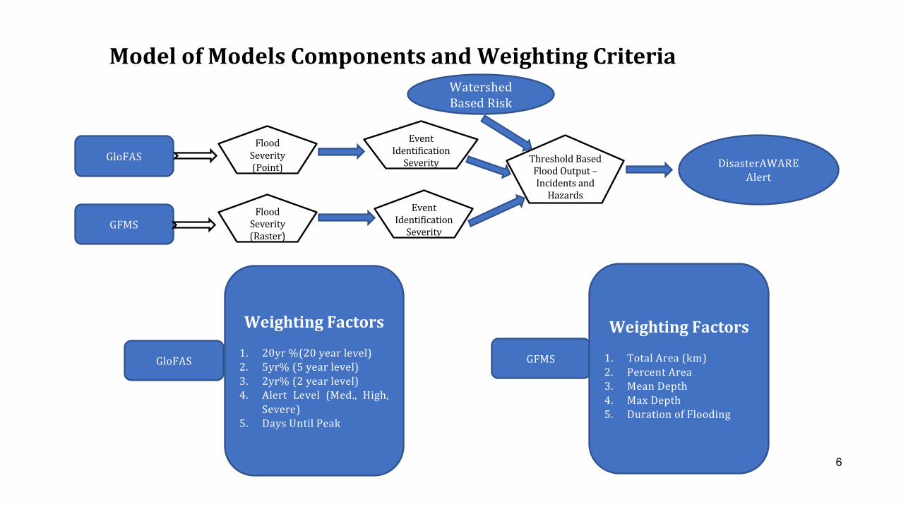
ModelofModelsComponentsandWeightingCriteria
GloFAS
GFMS
FloodSeverity(Point)
FloodSeverity(Raster)
EventIdentificationSeverity
WatershedBasedRisk
EventIdentificationSeverity ThresholdBased
FloodOutput–IncidentsandHazards
DisasterAWAREAlert
GloFAS
WeightingFactors
1. 20yr %(20 year level)2. 5yr% (5 year level)3. 2yr% (2 year level)4. Alert Level (Med., High,
Severe)5. Days Until Peak
GFMS
WeightingFactors
1. Total Area (km)2. Percent Area3. Mean Depth4. Max Depth5. Duration of Flooding
6
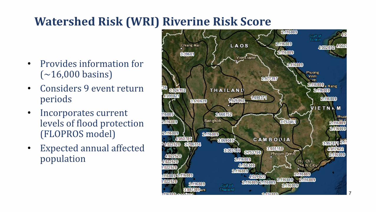
• Providesinformationfor(~16,000basins)
• Considers9eventreturnperiods
• Incorporatescurrentlevelsoffloodprotection(FLOPROSmodel)
• Expectedannualaffectedpopulation
WatershedRisk(WRI)RiverineRiskScore
7
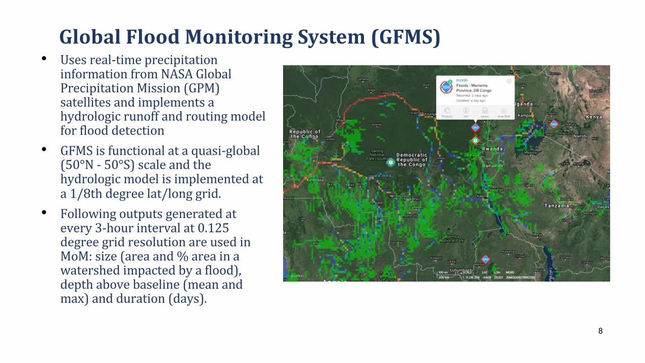
• Usesreal-timeprecipitationinformationfromNASAGlobalPrecipitationMission(GPM)satellitesandimplementsahydrologicrunoffandroutingmodelforflooddetection
• GFMSisfunctionalataquasi-global(50°N- 50°S)scaleandthehydrologicmodelisimplementedata1/8thdegreelat/longgrid.
• Followingoutputsgeneratedatevery3-hourintervalat0.125degreegridresolutionareusedinMoM:size(areaand%areainawatershedimpactedbyaflood),depthabovebaseline(meanandmax)andduration(days).
GlobalFloodMonitoringSystem(GFMS)
8
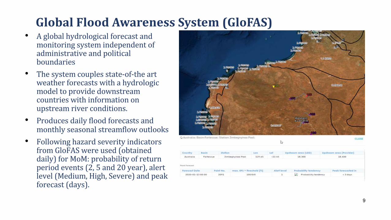
• Aglobalhydrologicalforecastandmonitoringsystemindependentofadministrativeandpoliticalboundaries
• Thesystemcouplesstate-of-theartweatherforecastswithahydrologicmodeltoprovidedownstreamcountrieswithinformationonupstreamriverconditions.
• Producesdailyfloodforecastsandmonthlyseasonalstreamflowoutlooks
• FollowinghazardseverityindicatorsfromGloFAS wereused(obtaineddaily)forMoM:probabilityofreturnperiodevents(2,5and20year),alertlevel(Medium,High,Severe)andpeakforecast(days).
GlobalFloodAwarenessSystem(GloFAS)
9
FLOODINGINEASTANDCENTRALAFRICASPRING2020
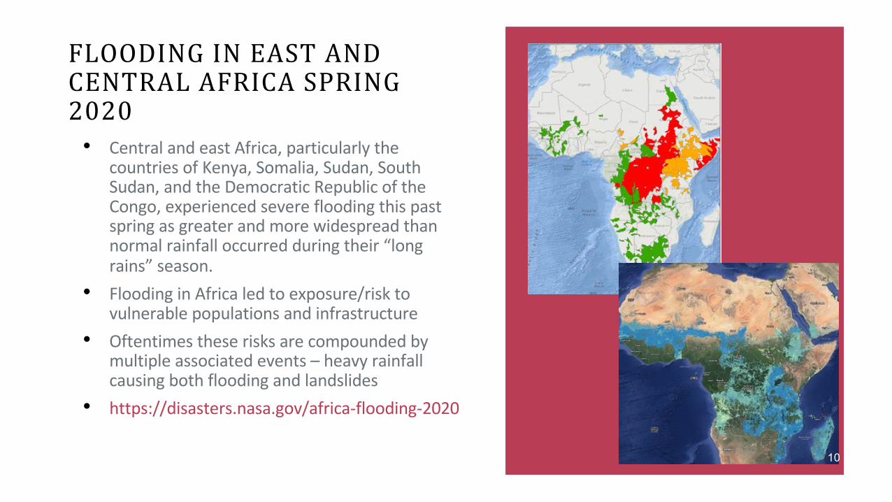
• Central and east Africa, particularly the countries of Kenya, Somalia, Sudan, South Sudan, and the Democratic Republic of the Congo, experienced severe flooding this past spring as greater and more widespread than normal rainfall occurred during their “long rains” season.
• Flooding in Africa led to exposure/risk to vulnerable populations and infrastructure
• Oftentimes these risks are compounded by multiple associated events – heavy rainfall causing both flooding and landslides
• https://disasters.nasa.gov/africa-flooding-2020
10
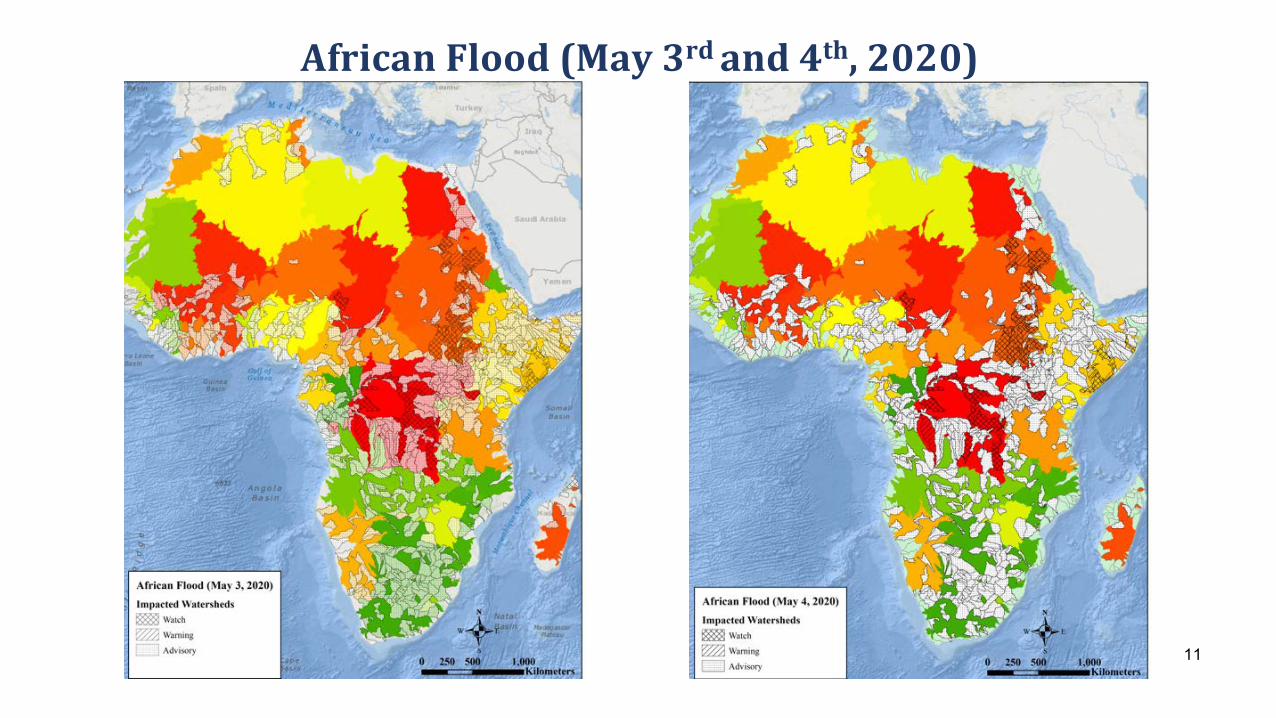
AfricanFlood(May3rdand4th,2020)
11
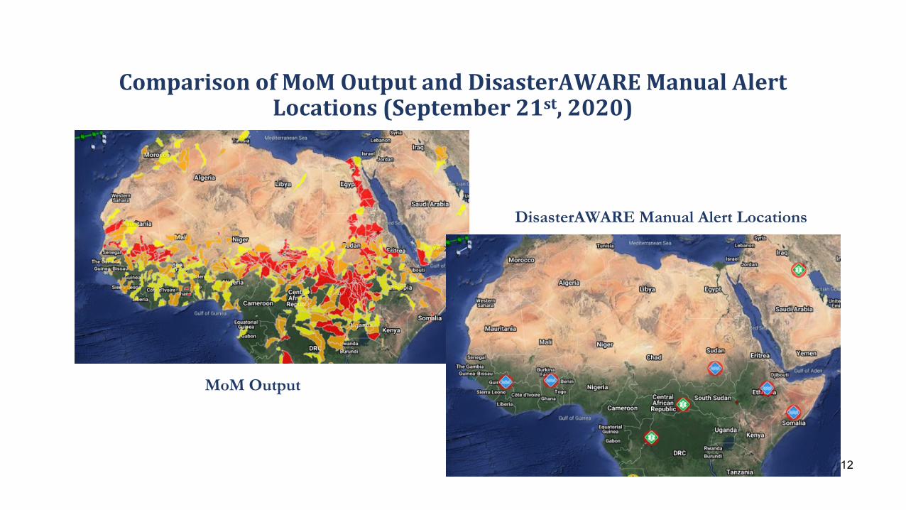
ComparisonofMoMOutputandDisasterAWAREManualAlertLocations(September21st,2020)
DisasterAWARE Manual Alert Locations
MoM Output
12
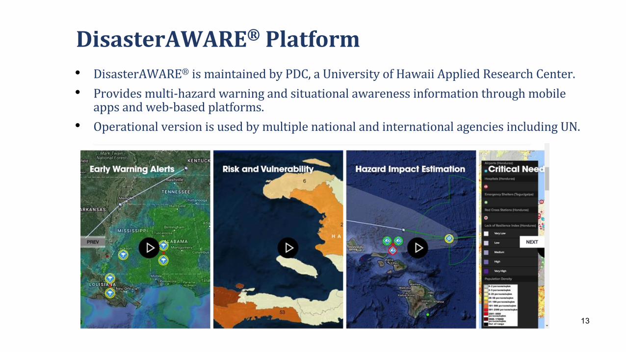
DisasterAWARE® Platform• DisasterAWARE® ismaintainedbyPDC,aUniversityofHawaiiAppliedResearchCenter.• Providesmulti-hazardwarningandsituationalawarenessinformationthroughmobile
appsandweb-basedplatforms.• OperationalversionisusedbymultiplenationalandinternationalagenciesincludingUN.
13
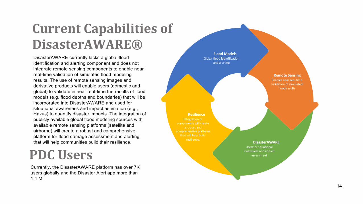
CurrentCapabilitiesofDisasterAWARE®DisasterAWARE currently lacks a global flood identification and alerting component and does not integrate remote sensing components to enable near real-time validation of simulated flood modeling results. The use of remote sensing images and derivative products will enable users (domestic and global) to validate in near real-time the results of flood models (e.g. flood depths and boundaries) that will be incorporated into DisasterAWARE and used for situational awareness and impact estimation (e.g., Hazus) to quantify disaster impacts. The integration of publicly available global flood modeling sources with available remote sensing platforms (satellite and airborne) will create a robust and comprehensive platform for flood damage assessment and alerting that will help communities build their resilience.
Flood ModelsGlobal flood identification
and alerting
Remote SensingEnables near real time validation of simulated
flood results
DisasterAWAREUsed for situational
awareness and impact assessment
ResilienceIntegration of
components will create a robust and
comprehensive platform that will help build
resilience.
PDCUsersCurrently, the DisasterAWARE platform has over 7K users globally and the Disaster Alert app more than 1.4 M.
14