Embed Size (px)
Citation preview
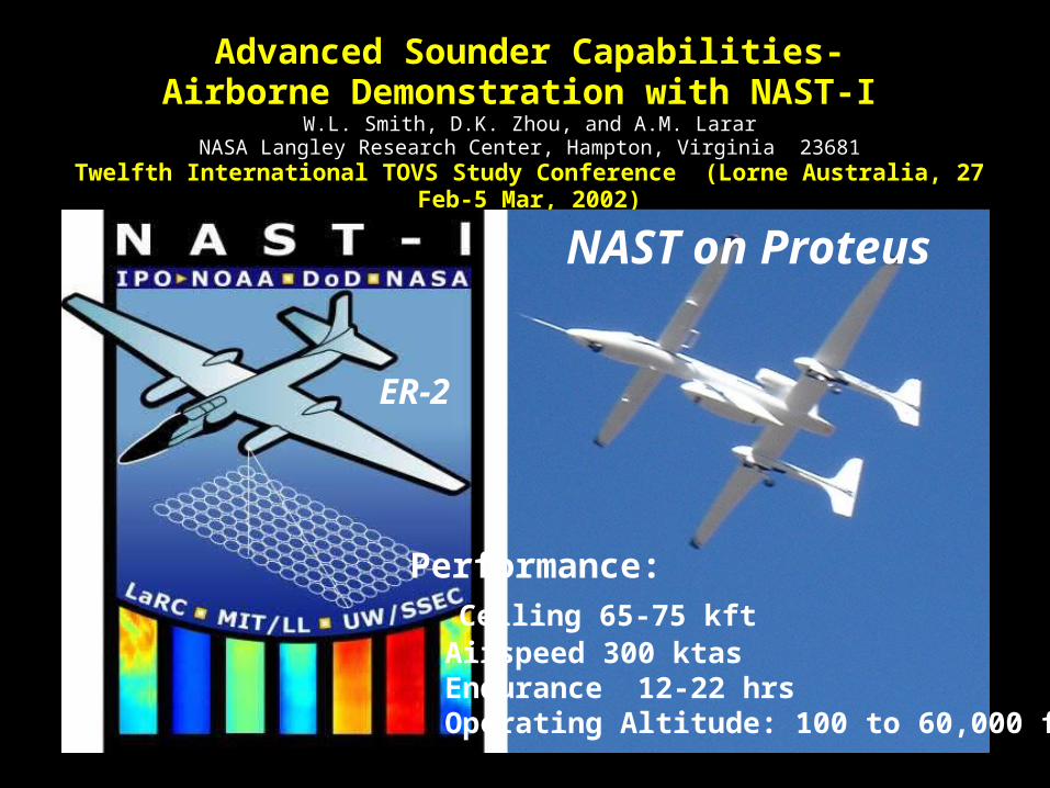
Advanced Sounder Capabilities-Airborne Demonstration with NAST-I
W.L. Smith, D.K. Zhou, and A.M. LararNASA Langley Research Center, Hampton, Virginia 23681
Twelfth International TOVS Study Conference (Lorne Australia, 27 Feb-5 Mar, 2002)
NAST on Proteus
Performance: Ceiling 65-75 kft Airspeed 300 ktas Endurance 12-22 hrs Operating Altitude: 100 to 60,000 ft
ER-2

NPOESS Airborne Sounder Testbed (NAST)NPOESS Airborne Sounder Testbed (NAST)
IR interferometer ( NAST-I )Spectral Range:3.5 – 16microns
Spectral Resolution:>2000 (0.25cm-1)
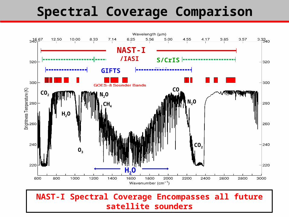
NAST-I Spectral Coverage Encompasses all future satellite sounders
CrIS
CO2
O3
H2ON2OCO2
CON2OCH4
H2O
GIFTS-SW
GIFTS-LW
H2OCO2
O3
N2O
CH4
CO
N2O
CO2
H2O
H2O
AIRS/CrIS
GIFTS
NAST-I /IASI
Spectral Coverage ComparisonSpectral Coverage Comparison
p
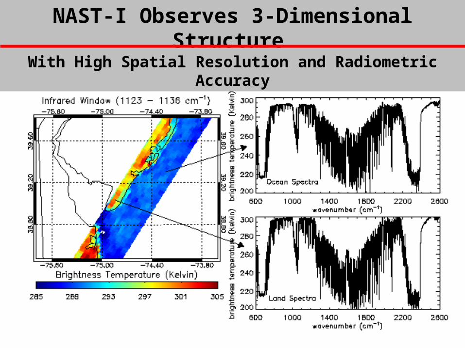
NAST-I Observes 3-Dimensional StructureNAST-I Observes 3-Dimensional Structure With High Spatial Resolution and Radiometric AccuracyWith High Spatial Resolution and Radiometric Accuracy
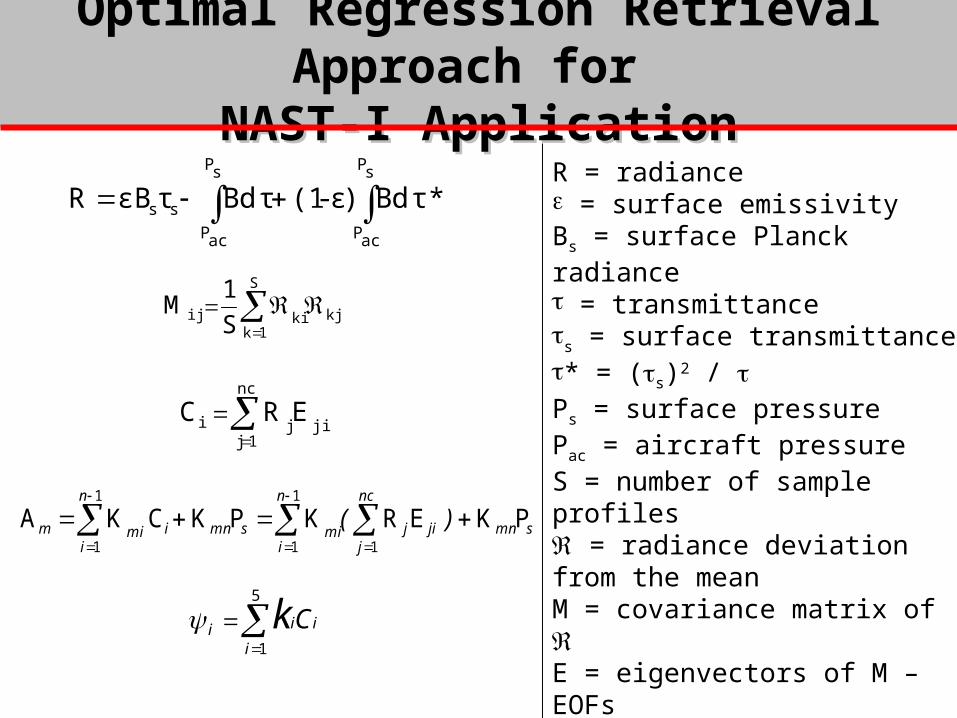
Optimal Regression Retrieval Approach for Optimal Regression Retrieval Approach for NAST-I ApplicationNAST-I Application
nc
1jjiji ERC
PKERKPKCKA1
1
1
1
1smn
nc
jjij
n
imismni
n
imim )(
kj
S
1kkiij S
1M
τ*dB)ε-(1τdBτεBRsP
acP
sP
acP
ss R = radiance = surface emissivityBs = surface Planck radiance = transmittance
s = surface transmittance* = (s)2 / Ps = surface pressurePac = aircraft pressureS = number of sample profiles = radiance deviation from the mean M = covariance matrix of E = eigenvectors of M – EOFsC = radiance EOF amplitudesA = {Ts, , T, q, ...} parametersK and k = regression coefficients = emissivity EOF amplitudes
5
1
i
iii Ck
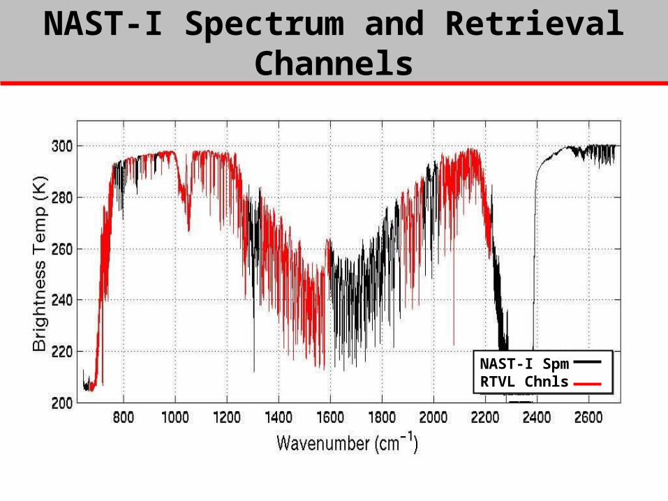
NAST-I Spectrum and Retrieval ChannelsNAST-I Spectrum and Retrieval Channels
NAST-I SpmRTVL Chnls

Retrieval Accuracy Vs EOF NumberRetrieval Accuracy Vs EOF Number
Full Noise
1/2 Noise
2610
58
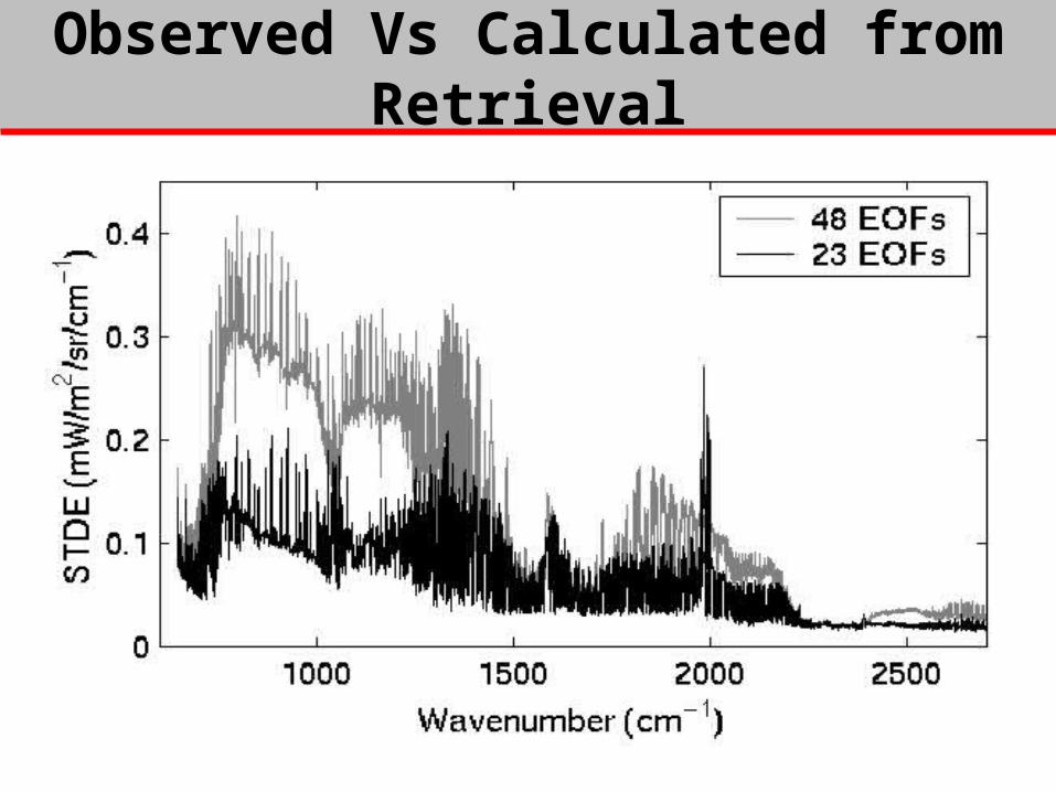
Observed Vs Calculated from RetrievalObserved Vs Calculated from Retrieval
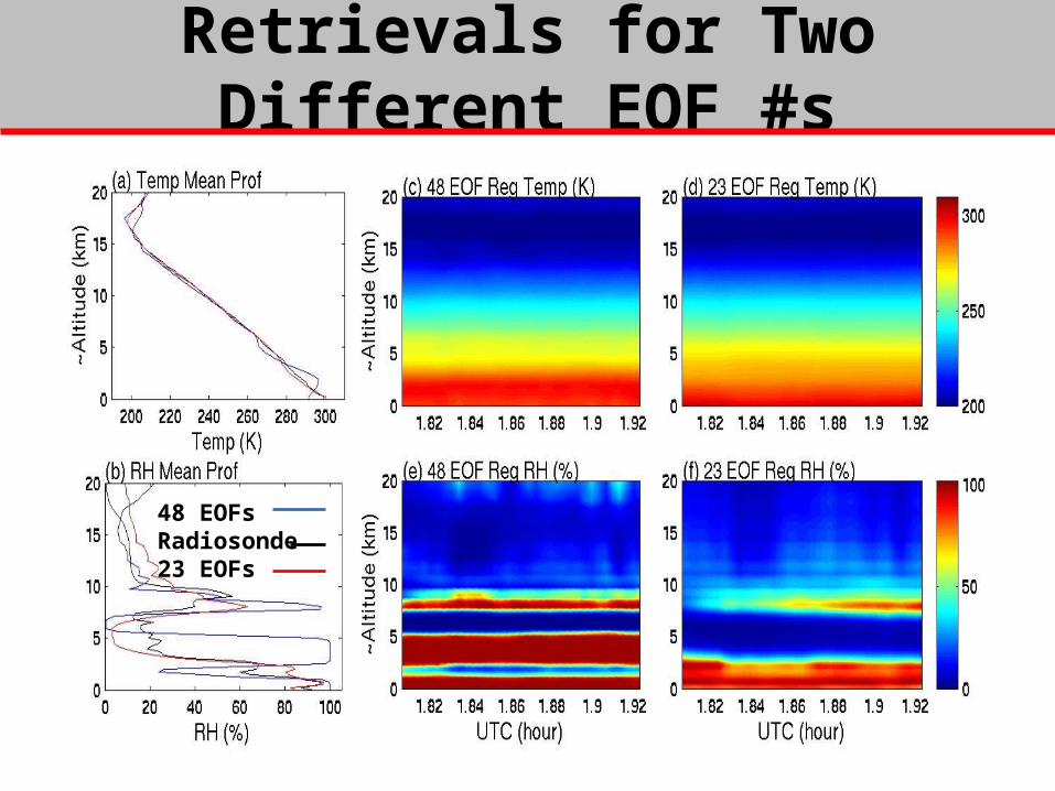
Retrievals for Two Different EOF #sRetrievals for Two Different EOF #s
48 EOFsRadiosonde23 EOFs
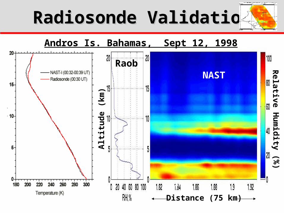
Radiosonde ValidationRadiosonde Validation
Alt
itu
de
(km
)
Relative H
um
idity (%
)
Distance (75 km)
3km
Andros Is. Bahamas, Sept 12, 1998
NASTRaob
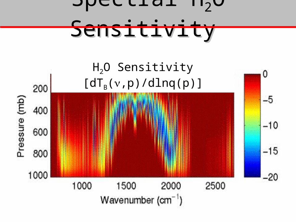
Spectral HSpectral H22O SensitivityO Sensitivity
H2O Sensitivity [dTB(,p)/dlnq(p)]

Water Vapor Retrieval Water Vapor Retrieval SensitivitySensitivity
75 km
LW-side of H2O Band
SW-side of H2O Band

ARM CART-Site Sounding Validation
CD
A
BSpace & Time
Variability
Spatial (~22km) & Temporal (~2-3hr) Temperature Variation Over Purcell
Sfc Temp (21Z)
Sfc Temp (19Z)
P
P
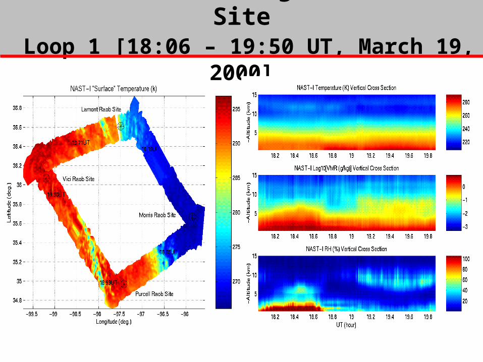
PROTEUS NAST-I Flight Over CART Site Loop 1 [18:06 – 19:50 UT, March 19, 2000]
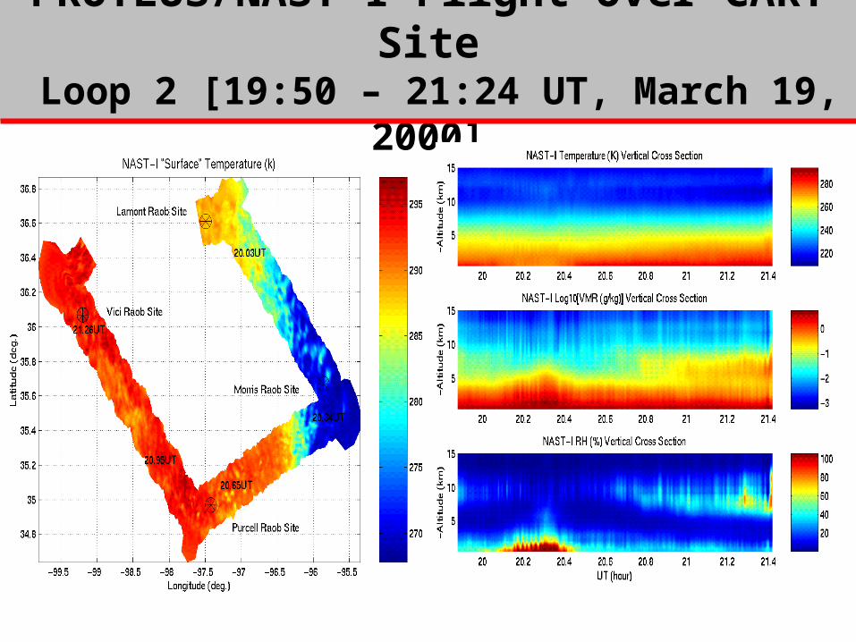
PROTEUS/NAST-I Flight Over CART Site Loop 2 [19:50 – 21:24 UT, March 19, 2000]
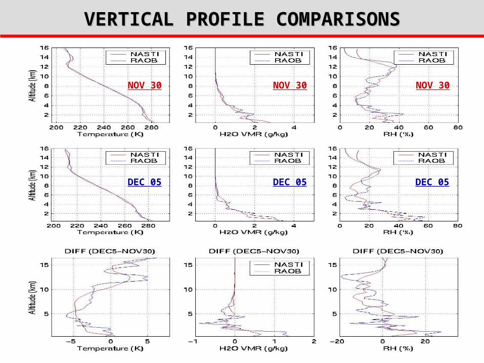
VERTICAL PROFILE COMPARISONSVERTICAL PROFILE COMPARISONS
NOV 30 NOV 30NOV 30
DEC 05DEC 05 DEC 05

COMPARISON WITH GSFC-SRL (DEC. 5, 2000)COMPARISON WITH GSFC-SRL (DEC. 5, 2000)
NAST-I cross section is produced by profiles from 7 high altitude passes over Lamont OK.
GSFC-SRL Ground-based Scanning Raman LIDARproduced from 10 min averages at Lamont OK
Time Average
Loss of Sensitivity
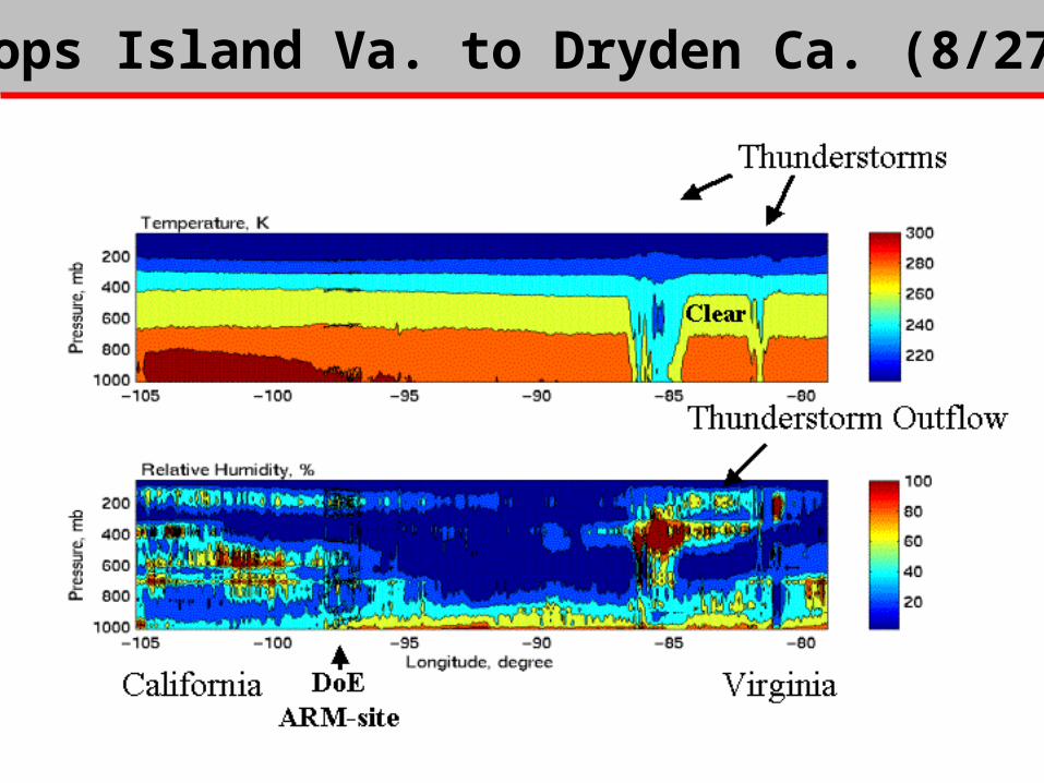
Wallops Island Va. to Dryden Ca. (8/27/99)
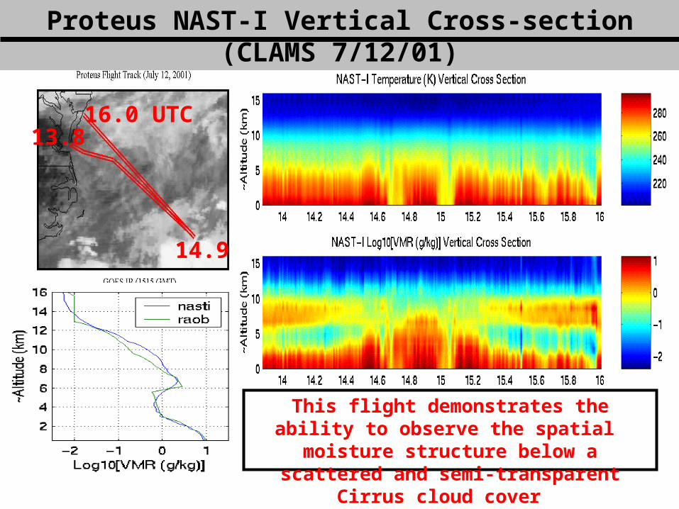
Proteus NAST-I Vertical Cross-section (CLAMS 7/12/01)Proteus NAST-I Vertical Cross-section (CLAMS 7/12/01)
This flight demonstrates the ability to observe the spatial moisture structure below a scattered
and semi-transparent Cirrus cloud cover
14.9
13.816.0 UTC

Effective Surface Temperature (July 26, 2001)Effective Surface Temperature (July 26, 2001)GOES image
High dense convective clouds over North Carolina and low cumulus clouds over the Delmarva peninsula
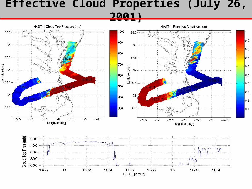
Effective Cloud Properties (July 26, 2001)Effective Cloud Properties (July 26, 2001)

Vertical Cross-section (July 26, 2001)Vertical Cross-section (July 26, 2001)
CLOUDS
CLOUDSCLOUDS
Clouds
Clouds
Clouds
IR Window Image Along Track
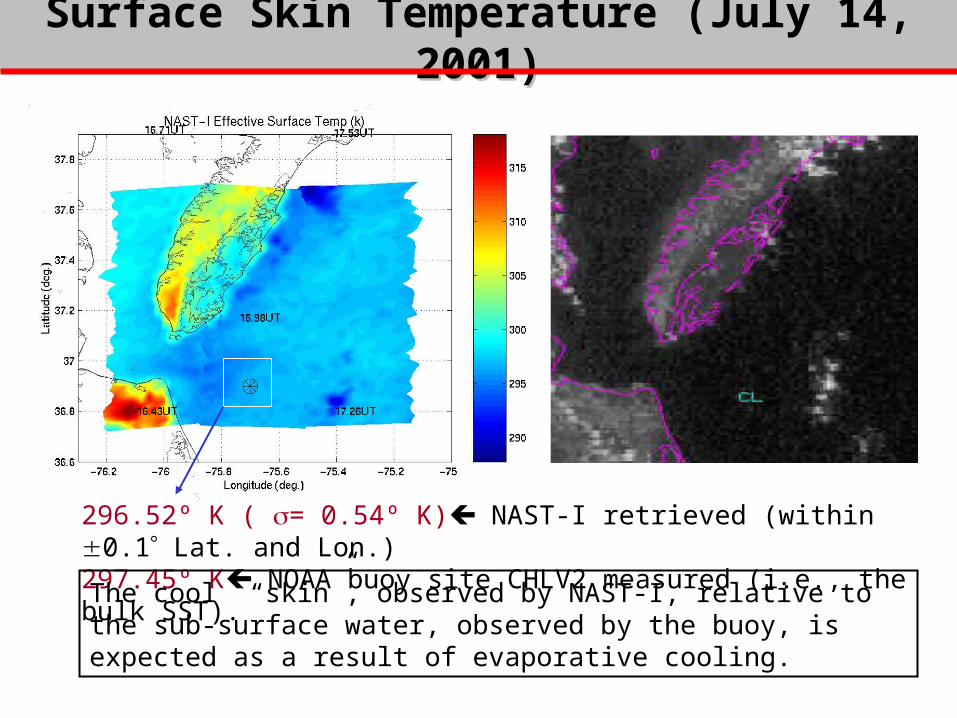
Surface Skin Temperature (July 14, 2001)Surface Skin Temperature (July 14, 2001)
296.52º K ( = 0.54º K) NAST-I retrieved (within 0.1 Lat. and Lon.)297.45º K NOAA buoy site CHLV2 measured (i.e., the bulk SST). The cool “skin”, observed by NAST-I, relative to the sub-surface water, observed by the buoy, is expected as a result of evaporative cooling.
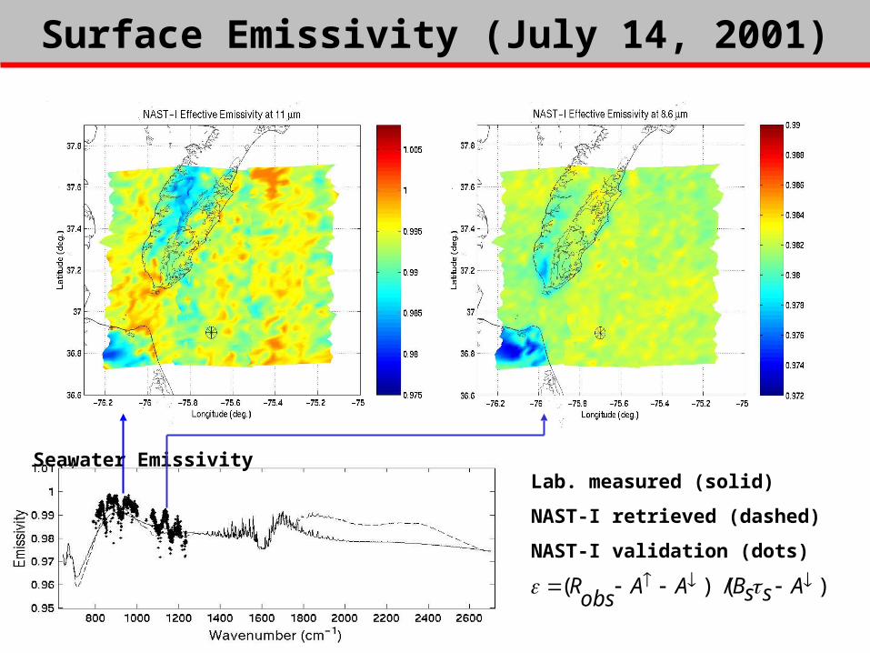
Surface Emissivity (July 14, 2001)Surface Emissivity (July 14, 2001)
Seawater EmissivityLab. measured (solid)
NAST-I retrieved (dashed)
NAST-I validation (dots)
)( / )( AssBAAobsR

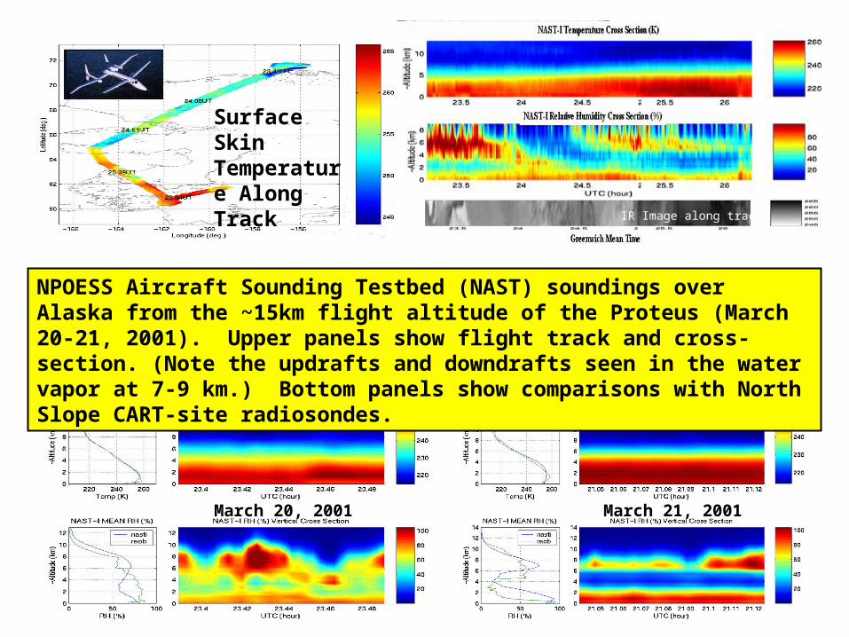
March 20, 2001 March 21, 2001
NPOESS Aircraft Sounding Testbed (NAST) soundings over Alaska from the ~15km flight altitude of the Proteus (March 20-21, 2001). Upper panels show flight track and cross-section. (Note the updrafts and downdrafts seen in the water vapor at 7-9 km.) Bottom panels show comparisons with North Slope CART-site radiosondes.
IR Image along track
Surface Skin Temperature Along Track
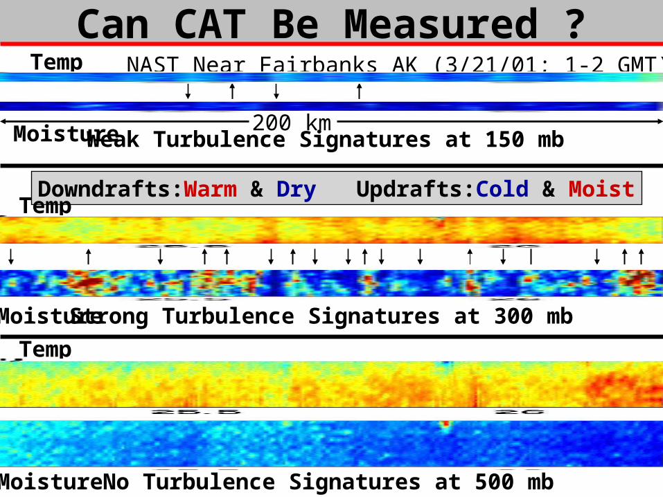
Can CAT Be Measured ?
Strong Turbulence Signatures at 300 mb
Weak Turbulence Signatures at 150 mb
No Turbulence Signatures at 500 mb
Downdrafts:Warm & Dry Updrafts:Cold & Moist
Temp
Temp
Temp
Moisture
Moisture
Moisture
NAST Near Fairbanks AK (3/21/01; 1-2 GMT)
Moisture
200 km
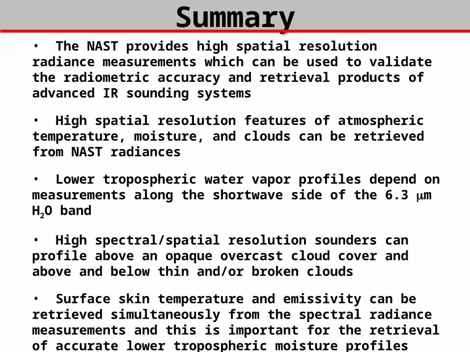
SummarySummary• The NAST provides high spatial resolution radiance measurements which can be used to validate the radiometric accuracy and retrieval products of advanced IR sounding systems
• High spatial resolution features of atmospheric temperature, moisture, and clouds can be retrieved from NAST radiances
• Lower tropospheric water vapor profiles depend on measurements along the shortwave side of the 6.3 m H2O band
• High spectral/spatial resolution sounders can profile above an opaque overcast cloud cover and above and below thin and/or broken clouds
• Surface skin temperature and emissivity can be retrieved simultaneously from the spectral radiance measurements and this is important for the retrieval of accurate lower tropospheric moisture profiles
• Atmospheric turbulence might be observed with very high spatial resolution advanced sounders