Embed Size (px)
DESCRIPTION
Advanced Concepts Workshop on Remote Sensing of Precipitation at Multiple Scales
Citation preview
Advanced Concepts Workshop on Remote
Sensing of Precipitation at Multiple Scales
March 15-17, 2010
Soroosh Sorooshian & Amir AghaKouchak
Center for Hydrometeorology & Remote Sensing (CHRS)
Department of Civil & Environmental Engineering
Henry Samueli School of Engineering
University of California Irvine
Advanced Concepts Workshop on Remote Sensing of Precipitation at Multiple Scales University of California Irvine, Beckman Center, Irvine, CA
March 15-17, 2010
Table of Contents
ACKNOWLEDGEMENT ................................................................................................................................... 3
EXECUTIVE SUMMARY .................................................................................................................................. 4
INTRODUCTION ............................................................................................................................................. 7
WORKSHOP OBJECTIVES ............................................................................................................................... 8
RECOMMENDATIONS ................................................................................................................................. 10
Precipitation Measurement & Algorithms .............................................................................................. 10
Modeling and Uncertainty ...................................................................................................................... 14
Applications............................................................................................................................................. 18
Bibliography ................................................................................................................................................ 22
APPENDIX I - PARTICIPANTS ...................................................................................................................... 23
APPENDIX II - TECHNICAL PROGRAM ........................................................................................................ 25
APPENDIX III - GROUP SESSIONS ............................................................................................................... 29
APPENDIX IV - RESEARCH QUESTIONS ...................................................................................................... 30
APPENDIX V - WORKSHOP VENUE ............................................................................................................ 32
Advanced Concepts Workshop on Remote Sensing of Precipitation at Multiple Scales University of California Irvine, Beckman Center, Irvine, CA
March 15-17, 2010
ACKNOWLEDGEMENT
We are pleased to acknowledge that a major portion of the funding for this workshop was
provided by the U.S. Army Research Office. Our deepest gratitude goes to Dr. Russell
Harmon for his unyielding support throughout the planning and organization of the
workshop. We wish thank Prof. Susan Bryant, Vice Chancellor for Research and Prof. Rafael
Bras, Dean of the Henry Samueli School of Engineering, University of California Irvine for
their support. Appreciation is expressed to the keynote speakers Dr. William Martin
Walter, Director of the Coastal and Hydraulics Laboratory, U.S. Army Engineering Research
and Development Center and Dr. John Eylander, Director of the Tech & Science Planning,
AFWA 2nd Weather Group, who addressed current capabilities as well as observational
and forecasting requirements. We are also grateful to Drs. Efi Foufoula-Georgiou, Philip
Arkin, John Eylander, Jan Hendrickx, Brian Skahill, Gail Skofronick Jackson and Robert
Kuligowski who chaired the three workgroups of this workshop. Furthermore, we offer
special thanks to Dr. Bisher Imam and Diane Hohnbaum for preparation of the workshop
proposal, organizing and coordinating the workshop activities. We appreciate Dr. Kuolin
Hsu’s thoughtful comments upon an early draft of this report. We thank Prof. G.P. Li,
Director of California Institute for Telecommunication and Information Technology (Calit2)
and Drs. Stephen Jenks and Sung-Jin Kim of Calit2 for providing the use of their HIPerWall
facility for demonstration of CHRS satellite precipitation capabilities. We are grateful to
Drs. Xiaogang Gao, Jialun Li and Wei Chu who provided a great deal of help during the
workshop. Finally, we are very thankful to CHRS graduate students Jingjing Li, Rebeka
Sultana, Qing Xia, Ali Zahraei, Tsou Chun Jaw, Nasrin Nasrollahi and Hamed Ashouri who
offered so generously of their time summarizing group discussions throughout the
workshop.
Advanced Concepts Workshop on Remote Sensing of Precipitation at Multiple Scales University of California Irvine, Beckman Center, Irvine, CA
March 15-17, 2010
EXECUTIVE SUMMARY
This report summarizes the presentations and discussions of the workshop; Advanced
Concepts on Remote Sensing of Precipitation at Multiple Scales, held at the University of
California Irvine, March 15-17, 2010. The main objective was to develop a list of research
recommendations in the field of remote sensing of precipitation. Research challenges and
advanced concepts in satellite-retrieved precipitation estimation were explored in three
main themes: (I) Precipitation Measurements & Algorithms; (II) Modeling & Uncertainties;
and (III) Applications. Following a number of related plenary presentations, three study
groups were formed to discuss a list of pre-determined questions related to each of the
three main themes.
Research strategies and recommendations for future investigation emerged from the three
study groups for each of the three main themes. A brief summary of recommendations is
provided here:
(a) Uncertainty of merged products and multi-sensor observations merits a great deal
of research. Identification of uncertainties and their propagation into combined
products is vital for future developments;
(b) Future improvements in satellite-based precipitation retrieval algorithms rely on
more in-depth research on error properties in different climate regions, storm
regimes, seasons and altitudes. Given such information, precipitation algorithms,
both retrieval and downscaling, can be optimized for different climate conditions;
(c) Due to the importance of high resolution and reliable precipitation data for current
and future research and applications, there exists the need to investigate more
multi-spectral and multi-satellite precipitation retrieval techniques. This will
enhance the ability to obtain the best possible approximation of precipitation with
the highest resolution possible;
(d) Based on the currently available data, global multi-channel precipitation estimates
with the spatial and temporal resolutions of 4 km and 30 min can be considered as
the target dataset that can be achieved in the near future. Extensive development
and validation efforts are required to make such a dataset available to the
community for research and applications;
(e) Development of metrics for validation and uncertainty analysis are of great
importance. Various metrics with emphasize on different aspects of performance
are required so that users can decide which product fits their purposes/applications
best;
Advanced Concepts Workshop on Remote Sensing of Precipitation at Multiple Scales University of California Irvine, Beckman Center, Irvine, CA
March 15-17, 2010
(f) Developing diagnostic statistics (shifting, rotation) will help to capture the
systematic deficiency inherent in precipitation retrieval algorithms;
(g) Bias removal, particularly PDF-based adjustment, deserves more in-depth research.
Ignoring the distribution information in bias adjustment procedure could result in
loss of information, especially regarding the tails of the distribution;
(h) Currently, there is no operational precipitation assimilation model available. This is
mainly due to the difficulties caused by the inherent deficiencies in model definition
and structure and also lack of research on reliable data assimilation techniques.
More research needs to be devoted to developing data assimilation techniques in
order to integrate assimilation as a part of modeling and algorithm development
approach.
It was the general consensus that further research efforts should concentrate on the
following issues to enhance application of satellite data in engineering and decision
making: (a) Moving toward higher resolution through downscaling of satellite based
precipitation products in combination with data assimilation techniques; (b) Improving the
latency/timeliness of receiving satellite precipitation products. Given the fact that this
latency is one of the primary obstacles in now-casting, future efforts should be focused to
reduce this time lag to less than thirty (30) minutes; (c) Systematic satellite data processing
with users option for various data formats (e.g., ascii, binary, or ArcGIS) is vital for faster
integration of satellite data in practical applications; (d) Transferability of the validation
studies and test cases should be considered for future research; (e) Review publications on
success/failure of application of satellite based precipitation products can help researchers
and program managers to identify the weaker links in the process and where addition
research efforts should be directed; (f) The concept of ensemble streamflow modeling
seems to be the future direction particularly when uncertainty in streamflow output is of
interest.
The workshop participants agreed that future research efforts in the above mentioned
areas will advance remote sensing of precipitation and will deliver more accurate
precipitation estimates with quantified uncertainties. Reliable remotely sensed
precipitation estimates provide a unique opportunity to model the earth system more
accurately.
Advanced Concepts Workshop on Remote Sensing of Precipitation at Multiple Scales University of California Irvine, Beckman Center, Irvine, CA
March 15-17, 2010
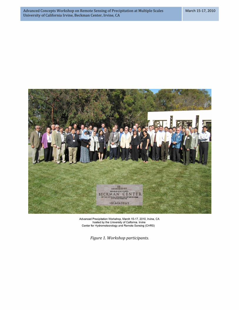
Figure 1. Workshop participants.
Advanced Concepts Workshop on Remote Sensing of Precipitation at Multiple Scales University of California Irvine, Beckman Center, Irvine, CA
March 15-17, 2010
INTRODUCTION
Precipitation is the primary driver of the hydrologic cycle and the main input of
hydrometeorological models and climate studies. Accuracy of hydrometeorological
predictions significantly relies on the quality of observed precipitation intensity, pattern,
duration and aerial extent. In addition to civilian applications, reliable and timely
measurements of precipitation are important to modern military operations at battlefield,
air and sea, and strategic command levels. Severe rainfall events can constrain or
significantly impede the movement of troops and tactical vehicles on the battlefield. It can
also affect river crossing operations, and impact humanitarian mission activities in a
theater of operation.
Rain gauge data have been the main source of precipitation measurements for
hydrometeorological applications. However, they suffer from poor spatial coverage and
lack of areal representation over land, and are unavailability over the oceans. Further, the
quality, density and coverage of gauge networks vary significantly across the globe
(Huffman, 1997). In addition to rain gauge stations, weather radar systems provide high
resolution precipitation data in space and time. However, their spatial extent is inadequate
to detect global precipitation and to evaluate weather and climate models at global and
continental scales (Tang, et al., 2009). In fact, in most parts of the world, radar installations
for precipitation measurements are not available. With the available radar systems,
regional scale studies can be performed only across the United States, Western Europe, and
few other locations across the globe. Even in the United States, many mountainous regions
(e.g., Western United States) suffer from poor radar coverage due to significant blockage
(Maddox, et al., 2002). A further consideration from a military application point of view is
that the utility of radar due to its detect ability in the theater of operation is prohibitive.
The limitations of rain gauges and weather radar systems highlight the importance of
satellite-based global precipitation data in military applications and for weather and
climate studies. The first satellite-derived precipitation estimation dates back to the
seventies (Kidd, 2001). Since then, various satellite series have provided valuable weather
information to the hydrometeorological community. So far, a number of satellite
precipitation retrieval algorithms have been developed for practical applications (e.g.,
TRMM 3B43; (Huffman, et al., 2007); CMORPH, (Joyce, et al., 2004); PERSIANN, (Hong, et
al., 2004) and (Sorooshian, et al., 2000)). In spite of significant developments in measuring
and characterizing precipitation using remote sensing observations over the past four
decades, satellite observation of precipitation remains inadequate at spatial and temporal
Advanced Concepts Workshop on Remote Sensing of Precipitation at Multiple Scales University of California Irvine, Beckman Center, Irvine, CA
March 15-17, 2010
scales relevant for hydrologic and climate studies. There are a number of issues that
require the development of advanced concepts to address key challenges in satellite-based
observation of precipitation. Among these challenges are:
(1) Development of hybrid solutions to combine the benefits of satellites and ground
observations (e.g., ground radars and gauge networks) in order to improve the benefit of
both;
(2) Development of advanced multi-spectral algorithms to improve the accuracy and
spatial resolution of satellite precipitation estimates (providing high resolution data
relevant to various applications);
(3) Improving computational efficiency and accuracy of precipitation now-casting
algorithms including those dependent on cloud tracking;
(4) Improving the accuracy of downscaling algorithms, especially over complex terrain, for
hydrologic applications;
(5) Near real-time bias adjustment and integration of heterogeneous airborne and ground
based precipitation estimates;
(6) Enhancing the ability of detecting liquid and solid precipitation from satellite
observations;
(7) Understanding and communicating uncertainties of precipitation estimates and
forecasts.
Addressing these challenges requires collaboration between the satellite precipitation
research community, instrument development teams, military weather forecasting experts,
decision makers, and the engineering community. The objective of the workshop was to
refine the research agenda for rainfall measurement, uncertainty, and modeling with
specific emphasis on both civilian and military applications.
WORKSHOP OBJECTIVES
The primary objective of this advanced concept workshop was to take a new view of
satellite-based precipitation estimation and develop a list of research recommendations. To
achieve this, members of the civilian precipitation research community and military
weather forecasting experts were invited. The participants explored advanced concepts
and challenges of satellite estimation of precipitation in manners that significantly improve
Advanced Concepts Workshop on Remote Sensing of Precipitation at Multiple Scales University of California Irvine, Beckman Center, Irvine, CA
March 15-17, 2010
situational awareness and enhance the accuracy, resolution, and communication of
information for a variety of civilian and military applications. The workshop gathered
experts from different disciplines including:
(1) Academics involved in satellite precipitation estimations from a wide range of
disciplines including remote sensing, weather forecasting, cloud physics, hydrology,
electrical engineering, sensor development (X-band, S-band, IR, and Microwave) and
mathematics;
(2) Scientists from space and weather agencies;
(3) Military personnel involved in air force weather monitoring and forecasting;
(4) Military R&D laboratory scientists engaged in weather and hydrologic forecasting and
decision-making research;
(5) Information and telecommunication specialists.
The workshop was sponsored by the U.S. Army Research Office and coordinated and
organized by the Center for Hydrometeorology and Remote Sensing (CHRS) at the
University of California, Irvine. Following a number of plenary presentations related to the
three main themes of the workshop, namely; (1) Precipitation Measurements &
Algorithms; (2) Modeling & Uncertainties; and (3) Applications, the workshop attendees
were divided into three study groups. Each study group met at three separate times, each
time addressing a list of pre-determined questions related to each of the three main themes
mentioned above. The list of participants in each group is provided in Appendix III. The
participants discussed the research questions provided in Appendix IV. Research strategies
and recommendations for future investigations emerged from the three study groups for
each of the three main themes. The recommendations for each of the themes (from the
three groups) were combined and streamlined with the help of CHRS graduate students. In
the following section, a summary of recommendations which emerged regarding the three
themes is presented.
Advanced Concepts Workshop on Remote Sensing of Precipitation at Multiple Scales University of California Irvine, Beckman Center, Irvine, CA
March 15-17, 2010
RECOMMENDATIONS
Precipitation Measurement & Algorithms
One topic that merits a great deal of research in merging data from different sources is the
uncertainty of each sensor and the propagation of those uncertainties into the combined
product. Several merged products are now available; however, uncertainties of these
products still need more detailed investigation. Uncertainties associated with information
from each sensor are often neglected. Future research in this area is highly desirable
through application of data assimilation techniques (e.g., Ensemble Kalman Filtering,
multivariate statistical simulation methods). In order to approach uncertainty of merged
products, satellite error estimates need to be investigated in detail. Characterization of
single sensor error and multi-sensor error sources require particular attention (e.g.,
analysis of covariance and joint PDF of errors from different sources).
More in-depth research on error properties in different climate regions, storm regimes and
seasons are necessary to evaluate the quality and reliability of satellite precipitation
estimates in different regions and climate conditions. This information may also improve
the development of precipitation algorithms. It may be necessary to design algorithms that
adaptively self-correct based upon climate conditions or regions, using the almost real-time
information provided by the Precipitation Radar (PR). Estimation of error characteristics
should be initiated from understanding sources of errors that are partly known. Research
on this subject may lead to a better understanding of precipitation uncertainty at various
climate regions.
A framework for combining data sources for different applications should be defined.
When considering merging products, the spatial and temporal resolution required for a
given application plays an important role in designing the appropriate technique and the
specific data sources required.
For future algorithm developments, methods based on GEO-IR cloud forward advection
and backward smoothing of passive microwave rainfall estimation should receive more
attention (e.g., Global Satellite Mapping of Precipitation (GSMaP) and CMORPH). The
strategy to track and advance precipitation is expected to perform well since it closely
tracks and simulates how cloud systems move in nature. Obviously, better tracking of
clouds and other precipitating elements would enhance the capability of algorithms in
estimating precipitation.
Advanced Concepts Workshop on Remote Sensing of Precipitation at Multiple Scales University of California Irvine, Beckman Center, Irvine, CA
March 15-17, 2010
Regarding extreme precipitation analysis, the first step is to define what is considered as
extreme. The definition of extremes in climatological studies may be different than
extremes in short-term forecasts. In other words, extreme precipitation analysis should be
viewed in appropriate scale (e.g., event scale or climatology viewpoint). Many IR-based
algorithms underestimate high rain rates, both retrieval and downscaling, and
overestimate low rain rates. Extensive efforts are necessary to develop algorithms that can
capture extremes more reliably. The current limitations on accurate estimation of extremes
prevent us from designing short-term warning systems based on satellite data. Future
advancement in detection of extremes may lead to a quantum advancement in early
warning systems and hazard mitigation. Future research on extremes evaluation using
ground reference measurements (e.g., ground radars and gauges) is necessary to
understand to what extent one can reliably estimate extremes.
For military applications, both extremes forecasting and extreme event detection are
important. In order to reliably detect extreme events, the use of additional auxiliary
information should be considered (e.g., lightning). Usually, satellites detect large scale
extreme events more reliably than small scale ones. The primary reason for this is that
observation noise has less impact on the large scale events.
There is indeed a tradeoff between resolution and estimation skill. Currently, the most
applicable resolution is 0.25o/3hr. The 1km/1hr may be the ideal resolution; however, the
question arises of the reliability and accuracy of such data, particularly for sensitive
operations (e.g., flash flood warnings, military applications and decision making).
Improvements in the accuracy of precipitation estimation are expected through the Global
Precipitation Measurement (GPM) mission. While GPM mission does not contribute directly
to producing high resolution data, the GPM dataset may be used for downscaling to finer
resolutions or training of the high resolution infrared-based precipitation estimates.
Currently, the Center for Hydrometeorology and Remote Sensing, the University of
California Irvine, offers a new version of Precipitation Estimation from Remotely Sensed
Information using Artificial Neural Networks (PERSIANN) algorithm, which utilizes
computer image processing and pattern recognition techniques to develop a patch-based
cloud classification and rainfall estimation system based on satellite infrared images. The
system, called PERSIANN-Cloud Classification System (PERSIANN-CCS, Hong et al. 2004), is
now operationally available at 0.04o and 3 hourly temporal resolutions. Since this product
is based on geostationary data, the temporal resolution can be further refined to 30 min.
Due to the importance of high resolution and reliable precipitation data for current and
future research and applications, there exists the need to investigate more multi-spectral
and multi-satellite precipitation retrieval techniques in order to obtain the best possible
approximation of precipitation with the highest resolution possible.
Advanced Concepts Workshop on Remote Sensing of Precipitation at Multiple Scales University of California Irvine, Beckman Center, Irvine, CA
March 15-17, 2010
In the near future, Geostationary Operational Environmental Satellite-R (GOES-R) will
provide the spectral information required to produce precipitation data with 2km/15min
resolution. The data, however, will not be available for military applications in regions
where GOES-R does not cover but the army requires information for supporting troops on
the ground. The current Meteosat Second Generation (ESA MSG) provides similar
parameters: 15-minute multi-spectral image (11 channels) from Spinning Enhanced Visible
and Infrared Imager (SEVIRI) for rainfall estimation. The MSG covers Europe, the Middle
East and surrounding oceans, which is complimentary to what GOES-R can provide in
terms of area coverage. At the same time, we can expect that other Geostationary satellites
with the same level of spectral capabilities as GOES-R will be launched by the international
community. Hence, global precipitation products of similar resolution ( 2km/15 min) will
become available. Based on the currently available data, however, global multi-channel
precipitation estimates with the spatial and temporal resolutions of 4 km and 30 min can
be considered as the target dataset that can be achieved in the near future. Extensive
development and validation efforts are required to make such a dataset available to the
public for research and practice. Aside from the resolution issue, estimation of the
following types of precipitation is also challenging: light rainfall, solid precipitation, and
orographic rainfall. It is hoped that with its additional capabilities, GPM will detect light
and solid rain more accurately by using dual frequency (k-band). Furthermore, Cloudsat
data can be used to better detect light rainfall. There are also suggestions of using Soil
Moisture Active and Passive (SMAP) to infer or cross-validate occurrence of light
precipitation. In addition to spaceborne sensors, polarimetric radars will also help in
distinguishing and estimating light and solid precipitation. Orographic rainfall can be best
estimated using modeling techniques. Current efforts are underway to employ surface
emissivity data over land in order to improve rainfall retrieval algorithms.
With the goal of improving precipitation estimates for military applications, some issues
should receive additional consideration. In military applications, installing observation
stations (e.g., radar sites) is not feasible. One main limitation is communication of such
observations to processing centers. In fact, other issues including maintenance and data
transmission are more difficult to overcome than installation costs. When data is collected
at military sites, many other considerations arise. For example: How accurate is the
gathered information? How to handle sensitive and classified issues? Could data be shared
without revealing the location and coordinates of the source?
Advanced Concepts Workshop on Remote Sensing of Precipitation at Multiple Scales University of California Irvine, Beckman Center, Irvine, CA
March 15-17, 2010
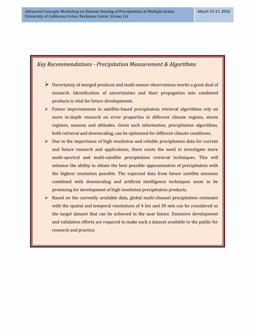
Key Recommendations - Precipitation Measurement & Algorithms
Uncertainty of merged products and multi-sensor observations merits a great deal of
research. Identification of uncertainties and their propagation into combined
products is vital for future developments.
Future improvements in satellite-based precipitation retrieval algorithms rely on
more in-depth research on error properties in different climate regions, storm
regimes, seasons and altitudes. Given such information, precipitation algorithms,
both retrieval and downscaling, can be optimized for different climate conditions.
Due to the importance of high resolution and reliable precipitation data for current
and future research and applications, there exists the need to investigate more
multi-spectral and multi-satellite precipitation retrieval techniques. This will
enhance the ability to obtain the best possible approximation of precipitation with
the highest resolution possible. The expected data from future satellite missions
combined with downscaling and artificial intelligence techniques seem to be
promising for development of high resolution precipitation products.
Based on the currently available data, global multi-channel precipitation estimates
with the spatial and temporal resolutions of 4 km and 30 min can be considered as
the target dataset that can be achieved in the near future. Extensive development
and validation efforts are required to make such a dataset available to the public for
research and practice.
Advanced Concepts Workshop on Remote Sensing of Precipitation at Multiple Scales University of California Irvine, Beckman Center, Irvine, CA
March 15-17, 2010
Modeling and Uncertainty
The first step to study and assess uncertainties is to define a set of metrics to quantify
them. These metrics can serve as objective measures of how well satellite-derived
precipitation estimates compare to ground reference observations. The selected metrics
should be user-dependent. Each measure may emphasize a different aspect of performance
and the user must decide which ones are more important to their purposes/applications.
For example, military mission planners, conducting a risk assessment study, may be more
interested in examining the uncertainties associated with both, single satellite observations
and multi-sensors.
Statistical testing criteria should be carefully chosen in order to ensure that validation
results are objective and informative. When validating satellite products, one needs to
carefully consider systematic errors. Low testing scores, obtained in a validation study, do
not necessary mean bad performance or large errors. Some low testing scores could be
caused by shifting or rotation errors that can be simply corrected for. Successful bias
removal approaches require extensive research on systematic uncertainties that are
application-independent. Once these uncertainties are identified, they can be removed in
satellite retrieval algorithms. Developing diagnostic statistics (shifting, rotation) will
provide the mechanism to understand the systematic deficiency inherent in precipitation
retrieval algorithms. As mentioned above, once a systematic deficiency is observed it can
be removed using adjustment techniques. While adjusting for errors may improve
precipitation products, it is more important to understand why a particular type of error is
occurring and what might be the physical explanation behind it. Such information may lead
to improvements in the retrieval algorithms.
New diagnostic statistics, such as object oriented validation methods deserve more
attention to improve the commonly used grid based methods (comparing same grids of
multiple satellite-based estimates). It is well known that the discrepancy between satellite
estimates and ground observations is not limited to the magnitude of rain rates. Very often,
precipitation patterns and structural geometries are estimated differently by independent
satellite sensors. Therefore, various measures need to be developed to evaluate errors and
uncertainty in patterns of precipitation measured by different sensors.
In order to account for uncertainty of satellite precipitation data, characteristics of error
should be investigated first. For example, understanding spatial and temporal
dependencies of errors play a key role in developing uncertainty models. Probability
distribution function (PDF) and variance of errors are also important when building
Advanced Concepts Workshop on Remote Sensing of Precipitation at Multiple Scales University of California Irvine, Beckman Center, Irvine, CA
March 15-17, 2010
uncertainty models. Understanding multivariate characteristics of errors will significantly
advance our ability to assimilate errors using stochastic techniques. By providing reliable
information on products’ uncertainties, users can make adjustments to their modeling
approach or decision making method “on-the-fly”.
The workshop attendees unanimously agreed as to the importance of the need for effective
methods for bias removal. In particular, PDF-based adjustment techniques deserve more
in-depth research. Ignoring the distribution information in bias adjustment procedures
could potentially result in loss of valuable information, especially with regard to the tails of
the distribution. In hydrologic applications, watershed response significantly depends on
the tails of rainfall intensities. Radar observations are the best reference data for bias
adjustment when no gauge data is available. However, radar data are also subject to
various types of uncertainties as reported in many publications (e.g., beam blockage,
random variability in vertical profile, Z-R relationship, among others, see (Krajewski, et al.,
2005) and (Krajewski, et al., 2002)). In fact, radar data might be even more biased than
satellite estimates if not adjusted with gauge measurements. Currently, National Weather
Service (NWS) radars are adjusted by gauges through two steps: mean-field and localized
adjustments. This procedure seems to be successful in producing reasonable rainfall
estimates. Similar adjustment techniques for satellite-retrieved products may lead to a
significant improvement in the quality of data. The concept of adjustment, however, is
relatively new and still warrants more research. If radar and gauge observations are not
available, satellite-based estimated can be adjusted for bias using long-term climatological
data at the location of interest or a nearby location for which long data records are
available. Such data may not be of high quality in high resolution; however,
monthly/annual accumulations over the area of interest may be reasonably accurate.
It is noted that representative error and probabilistic metrics are regime dependent.
Comprehensive validation studies over different climatological regions considering
different thresholds as well as deriving error surfaces for different products may help to
identify satellite products’ uncertainties. Experiments such as Observing System Simulation
Experiments (OSSE) are needed to determine the effects of uncertainty in retrieval
algorithms. It is expected that the results of such experiments improve future algorithm
developments. The International Precipitation Working Group (IPWG) satellite
precipitation validation project is also expected to improve characterization of algorithm
errors. Such analysis may lead to recommendation on reliability of a certain model in a
certain condition/location. For example, it would be very helpful to know which model
performs best under a certain climate condition. The decision makers can then decide
which model to use given the weather/location condition. Future research in this area will
be very beneficial to civilian and military communities. Having such information on
different algorithms, one can avoid searching for “the best algorithm”; instead different
Advanced Concepts Workshop on Remote Sensing of Precipitation at Multiple Scales University of California Irvine, Beckman Center, Irvine, CA
March 15-17, 2010
algorithms will be considered for various application/climate conditions/geographic
locations.
The impacts of precipitation uncertainty on hydrologic modeling processes and modeling
components need to be evaluated. Intuitively, the impacts of uncertainties of remotely-
sensed precipitation data on model outputs depend on model type (e.g., distributed or
lumped), watershed size, and data resolution, among others. For example, detailed
information on rainfall distribution may not have a significant influence in the final
aggregated streamflow for large watersheds, while it may have a considerable effect on the
estimate of streamflow from a small watershed. Research in this area may lead to a better
understanding on the effects of uncertainty at different scales.
From the military point of view, uncertainty plays a major role in planning and decision
making. Having estimates of precipitation uncertainty, one can obtain an ensemble of
streamflows with uncertainty bounds that can be used for risk assessment or decision
making. Uncertainty propagation into models in real-time forecast may also be provided
through ensemble assimilation of precipitation estimates. Future research in this area is
highly desirable for the decision makers.
Recently, the Global Forecast Systems (GFS) and the Goddard Earth Observing System
Model, Version 5 (GEOS5) global models have been integrated into precipitation estimation
algorithms for flood warning system. It is hoped that in the near future, predictions of the
Weather Research and Forecasting (WRF) model can also be integrated into precipitation
estimation algorithms. It is anticipated that further improvement in precipitation
estimation can be gained since model estimates, such as WRF, benefit from the built-in
physically-consistent, 3D atmospheres and mesoscale dynamics. From a military point of
view, integrating WRF and GFS predictions could be a potentially suitable model for
forecasting. In general, it is expected that high resolution global scale and physically-based
models will be more common in future. Current models require extensive input data that
are often approximated based on large scale observations or re-analysis methods. In data
limited regions, a complex model may not necessarily provide the most accurate estimates
due uncertainties in the input variables. In such cases a simple climate model may be
superior to a complex model. For models currently available or being developed, a great
deal of research should focus on the sensitivity of the models to the required input
variables. While sensitivity studies are commonly reported in literature, few studies
provide practical recommendations on where, when and how a certain model can be used
best.
Currently, there is no operational precipitation assimilation model available. This is mainly
due to the difficulties caused by the inherent deficiencies in model definition and structure
Advanced Concepts Workshop on Remote Sensing of Precipitation at Multiple Scales University of California Irvine, Beckman Center, Irvine, CA
March 15-17, 2010
and also lack of research on reliable data assimilation techniques. More research is
required to develop data assimilation techniques in order to integrate assimilation as a part
of the modeling approach. Data assimilation such as Land Data Assimilation Systems
(LDAS) is useful for modeling purposes; however we need to understand data uncertainty
in order to improve data assimilation techniques. Future research is necessary in using
data assimilation techniques for both input variables and initial conditions. Furthermore,
assimilation techniques can be used to derive relative importance of initial conditions and
boundary conditions to domain size, lead time, among others.
Key Recommendations - Modeling and Uncertainty
Development of metrics for validation and uncertainty analysis is of great
importance. Various metrics with emphasize on different aspects of performance are
required so that users can decide which product fits their purposes/applications
best.
Developing diagnostic statistics (shifting, rotation) will help to capture the
systematic deficiency inherent in precipitation retrieval algorithms.
The workshop attendees unanimously pointed out that bias removal, particularly
PDF-based adjustment, deserves more in-depth research. Ignoring the distribution
information in the bias adjustment procedure could result in loss of information,
especially regarding the tails of the distribution.
Currently, there is no operational precipitation assimilation model available. This is
mainly due to the difficulties caused by the inherent deficiencies in model definition
and structure and also lack of research on reliable data assimilation techniques.
More research needs to be devoted to developing data assimilation techniques in
order to integrate assimilation as a part of the modeling and algorithm development
approach.
Advanced Concepts Workshop on Remote Sensing of Precipitation at Multiple Scales University of California Irvine, Beckman Center, Irvine, CA
March 15-17, 2010
Applications
Application of satellite-based precipitation products in hydrologic modeling, with special
emphasis on military needs, was the third topic of discussion at the workshop. For military
operations, a variety of information may be required for decision purposes. Probabilities of
rain and flood event, dust storm, landslides, as well as soil moisture conditions are
frequently requested by military decision makers. Therefore, timeliness of this information
with the highest accuracy is warranted.
Most parts of the globe have a limited number of in-situ data and for those less accessible
areas, satellite-based precipitation products have proven to be of great value. So far, the
most successful applications of satellite-based precipitation data have been: (a) climate
monitoring/prediction, flash flood forecasting, now-casting, agricultural monitoring and
disease prediction; (b) successful hurricane forecasting using Tropical Rainfall Measuring
Mission (TRMM) and other satellite-based data. This information has led to better
preparation for saving lives and avoiding unnecessary evacuations during hurricane
season; (c) Using precipitation products in both the NRMM (NATO Reference Mobility
Model) and GSSHA (Gridded Surface Subsurface Hydrologic Analysis); (d) Environmental
security.
As mentioned above, satellite-based precipitation products have been applied successfully
for civilian and military applications. Most of these applications are in coarse resolution
whereas most often information is required at finer spatial and temporal scales. In this
regard, downscaling of coarse resolution satellite-based precipitation products in
combination with data assimilation techniques may provide high resolution estimates
required for practical applications. It is worth pointing out that many applications (e.g.,
decision making) require high resolution data in near real-time. Therefore the
latency/timeliness of receiving satellite precipitation products is of particular importance.
Currently, most of the satellite products have latency ranges of 1 hour to 3 hours. Given the
fact that this latency is one of the primary obstacles in now-casting, future efforts should be
focused to reduce this time lag to less than half an hour.
From the application point of view, uncertainty of precipitation estimates is identified as
one of the key issue that requires extensive future research. There is uncertainty in merged
multi-sensor satellite products as well as model physical processes which are forced by
uncertain precipitation input. Errors/uncertainty from different sources should be
identified in order to reduce the uncertainty in model results and merged multi-sensor
Advanced Concepts Workshop on Remote Sensing of Precipitation at Multiple Scales University of California Irvine, Beckman Center, Irvine, CA
March 15-17, 2010
precipitation products. Having estimates of data uncertainty is perhaps the most desired
information for decision makers at all levels.
Current satellite products have been utilizing information from a number of channels only
while satellite-based precipitation estimates can be improved by using multispectral
imagers for precipitation estimation. There are many satellite channels that are gathering
information daily but have not been integrated into precipitation retrieval algorithms yet.
For instance, the operational Spinning Enhanced Visible and Infrared Imager (SEVIRI)
instrument, onboard Meteosat Second Generation (MSG), has 12 spectral bands. The
SEVIRI provides observations with a spatial resolution of 3 km and a temporal resolution of
15 min. It is worth mentioning that the future GOES-R series will carry the Advanced
Baseline Imager (ABI), which will scan the earth’s surface in 16 spectral bands. It is
expected that usage of multi-channel information can bring improvements in precipitation
estimation.
Several studies show that satellite precipitation products tend to over-estimate intense
precipitation events quite significantly, particularly during warm months. On the other
hand, winter precipitation is best predicted by Numerical Weather Prediction models. It is
worth considering near real-time precipitation forecasting using both satellite data and
numerical weather prediction models. Furthermore, there is a need for considerable
research efforts on orographic precipitation estimation using satellite data.
Satellite-derived precipitation products are not well addressed and applied by the
engineering community/agencies. There is a gap between research community and
operational personnel in the mutual preferences and needs. Future conferences and
workshops should try to bridge the gap between the research and operational
communities. This will help to set up working groups to get the operational and R&D
groups working together to develop future products. Additionally, systematic satellite data
processing with users option for various data formats (e.g., ascii, binary, or ArcGIS) is vital
for faster practical applications.
It is crucial to rigorously evaluate available precipitation products in different hydrologic
and climate models for various scenarios/objectives. Further, transferability of the
validation studies and test cases should be considered for future research. One option
could be to divide the entire United States in multiple climate zones where test cases can be
carried out. Then, transferability can be tested and validated at each climate zone.
The appropriateness of hydrologic models for real-time application based on satellite-
based precipitation products requires careful evaluation. Research is necessary to
investigate distributed versus lumped models with respect to the uncertainty of high
Advanced Concepts Workshop on Remote Sensing of Precipitation at Multiple Scales University of California Irvine, Beckman Center, Irvine, CA
March 15-17, 2010
resolution satellite data. Will the performance of a high resolution distributed model
improve over a lumped model, with high resolution precipitation satellite input data, which
is subject to higher uncertainty? In another words, what are the appropriate scales for
distributed modeling, given the current state of satellite-based precipitation products in
terms of their interrelated resolution and uncertainty (i.e. higher resolution in both time
and space, higher uncertainty)?
The concept of ensemble streamflow modeling seems to be the future direction particularly
when uncertainty in streamflow output is of interest (e.g., for military decision making
applications). In this regard, ensemble precipitation is the key element. Future studies
should focus on development of near real-time precipitation ensemble generation.
Furthermore, implementation of ensembles of precipitation for streamflow forecasting
deserves more attention. There are various models currently being used that can be
considered as base models for ensemble forecasting studies (e.g., Gridded Surface
Subsurface Hydrologic Analysis (GSSHA, see (Downer, et al., 2002)) model, tRIBS+VEGGIE
(Ivanov, et al., 2008) which is a dynamic eco-hydrological model, Land Information System
(LIS, (Kumar, et al., 2006)), among others).
Finally, review publications on success/failure of application of satellite-based
precipitation products can help researchers to identify new research directions.
Advanced Concepts Workshop on Remote Sensing of Precipitation at Multiple Scales University of California Irvine, Beckman Center, Irvine, CA
March 15-17, 2010
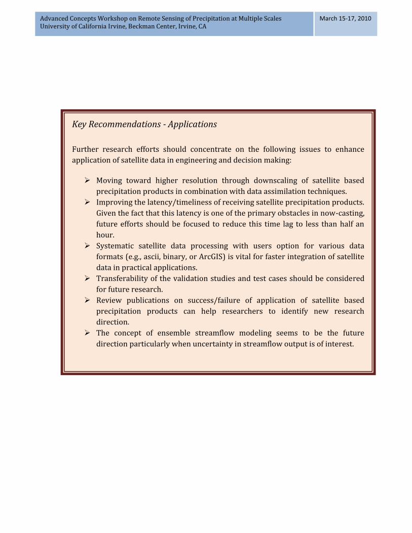
Key Recommendations - Applications
Further research efforts should concentrate on the following issues to enhance
application of satellite data in engineering and decision making:
Moving toward higher resolution through downscaling of satellite based
precipitation products in combination with data assimilation techniques.
Improving the latency/timeliness of receiving satellite precipitation products.
Given the fact that this latency is one of the primary obstacles in now-casting,
future efforts should be focused to reduce this time lag to less than half an
hour.
Systematic satellite data processing with users option for various data
formats (e.g., ascii, binary, or ArcGIS) is vital for faster integration of satellite
data in practical applications.
Transferability of the validation studies and test cases should be considered
for future research.
Review publications on success/failure of application of satellite based
precipitation products can help researchers to identify new research
direction.
The concept of ensemble streamflow modeling seems to be the future
direction particularly when uncertainty in streamflow output is of interest.
Advanced Concepts Workshop on Remote Sensing of Precipitation at Multiple Scales University of California Irvine, Beckman Center, Irvine, CA
March 15-17, 2010
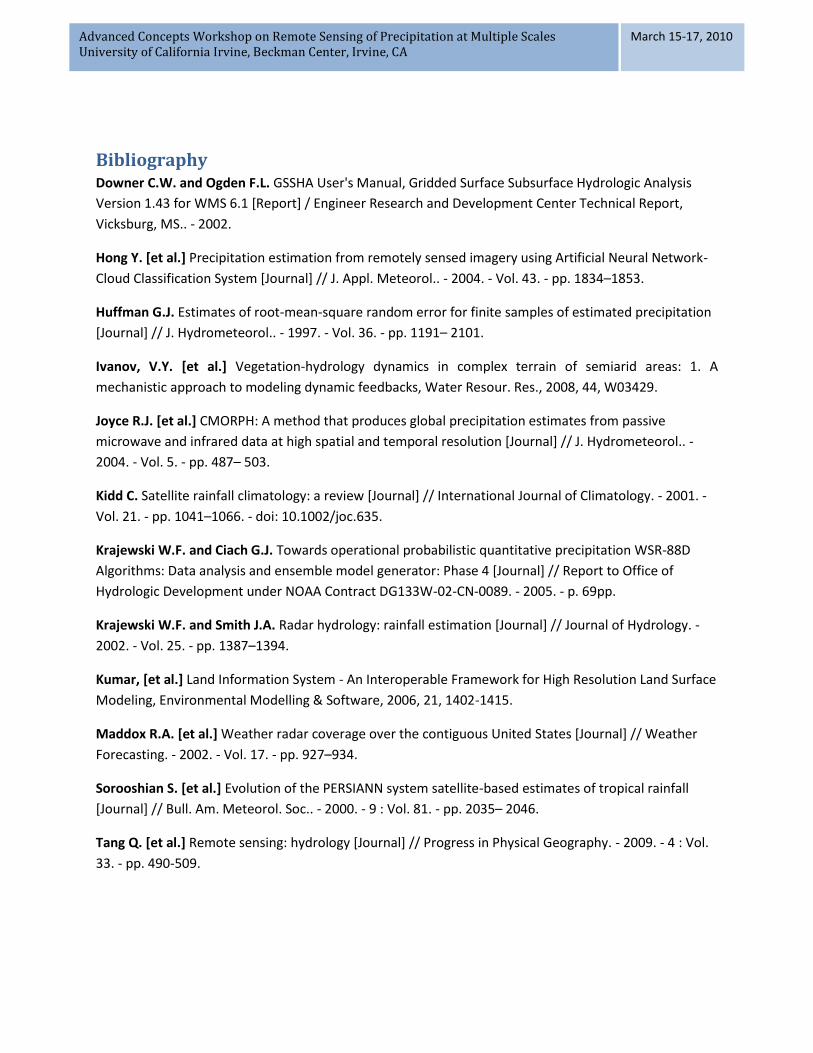
Bibliography Downer C.W. and Ogden F.L. GSSHA User's Manual, Gridded Surface Subsurface Hydrologic Analysis
Version 1.43 for WMS 6.1 [Report] / Engineer Research and Development Center Technical Report,
Vicksburg, MS.. - 2002.
Hong Y. [et al.] Precipitation estimation from remotely sensed imagery using Artificial Neural Network-
Cloud Classification System [Journal] // J. Appl. Meteorol.. - 2004. - Vol. 43. - pp. 1834–1853.
Huffman G.J. Estimates of root-mean-square random error for finite samples of estimated precipitation
[Journal] // J. Hydrometeorol.. - 1997. - Vol. 36. - pp. 1191– 2101.
Ivanov, V.Y. [et al.] Vegetation-hydrology dynamics in complex terrain of semiarid areas: 1. A
mechanistic approach to modeling dynamic feedbacks, Water Resour. Res., 2008, 44, W03429.
Joyce R.J. [et al.] CMORPH: A method that produces global precipitation estimates from passive
microwave and infrared data at high spatial and temporal resolution [Journal] // J. Hydrometeorol.. -
2004. - Vol. 5. - pp. 487– 503.
Kidd C. Satellite rainfall climatology: a review [Journal] // International Journal of Climatology. - 2001. -
Vol. 21. - pp. 1041–1066. - doi: 10.1002/joc.635.
Krajewski W.F. and Ciach G.J. Towards operational probabilistic quantitative precipitation WSR-88D
Algorithms: Data analysis and ensemble model generator: Phase 4 [Journal] // Report to Office of
Hydrologic Development under NOAA Contract DG133W-02-CN-0089. - 2005. - p. 69pp.
Krajewski W.F. and Smith J.A. Radar hydrology: rainfall estimation [Journal] // Journal of Hydrology. -
2002. - Vol. 25. - pp. 1387–1394.
Kumar, [et al.] Land Information System - An Interoperable Framework for High Resolution Land Surface
Modeling, Environmental Modelling & Software, 2006, 21, 1402-1415.
Maddox R.A. [et al.] Weather radar coverage over the contiguous United States [Journal] // Weather
Forecasting. - 2002. - Vol. 17. - pp. 927–934.
Sorooshian S. [et al.] Evolution of the PERSIANN system satellite-based estimates of tropical rainfall
[Journal] // Bull. Am. Meteorol. Soc.. - 2000. - 9 : Vol. 81. - pp. 2035– 2046.
Tang Q. [et al.] Remote sensing: hydrology [Journal] // Progress in Physical Geography. - 2009. - 4 : Vol.
33. - pp. 490-509.

Advanced Concepts Workshop on Remote Sensing of Precipitation at Multiple Scales University of California Irvine, Beckman Center, Irvine, CA
March 15-17, 2010
APPENDIX I - PARTICIPANTS
Phillip Arkin (CICS/ESSIC University of Maryland) [email protected]
Eyal Amitai (NASA Goddard and Chapman U) [email protected]
Walter Bach (U.S. Army Research Office) [email protected]
Brian Baldauf (Northrop Grumman Space Technology) [email protected]
Ali Behrangi (NASA-JPL) [email protected]
Doug Boyle (Desert Research Institute) [email protected]
John Eylander (U.S. AFWA 2nd Weather Group) [email protected]
Efi Foufoula-Georgiou (Dept. of Civil Engineering, University of Minnesota) [email protected]
Alejandro Flores (Boise State University) [email protected]
Michael Follum, (U.S.Army COE-ERDC-CHL), [email protected]
Ziad Haddad (NASA-JPL) [email protected]
Jan Hendrickx, (New Mexico Tech) [email protected]
Russell Harmon (U.S. Army Research Office) [email protected]
Yang Hong (Oklahoma University) [email protected]
Gail Skofronick Jackson (NASA-GPM) [email protected]
Stan Kidder (CSU/CIRA) [email protected]
David Kitzmiller (NOAA-NWS) [email protected]
Robert Kuligowski (NOAA/NESDIS/STAR) [email protected]
Witold F. Krajewski (The University of Iowa) [email protected]
Shayesteh Mahani (CCNY ) [email protected]
William Martin (U.S. Army COE-ERDC-CHL) [email protected]
Eric McDonald (Desert Research Institute) [email protected]
Brian Nelson (NOAA-NCDC) [email protected]
Eni Njoku (NASA-JPL) [email protected]
Alexander Ryzhkov (NOAA-NSSL) [email protected]
Brian Skahill (U.S. Army COE-ERDC-CHL-MS) [email protected]
Armin Sorooshian, (University of Arizona) [email protected]
Yudong Tian (NASA-GSFC) [email protected]
Joe Turk, (NASA-JPL) [email protected]
Rafael Bras (Dean, HSSoE) [email protected]
Jingfeng Wang (CEE/UCI) [email protected]
Brett Sanders (CEE/UCI) [email protected]
Jasper Vrugt (CEE/UCI) [email protected]
Jin-Yi Yu (CEE/UCI) [email protected]
MinHui Lo (ESS/UCI) [email protected]

Advanced Concepts Workshop on Remote Sensing of Precipitation at Multiple Scales University of California Irvine, Beckman Center, Irvine, CA
March 15-17, 2010
Soroosh Sorooshian (CEE/UCI) [email protected]
Xiaogang Gao (CEE/UCI) [email protected]
Kuo-lin Hsu (CEE/UCI) [email protected]
Bisher Imam (CEE/UCI) [email protected]
Byung-kook Lee (visiting scholar) [email protected]
Amir Aghakouchak (CEE/UCI) [email protected]
Wei Chu (CEE/UCI) [email protected]
Jialun Li (CEE/UCI) [email protected]
Tsou Chun Jaw (CEE/UCI) [email protected]
Nasrin Nasrolliahi (CEE/UCI) [email protected]
Rebeka Sultana (CEE/UCI) [email protected]
Hamed Ashouri (CEE/UCI) [email protected]
Qing Xia (CEE/UCI) [email protected]
Ali Zahraei (CEE/UCI) [email protected]
Diane Hohnbaum [email protected]
Dan Braithwaite (CEE/UCI) [email protected]
Advanced Concepts Workshop on Remote Sensing of Precipitation at Multiple Scales University of California Irvine, Beckman Center, Irvine, CA
March 15-17, 2010
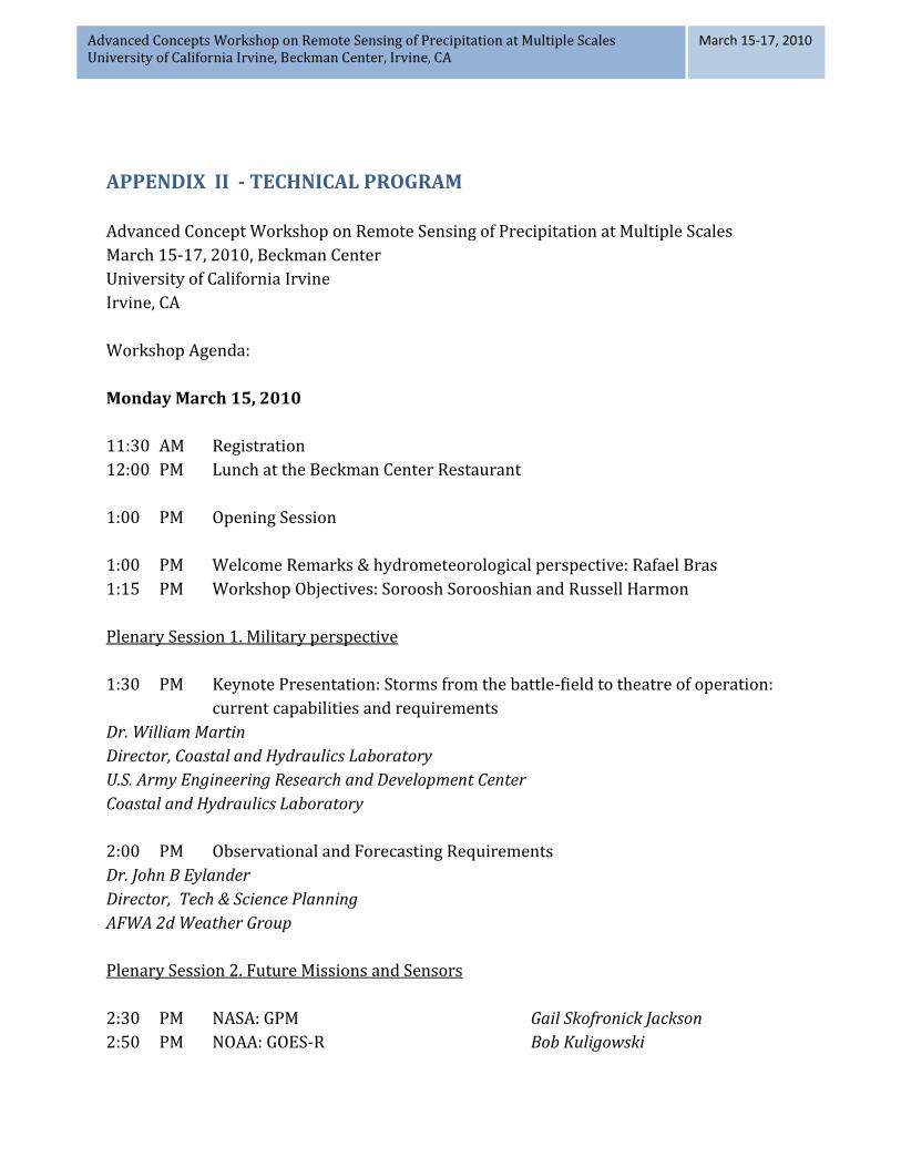
APPENDIX II - TECHNICAL PROGRAM
Advanced Concept Workshop on Remote Sensing of Precipitation at Multiple Scales
March 15-17, 2010, Beckman Center
University of California Irvine
Irvine, CA
Workshop Agenda:
Monday March 15, 2010
11:30 AM Registration
12:00 PM Lunch at the Beckman Center Restaurant
1:00 PM Opening Session
1:00 PM Welcome Remarks & hydrometeorological perspective: Rafael Bras
1:15 PM Workshop Objectives: Soroosh Sorooshian and Russell Harmon
Plenary Session 1. Military perspective
1:30 PM Keynote Presentation: Storms from the battle-field to theatre of operation:
current capabilities and requirements
Dr. William Martin
Director, Coastal and Hydraulics Laboratory
U.S. Army Engineering Research and Development Center
Coastal and Hydraulics Laboratory
2:00 PM Observational and Forecasting Requirements
Dr. John B Eylander
Director, Tech & Science Planning
AFWA 2d Weather Group
Plenary Session 2. Future Missions and Sensors
2:30 PM NASA: GPM Gail Skofronick Jackson
2:50 PM NOAA: GOES-R Bob Kuligowski

Advanced Concepts Workshop on Remote Sensing of Precipitation at Multiple Scales University of California Irvine, Beckman Center, Irvine, CA
March 15-17, 2010
3:10 PM Compact Hyperspectral Sensors Brian Baldauf
3:30 PM Coffee Break
3:50 PM Space borne radars Ziad Haddad
4:10 PM Mobile Sensors (X-band) Alexander Ryzhkov
4:30 PM Ground-based radars Witold Krajewski
Plenary Session 3. Algorithms, Challenges and opportunities
4:50 PM Realtime Algorithms: Phil Arkin
5:10 PM MW, Algorithms: Joe Turk
5:30 PM IR , &combination Algorithms: Kuolin Hsu
5:50 PM Multi-spectral algorithms: Ali Behrangi
6:10 PM Adjourn for Dinner at the Beckman Center
Tuesday, March 16, 2010
7:30 AM Breakfast
Plenary Session 4. Precipitation Modeling
8:30 AM Precip. Forecasting/QPF (short term) David Kitzmiller
8:50 AM NRC Precipitation Modeling Report Efi Foufoula-Georgiou
Plenary Session 5. Applications
9:10 AM Soil Moisture & Precipitation: Eni Njoku
9:30 AM Global Hydrologic Applications: Yudong Tian
9:50 AM BREAK
Plenary Session 6. Topical Presentations
10:15 AM ERDC Watershed Modeling Brian Skahill and Mike Follum
Activities & Remote Sensing
10:45 AM Verification of Extreme Events with Q2 Eyal Amitai
11:00 AM Mountain Precipitation Shayesteh Mahani
11:15 AM NASA SERVIR Initiative Yang Hong

Advanced Concepts Workshop on Remote Sensing of Precipitation at Multiple Scales University of California Irvine, Beckman Center, Irvine, CA
March 15-17, 2010
11:30 AM Satellite Precipitation and ET Estimation Jan Hendrickx
11:45 AM Study Group Session Assignments and Break-out Information by Soroosh
Sorooshian and Bisher Imam
Group Session Co-Leaders:
Group 1: John Eylander & Efi Foufoula-Georgiou
Group 2: Philip Arkin & Jan Hendrickx
Group 3: Brian Skahill, Gail Skofronick Jackson, Bob Kuligowski
12:00 PM Lunch
1:00 AM Study Group Session 1. Measurements
Group 1 Huntington Room
Group 2 Board Room
Group 3 Balboa Room
2:50 PM Coffee Break
3:10 PM Study Group Session 2. Modeling/Uncertainty
Group 1 Huntington Room
Group 2 Board Room
Group 3 Balboa Room
5:00 PM Adjourn Travel to Calit2
5:30 PM Calit2 Visualization of Precipitation Systems Demonstration
6:00 PM Dinner at University Club
Wednesday, March 17, 2010
7:30 AM Breakfast
8:30 AM Study Group Session 3. Applications
Group 1 Huntington Room
Group 2 Board Room
Group 3 Balboa Room
10:20 AM Coffee Break

Advanced Concepts Workshop on Remote Sensing of Precipitation at Multiple Scales University of California Irvine, Beckman Center, Irvine, CA
March 15-17, 2010
Plenary Session 7. Workshop Report Outline and Assignment
10:40 AM Group 1 Report
11:00 AM Group 2 Report
11:20 AM Group 3 Report
11:40 AM General Discussion
12:30 PM Lunch
Plenary Session 8. Workshop Report Outline and Assignment
1:30 PM General Discussion
2:30 PM Report Outline Discussion
3:30 PM Conclusion and Adjourn

Advanced Concepts Workshop on Remote Sensing of Precipitation at Multiple Scales University of California Irvine, Beckman Center, Irvine, CA
March 15-17, 2010
APPENDIX III - GROUP SESSIONS
Group 1
Co-Leaders :
John Eylander
Efi Foufoula-Georgiou
Location:
Huntington Room
Group 2
Co-Leaders:
Philip Arkin
Jan Hendrickx
Location:
Board Room
Group 3
Co-Leaders:
Brian Skahill
Gail Skofronick Jackson
Robert Kuligowski
Location:
Balboa Room
Amir AghaKouchak
Eyal Amitai
Rafael Bras
Wei Chu
Michael Follum
Yang Hong
Kuo-lin Hsu
Russell Harmon
Stan Kidder
David Kitzmiller
Yudong Tian
Joe Turk
Walter Bach
Ana Barros
Ali Behrangi
Alejandro Flores
Ziad Haddad
Byung-kook Lee
Jialun Li
Shayesteh Mahani
Brian Nelson
Eni Njoku
Soroosh Sorooshian
Jasper Vrugt
Brian Baldauf
Doug Boyle
Xiaogang Gao
Bisher Imam
Witold F. Krajewski
William Martin
Eric McDonald
Alexander Ryzhkov
Brett Sanders
Armin Sorooshian
Jingfeng Wang
Advanced Concepts Workshop on Remote Sensing of Precipitation at Multiple Scales University of California Irvine, Beckman Center, Irvine, CA
March 15-17, 2010
APPENDIX IV - RESEARCH QUESTIONS
Workshop attendees were divided into three study groups: (1) Measurements
&Algorithms; (2) Modeling & Uncertainties; and (3) Applications. List of participants in
each group is provided in Appendix III. The participants discussed the following research
questions and provided recommendations (see Section Recommendations)
Measurements & Algorithms:
1. Given the difference in instrument capabilities and algorithms, what are the most
suitable approaches to combine data from passive and active sensors, along with high
resolution ground instruments to improve the quality, timeliness, and resolution of
precipitation data?
2. Are current instruments and algorithms capable of reproducing extreme events, both at
event scale and their climatology? If not, what is required to improve the capture of
extreme events, and to what extent do current and future missions address these
requirements?
3. What is the most realistic target of spatial and temporal resolution of global precipitation
estimates in real-time for the next 5, 10, 15, and 20 year time-frames? How far are these
targets from the ideal hourly/1 km resolution required to understand precipitation process
and local scales?
4. How can current algorithms be improved and revised to capture light precipitation and
solid precipitation?
5. What are the most appropriate methods to integrate military acquired data (e.g.,
aircrafts, ships, and ground radars) in improving precipitation estimation algorithms
Modeling/Uncertainties
1. What are the measures of error and uncertainties that can reflect the ability of satellite-
derived precipitation to capture spatial and temporal structures of precipitation? How to
best compute these measures from sparse ground observation networks?
Advanced Concepts Workshop on Remote Sensing of Precipitation at Multiple Scales University of California Irvine, Beckman Center, Irvine, CA
March 15-17, 2010
2. How to best adjust remotely-sensed observation for bias over un-gauged catchments, at
what spatial and temporal scales? Is bias adjustment more important than the preservation
of intensity distribution?, If so, at what scales?
3. What are the impacts of uncertainties in remotely-sensed precipitation on model
output? How to best capture the mechanism of uncertainty propagation into models in
real-time forecast (e.g. QPF, streamflow, soil moisture) operations?
4. Which models are more suitable for integration into precipitation estimation
algorithms? (e.g. cloud tracking, NWP) ? What are the error characteristics of these models
and what is the impact of these errors on the performance of the algorithm?
5. Does data assimilation provide the means to adjust initial conditions? How does
improvement in initial conditions affect the role of errors in boundary conditions in model
forecasts? To what extent does uncertainty in assimilated precipitation affect these
forecasts?
Applications
1. To date, how successful has satellite-based precipitation estimates been in providing
some of the needs of military applications? What aspects remain to be improved to achieve
better use and integration of satellite-based global precipitation estimation into these
applications?
2. To date, what are the most successful applications of satellite-based precipitation? What
have we learned from these applications in terms of data integration, information
infrastructure, and real-time availability of data?
3. What are the appropriate hydrologic models for real-time application of satellite
precipitation, especially with respect to those relevant to soil-moisture?

Advanced Concepts Workshop on Remote Sensing of Precipitation at Multiple Scales University of California Irvine, Beckman Center, Irvine, CA
March 15-17, 2010
APPENDIX V - WORKSHOP VENUE
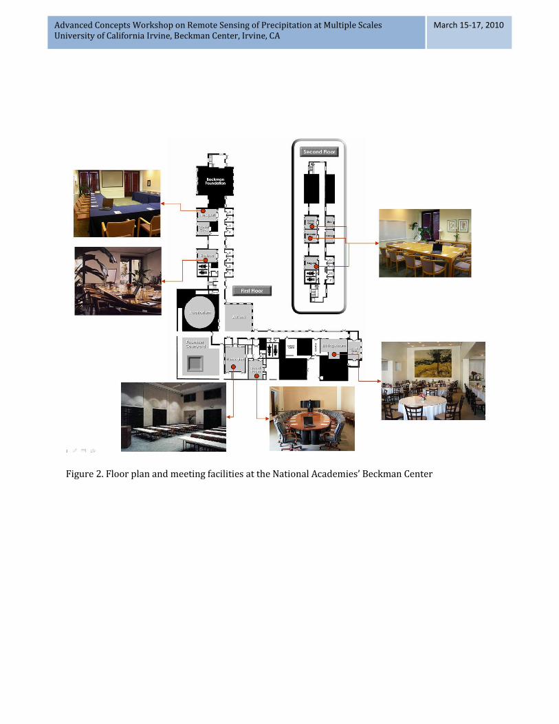
The workshop was held in the Arnold and Mabel Beckman center of the National Academies. The center is located on seven acres bordering the cities of Irvine and Newport Beach and is only minutes away from the John Wayne Orange County Airport (SNA). The conference, meeting, and board rooms are equipped with a wide variety of state of the art technology with on-site staff available to coordinate all audio-visual and computer needs of meetings. The center also includes an onsite dining facility and catering services.
Due to the small size of the workshop, plenary sessions were held in the Huntington room (see Figure 2) which can seat between 30-90 participants based on room configuration. Workshop study groups were held in four 12 person capacity meeting rooms (Balboa, and Newport). Figure 1 illustrates the Beckman’s center floor plan and the various rooms available at the facility. Breakfast, lunch and refreshments were served during the workshop. The workshop’s banquet dinner was also served in the Beckman center on the first day of the workshop.
Rooms for workshop participants were arranged in a local hotel near the workshop venue.
The Center for Hydrometeorology and Remote Sensing arranged courtesy shuttle service
from the hotel to the Beckman center and vice versa.
Advanced Concepts Workshop on Remote Sensing of Precipitation at Multiple Scales University of California Irvine, Beckman Center, Irvine, CA
March 15-17, 2010
Figure 2. Floor plan and meeting facilities at the National Academies’ Beckman Center


![Remote Sensing Time Series for Modeling Invasive Species ... Sensing...tamarisk distribution on small scales often using high spatial resolution [Ge et al. 2006] or hyperspectral data](https://img.pdfslide.us/doc/110x75/5ff95f17c0053c722927d77d/remote-sensing-time-series-for-modeling-invasive-species-sensing-tamarisk.jpg)