Embed Size (px)
Citation preview
ADQL/s Syntax (Proposal)-- towards unification of ADQL, SIA
P, SSAP, SXAP... --
Yuji [email protected]
National Astronomical Observatory of JapanJVO
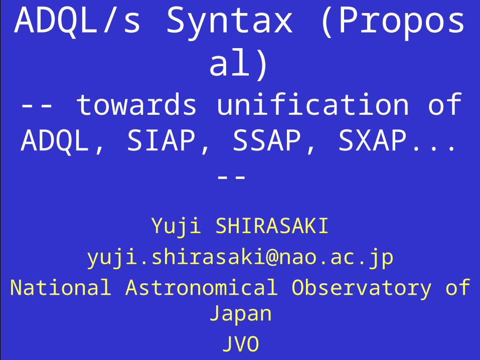
Objective of this talk• Establish a unified query language used to search for any kinds of Astronomical Data, such as, Catalog, Image, Spectrum, 3D-Data Cube, Photon List, Light Curve, ...
• Current situation
– Catalog Data Search ADQL– Image Data Search/Retrieval SIAP– Spectrum Data Search/RetrievalSSAP– others nothing
• We should define a master language whose semantics is upward compatible with SIAP and SSAP ... • I present proposed extensions of SQL syntax (JVOQL V.2) for Astronomical Data Query Language (ADQL/s).
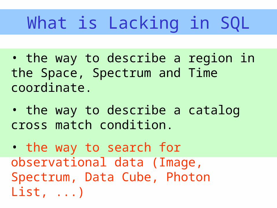
What is Lacking in SQL
• the way to describe a region in the Space, Spectrum and Time coordinate.
• the way to describe a catalog cross match condition.
• the way to search for observational data (Image, Spectrum, Data Cube, Photon List, ...)
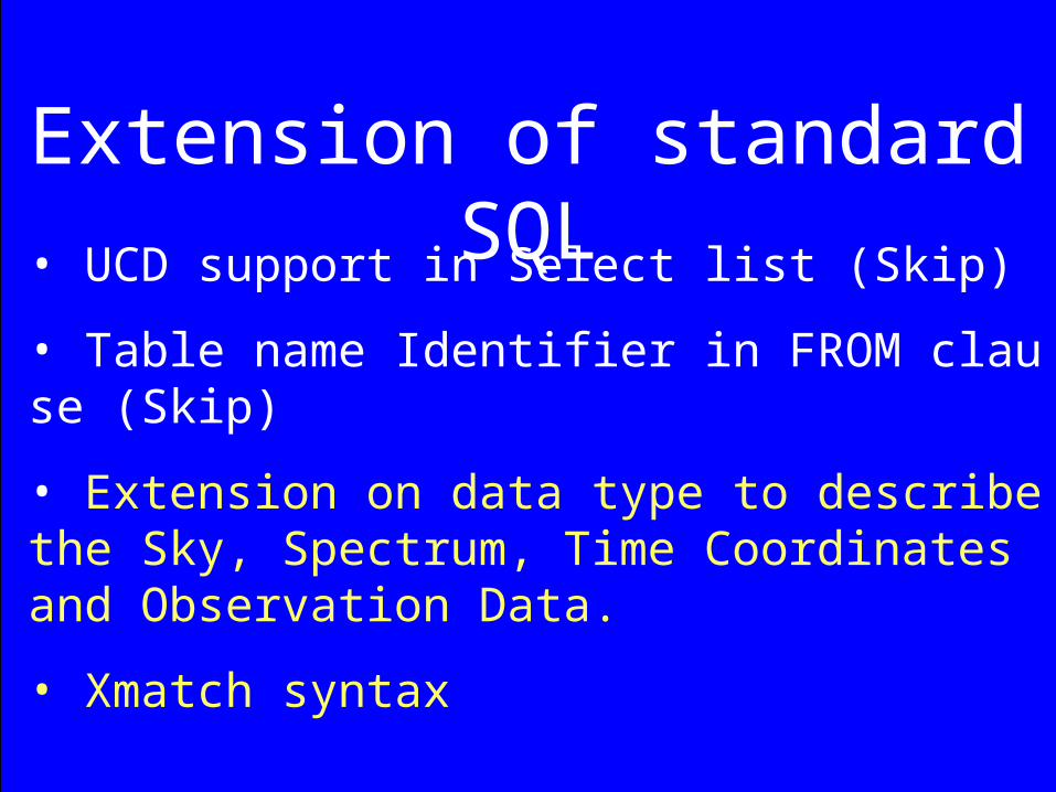
Extension of standard SQL• UCD support in Select list (Skip)
• Table name Identifier in FROM clause (Skip)
• Extension on data type to describe the Sky, Spectrum, Time Coordinates and Observation Data.
• Xmatch syntax
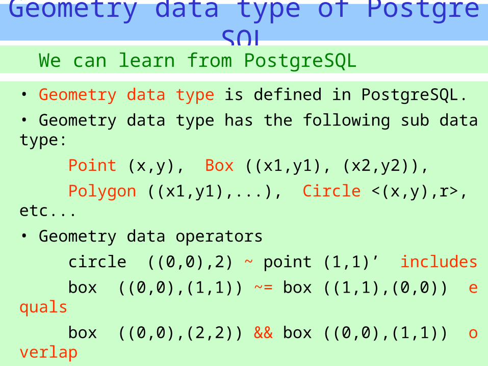
Geometry data type of PostgreSQL
• Geometry data type is defined in PostgreSQL.• Geometry data type has the following sub data type:
Point (x,y), Box ((x1,y1), (x2,y2)),
Polygon ((x1,y1),...), Circle <(x,y),r>, etc...• Geometry data operators
circle ((0,0),2) ~ point (1,1)’ includes
box ((0,0),(1,1)) ~= box ((1,1),(0,0)) equals
box ((0,0),(2,2)) && box ((0,0),(1,1)) overlap• Geometry data function
circle(point, double precision) returns circle data type
box(point, point) returns box data type
We can learn from PostgreSQL
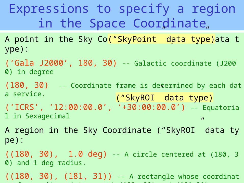
Expressions to specify a region in the Space Coordinate
A point in the Sky Coordinate (“SkyPoint” data type):
(‘Gala J2000’, 180, 30) –- Galactic coordinate (J2000) in degree
(180, 30) -- Coordinate frame is determined by each data service.
(‘ICRS’, ‘12:00:00.0’, ‘+30:00:00.0’) –- Equatorial in Sexagecimal
A region in the Sky Coordinate (“SkyROI” data type):
((180, 30), 1.0 deg) -- A circle centered at (180, 30) and 1 deg radius.
((180, 30), (181, 31)) -- A rectangle whose coordinate of opposite points are at (180, 30) and (181,31).
((‘ICRS’,10,20), (12,20), (12,22), (10,22)) –- A polygon. Coordinate frame specified in the first point is inherited by the following points.
“SkyPoint” and “SkyROI” are sub data types of “Sky” data type
(“SkyPoint” data type)
(“SkyROI” data type)
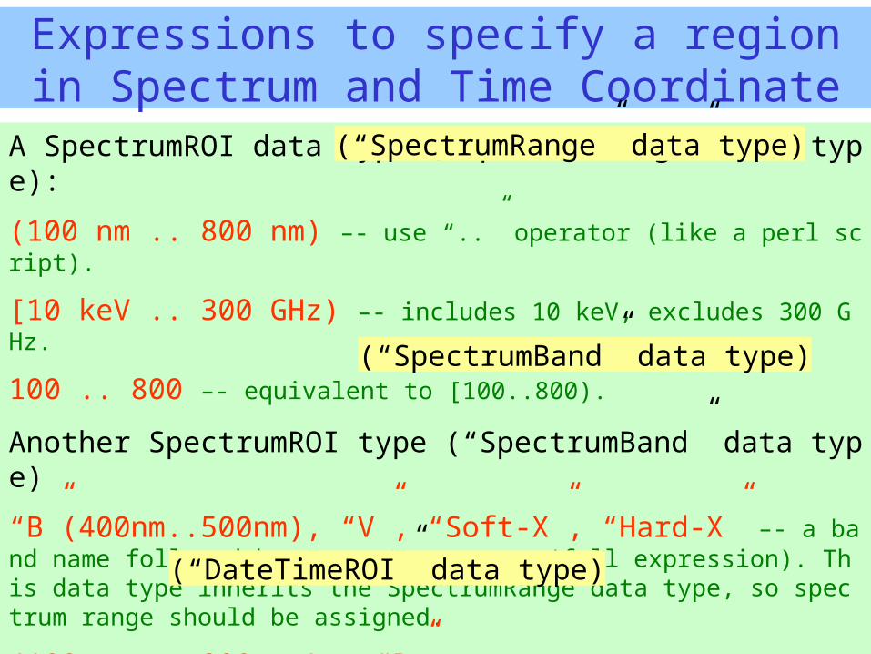
Expressions to specify a region in Spectrum and Time Coordinate
A SpectrumROI data type (“SpectrumRange” data type):
(100 nm .. 800 nm) –- use “..” operator (like a perl script).
[10 keV .. 300 GHz) –- includes 10 keV, excludes 300 GHz.
100 .. 800 –- equivalent to [100..800).
Another SpectrumROI type (“SpectrumBand” data type)
“B”(400nm..500nm), “V”, “Soft-X”, “Hard-X” –- a band name followed by a spectrum range (full expression). This data type inherits the SpectrumRange data type, so spectrum range should be assigned.
(100 nm .. 800 nm) ~ “B” –- the two data types can be compared.
A time region (“DateTimeROI” data type):
(‘2004-05-20 10:30:00.00’ .. ‘12:00:00.0’)
(“SpectrumRange” data type)
(“SpectrumBand” data type)
(“DateTimeROI” data type)
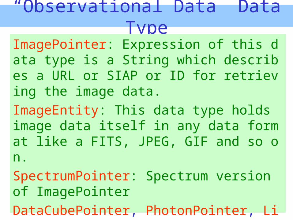
“Observational Data” Data Type
ImagePointer: Expression of this data type is a String which describes a URL or SIAP or ID for retrieving the image data.ImageEntity: This data type holds image data itself in any data format like a FITS, JPEG, GIF and so on.SpectrumPointer: Spectrum version of ImagePointerDataCubePointer, PhotonPointer, LightCurvePoiter,....
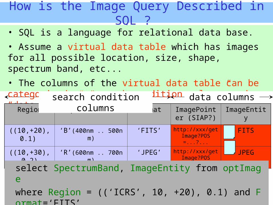
How is the Image Query Described in SQL ?
• SQL is a language for relational data base.
• Assume a virtual data table which has images for all possible location, size, shape, spectrum band, etc...
• The columns of the virtual data table can be categorized as “search condition column” and “data column”.
Region SpectrumBand Format ImagePointer (SIAP?)
ImageEntity
((10,+20),0.1) ‘B’(400nm .. 500nm) ‘FITS’ http://xxx/getImage?POS=...?...
FITS
((10,+30),0.2)
‘R’(600nm .. 700nm) ‘JPEG’ http://xxx/getImage?POS=...?...
JPEG
select SpectrumBand, ImageEntity from optImage where Region = ((‘ICRS’, 10, +20), 0.1) and Format=‘FITS’
and (100nm .. 1000nm) ~ SpectrumBand
search condition columns
data columns
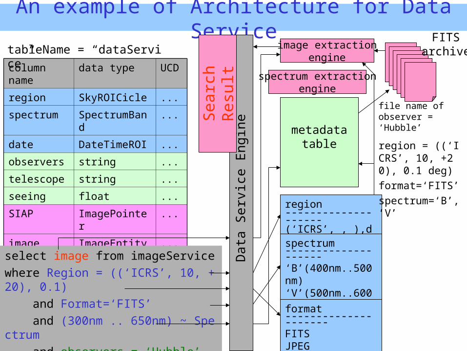
An example of Architecture for Data Service
column name
data type UCD
region SkyROICicle ...
spectrum SpectrumBand ...
date DateTimeROI ...
observers string ...
telescope string ...
seeing float ...
SIAP ImagePointer ...
image ImageEntity ...
format string ...
region --------------------(‘ICRS’, , ),deg)
metadatatable
image extractionengine
Data
Serv
ice E
ng
ine
select image from imageService where Region = ((‘ICRS’, 10, +20), 0.1) and Format=‘FITS’ and (300nm .. 650nm) ~ Spectrum and observers = ‘Hubble’
Searc
h
Resu
lt
region = ((‘ICRS’, 10, +20), 0.1 deg) format=‘FITS’spectrum=‘B’, ’V’
file name of observer = ‘Hubble’
tableName = “dataService”FITS
archive
spectrum extractionengine
spectrum-------------------- ‘B’(400nm..500nm)‘V’(500nm..600nm)‘R’(600nm..700nm)
format---------------------FITSJPEG
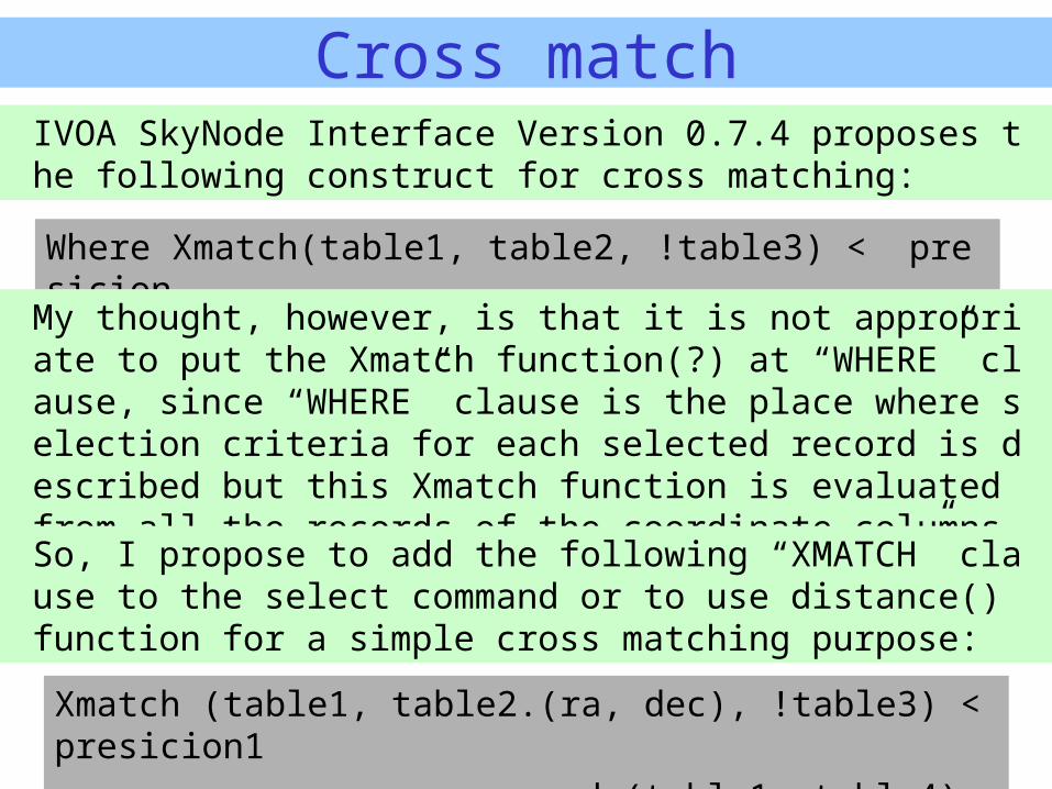
Cross match
Xmatch (table1, table2.(ra, dec), !table3) < presicion1 and (table1, table4) < precision2
Where Xmatch(table1, table2, !table3) < presicion
IVOA SkyNode Interface Version 0.7.4 proposes the following construct for cross matching:
My thought, however, is that it is not appropriate to put the Xmatch function(?) at “WHERE” clause, since “WHERE” clause is the place where selection criteria for each selected record is described but this Xmatch function is evaluated from all the records of the coordinate columns.
So, I propose to add the following “XMATCH” clause to the select command or to use distance() function for a simple cross matching purpose:

Examples of Usage
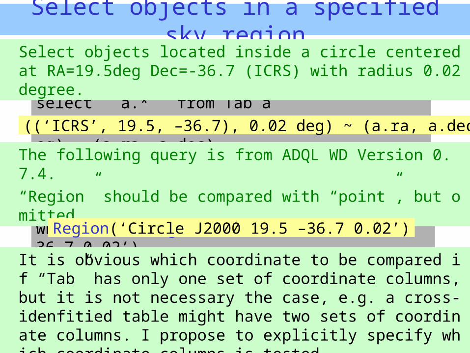
Select objects in a specified sky region
select a.* from Tab a where Region(‘Circle J2000 19.5 –36.7 0.02’)
select a.* from Tab a where ((‘ICRS’, 19.5, –36.7), 0.02 deg) ~ (a.ra, a.dec)
The following query is from ADQL WD Version 0.7.4.“Region” should be compared with “point”, but omitted....
It is obvious which coordinate to be compared if “Tab” has only one set of coordinate columns, but it is not necessary the case, e.g. a cross-idenfitied table might have two sets of coordinate columns. I propose to explicitly specify which coordinate columns is tested.
Select objects located inside a circle centered at RA=19.5deg Dec=-36.7 (ICRS) with radius 0.02 degree.
((‘ICRS’, 19.5, –36.7), 0.02 deg) ~ (a.ra, a.dec)
Region(‘Circle J2000 19.5 –36.7 0.02’)
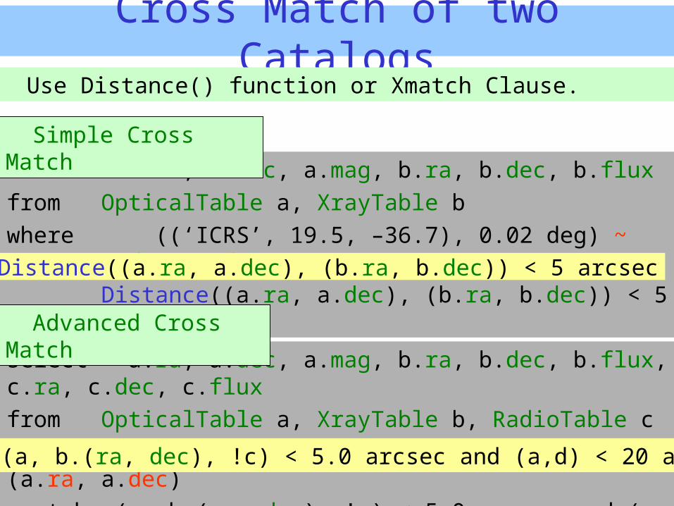
Cross Match of two Catalogs
select a.ra, a.dec, a.mag, b.ra, b.dec, b.fluxfrom OpticalTable a, XrayTable bwhere ((‘ICRS’, 19.5, –36.7), 0.02 deg) ~ (a.ra, a.dec) and
Distance((a.ra, a.dec), (b.ra, b.dec)) < 5 arcsec
Use Distance() function or Xmatch Clause.
Distance((a.ra, a.dec), (b.ra, b.dec)) < 5 arcsec
select a.ra, a.dec, a.mag, b.ra, b.dec, b.flux, c.ra, c.dec, c.fluxfrom OpticalTable a, XrayTable b, RadioTable cwhere ((‘ICRS’, 19.5, –36.7), 0.02 deg) ~ (a.ra, a.dec)xmatch (a, b.(ra, dec), !c) < 5.0 arcsec and (a,d) < 20 arcsecxmatch (a, b.(ra, dec), !c) < 5.0 arcsec and (a,d) < 20 arcsec
Simple Cross Match
Advanced Cross Match
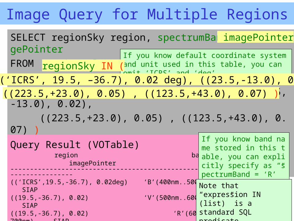
Image Query for Multiple RegionsSELECT regionSky region, spectrumBand band, imagePointer FROM virtualImageWHERE regionSky IN (
((‘ICRS’, 19.5, –36.7), 0.02 deg), ((23.5,-13.0), 0.02), ((223.5,+23.0), 0.05) , ((123.5,+43.0), 0.07) )
and (100 nm .. 1000 nm) ~ spectrumBand and obsDate = [‘2002-03-23’ .. ’2004-05-18’]
Query Result (VOTable) region band imagePointer-------------------------------------------------------------------((‘ICRS’,19.5,-36.7), 0.02deg) ‘B’(400nm..500nm) SIAP((19.5,-36.7), 0.02) ‘V’(500nm..600nm) SIAP((19.5,-36.7), 0.02) ‘R’(600nm.700nm) SIAP((23.5,-13.0), 0.02) ‘R’ SIAP((223.5,+23.0), 0.05) ‘R’ SIAP((123.5,+43.0), 0.07) ‘R’ SIAP
If you know default coordinate system and unit used in this table, you can omit ‘ICRS’ and ‘deg’
If you know band name stored in this table, you can explicitly specify as “spectrumBand = ‘R’”
Note that “expression IN (list)” is a standard SQL predicate.
regionSky IN (((‘ICRS’, 19.5, –36.7), 0.02 deg), ((23.5,-13.0), 0.02),
((223.5,+23.0), 0.05) , ((123.5,+43.0), 0.07) )
imagePointer
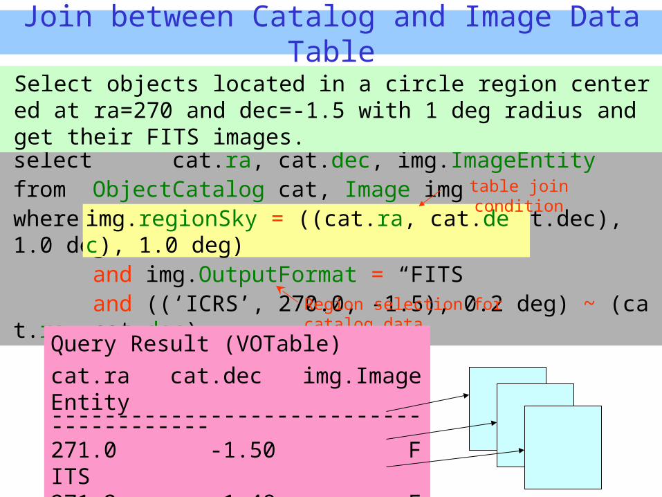
Join between Catalog and Image Data Table
select cat.ra, cat.dec, img.ImageEntityfrom ObjectCatalog cat, Image imgwhere img.regionSky = ((cat.ra, cat.dec), 1.0 deg)
and img.OutputFormat = “FITS” and ((‘ICRS’, 270.0, -1.5), 0.2 deg) ~ (cat.ra, cat.dec)
Region selection for catalog data
Query Result (VOTable) cat.ra cat.dec img.ImageEntity----------------------------------------271.0 -1.50 FITS271.2 -1.48 FITS270.0 -1.51 FITS
img.regionSky = ((cat.ra, cat.dec), 1.0 deg)table join condition
Select objects located in a circle region centered at ra=270 and dec=-1.5 with 1 deg radius and get their FITS images.
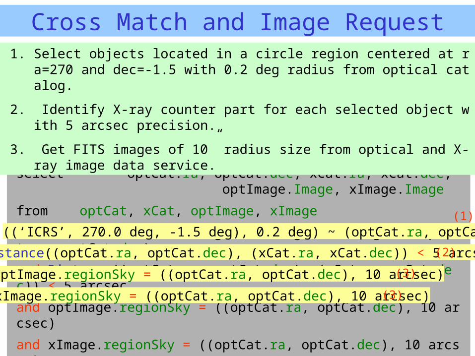
Cross Match and Image Request
select optCat.ra, optCat.dec, xCat.ra, xCat.dec, optImage.Image, xImage.Image
from optCat, xCat, optImage, xImage
where ((‘ICRS’, 270.0 deg, -1.5 deg), 0.2 deg) ~ (optCat.ra, optCat.dec)
and Distance((optCat.ra, optCat.dec), (xCat.ra, xCat.dec)) < 5 arcsec
and optImage.regionSky = ((optCat.ra, optCat.dec), 10 arcsec)
and xImage.regionSky = ((optCat.ra, optCat.dec), 10 arcsec)
and optImage.FORMAT = “FITS”
and xImage.FORMAT = “FITS”
1. Select objects located in a circle region centered at ra=270 and dec=-1.5 with 0.2 deg radius from optical catalog.
2. Identify X-ray counter part for each selected object with 5 arcsec precision.
3. Get FITS images of 10” radius size from optical and X-ray image data service.
((‘ICRS’, 270.0 deg, -1.5 deg), 0.2 deg) ~ (optCat.ra, optCat.dec)
Distance((optCat.ra, optCat.dec), (xCat.ra, xCat.dec)) < 5 arcsec
optImage.regionSky = ((optCat.ra, optCat.dec), 10 arcsec)
xImage.regionSky = ((optCat.ra, optCat.dec), 10 arcsec)
(1)
(2)
(3)
(3)
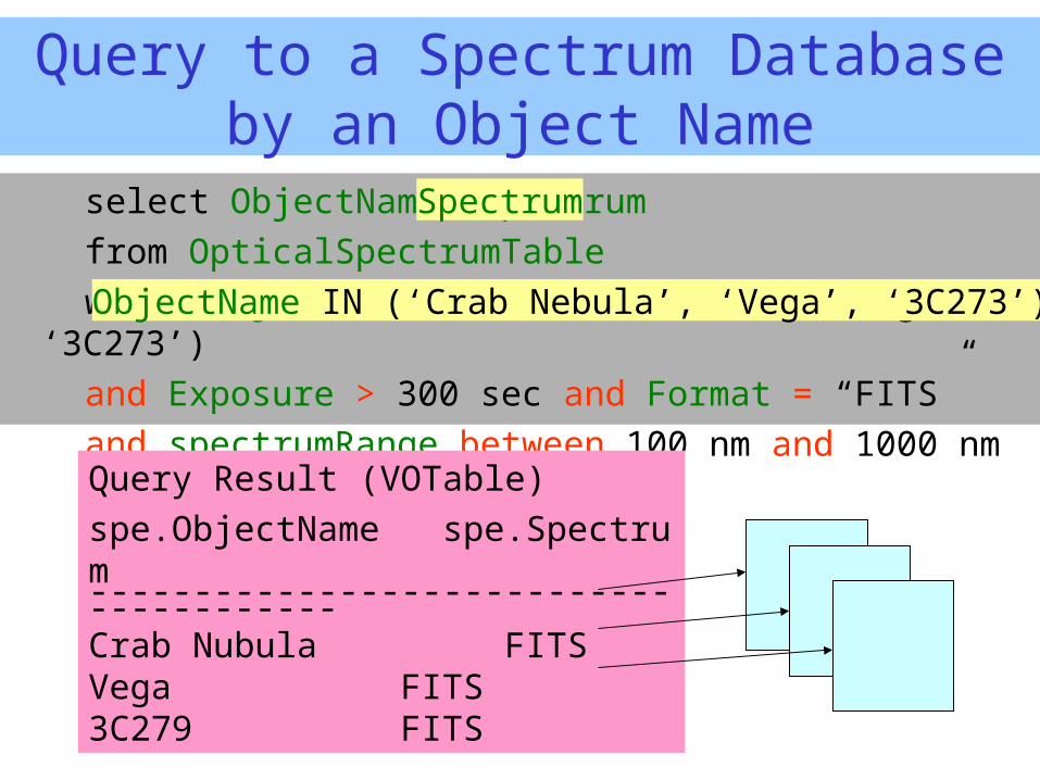
Query to a Spectrum Database by an Object Name
select ObjectName, Spectrumfrom OpticalSpectrumTablewhere ObjectName IN (‘Crab Nebula’, ‘Vega’, ‘3C273’)and Exposure > 300 sec and Format = “FITS”and spectrumRange between 100 nm and 1000 nm
Query Result (VOTable) spe.ObjectName spe.Spectrum----------------------------------------Crab Nubula FITSVega FITS 3C279 FITS
ObjectName IN (‘Crab Nebula’, ‘Vega’, ‘3C273’)
Spectrum
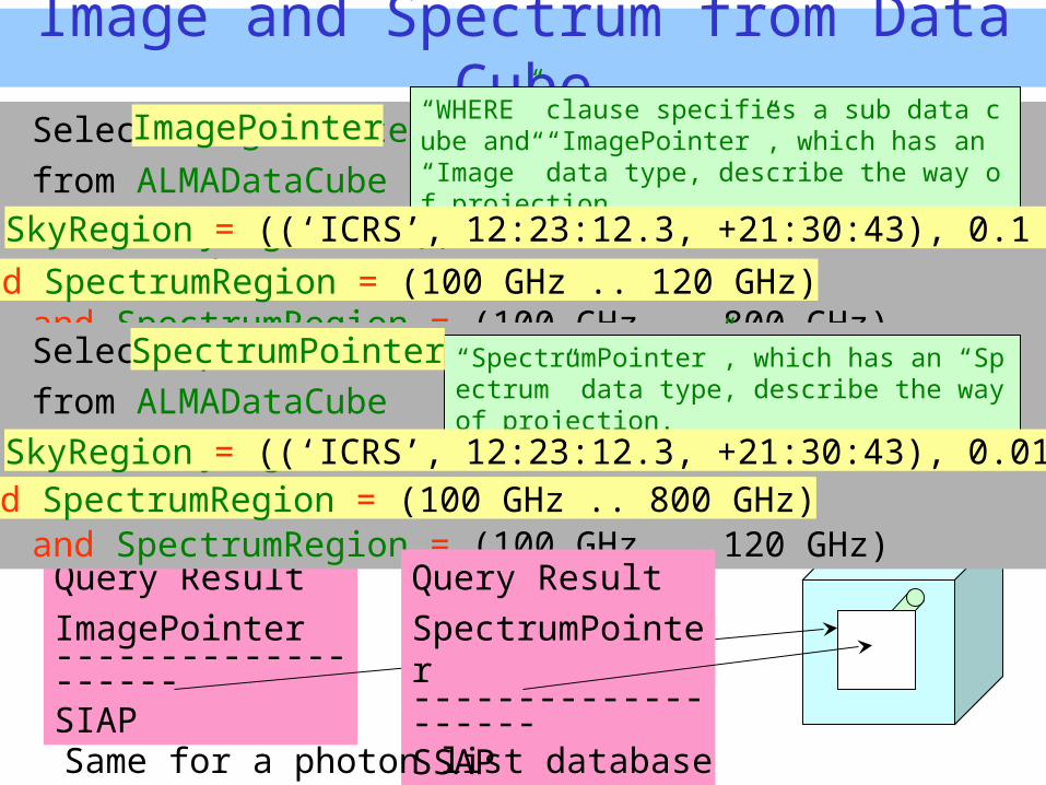
Image and Spectrum from Data Cube
Select ImagePointerfrom ALMADataCubewhere SkyRegion = ((‘ICRS’, 12:23:12.3, +21:30:43), 0.1 deg)and SpectrumRegion = (100 GHz .. 800 GHz)
Query ResultImagePointer--------------------SIAP
Select SpectrumPointerfrom ALMADataCube where SkyRegion = ((‘ICRS’, 12:23:12.3, +21:30:43), 0.01 deg)and SpectrumRegion = (100 GHz .. 120 GHz)
Query ResultSpectrumPointer--------------------SSAP
“WHERE” clause specifies a sub data cube and “ImagePointer”, which has an “Image” data type, describe the way of projection.
Same for a photon list database
“SpectrumPointer”, which has an “Spectrum” data type, describe the way of projection.
SkyRegion = ((‘ICRS’, 12:23:12.3, +21:30:43), 0.1 deg)and SpectrumRegion = (100 GHz .. 120 GHz)
SkyRegion = ((‘ICRS’, 12:23:12.3, +21:30:43), 0.01 deg)and SpectrumRegion = (100 GHz .. 800 GHz)
ImagePointer
SpectrumPointer
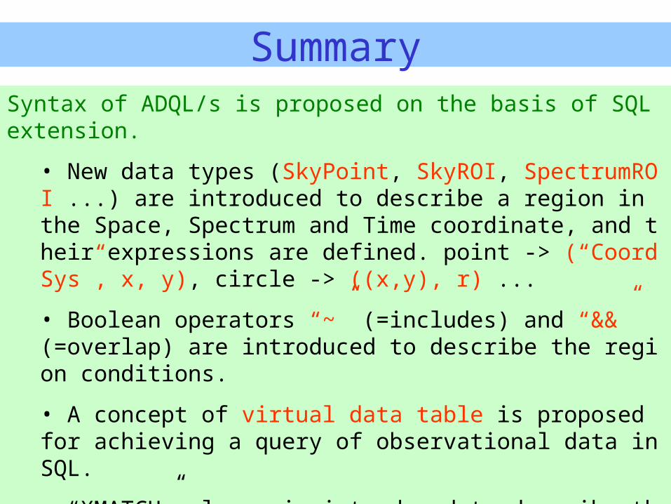
SummarySyntax of ADQL/s is proposed on the basis of SQL extension.
• New data types (SkyPoint, SkyROI, SpectrumROI ...) are introduced to describe a region in the Space, Spectrum and Time coordinate, and their expressions are defined. point -> (“CoordSys”, x, y), circle -> ((x,y), r) ...
• Boolean operators “~” (=includes) and “&&” (=overlap) are introduced to describe the region conditions.
• A concept of virtual data table is proposed for achieving a query of observational data in SQL.
• “XMATCH” clause is introduced to describe the cross match conditions.
XMatch (table1(ra, dec), table2, !table3) < precision
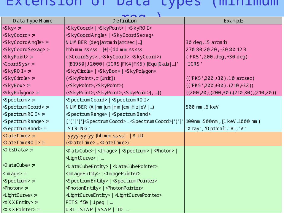
Extension of Data types (minimum req.)Data Type Name Defi nition Example
<Sky> := <SkyCoord> | <SkyPoint> | <SkyROI >
<SkyCoord> := <SkyCoordAngle> | <SkyCoordSexag>
<SkyCoordAngle> := NUMBER [deg|arcmin|arcsec|...] 30 deg, 15 arcmin
<SkyCoordSexag> := hhh:mm:ss.sss | [+|-]dd:mm:ss.sss 270:30:20.20, -30:00:12.3
<SkyPoint> := ([<CoordSys>], <SkyCoord>, <SkyCoord>) (' FK5' , 200. deg, +30 deg)
<CoordSys> := ' [B1950|J 2000] (I CRS|FK4|FK5) [Equ|Gala|...]' ' I CRS'
<SkyROI > := <SkyCircle> | <SkyBox> | <SkyPolygon>
<SkyCircle> := (<SkyPoint>, r [unit]) ((' FK5' ,200,+30), 1.0 arcsec)
<SkyBox> := (<SkyPoint>, <SkyPoint>) ((' FK5' ,200,+30), (210,+32))
<SkyPolygon> := (<SkyPoint>, <SkyPoint>, <SkyPoint>[, ...]) ((200,20),(200,30),(210,30),(210,20))
<Spectrum> := <SpectrumCoord> | <SpectrumROI >
<SpectrumCoord> := NUMBER (A|nm|um|mm|cm|Hz|eV|...) 500 nm, 6 keV
<SpectrumROI > := <SpectrumRange> | <SpectrumBand>
<SpectrumRange> := [' (' |' [' ]<SpectrumCoord> .. <SpectrumCoord>[' )' |' ]' ]100nm..500nm, [1 keV..1000 nm)
<SepctrumBand> := ' STRI NG' 'Xray' , 'Optical' , ' B' , ' V'
<DateTime> := 'yyyy-yy-yy [hh:mm:ss.ss]' | MJ D<DateTimeROI > := (<DateTime> .. <DateTime>)
<ObsData> := <DataCube> | <I mage> | <Spectrum> | <Photon> |
<LightCurve> | ...
<DataCube> := <DataCubeEntity> | <DataCubePointer>
<I mage> := <I mageEntity> | <I magePointer>
<Spectrum> := <SpectrumEntity> | <SpectrumPointer>
<Photon> := <PhotonEntity> | <PhotonPointer>
<LightCurve> := <LightCurveEntity> | <LightCurvePointer>
<XXXEntity> := FI TS fi le | J peg | ...
<XXXPointer> := URL | SI AP | SSAP | I D ...
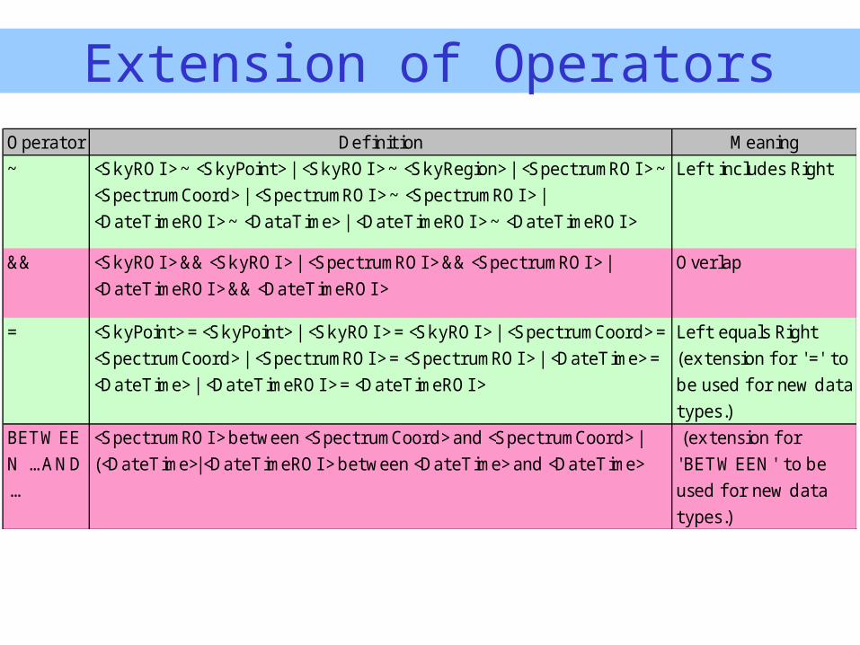
Operator Defi nition Meaning
~ <SkyROI > ~ <SkyPoint> | <SkyROI > ~ <SkyRegion> | <SpectrumROI > ~
<SpectrumCoord> | <SpectrumROI > ~ <SpectrumROI > |
<DateTimeROI > ~ <DataTime> | <DateTimeROI > ~ <DateTimeROI >
Lef t includes Right
&& <SkyROI > && <SkyROI > | <SpectrumROI > && <SpectrumROI > |
<DateTimeROI > && <DateTimeROI >
Overlap
= <SkyPoint> = <SkyPoint> | <SkyROI > = <SkyROI > | <SpectrumCoord> =
<SpectrumCoord> | <SpectrumROI > = <SpectrumROI > | <DateTime> =
<DateTime> | <DateTimeROI > = <DateTimeROI >
Lef t equals Right
(extension f or '=' to
be used f or new data
types.)
BETWEE
N ... AND
...
<SpectrumROI > between <SpectrumCoord> and <SpectrumCoord> |
(<DateTime>|<DateTimeROI > between <DateTime> and <DateTime>
(extension f or
'BETWEEN' to be
used f or new data
types.)
Extension of Operators
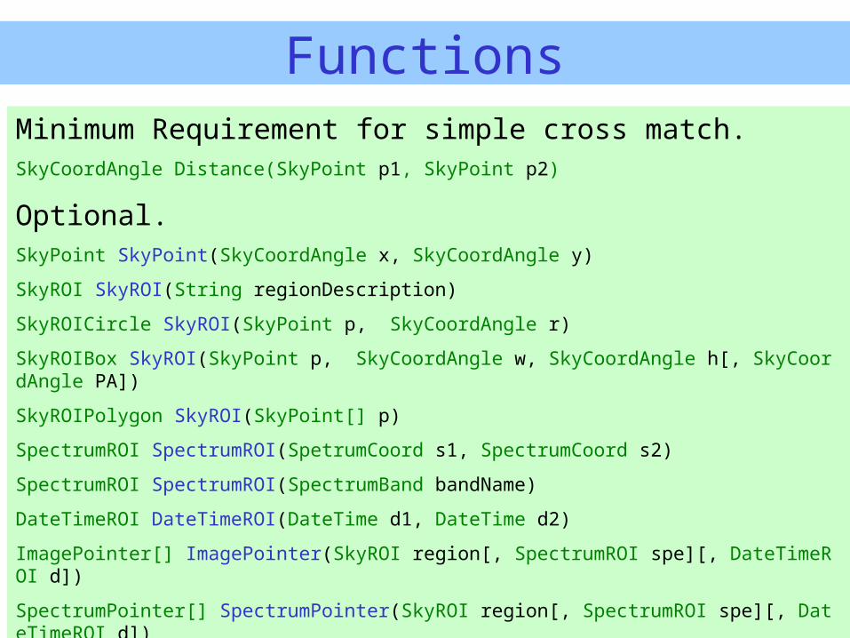
FunctionsMinimum Requirement for simple cross match.SkyCoordAngle Distance(SkyPoint p1, SkyPoint p2)
Optional.SkyPoint SkyPoint(SkyCoordAngle x, SkyCoordAngle y)
SkyROI SkyROI(String regionDescription)
SkyROICircle SkyROI(SkyPoint p, SkyCoordAngle r)
SkyROIBox SkyROI(SkyPoint p, SkyCoordAngle w, SkyCoordAngle h[, SkyCoordAngle PA])
SkyROIPolygon SkyROI(SkyPoint[] p)
SpectrumROI SpectrumROI(SpetrumCoord s1, SpectrumCoord s2)
SpectrumROI SpectrumROI(SpectrumBand bandName)
DateTimeROI DateTimeROI(DateTime d1, DateTime d2)
ImagePointer[] ImagePointer(SkyROI region[, SpectrumROI spe][, DateTimeROI d])
SpectrumPointer[] SpectrumPointer(SkyROI region[, SpectrumROI spe][, DateTimeROI d])
PhotonPointer[] PhotonPointer(SkyROI region[, SpectrumROI spe][, DateTimeROI d])
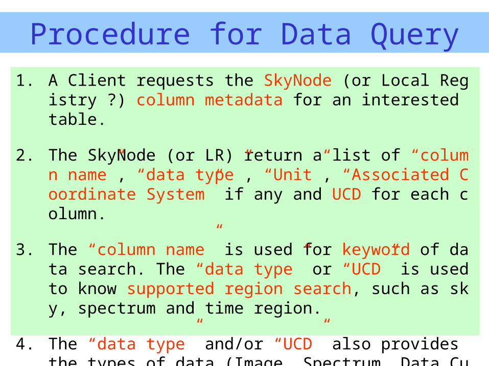
Procedure for Data Query1. A Client requests the SkyNode (or Local Registry ?) column
metadata for an interested table.
2. The SkyNode (or LR) return a list of “column name”, “data type”, “Unit”, “Associated Coordinate System” if any and UCD for each column.
3. The “column name” is used for keyword of data search. The “data type” or “UCD” is used to know supported region search, such as sky, spectrum and time region.
4. The “data type” and/or “UCD” also provides the types of data (Image, Spectrum, Data Cube, Photon List, ...) searchable with this table.