Embed Size (px)
Citation preview

Working with
OpenStreetMap in ArcGIS
Innovation. Information. Interaction.
Developer Hub
ESRI (UK) Ltd Millennium House 65 Walton Street Aylesbury Buckinghamshire HP21 7QGT 01296 745500 F 01296 745544 E [email protected] www.esriuk.com
© 2006 – 2010 ESRI (UK) Ltd and its third party licensors. All rights reserved. The ESRI globe and ESRI products, services and trademarks mentioned are trademarks of Environmental Systems Research Institute, Inc. Other companies and products mentioned herein are the property of their respective trademark owners.
January 2010
Additional notes■ OSM is created and maintained by the user community, its level of content is not
homogeneous. There are areas where information is scant at best. So it cannot
be assumed that the rich content available for urbanised areas such as London,
Cambridge, Oxford and other similar metropolis would be also found in rural,
isolated areas.
■ When using the OSM data is needs to be credited. Guidance notes on this can
be found at http://wiki.openstreetmap.org/wiki/Legal_FAQ and at http://www.
opengeodata.org/2008/01/07/the-licence-where-we-are-where-were-going/
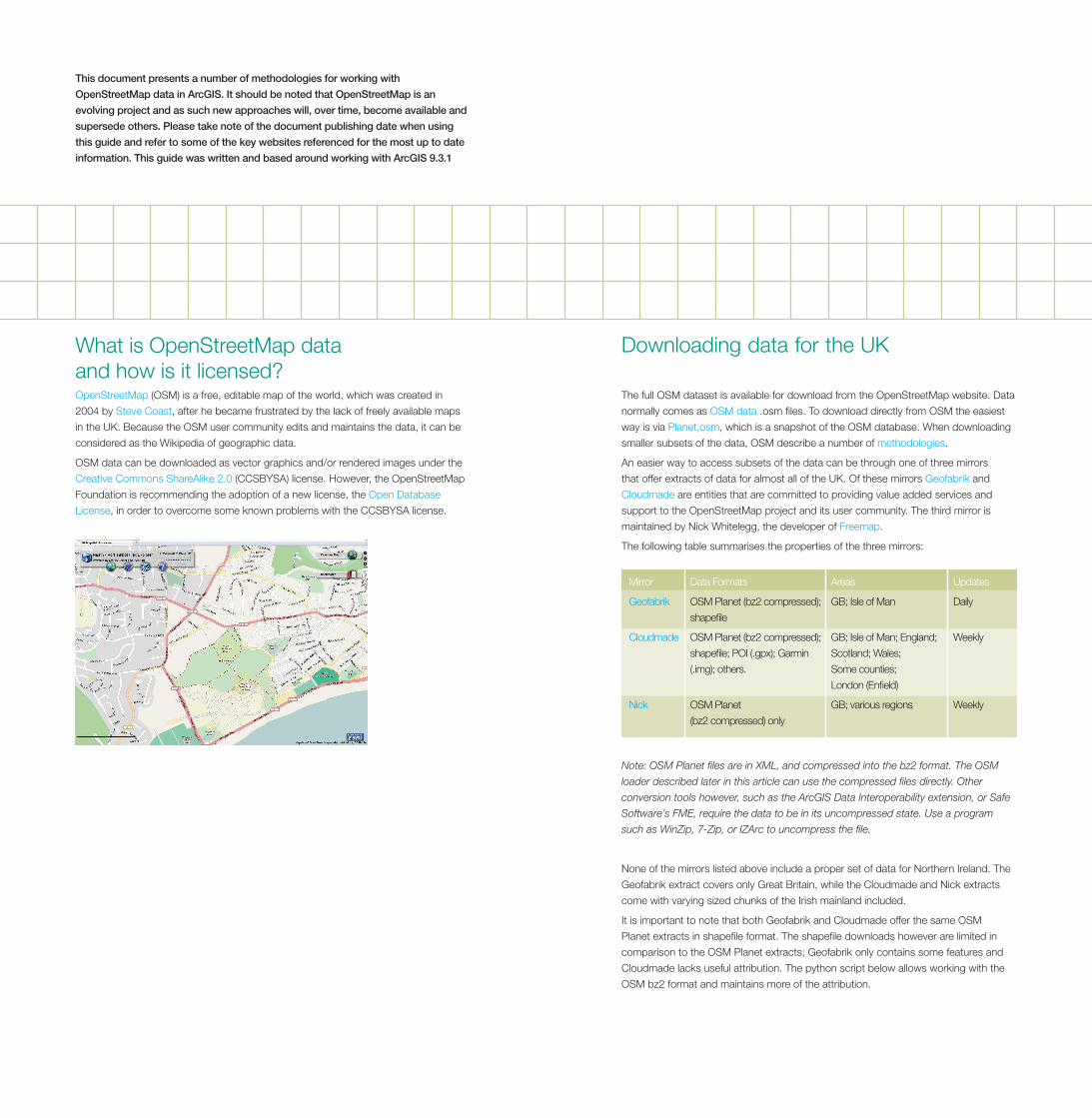
Downloading data for the UK
The full OSM dataset is available for download from the OpenStreetMap website. Data
normally comes as OSM data .osm files. To download directly from OSM the easiest
way is via Planet.osm, which is a snapshot of the OSM database. When downloading
smaller subsets of the data, OSM describe a number of methodologies.
An easier way to access subsets of the data can be through one of three mirrors
that offer extracts of data for almost all of the UK. Of these mirrors Geofabrik and
Cloudmade are entities that are committed to providing value added services and
support to the OpenStreetMap project and its user community. The third mirror is
maintained by Nick Whitelegg, the developer of Freemap.
The following table summarises the properties of the three mirrors:
What is OpenStreetMap data and how is it licensed?OpenStreetMap (OSM) is a free, editable map of the world, which was created in
2004 by Steve Coast, after he became frustrated by the lack of freely available maps
in the UK. Because the OSM user community edits and maintains the data, it can be
considered as the Wikipedia of geographic data.
OSM data can be downloaded as vector graphics and/or rendered images under the
Creative Commons ShareAlike 2.0 (CCSBYSA) license. However, the OpenStreetMap
Foundation is recommending the adoption of a new license, the Open Database
License, in order to overcome some known problems with the CCSBYSA license.
Mirror Data Formats Areas Updates
Geofabrik OSM Planet (bz2 compressed); GB; Isle of Man Daily
shapefile
Cloudmade OSM Planet (bz2 compressed); GB; Isle of Man; England; Weekly
shapefile; POI (.gpx); Garmin Scotland; Wales;
(.img); others. Some counties;
London (Enfield)
Nick OSM Planet GB; various regions Weekly
(bz2 compressed) only
Note: OSM Planet files are in XML, and compressed into the bz2 format. The OSM
loader described later in this article can use the compressed files directly. Other
conversion tools however, such as the ArcGIS Data Interoperability extension, or Safe
Software’s FME, require the data to be in its uncompressed state. Use a program
such as WinZip, 7-Zip, or IZArc to uncompress the file.
None of the mirrors listed above include a proper set of data for Northern Ireland. The
Geofabrik extract covers only Great Britain, while the Cloudmade and Nick extracts
come with varying sized chunks of the Irish mainland included.
It is important to note that both Geofabrik and Cloudmade offer the same OSM
Planet extracts in shapefile format. The shapefile downloads however are limited in
comparison to the OSM Planet extracts; Geofabrik only contains some features and
Cloudmade lacks useful attribution. The python script below allows working with the
OSM bz2 format and maintains more of the attribution.
This document presents a number of methodologies for working with
OpenStreetMap data in ArcGIS. It should be noted that OpenStreetMap is an
evolving project and as such new approaches will, over time, become available and
supersede others. Please take note of the document publishing date when using
this guide and refer to some of the key websites referenced for the most up to date
information. This guide was written and based around working with ArcGIS 9.3.1
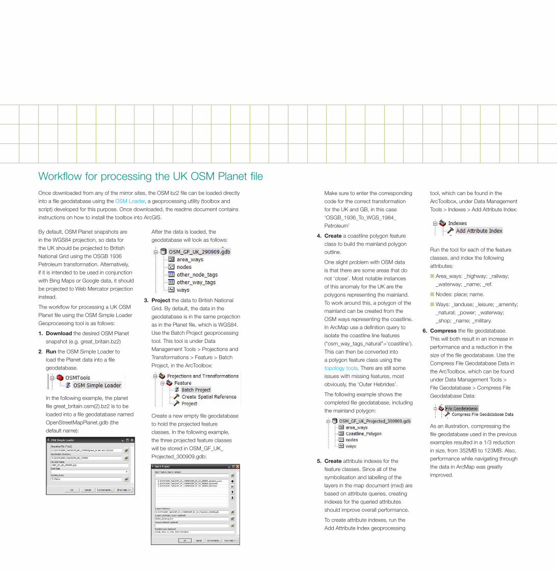
By default, OSM Planet snapshots are
in the WGS84 projection, so data for
the UK should be projected to British
National Grid using the OSGB 1936
Petroleum transformation. Alternatively,
if it is intended to be used in conjunction
with Bing Maps or Google data, it should
be projected to Web Mercator projection
instead.
The workflow for processing a UK OSM
Planet file using the OSM Simple Loader
Geoprocessing tool is as follows:
1. Download the desired OSM Planet
snapshot (e.g. great_britain.bz2)
2. Run the OSM Simple Loader to
load the Planet data into a file
geodatabase.
In the following example, the planet
file great_britain.osm(2).bz2 is to be
loaded into a file geodatabase named
OpenStreetMapPlanet.gdb (the
default name):
After the data is loaded, the
geodatabase will look as follows:
3. �Project the data to British National
Grid. By default, the data in the
geodatabase is in the same projection
as in the Planet file, which is WGS84.
Use the Batch Project geoprocessing
tool. This tool is under Data
Management Tools > Projections and
Transformations > Feature > Batch
Project, in the ArcToolbox:
Create a new empty file geodatabase
to hold the projected feature
classes. In the following example,
the three projected feature classes
will be stored in OSM_GF_UK_
Projected_300909.gdb:
Workflow for processing the UK OSM Planet fileOnce downloaded from any of the mirror sites, the OSM bz2 file can be loaded directly
into a file geodatabase using the OSM Loader, a geoprocessing utility (toolbox and
script) developed for this purpose. Once downloaded, the readme document contains
instructions on how to install the toolbox into ArcGIS.
Make sure to enter the corresponding
code for the correct transformation
for the UK and GB, in this case
‘OSGB_1936_To_WGS_1984_
Petroleum’
4. �Create a coastline polygon feature
class to build the mainland polygon
outline.
One slight problem with OSM data
is that there are some areas that do
not ‘close’. Most notable instances
of this anomaly for the UK are the
polygons representing the mainland.
To work around this, a polygon of the
mainland can be created from the
OSM ways representing the coastline.
In ArcMap use a definition query to
isolate the coastline line features
(“osm_way_tags_natural”=’coastline’).
This can then be converted into
a polygon feature class using the
topology tools. There are still some
issues with missing features, most
obviously, the ‘Outer Hebrides’.
The following example shows the
completed file geodatabase, including
the mainland polygon:
5. �Create attribute indexes for the
feature classes. Since all of the
symbolisation and labelling of the
layers in the map document (mxd) are
based on attribute queries, creating
indexes for the queried attributes
should improve overall performance.
To create attribute indexes, run the
Add Attribute Index geoprocessing
tool, which can be found in the
ArcToolbox, under Data Management
Tools > Indexes > Add Attribute Index:
Run the tool for each of the feature
classes, and index the following
attributes:
■ Area_ways: _highway; _railway;
_waterway; _name; _ref.
■ Nodes: place; name.
■ Ways: _landuse; _leisure; _amenity;
_natural; _power; _waterway;
_shop; _name; _military.
6. �Compress the file geodatabase.
This will both result in an increase in
performance and a reduction in the
size of the file geodatabase. Use the
Compress File Geodatabase Data in
the ArcToolbox, which can be found
under Data Management Tools >
File Geodatabase > Compress File
Geodatabase Data:
As an illustration, compressing the
file geodatabase used in the previous
examples resulted in a 1/3 reduction
in size, from 352MB to 123MB. Also,
performance while navigating through
the data in ArcMap was greatly
improved.
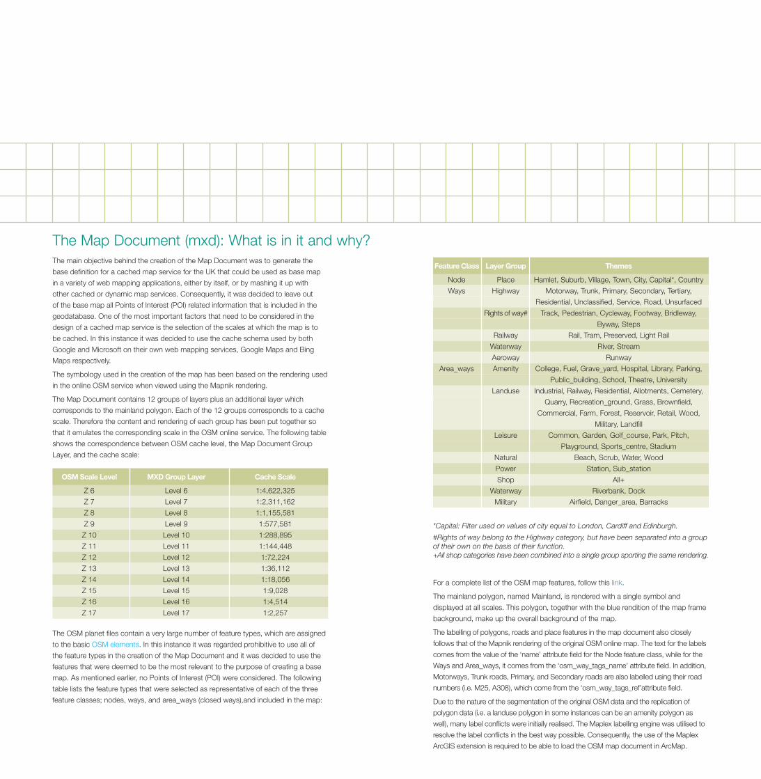
*Capital: Filter used on values of city equal to London, Cardiff and Edinburgh.
#Rights of way belong to the Highway category, but have been separated into a group of their own on the basis of their function. +All shop categories have been combined into a single group sporting the same rendering.
For a complete list of the OSM map features, follow this link.
The mainland polygon, named Mainland, is rendered with a single symbol and
displayed at all scales. This polygon, together with the blue rendition of the map frame
background, make up the overall background of the map.
The labelling of polygons, roads and place features in the map document also closely
follows that of the Mapnik rendering of the original OSM online map. The text for the labels
comes from the value of the ‘name’ attribute field for the Node feature class, while for the
Ways and Area_ways, it comes from the ‘osm_way_tags_name’ attribute field. In addition,
Motorways, Trunk roads, Primary, and Secondary roads are also labelled using their road
numbers (i.e. M25, A308), which come from the ‘osm_way_tags_ref’attribute field.
Due to the nature of the segmentation of the original OSM data and the replication of
polygon data (i.e. a landuse polygon in some instances can be an amenity polygon as
well), many label conflicts were initially realised. The Maplex labelling engine was utilised to
resolve the label conflicts in the best way possible. Consequently, the use of the Maplex
ArcGIS extension is required to be able to load the OSM map document in ArcMap.
The Map Document (mxd): What is in it and why?The main objective behind the creation of the Map Document was to generate the
base definition for a cached map service for the UK that could be used as base map
in a variety of web mapping applications, either by itself, or by mashing it up with
other cached or dynamic map services. Consequently, it was decided to leave out
of the base map all Points of Interest (POI) related information that is included in the
geodatabase. One of the most important factors that need to be considered in the
design of a cached map service is the selection of the scales at which the map is to
be cached. In this instance it was decided to use the cache schema used by both
Google and Microsoft on their own web mapping services, Google Maps and Bing
Maps respectively.
The symbology used in the creation of the map has been based on the rendering used
in the online OSM service when viewed using the Mapnik rendering.
The Map Document contains 12 groups of layers plus an additional layer which
corresponds to the mainland polygon. Each of the 12 groups corresponds to a cache
scale. Therefore the content and rendering of each group has been put together so
that it emulates the corresponding scale in the OSM online service. The following table
shows the correspondence between OSM cache level, the Map Document Group
Layer, and the cache scale:
The OSM planet files contain a very large number of feature types, which are assigned
to the basic OSM elements. In this instance it was regarded prohibitive to use all of
the feature types in the creation of the Map Document and it was decided to use the
features that were deemed to be the most relevant to the purpose of creating a base
map. As mentioned earlier, no Points of Interest (POI) were considered. The following
table lists the feature types that were selected as representative of each of the three
feature classes; nodes, ways, and area_ways (closed ways),and included in the map:
� OSM�Scale�Level� MXD�Group�Layer� Cache�Scale
Z 6 Level 6 1:4,622,325
Z 7 Level 7 1:2,311,162
Z 8 Level 8 1:1,155,581
Z 9 Level 9 1:577,581
Z 10 Level 10 1:288,895
Z 11 Level 11 1:144,448
Z 12 Level 12 1:72,224
Z 13 Level 13 1:36,112
Z 14 Level 14 1:18,056
Z 15 Level 15 1:9,028
Z 16 Level 16 1:4,514
Z 17 Level 17 1:2,257
�Feature�Class� Layer�Group� Themes
Node Place Hamlet, Suburb, Village, Town, City, Capital*, Country
Ways Highway Motorway, Trunk, Primary, Secondary, Tertiary,
Residential, Unclassified, Service, Road, Unsurfaced
Rights of way# Track, Pedestrian, Cycleway, Footway, Bridleway,
Byway, Steps
Railway Rail, Tram, Preserved, Light Rail
Waterway River, Stream
Aeroway Runway
Area_ways Amenity College, Fuel, Grave_yard, Hospital, Library, Parking,
Public_building, School, Theatre, University
Landuse Industrial, Railway, Residential, Allotments, Cemetery,
Quarry, Recreation_ground, Grass, Brownfield,
Commercial, Farm, Forest, Reservoir, Retail, Wood,
Military, Landfill
Leisure Common, Garden, Golf_course, Park, Pitch,
Playground, Sports_centre, Stadium
Natural Beach, Scrub, Water, Wood
Power Station, Sub_station
Shop All+
Waterway Riverbank, Dock
Military Airfield, Danger_area, Barracks
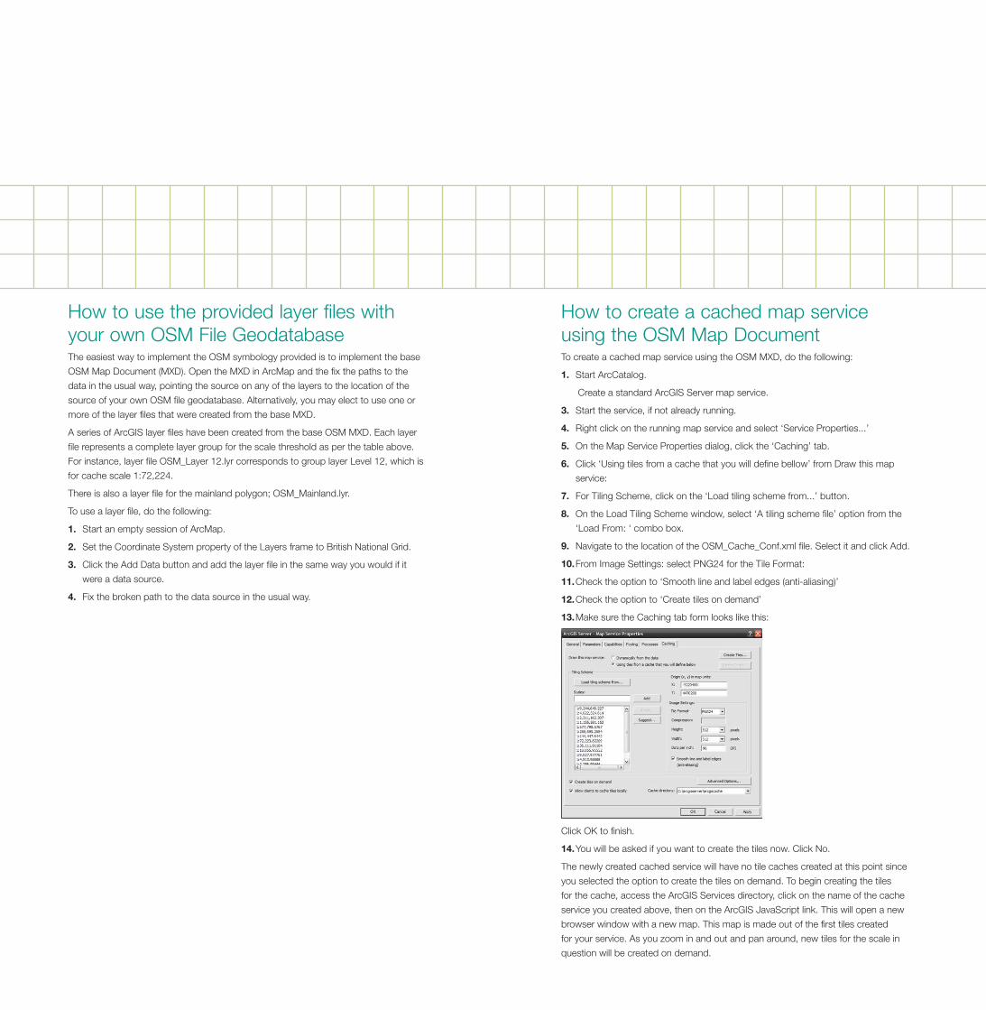
To create a cached map service using the OSM MXD, do the following:
1.� Start ArcCatalog.
Create a standard ArcGIS Server map service.
3.� Start the service, if not already running.
4.� Right click on the running map service and select ‘Service Properties...’
5.� On the Map Service Properties dialog, click the ‘Caching’ tab.
6.� Click ‘Using tiles from a cache that you will define bellow’ from Draw this map
service:
7.� For Tiling Scheme, click on the ‘Load tiling scheme from...’ button.
8.� �On the Load Tiling Scheme window, select ‘A tiling scheme file’ option from the
‘Load From: ‘ combo box.
9.� Navigate to the location of the OSM_Cache_Conf.xml file. Select it and click Add.
10.�From Image Settings: select PNG24 for the Tile Format:
11.�Check the option to ‘Smooth line and label edges (anti-aliasing)’
12.�Check the option to ‘Create tiles on demand’
13.�Make sure the Caching tab form looks like this:
Click OK to finish.
14.�You will be asked if you want to create the tiles now. Click No.
The newly created cached service will have no tile caches created at this point since
you selected the option to create the tiles on demand. To begin creating the tiles
for the cache, access the ArcGIS Services directory, click on the name of the cache
service you created above, then on the ArcGIS JavaScript link. This will open a new
browser window with a new map. This map is made out of the first tiles created
for your service. As you zoom in and out and pan around, new tiles for the scale in
question will be created on demand.
How to use the provided layer files with your own OSM File GeodatabaseThe easiest way to implement the OSM symbology provided is to implement the base
OSM Map Document (MXD). Open the MXD in ArcMap and the fix the paths to the
data in the usual way, pointing the source on any of the layers to the location of the
source of your own OSM file geodatabase. Alternatively, you may elect to use one or
more of the layer files that were created from the base MXD.
A series of ArcGIS layer files have been created from the base OSM MXD. Each layer
file represents a complete layer group for the scale threshold as per the table above.
For instance, layer file OSM_Layer 12.lyr corresponds to group layer Level 12, which is
for cache scale 1:72,224.
There is also a layer file for the mainland polygon; OSM_Mainland.lyr.
To use a layer file, do the following:
1. Start an empty session of ArcMap.
2. Set the Coordinate System property of the Layers frame to British National Grid.
3. Click the Add Data button and add the layer file in the same way you would if it
were a data source.
4. Fix the broken path to the data source in the usual way.
How to create a cached map service using the OSM Map Document