Embed Size (px)
Citation preview

JAMSTEC Report of Research and Development, Volume 4, November 2006, 13– 26
13
Active source seismic studies across/along across-arc seamount chains in Izu-Bonin arc- Cruise report of KR0601 and KR0605 -
Shuichi Kodaira1, Gou Fujie1, Mikiya Yamashita1, Seiich Miura1, Narumi Takahashi1 andYoshiyuki Kaneda1
Abstract In order to investigate formation processes of the across-arc sea mount chains in the Izu-Bonin arc, we have carried
out two active source seismic cruises by using JAMSTEC R/V Kairei in 2006. The wide-angle seismic data were acquired
across the across-arc seamount chains (Nishi-shichito ridge) in KR0605 and along the across-arc seamount chain (Minami-
Iojima ridge) in KR0601. In addition to those two wide-angle profiles, multichannel seismic data were also acquired along two
profiles which are parallel to the strike of the across arc seamount chains. The wide-angle seismic data indicate thinning of crust
toward the south across the Nishi-shichito ridge, and relatively flat and thin crust beneath the Minami-Ioujima ridge. The multi-
channel data show that the basement of the Shikoku basin can be traced beneath the western flank of the across-arc seamount
chain. This suggest that a boundary between the Shikoku basin crust and the Oligocene Izu arc may be situated around the east-
ern end of the across-arc seamount chains.
Keywords: Crustal structure, active source seismic study, Izu-Bonin, across-arc seamount chains
1. IntroductionThe Izu-Bonin-Mariana (IBM) intra-oceanic arc sys-
tem extends over 2800 km from Sagami Bay in thenorth to Guam in the south, and has long been studied asan excellent example of an intra-oceanic island arc sys-tem. The tectonic history of the IBM arc is well docu-mented in many studies. Here, we briefly summarizethose studies of relevance to ours, following the work ofStern et al. (2003). Estimates of the age of basementrocks of the IBM forearc (Bloomer et al., 1995; Cosca etal., 1998) suggest that initial subsidence of the litho-sphere along the IBM arc began at about 50 Ma.Depleted tholeiites and boninites erupted at the forearcat this stage (Hickey and Frey, 1982; Stern et al., 1991;Taylor et al., 1994). Subsidence of the lithosphereevolved into subduction at about 43 Ma (Eocene) whenthe motion of the Pacific plate changed abruptly from anortherly to a westerly direction (Richards and Lithgow-Bertellone., 1996).
The magmatic arc was close to its present position atthe commencement of subduction (i.e., the distancefrom the magmatic arc to the trench has changed littlesince the formation of the magmatic arc). Single-arcvolcanism continued until rifting started along the
Parece Vela Basin at 30 Ma (Oligocene). At 25 Ma, theShikoku basin started spreading at the northernmost endof the IBM arc and propagated to the south (Kobayashiet al., 1995; Okino et al., 1999). The two rifting systemsmet at 20 Ma, and spreading stopped at about 15 Ma.The Kyushu-Palau Ridge (KPR) was formed at thewestern edge of both basins. At the same time (15 Ma)the development of a subduction zone at the NankaiTrough initiated the collision of the northernmost part ofthe Izu arc with the central Japanese landmass. Back arcrifting along the Mariana Trough started at 10 Ma, andthe consequent seafloor spreading began at 3–4 Ma(Bibee et al., 1980; Yamazaki and Stern, 1997). Intra-arc rifting west of the present-day volcanic front of theIzu arc started at 2 Ma.
In the rear arc side of the Izu-Bonin arc, across-arcseamount chains are observed. Volcanism began alongthe across-arc seamount chains and at adjacent isolatedseamounts at ca. 17 Ma, slightly before the ShikokuBasin ceased spreading, and continued until ca. 3 Ma(Ishizuka et al. 1998; 2003). Volcanism along thesechains occurred sporadically along their total length,although volcanoes in the western part of the chainsceased to erupt earlier than those to the east. Volcanism
1 Institute for Research on Earth Evolution, Japan Agency for Marine-Earth Science and Technology

Active source seismic studies across/along across-arc seamount chains in Izu-Bonin arc - Cruise report of KR0601 and KR0605 -
JAMSTEC Rep. Res. Dev., Volume 4, November 2006, 13– 2614
along the seamount chains ceased at the initiation ofrifting behind the volcanic front at ca. 2.8 Ma (Ishizukaet al. 2002).
Remarkable geochemical variations along the across-arc seamount chains have been observed (e.g.,Hochstaedter et al., 2000). These across-arc variationsimply that: 1) the proportion of slab-derived fluid com-ponent becomes smaller toward the backarc; 2) fluid isthe dominant slab-derived component in the volcanicfront, while sediment melt becomes more significant inthe rear-arc seamounts; 3) heterogeneity exists in themantle wedge prior to the addition of slab-derived com-ponents; 4) decompression melting may predominatetoward the rear-arc whereas flux melting may predomi-nate toward the volcanic front, even without backarcspreading; and 5) felsic magmatism inherits these differ-ences. A more enriched source, in terms of the less-fluid-mobile incompatible elements, is expected tounderlie the across-arc seamount chains. It is unknownwhether these patterns occur uniformly across the arc oronly along the across-arc seamount chains – that is,whether slab-derived components add continental-typecrust only in certain parts of the arc. In order to examineformation mechanism of the across-arc seamount chains
and their geochemical variations, we carried out twoactive source seismic cruises along and across theacross-arc sea mount chains in 2006.
2. Experiments 2.1 KR0601
Wide-angle seismic data were acquired along theMinami-Ioujima ridge, which is located at the southernend of Izu-Bonin arc, by using a seismic system on R/VKairei (Fig. 1). The cruise was from 5th to 27th ofJanuary. We deployed Ocean bottom seismographs(OBS) from 7th to 13th. Air-gun shooting was done from14th to 17th. OBSs were recovered from 17th to 22nd.One OBS (Site 12) was not recovered. Acoustictransponder seemed to work, but due to unknown reasonthis OBS did not released. After recovering the OBS,air-gun shooting test with a flip-flop mode was done.Although we planned to acquired multichannel reflec-tion seismic data in adjacent profiles, those profile havenot been made due to bad sea condition in the beginningof the cruise (Table 1 and 2). This cruise was the firstR/V Kairei’s wide-angle seismic experiment using morethan 100 OBSs.
Figure 1: Profile map of KR0601
Table 2: Profile positions of KR0601
Table 1: Daily log of KR0601 cruise.

S Kodaira et al.,
JAMSTEC Rep. Res. Dev., Volume 4, November 2006, 13– 26 15
Figure 2: Profile map of KR0605
Table 3: Daily log of KR0605
Table 4: Profile positions of KR0605
2.2 KR0605Wide-angle seismic data across the Nishi-shichito
ridge between 27º N and 32º N and multichannel reflec-tion data along two profiles from the Kinan seamountchain to the western edge of the Nishi-shichito ridgewere acquired during this cruise (15 th of May to 6 the ofJune) (Fig. 2, Table 3 and 4). OBSs were deployed from16th to 21st. Air-gun was shot for the OBSs to acquiredthe wide-angle seismic data from 21st to 25th. All OBSswere recovered from 26th to 31st. An acoustic transpon-der mounted on an OBS (Site22) did not respond, but itcame up to sea surface without any reply. The multi-channel reflection data were acquired from 1st to 4th ofJune. Sea condition was very stable during the entireperiod of this cruise. A new type of an acoustic transpon-der (System-Giken) is used in this cruise. It is attached to27 OBSs. The new system, which is directory controlledby the ship-board acoustic system, worked fine except“inactive” command. The “inactive” command to stopreplying seemed to be automatically reset sometime afterthis command was accepted.
3. Seismic systems3.1 Air-gun array
An air-gun array equipped on R/V Kairei was usedfor all profiles during the cruise. Shooting interval was50 m, corresponding 20 – 30 s with accuracy of shottime of 1 ms for acquiring multichannel reflection data,while 200 m for acquiring wide-angle seismic data.Total volume of the air-gun array we used was 12,000cubic inches, which consists of eight Bolt long life air-gun with 1,500 cubic inches each. The standard air pres-sure was 2000 psi (140 MPa). As shown in Fig. 3, twostring of sub-array were deployed at the port and star-board sides of the vessel. Their width was expaned to88.0 m by paravane system and the central position ofthe array was set 197.0 m behind the ship GPS antennaposition.
3.2 Ocean bottom seismographFor recoding the wide-angle seismic data, we
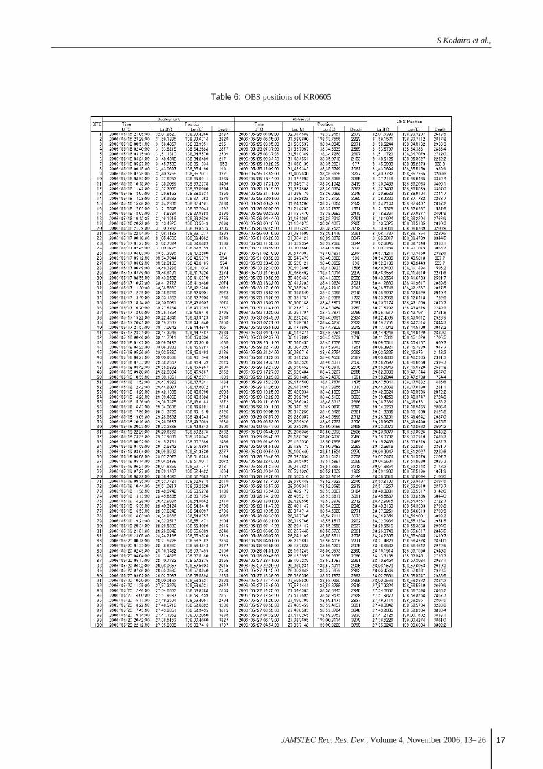
deployed 100 OBSs with 5 km interval during bothcruise (Table 5 and 6), and recovered all of them except
Active source seismic studies across/along across-arc seamount chains in Izu-Bonin arc - Cruise report of KR0601 and KR0605 -
JAMSTEC Rep. Res. Dev., Volume 4, November 2006, 13– 2616
Table 5: OBS positions of KR0601
S Kodaira et al.,
JAMSTEC Rep. Res. Dev., Volume 4, November 2006, 13– 26 17
Table 6: OBS positions of KR0605

Active source seismic studies across/along across-arc seamount chains in Izu-Bonin arc - Cruise report of KR0601 and KR0605 -
JAMSTEC Rep. Res. Dev., Volume 4, November 2006, 13– 2618
SkyFix. As navigation software for seismic data acquisi-tion, we used the SPECTRA made by Concept Inc.Positioning data collected from StarFire as well asSkyFix were sent to RTNµ (a network interface madeby Concept Inc.) via a terminal server connected toLAN in the vessel. The RTNµ obtains time signals ofDGPS (StarFire) from the original antenna. Then, thenavigation data is sent to the PC Linux machine, onwhich the SPECTRA was installed and displayed. Shottimes and Shot Point (SP) are set on the SPECTRA andthen a trigger signal is sent to the recording system andthe gun controller (GCS90), as follows.
First, a system-start-signal generated from the SPEC-TRA is sent to the recording system via the RTNµ, andsoon after, the recording system send back a reply signalto the SPECTRA when the system is ready for record-ing. Second, the SPECTRA sends a trigger signal to thegun controller and the recording system sends a data-acquisition-start-signal to the streamer cable. The guncontroller sends back an internal-time-break-signal tothe RTNµ and recording system, and also sends trigger-signals to the eight airguns as shooting orders just afterreceiving the trigger signal from the SPECTRA. At thesame timing with shot, the gun controller starts to gatherboth position data of the airgun sub-arrays from the air-gun positioning system (RGPS) and first breaks of near-field shot records from monitor hydrophones nearbyguns. Then seismic data are transmitted from the activemodules to the recording system and position data of thestreamer are sent from the depth controllers (so-calledbirds). After that, the position data of both the airgunand streamer cable are stored into the SPECTRA via theRTNµ and are also sent to the recording system. Finally,the seismic data are output to a tape drive and recordedon 3590E tapes. The recording system and gun con-troller are connected via RTNµ as shown by Figure 5.
4. Example of data4.1 Wide-angle seismic data along the Minami-Ioujima ridge (KR0601)
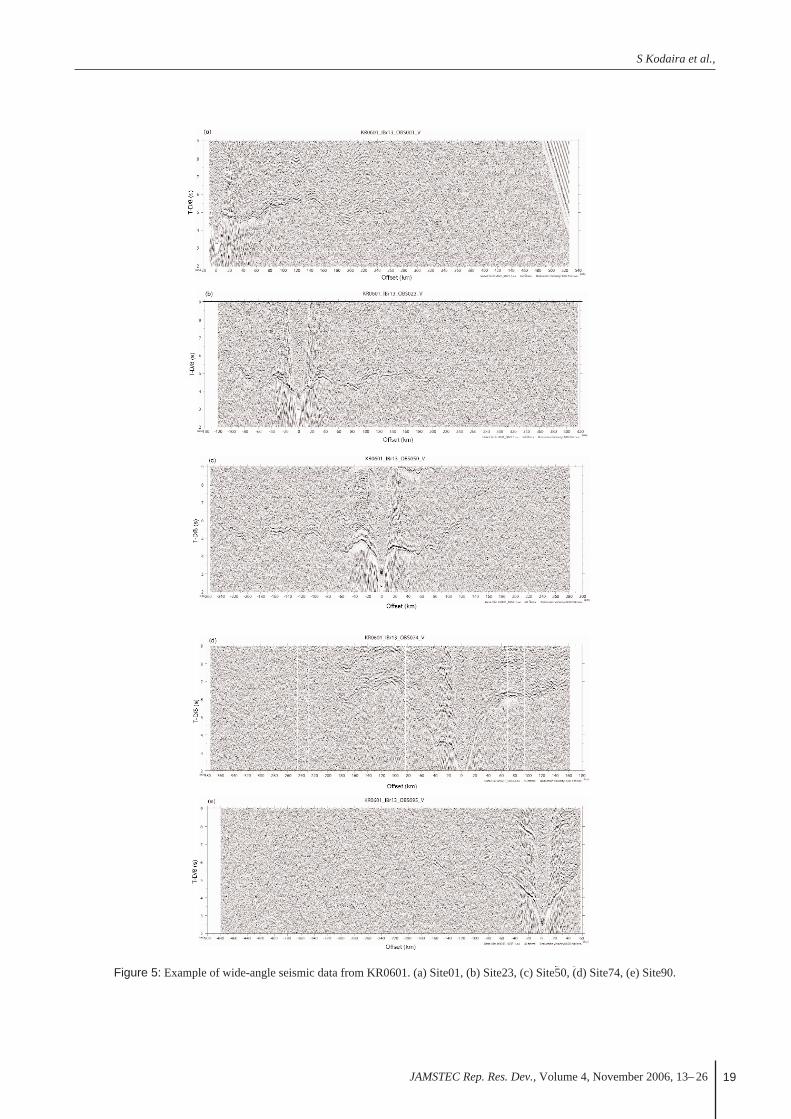
All seismic section shown in Fig. 5 are plotted with 3– 12 Hz band-pass filter, predictive deconvolution filterand 1s automatic gain control.
Site01: Quality of data is relatively good. First arrivalcan be traced up to 300 km offsets. This section is char-acterized by faster apparent velocity at near offset. Theapparent velocity of ~ 8 km/s is observed from only 10km offsets. This implies remarkably thin crust at thesouthwestern end of the ridge. Although clearer laterreflections are hardly observed, a strong amplitudebetween 100 and 200 km offset may correspond a sub-moho reflection.
for one OBS which was used in KR0601 (Site 22). TheOBSs used (4.5 Hz, three-component gimbal-mountedgeophones and hydrophones, continuous 16-bit digitalrecording with 100 Hz) were originally designed byKanazawa and Shiobara (1994) and Shinohara et al.(1993). Continuous round motions were recorded ondigital audiotape or a hard disk. Rechargeable lithium-ion batteries are used as an electric power supply. Allparts including sensors with gimbal-leveling mecha-nism, batteries and a recorder are installed in 17-inchglass spheres made by Benthos, Inc, USA and NautilusMarine service Gmbh, Germany. An OBS equipped anacoustic transponder system which control releasemechanism as well as positioning system. An OBS isreleased from anchors by electric corrosion of stainlessplates when a release command was send from the ves-sel. For positioning an OBS, super short base line(SSBL) acoustic positioning system is used. An accura-cy of the SSBL system is about 3 % of water depth.After correcting a drift of an OBS clock by comparingthe OBS clock and GPS, 70 s long data for each shotsare formatted with SEG-Y.
3.3 Streamer cableFor acquiring the multichannel reflection seismic data
during KR0605, we used a 204-channle hydrophonestreamer cable made by Sercel Inc. (Fig. 4) The stream-er cable is composed of 68 active sections, and eachactive section is 75m long and consists of three receivergroups (channels). The active modules including 24bitA/D converters are inserted every four active sectionsand collect seismic data from the four sections. Theinterval of each group is 25m. The lengths of totalactive section and lead-in cable are 5100m (75m × 68)and 110m, respectively. Hydrophone sensors (BenthosReduce Diameter Array hydrophone) with sensitivity of20V/Bar are used and the signals from 32 sensors in thesame group (channel) are stacked before A/D conver-sion. The towing depth of streamer cable was controlledto be 15m below sea surface by the depth controllercalled Bird (DigiCOURSE System3).
3.4 Recoding and navigation systemThe recording system of multichannel reflection data
is the SYNTRAK960-24, which was made by SercelInc., and outputs seismic data onto 3590E tapes withSEG-D 8048 format. We set system delay to be 150ms.The sampling rate was 4ms and the record length was15s. The Differential GPS (DGPS) was used for thepositioning. We adopted StarFire system as a main posi-tioning system and SkyFix as a backup. The accuracy isreported to be about 0.4 m in StarFire and 5 m in
S Kodaira et al.,
JAMSTEC Rep. Res. Dev., Volume 4, November 2006, 13– 26 19
Figure 5: Example of wide-angle seismic data from KR0601. (a) Site01, (b) Site23, (c) Site50, (d) Site74, (e) Site90.

Active source seismic studies across/along across-arc seamount chains in Izu-Bonin arc - Cruise report of KR0601 and KR0605 -
JAMSTEC Rep. Res. Dev., Volume 4, November 2006, 13– 2620
Figure 6: Example of wide-angle seismic data from KR0605. (a) Site05, (b) Site10, (c) Site38, (d) Site70, (e) Site98.

S Kodaira et al.,
JAMSTEC Rep. Res. Dev., Volume 4, November 2006, 13– 26 21
Site23: We can trace first arrivals more than 200 kmoffset from this record section. In contrast with the dataobserved at Site01, first arrivals showing apparentvelocity less than 6 km/s are observed at shorter offset (~ 40 km offsets). Clear later reflection arrivals are rec-ognized between 160 – 200 km offsets at 4.5 – 5.5 s.Those indicate an existence of a sub-moho reflector.Since the reflection from sub-moho reflector is alsoobserved at Site01, this reflector may extend at thesouthern part of the ridge.
Site50: First arrivals can be traced more than 250 kmoffset at the southwestern part of the profile, while theycan be traced up to only 160 km offset at the northeast-ern part. Characters of the first arrivals in the southwest-ern part are similar to Site 23. This indicates simple flatstructure at least in the southwestern half of the profile.The apparent velocity of the first arrival from the north-eastern part is distorted due to abrupt change of waterdepths. Stronger amplitude observed at 90 – 130 km off-sets and 140 – 170 may indicate reflection phases.
Site74: This record section shows remarkably differ-ent character from the previous record sections. Themost significant difference is longer observable range ofslower apparent velocity phases (> 6 km/s). Those phas-es are observed up to 100 km offset at the southwesternpart and 60 km offsets at the northeastern part. Sincethis OBS is located at near the top of the arc, thoselonger observable range indicate significantly thickercrust beneath the arc than the southern part of the ridge.Later arrivals observed at 70 – 15 km offsets (7 s) at thesouthwestern part and 60 – 120 km offsets (6.5 s) at thenortheastern part are interpreted as reflections from thebase of the crust beneath the arc. We can estimate exactthickness of the arc crust by further processing.
Site95: Observable ranges of slower apparent velocityless than 6 km/s is shorter than that of Site74. Thisimplys thinning of the crust toward forearc. A weakeramplitude phase observed more than 80 km offsets maycorrespond mantle reflection phase. Although laterreflection phases are not very obvious, larger amplitudephases at 40 – 70 km and 80 – 120 km offset may repre-sent reflection phases.
4.2 Wide-angle seismic data across the Nishi-shichito ridge (KR0605)
Seismic sections shown here are only process with 5– 15 Hz band-pass filter and automatic gain control of 2s as preliminary processing (Fig. 6).
Site05: Since the profile is designed for across theridges, apparent velocities of first arrivals are stronglyaffected by variation of water depth along the profile(e.g., 5 – 20 km offsets and 50 – 70 km offsets). First
arrivals observed farther than 30 km, however, roughlyshow apparent velocity of 8 km/s which may be refrac-tion arrival from mantle. Stronger amplitude at 80 – 110km and 160 – 200 km offset may be reflections phases.
Site10: This record section shows good quality ofarrivals. We can trace the signal up to 250 km offset.The slower apparent velocity phase less than 7 km/sobserved till 70 km offset is interpreted as crustalrefraction phases. Later arrivals at 50 – 90 km and 14 –200 km offsets may be reflections from the base of crustand sub-moho reflector, respectively.
Site38: This record section also shows good qualitydata. First arrival can be traced more than 250 km off-set. Slower apparent velocity phases less than 7 km/s areobserved 120 km at the south and 80 km at the north.They shows longer offsets than those observed atSite10. This implies that crust becomes thicker towardthe middle of the profile from the north. Strong ampli-tude later arrivals observed from 80 km offset at bothside are interpreted as reflections from the base of crust.Another later arrival observed at 120 – 150 km offsetmay correspond to reflection from a sub-moho reflectorat the northern part of the profile.
Site70: Observable range of slower apparent velocityphase (< 7 km/s) becomes shorter in this section thanthose of site 38. This indicates crustal thinning towardthe south from the middle of the profile. Later arrivalsobserved at 40 – 60 km offset may be reflection fromthe base of curst.
Site98: First arrivals interpreted as crustal refractionphases are observed up to 130 km offset. Apparentvelocity of those phase seem to be firster than the previ-ous sections, but this may be cause of variation of waterdepth. Due to reverberation of the first arrival, onset oflater reflection arrivals are not clearly recognized, how-ever, wave-train observed between 50 and 120 km off-set seems to show reflections from the base of crust.
4.3 Multichannel reflection seismic dataRaw MCS reflection data are processed on board for
the purpose of quality control and preliminary interpre-tation of tectonic structures in the study areas. The on-board data processing was conducted preserving relativeamplitudes under the conventional processing scheme,as shown in Figure 7, which contains noisy-trace edit-ing, 5-100 Hz band-pass filtering, deconvolution with a28-ms-length predictive distance and a 250-ms-lengthoperator, amplitude compensation by T2 (T is two waytraveltime), velocity analysis, multiple suppression byradon transform, muting, CDP stacking and post-stacktime migration.
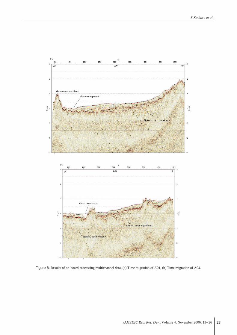
Figure 8 show results of on-board processing A01

Active source seismic studies across/along across-arc seamount chains in Izu-Bonin arc - Cruise report of KR0601 and KR0605 -
JAMSTEC Rep. Res. Dev., Volume 4, November 2006, 13– 2622
Figure 7: Flow chart of on-board processing multichannel data
S Kodaira et al.,
JAMSTEC Rep. Res. Dev., Volume 4, November 2006, 13– 26 23
Figure 8: Results of on-board processing multichannel data. (a) Time migration of A01, (b) Time migration of A04.
Active source seismic studies across/along across-arc seamount chains in Izu-Bonin arc - Cruise report of KR0601 and KR0605 -
JAMSTEC Rep. Res. Dev., Volume 4, November 2006, 13– 2624
and A04. Both profiles are located from the Kinanseamount chains to the Nishi-shitito ridges through theKinan escarpment, A01 was take more parallel to thestrike of across-arc seamount chains. The most charac-teristic structure in both sections is that the basement ofthe Shikoku basin is imaged beneath the basementextending from the across-arc seamount chains. We canrecognize this character clearer along A01. In Fig.8, theShikoku basin basement is traced at SP4300. The base-ment form the across-arc seamount chains cover theShikoku basin basement till SP2500. This characterindicates that the across-arc seamount chains wereformed on the Shikoku basin crust, and a boundarybetween the Shikoku basin and the Oligocene arc maybe situated around eastern end of the across-arcseamount chains. It notes that the base of the Shikokubasin crust is sporadically observed along both profiles.Although the Kinan escarpment has been suggested as asort of structure boundary, any distinct structural varia-tion beneath the basement can not be observed in A01.
5. SummaryWe have conducted two active source seismic cruises
across and along the across-arc seamount chains in theIzu-Bonin arc by R/V Kairei in 2006, KR0601 andKR0605. They are the first cruises in which more than100 OBS were handled by R/V Kairei. We have suc-cessfully acquired wide-angle seismic data during bothcruise and multichannel reflection data during KR0605.The observed wide-angle seismic data acquired alongthe Minami-Ioujima ridge (KR0601) indicate flat andthin crust beneath the ridge. The wide-angle seismicdata across the across-arc seamount chain in the Izu arcshow the north – south structural variation (i.e. thickercrust in the north and thinner crust in the south). Wefound that the basement of the Shikoku basin is contin-ued under the across-arc seamount chain. This indicatesthat a boundary between the Shikoku basin crust and theOligocene arc crust is situated around eastern end of theacross-arc seamount chains.
6. AcknowledgementWe thank the captains Ishida and Ryono, chief tech-
nicians Messrs. Toizumi, Katayama and Ito, crews andtechnical staffs onboard of R/V Kairei KR0601 andKR0605 cruise for their support. Ms. Takizawa helpedto prepare figures. All of the surveys were conducted asa part of the Continental Shelf Project.
References1) Bibee, L. D., G.G.S.Jr. and R. S. Lu, Inter-arc spreading
in the Mariana Trough, Marne Geol., 35, 183-197, 1980.
2) Bloomer, S. H., B. Taylor, C. J., MacLeod, R. J. Stern, P.
Fryer, J. W. Hawkins and L. Johnson, Early Arc volcan-
ism and the Ophiolite problem: A perspective from
drilling in the Western Pacific, in Active Margins and
Marginal Basins of the Western Pacific, edited by B.
Taylor and J. Natland, pp. 67-96, AGU Geophys. Monogr.
88, AGU, Washington D.C., 1995
3) Cosca, M. A., R. J. Arculus, J. A. Pearce and J. G.
Mitchell, 40Ar/39Ar and K-Ar geochronological age con-
straints for the inception and early evolution of the Izu-
Bonin-Mariana arc system, The Island Arc, 7, 1998.
4) Hickey, R. L., and F. A. Frey, Geochemical characteristics
of boninite series volcanics: Implications for their source,
Geochim. Cosmochim. Acta, 45, 2099-2115, 1982.
5) Hochstaedter, A., Gill, J., Peters, R., Broughton, P. &
Holden, P., Across-arc geochemical trends in the Izu-
Bonin arc: Contributions from the subducting slab,
Geochemistry Geophysics Geosystems 2, 2000GC000105,
2001.
6) Ishizuka, O., Uto, K., Yuasa, M. & Hochstaedter, A. G.,
K-Ar ages from seamount chains in the back-arc region of
the Izu-Ogasawara arc. The Island Arc 7, 408-421, 1998
7) Ishizuka, O., Uto, K., Yuasa, M. & Hochstaedter,
A.G.,Volcanism in the earliest stage of back-arc rifting in
the Izu-Bonin arc revealed by laser-heating 40Ar/39Ar dat-
ing, J. Volcanol. Geothermal Res. 120, 71-85, 2002
8) Ishizuka, O., Uto, K. &Yuasa, M. (2003). Volcanic histo-
ry of the back-arc region of the Izu-Bonin (Ogasawara)
Arc. In: Larter R.D. & Leat P.H. (eds) 2003. Intra-
Oceanic Subduction Systems: Tectonic and Magmatic
Processes. Geol. Soc. London Spec. Publ. 219, 187-205,
2003.
9) Kanazawa, T. and H. Shiobara, Newly developed ocean
bottom seismometer, Prog. Abst. Japan Earth and
Planetary Science Joint Meeting, 2, 240, 1994.
10) Kobayashi, K., S. Kasuga and K. Okino, Shikoku Basin
and its margins, in Backarc Basin: Tectonics and
Magmatism, edited by B. Taylor, pp. 381-405, Plenum
Press, New York, 1995.
11) Okino, K., Y. Ohara, S. Kasuga and Y. Kato, The
Philippine Sea: New survey results reveal the structure
and the history of the marginal basins, Geophys. Res.
Lett., 26, 2287-2290, 10.1029/1999GL900537, 1999.
12) Richards M. A. and C. Lithgow-Bertellone, Plate motion
changes, the Hawaiian-Emperor Bend, and the apparent
success and failure of geodynamic models, Earth Planet.
Sci. Lett., 137, 19-27, 1996.
13) Shinohara M., K. Suyehiro, S. Matsuda and K. Ozawa,
Digital recording ocean bottom seismometer using
portable digital audio tape recorder, Journal of the Japan
Society for Marine Surveys and Technology, 5, 21-31,
1993.

S Kodaira et al.,
JAMSTEC Rep. Res. Dev., Volume 4, November 2006, 13– 26 25
14) Stern, R. J., J. Morris, S. H. Bloomer and J. W. Hawkins,
The source of the subduction component in convergent
margin magmas: Trace element and radiogenic isotope
evidence from Eocene boninites, Mariana forearc,
Geochim. Cosmochim. Acta, 55, 1467-1481, 1991.
15) Stern R. J., M. J. Fouch and S. L. Klemperer, An overview
of the Izu-Bonin-Mariana subduction factory, in Inside the
subduction factory, edited by J. Eiler, pp. 175-222, AGU
Geophys. Monogr. 183, AGU, Washington, 2003.
16) Taylor, R. N., R. W. Nesbitt, P. Vidal, R. S. Harmon, B.
Auvray and I. W. Croudace, Mineralogy, Chemistry, and
genesis of the Boninite Series Volcanics, Chichijima,
Bonin Islands, Japan, J. Petrol., 35, 577-617, 1994.
17) Yamazaki, T. and R. J. Stern, Topography and magnetic
vector anomalies in the Mariana Trough, JAMSTEC
Journal of Deep Sea Research, 13, 1997.
(Received July 13, 2006)