Embed Size (px)
Citation preview
October 4, 2013 Journal of Location Based Services mooney˙rehrl˙hochmair˙jlbs
To appear in the Journal of Location Based ServicesVol. 00, No. 00, September 2013, 1–20
Action and Interaction in Volunteered Geographic Information:
A Workshop Review
Peter Mooneya∗ and Karl Rehrlb and Hartwig Hochmairc
aDepartment of Computer Science, Callan Building, National University of Ireland
Maynooth (NUIM), Maynooth, Co. Kildare, Ireland;bSalzburg Research Forschungsgesellschaft mbH, Jakob Haringer Strasse 5/3, A-5020
Salzburg, Austria;cFort Lauderdale Research and Education Center (FLREC),University of Florida,3205
College Avenue,Fort Lauderdale, FL 33314-7799, United States of America
(Received 00 Month 20XX; final version received 00 Month 20XX; accepted 00 Month 20XX)
This paper presents a summary of the Action and Interaction in Volunteered Geo-graphic Information (ACTIVITY) international workshop which was held as a oneday pre-conference workshop to the 16th Annual Association of Geographic Informa-tion Laboratories in Europe (AGILE) conference in Leuven, Belgium in May 2013.This paper summarizes the important outcomes of workshop presentations and keydiscussion statements from participant contributions to an open-floor discussion onthe most pertinent issues in VGI research. Participants engaged this discussion fo-cused on what are the most likely problems which could form the basis for a researchagenda in VGI composed of both short- and long-term research objectives. Whilst thedevelopment of a VGI research agenda will require the involvement of the broadestpossible spectrum of disciplines this paper is, none-the-less, an important first step onthis journey.
Keywords: VGI, ACTIVITY, Action and Interaction, OpenStreetMap, AGILEWorkshop, Research
1. Introduction
How is Volunteered Geographic Information (VGI) generated, collected, assessed,managed, and ultimately used? As the amount of VGI being generated constantlyincreases, in addition to the rapid rise in sensor data streams, it is now appropriateto assess the research challenges faced by this “profound transformation on howgeographic data, information, and knowledge are produced and circulated” (Sui,Goodchild, and Elwood 2013, Chapter 1). This paper presents a summary of theAction and Interaction in Volunteered Geographic Information (ACTIVITY) in-ternational workshop which was held as a one day pre-conference workshop to the16th Annual Association of Geographic Information Laboratories in Europe (AG-ILE) conference in Leuven, Belgium in May 2013. The workshop focused on theactivities and interactions which occur during VGI collection, management, anddissemination. One of the primary goals of this workshop was to foster discussionsamongst the various communities involved in VGI research on understanding how
∗Corresponding author. Email: [email protected]
1

October 4, 2013 Journal of Location Based Services mooney˙rehrl˙hochmair˙jlbs
the current challenges in VGI are being tackled. Some of the questions which wereconsidered for discussion at the workshop are as follows:
• How do VGI communities evolve?• What are the types and patterns of contributions to VGI projects?• When, where, and how is VGI generated?• What do we know about the actual contributors to VGI projects?• What types of applications and use-cases is VGI useful for?
This workshop is not the first workshop of it’s kind. Amongst several workshopson VGI in the recent past the most notable examples include:
• USGS Workshop 2010: U.S. Geological Surveys Volunteered Geographic In-formation Workshop (Usery, Bearden, and Poore 2010). Workshop Goal: Thepurpose of the workshop was to gather information on the potential use ofvolunteered geographic information as part of The National Map, the USGS’source for topographic information for the United States.
• AAG 2011 Workshop: Volunteered Geographic Information (VGI) Researchprogress and new developments (Hardy 2011). Workshop Goal: Discussion ofprogress to date, identification of ongoing research questions, and discussionof new directions. Topics included: The use of VGI in time-critical situations,innovative methods of analyzing, synthesizing, and visualizing VGI, and dataquality and credibility issues in VGI
• GIScience 2012 Workshop: The Role of Volunteered Geographic Informationin Advancing Science: Quality and Credibility (Bhaduri and Devillers 2012).Workshop Goal: To investigate research into assessment of the authenticity,validity, and uncertainty of volunteered geographic information and devel-oping steps towards rendering VGI as a valuable and usable component forscientific research.
• ACM GIS 2012 Workshop: First ACM SIGSPATIAL International Work-shop on Crowdsourced and Volunteered Geographic Information (Goodchild,Pfoser, and Sui 2012). Workshop Goal: To investigate questions that are fun-damental for future developments in VGI. These questions include: Whatdata structures, algorithms and implemented systems are appropriate for themanagement of VGI? What are appropriate benchmarks for measuring theperformance and comparing existing systems? How can we crowdsource high-quality geospatial datasets? What are candidate data fusion techniques?
Our workshop is novel in that it is primarily focused on the production of VGIand on the action and interaction of VGI contributors. It is very important tounderstand how VGI is produced and generated and how these VGI contributorsinteract. An open access journal was chosen for this publication so as to ensurethat the outputs in this paper were accessible to the widest possible audience. It ishoped that this paper will be disseminated amongst the VGI community, the citizenscience community, and the open source and open data movements. Sui, Goodchild,and Elwood (2013, Chapter 1, page 2) argues that the phenomenon of volunteeredgeographic information is part of a profound transformation in how geographicdata, information, and knowledge are produced and circulated. VGI is now situatedin the context of the “big-data deluge and data-intensive inquiry”. Critical tosupporting the goals of our workshop this book contents “that future progressin VGI research depends in large part on building strong linkages with diversegeographic scholarship”. We feel that our workshop programme reflects a diverseset of geographical skills and domains. During early 2013 an open call was made
2

October 4, 2013 Journal of Location Based Services mooney˙rehrl˙hochmair˙jlbs
for contributions to the workshop and we collected contributions which includedfull papers and position papers. The workshop welcomed presenters from researchinstitutions in North America, Europe, and Australia. Peter Mooney and KarlRehrl acted as workshop chairs. There were two overview presentations providedby Mooney and Rehrl at the beginning and closing of the workshop. There wereten paper presentations, organised into three sessions, where all presenters weregiven approximately twenty minutes to present their work. After each presentationquestions and comments from the participants in the audience were welcomed.The remainder of this paper is organised as follows. Section 2 provides a summary
overview of each of the presentations at the workshop with a brief commentary onthe key statements highlighted by the presenter in each case. In section 3 we outlinesome of the main discussion points from the open-floor discussion amongst all thirtyparticipants in the workshop. In section 4 we close the paper with some concludingremarks and research objectives for planned future work.
2. Workshop Presentations Overview
In this section we provide a brief overview of the key research results outlined byeach paper presentation at the workshop. We organised the following subsectionsinto a similar structure to how these papers were presented at the workshop.
2.1 Session 1: Patterns of Contribution and Understanding the
Activity of the Contributor
Many researchers are primarily interested in the geographic information generatedin VGI projects. The volunteers who collect this information play a central roleas they are responsible for generating this information in the first place. Predom-inantly the work in collecting and contributing data and information in VGI isperformed on a purely voluntary basis. However, analysis by authors such as Wil-lett, Heer, and Agrawala (2012) indicate that for certain tasks paid crowd workerscan reliably produce high quality results or solutions and they believe that theirresults suggest that larger scale tasks could be solved using this method. So whydo so many people become active contributors, without obvious financial rewards,to VGI projects? Coleman, Georgiadou, and Labonte (2009) outline a list of mo-tivating factors which they believe underlines the motivations for contributors tovolunteer their time for the collection and management of VGI. These include altru-ism, professional or personal interest, intellectual stimulation, social reward, prideof place, enhanced personal reputation, and an outlet for creative and indepen-dent self-expression. There has also been significant and influential work publishedin Budhathoki, Nedovic-Budic et al. (2008) and Budhathoki, Nedovic-Budic, andBruce (2010) which provides steps towards understanding contributors and con-tributor patterns in VGI. The authors emphasise the need for a multidisciplinaryapproach which draws from different disciplines including GIScience, informationscience, social psychology, political economy, and leisure studies. Contributors canalso be responsible for the import of freely available geodata to VGI projects, suchas OpenStreetMap (OSM) called bulk imports. Zielstra, Hochmair, and Neis (2013)and Hochmair and Zielstra (2013) analyze the effect of imported road data (e.gTIGER/Line) and points of interest (e.g. the U.S. Geological Survey’s GeographicNames Information System (GNIS)) on OSM data quality and they conclude thatone-time data imports into OSM may be beneficial to the OSM project if these
3
October 4, 2013 Journal of Location Based Services mooney˙rehrl˙hochmair˙jlbs
kind of data have not been previously collected in the geographic area of interest.This session investigates the motivations of contributors to VGI projects includingOSM. The session also attempts to identify the patterns of contributions to VGIprojects to attempt to understand how contributors collect information.
2.1.1 Individuals’ contribution to cells: a cellular automata approach forsimulation of collaboratively mapped areas
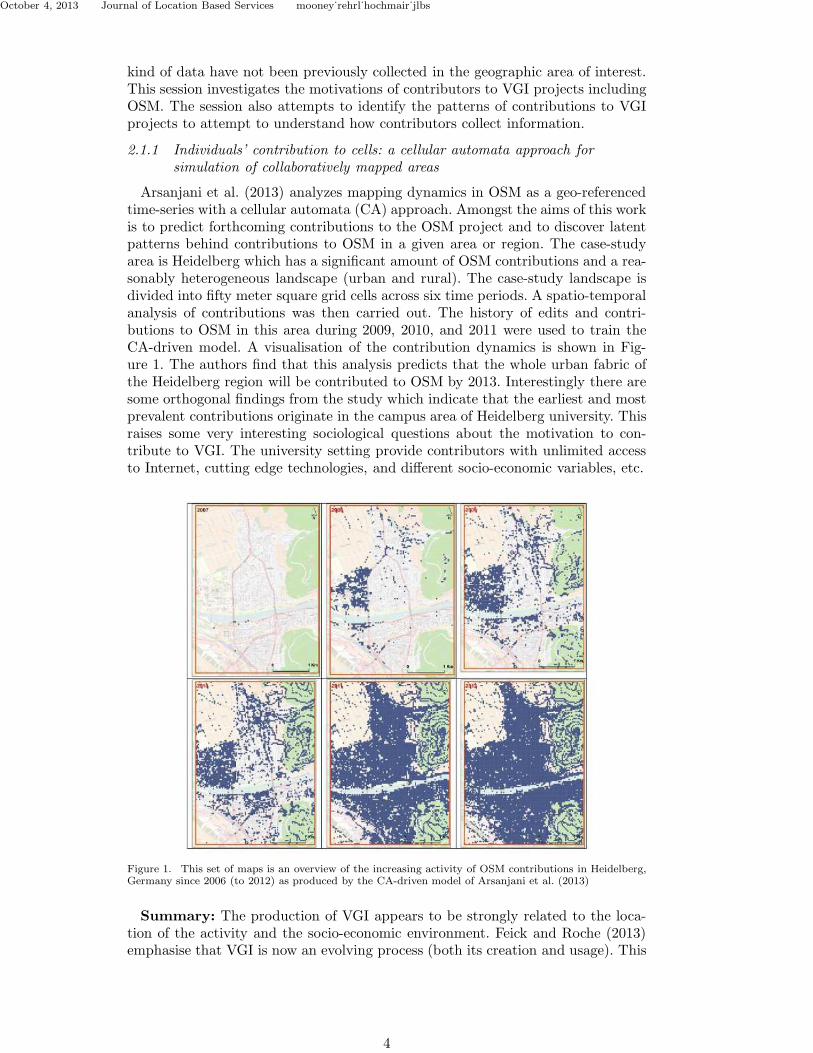
Arsanjani et al. (2013) analyzes mapping dynamics in OSM as a geo-referencedtime-series with a cellular automata (CA) approach. Amongst the aims of this workis to predict forthcoming contributions to the OSM project and to discover latentpatterns behind contributions to OSM in a given area or region. The case-studyarea is Heidelberg which has a significant amount of OSM contributions and a rea-sonably heterogeneous landscape (urban and rural). The case-study landscape isdivided into fifty meter square grid cells across six time periods. A spatio-temporalanalysis of contributions was then carried out. The history of edits and contri-butions to OSM in this area during 2009, 2010, and 2011 were used to train theCA-driven model. A visualisation of the contribution dynamics is shown in Fig-ure 1. The authors find that this analysis predicts that the whole urban fabric ofthe Heidelberg region will be contributed to OSM by 2013. Interestingly there aresome orthogonal findings from the study which indicate that the earliest and mostprevalent contributions originate in the campus area of Heidelberg university. Thisraises some very interesting sociological questions about the motivation to con-tribute to VGI. The university setting provide contributors with unlimited accessto Internet, cutting edge technologies, and different socio-economic variables, etc.
Figure 1. This set of maps is an overview of the increasing activity of OSM contributions in Heidelberg,Germany since 2006 (to 2012) as produced by the CA-driven model of Arsanjani et al. (2013)
Summary: The production of VGI appears to be strongly related to the loca-tion of the activity and the socio-economic environment. Feick and Roche (2013)emphasise that VGI is now an evolving process (both its creation and usage). This
4

October 4, 2013 Journal of Location Based Services mooney˙rehrl˙hochmair˙jlbs
process has become less tractable as one considers that the nature of social re-lations across the Geoweb are very often transient, and issue- and place-specific.This raises issues related to a digital divide in geographic data collection and access(Cinnamon and Schuurman 2013).
2.1.2 Contribution Profiles of Voluntary Mappers in OpenStreetMap
The work presented by Steinmann et al. (2013) attempts to build contributionprofiles of contributors to OSM through an analysis of the entire editing and con-tribution history of OSM. The OSM Full History Planet File contains every versionof each OSM feature ever contributed to OSM. The high-level research questionis stated informally as “who contributes what to this VGI project?” The paperreviewed some previous studies outlined in the literature which assess contributoractivity of VGI projects (Mooney and Corcoran 2012; Neis and Zipf 2012; Coleman2013; Mooney and Corcoran 2013; Rehrl et al. 2013). There are also similiar studiescarried out which analyse contributor behaviour and activity in Wikipedia (suchas Hardy (2013)). The authors use this information to compute “action profiles”which provides information about the type of edits of individual contributors. Theoverall methodology involves: statistical analysis, profile definition, profile calcu-lation, k-means clustering, and interpretation of results. The authors carried outtheir analysis on the entire OSM history dataset. Previous analysis of this type wasrestricted to smaller geographic regions. The authors found that just 3% of contrib-utors are active on more than 100 days (over several years of the project lifetime).The clustering of actions reveals a number of distinct categories of contributorsincluding:
• CREATOR: These contributors predominantly create data.• UPDATER: These contributors predominantly perform update actions.• DELETER : These contributors are predominantly involved in the deletion
of data from the OSM database.• Premium Creator: These contributors have performed a very large number
of actions over a long period of time.• Basic Creator. These contributors have created data in the database but have
done little else.• Basic Allrounder: Contributors in this cluster have close to the mean number
of contributions for the OSM community and are involved in all types ofactions: update, delete, create, and edit.
In addition to the exaction of action profiles the authors investigated the types ofgeographical features being edited by contributors over the history of OSM and itwas found that in 2005 over 90% of all geographic features contributed to OSM werehighway or road features which in 2012 had reduced to about 36%. The clustersfor both contributor types and geographic features appear to be very distinct anddisplay a fluent transition from year to year.Summary: Building contribution profiles in OSM is necessary to understand
how, what, when, and where people contribute geographic data and information.The clustering approach does not, as yet, explicitly include a spatial component.Steinmann et al. classifies contributors based on their activity in the OSM projectbased on extraction of this knowledge from the history of all OSM edits. Thiswork can lead to very useful information regarding the types of contributions thatspecific contributors make. The work fits nicely into a series of related work (e.g.Neis and Zipf (2012)) and adds some new aspects in terms of contributor profiles.
5

October 4, 2013 Journal of Location Based Services mooney˙rehrl˙hochmair˙jlbs
2.1.3 Gender and Experience-Related Motivators for Contributing toOpenStreetMap
Schmidt and Klettner (2013) report the results of a survey distributed to con-tributors to OSM. Typically the contributors to OSM are male, well-educated,and technologically savvy. The paper discussed some of the motivations for thesecontributors work including the findings from Haklay and Budhathoki (2010) thatthere were 97% male and only 3% female contributors to the OSM database. Thediversity of our society is certainly not reflected in the results of the survey. The au-thors ask if there are advantages to a VGI project of having a broader contributorgroup? This would result in a larger group of potential contributors for collecting,updating and editing data in VGI projects and would lead to a more diverse digitalmap view of the world around us.The authors performed a further smaller focus group study of 12 females equiv-
alent to the typical OSM (male) contributor. This allowed for a qualitative studyto generate hypotheses on what are the barriers for females to participate in VGIand the required motivations for future participation. The participants in the focusgroup listed some requirements of a VGI project (such as OSM) which would causethem to participate. These included items such as improved help and support op-tions and dedicated tutorials for beginners. The participants also felt that thereshould be some positive feedback and rewards for editing. There was also a feel-ing that meeting new people could be a motivating factor rather than working orcontributing in complete isolation. Finally, the participants in the focus group feltthat the VGI project needed to have clearly defined aims and objectives as thereneeds to be a “a dedicated purpose” for mapping. The larger survey (with over500 respondants) stated that mapping for a dedicated purpose, better help andsupport in tutorial form, and less time consuming mapping options (ie smartphoneapplications) would encourage more people to participate.Summary: This presentation helped focus the minds of participants on their
perception of who is contributing to VGI projects such as OpenStreetMap. Elwood(2008, Page 175) comments that “the phenomenon of VGI pushes us to re-think ourconceptualization of the user and there seems to be a co-productive relationshipbetween knowledge and gender identity in VGI”.
2.1.4 Crowdsourced Metadata supporting Crowdsourced Geospatial Data
The work presented by Kalantari (2013) addressed the issue of metadata incrowdsourced geospatial data production. The author comments that much of theresearch effort in VGI is focussed on the actual spatial data itself. It is very oftenthe case that the contribution of metadata is lagging behind data production inVGI projects. Metadata is important and is a crucial prerequisite for interoper-ability and its meaning has to be widely understood. VGI contributors need tounderstand what metadata needs to be produced and what should be provided tohelp users understand a VGI resource (Danko 2012). Poore and Wolf (2013) stressthat metadata production must be made more interactive and effective. This isthe driver for what Kalantari calls crowd-sourced metadata. The users of VGI donot have any real say in the process of metadata creation and at present they donot play a major role in the process of metadata creation. They cannot contributemetadata information without subscription or registration to most VGI projects.The users who end up using the VGI could potentially add metadata about howthe used the data, what the data was suitable for, problems with the data or spe-cific objects/features, etc. Kalantari describes an add-on tool built on GeoNetwork(http://geonetwork-opensource.org/) allowing users to supply metadata for
6

October 4, 2013 Journal of Location Based Services mooney˙rehrl˙hochmair˙jlbs
features in VGI datasets or services. Users are not required to register or subscribeto the metadata collection service. In initial trials this approach showed the poten-tial that users of VGI from can use VGI for their own purposes and then optionallycontribute metadata about the VGI.Summary: The active inclusion of users in the crowdsourced collection of meta-
data for VGI is a promising and novel concept. The approach attempts to close theloop which transforms users into Coleman, Georgiadou, and Labonte’s prod-usersand prod-sumers. This approach has great potential to assist in providing addi-tional metadata to VGI datasets and also in the provision of statements about adataset’s spatial and temporal accuracy, fitness for use, and fitness for purpose.
2.2 Session 2: Social aspects - Connecting contributors and
communities
Social media generated from many individuals is playing an increasing role in ourdaily lives and provides a unique opportunity to gain valuable insight on infor-mation flow and social networking within a society. Through data collection andanalysis of its content it supports a greater understanding of the evolving hu-man landscape (Stefanidis, Crooks, and Radzikowski 2013). Location-based games(LBGs) have been shown to be one successful method in motivating non-expertusers to collect and tag geospatial data (Elwood and Leszczynski 2011; Parker,May, and Mitchell 2013). With respect to data quality, revious studies (such aswork by Bell et al. (2009); Grant et al. (2007); Matyas et al. (2011)) have shownthat games which reward players for in- or post-game data reviewing can achieve avalidation rate of about 40% of the data. Researchers such as Matyas et al. (2011)have attempted to further improve VGI data quality by introducing a new LBGdesign pattern, based on game rules that encourage players to take the decisions ofother players into account while making their own data collecting decisions. The“gamification” of the collection of geo-data is closely linked to the increased influ-ence of social media technologies which have been shown by some authors, such asNaaman et al. (2012), to affect citizens’ real world behaviour.
2.2.1 What, When and Where: The real-world activities that contribute toonline social networking posts
McKenzie, Deutsch, and Raubal (2013) describes work in progress on extractingpatterns of real-world activities from social networking posts and then validatingthese patterns against the actual real-world activities. The authors remark thatthere is promise in an approach of passively extracting this type of informationfrom the active participation of citizens on social networking websites such asFacebook. Is it possible to quantify the relationship between online activities (posts)and non-online activities (actual physical activities such as shopping, going to thepark, travelling to work, etc). The paper attempt to classify activity types by: whatthe activity is, where it could occur, and when it occurs. The research question isthen one of how close to an activity does a post occur on social media in relationto the actual physical start of an activity? From their focus group they find thatthe mean time of “post-to-activity” is 9.3 hours before the activity. 91% of postsabout an activity are within 24 hours of the activity. Long distance travel andvacation have been posted most frequently relative to related real-world activities.The authors point out that this high percentage of posting could be related to aperceived increase in social value from travel and vacation. The authors indicatethat their initial results proved successful to predict future events from one’s socialnetworking activities.
7

October 4, 2013 Journal of Location Based Services mooney˙rehrl˙hochmair˙jlbs
Summary: The extraction of spatial information from social media websitesand postings could be helpful in understanding the future activities of partici-pants. Stefanidis, Crooks, and Radzikowski (2013) comment that harvesting ambi-ent geospatial information from social media feeds is resource intensive. Howeverif this is performed with the permission of participants there could be very usefulinformation extracted about participants’ future activities. However, privacy andaccess limitations are very important issues and have to be seriously considered.Extracting and recreating the movements of citizens from openly available datasources has been demonstrated in work by authors such as Girardin et al. (2008).Another key issue is concerned with the validation of extracted patterns and trends.
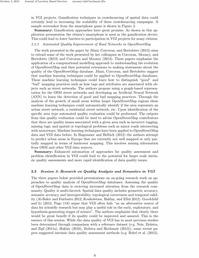
Figure 2. An screenshot of a stage of the VGI data collection smartphone game developed and presentedby Davidovic (2013)
2.2.2 Using Location Based Game ’MapSigns’ to motivate VGI data collectionrelated to traffic signs
The presentation by Davidovic (2013) outlined the use of gamification techniquesto motivate high levels of participation in VGI data collection related to “less in-teresting” types of data. The author develops an Android smartphone applicationwhich provides a smartphone game to encourage citizens to collect informationabout traffic signs, park benches, trash cans, pedestrian crossings, etc. The paperargues that much of the emphasis in VGI is on the collection of spatial data andinformation related to more “popular” features such as highways, shopping andleisure, and buildings. The MapSigns game is a chase-type game with two teams(thieves and cops) and they are racing to the same destination. Each team collectstraffic signs and other information with the smartphone application. Points areawarded using a set of rules depending on the types of data collected. Gamifica-tion is a very promising approach (Mart et al. 2012). As outlined in work suchas Mart et al. (2012) smartphones have become low-cost measuring devices thatmany citizens have in their pocket. The techniques implemented here are used toevaluate the potential for gamification to encourage the collection of “unpopular”spatial data which are frequently found all around us but not always collected
8
October 4, 2013 Journal of Location Based Services mooney˙rehrl˙hochmair˙jlbs
in VGI projects. Gamification techniques in crowdsourcing of spatial data couldcertainly lead to increasing the scalability of these crowdsourcing campaigns. Asample screenshot from the smartphone game is shown in Figure 2.Summary: Gamification approaches have great promise. As shown in this ap-
plication presentation the citizen’s smartphone is used as the gamification device.This could lead to lower barriers to participation in VGI projects for many citizens.
2.2.3 Automated Quality Improvement of Road Networks in OpenStreetMap
The work presented in the paper by Jilani, Corcoran, and Bertolotto (2013) aimsto extend some of the work presented by her colleagues in Corcoran, Mooney, andBertolotto (2013) and Corcoran and Mooney (2013). These papers emphasise theapplication of a computational modelling approach to understanding the evolutionof OpenStreetMap and then potential extensions to making statements about thequality of the OpenStreetMap database. Jilani, Corcoran, and Bertolotto suggestthat machine learning techniques could be applied to OpenStreetMap databases.These machine learning techniques could learn how to distinguish “good” and“bad” mapping practices such as how tags and attributes are associated with ob-jects such as street networks. The authors propose using a graph-based represen-tation for the OSM street networks and developing an Artificial Neural Network(ANN) to learn the detection of good and bad mapping practices. Through theanalysis of the growth of small areas within larger OpenStreetMap regions thesemachine learning techniques could automatically identify if the area represents anurban street network, a residential street network, etc. Upon identification of thespecific area type automated quality evaluation could be performed. The outputsfrom this quality evaluation could be used to advise OpenStreetMap contributorsthat there are quality issues associated with a given area such as incorrect tagging,missing tags, and spatial or topological problems such as minor roads intersectingwith motorways. Machine learning techniques have been applied to OpenStreetMapdata and VGI data before. In Hagenauer and Helbich (2012) the authors attemptto predict urban areas in Europe that are currently not well mapped or only par-tially mapped in terms of landcover mapping. This involves mining informationfrom OSM and other VGI data sources.Summary: Enhanced automation of approaches for quality assessment and
problem identification in VGI could lead to the potential for larger scale intrin-sic quality assessments and more rapid identification of data quality issues.
2.3 Session 3: Research on Quality Analysis and Semantics in VGI
The three papers below provided presentations on on-going research work on ap-proaches to quality analysis of OpenStreetMap databases. Assessing the qualityof OpenStreetMap data is recieving increased attention from the research com-munity. Quality is multi-faceted. Spatial data quality includes geometric accuracy,semantic accuracy and interoperability, topological correctness and temporal valid-ity (Al-Bakri and Fairbairn 2012; Koukoletsos, Haklay, and Ellul 2012). Goodchildand Li (2012, Page 118) argue that VGI often fails “as an alternative source ofdata for scientific research but may play a useful role in the early, exploratory, andhypothesis-generating stages of science”. The authors emphasise that clearly therewould be great benefit if its quality could be improved and assured. This is theessence of this session. While the data quality of VGI has in most previous studiesbeen determined through comparison with a reference dataset (e.g. Neis, Zielstra,and Zipf (2011a), Haklay (2010), Zielstra and Hochmair (2013)), some recent pa-pers suggested intrinsic data quality assessment methods (e.g. Rehrl et al. (2013),
9

October 4, 2013 Journal of Location Based Services mooney˙rehrl˙hochmair˙jlbs
Mooney and Corcoran (2012)), which become useful where ground-truth data arenot available for comparison. One of the workshop papers (Jilani, Corcoran, andBertolotto 2013) adds a novel method to this group of quality assessment methods.The papers in this session present ideas regarding intrinsic quality evaluation
of OpenStreetMap data, semantic interoperability issues whilst integrating Open-StreetMap data with authoritative spatial datasets, and active collection of ground-truth spatial data to assess OpenStreetMap data.
2.3.1 Towards intrinsic Quality Analysis of OpenStreetMap Datasets
This work presented by Barron, Neis, and Zipf (2013) proposes a frameworkcalled iOSMAnalyzer. The idea behind iOSMAnalyzer is that it could indeedbe possible to assess the quality of OpenStreetMap datasets without a referencedataset. The quality assessment is performed intrinsically by looking into the Open-StreetMap dataset itself. This concept has been proposed before by authors suchas Mooney and Corcoran (2012) who have suggested that it might be very ben-eficial to consider the lineage or evolutionary history of OpenStreetMap data aspart of quality assessments. iOSMAnalyzer investigates the full edit history ofOpenStreetMap for a given region or area. The software implementation of iOSM-Analyzer is based on open source components. The concept for iOSMAnalyzer hasgrown from significant previous work by the research group of Barron, Neis, andZipf and previous work on OpenStreetMap historical analysis in literature such asNeis and Zipf (2012) and Neis, Zielstra, and Zipf (2011b).iOSMAnalyzer aims to provide an overall report on various aspects of intrinsic
OpenStreetMap quality analysis whereby potential users could use this report aspart of their fitness for purpose evaluations. iOSMAnalyzer will provide:
• General area information, routing and navigation information, address-searching, points of interest searching, map-applications, contributor infor-mation and behaviour (from Neis and Zipf (2012)).
• Information reports on factors such as: total road network length, OSM roadnetwork lengths by road type (from Neis, Zielstra, and Zipf (2011b)).
• Positional accuracy of highway junctions.
The future work of iOSMAnalyzer will concentrate on the development of thesemethods and other quality indicators. There will also be scope to integrate re-lated work on the potential detection of acts of vandalism performed on the Open-StreetMap dataset in a given area (see Neis, Goetz, and Zipf (2012)). Eventuallyit is hoped that iOSMAnalyzer will build a metadata repository of indicators ofquality which is not solely focussed on spatial positional accuracy.Summary: Intrinsic quality analysis of OSM has the potential to yield very
promising outcomes. In particular iOSMAnalyzer could generate very informative“fitness for use” and “fitness for purpose” reports for regions of OSM. This work iscomplimentary to work done by researchers such as Rehrl et al. (2013) and Mooneyand Corcoran (2012) on investigation of the patterns of activities and operationsperformed over the entire history of the OSM database.
2.3.2 Integrating Authoritative and Volunteered Geographic Information - AnOntological Approach
Whilst VGI provides a very rich resource for academic research activities wemust also consider how VGI datasets could be integrated with authoritative spatialdatasets. This work presented by Ramos and Devillers (2013) tackles the problemof integration of VGI data with authoritative national mapping spatial data withspecific emphasis on the problems of semantics and ontologies. Many previous anal-
10

October 4, 2013 Journal of Location Based Services mooney˙rehrl˙hochmair˙jlbs
yses of VGI are based purely on the positional and geometrical accuracy of a VGIdataset in comparison to a reference dataset. The authors propose an ontologicalapproach for integration of VGI data with authoritative national mapping spatialdata. Ramos and Devillers emphasises that national mapping agencies (NMAs)are in these times finding it difficult to justify the cost of traditional data main-tenance mechanisms. The integration of VGI with these NMA datasets could bea compromise solution to offset the costs of traditional data maintenance. How-ever, the semantics of VGI datasets is a complex issue. Ballatore, Bertolotto, andWilson (2012) mentions that because of its simple and open semantic structure,the OSM approach often results in noisy and ambiguous semantic data, limitingits usability for analysis in information retrieval, recommender systems and datamining. Simple examples were provided of these types of problems. For examplethree different spatial datasets might put the same concept (a road) into differentclasses or three different ontologies. Ramos and Devillers speculate that we canpotentially perform geodata integration using ontologies. Whilst the work is in it’searly development stage it posts some interesting challenges. The number of tagsper object class tends to increase with the scale and the relative percentage of thesetags is important. As the dataset is edited and changed in a collaborative mannerthe dataset evolves towards approaching a certain level of agreement.Summary: The type of spatial data integration outlined by Ramos and Dev-
illers (2013) is ambitious but potentially very beneficial for NMAs. One of the mostserious difficulties is that the integration will require an explicit semantic conceptu-alisation. This is possible in an NMA dataset but not necessarily in a crowdsourcedgeospatial dataset. In fact the semantic concepts in the crowdsourced dataset couldbe subject to change over time. Time and spatial scale are crucial factors affectingsemantic heterogeneity in OSM datasets.
2.3.3 Collecting a Ground Truth Dataset for OpenStreetMap
In the presentation by Kessler (2013) the author outlines some ideas related tocollecting a ground truth dataset specifically for OSM. This work leads on fromother work by the author which tries to assess an OSM geographic feature’s qual-ity based on its trustworthiness (Kessler and Groot 2013). Kessler asks if there isactually a “gold standard” against which we can measure a geographic feature’squality? Kessler explains that assessing the geometric accuracy of OSM againstanother dataset has been demonstrated by several other researchers. However, en-suring thematic accuracy, consistency, temporal accuracy, and completeness aremuch harder but are also more interesting research problems. There is an issuethat while OSM attempts to capture spatial information on “anything mappable”there may be features in OSM where no external ground-truth dataset exists (orat least is easily accessible). Kessler proposes two approaches to create a suitableground-truth dataset for OSM quality analysis. These are outlined as follows:
(1) Combine existing datasets: There are many geodata services explic-itly providing information about places (Waze, Wikipedia, Foursquare, etc).These offer different thematic angles and could be used to complement com-mercial reference data for better overall scope. There are problems regardingthe sometimes restrictive API usage and potentially complex semantic prob-lems in this conflation process.
(2) Crowdsourcing - in the spirit of OSM: Ad-hoc collection of requiredreference data in the same way as OSM. There is then potential to use thedata for much more than just comparison. However there are serious issuesregarding motivation of current OSM contributors, or new contributors to
11

October 4, 2013 Journal of Location Based Services mooney˙rehrl˙hochmair˙jlbs
essentially re-map an area.
Kessler concludes that option 2 provides the best incentives for data reuse. VGIprojects, such as OSM, he concludes, “should define their own quality requirementsand limitations”. A connection is made with the work of Kalantari (2013) from thisworkshop where this type of metadata could also provided by the users of a VGIdataset?Summary: Using external datasets for ground-truth quality comparison of a
dataset is a well known method for assessing the data quality of that dataset. Thephysical collection and survey of geographical features to make a ground-truthdataset is a resource intensive task. There is also the issue that the initial datasetwas created as a crowdsourced dataset. However as Kessler emphasises this couldassist in delivering a better understanding of the overall quality of OSM data andhow it is collected and maintained.This concludes section 2 which has outlined the presentations from the workshop.
In table 1 we have provided a simple overview of the key topics presented in theworkshop and as a simple lookup table of which papers touched upon these topicsand challenges. We feel that the presentations in the workshop provided a verygood overview of current work in these areas.
3. Open Floor Discussion and Debate
In this section we summarise the open floor discussion and debate. During theworkshop it was decided to aim for a single mode discussion involving all par-ticipants as a single group. We collected the report notes and collated them ina manner which best summarises the general discussion flow. To focus the openfloor discussion and debate dealt with a number of key issues we suggested to theparticipants that the conversation be focussed on the following three questions:
(1) What is the research community planning to do?(2) Can we propose items for consideration on a research agenda for VGI?(3) How can we align or combine our efforts?
We did not impose a strict plan to follow these key issues. Rather we used theseas initial guideline. We felt that the discussion was very engaging, wide-ranging,and informative. The key points are outlined as follows:
(1) The citizen as a sensor: While discussing VGI we must not forget the“citizen as sensor” (Goodchild 2007) concept and vision. Participants sug-gested that, to maintain VGI success, it is necessary to become more con-nected to citizens with sensors. This could involve connecting VGI producers(or projects) on social media and then reaching out pro-actively to citizens.This would also encourage an extension of sensor support in VGI. Currentlystatic geographical features are captured very successfully in VGI. Dynamicprocesses such as: traffic flows, environmental factors such as seasonality inrivers, river-basins, lakes, etc are not properly captured or understood. Inthe future the subtlety of data contributed passively by sensors will be muchricher than we can probably imagine now.
(2) Improved understanding of users and user contexts. Where do userswant to use VGI for? What type of applications and use-case scenarios dousers have in mind? Who are the potential users?. As stated by authors suchas Schade et al. (2013) and Coleman, Georgiadou, and Labonte (2009) there
12

Octo
ber
4,2013
Journ
alofLocatio
nBased
Serv
icesmooney
˙rehrl˙h
och
mair˙jlb
s
Table 1. This table outlines some of the key topics presented at the workshop and a cross-check of which papers dealt with these topics. An ’X’ in a table cell indicates that thecorresponding paper had a strong focus on the topic outlined in the column heading.
Paper VGI Meta-data
User Profil-ing
Data Qual-ity
Gamification ContributionActivity
Modellingand Simula-tion
Arsanjaniet al. (2013)
X X
Steinmannet al. (2013)
X X
Schmidtand Klet-tner (2013)
X X
Kalantari(2013)
X X X
McKenzie,Deutsch,and Raubal(2013)
X X
Davidovic(2013)
X X
Jilani, Cor-coran, andBertolotto(2013)
X X
Barron,Neis, andZipf (2013)
X X X
Ramos andDevillers(2013)
X X X
Kessler(2013)
X X
13

October 4, 2013 Journal of Location Based Services mooney˙rehrl˙hochmair˙jlbs
are now very blurred lines between “prod-users/prod-sumers”. There is now aheavy emphasis on producing VGI, checking data quality, and data integrity.But do we really know the user contexts? Little is known about user groupswho are only consuming VGI. It would be very valuable to the research com-munity and their understanding of these issues if the dialogue between VGIcontributors, VGI users and the VGI research community could be strength-ened. One example could be the motivation of VGI users to contribute theirfeedback on their usage of VGI and in particular their specific informationneeds.
(3) Enhanced Collaboration. Many of the delegates felt that there was some-thing of an “Us-against-them” mentality in VGI. There are many differenttypes of communities and actors involved and everyone could actually benefitfrom joint exploration of commonalities rather than differences. This includesGoogle Map Maker, OpenStreetMap, Wikipedia, Wikimapia, National Map-ping Agencies, etc. At the core of the work of all of these communities (bethey commericial interests or crowdsourced projects) is an objective for betterspatial data, more diversity in the features collected, greater participation,etc. There could be great benefits to mutual collaboration. The long-termfuture of the geospatial data industry could very well be built upon a plat-form which shares geospatial data collection through a mixture of traditionalapproaches (INSPIRE driven, National Mapping and Cadastral Agencies,commercial mapping and survey companies) and today’s “disruptive tech-nologies” (Hughes and Cosier 2001, Page 24) such as VGI and sensor-webs.
(4) The value of passive crowdsourcing. One of the most powerful of the“disruptive technologies” is the ability to carry out “passive crowdsourcing”which happens as a background activity. The smartphone has made thispossible and spreads to millions or even billions of potential devices. EdParsons from Google commented that one of the industries biggest geospatialdataset is where Google extracts travel and traffic speeds from mobile phonesensing. This activity is completely passive for the smartphone user. Similiarpassive crowdsourcing can collect data and information on noise, weathervariables, energy usage, etc (Karnouskos 2011) .
(5) Incentives for passive crowdsourcing. As mentioned in the previouspoint passive crowdsourcing of information is very popular and offers veryhigh potential for the future collection of VGI. But what are the incentivesfor contributors? The incentives come from industry. The technology industryembed applications on our mobile devices and leaving these passive applica-tions “switched on” becomes woven into the fabric of using that device. Wemust understand how to incentivise the active participant to continue par-ticipating whilst ensuring that the passive participant will also continue tocollect and contribute information passively.
(6) Should we accept uncertainty in VGI? There was a long discussionabout uncertainty in VGI data and information. Managing spatial data un-certainty requires a very precise knowledge of the sources of uncertainty. Un-certainty is introduced into VGI in many different ways. There is uncertaintysurrounding: the accuracy of equipment used by contributors, the differinglevels of expertise of contributors, the levels of accuracy to which contrib-utors are willing to measure, model, or map, etc. It was agreed that thecrowdsourced collection of geodata will always be likely have a high degreeof uncertainty. This produced a number of self-examination questions for theresearch community in regards to uncertainty in VGI. These questions aresummarised as follows:
14

October 4, 2013 Journal of Location Based Services mooney˙rehrl˙hochmair˙jlbs
(a) Are we as GIScientists trying to obtain very high levels of certainty inVGI when we should just accept uncertainty is an inherent characteristicof VGI? This would be a radical change in direction and is certainly nota comfortable direction for the users nor for the scientists involved!
(b) How can we communicate this uncertainty in VGI?(c) How do we communicate uncertainty in VGI for different VGI datasets
and different applications and usage scenarios?(7) Understand what VGI is being used for: There appears to be a lack
of understanding of what problems VGI can actually help solve. Automobilerouting is a very frequent application domain of VGI. The research commu-nity needs to understand the types of problems which VGI is being used for.By understanding these use-case scenarios it could become easier to establishindicators of quality. We must be cognisant of updating cycles in both VGIproduction and within NMAs.
(8) Play to the strengths of Crowdsourcing VGI. VGI has demonstratedthrough Google Map Maker, OpenStreetMap, Wikimapia, etc an incredibleability to collect the types of information which National Mapping and Cadas-tral Agencies have been doing all over the world for the past 200 years. One ofthe possible strongest aspects of VGI could lie in the types of information anddata which is only possible to collect using a VGI/crowdsourced approach.These are data and information streams on a very large even global scale.This could include indoor information (Goetz 2012), noise mapping (Maison-neuve et al. 2009) or very dense collections of environmental information(temperature, atmospheric pressure, etc).
4. Conclusions
In this paper we have summarised the presentations and discussions at the Actionand Interaction in Volunteered Geographic Information (ACTIVITY) internationalworkshop 2013. Overall the workshop was a great success and the feedback to theworkshop co-chairs and the AGILE organisation has been very positive. This work-shop could become a catalyst for future workshop and conference events and fur-ther research collaboration. We set an objective of seeking to begin discovering anddefining key research issues in VGI. In this capacity we feel that the workhop hasmade a contribution. In section 3 the open floor discussions provided a very broadrange of issues which will require cross disciplinary solutions. The presentationsoutlined in section 2 provided an overview of the types of research being carriedout by GIScientists in VGI and the types of research themes they are investigat-ing. There are four key research themes which have emerged from the presentationsand discussions. We provide them here and they form substantial and valuable in-put for ongoing future work. Beside each research theme we provide a high-leveldescription of a research challenge which is directly related to this theme.
• A shift from static to dynamic data: There must be a greater connectionmade with the “citizen as sensors”. Citizens using their social networks, theirsmartphones which have sensors, etc. What are their roles as passive/activecontributors of VGI?Research Recommendation: There will need to be better conceptuali-sation and understanding of the roles of citizens as active and/or passivegenerators and collectors of geodata and information for VGI projects.
• Better understanding of users and user contexts: The “prosumers” are emerg-
15

October 4, 2013 Journal of Location Based Services mooney˙rehrl˙hochmair˙jlbs
ing in greater numbers but there are also communities who are only consum-ing VGI. There is surely value in users of data feeding back information abouttheir experiences. In essence these users would then become contributors.Research Recommendation: There is an urgent need for a greater under-standing of the different use-cases for VGI. Which applications or domainscan VGI make a signficant long-term contribution? What motives both theactive and passive contributors in VGI?
• Current research work being carried out is peformed in a slightly disconnectedmanner : VGI is a relatively young research area. However, there needs to bea shared approach which combines the VGI communities, the NMAs, theusers, legally mandated spatial data instruments such as INSPIRE, and thegeospatial industry.Research Recommendation: A VGI research agenda or set of grand chal-lenges, similiar to those outlined by Goodchild (2008) several years ago forthe GIS community.
• Integrating traditional GIS processes and “disruptive technologies” in VGI.We must seek a common ground between data collection methodologiesthrough traditional approaches (INSPIRE driven or legally mandated, NMA,etc) against “disruptive technologies” (such as OSM, Wikimapia, etc). Bothdomains have many things in common most notably their mission to collectand distribute high quality geodata. Will there be a convergence in 5, 10, or15 years time?Research Recommendation: There must be investigation of whether co-ordination or cooperation is possible between these two methodologies and ifsome areas of mutual benefit can be found.
The workshop information and the contributed papers (Mooney and Rehrl 2013)provide a very valuable knowledge resource. We feel that our workshop is both alogicial continuation and complimentary activity to several key workshops whichhave been organised in the recent past. The participation of delegates from bothacademia and industry ensured that issues and future research requirements wereidentified in a collaborative manner. It is our hope that these workshop outputsprovide a true reflection of the quality of the workshop, the presentations given atthe workshop, and the potential for future work and collaborative which it fostered.
Acknowledgements
These will be provided for the final submitted article.The authors would like to acknowledge the excellent assistance provided by Mr.
Adam Benjamin from University of Florida Fort Lauderdale Research and Educa-tion Center who setup and maintained the workshop website.
References
Al-Bakri, Maythm, and David Fairbairn. 2012. “Assessing similarity matching for pos-sible integration of feature classifications of geospatial data from official and informalsources.” International Journal of Geographical Information Science 26 (8): 1437–1456.http://www.tandfonline.com/doi/pdf/10.1080/13658816.2011.636012. http://
www.tandfonline.com/doi/abs/10.1080/13658816.2011.636012.Arsanjani, Jamal Jokar, Lukas Loos, Mohamed Bakillah, and Marco Helbich. 2013. “Indi-
16

October 4, 2013 Journal of Location Based Services mooney˙rehrl˙hochmair˙jlbs
vidual’s contribution to cells: a cellular automata approach for simulation of collabora-tively mapped areas.” In Mooney and Rehrl (2013). 1–6.
Ballatore, Andrea, Michela Bertolotto, and DavidC. Wilson. 2012. “Geographic knowledgeextraction and semantic similarity in OpenStreetMap.” Knowledge and Information Sys-tems 1–21. http://dx.doi.org/10.1007/s10115-012-0571-0.
Barron, Christopher, Pascal Neis, and Alexander Zipf. 2013. “Towards intrinsic QualityAnalysis of OpenStreetMap Datasets.” In Mooney and Rehrl (2013). 43–48.
Bell, Marek, Stuart Reeves, Barry Brown, Scott Sherwood, Donny MacMillan, John Fer-guson, and Matthew Chalmers. 2009. “EyeSpy: supporting navigation through play.”In Proceedings of the SIGCHI Conference on Human Factors in Computing Systems,Boston, MA, USA. CHI ’09. 123–132. New York, NY, USA: ACM. http://doi.acm.
org/10.1145/1518701.1518723.Bhaduri, Budhendra L., and Rodolphe Devillers. 2012. “Workshop: Role of Volunteered
Geographic Information in Advancing Science: Quality and Credibility.” A workshopin conjunction with GIScience 2012: Proceedings available online at http://www.ornl.gov/sci/gist/workshops/2012/index.shtml (checked July 2013).
Budhathoki, N, Z Nedovic-Budic, and B Bruce. 2010. “An interdisciplinary frame for un-derstanding volunteered geographic information.” Geomatica 64 (1): 11–26.
Budhathoki, Nama Raj, Zorica Nedovic-Budic, et al. 2008. “Reconceptualizing the role ofthe user of spatial data infrastructure.” GeoJournal 72 (3-4): 149–160.
Cinnamon, Jonathan, and Nadine Schuurman. 2013. “Confronting the data-divide in a timeof spatial turns and volunteered geographic information.” GeoJournal 78 (4): 657–674.http://dx.doi.org/10.1007/s10708-012-9458-6.
Coleman, DavidJ. 2013. “Potential Contributions and Challenges of VGI for ConventionalTopographic Base-Mapping Programs.” In Crowdsourcing Geographic Knowledge, editedby Daniel Sui, Sarah Elwood, and Michael Goodchild. 245–263. Springer AK Houten,Netherlands. http://dx.doi.org/10.1007/978-94-007-4587-2_14.
Coleman, David J., Yola Georgiadou, and Jeff Labonte. 2009. “Volunteered GeographicInformation: The Nature and Motivation of Produsers.” International Journal of SpatialData Infrastructures Research 4: 332–358.
Corcoran, Padraig, and Peter Mooney. 2013. “Characterising the metric and topo-logical evolution of OpenStreetMap network representations.” The European Physi-cal Journal Special Topics 215 (1): 109–122. http://dx.doi.org/10.1140/epjst/
e2013-01718-2.Corcoran, Padraig, Peter Mooney, and Michela Bertolotto. 2013. “Analysing the growth
of OpenStreetMap networks.” Spatial Statistics 3 (1): 21 – 32. http://www.
sciencedirect.com/science/article/pii/S2211675313000031.Danko, DavidM. 2012. “Geospatial Metadata.” In Springer Handbook of Geographic In-
formation, edited by Wolfgang Kresse and David M. Danko. 191–244. Springer BerlinHeidelberg. http://dx.doi.org/10.1007/978-3-540-72680-7_12.
Davidovic, Nikola. 2013. “Using Location Based Game MapSigns to motivate VGI datacollection related to traffic signs.” In Mooney and Rehrl (2013). 31–36.
Elwood, Sarah. 2008. “Volunteered geographic information: future research directions mo-tivated by critical, participatory, and feminist GIS.” GeoJournal 72 (3-4): 173–183.http://dx.doi.org/10.1007/s10708-008-9186-0.
Elwood, Sarah, and Agnieszka Leszczynski. 2011. “Privacy, reconsidered: New represen-tations, data practices, and the geoweb.” Geoforum 42 (1): 6 – 15. http://www.
sciencedirect.com/science/article/pii/S001671851000093X.Feick, Rob, and Stphane Roche. 2013. “Understanding the Value of VGI.” In Crowd-
sourcing Geographic Knowledge, edited by Daniel Sui, Sarah Elwood, and MichaelGoodchild. 15–29. Springer AK Houten, Netherlands. http://dx.doi.org/10.1007/
978-94-007-4587-2_2.Girardin, F., F. Calabrese, F.D. Fiore, C. Ratti, and J. Blat. 2008. “Digital Footprinting:
Uncovering Tourists with User-Generated Content.” Pervasive Computing, IEEE 7 (4):36–43.
Goetz, Marcus. 2012. “Using Crowdsourced Indoor Geodata for the Creation of a Three-
17

October 4, 2013 Journal of Location Based Services mooney˙rehrl˙hochmair˙jlbs
Dimensional Indoor Routing Web Application.” Future Internet 4 (2): 575–591. http:
//www.mdpi.com/1999-5903/4/2/575.Goodchild, MichaelF. 2007. “Citizens as sensors: the world of volunteered geography.”
GeoJournal 69 (4): 211–221. http://dx.doi.org/10.1007/s10708-007-9111-y.Goodchild, Mike, Dieter Pfoser, and Dan Sui. 2012. “First ACM SIGSPATIAL Inter-
national Workshop on Crowdsourced and Volunteered Geographic Information.” Aworkshop in conjunction with ACM GIS 2012: Proceedings available online at http:
//www.geocrowd.eu/workshop_2012/ (checked July 2013).Goodchild, Michael F. 2008. Geographic Information Science: The Grand Challenges. 596–
608. Blackwell Publishing Ltd. http://dx.doi.org/10.1002/9780470690819.ch33.Goodchild, Michael F., and Linna Li. 2012. “Assuring the quality of volunteered geographic
information.” Spatial Statistics 1 (0): 110 – 120. http://www.sciencedirect.com/
science/article/pii/S2211675312000097.Grant, Lyndsay, Hans Daanen, Steve Benford, Alastair Hampshire, Adam Drozd, and Chris
Greenhalgh. 2007. “MobiMissions: the game of missions for mobile phones.” In ACMSIGGRAPH 2007 educators program, San Diego, California. SIGGRAPH ’07. New York,NY, USA: ACM. http://doi.acm.org/10.1145/1282040.1282053.
Hagenauer, Julian, and Marco Helbich. 2012. “Mining urban land-use patterns from vol-unteered geographic information by means of genetic algorithms and artificial neuralnetworks.” International Journal of Geographical Information Science 26 (6): 963–982.http://www.tandfonline.com/doi/pdf/10.1080/13658816.2011.619501. http://
www.tandfonline.com/doi/abs/10.1080/13658816.2011.619501.Haklay, Muki. 2010. “How good is volunteered geographical information? A comparative
study of OpenStreetMap and Ordnance Survey datasets.” Environment and PlanningB: Planning and Design 37 (4): 682–703.
Haklay, Muki, and Nama Budhathoki. 2010. “OpenStreetMap - Overview and Mo-tivational Factors.” Presented at the Horizon Infrastructure Challenge ThemeDay, the University of Nottingham, UK. Proceedings available online athttps://www.ideals.illinois.edu/bitstream/handle/2142/16461/Horizon%
20March%202010%20%28Haklay%20and%20Budhahtoki%29.pdf?sequence=2 (checkedSeptember 2013).
Hardy, Darren. 2011. “Volunteered Geographic Information (VGI) Research progress andnew developments.” A workshop held as pre-conference workshop to AAG (Associationof American Geographers Annual Meeting) 2011. Proceedings are available online athttp://vgi.spatial.ucsb.edu/ (checked July 2013).
Hardy, Darren. 2013. “The Geographic Nature of Wikipedia Authorship.” In Crowd-sourcing Geographic Knowledge, edited by Daniel Sui, Sarah Elwood, and MichaelGoodchild. 175–200. Springer AK Houten, Netherlands. http://dx.doi.org/10.1007/978-94-007-4587-2_11.
Hochmair, H. H., and Dennis Zielstra. 2013. “Development and Completeness of Points OfInterest in Free and Proprietary Data Sets: A Florida Case Study..” In GI Forum 2013,edited by Thomas Jekel, Adrijana Car, Josef Strobl, and Gerald Griesebner. Berlin:Wichmann.
Hughes, PM, and G Cosier. 2001. “What Makes a Revolution? Disruptive Technology andSocial Change.” BT Technology Journal 19 (4): 24–28. http://dx.doi.org/10.1023/
A%3A1013718227208.Jilani, Musfira, Padraig Corcoran, and Michela Bertolotto. 2013. “Automated Quality Im-
provement of Road Networks in OpenStreetMap.” In Mooney and Rehrl (2013). 37–42.Kalantari, Mohsen. 2013. “Crowdsourced Metadata supporting Crowdsourced Geospatial
Data.” In Mooney and Rehrl (2013). 19–24.Karnouskos, S. 2011. “Crowdsourcing information via mobile devices as a migration en-
abler towards the SmartGrid.” In Smart Grid Communications (SmartGridComm),2011 IEEE International Conference on, 67–72.
Kessler, Carsten. 2013. “Collecting a Ground Truth Dataset for OpenStreetMap.” InMooney and Rehrl (2013). 55–60.
Kessler, Carsten, and RenTheodoreAnton Groot. 2013. “Trust as a Proxy Measure for
18
October 4, 2013 Journal of Location Based Services mooney˙rehrl˙hochmair˙jlbs
the Quality of Volunteered Geographic Information in the Case of OpenStreetMap.”In Geographic Information Science at the Heart of Europe, edited by Danny Vanden-broucke, Bndicte Bucher, and Joep Crompvoets. Lecture Notes in Geoinformation andCartography. 21–37. Springer International Publishing. http://dx.doi.org/10.1007/
978-3-319-00615-4_2.Koukoletsos, Thomas, Mordechai (Muki) Haklay, and Claire Ellul. 2012. “Assessing Data
Completeness of VGI through an Automated Matching Procedure for Linear Data.”Transactions in GIS 16 (4): 477–498. http://dx.doi.org/10.1111/j.1467-9671.
2012.01304.x.Maisonneuve, Nicolas, Matthias Stevens, Maria E. Niessen, Peter Hanappe, and Luc Steels.
2009. “Citizen noise pollution monitoring.” In Proceedings of the 10th Annual Interna-tional Conference on Digital Government Research: Social Networks: Making Connec-tions between Citizens, Data and Government, dg.o ’09. 96–103. Digital GovernmentSociety of North America. http://dl.acm.org/citation.cfm?id=1556176.1556198.
Mart, IreneGarcia, LuisE. Rodrguez, Mauricia Benedito, Sergi Trilles, Arturo Beltrn,Laura Daz, and Joaqun Huerta. 2012. “Mobile Application for Noise Pollution Mon-itoring through Gamification Techniques.” In Entertainment Computing - ICEC 2012,Vol. 7522 of Lecture Notes in Computer Science edited by Marc Herrlich, RainerMalaka, and Maic Masuch. 562–571. Springer Berlin. http://dx.doi.org/10.1007/
978-3-642-33542-6_74.Matyas, Sebastian, Peter Kiefer, Christoph Schlieder, and Sara Kleyer. 2011. “Wis-
dom about the Crowd: Assuring Geospatial Data Quality Collected in Location-BasedGames.” In Entertainment Computing ICEC 2011, Vol. 6972 of Lecture Notes in Com-puter Science edited by JuniaCoutinho Anacleto, Sidney Fels, Nicholas Graham, BillKapralos, Magy Saif El-Nasr, and Kevin Stanley. 331–336. Springer Berlin Heidelberg.http://dx.doi.org/10.1007/978-3-642-24500-8_36.
McKenzie, Grant, Kathleen Deutsch, and Martin Raubal. 2013. “What, When and Where:The real-world activities that contribute to online social networking posts.” In Mooneyand Rehrl (2013). 25–30.
Mooney, Peter, and Padraig Corcoran. 2012. “Characteristics of Heavily Edited Objects inOpenStreetMap.” Future Internet 4 (1): 285–305. http://www.mdpi.com/1999-5903/
4/1/285.Mooney, Peter, and Padraig Corcoran. 2013. “Understanding the Roles of Communities in
Volunteered Geographic Information Projects.” In Progress in Location-Based Services,edited by Jukka M. Krisp. Lecture Notes in Geoinformation and Cartography. 357–371.Springer Berlin Heidelberg. http://dx.doi.org/10.1007/978-3-642-34203-5_20.
Mooney, Peter, and Karl Rehrl, eds. 2013. International Workshop on Action and Interac-tion in Volunteered Geographic Information (ACTIVITY). Leuven, Belguim: Online athttp://flrec.ifas.ufl.edu/geomatics/agile2013/programme.html.
Naaman, Mor, Amy Xian Zhang, Samuel Brody, and Gilad Lotan. 2012. “On the Study ofDiurnal Urban Routines on Twitter..” In ICWSM, edited by John G. Breslin, Nicole B.Ellison, James G. Shanahan, and Zeynep Tufekci. The AAAI Press. http://dblp.
uni-trier.de/db/conf/icwsm/icwsm2012.html#NaamanZBL12.Neis, Pascal, Marcus Goetz, and Alexander Zipf. 2012. “Towards Automatic Vandalism
Detection in OpenStreetMap.” ISPRS International Journal of Geo-Information 1 (3):315–332. http://www.mdpi.com/2220-9964/1/3/315.
Neis, Pascal, Dennis Zielstra, and Alexander Zipf. 2011a. “The Street Network Evolutionof Crowdsourced Maps: OpenStreetMap in Germany 20072011.” Future Internet 4 (1):1–21. http://www.mdpi.com/1999-5903/4/1/1.
Neis, Pascal, Dennis Zielstra, and Alexander Zipf. 2011b. “The Street Network Evolutionof Crowdsourced Maps: OpenStreetMap in Germany 20072011.” Future Internet 4 (1):1–21. http://www.mdpi.com/1999-5903/4/1/1.
Neis, Pascal, and Alexander Zipf. 2012. “Analyzing the Contributor Activity of a Volun-teered Geographic Information Project The Case of OpenStreetMap.” ISPRS Interna-tional Journal of Geo-Information 1 (2): 146–165. http://www.mdpi.com/2220-9964/
1/2/146.
19

October 4, 2013 Journal of Location Based Services mooney˙rehrl˙hochmair˙jlbs
Parker, Christopher J., Andrew May, and Val Mitchell. 2013. “The role of {VGI} and{PGI} in supporting outdoor activities.” Applied Ergonomics 44 (6): 886–894. http:
//www.sciencedirect.com/science/article/pii/S0003687012000816.Poore, BarbaraS., and EricB. Wolf. 2013. “Metadata Squared: Enhancing Its Usability for
Volunteered Geographic Information and the GeoWeb.” In Crowdsourcing GeographicKnowledge, edited by Daniel Sui, Sarah Elwood, and Michael Goodchild. 43–64. SpringerAK Houten,Netherlands. http://dx.doi.org/10.1007/978-94-007-4587-2_4.
Ramos, Jimena Martinez, and Rodolphe Devillers. 2013. “Integrating Authoritative andVolunteered Geographic Information - An Ontological Approach.” In Mooney and Rehrl(2013). 49–54.
Rehrl, Karl, Simon Grechenig, Hartwig Hochmair, Sven Leitinger, Renate Steinmann, andAndreas Wagner. 2013. “A Conceptual Model for Analyzing Contribution Patterns inthe Context of VGI.” In Progress in Location-Based Services, edited by Jukka M. Krisp.Lecture Notes in Geoinformation and Cartography. 373–388. Springer Berlin Heidelberg.http://dx.doi.org/10.1007/978-3-642-34203-5_21.
Schade, Sven, Laura Daz, Frank Ostermann, Laura Spinsanti, Gianluca Luraschi, SimonCox, Manoli Nuez, and Bertrand Longueville. 2013. “Citizen-based sensing of crisisevents: sensor web enablement for volunteered geographic information.” Applied Geo-matics 5 (1): 3–18. http://dx.doi.org/10.1007/s12518-011-0056-y.
Schmidt, Manuela, and Silvia Klettner. 2013. “Gender and Experience-Related Motivatorsfor Contributing to OpenStreetMap.” In Mooney and Rehrl (2013). 13–18.
Stefanidis, Anthony, Andrew Crooks, and Jacek Radzikowski. 2013. “Harvesting ambientgeospatial information from social media feeds.” GeoJournal 78 (2): 319–338. http:
//dx.doi.org/10.1007/s10708-011-9438-2.Steinmann, Renate, Simon Grchenig, Karl Rehrl, and Richard Brunauer. 2013. “Contribu-
tion Profiles of Voluntary Mappers in OpenStreetMap.” In Mooney and Rehrl (2013).7–12.
Sui, Daniel, Michael Goodchild, and Sarah Elwood. 2013. “Volunteered Geographic Infor-mation, the Exaflood, and the Growing Digital Divide.” In Crowdsourcing GeographicKnowledge, edited by Daniel Sui, Sarah Elwood, and Michael Goodchild. 1–12. SpringerAK Houten, Netherlands. http://dx.doi.org/10.1007/978-94-007-4587-2_1.
Usery, Lynn, Morgan Bearden, and Barbara Poore. 2010. “U.S. Geological Survey’s Vol-unteered Geographic Information Workshop.” A workshop held at USGS Herndon, VA,USA. Proceedings are available online at http://cegis.usgs.gov/vgi/results.html(checked July 2013).
Willett, Wesley, Jeffrey Heer, and Maneesh Agrawala. 2012. “Strategies for crowdsourcingsocial data analysis.” In Proceedings of the SIGCHI Conference on Human Factors inComputing Systems, Austin, Texas, USA. CHI ’12. 227–236. New York, NY, USA: ACM.http://doi.acm.org/10.1145/2207676.2207709.
Zielstra, Dennis, and Hartwig H. Hochmair. 2013. “Positional accuracy analysis of Flickrand Panoramio images for selected world regions.” Journal of Spatial Science 58: 251–273. http://www.tandfonline.com/doi/abs/10.1080/14498596.2013.801331.
Zielstra, Dennis, Hartwig H. Hochmair, and Pascal Neis. 2013. “Assessing the Effect ofData Imports on the Completeness of OpenStreetMap A United States Case Study.”Transactions in GIS 17 (3): 315–334. http://dx.doi.org/10.1111/tgis.12037.
20


![Reimann, T., Rehrl, C., Shoemaker, W. B., Geyer, T., Birk ... · 120 flow is governed by the dimensionless Reynolds number [Bear, 1988]: 121 * Re qd 122 (1) 123 124 where q denotes](https://img.pdfslide.us/doc/110x75/5fcdb046881af632027cde50/reimann-t-rehrl-c-shoemaker-w-b-geyer-t-birk-120-flow-is-governed.jpg)