Embed Size (px)
Citation preview

1
ASSOCIATION OF CARIBBEAN STATES – ACS –
ACS PROJECT CONCEPT DOCUMENT
(ACS PCD)
-
FORMAT FOR THE PRESENTATION
OF ACS PROJECTS
STRENGTHENING HYDROMETEOROLOGICAL OPERATIONS AND SERVICES IN THE CARIBBEAN SIDS,
Phase II (SHOCS II)

2
CONTENTS
ABBREVIATIONS AND ACRONYMS ....................3 - PROJECT OVERVIEW ......................................4
A. PROJECT DESCRIPTION ..........................4 .1 Project name/number.............................4 .2 ACS Focal Area ......................................4 .3 Objectives ................................................4 .4 Justification .............................................4 .5 Results / Components .............................5 .6 Estimated Duration and Cost ................5 .7 Project current status .............................5
B. STAKEHOLDERS ........................................5 .8 Entity responsible ...................................5 .9 Beneficiaries ............................................5 .10 Collaborating institutions ......................5 .11 Executing institutions .............................5 .12 Financing institutions .............................5
- PROJECT INTERVENTION LOGIC ...............6 A. CONTEXT AND BACKGROUND ..............6 1.1 VULNERABILITY OF THE CARIBBEAN SIDS TO
THE IMPACTS OF EXTREME HYDRO-METEOROLOGICAL CONDITIONS ....................6
1.2 MACROECONOMIC AND SOCIAL IMPACTS .....7 1.3 IMPACTS OF CLIMATE CHANGE .....................8 1.4 CURRENT LEVEL OF PREPAREDNESS IN
CARIBBEAN SIDS............................................8 1.5. RESULTS OF THE SHOCS (PHASE I) PROJECT
.......................................................................11 B. OBJECTIVES..............................................13
.1 Project overall objective .........................13
.2 Project specific objective(s)....................13
.3 Expected results......................................13 C. STAKEHOLDERS ......................................14
Participating institutions ................................15 D. BENEFITS, RISKS AND
SUSTAINABILITY .....................................15 .4 Benefits...................................................15 .5 Critical risks and Sustainability ..............15
- PROJECT IMPLEMENTATION.....................17 A. COMPONENTS AND ACTIVITIES.........17
.1 Listing of activities .................................18 Activity 1.1 Training and consulting for
improved maintenance and rehabilitation of selected weather observation stations .........................18
Activity 1.2. Implementation of forecasting tools and production systems at selected NMHSs ...........20
.2 Expected schedule.................................29 B. EXECUTION...............................................29
.3 Physical means required ......................29
.4 Expertise required ................................29 C. COST ............................................................29
.5 Financing Matrix.................................. 30 - PROJECT EVALUATION ............................... 30 ANNEX I - SCHEDULE OF ACTIVITIES ............ 30 ANNEX II - DETAILED BUDGET......................... 31 ANNEX III - LOGICAL FRAMEWORK............... 32 ANNEX III - LOGICAL FRAMEWORK............... 33 ANNEX IV - APPENDICES..................................... 33 1. PROJECTS BY CDEMA................................... 35 2. WMO REGIONAL PROGRAMME IN MULTI-
HAZARD EARLY WARNING SYSTEMS (MHEWS) WITH NATIONAL CAPACITY DEVELOPMENT............................................... 35
4.3 UNITED NATIONS DEVELOPMENT PROGRAMME .................................................. 36 DEVELOPING A TSUNAMIS AND COASTAL
HAZARDS EARLY WARNING SYSTEM FOR THE
CARIBBEAN AND ADJACENT REGION .......... 37

ACS Project Concept Document –SHOCS II.
3
ABBREVIATIONS AND ACRONYMS
ACS Association of Caribbean States CAP Common Alert Protocol CARICOM Caribbean Community and Common Market CCCCC Caribbean Community Climate Change Centre CDEMA (formerly CDERA) Caribbean Disaster Emergency Management Agency CDM Comprehensive Disaster Management Strategy CHAMP Caribbean Hazard Mitigation Capacity Building Programme CHC CDM Coordination and Harmonization Council CIDA Canadian International Development Agency CIMH Caribbean Institute for Meteorology and Hydrology CMO Caribbean Meteorological Organization CTWC Caribbean Tsunami Warning Centre DRR Disaster Risk Reduction DRM Disaster Risk Management DMA Disaster Management Agency EMWIN Emergency Managers Weather Information Network EUMETNET European Network of Meteorological Services FMI Finnish Meteorological Institute ICAO International Civil Aviation Organization ICI Institutional Cooperation ICG Intergovernmental Coordination Group IOC Intergovernmental Oceanic Commission JICA Japan International Cooperation Agency MFAF Ministry for Foreign Affairs of Finland MHEWS Multi-Hazard Early Warning System NGO Non-Governmental Organization NOAA National Oceanic and Atmospheric Administration (NMHS USA) NWP Numerical Weather Prediction OCTs Overseas countries and territories OECS Organization of Eastern Caribbean States OFDA USAID Office for Disaster Assistance PB Project Board PM Project Manager QMS Quality Management System RAIV Regional Association IV RBM Result Based Management RSMC Regional Specialized Meteorological Centre SIDS Small Island Developing State SRU Seismic Research Unit UNEP United Nations Environment Programme UNESCO U.N. Educational, Scientific and Cultural Organization UNFCCC United Nations Framework Convention on Climate Change UWI University of the West Indies USAID United States Agency for International Development WMO World Meteorological Organization

Documento de Concepto de Proyecto de la AEC – SHOCS II
4
- PROJECT OVERVIEW
A. PROJECT DESCRIPTION
.1 Project name/number
STRENGTHENING HYDROMETEOROLOGICAL OPERATIONS AND SERVICES IN THE CARIBBEAN SIDS – Implementations (SHOCS II)
.2 ACS Focal Area
Directorate of Disaster Risk reduction
.3 Objectives Overall objective: Caribbean societies are better prepared, able to respond and to manage risks related to severe weather and hydro-meteorological hazards. Societies have also attained stronger resilience on adverse impacts of climate and long term natural hazards. Specific Objective(s): Enhancing the role and strengthening the capacity of National Meteorological and Hydrological Institutions and Disaster Management Agencies in ACS Member States in the provision of early warning services and preparedness to mitigate impacts of natural hazards.
.4 Justification Statistics on natural disasters in North and Central America and the Caribbean indicate that majority of events, casualties and economic losses are related to meteorological, hydrological and climate related hazards and associated effects. Although the Early Warning Systems on natural hazards in the Caribbean are recognized to be at a relatively high level, the estimated implications of climate change with the possibility of intensification of hurricanes, sea level rise, increase of torrential rains and concurrently the increase in vulnerability of the Caribbean societies, have set even higher requirements and urgency on the enhancement for preparedness to mitigate impacts of natural disasters. This project is a logical continuation of SHOCS (Phase I) in which the following results were obtained:
- Increased Capacity in the Caribbean on the development methods for Multi-hazard Early Warning Systems and Disaster Risk Reduction. NMHSs and DMAs of the 16 beneficiary SIDS have been supported to participate in a few of the MHEWS- DRR related regional workshops and meetings in the Caribbean.
- Increased capacity in developing Quality Management Systems. Two inter-linked training workshops on QMS for Aeronautical Meteorological Services were organized in May and Dec 2011 with participation from altogether 21 Caribbean SIDS Meteorological Services/Offices.
- Capacity assessment on future needs of development of MHEWS and DRR. Feasibility Assessment Missions to visit the 16 beneficiary SIDS were carried out in Dec 2011 – March 2012. Meetings, lasting 1-2 days, included presentations and interaction between invited representatives from the NMHS, DMA and related regional and local organizations. Reports from these meetings and the summary assessment report will be made available for review at the ACS web site a few weeks prior to the final meeting 21st Nov 2012.
Resulting from the feasibility assessment, key priority areas for further capacity building and implementation of methods were identified as stated below in the
Documento de Concepto de Proyecto de la AEC – SHOCS II
5
expected Result Components
.5 Results / Components
- Improved capacity of NMHSs to operate the weather observation network and handling hydro-meteorological information - Improved Institutional Governance and Early Warnings services to the society - Enhanced tools for Climate monitoring and services;
.6 Estimated Duration and Cost
Project will start during 2013 and finish during 2015, estimated duration 30 months Total Cost 1 million Euros. Costs for capacity building ca. 700 000 € and for investments ca. 300 000 €.
.7 Project current status
Final project document following the ICI format to be submitted to the Ministry for Foreign Affairs of Finland is under preparation
B. STAKEHOLDERS
.8 Entity responsible
Finnish Meteorological Institute (FMI)
.9 Beneficiaries The Meteorological and Hydrological Institutes/Services/Offices and Disaster Management Agencies of the following Small Island Developing States (SIDS): Antigua & Barbuda, Bahamas, Barbados, Belize, Cuba, Dominica, Dominican Republic, Grenada, Guyana, Haiti, Jamaica, St. Kitts & Nevis, Saint Lucia, St. Vincent & The Grenadines, Suriname, Trinidad and Tobago.
.10 Collaborating institutions
Association of Caribbean States (ACS) Finnish Meteorological Institute (FMI) Caribbean Meteorological Organization (CMO) Caribbean Institute for Meteorology and Hydrology (CIMH) World Meteorological Organization (WMO) Caribbean Disaster Emergency Management Agency (CDEMA)
.11 Executing institutions
Association of Caribbean States (ACS) Finnish Meteorological Institute (FMI)
.12 Financing institutions
Ministry for Foreign Affairs of Finland (MFAF)

ACS Project Concept Document –SHOCS II.
6
- PROJECT INTERVENTION LOGIC
A. CONTEXT AND BACKGROUND
1.1 VULNERABILITY OF THE CARIBBEAN SIDS TO THE IMPACTS OF EXTREME HYDRO-METEOROLOGICAL CONDITIONS The Caribbean Small Island Developing States (SIDS) are susceptible to many hydro-meteorological hazards, namely tropical cyclones (tropical storms and hurricanes), thunderstorms or lighting, coastal storm surges, floods, flash floods, coastal flooding, river flooding, drought, strong winds, heat waves, and dust or haze (IDB, 1999). While tsunamis are not hydro-meteorological hazards, the impacts are very similar. In addition, global trends now clearly indicate the need to add climate change hazards. Hydro-meteorological hazards have the potential to cause coastal erosion, landslides, mudslides, epidemics, and the movement and spread of toxic substances and volcanic material. The Caribbean SIDS are located in the Atlantic Basin, one of the world’s most active hurricane regions. This makes them vulnerable to hurricanes annually. In an average hurricane season it is estimated that at least 10 tropical storms, 6 hurricanes and 2 major hurricanes can occur.1 For the period of 2000-2010 there was an annual average of 15 tropical storms, 8 hurricanes and 4 major hurricanes reaching category 3 strength or greater on the Saffir–Simpson hurricane scale (see Table 1). For each year, during the period, the number of tropical storms, hurricanes and major hurricanes exceeded the average number predicted for a typical hurricane season. The worst of these were in 2004 when 23 storms, including Hurricane Ivan which, at the time, was deemed the most powerful hurricane to hit the region in 10 years (ECLAC, 2005).
Table 1. Occurrence of Tropical Storms and Hurricanes for the Period 2000-2010 (Source:
EM-DAT2) Year 2000 2001 2002 2003 2004 2005 2006 2007 2008 2009 2010 Tropical Storm
15 15 12 16 15 28 10 14 16 9 19
Hurricane 8 9 4 7 9 15 5 6 8 3 12 Major Hurricane*
3 4 2 3 6 7 2 2 5 2 5
The vulnerability of Caribbean SIDS to the impacts of these phenomena is a function of several
factors including: the strength and severity of the systems in terms of wind speed, moisture
content, intensity as categorized by the Saffir-Simpson Scale, and rate of movement of the
system; topographical characteristics of the island: for example mountainous terrain with steep
slopes are affected differently from relatively flat terrain, though both areas are vulnerable; low-
lying coastal areas are more prone to storm surges while altitudes that are below sea level
experience flooding from both storm surges and rivers; human activity may also influence
vulnerability: for example the location of settlements and economic activity, building design, and
the overall application of town and country planning principles.
1 Summary Atlantic Hurricane Season of 2000 2 EM_DAT is a global database on disasters developed and held by the Centre for Research on the Epidemiology of Disasters (CRED), Université Catholique de Louvain – Ecole de Santé Publique, and sponsored by a partnership that includes the IFRC, ISDR, USAID and others EM-DAT is the database of the Universite Catholique de Louvain, Brussels, Belgium.

Documento de Concepto de Proyecto de la AEC – SHOCS II
7
The level of vulnerability of Caribbean SIDS has been demonstrated by the severity of impacts of various types of weather systems over the years, mainly hurricanes and tropical storms but also impacts of prolonged heavy rainfall, droughts and floods. The wave action created by strong winds can affect coastlines several kilometers away from the source. Hurricane Lenny in 1999, for example, caused extensive damage on the western coasts of all the Lesser Antilles as well as in the Dutch islands and the South American coastline (WMO, 2010). Flooding, either flash flood associated with tropical cyclones or due to periods of prolonged rainfall, has been the most common and frequent hydro-meteorological hazard that has affected the environment and the socio-economic development of many Caribbean islands in a major way. In the 2010 Atlantic Hurricane Season tropical storm Nicole caused extensive infrastructural damage and 13 deaths in Jamaica. Other islands such as Barbados, Antigua and Barbuda, St. Vincent and the Grenadines, the British Virgin Islands, Bermuda and Belize have all experienced infrastructural damage caused by severe flooding (Wedderburn, 2010).
Droughts are another hazard that has the potential to affect all Caribbean islands and countries. Droughts are often related to the El Niño Southern Oscillation (ENSO), as there is a strong relationship between El Niño and dryness in the Lesser Antilles. These countries/territories therefore experience extended periods of abnormal lack of rainfall, especially during the dry season (WMO, 2010). The Lesser Antilles, Cuba and Guyana have recorded droughts in 2010, 2006 and 1997 respectively. 1.2 MACROECONOMIC AND SOCIAL IMPACTS Hydro-meteorological hazards can negatively impact the productive sectors (agriculture,
tourism, and commerce), social sectors and infrastructure, causing significant damage and
losses. For example in the 2000-2011 period the estimated cost for the damages associated
with storms was US$17.1 billion, droughts US$ 9.1 million and floods US$264 million (EM-DAT,
2011). Ivan rendered close to 59,000 people homeless and cost the region more then US$8.4
billion in damage (EM-DAT, 2009). Ivan affected Grenada as a relatively dry Category 3
hurricane (World Bank, 2004) that caused almost US$900 million in damage (EM-DAT, 2009;
ECLAC, 2005) before going on to cause US$3.4 billion (or 138% of GDP in 2003) in damage in
Cayman Islands and US$575 million in Jamaica as a Category 4 hurricane (ECLAC, 2005).
Damages to infrastructure (roads, communications, water, electricity, air and seaports) can significantly hinder economic activity, costing the countries and territories of the Caribbean hundreds of thousands to millions of dollars per disaster. For example, the impact of Hurricane Dean (2007) on Dominica’s infrastructure cost the country an estimated US$2.6 million.
During the year of any disaster the growth of GDP (Gross Development Product) tends to decline. Research indicates that this could be attributed to a decline in productivity (resulting from damaged infrastructure) a decrease in agriculture production and reduced tourist arrivals. However, it is noted that in the period immediately following the disaster there is a significant growth in GDP. This growth is normally facilitated by a sudden boom in construction and rehabilitation activities which are financed by international lending agencies (Crowards, 2000). The social sector often suffers damages and losses to housing stock and to the culture, education and health sectors costing millions of dollars, as well as injury, death, epidemics, homelessness and disruption of communities. For the period 2000-2011 there were approximately 4,000 deaths by storm, 3,000 by flood, 5,000 by epidemics and 2 deaths (Trinidad) by mass movement. In the past 11 years it is estimated that 41,000 people (95% of whom are from Haiti) have been made homeless as a result of flooding. For the same period storms have left approximately 63,000 individuals homeless, the majority in Cuba. The number of persons affected by floods, storms drought, epidemics and wet/dry mass movement range from the thousand to the millions of persons (EM-DAT, 2011).
Documento de Concepto de Proyecto de la AEC – SHOCS II
8
1.3 IMPACTS OF CLIMATE CHANGE
The phenomenon of global climate change features prominently in the discussion on disaster risk management in the Caribbean because of its likely impacts with respect to regional weather systems and related general and sectoral impacts. The Inter-governmental Panel on Climate Change (IPCC) Fourth Assessment Report has projected that temperatures in the Caribbean small island region will increase by 1.4° to 3.2°C by the end of this century (2099). Summer rainfall in the Greater Antilles is projected to decrease while elsewhere in the region the impact on rainfall is still uncertain. Sea levels in the region are expected to rise by 0.18 m and ocean acidity to increase by 0.14 to 0.35 pH units.
With respect to extreme events, there is a likelihood (>66% certainty) that the frequency and intensity of hurricanes will increase. The United Nations Framework Convention on Climate Change (UNFCCC) reports an increase in climate and weather-related disasters over the last five decades. The possible explanation is that climate change has influenced the increase in climate-related disasters, and it is certainly set to be a more powerful force as it continues and accelerates (UNFCCC, 2008).
In the North Atlantic basin, there has been an increase in the frequency of tropical storms and major hurricanes. Long term data from 1850 to 1990 shows the average annual number of tropical storms was 10, five of which were hurricanes. Since 1998 the average has been 15 tropical storms annually, eight of which were hurricanes. This increase in frequency coincides with the rise in North Atlantic sea surface temperatures, and recent peer reviewed scientific studies link this temperature increase to global warming.
1.4 CURRENT LEVEL OF PREPAREDNESS IN CARIBBEAN SIDS Disaster risk management in the Caribbean requires coordination among a number of agencies ranging from the regional to the national to the community level. At the regional level the coordination network comprises CARICOM and its specialized entities including the Caribbean Disaster Emergency Management Agency (CDEMA), the Caribbean Meteorological Organization (CMO), the Caribbean Institute of Meteorology and Hydrology (CIMH) and the Caribbean Community Climate Change Centre (CCCCC). The regional arms of certain international agencies also play a role in DRM at the regional level; namely, the WMO Regional Association IV (RA IV) and the IOC-UNESCO Intergovernmental Coordination Group for the Tsunami and other Coastal Hazards Early Warning System for the Caribbean and Adjacent Regions (ICG/CARIBE EWS). National agencies are primarily the National Disaster Management Agencies3 and National Meteorological and Hydrological Services which also carry titles that vary from country to country. In some cases the functions of these two key agencies are detailed in specific legislation and in others they function as parts of parent ministries in the respective countries. Linkages exist between the national agencies and local or community level agencies such as District Emergency Organizations or community-based groups. While the Caribbean SIDS participating in the SHOCS project are vulnerable to several different types of natural hazards, as at January 2006 separate EWS existed for the hydrometeorological hazards of tropical cyclones, storm surge, floods (Belize, Guyana, Trinidad and Tobago) droughts (Trinidad and Tobago) and landslides (see Table 2). CDEMA is currently implementing the CADM II project which will establish, and build capacity for early flood warning
3 variously called National Emergency Management Organizations, Departments of Emergency Management, National Disaster Organizations and others

Documento de Concepto de Proyecto de la AEC – SHOCS II
9
systems, one in each of the pilot sites of Belize, Dominica, Grenada, Guyana and Saint Lucia (CDEMA, 2010). The most developed existing EWS structure in the region, however, is for the tropical cyclone and associated storm surge, which is described below, based on reports published by CDEMA (2006) and the WMO (2010).
Table 2. Early Warning Systems in Selected Caribbean Small Island Developing States (2006)4
Country Tropical Cyclone
Storm Surge Flood Drought Landslide
Antigua and Barbuda √ √ Bahamas √ √ Barbados √ √ Belize √ √ √ Grenada √ √ Guyana √ Martinique √ √ √ √ Saint Lucia √ √ St. Vincent and the Grenadines
√ √
Trinidad and Tobago √ √ √ √
Tropical Cyclone Early Warning System in the Caribbean
The Meteorological services of the Caribbean share information and capabilities through the Caribbean Meteorological Organization (CMO). Additional information and forecasting assistance is obtained from the National Hurricane Centre and National Weather Service of the National Oceanic and Atmospheric Administration (NOAA) of the United States, which is one of WMO’s Regional Specialized Meteorological Centres (RSMC).
Most Caribbean SIDS are also members of the WMO. WMO Members coordinate and implement standardization of measuring methods and techniques, common telecommunication procedures, and the presentation of observed data and processed information in a manner that is understood by all countries, regardless of language.
The tropical cyclone warning system in the Caribbean is part of the WMO Regional Association IV (RAIV) grouping of national meteorological services that include North and Central America and the Caribbean. For the SIDS of RAIV, the allocation of responsibility for preparing and issuing warnings is set out in Table 3. below. In addition to the WMO RAIV system, the Caribbean SIDS are also part of a wider Caribbean and Atlantic warning system linked to the Hurricane Centre in Miami, Florida and the National Oceanic and Atmospheric Administration (NOAA). NOAA contains 9 centres for Environmental Prediction that are involved in various aspects of hydro-meteorological and ocean analysis, prediction and warnings that input into the tropical cyclone EWS.
The Caribbean Tropical Cyclone EWS demonstrates the four key components of the ISDR generic system of early warning as illustrated below.
4 Adopted from CDEMA/JICA, 2006

Documento de Concepto de Proyecto de la AEC – SHOCS II
10
Table 3. Allocation of Responsibility for Preparing and Issuing Warnings of the SIDS5
SHOCS SIDS with Weather Forecast and Warning Offices
States and Areas of Responsibility for Forecasts and Warnings
Antigua and Barbuda The islands and coastal waters of Antigua, Anguilla, Barbuda, British Virgin Islands, Montserrat, Nevis and St. Kitts
Bahamas The islands and coastal waters of the Bahamas, Turks and Caicos Islands
Barbados The islands and coastal waters of Barbados, Dominica, St. Vincent and the Grenadines
Belize The islands, coastal waters and inland areas of Belize Cuba The islands, coastal waters and inland areas of Cuba Dominican Republic The islands, coastal waters and inland areas of the Dominican Republic Jamaica The coastal waters and islands of Jamaica Saint Lucia The islands, coastal waters and inland areas of Saint Lucia
Trinidad and Tobago The islands and coastal waters of Trinidad, Tobago, and Grenada and its dependencies
The United States The United States has agreed to issue warnings for Haiti and its coastal waters Guyana Suriname
These two countries are members of WMO Region III (South America). They are responsible for warnings for their inland areas and coastal waters
.
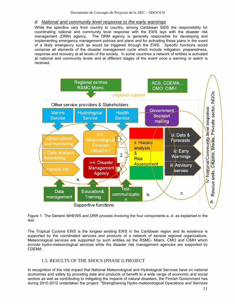
a. Observation, hazard detection, monitoring and forecasting The tropical cyclone EWS includes the collection and analysis of hydro-meteorological data on Atlantic cyclones and the transmission of related information through a network of collaborating countries in the Caribbean Basin. Data analysis and the generation of information are largely undertaken by the National Hurricane Center in Florida, USA. The technical components of the EWS include RADAR, satellites, reconnaissance aircrafts, surface observations and upper air conditions via rawindsonde devices. The observation and detection functions of the National Hurricane Center are supported by the Tropical Analysis and Forecast Branch (TFAB) which collects data pertaining to high seas and offshore waters forecasts, tropical weather discussions that explain the reasoning behind the analysis and forecast, and surface weather analyses and forecasts over the tropics (WMO, 2011b, CDEMA 2006).
b. Incorporation of risk information in emergency planning and warning messages Data generated through the afore-mentioned networks of components is analyzed and the information generated is communicated by the RSMC Miami – Hurricane Centre to the National Meteorological and Hydrological Services (NMHS) throughout collaborating Caribbean countries. The NMHS in turn, collaborate with the national Disaster Management Agencies (NMA) to issue bulletins, advisories, watches and warnings. Each of these categories of information indicates the increasing probability of impact from a cyclone. The information communicated by the NMHS triggers a response from the DMAs that activates the national mechanism for emergency management that comprises a network of government and non-government agencies that function at national, local and community levels.
c. Dissemination and Communication of risk information and early warnings In the majority of countries the responsibility for disseminating warning information lies with the NMHS. Some countries designate responsibilities to the DRM agency while in others the responsibility is shared between the NMHS and the DRM agency. The information that is communicated usually includes a range of hydro-meteorological data related to the generation, characteristics and movement of tropical cyclones. It includes: rainfall quantity and intensity, cloud pattern/height, wind direction and speed, humidity/temperature, and atmospheric pressure, as well as the likely impacts (e.g. of the winds, rainfall, flooding etc.) and the precautionary and preparatory measures to take including evacuation if deemed necessary. The information is issued via the mass media, facsimile and electronic mail. The mass media is generally used for warnings to the public while other modes are used for communication among relevant agencies that have a role to play in emergency response.
5 :Compiled from WMO, 2011a, CMO Resolution 1, CMC51, 2011
Documento de Concepto de Proyecto de la AEC – SHOCS II
11
d. National and community level response to the early warnings While the specifics vary from country to country, among Caribbean SIDS the responsibility for coordinating national and community level response with the EWS lays with the disaster risk management (DRM) agency. The DRM agency is generally responsible for developing and implementing emergency management policies and plans and for activating these plans in the event of a likely emergency such as would be triggered through the EWS. Specific functions would comprise all elements of the disaster management cycle which include mitigation, preparedness, response and recovery at all levels of the society. In some countries a network of entities is activated at national and community levels and at different stages of the event once a warning or watch is received.
Figure 1. The Generic MHEWS and DRR process involving the four components a.-d. as explained in the text.
The Tropical Cyclone EWS is the longest existing EWS in the Caribbean region and its existence is supported by the coordinated services and products of a network of several regional organizations. Meteorological services are supported by such entities as the RSMC- Miami, CMO and CIMH which provide hydro-meteorological services while the disaster risk management agencies are supported by CDEMA.
1.5. RESULTS OF THE SHOCS (PHASE I) PROJECT In recognition of the vital impact that National Meteorological and Hydrological Services have on national economies and safety by providing data and products of benefit to a wide range of economic and social sectors as well as contributing to mitigating the impacts of natural disasters, the Finnish Government has during 2010-2012 undertaken the project: "Strengthening Hydro-meteorological Operations and Services

Documento de Concepto de Proyecto de la AEC – SHOCS II
12
in the Caribbean SIDS (SHOCS). The SHOCS project is part of the on-going interest of the Finnish Government in promoting sustainable development with a special emphasis on issues relating to the environment. It responds to the need of Caribbean countries to build their resilience to the impacts of hydro-meteorological hazards including the impacts of climate change. Key outcomes of this project are
- Enhanced know-how on Multi-hazard Early Warning Systems and Disaster Risk Reduction. NMHSs and DMAs of the beneficiary SIDS were supported to participate in a few of the MHEWS- DRR related regional workshops and meetings in the Caribbean.
- Training to NMHSs Quality Managers for developing Quality Management Systems for the Aeronautical Services as required by ICAO to be in place by November 2012. Two inter-linked training workshops on QMS for Aeronautical Meteorological Services were organized in May and Dec 2011 with participation from altogether 21 Caribbean SIDS Meteorological Services/Offices. This training resulted in significant progress in completion of the QMS requirements.
- Capacity assessment on future needs of development of MHEWS and DRR. Assessment Missions to visit the 16 beneficiary SIDS were carried out in Dec 2011 – March 2012. Meetings, lasting 1-2 days, included presentations and interaction between invited representatives from the NMHS, DMA and related regional and local organizations to arrive a list of key priorities for development of the different elements of the MHEWS and DRR process, illustrated in Figure 1. The outcome of the assessment is available as country reports, mission reports and a Summary report6.
Recognized priorities for development based on result of the SHOCS assessment are listed in the Summary report as
1. The greatest priority for the region with respect to strengthening capacity for MHEWS and DRR is to build their institutional capacity. Ten (10) out of the sixteen (16) countries involved in the assessment prioritized this need and identified the main requirements as increased numbers of staff as well as more highly trained and professionally-trained staff working at the national, local and community levels, as well as the financial resources to build this capacity.
2. The second level of priority, also associated with institutional strengthening, is for the methods and technical resources to enhance hazard detection, monitoring and forecasting. This is needed particularly to increase the number of automatic weather stations (AWS) across the various countries, both for monitoring and to transmit meteorological data in real time. The technical resources needed refer also to high resolution numerical weather prediction (NWP) models and the associated software, to be used for monitoring, forecasting and transmitting data on conditions in localized areas. Countries that prioritized this need noted that existing models cannot capture information at the scale needed by small island states, which would enable them to identify occurrences such as heavy rainfall that results in flash flooding and landslides in hilly terrain.
3. The capacity for communicating watches, warnings and advisories was examined specifically as it relates to the consistency and clarity of warning messages and the extent to which they link risk information to the appropriate response actions that should be taken. This was the third most prioritized area and countries expressed the concern
6 The reports can be accessed at http://www.acs-aec.org (effective ca. Nov 15th 2012)

Documento de Concepto de Proyecto de la AEC – SHOCS II
13
that messages need to be delivered in a language that is understood by the people. This means that they must relate to all populations including the language of indigenous peoples, remote communities, and the general public. Many Caribbean countries, for example, are popular tourist destinations and it was observed that the languages of the non-English speaking source areas of tourists (for example, German, French and Spanish) would be helpful in advising tourists on the appropriate response in emergency situations.
4. The fourth priority area was political recognition and legislation for MHEWS and DRR, specifically for those countries which had not yet done so to develop legislation that clearly identifies those agencies that must be involved in MHEWS and DRR, and defined their respective roles and responsibilities. Some countries have already drafted the legislation and therefore needed to revisit the draft to ensure that the relevant aspects of MHEWS and DRR are included. Finally, several countries that already have legislation saw the need to revise to include important aspects that were not considered at the time the legislation was developed.
5. Training in basic skills in meteorology and disaster management (risk awareness communicating with the media, risk assessment) was the fifth level of priority noted by countries. In this category the main needs are for training in the use of modern technologies available in the hydrological and meteorological sciences, and training of meteorological and disaster management personnel in communicating early warning information between the agencies and to both the media the general public.
6. Finally, at the sixth level of priority is the need to enhance the methods and techniques used in disseminating watches, warnings and advisories. This area relates to the instruments, technologies and physical resources available to meteorological and disaster management personnel to disseminate information in a timely manner.
B. OBJECTIVES
.1 Project overall objective Caribbean societies are better prepared, able to manage risks related to severe weather and hydro-meteorological hazards. Societies have also attained stronger resilience on adverse impacts of climate and long term natural hazards.
.2 Project specific objective(s) - Hydro-meteorological information and products will be better available for decision makers and
the general public. - Meteorologists and Disaster Managers will have improved tools for handling and delivering
information on extreme hydro-meteorological phenomena. - Information on slowly developing hazards, climate anomalies and climate change will be better
demonstrated in the
.3 Expected results
Documento de Concepto de Proyecto de la AEC – SHOCS II
14
- Improved capacity of NMHSs to operate the weather observation network and handling hydro-meteorological information
- Improved Institutional Governance and Early Warnings services to the society - Enhanced tools for Climate monitoring and services; C. STAKEHOLDERS
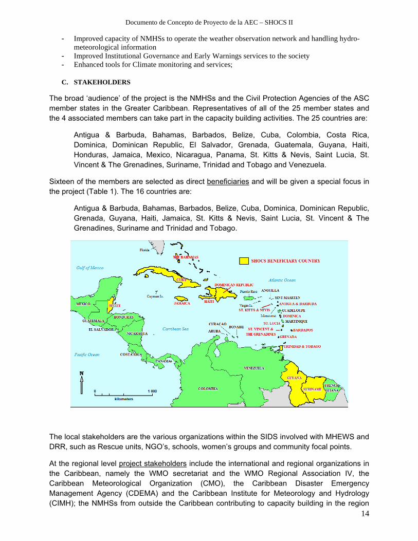
The broad ‘audience’ of the project is the NMHSs and the Civil Protection Agencies of the ASC member states in the Greater Caribbean. Representatives of all of the 25 member states and the 4 associated members can take part in the capacity building activities. The 25 countries are:
Antigua & Barbuda, Bahamas, Barbados, Belize, Cuba, Colombia, Costa Rica, Dominica, Dominican Republic, El Salvador, Grenada, Guatemala, Guyana, Haiti, Honduras, Jamaica, Mexico, Nicaragua, Panama, St. Kitts & Nevis, Saint Lucia, St. Vincent & The Grenadines, Suriname, Trinidad and Tobago and Venezuela.
Sixteen of the members are selected as direct beneficiaries and will be given a special focus in the project (Table 1). The 16 countries are:
Antigua & Barbuda, Bahamas, Barbados, Belize, Cuba, Dominica, Dominican Republic, Grenada, Guyana, Haiti, Jamaica, St. Kitts & Nevis, Saint Lucia, St. Vincent & The Grenadines, Suriname and Trinidad and Tobago.
The local stakeholders are the various organizations within the SIDS involved with MHEWS and DRR, such as Rescue units, NGO’s, schools, women’s groups and community focal points.
At the regional level project stakeholders include the international and regional organizations in the Caribbean, namely the WMO secretariat and the WMO Regional Association IV, the Caribbean Meteorological Organization (CMO), the Caribbean Disaster Emergency Management Agency (CDEMA) and the Caribbean Institute for Meteorology and Hydrology (CIMH); the NMHSs from outside the Caribbean contributing to capacity building in the region
Documento de Concepto de Proyecto de la AEC – SHOCS II
15
and others as recognized. Close contact and cooperation in joint activities will be maintained with these organizations both at sub-national, national and regional levels (see also Appendix I).
Participating institutions
Name of institution: Finnish Meteorological Institute (FMI)
Name and last name of legal representative: Petteri Taalas
Address: Erik Palménin aukio 1, P.O. BOX 503, FI-00101 City: HELSINKI
Country: FINLAND
Tel: +358 29 539 1000
Fax: +358 29 539 4129
Email: <firstname>.<lastname>@fmi.fi
Website: http://www.fmi.fi
D. BENEFITS, RISKS AND SUSTAINABILITY
.4 Benefits
The project aims at contributing to all four components of the MHEWS process: by improving capability to monitor and assess hazard situations, by providing new tools for issuing and delivering alerts and warnings on timely manner in language understood by citizens, by building seamless cooperation with the institutes an agencies involved and by providing tools to reach and inform the citizen being threatened of the hazard.
Benefits can be expected in all sectors of the Societies of the Caribbean. Several assessments and studies have shown that the economic benefit through an overall enhancement of the MHEWS and DRR process can be at least five fold compared to the investment on development. Savings are obtained because local communities are better informed on risks associated with severe weather and perform corresponding protective measures. In individual countries, for example in Cuba, the intensification of media communications by meteorologists and leaders prior and during hurricane threat has diminished casualties during recent hazard episodes.
.5 Critical risks and Sustainability

Documento de Concepto de Proyecto de la AEC – SHOCS II
16
Potential Risk categories relevant to this project can be listed as: ‘Financial’, ‘Human’, ‘Logistical’, ‘Organizational’ and a more generally ‘Force Major’. The scale of Risk Rating is defined here as from 1 to 5, where 1 indicates very low risk and 5 very high risk.
Critical Risks Risk Rating
Risk Mitigation Measures
Financial - Situations (e.g. cancellations of
reservations for various reasons, higher than expected investment costs) leading to unintentional spending of project funds leading to cancellation of some planned investments or tasks:
3
- Careful management of the tender process
- Organize majority of workshops and meeting outside the hurricane season
Human - Rotation of experts during the course of
the project leading to delays, information breaks etc.
4
- Nomination of subsitutes that are on
‘stand by’ and informed
Logistical - Unexpected delays in the acquiring of
instruments, hardware and software - Availability of experts and/or trainees for
events scheduled
3 4
- The tender and purchase process of
items is initiated as early as possible after the project start
- Set priority high, plan well in advance, motivate by good practices (organization etc.), monitor satisfaction, use substitutes (see above)
Organizational
- Competition between donors or projects leading to block outs etc.
2
- Keeping stakeholders well informed
and promoting co-operation.
Force major - Personal issues (illness etc.) preventing
participation in project work -
3
- Nominate substitutes, keep them
informed.
Building sustainability is inherent in the Project. No methods, Instruments, hardware and software are acquired without providing appropriate training on their use. In case of products that are new to the Project members and beneficiaries, such as the TV presentation software, training is included in the tender and will be acquired from the instrument provider. In developing new solutions, tools and products the project beneficiaries will participate and contribute in the in planning, execution and testing phases. Users of the services and products, particularly from the Caribbean SIDS local communities, are invited to participate in the innovation process by promoting unbiased participation from genders, as well as different age and social groups.

Documento de Concepto de Proyecto de la AEC – SHOCS II
17
- PROJECT IMPLEMENTATION
A. COMPONENTS AND ACTIVITIES
Result 1: Improved operational capacity of the Caribbean SIDS weather and
climate services Indicators for this result are
- Number of Existing Automatic Weather Stations (AWS) restored into operation
- Increase in volume of hydro-meteorological observational data shared regionally
- New tools adopted at Service Offices for analyzing observational and forecast
hydro-meteorological data
- Popularity of NMHS web sites
- New hydro-meteorological and climate service products implemented
- Common methods and products agreed and implemented to communicate
weather and climate related risks
Sources for verification of this result are
o Project, CMO and WMO-RAIV reports
o NMHSs, DMA institutional reports
o Volume of data in regional data base
o Statistics on quality and availability of data regionally
o Number of staff trained
o Number of users at NMHS web-sites
o User satisfaction
Result 2. Improved capacity of NMHSs and DMAs for the governance of the early warning and DRR process Indicators for this result are
- Increase in the degree of Completion of the QMSs at Institutes
- Tools adopted at Institutes to enhance Result Based Management
- Auditing of the QMSs by rotation of trained auditors is initiated
- A virtual service on climate information is in use and assessed by the Caribbean
communities
- Improved skills attained on presentation and communication of risks related to
weather hazards
Sources for verification of this result are
o Project, CMO and WMO-RAIV reports
Documento de Concepto de Proyecto de la AEC – SHOCS II
18
o NMHSs, DMA institutional reports
o Number of auditors trained
o Climate service user feedback and satisfaction
o Number of presenters of weather hazards trained
o Feedback from local communities
.1 Listing of activities
The following activities and inputs have been specified to obtain the results.
RESULT 1: IMPROVED OPERATIONAL CAPACITY OF THE CARIBBEAN SIDS WEATHER AND CLIMATE SERVICES
The Activities within this result component aim at improving the overall technical and methodological capacity of weather services of the SIDS Meteorological Services/Offices. Main focus will be on enhancing the reliability and timeliness of data delivery from existing Automated Weather Stations (AWS) and access to other available observational data to better support monitoring of rapidly moving and developing tropical cyclones and hurricanes. Attention will be given also on data sustainability so that the observation data can better serve analyses of slowly developing and climate risks. Also new AWSs can be purchased for selected locations, based on expressed needs, e.g. to improve monitoring of coastal conditions or flood prone watersheds. The acquirement of instruments will typically involve a tender procedure which is included in the Activities of this Result component. Staff responsible of operations and maintenance with the accrued instruments will be instruments The investments will be complemented by training given by the project experts to local staff on proper maintenance and continuous 24/7 operation. Project experts from FMI and CIMH work in cooperation to execute the activities listed below. Activity 1.1 Training and consulting for improved maintenance and rehabilitation of selected weather observation stations Most weather stations in the Caribbean that report regularly to WMO data centers are manually operated and form a so called Regional Basic Synoptic Network (RBSN). The frequency of observations of these stations, when located at the airports is typically 1 hour and elsewhere 3 hours. For monitoring of rapidly moving or developing severe weather systems, such as tropical storms and hurricanes, a recording frequency of as high as every 10 min is desirable. For this purpose Automated Weather Stations with online and real-time reporting capability are most appropriate. To improve the monitoring of severe weather phenomena several projects have donated Automated Weather Stations to the Caribbean Islands during the past years, but only a portion of them have remained in function and are delivering high quality data continuously. The causes of station malfunctions or inoperability are many fold; for example, the humid environment and maritime air in the Caribbean cause corrosion on the station hardware. Other causes can be related e.g. to lack of resources (trained staff and/or funding) to rehabilitate the systems.

Documento de Concepto de Proyecto de la AEC – SHOCS II
19
In this Activity the technicians from CIMH and FMI, together with the local technicians at the SIDS NMHS will form a team to carry out on-site maintenance and rehabilitation work as recognized necessary to make the exstiting AWSs in full operation. The Project will provide also on-site training as necessary, acquire spare parts for the stations and solve data communication issues. For remote sites the ownership of communities on the weather stations will be promoted by providing training on maintenance operations to local volunteers. Also new AWSs, equipped with regular components such as sensors to measure: wind speed and direction, temperature, relative humidity, air pressure and precipitation intensity, will be delivered to selected SIDS based on expressed needs and availability of project funds. Special types of AWSs can be also configured depending on the role of the stations: e.g. the AWS can be configured for coastal/marine conditions with capacity to measure sea level and wave height, or if placed in a water-shed area to measure lake/river height. At sites near the sea, under very the saline conditions, the components of the AWS and the installation technique can be selected such as to obtain best possible resistance to corrosion. During their visits to the SIDS meteorological offices, CIMH and FMI technicians will give further training on procedures to sustain high performance of the AWSs, such as: - Help assembling new AWSs at the selected sites - Maintenance and on-site calibration of AWSs - Finding optimal technical solutions for data retrieval and storage. - Demonstrating and Creating automated and manual QA/QC monitoring procedures for AWS
data - Consulting on the purchasing procedures for sensors and rotation of sensors for calibration
at CIMH Inputs Experts contributing to this Activity are: Title Tasks Proposed Agency Project Manager Coordination FMI Purchase Officer Manage tendering and purchase of equipment FMI AWS technician1 Training and consulting on AWS installations
and maintenance FMI
AWS technician2 Training and consulting on AWS data transfer, storage and quality management
FMI
AWS technician3 Training and consulting on AWS installations and maintenance
CIMH
AWS technician4 Training and consulting on AWS data transfer, storage and quality management
CIMH
SIDS AWS technicians Cooperate Selected SIDS Work plan: Number of Institutes involved is eight (8): Four (4) missions by one FMI and one CIMH technicians at a time visiting two Institutes per mission Approximately eight SIDSs/NMHSs (Institutes) can be included as beneficiaries of this Activity. FMI and CIMH technicians work as pairs to perform maximum one week missions to each SIDS. Prior to the missions, the Project technicians consult remotely with the Institutes at each
Documento de Concepto de Proyecto de la AEC – SHOCS II
20
SIDS to decide on the investments, installation and training needed to achieve the targeted results. The needs for investments are communicated to PM and Purchase Officer to start the tender process (if required). Missions can start after all investments have been delivered to the Institutes. Reserved resources for capacity building: Activity Project Member Cost Element Days/Travels
CIMH Technician A5. Travels 8
A6. Accommodation 56
A7. Allowances 56
FMI Technician A1. Work 56
A2. Travels 8
A3. Accommodation 112
A4. Allowances 112
FMI PM A1. Work 7
FMI Purchase Officer A1. Work 7
A1.1 Training on solutions to improve AWS
performance and to mobilize observational
data regionally
Reserved resources for investment: Function Item Sites CostItem Unit Cost Qty Qty Total Total cost
Tender FMI PM 1 A1. Work 845 7 7 days 5 915 €
Tender FMI Purchase Officer 1 A1. Work 540 7 7 days 3 780 €
AWS components 1 C. Fixed Assets 10000 10 10 100 000 €
Customs 0.15 C. Fixed Assets 10000 10 1.5 15 000 €
Total 124 695 € Activity 1.2. Implementation of forecasting tools and production systems at selected NMHSs This activity aims at introducing technical tools and to provide training to meteorologists and IT technicians to enhance capacity of the duty meteorologists in their 24/7 duty work analyzing the weather situation and delivering forecasts, alerts and warnings and related information. New methods introduced aim at analyze hydro-meteorological conditions, prepare weather forecasts, climate outlooks and issue warnings in a coherent way between SIDS offices. The tools introduced would also allow for automated (or IT assisted) generation of service products, e.g. web pages, and in this way make the work more productive especially under severe weather conditions.
The SmartMet technology, developed at FMI, will be offered as a solution at selected service offices to collate, view, analyze and interpret meteorological data. Sources of information are any data with geographical coordinates and time information, such as surface observational data, weather soundings, weather radar data, satellite data and numerical weather forecasts from different models. The data archive is a real time relation data base for data covering the specified geographical region and a time period of a couple of weeks backwards and about two weeks forward in time7.
Two types of installations of the SmartMet system are proposed: At a ‘Main site’ presently used e.g. in Trinidad&Tobago and Jamaica Meteorological Services, the data collection is tailored to integrate all available hydro-meteorological and associated data into a dedicated data base to 7 Note: SmartMet is a tool specifically developed for a duty meteorologist to analyze data and to prepare service products, and is thus complementary to the DEWETRA system also being introduced to NMHSS and the DMAs.

Documento de Concepto de Proyecto de la AEC – SHOCS II
21
allow for interactive post-processing with the inbuilt tools8. The Main site database can be continuously mirrored to ‘Remote Sites’ at selected SIDS offices (tbd), where the same data can then be viewed interactively and used to produce localised products. The requirements for the remote user offices are: at least 1MB bandwidth to the Main site and enough technical staff capable to maintain the system operative at all times.
To keep the SmartMet sites operative on a 24/7 basis, IT technicians need dedicated training and a back-up server and power generator is required. The configuration and maintenance of the remote SmartMet server is less demanding as no other data I/O operations than the mirroring are required. To make full benefit of the system, meteorologists need at least two weeks of training and daily self practice for a longer period to familiarize with the system.
Inputs:
The number of Institutes involved is seven (7). Four (4) missions will be executed by a pair of FMI & CIMH technicians will visit two Institutes per mission. In this Project one new SmartMet Main site and a maximum of 6 new Remote sites can be established at selected SIDS. The existing SmartMet installations in Trinidad and Tobago and Jamaica that were rehabilitated through ICI projects in 2011 can be used as another Main site and/or as a back-up site. The location of the new Main site should be selected based on the extent of 24/7 service responsibilities of the forecast office and the level of training/experience of forecasters and technicians. Also the existing or planned data processing configurations should be taken into account and benefited as much as possible. The selection of the sites of installation is subject to further discussion and final decision amongst the SIDS NMHSs, CMO and recommendations by the SHOCS Project Board. At the Main site the SmartMet Expert and Trainer from FMI can stay two weeks for installation of equipment and software, consulting and initial training. At FMI work time is reserved for configuration of the system and remote consulting. Total of 130 work days is budgeted for the installation and training. At the Remote sites one FMI Technician and one trainer will stay about one week for installation and initial training of forecasters. Equipment is acquired through a tender according the list given below. Roles of participants: Title Tasks Proposed Agency Project Manager Coordination FMI SmartMet Lead trainer Installation and training at the Main Site FMI SmartMet trainer Hands-on Training for duty meteorologists FMI SmartMet technician Installation and training at Remote sites FMI Purchase Officer Manage tendering and purchase of equipment FMI SIDS Forecasters and IT Technicians
Trainee Selected SIDS
The investments will involve purchases of workstation hardware and the required supporting software licences. Forecasters and technicians will be given initial hands-on training associated with the installation of software and hard ware at the Service Offices. Further training dedicated 8 In case a data storage already exists at or near the location of the main site, the two data bases can be connected thus avoiding duplication of the data I/O operations.

Documento de Concepto de Proyecto de la AEC – SHOCS II
22
to advanced features of the system will be organized in a form of common training workshops for users of the system. Reserved resources for investment: Function Item Sites CostItem Unit Cost Qty Qty Total Total cost
Tender FMI PM 1 A1. Work 845 7 7 days 5 915 €
Tender FMI Purchase Officer 1 A1. Work 540 7 7 days 3 780 €
Main Site Server 1 C. Fixed Assets 3000 2 2 6 000 €
Main Site PC Workstation 1 C. Fixed Assets 3000 2 2 6 000 €
Main Site Monitor 27" 1 C. Fixed Assets 400 2 2 800 €
Main Site Graphics software 1 C. Fixed Assets 1000 1 1 1 000 €
Remote site PC Workstation 6 C. Fixed Assets 2000 2 12 24 000 €
Remote site Monitor 27" 6 C. Fixed Assets 400 2 12 4 800 €
Remote site Graphics software 6 C. Fixed Assets 1000 1 6 6 000 €
Customs 0.15 7 290 €
Total 65 585 € Reserved resources for capacity building: Activity Project Member Cost Element Days/Travels
FMI Smart Trainer A2. Travels 6
A3. Accommodation 78
A4. Allowances 84
FMI Smart Trainer & techA1. Work 126
FMI Lead expert on Smar A1. Work 28
A2. Travels 1
A3. Accommodation 13
A4. Allowances 14
FMI PM A1. Work 7
FMI Purchase Officer A1. Work 7
FMI Smart Met trainer A1. Work 42
A2. Travels 3
A3. Accommodation 27
A4. Allowances 28
FMI SmartMet IT expert A1. Work 84
A2. Travels 2
A3. Accommodation 26
A4. Allowances 28
SIDS Experts A5. Travels 12
A6. Accommodation 120
A7. Allowances 120
A1.2 Implementation forecasting tools and
production systems at selected NMHSs
Activity 1.3 Development and implementation of solutions for common presentation and communication of early warnings Topics of this activity include
- Designing region wide harmonization of alert information with agreed colors and symbols indicating the level of risk and hazard type associated.
- Reactivate and rehabilitate the use of Weather Information Network (EMWIN) between NMHSs and DMAs
- Introducing and implementation of the Common Alert Protocol, CAP region wide

Documento de Concepto de Proyecto de la AEC – SHOCS II
23
‐ Planning and implementation of software to create web pages showing weather alerts and warnings
The issuing of alerts and warnings is at national level typically tasked to a NMHS or DMA (or both in cooperation) and enforced by the national law and/or National Disaster Management Plan. Within the context of the WMO Hurricane Committee, the Caribbean states have agreed upon a common set of warning criteria as regards The Caribbean Tropical Cyclone EWS. Official alerts and warnings are communicated via different channels to government ministries, stakeholders within the DRR sector and media to reach the local communities. While the communication of this information at national level is commonly fairly well organized, there is a need to better integrate warnings regionally to create a situational view cross the Caribbean.
An example of effective sharing of official hydro-meteorological warnings is The MeteoAlarm service (www.meteoalarm.eu), which began as a Project of the European Network of Meteorological Services (EUMETNET) and was launched in 2007 (see Annex 6). It collects the pre-determined types of weather warnings at a national and municipal/provincial level into a single service where the user is able to view all standing weather warnings in Europe. The MeteoAlarm service is an innovative regional collaboration that greatly enhances the cooperation between the NMHSs and brings their most important products, the weather warnings, to the reach of the general public. This concept has not yet been duplicated to other regions as such and currently there is room for enhancing the exchange of official weather warnings between the Caribbean NMHSs beyond the regional tropical cyclone warnings issued by the Regional Specialized Meteorological Centre (RSMC) Miami.
In this Activity the Project elaborates the applicability of the MeteoAlarm concept to be adapted in the Caribbean. The Project will establish a team consisting of members from the NMHSHs and DMAs and stakeholders organizations to build a roadmap including planning and for implementation, e.g. to develop the requirements for the software needed, procedures to exchange and collect local warnings and establish a web service for common use. The Project will provide resources for the meetings and workshops and Technical Assistance from staff at the FMI, who have been involved in the original MeteoAlarm Project.
Another related component of this Activity is to introduce the Common Alerting Protocol (CAP), endorsed by WMO9., as a tool for effective and standardized dissemination of alert and warning information. CAP is an international standard format for emergency alerting and public warnings. It is applicable for all hazard types, including hydro-meteorological hazards. CAP also applies to various media channels/platforms such as such as sirens, cell phones, fax, radio, TV and various internet based communication networks. The CAP message can be effectively communicated through many of the channels at the same time thus increasing effectiveness and simplifying the alerting task. Inputs: This Activity is carried as a set of four, three day workshops at selected SIDS Institutes Offices. The first meeting is used for introducing the concepts and methods and to agree on details of expected results. Five SIDS participants are budgeted travel to each workshop/meetings. Development work is carried in the intermediate times through remote correspondence.
9 WDS/PWS/WMO-RAA/CAP-JSO; Geneva 14 August 2012; see also http://www.wmo.int/pages/prog/amp/pwsp/CommonAlertProtocal_en.html
Documento de Concepto de Proyecto de la AEC – SHOCS II
24
Roles of participants: Title Tasks Proposed Agency Project Manager Coordination, Training on Meteoalarm FMI SIDS - EWS Expert Training and Consulting on EWS
development SIDS Institute
CAP Expert Training and consultation on CAP SIDS or WMO IT Technician Programming of solutions for web-based tools FMI EMWIN Expert Training and consultation on EMWIN SIDS Institute EWS experts (3-4) Contribute to planning and testing Selected SIDS Reserved resources for capacity building: Activity Project Member Cost Element Days/Travels
FMI Expert A1. Work 28
A2. Travels 4
A3. Accommodation 16
A4. Allowances 16
FMI PM A1. Work 14
A2. Travels 8
A3. Accommodation 8
A4. Allowances 12
SIDS Expert A5. Travels 20
A6. Accommodation 20
A7. Allowances 25
A1.3 Development and implementation of
solutions for common presentation and
communication of early warnings
RESULT 2. IMPROVED CAPACITY OF INSTITUTES FOR THE GOVERNANCE OF THE EARLY WARNING PROCESS
Activity 2.1 Capacity building on institutional governance through Quality Management The purpose of this Activity is to continue training and consulting on Quality Management to the extend required by those agencies that did not yet complete the QMS by the target date specified by ICAO (November 2012), The activities also involve training to selected QMS auditors and organizing periodic auditing of the established QMSs at the NMHSs. The aim is also to extend the management procedures to other service activities, to promote methods for Result Based Management (RBM) and of the overall governance of the Institute. Inputs The Activity is executed as to workshops: ‐ One QMS workshop for 3 days at selected SIDS budgeted for participation of 16 SIDS experts ‐ Two RBM oriented workshops at FMI organized as a one week study tour to Finland. Budgeted for 8
SIDS experts per study tour.
Roles of participants: Title Tasks Proposed Agency Project Manager Coordination of workshops FMI QMS Expert Training and Consulting on QMS FMI

Documento de Concepto de Proyecto de la AEC – SHOCS II
25
FMI Experts (6) Presentations of Good Practices at FMI FMI SIDS Expert (16) Contribute to the study tour SIDS Institutes Reserved resources for capacity building: Activity Project Member Cost Element Days/Travels
FMI Expert A1. Work 14
A2. Travels 6
A3. Accommodation 8
A4. Allowances 10
FMI Experts A1. Work 8
FMI PM A1. Work 8
FMI PM/QMS Expert A1. Work 8
A2. Travels 6
A3. Accommodation 8
A4. Allowances 12
SIDS Expert A5. Travels 31
A6. Accommodation 156
A7. Allowances 187
A2.1 Capacity building on institutional
governance through Quality Management
Activity 2.2 Enhancing presentation skills of Early Warning information to the general public and communities - Training on a TV broadcasting solution This activity focuses on creating effective visual demonstrations on hazard situations with a TV presentation solution to be acquired for test use at one selected Institute. Workshops will be organized to selected staff (forecasters and disaster managers) to use the presentation system and to improve their communication skills The solution at the selected site would consists a server unit, large touch screen to act as a ‘story board,’ and software dedicated to visualization of hydro-meteorological data during a live TV broadcast. Tentatively, the solution would also include one remote system that would take benefit of the product generation packages located at the main site, but which would allow another weather centre to send its data and graphics to be tailored to another Caribbean SIDS/area of interest. The SIDS where the main system and the remote system will be installed is subject to discussion and decision between stakeholders and beneficiaries. (Presently the establishment of the Remote site is left pending of additional investment funds). The TV broadcasting unit(s) and the local SmartMet-server (to be acquired as part of Activity 1.2) can be linked so that the input data can be first controlled or edited by the Smartmet unit. This activity will also focus on the training of selected meteorologists to use both the SmartMet and the TV broadcast system for effective illustrations and communication of alerts and warnings. Inputs: Investments are (presently) budgeted for one full installation of the presentation equipment. Training is first organized during one week for the staff at the local Institute. Two additional training courses using the acquired tools and lasting 5 weekdays, with a participation of 6 SIDS (travelling) SIDS Experts will be organized.

Documento de Concepto de Proyecto de la AEC – SHOCS II
26
Roles of participants: Title Tasks Proposed Agency Project Manager Coordination FMI SmartMet Lead trainer Technical consulting and training
on the use of SmartMet with the presentation software
FMI
Purchase Officer Manage tendering and purchase of equipment
FMI
SIDS Expert on TV presentation Training for duty meteorologists SIDS Institute Local trainees Trainee SIDS Institute SIDS EWS & DRR presenters (12) Trainee Selected SIDS
Institute Reserved resources for capacity building:
FMI Expert A1. Work 14
A2. Travels 2
A3. Accommodation 12
A4. Allowances 14
FMI PM/QMS Expert A1. Work 14
A2. Travels 2
A3. Accommodation 8
A4. Allowances 10
FMI Lead expert on Smar A1. Work 14
A2. Travels 1
A3. Accommodation 4
A4. Allowances 7
FMI PM A1. Work 7
FMI Purchase Officer A1. Work 7
SIDS Expert A5. Travels 12
A6. Accommodation 48
A7. Allowances 60
A2.2 Enhancing presentation skills or Early
Warning information to the general public and
communities ‐ Training on a TV broadcasting
solution
Reserved resources for investment: Function Item Sites CostItem Unit Cost Qty Qty Total Total cost
Tender FMI PM 1 A1. Work 845 7 7 days 5 915 €
Tender FMI Purchase Officer 1 A1. Work 540 7 7 days 3 780 €
1 B. Administrativ 1000 1 1 1 000 €
Main Site TV broadcasting Server 1 C. Fixed Assets 85000 1 1 85 000 €
Customs 0.15 C. Fixed Assets 85000 1 0.15 12 750 €
Total 108 445 € Activity 2.3 Enhancing communication of climate information to the Caribbean communities This activity will focus on building the capacity at the CIMH and NMHSs to communicate information on slow on-set hazards, climate variability and climate change to local communities in the Caribbean with emphasis on potentially hazardous phenomena. To assist in the general understanding of weather information, Institutes will work with NGO’s, the media, and

Documento de Concepto de Proyecto de la AEC – SHOCS II
27
community based organizations such as church and women’s groups, to develop strategies to ensure that the weather and climate forecasts and warnings are communicated using appropriate languages familiar to the users of the information. The information will contain, for example, long term observation records, projections of future climate based on different emission scenarios of greenhouse gases and assessments of slow-onset hazards such as drought and risk for forest fires. Information will be made available via an internet portal to be designed and implemented as a result of this activity. The objective of this virtual forum is to ‐ To provide an internet portal to present temporal and spatial variability of climate data. The
user interface will be open to public use and available in English and Spanish. ‐ Demonstrate strength and impacts (casualties, physical and economical) of extreme hydro-
meteorological conditions (hurricanes, tropical storms, drought, flooding etc.) based on existing reports and data
‐ To provide operational long term weather and climate outlooks with a lead time from one week up to three months (tbd) using medium and long term NWP-prediction results.
The Activity will include training to community focal points on the use of the portal, how to apply these information for adaptation and mitigation planning and to gain feedback for future development of the system. To develop the portal the following benchmarks are targeted: ‐ Organization of the team and defining the roles ‐ Potential users contacted and user requirements assessed ‐ Available data sources assessed and organized into a database ‐ A technical plan of the portal prepared: specification of hardware and software,
assessment and use of data sources ‐ A demonstration version of the portal ready ‐ Overall assessment of the portal test version prepared ‐ Collection of test user feed back ‐ Implementation of the operational version
A similar solution, called Climate Guide (http://ilmasto-opas.fi/en/) was recently developed at FMI. It consists of information on observed and modeled climate change and its impacts as maps and graphs, via easy-to-use user interfaces including:
climate observations and modelled information on future climate, modeled information on the future impacts of climate change and examination of the impacts by locality
Input: Roles of participants:
Title Tasks Proposed Agency Climate services Expert Coordinate the tasks of the Activity FMI Scientific advisor Consulting on scientific content FMI Communications specialist Contribute to language used and style SIDS Institute Content producer & Data Specialist
Acquire data for the service SIDS Institute

Documento de Concepto de Proyecto de la AEC – SHOCS II
28
DRR specialist Connect the team with the local users CDEMA Community focal points Specify needs requirements and give
feedback on the services Selected SIDS community units
Technical requirements: climate databases for observations and climate model data for the Caribbean region available as input. The team will hold four workshops/meetings in the Caribbean lasting three working days each. Focal points from communities are invited to attend/contribute. During intermediate times, team members carry out tasks specified by the team. Reserved resources for capacity building: Activity Project Member Cost Element Days/Travels
FMI Lead Expert A1. Work 80
A2. Travels 4
A3. Accommodation 16
A4. Allowances 20
FMI Technician A1. Work 5
A2. Travels 15
A3. Accommodation 15
A4. Allowances 15
SIDS Experts A5. Travels 20
A6. Accommodation 16
A7. Allowances 20
Sub‐contracted work A8. Subcontracted work
A2.3 Enhancing communication of climate
information to the Caribbean communities
Activity 2.5 Project meetings This activity will cover formal meetings of the project such as Kick-off, Project Board and Final meeting. The project will be launched by holding an opening (Kick-off) meeting, possibly associated with another regional occasion in the Caribbean. Key project stake holders, the project board and the project team members will participate in the kick-off meeting to allow for wide audience the meeting will be broadcasted interactively to the 16 Caribbean SIDS offices. The project will be concluded with a Final meeting to be organized, if possible, in conjunction with the ACS SCDRR meeting to allow for wide representation from the ACS member states. The Project Board consists of representatives from ACS (2), FMI(1), WMO (1), CDEMA(1) and CMO(1). Project Manager calls upon the meeting, prepares the agenda and distributes the documents. PB approves the Annual Plan and any major changes proposed by the PM on budget allocations. PB also approves the bi-annual Progress reports and consults in any issue regarding the project execution and management. The Project Board will meet twice per year at the time of finalization of the bi-annual project reports (typically end of May and November). There will be 4-5 Project Board meetings (tbd) of which at least three will be organized as physical meetings while others will be held through teleconferencing.

Documento de Concepto de Proyecto de la AEC – SHOCS II
29
Reserved resources for capacity building: Activity Project Member Cost Element Days/Travels
PB members A5. Travels 9
A6. Accommodation 24
A7. Allowances 27
Project manager A1. Work 20
A2. Travels 8
A3. Accommodation 9
A2.4 Project meetings
A4. Allowances 9
.2 Expected schedule
Q2 Q3 Q4 Q1 Q2 Q3 Q4 Q1 Q2 Q3
A1.1 Training on solutions to improve AWS performance and to
mobilize observational data regionally 201 375 €
A1.2 Implementation forecasting tools and production systems
at selected NMHSs 294 105 €
A1.3 Development and implementation of solutions for
common presentation and communication of early warnings 63 300 €
A2.1 Capacity building on institutional governance through
Quality Management 104 450 €g p y g
information to the general public and communities ‐ Training
on a TV broadcasting solution 165 625 €
A2.3 Enhancing communication of climate information to the
Caribbean communities 122 870 €
A2.4 Project meetings 27 550 €
2014
Activity Total
20152013
B. EXECUTION
.3 Physical means required The observation instruments, computer hardware and software are included in the budget as Fixed Assets. These are acquired as necessary through a tender process. Estimated costs are detailed in the input section of the corresponding Activity description.
.4 Expertise required
The required expertise is described in the Activities section. .6 Project Team
The project team consists of personnel at the ACS Section for Disaster Risk Reduction: Director, Project coordinator, Project Assistant., The staff at FMI, Consulting services consists of Project Manager and Project Assistant.
C. COST

Documento de Concepto de Proyecto de la AEC – SHOCS II
30
.5 Financing Matrix
Cost Element Cost of unit Units Unit Total A1.‐A8.
A1. Work 450‐845 € 605 days 362 215 € 36 %
A2. Travels 1 400 € 68 # 95 200 € 10 %
A3. Accommodation 110 € 360 days 39 600 € 4 %
A4. Allowances 70 € 391 days 27 370 € 3 %
A5. Travels 600 € 112 # 67 200 € 7 %
A6. Accommodation 110 € 440 days 48 400 € 5 %
A7. Allowances 70 € 495 days 34 650 € 3 %
A8. Subcontracted work 30 000 € 30 000 € 3 %
B. Administrative 1 000 € 6 6 000 € 1 %
C. Fixed Assets 50.8 268 640 € 27 %
D. Contingency 20 725 € 2 %
Grand Total 1 000 000 € 704 635 € 424 890 €
70 %
42 %
A5.‐A7.+
B+C
% of Total
- PROJECT EVALUATION
This project conforms to the INSTITUTIONAL COOPERATION INSTRUMENT – ICI described in detail in the ICI Manual and Recommended Best Practices (Revised version 7, June 2012) attached to this Project Work Plan as a separate document.
ANNEX I - SCHEDULE OF ACTIVITIES
According to the ICI norm the detailed schedule and budget is first determined at the time of preparation of the first Annual Plan and thereafter updated at the Start of every Calendar Year

Documento de Concepto de Proyecto de la AEC – SHOCS II
31
ANNEX II - DETAILED BUDGET
Activity Cost Element UnitCost Units Total cost
A1. Work 642 € 70 39 935 €
A2. Travels 1 400 € 8 11 200 €
A3. Accommodation 110 € 112 12 320 €
A4. Allowances 70 € 112 7 840 €
A5. Travels 500 € 8 4 000 €
A6. Accommodation 110 € 56 6 160 €
A7. Allowances 70 € 56 3 920 €
B. Administrative 1 000 € 1 1 000 €
C. Fixed Assets 10 000 € 11.5 115 000 €
201 375 €
A1. Work 593 € 294 167 195 €
A2. Travels 1 400 € 12 16 800 €
A3. Accommodation 110 € 144 15 840 €
A4. Allowances 70 € 154 10 780 €
A5. Travels 500 € 12 6 000 €
A6. Accommodation 110 € 120 13 200 €
A7. Allowances 70 € 120 8 400 €
C. Fixed Assets 1 543 € 37 48 600 €
286 815 €
A1. Work 693 € 42 26 950 €
A2. Travels 1 400 € 12 16 800 €
A3. Accommodation 110 € 24 2 640 €
A4. Allowances 70 € 28 1 960 €
A5. Travels 500 € 20 10 000 €
A6. Accommodation 110 € 20 2 200 €
A7. Allowances 70 € 25 1 750 €
B. Administrative 1 000 € 1 1 000 €
63 300 €
A1. Work 693 € 38 25 400 €
A2. Travels 1 400 € 12 16 800 €
A3. Accommodation 110 € 16 1 760 €
A4. Allowances 70 € 22 1 540 €
A5. Travels 850 € 31 26 700 €
A6. Accommodation 110 € 156 17 160 €
A7. Allowances 70 € 187 13 090 €
B. Administrative 1 000 € 2 2 000 €
104 450 €
A1. Work 704 € 56 39 585 €
A2. Travels 1 400 € 5 7 000 €
A3. Accommodation 110 € 24 2 640 €
A4. Allowances 70 € 31 2 170 €
A5. Travels 500 € 12 6 000 €
A6. Accommodation 110 € 48 5 280 €
A7. Allowances 70 € 60 4 200 €
B. Administrative 1 000 € 1 1 000 €
C. Fixed Assets 56 667 € 2.15 97 750 €
165 625 €
A1. Work 517 € 85 46 250 €
A2. Travels 1 400 € 19 26 600 €
A3. Accommodation 110 € 31 3 410 €
A4. Allowances 70 € 35 2 450 €
A5. Travels 500 € 20 10 000 €
A6. Accommodation 110 € 16 1 760 €
A7. Allowances 70 € 20 1 400 €
A8. Subcontracted work 30 000 € 1 30 000 €
B. Administrative 1 000 € 1 1 000 €
122 870 €
A1. Work 845 € 20 16 900 €
A2. Travels 0 € 8 0 €
A3. Accommodation 110 € 9 990 €
A4. Allowances 70 € 9 630 €
A5. Travels 500 € 9 4 500 €
A6. Accommodation 110 € 24 2 640 €
A7. Allowances 70 € 27 1 890 €
27 550 €
D. Contingency 28 015 €
A2.4 Project meetings
A1.1 Training on solutions to improve AWS
performance and to mobilize observational data
regionally
A1.2 Implementation forecasting tools and
production systems at selected NMHSs
A1.3 Development and implementation of
solutions for common presentation and
communication of early warnings
A2.1 Capacity building on institutional governance
through Quality Management
A2.2 Enhancing presentation skills or Early
Warning information to the general public and
communities ‐ Training on a TV broadcasting
solution
A2.3 Enhancing communication of climate
information to the Caribbean communities

ACS Project Concept Document –SHOCS II.
ANNEX III - LOGICAL FRAMEWORK
OBJECTIVES VERIFIABLE INDICATORS MEANS OF VERIFICATION FAVOURABLE ASSUMPTIONS
DEVELOPMENT OBJECTIVE Caribbean societies are better prepared, able to respond and to manage risks related to severe weather and hydro-meteorological hazards. Societies have also attained stronger resilience on adverse impacts of climate and long term natural hazards.
Decrease in casualties and economic losses due to natural hazards in the Greater Caribbean region
Growth in investments on early warning systems and rescue preparedness
increase in attentiveness and satisfaction of stakeholders and general public on early warning systems
National regional institute reports, Insurance company reports
Statistics on hazards and their impacts
Media releases, Statistics on visits at EWS service sites, User feedback
Government support in to beneficiary institutes and to project initiatives on MHEWS and DRR
The hurricane activity will not prevent project implementation in the beneficiary states
Economical and political stability in the region
PURPOSE
Enhancing the role and strengthening the capacity of National Meteorological and Hydrological Institutions and Disaster Management Agencies in ACS Member States in the provision of early warning services and preparedness to mitigate
impacts of natural hazards.
Number of new systems implemented and users trained
Customer satisfaction
Number of regional institutional QMS auditors trained
Number of institutional performance measures established for National Meteorological and Hydrological Services (NMHSs) and Disaster Management Agencies (DMAs)
ACS, CMO, WMO/RAIV annual reports
Annual reports of NMHSs and DMAs
QMS Audit reports
Project mission reports
Availability and willingness of personnel to participate in project activities in the partnering, stakeholder and beneficiary state organizations
Political support for the acquirement of instruments, computer hardware and software to the beneficiary countries
Costs on investments, i.e. purchase and delivery of instruments, hardware and software, don’t significantly exceed the preliminary estimates
Close and smooth connection between project stakeholders: Minimum rotation of staff in partner, stakeholder and beneficiary institutes during the course of the project.
Equality of men and women practised in all project activities
Appropriate use of project funds and time as planned.
COMPONENTS
Result 1: Improved operational capacity of the Caribbean SIDS weather and climate services
Number of Existing Automatic Weather Stations (AWS) restored into operation
Increase in volume of hydro-meteorological observational data shared regionally
New tools adopted at Service Offices for analyzing observational and forecast hydro-meteorological data
Popularity of NMHS web sites
New hydro-meteorological and climate service products implemented
Common methods and products agreed and implemented to communicate weather and climate related risks
• Project, CMO and WMO-RAIV reports
• NMHSs, DMA institutional reports
• Volume of data in regional data base
• Statistics on quality and availability of data regionally
• Number of staff trained
• Number of users at NMHS web-sites
• User satisfaction
Favourable weather during scheduled field work
Minimum delays and cancellation of scheduled project events due to strikes, accidents etc.
Availability of staff at institutes for project activities
Minimum of delays in acquiring instruments, hardware and software

Documento de Concepto de Proyecto de la AEC – SHOCS II
communication of risks related to weather hazards
ANNEX III - LOGICAL FRAMEWORK
OBJECTIVES VERIFIABLE INDICATORS MEANS OF VERIFICATION FAVOURABLE ASSUMPTIONS
ACTIVITIES
A1.1 Training on solutions to improve AWS performance and to mobilize observational data regionally
Number of AWSs restored
Increase of AWS data for regional use
Increase in quality (availability, timeliness, accuracy) of online observation data
WMO and CMO Annual
reports
Project reports
Statistics on data quality
Minimum damage to AWS
installation due to vandalism and natural hazards
Availability of NMHS technicians during project visits
Safe delivery of equipment
A1.2 Implementation forecasting tools and production systems at selected NMHSs
Number of service products adopted in use
Number of staff trained
Improved productivity
Improved quality of products
Improved user satisfaction
Project reports
Customer satisfaction
Statistics on visits at Institute web site
Surveys on satisfaction on training
Availability of NMHS technicians during project visits
Safe delivery of new equipment
A1.3 Development and implementation of solutions for common presentation and communication of early warnings
Procedures to share warnings regionally agreed
Number of staff trained
Production software ready for operational use
Project reports
Customer satisfaction
Statistics on visits at Institute web site
Satisfaction on training
Visits at NMHS web sites
Availability of NMHS forecasters during project visits
A2.1 Capacity building on institutional governance through Quality Management
Progress in completion of QMSs for aeronautical services
4-5 QMS auditors trained
Number of QMS audits performed
Extent of RBM tools adopted in use
Progress in completion of QMSs for aeronautical services
Institute reports
QMS audit reports
Directors committed to complete QMSs at their Institutes
A2.2 Enhancing presentation skills or Early Warning information to the general public and communities - Training on a TV broadcasting solution
Presentation software acquired and installed
Number of staff trained
Media and public feed back
Number of web products generated
Project reports
Customer satisfaction
Statistics on visits at Institute web site
Satisfaction on training
Visits at NMHS web sites
Costs on Purchase and delivery of the hardware and software don’t greatly exceed the preliminary estimates
A2.3 Enhancing communication of climate information to the Caribbean communities
User requirements defined
Work plan agreed
User interface developed
Number of contributing local communities involved
Number of public users trained
Project reports
User satisfaction reports
Media feed back
Availability of experts in the Caribbean for project tasks
Adequate availability and quality of climate data for publication as climate services
A2.4 Project meetings 5 meetings scheduled
PB meeting minutes including decisions and quidance on project governance
Common times available for meetings
ANNEX IV - APPENDICES
Documento de Concepto de Proyecto de la AEC – SHOCS II
c) Provide immediate and coordinated response by means of emergency disaster relief to any affected Participating State,
d) Secure, coordinate and provide in interested inter-governmental and non-governmental organizations reliable and comprehensive information on disasters affecting Participating States.
e) Encouraging:
i) The adoption of disaster loss reduction and mitigation policies and practices at the regional and national level,
ii) Cooperative arrangements and mechanisms to facilitate the development of a culture of disaster loss reduction, and
f) Coordinate the establishment, enhancement and maintenance of adequate emergency disaster response capabilities among the Participating States (CARICOM, 2008).
The foregoing objectives, particularly (e), clearly give CDEMA a mandate to advance DRM in the region. With respect to climate change, CDEMA has adopted the position, {consistent with that of the Caribbean Community Climate Change Centre (CCCCC)} that the starting point for the discussion on climate change adaptation is with DRM. Further, the Enhanced Comprehensive Disaster Management Strategy (CDM) being spearheaded by CDEMA over the framework for advancing DRM in the region is seeking “to strengthen regional, national and community capacity for the mitigation, management, and coordinated response to natural and technological hazards, and the effects of climate change” (CDERA, 2008, p.49).
CDEMA’s mandate requires it to work closely with national counterpart agencies in achieving its objectives. The governance mechanism for the Comprehensive Disaster Management Strategy (CDM) is the CDM Coordination and Harmonization Council (CHC) which was established in 2007 to provide policy and technical advice for CDM implementation at the national, sectoral and regional levels. Among the specific goals of the CDM CHC are: mainstreaming disaster risk reduction at the national level and into key sectors of national economies, and strengthening regional capacity for leadership in advancing the disaster loss agenda (CDEMA, 2010). Six (6) sectoral sub-committees established within the mechanism (Education, Health, Civil Society, Agriculture, Tourism and Finance) complete the council.
The Caribbean Institute of Meteorology and Hydrology (CIMH) is a training and research organization. Responsibility for its operation rests with the sixteen Commonwealth Governments which comprise the Caribbean Meteorological Organization (CMO). The role and mission of the CIMH is to improve meteorological and hydrological services and to assist in promoting awareness of the benefits of these services for the economic well-being of the CMO countries. This is achieved through training, research and investigations, and the provision of specialised services and advice (CIMH, 2007). The specific functions of the Institute are to:
Provide facilities for the training of various categories of meteorological and hydrological personnel;
Operate as a centre of research in meteorology and hydrology and associated sciences;
Operate as contractors and consultants on various meteorological and hydrological projects;
Maintain a service for the upkeep, repair, and calibration of meteorological instruments;
Provide advice to participating governments on meteorological and hydrological matters;
Collect, analyze, and publish meteorological and hydrological data;
The CIMH has strong capabilities in meteorology and climate. It is the regional research centre in meteorology and is home to one of the more complete climate data bases in the region. The Institute has a specialization in climate change investigation, including sea level monitoring stations across the region. It has expertise in hydrology, hydrogeology, water resources management, fresh and salt water interactions in the coastal environment, and marine forecasting.
The Institute is involved in several related projects including developing a flood forecasting system for the Caribbean; the Caribbean Water Initiative (CARIWIN) which is promoting integrated water resources management among CARICOM states and the Caribbean Drought and Precipitation Monitoring Network launched under that project; the Caribbean Catastrophe Risk Insurance Facility (CCRIF) project on parametric development of excess rainfall models; storm surge modeling and the NASA Caribbean Flood Pilot project. The CIMH is also part of the CDEMA tsunami alerting system and serves on several of its advisory committees including the Technical Advisory

Documento de Concepto de Proyecto de la AEC – SHOCS II
APPENDIX II
PROJECTS AND STUDIES RELATED TO MHEWS IN THE REGION This section presents an overview of selected projects and studies that take account of different types of hazards in the region. For the Caribbean, MHEWS that focus on hydrometeorological hazards would address, as previously noted, hurricanes, floods, droughts and landslides. There is also increased attention being paid to tsunamis early warning systems and the need to integrate climate change impacts into MHEWS. The development and assessment of such early warning systems for the SIDS of the Caribbean region has been the subject of a progression of conferences and studies mainly since 2004 in the wake of the Asian Tsunami. Some of these are briefly summarised below.
1. Projects by CDEMA Status of Hazard Maps, Vulnerability Assessments and Digital Maps in the Caribbean. This 2003 CDERA/JICA study sought to assess the capacity of the region in fulfilling the first steps in an EWS, namely hazard detection, monitoring and forecasting. The objectives of the study were to determine the status of hazard maps and vulnerability assessment studies and their use in socio-economic planning and management in the Caribbean; to determine critical success factors, gaps and best practices in the preparation and use of hazard maps and vulnerability assessment studies in the Caribbean; and to compile a database of hazard maps, vulnerability assessment reports and digital maps available in the Caribbean. The study revealed the existence of a number of hazard maps at regional and local levels and identified their areas of coverage. Inventory of Disaster EWS in the Caribbean. This 2006 CDERA/JICA study was executed under the CADM project. It reported multiple EWS in several countries (see Table 2) and assessed the limitations and opportunities for improvement in the then existing systems. The Caribbean Hazard Mitigation Capacity Building Programme II (CHAMP) was a continuation of efforts to implement some of the specific objectives of the CDM strategy and to strengthen national and regional capacity to address hazard management through disaster mitigation. Originally intended to be a three-year project funded by the Canadian International Development Agency (CIDA), the project was actually executed over the period June 2002 to August 2006 (CDERA, 2006). The project sought to enhance regional capacity to reduce vulnerability to the effects of natural hazards through the following:
i. development of national hazard mitigation policies and implementation programmes, ii. the promotion of the wider use of hazard information in development decisions, and iii. the strengthening of safe building practices building training and certification.
CHAMP activities were conducted in the four pilot states of Belize, British Virgin Islands, Grenada and Saint Lucia. CADM II: Flood Early Warning System. As part of Outcome 4 of the CDM, CDEMA is now implementing the Caribbean Disaster Management (CADM) Project Phase II with the support of the Japan International Cooperation Agency (JICA). The project is aimed at building capacity of CDEMA and five (5) of its Participating States (Belize, Dominica, Grenada, Guyana and Saint Lucia) for managing the flood hazards. The outputs of the CADM Phase II are: (i) establishment and implementation of Early Warning System for flood hazards at the five Pilot Sites; (ii) enhanced capacity of the Regional Team to develop Hazard Maps and to establish Flood Early Warning Systems; and (iii) establishment of a Hydrological Database to function from the Caribbean Institute of Meteorology and Hydrology (CIMH). This is a three-year project which started in 2009 and is scheduled to end December 2011 (CDEMA, 2010).
2. WMO Regional Programme in Multi-Hazard Early Warning Systems (MHEWS) with National Capacity Development
Considerable attention in the Caribbean at this time is focused on designing an MHEWS for the region and assessing the enabling national capacity needs, largely under the leadership of the WMO in collaboration with a number of international partners. The progress in this initiative is summarised as follows:
Training Workshop on MHEWS with focus on Institutional Partnerships and Coordination - Costa Rica, March 2010 Hosted by the WMO in collaboration with the Instituto Meteorológico Nacional and the
Documento de Concepto de Proyecto de la AEC – SHOCS II
(ii) To enhance coordination among hydro-meteorological warning systems (building on the existing regional coordination for tropical cyclones) other hazards (e.g., tsunamis).
The Assessment of the Capacities, Gaps and Needs for the Development of the Caribbean Regional Program on Multi-Hazard Early Warning Systems and Phase-I Project Priorities: Focus on hydro-meteorological hazards and warning systems and possible linkages with other warning systems. This is an in-depth study conducted by the WMO to identify and map the gaps and needs related to MHEWS in the region. The findings, which were discussed by technical experts at a workshop on MHEWS in Barbados (November 2010), constitute the primary source of information for this report, particularly the section dealing with the existing capacities, needs and opportunities for MHEWS and DRR in Caribbean SIDS.
National Disaster Coordinators and Meteorologists Dialogue: Advancing Multi-Hazard Early Warning Systems in the Caribbean (Jamaica, December 2010).
This dialogue discussed the findings of the 2010 study and highlighted a number of key issues related to the existing capacities and challenges in EWS in the Caribbean. They included the need to (1) integrate DRR into national and regional legislation, policies and planning at all levels; (2) strengthen the existing EWS on tropical cyclones in the region, integrate them with other existing national / regional EWS (e.g. for tsunami) and expand them to other hazards such as flooding and drought; (3) strengthen regional cooperation on forecasting hazards; strengthen coordination and collaboration between the NMHS and the DRM agencies and other EWS stakeholders; (4) There is a need to improve warning messages disseminated through EWS in the Caribbean region to make them more effective (5) strengthen the warning dissemination mechanisms in the region; and (6) improve coordination and harmonization for watch and warning systems. The national disaster coordinators and meteorologists at the Dialogue identified long-term objectives to strengthen MHEWS in the Caribbean, and priorities for Phase 1 projects for the Caribbean Regional Programme in MHEWS with National Capacity Development.
In addition to the WMO Regional Programme in Multi-Hazard Early Warning Systems (MHEWS), other regional and international agencies have been involved in related projects in the Caribbean SIDS.
4.3 United Nations Development Programme
Enhancing Resilience to Reduce Vulnerability in the Caribbean. Funded by the Italian Development Cooperation to the tune of €3.5m, the goal of this project is to reduce vulnerability and increase resilience to climate change, natural hazards and poverty at the regional, national and community levels within the Caribbean region. Its specific objective is to strengthen civil protection type mechanisms through capacity development for early warning systems, information dissemination, and institutional coordination for disaster management and response in CARICOM member states. The expected outputs at the end of the project are:
A network of real-time decision support centres for early warning systems through real-time sharing and use of hydrometeorological data
Strengthened national disaster management mechanisms in particular with respect to contingency plans, dissemination and communication alert system before the event to population and tourists.
Support to enhancing regional tsunami public awareness programme in support of the EWS through the establishment of the Caribbean Tsunami Information Centre (CTIC).
The beneficiary countries for this project are Barbados and the Organization of Eastern Caribbean States (Anguilla, Antigua and Barbuda, British Virgin Islands, Dominica, Grenada, Montserrat, St. Kitts and Nevis, Saint. Lucia and St. Vincent and the Grenadines). Started in 2009, it is being implemented by the Caribbean Institute for Meteorology and Hydrology (CIMH), with technical and management support from the United Nations Development Programme (UNDP) Barbados & the OECS and the Caribbean Disaster Emergency Management Agency (CDEMA). The Italian Civil Protection Agency and CIMA Research Foundation (Italy) provide technical support and coordination to the initiative It is being
Documento de Concepto de Proyecto de la AEC – SHOCS II
predict and prepare for natural hazards, thus improve resilience and reduce risk and subsequent loss. By the end of the project it is expected that the following objectives will be achieved:
Increased capacity in hazard mapping and associated vulnerability assessments, to further be incorporated into spatial information systems to inform planning and development processes
A regional early warning systems (EWS) pilot for the OCTs, based on the ITU automated alert protocol for warnings
Capacity built in response, rescue and recovery, in order to shorten recovery periods through the use risk assessment and mitigation practices for development planning
Strengthened local disaster management structures and capacities in terms of tools and best practices to support comprehensive disaster risk management
Greater cooperation and coordination between the OCTs, with documentation and dissemination of best practices.
As Caribbean SIDS with characteristics similar to those of the SHOCS project participants, opportunities exist for harmonising aspects of the regional EWS.
DEVELOPING A TSUNAMIS AND COASTAL HAZARDS EARLY WARNING SYSTEM FOR THE CARIBBEAN AND ADJACENT REGION
Efforts to establish an early warning system for tsunamis and other coastal hazards in the Caribbean gained momentum following the Indian Ocean tsunami of December 2004. The Caribbean charter of the Intergovernmental Oceanic Commission (IOC), part of the U.N. Educational, Scientific and Cultural Organization (UNESCO), first proposed a tsunami warning system for the Caribbean in 1993, but failed to obtain sufficient regional support to secure funding until after the Indian Ocean catastrophe occurred (USAID, 2008). Now the region is working with the IOC and other partners to implement the system, which will include long-term mitigation measures as well as a programme to educate and prepare the region’s inhabitants for future tsunamis and coastal hazards.
In 2006, USAID Office for Disaster Assistance (OFDA) awarded a $249,680 grant to help fund the project:“Caribbean Tsunami Early Warning System Communications and Protocols Project” of the Seismic Research Unit (SRU) of the University of the West Indies (UWI), the agency responsible for monitoring earthquakes and volcanic activity for the English-speaking eastern Caribbean countries. The 18-month project strengthened the capacity of the SRU to detect, monitor and provide early warning of tsunamis and related geological hazards.
In September 2007, the USAID/ OFDA also awarded a $300,000 grant to the regional disaster management organization CDERA to support its work to create awareness of tsunamis and other coastal hazards at the community level. USAID/OFDA has also funded efforts to improve the seismic monitoring and reporting capabilities of the SRU. In 2008 USAID/OFDA partially funded CDERA’s program “Empowering Coastal Communities to Prepare for and Respond to Tsunamis and Coastal Hazards.” Valued at $828,500 and executed over a two-year period, this was a public awareness and education program geared to provide the 2.5 million residents living on or near coastal areas in the Caribbean with the knowledge and skills to respond effectively to the dangers of tsunamis and coastal hazards (USAID/OFDA, 2008).
The UNESCO IOC Intergovernmental Coordination Group for tsunami EWS (ICG CARIBE EWS) continues to coordination regional tsunami EWS activities, including establishment of the Caribbean Tsunami Information Centre, for which the first three year of operation will be funded by the Italian/UNDP programme “Enhancing Resilience to Reduce Vulnerability in the Caribbean”. In addition, plans to establish the Caribbean Tsunami Warning Centre (CTWC) are still on track with a United States commitment to establish the centre at the University of Puerto Rico in Mayaguez pending congressional funding approval (IOC ICG CARIBE EWS, 2010).

Documento de Concepto de Proyecto de la AEC – SHOCS II
References:
Caribbean Disaster Emergency Management Agency (CDEMA). Comprehensive Disaster Management (CDM) Regional Baseline Study: Draft Report. May, 2010b.
CDEMA. Regional progress report on the implementation of the Hyogo Framework for Action (2009-2011). December 2010a.
Caribbean Disaster Emergency Response Agency (CDERA). Sustainability Plan for the Caribbean Hazard Mitigation Capacity Building Programme. 2006.
CDERA/ JICA. “Inventory of disaster Early Warning Systems in the Caribbean.” 2006.
CDERA, OAS/JICA/CIDA. “Status of Hazard Maps, Vulnerability Assessments and Digital Maps in the Caribbean.” 2003. Available at: http://www.cdera.org/projects/champ/docs/all_docs.shtml. Accessed September 15, 2011.
Crowards Tom. “Comparative Vulnerability to Natural Disaster in the Caribbean.” Caribbean Development Bank. 2000.
Economic Commission for Latin America and the Caribbean (ECLAC). The impact of Hurricane Ivan in the Cayman Islands. ECLAC/UNDP, 2005.
Economic Commission for Latin America and the Caribbean (ECLAC). “Socio-economic Assessment of the Damage and Losses Caused by Hurricane Dean. In collaboration with the Inter-American Institute for Cooperation on Agriculture (IICA). 2007.
Inniss, L. the Tsunami and Coastal Hazards Warning System for the Caribbean and Adjacent Regions: Challenges and Opportunities. Presentation, 2011.
Inter-American Development Bank, Regional Operations Department 2. “Reducing Vulnerability to Natural Hazards: Lessons Learned from Hurricane Mitch.” A Strategy Paper on Environmental Management. May 1999.
United Nations. 2006. Global Survey of Early Warning Systems: An assessment of capacities, gaps and opportunities toward building a comprehensive global early warning system for all natural hazards.
United Nations Development Programme (UNDP). Enhancing Resilience to Reduce Vulnerability in the Caribbean. Available at: http://www.bb.undp.org/index.php?page=enhancing-resilience-to-reduce-vulnerability. Accessed October 05, 2011.
UNDP. Report of the Enhancing Resilience to Reduce Vulnerability in the Caribbean
Orientation and Planning Workshop. Barbados, 2 - 3 March 2011. Available at: http://www.bb.undp.org/uploads/file/pdfs/crisis/ERC%20March%202011/Report%20of%20ERC%20Launch%20Workshop%20revised%20.pdf. Accessed October 15, 2011.
UNDP. OCTs Regional Risk Reduction Initiative (R3I). Available at: http://www.bb.undp.org/regional-risk-reduction-initiative. Accessed October 05, 2011
UNESCO Intergovernmental Coordination Group for the Tsunami and other Coastal Hazards Warning System for the Caribbean Sea and Adjacent Regions (ICG CARIBE EWS). Report of the Fifth Session, Managua, Nicaragua 15–17 March 2010.
USAID Office of Disaster Assistance. Strengthening the Caribbean Tsunami Early Warning System. January 2008. Available at: http://www.usaid.gov/our_work/humanitarian_assistance/disaster_assistance/ofdalac/articles/Tsunami_2008_eng.html. Accessed October 15, 2011.