Embed Size (px)
Citation preview

Improved Dredge Material Management for the Great Barrier Reef Region
APPENDIX A
Literature Review and Cost Analysis of Land-based Dredge Material Re-use and Disposal Options
Sinclair Knight Merz Pty Ltd (SKM)
Revision 2.4
15 July 2013

© Commonwealth of Australia 2013Published by the Great Barrier Reef Marine Park Authority 2013
ISBN 978 1 922126 14 6 (ebook)
This work is copyright. You may download, display, print and reproduce this material in unaltered form only (appropriately acknowledging this source) for your personal, non-commercial use or use within your organisation. Apart from any use as permitted under the Copyright Act 1968, all other rights are reserved.
DisclaimerThe views and opinions expressed in this publication are those of the authors and do not necessarily reflect those of the Australian Government or the Minister for Sustainability, Environment, Water, Population and Communities.
While reasonable efforts have been made to ensure that the contents of this publication are factually correct, the Australian Government does not accept responsibility for the accuracy or completeness of the contents, and shall not be liable for any loss or damage that may be occasioned directly or indirectly through the use of, or reliance on, the contents of this publication.
National Library of Australia Cataloguing-in-Publication entry
Sinclair Knight Merz (Firm).
Improved dredge material management for the Great Barrier Reef Region / Sinclair Knight Merz Pty Ltd (SKM); Asia-Pacific Applied Science Associates (APASA).
ISBN 978 1 922126 14 6 (ebook)
Dredging spoil--Environmental aspects--Queensland--Great Barrier Reef.Dredging spoil--Queensland--Great Barrier Reef--Management.Spoil banks--Environmental aspects--Queensland--Great Barrier Reef.Spoil banks--Queensland--Great Barrier Reef--Management.Dredging--Environmental aspects--Queensland--Great Barrier Reef.Dredging--Risk management--Queensland--Great Barrier Reef.Water quality management--Queensland--Great Barrier Reef.Hydrodynamic receptors.
Asia-Pacific Applied Science Associates.Great Barrier Reef Marine Park Authority.
363.7284
This publication should be cited as:SKM 2013, Improved dredge material management for the Great Barrier Reef Region, Great Barrier Reef Marine Park Authority, Townsville.
AcknowledgementThis report was supported with funding from the Department of Sustainability, Environment, Water, Population, and Communities through the Sustainable Regional Development Program.
Requests and enquiries concerning reproduction and rights should be addressed to:Great Barrier Reef Marine Park Authority 2-68 Flinders Street (PO Box 1379) Townsville QLD 4810, Australia
Phone: (07) 4750 0700 Fax: (07) 4772 6093 Email: [email protected]

DOCUMENT HISTORY AND STATUS
Revision Date issued
Author(s) Reviewed by
Approved by
Date approved Revision type
A 15/11/12
C BaileyD SmithM YeatesH Stevens
D Smith D Smith 16/11/12 Draft
B 16/11/12
C BaileyD SmithM YeatesH Stevens
M Yeates D Smith 16/11/12 Draft
C 19/11/12
C BaileyD SmithM YeatesH Stevens
C Adnitt D Smith 19/11/12 Draft
0 21/11/12
C BaileyD SmithM YeatesH Stevens
M Huber M Huber 21/11/12 Submitted to client for comment
1 17/12/12
C BaileyD SmithM YeatesH Stevens
D Smith M Huber 19/12/12 Draft Final
1.1 21/01/13
C BaileyD SmithM YeatesH Stevens
D Smith M Huber 21/01/13 Final submitted to the client
2 25/01/13
C BaileyD SmithM YeatesH Stevens
K Goudkamp
D Smith 29/01/13 Final submitted to the client
2.1 28/06/13
C BaileyD SmithM YeatesH Stevens
M Huber M Yeates 28/06/13 Revised final
2.2 03/07/13
C BaileyD SmithM YeatesH Stevens
M Yeates M Yeates 03/07/13 Revised final
2.3 10/07/13
C BaileyD SmithM YeatesH Stevens
M Yeates M Yeates 10/07/13 Revised final
2.4 15/07/13
C BaileyD SmithM YeatesH Stevens
M Yeates M Yeates 15/07/13 Revised final

CONTENTS
ACRONYMS...................................................................................................... IXGLOSSARY.......................................................................................................XIACKNOWLEDGMENTS..................................................................................XIVRELIANCE STATEMENT................................................................................XVSUMMARY..........................................................................................................1INTRODUCTION.................................................................................................4
Background 4Purpose 8Scope 8
METHODS.........................................................................................................10Stakeholder Engagement 10Literature Review 10Port-specific Cost Review 10Multi-criteria Assessment 15Study Limitations 16
REVIEW OF BENEFICIAL RE-USE OF DREDGE MATERIAL........................18Dredge Material as a Resource 18
Dredge Material Management in the UK 18Dredge Material Management in the US 20Dredge Material Management in Other Countries 21
Beneficial Re-use Opportunities 21Engineered Uses 22Land reclamation 23Agricultural Uses 26Environmental Enhancement 26
Sediment Characteristics Considerations 28Considerations for Onshore Use of Dredge Material 30
GENERIC COST ANALYSIS AND MULTI-CRITERIA ANALYSIS..................38Pumping/Pipeline Transport Costs 39Barge Transport Costs 39Access/Loading and Unloading Costs 40On-road Transport Costs 41De-watering Costs 42Stabilisation Costs 43Separation Costs 44Water Quality Monitoring Costs 45Land Reclamation Costs 45Habitat Restoration/Shore Protection Costs 45Containment Dikes/De-watering Basins Construction Costs 46Elevated Conveyor Belt Construction Costs 46Cost of Beach Nourishment 47Unquantified Costs 47

PORT-SPECIFIC OPTIONS ASSESSMENT....................................................48Port of Gladstone 48
Description of Port and Current Planned Projects 48Sediment Characteristics 48Potential Option(s) 48Cost Analysis 49Multi-criteria Assessment 52
Rosslyn Bay State Boat Harbour 54Description of Port and Upcoming Projects 54Sediment Characteristics 54Potential Option(s) 55Cost Analysis 55Multi-criteria Assessment 55
Port of Hay Point 56Description of Port and Upcoming Projects 56Sediment Characteristics 56Potential Option(s) 56Cost Analysis 57Multi-criteria Assessment 59
Port of Abbot Point 61Description of Port and Upcoming Projects 61Sediment Characteristics 61Potential Option(s) 61Cost Analysis 62Multi-criteria Assessment 65
Port of Townsville 67Description of Port and Upcoming Projects 67Sediment Characteristics 67Potential Option(s) 68Cost Analysis 68Multi-criteria Assessment 70
Port of Cairns 72Description of Port and Upcoming Projects 72Sediment Characteristics 72Potential Option(s) 72Cost Analysis 73Multi-criteria Assessment 75
CONCLUSIONS................................................................................................76REFERENCES..................................................................................................78APPENDIX A DATES, LOCATIONS, AND ATTENDEES AT PORT STAKEHOLDER WORKSHOPS......................................................................85APPENDIX B LITERATURE AND DATABASE SOURCES USED IN PREPARING THE REPORT.............................................................................87
Databases 87Port Assessments 87

Publications and Other Literature 88
APPENDIX C DETAILED PORT-SPECIFIC OPTIONS REVIEW..................90Port of Gladstone 90
Land Reclamation (sub-tidal creation of land) 90Construction Fill (supra-tidal) 90Mine Rehabilitation 90Shore Protection/erosion Control 91Beach Nourishment 91Construction Material 91Parks and Recreation (fill purposes) 91Agriculture/forestry/aquaculture 91Habitat Restoration/creation 92Landfill (capping and blending for beneficial use) 92Landfill (non-beneficial permanent disposal in constructed retention pond) 92Non-beneficial Disposal (permanent disposal in constructed retention pond) 92
Rosslyn Bay State Boat Harbour 93Land Reclamation (sub-tidal creation of land) 93Construction Fill (supra-tidal) 93Mine Rehabilitation 94Shore Protection/erosion control 94Beach Nourishment 94Construction Material 94Parks and Recreation (fill purposes) 94Agriculture/forestry/aquaculture 94Habitat Restoration/creation 95Landfill (capping and blending for beneficial use) 95Landfill (non-beneficial permanent disposal) 95Non-beneficial Disposal (permanent disposal in constructed retention pond) 95
Port of Hay Point 96Land Reclamation (sub-tidal creation of land) 96Construction Fill (supra-tidal) 97Mine Rehabilitation 98Shore Protection/erosion Control 98Beach Nourishment 98Construction Material 99Parks and Recreation (fill purposes) 99Agriculture/forestry/aquaculture 99Habitat Restoration/creation 100Landfill (capping and blending for beneficial use) 100Landfill (non-beneficial permanent disposal) 100Non-beneficial Disposal (permanent disposal in constructed retention pond) 100
Port of Abbot Point 101Land Reclamation (sub-tidal creation of land) 101Construction Fill (supra-tidal) 101Mine Rehabilitation 102Shore Protection/erosion Control 102Beach Nourishment 103

Construction Material 103Parks and Recreation (fill purposes) 103Agriculture/forestry/aquaculture 103Habitat Restoration/creation 103Landfill (capping and blending for beneficial use) 104Landfill (non-beneficial permanent disposal) 104Non-beneficial Disposal (permanent disposal in constructed retention pond) 104
Port of Townsville 105Land Reclamation (sub-tidal creation of land) 105Construction Fill (supra-tidal) 105Mine Rehabilitation 105Shore Protection/erosion Control 106Beach Nourishment 106Construction Materia 106Parks and Recreation (fill purposes) 106Agriculture/forestry/aquaculture 106Habitat Restoration/creation 106Landfill (capping and blending for beneficial use) 107Landfill (non-beneficial permanent disposal) 107Non-beneficial Disposal (permanent disposal in constructed retention pond) 107
Port of Cairns 108Land Reclamation (sub-tidal creation of land) 108Construction Fill (supra-tidal) 108Mine Rehabilitation 108Shore protection/erosion Control 109Beach Nourishment 109Construction Material 109Parks and Recreation (fill purposes) 109Agriculture/forestry/aquaculture 109Habitat Restoration/creation 109Landfill (capping and blending for beneficial use) 110Landfill (non-beneficial permanent disposal) 110Non-beneficial Disposal (permanent disposal in constructed retention pond) 111
APPENDIX D GENERIC CONSTRAINTS AND CONSIDERATIONS FOR PLACEMENT OF DREDGE MATERIAL ON LAND.......................................112APPENDIX E PORT-SPECIFIC OPPORTUNITY AND CONSTRAINTS MATRICES 145APPENDIX F PURCHASING POWER PARITY INDICES...........................191APPENDIX G PRO DREDGING AND MARINE CONSULTANTS COST ESTIMATES 192
Port of Gladstone 193Capital Dredging 193Maintenance Dredging 194
Rosslyn Bay State Boat Harbour 195Placement of dredged materials offshore 195Placement of dredged materials onshore 195

Port of Hay Point 196Capital Dredging and offshore placement 196Placement of dredged materials onshore 196
Port of Abbot Point 197Capital Dredging with placement of materials offshore 197Capital Dredging and placement of materials onshore 197
Port of Townsville 198Maintenance Dredging 198Capital Dredging 198
Port of Cairns 199Maintenance Dredging 199Capital Dredging to offshore spoil-ground 199Capital Dredging and pumping ashore 199
Final considerations 200Summary of cost prices for offshore and onshore placement of dredged materials
200
FIGURES
Figure 1. UK waste hierarchy. Source: MMO (2011)............................................................................19
Figure 2. Classification of sediment management approaches in terms of the waste hierarchy. Source: Apitz, (2010)............................................................................................................................ 20
TABLES
Table 1. Summary of port-specific options for placement of dredge material on land.............................3
Table 2. Legislation potentially relevant to the re-use or disposal of dredge material on land or land reclamation of subtidal areas..........................................................................................................5
Table 3. Assumptions made for costing options...................................................................................13
Table 4. Critical success factors...........................................................................................................15
Table 5. Scoring system....................................................................................................................... 15
Table 6. Suitability of dredge material for various beneficial uses. Source: Adapted from Brandon & Price (2007)........................................................................................................................ 28
Table 7. Suitability of contaminated dredge material for various beneficial uses. The relative level of contamination refers to contaminated land guidelines and not those for the unconfined placement of material at sea. Source: A guide to mitigation and beneficial uses for dredge material (www.mceu.gov.uk).................................................................................................................29
Table 8. Considerations of land-based re-use and disposal options.....................................................32
Table 9. Constraints and considerations for each beneficial re-use option...........................................33
Table 10. Summary of disposal options................................................................................................38
Table 11. Pumping cost estimates. Source: Pro-dredging and Maine Consultants (2012)...................39
Table 12. Offshore (barge) transport cost per cubic yard of dried material. Source: Northern Bayshore Dredge Material Management Plan (2009)...........................................................................40
Table 13. Indicative infrastructure costs for unloading of dredge material............................................40
Table 14. Range of access/unloading costs.........................................................................................40

Table 15. On road (truck) transport cost. Source: Northern Bayshore Dredge Material Management Plan (2009)..................................................................................................................... 42
Table 16. Unit cost examples for de-watering of dredge material (including plant and equipment)............................................................................................................................................ 42
Table 17. Diking and de-watering costs. Source: US Army Corps of Engineers (2003).......................43
Table 18. Stabilisation costs.................................................................................................................44
Table 19. Case study - Port of Brisbane land reclamation site. Source: SKM Industry knowledge............................................................................................................................................ 45
Table 20. Infrastructure/capital costs for artificial wetland and/or shore protection...............................45
Table 21. Range of infrastructure costs................................................................................................46
Table 22. Conveyor belt cost estimates. Source: Queensland Government (2012).............................47
Table 23. Cost analysis for the Port of Gladstone.................................................................................50
Table 24. Multi-criteria assessment for the Port of Gladstone..............................................................52
Table 25. Cost analysis for the Port of Hay Point.................................................................................58
Table 26. Multi-criteria assessment for the Port of Hay Point...............................................................59
Table 27. Cost analysis for the Port of Abbot Point..............................................................................63
Table 28. Multi-criteria assessment for the Port of Abbot Point............................................................65
Table 29. Cost analysis for the Port of Townsville................................................................................69
Table 30. Multi-criteria assessment for the Port of Townsville..............................................................70
Table 31. Cost analysis for the Port of Cairns.......................................................................................74
Table 32. Multi-criteria assessment for the Port of Cairns....................................................................75
Table 33. Attendees at Port Workshops...............................................................................................85

ACRONYMS
ACH Aboriginal Cultural Heritage ActAUD Australian DollarAPASA Asia-Pacific Applied Science Associates Pty LtdASS Acid sulphate soilsCBA Cost-benefit analysisCPM Coastal Protection and Management ActCRC CARE Cooperative Research Centre for Contamination Assessment and
Remediation of the EnvironmentCY Cubic YardDBCT Dalrymple bay Coal TerminalDEHP Department of Environment and Heritage ProtectionDGE Dutch-German ExchangeDSEWPaC Department of Sustainability, Environment, Water, Population and
CommunitiesDSITIA Department of Science, Information Technology, Innovation and ArtsDTMR Department of Transport and Main RoadsEIL Environmental Investigation LevelsEUR European Union Currency (Euro)EPA Environmental Protection AgencyEP Environmental Protection ActEPBC Environment Protection and Biodiversity Conservation ActGBRMPA Great Barrier Reef Marine Park AuthorityGBP Great British PoundGPC Gladstone Ports CorporationHPCT Hay Point Coal TerminalHPX3 Hay Point Coal Terminal Expansion ProjectLATE Lime-assisted tidal exchangeLNG Liquefied Natural GasMCA Multi-criteria assessmentMCAA Marine and Coastal Access ActMMO Marine Management OrganisationMSQ Maritime Safety QueenslandNAGD National Assessment Guidelines for DredgingNC Nature Conservation ActNQBP North Queensland Bulk Port Corporation Pty LtdOECD Organisation for Economic Co-operation and DevelopmentPASS Potential acid sulphate soilsPAH Polycyclic aromatic hydrocarbonsPCB Polychlorinated BiphenylsPCQ Ports Corporation QueenslandPOTL The Port of Townsville LtdQPWS Queensland Parks and Wildlife Service

SKM Sinclair Knight Merz Pty LtdSPP State Planning PolicySP Sustainable Planning ActTBT TributyltinTSHD Trailer suction hopper dredgeUCL Upper Confidence LimitUSACE U.S Army Corps of EngineersUS United StatesUSD United States DollarVM Vegetation Management Act

GLOSSARY
A priori Decisions, knowledge, or statistical analyses made before an event.
Bathymetry The study of underwater depth of ocean floors. Bathymetric (or hydrographic) charts are typically produced to support safety of surface or sub-surface navigation, and usually show seafloor relief or terrain as contour lines (called depth contours or isobaths) and selected depths (soundings), and typically also provide surface navigational information.
Bed-shear stress Forces exerted by the ocean on bed sediments (at rest). When bed shear stress exceeds the critical shear stress for the bed sediments, the sediments will become transported by the ocean.
Beneficial re-use of dredge material Is the practice of using dredge material for another purpose that provides social, economic or environmental benefits.
Non-beneficial re-use Dredge material placement that does not provide a concurrent benefit, such as disposal at a landfill site or dedicated permanent disposal facility.
Berm creation A berm is a level space, shelf, or raised barrier separating two areas. Berms are used to control erosion and sedimentation by reducing the rate of surface runoff. The berms either reduce the velocity of the water, or direct water to areas that are not susceptible to erosion, thereby reducing the adverse effects of running water on exposed topsoil.
Bioavailable (Bioavailability testing) A bioavailable substance is one that in a chemical and physical form affects organisms or is accumulated by them. Bioavailability testing assesses potential impacts on sediment quality. If tests indicate that the bioavailability of the relevant contaminants is below the specified criteria, the dredged material is chemically acceptable for ocean disposal. If the bioavailability is above the criteria, the sediment is potentially toxic and the assessment must proceed to toxicity and bioaccumulation testing.
Bucket and grab dredgers Are equipped with a bucket or grab dredge, devices that pick up sediment by mechanical means, often with many circulating buckets attached to a wheel or chain.
Capping Capping involves the placement of clean dredged clay material over a landfill, mining site or contaminated site to isolate it from the surrounding environment.
Construction fill The use of dredge material as fill above the high-tide mark.
Cumulative impacts Impacts resulting from the effects of one or more impacts, and the interactions between those impacts, added to other past, present, and reasonably foreseeable future pressures.
Cutter-section dredger A cutter-suction dredger's suction tube has a cutting mechanism at the suction inlet. The cutting mechanism loosens the bed material and transports it to the suction mouth. The dredged material is usually sucked up by a wear-resistant centrifugal pump and discharged either through a pipe line or to a barge. Cutter-suction dredgers are most often used in geological areas consisting of hard surface materials (for example gravel deposits or surface bedrock) where a standard suction dredger would be ineffective. In recent years, dredgers with more powerful cutters have been built in order to excavate harder rock without the need for blasting.

De-watering of dredge material Natural de-watering – Removal of water from dredge material through evaporation, mechanical compaction of material.
Mechanical de-watering- Artificial compaction of sediments; use of geobags (sand filled geotextile bags).
Dredging- Capital Dredging for navigation, to create new or enlarge existing channel, port, marina and boat harbour areas. Dredging for engineering purposes, to create trenches for pipes, cables, immersed tube tunnels, to remove material unsuitable for foundations and to remove overburden for aggregate.
Dredging- Maintenance Dredging to ensure that previously dredged channels, berths or construction works are maintained at their designated dimensions.
Dredge footprint A designated area or areas where dredging operations of bottom sediments are proposed to, or will, occur.
Elutriate testing Assesses impacts to water quality. Test results are normally compared to the relevant ANZECC/ARMCANZ marine water quality trigger values for 95 per cent protection, except where the water body has been zoned to have a higher or lower level of protection. If all contaminants are below the relevant guideline values after initial dilution, effects on organisms in the water column would not be expected during ocean disposal of dredge material.
Hydrodynamics The movement (dynamics) of water due to the action of tides, waves, winds and other influences.
Hydrographic The physical and chemical features of the oceans.
Hydrodynamic models Hydrodynamic models are generated by computer softwares. A two-dimensional hydrodynamic model, although useful in many situations, is limited to depth-averaged equations and therefore unable to resolve stratification or vertical gradients. A three-dimensional model can determine the vertical distribution of currents. It provides the most complete solution for any hydrodynamic system including the formulation for the effects of bottom shear stress and surface wind shear stress. A 3D hydrodynamic model is highly recommended as best practice because it provides realistic simulation of the marine environment.
Land reclamation When material is used to convert subtidal areas to dry land. Reclamation involves filling, raising and protecting an area that is otherwise periodically or permanently submerged. Land reclamation may also involve constructing perimeter walls or enclosures to limit erosion using dredge rock.
Littoral sediment Sediment that is derived from the intertidal (littoral) coastal zone.
Scour changes on the bed of the ocean. The frequent movement of water can lead to a scouring effect.
Sedimentation The deposition or accumulation of sediment either on the seabed or in the water column. Deposition on the seabed is calculated as a probability function of the prevailing bottom stress, local sediment concentration and size class. Sediment that is deposited may subsequently be resuspended into the lower water column if critical levels of bottom stress are exceeded.
Sediment transport The movement of solid particles (sediment), typically due to a combination of the force of gravity acting on the sediment, and the movement of

the fluid in which the sediment is entrained. Sediment transport is affected by a range of oceanographic factors including waves, currents and tides.
Suspended sediment concentration Total Suspended Solids (TSS) (mg/L) The concentration of sediment suspended in seawater (not dissolved), expressed in milligrams of dry sediment per litre of water-sediment mixture (mg/L).
Sediment plume spatial extents For this project spatial extents of sediment plumes associated with dredge material placement are modelled and expressed as median (50th percentile) and 95th percentile contours of a range of values of TSS (mg/L) and sedimentation rate (mg/cm2/d).
Median (50th percentile) contours represent “average” conditions, for example a 5 mg/L TSS median contour shows locations where 5 mg/L is predicted to occur 50 per cent of the time during the modelling period. Areas enclosed by the contour are predicted to experience TSS concentrations ≥ 5 mg/L more than half the time. Areas outside the contour are predicted to experience 5 mg/L TSS less than half the time during the modelling period.
The 95th percentile contours represent conditions 5 per cent of the time. For example, areas outside the 95th percentile contour for 10 mg/cm2/d sedimentation rate are predicted to experience sedimentation of this intensity less than 5 per cent of the time during the dredge material placement campaign.
Tail water discharge Water discharged from the tailings process to water courses. Occurs during land-based dredge material re-use and disposal including land reclamation and mine rehabilitation.
Total sedimentation (mg/cm2) The amount of dredge material deposited on the seabed in milligrams per square centimetre. For example, total sedimentation of 5 mg/cm2 equates to a sediment thickness of 0.05 mm.
Trailing suction hopper dredger (TSHD) Trails its suction pipe when working, and loads the dredge spoil into one or more hoppers in the vessel. When the hoppers are full, the TSHD sails to a disposal area and either dumps the material through doors in the hull or pumps the material out of the hoppers.
Turbidity Turbidity is a measure of the degree to which the water loses its transparency due to the presence of suspended particulates. The more total suspended solids in the water, the higher the turbidity. There are various parameters influencing the cloudiness of the water. Some of these are: sediments, phytoplankton, resuspended sediments from the bottom, waste discharge, algae growth and urban runoff.
Turbidity is measured in NTU: Nephelometric Turbidity Units using a nephelometer, which measures the intensity of light scattered at 90 degrees as a beam of light passes through a water sample.
ACKNOWLEDGMENTS
The Department of Sustainability, Environment, Water, Population and Communities (DSEWPaC) funded the work contained in this report and the Great Barrier Reef Marine Park Authority is gratefully acknowledged for commissioning and defining the scope of work and for their assistance during the project. We would also like to thank all of the attendees at the risk assessment workshops for the six locations (Port of Gladstone, Rosslyn Bay State Boat Harbour, Port of Hay Point, Port of Abbot Point, Port of Townsville and Port of Cairns) for their input and engagement, provision of data and information, and prompt feedback.

RELIANCE STATEMENT
This report has been prepared pursuant to the Contract between Sinclair Knight Merz Pty Limited (SKM) and the Great Barrier Reef Marine Park Authority (the Client) dated 18 September 2012 as varied on 21 November 2012, 14 March 2013 and 17 June 2013 (the Contract). The scope of this report and associated services performed by SKM was developed with the Client to meet the specific needs of the project.
In preparing this report, SKM has relied upon, and presumed accurate, information (or confirmation of the absence thereof) provided by the Client and/or other sources including port authorities. Except as otherwise stated in the report, SKM has not attempted to verify the accuracy or completeness of such information. If the information relied upon by SKM as at the date of issue of this report is subsequently determined to be false, inaccurate or incomplete, then it is possible that the accuracy of SKM’s observations and conclusions expressed in this report may be affected.
SKM warrant that it has prepared this report in accordance with the usual care and thoroughness of the consulting profession, by reference to applicable standards, guidelines, procedures and practices and information sourced at the date of issue of this report. No other warranty or guarantee, whether expressed or implied, is made as to the data, observations, and findings expressed in this report, to the extent permitted by law except as provided for in the Contract between SKM and the Client.
SKM strongly recommends that this report should be read in full and no excerpts be interpreted as representative of the findings. Except as provided for in the Contract, no responsibility is accepted by SKM for use of any part of this report in any other context.
This report has been prepared on behalf of, SKM’s Client, and is subject to, and issued in accordance with, the provisions of the Contract between SKM and the Client. SKM accepts no liability or responsibility whatsoever for any use of, or reliance upon, this report by any third party but this does not affect the obligation on SKM to indemnify the Client in accordance with the terms of the Contract.
xv

SUMMARY
The Great Barrier Reef World Heritage Area has had a rapid increase in the number of proposed new ports and port expansions, which has prompted the Australian and Queensland governments to undertake a strategic assessment to help identify, plan for, and manage existing and emerging risks. This assessment was in part a response to the World Heritage Committee’s request to Australia to undertake a strategic assessment of the Great Barrier Reef World Heritage Area and adjacent coastal zone. The Great Barrier Reef Marine Park Authority (GBRMPA) is leading the offshore strategic assessment with the primary aim of determining the likely impact of actions on matters of national environmental significance as defined by the Environment Protection and Biodiversity Conservation Act 1999, the effectiveness of existing management arrangements, and the need for improved management strategies.
Sinclair Knight Merz (SKM) and Asia-Pacific Applied Science Associates (APASA) were commissioned to complete the project ‘Improved Dredge Material Management for the Great Barrier Reef Region’ project, which encompasses three tasks:
Task 1 . Perform a literature review and cost analysis that synthesises the available literature on the environmental and financial costs associated with land-based re-use and land-based disposal options for dredge material at six locations (Port of Gladstone, Rosslyn Bay State Boat Harbour, the Port of Hay Point, the Port of Abbot Point, the Port of Townsville, and the Port of Cairns)
Task 2 . Develop a generic water quality monitoring framework that can be applied to developing a water quality monitoring and management program for any dredge material disposal site
Task 3 . Identify potential alternative dredge material placement areas within 50 km of the six locations, based on environmental, socioeconomic, and operational considerations, as well as hydrodynamic modelling of bed shear-stress. Within these alternative areas, identify 13 model case sites (two for each location except Gladstone, for which three model cases were identified recognising that the current placement site has no remaining capacity) for hydrodynamic modelling of sediment migration and turbidity plumes, and assessment of risks to environmental values. This study makes no assumption that the alternative areas identified provide intrinsic environmental or socioeconomic benefits compared to the current placement sites, and the forthcoming modelling and risk assessment will consider the current and alternative sites equally.
This report presents the findings of the first task of the project. A review of the types of beneficial re-use of dredge material that have been employed in Australia and overseas was undertaken with a view to identifying the considerations that need to be taken into account in evaluating each option. The report includes brief case studies of land-based re-use of dredge material.
An information gathering and consultation process was conducted with each port to initiate the identification of suitable land-based disposal options at each port, constraints on land disposal, and criteria that might be used in evaluating disposal options and their relative importance. A qualitative assessment was conducted to identify the environmental, socioeconomic and human health risks in relation to each land-based re-use and disposal option. The options for land-based disposal and re-use were assessed for each port based on environmental, socioeconomic, and technical factors. A summary of the potential land-based re-use and disposal options that were assessed as most suitable for consideration in the future use of dredge material are provided in Table 1 below. The options selected are not recommended options but
16

suitable options that could be assessed in greater detail in an EIA for a specific project. These potential options were considered in further detail for the cost analysis.
Qualitative considerations of the environmental costs and benefits of land-based re-use and disposal were detailed in an overarching matrix for more detailed analysis at the port-specific level. Indicative unit costs of processes involved in land-based re-use and disposal including but not limited to material handling, de-watering, treatment, transport and site management were provided.
In addition to indicative cost estimates, qualitative, port-specific multi-criteria analysis (MCA) was conducted for disposal options identified as potentially appropriate in Table 1.
17
Table 1. Summary of port-specific options for placement of dredge material on land.
Disposal Option Port of GladstoneRosslyn Bay State Boat Harbour
Port of Hay Point Port of Abbot Point Port of Townsville Port of Cairns
Offshore dredge material placementPlacement of material on the seabed
Y Y Y Y Y Y
Land reclamationCreation of land in an area that is either permanently or partially submerged
Y
Mixture of clay, silt, sand, gravel
NY
Rock only
Y
Sand
Y
Sand silt clayN
Construction fill (supra tidal)Material used for fill purposes above the spring high tide mark for load bearing purposes
Y
Mixture of clay, silt, sand, gravel
NY
Rock only
Y
SandN Y
Mine rehabilitationMaterial used to fill disused/ closed mines
N N N N N N
Shore protection/Erosion controlMaterial used for engineered purposes of hard structures, seawalls
N N N N N N
Beach nourishmentMaterial used for replenishing beaches that are prone to erosion
N N NY
SandN N
Construction materialMaterial used to produce fill material, construction product (e.g. brick) or mixture
Y
Gravel and sandN N
Y
SandN N
3

Disposal Option Port of GladstoneRosslyn Bay State Boat Harbour
Port of Hay Point Port of Abbot Point Port of Townsville Port of Cairns
Parks and RecreationMaterial used as fill for the parks and recreational purposes with minimal load bearing
Y N NY
SandN N
Agriculture/Forestry/AquacultureMaterial used as fertiliser for agriculture or forestry or to line ponds for aquaculture
N N N N N N
Habitat restorationRestoration or development of bird roost, nesting island, wetlands
Y N N Y N N
Landfill site cappingMaterial used for capping or blending purposes as part of landfill management
N N N N Y Clay N
Permanent disposal in landfill (non-beneficial)Material taken to landfill site for permanent disposal
N N N N N N
Permanent disposal in confined disposal facilityPermanent disposed of into constructed retention pond and not used further
N N N N N N
Y = Potential option for dredge material.N = Considered to not be a feasible potential option for dredge material.
4

INTRODUCTION
Background
The Australian and Queensland governments are undertaking a strategic assessment of the Great Barrier Reef World Heritage Area and adjacent coastal zone to identify, plan for, and manage risks within the Great Barrier Reef Marine Park (Marine Park), Great Barrier Reef World Heritage Area (World Heritage Area) and adjacent coastal zone. This assessment is in part a response to the World Heritage Committees’ request of Australia to undertake a strategic assessment of future development that could impact on the reef’s values, and to enable long-term planning for sustainable development (World Heritage Committee June 2011). The Great Barrier Reef Marine Park Authority (GBRMPA) is leading the marine components of the strategic assessment, which involve the identification of potential impacts from development; an evaluation of the effectiveness of existing management arrangements; and the development of strategies for improved management to protect the reef’s unique world heritage values.
Queensland’s mining and resource sectors are currently in a phase of significant expansion, with a number of new or expanded export facilities proposed along the Queensland coast to meet the needs of the sector. Port expansions have also been proposed to meet the needs of the tourism, naval, and other sectors and economic growth in general. Proposed port expansions involve significant works within and adjacent to the Marine Park, World Heritage Area and its adjacent coastal zone. Port expansion often involves significant capital dredging to create new or deeper shipping channels and/or berth areas. Similarly, the regular maintenance dredging requirements of ports are an important factor in the consideration of improved management of dredge material in the Great Barrier Reef Region.
Sinclair Knight Merz (SKM) and Asia-Pacific Applied Science Associates (APASA) have been commissioned by the GBRMPA as part of the strategic assessment to provide an independent study on ‘Improved Management of Dredge Material for the Great Barrier Reef Region’. As part of this study SKM was commissioned to conduct a generic review and synthesis of literature on land-based re-use and disposal options and the associated costs and benefits. This data was then overlaid onto port-specific situations at six locations (Port of Gladstone, Rosslyn Bay State Boat Harbour, Port of Hay Point, Port of Abbot Point, Port of Townsville and Port of Cairns) and an opportunities and constraints matrix for each port was produced.
Dredging is often an essential component of establishing and maintaining harbours, ports, and shipping channels, and is required when the water depth of water is less than required for safe navigation. Dredging is conducted in a diverse range of marine environments and consists of both capital and maintenance dredging projects. Capital dredging refers to dredging to construct a new port or significantly increase the capacity of an existing port by deepening or widening channels and/or berths, or adding new channels and/or berths. Maintenance dredging is conducted to remove sediment that has accumulated in existing dredged areas to maintain their navigable depth. Dredging is sometimes also conducted for environmental reasons such as shoreline protection works or the maintenance of coastal processes, or in the mining of sand and gravel or other mineral resources. This report only considers dredging in relation to port development and operation.
The fate of dredge material may be subject to significant operational and environmental considerations by project proponents, community stakeholders and environmental regulators. Dredge material is often considered to be a waste product of little value, requiring disposal in a cost-effective manner that minimises environmental harm. This
4

is particularly so when sediments are of a fine grain size (silt or clay) and are therefore generally difficult to de-water and re-use on land. Where sandy sediments are present and suitable for beneficial re-use on land, their use may be hindered by operational constraints associated with de-watering, handling, storage and transport, or by the difficulty of separating materials of differing particle sizes.
Dredging and dredge material disposal activities in the Great Barrier Reef Region may be regulated at the Commonwealth, State and local government levels. Dredge material placement activities within Australian waters require a permit under the Environment Protection (Sea Dumping) Act 1981, with works within the Great Barrier Reef Marine Park also requiring a permit under the Great Barrier Reef Marine Park Act 1975. Approval may also be required under the Environment Protection and Biodiversity Conservation Act 1999 if the project has potential to significantly impact on matters of national environmental significance. At a State level, dredging and dredge material disposal activities may require approvals under the Marine Parks Act 2004, Environmental Protection Act 1994, Coastal Protection and Management Act 1995, Sustainable Planning Act 2009 and Fisheries Act 1994. The extent to which these legislative instruments apply depends on the type and location of the works and the level of development and disturbance to natural features.
Placement of dredge material onshore may also trigger a range of Commonwealth, State and local government legislation and associated approvals, as identified in Table 2.
Table 2. Legislation potentially relevant to the re-use or disposal of dredge material on land or land reclamation of subtidal areas.
Legislation Application
Queensland
Marine Parks Act 2004 (Queensland) If reclamation areas are within the Marine Park a permit will be required.
Sustainable Planning (SP) Act 2009 Outlines the assessment and approval system (IDAS) that is used to issue licences and permits under the Coastal Act, EP Act and the Transport Infrastructure Act 1994. Development of onshore disposal sites on non-strategic port land will require the lodgement of a development application under the SP Act.
State Planning Policy Policy under the SP Act which applies to development involving acid sulphate soils in low-lying coastal areas.
State Development and Public Works Organisation Act 1971
This Act is triggered if the project (i.e. reclamation) is declared a “significant project” and a whole of government approach to assessment of environmental impacts will be required.
Coastal Protection and Management (CPM) Act 1995
The development assessment process under the CPM Act is fully aligned with the IDAS under the SP Act. Approval is required for a range of activities, including for example tidal works, reclamation works, or material change of use within a Coastal Management District. Approval is likely to apply to the majority of options under consideration for onshore disposal.
Environmental Protection (EP) Act 1994 Approval is required for environmentally relevant activities (ERAs) under the EP Act, due to the potential to cause environmental harm. Dredging, waste disposal, storage and transport are ERAs. Applications for approval are coordinated through the IDAS process within the SP Act.
5

Legislation Application
Fisheries Act 1994 Approval is required under the Fisheries Act 1994 to disturb marine plants or to conduct works within a declared Fish Habitat Area. Approvals are coordinated by the IDAS process within the SP Act. Discharge from a holding pond may impact on ‘marine plants’ including mangroves and seagrass and may require approval.
Aboriginal Cultural Heritage (ACH) Act 2003
The ACH Act provides for the protection of Aboriginal Cultural Heritage by managing the risk of disturbing items of cultural value. Works involving the disturbance of sediments on land or at sea should be conducted in accordance with the requirements of the ACH Act, including the duty of care guidelines.
Vegetation Management (VM) Act 1999 The clearing of native vegetation in Queensland is managed under the VM Act. The Act sets down the rules and regulations that guide what clearing can be done, and how it must be done to meet the requirements of the law. The act would be relevant to any onshore material disposal option involving the clearing of native vegetation.
Nature Conservation (NC) Act 1992 Protected areas in Queensland, such as national parks are established under the NC Act. Wildlife is also protected under the provisions of the NC Act. Legislation is unlikely to be applicable to the disposal of dredge material, unless the proposal involves works within a protected area or the disturbance of protected wildlife.
Water Act 2000 A licence is required if the disposal activity is deemed to be interfering with the flow of water on, under or adjoining any of the land.
Transport Infrastructure Act 1994 Land classified as strategic port land may be allocated for specific uses which may be incompatible with onshore disposal areas.
Commonwealth
Great Barrier Reef Marine Park (GBRMP) Act 1975
Placement of dredge material or any works located within the Marine Park will require approval under the GBRMP Act. Waste discharge from a fixed structure entering the GBRMP will require approval and a permit.
Environment Protection and Biodiversity Conservation (EPBC) Act 1999
A referral is required if the activity will have, or is likely to have, a significant impact on a matter of national environmental significance (World Heritage area, National Heritage places, Ramsar Wetlands, listed threatened species and communities, migratory species protected under international agreements, nuclear actions and the Commonwealth marine environment). Reclamation within the World Heritage Area would require referral under this Act.
Onshore re-use or disposal of dredge material requires the approval of local government if it is to occur on Council land under their planning scheme. Where possible, regulatory authorities may conduct joint assessment of permit applications to streamline the assessment process, as is the case for marine parks permits administered by the Commonwealth and State within the Great Barrier Reef Region. In some cases, an environmental impact study may be required to satisfy the environmental approval requirements for a dredging project.
6

The Australian Government has published the National Assessment Guidelines for Dredging 2009 (NAGD; Commonwealth of Australia 2009), which provide a framework for the environmental assessment of dredging and placement of dredge material at sea, consistent with the Protocol to the Convention on the Prevention of Marine Pollution by Dumping of Wastes and Other Matter, 1972 (London Protocol 1996). The NAGD provide an assessment framework for assessing the acceptability of dredging and sea disposal projects and identifying suitable sites for the placement of dredge material. Steps in the framework include:
Evaluation of alternatives to ocean disposal Waste minimisation Assessment of sediment quality Assessment of loading and placement sites and potential impacts Management and monitoring.
The NAGD require that alternatives to ocean disposal of dredge material are evaluated in relation to environmental, social, and economic factors. Opportunities to beneficially re-use dredge material are an important consideration in the assessment framework.
One of the key environmental considerations in evaluating the placement of dredge material at sea is the contamination status of the material. Chemical contaminants such as metals and organic pollutants can persist in the sediments and pose a potential risk to biota if moved to uncontaminated sites or mobilised into surrounding waters during dredging and placement activities. Sediment is generally only considered to be suitable for placement at sea if the concentration of contaminants is below the screening levels specified by the NAGD, or if further testing shows that contaminants present above screening levels are unlikely to result in impacts on biota. Often material that is not acceptable for disposal at sea due to contamination may be suitable for use on land (Commonwealth of Australia 2009).
Assessment of the particle size distribution and settling rate of dredge material is also important in assessing the environmental impacts that may result from placement of dredge material at sea, such as the likely concentration and distribution of turbidity plumes.
When considering the placement of dredge material on land, the Environmental Investigation Levels (EIL) in the Draft Guidelines for the Assessment and Management of Contaminated Land in Queensland (1998) need to be considered, as they are generally more stringent than other contaminated land guidelines, such as the 1999 and draft (2011) versions of the National Environmental Protection Measure. The State Planning Policy (SPP2/02) for disturbance of acid sulphate soils may also be triggered if acid-forming or potentially acid-forming soils occur in the dredge area. The EILs are, however, less stringent than the NAGD screening levels, and material that is considered contaminated in relation to ocean placement under the NAGD is often perfectly acceptable for onshore re-use or disposal. However, runoff from the placement site needs to be considered.
Direct impacts of dredge material placement on land may include clearing of vegetation for construction of drying or final disposal areas, reduced marine water quality from turbid tail water discharges, surface and groundwater contamination from runoff and leachates, high use of water resources for material processing, terrestrial habitat loss and species displacement, disturbance of potential acid sulphate soils (PASS) and associated runoff/leachate issues, health and safety issues associated with handling of material, and decreased air, noise and aesthetic quality of an area.
7

Purpose
The GBRMPA seeks to improve understanding of the risks, environmental impacts, and future management arrangements associated with the disposal of dredge material in the Great Barrier Reef Region, through the completion of port-specific assessments.
The key objectives of the project as a whole are to:
Model bed shear-stress within 50 km of 12 Queensland ports, to indicate broad-scale port sediment transport and related scour, natural deposition, and morphology changes
Review existing environmental data within a 50 km radius offshore of six locations (Port of Gladstone, Rosslyn Bay State Boat Harbour, Port of Hay Point, Port of Abbot Point, Port of Townsville, and the Port of Cairns)
Identify broad alternative dredge material placement areas in the 50 km study area around each location, within which the placement of dredge material appears to represent a low risk of adverse impacts on environmental values. It is stressed that rigorous EIA beyond the scope of the present study must precede any placement of dredge material within the identified alternative areas.
Identify three model case sites within the alternative area at Gladstone, and two model case sites at the other five locations, (13 in total) for further sediment migration and disposal plume modelling and risk assessment, based on a review of environmental, management, socioeconomic, and cultural values
Conduct hydrodynamic modelling studies and environmental risk assessments, to evaluate risks associated with dredge material placement at the 13 identified model sites, as well as the currently used placement sites
Conduct a review of international and national best practice and examples for the disposal of dredge material on land; and undertake a port-specific cost-benefit analysis of land-based re-use and land-based disposal options for dredge material
Develop a generic water quality monitoring framework that can be applied to any dredge material placement site.
Scope
This report provides the results of a literature review and cost analysis that synthesises available literature on the environmental and financial costs associated with land-based re-use and disposal options for dredge material at six ports (Port of Gladstone, Rosslyn Bay State Boat Harbour, the Port of Hay Point, the Port of Abbot Point, the Port of Townsville, and the Port of Cairns) and focuses on the following tasks:
Cost analysis of land-based re-use and disposal of dredge material including: A review of the types of beneficial re-use of dredge material that have been
employed in Australia and overseas Identification of considerations to be taken into account in evaluating each
option and identification of examples of best practice A review of experiences involving non-beneficial land disposal of dredge
material, including considerations to be taken into account when evaluating land disposal, the long-term suitability of disposal sites for other uses, and recovery of ecosystems on disposal sites
Qualitative consideration of the environmental costs and benefits of land-based re-use and disposal that provide an overarching framework for more detailed analysis at the port-specific level. The qualitative analysis will include the
8

identification of environmental, socioeconomic and human health risks in relation to land-based disposal
Indicative unit costs of processes involved in land disposal including but not limited to material handling, de-watering, treatment, transport and site management. The review will establish a typical range of costs and identify the key factors that affect the costs for consideration in evaluating costs and benefits at the level of the individual ports.
A port-specific cost review at each of the six ports, including: A review of port-specific factors that affect the range of options available for
land-based disposal and their relative costs and benefits, including but not limited to planned and foreseeable dredging and disposal volumes, likely dredging methods and likely range of material types to be dredged, local geography, available transport and other infrastructure, planned and foreseeable dredging sites, surrounding land uses and planning frameworks, environmental setting, and local uses for dredge material
Consideration of potential sites for land-based disposal An annotated matrix of opportunities and constraints for land-based disposal
for each port identifying options that should be evaluated in more detail in future dredging proposals as well as those that can be ruled out on technical, environmental, socioeconomic or other criteria
Indicative unit costs for various stages of disposal for the identified potential options for each port.
9

METHODS
Stakeholder Engagement
A teleconference was held with each of the port authorities shortly after project inception to explain and receive feedback on SKM/APASA’s approach to the project, to identify available information the port authorities could provide and to establish a process to obtain the information. This initial consultation was followed by further telephone and email consultation to obtain additional information as required.
On 25 September 2012, SKM participated in a collective workshop with representatives of the GBRMPA, port authorities, Maritime Safety Queensland (MSQ) and Australian Maritime Safety Association. The Queensland Department of Transport and Main Roads (DTMR), operator of the Rosslyn Bay State Boat Harbour were unable to attend. The workshop provided an overview of the project in the context of the broader Strategic Assessment of the Great Barrier Reef Region, as well as the project scope and timeframe. It also provided an opportunity to discuss SKM/APASA’s approach to the project’s completion and information that should be considered in the study. The workshop identified criteria relevant to the assessment of land-based placement of dredge material, another component of the overall project scope.
Between 9 and 16 October 2012, SKM conducted a series of port-specific risk assessment workshops with each of the port authorities and the DTMR. The workshops discussed the potential options and technical feasibility of disposing of or re-using dredge material onshore. In addition to the port authorities, some workshops were also attended by representatives of the Queensland Government and local councils. A list of representatives that attended the workshops is provided in Appendix A.
Literature Review
An extensive literature review was conducted using published literature, online databases such as the National Waste Management Database and the Department of Natural Resources and Mines Database, as well as previous land-based options assessment reports conducted by the port authorities and other proponents. The outcome of the literature review provided a range of potential uses for dredge material on land, indicative cost estimates for various cost components.
A summary of the literature sources and databases used, although not exhaustive, is provided in Appendix B.
Port-specific Cost Review
The scope of this study includes indicative unit cost estimates for various land-based disposal/re-use options, as well as an indicative cost of offshore disposal. Indicative costs are based on a review of international literature and have been converted to a generic Australian context. Therefore, the unit costs are not port-specific. The intention is that the unit costs may be used for the high-level comparison of various beneficial use and land-based options. Table 3 details the assumptions made in estimating the cost for each option. The assessment does not represent a formal Cost-Benefit Analysis (CBA), as discussed in the Stakeholder Workshop on 25 September 2012, nor should the cost analysis be used to conduct financial feasibility assessments.
The purpose of a CBA is to assess net benefits and costs of different disposal options compared to a reference or base case, where the base case represents a ‘business as
10

usual’ scenario. In order conduct a CBA, an engineering feasibility assessment would be required to determine such factors as, but not limited to:
Total volume of dredged material utilised for each option Specific disposal sites including distances Potential for double handling and to what extent Time required for handling/drying of materials.
The purpose of this assessment is not to provide a recommendation regarding whether land-based placement options are to be preferred over sea-based options, but rather to provide information to support the assessment and selection of options for future projects. The study has focused on providing an indicative range of cost estimates for the following:
Transport from dredge site Pipeline transport (onshore and offshore) Cost of transfer by barge (onshore)
Infrastructure costs required to support barge operations Access/unloading costs for transport of dredged material (also applicable for on-
shore transport) On-road transport by truck Processing costs
De-watering costs including infrastructure costs. It is assumed that de-watering would be conducted close to shore – therefore no overland pipe infrastructure would be required)
Stabilisation costs (only required where acid sulphates are present in dredge material). It is assumed that stabilisation would occur within the de-watering site, therefore no additional infrastructure would be required.
Separation costs (for example separation of rock from sand). It is assumed that separation would occur within the de-watering site, therefore no additional infrastructure would be required.
Water quality monitoring costs Infrastructure/capital costs
Construction of land reclamation sites Construction of seawalls for shore protection and/or habitat restoration Containment dikes/de-watering basins Elevated conveyor belt for Abbot Point
Cost of sand dispersion for beach nourishment.
There are a number of additional costs which are not included in study due to the detailed and project specific nature of the considerations that would need to be considered on a case by case basis for a project specific EIA. These costs would be impossible to predict without a specific project in mind. For example costs associated with:
Dredge material contamination testing for heavy metals, hydrocarbons, organochlorines etc, and possible elutriate and bioavailability testing
Treatment of contaminated dredge material Environmental management of dust, noise and erosion impacts Waste management
11

Management of health and safety standards Geotechnical surveys and engineering design costs Security costs i.e. fencing around settling ponds.
12

Table 3. Assumptions made for costing options.Location Offshore Land Reclamation:
Creation of land in an area that is either permanently or partially submerged.
Construction Fill (supra tidal):
Material used for fill purposes above the spring high tide mark for load bearing purposes.
Construction Material:Material used to produce fill material, construction product (e.g. brick) or mixture.
Shore Protection/
Erosion Control:
Material used for engineered purposes of hard structures, seawalls.
Beach Nourishment:Material used for replenishing beaches that are prone to erosion.
Parks and Recreation:Material used as fill for the parks and recreational purposes with minimal load bearing.
Habitat Restoration:
Restoration or development of bird roost, nesting island, wetlands. Assumes that habitat restoration would occur offshore.
Landfill Site Capping/ Blending:
Material used for capping or blending purposes as part of landfill management.
Port of Gladstone
1. Pump dredged material to final disposal site.
1. Pump dredge material to shore
2. Access/loading/unloading3. De-watering*4. Stabilisation5. Separation6. Water quality monitoring7. Infrastructure associated
with reclamation site.
1. Pump to shore2. Access/loading/unloading3. De-watering4. Stabilisation5. Separation6. Water quality monitoring7. On-road transport (truck)
to fill site.
1. Pump to shore2. Access/loading/unloading3. On-road transport (truck)
to separation site4. De-watering5. Stabilisation6. Separation7. On-road transport to final
use site.
N/A N/A 1. Transport dredge material by barge
2. De-watering3. Stabilisation4. Separation5. On-road transport to
final destination.
1.Transport by barge to habitat restoration site
2.Construction of sea walls/perimeter rock wall
3.Water quality monitoring.
N/A
Rosslyn Bay State Boat Harbour:No land-based options were included this table as no land-based options were found to be suitable.
1. Pumping dredge material to final disposal site
N/A N/A N/A N/A N/A N/A N/A N/A
Port of Hay Point
1. Sailing and pumping dredge material to final disposal site.
1. Transport dredge material to shore by barge
2. Water quality monitoring3. On-road transport to final
destination (dredge material may be used for Tug Harbour expansion at Hay Point however transport to other sites may be required)
4. Infrastructure associated with reclamation site.
1. Transport dredge material to shore by barge
2. Water quality monitoring3. On-road transport (truck) to
fill site.
N/A N/A N/A N/A N/A N/A
Port of Abbot Point
1. Sailing and pumping dredge material to final disposal site.
1. Pump dredge material to shore
2. Access/loading/unloading3. De-watering4. Stabilisation5. Separation6. Water quality monitoring7. Infrastructure associated
with reclamation site.
1. Pump to shore2. Access/loading/unloading3. De-watering4. Stabilisation5. Separation6. Water quality monitoring7. Construct elevated
conveyor for transport from port
1. Transport dredge material by barge
2. Access/loading/unloading3. On-road transport (truck)
to separation site4. De-watering5. Stabilisation6. Separation7. Water quality monitoring8. Construct elevated
N/A 1. Pump to shore2. Access/loading/
unloading3. De-watering4. Stabilisation5. Separation6. Water quality monitoring7. Shaping/dispersion of
sand on shore.
1. Pump to shore2. Access/loading/
unloading3. De-watering4. Stabilisation5. Separation6. Water quality monitoring7. Construct elevated
conveyor for transport from port
1. Pump dredge material to restoration site
2. Access/loading/ unloading
3. Construction of sea walls/perimeter rock wall
N/A
13

Location Offshore Land Reclamation:Creation of land in an area that is either permanently or partially submerged.
Construction Fill (supra tidal):
Material used for fill purposes above the spring high tide mark for load bearing purposes.
Construction Material:Material used to produce fill material, construction product (e.g. brick) or mixture.
Shore Protection/
Erosion Control:
Material used for engineered purposes of hard structures, seawalls.
Beach Nourishment:Material used for replenishing beaches that are prone to erosion.
Parks and Recreation:Material used as fill for the parks and recreational purposes with minimal load bearing.
Habitat Restoration:
Restoration or development of bird roost, nesting island, wetlands. Assumes that habitat restoration would occur offshore.
Landfill Site Capping/ Blending:
Material used for capping or blending purposes as part of landfill management.
8. On-road transport to final use site.
conveyor for transport from port
9. On-road transport to final use site.
8. Water quality monitoring. 8. On-road transport to final destination.
4. Water quality monitoring.
Port of Townsville
1. Sailing and pumping dredge material to final disposal site.
1. Pump dredge material to shore
2. Access/loading/unloading3. De-watering4. Stabilisation5. Separation6. Water quality monitoring7. Infrastructure associated
with reclamation site.
N/A N/A N/A N/A N/A N/A 1. Pump dredge material to shore
2. Access/loading/ unloading
3. De-watering4. Stabilisation5. Separation6. Water quality
monitoring.Port of Cairns
1. Sailing and pumping dredge material to final disposal site.
NA 1. Pump dredge material to shore
2. Access/loading/unloading3. De-watering4. Stabilisation5. Separation6. Water quality monitoring7. On-road transport.
N/A N/A N/A N/A N/A N/A
N/A – not applicable, option is not considered feasible at this port.* Note that de-watering is assumed to occur at final destination within bund walls.
**Further definition on the various types of re-use options can be found in the Beneficial Re-use Opportunities section of report.
14
Multi-criteria Assessment
A multi-criteria assessment (MCA) was carried out to qualitatively indicate potential benefits of each option. While placement at sea is often less costly than land-based alternatives, the NAGD require that environmental and social and economic factors are considered in assessing the acceptability of dredge material placement at sea, and prioritise land-based over sea-based placement.
A standard framework and methodology for costing or qualitatively evaluating social and environmental factors concerning land-based placement of dredge material has not been developed, and therefore a qualitative approach is considered appropriate given the scope of the present study, based on identified critical success factors. Table 4 identifies the critical success factors that are used in this study.
Table 4. Critical success factors.
Success Factors* Description
Reduces impacts to marine environment
The disposal option reduces negative impacts to marine species and biodiversity relative to the control alternative (ocean disposal at traditional site).
Reduces impacts to terrestrial environment
The disposal option reduces negative impacts to terrestrial species and biodiversity relative to the control alternative (in this case, no disposal on land).
Reduces impacts to social, aesthetic, and cultural heritage values
The disposal option reduces negative impacts to social, aesthetic or cultural heritage aspects of the surrounding environment.
Improves ecological systems and services
Provides an additional benefit to the ecosystem in which it has been introduced such as habitat creation or improvement.
Avoids or reduces impacts to human health
Provides an additional benefit by reducing the negative impact on human health through avoidance of contamination, improvement of water quality, desalinisation or other.
Provides a commercially beneficial re-use
Provides an additional benefit to society through engineering or commercially based use of recycled (dredge) material as opposed to the requirement of a ‘new’ material. Examples include sealing contaminated sites, cement stabilisation or other.
Provides a socio-economic beneficial re-use
Provides an additional benefit to society through improvement or creation of a public good. Examples include noise/wind barriers, beach nourishment, road foundations, etc.
*The constraints and considerations that were taken into account when using the MCA methodology are provide in Table 8 and Table 9.
Table 5 outlines the scoring system that was used for the MCA, which is based on a scale of 1 to 5 where 1 does not meet the identified critical success factors and 5 exceeds requirements.
Table 5. Scoring system.
Score Descriptions
1 Fails to achieve the objectives of the criterion.
2 May partially achieve some objectives of the criterion but does not meet minimum requirements.
3 Achieves the objectives of the criterion to a minimum acceptable level.
15

Score Descriptions
4 Achieves the objectives of the criterion to a high level.
5 Exceeds the objectives of the criterion.
The critical success factors and scoring system used in this study are not suited for direct application of the evaluation of specific options for any specific project. The rigorous assessment of specific options for specific projects requires the involvement of key stakeholders to define in more detail the critical success factors, the scoring system, and most importantly the scores assigned to the options under consideration. The current study does not assign any weightings to different critical success factors, which thus are all considered to be of equal importance. Again, stakeholder consultation to determine the relative importance of critical success factors (ranking criteria), and hence their relative weightings, is a critical part of the assessment process for specific individual projects.
The MCA is useful in providing a high-level comparison of the various options to show which option has the potential to have a negative or positive effect on environmental and social values. The MCA can be used alongside the CBA to provide further information as to which land-based use option would be most suitable for a particular future port development, providing a broader picture of the costs involved, potential environmental impacts, health and safety risks and impacts on local communities.
Study Limitations
The study was based entirely on existing information and data available to SKM. Field surveys were not included in the scope of the study. As this is not a project-specific assessment, approval requirements and the time and costs of obtaining approvals have not been considered.
Key assumptions in deriving the cost estimates include:
Unit costs are provided for a generic Australian context based on the international literature review, and were considered as indicative of all ports unless otherwise stated. A relative cost of options for individual ports may be derived through indicative unit costs, cost breakdowns, transport distances and volume of dredge material. The purpose of this assessment is to provide an indicative range of costs of various disposal options. The assessment is an information paper and does not constitute a financial assessment. Therefore, the cost estimates provided should not be relied upon in determining financial feasibility of re-use/disposal options. Interested parties may refer to this information to determine potential cost breakdowns, however it is expected that a full market review would need to be conducted to determine final suitability of re-use/disposal options. SKM does not accept any liability for cost estimates provided herein, including assumed cost breakdowns.
The analysis did not consider changes in technology over time; rather, costs were indexed to 2012 based on the producer price index. Therefore, where possible, more recent cost estimates from the literature review were used. This is considered conservative given that improvements in technology over time would likely result lower unit costs.
16
Although broadly reflective of international experience where possible, the literature review did not attempt to provide cost estimates within any bounds of statistical certainty
Land acquisition costs were not included in the analysis. These are likely to be a significant if not overriding cost component for many land-based options but are highly site- and port-specific and subject to considerable variation in market conditions.
The assessment provides an indicative cost range for various re-use/disposal options in isolation – i.e. costs of disposing of material excess to the capacity of individual land-based options were not included. In many cases, a given land-based option will not be able to accommodate all, or even a significant fraction of, the total volume of dredge material from a specific project or a port’s total 25-year volume of dredge material. This may be due either to the nature of the dredge material or the capacity of the option in question to accommodate dredge material. Where multiple options may be applicable, there may be operating efficiencies that affect the unit costs provided for a single option. Where an option can accommodate only a small fraction of the total volume of dredge material on land the benefits may not justify the costs.
The assessment provided has not considered costs of assessing the contamination status or acid-forming potential of dredge material, both because this is not a project-specific assessment and because such assessments would be required for all disposal options as part of the normal EIA process.
17

REVIEW OF BENEFICIAL RE-USE OF DREDGE MATERIAL
Dredge Material as a Resource
Beneficial re-use is the practice of using dredge material for another purpose that provides social, economic or environmental benefits (Lukens 2000). Conversely, non-beneficial disposal of dredge material is its placement in a manner that does not provide a concurrent benefit, such as disposal at a landfill site or dedicated permanent disposal facility. There are several challenges in the beneficial re-use of dredge material. The viability of options for the re-use of material on land is strongly related to its physical and chemical properties of the sediment, particularly grain size and chemical contamination status. The main constraint on beneficial re-use options is often the cost, time, and feasibility of processing the material into a form that can be used. Constraints such as higher costs than sea disposal, complex and inconsistent legislation and regulation, negative public perception of disposal options, environmental impacts on land, and difficulty in finding suitable markets for use may hinder finding suitable beneficial re-use options (PIANC 2009; CEDA 2010), however, these are by no means insurmountable and new technologies alternative uses for dredge material are continually developing.
As noted above, in Australia the NAGD identify the re-use of dredge material on land as preferable to its placement at sea. However, experience is that in the majority of port and harbour developments, project costs, technical and logistic constraints, land-use considerations, terrestrial environmental factors and social factors have limited the viability of land-based re-use, depending upon the type and volume of dredge material involved.
Dredge Material Management in the UK
Legislation and guidelines in many countries encourage the re-use of dredge material on land. The regulatory framework for dredging and disposal activities in the UK is similar to that in Australia. Such activities are governed by the Marine Management Organisation (MMO), which was formed in April 2011 under the Marine and Coastal Access Act 2009 (MCAA). The MCAA provides the statutory means to meet the UK's obligations under both the Convention for the Protection of the Marine Environment of the North-East Atlantic 1992 (OSPAR Convention) and Convention on the Prevention of Marine Pollution by Dumping of Wastes and Other Matter 1972 (London Convention), which address the prevention of marine pollution from dumping at sea. Parties proposing to conduct dredging or disposal activities must apply to the MMO for a licence. The MMO’s policy is that waste, including dredge material, should not be disposed of at sea if there is a safe and practicable land-based alternative, and the applicants are expected to provide evidence that there are no such alternatives. These and other legislative requirements, such as the EC Waste Framework Directive 2008, are governed by the waste management hierarchy illustrated in Figure 1.
18

Figure 1. UK waste hierarchy. Source: MMO (2011).
This waste management hierarchy is central to assessing the management options for dredge material, especially contaminated dredged material. Apitz (2010; Figure 2) illustrated various sediment management approaches, classifying them in terms of the waste hierarchy. Where prevention or minimisation of dredge material generation is not possible, for example where dredging is required to ensure navigational safety, applicants for dredging and disposal licences must consider alternatives to sea disposal of dredged material. Re-use of the material must be considered in the first instance. When considering whether dredged material can be re-used the following must be considered (Defra 2006):
Contamination status of the material Site selection Technical feasibility Environmental acceptability Cost/benefit ratio Legal considerations.
Where a re-use option of disposal to landfill has been chosen, contaminated sediments must be treated on land prior to re-use or disposal, which may require an environmental permit, a mobile waste treatment plant licence, and possibly a discharge consent if de-watering is part of the sediment treatment (EA 2012).
19

Figure 2. Classification of sediment management approaches in terms of the waste hierarchy. Source: Apitz, (2010).
Dredge Material Management in the US
In the United States (US), prior to the implementation of Federal environmental laws in the 1970s (e.g. Federal Water Control Act Amendments of 1972; Marine Protection, Research and Sanctuaries Act 1972) decisions on the disposal of dredge material were based solely on cost-effectiveness and the needs of local communities. Environmental impacts were not well understood (Brandon & Price 2007). Currently, the U.S Army Corps of Engineers (USACE) is responsible for maintaining federal navigation channels and reviewing and issuing dredging permits in concurrence with the U.S Environmental Protection Agency (EPA). The USACE and EPA strongly support beneficial re-use projects, particularly those involving habitat restoration, and have the financial support and legislative authority from U.S Congress to pursue opportunities. The USACE has produced a framework for dredge material management which includes assessment of the material for beneficial re-use. In this framework beneficial needs and opportunities and an evaluation of physical suitability are assessed, as well as logistical considerations and environmental suitability (Brandon & Price 2007). Nonetheless, only 20 to 30 per cent of dredge material is estimated to be used beneficially (EPA/USACE
20
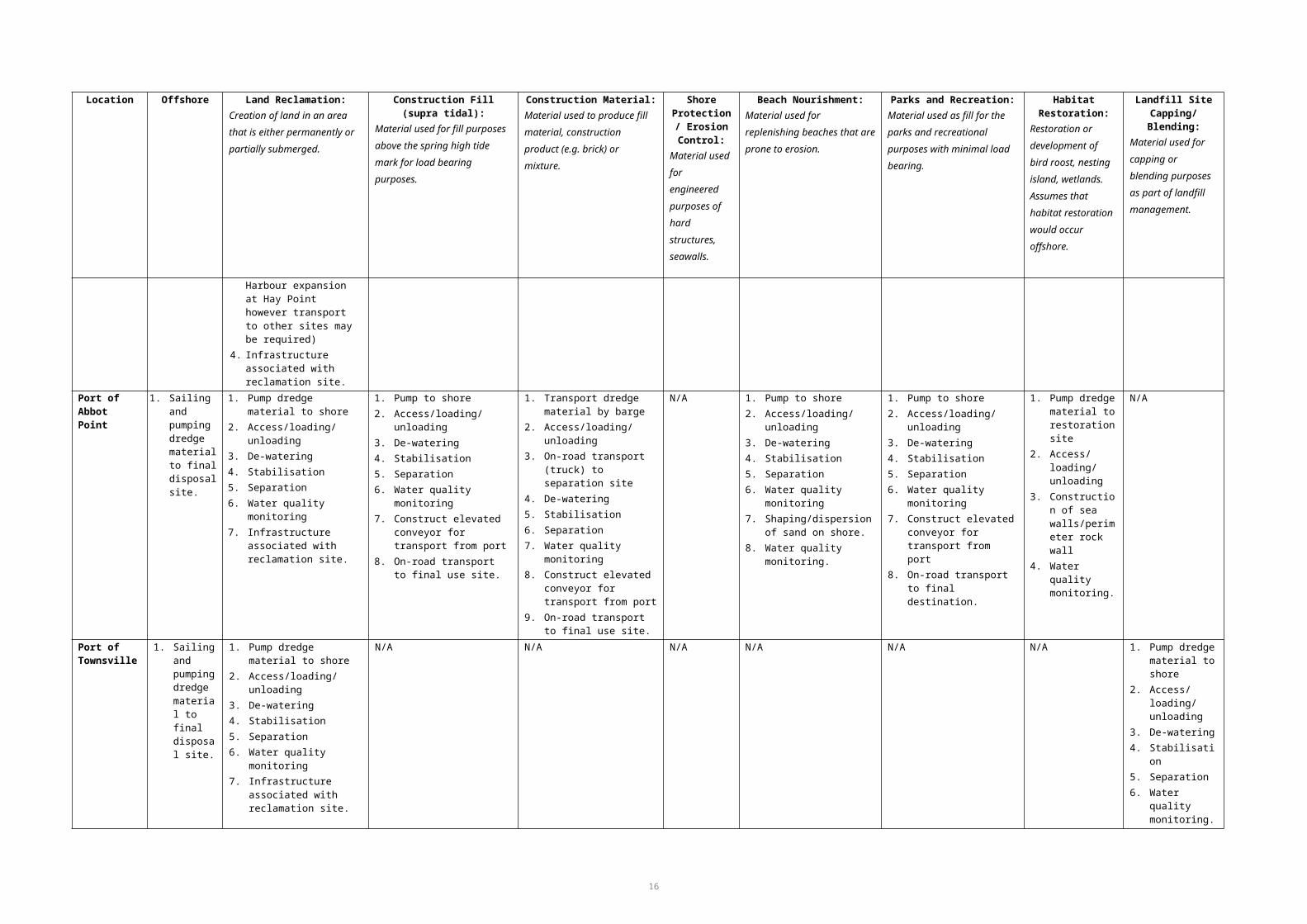
2007a). There are differences in beneficial re-use guidance at national, regional and state levels, and the USACE has recommended the development of a consistent national policy for identifying, planning and financing beneficial use projects (Brandon & Price 2007).
In the US and elsewhere, most dredged material not suitable for open-water disposal due to its contamination status has historically been put in confined disposal facilities onshore for processing and later disposal as landfill. Many of these sites in the US have reached capacity, and while some proponents have increased capacity by raising containment walls, there is a general trend to find longer-term solutions to meet future dredging needs (Brandon & Price 2007). There has been a change in management approaches to dealing with contaminated and clean sediments in recent years, and more often such material is used beneficially instead of being placed in offshore waters or non-beneficially disposed onshore.
Dredge Material Management in Other Countries
A number of other countries have regulatory regimes that encourage beneficial re-use of dredge material on land. Cyprus, Norway and Spain have licensing requirements for beneficial re-use to be considered. The Netherlands and Germany both actively encourage the placement of harbour sediment onshore. Germany and the Netherlands share river basins and have harbours that require routine dredging. They have established a Dutch-German Exchange (DGE) on dredge material (Leuchs et al. 2006), which shares information on dredge material management technologies, policy integration, legislation, best practices and management approaches on climate change due to increased risk of flooding and need for dredging. This coordinated approach to management of dredge material is in place in some other overseas countries and is effective is achieving streamlined policies and procedures across borders. Such approaches could be considered best practice in an international sense.
Sustainable, beneficial re-use of dredge material in locations such as Japan, Hong Kong and the Netherlands, has largely driven by to a lack of land disposal space (Entec 2010). In 2003, Japan used more than 90 per cent of dredge material in a beneficial way (PIANC 2009; CEDA 2010). Such uses included beach nourishment (1.4 per cent), creation of tidal flats (10.7 per cent), land filling (56.5 per cent), construction material (21.1 per cent), other inland disposal (7.3 per cent) with only 3.0 per cent being disposed of in the ocean (Nakamura no date). Conversely, France, Sweden and Italy have no specific legislative requirements for the re-use of dredge material.
Climatic conditions vary around the world and can affect the drying times of sediments in holding ponds. Dredge material placed in holding ponds in wetter climates will take significantly longer to dry than those in drier climates. This is a particular problem for areas in the north of Queensland during the wet season.
Beneficial Re-use Opportunities
Marine sediments in Australian ports and harbours are generally considered uncontaminated compared with the US and European countries with a long history of industrialisation and associated shipping. Port activity is relatively recent in Australia, and contamination of marine sediments is generally low by international standards and does not necessarily inhibit land-based options. A primary limiting factor in the beneficial re-use of sediment from ports and harbours along the Queensland coast is the high silt and clay content of the material, and for some uses the high salt content of marine sediments. This is also true in other parts of the world, with the majority of port and harbour sediments consisting of mud with a high silt and clay content. Due to the
21

geotechnical properties of mud, it is generally considered to be unsuitable for beneficial use in land reclamation or engineered fill (i.e., for load-bearing use) and only really suitable for wetland development and mudflat restoration (Entec 2010).
Re-use opportunities around the world can be divided generally into three main categories and can be re-used in a variety of beneficial ways depending on the physical characteristics of the material:
Engineered and product uses - land creation, beach nourishment, fill material for future infrastructure projects, park creation, shoreline stabilisation and erosion control
Agriculture and related uses – use to enhance soils in agriculture, forestry, and aquaculture, and related uses such as mine rehabilitation
Environmental enhancement – habitat development, restoration of tidal flats, mud flats, salt marshes, wetlands, nesting habitats.
The following sections provide an overview of the requirements of the sediment characteristics for each beneficial use and highlights case studies where dredge material has been re-used successfully. A generic matrix that summarises the range of land-based beneficial re-uses for and non-beneficial disposal of dredged material, and constraints upon and considerations for these uses, is provided in Appendix D.
Engineered Uses
Engineered use typically involves the use of coarse-grain sediment for land reclamation, fill material, construction products or beach nourishment. The use of dredge material for load-bearing fill is a widespread beneficial use of dredge material. In this report, the term ‘land reclamation’ is used when material is used to convert subtidal areas to dry land, and ‘construction fill’ refers to the use of material as fill above the high-tide mark. Reclamation involves filling, raising and protecting an area that is otherwise periodically or permanently submerged (USACE 2006). Land reclamation may also involve constructing perimeter walls or enclosures to limit erosion using dredge rock.
The suitability of dredge sediment for land reclamation depends on grain size, sediment contamination and the geotechnical properties of the material. Fine materials are generally used for creating areas such as parks and recreational land, and do not need to have high load bearing capacity, whereas coarse grains and rock is used in land reclamation for industrial purposes and are subject to strict regulations and specific building codes. Depending on the level of contamination and/or acid-forming potential, the material may require treatment or may be capped or lined with other material to contain the contaminated sediment.
Sediments with a high silt and clay content and associated high moisture levels require long drying times before they can be built upon. There have been many cities that have included significant development on reclaimed wetlands and coastal land, including San Francisco, Rio de Janeiro, Cape Town, Mumbai, Hong Kong and Singapore. Artificial islands have been created in a number of places for tourism, such as ‘The Palm’ and ‘The World’ islands in Dubai (which are in sandy environments). Much of the Perth foreshore between the city and the Swan River is reclaimed land from various projects between the 1870s and the 1960s, along with Fishermans Island at the Port of Brisbane.
22

Land reclamation
Due to land availability surrounding ports and harbours generally being highly constrained, land reclamation for port construction in the majority of cases is the most suitable option for beneficial use of dredge material. The sediment can often be pumped directly from the dredge footprint (while dredging is occurring) or from barge/vessel to the containment facility. The size of the reclamation area required will be dependent on the volume of material being dredge and the necessary drying times for the type of material. Large reclamation areas with a shallow depth may be required for silt and clay due to the high moisture content, especially in areas prone to high rainfall and short dry seasons. Material any deeper than one metre may never dry out and the reclamation area will be unusable in the future if this occurs. The testing of material and characteristics of the sediment is required prior to dredging to determine whether it may be suitable for reclamation purposes.
23
Case study: Falmouth Cruise Terminal Project, UK
Approximately 100,000 m3 of contaminated material needed to be disposed of for the deepening of a navigation channel and port at a cruise ship terminal in Falmouth. A number of options were investigated including disposal of untreated material at sea, treatment of material prior to disposal at sea, capping of untreated material at sea and disposal of treated material as fill material for wharf improvements. Due to high contamination levels the material was not allowed to be disposed of untreated at sea, however, if material treated on land was considered industrial waste and under the licensing at the time, it was not permitted to be disposed of at sea after treatment. Capping of the material after disposal at sea was ruled out as an option as the technique had not been fully developed in the UK and there was limited experience. During the study various locations were presented as options to where treated material could be used beneficially as fill material for wharves and structures. Due to complex legislation, re-use of the material proved to be unfeasible and too complicated to attempt. The end result was that only 20,000 m3 of the material could be treated and used above mean high water for ground improvement and coastal erosion protection and the remaining material was to be sent to landfill. The case study described in Entec (2010) illustrates the need for legislation to support the re-use of dredge material and not specify the material as waste.
Case Study: Port of Brisbane, Queensland
The expansion of the Port of Brisbane has been a work in progress since 2002 with ongoing dredging of the approach channels and berths providing fill material for land reclamation and subsequent expansion of this container port. In 2007 a 4.8 km sea wall was constructed to provide for in excess of 15 million cubic meters of dredge material. The Port continues to expand and dredging of berths 12 and berth 13 will provide 500,000 m3 of material for further land reclamation purposes. The nature of the material is predominantly soft clays and sand and requires geotechnical treatment to gain load bearing capabilities (Hall Contracting 2011).

Land reclamation may be positive in the long term with the creation of parklands or industrial land, however, there may be short-term environmental impacts associated with the disposal of dredge material during construction works, such as the permanent loss of sub tidal habitat (e.g. seagrass meadows), discharge of turbid and ultra-saline water from ponds, turbidity plumes, spills from filling operations and the alteration of coastal dynamics. Ultimately, reclamation also involves the destruction of an area of tidal lands and waters, which may be unacceptable or a major limiting factor from an environmental perspective.
Construction fill
The use of dredge material as construction fill is similar to use in land reclamation, in terms of the geotechnical requirements of the material. Fill material will have different characteristics and requirements depending on where it will be used and the loads to which it will be subjected. In some cases it may be possible to pump or otherwise transport material directly to the fill site, however if the fill site is at a distance from the dredging site it is necessary to transport the material overland, often with an intermediate drying step and associated multiple handling of the material.
Construction material
Certain types of dredge material can be used for construction and other products. Sand and gravel extraction for construction purposes and product use has been occurring in many of Queensland’s rivers (South Pine River, Mary River and Tully River), estuaries and bays both on a large scale and commercial basis and by private landholders since the mid-1850s (Hopkins & White 1998). Dredging activities and sand extraction are more common in southern Queensland, with extraction steadily increasing in areas such as Moreton Bay. Product uses in the construction industry include industrial mix, cement base and building materials. Suitable material is generally clean sands with minimal silt and clay content, and is dried out in large drying ponds until the moisture content is low enough to enable rehandling and transport (usually less than 40 per cent). The material may require processing for the removal of salts, organic matter, or contaminants, and must be matched to specific project-related requirements and relevant building codes (Krause 2000). The re-use of dredge sands for construction purposes requires processing facilities in close proximity to the dredging project, transportation by roads and also a local demand for the product.
24
Case Study: Port Botany Expansion Project, Sydney
The Port Botany Project involved the construction of 1.86 km of new deep water shipping wharves, and dredging of over 11 Mm3 of material to create new shipping channels and fill for land reclamation. The expansion project was completed in June 2011 for an estimated AUS $515 million and included the reclamation of 63 ha of land for a third container terminal. The size and nature of the project required the development of technical solutions in reclamation compaction and engineering capabilities to enable large concrete marine structures to be built on the reclaimed land. The project won the 2012 Construction Achievement Award and has set new standards in marine infrastructure projects (Engineers Australia 2012).

Beach nourishment
Beach nourishment may be beneficial in areas where littoral drift of sediment occurs due to winds and tides. Beaches may be restored or even created by beach nourishment and dredging can supply the required amounts of sand. Dredging for beach nourishment involves the removal of sands for the purposes of pumping the material onto a designated eroded beach either above the high tide mark or in the near-shore environment. The sand content of the material must generally be above 80 per cent for this to be a viable option and the material should be uncontaminated. Beach nourishment is now the principal option for shore protection in some countries such as the United States and The Netherlands (Nordstrom 2005; USACE 2006), where coarse grain sizes are common. Beach nourishment using dredge material is a means to re-use sediments in a productive way to create shoreline protection and nourish beaches that may be prone to erosion. Dredge material is generally pumped directly from the dredging footprint via floating pipelines while dredging is occurring (i.e. with a cutter suction dredge) or transported on a barge or dredge vessel to the disposal location and pumped over the vessel bow.
Despite the potential benefits of depositing sediment from a dredge site to aid in shoreline protection, the deposition of sediment can smother existing fauna and flora, and result in changes to sediment characteristics that can slow the recovery of benthic habitats. To minimise adverse ecological impacts at or near the disposal site, the donor sediment must be similar in size and characteristics (particle size distribution, organic matter and contaminants) to the recipient sediment. Changes to benthic communities from the deposition of donor sediments that differ in physical and chemical characteristics to the recipient sediments could potentially alter community structures and indirectly influence commercially important species of fishes and crustaceans that feed primarily on benthic invertebrates. For any beach nourishment scheme to become successful, diligent environmental monitoring before and after sediment disposal is mandatory. Transport costs of sediments from the dredge area to the disposal site can be extremely high and in a lot of cases these make the project unviable. This cost can be greatly reduced by using long-shore currents to transport and distribute sediments to the intertidal beach with the added benefit of natural sorting of grain sizes that closely match those of the beach (Bishop et al. 2005).
In Australia, there is value in recognising dredge material as a future resource for beach nourishment projects, especially in areas prone to increased storm activity and potential climate change impacts. The need for restoration of the near-shore shoals off the southern Gold Coast beaches has been of concern for the New South Wales and Queensland Governments since the 1980s. Training walls on either side of the Tweed River were established in the late 1800s to improve navigational channels for vessels
25
Case study: Mhlathuze Estuary, South Africa
A beach nourishment project utilising dredge material had detrimental impact on the surrounding values of an estuary in South Africa to the south of the disposal site. Environmental baseline studies and monitoring was not appropriately conducted and current direction from the disposal site was predicted by sediment disposal models to be in a northerly direction (Cyrus et al. 2008). The Mhlathuze Estuary is a national important sanctuary area with significant seagrass meadows (Zostera capensis) to the south of the disposed site. The significance of environmental monitoring during the project became apparent when current direction changed and a turbidity plume entered the estuary. Suspended sediment settled in the lower reaches of the estuary and caused a significant die back of seagrass meadows. This case study reiterates the importance of conducting thorough assessments on the surrounding environment when evaluating potential impacts from dredge footprints.

entering the river, however, construction of the walls disturbed the coastal processes and starved the supply of sand to southern Gold Coast beaches by interrupting littoral drift. The Bypass Project has been established which involves the bypassing of sand using a permanent sand pumping jetty and regular maintenance dredging of the entrance channel. The project is undertaken on a regular basis involving on average about 500,000 m3 of sand pumped each year (NSW Government 2012; International Coastal Management 2011). A total of over 4 Mm3 of sand has been pumped and dredged since 2001 from the Tweed River and deposited within the active sand profile of the Gold Coast beaches (Strauss et al. 2009).
Agricultural Uses
Agricultural and related uses involve using dredge material for soil enhancement for agriculture, forestry and aquaculture. Dredge material has been used in agriculture, horticulture and forestry extensively over the last 100 years, however, the salt content in marine and estuarine sediments usually precludes their use for such purposes (EPA/USACE 2007b). The material must first be de-watered in drying ponds and then depending on the sediment characteristics, it can be applied to farmland to elevate the soil surface, increase drainage and enhance the physical and chemical characteristics of soils. Dredge material has been used in the remediation of mine sites such as the restoration of an abandoned acid mine drainage site in the U.S. into a recreational parks, wetlands, and passive remediation facilities. The dredge material was blended with waste paper fibre and cow manure to create a substrate used in the constructed wetland and final treatment of acidic drainage water (Brandon & Price 2007).
Aquaculture projects in dredge containment facilities have been undertaken since the 1980s in many countries around the world and can be a cost-effective and feasible use of dredge material. However, sediments used within aquaculture ponds producing product for human consumption must be uncontaminated or contain only very low levels of contaminants.
Environmental Enhancement
Dredged sediment can be and has been used to enhance wetlands that have been deprived of other sediment sources over time (e.g. by dams, diversions) or through anthropogenic influences such as port expansion. Environmental enhancement using dredge material involves the creation or restoration of tidal lands, wetlands, shorebird islands, and other habitats. Most dredge material has the potential to be suitable for some form of habitat development or restoration, and silts/clays are most suitable for use in wetland habitats. However, highly contaminated sediments are generally not suitable, unless treated, as they may cause further deterioration of environmental
26
Case study: Jetty Island, U.S.
The U.S Army Corps of Engineers (USACE) used dredge material from a long term maintenance dredging project to create a protective sand berm adjacent a 200 acre port owned intertidal island at the mouth of a river. The berm allowed for the formation of salt marshes, lagoon and back shore dune habitats on Jetty Island. The dredging and disposal costs were paid for by the USACE and the port funded all baseline and environmental monitoring costs of the project. Federal and state environmental departments were supportive in the planning and approval of the project as they considered the creation of salt marshes and intertidal habitats to be mutually beneficial for juvenile salmon. A total of 562,000 cubic yards of material was deposited at the site on two events during the 1990s. The success of this project and participation of numerous departments and stakeholders encouraged the beneficial use of dredge material in the future years.

values. Also it should be noted that many wetlands have high conservation and environmental values in their own right, and placement of dredge material on them will in many cases degrade these values. This is particularly the case along the Queensland coast, where wetlands are considered to be of high ecological value and may be utilised by a variety of threatened and migratory species.
Dredge material can be used effectively when there are issues of eroding habitats, where material can be placed directly onto the eroding system or supplied to the sediment system to feed naturally onto an intertidal area. This method is useful where natural sediment supplies have been interrupted.
In Japan, due to increasing pressure on coastal resources and the loss of tidal flats from increasing coastal development, the Japanese government encourages the creation of artificial tidal flats, which is now a requirement by the government for all coastal developments (Ryo Ishii et al. 2008). Mountain and/or sea sand is used to create an artificial environment for the restoration of areas for human recreation and wildlife habitat. Mountain sand, however, lacks the silt and clay component, along with organic matter, needed to achieve the same physico-chemical and biological substrate in natural tidal flats (Hizon-Fradejas et al. 2010). In construction of the flats, the addition of uncontaminated dredge material to mountain sand has had a positive impact on the number and/or composition of macrobenthic community on the tidal flats. Organic matter in the dredge material has been found to contribute to macrobenthic algae production and improve eelgrass (Zostera marina) growth on artificial prepared substrates (Ryo Ishii et al. 2008; Hizon-Fradejas et al. 2010).
27
Case study: Wallasea Island, UK
The Wallasea Island project was designed to compensate for the draining and development of a wetland area adjacent to the project site for port expansion at Felixstowe and Sheerness. It is one of the largest man-made marine wetlands in the United Kingdom and is an area of 115 hectares of reclaimed land on the Crouch Estuary in Essex. The Island is an example of a new approach to flood mitigation in the UK with a whole ecosystem approach. A new sea wall was constructed with a freshwater habitat behind and salt marsh seaward of the wall. Beach nourishment was used as a strategy to have a more sustainable impact on the environment and to create an area that would be less maintenance in the long term. The reclaimed land was designed to enhance the surrounding river, estuary and coastal habitats and act as flood mitigation by absorbing wave energy and storing water in times of flood. The site provides important feeding and roosting habitat for international protected migratory birds. Critical success factors identified through the duration of the project was the involvement of numerous public groups, environmental groups, stakeholders and parties in the planning, implementation and monitoring phases of the project (Murray 2008).

The creation of artificial reefs and fish habitat using dredge material in open waters has proven successful around the world in providing habitat, increasing fish stocks and creating recreational fishing opportunities. The disposal of dredge rock mixed with sediment can be used to construct mounds on the seafloor which deflect currents and create eddies that concentrate food organisms for mid water fish (PIANC 2012). Mixed rock and dredge sediment mounds can provide habitat for burrowing fauna thereby attracting predatory fish and increasing recreational fishing opportunities. The creation of artificial reefs may in turn provide habitat for introduced marine species and monitoring of the disposal site may be necessary in areas with extensive shipping movements. On the contrary it has been found in some cases artificial reefs do not generate increased fish stocks but simply relocate fish from one area to another.
Sediment Characteristics Considerations
Physical characterisation of the sediment is extremely important in order to determine which beneficial re-use options may be appropriate for dredge material. Table 6 categorises the suitability of different sediment types for different land-based re-use options.
Table 6. Suitability of dredge material for various beneficial uses. Source: Adapted from Brandon & Price (2007).
Beneficial Use Option Rock Sand & Gravel
Consolidated Clay
Silt/Soft Clay Mixture
Engineered Uses
Land reclamation Y Y Y Y Y
Land improvement Y Y Y Y Y
Berm creation Y Y Y N Y
Shore protection Y Y Y N
Replacement fill for construction purposed
Y Y N N Y
Beach nourishment N Y N N N
Capping N Y Y N Y
Agricultural/Product Uses
28
Case Study: Sydney Olympic Park, New South Wales
Sydney Olympic Park was a once degraded wetland and terrestrial ecosystem which underwent extensive restoration works in the 1990s in what was the largest land remediation exercise to ever happen in Australia. The Park is located on the Parramatta River and was subject to extensive historical land reclamation works and controlled and uncontrolled landfilling. The area was historically used intensively for industries and included large areas of contaminated land and waste. Restoration works were undertaken to create 760 hectares of commercial, residential, sporting and recreational areas. The terrestrial ecosystems of the area were predominantly isolated from surrounding urban development due to the network of wetland and estuarine habitat, and restoration of these ecosystems has created new habitat for endangered species. Restoration works involved remediation of salt marsh, frog ponds, grassland, woodland, tidal waterways and topsoils. The project was undertaken between 1992 and 2001 at an estimated cost of AUS $137 million, and managed by NSW government agencies (NSW Government 2011)

Beneficial Use Option Rock Sand & Gravel
Consolidated Clay
Silt/Soft Clay Mixture
Construction materials Y Y Y Y Y
Aquaculture N N Y Y Y
Topsoil N N N Y Y
Environmental Enhancements
Wildlife habitats Y Y Y Y Y
Fisheries improvement Y Y Y Y Y
Wetland restoration N N Y Y Y
Y = Potentially suitableN = Not suitable
Testing sediments for chemical contamination is an important part of the evaluation process when assessing the suitability and characteristics of the dredge material. Options for re-use of dredge material for beneficial purposes depend on the level of contamination (Table 7). It should be noted that dredge material that is considered unsuitable for ocean disposal is often suitable for a range of onshore uses; often only highly contaminated material requires any treatment to meets the relevant guidelines for use on land. Only on very rare occasions is marine sediment contaminated to a level that would classify it as a human health risk, or require hazardous waste handling and disposal (Krause 2000).
Table 7. Suitability of contaminated dredge material for various beneficial uses. The relative level of contamination refers to contaminated land guidelines and not those for the unconfined placement of material at sea. Source: A guide to mitigation and beneficial uses for dredge material (www.mceu.gov.uk).
Uncontaminated Lightly contaminated Moderately Contaminated Contaminated
Habitat creationSalt marsh Protection/RegenerationInter-tidal mudflats (silts, sands)Beach nourishmentSea defencesCoastal protectionLand reclamationLand improvement (silts, sands)Construction (sands)Landfill
Habitat creation (capped)Inter-tidal mudflats (silts, sands)Beach nourishment (sands)Sea defencesCoastal protectionLand reclamationLand improvementConstruction (cleaned sands)
Land reclamation (capped)Landfill (capped/contained)Replacement fill (e.g. mine shafts – silts, sands)
Landfill at controlled site (silt, clay size)
Where highly contaminated dredge material is encountered, a management decision must be made as to the most acceptable means of disposal from an environmental, social, legislative and economic perspective. The presence of contamination does not preclude beneficial use. However, treatment may be required to stabilise or remove chemical contaminants which can increase costs and handling times (PIANC 2009). Marine sediments in highly industrialised ports and harbours have the potential to be contaminated by a variety of chemicals from port and industrial activity. Contamination
29

may come from heavy metals, organo-metal complexes (e.g. TBT), polycyclic aromatic hydrocarbons (PAHs), organochlorine pesticides and polychlorinated biphenyls (PCBs). Certain chemicals may only be associated with specific industries such as dioxins with pesticides and paper making plants, and radionuclides with mining or mineral processing (Commonwealth of Australia 2009).
The risk of mobilisation of contaminants into the water column depends on the contaminant itself. For example, zinc and arsenic are less tightly bound to sediments and are more readily mobilised by dredging than are other heavy metals (Entec 2010). Environmental legislation regarding the use of chemicals which may leach into the environment is now highly regulated, with many highly toxic compounds banned. However, some chemicals are persistent in sediments and do not readily break down, leaving a long-term contamination legacy for dredging projects to operate within. Chemical contamination of sediments within estuaries often reflects the history of industrial activity and waste discharges of a neighbouring coastal community (Entec 2010). In the U.S, contaminated material is generally put in confined disposal facilities for storage before being transported to a central processing facility for reprocessing and re-handling. These storage facilities may be capped with clean material and though not considered “beneficial re-use”, they have been used in the U.S. to increase shallow water habitat for threatened eelgrass and fish nursery areas (Krause 2000).
Options for the treatment of contaminated sediment depend on the types and concentration of contaminants and also the sediment characteristics. Dredge material consisting of silts and clays has a low permeability and the time and costs to dry out the material are prolonged and high. There are a range of treatment technologies employed around the world with the principal methods being de-watering, thermal immobilisation and bioremediation. Depending on the amount of contamination, simple technology such as sand separation may be used if the material is not heavily contaminated (PIANC 2009; CEDA 2010). Beneficial re-use of contaminated dredge material is being explored and developed around the world along with comprehensive management strategies that address logistics related to sediment movement, de-watering, chemical treatment, and suitable re-use technologies.
Considerations for Onshore Use of Dredge Material
Projects requiring onshore disposal of dredge material are usually deemed unviable due to a number of constraints, primarily cost and the suitability of the material for particular uses. For proponents, technical constraints of transporting the ‘other than rock’ dredge material from the dredger to land and costs involved in the associated works usually preclude investment into further investigations. This does depend, however, on the location of offshore placement or disposal sites and the relative distances for transportation. In 2009, assessment of onshore disposal options at Hay Point, Queensland were found to involve significantly higher costs for disposal of shot rock on land than at sea. However, handling and transportation was more feasible than the clay component of dredge material (BMA 2009). While evaluating the alternatives to offshore disposal, the initial consideration is whether the material has suitable characteristics for beneficial re-use. Fine silts and clays do not have high geotechnical properties and are limited in their use for fill material and land reclamation, but can provide opportunities for restoration of specific habitats.
Although the re-use of dredge material may have positive impacts on the environment in the long term (e.g. creation of habitat or parkland), there are many considerations and potential environmental costs that may be associated with re-use projects. These include:
Permanent loss of intertidal and sub-tidal habitats by reclamation
30

Terrestrial habitat loss for drying ponds and processing facilities Saline and turbid tail water discharge from drying ponds and processing
facilities Material spills on land during filling operations of drying ponds Turbidity plumes from filling operations and contamination of adjacent creeks
and streams Impacts on residential amenity due to transportation of dredge material through
urban areas Disturbance of potential acid sulphate soils and associated issues.
Onshore disposal of dredge material requires large areas of land for drying purposes and processing. Morton (2012) considered that dredge material could not be dried if placed in layers thicker than 1.5 m. Based on this, it was calculated that drying of 15 Mm3 of dredge material would require at least 7500 ha of flat land.
The material may have suitable characteristics for onshore re-use, however, there may not be available land to enable de-watering of the material. Technical and logistical constraints associated with the disposal of material on land include drying areas situated close to the dredging footprint due to the practicality of pumping sediments long distances from vessels to shore. ‘Other than rock’ material consisting of fine and loose silts/clays needs to be pumped via pipelines from vessels to shore in a water-based slurry, creating the possibility of spills and turbidity plumes during filling operations. De-watering of the material is required before further reprocessing or separation can be commenced. Temporary structures, containment facilities and
31
Theoretical example: land requirements and costs involved for 400,000 m3 of maintenance dredge material at the Port of Townsville
The dredged material would need to be dried out before it could be re-used or disposed of, due to its high clay content. A relatively flat area of land would be required to support the holding ponds and facilitate the de-watering process. The storage ponds would require earth bunds to be constructed to accommodate a depth of dredged material of at least 2 m. Once sediments are pumped into the holding ponds to dry out, the volume of material can be expected to expand by about 4 times its original (pre-dredged) volume. Therefore, a significant area of land would be required to provide sufficient space to dry the dredged material out. Approximately 20 ha of land would provide enough area to dewater and dry approximately 400,000 m3 of consolidated dredged material at a depth of 2 m. But when taking into account the expansion factor, an area of 80 ha would be required to accommodate the volume of maintenance dredge material. However, it should be noted that the expansion factor will decrease in time as water is removed from the dredge material.
The costs for de-watering can range from $5.6–105.2 per m3. Therefore for 400,000 m3 of dredge material it could cost between $2,240,000 and $42,080,000 to complete the de-watering process. The higher costs include the infrastructure investment of constructing the de-watering facilities. Stabilisation costs range from $36.6 to 158.1 per m3, resulting in a cost of between $14,640,000 and $63,240,000 to stabilise the dredge material. Separation costs range from $6.3-25.1 per m3, resulting in a cost between $2,520,000 and $10,040,000. It should be noted that these costs are indicative only, based on a literature review and should not be applied to specific projects without further consideration of local factors.

access to transportation for trucking may also be needed. It is essential that potential environmental impacts are weighed up against the overall environmental benefits of the project, both on land and at sea. A list of considerations to be taken into account is shown in Table 8.
Table 8. Considerations of land-based re-use and disposal options.
Material Characteristics
1. Material suitable for re-use purpose (geotechnical properties, grain size and sediment contamination)
Environmental
1. Suitable land within close proximity to dredge footprint available for reclamation and/or drying ponds
2. Removal of marine habitats for reclamation purposes, drying ponds or processing facilities (terrestrial and aquatic)
3. Protected/threatened species and communities within the surrounding area4. Significant ecosystems surrounding the proposed disposal area5. Impacts on the values of the Marine Park and World Heritage Area (e.g. dredge haul routes through
marine protected areas)6. Noise and dust impacts from processing facilities and pumping of material7. Water quality impacts (marine/surface/groundwater) from processing and containment facilities8. Carbon emissions from processing facilities and transportation (trucks)
Technical/Engineering
1. Length of pipe required for pumping material from vessel to land Practical distance for pumping spoil is 7 to 10 km, above this distance booster pumps may be required (this is the maximum and plant capable of these distances may not be suitable/available for specific projects).
2. Construction of bund walls to contain material (settlement ponds)3. De-watering infrastructure and drying of material required prior to transport to disposal sites4. Dredge equipment needed and availability (timing and requirements)5. Loading and unloading requirements (e.g. machinery required for loading trucks6. Pumping to land over longer distances requires more pipelines, costs more fuel, and may affect the
dredger’s production.
Legislative
1. Permits and approvals (inconsistency with local, regional and state plans)2. Land tenure
Topography
1. Need for low sloping land for most re-use projects. Low slope (< 2 per cent) preferable for containment of material.
Hydrodynamics
1. Ports can be shallow, restricting entry for barges to unload dredge material2. High energy areas subject to current and waves are not suitable for pumping of spoil in floating
pipelines (pose risk of spills and damages to equipment)3. Bund walls need to be able to withstand coastal conditions of area (e.g. storm surges/cyclonic
events/erosion).
Social/Cultural/Community
1. Impacts on known cultural heritage values of the area2. Proximity to recreational, residential and commercial areas3. Limitation of future land use opportunities4. Aesthetic/visual impacts on the surrounding area5. Demand for product use and construction material within local community.
Economic
1. Funding needed for the project (i.e. wetland restoration, who will pay?)2. Management costs of the project (i.e. long term monitoring)3. Transportation costs of barges, vessels and trucks4. Construction costs of retaining (bund) walls Construction costs of processing facilities and
32

Material Characteristics
transportation roads.
Transport of dredge material
1. Length of pipe needed for pumping of spoil from vessel to land/truck. Practical distance for pumping spoil is 7 to 10 km, above this distance booster pumps may be required
2. Suitable infrastructure available for transport of material.
Although land-based options have common considerations (e.g. the type of dredge material will influence the suitability for a particular land use option), other considerations will vary for each land-based option. Table 9 provides a list of constraints and considerations for each land-based option being assessed in this report.
Table 9. Constraints and considerations for each beneficial re-use option.
Land ReclamationCreation of land in an area that is either permanently or partially submerged
1. Gravel, rock, sand or a mixture suitable for load bearing (construction). Clays and silts potentially suitable for creation of parks/recreation areas
2. Geotechnical characteristics must suit end use (e.g. load bearing)3. Contaminated material can be used with treatment/capping/lining. Acid sulphate soils may require
management4. Land area required depends on material characteristics (depth needed for drying times) and
volume of material5. Low slope and stable site needed for containment. Slopes < 2 per cent preferable6. Sand/silt/clay can often be pumped directly from dredging site to reclamation site (practical limit is
7-10 km) or from barge to shore.7. Dredges/barges must have suitable draft and manoeuvrability to get close to reclamation site for
unloading/pumping material8. High energy marine environment (wind/waves) increase risk of pipe rupture and spills9. Land reclamation site not to be in area prone to coastal erosion and storm surge10. Operational risks include turbidity plumes, spills, failure of bund walls11. Construction required includes bund walls, pipelines, drainage systems, discharge ponds, fencing,
road access, berthing facilities12. Environmental impacts may include permanent loss of sub tidal habitat, saline tail water discharge,
turbidity plumes, alteration of coastline and dynamics, noise, dust, carbon emissions, impacts on recreational and commercial users of area.
Construction Fill (supra-tidal)Material used for fill purposes above the spring high tide mark for load bearing purposes
1. Any material potentially suitable (depending on end use), silt/clays may take years to dry out to 40–60 per cent moisture content to enable re-handling with machinery.
2. Geotechnical characteristics must suit end use (e.g. load bearing)3. Contaminated material can be used with treatment/capping/lining. Acid sulphate soils may require
management4. Large areas of land are required for drying sites for silt/clay material. Only small volumes of dredge
material can be dried, processed and transported at any one time due to land space availability and infrastructure required.
5. Low slope and stable site needed for containment. Slopes < 2 per cent preferable6. Sand/silt/clay can often be pumped from dredging site to drying ponds (practical limit is 7-10 km).
Dredges/barges must have suitable draft and manoeuvrability to get close to drying ponds for unloading/pumping material
7. High energy marine environment (wind/waves) increase risk of pipe rupture and spills8. Operational risks include turbidity plumes, spills and failure of drying pond walls, groundwater
contamination at capping site from chemical leachate, infrastructure failure, equipment breakdown.9. Construction required includes drying ponds, pipelines, drainage systems, discharge ponds,
fencing, road access, berthing facilities, material storage facilities, machinery for loading and unloading material, road and/or rail infrastructure access to site.
33

Land ReclamationCreation of land in an area that is either permanently or partially submerged
10. Environmental impacts may include permanent loss of terrestrial habitat (land clearing), saline tail water discharge, turbidity plumes, surface runoff and leaching after placement at disposal site, noise, dust, high carbon emissions (transportation)
11. Use of material on port land or local demand for material required. Environmental impacts may include permanent loss of terrestrial habitat (land clearing), saline tail water discharge, turbidity plumes, surface runoff and leaching after placement at disposal site, noise, dust, high carbon emissions (transportation)
12. Local demand for material required.
Mine RehabilitationMaterial for filing of disused mine sites
1. Any material may be suitable, though clays and silts may take years to dry out2. Geotechnical characteristics must suit end use (e.g. load bearing)3. Material may need to be washed to remove salt content if used for revegetation purposes4. Contaminated material can be mixed with chemicals for binding purposes to form required fill (e.g.
ash). Treatment may be required for acid sulphate soils.5. Large areas of land are required for drying sites for silt/clay material. Only small volumes of dredge
material can be dried, processed and transported at any one time due to land space availability and infrastructure required.
6. Low slope and stable site needed for containment. Slopes < 2 per cent preferable7. Sand/silt/clay can often be pumped from dredging site to reclamation site (practical limit is
7-10 km).8. Dredges/barges must have suitable draft and manoeuvrability to get close to reclamation site for
unloading/pumping material9. High energy marine environment (wind/waves) increase risk of pipe rupture and spills10. Operational risks include turbidity plumes, spills and failure of drying pond walls, groundwater
contamination at capping site from chemical leachate, infrastructure failure, and equipment breakdown.
11. Construction required includes drying ponds, pipelines, drainage systems, discharge ponds, fencing, road access, berthing facilities, material storage facilities, machinery for loading and unloading material, road and/or rail infrastructure access to site, storage facilities at offloading site (e.g. additional infrastructure at coal mines for unloading material)
12. Environmental impacts may include permanent loss of terrestrial habitat (land clearing), saline tail water discharge, turbidity plumes, surface runoff and leaching after placement at disposal site, noise, dust, high carbon emissions (transportation)
13. Mines needed within reasonable distance that requires capping material (local demand).
Shore Protection/Erosion Control Material used for engineered purposes of hard structures, seawalls etc
1. Rock generally used for hard structures, sand and gravel may be used behind the seawall to fill area
2. Material used must have high geotechnical properties, such as rock, to withstand coastal conditions and storm surge.
3. Contaminated material may be used but must be capped and contained by other material to prevent leaching to surrounding marine environment
4. Site must be stable to contain material5. Dependent of type of material, it may be pumped ashore directly to site or unloaded at berth facility
into trucks (rock)6. Operational risks include spills and failure of equipment7. Environmental impacts include loss of near shore habitat, smothering of existing marine habitat8. Impact on recreational users due to beach not being accessible during project works of structure9. Local demand for seawall or structures within reasonable proximity to project
Beach NourishmentMaterial used for replenishing beaches that are prone to erosion
1. Sand and gravel grains suitable only, sand content to be > 80 per cent2. Donor and recipient sand must be similar in nature, clean and uncontaminated sand only3. Need for beach within reasonable distance to project works that requires nourishment4. Sand can be pumped directly from dredge footprint to beach while dredge is active
34

Land ReclamationCreation of land in an area that is either permanently or partially submerged
5. Practical distance of pipeline for pumping of sand is 7 -10 km6. May require double handling if sand is first pumped to shore and then transported to beach site7. Coastal conditions will affect, delay or pose risk to pumping of sand through floating pipelines8. Operational Risks include turbidity plumes and spills during pumping operations9. Environmental impacts may include damage to sensitive aquatic and shoreline habitats, smothering
of benthic habitats through plumes, increased sedimentation and beach compaction10. Impacts on recreational users of the area due to beach being inaccessible during project works
Construction MaterialMaterial used to produce fill material, construction product (e.g. brick) or mixture
1. Sand and rock most suitable, silt/clays may take years to dry out to 40–60 per cent with high processing of material
2. Geotechnical characteristics must suit end use (e.g. load bearing)3. Contaminated material may need to be de-watered and treated first. Clean sands most preferable4. Large areas of land are required for drying sites for silt/clay material. Only small volumes of dredge
material can be dried, processed and transported at any one time due to land space availability and infrastructure required. Sand may need to be washed to remove salt content
5. Hard rock may be loaded directly from vessel to shore, other material may require pumping and double handling
6. Operational risks include turbidity plumes, spills and failure of drying pond walls, groundwater contamination, infrastructure failure, equipment breakdown.
7. Construction required includes drying ponds, pipelines, drainage systems, discharge ponds, fencing, road access, berthing facilities, material storage facilities, machinery for loading and unloading material, road and/or rail infrastructure access to site.
8. Environmental impacts may include permanent loss of terrestrial habitat (land clearing), saline tail water discharge, turbidity plumes, surface runoff and leaching after placement at disposal site, high use of water for washing of sand, noise, dust, high carbon emissions (transportation)
9. Local demand for material required.
Parks and RecreationMaterial used as fill for the parks and recreational purposes with minimal load bearing
1. Clays and silts most suitable as for non-load bearing purposes.2. Material may need to be washed to remove salt content if used for revegetation purposes3. Large areas of land are required for drying sites for silt/clay material. Only small volumes of dredge
spoil can be dried, processed and transported at any one time due to land space availability and infrastructure required.
4. Low slope and stable site needed for containment. Slopes < 2 per cent preferable5. Sand/silt/clay can often be pumped from dredging site to reclamation site (practical limit is
7-10 km). Additional handling required to transport material from shore to fill site6. Dredges/barges must have suitable draft and manoeuvrability to get close to reclamation site for
unloading/pumping material7. High energy marine environment (wind/waves) increase risk of pipe rupture and spills8. Operational risks include turbidity plumes, spills and failure of drying pond walls, groundwater
contamination at capping site from chemical leachate, infrastructure failure, equipment breakdown.9. Construction required includes drying ponds, , pipelines, drainage systems, discharge ponds,
fencing, road access, berthing facilities, material storage facilities, machinery for loading and unloading material, road and/or rail infrastructure access to site, storage facilities at offloading site (e.g. additional infrastructure at coal mines for unloading material)
10. Environmental impacts may include permanent loss of terrestrial habitat (land clearing), saline tail water discharge, turbidity plumes, surface runoff and leaching after placement at disposal site, noise, dust, high carbon emissions (transportation)
11. Local demand required for recreational purposes fill material.
Agriculture/Forestry/AquacultureMaterial used in replacing eroded top soil, elevating soil surface or improving soil composition
1. Clays and silt most suitable2. Material requires washing to remove salt content for use in agricultural top soil3. Large areas of land are required for drying sites for silt/clay material. Only small volumes of dredge
material can be dried, processed and transported at any one time due to land space availability and
35

Land ReclamationCreation of land in an area that is either permanently or partially submerged
infrastructure required.4. Low slope and stable site needed for containment. Slopes < 2 per cent preferable5. Sand/silt/clay can often be pumped from dredging site to reclamation site (practical limit is
7-10 km). Additional handling required to transport material from shore to fill site6. Dredges/barges must have suitable draft and manoeuvrability to get close to reclamation site for
unloading/pumping material7. High energy marine environment (wind/waves) increase risk of pipe rupture and spills8. Operational risks include turbidity plumes, spills and failure of drying pond walls, groundwater
contamination at capping site from chemical leachate, infrastructure failure, equipment breakdown.9. Construction required includes drying ponds, , pipelines, drainage systems, discharge ponds,
fencing, road access, berthing facilities, material storage facilities, machinery for loading and unloading material, road and/or rail infrastructure access to site, storage facilities at offloading site (e.g. additional infrastructure at coal mines for unloading material)
10. Environmental impacts may include permanent loss of terrestrial habitat (land clearing), saline tail water discharge, turbidity plumes, surface runoff and leaching after placement at disposal site, noise, dust, high carbon emissions (transportation)
11. Local demand for agricultural product.
Habitat RestorationRestoration or development of bird roost, nesting island, wetlands etc
1. Clays and silts most suitable2. Depending on characteristics of material, it may be pumped directly to wetland site3. Large areas of land may be required for drying sites for silt/clay material. Only small volumes of
dredge material can be dried, processed and transported at any one time due to land space availability and infrastructure required.
4. Low slope and stable site needed for containment. Slopes < 2 per cent preferable5. Sand/silt/clay can often be pumped from dredging site to reclamation site (practical limit is
7-10 km). Additional handling required to transport material from shore to fill site6. Dredges/barges must have suitable draft and manoeuvrability to get close to reclamation site for
unloading/pumping material7. High energy marine environment (wind/waves) increase risk of pipe rupture and spills8. Operational risks include turbidity plumes, spills and failure of drying pond walls, groundwater
contamination at capping site from chemical leachate, infrastructure failure, and equipment breakdown.
9. Construction required includes drying ponds, bund walls, pipelines, drainage systems, discharge ponds, fencing, road access, berthing facilities, material storage facilities, machinery for loading and unloading material, road and/or rail infrastructure access to site, storage facilities at offloading site (e.g. additional infrastructure at coal mines for unloading material)
10. Environmental impacts may include permanent loss of terrestrial habitat (land clearing for drying ponds), saline tail water discharge, turbidity plumes, surface runoff and leaching after placement at disposal site, displacement of species from wetland site during project works, impacts on surrounding environmental values.
11. Habitat that require restoration or development within surrounding area.
Landfill (Beneficial Use)Material used for capping or blending purposes as part of landfill management
1. Any material may be suitable, clays and silts may take years to dry out2. Geotechnical characteristics must suit end use (e.g. load bearing)3. Contaminated material can be mixed with chemicals for binding purposes to form required fill (e.g.
ash). Treatment may be required for acid sulphate soils.4. Material must comply with regulations at waste disposal site5. Large areas of land are required for drying sites for silt/clay material. Only small volumes of dredge
material can be dried, processed and transported at any one time due to land space availability and infrastructure required.
6. Low slope and stable site needed for containment. Slopes < 2 per cent preferable7. Sand/silt/clay can often be pumped from dredging site to reclamation site (practical limit is
7-10 km). Additional handling required to transport material from shore to fill site8. Dredges/barges must have suitable draft and manoeuvrability to get close to reclamation site for
unloading/pumping material9. High energy marine environment (wind/waves) increase risk of pipe rupture and spills
36

Land ReclamationCreation of land in an area that is either permanently or partially submerged
10. Operational risks include turbidity plumes, spills and failure of drying pond walls, groundwater contamination at capping site from chemical leachate, infrastructure failure, equipment breakdown.
11. Construction required includes drying ponds, bund walls, pipelines, drainage systems, discharge ponds, fencing, road access, berthing facilities, material storage facilities, machinery for loading and unloading material, road and/or rail infrastructure access to site, storage facilities at offloading site (e.g. additional infrastructure at coal mines for unloading material)
12. Environmental impacts may include permanent loss of terrestrial habitat (land clearing), saline tail water discharge, turbidity plumes, surface runoff and leaching after placement at disposal site, noise, dust, high carbon emissions (transportation)
13. Land fill sites available within reasonable distance to project site (may be limited space) or loss of land (e.g. farming, recreational) due to clearing for land fill site with associated impacts on terrestrial ecology.
Landfill (Non-beneficial Use)Material taken to landfill site for permanent disposal
1. Any material may be suitable, clays and silts may take years to dry out2. Geotechnical characteristics must suit end use (e.g. load bearing)3. Contaminated material can be mixed with chemicals for binding purposes to form required fill (e.g.
ash). Treatment may be required for acid sulphate soils.4. Material must comply with regulations at waste disposal site5. Large areas of land are required for drying sites for silt/clay material. Only small volumes of dredge
material can be dried, processed and transported at any one time due to land space availability and infrastructure required.
6. Low slope and stable site needed for containment. Slopes < 2 per cent preferable7. Sand/silt/clay can often be pumped from dredging site to reclamation site (practical limit is
7-10 km). Additional handling required to transport material from shore to fill site8. Dredges/barges must have suitable draft and manoeuvrability to get close to reclamation site for
unloading/pumping material9. High energy marine environment (wind/waves) increase risk of pipe rupture and spills10. Operational risks include turbidity plumes, spills and failure of drying pond walls, groundwater
contamination at capping site from chemical leachate, infrastructure failure, and equipment breakdown.
11. Construction required includes drying ponds, bund walls, pipelines, drainage systems, discharge ponds, fencing, road access, berthing facilities, material storage facilities, machinery for loading and unloading material, road and/or rail infrastructure access to site, storage facilities at offloading site (e.g. additional infrastructure at coal mines for unloading material)
12. Environmental impacts may include permanent loss of terrestrial habitat (land clearing), saline tail water discharge, turbidity plumes, surface runoff and leaching after placement at disposal site, noise, dust, high carbon emissions (transportation)
13. Land fill sites available within reasonable distance to project site (may be limited space) or loss of land (e.g. farming, recreational) due to clearing for land fill site with associated impacts on terrestrial ecology).
Non-beneficial DisposalPermanent disposal in constructed retention pond
1. Any material may be suitable, clays and silts may take years to dry out2. Material may need to be capped using imported material3. Treatment may be required for acid sulphate soils.4. Suitable land required for construction of retention ponds5. Low slope and stable site needed for containment. Slopes < 2 per cent preferable6. Sand/silt/clay can often be pumped from dredging site to reclamation site (practical limit is
7-10 km). Additional handling required to transport material from shore to fill site7. Dredges/barges must have suitable draft and manoeuvrability to get close to reclamation site for
unloading/pumping material8. High energy marine environment (wind/waves) increase risk of pipe rupture and spills9. Operational risks include turbidity plumes, spills and failure of drying pond walls, groundwater
contamination at capping site from chemical leachate, infrastructure failure, equipment breakdown10. Construction required includes retention ponds, pipelines, drainage systems, discharge ponds,
fencing, road access, berthing facilities, Environmental impacts may include permanent loss of terrestrial habitat (land clearing), saline tail water discharge, turbidity plumes, surface runoff and
37
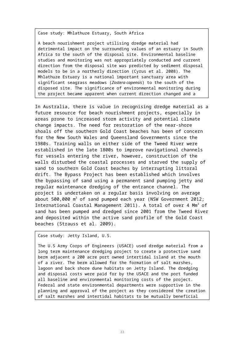
Land ReclamationCreation of land in an area that is either permanently or partially submerged
leaching after placement at disposal site, dust and odour.
38

GENERIC COST ANALYSIS AND MULTI-CRITERIA ANALYSIS
This section of the report provides an indicative range of costs involved in implementing various land-based re-use/disposal options as outlined in the Methods. Costs were only considered for options that were considered viable for at least one of the six locations based on port-specific considerations (refer to Table 10, below). Options that were not considered appropriate for further consideration at any of the six ports were mine rehabilitation, non-beneficial disposal at landfill site, agriculture/forestry/aquaculture, and permanent disposal in a constructed retention pond.
Table 10. Summary of disposal options.
Disposal Option Port of Gladstone
Rosslyn Bay State
Boat Harbour
Port of Hay Point
Port of Abbot Point
Port of Townsville
Port of Cairns
Offshore dredge material placement
Y Y Y Y Y Y
Land reclamation Y
Mixture of clay, silt,
sand, gravel
NY
Rock only
Y
Sand
Y
Sand silt clayN
Construction fill (supra tidal)
Y
Mixture of clay, silt,
sand, gravel
NY
Rock only
Y
SandN
Y
Mine rehabilitation N N N N N N
Shore protection/Erosion control
N N N N N N
Beach nourishmentN N N
Y
SandN N
Construction material Y
Gravel and sand
N NY
SandN N
Parks and recreationY N N
Y
SandN N
Agriculture/Forestry/Aquaculture N N N N N N
Habitat restoration Y N N Y N N
Landfill site capping N N N N Y Clay N
Permanent disposal in landfill (non-beneficial) N N N N N N
Permanent disposal in confined disposal facility
N N N N N N
39

Y = Considered a potential option, N = Considered to not be a feasible potential option for dredge material.
Pumping/Pipeline Transport Costs
Table 11 summarises indicative cost estimates provided by Pro Dredging and Marine Consultants for the pumping of dredge material offshore and onshore (refer to Appendix G). Prices vary by port according to the sediment grain size, distance from dredge site to storage area. The costs do not include the cost of dredging. Only capital dredging costs were estimated for Gladstone as the exact location of maintenance dredging activities was not known and this has an impact on the cost estimate. Only maintenance dredging was considered for Rosslyn Bay State Boat Harbour as no capital projects are planned in the near future and estimates were provided for offshore placement only as all other onshore options were deemed to be unsuitable (see ‘Port-specific Options Assessment’, page 49). Only capital dredging for the Port of Hay Point was estimated for offshore placement as all other onshore options were deemed to be unfeasible due to the pumping distance to shore, as detailed in Appendix G. Capital dredging is the predominant dredging activity at the Port of Abbot Point, so only the costs for capital dredging were estimated for both offshore and onshore placement options. Appendix G contains further details on method used in deriving the cost estimates and assumptions.
Table 11. Pumping cost estimates. Source: Pro-dredging and Maine Consultants (2012).
Location Cost of Dredge Material PlacementOffshore Onshore
Capital Maintenance Capital MaintenancePort of Gladstone $ 3.00/m3 N/A $ 15.00 to
16.50/m3N/A
Rosslyn Bay State Boat Harbour
N/A $ 4.00/m3 N/A N/A
Port of Hay Point $ 5.00/m3 N/A N/A N/A
Port of Abbot Point $4.00/m3 N/A $ 12.50/m3 N/A
Port of Townsville $ 4.50 to 5.00/m3
$3.50/m3 $ 7.00/m3 $ 7.50/m3
Port of Cairns $ 4.00/m3 $ 3.00 to 3.50/m3
$ 5.00/m3 N/A
Barge Transport Costs
Table 12 outlines estimated costs of barge transport for dried materials. These costs are based on 2006 estimates from the US Army Corps Engineers and were the best available source for barge transportation per m3/km, therefore it had to be assumed that the cost for transporting wet dredge material would be similar, although you expect the load to increase with the bulking factor.
The derived Australian dollar cost is subject to the following assumptions:
Costs (USD) per mile have been converted to a cost per km Costs (USD) per cubic yard have been converted to a cost per cubic metre Indicative cost estimates have been converted to an Australian price (in USD)
based on purchasing power parity indexes for 2006
40

USD have been converted to AUD utilising an assumed average exchange rate in 2006 (1 AUD = $0.80 USD)
The resulting cost estimates have been indexed to base year 2012 using the Australian producer price index for Water Freight Transport.
Table 12. Offshore (barge) transport cost per cubic yard of dried material. Source: Northern Bayshore Dredge Material Management Plan (2009).
Distance (Miles) Cost/Cubic Yard of Dried Material
(USD, 2006)
Distance (km) Average price/m3 (AUD
2012)
Average price per m3/km (AUD
2012)
5 $4.00 8.0 $1.29 $0.160
10 $6.00 16.1 $0.97 $0.060
20 $7.00 32.2 $0.56 $0.018
30 $7.50 48.3 $0.40 $0.008
40 $8.00 64.4 $0.32 $0.005
50 $8.50 80.5 $0.27 $0.003
60 $9.00 96.6 $0.24 $0.003
The results indicate that offshore (barge) transport costs range from $0.003 to $0.16/m3/km. Data from the US indicates economies of scale are achieved over increased distances, with an average reduction in price per cubic metre of 1.7 per cent per additional kilometre travelled.
Access/Loading and Unloading Costs
Indicative estimated infrastructure costs to support unloading of dredge materials are provided in Table 13.
Table 13. Indicative infrastructure costs for unloading of dredge material.
Initial Price Year
Type Infrastructure cost AUD (millions)
AUD 2012 (millions)
Case Study/Source
2009 Construction of a wharf to carry a grab crane
$2.00 $2.20 Hay Point Coal Terminal Expansion Project/BMA, SKM and Aurecon (2009)
2011 Establishment of a load out facility to allow transportation of dredge material to bunded area
$1.00 $1.40 Mackay Port/North Queensland Bulk Corporations Limited (2011)
Estimated loading and unloading costs have been informed by the data provided in Table 14.
Table 14. Range of access/unloading costs.
Description Price Unit Currency
Base Price Year
Source Derived AUD (2012) Cost per
m3
Based on costs of accessing dredge material from a confined disposal facility (CDF) that is
$6.00 to$8.00
CY USD 2006 Northern Bayshore Dredge Material Management Plan (2009)
$16.47 to $21.95
41

Description Price Unit Currency
Base Price Year
Source Derived AUD (2012) Cost per
m3
road accessible
Based on the cost of removing materials from a CDF surrounded by salt marsh or open water
$12.00 to$14.00
CY USD 2006 Northern Bayshore Dredge Material Management Plan (2009)
$32.93 to $38.42
Range of loading costs (dried mud)
$5.13 to $6.48
m3 AUD 2005 Port of Brisbane Corporation, cited in Kellogg Brown & Root Pty Ltd (2006)
$6.01 to $7.60
Indicative costs for 2012 (AUD) are subject to the following assumptions:
Costs (USD) per cubic yard have been converted to a cost per cubic metre Indicative cost estimates have been converted to an Australian price (in USD)
based on purchasing power parity indexes USD have been converted to AUD utilising an assumed average exchange rate in
2005 and 2006 (1 AUD = $0.80 USD) The resulting costs estimates have been indexed to base year 2012 utilising the
average of the Australian producer price index for Water Freight Transport and Road Freight Transport.
It is noted that the costs provided above are highly sensitive to the total volume of dredge materials (e.g. loading and unloading costs are likely to comprise a daily rate which is not dependant on the volume of dredge material). As an example, SKM industry knowledge places this estimate in the range of $10,000 per day for staff and machinery for unloading of dredge material which has been pumped to shore, and placing in disposal/de-watering site.
On-road Transport Costs
Table 15 provides estimated costs of on-road (truck) transport of dried dredge material provided by the US Army Corps Engineers. It is assumed that on-road transport would only be conducted for dried/de-watered materials since de-watering would likely occur as close to shore as possible due to the difficulties in transporting wet material. Indicative costs for an Australian context have been derived based on the following assumptions:
Costs (USD) per mile have been converted to a cost per kilometre Costs (USD) per cubic yard have been converted to a cost per cubic metre Indicative cost estimates have been converted to an Australian price (in USD)
based on purchasing power parity indexes USD have been converted to AUD utilising an assumed average exchange rate in
2006 (1 AUD = $0.80 USD) The resulting costs estimates have been indexed to base year 2012 using the
Australian producer price index for Road Freight Transport.
42

Table 15. On road (truck) transport cost. Source: Northern Bayshore Dredge Material Management Plan (2009).
Distance (Miles) Cost/CY (USD 2006)
Distance (km) Cost/m3 (AUD 2012)
Average price per m3/km(AUD
2012)
5 $7.00 8.00 $2.66 $0.331
10 $11.00 16.10 $2.09 $0.130
20 $15.00 32.20 $1.43 $0.044
30 $17.00 48.30 $1.08 $0.022
40 $19.00 64.40 $0.90 $0.014
50 $22.00 80.50 $0.84 $0.010
60 $24.00 96.60 $0.76 $0.008
The results of the analysis indicate that on-road transport costs of dried material in Australia may range from $0.008/m3/km to $0.331/m3/km. Data from the United States indicates that efficiencies of scale are achieved for transport over longer distances, with an average reduction in price per cubic metre of 1.4 per cent per additional kilometre travelled.
The costs appears to be low, however, it should be noted that the cost refers to the on-road component only. Access/unloading (handling) and infrastructure costs are dealt with elsewhere in the report. Estimates are provided by US Army Corps Engineers and converted to AUD. This is considered a reliable source, however as noted, indicative costs reflect an ‘average’ situation and a full financial feasibility should be conducted by proponents’.
De-watering Costs
Estimated de-watering costs from the literature review are and derived costs for an Australian context are provided in Table 16. De-watering costs presented do not include the cost of land acquisition.
Table 16. Unit cost examples for de-watering of dredge material (including plant and equipment).
Type of de-watering Price/m3 Price Year
Source Derived AUD 2012/per m3
Ripening/Land-farming €11.00 to 25.00
2002 Hakstege. P. (n.d)
$46.30 to 105.20
Natural de-watering
Removal of water through evaporation, mechanical compaction of material
€10.00 to 25.00 2008 DEFRA (2010)
$23.70 to 59.20
Mechanical De-watering
Artificial compaction of sediments; use of geobags
(range for fixed and mobile plants)
€10.00 to 35.00 2008 DEFRA (2010)
$23.70 to 82.90
International prices have been converted to an indicative Australian cost based on relevant purchasing power parity indices and historical exchange rates for 2002 and
43

2010. The average exchange rate in 2002 was $0.50 USD/AUD (1 AUD = $0.50 USD). The average exchange rate in 2010 was $0.90 USD/AUD (1 AUD = $0.90 USD).
The resulting costs estimates have been indexed to base year 2012 utilising the Australian producer price index for cement, lime, plaster and concrete product manufacturing.
Table 17 also provides a range of de-watering costs from the US Army Corps of Engineers (2003), which includes the cost of de-watering as well as infrastructure cost of open-water diking. Data are provided for various project sizes measured in cubic yards (CY). The table also presents the derived Australian dollar price per cubic metre.
Table 17. Diking and de-watering costs. Source: US Army Corps of Engineers (2003). Volume (CY) Average Cost per CY Derived Cost in AUD per CY
(2012)
26,000 $3.00 $11.20
50,000 $2.50 $9.30
75,000 $2.50 $9.30
100,000 $2.00 $7.50
250,000 $2.00 $7.50
500,000 $1.80 $6.50
750,000 $1.80 $6.50
1,000,000 $1.50 $5.60
Data from the US Army Corps of Engineers indicates that de-watering costs may be lower than the range provided in Table 16, particularly where larger volumes of dredge material are de-watered. Derived cost estimates range from $5.60 to $11.20/m3 (AUD). Given the data in Table 17 includes the cost of open water diking, and is lower than the costs provided in Table 16 it may be reasonable to assume that estimates provided in Table 16 also include infrastructure costs of de-watering facilities.
It is noted that security fencing would be required. It is not clear as to whether the cost estimates presented in the literature review include the cost of fencing.
Stabilisation Costs
Table 18 provides a range of unit costs for stabilisation of acid sulphates from the literature review, including indicative costs for an Australian context based on the following assumptions:
The stabilisation process would comprise liming treatment It is assumed that the cost of stabilisation sourced from the literature review
includes equipment/machinery costs Costs per cubic yard have been converted to a cost per cubic metre International prices have been converted to an indicative Australian cost based on
relevant purchasing power parity indices and historical exchange rates for 2000 and 2002. The average exchange rate in 2000 was $0.60 USD/AUD (1 AUD = $0.60 USD). The average exchange rate in 2002 was $0.50 USD/AUD (1 AUD = $0.05 USD)
Resulting costs estimates have been indexed to base year 2012 utilising the Australian producer price index for cement, lime, plaster and concrete product manufacturing
44

Importantly, as previously stated, these estimates exclude the cost of land.
Table 18. Stabilisation costs.
Cost Unit Currency Price Year Source AUD 2012/m3
$30.00 to 60.00 CY USD 2000 Krause & McDonnell (2000)
$79.10 to 158.10
$23.00 to 31.35 m3EUR 2002 Hakstege. P. (n.d) $96.80 to 131.90
$19.11 to 30.00 m3 AUD 2002 AustStab (2002) $36.60 to 43.90
£17.00 to 30.00 m3 GBP 2008 Defra (2010) $66.30 to 117.00
The results presented above indicate that the cost of stabilisation may range from $36.60 to $158.10/m3. Importantly, as previously stated, these estimates exclude the cost of land.
It is noted that security fencing would be required. It is not clear as to whether the cost estimates presented in the literature review include the cost of fencing.
Separation Costs
The UK Department for Environment, Food and Rural Affairs (2010) also provides an indicative cost range for longitudinal separation and mechanical separation of uncontaminated dredge material. Longitudinal separation relies upon the differential settling behaviour of fine and coarse particles, and is conducted using sloped flushing fields (or sedimentation basins). The basins are elongated with a gentle slope which allows sediment slurry transit, and settles out of the water.
Mechanical separation can be achieved using sieves and/or hydro-cyclones, as well as separation of fine from coarse particles using sediment basins, upstream current classifiers, spirals, jigs, flotation-cells.
Longitudinal separation techniques are generally more suited to sandier sediments, while mechanical separation techniques are more suited to fine grained sediments. It is assumed that separation would be an appropriate measure for beneficial uses which do not require de-watering such as beach nourishment and shore protection.
Estimates for both techniques lie within the range of £2.00–8.00/m3 in 2008. Derived costs for an Australian context are estimated at potentially between $6.30-25.10 in 2012 prices (AUD). Estimates are based on the following assumptions:
International prices have been converted to an indicative Australian cost based on relevant purchasing power parity indices and historical exchange rates for 2010. The average exchange rate in 2010 was $0.90 USD/AUD (1 AUD = $0.90 AUD)
The resulting costs estimates have been indexed to base year 2012 utilising the Australian producer price index for cement, lime, plaster and concrete product manufacturing
Disposal costs of residue are not included Importantly, as previously stated, these estimates exclude the cost of land
45

It is noted that security fencing would be required. It is not clear as to whether the cost estimates presented in the literature review include the cost of fencing.
Water Quality Monitoring Costs
SKM industry knowledge suggests that water quality monitoring costs may be in the range of $0.25/m3 of dredge material. This estimate is based on a theoretical project involving water quality monitoring during the dredging of 12 Mm3 of dredge material and use of dredge material for land reclamation. It would cost approximately $3-3.5 M for a project of this size to monitor the water quality during the dredging operations and the tail water discharge from the reclamation site for a period of one year. This cost includes all field work, field equipment (water loggers, probes, etc), vessels hire, laboratory analysis, and reporting requirements. The costs do not include Phase II elutriate testing should further chemical analysis be required. It should be noted that this is an example and a more detailed cost assessment would be required on a case by case project.
Land Reclamation Costs
Construction costs for land reclamation areas are estimated at approximately $7.40-$9.30/m3 based on the data in Table 19. The 2012 estimates have been indexed by the Australian producer price index for non-residential building construction.
Table 19. Case study - Port of Brisbane land reclamation site. Source: SKM Industry knowledge.
Total Cost (approximately) $90 million (2009)
Size 250 hectares
Depth 4 to 5 metres
Total m3 10 to 12.5 million
Approximate cost per m3 (AUD, 2012) $7.40 to $9.30
Habitat Restoration/Shore Protection Costs
Table 20 provides estimated capital/construction costs for artificial wetland and/or shore protection facilities. Estimates have been indexed to 2012 utilising the Australia producer price index for non-residential building construction.
Table 20. Infrastructure/capital costs for artificial wetland and/or shore protection.
Type Price Year
Currency
Cost Unit Source AUD (2012)
Construction of sea walls
2009 AUD $150.00 Cubic Metre
BMA (2009) $154.60
Capital cost of perimeter rock wall
2005 AUD $130,000.00
Linear Metre
Kellogg Brown & Root Pty Ltd (2006)
$152,878.20
Perimeter Rock Wall including temporary causeway
2005 AUD $20,000.00 Metre Kellogg Brown & Root Pty Ltd (2006)
$23,519.70
Interior bunds (for construction of artificial wetland)
2005 AUD $10,000.00 Linear Metre
Kellogg Brown & Root Pty Ltd (2006)
$11,759.90
46

Type Price Year
Currency
Cost Unit Source AUD (2012)
Interior Bunds for construction of artificial wetland)
2005 AUD $2,000.00 Metre Kellogg Brown & Root Pty Ltd (2006)
$2,352.0
Containment Dikes/De-watering Basins Construction Costs
This report has assumed that de-watering costs provided in Table 16 includes infrastructure costs for de-watering facilities (for example holding ponds). However, the report makes no attempt to provide indicative cost estimates to any degree of certainty. Therefore, for convenience, Table 21 provides indicative costs for construction of containment dikes/de-watering basins. Derived estimates for an Australian context (AUD–2012) are based on the following assumptions:
International prices have been converted to an indicative Australian cost based on relevant purchasing power parity indices and historical exchange rates for 1998 and 2007. The average exchange rate in 1998 was $0.60 USD/AUD (1 AUD = $0.60 USD). The average exchange rate in 2007 was $0.80 USD/AUD (1 AUD = $0.80 USD)
The resulting costs estimates have been indexed to base year 2012 utilising the Australian producer price index for non-residential building construction.
Table 21. Range of infrastructure costs. Type Price
YearCurrency Cost Unit Source AUD (2012)
Containment Dike
1998 USD $91.00 to $228.00$2.60
Ham3
United States Environmental Protection Agency (2007)
$752.50 to $1,885.30/ha$8.70/m3
De-watering basins construction
2007 USD $560,000 Based on construction of one facility (size unknown)
Gannett Fleming (2008)
$1,008,740.60
Elevated Conveyor Belt Construction Costs
There are significant constraints for the transportation of dredged material by road transport from Abbot Point due to a wetland of national environmental significant behind the port. A possible solution (discussed at the Port of Abbot Point Risk Assessment Workshop, October 2012) could be to construct an elevated conveyor belt system across the wetland, this would enable the dredge material to be transported to a site without impacting on the wetland.
Table 22 summarises potential cost estimates for various conveyor types based on the Abbot Point Development Area Multi-user Infrastructure Corridor Study (Queensland Government 2012). The cost estimates comprise the capital cost for conveyor (approximate), including mechanical, electrical, and structural works. 2012 estimates have been indexed by the Australian producer price index for non-residential building construction.
47

Table 22. Conveyor belt cost estimates. Source: Queensland Government (2012).
Type CostAUD 2010 AUD 2012
Onshore Conveyor - Conventional Conveyor (Single Stack) $6.80 M/km $7.00 M/km
Onshore Conveyor - Conventional Conveyor (Double Stack) $8.20 M/km $8.40 M/km
Onshore Conveyor - Cable Belt Conveyor $6.80 M/km $7.00 M/km
Onshore Conveyor - Pipe Conveyor $8.50 M/km $8.70 M/km
Onshore Conveyor - Ropecon Conveyor $11.50 M/km $11.80 M/km
Cost of Beach Nourishment
Placement/dispersion of sand to design profile is estimated at approximately $10/m3 (AUD) in 2010 (Worley Parsons 2010) or $10.67 in 2012 prices. Indexing to 2012 is based on the labour price index, since it is assumed that the majority of costs for sand dispersion/shaping would be labour costs.
Unquantified Costs
There are a number of additional costs that would need to be considered which are not included in this cost analysis due to the detailed and project specific nature of the considerations. For example costs associated with the dredge material contamination and treatment, and the management of dust, noise, erosion, safety standards, etc during construction and operation of works for a specific project such as a land reclamation project, would need to be considered on a case by case scenario for a project specific EIA. As previously discussed this is a high level study only providing an indication of the basic costs involved for each option to be used comparatively.
The following additional costs may be incurred on a project specific case depending on the sediment type, the development and the environmental factors:
Dredge material contamination testing for heavy metals, hydrocarbons, organochlorines, etc, and possible elutriate and bioavailability testing
Treatment of contaminated dredge material Environmental management of dust, noise and erosion impacts Waste management Management of health and safety standards Geotechnical surveys and engineering design costs Security costs i.e. fencing around settling ponds.
48

PORT-SPECIFIC OPTIONS ASSESSMENT
This section summarises the consideration of potential operations for land-based re-use or disposal for each of the six ports. Further details of the options assessment are provided in Appendix C and Appendix E.
Port of Gladstone
Description of Port and Current Planned Projects
The Port of Gladstone is located approximately 10 km north of Gladstone’s central business district. The port limits lie within the boundaries of the World Heritage Area and are immediately adjacent to the Marine Park. The Port of Gladstone lies within an estuarine passage between the mainland and Facing and Curtis Islands. Gladstone Ports Corporation (GPC) manages and operates the Port of Gladstone, Gladstone Marina, Port of Bundaberg, and Port Alma Shipping Terminal. The Port of Gladstone is Queensland’s largest multi-commodity port with a throughput of approximately 1400 vessels annually (GPC 2011). The port caters for the import and export of a variety of raw materials and products (GPC 2011). In the past 30 years the port has rapidly expanded to accommodate major mining projects, mostly coal, and future LNG exports (GPC 2011). There are a number of projects in the pipeline such as the Western Basin dredging and disposal project, in addition sites on Curtis Island at Hamilton Point and Laird Point are under investigation by future LNG proponents.
Sediment Characteristics
Sediments requiring maintenance dredging in Gladstone harbour have been found to be predominantly coarse in nature with 54 per cent of all locations having a combined gravel and sand proportion of > 90 per cent (WBM 2012). Sediments within shallower intertidal areas are more characterised by silts and clays. The majority of maintenance dredging occurs within the outer and inner channels of the harbour, with a small amount in berth and swing basin areas. Very coarse gravel and high shell content was found in sites within the channel adjacent to facing and Curtis Islands (inner channel). Sediments requiring capital dredging in Gladstone Harbour are lensed consisting of fine silts, sands, gravels to stiff clays (GPC pers. comm. 2012).
Sediments in Gladstone harbour are uncontaminated. Arsenic was found to be elevated at one site but the 95 per cent UCL concentrations of all contaminants were below NAGD screening levels. PASS has been found in the near-shore environments (BMT WBM 2012).
Potential Option(s)
A summary of the options considered is provided in Appendix E. The options that could potentially be considered as suitable options for the placement of dredge material and/or placement on land were:
Land reclamation
Construction fill (supra tidal)
Construction material
Parks and recreation
Habitat restoration.
49

However, such options would only be viable for a small proportion of the volumes of dredge material anticipated in the future. Key constraints with disposal on land include the location, size and costs associated with construction of sediment handling facilities and the arrangements for transporting dredge sediments by their final disposal location.
Cost Analysis
Table 23 provides indicative unit costs for various stages of disposal options which have been deemed potentially feasible for future management of dredge material at the Port of Gladstone. Details of the considerations and constraints criteria upon which the decisions were made are presented in Appendix C and Appendix E.
50

Table 23. Cost analysis for the Port of Gladstone.Cost Offshore
DisposalLand
ReclamationConstruction Fill
(supra tidal)Construction
MaterialParks and Recreation
Habitat Restoration
Transport dredge material from dredge site
Barge transport N/A N/A N/A N/A $0.003 to $0.160/m3/km
$0.003 to $0.160/m3/km
Infrastructure required for barge transport
N/A N/A N/A N/A $1.4 to $2.2 million per facility
$1.4 to $2.2 million per facility
Pump/pipeline transport Capital Dredging: $15.00 to $16.50/m3
Capital Dredging:$3.00/m3
Maintenance Dredging:Methodology 1: $30.00 to 33.00Methodology 2: $15.00Methodology 3: $12.50
Maintenance Dredging:Methodology 1: $30.00 to 33.00Methodology 2: $15.00Methodology 3: $12.50
N/A N/A
Access/Loading/Unloading costs
N/A $6.00 to $38.00/m3 or $10,000.00/d
$6.00 to $38.00/m3 or $10,000.00/d
$6.00 to $38.00/m3 or $10,000.00/d
$6.00 to $38.00/m3 or $10,000.00/d
$6.00 to $38.00/m3 or $10,000.00/d
On-road transport by truck N/A N/A $0.008 to $0.331/m3/km
$0.008 to $0.331/m3/km
$0.008 to $0.331/m3/km
N/A
Processing costs De-watering N/A $6.00 to $105.00/m
$6.00 to $105.00/m
$6.00 to $105.00/m
$6.00 to $105.00/m
N/A
Stabilisation N/A $37.00 to $158.00/m3
$37.00 to $158.00/m3
$37.00 to $158.00/m3
$37.00 to $158.00/m3
N/A
Separation N/A $6.00 to $25.00/m3
$6.00 to $25.00/m3
$6.00 to $25.00/m3
$6.00 to $25.00/m3
N/A
Water Quality monitoring N/A $0.25/m3 $0.25/m3 $0.25/m3 $0.25/m3 $0.25/m3
Other infrastructure costs
Land reclamation site N/A $7.00 to $9.00/m3 N/A N/A N/A N/ASea walls N/A N/A N/A N/A N/A N/ABunded facility for artificial habitat
N/A N/A N/A N/A N/A $155.00/ m3
$11, 759.90 to 152, 878.20/ linear metre$2,352.00 to $23,519.00/linear
51

Cost Offshore Disposal
Land Reclamation
Construction Fill (supra tidal)
Construction Material
Parks and Recreation
Habitat Restoration
metreSand dispersion/shaping N/A N/A N/A N/A N/A N/AN/A – the cost is not applicable for this process* This estimate likely includes the cost of de-watering facilities. It is noted that de-watering may occur in final land reclamation site.
52

Multi-criteria Assessment
A multi-criteria assessment (MCA) was conducted on the shortlisted options with a view to assessing additional impacts which are not captured as part of the cost assessment. These include social impacts such as environmental and health impacts as well as economic impacts for industry. Evaluation of social and environmental costs and benefits has been conducted by identifying critical success factors for disposal methods. Table 4 in the Methods section (page 15), identifies the critical success factors used in this assessment, and Table 5 shows the scoring system. The results of the port-specific MCA are shown in Table 24. It is stressed that, as for all ports, the MCA is generic and does not include the consideration of specific sites for the options considered, or the nature and volumes of material generated by a specific dredging project. Therefore, the MCA is purely indicative and does not proscribe the outcomes of future, more detailed, project-specific assessments.
For the Port of Gladstone there are four options for onshore placement. All options would involve a high level of investment in processing sediments and re-handling. Offshore placement received the lowest score for the MCA.
Table 24. Multi-criteria assessment for the Port of Gladstone.
Success Factors
Description
Land
R
ecla
mat
ion
Con
stru
ctio
n Fi
ll
Hab
itat
Res
tora
tion
Park
s an
d R
ecre
atio
n
Reduces impacts to marine environment
The disposal option reduces negative impacts to marine species and biodiversity. 2 4 4 4
Reduces impacts to terrestrial environment
The disposal option reduces negative impacts to terrestrial species and biodiversity. 4 2 3 2
Reduces impacts to social, aesthetic and cultural heritage values
The disposal option reduces negative impacts to social, aesthetic or cultural heritage aspects of the surrounding environment.
3 2 4 3
Improves ecological systems and services
Provides an additional benefit to the ecosystem in which it has been introduced such as habitat creation or improvement. 2 1 5 3
Avoids or reduces impacts to human health
Provides an additional benefit by reducing the negative impact on human health through avoidance of contamination, improvement of water quality, desalinisation or other.
3 3 3 3
Provides a commercially beneficial re-use
Provides an additional benefit to society through engineering or commercially based use of recycled (dredge) material as opposed to the requirement of a ‘new’ material. Examples include sealing contaminated sites, cement stabilisation or other.
4 4 3 5
53
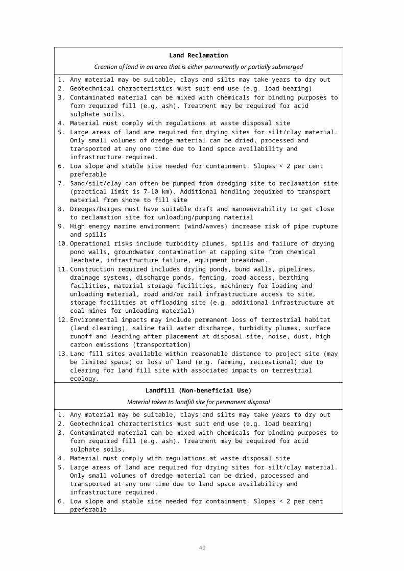
Success Factors
Description
Land
R
ecla
mat
ion
Con
stru
ctio
n Fi
ll
Hab
itat
Res
tora
tion
Park
s an
d R
ecre
atio
n
Provides a socio-economic beneficial re-use
Provides an additional benefit to society through improvement or creation of a public good. Examples include noise/wind barriers, beach nourishment, road foundations, etc.
4 5 3 5
Total Score 22 21 25 251 Fails to achieve the objectives of the criterion.2 May partially achieve some objectives of the criterion but does not meet minimum requirements.3 Achieves the objectives of the criterion to a minimum acceptable level.4 Achieves the objectives of the criterion to a high level.5 Exceeds the objectives of the criterion.
54

Rosslyn Bay State Boat Harbour
Description of Port and Upcoming Projects
Rosslyn Bay State Boat Harbour, also known as Keppel Bay Marina is located approximately 8 km south of the central business district of Yeppoon. The harbour is within Keppel Bay and adjacent the Mackay/Capricorn management area of the Great Barrier Reef Marine Park. The Department of Transport and Main Roads (DTMR) manages Rosslyn Bay State Boat Harbour on behalf of the State Government and is responsible for the maintenance dredging of the navigation channels and the inner harbour public boating areas. The harbour, situated to the north of the Fitzroy River receives considerable volumes of sediment each year through wave action in Keppel Bay. Maintenance dredging of approximately 30,000 m3 is required every three to four years for navigational purposes. However, due to recent flooding events in the Fitzroy River, the 2012 maintenance dredging campaign is likely to be in the order of 86,000 m3 from increased siltation (DTMR 2012). The harbour has 400 marina berths available and caters for short term and long term recreational and commercial vessels up to 35 metres in length. Future developments within Rosslyn Bay State Boat Harbour include the construction of waterfront villas with associated berths, along with condominiums, apartments, townhouses, retail outlets and facilities on the western side of the marina. The proposed development is within the boundaries of the marina on the existing reclaimed parkland. Approval of construction of a five storey building with residential units, arts and crafts centre, restaurants, shops and basement parking has recently been granted on the eastern side of the marina within the existing kiosk and service station area.
Sediment Characteristics
Sediments within the Rosslyn Bay State Boat Harbour and entrance channel are composed of sand with large quantities of clay and silt. Generally areas within the inner harbour are fine, silty clays typically overlaid with stiffer clays at approximately one meter (GHD 2005), with the outer channel more dominated by sandy material. Cobbles have been found in the underlying layers of the harbour area. In 1997, prior to the publication of the National Ocean Disposal Guidelines for Dredged Material (NODGDM), sediment sampling showed elevated TBT levels (Voisey 2001), which were managed via a monitoring program. However, DTMR has since undertaken extensive sediment sampling programs to support dredging projects that have identified no TBT contamination above the screening level in the NODGDM and subsequently the NAGD.
Sediment sampling and analysis in 2000, 2005 and 2009 showed that all the contaminants, except one, were below the NODGDM screening levels. In 2000 and 2005, the only contaminant that exceeded NODGDM screening levels was nickel, which was found in relatively low concentrations. Concentrations of nickel were also found in the sediments outside of the harbour, however, as nickel was found in other areas of the surrounding coastline, DERM and the GBRMPA approved the unconfined offshore placement of material from these dredge campaigns. In 2009, the concentration of antimony exceeded the NODGDM screening level by 0.6 mg/kg (surface sediments) and 0.5 mg/kg (deeper sediments). However DERM and the GBRMPA approved the offshore disposal campaign (FRC 2011). Concentrations hydrocarbons, herbicides and pesticides, organotins and poly-chlorinated biphenyls were all below the screening level in 2009.
Sediment sampling and analysis in 2005 and 2009 found that ASS were not present or found in very low concentrations, and as such were not considered to be a risk to aquatic ecology during dredging and offshore disposal (FRC 2011).
55

Potential Option(s)
A summary of the options considered is provided in Appendix E. As discussed above disposal options for the beneficial re-use of dredge material in Rosslyn Bay are extremely constrained due to its small size and location surrounded by highly valued conservation land and adjacent residential use land. Sediment sampling has found sediments to be generally uncontaminated (FRC 2009) and suitable for placement offshore therefore considering the all constraints with placing the dredge material on land, the most suitable option appears to be placement at sea.
Cost Analysis
This assessment did not identify any land-based options as potentially feasible for future management of dredge material at Rosslyn Bay State Boat Harbour. Details of the considerations and constraints criteria upon this assessment was based are presented in Appendix C and Appendix E. The cost for pumping maintenance dredge material offshore to the existing placement site was estimated at $4.00/m3.
Multi-criteria Assessment
An MCA was not conducted for Rosslyn State Boat Harbour as no land-based options were found to be suitable.
56

Port of Hay Point
Description of Port and Upcoming Projects
The Port of Hay Point is located in the Mackay Regional Council area and lies within the World Heritage Area. The port is the world’s largest coal export port, comprising two separate terminals: Dalrymple Bay Coal Terminal and the Hay Point Coal Terminal. Land uses in the area of the port include low density and semi residential use, and port related activities. Capital dredging in 2006 undertaken by the Ports Corporation Queensland (PCQ) at Hay Point involved the removal and placement of approximately 9 Mm3 of material from the departure paths and apron areas to increase the export capacity of the terminal. The Hay Point Coal Terminal Expansion Project (HPX3) involved capital dredging in 2012 of 275,000 m3 of material for a new third berth, with associated construction of infrastructure at the terminal and Tug Harbour to the south. There are plans for future development of a new coal terminal and associated infrastructure at Dudgeon Point, four kilometres north-west of Hay Point. Approval processes are progressing for two new coal terminals including coal stockyards, eight new ship berths, and a rail network along with further expansion of Tug Harbour. Future dredging projects within the Port of Hay Point will involve the removal of 15 Mm3
for capital dredging of berths, swing basins and channels at Dudgeon Point, along with 1 Mm3 of maintenance dredging every 3 years.
Sediment Characteristics
Capital dredge material for the Dudgeon Point project (15 Mm3) is expected to consist of 50 per cent sand and 50 per cent stiff clay at the berth pockets and 70 per cent sand and 30 per cent clay at the apron area. Previous studies indicate that the inner section of the shipping channel is composed of mostly silts and silty fine sands of variable thickness (1-30 cm) in the surficial layers overlaying very stiff layers of clays > 30 cm thick (WBM 2004). Sediment sample analysis undertaken as part of the macroinvertebrate monitoring (WBM 2001; Hydrobiology 2004, WBM 2004) indicate that the general seabed to the north of the existing dredge material placement ground is predominantly sands and small gravel with less than 2 per cent fine silts and clays.
The majority of capital and maintenance dredge material around Hay Point have not contained rock material, however, rock has been encountered in isolated outcrops within the berth pockets at depths greater than 3 m, based on previous geotechnical work and dredging for the HPX3 project (BMA 2009). The rock was found to be both weathered and fresh rock and required blasting. There is a possibility that future expansion project could encounter rock again.
Sediment quality analysis results for maintenance dredge material (Hydrobiology 2004) have found that all contaminants of concern apart from TBT and arsenic were below the relevant screening levels. Further analysis found that 95 per cent upper confidence limit (UCL) for both contaminants were below the screening level criterion. The assessment concluded that the sediment had low acid sulphate potential. WBM (2004) reported that there would be nil to minimal risk, in terms of the chemical nature of the sediment, of contamination if placed onshore.
Potential Option(s)
A summary of the options considered is provided in Appendix E. Options for use of dredge material on land are highly constrained, due to the fine material types (clays), large volumes of anticipated material to be dredged and associated land requirements for drying, and high environmental values. The size of land required to establish an onshore treatment facility for dredge sediments, even for only a small proportion of
57

future dredging requirements, is too large to be practical. Logistical constraints associated with pumping large quantities of stiff clay material several kilometres also represent significant constraints for other onshore options. It is not feasible to pump the dredge material to shore. The dredge material cannot be pumped ashore by a trailer dredger, as it is not possible to feed these materials gradually from the hopper well in to the dredger’s discharge pipelines for pumping ashore. An alternative is to pump the dredged materials with a large self-propelled cutter suction dredger directly into a reclamation area on shore, however, it is not feasible due to the long pumping distance between dredging area and reclamation area (12 to 14 km distance) which is beyond the technical capabilities of even the largest self-propelled cutter suction dredger in the world (Pro-dredging and Maine Consultants 2012).
Rock has been found to in small isolated patches surrounding Hay Point. Some of the rock material is highly weathered and therefore may not be suitable for many shoreline protection purposes. However, it may be suitable as fill material behind sea walls, on projects like the Tug Harbour expansion or for reclamation. As noted above, previous expansions at both the Dalrymple Bay and Hay Point coal terminals have encountered small amounts of rock fresh enough to require pre-treatment by blasting prior to dredging. Such rock may be competent for shoreline protection, bund construction, or engineering fill.
Cost Analysis
Table 25 provides indicative unit costs which for various stages of placement options which have been deemed potentially suitable for future management of dredge material at the Port of Hay Point. Details of the considerations and constraints criteria upon which the decisions were made are presented in Appendix C and Appendix E.
58

Table 25. Cost analysis for the Port of Hay Point.
Cost Offshore Placement Land Reclamation Construction Fill (supra tidal)
Transport dredge material from dredge site
Barge transport N/A $0.003 to $0.160/m3/km $0.003 to $0.160/m3/km
Infrastructure required for barge transport
N/A $1.4 to $2.2 million per facility $1.4 to $2.2 million per facility
Pump/pipeline transport Capital Dredging: $5.00/m3 N/A N/A
Access/Loading/Unloading costs N/A $6.00 to $38.00/ m3 or $10,000/day
$6.00 to $38.00/ m3 or $10,000/day
On-road transport by truck N/A N/A $0.008 to $0.331/m3/km
Processing costs De-watering N/A N/A N/A
Stabilisation N/A N/A N/A
Separation N/A N/A N/A
Water Quality monitoring N/A $0.25/m3 $0.25/m3
Other infrastructure costs Land reclamation site N/A $7.00 to $9.00/m3 N/A
Sea walls N/A N/A N/A
Bunded facility for artificial habitat N/A N/A N/A
Sand dispersion/shaping N/A N/A N/A
N/A – the cost is not applicable for this process
59

Multi-criteria Assessment
A multi-criteria assessment was conducted on the shortlisted options with a view to assessing additional impacts which are not captured as part of the cost assessment. These include social impacts such as environmental and health impacts as well as economic impacts for industry. Evaluation of social and environmental costs and benefits has been conducted by identifying critical success factors for dredge material placement methods. Table 4 in the Methods section (page 15), identifies the critical success factors used in this assessment, and Table 5 shows the scoring system. The results of the port-specific MCA are shown in Table 26. It is stressed that, as for all ports, the MCS is generic and does not include the consideration of specific sites for the options considered, or the nature and volumes of material generated by a specific dredging project. Therefore, the MCA is purely indicative and does not proscribe the outcomes of future, more detailed, project-specific assessments.
For Hay Point the use of rock material for construction fill stands out as a key option, while reclamation also scores highly.
Table 26. Multi-criteria assessment for the Port of Hay Point.
Success Factors Description
Land
Rec
lam
atio
n
Con
stru
ctio
n Fi
ll
Reduces impacts to marine environment
This option reduces negative impacts to marine species and biodiversity relative to the control alternative (ocean disposal at traditional site).
2 4
Reduces impacts to terrestrial environment
This option reduces negative impacts to terrestrial species and biodiversity relative to the control alternative (in this case, no disposal on land).
4 4
Reduces impacts to social, aesthetic and cultural heritage values
This option reduces negative impacts to social, aesthetic or cultural heritage aspects of the surrounding environment.
3 2
Improves ecological systems and services
Provides an additional benefit to the ecosystem in which it has been introduced such as habitat creation or improvement.
2 1
Avoids or reduces impacts to human health
Provides an additional benefit by reducing the negative impact on human health through avoidance of contamination, improvement of water quality, desalinisation or other.
4 4
Provides a commercially beneficial re-use
Provides an additional benefit to society through engineering or commercially based use of recycled (dredge) material as opposed to the requirement of a ‘new’ material. Examples include sealing contaminated sites, cement stabilisation or other.
4 5
60

Success Factors Description
Land
Rec
lam
atio
n
Con
stru
ctio
n Fi
ll
Provides a socio-economic beneficial re-use
Provides an additional benefit to society through improvement or creation of a public good. Examples include noise/wind barriers, beach nourishment, road foundations, etc.
3 5
Total Score 22 251 Fails to achieve the objectives of the criterion.2 May partially achieve some objectives of the criterion but does not meet minimum requirements.3 Achieves the objectives of the criterion to a minimum acceptable level.4 Achieves the objectives of the criterion to a high level.5 Exceeds the objectives of the criterion.
61

Port of Abbot Point
Description of Port and Upcoming Projects
The Port of Abbot Point is located approximately 25 km north-west of Bowen and is operated by North Queensland Bulk Port Corporation Pty Ltd (NQBP). The port is adjacent the Abbot Point State Development Area and has been identified by the State Government as an area for large scale industrial development (GHD 2012a in draft, unpublished). The port is located close to coal resources of the Galilee and Bowen basin and is presently transforming into a globally important port for the export of coal. The port comprises rail in-loading facilities, coal handling and stockpiling areas and a single trestle jetty and conveyer connecting two offshore berths and two ship loaders (www.nqbp.com.au/abbot-point/). Development at the port includes the expansion of the existing terminal, construction of three additional terminals, and associated infrastructure to meet the increasing demand for coal export through the port (T0, T2 and T3 project). Capital dredging campaigns for the T0, T2 and T3 project will involve removal of up to 3 Mm3 of material within the berth pockets and apron areas and is expected to commence mid 2013. Maintenance dredging within the port is marginal and infrequent by comparison due to the depth of the Port of Abbot Point and associated low accumulation of sediments (port stakeholder workshop pers. comm.). The port lies within the World Heritage Area and borders the Marine Park. Land uses within the port are predominantly associated with port activity and there is no residential area within the immediate vicinity of the port.
Sediment Characteristics
Sediment sampling and analysis undertaken within the port for capital dredging in 2005 found sediments consisted of silty sands to depths of 0.5 m, underlain by stiff clays (WBM 2005). In 2009, sediment sampling and analysis for the formerly proposed multi cargo facility closer to shore found medium to coarse grained sands and fine gravels (GHD 2009a). Also, sediment sampling and analysis for the capital dredging project proposed for 2013 found the sediments of Abbot Point were relatively similar across the dredge area and consisted predominantly sands (54 per cent), silts (19 per cent), clay (20 per cent) and gravel (7.7 per cent; GHD 2012b in draft, unpublished).
Mean concentrations for heavy metals, metalloids and other contaminants were generally less than the NAGD screening levels in all previous sampling undertaken (GHD 2012b in draft unpublished). Contaminants of concern detected in a number of sampling programs (WBM 2005; Worley Parsons 2007; GHD 2009b) were TBT (from shipping anti-fouling use) and polycyclic aromatic hyrdrocarbons (PAHs), possibly from coal or engine sources). More recent sediment sampling and analysis for a proposed capital dredging project found the material to be suitable for offshore disposal with the 95 per cent UCLs of analysed contaminant substances all being less than the NAGD screening levels (GHD 2012b in draft, unpublished).
Sediments were considered to be PASS, however, the potential acid neutralising capacity of the sediment was greater than the acid generating potential, though if fines were separated from the sediment matrix, the acid generating potential may increase in the fines (GHD 2012b in draft, unpublished). Any material that may be re-used on land will therefore require monitoring for ASS and management.
Potential Option(s)
A summary of the options considered is provided in Appendix E. The options that could feasibly be considered as potential options for the use or land-based placement of dredge material were primarily related to small quantities of sand in the upper sediment
62

layers. Potential uses include beach nourishment, reclamation, habitat restoration and use as non-structural fill. Any treatment area constructed on land would need to be managed to prevent impacts on the Caley Valley Wetland.
Cost Analysis
Table 27 provides indicative unit costs for various stages of placement options which have been deemed potentially suitable for future management of dredge material at the Port of Abbot Point. Details of the considerations and constraints criteria upon which the decisions were made are presented in Appendix C and Appendix E.
63

Table 27. Cost analysis for the Port of Abbot Point.
Cost Offshore Placement
Land Reclamation
Construction Fill (supra
tidal)
Construction Material
Beach Nourishment
Parks and Recreation
Habitat Restoration
Transport dredge material from dredge site
Barge transport N/A N/A N/A $0.003 to $0.160/ m3/km
N/A N/A N/A
Infrastructure required for barge transport
N/A N/A N/A $1.4 to $2.2 million per facility
N/A N/A N/A
Pump/pipeline transport Capital Dredging:
$4.00/m3
Capital Dredging:
$12.50/m3
Capital Dredging:
$12.50/m3
N/A Capital Dredging:
$12.50/m3
Capital Dredging:
$12.50/m3
Capital Dredging:
$12.50/m3
Access/Loading/Unloading costs
N/A $6.00 to $38.00/m3 or $10,000.00/d
$6.00 to $38.00/m3 or $10,000.00/d
$6.00 to $38.00/m3 or $10,000.00/d
$6.00 to $38.00/m3 or $10,000.00/d
$6.00 to $38.00/m3 or $10,000.00/d
$6.00 to $38.00/m3
or $10,000.00/d
On-road transport by truck N/A N/A $0.008 to $0.331/m3/km
$0.008 to $0.331/m3/km
N/A $0.008 to to $0.331/m3/km
N/A
Processing costs
De-watering N/A $6.00 to $105.00*/ m3
$6.00 to $105.00/ m3
$6.00 to $105.00/ m3
$6.00 to $105.00/ m3
$6.00 to $105.00/ m3
N/A
Stabilisation N/A $37.00 to $158.00/ m3
(as required)
$37.00 to $158.00/ m3
(as required)
$37.00 to $158.00/ m3
(as required)
$37.00 to $158.00/ m3
(as required)
$37.00 to $158.00/ m3
(as required)
N/A
Separation N/A $6.00 $25.00/m3 (as required)
$6.00 to $25.00/m3 (as required)
$6.00 to $25.00/m3 (as required)
$6.00 to $25.00/m3 (as required)
$6.00 to $25.00/m3 (as required)
N/A
Water Quality monitoring N/A $0.25/m3 $0.25/ m3 $0.25/m3 $0.25/m3 $0.25/m3 $0.25/m3
Other infrastructur
Land reclamation site N/A $7.00 to $9.00/m3
N/A N/A N/A N/A N/A
64

Cost Offshore Placement
Land Reclamation
Construction Fill (supra
tidal)
Construction Material
Beach Nourishment
Parks and Recreation
Habitat Restoration
e costs Sea walls N/A N/A N/A N/A N/A N/A N/A
Bunded facility for artificial habitat
N/A N/A N/A N/A N/A N/A $154.60/m3
$11, 759.90 to 152, 878.20/linear metre$2,352.00 to $23,519.00/ linear metre
Elevated transport conveyor
N/A N/A $7.00 M to $11.80 M/km
$7.00 M to $11.80 M/km
$7.00 M to $11.80 M/km
$7.00 M to $11.80 M/km
$7.00 M to $11.80 M/km
Sand dispersion/shaping N/A N/A N/A N/A $10.67/m3 N/A N/A
N/A – the cost is not applicable for this process
*This estimate likely includes the cost of de-watering facilities. It is noted that de-watering may occur in final land reclamation site.
65

Multi-criteria Assessment
A multi-criteria assessment was conducted on the shortlisted options with a view to assessing additional impacts which are not captured as part of the cost assessment. These include social impacts such as environmental and health impacts as well as economic impacts for industry. Evaluation of social and environmental costs and benefits has been conducted by identifying critical success factors for placement methods. Table 4 in the Methods section (page 15), identifies the critical success factors used in this assessment, and Table 5 shows the scoring system. The results of the port-specific MCA are shown in Table 28. It is stressed that, as for all ports, the MCA is generic and does not include the consideration of specific sites for the options considered, or the nature and volumes of material generated by a specific dredging project. Therefore, the MCA is purely indicative and does not proscribe the outcomes of future, more detailed, project-specific assessments.
For Abbot Point there are a variety of options potentially available because of the sandy nature of the material. Highest scores were generated for the options of beach nourishment; and parks and recreation. A lack of demand for these uses due to the remoteness of the port, however, presently constrains the viability of these options. The wetland west of the port also constrains material transport. If future development stimulates demand, transport of dredge material to market via an elevated conveyor could be considered, but this would likely not be viable for small amounts of material or one-off projects. It should be noted that this option would require a market demand for sand and could have further possible impacts on the wetland habitat during construction and operation of the conveyor.
Table 28. Multi-criteria assessment for the Port of Abbot Point.
Success Factors
Description
Land
R
ecla
mat
ion
Con
stru
ctio
n Fi
ll
Bea
ch
Nou
rishm
ent
Hab
itat
Res
tora
tion
Park
s an
d R
ecre
atio
nReduces impacts to marine environment
This option reduces negative impacts to marine species and biodiversity relative to the control alternative (ocean disposal at traditional site).
2 4 5 4 4
Reduces impacts to terrestrial environment
This option reduces negative impacts to terrestrial species and biodiversity relative to the control alternative (in this case, no disposal on land).
4 4 5 4 4
Reduces impacts to social, aesthetic and cultural heritage values
This option reduces negative impacts to social, aesthetic or cultural heritage aspects of the surrounding environment.
3 3 4 4 3
Improves ecological systems and services
Provides an additional benefit to the ecosystem in which it has been introduced such as habitat creation or improvement.
2 1 4 5 3
66

Success Factors
Description
Land
R
ecla
mat
ion
Con
stru
ctio
n Fi
ll
Bea
ch
Nou
rishm
ent
Hab
itat
Res
tora
tion
Park
s an
d R
ecre
atio
n
Avoids or reduces impacts to human health
Provides an additional benefit by reducing the negative impact on human health through avoidance of contamination, improvement of water quality, desalinisation or other.
4 4 3 3 4
Provides a commercially beneficial re-use
Provides an additional benefit to society through engineering or commercially based use of recycled (dredge) material as opposed to the requirement of a ‘new’ material. Examples include sealing contaminated sites, cement stabilisation or other.
4 5 5 3 5
Provides a socio-economic beneficial re-use
Provides an additional benefit to society through improvement or creation of a public good. Examples include noise/wind barriers, beach nourishment, road foundations, etc.
3 5 4 3 5
Total Score 22 26 30 26 281 Fails to achieve the objectives of the criterion.2 May partially achieve some objectives of the criterion but does not meet minimum requirements.3 Achieves the objectives of the criterion to a minimum acceptable level.4 Achieves the objectives of the criterion to a high level.5 Exceeds the objectives of the criterion.
67

Port of Townsville
Description of Port and Upcoming Projects
The Port of Townsville Ltd (POTL), located on Ross Creek in far north Queensland, lies within Cleveland Bay bound by Cape Cleveland on the east, Cape Pallarenda on the west, and Magnetic Island at the entrance. It faces directly north and is protected by the prevailing south-easterly sea breezes. The port is located within the World Heritage Area and a portion of the port lies within the Marine Park. Cleveland Bay is broad and shallow with 50 per cent of the bay less than 5 m deep (Kettle et al. 2002). Sediments accumulate in the bay from northward sediment transport and deposition from surrounding river systems. The port is Australia’s largest exporter of sugar and molasses, along with exporting a diverse base of metals. The Port of Townsville Pty Ltd is a Government Owned Corporation and trade activity is forecast to grow substantially in the future with an additional 30 million tonnes of cargo throughput expected in the next 30 years (www.townsville-port.com.au). Associated port development and critical infrastructure will be required to facilitate growth and meet future demand. The Port Development Plan 2010–2040 (as outlined on the Port of Townsville website) highlights short, medium and long term developments within the port between the years 2010 to 2040. The major projects and developments in the near future include:
The development of a new marine precinct on the eastern side of the port for marine industries and facilities (The Marine Precinct Project)
Development of the existing eastern reclamation area (land, rail , road and civil services) for cargo storage and handling facilities
Expansion of the outer harbour of the port including construction of a breakwater, land reclamation, new berths and deepening of the harbour (the Sea and Platypus Channel) to accommodate larger vessels – Port Expansion Project (PEP)
Expansion of Berth 10 (B10X).
The capital and maintenance dredging volumes over the next 25 years including all approved, existing and proposed projects is anticipated to be approximately 33 Mm3. Past dredging campaigns have disposed of the material at offshore locations and as fill material for land reclamation (Port of Townsville 1992).
Sediment Characteristics
Previous sediment sampling within the port found sediments consisting of a surface layer of soft and compressible marine silt overlying stiff sandy clay/clayey sand materials (AECOM 2009). The study area lies within the Great Barrier Reef High Nutrient Coastal strip, which is characterised by muddy sediments and elevated nutrients. Sediment sampling carried out in 2010 and 2011 by BMT WBM (2012 in draft unpublished) found silty fine to medium sands dominated the areas east and west of the port with mud, sand and occasional gravel dominating the sediment type north of the port, the shipping channel, west of Magnetic Island and the existing dredge placement area.
Contaminants of concern have been found within dredged sediment in past sampling programs (arsenic, zinc, copper, organosilicon, cyanides and fluorides), however the concentrations of the substances were within the limits specified by the London Dumping Convention and were not considered not to affect the marine environment (Townsville Port Authority 1992).
An acid sulphate soil investigation as art of the Marine Precinct Project, identified PASS in all the main material types encountered at various depths below the sea bed
68
in 77 per cent of samples analysed (GHD 2009). However, no actual acid sulphate soils were found during the study. The soils were found to have higher acid neutralising capacity than acid generating capacity (GHD 2009).
Potential Option(s)
A summary of the options considered is provided in Appendix E. Reclamation is the primary option that could feasibly be considered for land-based placement of dredge material. Other land-based options are highly constrained due to a lack of available land and due to the nature of sediments to be dredge, which are unsuitable for beach nourishment or construction purposes.
Cost Analysis
Table 29 provides indicative unit costs for various stages of placement options which have been deemed potentially suitable for future management of dredge material at the Port of Townsville. Details of the considerations and constraints criteria upon which the decisions were made are presented in Appendix C and Appendix E.
69

Table 29. Cost analysis for the Port of Townsville.
Cost Offshore Disposal Land Reclamation Landfill Capping/Blending
Transport dredge material from dredge site
Barge transport N/A N/A N/A
Infrastructure required for barge transport
N/A N/A N/A
Pump/pipeline transport Capital Dredging: $4.50 to $5.00/m3
Maintenance Dredging: $3.50/m3
Capital Dredging: $7.00/m3
Maintenance Dredging: $7.50/m3
Capital Dredging: $7.00/m3
Maintenance Dredging: $7.50/m3
Access/Loading/Unloading costs
N/A $6.00 to $38.00/m3 or $10,000.00/d
$6.00 to $38.00/m3 or $10,000.00/d
On-road transport N/A N/A $0.008-$0.331/m3/km
Processing costs De-watering N/A $6.00 to $105.00/ m3* $6.00 to $105.00/ m3*
Stabilisation N/A $37.00 to $158.00/m3 (as required)
$37.00 to $158.00/m3 (as required)
Separation N/A $6.00 to $25.00/ m3 (as required)
$6.00 to $25.00/ m3 (as required)
Water Quality monitoring N/A $0.25/ m3 $0.25/m3
Other infrastructure costs Land reclamation site N/A $7.00 to $9.00/m3 N/A
Sea walls N/A N/A N/A
Bunded facility for artificial habitat
N/A N/A N/A
Sand dispersion/shaping N/A N/A N/A
N/A – the cost is not applicable for this process*This estimate likely includes the cost of de-watering facilities. It is noted that de-watering may occur in final land reclamation site.
70

Multi-criteria Assessment
A multi-criteria assessment was conducted on the shortlisted options with a view to assessing additional impacts which are not captured as part of the cost assessment. These include social impacts such as environmental and health impacts as well as economic impacts for industry. Evaluation of social and environmental costs and benefits has been conducted by identifying critical success factors for placement methods. Table 4 in the Methods section (page 15), identifies the critical success factors used in this assessment, and Table 5 shows the scoring system. The results of the port-specific MCA are shown in Table 30. It is stressed that, as for all ports, the MCA is generic and does not include the consideration of specific sites for the options considered, or the nature and volumes of material generated by a specific dredging project. Therefore, the MCA is purely indicative and does not proscribe the outcomes of future, more detailed, project-specific assessments.
For the Port of Townsville there are limited options of which reclamation and landfill capping appear to be the most practical and feasible. Land reclamation scored the highest in the MCA.
Table 30. Multi-criteria assessment for the Port of Townsville.
Success Factors
Description
Land
R
ecla
mat
ion
Land
fill S
ite
Cap
ping
/ B
lend
ing
Reduces impacts to marine environment
This option reduces negative impacts to marine species and biodiversity relative to the control alternative (ocean disposal at traditional site).
2 4
Reduces impacts to terrestrial environment
This option reduces negative impacts to terrestrial species and biodiversity relative to the control alternative (in this case, no disposal on land).
4 2
Reduces impacts to social, aesthetic and cultural heritage values
This option reduces negative impacts to social, aesthetic or cultural heritage aspects of the surrounding environment.
3 2
Improves ecological systems and services
Provides an additional benefit to the ecosystem in which it has been introduced such as habitat creation or improvement. 2 2
Avoids or reduces impacts to human health
Provides an additional benefit by reducing the negative impact on human health through avoidance of contamination, improvement of water quality, desalinisation or other.
3 2
Provides a commercially beneficial re-use
Provides an additional benefit to society through engineering or commercially based use of recycled (dredge) material as opposed to the requirement of a ‘new’ material. Examples include sealing contaminated sites, cement stabilisation or other.
4 3
Provides a socio-economic beneficial re-use
Provides an additional benefit to society through improvement or creation of a public good. Examples include noise/wind barriers, beach nourishment, road foundations, etc.
4 3
Total Score 22 18
71

1 Fails to achieve the objectives of the criterion.2 May partially achieve some objectives of the criterion but does not meet minimum requirements.3 Achieves the objectives of the criterion to a minimum acceptable level.4 Achieves the objectives of the criterion to a high level.5 Exceeds the objectives of the criterion.
72

Port of Cairns
Description of Port and Upcoming Projects
The Port of Cairns is the most northern major port on Australia’s eastern seaboard and is owned and operated by Far North Queensland Ports Corporation Limited (Ports North). It is Australia’s busiest cruise port with over 200 international and domestic cruise ship visits annually (wwwcairnsport.com.au). The Port of Cairns receives a high amount of sediment deposition from the Barron River to the north and from northward longshore transport of sediment around Cape Grafton. The City of Cairns and the Port are built surrounding a shallow estuary system, therefore, periodic maintenance dredging is essential.
Cairns is a rapidly growing city centre and accordingly Ports North has commenced plans to improve shipping access to the Port of Cairns to accommodate mega class cruise ships in an effort to make Cairns a premier cruise destination in Queensland. The Cairns Shipping Development Project involves expansion of the existing shipping channel and shipping swing basins, expansion of the existing dredge material placement area, establishment of a new shipping swing basin to support future growth of the HMAS Cairns Navy Base and upgrade of the wharves. Construction is estimated to be complete by 2015 (www.cairnsport.com.au).
Sediment Characteristics
The Ports of Cairns requires approximately 350,000 m3 of material in situ to be dredged annually to maintain adequate depth within the navigational channels and basins. The trailer suction hopper barge the “Brisbane” is the principal dredger used within the Port along with a small bucket grab dredge “Willunga” (approximately 50,000 to 70,000 m3) at different times during the year. It is anticipated that future capital dredging within the Port will involve the removal of approximately 5 Mm3 of material in situ.
The dredged material is expected to be composed of a mixture of high plasticity clay and silt (90 per cent), and approximately 10 per cent sand layers (5 mm to 10 mm thick) interspersed throughout. The sediment is highly lensed (Golder Associates 2012). The sediment in the outer shipping channel is predominately composed of silt (0.060 mm–0.002 mm), whereas sediments in the inner channel are composed equally of silt and clay (< 0.002 mm; Worley Parsons 2010).
TBT has routinely been detected in sediments within the marina areas, navy base, inner port and outer channel dredge area at or above screening guideline levels. Most dredge areas except the outer channel typically exceed the screening level for TBT and required further testing. Metal contaminants in sediments have in the past typically occurred at or below NODGDM / NAGD screening levels. Based on the data for 2005 to 2009, metals and metalloids that have exceeded screening values include: arsenic, in the inner port (including marinas), navy base, outer channel and the spoil ground; cadmium in at the inner port and spoil ground; and copper and zinc in the inner port only (Worley Parsons 2012).
Potential Option(s)
A summary of the options considered is provided in Appendix E. Construction fill is the primary option that could feasibly be considered for land-based use of dredge material, however, this option would only be suitable if there was a requirement, if any ASS had been treated and if there were no other contaminants present. Other land-based options are highly constrained due to a lack of available land and due to the nature of
73

sediments to be dredge, which are unsuitable for beach nourishment or construction purposes.
Cost Analysis
This assessment only identified use as construction fill material as a potentially feasible option, the costs of which are detailed in Table 31. Details of the considerations and constraints criteria upon this assessment was based are presented in Appendix C and Appendix E.
74

Table 31. Cost analysis for the Port of Cairns.
Cost Offshore Disposal Construction Fill (supra tidal)
Transport dredge material from dredge site
Barge transport N/A N/A
Infrastructure required for barge transport N/A N/A
Pump/pipeline transport Capital Dredging: $4.00/m3
Maintenance Dredging: $3.00 to $3.50/m3
Capital Dredging: $5.00/m3
Access/Loading/Unloading costs N/A N/A
On-road transport by truck N/A $0.008 to $0.331/m3/km
Processing costs De-watering N/A $6.00 to $105.00/m
Stabilisation N/A $37.00 to $158.00/m3
Separation N/A $6.00 to $25.00/m3
Water Quality monitoring N/A $0.25/m3
Other infrastructure costs Land reclamation site N/A N/A
Sea walls N/A N/A
Bunded facility for artificial habitat N/A N/A
Sand dispersion/shaping N/A N/A
N/A – the cost is not applicable for this process
75
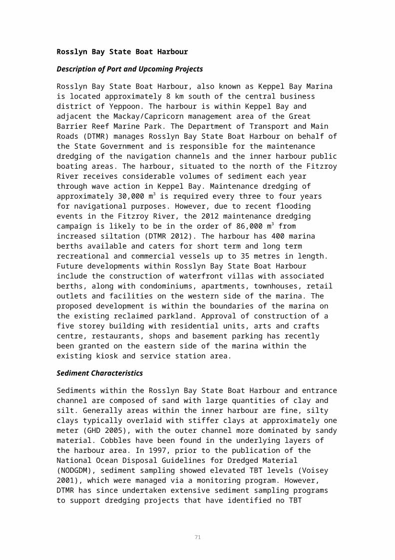
Multi-criteria Assessment
A multi-criteria assessment was conducted on the shortlisted options with a view to assessing additional impacts which are not captured as part of the cost assessment. These include social impacts such as environmental and health impacts as well as economic impacts for industry. Evaluation of social and environmental costs and benefits has been conducted by identifying critical success factors for placement methods. Table 4 in the Methods section (page 15) identifies the critical success factors used in this assessment, and Table 5 shows the scoring system. The results of the port-specific MCA are shown in Table 30. It is stressed that, as for all ports, the MCA is generic and does not include the consideration of specific sites for the options considered, or the nature and volumes of material generated by a specific dredging project. Therefore, the MCA is purely indicative and does not proscribe the outcomes of future, more detailed, project-specific assessments.
Only two suitable options were considered in the MCA. Use of dredge material as construction fill scored the highest compared to offshore dredge material placement.
Table 32. Multi-criteria assessment for the Port of Cairns.
Success Factors Description
Con
stru
ctio
n Fi
ll
Reduces impacts to marine environment
This option reduces negative impacts to marine species and biodiversity. 5
Reduces impacts to terrestrial environment
This option reduces negative impacts to terrestrial species and biodiversity.
2
Reduces impacts to social, aesthetic and cultural heritage values
This option reduces negative impacts to social, aesthetic or cultural heritage aspects of the surrounding environment.
2
Improves ecological systems and services
Provides an additional benefit to the ecosystem in which it has been introduced such as habitat creation or improvement.
1
Avoids or reduces impacts to human health
Provides an additional benefit by reducing the negative impact on human health through avoidance of contamination, improvement of water quality, desalinisation or other.
3
Provides a commercially beneficial re-use
Provides an additional benefit to society through engineering or commercially based use of recycled (dredge) material as opposed to the requirement of a ‘new’ material. Examples include sealing contaminated sites, cement stabilisation or other.
5
Provides a socio-economic beneficial re-use
Provides an additional benefit to society through improvement or creation of a public good. Examples include noise/wind barriers, beach nourishment, road foundations, etc.
4
Total Score 221 Fails to achieve the objectives of the criterion.2 May partially achieve some objectives of the criterion but does not meet minimum requirements.3 Achieves the objectives of the criterion to a minimum acceptable level.4 Achieves the objectives of the criterion to a high level.5 Exceeds the objectives of the criterion.
76

CONCLUSIONS
Potential options for beneficial re-use and land-based disposal of dredge material have been considered at six locations on the Great Barrier Reef. A number of disposal options were unviable, based on absolute constraints outlined in Appendix E. For Rosslyn Bay State Boat Harbour, offshore placement was the only viable option, mainly due to the land constraints for drying the dredge material. At the Port of Hay Point the distance of the area to be dredged from the shore posed a major constraint in transporting the material by pipeline. In addition, the nature of the material meant that transport by barge was not an option. The only viable option for beneficial re-use at Hay Point was for the use of rock material, which although uncommon has been found previously in the area and used in land reclamation as fill material.
The main common constraint for all the ports was available land for drying out the dredge material to enable it to be transported and used elsewhere. This generally eliminated the options of permanently holding dredge material within a holding pond or disposing of it into a landfill site. No suitable opportunities for use of dredge material in mine rehabilitation were identified, as transporting the wet material was a major constraint. The dredge material for all locations was not suitable for shore protection (e.g. rock armouring). However, there was a possible opportunity for sand from dredge material at the Port of Abbot Point to be used for future beach re-nourishment purposes. The dredge material at all locations was not considered suitable for agricultural use due to the high salt content and need for de-watering and processing. The clay portion of dredge material present at Cairns, Townsville and Hay Point could be used in aquaculture for the lining of earth ponds to prevent water seepage. However, it is unlikely that there will be sufficient demand for this type of use in these regions to provide a major disposal option.
The capital dredge material at the Port of Gladstone is highly layered and although land availability is a major constraint for drying and separating the dredge material, should this obstacle be overcome, some fractions could be used for land reclamation, construction material, fill and restoration of the mangrove and wetland habitats. The dredge material for the Port of Abbot Point contains a high percentage of sand which could be used for land reclamation, construction fill, construction material, for parks and recreation and habitat creation. Although there is currently no demand for the use of the sand as construction material this may change in the future with increased development of the land around Abbot Point. Construction fill could feasibly be considered as a use of dredge material at the Port of Cairns, however, this option would only be suitable if there were no other contaminants present and any ASS was treated. Land reclamation was considered an option for the Port of Townsville as well as landfill capping, however, land for drying the clay material may be an issue.
The cost review revealed that the placement of dredge material offshore was significantly cheaper than all of the options considered for beneficial re-use and land based disposal. This was mainly due to the comparative costs involved in storing the dredge material in a holding pond to dry out before further use could be made, which involved the construction of the de-watering basin, the de-watering itself, stabilisation and separation costs, and the monitoring of water quality throughout the duration of the de-watering process. The use of rock material for land reclamation and fill material was less costly as this avoided the de-watering costs.
There are a number of additional costs which are not included in this study due to the detailed and project-specific nature of the considerations that would need to be considered. These would best be quantified on a case by case basis for a project
77

specific EIA. Accordingly, such costs would be impossible to predict without a specific project in mind. For example costs may vary according to the following factors: Dredge material contamination testing for heavy metals, hydrocarbons,
organochlorines, etc, and possible elutriate and bioavailability testing Treatment of contaminated dredge material Environmental management of dust, noise and erosion impacts Waste management Management of health and safety standards Geotechnical surveys and engineering design costs Security costs i.e. fencing around settling ponds.
Although a wealth of information has been synthesised in order to make this assessment, the options put forward would still need to undergo a rigorous EIA for a specific port development. The information within this report can be used to guide and refine future EIAs’ for both port authorities and regulatory bodies, and highlight areas where further information is required.
78

REFERENCES
AECOM 2009, ‘Townsville Port expansion preliminary engineering and environmental study, dredging and reclamation strategy’, Port of Townsville Limited.
Apitz, S. E. 2010, ‘Waste or resource? Classifying and scoring dredged material management strategies in terms of the waste hierarchy’, Journal of Soils and Sediments 10, 1657-1668.
Aurecon 2011, ‘Memorandum to North Queensland Bulk Ports Corp, Port of Hay Point master plan, onshore disposal of dredging’.
Australian Bureau of Statistics 2012, Website information http://www.abs.gov.au/.
AustStab 2002, Technical Note No.1 May 2002, Lime Stabilisation Practice.
Berger, E. 2007, ‘Lime use for soil improvement & full depth reclamation’, Chemical Lime, a Lhoist Group Company.
Bishop, M.J, Peterson, C.H., Summerson, H.C., Lenihan, H.S. and Grabowski, J.H., 2005, Deposition and Long-shore Transport of Dredge Spoils to Nourish Beaches: Impacts on Benthic Infauna of an Ebb-tidal Delta, Institute of Marine Science, University of North Carolina, U.S.A.
BMA 2009, ‘Hay Point terminal expansion project, dredge disposal options and marine pest risk assessment, August 2009’, BHP Mitsubishi Alliance.
BMT WBM 2012, ‘Port of Gladstone maintenance dredging – SAP implementation report’, Report to Gladstone Ports Corporation.
BMT WBM 2012, ‘Port of Townsville Port expansion project EIS – marine ecology chapter (final draft report). R.B17733.006.02.Marine_ecology final draft. September 2012’, Report to Port of Townsville Limited.
Brandon, D.L. & Price, R.A. 2007, Summary of Available Guidance and Best Practices for Determining Suitability of Dredged Material for Beneficial Uses, US Army Corps of Engineers, Engineer Research and Development Centre.
Brisbane River Management Group 1997. ‘State of the Brisbane River, Moreton Bay and waterways 1996’, Report prepared in conjunction with Brisbane River and Moreton Bay Wastewater Management Study, Department of Environment, 116pp.
CEDA 2010, ‘Dredged material as a resource: options and constraints’, A CEDA Information Paper.
Coastal and Environmental Services 2001, ‘The environmental impacts of offshore dredge spoil from the Coeaga Port dredging operation’, Chapter 5, in Specialist Report on the Environmental Impacts and Monitoring Guidelines for the Land Excavation and Disposal, Marine Dredging and Marine Disposal Operations at Coega Port, Grahamstown, South Africa.
Commonwealth of Australia 2009, National Assessment Guidelines for Dredging, Canberra, 2009.
79

Cyrus, D.P., MacKay, C.F. & Weerts, S.P. 2008, ‘Intrusion of beach-disposed dredger spoil into the Mhlathuze Estuary, South Africa, and its impact on Zostera capensis’, African Journal of Aquatic Science, 33 (3), 223-231.
De’ath, G, Fabricius, KE, Sweatman, H, & Puotinen, M 2012, ‘The 27-year decline of coral cover on the Great Barrier Reef and its causes’, published on the Proceedings of the National Academy of Sciences of the United States of America website, www.pnas.org.
DEFRA 1999, ‘Economic evaluation of MAFF’s policy relating to the disposal of dredged waste at sea’, Ministry of Agriculture, Fisheries and Food, Report Number: 505S012/2.
DEFRA 2008, Maintenance Dredging Protocol - A Simplified Flow Chart, Retrieved 11th March, 2011, from http://www.defra.gov.uk/wildlife-pets/wildlife/protect/documents/mdp-process.pdf., Department for Environment, Food and Rural Affairs.
DEFRA 2010, ‘Research and support for developing a UK strategy for managing contaminated marine sediments’, Entec UK Limited, Department for Environment, Food and Rural Affairs.
DEFRA 1999, Website information http://www.defra.gov.uk/environment/waste/legislation/, Department for Environment, Food & Rural Affairs.
DERM 2009, Queensland Government Wildlife Online Database (DEHP 2012) and EPBC Protected Matters Search Tool, http://www.ehp.qld.gov.au/wildlife/wildlife-online/
DIP 2009, Far North Queensland Regional 92 Plan 2009–2031. Department of Infrastructure and Planning. February 2009. ISBN: 978-0-9804831-1-6.
DNRM 2012, Interactive Resources and Tenure Maps for Mining, Exploration and Petroleum. Website database, Department of Natural Resources and Mines. http://mines.industry.qld.gov.au/mining/default.htm.
DTMR 2009, Environmental Management Plan (Dredging), Rosslyn Bay Boat Harbour, 2009, Department of Transport and Main Roads.
DTMR 2012, Environmental Management Plan (Dredging), Rosslyn Bay Boat Harbour, 2012, Department of Transport and Main Roads.
EA 2012, Dredge Material Management. Environment Agency, UK. http://www.environment-agency.gov.uk/business/sectors/110801.aspx.
Entec UK Limited 2010, ‘Task 5: Establishing best practice for current disposal and treatment options for contaminated dredged marine sediments’, in Research and Support for Developing a UK Strategy for Managing Contaminated Marine Sediments, Report to Department for Environment, Food and Rural Affairs, April 2010.
Engineers Australia 2012, ‘Media Release’, Information sourced from website http://www.engineersaustralia.org.au/news/media-release-sydney-s-port-botany-expansion-project-wins-2012-australian-construction-achievem
80

EPA/USACE 2007a, ‘The role of the federal standard in the beneficial use of dredged material from U.S. Army Corps of Engineers new and maintenance navigation projects’, U.S Environmental Protection Agency, Washington D.C.
EPA/USACE 2007b, ‘Identifying, planning and financing beneficial use projects using dredged material, beneficial use planning manual’, U.S Environmental Protection Agency, Washington D.C.
Fabricius, K.E 2005, ‘Effects of terrestrial runoff on the ecology of corals and coral reefs: review and synthesis’, Marine Pollution Bulletin 50, 125-146.
FRC 2009, ‘Rosslyn Bay Boat Harbour: sediment sampling & analysis’, Report to Department of Transport and Main Roads.
FRC 2011, ‘Rosslyn Bay Boat Harbour sediment sampling and analysis report 2011’, Report to Department of Transport and Main Roads.
FRC 2012, ‘Sediment sampling and analysis plan, Rosslyn Bay Boat Harbour’, Report to Department of Transport and Main Roads.
Gannett Fleming 2008, ‘Updated cost estimate for dredging the South Fork Rivanna Reservoir’.
Garrad, P.D, 1998, Mineral Occurrences – Queensland, Queensland Department Of Minerals and Energy.
GHD 2000, ‘Department of Defence HMAS Cairns, report on dredge spoil disposal options, June 2000’.
GHD 2005, ‘Rosslyn Boat Harbour long-term dredging strategy, option development’, Report to Department of Transport and Main Roads.
GHD 2009a, ‘Proposed multi cargo facility, Abbot Point: preliminary sediment quality assessment’.
GHD 2009b, Port of Abbot Point X110 Apron and Berth Capital Dredging: Sediment Sampling and Analysis Program Plan.
GHD 2009c, Townsville Marine Precinct Project, Environmental Impact Statement for the Port of Townsville.
GHD 2012a, ‘Abbot Point, Terminal 0, Terminal 2 and Terminal 3 capital dredging, draft public environmental report (EPBC 2011/6213/GBRMPA G34897.1)’, In draft unpublished.
GHD 2012b, ‘Abbot Point, Terminal 0, Terminal 2 and Terminal 3 capital dredging, draft public environmental report, Appendix G, SAP implementation report’, In draft, unpublished.
Golder Associates 2008, ‘Geotechnical studies. Redevelopment of Cairns Ports land at Tingira Street, Portsmith, Queensland. October 2008’.
Golder Associates 2012, ‘Cairns Channel Dredging – Comments on Material re-use Options’, November 2012.
81

GPC, 2011, Gladstone Ports Corporation Ltd 2011, Website information, http://www.gpcl.com.au/.
Great Barrier Reef Marine Park Authority 2012, Great Barrier Reef Biodiversity Conservation Strategy 2012, GBRMPA, Townsville.
Hakstege. P. (no date) Handling of Dredged Material in the Netherlands, Ministry of Transport, Public Works and Water Management, The Netherlands.
Hall Contracting 2011, ‘Port of Brisbane Portfolio ‘Information sourced from website http://www.hallcontracting.com.au/projects/port-of-brisbane
Hizon-Fradejas, A.B., Nakano, Y., Nakai, S., Nishijima, W. & Okada, M. 2010, ‘Utilizing dredged sediment for enhancing growth of eelgrass in artificially prepared substrates’, International Journal of Environmental and Earth Sciences 1(2), 2010.
Hopkins, E., & White, M. 1998, Dredging, Extraction and Spoil Disposal Activities: Departmental Procedures for Provision of Fisheries Comments, Queensland Department of Primary Industries, Fish Habitat Management Operational Policy FHMOP 004, 79 pp..
Hydrobiology Pty Ltd 2004, ‘Maintenance dredging SAP implementation for the departure Apron Area, Port of Hay Point’.
International Coastal Management 2011, ‘Tweed River Entrance Sand Bypass Project (TRESBP) Case Study’, Information sourced from website http://www.coastalmanagement.com.au/tweed-river-sand-bypass/
Kaly, UL, Mapstone, BD, Ayling, AM, & Choat, JH 1994, ‘Coral communities’, in Port Authority Capital Dredging Works 1993: Environmental Monitoring Program, Benson, L.J., Goldsworthy, P.M., Butler, I.R. 1994 (eds.). Townsville, Townsville Port Authority.
Kellogg Brown & Root Pty Ltd 2006, ‘Moreton Bay dredge material placement study – stage 2 report’, Author, Brisbane.
Keppel Bay Marina, 2012 Keppel Bay Marina, website information http://www.keppelbaymarina.com.au/
Kettle, B., Dalla Pozza, R., & Collins, J. 2002, ‘A review of the impacts of dredging in Cleveland Bay and research priorities for the next decade’, Report to Townsville Port Authority’s Dredge Spoil Disposal Technical Advisory and Consultative Committee.
Krause, P. & McDonnell, K. 2000, ‘The beneficial re-use of dredged material for upland disposal’, Harding Lawson Associates, California.
Leuchs, H., Ossterbaan, J. & de Jonge, J. 2006, ‘Dutch-German Exchange (DGE) on dredged material, Part 4, ‘status of ecological assessment of dredging and relocation sites in Germany and the Netherlands’.
Lukens, J. 2000, ‘National Coastal Program Dredging Policies’ An Analysis of State, Territory, & Commonwealth Policies Related to Dredging & Dredged Material Management Volume I of II. OCRM/CPD Coastal Management Program Policy Series Technical Document 00-02. April 2000.
Mackay Port/ North Queensland Bulk Corporations Limited 2011, Website information http://www.nqbp.com.au/mackay/.
82

McArthur C, Ferry R, Proni J 2002, Development of guidelines for dredged material disposal based on abiotic determinants of coral reef community structure, Dredging ’02, Proceedings of the Third Specialty Conference on Dredging and Dredged Material Disposal Coasts’, Oceans, Ports, and Rivers Institute (COPRI) of ASCE May 5, 2002, Orlando, FL USA.
McKillup, S.C. and Houston, W.A. 1994, ‘Biological survey of a mangrove/saltmarsh wetland at Hay Point’, Report to Hay Point Services. Department of Biology, Central Queensland University.
MMO 2011, ‘Marine licensing guidance 3: dredging, disposal and aggregate dredging’, Marine Management Organisation. April 2011.
Morton, R. 2012, ‘Dudgeon Point Coal terminals project – dredged material re-use review’, Rick Morton Consulting Pty Ltd.
Murray, L., 2008, ‘Dredge material as a resource’, Terra et Aqua 112, September 2008, PIANC.
Nakamura, Y., no date, ‘Environmental restoration activities in Japan as the beneficial use of dredged material’, Port and Airport Research Institute, Japan.
Nordstrom, K.F. 2005, ‘Beach nourishment and coastal habitats: research needs to improve compatibility’, Restoration Ecology 13,. 215-222.
North Queensland Bulk Ports Corporation Limited 2011, Long Term Dredge Management Plan, Mackay Port 2012-2022, Author.
Northern Bayshore Dredged Material Management Plan 2009, ’Identifying beneficial uses for dredged material’, Raritan and Sandy Hook Bays, Monmouth County, New Jersey, Monmouth County, New Jersey.
NQBP, 2012, North Queensland Bulk Ports Limited, 2012, website information, www.nqbp.com.au/abbot-point/.
NSW Government 2011, ‘Ecosystem Restoration of Sydney Olympic Park’ Information sourced from website http://www.sopa.nsw.gov.au/our_park/environment/ecosystem_restoration
NSW Government 2012, ‘Tweed River Entrance Sand Bypassing Project’, Information sourced from website http://www.tweedsandbypass.nsw.gov.au/
Olin-Estes, T.J., & Palermo, M.R. 2000, ‘Determining recovery potential of dredged material for beneficial use – Soil separation concepts’, in DOER Technical Notes Collection (ERDC TN-DOER-C13), U.S Army Engineer Research and Development Centre.
Oxford Economics 2009, Valuing Effects of Great Barrier Reef Bleaching, Great Barrier Reef Foundation, Australia 2009.
PIANC 2009, ‘Dredged material as a resource: options and constraints’, PIANC report no 104-2009.
PIANC 2010, ‘Dredging and port construction around coral reefs’, Report no. 108 Environmental Commission.
83

PIANC 2012, ‘Dredging 2012’, Technical session, San Diego 22-25 October http://dredging12.pianc.us/agd_detailss.cfml?ssid=211
Ports North 2012, Ports North website http://www.cairnsport.com.au/content/portsnorth-standard2.asp?name=Port_Cairns. Accessed November 2012.
POTL, 2008, Port of Townsville Limited, website information, http://www.townsville-port.com.au./.
Pro-dredging and Marine Consultants Pty Ltd 2012, ‘Improved Dredge Material Management for the Great Barrier Reef’, Letter to SKM, Pro Dredging and Marine Consultant Party Ltd, December 2012.
Reserve Bank of Australia, 2012, Website information http://www.rba.gov.au/.
Rogers, C. S 1990, ‘Responses of coral reefs and reef organisms to sedimentation’, Marine Ecology Progress Series 62, 185-202.
Ryo Ishii a, Yoichi Nakano b, Satoshi Nakai c,, Wataru Nishijima d & Mitsumasa Okada c. 2008, ‘Benthic ecosystem development in an artificial tidal flat constructed from dredged spoil’, Marine Pollution Bulletin, 56, 2059-2066.
Strauss, D., Tomlinson, R. & Hunt, S. 2009, ‘Profile response and dispersion of beach nourishment: Gold Coast, Australia’, Journal of Coastal Research, SI 56,133 -137.
Townsend, D.B., Preston, W.A., & Cooper, R.W. 1996, ‘Mineral resources and locations, Western Australia: digital dataset from Minedex’, Geological Survey of Western Australia.
Townsville Port Authority, 1992, Long Term Dredge Spoil Disposal Strategy, Phase 1, Queensland Transport.
U.S Army Corps of Engineers (USACE), 2003, ‘Dredged material disposal costs for various alternatives’, Author, Concord MA.
United States Environmental Protection Agency (USEPA) 2007, ‘Beneficial uses of dredged materials, case study: Poplar Island, Chesapeake Bay, Author.
URS 2006, ’Managing the effects of dredging on coral reefs – a literature review’, Report to Woodside Energy Ltd. URS Australia Pty Ltd.
USACE 2006, Beneficial Uses of Dredged Material for Beach Nourishment, USACE website http://el.erdc.usace.army.mil 5 September 2012.
Voisey, C. & Apelt, C. 2001, ‘Recent dredging projects in sensitive areas in Queensland’, Report to CRC Sustainable Tourism.
WBM Oceanics Australia (WBM) 2005, ‘SAP implementation program for X50 capital dredging, Abbot Point Coal terminal, stage 3 expansion, environmental impact statement’, Report to Ports Corporation Queensland.
WBM 2004, ‘Spoil ground site selection – Port of Hay Point. Report No. B15109’, Report to Ports Corporation of Queensland.
84

Worley Parsons 2007, ‘Port of Abbot Point: sediment quality assessment report (305/15503/02) for capital and maintenance dredging’.
Worley Parsons 2008, Cairns Port Annual Sampling and Analysis Plan – Report Outer Channel’, Cairns Port Limited, August 2008.
Worley Parsons 2010, Cairns Port longs term management plan, dredging and dredge spoil management.
85

APPENDIX A DATES, LOCATIONS, AND ATTENDEES AT PORT STAKEHOLDER WORKSHOPS
Table 33 lists the dates, locations and attendees of the port stakeholder consultation workshops.
Table 33. Attendees at Port Workshops.
Workshop Attendees
Port of Abbot Point,
9 October 2012,
NQBP office, Brisbane
Department of Science, Information Technology, Innovation and Arts (DSITIA)
North Queensland Bulk Ports (NQBP)
Department of Sustainability, Environment, Water, Population and Communities (DSEWPaC)
SKM
APASA
Port of Hay Point,
9 October 2012,
NQBP office, Brisbane
DSITIA
NQBP
DSEWPaC
SKM
APASA
Port of Townsville (POTL),
10 October 2012,
Port of Townsville, Townsville
GBRMPA
Townsville City Council, (TCC)
Department of Environment and Heritage Protection (DEHP)
Maritime Safety of Queensland (MSQ)
BMT WBM
Port of Townsville Ltd (POTL)
SKM
APASA
Department for Agriculture, Fisheries and Forestry (DAFF)
Rosslyn Bay Boat Harbour,
11 October 2012,
DTMR office, Brisbane
Department for Transport and Main Road (DTMR)
MSQ
SKM
APASA
DSEWPaC
Port of Cairns,
15 October 2012,
Port of Cairns, Cairns
GBRMPA
Ports North
DEHP
SKM
APASA
MSQ
86

Workshop Attendees
Port of Gladstone,
16 October 2012,
Port of Gladstone, Gladstone
Gladstone Ports Corporation (GPC)
GBRMPA
MSQ
DEHP
SKM
APASA
87

APPENDIX B LITERATURE AND DATABASE SOURCES USED IN PREPARING THE REPORT
Databases
Department of Natural Resources and Mines 2012, Interactive resources and tenure maps for mining, exploration and petroleumhttp://www.dnrm.qld.gov.au/our-department/natural-resources-and-mines-data
The National Waste Management Database https://www.ga.gov.au/products/servlet/controller?event=GEOCAT_DETAILS&catno=72592
Geoscience Australia, 2102 National Waste Management Database, Website database with spatial locations of Australia’s known landfills and waste facilities. http://www.ga.gov.au/meta/ANZCW0703016315.html
Department of Environment and Heritage Protection, 2012, WetlandInfo database. Maps and wetland data search tool, Queensland Government http://wetlandinfo.derm.qld.gov.au/wetlands/MappingFandD/WetlandMapsAndData/SummaryInfo.jsp
Port Assessments
BMA 2009, ‘Hay Point terminal expansion project, dredge disposal options and marine pest risk assessment, August 2009’, BHP Mitsubishi Alliance.
BMT WBM 2012, Port of Townsville Port Expansion Project EIS – Marine Ecology Chapter (Final Draft Report). R.B17733.006.02.Marine_Ecology Final Draft. September 2012. Report to Port of Townsville Limited. In draft, unpublished.
Cairns Port Authority/Connell Wagner 1990, ‘Cairns Harbour and channel spoil disposal study, phase 1 – site selection’.
Cairns Port Authority/Connell Wagner 1992, ‘Cairns Harbour and channel spoil disposal study, phase 2 – site selection (Draft)’.
DTMR 2009, Environmental Management Plan (Dredging) Rosslyn Bay Boat Harbour, 2009, Queensland Department of Transport and Main Roads.
DTMR 2012, Environmental Management Plan (Dredging) Rosslyn Bay Boat Harbour, 2012, Queensland Department of Transport and Main Roads.
Environment North 2005, Cairns Harbour Dredging Long Term Dredge Spoil Disposal Management Plan, Report to Cairns Port Authority.
FRC 2009, ‘Rosslyn Bay boat harbour: sediment sampling & analysis’, Report to Department of Transport and Main Roads.
FRC 2011, ‘Rosslyn Bay boat harbour sediment sampling and analysis report 2011’, Report to Department of Transport and Main Roads.
GHD 2000, ‘Department of Defence HMAS Cairns, report on dredge spoil disposal options, June 2000’.
GHD 2005, ‘Rosslyn boat harbour long-term dredging strategy, option development’, Report to Department of Transport and Main Roads.
88

GHD 2009a, ‘Proposed multi cargo facility, Abbot Point: preliminary sediment quality assessment’.
GHD 2012a, ‘Abbot Point, Terminal 0, Terminal 2 and Terminal 3 capital dredging, draft Public Environmental Report (EPBC 2011/6213/GBRMPA G34897.1)’, In draft unpublished.
GHD 2012b, ‘Abbot Point, Terminal 0, Terminal 2 and Terminal 3 capital dredging, draft Public Environmental Report, Appendix G, SAP implementation report’, In draft, unpublished.
Kellogg Brown & Root Pty Ltd 2006, ‘Moreton Bay dredge material placement study – stage 2 report’, Author, Brisbane.
Morton, R. 2012, ‘Dudgeon Point coal terminals project – dredge material re-use review’, Rick Morton Consulting Pty Ltd.
Voisey, C.J. & Apelt, C. 2001, ’Recent dredging projects in sensitive areas in Queensland. Cooperative Research Centre for Sustainable Tourism. ISBN 1 876685 62 X’.
WBM/PCQ 2004, ‘Draft Environmental Impact Assessment, Port of Hay Point Apron Areas and Departure Path Capital Dredging, Appendix C, Spoil Disposal Options Assessment, Assessment for Land Disposal Options for Dredge Spoil at the Port of Hay Point'.
WBM Oceanics Australia (WBM) 2005, SAP Implementation Program for X50 Capital Dredging, Abbot Point Coal Terminal, Stage 3 expansion, Environmental Impact Statement, Report to Ports Corporation Queensland.
Worley Parson 2007, ‘Sediment quality assessment report for capital and maintenance dredging’.
Worley Parsons 2008, ‘Cairns Port annual sampling and analysis plan – report outer channel’, Cairns Port Limited, August 2008.
Worley Parsons 2010, Cairns Port Longs Term Management Plan, Dredging and Dredge Spoil Management.
Publications and Other Literature
Brandon, D.L. & Price, R.A. 2007, ‘Summary of available guidance and best practices for determining suitability of dredge material for beneficial uses’, US Army Corps of Engineers, Engineer Research and Development Centre.
Cyrus, D.P., MacKay, C.F. & Weerts, S.P. 2008, ‘Intrusion of beach-disposed dredger spoil into the Mhlathuze Estuary, South Africa, and its impact on Zostera capensis’, African Journal of Aquatic Science, 33(3), 223-231.
Entec UK Limited 2010, ‘Task 5: Establishing best practice for current disposal and treatment options for contaminated dredge marine sediments’, in Research and Support for Developing a UK Strategy for Managing Contaminated Marine Sediments, Report to Department for Environment, Food and Rural Affairs, April 2010.
EPA/USACE 2007a, ‘The role of the federal standard in the beneficial use of dredge material from U.S. Army Corps of Engineers new and maintenance navigation projects’, U.S Environmental Protection Agency, Washington D.C.
89

EPA/USACE 2007b, Identifying, Planning and Financing Beneficial Use Projects Using Dredge Material, Beneficial Use Planning Manual, U.S Environmental Protection Agency, Washington D.C.
PSB & J 2008, Best Management Practices (BMPs) for Construction, Dredge and Fill and Other Activities Adjacent to Coral Reefs.
The World Association for Waterborne Transport Infrastructure (PIANC) reports:
Murray, L. 2008, ‘Dredge material as a resource’, Terra et Aqua, 112, September 2008, PIANC.
PIANC 2009, ’Dredge material as a resource: options and constraints’, PIANC report no 104-2009.
PIANC 2010, ‘Dredging and port construction around coral reefs’, PIANC Report No. 108–2012, UNEP.
PIANC 2012, ‘Dredging 2012’, Technical session, San Diego 22-25 October http://dredging12.pianc.us/agd_detailss.cfml?ssid=211.
90

APPENDIX C DETAILED PORT-SPECIFIC OPTIONS REVIEW
Port of Gladstone
Land Reclamation (sub-tidal creation of land)
The coarse gravel components of the dredged material are suitable for land reclamation purposes. Land availability is highly constrained in Gladstone for land reclamation due to the need of land for growing industries. In the Western Basin there is already a large reclamation area of 408.5 ha for the disposal of approximately 55 M m3 of dredged material. There are other possible sites on Curtis Island at Hamilton Point and Laird Point, however, due to the growth of Gladstone these sites are under investigation by future LNG proponents.
The harbour has high environmental values and all alternative land reclamation sites on the eastern and western side have significant seagrass meadows, fringing mangroves and intertidal habitats. Areas further north of the present reclamation area have no access (road) and have high environmental values. There may be possible areas south at South Trees towards Boyne Island and Tannum Sands, however, access may be difficult due to narrow channels. The benefit from loss of land for reclamation purposes must outweigh the environmental impacts in an already highly impacted environment.
Existing land reclamation areas do not have the capacity to accommodate further expansion due to surrounding environmental values. A new reclamation area would need to be built to accommodate the material with bund walls and access to and from the site. Such an area could be established adjacent to existing reclamation sites to minimise environmental impacts in other locations. A new, dedicated reclamation area would be required to accommodate the 80 Mm3 of dredging anticipated in future years.
Construction Fill (supra-tidal)
Sediments may be suitable for construction purposes due to high sand and gravel content. Gladstone is highly industrialised and land is of prime importance for a growing mining industry. An area of Gladstone (28,000 ha of declared land) has been identified by the State and Federal Government to be set aside for attracting future industries. To use the material as construction fill, the material would first need to be de-watered and treated prior to use for fill. This would require a large area of land for drying ponds. As Gladstone is highly undulating, the flat areas are within the near shore environment. The benefits of developing a large drying area for the processing of material and subsequent loss of near shore habitat would have to outweigh the impact on environmental values.
Currently there are no facilities for handling the dredged material. Transport of dried material, once created would be difficult by road, would involve large amounts of rehandling and truck movements. Given the significant industrial precinct in Gladstone, the further investigation of material processing facilities may be warranted.
Mine Rehabilitation
The nature of the material at Gladstone being dominated by coarse grains, the material may be suitable for mine capping as engineered fill. The material may be suitable for rehabilitation of mine site (re-vegetation), however, the high salt content may be an issue. Gladstone is highly industrialised and land is of prime importance for a growing mining industry. To use the material for mine capping purposes, the material would first need to be de-watered and treated prior to use for fill. This would require a large area
91

of land for drying ponds. There may be possible areas in the southern area of the harbour of Boyne Island and Tannum Sands and mine sites of Boyne Island may require capping material. The benefits of developing a large drying area for the processing of material and subsequent loss of near shore habitat would have to outweigh the impact on environmental values.
Shore Protection/erosion Control
No rock material is present in the areas required for maintenance dredging. The presence of rock in deeper sediments requiring capital dredging is unknown.
Beach Nourishment
There are mixes of beach types in the Gladstone area which may benefit from shoreline protection from time to time. No treatment would be necessary as the dredged material is generally uncontaminated but grain size may not be suitable for beach nourishment at all sites and some processing or selective dredging of sediments could be necessary to achieve the correct grain size match with beaches.
Construction Material
Maintenance dredging material may be suitable for construction purposes due to high sand and gravel content, however, they still may not be off sufficient quality for construction purposes due to silt and clays still being present. Clean sands are required for use as construction material. Dredged material would first need to be de-watered and treated prior to use as construction material. Most land in the vicinity of the port is used for high density residential purposes, conservation and cultural heritage management, forestry purposes or mixed agricultural purposes. Accordingly, establishment of a dredged material processing area is highly constrained due to a lack of available land and a growing city, reliant on tourism. Drying times in the wet tropics would also be highly constrained and larger areas would therefore be required. There are no de-watering and drying facilities currently in place. Transport of dried material, once created would be difficult by road, would involve large amounts of rehandling and truck movements. Due to the large volumes of dredging being contemplated, transport of material by road would be unviable and would require land areas of land fill or sediment storage.
Parks and Recreation (fill purposes)
The material may be suitable for parks and recreational purposes, but would need to be dried out first. Due to the high plasticity, material is unlikely to be able to support significant infrastructure. Capital dredging material may be more suitable for parks/recreation purposes due to higher sand content than maintenance dredge material. Sediments within Gladstone harbour are clean and uncontaminated. Arsenic was found to be elevated at one site but all contaminants were below the 95 per cent UCL screening levels of the NAGD. There are some PASS in near shore environments, which may require treatment prior to transport to parks.
Agriculture/forestry/aquaculture
The material is not suitable for agriculture product due to the salt content and need for de-watering and processing.
92

Habitat Restoration/creation
The material is suitable for the construction of artificial wetlands or bird roost sites. Much of the material is coarse sands and gravels with small amount of clay/silts. Material would be suitable for aquatic intertidal habitat for development of a mudflat for seagrass and mangrove restoration. However, this has the potential to change the natural habitat types within the Great Barrier Reef World Heritage Area and may involve reclamation. I addition there is a risk of spillage and impacts on water quality from sediment plumes generated during pumping operations.
Landfill (capping and blending for beneficial use)
The material is suitable for non-beneficial disposal but needs to be dried out first before it can be transported to landfill. There is no land available for this purpose. Flat land near the port is used for residential, tourism, cultural, conservation or agricultural purposes and there are no de-watering and drying facilities currently in place. Transport of dried material, once created would be difficult by road, would involve large amounts of rehandling and truck movements. Due to the large volumes of dredging being contemplated, transport of material by road would be unviable and would require land areas of land fill or sediment storage.
Landfill (non-beneficial permanent disposal in constructed retention pond)
Benaraby Regional Landfill site is approximately 25 km south of the port of Gladstone (National Waste Management Database 2012). The material is suitable for non-beneficial disposal but needs to be dried out first before it can be transported to landfill. There is no land available for this purpose. Flat land near the port is used for residential, tourism, cultural, conservation or agricultural purposes and there are no de-watering and drying facilities currently in place.
Non-beneficial Disposal (permanent disposal in constructed retention pond)
There is no available space for the construction of a permanent retention pond within an area already constricted by development and high environmental value.
93

Rosslyn Bay State Boat Harbour
Land Reclamation (sub-tidal creation of land)
Sandy material from the outer channel may be suitable for land reclamation, however, geotechnical investigation of the sediments would need to be undertaken if the land was proposed to be of load bearing capability. Recent sampling has found the sediment not to be contaminated or constitute PASS, therefore further treatment would not be necessary (FRC 2009). Capital dredging sediments were used in the construction of the harbour in 1989 to create 12 hectares of offshore land. The project involved the construction of a 1.05 km zoned rock fill breakwater, revetment walls and associated placement of 550,000 m3 of dredged fill material (www.leighton.com.au/projects).
Sediments from maintenance dredging are also suitable for reclamation purposes, however the large clay and silt content may limit the use of the area to recreational purposes with minimal load bearing capabilities. Fine material consisting of silts and clays take a long time to dry and consolidate and filling of areas is usually limited to certain depths to allow optimal de-watering and drainage. Therefore, to accommodate fine materials, a large space is required in close proximity to the harbour and dredge footprint. Land surrounding the harbour is highly constrained and has a diversity of uses including National Park, farm land, park land and residential land. There are scattered mangroves along the western side of the harbour and in the lee of Rosslyn Headland with sandy beaches to the east and west of the harbour.
The only viable location for reclamation would be an extension of the existing reclaimed land on the western side of the harbour. Reclamation works would involve construction of a new revetment wall to contain the material and associated access road and facilities. Environmental impacts of land reclamation of this area may include loss of benthic habitat, mangroves, and turbidity plumes from tail water discharge. This area may not be available for reclamation works as there is a proposed development of the area by Rosslyn Bay State Boat Harbour for residential and commercial purposes (http://www.keppelbaymarina.com.au website). Plans for the existing reclaimed area include construction of townhouses, berth facilities and retail premises. Reclamation works would impact on this proposed development through construction of walls, access roads and associated facilities. There would be high aesthetic impacts on present/future residents and local users of the area along with environmental impacts on mangroves and intertidal areas in close proximity to the proposed site.
Construction Fill (supra-tidal)
Sediments would need to first be de-watered, requiring sufficient flat land available for the construction of ponds and a material processing area. The material may also need to be washed to remove the salt content. Land is highly constrained surrounding the harbour and has a diversity of value as residential, farm land and conservation area. The only suitable flat land within pumping distance of the dredge footprint is a salt marsh/clay pan 2 km to the south-west of the marina. This area is within the Yeppoon – Keppel Sands Tidal Wetlands and is listed as a Nationally Important Wetland due to its high conservation value for migratory birds. Sediments from maintenance dredging consisting of fine silts and clay do not have suitable geotechnical characteristics for this option and would need to be mixed with aggregate to form suitable fill. Based on lack of suitable land for drying ponds and processing facilities, construction fill as a beneficial use is not an option for Rosslyn Bay State Boat Harbour.
94

Mine Rehabilitation
Material would need to be de-watered and salt content removed to enable its use in re-vegetation activities. This option poses the same constraint as “construction fill”. Once dried out the material would need to be transported by truck to the accommodating mine fill site. Local roads would need to be upgraded to accommodate high heavy vehicle use. There would be impacts on local residents, aesthetically, visually and from noise associated with truck movements.
There are no existing rail networks within the area for potential transportation of the material to a suitable mine site. The nearest mine site to Rosslyn Bay is the abandoned gold and copper mine site of Mount Morgan 38 kilometres south-west of Rockhampton. The mine is presently being rehabilitated by the State Government due to acid rock drainage and contamination of the Dee River. There may be a need for dredged material in the remediation of this mine site, however, the material would possibly need further treatment after de-watering to create the correct chemical composition of the sediment for use. As with other onshore options, lack of available space for de-watering and processing areas within the Rosslyn Bay are not available, therefore, mine rehabilitation is not a potential option for the re-use of dredged material.
Shore Protection/erosion control
The sediment does not contain rock or gravel material that would be suitable for this use.
Beach Nourishment
The sediments requiring dredging are unlikely to be of sufficient quality for beach nourishment purposes due to the high silt and clay content. Generally sediments should contain > 80 per cent sand (Morton 2012). The Keppel Bay area has high conservation value and beaches within close proximity to the harbour are not degraded and would not benefit from beach nourishment. Beach nourishment is not a potential option for the re-use of dredged material.
Construction Material
Sediment is not suitable for use as construction product due to high silt and clay content and associated geotechnical constraints of the material.
Parks and Recreation (fill purposes)
This option requires land availability for construction of ponds and facilities to de-water the material and remove the salt content. There are no suitable areas of land available within close vicinity to the harbour.
Agriculture/forestry/aquaculture
The material would first need to be de-watered requiring large areas of suitable flat land. The use of marine dredged material in agriculture is an issue due to the high salt and the material would need to be washed. There is also unlikely to be a need for agriculture product in the Rockhampton region as the area is known to have relatively high quality agricultural soils. This option is not suitable due to a variety of constraints.
95

Habitat Restoration/creation
Rosslyn Bay is an area of high conservation value and there is presently no need for the restoration of wetlands or creation of shorebird roost sites within pumping distance of the dredge site.
Landfill (capping and blending for beneficial use)
The material does not have suitable geotechnical composition for use in load bearing fill. It could be blended with another aggregate and material to produce a mixture adequate for recreational purposes, however, the same constraint exists for other options, being the lack of available space for de-watering and associated facilities.
Landfill (non-beneficial permanent disposal)
The nearest landfill to Rosslyn Bay State Boat Harbour is the Yeppoon Waste Management Facility, located in Yeppoon (National Waste Management Database 2012). There is proposed expansion of this facility to accommodate waste generated from population growth of the community. There may be potential for disposal of dredged material as non-beneficial landfill, however the main constraint with this option is the lack of available land for drying ponds and associated facilities within pumping distance of Rosslyn Bay State Boat Harbour.
Non-beneficial Disposal (permanent disposal in constructed retention pond)
There is no available space for the construction of a retention pond within pumping distance of the harbour.
96

Port of Hay Point
Land Reclamation (sub-tidal creation of land)
The material requiring maintenance dredging is comprised predominantly of silt which makes it difficult for use in land reclamation projects for load bearing purposes. Dredged material used for land reclamation is generally to create land for commercial purposes and future development. It can be a cost-effective option in the re-use of dredged material and prevents future land use conflicts (Morton 2012). However, sediments likely to be dredged for maintenance purposes at Hay Point do not have the appropriate engineering qualities for such reclamation purposes and to date, all fine material has been found to not be suitable for this purpose and has been disposed of offshore (Port Workshop discussion comments).
Dredged rock encountered during capital dredging for the port has been and will be used in the expansion of the Tug Harbour through the construction of sea walls and reclamation areas. It is noted that sand present in the dredged material, although in small quantities, could potentially be used in the construction of bund walls (as discussed in Port Workshops), however, would need to be separated from other fine material. Land reclamation could create additional port land for infrastructure use at Dudgeon Point. However, it is imperative that the dredged material has the geotechnical and engineering qualities that enable construction and future development on the reclaimed area.
Constraints associated with land reclamation within the Port of Hay Point include the existing environmental values of the area and lack of suitable land for reclamation. Intertidal flats in the area south-east of the Dalrymple Bay coal terminal have been identified as being of high conservation significance (McKillop and Houston 1994) and are listed as an environmentally sensitive area. Intertidal flats associated with the Sandringham Bay and Louisa Creek wetlands are classified as a Wetland of National Importance. Rocky reefs fringe the coastline at Dudgeon Point and Hay Point providing habitat for a mixture of benthic communities. Regional ecosystems within the surrounding area comprise tidal flats, beaches coastal dunes, river and creek flats, and hills and lowlands that support eucalypt-dominated woodland (DERM 2009). The fore dune vegetation adjacent to Hay Point beach on the eastern sides of Hay Point and Dudgeon Point has high conservation value (BMA 2009). Some potential areas for land reclamation were found to be suitable in a study undertaken by WBM (2004) immediately adjacent to the Hay Point and Dalrymple Bay coal terminals and stockyards, however, further investigation into the potential use of these areas was considered unnecessary due to public opposition; the area could only accommodate up to 2 Mm3; there were significant engineering and geotechnical constraints associated with the construction of the reclamation area; and the fill material would need significant treatment and engineering costs to make it suitable for load bearing purposes (Morton 2012).
Aurecon (2011) estimated that an area of 486 hectares would be required to contain the anticipated dredge volume of the Dudgeon Point project with the selected site being able to withstand the coastal process of the area. This could be addressed by engineering design but with high costs to the project (Morton 2012). Areas for land reclamation at Hay Point and Dudgeon Point have been previously investigated by WBM (2004) who found two potential land reclamation areas north-west of the HPCT and DBCT stockyards. However the areas were only able to accommodate a portion of the 9 Mm3 volume of dredged material. The main constraints associated with the two areas included: engineering constraints of pumping distances; increased in costs associated with infrastructure required; ecological impact of removing up to 18 hectares
97

of rocky shoreline; water quality impacts; impacts on turtle nesting beaches; and the proximity of the reclamation to the residential community of Louisa Creek.
Land reclamation within the intertidal area may directly alter tidal currents and coastal processes of Sandringham Bay with associated indirect environmental impacts on marine species, such as nesting turtles. The bathymetry of Hay Point and coastal conditions of the area also creates considerable problems for the transportation of material from vessel to shore. Sandy material would need to be pumped via floating pipelines due to the shallow nature of the area and access issues for large vessels. Additional booster pumps may be required to pump the material, which has a high clay content, the necessary distance from dredger to reclamation area. The area is unprotected from strong south-easterly winds and has large tidal fluctuations, thereby creating logistical and engineering issues/risks for pumping the material to shore. Additional infrastructure may be required for the dredger to remain stationary at berth while pumping operations are occurring. The size of the reclamation area required to accommodate even a portion of dredging volumes generated at the port is substantial, and considering the moisture content of the material would need to be large and shallow enough to enable sufficient drying of the material. Areas surrounding Hay Point are of high conservation value, within the World Heritage Area and include sandy beaches, mangroves and wetlands. The area to the west of Dudgeon Point within Sandringham Bay is a nationally listed wetland and the benefit of land reclamation adjacent these areas would need to outweigh the potential environmental impacts associated with this re-use option.
Based on sediment characteristics and the nature of the material at the Port of Hay Point, land reclamation is a potential re-use option using dredge rock in the expansion of Tug Harbour and associated future development of the area. Land reclamation within other areas surrounding the port is highly constrained due to lack of suitable available land and potential environmental impacts on ecosystems as discussed above. If material with a high content of sand is found within the capital dredging material, it may be of potential use as fill material within bund walls. However, land availability may pose issues for this option. Land reclamation using rock (and to a lesser extent sand) would only be able to accommodate a certain amount of the dredge volume, and alternative disposal options would still be necessary.
Construction Fill (supra-tidal)
The fine silts and clays are unlikely to be suitable as construction fill without additional treatment due to its geotechnical properties. There are presently no facilities in place within the Hay Point region for the de-watering of dredged material and construction of drying ponds and associated facilities would be required. Drying sites must be within close proximity to the dredging footprint for pumping feasibility and located on relatively flat land. Land availability is highly constrained surrounding Hay Point due to a mixture of commercial, residential and farming land uses and the presence of ecosystems with high conservation value. Drying ponds need to be adjacent to water courses to enable tail water discharge from the de-watering process. WBM (2004) investigated onshore disposal sites on port land at Dudgeon Point and found approximately 110 ha of land, some areas with nil constraints and other areas with significant constraints. The potential volume of material that could be accommodated based on a 5 m depth was approximately 2.4 Mm3 (WBM 2004). WBM (2004) found that the main constraints included: the requirement of booster pumps and additional infrastructure to pump the distance form vessel to disposal location; the requirement for a significant pipeline through ecologically sensitive foredune area; impacts of potential pipeline failure; time and cost of the project; and the time required for the material to compact to create usable land for future development.
98

Onshore dredged material disposal sites were investigated in 2009 for dredging operations associated with the HPX3 project. The potential uses of dredged material for use onshore were limited as the geotechnical quality of the material was unsuitable for use as engineered fill. Due to the nature of the sediment composition of sand, silt and clay with high moisture content, the material would have dried unevenly and taken years before it was suitable for construction purposes (BMA 2009). Shot rock was found to suitable for engineering purposes and was transported to shore on barge for use in expansion of Tug Harbour.
The use of rock if encountered during capital dredging projects at the port is suitable as construction fill for engineering purposes and has been used previously in the expansion and construction of Tug Harbour.
Mine Rehabilitation
Similar constraints exist for re-use of fine dredged material for mine rehabilitation purposes. The material would need to be de-watered in drying ponds and may need washing due to the high salt content if used for re-vegetation purposes. Sufficient drying of the material would be required to enable re-handling and transportation to the mine site. Large drying areas close to water courses for tail water discharge would be required, along with construction of infrastructure for pumping material from dredger to shore and loading and unloading facilities. Land surrounding Hay Point is a mix of commercial, industrial and residential use, and land availability is constrained due to potential environmental and social impacts on the users of the area. Transportation of the material is also a considerable issue as mine sites are generally large distances from ports. There would be substantial impacts to residential communities due to the number of trucks required to transport the material and associated traffic congestion. Mine rehabilitation is not a potential re-use option for dredged material at the Port of Hay Point primarily due to land availability and the need for construction of drying ponds and processing facilities, along with truck and transportation issues.
Shore Protection/erosion Control
Shore protection and erosion control using dredge rock (if encountered) is a potential option for re-use of part of the dredge volume. Silts and sands are not suitable for shore protection works. There may be a requirement for shore protection works within the Tug Harbour area, the future Dudgeon Point project area or the existing Hay Point Coal Terminal. There is no requirement for erosion control or construction of shoreline protection features at beaches surrounding Hay Point and such project works would have high impacts on the surrounding conservation values of the area. Facilities required include infrastructure for unloading and loading dredge rock, storage areas, transport roads and trucks to transport material. This option may be potentially viable for dredge rock and has been included in the cost analysis, however, there is no such demand for shore protection or erosion control measures within the Hay Point area.
Beach Nourishment
Material generated by maintenance dredging would not be suitable for beach nourishment due to the high content of fine material and clay. Sediments from capital dredging may be suitable; however, they would need to have a high sand content (generally above 80 per cent) for such purposes, which is highly unlikely at Hay Point. It would be necessary for the recipient beach to be in close proximity to the dredge vessel for pumping of the material, and there are inherent engineering risks associated with long-distance pumping of material under the prevailing conditions at Hay Point in regards to weather, tides and shipping traffic. Beaches in the Mackay/Hay Point area are low-density nesting areas for marine turtles, with flatback turtles being the most
99

common. Beach nourishment project works may impact on turtle populations nesting in these areas by the smothering of nesting sites. There may be opportunity for nourishing of McEwens beach within Sandringham Bay, however, the erosion issues at this beach are considered unlikely to be rectified by the use of fine-grained dredged material (Morton 2012). Sediment characteristics and surrounding beaches with high conservation value make beach nourishment an unsuitable option for the re-use of dredged material at the Port of Hay Point.
Construction Material
The nature of the material being predominantly clays, silts and sands makes it unsuitable for construction material and product use. Sand is generally the primary material in demand in the construction industry and the material would need to be of high sand content to make it a valuable product. There may be potential for use of dredge rock/gravel as engineering fill within the construction industry, however, it would need to have suitable engineering qualities and adhere to specific building codes. It is noted that rock material within the port has been found to be too weathered and unsuitable for this purpose, however should not be dismissed as a potential option (Port workshop discussions). Unloading and loading facilities would be required along with storage areas for rock, access roads and onwards transportation (trucks). It would be beneficial for infrastructure to be accommodated on Port land which is already highly industrial. There may be potential use of dredged rock as construction material and a cost analysis has been included in this report. However, it should be noted that it is highly unlikely that there will be demand for this product within the Mackay region due to material already being readily available in the construction industry (Morton 2012).
Parks and Recreation (fill purposes)
The material may be suitable for parks and recreational purposes with minimal load bearing requirement. It would need to be pumped to drying ponds first and the material de-watered. The salt content of the material may pose issues if it is being used for re-vegetation and landscaping purposes and may require washing. It has been estimated that to accommodate the volume of dredged material for Dudgeon Point project (15 Mm3) placed in drying layers of no more than 1.5 m depth, at least 7,500 hectares of land would be required (Morton 2012). Drying areas need to be close to existing water courses to enable tailwater discharge and away from any damaging coastal processes (e.g. storm surge). Additional infrastructure including loading and unloading facilities and road access would be required. Within the Hay Point area, the main issue is finding available land that is not used for cane farming, is not too close to residential areas, does not have high conservation value, and would not impact on the water quality of Sandringham Bay through discharge of saline and turbid water. This option is highly constrained and would only be able to cater for re-use of a small amount of the dredge volume generated within the port.
Agriculture/forestry/aquaculture
The material is not suitable for agriculture product due to the salt content and need for de-watering and processing. The clay portion of the dredge material could be used in aquaculture for the lining of earth ponds to prevent water seepage, however, it is unlikely that there will be sufficient demand for this type of use to provide a major disposal option.
100

Habitat Restoration/creation
Use of the material in wetland restoration requires the wetland site to be within practical pumping distance of the vessel. However, there are no significantly degraded habitats within the Hay Point area that require restoration. Lake Barfield is a constructed fresh water body located close to Hay Point, south-west of Half Tide Beach with adjacent regional ecosystems of concern. It has high conservation value, provides habitat for a range of waders and birds and does not require restoration. The construction of suitable roosting sites for migratory shorebirds within the World Heritage Area using dredged material needs to be aligned with the existence of high value feeding sites, as there is no guarantee that the site would be used and have ongoing environmental value. Construction of bund walls would be required to contain the material and would need to be engineered to sustain the coastal conditions of the area, including storm surge and cyclonic events. Environmental impacts of pumping material to restoration or development site include spills and turbidity plumes, smothering of existing marine ecosystems, and change in natural habitat types within the World Heritage Area. The environmental benefits would need to be high (e.g. provide habitat for threatened species) to outweigh impacts. This option could only accommodate a small portion of the dredge volume generated and alternative disposal sites would be required for the remainder of the material. There is no immediate need for habitat restoration or development presently in the area, however, the costs of this option have been analysed in case there may be a need in the future.
Landfill (capping and blending for beneficial use)
The material may be suitable for capping of landfill sites unless it was dried first. However lack of available land for drying ponds makes this option unviable.
Landfill (non-beneficial permanent disposal)
The nearest landfill site is less than 2 km away at Hay Point land fill site. Sarina landfill site is approximately 15 km to the south-west of Hay Point (National Waste Management Database 2012). Both sites accept commercial waste, however, in order to transport the dredge material to the site it would need to be dried in a holding pond. Lack of available land for drying ponds makes this option unviable.
Non-beneficial Disposal (permanent disposal in constructed retention pond)
This option is not suitable at Hay Point due to the environmental values of the surrounding intertidal areas and lack of suitable space to construct a permanent disposal pond. It would be highly unlikely to be accepted by the surrounding community.
The most suitable option for the re-use of dredged material is land reclamation for commercial purposes using dredge rock or other suitable material. The majority of other re-use options require available land in close proximity to the dredge area to enable de-watering of the material and further rehandling. Further expansion of Tug Harbour using rock and land reclamation is the most feasible option with least environmental impacts.
101

Port of Abbot Point
Land Reclamation (sub-tidal creation of land)
Silty sands and clay material is unsuitable for land reclamation purposes that require load bearing capability without additional treatment. Capital dredging material with high content of medium to coarse grained sands may be potentially suitable for land reclamation, depending on geotechnical testing of the material. A Dredged Material Relocation and Re-use Options Assessment undertaken by GHD in 2012 investigated several options for the placement of capital dredging material through a Multi Criteria Analysis of locations onshore and offshore. Several options were assessed for the disposal of up to 3 Mm3 of dredged material from the project area based on a variety of environmental, social, legislative, technical and economic criteria. Land reclamation was identified as the third most feasible option out of seven potential options identified. The two most preferred options identified were disposal of material to the existing offshore location, and disposal of the material to a deeper offshore location (GHD 2012). The suitable land reclamation area of 16 hectares identified is to the left of the existing trestle and has been formerly proposed as a multi cargo facility (MCF). Land reclamation within this area would involve the construction of a perimeter enclosure to accommodate the material and for protection against erosion form waves and currents (USACE/USEPA 2011). The main significant constraint that was encountered in the options assessment study in 2012 was that no approvals were held for the construction of the MCF at the time discussions were being held (GHD 2012a). Further assessment of this option concluded that an additional area of 34 hectares was required consisting of reclaimed land and sediment ponds, and that construction of these facilities would delay the dredging project by one and a half years (GHD 2012a).
Reclamation within port limits would involve the loss of benthic habitat including seagrass habitat, rocky reef and open seabeds potential impacting marine megafauna that are found within the area. Other potential impacts include alteration of coastal processes within the area, potential contamination of water from acid leaching soils, and reduced marine water quality from turbidity plumes. Oxidation of PASS were determined not to occur if placed in the formerly proposed MCF as the material would remain underwater, however, monitoring and management would be required.
Apart from the formerly proposed MCF, other potential areas for land reclamation in the vicinity of the port are highly constrained due to high conservation value of the marine environment.
Construction Fill (supra-tidal)
Sandy material may suitable for construction fill purposes, but would require geotechnical testing to assess the suitability of the material and engineering qualities. The material would need to be transported via pipelines from the dredge footprint to drying ponds for the de-watering process. There is elevated and undulating areas directly to the south of the dredge area, and it may be necessary to pump the material across the flat area to the west which poses high risk of spills to the adjacent wetland and dunes. Large areas for drying the material would be required within close proximity to the coastal environment to enable tail water discharge. There is a mixture of regional ecosystems in the Abbot Point area surrounding port land including forest, woodland and coastal dunes with high conservation value that may need to be removed for drying areas. Port land is also surrounded to the south and west by the Nationally Listed Caley Valley Wetland which may be impacted by tail water discharge, surface or ground water contamination. This option was assessed by GHD (2012a) and it was assumed that the dredged material would be contained within the footprint area of the infrastructure and would not encroach on the Caley Valley Wetland. A small area of
102

land could be used for drying ponds in the allocated lay down areas; however, this is not likely to fulfil the entire future capital dredging campaign volumes. Perhaps some of the area could be used for dewatering purposes. The material contains PASS and may need treatment and management.
Areas within the port limits have been investigated and the use of dredged material as construction fill beneath the proposed terminals has been assessed by GHD (2012a). It was determined that the amount of land required to accommodate the dredged material would not be able to be contained in the Port Development area and another suitable area would be required. Due to the large wetland surrounding the port, the next most suitable area was found to be 12 kilometres away from the dredge footprint which posed issues for pumping distances of the material (GHD 2012a).
GHD (2012a) found that the material was unsuitable in its current form for beneficial re-use on land due to its geotechnical qualities, and would require treatment and stabilisation. The method of relocating the material onshore and geotechnically enhancing the material would result in potential impacts relating to: water quality in the coastal environment, terrestrial ecosystems, acid sulphate soils, surface and ground waters, noise, cultural heritage (GHD 2012a). The excavation and mixing of material along with surcharge and mass stabilisation was further investigated and was deemed not to be feasible due to timeframes required to carry out the operations (up to 3 years) as well as the environmental impacts resulting from rehandling of the material (GHD 2012a).
Recent studies suggest that the geotechnical qualities of the material are not suitable for construction fill purposes. Lack of available land for drying areas is a main constraint with this option as assessed by GHD (2012a). There are also high environmental impacts associated with treatment and stabilisation of the material which if not managed appropriately may have an impact on surrounding high conservation areas. There are several constraints with this option, however, we have decided to leave it in the cost benefit analysis as it may be revisited in the future.
Mine Rehabilitation
The material may be suitable for mine rehabilitation purposes, however, would need the same processing as material for construction fill. The material contains PASS and may need treatment and management. Additional facilities would be required for the loading of the material for transportation, and unloading of the fill at the receiving end. The material does not have the geotechnical qualities for load bearing purposes as identified in GHD (2012a) and may require washing to remove the salt content. There is existing rail infrastructure that services Abbot Point that could be used to transport the material, however, may pose problems from cross - contamination of the coal carts and impacts to rail congestion as identified in Morton (2012). The closest mines to Abbot Point are Collinsville and Sonoma approximately 100 kilometres away that may have an interest in dredged material for mine rehabilitation. This option was assessed by GHD (2012a) and was deemed to be a potential option based on the assumption that: there was suitable transport for the material; the material did not require any other treatment other than de-watering; and there were receiving mines that could use the material. Environmental impacts associated with this option include loss of terrestrial habitat, and water quality impacts associated with runoff.
Shore Protection/erosion Control
The material is not suitable for shore protection or erosion control as it is predominantly sand and clay with no rock.
103

Beach Nourishment
The medium to coarse grained sandy material would be suitable for beach nourishment. There are beaches surrounding the port, however, they are not in need of replenishment and have conservation value for nesting turtles. There would need to be a requirement for nourishment of beaches within close proximity of the port, and the outcomes of the project would need to outweigh the potential environmental impacts of such a project (e.g. smothering of benthic habitats, seagrass, turtle nests). There may not be a requirement for treatment of the soils (due to PASS) if the material is pumped directly from dredge area to beach and sediment is kept underwater.
Construction Material
There are similar constraints associated with the use of the material in the construction industry as there are with using the material as construction fill. The material would need to have high sand content and appropriate geotechnical qualities for use in the construction industry. Dryings area, processing facilities, storage areas and loading infrastructure would be required along with transportation trucks. The material contains PASS and may need treatment. The closest town to Abbot Point is Bowen which is experiencing growth in the industry sector due to mining activities in the Bowen Basin. There may be a local demand for sand in the building industry within the Bowen area or within the port limits for construction of infrastructure projects in the future.
Parks and Recreation (fill purposes)
The material is suitable for fill material of parks and recreational areas. The material may need washing if it is to be used for rehabilitation purposes due to its salt content. Drying areas and processing would be required along with loading facilities and transportation of the material. The material contains PASS and may need treatment. There would need to be a local demand for the product within the Bowen region.
This option was also assessed by GHD (2012a) and was deemed to be a potential option based on the following assumptions: there were facilities available to load and unload the material; there were trucks available to transport the material; the material did not require extensive treatment prior to transportation; and there were local projects in demand of the material.
Agriculture/forestry/aquaculture
The material is not suitable due to high salt content.
Habitat Restoration/creation
The Caley Valley Wetland to the south and west of Abbot Point comprises intertidal and sub tidal marine and estuarine wetlands receiving water from various sources including rainfall, tidal waters, and freshwater creek systems. The disposal of potential acid sulphate forming soils within this Nationally Listed Wetland could result in surface water and ground water contamination within the receiving waters, with direct impacts on water quality and marine ecosystems. In order to transport the material to the project site an area of wetland would need to be destroyed to construct access tracks for pipelines to transport material from the coats over the wetland approximately 6-8 kilometres (as discussed in port workshop). Wetland restoration was assessed by GHD (2012a) and identified as the preferred option number four out of seven disposal options. A comprehensive study would be required to examine whether the use of dredged material within the wetland would increase its environmental values (GHD 2012a). The dredged material would be transported and handled in a similar way as all
104

other land-based options with the construction of drying ponds and processing areas required. It was determined that the material would be dried on port land within the proposed infrastructure footprints and then placed on the wetland for restoration purposes. Assumptions were that the wetland has sufficient capacity to accommodate the material (GHD 2012a). Environmental impacts include loss of habitat for pipeline from vessel to drying ponds, displacement of species from the area, surface water impacts, acid drainage from ASS, and sediment runoff into the coastal environment.
The environmental benefits of restoration of the Caley Valley Wetland would have to outweigh the possible impacts of this option, for example by creating habitat for vulnerable or threatened species in the area.
Landfill (capping and blending for beneficial use)
Existing landfill sites within the Abbot Point/Bowen region are managed by the Whitsunday Regional Council further investigation as to whether they need material for capping of landfills may be warranted as currently there appears to be no demand for this use.
Landfill (non-beneficial permanent disposal)
The nearest landfill site is Bowen landfill site which is approximately 20 km south of Abbot Point (National Waste Management Database 2012). Further investigation as to whether this type of sediment will be accepted at the site may be warranted as currently there appears to be no demand for this use.
Non-beneficial Disposal (permanent disposal in constructed retention pond)
There is no available space for the construction of a permanent retention pond within an area already constricted by development and high environmental value.
105

Port of Townsville
Land Reclamation (sub-tidal creation of land)
The material is suitable for land reclamation purposes, but may not have the suitable engineering qualities for construction purposes and may need to be capped with suitable fill material.
The Townsville Port Expansion Project currently in the approval process involves dredging and channel deepening of the Sea and Platypus Channels and dredging of harbour basins and the proposed reclamation area (AECOM 2011). Soft and compressible surface material dredged from the proposed harbour and under the future reclamation areas is unsuitable for land reclamation and is proposed to be placed at the POTLs existing offshore dredged material placement area on the east side of Magnetic Island (AECOM 2011). Material to be dredged during the development of the proposed harbour basin that is found to be suitable will be used as reclamation fill in the port expansion. A total of approximately 3.5 Mm3 will be removed with dredging of the channels and will be placed at the existing offshore placement area (AECOM 2011). A total of approximately 6,800,000 m3 of material will be removed from the harbour basin with 5,000,000 m3 going to land reclamation and 1,800,000 m3 being disposed of at sea (email correspondence from M. Louden at POTL 2012). The project will involve reclamation of 100 hectares of land within the eastern part of the port, extending the existing reclamation area to accommodate six additional berths and associated facilities. Reclamation will involve the construction of bunds using imported fill material to retain the dredged material. There will also be a requirement for fill material with good engineering qualities for capping of the dredged material for construction purposes, and it is estimated that 700,000 m3 of fill material will be imported for the project (AECOM 2011).
Dredging of the Ross River Channel is required as part of the Marine Precinct Project. Land reclamation has been proposed for beneficial re-use of dredged material in the development of the Marine Precinct Project.
Alternative areas for land reclamation in the future to accommodate proposed capital and maintenance dredging projects are highly constrained. The entrance of the Ross River to the south of the port does not have space to accommodate an extension of the proposed PEP land reclamation area. Areas to the south of the port have high conservation value and would not be supported. Any further reclamation of the port would result in loss of seagrass and benthic habitat, and may alter the coastal processes of the Ross River significantly.
Construction Fill (supra-tidal)
The material is not suitable for construction purposes due to the fine nature of the material and high clay content. It may be used in land reclamation (as detailed above), however, due to its geotechnical properties it will need capping with material of higher engineering quality.
Mine Rehabilitation
The material would require de-watering and possible washing of material to remove the salt content depending on the intended purpose (e.g. re-vegetation). The material may also require treatment and management of PASS at the destination. Lack of available space for drying areas within port limits is the main constraint due to the proposed and existing land uses. Areas within close vicinity of the port area mixed use residential, commercial to the east and north, or have high conservation value to the south. It is
106

noted that within the region there may be a potential for mine fill, however, there is already suitable and cheaper clay material for fill purposes within the region (as discussed at port workshops).
Shore Protection/erosion Control
The dredged material is not suitable for shore protection or erosion control. There is no rock present in the underlying layers to be dredged.
Beach Nourishment
Beach nourishment has been undertaken at The Strand north of the port. There are potential options for beach nourishment at Rowes Bay, Cape Pallarenda and the Strand, however, the dredged material was found not to be of a suitable grain size (as discussed at port workshops).
Construction Material
The material is not suitable for construction purposes due to its high silt and clay content.
Parks and Recreation (fill purposes)
The material may be suitable for parks and recreational purposes, however, it would first need de-watering involving large spaces of land for drying ponds, for which there is no available space in Townsville. The high silt and clay content will involve lengthy drying times before it can be re-used. Its salt content may also preclude its use for re-vegetation purposes. The material may need to be treated and managed for PASS. The re-use of dredged material for recreational fill purposes is not a potential option.
Agriculture/forestry/aquaculture
The material is not suitable for agricultural use due to salt content. It would need to be de-watered in drying areas, for which there is a lack of available space in Townsville. The primary practical use of dredged material for aquaculture would be lining of earth ponds with clay to prevent water seepage, however, it is unlikely that there will be sufficient demand for this type of use to provide a major disposal option.
Habitat Restoration/creation
Existing mangroves within the Townsville area are extensive and several species are represented along the foreshore and creek systems within the port and surrounds (POT 1992). Townsville has already lost an estimated 70 per cent of mangroves within the area (as discussed by participants at the port workshop) and there may be value in the restoration of some areas from dredged material. The material may be suitable for habitat restoration, but would need testing for contaminants and may require acid sulphate soil management. Habitats within the port have high conservation value with seagrass, mangroves, salt marsh and tidal creeks found in the vicinity of the port and it is noted that community support for disposal of dredged material on mangroves areas may not be supported (as discussed in the port stakeholder workshop). Bowling Green Bay, east of Townsville is a listed RAMSAR site, being important habitat for international migratory bird species listed on conservation agreements (EPA 1999). There is unlikely to be support of such restoration of wetlands in the Townsville area by the use of dredged material.
107

Landfill (capping and blending for beneficial use)
The material having a high clay content may be of use for landfill capping purposes, however, it would need to be dried prior to transportation requiring sufficient land for drying ponds and loading facilities. It is noted that the council is currently having problems with the capacity of the existing landfill sites (as discussed in the workshop). The sediment would also need to be washed to remove the salt content which poses a challenge in Townsville due to the shortage of potable water. In addition there are other more suitable and sources of clay for use as capping elsewhere.
Landfill (non-beneficial permanent disposal)
There are five landfill sites within 50 km of the Port of Townsville, Hervey Range, Jensen, Stuart and Magnetic Island Landfill (National Waste Management Database 2012). Magnetic Island does not accept commercial, construction and demolition waste and regulated waste (TCC 2012). The closest landfill site is Stuart Waste Disposal 9 km south of Townsville. The dredged material would need to be dried out in a holding pond first to enable the material to be transported to a landfill site. This poses issues of land availability and time it would take to dry the dredged material. The current landfill sites are unlikely to have enough capacity (DEHP at port workshop) for amount and uncontaminated nature of the dredged material, especially when there is contaminated material is need of adequate disposal. This option is not considered a viable option.
Non-beneficial Disposal (permanent disposal in constructed retention pond)
There is no available space for the construction of a retention pond within pumping distance of the port.
108

Port of Cairns
Land Reclamation (sub-tidal creation of land)
Land reclamation using fine silt and clay material limits the end use of the area to recreational land where load bearing capability is minimal. Large areas of land are required to allow shallow filing depth of material to maximise the de-watering process, drainage and evaporation. Fast de-watering of the material is essential in a location such as Cairns as drying times are short and wet seasons bring heavy rain. Land availability for reclamation purposes is a major constraint in Cairns as the port is located within areas of high commercial and residential value.
Previous studies identified the Cairns Esplanade as a potential reclamation site. However, this option was rejected due to the presence of high conservation value seagrass beds and internationally recognised migratory wader bird habitat surrounding the project area that would be impacted. The port is bound by mixed industrial, commercial and residential use to the north and west, and presently there is no need for expansion of the port through reclamation. On the south and eastern sides are mangrove wetlands of high environmental and cultural value. Environmental management areas surrounding the port that may constrain reclamation include the Cairns Tidal Wetlands, Trinity Inlet Fish Habitat Area and Estuarine Conservation Zone. Land reclamation requires large expanses of flat land in close proximity to the dredge footprint, which is not available in the Port of Cairns.
Construction Fill (supra-tidal)
There is a small area of land on Tingira St, Portsmith owned by the Port of Cairns where the port previously used dredged material as fill material. The Tingira Street Land Development site was initially filled in the mid to late 1980’s using material dredged from Smiths Creek and the Commercial Fishing Base 2 harbour. Prior to 1982 the site was mangrove wetland. During dredging operations 1 to 2 m high bunds were constructed on the site to confine the dredged materials. Approximately 0.5 m of dredged material was hydraulically placed within the bunded area. Additional filling including demolition waste took place from 1990-2008 (Golder Associates 2008). The previous dredged material was too contaminated to dispose of at the current dredged material placement area (Alan Vico, port workshop) and was treated prior to be used as fill material. This site could be a potential option, however, for such a small area it would only be practical for a small amount of material that could not be disposed of at sea in the current dredge placement area. Only soils with contaminant concentrations below current health investigation thresholds for commercial land use could be accepted. In addition, there is a potential for ASS to be present and the dredge material would require lime treatment before it could be used for construction fill purposes.
Mine Rehabilitation
The closest mine to Cairns is approximately 30 km west, near Mareeba. The Mareeba Lime Mine is an abandoned limestone/carbonates mine (Garrad 1998). There is another mine approximately 63 km west, near Mount Mcleod (DNRM 2012). The Lake Macleod North Mine is an open cut gypsum deposit also known as the Prima Mine (Townsend 1996).
The nature of the material at Cairns being dominated by fine silts and clays, means that de-watering is essential prior to transport of the material to a mine site. The nearest sealed road to Mareeba Lime Mine is the Kennedy Highway (1.29 km away). The terrain surrounding the mine is very mountainous and would make transport of the dried material difficult. The material would not be suitable as capping fill for engineered
109

purposes due to its load bearing properties. The high salt content may preclude its use as material for re-vegetation purposes and treatment of the sediments may be necessary to reduce the acid sulphate potential. The use of the material in mine rehabilitation is not a potential beneficial re-use option.
Shore protection/erosion Control
No rock material is present in the areas required for maintenance dredging and the presence of rock is unknown in deeper sediments requiring capital dredging. If rock material is encountered during capital dredging, then this beneficial re-use may be an option and should be explored further. There would need to be a requirement for shoreline protection works in Cairns to enable this option to be considered in the future.
Beach Nourishment
The capital dredged material is expected to be composed of a mixture of 90 per cent high plasticity clay and silt, and approximately 10 per cent sand layers (5 mm to 10 mm thick) interspersed throughout. The sediment is highly lensed and it would be very difficult to separate out the sand. The sand layers would need to be at least 500 mm to 1000 mm thick and laterally persistent to enable them to be selectively dredged. For this reason the strata likely to be dredged are not considered suitable for beach nourishment. In addition some of the material may be PASS and would require lime treatment before being used (Golder Associates 2012).
Construction Material
The dredged material is unsuitable for use as construction material for engineered purposes.
Parks and Recreation (fill purposes)
The material could be suitable as fill material for parks and recreation purposes with minimal load bearing capability. However, it would need to be dried out first which would involve pumping of the material directly to shore from the dredger to the processing facility and treated for ASS’s. Large areas of flat land within close proximity to the dredge footprint would be required for de-watering ponds and facility. Access to the facility would be required for road and transportation requirements. No available land has been identified for this other than the land at East Trinity Reserve. Presently this area is being rehabilitated through the Queensland State Government funded Acid Sulphate Soil Remediation program and therefore is unlikely that this area of land would be suitable for parks or recreation fill purposes.
Agriculture/forestry/aquaculture
The potential to use dredged materials from marine areas for agricultural purposes is extremely limited as the material is generally fine grained and saline. This renders most agricultural re-use options unviable. Most dredged material re-use options involving agricultural uses relate to freshwater rather than marine sediments due salinity issues. This option is not a potential option for the Port of Cairns.
Habitat Restoration/creation
There is an area east of Trinity Inlet that has previously been cleared and bunded to grow cane in 1970s. Currently the site is undergoing a Queensland State Government funded Acid Sulphate Soil Remediation program that commenced in 2001 and is due for completion in 2014. The site is a Reserve for Environmental Purposes and is
110

maintained by the Queensland Parks and Wildlife Service (QPWS) as the designated owners. The remediation activities are managed by the Department of Science, Information Technology, Innovation and the Arts (DSITIA). This former tidal wetland comprising complex mangrove and samphire communities was severely degraded in the 1970’s as a consequence of tidal exclusion caused by bunding and tide gating of the major streams, thereby causing the oxidation of underlying marine sediments and the formation of acid sulphate soils. The principal element of the remediation program is lime-assisted tidal exchange (LATE, a method of controlled, daily tidal flushing augmented by the addition of hydrated lime). The aim of the remediation strategy is to have water of acceptable quality (pH > 6) exiting the site on a consistent basis, in all seasonal conditions, under a self-managed tidal regime, without lime augmentation.
In the process of remediating the ASS, the degraded and acidified environment is being returned into a functioning tidal wetland system. Mangroves are re-colonising the remediated areas at an increasing rate, and monitoring programs have documented the proliferation of marine and terrestrial biota. Regularly measured soil and water quality parameters have, or are returning to levels consistent with natural, undisturbed systems. In 2007, the site became a National Demonstration Site for ASS Remediation as part of the Cooperative Research Centre for Contamination Assessment and Remediation of the Environment (CRC CARE).
The State funded remediation program had as its objective to preserve the natural backdrop of Cairns. Scoping studies have been carried out into the future potential of the site as an eco-tourism, eco-education facility capturing the remediation, recreational and indigenous aspects of the site. A local indigenous group (Mandingalbay Yidingi) have a successful native title claim surrounding the site and are actively participating in a QPWS ranger training program associated with the remediation activities (DSITIA pers. comm 2012).
The remediation process at East Trinity is ongoing and will require careful management of the surface and subsurface hydrology of the site. Due to the potential for ASS present in the dredge material (Golder Associates 2012) and the sensitivity of the site, use of the dredge material for habitat restoration and/or creation is not likely to be suitable without treatment by liming and further studies to estimate the impacts that this would have on the ongoing maintenance of treated and un-treated zones. Furthermore the DSITIA have not expressed that there is a requirement for material to use as habitat creation at the site.
Landfill (capping and blending for beneficial use)
Due to the fine mud and silt content the dredged material would not be suitable for capping of landfill sites.
Landfill (non-beneficial permanent disposal)
There is a landfill site in close proximity to the port, at Portsmith covering an area of approximately 20 ha, however, it is now closed. Springmount waste management (landfill) facility near Mareeba has 140 ha of land and is expected to last 50 years (DIP 2009). However Mareeba is approximately 40 km west of Cairns. There is also Yungaburra waste management facility approximately 40 km south-west of Cairns (National Waste Management Database 2012). The dredged material would need to be dried first posing issues of land availability and then transported long distance up mountainous terrain. This is not a viable option for uncontaminated dredged material.
111

Non-beneficial Disposal (permanent disposal in constructed retention pond)
As detailed above the dredged material will need to be dried out before any further potential use can be made of it. However the process of drying out requires large areas of land which is not available.
112

APPENDIX D GENERIC CONSTRAINTS AND CONSIDERATIONS FOR PLACEMENT OF DREDGE MATERIAL ON LAND
113
OPTIONS
Material Characteristics
Grain size Geotechnical conditions Volume of material Chemical contamination and ASS
LAND RECLAMATION (sub-tidal creation of land)
Gravel, rock, sand or a mixture suitable for load bearing (construction). Clays and silts potentially suitable for creation of parks/recreation areas.
Geotechnical characteristics must suit end use (e.g. load bearing).
Direct function of area to be reclaimed. Depth of reclamation limited to ~1 m for silt/clay material due to drying time.
Can accommodate contaminated material with treatment/capping/lining. ASS material requires management.
CONSTRUCTION FILL (supra-tidal)
Any material potentially suitable depending on end use. Silt and clays can take years to dry out and may need further treatment to quicken the process. Material needs to be dried to approximately 40-60 per cent moisture content to enable re-handling with machinery.
Geotechnical characteristics must suit end use (e.g. load bearing).
Large areas of land are required for drying sites for silt/clay material. Only small volumes of dredge spoil can be dried, processed and transported at any one time due to land space availability and infrastructure required.
Can accommodate contaminated material with treatment/capping/lining. ASS material requires management.
MINE REHABILITATION Any material can be suitable. Silt and clays can take years to dry out and may need further treatment to quicken the process. Material needs to be dried to approximately 40-60 per cent moisture content to enable re-handling with
Material must be of geotechnical characteristics for end use e.g. engineering fill if roads are going to be built on land needs to have load bearing geotechnical properties.
Large areas of land are required for drying sites to accommodate spoil. Only small volumes of dredge spoil can be dried, processed and transported at any one time due to land space availability
Yes. Contaminated dredge spoil can be mixed with chemicals for binding purposes (e.g. ash) to form engineered fill with low permeability for use in strip mines. Treatment may be required for ASS's with lime to
114

OPTIONS
Material Characteristics
Grain size Geotechnical conditions Volume of material Chemical contamination and ASS
machinery. and infrastructure required. de-neutralise. Material may need washing to remove salt content.
SHORE PROTECTION/EROSION CONTROL
Rock generally used for hard structures. Sand and gravel may be used behind the seawall to fill area.
Material used must have high geotechnical properties, such as rock, to withstand coastal conditions and storm surge.
Dependent on volume of material needed for project.
Contaminated material may be used but will be capped and contained by other material to prevent leaching to surrounding marine environment.
BEACH NOURISHMENT Sand and gravel grain size. Donor and recipient must be similar in nature. Sand content > 80 per cent.
Sand content > 80 per cent. Volume of sand depends on size of beach and amount of sand required to inhibit future erosion.
Sand must be clean and not contaminated.
CONSTRUCTION MATERIAL
Any material can be suitable dependent on product demand. Fine silts and clays have to be mixed with cement. Rock and sand is the most suitable material.
Variety of materials can be used, however, geotechnical properties must be high. Materials may need to be mixed with additives to form suitable aggregate.
Dependent on local demand for material and facilities where material will be processed and stored.
Dredged rock is most suitable and is generally not contaminated. Contaminated material may need to be dewatered and washed prior to use.
PARKS and RECREATION (fill
Any material suitable however, sand and gravel most suitable
Material must able to dry out within sufficient time frame.
Only small volumes due to processing of material
Low level contaminated soils preferable. Highly
115

OPTIONS
Material Characteristics
Grain size Geotechnical conditions Volume of material Chemical contamination and ASS
purposes) material for parks and recreation.
Material must have suitable geotechnical qualities for end use.
(dewatering). contaminated soils would need to be treated due to public exposure if material used in parks. During project phase material may release metals by oxidation or erosion to the surrounding environment.
AGRICULTURE/FORESTRY/AQUACULTURE
Any material can be suitable for use as agriculture product, however, salt content restricts potential applications. Freshwater dredge material preferable. Most suitable material is consolidated clays and silt/soft clay.
Any material can be suitable. Geotechnical properties not significant.
Only small volumes due to local demand.
Material being used in aquaculture producing products from human consumption must be contaminant free. Material used in agriculture must have salt content removed.
HABITAT RESTORATION/ CREATION
Any material may be suitable for habitat restoration and development. Silt and soft clays suitable for wetland restoration.
Minimal as habitat not load bearing. Clays and silts suitable.
Smaller dredging projects. Contaminated sediment not suitable for use. Sediment oxidation at upland project sites could release metal contaminants. PASS soils not suitable for habitats that remain dry (upland).
116

OPTIONS
Material Characteristics
Grain size Geotechnical conditions Volume of material Chemical contamination and ASS
LANDFILL(capping and blending for beneficial use)
Any material but needs to be dried out in large drying ponds first. Clays most suitable for use in capping of mine sites. Clays very hard to pump to shore and may take years to dry out without the use of additives.
Material must be dry enough and not in slurry form for transportation to landfill sites. Material needs to be dried to approximately 40-60 per cent to enable handling by machinery.
Only small volumes of dredge spoil can be dried, processed and transported at any one time due to land space availability and infrastructure required. Volume of material able to be disposed of at landfill sites depends on how much available space the site has and how much material they can accept. Generally not an option for disposal of large capital dredge project volumes.
Treatment may be required for ASS’s with lime to de-neutralise.
LANDFILL (non-beneficial permanent disposal)
Any material but needs to be dried out in large drying ponds first.
Any material may be suitable but needs to be dried out first.
Large areas of land are required for drying sites to accommodate spoil. Only small volumes of dredge spoil can be dried, processed and transported at any one time due to land space availability and infrastructure required. Volume of material able to be disposed of at landfill sites
Treatment may be required for ASS’s with lime to de-neutralise.
117

OPTIONS
Material Characteristics
Grain size Geotechnical conditions Volume of material Chemical contamination and ASS
depends on how much available space the site has and how much material they can accept. Generally not an option for disposal of large capital dredge project volumes.
NON-BENEFICIAL DISPOSAL (permanent disposal in constructed retention pond)
Any material but needs to be dried out in large drying ponds first. Clays very hard to pump to shore and may take years to dry out without the use of additives.
Material must be dry enough and not in slurry form for transportation to landfill sites. Material needs to be dried to approximately 40-60 per cent to enable handling by machinery.
Depends on how much land is available for construction of retention ponds.
Yes. Treatment may be required for ASS’s with lime to de-neutralise.
118

OPTIONS
Technical and Operational Feasibility Considerations
Transport Draft of dredge and manoeuvrability
Hydrodynamics of site (coastal conditions including currents and waves, storm surge etc)
Operational risks
LAND RECLAMATION (sub-tidal creation of land)
Sand/silt/clay can often be pumped from dredging site to reclamation site. The practical limit for pumping spoil is 7-10 km. Greater distances require booster pumps. Pumping of coarser material including clay lumps may not be feasible. If pumping is not an option, multiple handling (loading/unloading of barges, trucking) may be required.
Dredges/barges must be with suitable draft and manoeuvrability to be able to get close enough to reclamation site to pump or offload the material. Causeway/jetty construction may be required to offload if pumping not feasible.
High energy conditions increase risks of pipe rupture, vessel grounding, and spills. Land reclamation site must not be in an area prone to coastal erosion or storm surge.
Turbidity plumes, spills during pumping of spoil, failure of pipelines, vessel grounding/navigational hazards, failure of bund walls from extreme weather events.
CONSTRUCTION FILL (supra-tidal)
Sand/silt/clay can often be pumped from dredging site to reclamation site. The practical limit for pumping spoil is 7-10 km. Greater distances require booster pumps. Pumping of
Dredges/barges must be with suitable draft and manoeuvrability to be able to get close enough to reclamation site to pump or offload the material.
Coastal conditions can affect, delay and pose risk to unloading and/or pumping operations of material to shore and increase the risk of
Turbidity plumes, spills and failure of drying pond walls. Groundwater contamination at capping site from chemical leachate. Transportation and facility or storage
119

OPTIONS
Technical and Operational Feasibility Considerations
Transport Draft of dredge and manoeuvrability
Hydrodynamics of site (coastal conditions including currents and waves, storm surge etc)
Operational risks
coarser material including clay lumps may not be feasible. Additional handling required to transport material from shore line to fill site.
Causeway/jetty construction may be required to offload if pumping not feasible.
spillage. infrastructure failure, equipment breakdown.
MINE REHABILITATION The material is pumped directly from the dredger as a slurry with water content around 90 per cent. The practical limit for pumping spoil is 7-10 km. Greater distances (> 10 km) may require the use of booster pumps.
The dredge vessel must be with suitable draft and manoeuvrability to be able to get within close proximity to the drying sites or to berth facilities to pump the material. Shallow harbours create problems for vessels to approach site within suitable distances for pipelines and pumping equipment.
Coastal conditions can affect, delay and pose risk to unloading and/or pumping operations of material to shore and increase the risk of spillage.
Turbidity plumes, spills and failure of drying pond walls. Groundwater contamination at capping site from chemical leachate. Transportation and facility or storage infrastructure failure, equipment breakdown.
SHORE PROTECTION/EROSION CONTROL
Type of material will determine whether it needs to be pumped or unloaded from vessel to shore , or unloaded at a berth facility directly into
Dredge vessel must be chosen with suitable draft and manoeuvrability (many harbours very shallow and vessel cannot get close
Coastal conditions may affect, delay and pose risk to unloading and/or pumping operations of material to shore. Coastal conditions may
Spills during works, turbidity plumes. Project not successful due to wave action removing deposited sediments.
120

OPTIONS
Technical and Operational Feasibility Considerations
Transport Draft of dredge and manoeuvrability
Hydrodynamics of site (coastal conditions including currents and waves, storm surge etc)
Operational risks
trucks. enough to site) to approach site within suitable distance for pipelines and pumping equipment, and/or offloading of material at berth/wharves to containment facilities.
influence net drift of sand deposited on beach and distribute it in other places. Depending on type of erosion control/shore protection being undertaken, project may simply be a one off beach fill or construction of embankments using hard material.
BEACH NOURISHMENT Sandy sediments pumped are pumped either directly from dredger site while dredge is active or delivered to site by barge. If material may need to be double handled and pumped to shore then loaded onto trucks.
Dredge vessel must be chosen with suitable draft and manoeuvrability (many harbours very shallow and vessel cannot get close enough to site) to approach site within suitable distance for pipelines and pumping equipment, and/or offloading of material at berth/wharves to
Coastal conditions will affect, delay and pose risk to unloading and/or pumping operations of material to shore.
Spills during works, turbidity plumes. Project not successful due to wave action removing deposited sediments.
121

OPTIONS
Technical and Operational Feasibility Considerations
Transport Draft of dredge and manoeuvrability
Hydrodynamics of site (coastal conditions including currents and waves, storm surge etc)
Operational risks
containment facilities.
CONSTRUCTION MATERIAL
Hard materials such as dredged rock may be loaded to shore from barges via machinery. Other material may need to be pumped via pipelines across water or land.
Dredge vessel must be chosen with suitable draft and manoeuvrability (many harbours very shallow and vessel cannot get close enough to site) to approach site within suitable distance for pipelines and pumping equipment, and/or offloading of material at berth/wharves to containment facilities.
Coastal conditions will affect, delay and pose risk to unloading and/or pumping operations of material to shore.
Due to double handling of material, similar risks as other beneficial uses, such as spills, runoff and turbidity plumes.
PARKS and RECREATION (fill purposes)
Type of material will determine whether it needs to be pumped from vessel to shore or unloaded at a berth facility directly into trucks. Where a barge does not have direct access to a berth to offload material, the material must be pumped as a slurry
Dredge vessel must be chosen with suitable draft and manoeuvrability (many harbours very shallow and vessel cannot get close enough to site) to approach site within suitable distance for pipelines and pumping equipment, and/or offloading
Coastal conditions will affect, delay and pose risk to unloading and/or pumping operations of material to shore.
Due to double handling of material, similar risks as other beneficial uses, such as spills, runoff and turbidity plumes.
122

OPTIONS
Technical and Operational Feasibility Considerations
Transport Draft of dredge and manoeuvrability
Hydrodynamics of site (coastal conditions including currents and waves, storm surge etc)
Operational risks
mixed with water through floating pipelines from barge to facility. The practical limit for pumping spoil is 7-10 km.
of material at berth/wharves to containment facilities.
AGRICULTURE/FORESTRY/AQUACULTURE
Material will need to be pumped from vessel to shore as per other options.
Dredge vessel must be chosen with suitable draft and manoeuvrability (many harbours very shallow and vessel cannot get close enough to site) to approach site within suitable distance for pipelines and pumping equipment, and/or offloading of material at berth/wharves to containment facilities.
Coastal conditions will affect, delay and pose risk to unloading and/or pumping operations of material to shore.
Due to double handling of material, similar risks as other beneficial uses, such as spills, runoff and turbidity plumes.
HABITAT RESTORATION/ CREATION
Depending on type of material being used, it may require being pumped from vessel to drying ponds on shore. Direct use of material would limit double handling (e.g. direct
Dredge vessel must be chosen with suitable draft and manoeuvrability (many harbours very shallow and vessel cannot get close enough to site) to approach
Coastal conditions will affect, delay and pose risk to unloading and/or pumping operations of material to shore. Hydrodynamics of proposed delivery site (bird
Spills during works, turbidity plumes. Project not successful due to wave action removing deposited sediments.
123

OPTIONS
Technical and Operational Feasibility Considerations
Transport Draft of dredge and manoeuvrability
Hydrodynamics of site (coastal conditions including currents and waves, storm surge etc)
Operational risks
transfer to wetland (clays and silts) or offshore island (rocks).
site within suitable distance for pipelines and pumping equipment, and/or offloading of material at berth/wharves to containment facilities.
roost, wetland) could affect transport of donor sediment away from site. Wind, wave and tide plus seasonal influences should be considered at delivery site.
LANDFILL(capping and blending for beneficial use)
The material is pumped directly from the dredger as a slurry with water content around 90 per cent. Clays are very difficult to pump due to the nature of the material and clay balls getting stuck in pump equipment.
The dredge vessel must be with suitable draft and manoeuvrability to be able to get within close proximity to the drying sites or to berth facilities to pump the material. Shallow harbours create problems for vessels to approach site within suitable distances for pipelines and pumping equipment.
Coastal conditions can affect, delay and pose risk to unloading and/or pumping operations of material to shore and increase the risk of spillage.
Turbidity plumes, spills and failure of drying pond walls. Groundwater contamination at capping site from chemical leachate. Transportation and facility or storage infrastructure failure, equipment breakdown.
LANDFILL (non-beneficial permanent disposal)
The material is pumped directly from the dredger as a slurry with water content around 90 per cent. Clays are
The dredge vessel must be with suitable draft and manoeuvrability to be able to get within close proximity to
Coastal conditions can affect, delay and pose risk to unloading and/or pumping operations of material to
Turbidity plumes, spills and failure of drying pond walls. Groundwater contamination at capping site from chemical
124

OPTIONS
Technical and Operational Feasibility Considerations
Transport Draft of dredge and manoeuvrability
Hydrodynamics of site (coastal conditions including currents and waves, storm surge etc)
Operational risks
very difficult to pump due to the nature of the material and clay balls getting stuck in pump equipment.
the drying sites or to berth facilities to pump the material. Shallow harbours create problems for vessels to approach site within suitable distances for pipelines and pumping equipment.
shore and increase the risk of spillage.
leachate. Transportation and facility or storage infrastructure failure, equipment breakdown.
NON-BENEFICIAL DISPOSAL (permanent disposal in constructed retention pond)
The material is pumped directly from the dredger as with the case of land reclamation.
The dredge vessel must be with suitable draft and manoeuvrability to be able to get within close proximity to the drying sites or to berth facilities to pump the material. Shallow harbours create problems for vessels to approach site within suitable distances for pipelines and pumping equipment.
Coastal conditions can affect, delay and pose risk to unloading and/or pumping operations of material to shore and increase the risk of spillage.
Turbidity plumes, spills and failure of drying pond walls. Groundwater contamination at capping site from chemical leachate. Transportation and facility or storage infrastructure failure, equipment breakdown.
125

OPTIONS
Environmental Considerations
Impacts on/risks to environmental values
Aesthetic/noise/pollution impacts
Topography of area (i.e. slope/gradient and stability of disposal site)
Carbon footprint Impacts on recreational and commercial users of the area
LAND RECLAMATION (sub-tidal creation of land)
Permanent loss of sub tidal habitat. Saline and turbid tail water discharge. Spills during filling operations. Alteration of bathymetry, coastline, coastal dynamics. Bund leakage/failure.
Noise from vessels, pumps, heavy equipment.
Low slope and stable site required for containment of material. Slopes < 2 per cent preferable. Slopes > 5 per cent unsuitable.
Carbon emissions from material transport, pumping, construction emissions.
Loss of land for recreation purposes, loss of coastal area, certain areas inaccessible to the public. Depending on end goal of land use, reclamation may create more usable space for recreation purposes.
CONSTRUCTION FILL (supra-tidal)
Long-term or permanent loss of habitat at drying sites. Saline and turbid tail water discharge. Spills during transport to drying site. Surface runoff and leaching after placement at disposal site.
Aesthetic impact on surrounding environment from large drying sites and processing facilities. Noise, dust and water pollution. Other issues common to any construction fill project.
Low slope and stable site required for containment of material. Slopes < 2 per cent preferable. Slopes > 5 per cent unsuitable.
Carbon emissions from material transport, pumping, construction. Emissions increased by multiple handling and land transport of material.
Permanent loss of land for drying sites.
126

OPTIONS
Environmental Considerations
Impacts on/risks to environmental values
Aesthetic/noise/pollution impacts
Topography of area (i.e. slope/gradient and stability of disposal site)
Carbon footprint Impacts on recreational and commercial users of the area
MINE REHABILITATION Clearing of land for drying sites (e.g. impact on turtle nesting sites, coastal vegetation), saline and turbid tail water discharge to surrounding coastal system, water quality impacts on surrounding creeks, runoff, turbidity plumes, effluent spills during filling operations, machinery gas emissions. Surface runoff and leachate of biological or chemical agents after placement at disposal site.
Noise, dust and water pollution. Aesthetic impact on surrounding environment from large drying out sites and processing facilities.
Low slope and stable site required for facilities and containment of material. Sloping land of < 2 per cent preferable. Slopes > 5 per cent unsuitable.
Carbon emissions from material transport, pumping, construction. Emissions increased by multiple handling and land transport of material.
Alienation of land at dewatering sites.
SHORE PROTECTION/EROSION CONTROL
Impact on fauna within the intertidal area, loss/smothering of habitat and nesting
During project works. Site must be stable to contain material.
High gas emissions from pumping of material from vessel to shore. If material needs
Beach not accessible during works in short term, vessel conflict with commercial and
127

OPTIONS
Environmental Considerations
Impacts on/risks to environmental values
Aesthetic/noise/pollution impacts
Topography of area (i.e. slope/gradient and stability of disposal site)
Carbon footprint Impacts on recreational and commercial users of the area
sites (e.g. turtles). processing first (i.e. sand separation) then carbon emissions increased from processing facilities.
recreational boating activity.
BEACH NOURISHMENT During project works: loss of marine plants, damage of sensitive aquatic and shoreline habitats, creation of turbidity plumes, sedimentation and beach compaction. Post project works if erosion is high sedimentation and turbidity can cause problems at adjacent habitats.
Noise from pumping operations, gas emissions from vessels, turbidity plumes and spills.
Preferable to use wave and tide action to distribute sediment along beach.
High - if pumping of material is required, along with further processing at treatment facilities and potential transportation of material to site. Best scenario would be direct pumping of material to beach with no double handling.
Beach not accessible during works in short term, vessel conflict with commercial and recreational boating activity.
CONSTRUCTION MATERIAL
Clearing of land for processing facilities required within close
Noise from pumping operations, gas emissions from vessels,
Dependent on type of material used and form
High - if pumping of material is required, along with further
Limits area available for recreational use.
128

OPTIONS
Environmental Considerations
Impacts on/risks to environmental values
Aesthetic/noise/pollution impacts
Topography of area (i.e. slope/gradient and stability of disposal site)
Carbon footprint Impacts on recreational and commercial users of the area
proximity to dredge unloading berths. Large amounts of water required for processing of material. Cleaning of sands requires large discharge of water to surrounding environment and possible creation of plumes. Surface water contamination. Acquisition of land for processing facility and storage containments. Clearing of land for processing facilities and storage containments.
turbidity plumes and spills.
of aggregate. processing/sand separation at treatment facilities and transportation of material to site.
PARKS and RECREATION (fill purposes)
Surface water runoff may impact surrounding catchment during project works.
High pollution during project works due to machinery transporting material. Depending on
Low slope and stable site required for facilities and containment of material.
High - if pumping of material is required, along with further processing at treatment
Creation of recreational land, positive impacts in the long term.
129

OPTIONS
Environmental Considerations
Impacts on/risks to environmental values
Aesthetic/noise/pollution impacts
Topography of area (i.e. slope/gradient and stability of disposal site)
Carbon footprint Impacts on recreational and commercial users of the area
Depending on level of contamination of material, leachate may enter surface waters or groundwater's. Erosion and sediment runoff during project works.
material, site could be visually unappealing and smell while material is drying out. If re-vegetated, land can be visually appealing in the long term.
Sloping land of < 2 per cent preferable. Slopes > 5 per cent unsuitable. Revegetation can help stabilise land.
facilities and potential transportation of material to site. Best scenario would be direct pumping of material to beach with no double handling.
AGRICULTURE/FORESTRY/AQUACULTURE
Clearing of land for drying sites (e.g. impact on turtle nesting sites, coastal vegetation), saline and turbid tail water discharge to surrounding coastal system, water quality impacts on surrounding creeks, large amount of water used in washing (if needed) and processing of material, runoff, turbidity plumes, effluent spills during
Noise and dust, machinery emissions from processing facilities.
Stable site for depositing material.
High carbon footprint due to pumping of material, construction drying ponds and processing facilities with high water usage, transportation facilities, trucks. High water use to remove salt content.
Drying ponds and processing facilities not in close proximity to residential properties.
130

OPTIONS
Environmental Considerations
Impacts on/risks to environmental values
Aesthetic/noise/pollution impacts
Topography of area (i.e. slope/gradient and stability of disposal site)
Carbon footprint Impacts on recreational and commercial users of the area
filling operations, machinery gas emissions.
HABITAT RESTORATION/ CREATION
Turbidity plumes, spills, loss of island due to seasonal influence (cyclone). Impact on surrounding habitats from suspended sediment loads or smothering of benthic communities. Displacement of species form area during project works.
Noise and gas emissions from vessels and machinery during project works.
Site must have stable topography to reduce loss of dredge material from proposed habitat.
Carbon footprint high if pumping of material is required, along with further processing onshore and potential transportation of material to site. Lower footprint if material such as rock can be directly transported to site without the need for double handling.
Site inaccessible during project works. Conflict with other boating activity in area. Increase of wildlife to an area can attract tourists and be positive for local recreation users of area. Creation of near shore islands may increase fishing opportunities. Creation of wetland for recreational users e.g. bushwalkers, bird watchers, recreational fishers.
131

OPTIONS
Environmental Considerations
Impacts on/risks to environmental values
Aesthetic/noise/pollution impacts
Topography of area (i.e. slope/gradient and stability of disposal site)
Carbon footprint Impacts on recreational and commercial users of the area
LANDFILL(capping and blending for beneficial use)
Clearing of land for drying sites (e.g. impact on turtle nesting sites, coastal vegetation), saline and turbid tail water discharge to surrounding coastal system from drying out ponds, water quality impacts on surrounding creeks, runoff, turbidity plumes and effluent spills during filling/pumping operations. Clearing of land for facilities and storage areas, storm water runoff from construction activities.
Noise from pumping operations, construction activities, transportation and heavy machinery. Dust and surface water pollution. Aesthetic impact on surrounding environment from large drying out sites, processing facilities and landfill disposal sites.
Low slope and stable site required for facilities and containment of material. Sloping land of < 2 per cent preferable. Slopes > 5 per cent unsuitable.
High carbon footprint due to transportation of fill to landfill sites. Large amount of machinery involved with double handling of material.
Loss of land for drying areas.
LANDFILL (non-beneficial permanent disposal)
Clearing of land for drying sites (e.g. impact on turtle nesting sites,
Noise from pumping operations, construction activities, transportation
Low slope and stable site required for facilities and
High carbon footprint due to transportation of fill to landfill sites. Large
Loss of land for drying areas and landfill sites (if required).
132

OPTIONS
Environmental Considerations
Impacts on/risks to environmental values
Aesthetic/noise/pollution impacts
Topography of area (i.e. slope/gradient and stability of disposal site)
Carbon footprint Impacts on recreational and commercial users of the area
coastal vegetation), saline and turbid tail water discharge to surrounding coastal system from drying out ponds, water quality impacts on surrounding creeks, runoff, turbidity plumes and effluent spills during filling/pumping operations. Clearing of land for facilities and storage areas, storm water runoff from construction activities. Clearing of land for landfill sites (if required). Use existing landfill sites if available.
and heavy machinery. Dust and surface water pollution. Aesthetic impact on surrounding environment from large drying out sites, processing facilities and landfill disposal sites.
containment of material. Sloping land of < 2 per cent preferable. Slopes > 5 per cent unsuitable.
amount of machinery involved with double handling of material.
NON-BENEFICIAL Permanent loss of sub tidal habitat. Saline and
Noise from vessels, pumps, heavy
Low slope and stable site required for
Carbon emissions from material transport,
Permanent loss of land for recreation purposes,
133

OPTIONS
Environmental Considerations
Impacts on/risks to environmental values
Aesthetic/noise/pollution impacts
Topography of area (i.e. slope/gradient and stability of disposal site)
Carbon footprint Impacts on recreational and commercial users of the area
DISPOSAL (permanent disposal in constructed retention pond)
turbid tail water discharge. Spills during filling operations. Alteration of bathymetry, coastline, coastal dynamics. Bund leakage/failure.
equipment. facilities and containment of material. Sloping land of < 2 per cent preferable. Slopes > 5 per cent unsuitable.
pumping, vessel emissions.
loss of coastal area, certain areas inaccessible to the public. No intended future use of site, permanent impact on residential and commercial users of area.
134

OPTIONS
Planning Approval Considerations
Legislation, planning and permits and approval
Land availability Present and future land uses Proximity to residential and commercial properties
LAND RECLAMATION (sub-tidal creation of land)
Variety of approvals required (e.g. under Sustainable Planning Act, Fisheries Act, Coastal Protection and Management Act, Marine Parks Act, Environmental Protection Act, GBRMP Act, EPBC Act). Absolute constraints for land reclamation sites include significant wetlands, cultural heritage sites and protected areas.
Suitable site in close proximity to dredge footprint must be available. Size of site directly determines the volume of spoil that can be accommodated. Example: 7500 ha required for 15 Mm3 volume of spoil at 1.5 m depth with a drying time of 8 months.
Must be a need for reclamation for future use.
General public not accepting of reclaimed land in close proximity to residential/recreational areas.
CONSTRUCTION FILL (supra-tidal)
Approvals required from various departments (e.g. under Environmental Protection Act). Absolute constraints for drying out (dewatering) facilities include significant wetlands, cultural heritage sites and protected areas.
Large areas required for drying out material. Land has to be within reasonable distance to dredge site to allow pumping of material. Drying out areas preferably close to reuse fill sites. Use of land owned by port would be best case.
Large areas must be available in vicinity of dredge site. There must be a need for the end product (fill material).
General community not accepting of drying out areas close to residential centres.
135

OPTIONS
Planning Approval Considerations
Legislation, planning and permits and approval
Land availability Present and future land uses Proximity to residential and commercial properties
MINE REHABILITATION Approvals required from various departments (e.g. under Environmental Protection Act). Absolute constraints for drying out (dewatering) facilities include significant wetlands, cultural heritage sites and protected areas.
Large areas required for drying out material. Land has to be within reasonable distance to dredge site to allow pumping of material. Drying out areas preferably close to reuse fill sites. Use of land owned by port would be best case.
Large areas must be available in vicinity of dredge site. There must be a need for the end product (fill material). Mines within reasonable distance requiring capping material or disused/abandoned mine lands or for acid drainage problems on mine sites.
General community not accepting of drying out areas close to residential centres.
SHORE PROTECTION/EROSION CONTROL
Approvals required from various departments under Sustainable Planning Act, Coastal Protection and Management Act, Marine Parks Act, Fisheries Act etc.
Beach /shore that requires erosion control.
Positive impact on future use of beach/shore.
Will affect local users during works.
BEACH NOURISHMENT Many permits required to address all legislation triggered (e.g. EPBC Act, GBRMP Act, Coastal Protection and Management Act). Approval from various government departments
Requires beach that has loss of sand due to littoral drift or other hydrodynamic factors.
Beaches in close proximity to the project site must require nourishment and have similar sediment composition. Beach nourishment projects usually continuous (e.g. Gold Coast).
Impacts on users of area during project works. Most beach nourishment projects undertaken in highly urbanised areas like the Gold Coast/Tweed Heads.
136

OPTIONS
Planning Approval Considerations
Legislation, planning and permits and approval
Land availability Present and future land uses Proximity to residential and commercial properties
required
CONSTRUCTION MATERIAL
Various permits required, mainly for the dredging and treatment aspects.
Suitable land needed for processing facilities.
Clearing of land for site and facilities. Limits future use of site for other purposes.
Site and facilities should be of sufficient distance from residential and commercial properties due to noise, visual and dust pollution
PARKS and RECREATION (fill purposes)
Variety of permits required - EPBC Act, Sustainable Planning Act, Coastal Protection Management Act, Aboriginal Heritage, State Development and Public Works Act. Local government approval also likely to be required.
Suitable land required for drying of material.
Beneficial in improving degraded land or creating land where there is lack of available space
Land creation can add value to an area through parks/recreation opportunities.
AGRICULTURE/FORESTRY/AQUACULTURE
Variety of permits required - EPBC Act, Sustainable Planning Act, Coastal Protection Management Act, Aboriginal Heritage, State Development and Public Works Act etc.
Large areas required for drying out material. Land has to be within reasonable distance to dredge site to allow pumping of material. Drying out areas preferably close to reuse fill sites. Use of land
Large areas must be available in vicinity of dredge site. There must be a need for the end product within the local industry (farming, aquaculture farms).
Dewatering areas not close to residential properties
137

OPTIONS
Planning Approval Considerations
Legislation, planning and permits and approval
Land availability Present and future land uses Proximity to residential and commercial properties
owned by port would be best case.
HABITAT RESTORATION/ CREATION
Various permits required. Could be complex as near shore islands created within the World Heritage Area are unlikely to be approved. Approvals required from various departments and high levels of public interest in some locations from stakeholders
Suitable land/water area that requires restoration. Land may be required for drying of material.
Land acquisition for creation of habitat. Unlikely to be a need for the creation of near shore islands within the Great Barrier Reef World Heritage Area.
Drying out ponds not in close proximity to residential properties.
LANDFILL(capping and blending for beneficial use)
Various permits required including land waste disposal permit.
Suitable mine site within close proximity to project that requires fill for capping.
Land acquisition required in close proximity to drying site or existing landfill sites with available space. Disposal sites may impact upon the future use of the land.
Site not in close proximity to residential sites.
LANDFILL (non-beneficial permanent disposal)
Various permits required including land waste disposal permit. Waste disposal fees and local government permits.
Available land required for drying areas and landfill sites (if can't use existing sites in surrounding area).
Land acquisition required in close proximity to drying site or existing landfill sites with available space. Disposal sites
Landfill sites within close proximity to residential areas would not be supported.
138

OPTIONS
Planning Approval Considerations
Legislation, planning and permits and approval
Land availability Present and future land uses Proximity to residential and commercial properties
may impact upon the future use of the land.
NON-BENEFICIAL DISPOSAL (permanent disposal in constructed retention pond)
Variety of approvals required (e.g. under Sustainable Planning Act, Fisheries Act, Coastal Protection and Management Act, Marine Parks Act, Environmental Protection Act, GBRMP Act, EPBC Act). Absolute constraints for construction of retention ponds include significant wetlands, cultural heritage sites and protected areas.
Suitable site in close proximity to dredge footprint must be available. Size of site directly determines the volume of spoil that can be accommodated.
Permanent impact on present and future land uses by construction of retention ponds.
General public not accepting of construction of retention ponds in close proximity to residential/recreational areas.
139

OPTIONS
Cost Considerations
Construction costs Transportation costs On-going management costs
LAND RECLAMATION (sub-tidal creation of land)
Land acquisition, bund construction, walls, land pipelines and drainage systems and ponds for discharge of tail water, fencing, road access to reclamation ponds, chemical decontamination costs, berthing facilities (depending on dredger used).
Dredge/barge/pumping costs. Handling and trucking costs if material not pumped, potentially causeway/jetty costs for unloading.
Security, fence maintenance, long-term alienation of site (drying of material can take years), potentially ongoing contamination/ASS management, environmental monitoring.
CONSTRUCTION FILL (supra-tidal)
Drying ponds, bund walls, fencing, pipelines and pumping equipment, drainage systems and discharge ponds at drying site. Storage facilities and machinery for loading of material, road and/or rail infrastructure for access to site, machinery and unloading equipment, storage facilities at offloading site (e.g. additional infrastructure at site for unloading material).
High transportation costs due to distance to mine site. Cost for dredge vessels and/or barges to transport material to drying site. Loading and unloading machinery, trucks/train for transporting fill, machinery for unloading equipment at fill site.
Maintenance of drying sites, infrastructure for processing storing and transporting fill.
MINE REHABILITATION Drying ponds, bund walls, fencing, pipelines and pumping equipment, drainage systems and discharge ponds at drying site. Storage facilities and machinery for loading of material, road
High transportation costs due to distance to mine site. Cost for dredge vessels and/or barges to transport material to drying site. Loading and unloading machinery, trucks/train for transporting fill,
Maintenance of drying sites facilities, infrastructure for processing storing and transporting fill.
140

OPTIONS
Cost Considerations
Construction costs Transportation costs On-going management costs
and/or rail infrastructure for access to site, machinery and unloading equipment, storage facilities at offloading site (e.g. additional infrastructure at coal mines for unloading material).
machinery for unloading equipment at mine site.
SHORE PROTECTION/EROSION CONTROL
Costs can be minimised if material is not double handled and can be pumped directly from vessel site. Costs for embankments or walls to contain material (if required).
Depends on nature of material being used for erosion control. Project may involve direct pumping of sands to beach or unloading of rock to project site. If material needs to be processed on shore first, then costs increase due to double handling - berthing facilities, dredgers, trucks for transport of material to site
Monitoring and management.
BEACH NOURISHMENT Cost of pumping material from vessel to beach through floating pipelines or over bow by "rainbowing". Onshore facilities (if required).
Transportation costs of pumping dredge material from vessel to shore or directly to beach.
Monitoring and management.
CONSTRUCTION MATERIAL
Depending on type of material, it may need to be washed and sorted into grain sizes. High cost for handling, processing and storage of material. Construction of processing facility, containments and
Transportation costs for dredge vessels. Trucks required for transport of construction material to users.
Costs to maintain processing and storage facilities.
141

OPTIONS
Cost Considerations
Construction costs Transportation costs On-going management costs
storage sites.
PARKS and RECREATION (fill purposes)
High cost for handling, processing and storage of material if pre treatment is required. Construction of drying out ponds and storage sites. Costs of land acquisition, clearing of land to make site suitable and revegetation of land.
Cost for dredge vessels and barges to transport material to site processing facilities and on to project site.
Revegetation costs, monitoring and management depending on level of contamination.
AGRICULTURE/FORESTRY/AQUACULTURE
High costs as material needs to be pumped to shore to processing and holding facilities (dewatering, treatment, washing etc). Product stored and then transported to industry. Construction of drying ponds, infrastructure for processing material, machinery for loading and unloading, road transport and trucks. Construction of aquaculture ponds for marine sediment use.
High - costs for vessel transporting material and time to offload material at site. Costs for road transportation of material
Costs to maintain and manage processing facilities
HABITAT RESTORATION/ CREATION
Lower cost if pumping directly from dredge to shore and no processing of material required. If double handling required then costs increase due to drying out ponds, storage and transport of
Dependent on project, costs increase if material needs to be double handled.
Monitoring and management of site in the long term.
142

OPTIONS
Cost Considerations
Construction costs Transportation costs On-going management costs
material. Containment walls may need to be constructed surrounding wetland.
LANDFILL(capping and blending for beneficial use)
Drying ponds, bund walls, fencing, pipelines and pumping equipment, drainage systems and discharge ponds at drying site. Storage facilities and machinery for loading of material, road and/or rail infrastructure for access to site, machinery and unloading equipment at disposal site.
Cost for dredge vessels and/or barges to transport material to drying site. Loading and unloading machinery, trucks/train for transporting fill, machinery for unloading equipment at fill site.
Maintenance of drying sites, infrastructure for processing storing, transporting and unloading fill at disposal sites.
LANDFILL (non-beneficial permanent disposal)
Drying ponds, bund walls, fencing, pipelines and pumping equipment, drainage systems and discharge ponds at drying site. Storage facilities and machinery for loading of material, road and/or rail infrastructure for access to site, machinery and unloading equipment at disposal site. Construction costs of any associated infrastructure at landfill site.
Cost for dredge vessels and/or barges to transport material to drying site. Loading and unloading machinery, trucks/train for transporting fill, machinery for unloading equipment at fill site.
Maintenance of drying sites, infrastructure for processing storing, transporting and unloading fill at disposal sites.
NON-BENEFICIAL DISPOSAL (permanent disposal in constructed
Construction of bund walls and retention ponds.
Cost of dredger to transport material to retention pond.
Maintenance.
143

OPTIONS
Cost Considerations
Construction costs Transportation costs On-going management costs
retention pond)
144

APPENDIX E PORT-SPECIFIC OPPORTUNITY AND CONSTRAINTS MATRICES
145

OPTIONS ABSOLUTE CONSTRAINTS
Grain size of material and chemical contamination
Land availability and Topography Environmental Impacts Material handling and infrastructure
Port of Gladstone
LAND RECLAMATION (sub-tidal creation of land)
Maintenance dredged sediments are predominantly coarse with 54 per cent of all locations having a combined gravel and sand proportion of > 90 per cent (WBM 2012). Sediments within shallower intertidal areas are characterised by silts and clays. Capital dredged sediments are lensed consisting of fine silts, sands, gravels to stiff clays (GPC pers.comm. 2012).Sediments within Gladstone harbour are clean and uncontaminated. There are some Potential Acid Sulfate Soils in near shore environments. Possible treatment may be required.
Land availability is highly constrained due industrial development. In the Western Basin there is already a large reclamation area of 408.5 ha for the disposal of approximately 55 Mm3 of spoil. There are other possible sites on Curtis Island at Hamilton Point and Laird Point, however, due to the growth of Gladstone these sites are under investigation by future LNG proponents. The harbour has high environmental values and on the eastern and western areas have significant seagrass meadows, fringing mangroves and intertidal habitats. Areas further north of the present reclamation area have no access (road) and have high environmental values. There may be possible areas south at South Trees towards Boyne Island and Tannum Sands, however, access any be difficult due to narrow channels. There was a small area to the east (contaminated bunded site) that could be considered for reclamation.
Tidal lands in the vicinity of Gladstone harbour are generally comprised of either seagrass, fish habitat areas or mangrove habitat and the entire harbour is a dugong protection zone. Impacts relating to water quality associated with de watering would need to be mitigated against.
Gladstone is an industrial city and handling facilities and infrastructure are not constraints
CONSTRUCTION Sediments may be suitable for To use the material as construction fill, the Significant impacts on Gladstone is an industrial city
146

OPTIONS ABSOLUTE CONSTRAINTS
Grain size of material and chemical contamination
Land availability and Topography Environmental Impacts Material handling and infrastructure
FILL (supra-tidal) construction purposes due to high sand and gravel content, however they would need to be separated.
material would first need to be dewatered and treated prior to use for fill. This would require a large area of land for drying ponds. As Gladstone is highly undulating, the flat areas are within the near shore environment. The majority of land in Gladstone is already owned for industrial purposes. The remaining areas have high value mangrove and wetland habitat. Land availability is a constraint.
terrestrial environmental values to clear sufficient land to dry material prior to dredging would be a constraint. Ongoing discharges of waste water during works as part of the de watering process.
and handling facilities and infrastructure are not constraints
MINE REHABILITATION
The nature of the material at Gladstone being dominated by coarse grains, the material may be suitable for mine capping as engineered fill. The material may be suitable for rehabilitation of mine site (revegetation), however, the high salt content may be an issue.
Gladstone is highly industrialised and land is of prime importance for a growing mining industry. To use the material for mine capping purposes, the material would first need to be dewatered and treated prior to use for fill. This would require a large area of land for drying ponds. There may be possible areas in the southern area of the harbour of Boyne Island and Tannum Sands and mine sites of Boyne Island may require capping material. The benefits of developing a large drying area for the processing of material and subsequent loss of near shore habitat would have to outweigh the impact on environmental values.
Significant impacts on terrestrial or wetland environmental values to clear sufficient land to dry material prior to dredging. Ongoing discharges of waste water during works as part of the de watering process. Positive environmental impacts may be revegetation of mine site for future land use, however, the material may need high processing and treatment to enable it suitable for revegetation purposes. The
No de-watering and drying facilities in place currently. Transport of dried material, once created would be difficult by road, would involve large amounts of rehandling and truck movements.
147

OPTIONS ABSOLUTE CONSTRAINTS
Grain size of material and chemical contamination
Land availability and Topography Environmental Impacts Material handling and infrastructure
benefits of revegetation of the site would have to outweigh the environmental impacts of processing of the material.
SHORE PROTECTION/EROSION CONTROL
No rock material is present in the areas required for maintenance dredging. The presence of rock in deeper sediments requiring capital dredging is unknown and worth further investigation.
No areas have been identified as requiring shore protection
Generally environmental impacts will be manageable, depending on the location of works. Design would need to minimise impacts on long shore sand migration, turtle nesting beaches (ranging from medium to high priority locations) and marine plants.
Gladstone is an industrial city and there would be operational solutions to transport the rock by barge and then by truck to potential sites. This is not a constraint.
BEACH NOURISHMENT
Sediments may be suitable for use in beach nourishment due to the high sand and gravel content, however, they would need to be separated. Clean sands of a similar grain size to the natural beaches in the area are required for beach nourishment.
No areas have been identified as requiring beach nourishment.
If appropriate grain sizes are used (where available), impacts will be minimal. There may be smothering of benthic habitats in the short term.
Feasible to pump sand to nearby beaches if required, but difficult to separate sand content from other particle sizes. Not a major constraint provided beaches are within pumping distance of dredging location.
CONSTRUCTION MATERIAL
High sand and gravel content may be suitable particularly as the sand
Dredged material would first need to be dewatered and separated into suitable
Significant impacts on terrestrial or wetland
Gladstone is an industrial city and handling facilities and
148

OPTIONS ABSOLUTE CONSTRAINTS
Grain size of material and chemical contamination
Land availability and Topography Environmental Impacts Material handling and infrastructure
is clean, however, they would need to be separated from the sediment fractions.
fractions prior to use as construction material. Land availability for drying out the material is a constraint.
environmental values to clear sufficient land to dry material prior to dredging. Ongoing discharges of waste water during works as part of the de watering process.
infrastructure are not constraints
PARKS and RECREATION (fill purposes)
The material may be suitable for parks and recreational purposes, but would need to be dried out first. Due to the high plasticity, material is unlikely to be able to support significant infrastructure. Capital dredging material may be more suitable for parks/recreation purposes due to higher sand content than maintenance dredge material.
To use the material as foundations, the material would first need to be dried out. Land availability is a constraint.
Significant impacts on terrestrial or wetland environmental values to clear sufficient land to dry material prior to dredging. Ongoing discharges of waste water during works as part of the de watering process.
Gladstone is an industrial city and handling facilities and infrastructure are not constraints
AGRICULTURE/FORESTRY/AQUACULTURE
The material is not suitable due to the high salt content.
No agricultural areas have been identified as requiring a need for this use.
Significant impacts on terrestrial or wetland environmental values to clear sufficient land to dry material prior to dredging. Ongoing discharges of waste water during works as part of the de
The material would need dewatering, processing and potential treatment of reduce salt content. Large facility required and machinery for loading and unloading of material at farm gate. Limited
149

OPTIONS ABSOLUTE CONSTRAINTS
Grain size of material and chemical contamination
Land availability and Topography Environmental Impacts Material handling and infrastructure
watering process. demand likely to be present for product.
HABITAT RESTORATION/ CREATION
A small fraction of the material would be suitable for creation of mudflat for seagrass and mangrove restoration, and potential bird roost sites.
Gladstone is highly undulating. The majority of flat land in Gladstone has already been developed for industrial purposes. The remaining areas have high value mangrove and wetland habitat.
Change in natural habitat types within the Great Barrier Reef World Heritage Area. May involve reclamation and associated change in habitat types. Impacts are dependent upon location (sub tidal, intertidal or wetland) and could generally be managed during construction, however, spills during pumping operations are possible. Gladstone is an important habitat for shorebirds, which may benefit from the construction of new habitat areas. Environmental benefits would need to be high to outweigh impacts (e.g. provide habitat for threatened species).
Material would need to be pumped to restoration/development site using floating pipelines. Not a major constraint. Passage Islands are most likely area - within pumping distance only for dredging in inner harbour and then there would be major navigational constraints. Possible need to transport by TSHD or hopper barge to get close to the sites.
LANDFILL(capping The material is suitable for non- There is no land available for this purpose Significant impacts on There are facilities in place to
150

OPTIONS ABSOLUTE CONSTRAINTS
Grain size of material and chemical contamination
Land availability and Topography Environmental Impacts Material handling and infrastructure
and blending for beneficial use)
beneficial disposal but needs to be dried out first before it can be transported to landfill.
for drying out the dredge material. Flat land near the port is used for residential, tourism, cultural, conservation or agricultural purposes and there are no de-watering and drying facilities currently in place.
terrestrial or wetland environmental values to clear sufficient land to dry material prior to dredging. Ongoing discharges of waste water during works as part of the de watering process.
construct bunds and transport the material to shore. This is not a constraint.
LANDFILL (non-beneficial permanent disposal)
The material is suitable for non-beneficial disposal
Land availability is a major constraint for this use.
Significant impacts on terrestrial or wetland environmental values to clear sufficient land to dry material prior to dredging. Ongoing discharges of waste water during works as part of the de watering process. Terrestrial land lost to non-beneficial land fill use, therefore, deeming it unavailable in the future for other purposes.
There are facilities in place to construct bunds and transport the material to shore. This is not a constraint.
NON-BENEFICIAL DISPOSAL
The material is suitable for non-beneficial disposal but needs to be
Land availability is a major constraint for this use.
Significant impacts on terrestrial or wetland
There are facilities in place to construct drying out ponds and
151

OPTIONS ABSOLUTE CONSTRAINTS
Grain size of material and chemical contamination
Land availability and Topography Environmental Impacts Material handling and infrastructure
(permanent disposal in constructed retention pond)
dried out first before it can be transported to landfill.
environmental values to clear sufficient land to dry material prior to dredging. Ongoing discharges of waste water during works as part of the de watering process. Terrestrial land lost to non-beneficial land fill use, therefore, deeming it unavailable in the future for other purposes.
transport the material to site once it is dried either by truck or by train. This is not a constraint.
Rosslyn Bay Boat Harbour
LAND RECLAMATION (sub-tidal creation of land)
Sediments would be suitable for use as reclamation fill, although the structural properties of sediments would need further investigation if the land was to be developed. Capital dredging sediments were used in construction of the harbour. Sediments from ongoing maintenance dredging are of a finer grain size, due to settlement of suspended sediments from the water column. Sediments generally uncontaminated with a small amount potential requiring treatment
Highly constrained as lands immediately surrounding the harbour have a diversity of uses, from National Park, farm land, park land and residential. The only viable location potentially suitable for reclamation would be an extension of the existing reclaimed parkland, by extending it to the north and west. Topography of areas surrounding the harbour are undulating and not suitable for reclamation.
Extending the existing reclamation area would result in impacts upon a narrow fringe of mangroves, direct disturbance to soft bottom habitats. Waste water discharges during construction would increase turbidity, which may have impacts on coral reef communities at the nearby Bluff Rock and Wreck Point.
Only available area is extension of existing reclamation area. This would impact local residents and not possible due to future proposed uses of park area (developments).
152

OPTIONS ABSOLUTE CONSTRAINTS
Grain size of material and chemical contamination
Land availability and Topography Environmental Impacts Material handling and infrastructure
for ASS.
CONSTRUCTION FILL (supra-tidal)
Sediments derived from capital dredging projects are likely to have a relatively high sand content and may be suitable for some forms of construction fill. However, most sediments dredged from the harbour for maintenance purposes will have poor geotechnical qualities due to the high silt and clay content.
Highly constrained as lands immediately surrounding the harbour have a diversity of uses, from National Park, farm land, park land and residential. There is currently no area available to de-water, dry and treat material for transport as construction fill, within close proximity to the harbour. The only flat land available is a salt marsh / clay pan with high environmental value.
While the reuse of dredge spoil for construction purposes would not have environmental impacts, it would first need to be dewatered and dried somewhere close to the harbour. The only flat land where this could happen is a salt marsh/clay pan environment 2 km to the south of the harbour, which has high environmental values. Disturbance of this area would be unacceptable, as a dredge spoil handling area would entirely smother this important habitat. Upgrade of local roads would also be required and may impact on terrestrial environmental values if clearing was required.
No existing dewatering, drying or storage areas for treatment of dredged material. Local roads would need upgrading to handle high loads of heavy vehicles.
MINE Sediments of Rosslyn Bay are Lands immediately surrounding the harbour Sediments would first need to No existing dewatering, drying
153

OPTIONS ABSOLUTE CONSTRAINTS
Grain size of material and chemical contamination
Land availability and Topography Environmental Impacts Material handling and infrastructure
REHABILITATION potentially suitable for mine rehabilitation, but would need to be dried prior to transport to mine sites. High salt content is likely to make sediments unsuitable for revegetation activities. High salt content may preclude the use of dredged material for mine revegetation purposes.
have a diversity of uses, from National Park, farm land, park land and residential. There is currently no area available to de-water, dry and treat material for transport as mine site fill, within close proximity to the harbour. A large salt marsh/clay pan habitat is located 2 km south of the harbour. However, this is likely to have high conservation values and construction of a spoil handling area here would not be appropriate. The township of Rosslyn is small and has only local roads which may not be suited to transport of dredged material to mine sites.
be dewatered and dried somewhere close to the harbour. The only flat land where this could happen is a salt marsh/clay pan environment 2 km to the south of the harbour, which has high environmental values. Pumping of material across the salt marsh, loss of habitat, displacement of species, smothering of benthic habitat. Upgrade of local roads would also be required and may impact on terrestrial environmental values if clearing was required.
or storage areas for treatment of dredged material. All facilities would need to be constructed. Local roads would need upgrading to handle high loads of heavy vehicles.
SHORE PROTECTION/ EROSION CONTROL
No rock material known to be present in areas requiring dredging. Some deep sediments have been found to contain cobbles.
There are small areas of land at the harbour which are currently used for shoreline protection. A public road is located along the esplanade of Rosslyn, and may benefit from erosion control from time to time.
Provided that national parks in the area were avoided, environmental impacts would be relatively minor. These would include alteration of the near-shore environmental and possible disturbance of marine plants and associated
Only minimal handling would be required and this could be accommodated within existing facilities provided that only small quantities were involved.
154

OPTIONS ABSOLUTE CONSTRAINTS
Grain size of material and chemical contamination
Land availability and Topography Environmental Impacts Material handling and infrastructure
faunal communities.
BEACH NOURISHMENT
Sediments from maintenance dredging within the harbour are unlikely to be of sufficient quality for beach nourishment purposes, due to high silt content. Sediments from the outer channel are more sandy and may be suited to beach nourishment, provided that silt and clay content is low. Sediments are not contaminated.
There are several beaches in the vicinity of the harbour which may benefit from beach nourishment activities. Most of these areas are within pumping distance from the harbour.
Temporary decline in water quality during works due to suspended sediment and turbidity. This may cause smothering of benthic communities and impact on coral reefs in the area. There is low density turtle nesting known to occur on islands in the region. Nesting activity on beaches in the area which may be subject to nourishment is unknown.
No material handling issues for this option. Sand could be pumped from the dredging footprint directly to the beach, however, unlikely that material has sufficient sand content.
CONSTRUCTION MATERIAL
Generally only high quality sands are suitable for use as construction material. Studies have shown that the majority of dredged material in the area is composed of fine sands with silt and clay. This would be a major constraint.
Lands immediately surrounding the harbour have a diversity of uses, from National Park, farm land, park land and residential. There is currently no flat area available to de-water, dry and treat material for transport as construction fill, within close proximity to the harbour.
Sediments would first need to be dewatered and dried somewhere close to the harbour. The only flat land where this could happen is a salt marsh/clay pan environment 2 km to the south of the harbour, which has high environmental values. Pumping of material across the salt marsh, loss of
No existing dewatering, drying or storage areas for treatment of dredged material. Local roads would need upgrading to handle high loads of heavy vehicles.
155

OPTIONS ABSOLUTE CONSTRAINTS
Grain size of material and chemical contamination
Land availability and Topography Environmental Impacts Material handling and infrastructure
habitat, displacement of species, smothering of benthic habitat. Upgrade of local roads would also be required and may impact on terrestrial environmental values if clearing was required.
PARKS and RECREATION
Sediments are of a suitable grain size and quality for use as a foundation for parks and recreational facilities, provided that significant infrastructure was not proposed. High salt content may preclude use of dredged material to grow turf or to landscape park areas. Salt content may preclude its use for vegetation purposes.
Lands immediately surrounding the harbour have a diversity of uses, from National Park, farm land, park land and residential. There is currently no flat area available to de-water, dry and treat material for transport as construction fill, within close proximity to the harbour.
Sediments would first need to be dewatered and dried somewhere close to the harbour prior to transporting to a recreational site. The only flat land where this could happen is a salt marsh/clay pan environment 2 km to the south of the harbour, which has high environmental values. Disturbance of this area would be unacceptable, as a dredge spoil handling area would entirely smother this important habitat. A large amount of water would be required to wash the sediments for vegetation
No existing dewatering, drying or storage areas for treatment of dredged material. There would need to be demand for parkland developments in the region.
156
OPTIONS ABSOLUTE CONSTRAINTS
Grain size of material and chemical contamination
Land availability and Topography Environmental Impacts Material handling and infrastructure
purposes.
AGRICULTURE/FORESTRY/AQUACULTURE
The material is not suitable due to its salt content.
Available land highly constrained. Sediments would first need to be dewatered and dried somewhere close to the harbour prior to transporting to a recreational site. The only flat land where this could happen is a salt marsh/clay pan environment 2 km to the south of the harbour, which has high environmental values. Disturbance of this area would be unacceptable, as a dredge spoil handling area would entirely smother this important habitat. Material would require washing (using large amounts of water and producing waste water) to remove salt content.
No facilities in place currently. Transport of dried material, once created would be difficult by road, would involve large amounts of rehandling and truck movements. There is not a demand for the product. Infrastructure may be required at the farm gate to blend dredged material with in situ soils.
HABITAT RESTORATION/ CREATION
The material is suitable for the construction of artificial wetlands or bird roost sites. The range of sediments in place including sands, clays and silts would all be
Highly constrained as Rosslyn Bay area is of high conservation value and has several existing national parks and wetland environments. While intertidal and supratidal development of new habitat could be
Change in natural habitat types within the Great Barrier Reef World Heritage Area. May involve reclamation and hence revocation of a section
Material would best be pumped directly to restoration site once a bund wall had been constructed.
157
OPTIONS ABSOLUTE CONSTRAINTS
Grain size of material and chemical contamination
Land availability and Topography Environmental Impacts Material handling and infrastructure
potentially suitable for this purpose. undertaken, it would result in a change in the natural habitat values of the World Heritage Area.
of the Great Barrier Reef Marine Park (depending on location). Impacts are depended upon location and could generally be managed during construction. Environmental benefits would need to be high to outweigh impacts (e.g. provide habitat for threatened species). No guarantee of successful use by birds.
LANDFILL (capping and blending for beneficial use)
Sediments are of a suitable grain size and quality for capping purposes. Non contaminated and suitable for in landfill capping.
Highly constrained due to lack of available areas for drying sites.
Sediments would first need to be dewatered and dried somewhere close to the harbour. The only flat land where this could happen is a salt marsh/clay pan environment 2 km to the south of the harbour, which has high environmental values. Pumping of material across the salt marsh, loss of habitat, displacement of species, smothering of benthic habitat. Upgrade of
No existing dewatering, drying or storage areas for treatment of dredged material. Loading and unloading facilities at drying site and landfill site. Local roads would need upgrading to handle high loads of heavy vehicles.
158

OPTIONS ABSOLUTE CONSTRAINTS
Grain size of material and chemical contamination
Land availability and Topography Environmental Impacts Material handling and infrastructure
local roads would also be required and may impact on terrestrial environmental values if clearing was required.
LANDFILL (non-beneficial permanent disposal)
Sediments are of a suitable grain size and quality for disposal at land fill sites, once dried.
Lack of available land for drying of material. Highly constrained.
Sediments would first need to be dewatered and dried somewhere close to the harbour. The only flat land where this could happen is a salt marsh/clay pan environment 2 km to the south of the harbour, which has high environmental values. Pumping of material across the salt marsh, loss of habitat, displacement of species, smothering of benthic habitat. Upgrade of local roads would also be required and may impact on terrestrial environmental values if clearing was required. Clearing of land for landfill site (unless use of
No existing dewatering areas and facilities for drying of material. Local roads would need upgrading to handle high loads of heavy vehicles. A local land fill site may also be required, and would need to be large enough to accommodate the volumes of dredged material being produced. Loading and unloading facilities at drying site and landfill site.
159

OPTIONS ABSOLUTE CONSTRAINTS
Grain size of material and chemical contamination
Land availability and Topography Environmental Impacts Material handling and infrastructure
existing landfills).
NON-BENEFICIAL DISPOSAL (permanent disposal in constructed retention pond)
Material is suitable for permanent disposal.
Highly constrained. No available land for permanent construction of ponds.
Similar impacts as landfill options, however, permanent loss of terrestrial or near shore habitat for the construction of ponds.
No existing facilities in place.
Port of Hay Point
LAND RECLAMATION (sub-tidal creation of land)
The predominant material at Hay Point is sand overlying stiff clays and in some isolated locations, rock. Channels requiring maintenance dredging are generally composed of silt. The nature of the material makes it acceptable for land reclamation purposes, although the large quantities of clays make transportation and drying difficult. The material has been found not to be contaminated but it has low acid sulfate potential. May require liming as treatment for PASS. The rock material may be an option for use as reclamation fill material,
While there is intertidal land available for reclamation, this generally has high environmental and recreational value and is of insufficient size to accommodate the majority of material proposed for dredging. Rock may be the most suitable material for use in reclamation land for construction purposes. The majority of the material (silts and clays) would create problems with dewatering (significant amount of land required to accommodate dredge volume) and the material does not have the geotechnical properties for industrial/construction purpose land. Most of the terrestrial land at Hay Point is constrained due to environmental values
Tidal lands in the vicinity of Hay Point are generally comprised of either sandy beaches, mangrove habitat, wetlands of national importance (Sandringham Bay) and are in the Great Barrier Reef World Heritage Area. A culturally significant fish trap is also present in the area west of Hay Point. Water quality impacts associated with de watering may be significant for inshore coral reefs which are located nearby (Hay Reef, Dudgeon
Highly constrained due to bathymetry of area and the long pumping distance between dredging area and shore required (8 to 14 km distance). Existing facilities could only accommodate small quantities of material. Large quantities of rock may be suitable for use in the expansion of the Tug Harbour. New reclamation bund walls would need to be constructed with associated drainage and access roads.
160

OPTIONS ABSOLUTE CONSTRAINTS
Grain size of material and chemical contamination
Land availability and Topography Environmental Impacts Material handling and infrastructure
however, the rock is weathered and would be better suited to strengthening of the existing Tug Harbour wall.
and existing or proposed uses. Reef).
CONSTRUCTION FILL (supra-tidal)
The weathered rock material could be suitable for construction fill. Previous studies have found other material (clay, silts and sands) not suitable for construction fill purposes. Sediment found to be clean and uncontaminated. Sediment may need treatment for ASS. Rock material will not require any treatment.
Material other than rock would require drying first with limited land available for drying areas in the Hay Point area. Land highly constrained due to environmental values and surrounding residential / commercial use. May be existing available areas for storage of rock material Tug Harbour. Land needs to have low slope and stable topography.
Clearing of land for drying areas and storage facilities, displacement of species, discharge of turbid and saline water into surrounding creeks (Louisa Creek, Sandringham Bay) from dewatering process. Risk of spills and turbidity plumes during pumping operations.
Existing facilities at Tug Harbour for accommodating rock material in future expansion. Drying ponds, bund walls, fencing, pipelines and pumping equipment, drainage systems and discharge ponds at drying site. Storage facilities and machinery for loading of material, road and/or rail infrastructure for access to site, machinery and unloading equipment, storage facilities at offloading site (e.g. additional infrastructure at site for unloading material). Coastal conditions of Hay Point make pumping of material other than rock difficult due to bathymetry of area and length of floating pipes required. Additional booster stations may be
161

OPTIONS ABSOLUTE CONSTRAINTS
Grain size of material and chemical contamination
Land availability and Topography Environmental Impacts Material handling and infrastructure
required due to long distances. Rock material could be unloaded directly from vessel to shore storage area for use at Tug Harbour.
MINE REHABILITATION
Clays and silts need to de-watered. The material would not be suitable as capping fill for engineered purposes (load bearing) due to the high silt content and may require washing to remove salt. The material is not contaminated and would not need further processing other than some liming to reduce minor ASS levels as determined by testing.
Drying ponds required for dewatering of material. Land availability in Hay Point and Dudgeon Point is highly constrained due to environmental values and existing or proposed uses. Only small sections of flat land are available, but these are too small to accommodate the volumes of material required.
Significant impacts on terrestrial environmental values to clear sufficient land to dry material prior to dredging. Ongoing discharges of waste water during works as part of the de watering process.
No facilities in place currently. Drying areas and associated facilities would need to be constructed. Transport of dried material, once created may be by road or rail and would involve large amounts of rehandling and truck movements. It is not technically feasible to pump the dredge material 12-14 km to shore.
SHORE PROTECTION/EROSION CONTROL
Only the rock component of dredge material has the potential to be suitable, however, the rock is weathered and does not meet appropriate engineering standards. Sands, silts and clays unsuitable.
Given the likely small quantities of rock, land availability may not be a large constraint. Local need for shore protection structures would also be required, such as the Tug Harbour expansion.
Generally environmental impacts will be manageable, depending on the location of works. Design would need to minimise impacts on long shore sand migration, turtle nesting beaches and marine plants.
Limited infrastructure currently available. Would depend on volumes of rock produced and their need in local projects. Rock material unloaded directly from vessel to shore best scenario. Transport of rocks by road or rail possible in
162

OPTIONS ABSOLUTE CONSTRAINTS
Grain size of material and chemical contamination
Land availability and Topography Environmental Impacts Material handling and infrastructure
small quantities.
BEACH NOURISHMENT
Material not suitable due to high silt and clay content.
Local beaches tend to have relatively high environmental values and may not require nourishing with additional sand. Material not suitable and would cause negative impacts on beaches.
Use of silts and clays will negatively impact beach amenity. Material not suitable.
N/A
CONSTRUCTION MATERIAL
Material with high sand content most suitable. Dredged rock is not suitable as construction material as too weathered. Previous studies have found other material (clay, silts and sands) not suitable for construction fill purposes. Rock material will not require any treatment.
Land highly constrained due to environmental values and surrounding residential / commercial use. May be existing available areas for storage of rock material Tug Harbour. Land needs to have low slope and stable topography.
Clearing of land for unloading and loading facilities may displace species from area. Use of areas within Tug Harbour most suitable.
It is not technically feasible to pump the dredge material 12-14 km to shore (Pronk 2012).
PARKS and RECREATION
The material may be suitable for parks and recreational purposes, but would need to be dried out first. Its salt content may limit its use as material for revegetation purposes. The material is not contaminated and would not need further processing other than some liming to reduce minor ASS levels as
Flat land required for drying areas. Most of the land at Hay Point and Dudgeon Point is constrained due to environmental values and existing or proposed uses.
Significant impacts on terrestrial environmental values to clear sufficient land to dry material prior to dredging. Ongoing discharges of waste water during works as part of the de watering process.
No facilities in place currently. Drying areas, loading and unloading machinery, road access required. Large amounts of rehandling and truck movements. It is not technically feasible to pump the dredge material 12-14 km
163

OPTIONS ABSOLUTE CONSTRAINTS
Grain size of material and chemical contamination
Land availability and Topography Environmental Impacts Material handling and infrastructure
determined by testing. to shore (Pronk 2012).
AGRICULTURE/FORESTRY/AQUACULTURE
The material is not suitable due to its salt content. Mackay region generally has relatively high value agricultural soils, of a better quality than dredged material (lack of demand for material). The material would require a significant reduction in its salt content for use in agricultural applications.
Drying ponds required. Most of the land at Hay Point and Dudgeon Point is constrained due to environmental values and existing or proposed uses.
Significant impacts on terrestrial environmental values to clear sufficient land to dry material. Ongoing discharges of waste water during works as part of the de watering process. Environmental values of surrounding areas would be impacted (wetlands, creek systems). High use of water for processing / washing material.
The potential to use dredged materials from marine areas for agricultural purposes is extremely limited as the material is generally fine grained and saline. Experiments conducted by the Port of Brisbane indicate that silty clays because of their fine-grained nature easily form a crust when drying that repels water. Blending organicmatter into the material (e.g. compost) can reduce such issues but there are major logistical in blending the dredge material (Rick Morton Consulting 2012). No facilities in place currently. Transport of dried material, once created would be difficult by road, would involve large amounts of rehandling and truck movements. Does not appear to be agricultural land in the
164

OPTIONS ABSOLUTE CONSTRAINTS
Grain size of material and chemical contamination
Land availability and Topography Environmental Impacts Material handling and infrastructure
area requiring clean fill.
HABITAT RESTORATION/ CREATION
The material is suitable for the construction of artificial wetlands or bird roost sites. Much of the material is clay and the restoration site would therefore need to be located close to the site of dredging. Material is not contaminated but may require treatment for ASS.
There are no significantly degraded habitats within the Hay Point area that require restoration. Lake Barfield is located close to Hay Point but would not appear to benefit from dredged material. For migratory waders, construction of suitable roosting sites needs to be aligned with the existence of high value feeding sites. No guarantee that site would be used and have ongoing environmental value.
Change in natural habitat types within the Great Barrier Reef World Heritage Area. May involve reclamation and hence revocation of a section of the Great Barrier Reef Marine Park (depending on location).
It is not technically feasible to pump the dredge material 12-14 km to shore (Pronk 2012).
LANDFILL (non-beneficial permanent disposal)
The material is suitable for capping purposes. The material is not contaminated and would not need further processing other than some liming to reduce minor ASS levels as determined by testing.
Highly constrained due to lack of suitable flat land for drying areas.
Significant impacts on terrestrial environmental values to clear sufficient land to dry material prior to dredging. Ongoing discharges of waste water during works as part of the de watering process.
It is not technically feasible to pump the dredge material 12-14 km to shore. The material would need to be dried to enable handling. Facilities and road access required for transportation to recipient site. Involves large amounts of rehandling and truck movements.
LANDFILL: Permanent disposal (non-beneficial)
The dredge material would be suitable but needs to be dried out in large drying ponds first.
Available flat land highly constrained. High environmental impacts with loss of terrestrial habitat, displacement of species.
It is not technically feasible to pump the dredge material 12-14 km to shore. The material
165

OPTIONS ABSOLUTE CONSTRAINTS
Grain size of material and chemical contamination
Land availability and Topography Environmental Impacts Material handling and infrastructure
would need to be dried to enable handling. Facilities and road access required for transportation to recipient site. Involves large amounts of rehandling and truck movements.
NON-BENEFICIAL DISPOSAL (permanent disposal in constructed retention pond)
Material suitable for permanent disposal. May need ASS treatment.
Large areas of flat land highly constrained. High due to loss of habitat. Permanent loss of area, no future use for land.
It is not technically feasible to pump the dredge material 12-14 km to shore. Construction of ponds, facilities and road access required.
Port of Abbot Point
LAND RECLAMATION (sub-tidal creation of land)
Sediments of Abbot Point are generally composed of fine to medium sands with varying degrees of silt and some clay. Material with a high content of sand may be suitable for reclamation. Sediments are uncontaminated and generally have a low acid potential, which can
There are some areas available for reclamation within pumping distance of dredging areas. Available land is quite undulating. Flat land tends to have high environmental values (wetlands and dune vegetation). There is an area to the left of the trestle that has been previously identified for land reclamation for a multi cargo facility
Sandy beaches are present on the eastern side of Abbot Point. The sandy nature of sediments would mean that water quality impacts of reclamation could be managed, provided silt and clay content was relatively
Sediments could be pumped from dredge to reclamation area. Dewatering would be required within the reclamation area, with discharge of waste water.
166

OPTIONS ABSOLUTE CONSTRAINTS
Grain size of material and chemical contamination
Land availability and Topography Environmental Impacts Material handling and infrastructure
be managed through treatment or remaining saturated as required.
(MCF). Apart from the MCF area, other areas within the port are highly constrained due to high conservation value (beaches, mangroves).
low. Loss of intertidal and sub tidal habitat. Some temporary impacts to local water quality conditions and possibly sparse seagrass habitats in the area.
CONSTRUCTION FILL (supra-tidal)
Sandy sediments may be suitable for construction fill purposes, however would require geotechnical testing depending on end use (load bearing). High salt content may present problems at mine or land fill site. Sediments are uncontaminated and generally have a low acid potential, which can be managed through treatment.
Most of the land at Abbot Point is constrained due to environmental values and existing or proposed uses. Only small sections of flat land are available, but these are too small to accommodate large volumes of dredged material. Available land is quite undulating. Flat land tends to have high environmental values (wetlands and dune vegetation). There may be available areas on port owned land, but these areas would not be large enough to accommodate full dredge volumes.
Areas most suited to construction of storage and dewatering facilities are of high environmental values (e.g. Clare Valley Wetland). Impacts on terrestrial ecology, displacement of species, tail water discharge, impacts on surrounding coastal areas from turbid water.
Existing, developed, flat land is at a premium and unlikely to be of sufficient size to accommodate treatment, dewatering and storage prior to transporting away. Loading and unloading facilities would be required.
MINE REHABILITATION
Material will need to be dewatered prior to transport. High salt content may present problems at mine or land fill site. Sediments are uncontaminated and generally have a low acid potential, which can be managed through treatment.
Drying ponds required. Most of the land at Abbot Point is constrained due to environmental values and existing or proposed uses. Only small sections of flat land are available, but these are too small to accommodate large volumes of dredged material. Available land is quite undulating.
Areas most suited to construction of storage and dewatering facilities are of high environmental values (e.g. Clare Valley Wetland). Impacts on terrestrial ecology. Clearing of land has
Existing, developed, flat land is at a premium and unlikely to be of sufficient size to accommodate treatment, dewatering and storage prior to transporting away. Loading and unloading facilities
167

OPTIONS ABSOLUTE CONSTRAINTS
Grain size of material and chemical contamination
Land availability and Topography Environmental Impacts Material handling and infrastructure
Flat land tends to have high environmental values (wetlands and dune vegetation).
impacts on terrestrial ecology of the area, displacement of species, impacts on surface water and groundwater.
required. May be able to use existing rail network.
SHORE PROTECTION/EROSION CONTROL
Dredged material likely to be largely devoid of rock material (minimal supply). Rock material (if found) would need to meet engineering guidelines for use.
Beaches requiring erosion control are not known to be present in the area.
Generally environmental impacts will be manageable, depending on the location of works. Design would need to minimise impacts on long shore sand migration, turtle nesting beaches and marine plants.
If rock is found, existing handling areas may be able to be used for loading and unloading of material. Road access required for transport of rock to site.
BEACH NOURISHMENT
Sediments of Abbot Point are predominantly fine to medium sands, comprising 50 per cent sand with increasing silt content with depth. Some clay also in deeper areas. Such material is likely to be of some value for beach nourishment. The material is uncontaminated and may not require treatment for ASS if sediment kept underwater.
There are no known beaches in the area requiring beach nourishment works.
If appropriate grain sizes are used (where available), impacts will be minimal. Sediments with a high silt and/or clay content must be avoided or environmental impacts will be high and changes to natural environmental qualities may result. Beaches have high conservation value for nesting turtles and other marine species, unlikely that beach
Depending on material, may be able to pump directly from vessel to beach site. If double handling required and sand needs to be separated from clays, then drying ponds and facilities will be required. Loading and unloading machinery for transportation.
168
OPTIONS ABSOLUTE CONSTRAINTS
Grain size of material and chemical contamination
Land availability and Topography Environmental Impacts Material handling and infrastructure
nourishment will be supported.
CONSTRUCTION MATERIAL
Surface sandy sediments may have some value as a construction material (most likely low grade, due to the fine to medium grain size). Sediments with high silt content would not be suitable. May only be feasible for a relatively a small portion of the dredged material.
No known industries locally that would require sandy material with some silt content. General lack of available land to store large amounts of material on. A variety of beach topographies can be addressed through appropriate engineering. Sediments would need to be dewatered first, with little flat spare land available.
Minimal, although sediments must first be dewatered, which would result in significant impacts to terrestrial ecology due to lack of suitable land and clearing required/impacts on sensitive wetlands.
Dependent upon volumes involved. Lack of general facilities to dewater and store clean sands.
PARKS and RECREATION
The material may be suitable for parks and recreational purposes, but would need to be dried out first. The material is not contaminated and would not need further processing other than some liming to reduce minor ASS levels as determined by testing. Salt content may pose problems for use in revegetation.
Drying ponds required. Most of the land at Abbot Point is constrained due to environmental values and existing or proposed uses. Sediments would need to be dewatered first, with little flat spare land available.
Significant impacts on terrestrial environmental values to clear sufficient land to dry material prior to dredging. Ongoing discharges of waste water during works as part of the de watering process.
No facilities in place currently. Transport of dried material, once created would be difficult by road, would involve large amounts of rehandling and truck movements. Does not appear to be spare recreational land in the area requiring clean fill.
AGRICULTURE/FORESTRY/AQUACULTURE
The material is not suitable due to its salt content. Bowen region generally has agricultural soils of a better quality than dredged material
Drying ponds required. Most of the land at Abbot Point is constrained due to environmental values and existing or
Significant impacts on terrestrial environmental values to clear sufficient land to dry material prior to
No facilities in place currently. Transport of dried material, once created would be difficult by road, would involve large
169

OPTIONS ABSOLUTE CONSTRAINTS
Grain size of material and chemical contamination
Land availability and Topography Environmental Impacts Material handling and infrastructure
(lack of demand for material). The material would require a significant reduction in its salt content for use in agricultural applications.
proposed uses. dredging. Ongoing discharges of waste water during works as part of the de watering process.
amounts of rehandling and truck movements. Does not appear to be agricultural land in the area requiring clean fill.
HABITAT RESTORATION and DEVELOPMENT
The material is suitable for the construction of artificial wetlands or bird roost sites.
Some wetlands close to Abbot Point may benefit from restoration (e.g. Caley Valley Wetland). For migratory waders, construction of suitable roosting sites needs to be aligned with the existence of high value feeding sites. No guarantee that site would be used and have ongoing environmental value. Sediments would need to be dewatered first, with little flat spare land available.
Risk of environmental impacts on existing wetland values. Change in natural habitat types within the Great Barrier Reef World Heritage Area. Impacts are depended upon location and could generally be managed during construction. Environmental benefits would need to be high to outweigh impacts (e.g. provide habitat for threatened species)
Transport of sediments to the wetland and dewatering to the required standard would be the biggest logistical constraint.
LANDFILL (capping and blending for beneficial use)
Material will need to be dewatered prior to transport. High salt content may present problems at mine or land fill site. Sediments are uncontaminated and generally have a low acid potential, which can be managed through treatment.
Drying ponds required. Most of the land at Abbot Point is constrained due to environmental values and existing or proposed uses. Only small sections of flat land are available, but these are too small to accommodate large volumes of dredged material. Available land is quite undulating. Flat land tends to have high environmental
Areas most suited to construction of storage and dewatering facilities are of high environmental values (e.g. Clare Valley Wetland). Impacts on terrestrial ecology.
Existing, developed, flat land is at a premium and unlikely to be of sufficient size to accommodate treatment, dewatering and storage prior to transporting away. Loading and unloading facilities required for transportation of
170

OPTIONS ABSOLUTE CONSTRAINTS
Grain size of material and chemical contamination
Land availability and Topography Environmental Impacts Material handling and infrastructure
values (wetlands and dune vegetation). Existing landfill sites required that need material for capping purposes.
material to landfill site.
LANDFILL (non-beneficial permanent disposal)
Material will need to be dewatered prior to transport. High salt content may present problems at mine or land fill site. Sediments are uncontaminated and generally have a low acid potential, which can be managed through treatment .
Drying ponds and landfill disposal sites required. . Most of the land at Abbot Point is constrained due to environmental values and existing or proposed uses. Only small sections of flat land are available, but these are too small to accommodate large volumes of dredged material. Available land is quite undulating. Flat land tends to have high environmental values (wetlands and dune vegetation). Once the material is dried, there would need to be local landfill sites that could accommodate the volume of dredge material.
Loss of habitat and permanent loss of land, impact on high environmental values (e.g. Clare Valley Wetland, nesting turtles). Impacts on terrestrial ecology, displacement of species.
Existing, developed, flat land is at a premium and unlikely to be of sufficient size to accommodate treatment, dewatering and storage prior to transporting away.
NON-BENEFICIAL DISPOSAL (permanent disposal in constructed retention pond)
Material suitable for non-beneficial disposal in retention ponds. May require treatment for ASS.
Most of the land at Abbot Point is highly constrained due to environmental values and existing or proposed uses. Unlikely that construction of retention ponds for permanent disposal is likely to be approved. Only small sections of flat land are available, but these are too small to accommodate large volumes of dredged material . Flat land tends to have high environmental values
Areas most suited to construction of storage and dewatering facilities are of high environmental values (e.g. Clare Valley Wetland, dunes, beaches). Impacts on terrestrial ecology. Permanent loss of habitat and displacement of species.
Existing, developed, flat land is at a premium and unlikely to be of sufficient size to accommodate treatment, dewatering and storage prior to transporting away. No existing facilities in place and retention ponds would need to
171

OPTIONS ABSOLUTE CONSTRAINTS
Grain size of material and chemical contamination
Land availability and Topography Environmental Impacts Material handling and infrastructure
(wetlands and dune vegetation). be constructed.
Port of Townsville
LAND RECLAMATION (sub-tidal creation of land)
Sandy materials may be suitable for reclamation, softer silts and clays may not be suitable if the land was to be developed at a later date. Uncontaminated and suitable for reclamation. Some potential acid sulphate soils may be present in surface layers. These could be treated prior to reclamation.
There are some areas adjacent to the existing port that would be suitable for reclamation (and it is noted that such reclamation has been proposed in an Initial Advice Statement). Areas to the east of the port have a high environmental value and are not suitable for reclamation due to the entrance of the Ross River and associated creeks and sand bank habitats. To the west of the Port, coastal areas are of high recreational value, being used for public recreation (along the Strand) and access. The Townsville area is predominantly flat, with topography not the limiting factor in locating a reclamation area.
Areas suitable for reclamation are outside of the Marine Park but within the World Heritage Area. Areas impacted by reclamation would be soft bottom sandy substrates, with adjacent areas potentially containing seagrass, fish habitat areas and mangroves (to the south). Low density seagrass is present along the Strand and at Middle Reef. Cleveland Bay is known to be an important foraging area for a variety of turtle species and a low density nesting area for the flatback and green turtles.
Reclamation area could be established relatively close to the existing port, within pumping distance. Sediment would need to be dewatered and treated as necessary on site (hence a large reclamation area would be required).
CONSTRUCTION FILL (supra-tidal)
Sandy sediments (without a high silt or clay content) only would be suitable for construction fill. These appear to be confined mainly to
Dredged material would first need to be dewatered and treated prior to use for fill. In the absence of reclamation, there is insufficient land immediately in the vicinity of
Extensive mangrove and other wetland communities occur south of the port along the Ross River and in
There would be a requirement for a large section of land to de-water, store and dry dredged material. This would
172

OPTIONS ABSOLUTE CONSTRAINTS
Grain size of material and chemical contamination
Land availability and Topography Environmental Impacts Material handling and infrastructure
deeper layers for capital dredging projects. Softer sediments would be unlikely to have the geotechnical qualities for use as construction fill. Uncontaminated, with sandy sediments potentially suitable for some types of construction projects and use as fill. Some potential acid sulphate soils may be present in surface layers. These could be treated prior to drying and use in construction if required. However, generally only the sandy (non-acidic) soils would be suitable for construction purposes.
the port to facilitate this. There is a large section of land south of the Ross River (4 km from Port) which is currently vacant and has extensive road and earth works underway. The long term intended use of this area is unclear. Other lands in the area are subjected to intense residential uses. Townsville coastal areas are relatively flat - not a major impediment.
Cleveland Bay. Water quality in the area is variable and changes seasonally with rainfall. Low density seagrass is present along the Strand and at Middle Reef. Cleveland Bay is known to be an important foraging area for a variety of turtle species and a low density nesting area for the flatback and green turtles. Ramsar site is located 9 km SE of the Port. Discharge of waste water from tail water/settlement ponds has the potential to impact on these values temporarily. Terrestrial ecosystems may be affected adjacent to material handling areas, as large volumes of dredged material can be anticipated. Such impacts could include vegetation clearing and impacts on terrestrial ecology values.
need to be within pumping distance from the port and suitable for truck transport to construction sites once dry. An existing spoil handling area comprising approximately 30 ha is at the Port, with plans for this to be expanded.
173

OPTIONS ABSOLUTE CONSTRAINTS
Grain size of material and chemical contamination
Land availability and Topography Environmental Impacts Material handling and infrastructure
MINE REHABILITATION
Sediment types would be suitable for mine rehabilitation. Uncontaminated and potentially suitable for rehabilitation Some potential acid sulphate soils may be present in surface layers. These could be treated prior to drying and use. Saline sediments may have limited environmental value for rehabilitating mines with vegetation.
Dredged material would first need to be dewatered and treated prior to transporting to a mine. In the absence of reclamation, there is insufficient land immediately in the vicinity of the port to facilitate this. There is a large section of land south of the Ross River (4 km from Port) which is currently vacant and has extensive road and earth works underway. The long term intended use of this area is unclear. Other lands in the area are subjected to intense residential uses. Availability of mines requiring rehabilitation in Townsville region is unknown. Townsville coastal areas are relatively flat - not a major impediment.
Extensive mangrove and other wetland communities occur south of the port along the Ross River and in Cleveland Bay. Water quality in the area is variable and changes seasonally with rainfall. Low density seagrass is present along the Strand and at Middle Reef. Cleveland Bay is known to be an important foraging area for a variety of turtle species and a low density nesting area for the flatback and green turtles. Ramsar site is located 9 km SE of the Port. Discharge of waste water from tail water/settlement ponds has the potential to impact on these values temporarily. Environmental and amenity impacts from transport of material to mines by road. Terrestrial ecosystems may be affected adjacent to material handling area, as
There would be a requirement for a large section of land to de-water, store and dry dredged material. This would need to be within pumping distance from the port and suitable for truck transport to construction sites once dry. An existing spoil handling area comprising approximately 30 ha is at the Port, with plans for this to be expanded. In addition, significant material loading facilities and road upgrades may be required, depending on the location of the mine site.
174

OPTIONS ABSOLUTE CONSTRAINTS
Grain size of material and chemical contamination
Land availability and Topography Environmental Impacts Material handling and infrastructure
large volumes of dredged material can be anticipated. Such impacts could include vegetation clearing and impacts on terrestrial ecology values.
SHORE PROTECTION/EROSION CONTROL
Sediments requiring dredging appear to be free of any rock material, which could be used to construct sea walls. Rock material not contaminated.
Small quantities of land may be available at the port in the event that unknown rock patches were encountered. Townsville coastal areas are relatively flat - not a major impediment.
Rock walls may impact on sediment transport and coastal environmental values of area. These include low density seagrass along the Strand and at Middle Reef. Impacts on soft bottom communities could also be expected, but these could be minimise through appropriate sitting.
Not required. If some rock was encountered, existing handling areas may be available for use as storage and loading areas.
BEACH NOURISHMENT
The vast majority of sediments are unsuitable for beach nourishment, as they have a different sediment composition to that of local beaches. Only small sections of dredged material contain high
Beaches of the Strand would benefit from periodic beach nourishment and are of high recreational value. Also further north, Rowes Bay may also benefit from nourishment after erosion has occurred. Other beaches in the region may benefit from nourishment
Potential smothering of benthic habitats, including seagrass and temporary impacts on water quality. Generally environmental impacts can be managed
Preference would be to pump sand directly to the beaches. This would limit feasibility to distances of 5-10 km from the Port. Sites further afield could be nourished, but would
175

OPTIONS ABSOLUTE CONSTRAINTS
Grain size of material and chemical contamination
Land availability and Topography Environmental Impacts Material handling and infrastructure
quality sand with low silt and clay content (mainly in deep sediment layers for capital dredging projects). Sandy sediments (where they exist)are uncontaminated and should not require any treatment. However, generally sediments of the area are unsuitable for beach nourishment and this cannot be addressed through treatment.
following cyclonic weather conditions, but may need transport via road rather than pipeline, which would result in double handling.
through appropriate controls and mitigation strategies. Sand migration to adjacent areas may result from beach nourishment. Turtle nesting sites may be impacted if activities occur during nesting season, or if the natural dune profile is altered. Recreational and amenity impacts are likely during works.
require truck transport of sediments, once they are de-watered and dried, or use of barges and processing facilities.
CONSTRUCTION MATERIAL
High grade sands are generally required for use in construction industry as concrete. Sediments at Townsville would generally be too fine and have a silt and clay content that would preclude this use. Bricks require a very low salt content and dredged material would generally not be suitable. No contamination issues.
Dredged material would first need to be dewatered and treated prior to use for construction purposes. In the absence of reclamation, there is insufficient land immediately in the vicinity of the port to facilitate this. There is a large section of land south of the Ross River (4 km from Port) which is currently vacant and has extensive road and earth works underway. The long term intended use of this area is unclear. Other lands in the area are subjected to intense residential uses. Demand for construction material in area unknown. Townsville coastal areas are relatively flat - not a major impediment.
Extensive mangrove and other wetland communities occur south of the port along the Ross River and in Cleveland Bay. Water quality in the area is variable and changes seasonally with rainfall. Low density seagrass is present along the Strand and at Middle Reef. Cleveland Bay is known to be an important foraging area for a variety of turtle species and a low density nesting area for the flatback and green turtles.
Processing facilities may be required. However, given the small quantities of suitable sand likely to be present, it would be difficult to justify constructing this infrastructure.
176

OPTIONS ABSOLUTE CONSTRAINTS
Grain size of material and chemical contamination
Land availability and Topography Environmental Impacts Material handling and infrastructure
Ramsar site is located 9 km SE of the Port. Discharge of waste water from tail water/settlement ponds has the potential to impact on these values temporarily. Terrestrial ecosystems may be affected adjacent to material handling areas, as large volumes of dredged material can be anticipated. Such impacts could include vegetation clearing and impacts on terrestrial ecology values.
PARKS and RECREATION
The material may be suitable for parks and recreational purposes, but would need to be dried out first. The material is not contaminated and would not need further processing other than some liming to reduce minor ASS levels as determined by testing.
Drying ponds required. Most of the land at Townsville Port is constrained due to environmental values and existing or proposed uses. Dredged material would first need to be dewatered and treated prior to use on park lands. In the absence of reclamation, there is insufficient land immediately in the vicinity of the port to facilitate this. There is a large section of land south of the Ross River (4 km from Port) which is currently vacant and has extensive
Environmental impacts would be mostly associated with the dewatering and storage of material prior to placement on park land. This could involve reclamation and/or use of existing or proposed handling areas, with discharge of waste water to Cleveland Bay. Temporary impacts on seagrass, water quality could
No facilities in place currently. Transport of dried material, once created would be difficult by road, would involve large amounts of rehandling and truck movements. Being on the doorstep of a major city, there could be a strong demand for sediments for this purpose, provided that they were suitable. Sediments would
177

OPTIONS ABSOLUTE CONSTRAINTS
Grain size of material and chemical contamination
Land availability and Topography Environmental Impacts Material handling and infrastructure
road and earth works underway. The long term intended use of this area is unclear. Other lands in the area are subjected to intense residential uses. Townsville coastal areas are relatively flat - not a major impediment.
be expected. have a high salt content and may not be suited for growing grass or other vegetation.
AGRICULTURE/FORESTRY/AQUACULTURE
The material is not suitable due to its salt content. Townsville region has agricultural soils which are likely to be of a better quality than dredged material (lack of demand for material). The material would require a significant reduction in its salt content for use in agricultural applications.
Drying ponds required. Most of the land at Townsville Port is constrained due to environmental values and existing or proposed uses. In the absence of reclamation, there is insufficient land immediately in the vicinity of the port to facilitate this. There is a large section of land south of the Ross River (4 km from Port) which is currently vacant and has extensive road and earth works underway. The long term intended use of this area is unclear. Other lands in the area are subjected to intense residential uses. Unlikely to be any demand for dredged material for agricultural use. Townsville coastal areas are relatively flat - not a major impediment.
Environmental impacts would be mostly associated with the dewatering and storage of material prior to use for agricultural purposes. This could involve reclamation and/or use of existing or proposed handling areas, with discharge of waste water to Cleveland Bay. Temporary impacts on seagrass, water quality could be expected. Truck movements would impact on residential amenity.
No facilities in place currently. Transport of dried material, once created would be difficult by road, would involve large amounts of rehandling and truck movements. There is not a demand for the product. Infrastructure may be required at the farm gate to blend dredged material with in situ soils.
HABITAT RESTORATION/ CREATION
The material is suitable for the construction of artificial wetlands or bird roost sites. The range of
There may not be significantly degraded habitats within the Townsville area that require restoration. Cleveland Bay has
Change in natural habitat types within the Great Barrier Reef World Heritage Area.
Material would best be pumped directly to restoration site once a bund wall had been
178

OPTIONS ABSOLUTE CONSTRAINTS
Grain size of material and chemical contamination
Land availability and Topography Environmental Impacts Material handling and infrastructure
sediments in place including sands, clays and silts would all be potentially suitable for this purpose.
mangrove and salt marsh communities, but these are of a high conservation value already, and would be impacted by 'restoration works'. The Townsville area is known to be important for migratory shorebirds, particularly near the mouth of the Ross River. The construction of high tide roost sites could be investigated and this could result in improved environmental outcomes if sites are located in an area in close proximity to feeding sites. Some vacant land south of the Port is also worthy of investigation.
May involve reclamation and hence revocation of a section of the Great Barrier Reef Marine Park (depending on location). Impacts are depended upon location and could generally be managed during construction. Environmental benefits would need to be high to outweigh impacts (e.g. provide habitat for threatened species). No guarantee of successful use by birds.
constructed.
LANDFILL (capping and blending for beneficial use)
Townsville Port has a variety of sediment types which vary with depth and location. Clay material would be suitable for landfill capping purposes but would require sufficient drying out before transportation.
Dredged material would first need to be dewatered and treated prior to disposal in land fill. In the absence of reclamation, there is insufficient land immediately in the vicinity of the port to facilitate this. There is a large section of land south of the Ross River (4 km from Port) which is currently vacant and has extensive road and earth works underway. The long term intended use of this area is unclear. Other lands in the area are subjected to intense residential uses. Townsville coastal areas are relatively flat -
Extensive mangrove and other wetland communities occur south of the port along the Ross River and in Cleveland Bay. Water quality in the area is variable and changes seasonally with rainfall. Low density seagrass is present along the Strand and at Middle Reef. Cleveland Bay is known to be an important foraging area for
There would be a requirement for a large section of land to de-water, store and dry dredged material. This would need to be within pumping distance from the port and suitable for truck transport to land fill sites once dry. An existing spoil handling area comprising approximately 30 ha is at the Port, with plans for
179

OPTIONS ABSOLUTE CONSTRAINTS
Grain size of material and chemical contamination
Land availability and Topography Environmental Impacts Material handling and infrastructure
not a major impediment. a variety of turtle species and a low density nesting area for the flatback and green turtles. Ramsar site is located 9 km SE of the Port. Discharge of waste water from tail water/settlement ponds has the potential to impact on these values temporarily. Terrestrial ecosystems may be affected adjacent to land fill site and material handling area, as large volumes of dredged material can be anticipated. Such impacts could include vegetation clearing and impacts on terrestrial ecology values.
this to be expanded.
LANDFILL (non-beneficial permanent disposal)
Material is suitable for non-beneficial disposal but may need ASS treatment.
Dredged material would first need to be dewatered and treated prior to disposal in land fill. In the absence of reclamation, there is insufficient land immediately in the vicinity of the port to facilitate this. There is a large section of land south of the Ross River (4 km from Port) which is currently vacant and has extensive road and earth works
Extensive mangrove and other wetland communities occur south of the port along the Ross River and in Cleveland Bay. Water quality in the area is variable and changes seasonally with rainfall. Low density seagrass
There would be a requirement for a large section of land to de-water, store and dry dredged material. This would need to be within pumping distance from the port and suitable for truck transport to land fill sites once dry. An
180

OPTIONS ABSOLUTE CONSTRAINTS
Grain size of material and chemical contamination
Land availability and Topography Environmental Impacts Material handling and infrastructure
underway. The long term intended use of this area is unclear. Other lands in the area are subjected to intense residential uses. Townsville coastal areas are relatively flat - not a major impediment. There would need to be existing landfill sites (or new sites available for landfill purposes) in the Townsville area that could accommodate the volumes of material. Landfill sites need to have a stable topography to contain material.
is present along the Strand and at Middle Reef. Cleveland Bay is known to be an important foraging area for a variety of turtle species and a low density nesting area for the flatback and green turtles. Ramsar site is located 9 km SE of the Port. Discharge of waste water from tail water/settlement ponds has the potential to impact on these values temporarily. Terrestrial ecosystems may be affected adjacent to land fill site and material handling area, as large volumes of dredged material can be anticipated. Such impacts could include vegetation clearing and impacts on terrestrial ecology values.
existing spoil handling area comprising approximately 30 ha is at the Port, with plans for this to be expanded. Loading and unloading facilities would be required for handling material and transporting to landfill site.
NON-BENEFICIAL DISPOSAL (permanent disposal in
Material is suitable for non-beneficial disposal
There would need to be suitable flat areas for construction of retention ponds. Land availability in Townsville is highly constrained due to values mentioned above.
Extensive mangrove and other wetland communities occur south of the port along the Ross River and in
There would be a requirement for a large section of land to de-water and store material permanently. There are no
181

OPTIONS ABSOLUTE CONSTRAINTS
Grain size of material and chemical contamination
Land availability and Topography Environmental Impacts Material handling and infrastructure
constructed retention pond)
Cleveland Bay. Water quality in the area is variable and changes seasonally with rainfall. Low density seagrass is present along the Strand and at Middle Reef. Cleveland Bay is known to be an important foraging area for a variety of turtle species and a low density nesting area for the flatback and green turtles. Ramsar site is located 9 km SE of the Port. Discharge of waste water from tail water/settlement ponds has the potential to impact on these values temporarily. Terrestrial ecosystems may be affected adjacent to land fill site and material handling area, as large volumes of dredged material can be anticipated. Such impacts could include vegetation clearing and impacts on terrestrial ecology values.
existing facilities in Townsville for this purpose and ponds would need to be built.
182

OPTIONS ABSOLUTE CONSTRAINTS
Grain size of material and chemical contamination
Land availability and Topography Environmental Impacts Material handling and infrastructure
Port of Cairns
LAND RECLAMATION (sub-tidal creation of land)
Sediments requiring maintenance dredging in the outer and inner shipping channel range from fine silts to sands. Areas within the inner port contain high quantities of fine silt and clay, which has a medium to high plasticity. Small areas of sand and gravel are present in the inner port but this is < 5 per cent of the dredging volume. Sediments within the inner port are generally unsuitable for reclamation if the area is to be built upon later, due to high quantities of silt and clay. Sediments from the shipping channel may be suitable depending on the level of sand present. Maintenance dredging volumes generally yield significant silt and clay material which is unsuitable for land reclamation. However, capital dredging from the shipping channels may be suitable for reclamation
Land availability for reclamation is highly constrained. The Trinity Inlet is already narrow and could not accommodate a reclamation area. There is no further need for reclamation at the port and the port is bound by mixed industrial, commercial and residential use to the north and west. On the south and eastern side are mangrove wetlands of high environmental and cultural values including East Trinity Reserve (government rehabilitation area). A beach of high tourism and amenity value is located to the west of the port. Environmental management areas surrounding the port constraining reclamation include the Cairns Tidal Wetlands, Trinity Inlet Fish Habitat Area and Estuarine Conservation Zone.
Tidal lands in the vicinity of Cairns harbour are generally comprised of either seagrass, fish habitat areas or mangrove habitat and are in the Great Barrier Reef World Heritage Area. The harbour is a highly turbid environment with high environmental values. Water quality impacts associated with de watering may be significant for intertidal habitats surrounding the port by the creation of turbidity plumes and possible contaminated discharge water.
Could be pumped directly to East Trinity.
183

OPTIONS ABSOLUTE CONSTRAINTS
Grain size of material and chemical contamination
Land availability and Topography Environmental Impacts Material handling and infrastructure
purposes if the sand content is high. Sediments comply with guidelines for disposal of the material at sea (uncontaminated), however PASS are likely to be present and liming may be required to reduce levels as determined by testing.
CONSTRUCTION FILL (supra-tidal)
Sediments may be suitable for use as construction fill, however, the potential for ASS to be present in sediments would require liming.
Dredged material would first need to be dewatered and treated prior to use for fill. Most land in the vicinity of the port is used for high density residential purposes, conservation and cultural heritage management, forestry purposes or mixed agricultural purposes. Accordingly, establishment of a spoil processing area is highly constrained due to a lack of available land and a growing city, reliant on tourism. Drying times in the wet tropics would also be highly constrained and larger areas would therefore be required. Dredged material was used as fill material at a small area of land on Tingira St, Portsmith owned by the Port Of Cairns because the dredged material was too contaminated to dispose of sea. It was treated as used as fill. This site could be a potential option, however, for such a small
Significant impacts on terrestrial environmental values to clear sufficient land to dry material prior to dredging. Ongoing discharges of waste water during works as part of the de watering process.
No facilities in place currently. Transport of dried material, once created would be difficult by road, would involve large amounts of rehandling and truck movements. If this is for the area across the river the material could be pumped, subject to navigational constraints etc as discussed at workshop
184

OPTIONS ABSOLUTE CONSTRAINTS
Grain size of material and chemical contamination
Land availability and Topography Environmental Impacts Material handling and infrastructure
area it would only be practical for a small amount of material that could not be disposed of at sea.
MINE REHABILITATION
The nature of the material at Cairns being dominated by clays and silts, means that dewatering prior to transport would be required. The material would not be suitable as capping fill for engineered purposes (load bearing) due to the high silt and clay content. The material may be suitable for rehabilitation of mine site (revegetation), however, the high slat and PASS content may be an issue. Therefore of limited use.
Mine rehabilitation
The closest mine to Cairns is approximately 30 km west, near Mareeba. The Mareeba Lime Mine is an abandoned limestone/carbonates mine (Garrad 1998).
The nature of the material at Cairns being dominated by fine silts and clays, means that de-watering is essential prior to transport of the material to a mine site. The nearest sealed road to Mareeba Lime Mine is the Kennedy Highway (1.29 km away). The terrain surrounding the mine is very mountainous and would make transport of the dried material difficult. Dredged material would first need to be dewatered and treated prior to use for mine rehabilitation. Most land in the vicinity of the port is used for high density residential purposes, conservation and cultural heritage management, forestry purposes or mixed agricultural purposes. Accordingly, establishment of a spoil
Significant impacts on terrestrial environmental values to clear sufficient land to dry material prior to dredging. Ongoing discharges of waste water during works as part of the de watering process. Positive environmental impacts may be revegetation of mine site for future land use, however, the material may need high processing and treatment to enable it suitable for revegetation purposes. The benefits of revegetation of the site would have to outweigh the environmental impacts of processing of the material.
No facilities in place currently. Transport of dried material, once created would be difficult by road, would involve large amounts of rehandling and truck movements. The nearest mine is over 30 km in mountainous terrain.
185

OPTIONS ABSOLUTE CONSTRAINTS
Grain size of material and chemical contamination
Land availability and Topography Environmental Impacts Material handling and infrastructure
processing area is highly constrained due to a lack of available land and a growing city, reliant on tourism. Transport of dried material to mine sites may also be problematic due to the mountainous terrain of the wet tropics surrounding the port. Drying times in the wet tropics would also be highly constrained and larger areas would therefore be required.
SHORE PROTECTION/EROSION CONTROL
No rock material is present in the areas required for maintenance dredging. The presence of rock in deeper sediments requiring capital dredging is unknown and worth further investigation.
The northern beaches may require shore protection, but mainly from sand nourishment. No rock material is present in dredge sediment.
Generally environmental impacts will be manageable, depending on the location of works. Design would need to minimise impacts on long shore sand migration, turtle nesting beaches and marine plants.
Limited infrastructure currently available. Would depend on volumes of rock produced and their need in local projects. Transport of rocks by barge, or road may be possible. Loading and unloading facility or machinery required.
BEACH NOURISHMENT
Sediments dredged are unsuitable for beach nourishment purposes due to the high silt and clay content.
The northern beaches are a considerable distance from the port and too far to pump directly from footprint to site.
There may be smothering of benthic habitats in the short term. Silts and clays must be avoided or impacts will be high.
The material would require separation of clean sand, then could either be transport by vessel and pumped to the beach or transported by truck.
CONSTRUCTION MATERIAL
Maintenance dredging material is unsuitable, due to the fine grain size
Dredged material would first need to be dewatered and treated prior to use as
Minimal, although sediments must first be dewatered,
Material would need massive processing and addition of
186

OPTIONS ABSOLUTE CONSTRAINTS
Grain size of material and chemical contamination
Land availability and Topography Environmental Impacts Material handling and infrastructure
of sediments (clays and silts). Clean sands are required for use as construction material. Capital dredging material may need further investigation for this purpose if the sand content is high.
construction material. Most land in the vicinity of the port is used for high density residential purposes, conservation and cultural heritage management, forestry purposes or mixed agricultural purposes. Accordingly, establishment of a spoil processing area is highly constrained due to a lack of available land and a growing city, reliant on tourism. Drying times in the wet tropics would also be highly constrained and larger areas would therefore be required.
which would result in significant impacts to terrestrial ecology due to lack of suitable land and clearing required. High use of water and discharge of waste water is sands needs to be washed.
aggregates. Large rehandling facilities required and transport equipment.
PARKS and RECREATION
The material may be suitable for parks and recreational purposes, but would need to be dried out first. Due to the high plasticity, material is unlikely to be able to support significant infrastructure.
Dredged material would first need to be dewatered and treated prior to use as fill in parks and recreational facilities. There may be the opportunity to use the material for the new upgrade/redevelopment of the Cairns Esplanade for landscaping purposes, however, the constraint is finding a suitable area for the drying out of the material. Most land in the vicinity of the port is used for high density residential purposes, conservation and cultural heritage management, forestry purposes or mixed agricultural purposes. Drying times in the wet tropics would also be highly constrained and larger areas would
Significant impacts on terrestrial environmental values to clear sufficient land to dry (and treat if needed) the material . Ongoing discharges of waste water during works as part of the de watering process.
The material would need dewatering, processing and potential treatment of reduce salt content. Large facility required and machinery for loading and unloading of material at recreation site.
187

OPTIONS ABSOLUTE CONSTRAINTS
Grain size of material and chemical contamination
Land availability and Topography Environmental Impacts Material handling and infrastructure
therefore be required.
AGRICULTURE/FORESTRY/AQUACULTURE
The material is not suitable due to its salt content. Cairns region generally has relatively high value agricultural soils, of a better quality than dredged material (lack of demand for material).
Dredged material would first need to be dewatered and treated prior to use as fill for agricultural purposes. Most land in the vicinity of the port is used for high density residential purposes, conservation and cultural heritage management, forestry purposes or mixed agricultural purposes. Accordingly, establishment of a spoil processing area is highly constrained due to a lack of available land and a growing city, reliant on tourism. Drying times in the wet tropics would also be highly constrained and larger areas would therefore be required.
Significant impacts on terrestrial environmental values to clear sufficient land to dry material prior to dredging. Ongoing discharges of waste water during works as part of the de watering process.
No facilities in place currently. Transport of dried material, once created would be difficult by road, would involve large amounts of rehandling and truck movements. There is not a demand for the product. Infrastructure may be required at the farm gate to blend dredged material with in situ soils.
HABITAT RESTORATION/ CREATION
The potential for ASS present and the high plasticity clay content it is unlikely that the dredged material would make a suitable vegetation growth medium (Golder Associates 2012)
There is an area east of Trinity Inlet that is being rehabilitated to restore tidal water habitat. Lime flushing has been undertaken to remove the ASS present. This could be a potential site to use dredge material for further habitat restoration, however, the ASS potential of the dredged material would need to be addressed..
Potential for ASS to be present and the wetland have already been rehabilitated so could be more sensitive to impacts from ASS. Removing the bunds could cause a land to subside.
Material would need to be pumped to restoration/development site using floating pipelines via the Trinity Inlet which may pose short term navigational issues but not a major constraint.
LANDFILL(capping and blending for
Due to the fine mud and silt content the dredged material would not be
Springmount waste management (landfill) facility near Mareeba has 140 ha of land.
The potential for ASS would need to be treated to prevent
No facilities in place currently. Dewatering, processing and
188

OPTIONS ABSOLUTE CONSTRAINTS
Grain size of material and chemical contamination
Land availability and Topography Environmental Impacts Material handling and infrastructure
beneficial use) suitable for capping of landfill sites. Potential for ASS to be present
However Mareeba is approximately 40 km west of Cairns. There is also Yungaburra waste management facility approximately 40 km south-west of Cairns. The dredge material would also need to be dried out first which poses a constraint as no land has been identified for this.
any adverse impacts. material handling faculties (loading and unloading at either end) would be required. The nearest landfill site is 40 km west of Cairns through mountainous terrain. Transport of dried material, once created would be difficult by road, and would involve large amounts of rehandling and truck movements.
LANDFILL (non-beneficial permanent disposal) prior to landfill.
The material is suitable for non-beneficial disposal but needs to be dried out first before it can be transported to landfill.
Springmount waste management (landfill) facility near Mareeba has 140 ha of land. However Mareeba is approximately 40 km west of Cairns. There is also Yungaburra waste management facility approximately 40 km south-west of Cairns. The material would need to be dried out before transporting. There is no land available for this purpose. Flat land near the port is used for residential, tourism, cultural, conservation or agricultural purposes. Land disposal sites (and existing landfill sites) are scarce in Cairns due to competing needs for land from a developing coastal city.
Significant impacts on terrestrial environmental values to clear sufficient land to dry material prior to dredging. Ongoing discharges of waste water during works as part of the de watering process. Terrestrial land lost to non-beneficial land fill use, therefore, deeming it unavailable in the future for other purposes.
No facilities in place currently. Dewatering, processing and material handling faculties (loading and unloading at either end) would be required. The nearest landfill site is 40 km west of Cairns through mountainous terrain. Transport of dried material, once created would be difficult by road, and would involve large amounts of rehandling and truck movements.
189

OPTIONS ABSOLUTE CONSTRAINTS
Grain size of material and chemical contamination
Land availability and Topography Environmental Impacts Material handling and infrastructure
NON-BENEFICIAL DISPOSAL (permanent disposal in constructed retention pond)
The material is suitable for non-beneficial disposal but needs to be dried out first before it can be transported to landfill. Developing coastal city.
There is no land available for this purpose. Flat land near the port is used for residential, tourism, cultural, conservation or agricultural purposes. Land disposal sites (and existing landfill sites) are scarce in Cairns due to competing needs for land from a developing coastal city.
Significant impacts on terrestrial environmental values to clear sufficient land to dry material prior to dredging. Ongoing discharges of waste water during works as part of the de watering process. Terrestrial land lost to non-beneficial land fill use, therefore, deeming it unavailable in the future for other purposes.
No facilities in place currently. Dewatering, processing and material handling faculties (loading and unloading at either end) would be required. Transport of dried material, once created would be difficult by road, and would involve large amounts of rehandling and truck movements.
190

APPENDIX F PURCHASING POWER PARITY INDICES
Transaction
PPPGDP: Purchasing Power Parities for GDP
Measure CD: National currency per US dollarFrequency Annual
Time 1998 1999 2000 2001 2002 2003 2004 2005 2006 2007 2008 2009 2010 2011 2012
CountryAustralia 1.3013547
2 1.296951.3116114
531.3293548
961.3364898
541.3475640
71.3654243
021.3883557
871.4095797
711.4275715
61.4790727
141.4647030
171.5303854
061.5595863
39 ..United Kingdom
0.644832557
0.652644358
0.635889311
0.626912371
0.627627428
0.641090247
0.632510656
0.636173112
0.626591632
0.645043431
0.650842945
0.654081051
0.658766403
0.678063633 ..
United States 1 1 1 1 1 1 1 1 1 1 1 1 1 1 ..Euro area (17 countries)
0.88177221
0.886837935
0.879061387
0.869692155
0.866726207
0.873053001
0.870311613
0.856878629
0.830448746
0.822636186
0.809273972
0.797322243
0.804630702
0.800787888 ..
EU 0.856122772
0.865123339
0.86948832
0.85898915
0.854624721
0.845424527
0.842582231
0.836550453
0.814205349
0.811654501
0.781816573
0.753626952
0.76878238
0.767317499 ..
data extracted on 08 Nov 2012 03:02 UTC (GMT) from OECD.Stat
191

APPENDIX G PRO DREDGING AND MARINE CONSULTANTS COST ESTIMATES
December 12th 2012
Improved Dredge Material Management for the Great Barrier Reef
Sinclair Knight Merz has requested Pro Dredging and Marine Consultants to provide estimates for productions and high level indicative costs for various potential options for onshore and offshore placement of dredged materials in six ports in Queensland: Cairns, Townsville, Abbot Point, Hay Point, Rosslyn Bay State Boat Harbour and Gladstone.
For the prices quoted in this report the costs of dredging the sediments are specifically NOT included in the quoted unit rates. For the trailer dredgers the quoted rates represent a percentage of the total costs depending on the cycle time of the trailer dredger. For the solutions where a cutter suction dredger is utilised the simple and arbitrary assumption has been made that 50 per cent of the unit rate is cutting the materials and sucking it up from the sea-bottom. The other 50 per cent represents transporting the dredged materials to the disposal site on land and spreading the materials within the reclamation area.
Site - specific sediment characteristics for the materials to be dredged and some other details have been taken from previous project data and the data request forms of APASA. In some cases specific data and experience records have been provided by the relevant port authority.
Pro Dredging and Marine Consultants
December 2012
192

Port of Gladstone
Capital Dredging
Scope: Quantities in excess of 3 million m3 for capital dredging for port expansion Material description: a large mixture of materials to be dredged in the various
sections of the harbour with presence of sand, gravel and clay Methodologies: Gladstone is a large harbour with different types of materials to be
dredged and limited opportunities to pump the materials into reclamation areas A new reclamation area, Western Basin Reclamation Area, has been established in
2010/2011 at considerable expense to provide future expansion opportunities for the Port.
The following methodologies have been considered:
Placement onshore with large cutter suction dredgers
Dredging a mixture of sand, gravel and clay and reclaiming directly in to the new Western Basin Reclamation Area by large cutter suction dredger (> 11,000 kW installed horse power) supported by additional booster-stations and floating pipelines and long submerged pipelines.
Maximum pumping distance is 6 km with the support of two booster-stations (more than 14,000 kW pumping power in total)
Weekly production: 120,000 to 150,000 m3
Cost: $15.00–16.50/m3.
Placement onshore with large trailing suction hopper dredgers
Dredging a mixture of coarse sand and gravel with only a limited quantity of clay in the Inner Harbour channels with a 20,000 m3 trailer dredger and pumping the dredged materials onshore in the new Western Basin reclamation area.
Cycle time: 6 hours Hopper load: 14,000 m3
Weekly production: 300,000 to 350,000 m3
Cost: $8.00/m3.
Placement offshore with a large TSHD
Dredging very stiff to hard clays in the entrance channels to the Port of Gladstone (Gatcombe, Golding, etc.) with a large trailing suction hopper dredger and disposing into the offshore spoil ground outside the port entrance. The large trailer dredger Rotterdam with 21,700 m3 hopper capacity has been considered for this part of the works.
Cycle time: 6 to 7 hours Hopper load: 10,000 m3
Weekly production: 200,000 m3
Cost: $3.00/m3.
193

Maintenance Dredging
There is an opportunity for placement of materials from the annual maintenance dredging onshore. This has been disposed of over many years in the offshore spoil-ground by the trailer dredger “Brisbane” with 2900 m3 hopper capacity.
With the establishment of the new Western Basin reclamation area this material can now also be pumped ashore and establish a kind of a sandwich construction with coarser reclamation materials similar to what has been done for the Fisherman Island expansion for the Port of Brisbane. An optimisation from a costs perspective can be achieved by placing the maintenance dredging in the Outer Channel in the offshore spoil ground. The maintenance dredging executed in the Inner Channel can be placed in the Western Basin reclamation area.
194

Rosslyn Bay State Boat Harbour
Placement of dredged materials offshore
Scope: 40,000 m3 of maintenance dredging every 3 to 4 years, split 50 per cent in the harbour and 50 per cent in the channel
Sediment characteristics: Clay and silt in the harbour and sandy materials in the channel
Methodology: small size cutter suction dredger pumping the dredged materials through floating pipelines into the existing temporary underwater spoil- area outside the harbour
Cost: $4.00/m3.
Placement of dredged materials onshore
Pro Dredging has been advised that no space is available at or around the reclaimed site in the harbour, and pumping the dredged materials with a small size cutter suction dredger into a stockpile is therefore not a feasible solution. This solution has not been considered further.
195

Port of Hay Point
Capital Dredging and offshore placement
Scope: Capital dredging up to 15 million m3 for Port Expansion Sediment characterisation: a mixture of fine to medium clayey sands and stiff to
hard sandy clays: on average the sand contains 20 to 25 per cent fines and the sandy clays up to 60 per cent fines; the split up has been assumed as 30 to 40 per cent clays and silts and 50 to 60 per cent clayey sands and gravels
Methodology: 18,000 m3 trailer dredger dumping the materials in the existing spoil-ground or in a new Off-shore Relocation Site at more than 20 km sailing distance.
Cycle time: 5 to 6.5 hours Hopper load: 11,000–14,000 m3
Weekly production: 300,000 m. Cost: $5.00/m3.
Placement of dredged materials onshore
It should be noted that these materials cannot be pumped ashore by a trailer dredger, as it is not possible to feed these materials gradually from the hopper well in to the dredger’s discharge pipelines for pumping ashore.
An alternative to pump the dredged materials with a large self-propelled cutter suction dredger directly into a reclamation area on shore has been considered in previous studies. It is not feasible however due to the long pumping distance between dredging area and reclamation area: 12 to 14 km distance, which is beyond the technical capabilities of even the largest self-propelled cutter suction dredger in the world.
196

Port of Abbot Point
Capital Dredging with placement of materials offshore
Scope: 3 million m3 of dredging for Offshore Berths to reach dredging depths of -18.5 m CD in the apron and -21.0 m CD in the berth-pockets. Maintenance dredging is expected not to be required
Sediment characteristics: the dredged material is a mixture of loose to medium dense silty, clayey fine sand and stiff silty clay. The material types exist as a soil- matrix of silt, clay, sand and some gravel. Average percentages over the whole dredging area have been provided as: 54 per cent sand, 7 per cent gravel, 19 per cent silt and 20 per cent clay
Methodology: 18,000 m3 trailer dredger taking materials offshore to the designated relocation site at 15 km distance
Cycle time: 5 hours Hopper load: 10,000 m3
Weekly production: 300,000 m3
Cost: $4.00/m3.
Capital Dredging and placement of materials onshore
Large Self-propelled Jumbo cutter suction dredger with pumping power in excess of 14,000 kW pumping the dredged materials ashore within total pumping distances of 6 km
Weekly production: 170,000 m3
Cost: $12.50/m3.Note: in order to utilise these materials onshore for reclamation further significant soil improvement works are required.
197

Port of Townsville
Maintenance Dredging
Scope: 250,000–650,000 m3 of dredging annually Sediment characteristics: varying between Inner Harbour, Access Channels and
Outer Harbour; 50 per cent clays (< 8 microns) and silts and with 70-80 per cent < 75 microns and only 5–20 per cent fine sands with a diameter of > 150 microns
Methodology: TSHD Brisbane with 2900 m3 hopper capacity pumping in existing disposal area adjacent to the port. It is assumed that pumping will not exceed 2000–2500 m
Cycle time: 3 hours Hopper load: 1400 m3 of low density in situ materials Weekly production: variable, average 75,000 m3
Cost: $7.50/m3.Note: materials are not suitable for land reclamation use.
Capital Dredging
Scope: 10 million m3
Sediment characteristics: top layer of soft silty clays to be deposited offshore in DMPA and clayey sand (50 per cent) in the deeper layers
Methodology: 12,000-15,000 m3 trailer dredger mobilised from overseas and pumping the clayey sands into the reclamation area adjacent to the existing port
Cycle time: 5 hours Hopper load: 8000-9000 m3
Weekly production: 250,000 m3
Cost: $7.00/m3.The top layer of soft silty clays will be disposed of into the Offshore Spoil-ground at a rate of more than 300,000 m3 per week and for a cost of $4.50 to 5.00/m3 (placement in offshore spoil-ground only).
198

Port of Cairns
Maintenance Dredging
Scope: 400,000 to 500,000 m3 of dredging annually in the channel Sediment characteristics were provided in correspondence from Golder Associates:
predominantly clays and silts to fine sands with 90 per cent < 75 microns and only 8 per cent > 150 microns. The materials comprise a fluidised mix of high plasticity clay and silt with a low in situ density (very soft clay)
Methodology: TSHD Brisbane with 2,900 m3 hopper capacity dredging in the channel and placing the dredged materials in an offshore spoil-ground at approximately 5km from the end of the channel
Cycle time: 2 to 2.25 hours Hopper load: 1,300 m3 of low density in situ materials after limited over-flowing Weekly production: 100,000 m3
Alternative: 5000 m3 trailer delivering 200,000 m3 per week Cost: $3.00–3.50/m3.Note: materials are not suitable for land reclamation use.
Capital Dredging to offshore spoil-ground
Scope: 1.5 to 5.0 million m3 of capital dredging to deepen the channel Sediment characteristics: it is assumed that the same characteristics apply as
above in 1.1, but in view of the increased depth it is assumed that the materials have more substance and can be characterised as soft clay with shear- strength of 15 to 20 kPa
Methodology is unchanged from 1.1, but in view of extended scope of work a trailer dredge with a hopper capacity of approximately 5000 m3 is considered
Cycle time: 2.25 hours including limited overflowing Hopper load: 2700 m3 of in situ materials Weekly production: 170,000 m3
Cost: $4.00/m3.In the event the offshore spoil-ground is located 5km further away from the end of the channel, weekly productions decrease with 15 per cent and the unit rate consequently increases with 15 per cent to $7.00/m3.
Capital Dredging and pumping ashore
Scope: A third solution has been looked into as a result of the desire to reclaim the dredged materials onshore in a disposal area, although the characteristics of the materials clearly show that the materials are not suitable for this purpose
Methodology: TSHD Brisbane with 2,900 m3 hopper capacity pumping in a yet to be established disposal area east or west of Trinity Inlet. It is assumed that pumping will not exceed 2000 m. Weekly productions would be in the order of 75,000 m3. The costs for placement of the material onshore would be $5.00/m3. The scope of capital dredging becomes quickly too large for the “Brisbane” in view of her commitments in Brisbane and on the Queensland Coast. An alternative calculation has been made for 1.2 with a trailer dredge of 5000 m3 hopper capacity.
199
Final considerations
The following comments and considerations are to be taken into account for the high level assessments made for the various solutions in the ports.
1. In general limited soil data have been made available, and many assumptions had to be made based on previous knowledge and project experience
2. Indicative costing has been based on normal dredging operations allowing for overflowing in granular materials, and limited or non-overflowing in silty and clayey materials (maintenance dredging)
3. No assessment has been made for the capacities of the existing reclamation areas in the various ports
4. Hence no capital costs have been included for constructing additional or new reclamation areas and perimeter bunds in the estimated costs quoted above
5. Cost indications for international dredgers are based on 2012 prices for labour and fuel, and an exchange rate of AUD 1.00 = Euro 0.80
6. Trailer dredgers and large self-propelled cutter suction dredgers need to be mobilised from overseas, most likely South East Asia. Substantial amounts of money are involved in the mobilisation and de-mobilisation of these dredgers which are not included in the rates quoted in this report
7. Costs for Cairns and maintenance dredging Townsville have been based on known costing levels for the PBC trailer dredger “Brisbane”.
Summary of cost prices for offshore and onshore placement of dredged materials
Costs of Dredged Material Placement
Port Offshore Onshore
Capital Maintenance Capital Maintenance
Port of Gladstone $3.00/m3 Data not available $15.00-16.50/m3 Data not available
Rosslyn Bay State Boat Harbour
NA $4.00/m3 N/A No space available
Port Of Hay Point $5.00/m3 N/A Not possible N/A
Port of Abbot Point $4.00 /m3 N/A $12.50/m3 N/A
Port of Townsville $4.50-5.00/m3 $3.50/m3 $7.00/m3 $7.50/m3
Port of Cairns $4.00/m3 $3.00-3.50/m3 $5.00/m3
1 Unit rates are for placing of material s including sailing t o and from the spoil-ground.2 Unit rates are exclusive of any costs for mobilisation, establishment and de-mobilisation.3 Costs for establishing a reclamation area onshore are not included.
200