Embed Size (px)
Citation preview
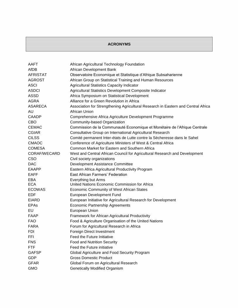
ACRONYMS
AAFT African Agricultural Technology Foundation
AfDB African Development Bank
AFRISTAT Observatoire Economique et Statistique d’Afrique Subsaharienne
AGROST African Group on Statistical Training and Human Resources
ASCI Agricultural Statistics Capacity Indicator
ASDCI Agricultural Statistics Development Composite Indicator
ASSD Africa Symposium on Statistical Development
AGRA Alliance for a Green Revolution in Africa
ASARECA Association for Strengthening Agricultural Research in Eastern and Central Africa
AU African Union
CAADP Comprehensive Africa Agriculture Development Programme
CBO Community-based Organization
CEMAC Commission de la Communauté Economique et Monétaire de l’Afrique Centrale
CGIAR Consultative Group on International Agricultural Research
CILSS Comité permanent Inter-états de Lutte contre la Sécheresse dans le Sahel
CMAOC Conference of Agriculture Ministers of West & Central Africa
COMESA Common Market for Eastern and Southern Africa
CORAF/WECARD West and Central African Council for Agricultural Research and Development
CSO Civil society organizations
DAC Development Assistance Committee
EAAPP Eastern Africa Agricultural Productivity Program
EAFF East African Farmers’ Federation
EBA Everything but Arms ECA United Nations Economic Commission for Africa
ECOWAS Economic Community of West African States
EDF European Development Fund
EIARD European Initiative for Agricultural Research for Development
EPAs Economic Partnership Agreements
EU European Union
FAAP Framework for African Agricultural Productivity
FAO Food & Agriculture Organisation of the United Nations
FARA Forum for Agricultural Research in Africa
FDI Foreign Direct Investment
FFI Feed the Future Initiative
FNS Food and Nutrition Security
FTF Feed the Future initiative
GAFSP Global Agriculture and Food Security Program
GDP Gross Domestic Product
GFAR Global Forum on Agricultural Research
GMO Genetically Modified Organism
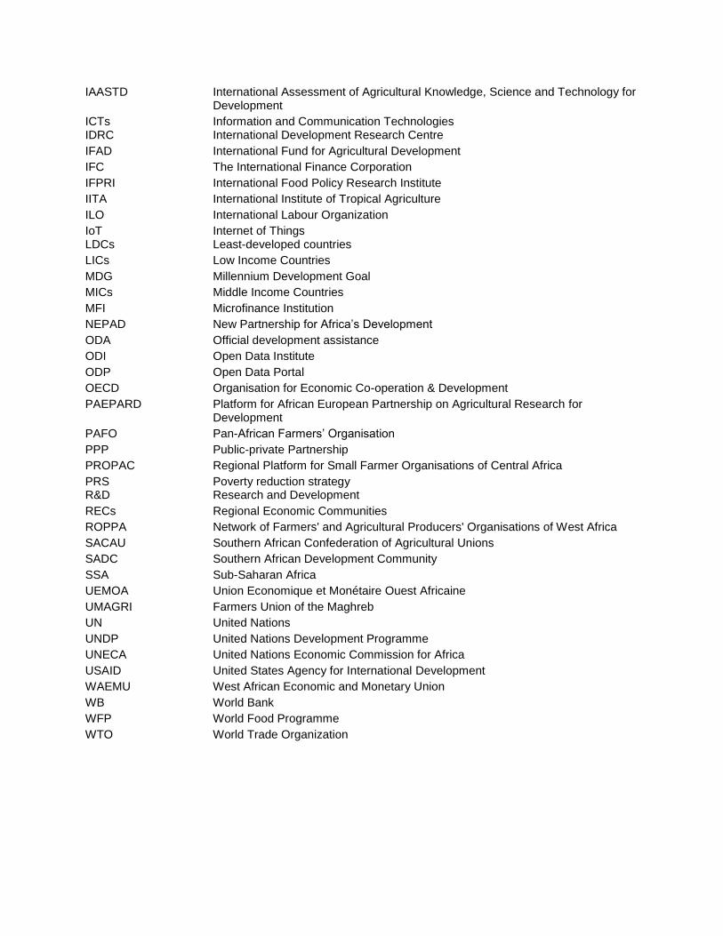
IAASTD International Assessment of Agricultural Knowledge, Science and Technology for Development
ICTs Information and Communication Technologies IDRC International Development Research Centre
IFAD International Fund for Agricultural Development
IFC The International Finance Corporation
IFPRI International Food Policy Research Institute
IITA International Institute of Tropical Agriculture
ILO International Labour Organization
IoT Internet of Things LDCs Least-developed countries
LICs Low Income Countries
MDG Millennium Development Goal
MICs Middle Income Countries
MFI Microfinance Institution
NEPAD New Partnership for Africa’s Development
ODA Official development assistance
ODI Open Data Institute
ODP Open Data Portal
OECD Organisation for Economic Co-operation & Development
PAEPARD Platform for African European Partnership on Agricultural Research for Development
PAFO Pan-African Farmers’ Organisation
PPP Public-private Partnership
PROPAC Regional Platform for Small Farmer Organisations of Central Africa
PRS Poverty reduction strategy R&D Research and Development
RECs Regional Economic Communities
ROPPA Network of Farmers' and Agricultural Producers' Organisations of West Africa
SACAU Southern African Confederation of Agricultural Unions
SADC Southern African Development Community
SSA Sub-Saharan Africa
UEMOA Union Economique et Monétaire Ouest Africaine
UMAGRI Farmers Union of the Maghreb
UN United Nations
UNDP United Nations Development Programme
UNECA United Nations Economic Commission for Africa
USAID United States Agency for International Development
WAEMU West African Economic and Monetary Union
WB World Bank
WFP World Food Programme
WTO World Trade Organization
GLOSSARY
A-B line a straight line between two points, A and B, chosen by a machine operator and calculated by a guidance system The A-B line defines a series of wheelings, a fixed distance apart, across the whole field. Also called guidance line accuracy in precision farming, the precision with which a positioning system can locate a point at which data is recorded or the position of a vehicle Different systems vary in their accuracy and their suitability for different tasks. There are three levels of accuracy in a GPS system: low (+/– 50-100 cm), medium (+/– 10 cm) and high (+/– 2 cm). See also pass-to-pass accuracy, RTK accuracy, static accuracy active light sensor a light sensor that emits its own light to illuminate the crop and measure the amount of light reflected from it. Active light sensors usually only capture a relatively small number of wavelengths because it is difficult to produce a bright enough light. active sensor a device that generates a signal, bounces it off an object, and measures the signal reflected from the object. See also passive sensor aerial digital photography high-resolution data capture of features on the ground by a digital camera mounted on a plane or on a balloon, mast etc. Abbr. ADP airborne remote sensor a sensor mounted on a plane or on a balloon airborne scanner an ultrasound, laser or other scanner mounted on an aircraft, providing continuous data on ground or crop features under a flight path algorithm a set of steps or rules for making calculations or solving problems, as used in computer programs Analytics Using software-based algorithms and statistics to derive meaning from data. Analytics platform Software or software and hardware that provides the tools and computational power needed to build and perform many different analytical queries. Integrate and analyse data to uncover new insights, and help companies make better-informed decisions. There is a particular focus on this field on latency, and delivering insights to end users in the most timely manner possible. application map
a plan showing the location and rate at which seed, fertilisers or agrochemicals will be applied across a management zone. An application map is derived manually or automatically from analysis of yield maps, weed maps, etc. area mapping the production of a plan which defines an area in a field or a field boundary, or calculates the size of an area, by remote sensing technology assisted steering an adaptation of the steering system of an existing vehicle to GPS automation, by replacing the standard steering wheel with a powered version, or fitting a drive mechanism to it auto guidance See guidance auto section control a system that operates boom sections automatically using a positioning system and precise on-off timing to minimise over-application caused by overlapping or missed areas caused by underlapping. wASC can be used on self-propelled, trailed or mounted sprayers. Abbr. ASC Automatic identification and capture (AIDC) Any method of automatically identifying and collecting data on items, and then storing the data in a computer system. For example, a scanner might collect data about a product being shipped via an RFID chip. automatic machine control computer control of operations carried out by agricultural vehicles, based on a positioning system and often combined with information collected by remote sensing technology. Automatic control can be used to control, for example, steering, headland management, spray boom height and rate of application of seed, fertilisers or agrochemicals auto steering See automatic steering automatic steering or auto steering a system based on GPS signals that steers a vehicle across a field without overlapping or underlapping. Auto steering is used on tractors, combines, and forage harvesters, and on self-propelled sprayers, spreaders and mowers base station a fixed site that sends and receives telecommunications signals. See also virtual base station Behavioral analytics Using data about people’s behavior to understand intent and predict future actions. Big data This term has been defined in many ways, but along similar lines. Doug Laney, then an analyst at the META Group, first defined big data in a 2001 report called “3-D Data Management: Controlling Data Volume, Velocity and Variety.” Volume refers to the sheer size of the datasets. The McKinsey report, “Big Data: The Next Frontier for Innovation, Competition, and Productivity,” expands on the volume aspect by saying that, “’Big data’ refers to datasets whose size is beyond the ability of typical database software tools to capture, store, manage, and analyze.” biomass map a plan that shows the variation in the crop canopy within a field, based on the data from a biomass sensor. it can indicate differences in soil fertility and therefore crop nutrient requirements, allowing fertiliser to be applied at different rates in different places.
biomass sensor a remote sensor that measures biomass by measuring the light reflected from the crop canopy. The data can be combined with GPS to make maps of canopy size, indicating differences in soil fertility. See also biomass map boom levelling automatic adjustment by ultrasound sensors of the height of a spray boom so that the spray pattern is uniform Sensors mounted at the centre and tips of the booms monitor nozzle height above the ground or crop and feed the information to a computer that makes small alterations to the boom hundreds of times a second. The boom can also be raised on headlands to avoid obstacles. boom section a part of a spray boom that can be turned on or off independently from other sections along the boom. Automatic systems control boom sections using a positioning system and precise on-off timing to minimise over-application caused by overlapping or missed areas caused by underlapping. boom-mounted radiometer or boom-mounted sensor a radiometer or sensor that is fixed onto a spray boom CANBUS a digital wiring system that connects different control units in a vehicle such as a tractor or combine, allowing data for machine control and diagnostics to be transferred between them CAN is an abbreviation of ‘Controller Area Network’. canopy management the careful planning of seed rates, nitrogen rates and timing of operations to achieve an optimum crop canopy for light interception \Optimum canopy should produce optimum yields in relation to nitrogen use. canopy sensing the process of collecting information on crop characteristics such as biomass and chlorophyll content from a distance, by means of satellite, aerial or tractor-mounted remote sensors. See also crop reflectance compaction compressed soil structure caused by pressure on the soil by vehicles, producing poor growing conditions Soil compaction has a significant negative effect on crop yields. Factors associated with compaction that reduce growth potential include oxygen supply, volumetric water content and vulnerability to losing nitrogen into the atmosphere; the crop may also root poorly. compatibility the ability of mapping software to work with different makes of machinery control equipment controlled traffic farming a management system that ensures that all the vehicles used in a field keep to the same permanent traffic lanes every year in order to restrict compaction of the soil to the smallest possible area wThe benefits are improved soil structure on untrafficked areas, which then require less tillage and have better drainage and less erosion, with resultant yield increases. Abbr. CTF; See also random traffic farming correction signal a radio signal that improves the positioning accuracy provided by the basic GPS signal to much less than one metre
Inaccuracies in the GPS signal, caused by interference in the ionosphere and other factors, are measured and correction data are broadcast, also via satellite or ground system, to the GPS receiver in the tractor or other vehicle. See also EGNOS correction service, RTK accuracy crabbing the tendency of a machine to slip sideways from its line of pull crop calibration the adjustment of machinery to the characteristics of a specific crop at a specific time, such as moisture content at harvest, or the different reflectance characteristics of different wheat varieties crop canopy the parts of a plant, especially the leaves, that receive light from the sun and shade the ground beneath Effective canopy management ensures that each plant has the light and space to maximise yield. See also green area index, leaf area index crop reflectance the amount of visible or invisible light reflected by a crop Infrared reflectance, which cannot be seen by the human eye, broadly measures canopy size/biomass and together with the amount of visible green light reflected from a crop gives an indication of its total green area. See also normalised difference vegetative index crop sensing the process of collecting information on crop characteristics such as biomass and chlorophyll content from a distance, by means of satellite, aerial or tractor-mounted remote sensors. See also crop reflectance crop variability differences in crop yields within a field caused by factors such as differences in soil type, soil fertility, compaction and previous cropping patterns data collection in precision farming, the gathering of information on fields and crops in digital form by sensors, in addition to data collected manually or visually data logging the automatic recording by a computer of information gathered digitally over time Differential Global Positioning System a system for providing a very accurate position, by calculating the difference between the actual location of a fixed-position ground station and the satellite-located position of the station, and providing a correction signal to a mobile user, either directly from a ground station or via a satellite This system corrects for errors introduced by interference with the GPS signal and produces a very accurate signal of well below one metre, which agricultural applications require. Abbr. dGPS, DGPS drift the change in a GPS position over time, by up to as much as 1.5 metres in an hour. This variation occurs as a result of changes in the orbit of the satellites providing the positioning signal, which rise and set like the sun, as well as interference to the signal by atmospheric conditions. See also static accuracy, pass-to-pass accuracy dual-frequency correction in a dGPS system, a method of giving very precise positioning on the ground based on two unrelated frequency components, using a dual frequency radio receiver. See also single-frequency receiver EC mapping the use of information on the characteristics of a soil revealed by measuring its electrical conductivity to create a soil map EC measurements can be taken at two depths, referred to as shallow array and deep array measurements, and the relationship between the two can also provide useful information. EGNOS correction service
a system that increases the accuracy of GPS and GLONASS signals by correcting disturbances in the ionosphere, sending corrections via the three EGNOS satellites to GPS and GLONASS users with an EGNOS receiver. It is free at the point of use. See also European Geostationary Navigation Overlay Service electrical conductivity a measure of how easily an electrical current flows through a material such as soil The electrical conductivity of a soil sample indicates the amount of salt, sand, clay, organic matter, and water it contains, so with GPS input it can be used to create a soil map. Measurements can be taken at two depths, referred to as shallow array and deep array measurements, and the relationship between the two can provide useful information. See also EC mapping electromagnetic induction a method of measuring the electrical conductivity of soil by passing an electromagnetic wave through the ground. Abbr. EMI electromagnetic radiation radiation in the form of electromagnetic waves such as visible and invisible light rays, gamma rays, X-rays and radio waves electromagnetic spectrum the full range of electromagnetic radiation from the shortest to the longest waves electro-optical sensor a light-sensitive electronic device that creates an electrical signal proportional to the amount of electromagnetic energy that it receives environmental variable a factor in the environment such as weather conditions, or soil type or soil fertility, that can vary with time or place European Geostationary Navigation Overlay Service a European global navigation satellite system, based on three geostationary satellites, that augments the American GPS and Russian GLONASS systems by providing a system of differential correction that allows users to determine their position to within two metres, compared with about 20 metres for GPS or GLONASS alone. Abbr. EGNOS frequency modulated continuous wave radar a sensing system based on microwaves suitable for short-range applications such as control of working depth or assessment of soil for the control of seedbed quality It has advantages over sensors based on optical or ultrasound devices in that it is unaffected by features of the agricultural environment such as dust and rain. Abbr. FMCW; See also ultrasound sensor General Packet Radio Services a system that enables phones to transfer data at high speeds, typically 32-48 kbps, and at the same time as making a voice call. Abbr. GPRS Geographic Information System software that captures and processes data, associating it with a position in a field. Abbr. GIS georeferencing the association of information on yield, pH, soil nitrogen or other factor with a position in a field Map coordinates are assigned to an image derived by remote sensing. geostationary telecommunication satellite a satellite in a special orbit remaining in a fixed point above the Earth’s surface used for receiving and relaying radio signals geostatistics statistics used for studying spatial patterns

Geostatistical analysis may be used to produce maps from data acquired at a relatively small set of locations. global navigation satellite system any satellite-based navigational system that can locate points on the Earth’s surface. Abbr. GNSS Global Navigation Satellite System (Globalnaya Navigatsionnaya Sputnikovaya Sistema) a satellite-based navigational system based on a constellation of satellites owned by the Russian Federation government. Abbr. GLONASS Global Positioning System a satellite-based navigational system based on 24 satellites owned by the US Department of Defense GPS is often used to refer to satellite navigation systems in general. Abbr. GPS GPS-compatible controller a system that can operate a sprayer, spreader or drill automatically according to an application map, using the Global Positioning System graphic display unit a device that receives digital data and converts it to a visual image Green Area Index the ratio of the total area of green plant tissue to the area of ground that the plant covers It provides information on canopy size and aids decision-making on, for example, the amount and timing of nitrogen applications. Abbr. GAI; See also leaf area index grid sampling a sampling method that samples soil in squares on a grid across a field to determine soil type or fertility levels The information can then be used to produce an application map. ground penetrating radar a non-destructive system that uses pulses of electromagnetic radiation in the UHF and VHF bands to penetrate the ground and create an image of the subsurface from the reflected rays The depth to which it can penetrate is greater when electrical conductivity is lower. ground station a radio base station on the ground that receives and transmits satellite signals ground truthing observing and measuring something such as leaf area index in the field, to compare it with values calculated from an image obtained by remote sensing ground-based sensor a sensor mounted on a vehicle or building guidance a system based on a positioning system that shows a driver where to steer to cover a field at the spacing required for the implement being used without overlapping or underlapping Guided steering avoids losses from underlapping or overlapping and allows more accurate working in the dark. It is also useful where there are no tramlines to follow, as in cultivations, drilling, pre- emergence spraying, autumn fertiliser spreading and lime spreading, and on grassland. guided hoe
a tractor-mounted hoe that is automatically steered to correct for tractor-driving inaccuracies and allow much finer hoe tolerances The automatic guidance system is based on a digital colour video camera that scans the crop rows ahead for green shoots. headland management in precision farming, the use of a guidance system to control the turn made by a tractor at field edges automatically and precisely, controlling the implements and minimising overlap when lifting and replacing implements The use of such a system increases the speed of turn and the accuracy of placement while reducing operator workload. high-level accuracy the highest level of accuracy of a positioning system to +/– 2 cm. See also RTK accuracy hyperspectral reflectance spectrometry the use of remote sensors to collect information about an object or area by building up an image based on hundreds to thousands of adjacent wavelength bands of the electromagnetic spectrum Hyperspectral reflectance offers high resolution and may be used to help farmers assess the development, health and nutrient status of crops. See also multispectral reflectance spectrometry in-field variation differences in a factor such as yield, soil fertility or soil type in different parts of a field. Also called within-field variation infrared band reflectance or infrared reflectance the reflection of invisible light in the infrared wavelengths of the spectrum from an object or area Infrared reflectance, especially near infrared reflectance, is used for remote sensing of soil and crop characteristics. infrared sensor a device that can detect information about a field, soil or crop from a distance, by measuring the amount of infrared light reflected from it intelligent tyres a system that maintains tyre inflation to a preset level, automatically inflating tyres that are below target pressure using air from an air tank, or allows an operator to change tyre pressures easily according to weight, speed and soil conditions ISOBUS an international standard, ISO 11738, for communication between tractors and implements ISOBUS potentially allows the operation of different implements with one tractor control terminal. ISOBUS-compatible software and systems complying with the ISOBUS standard kriging a statistical technique that allows the calculation of unknown values from known values By kriging, the value of yield or other characteristic at one location can be predicted based on its value at nearby locations. It may also be used for smoothing errors in data, such as those associated with the equipment used, to give more accurately representative information. There are several different kriging methods. L1 frequency band a radio wave frequency band centred on 1575.42 MHz, used in transmitting satellite positioning data. See also single-frequency receiver
L2 frequency band a radio wave frequency band centred on 1227.60 MHz, used in transmitting satellite positioning data It is used in conjunction with the L1 frequency band signal to correct positioning information distorted by ionosphere interference, allowing location on the ground to within several centimetres. See also dual-frequency correction leaf area index the ratio of the area of the leaves of a plant to the area of ground the plant covers It is related to the efficiency of light interception and provides information on biomass production. Light sensors can be used to estimate LAI. Abbr. LAI; See also green area index LIDAR an airborne system that uses height data received from laser beams scanning the ground to provide very accurate maps of the ground surface It can be used for mapping soils, monitoring erosion, floodplain management, etc. LIDAR stands for ‘Light Detection and Ranging’. light sensing the process of measuring from a distance the visible and invisible light reflected from a field, soil or crop, in order to assess various characteristics and calculate their values. See also infrared sensor, light sensor light sensor a device that can measure from a distance the visible and invisible light reflected from a field, soil or crop, in order to assess various characteristics and calculate their values Infrared sensors, which monitor the light reflected from a crop that cannot be seen by the human eye, broadly measure canopy size/biomass. The total green area of a crop is calculated as the ratio of this infrared reflectance measurement to the visible green light reflected from a crop. liquid crystal display a display of data created by changes in the colour of crystals caused by changes in electric current localised damage damage to crops in a specific area, caused by factors such as poor drainage, compaction, pH, or rabbits location-based service a service providing local and personalised information that can be accessed via the mobile network, based on the geographical position of a mobile phone. Services available include locating people, tracking vehicles, and weather reports. Abbr. LBS low-level accuracy the lowest precision of positioning offered by a dGPS system, +/– 50-100 cm management zone a part of a field, identified from the analysis of a yield map or soil map, that is defined by a specific characteristic such as soil type or fertility or weed cover and is managed in an appropriate way A field might be divided into several management zones. mapping software a computer program that uses GPS data to produce a map such as a yield map, a nutrient map or a treatment map, or that is used for the measurement of cropping areas medium-level accuracy the intermediate level of positioning offered by a GPS system, +/–10 cm. See also low-level accuracy, RTK accuracy
multispectral imaging See multispectral reflectance spectrometry multispectral reflectance spectrometry the use of remote sensors to collect information about an object or area by building up an image based on tens to hundreds of adjacent wavelength bands The image for each waveband is displayed in a different colour in a composite image. See also hyperspectral reflectance spectrometry nanosensor a highly sensitive sensor based on nanotechnology Nanosensors are designed to perform precise functions such as measuring individual proteins or triggering electrical, chemical or enzymatic reactions in response to changing environmental conditions. See also smart sensor, remote sensor near infrared reflectance the reflection of invisible light in the near infrared wavebands of the electromagnetic spectrum from an object or area Near infrared reflectance is used for remote sensing of soil and crop characteristics. Abbr. NIR non-intrusive sensor a device that can detect information about a field, soil or crop from a distance, without requiring samples to be taken, for example, EMI measuring equipment. Also called remote sensor non-trafficked soil soil that has not been driven over by vehicles and is therefore less compacted. See also controlled traffic farming normalised difference vegetative index the relationship between visible light reflectance and near infrared reflectance of a crop canopy, that allows assessment of its size, nutrient status and health Healthy vegetation absorbs most of the visible light that it receives and reflects a lot of the near-infrared light, while unhealthy or sparse vegetation reflects more visible nudge the adjustment of guidance equipment to correct drift when a GPS position has diverged from a known position on the ground parallel working the practice of steering a vehicle across a field in parallel passes without overlapping or underlapping by using GPS guidance when carrying out operations such as cultivating, sowing, spraying or harvesting passive sensor a light sensor that captures data in daytime, by measuring the amount of light reflected from the crop (for visible wavelengths), or absorbed and then re-emitted (for thermal infrared wavelengths) Passive light sensors are affected by the angle of the sun and cloud cover, although some can correct for changes. See also active sensor pass-to-pass accuracy the accuracy of a positioning signal over the period of time taken to cross a typical field, usually taken as 15 minutes. See also static accuracy patch map a plan that shows where patches of agronomically important weeds are located in a field. Also called weed patch map
patch spraying treating only the discrete patches of agronomically important weeds in a field with herbicide rather than spraying the whole field There are considerable cost benefits from reduced herbicide use, while an environmental benefit is increased floral diversity. permanent bed an area of soil between permanent traffic lanes that is not run over by vehicles permanent traffic lane a strip of soil that is permanently compacted, created by a single vehicle wheel or track. See also controlled traffic farming positioning signal a signal broadcast by a satellite to a receiver on the ground which, when a minimum of three signals are co- ordinated, allows a location to be established positioning system a system of linked satellites that transmit radio signals to receivers on the ground, allowing a location to be accurately pinpointed The core satellite systems are free, as are some of the enhanced dGPS systems such as WAAS (US) and EGNOS (EU). Subscription dGPS services offering high accuracy are available from commercial providers. Also called global navigation satellite system potential for variable rate management the possibility of applying seeds, fertilisers and agrochemicals effectively at different rates in different parts of a field, as required by soil or crop condition. Abbr. PVRM; See also variable rate technology precision farming management of farming practices that uses computers, satellite positioning systems, and remote sensing devices to provide information on which enhanced decisions can be made Sensors can determine whether crops are growing at maximum efficiency, highly specific local environmental conditions can be identified, and the nature and location of problems pinpointed. Information collected can be used to produce maps showing variation in factors such as crop yield or soil nutrient status, and provides a basis for decisions on, for example, seed rates and application of fertilisers and agrochemicals, as well for the automatic guidance of equipment. precision technology aids such as positioning systems, remote sensors and guidance control equipment that can map variability in fields and direct inputs precisely and only where they are required radiometer a device that measures the amount of electromagnetic radiation, including visible and invisible light waves radiometric data information on crop or soil conditions obtained by sensors detecting visible and invisible light reflected from surfaces radiometric map a plan created on the basis of the amount of visible and invisible light reflected from the area being studied A radiometric map can identify differences such as those in soil fertility and crop disease. radiometry the measurement of electromagnetic radiation, including visible and invisible light waves
random traffic farming the use of tractors and other vehicles on farm land where operations are carried out in different directions without a fixed pattern of wheelings being established. Abbr. RTF; See also controlled traffic farming real time kinematic a system that uses a fixed ground station to measure satellite drift accurately and send a correction signal by radio directly to GPS- equipped vehicles Unlike satellite- based correction systems RTK is not affected by atmospheric interference and as a result can give high and repeatable accuracy. Abbr. RTK real-time processing, updating and acting on data as soon as it is received from a source such as a sensor real-time agronomy the use of constantly updated data from a source such as a sensor to inform decision-making while working, for example decisions on application rates real-time mapping the production of a map by processing and updating data as soon as it is received, for example as a sprayer shows where it has sprayed real-time measurement the acquisition and processing of data while working, allowing decision- making to take place in the field, for example sensing the crop canopy, calculating an appropriate nitrogen rate and adjusting it on the move real-time monitoring the acquisition and processing of data while working, allowing decision- making to take place in the field reflectance radiometry the measurement of electromagnetic radiation, including visible and invisible light waves, reflected from an object Reflectance radiometry is used for remote sensing of soil and crop characteristics. reflectance sensor a sensor that measures the amount of a type of light such as infrared light reflected from an object reflectance spectrum the part of the electromagnetic spectrum that is reflected by various materials, which reflect and absorb different wavelengths differently Remote sensors can form images by detecting the solar radiation reflected from different objects or parts of objects on the ground. reflectance technology See reflectance radiometry remote sensing the process of detecting information about a field, soil or crop from a distance, using sensors mounted on satellites, aircraft or tractors etc. remote sensor a device that collects and processes the visible and invisible light reflected from an object or area There are passive sensors, in which the energy that is radiated comes from an external source such as the sun, and active sensors that produce their own energy source. repeatability
the ability of a positioning system to return to the same spot later on Because of drift, a vehicle may find itself 0.5-1.5 metre out in as little as an hour, depending on the static accuracy of the equipment. RTK is a system that does not suffer from drift and so has good repeatability. resolution the quality of detail that can be seen in an image The smaller the area represented by a pixel in a digital image, the more accurate and detailed the image is. RTK accuracy the highest level of positioning offered by a GPS system, +/– 2 cm This system requires a base station (on a tripod or building), with a dGPS receiver and radio transmitter, to get a very local correction signal, accurate to a few centimetres. The base station can transmit to multiple vehicles up to five or six miles away depending on the terrain. Also called high-level accuracy; See also real time kinematic RTK guidance the use of a positioning system with an RTK correction signal to increase the accuracy of working to +/– 2 cm. See also real time kinematic, guidance satellite constellation a set of satellites orbiting the Earth and working together to give maximum coverage of its surface Global navigation satellite systems are based on radio signals sent out by sets of linked satellites. These satellites rise and set like the sun, contributing to some of the positional errors in the signals. a means for the rapid monitoring of very large areas using a radar signal transmitted from a satellite The signal is not affected by bad weather or light conditions. satellite-mounted sensor a remote sensor on a satellite that can capture large amounts of data over a large area quickly scanning radiometer a system consisting of lenses, moving mirrors, and solid-state image sensors used on satellites that produces observations of Earth and its atmosphere by converting reflected radiation into digital images scanning radiometry See scanning radiometer scouting 1. quickly defining the boundary of a field or feature using GPS equipment 2. passing through a crop to record characteristics such as disease incidence or crop development by eye. Also called crop scouting sensor a device that produces an electrical signal in response to a stimulus such as light or ultrasound. See also remote sensor shoot density the number of stems per unit area simple ratio index an indicator of relative growth based on the proportion of infrared to red light reflected from a crop Abbr. SRI; See also vegetation index single-frequency receiver a radio receiver that uses the L1 frequency band to receive satellite positioning data smart sensor
a sensor that can monitor its own operation and compensate for changes in operating conditions For example, a group of smart sensors located throughout a field can be used to measure soil moisture in real time and transmit the results to a control system for irrigation. Also called intelligent sensor; See also nanosensor smoothing a statistical technique for transforming raw data that has been collected into a map For example, raw yield data contains errors associated with the equipment used and smoothing helps to remove such errors to give a more accurately representative yield map. See also kriging soil horizon a horizontal layer in the soil that differs in its physical characteristics from layers above or below it soil hydrology the characteristics of soil in relation to the content and movement of water soil map a plan of soil characteristics such as texture or fertility, created from a set of samples taken across an area at different depths soil mapping the production of a map of a field showing differences in soil characteristics such as texture or fertility that can be used, for example, to apply fertiliser only where it is needed and in appropriate amounts The production of a soil map can help to reduce the high cost of fertiliser application while maintaining or even increasing yields. Also called nutrient mapping; See also grid sampling soil sampling taking small amounts of soil from a site to analyse composition, nutrient content or condition soil sensing the measurement of soil characteristics by remote sensing techniques soil testing the analysis of soil samples to establish composition or nutrient content soil texture map a plan of soil type, created from a set of samples taken across an area at different depths or inferred from an EMI scan soil variability differences in soil type and fertility across an area, as a result of previous cropping patterns, fertiliser use, underlying soil texture or compaction spatial application technology the use of data collection devices such as remote sensors to establish which areas within fields and crops need a specific treatment and then deliver site-specific treatment to that area spatial distribution the way in which objects or features are located in an area relative to other objects or features; they may be evenly dispersed, randomly dispersed or aggregated (clumped together) Information on the spatial distribution of crop plants, weeds, diseased areas and soil types, for example, may be turned into maps on which site-specific treatments can be based. See also weed aggregation spatial dynamics
the changes occurring in the distribution of measurements or observations over time spatial information the association of measurements or observations with position in a field. Also called geographic information spatial mapping the production of a field map by associating data on factors such as soil fertility or crop health with field position spatial resolution the spacing between the points at which measurements or observations were taken in a field The closer the sampling points are to one another, the higher the spatial resolution. spatial variability the range of difference occurring in factors such as soil composition, crop yield or insect population according to position in a field spatially selective treatment the application of different rates of seed, fertiliser, or agrochemicals to soil or plants in different parts of a field, according to need Herbicide may be applied only to patches of weeds on the basis of a weed map, or fertiliser to specific parts of a field on the basis of a nutrient map. Also called site-specific treatment spectral band a set of wavebands in the electromagnetic spectrum. See also hyperspectral reflectance spectroscopy spectral reflectance the proportion of energy reflected by a surface at each wavelength in the electromagnetic spectrum. See also hyperspectral reflectance spectroscopy spectral signature the characteristic pattern of electromagnetic radiation reflected by a specific object or area. Also called spectral response pattern, spectral reflectance signature; See also hyperspectral reflectance spectroscopy spectrometer a device that collects and processes discrete wavelengths of radiation reflected from an object or area. See also hyperspectral reflectance spectroscopy spectroradiometer a device that collects radiation reflected from an object or area in wavebands rather than in discrete wavelengths sprayer auto-shut-off a system that allows sections of a spray boom to be turned on and off automatically, based on the GPS position as the sprayer crosses the field. See also auto section control static accuracy the accuracy of a positioning signal over 24 hours shown on a target map resembling an archery target where the variation from a true position (the centre point) is marked. Also called long-term accuracy; See also pass- to-pass accuracy sub-metre accuracy accurate location by GPS to less than one metre
submetric signal a GPS signal that gives location accuracy of less than one metre. See also sub-metre accuracy Synthetic Aperture Radar a type of radar that produces a high- resolution image of the ground by collecting the echoes of many radar signals along a flight path It can be used to detect features such as soil moisture and crop development. Abbr. SAR target map a circular diagram resembling an archery target on which the variation of a GPS position from a true position (the centre point) is marked. See also static accuracy telematics the use of telecommunications technology to deliver and store information about the operation of tractors and combines telemetry technology that facilitates remote monitoring and measurement terrain compensation in a guidance system, automatic adjustments for the rolling, pitching or yawing of vehicles on sloping ground textural or texture image analysis the characterisation of regions in a digital image by their texture, allowing, for example, the different leaf types of cereals and weeds to be distinguished threshold value the maximum desirable, allowable or possible level track width the distance between the centres of wheels or tracks on the same axle tractor-mounted sensor a remote sensor attached to a tractor that captures data in close proximity to it with good resolution traffic lane a compacted strip of soil created by a single vehicle wheel or track tramlines parallel lines on the ground created by the wheels or tracks of a vehicle, usually the tracks made by a sprayer or fertiliser spreader treatment map a plan that defines where the areas of a field to be treated and the application rate that should be used A treatment map can be used to control, for example, a seed drill, a fertiliser spreader or a sprayer to deliver site-specific treatment. ultrasound sensor a sensor that locates the presence or distance of an object or the ground by bouncing an ultrasound wave off it Such sensors are often used to measure the height of a boom in automatic systems. uniform rate technology the application of a single rate of seeds, fertilisers or agrochemicals across a whole field. Abbr. URT; See also variable rate technology
variability the range of difference occurring in a soil, crop or other factor variable rate application the application of seeds, fertilisers or agrochemicals at different rates as required by the conditions in different parts of a field. Abbr. VRA variable rate input the use of different rates of fertilisers or agrochemicals in different parts of a field For example, fertiliser application can be increased early in the season exactly in those areas where plant density is low in order to build an optimum leaf canopy. variable rate technology the devices enabling the differential application of fertilisers or agrochemicals in different parts of a field, according to an application map or real-time sensor. Abbr. VRT; See also uniform rate technology variably-applied inputs/nitrogen See variable rate input variogram a statistical method for analysing the relationships between all possible pairs of measurements taken in different places; there is a decreasing correlation as the distance between the locations increases. It is used in advanced soil sampling. A semi- variogram uses each data pair only once. vegetation index a scale that indicates relative growth and/or vigour of green vegetation, based on a ratio and/or linear combination of measurements of reflected light in the red and near- infrared regions of the spectrum. Abbr. VI; See also normalised difference vegetative index VI map a plan of a field produced using a vegetation index virtual base station in a GPS system, a mobile receiver that acts as a temporary base station within its zone. Abbr. VBS virtual reference station in a wide-area differential GPS system, a position for which locational corrections are predicted, based on calculations from a network of base stations and the user’s position. Abbr. VRS virtual road a guidance display that mimics the effect of driving along the centre line of a road visible band reflectance the reflection of light in the visible wavelengths of the spectrum from an object or area Visible band reflectance in a crop gives an estimate of the green area index. visible red light in the red wavelengths of the spectrum which can be seen by the human eye Visualization Platforms- Specifically designed- as the name might suggest- for visualizing data; taking the raw data and presenting it in complex, multi-dimensional visual formats to illuminate the information. Weather data
Real-time weather data is now widely available for organizations to use in a variety of ways. For example, a logistics company can monitor local weather conditions to optimize the transport of goods. A utility company can adjust energy distribution in real time. Web 2.0 Refers to an incremental development of the technologies behind the World Wide Web, allowing the user to participate and contribute directly to the production of information, rather than being a mere passive receiver of it. weed aggregation the appearance of weeds growing in patches rather than spread evenly across a field weed mapping the production of a plan showing where agronomically important weeds are located in a field Many such weeds are distributed in patches, and the production of a weed map potentially allows targeted treatment with herbicides. weighcell a fast, accurate electronic weighing device, used for example in fertiliser spreaders, telescopic handlers and weighbridges Wide Area Augmentation System a system developed by the US government that uses a network of ground stations to measure small variations in satellite signals and produce a correction signal, giving positional accuracy of below one metre. This feature should be disabled in the UK. Abbr. WAAS wide dynamic range vegetative index an enhancement of the normalised difference vegetation index under conditions of moderate to high biomass that applies a weighting to the near infrared reflectance values. Abbr. WDRVI wireless sensor a remote sensor that does not require a cable connection except for power. See also remote sensor wide-area differential GPS any positioning system that enhances GPS accuracy over a very large geographical area such as a continent. See also EGNOS, WAAS yield mapping the process of using GPS and yield monitoring data to show the variation in yield across a field Yield maps offer the possibility of identifying factors that vary across a field and potentially limit yield. Yield differences can then be addressed by applying treatments at different rates in different areas or by adjusting fertiliser rates to match previous crop off-take. yield monitor a device on a combine harvester that measures crop yield against field position yield variation differences in yield across a field in any one year, or from year to year
RESOURCES
En italique les documents disponibles en français
ACP-EU TECHNICAL CENTER FOR AGRICULTURAL AND RURAL COOPERATION (CTA) ICT Update. 2016. Drones for agriculture. Issue no. 82 April 2016 http://ictupdate.cta.int/content/download/37461/292206/file/ICT_Update_Issue_82_ENGLISH.pdf ICT Update. 2016. Les drones au service de l’agriculture. Numéro 82avril 2016 http://ictupdate.cta.int/fr/content/download/37461/293259/file/ICT_Update_Issue_82_FRENCH.pdf Spore. 2016. The connected farmer: A new opportunity for the agricultural system. Issue No. 180 March-April 2016 http://spore.cta.int/images/magazines/PDF/SE180-web.pdf Spore. 2016. Agriculteurs connectés: Nouvelles perspectives pour l’agriculture.
CTA, GODAN, PAFO. 2016. Data revolution for agriculture http://publications.cta.int/en/publications/publication/1937/ CTA, KIT, FAO. 2014. The business of agricultural business services: Working with smallholders in Africa. http://www.kit.nl/sed/wp-content/uploads/publications/2080_the_business_of_agricultural_business_services.pdf AFRICAN DEVELOPMENT BANK AfDB. 2015. “Agricultural Mechanization” Prepared by: Adekunle Ahmed, AEHC Co-Conveners: Oluwatosin Ariyo ,Propcomm http://www.afdb.org/fileadmin/uploads/afdb/Documents/Events/DakAgri2015/Agricultural_Mechanization.pdf BAD. 2015. « Mécanisation agricole ». Document De Référence http://www.afdb.org/fileadmin/uploads/afdb/Documents/Events/DakAgri2015/M%C3%A9canisation_agricole.pdf CEMA - European Agricultural Machinery Agritech Business Barometer Public report of the survey about the worldwide situation of the agricultural machinery business October 2015 http://cema-agri.org/sites/default/files/publications/2015-09%20Agritech%20Business%20Barometer%20public%20report_0.pdf Agrievolution Economic Committee. Economic Committee Tractor Market Report Calendar year 2014 http://cema-agri.org/sites/default/files/publications/2015-02%20Agrievolution%20Tractor%20Market%20Report.pdf CEMA. Advancing Agricultural Mechanization (AM) to promote farming & rural development in Africa July 2014 http://cema-agri.org/sites/default/files/publications/2014_Advancing%20Farm%20Mechanization%20in%20Africa%20-%20CEMA.pdf CEMA. 2014. « Promouvoir le développement rural et agricole en Afrique grâce à la mécanisation agricole (MA) avancée » http://cema-agri.org/sites/default/files/publications/FR_Promouvoir%20le%20d%C3%A9veloppement%20rural%20et%20agricole%20en%20Afrique_CEMA_2014_FINAL.pdf CEMA. The use of drones in agriculture Facts & Figures
http://cema-agri.org/sites/default/files/publications/Flyer_Q%26A%20drones%20FFA%20%202016%20FINAL.pdf EUROPEAN UNION European Parliament 2016. Report on technological solutions for sustainable agriculture in the EU (2015/2225(INI)) Committee on Agriculture and Rural Development. Rapporteur : Anthea McIntyre http://www.europarl.europa.eu/sides/getDoc.do?pubRef=-//EP//NONSGML+REPORT+A8-2016-0174+0+DOC+PDF+V0//EN 2016. « Rapport sur les solutions technologiques pour une agriculture durable dans l'Union européenne » (2015/2225(INI)) Commission de l'agriculture et du développement rural. Rapporteuse : Anthea McIntyre http://www.europarl.europa.eu/sides/getDoc.do?pubRef=-//EP//NONSGML+REPORT+A8-2016-0174+0+DOC+PDF+V0//FR 2016. Report on enhancing innovation and economic development in future European farm management (2015/2227(INI)) Committee on Agriculture and Rural Development. Rapporteur: Jan Huitema http://www.europarl.europa.eu/sides/getDoc.do?pubRef=-//EP//NONSGML+REPORT+A8-2016-0163+0+DOC+PDF+V0//EN 2016. « Rapport sur la promotion de l'innovation et du développement économique en rapport avec une gestion agricole d'avenir pour l'Union européenne » (2015/2227(INI)) Commission de l'agriculture et du développement rural Rapporteur: Jan Huitema http://www.europarl.europa.eu/sides/getDoc.do?pubRef=-//EP//NONSGML+REPORT+A8-2016-0163+0+DOC+PDF+V0//FR EIP-AGRI Focus Group Precision Farming FINAL REPORT NOVEMBER 2015 https://ec.europa.eu/eip/agriculture/sites/agri-eip/files/eip-agri_focus_group_on_precision_farming_final_report_2015.pdf FOOD AND AGRICULTURE ORGANIZATION (FAO) FAO. 2016. Public-Private Partnerships for Agribusines Development - A Review of international experiences. Rankin, M.; Gálvez Nogales, E.; Santacoloma, P.; Mhlanga, N.; Rizzo, C. Food and Agriculture Organization of the United Nations. Rome, Italy. http://www.fao.org/3/a-i5699e.pdf FAO. 2016. Public Private Partnerships for Inclusive Agricultural Growth. FAO Regional Conference for Africa, Twenty-ninth Session, Abidjan, Côte d’Ivoire, 4-8 April 2016 http://www.fao.org/3/a-mp575e.pdf FARM/FAO. 2015. « Une expérience originale de mécanisation partagée en Afrique. Les Coopératives d'utilisation de matériel agricole au Bénin » FARM – Champs d’acteurs n°3 – Avril 2015 http://www.fondation-farm.org/zoe/doc/farm_cha3_201504_cumabenin.pdf FAO. 2013. Mechanization for Rural Development: A review of patterns and progress from around the world. Integrated Crop Management Vol. 20-2013 Plant Production and Protection Division Food and Agriculture Organization of the United Nations Rome, 2013 Editors Josef Kienzle, John E. Ashburner, Brian G. Sims http://www.fao.org/docrep/018/i3259e/i3259e.pdf FAO, 2013. Agricultural mechanization in sub-Saharan Africa: Guidelines for preparing a strategy. Houmy, K., Clarke L.J., Ashburner, JE. & Kienzle, J. Food and Agriculture Organization of the United Nations. Rome, Italy. Integrated crop management 22. ISBN 978-92-5-107762-7 http://www.fao.org/docrep/018/i3349e/i3349e.pdf
FAO. 2013. Country case studies Agribusiness public-private partnerships (Annexes) http://www.fao.org/docrep/017/aq231e/aq231e.pdf FAO. 2013. Agribusiness public-private partnerships – A country report of Ghana. Country case studies – Africa. Rome http://www.fao.org/docrep/017/aq231e/aq231e.pdf FAO. 2013. Agribusiness public-private partnerships – A country report of Kenya. Country case studies – Africa. Rome http://www.fao.org/docrep/017/aq232e/aq232e.pdf FAO. 2013. Agribusiness public-private partnerships – A country report of Nigeria. Country case studies – Africa. Rome http://www.fao.org/docrep/017/aq233e/aq233e.pdf FAO. 2013. Agribusiness public-private partnerships – A country report of the United Republic of Tanzania. Country case studies – Africa. Rome http://www.fao.org/docrep/017/aq234e/aq234e.pdf FAO. 2013. Agribusiness public-private partnerships – A country report of Uganda. Country case studies – Africa. Rome http://www.fao.org/docrep/017/aq235e/aq235e.pdf FAO. 2012. “Public-Private Partnership For Initiating Agricultural Programmes To Sustain Livelihoods And Create Wealth”, FAO Regional Conference for Africa http://www.fao.org/docrep/meeting/024/md429e.pdf FAO. 2012. « partenariats public-privé à l’appui des programmes agricoles: assurer la subsistance et créer de la richesse » Conférence régionale de la FAO pour l'Afrique http://www.fao.org/docrep/meeting/024/md429f.pdf FAO. 2011. Hire services by farmers for farmers. By Brian Sims, Alexandra Röttger and Saidi Mkomwa. Diversification booklet number 19, Rural Infrastructure and Agro-Industries Division, Food and Agriculture Organization of the United Nations. Rome, Italy 2011 http://www.fao.org/3/a-i2475e.pdf FAO & UNIDO, 2008. Agricultural mechanization in Africa: time for action. Food and Agriculture Organization of the United Nations. Rome, Italy & UN Industrial Development Organization, Vienna, Austria. http://www.fao.org/3/a-k2584e.pdf FAO. 2006. Farm power and mechanization for small farms in sub-Saharan Africa. Brian G Sims and Josef Kienzle. Food and Agriculture Organization of the United Nations. Rome, Italy ftp://ftp.fao.org/docrep/fao/009/a0651e/a0651e00.pdf IFAD FIDA (2014) « Réaliser le potentiel de l’agriculture africaine » http://www.ifad.org/pub/thematic/agriculture/africa_agriculture_f.pdf IFAD (2013) “IFAD and public-private partnerships: Selected project experiences” International Fund for Agricultural Development http://www.ifad.org/pub/partnerships/ppp.pdf UNITED NATIONS
UNIDO (2013) Business Partnerships Partnering for Prosperity http://www.unido.org/fileadmin/user_media/Services/PSD/UNIDO_business_partnerships/UNIDO_BPP_English_2013.pdf Partenariats d’enterprises de l’ONUDI (2013) http://www.unido.org/fileadmin/user_media/Services/PSD/UNIDO_business_partnerships/UNIDO_BPP_French_2013.pdf PricewaterhouseCoopers (PWC) PricewaterhouseCoopers. 2015. Africa – are you in for the ride? - Agribusinesses Insights Survey 2014/2015 https://www.pwc.co.za/en/assets/pdf/agribusinesses-insights-survey-2014-2015.pdf PriceWaterhouseCooper. 2016. AgTech – don’t wait for the future, create it - Africa Agribusiness Insights Survey 2016 http://www.pwc.co.za/en/assets/pdf/agri-businesses-insights-survey-may-2016.pdf OTHER RESOURCES CIRAD. 2016. « Observation spatiale pour l’agriculture en Afrique : potentiels et défis » http://www.afd.fr/webdav/shared/Notes%20techniques/12-notes-techniques.pdf Diao, Xinshen; Silver, Jed; and Takeshima, Hiroyuki. 2016. Agricultural mechanization and agricultural transformation. IFPRI Discussion Paper 1527. Washington, D.C.: International Food Policy Research Institute (IFPRI). http://ebrary.ifpri.org/cdm/ref/collection/p15738coll2/id/130311 IFPRI. 2016. Agricultural mechanization and south-south knowledge exchange: What can Ghanaian and Nigerian policymakers learn from Bangladesh’s experience? By Patrick O. Aboagye, Abdullahi Garba Abubakar, Abdulai Iddrisu Adama, Akeem Oyeyemi Lawal, and Aliyu Abdullahi Musa Synthesized by Hiroyuki Takeshima. GSSP policy note 06 and NSSP policy note 36 • February 2016 http://dspace.africaportal.org/jspui/bitstream/123456789/35525/1/130351.pdf?1 Josef Kienzle and Brian Sims. 2016. Making Mechanization Accessible to Smallholder Farmers in Sub-Saharan Africa http://www.mdpi.com/2076-3298/3/2/11/pdf Japan Association for International Collaboration of Agriculture and Forestry. 2016. Feasibility Survey Project on Agricultural Mechanization for the Small Scale Farmers in Sub Sahara Africa -Acceleration of Agri-Business. Final Report –Third Year- March 2016 http://www.jaicaf.or.jp/fileadmin/user_upload/publications/FY2015/H27_AB_E.pdf Breuer, T., Brenneis, K. & Fortenbacher, D, 2015. Mechanisation – a catalyst for rural development in sub-Saharan Africa. Rural 21 49 (2): 16-19. http://www.rural21.com/uploads/media/rural2015_02-S16-19.pdf Cook, S.E., O’Brien, R, Corner, R.J., and T. Oberthur. 2015. Is precision agriculture irrelevant to developing countries? CGIAR/CIAT http://csusap.csu.edu.au/~robrien/papers/CookO'BrienCornerOberthuer2003.pdf Kienzle, J & Sims, BG., 2015. Strategies for a sustainable intensification of agricultural production in Africa. Open meeting of the Club of Bologna. Milan (Italy) Expo 21 September, 2015. http://www.clubofbologna.org/ew/documents/Josef_Kienzle_KNR.pdf KPMG. 2015. Sector Report: Agriculture in Africa 2015
https://www.kpmg.com/Africa/en/IssuesAndInsights/Articles-Publications/General-Industries-Publications/Documents/Agriculture%20in%20Africa%20sector%20report%202015.pdf Manuel Vázquez-Arellano , Hans W. Griepentrog, David Reiser and Dimitris S. Paraforos. 2016. 3-D Imaging Systems for Agricultural Applications—A Review http://www.mdpi.com/1424-8220/16/5/618/pdf Side C.S., Havard M.. 2015. « Développer durablement la mécanisation pour améliorer la productivité de l'agriculture familialeen Afrique Subsaharienne. » https://agritrop.cirad.fr/577133/1/Side%20Havard%20int%20J.%20Advance%20Studies%202015%20mecanisation%20agricole.pdf Société Française d’Économie Rurale. 2015. « La motorisation partagée : levier d’émergence des exploitations agricoles familiales ? L'expérience des Cuma du Bénin Enseignements et prise de recul par rapport à l'expérience française » http://www.sfer.asso.fr/content/download/5881/49827/version/2/file/C1-girard.pdf Roger Bymolt and Fred Zaal. 2015. Moving to Mechanisation: Mechanisation in maize farming systems in Kenya, Tanzania and Ethiopia. KIT (Royal Tropical Institute), Amsterdam, Netherlands https://www.kit.nl/sed/wp-content/uploads/publications/561e6391c647c_moving-to-mechanisation.pdf ACET. 2014. “2014 African Transformation Report: Growth in Depth” Africa Center for Economic Transformation http://acetforafrica.org/wp-content/uploads/2014/03/2014-African-Transformation-Report.pdf Fairtrade Foundation .2014. “A seat at the table? Ensuring smallholder farmers are heard in public-private partnerships” Fairtrade Foundation UK, September 2014 http://www.fairtrade.net/fileadmin/user_upload/content/2009/resources/1409-FairtradeUK-A_seat_at_the_table_-_Full_report_v2.pdf Ghemawat, P. and Altman, S.A. 2014. “DHL Global Connectedness Index 2014” Deutsche Post DHL http://www.dhl.com/content/dam/Campaigns/gci2014/downloads/dhl_gci_2014_study_high.pdf Grow Africa. 2014. “Agricultural partners take root across Africa 2nd Annual Report on private-sec or investment in support of country-led transformations in African agriculture 2013-2014” Report produced by the Grow Africa Secretariat http://www3.weforum.org/docs/IP/2014/GA/WEF_GrowAfrica_AnnualReport2014.pdf Carletto C, Jolliffe D and Banerjee R. 2013. The Emperor has no Data! Agricultural Statistics in Sub-Saharan Africa. Conference paper - African economic development: Measuring success and failure, Vancouver, Canada, 18-20 April 2013 http://mortenjerven.com/wp-content/uploads/2013/04/Panel-3-Carletto.pdf Christiaensen L, Carletto D, and Barrett CB. 2013. No food security without good data or local analysts. Presentation at the Workshop Café, 1st Global Food Security Conference, 29 Sept-2 October 2013, Noordwijkerhout, Netherlands
http://dyson.cornell.edu/faculty_sites/cbb2/presentations/Global%20Food%20Security%20Conf%20No%2
0food%20security%20without%20good%20data%20or%20local%20Sept%2030,final.pptx
Economist .2013. “Transforming African agriculture -The growing importance of unusual public private partnerships” A report by the Economist Intelligence Unit http://www.economistinsights.com/sites/default/files/downloads/Agricultural%20partnerships%20in%20Africa.pdf Isioye Olalekan Adekunle. 2013. Precision Agriculture: Applicability and Opportunities for Nigerian Agriculture
http://www.idosi.org/mejsr/mejsr13(9)13/16.pdf EMRC .2012. « Stimuler l’agriculture en Afrique par des partenariats, des investissements et la technologie » Rapport de conférence 25-28 novembre 2012 http://www.emrc.be/documents/document/20130418175115-def_def_agribusiness_report2013_fr_web.pdf IFC Advisory Services in Public-Private Partnerships (2012) “Food PPPs” International Finance Corporation http://www.ifc.org/wps/wcm/connect/72193c004ad94ed8aa20fa888d4159f8/Handshake_Issue5_WEBFINAL.pdf?MOD=AJPERES IFDC (2012) « Amélioration du Secteur Agricole Africain » Rapport, International Fertilizer Development Center http://www.ifdc.org/getattachment/Publications/IFDC_Reports/Vol-37-No-4-(layout)-(French).pdf/ Ferroni, M. and Castle, P. 2011. “Public-Private Partnerships and Sustainable Agricultural Development Sustainability” Journal Sustainability 2011, 3, 1064-1073 http://www.mdpi.com/2071-1050/3/7/1064/htm Mhlanga, M. (2010) “Private sector agribusiness investment in sub-Saharan Africa”, AGRICULTURAL Management, Marketing and Finance Working Document 27, Fao Rome http://www.fao.org/docrep/016/k7443e/k7443e.pdf SOS FAIM (2013) « Coopération pour le développement agricole en Afrique : Le rôle des entreprises et des fondations privées » Inter-réseaux Développement http://www.inter-reseaux.org/IMG/pdf/BDS_No10_final.pdf Spielman D.J., Hartwich F. and Grebmer K. (2010) “Public–private partnerships and developing-country agriculture: Evidence from the international agricultural research system” Future Agricultures Consortium http://www.future-agricultures.org/farmerfirst/files/T2a_Spielman.pdf World Bank (2013) “Growing Africa Unlocking the Potential of Agribusiness”, World Bank Group, Washington http://siteresources.worldbank.org/INTAFRICA/Resources/africa-agribusiness-report-2013.pdf
![Medicare and Medicaid Briefings: Common Health Care Terms · ACRONYMS & GLOSSARY Medicare & Medicaid Briefings: Common Health Care Terms JANuARY 15, 2009 [ A ] AAA Area Agency on](https://img.pdfslide.us/doc/110x75/5e87dd349348c4006d554340/medicare-and-medicaid-briefings-common-health-care-acronyms-glossary-medicare.jpg)