Embed Size (px)
Citation preview
Salinity risk mapping for assessing Carbon Farming Initiative proposals: decision support and data requirements
Resource management technical report 390
GP Raper and PS Gardiner
i
Copyright © Western Australian Agriculture Authority, 2014
Except for the accompanying maps or where otherwise noted, this work is licensed under creativecommons.org/licenses/by/3.0/au/
April 2014
ISSN 1039-7205
Recommended reference
Raper, GP & Gardiner, PS 2014, 'Salinity risk mapping for assessing Carbon Farming Initiative proposals: Decision support & data requirements', Resource management technical report 390, Department of Agriculture and Food, Western Australia, Perth.
Disclaimer
The Chief Executive Officer of the Department of Agriculture and Food and the State of Western Australia accept no liability whatsoever by reason of negligence or otherwise arising from the use or release of this information or any part of it.
Copies of this document are available in alternative formats upon request.
3 Baron-Hay Court, South Perth WA 6151Tel: (08) 9368 3333Email: [email protected]: agric.wa.gov.au
ContentsAcknowledgments................................................................................................ iv
Summary................................................................................................................v
1 Introduction...................................................................................................1
1.1 Project scope..........................................................................................2
2 Potential impacts of CFI tree plantings.......................................................3
3 Assessing CFI proposals.............................................................................5
3.1 Assessment methodology.....................................................................11
3.2 Scale issues..........................................................................................14
3.3 Changes to water resources legislation................................................14
4 Conclusions.................................................................................................15
References...........................................................................................................16
iii
Acknowledgments
The work reported here was performed for and funded through the South West Catchments Council. Regional natural resource management (NRM) organisations are updating their NRM plans to identify where climate change adaptation and mitigation activities should be directed. Funding for this planning is provided through the Clean Energy Futures Program, Stream 1 Project by the Australian Department of the Environment.
We gratefully acknowledge Jeff Watson and Elvyn Wise (Department of Agriculture and Food, Western Australia) for providing support for determining the most relevant and reliable spatial datasets.
Phillip Kalaitzis provided invaluable feedback on the sections of this report that deal with the role and responsibilities of the Department of Water. Phillip also provided insight into how the legislative arrangements for water resource protection in Western Australia interact with the Carbon Credits (Carbon Farming Initiative) Regulations 2011.
We also acknowledge the thorough and unambiguous advice of staff of the Clean Energy Regulator in response to enquiries on the interpretation of the Carbon Credits (Carbon Farming Initiative) Regulations 2011 and the Carbon Farming Initiative, Salinity guidelines (2011).
We also acknowledge the many colleagues, past and present, who have been involved in drilling observation bores, monitoring and maintaining the bore network, and performing data entry and quality control tasks. Without the efforts of these individuals over many decades, we would not have the basic data required to perform the analyses relied on in this report.
Julia Berney edited early drafts of this report and Angela Rogerson edited the final draft and provided advice on meeting DAFWA web accessibility guidelines.
iv

SummaryThe Clean Energy Legislation passed by the Australian Parliament on 8 November 2011 links the carbon price to the Carbon Farming Initiative (CFI). Under the Carbon Credits (Carbon Farming Initiative) Act 2011 (the Act), proponents need to consider regional natural resource management (NRM) plans to ensure that tree plantings for carbon bio-sequestration maximise environmental benefits and avoid unintended adverse effects on biodiversity, water and agricultural production systems. Regional NRM organisations therefore have a role to play in assessing carbon bio-sequestration tree plantings.
The Carbon Credits (Carbon Farming Initiative) Regulations 2011 stipulate that in areas receiving more than 600mm average annual rainfall, a plantation must help to mitigate dryland salinity to qualify as a carbon offset project. The Carbon Farming Initiative: Salinity guidelines (Department of Climate Change and Energy Efficiency 2011) outline how a proponent may demonstrate that a plantation in a particular location will contribute to the mitigation of dryland salinity. In WA, the prescribed method most likely to be applicable is Method 2: the reference to an approved salinity hazard map.
This report outlines a process that a regional NRM organisation in WA can apply to a carbon bio-sequestration tree planting proposal that is compliant with Method 2. The process also aims to protect water resources, taking into consideration the water resources legislation currently operating in this state. DoW is currently having new water resource management legislation drafted (Department of Water 2013); when this legislation is enacted, the processes recommended in this report will need to be revised.
v
1 IntroductionClean Energy Legislation was passed by the Australian Parliament on 8 November 2011. It outlines the way that Australia will introduce a carbon price to reduce carbon pollution, sets out how the carbon pricing mechanism will operate and what businesses will have to do, it also links the carbon price to the Carbon Farming Initiative (CFI).
The CFI is an Australian Government scheme to help farmers, forest growers and landholders earn income from carbon bio-sequestration through changes to agriculture and land management practices, principally tree planting.
The CFI outlines the rules for recognition of carbon credits generated on-farm that could then be sold in domestic or international carbon markets.
Under the Carbon Credits (Carbon Farming Initiative) Act 2011 (the Act), proponents will need to consider regional natural resource management (NRM) plans to ensure that tree plantings for carbon bio-sequestration maximise environmental benefits and avoid unintended adverse effects on biodiversity, water and agricultural production systems. They will also be required to ensure that plantings comply with all federal, state and local government water, planning and environmental requirements.
The conditions for CFI qualification are most stringent in areas that receive more than 600 millimetres (mm) of long-term average annual rainfall. There are two avenues by which plantings in these areas may qualify as a CFI project: a project may qualify as an ‘environmental planting’ or it must contribute to the mitigation of dryland salinity (Department of Climate Change and Energy Efficiency 2011). Regulation 3.37 of the Carbon Credits (Carbon Farming Initiative) Regulations 2011 (the Regulations) deals with environmental plantings and the mitigation of dryland salinity as well as the protection of water resources.
Qualification as an approved CFI project is simplified for projects that fall within a region for which the National Water Commission has determined that the water management arrangements around plantation interception comply with the National Water Initiative (2013) guidelines. However, as at 31 January 2013, the National Water Commission found no water planning areas in Australia with adequate plantation interception management arrangements (nwc.gov.au/our-work/assessments/cfi accessed 15/01/2014).
There are three methods, detailed in the Carbon Farming Initiative: Salinity guidelines (Department of Climate Change and Energy Efficiency 2011), by which a proponent may provide the evidence required to demonstrate a contribution to the mitigation of dryland salinity:
Method 1 requires a current regional NRM plan, or subsidiary plan, as the form of evidence. Where the relevant regional NRM plan has the necessary information available, this method will be the most straightforward to use.
1

Method 2 requires salinity risk maps and other supporting information as evidence. This method will be most relevant where the regional NRM plan does not contain the necessary information, but where this information is in other mapping products that have been endorsed by jurisdictions and NRM organisations.
Method 3 requires measurement or monitoring information from the project area/s. It is expected that this method would be used where there is no existing information available to demonstrate that the planting of trees would mitigate dryland salinity in the project area/s.
The proponent is responsible for providing evidence of compliance with the relevant regional NRM plan for individual carbon bio-sequestration tree plantings by seeking approval from the relevant regional NRM organisation. CFI carbon bio-sequestration tree plantings must also comply with all other federal, state and local government water, planning and environmental requirements.
The regional NRM organisations have been funded to update their regional plans to incorporate climate change mitigation and adaptation strategies. They will also be expected to identify opportunities to maximise secondary environmental benefits of carbon bio-sequestration tree planting and strategies to minimise the negative impacts, including impacts to biodiversity, water resources and production systems. In Western Australia (WA), spatial datasets identifying areas of high biodiversity value and sensitive water resources are available; however, no such dataset is available for high quality agricultural land.
1.1 Project scope
This project aims to provide the South West Catchments Council (SWCC) and the South Coast Natural Resource Management Inc. with a methodology and the necessary spatial datasets to assess tree planting proposals for CFI eligibility using Method 2 above. Furthermore, the methodology is expanded to ensure that water resources are protected from any adverse impacts of potential CFI tree plantings.
Environmental plantings are also considered in the CFI project assessment methodology presented here because they are covered by Regulation 3.37, which deals with tree plantings in areas receiving more than 600mm of annual rainfall.
2
2
2 Potential impacts of CFI tree plantingsOne of the three stated objectives of the Act is to increase carbon abatement in a manner that:
(a) is consistent with the protection of Australia’s natural environment(b) improves resilience to the effects of climate change.
The Act also specifies that carbon bio-sequestration projects should not have adverse impacts on:
(a) the availability of water(b) the conservation of biodiversity(c) employment(d) the local community(e) land access for agricultural production.
This project is primarily concerned with ensuring that carbon bio-sequestration tree plantings do not adversely affect water availability. The dryland salinity guidelines issued under the CFI (Department of Climate Change and Energy Efficiency 2011) relate to water availability because they are issued as an exemption to the exclusion of plantings in areas receiving more than 600mm annual rainfall that is in place to protect water resources. The dryland salinity guidelines are based on the assumption that: ‘Dryland salinity typically occurs in areas that receive between 600 and 800mm long-term average annual rainfall’ (Department of Climate Change and Energy Efficiency 2011, p. 2). This assumption is not true in WA where most of the dryland salinity occurs in areas receiving less than 600mm average annual rainfall (Caccetta et al. 2010). The salinity guidelines, however, do allow regional NRM organisations to consider whether the planting of trees in project areas outside this rainfall range would mitigate dryland salinity. Hence, at the request of SWCC, the rainfall criterion is omitted from the assessment methodology presented in the following section.
Tree plantings have the potential to have beneficial and adverse impacts on water resources depending on site-specific factors. Trees transpire and intercept more rainfall than shallow-rooted annual crops or pastures, thereby reducing surface run-off and groundwater recharge, which can lead to a reduction in surface water and groundwater resources. It can also lead to beneficial effects where watertables are reduced under salt-affected areas. If run-off from salt-affected land is reduced or if baseflow contributed from discharge of saline groundwater to a river is reduced, then the net impact on a water resource may be positive even if the volume of available water is reduced.
Neither the Act nor the Regulations provide for the potential beneficial effects on water quality of carbon bio-sequestration tree plantings in areas receiving more than 600mm average annual rainfall. The Regulations are written in terms that protect the volume of water available in a water resource; consideration of the potential benefits
3
of tree plantings on water quality, which are more contentious and difficult to substantiate before the fact, are avoided.
Tree plantings would generally reduce the likelihood of wind and water erosion on a site through increased surface cover. Tree plantings can also prevent nutrient and pesticide leaching to surface water and groundwater by maintaining land slope stability (Department of Water 2012). Poorly planned tree plantings, however, may increase the erosion risk where access tracks or furrowing for tree planting are orientated directly parallel to the local topographic gradient or contribute to nutrient and chemical contamination of water resources by fertilisers, pesticides or pathogens from human activity leaching into waterways.
Tree plantings have the potential to contribute to the protection of biodiversity by increasing landscape connectivity by joining existing wildlife corridors and providing habitat for native fauna. The Regulations guard against adverse impacts on biodiversity by explicitly excluding declared weed species from the CFI.
4
3 Assessing CFI proposalsThe CFI salinity guidelines (Department of Climate Change and Energy Efficiency 2011) specify three salinity risk mapping products that may be used to confirm that a plantation will contribute to the mitigation of dryland salinity under Method 2 of the guidelines. These are: a groundwater salinity map identifying the project area/s as occurring either on a
saline groundwater table or hydrologically connected to a saline groundwater table; or
a groundwater flow system map identifying the project area/s as occurring either in a groundwater flow system with a medium to high salinity risk or hydrologically connected to a groundwater flow system with a medium to high salinity risk; or
an endorsed salinity risk mapping product identifying the project area/s as occurring either in a region with a medium to high salinity risk or hydrologically connected to a region with a medium to high salinity risk.
The Department of Water (DoW) publishes a groundwater salinity map for the whole of WA (http://atlases.water.wa.gov.au/idelve/hydroatlas/); however, most of the data was captured at either 1:1 000 000 or 1:250 000 and is not suitable for this application. Coram et al. (2000) produced a groundwater flow systems map for the whole of Australia, at a scale of 1:5 000 000, which is also not suitable for this application.
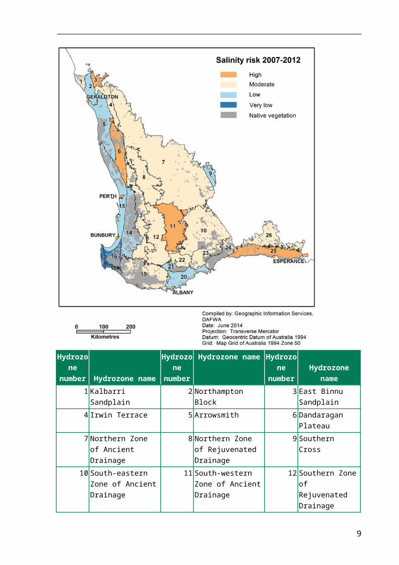
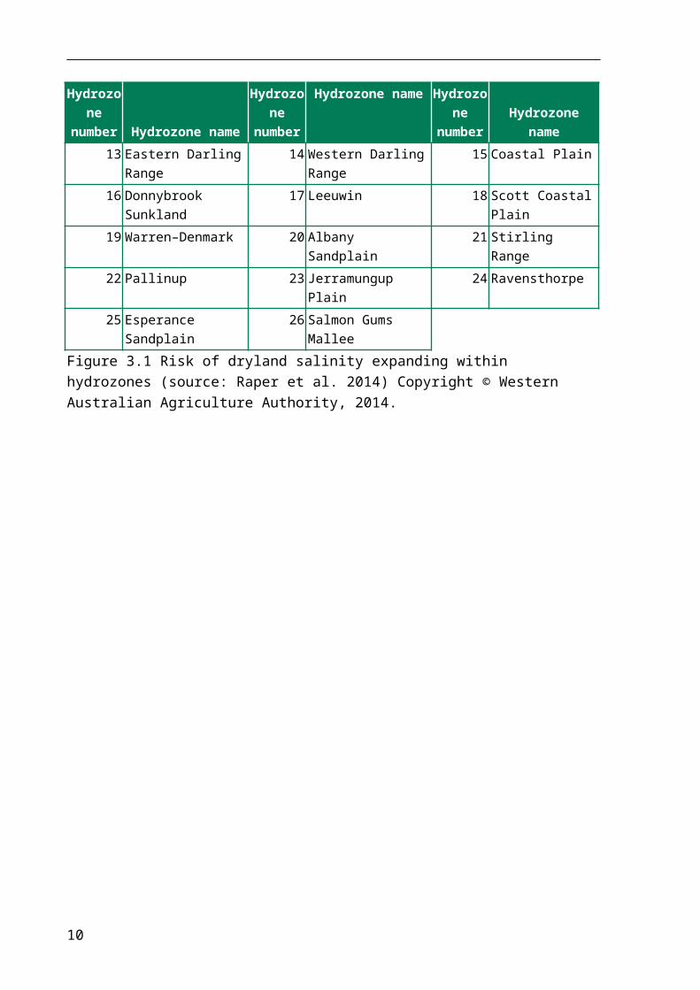
The only salinity risk mapping product available at an appropriate spatial scale for WA is a salinity risk map published at the hydrozone scale by the Department of Agriculture and Food, Western Australia (DAFWA 2013) (Figure 3.1). Agricultural land is the principal asset considered in this salinity risk assessment.
The hydrozones used by DAFWA (2013) to report salinity risk are based on soil-landscape zones, which are areas defined on geomorphologic or geological criteria that reflect state-scaled regions with similar hydrogeological and farming system attributes. The salinity risk assessment was based on the analysis of groundwater trends determined for over 1500 bores throughout the south-west agricultural region. A risk matrix of consequence and likelihood adapted from one recommended by Spies and Woodgate (2005) was then used to determine the risk of dryland salinity expanding beyond its current extent for each hydrozone. Inputs to the risk assessment, other than the groundwater trends, were the areas of salinity hazard and current extent, as determined by the Land Monitor project (Caccetta et al. 2010).
DAFWA (2013) also includes maps showing the dominant groundwater trends (Figure 3.2) and time to hydrological equilibrium (Figure 3.3) by hydrozone. Raper et al. (2014) provides details of the salinity risk assessment methodology.
The Regulations and the National Water Commission (2013) provide an assessment framework that specifies the level of formal water resource assessment and planning required for adequate management arrangements for dealing with interception from
5
proposed plantations. The decision ‘tree’ presented in Figure 3.4 applies that framework to the current water resource management regulations operating in WA.
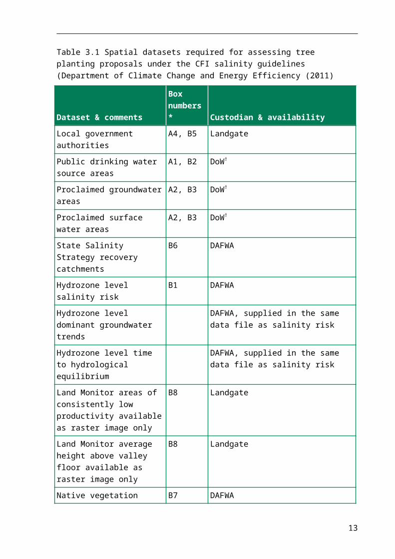
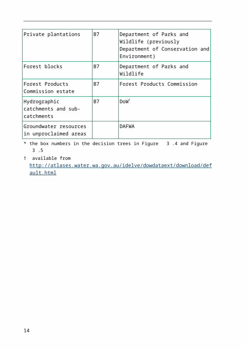
Spatial datasets required to assess carbon bio-sequestration plantings are outlined in Table 3.1. Several additional datasets, which support the salinity risk map, are also listed.
Hydrozone number Hydrozone name
Hydrozone number
Hydrozone name Hydrozone number Hydrozone name
1 Kalbarri Sandplain 2 Northampton Block 3 East Binnu Sandplain4 Irwin Terrace 5 Arrowsmith 6 Dandaragan Plateau7 Northern Zone of Ancient
Drainage8 Northern Zone of
Rejuvenated Drainage9 Southern Cross
10 South-eastern Zone of Ancient Drainage
11 South-western Zone of Ancient Drainage
12 Southern Zone of Rejuvenated Drainage
13 Eastern Darling Range 14 Western Darling Range 15 Coastal Plain16 Donnybrook Sunkland 17 Leeuwin 18 Scott Coastal Plain
6

Hydrozone number Hydrozone name
Hydrozone number
Hydrozone name Hydrozone number Hydrozone name
19 Warren–Denmark 20 Albany Sandplain 21 Stirling Range22 Pallinup 23 Jerramungup Plain 24 Ravensthorpe25 Esperance Sandplain 26 Salmon Gums Mallee No data No data
Figure 3.1 Risk of dryland salinity expanding within hydrozones (source: Raper et al. 2014) Copyright © Western Australian Agriculture Authority, 2014.
Figure 3.2 Dominant groundwater level trends 2007–12 (source: Raper et al. 2014) Copyright © Western Australian Agriculture Authority, 2014.
7
Figure 3.3 Time until the hydrozones reach hydrological equilibrium and all areas of potential dryland salinity have developed (source: Raper et al. 2014). Copyright © Western Australian Agriculture Authority, 2014.
8
Table 3.1 Spatial datasets required for assessing tree planting proposals under the CFI salinity guidelines (Department of Climate Change and Energy Efficiency (2011)
Dataset & commentsBox numbers* Custodian & availability
Local government authorities A4, B5 Landgate
Public drinking water source areas
A1, B2 DoW†
Proclaimed groundwater areas
A2, B3 DoW†
Proclaimed surface water areas
A2, B3 DoW†
State Salinity Strategy recovery catchments
B6 DAFWA
Hydrozone level salinity risk B1 DAFWA
Hydrozone level dominant groundwater trends
No data DAFWA, supplied in the same data file as salinity risk
Hydrozone level time to hydrological equilibrium
No data DAFWA, supplied in the same data file as salinity risk
Land Monitor areas of consistently low productivity available as raster image only
B8 Landgate
Land Monitor average height above valley floor available as raster image only
B8 Landgate
Native vegetation B7 DAFWA
Private plantations B7 Department of Parks and Wildlife (previously Department of Conservation and Environment)
Forest blocks B7 Department of Parks and Wildlife
Forest Products Commission estate
B7 Forest Products Commission
Hydrographic catchments and sub-catchments
B7 DoW†
Groundwater resources in unproclaimed areas
No data DAFWA
* the box numbers in the decision trees in Figure 3.4 and Figure 3.5† available from
http://atlases.water.wa.gov.au/idelve/dowdataext/download/default.html
9
10
3.1 Assessment methodology
The assessment methodology is presented as a decision tree (Figure 3.4 and Figure 3.5). It deals only with CFI qualification criteria and exclusions specified in Regulation 3.37
The first question to be answered under Regulation 3.37 is whether the proposed tree planting qualifies as an environmental planting. Regulation 3.34 contains the criteria:
‘environmental planting means a planting that consists of species that:
(a) are native to the local area of the planting(b) are sourced from seeds:
(i) from within the natural distribution of the species(ii) that are appropriate to the biophysical characteristics of the area of the planting
(c) may be a mix of trees, shrubs, and understorey species where the mix reflects the structure and composition of the local native vegetation community.’
If the project qualifies as an environmental planting, use Part A of the decision tree in Figure 3.4. If the project does not qualify as an environmental planting, it must be demonstrated that the project will contribute to the mitigation of dryland salinity; in this case, use Part B of the decision tree in Figure 3.5.
When assessing a proposal, the regional NRM organisations should communicate the need to satisfy land use planning considerations, overseen by local government authorities, and water resource protection, overseen by DoW. Proponents and regional NRM organisations should also be aware that, in most circumstances, local government authorities will refer land use planning applications to DoW if water resources protection considerations arise.
The decision tree requires the assessor to have access to maps of a range of administrative, NRM and salinity risk themes, preferably as Geographical Information System (GIS) spatial datasets (Table 3.1).
Box 7 in Figure 3.4 requires estimating the proportion of the catchment in which a CFI tree planting is proposed, that is already occupied by trees. Four spatial datasets (Table 3.1) will assist in making that estimation; however, these datasets may not capture all the trees in a catchment. To estimate the current tree cover in a catchment, it is recommended that regional NRM organisations access the most up-to-date aerial photography available via the Landgate online Locate service (www.locate.wa.gov.au/).
11
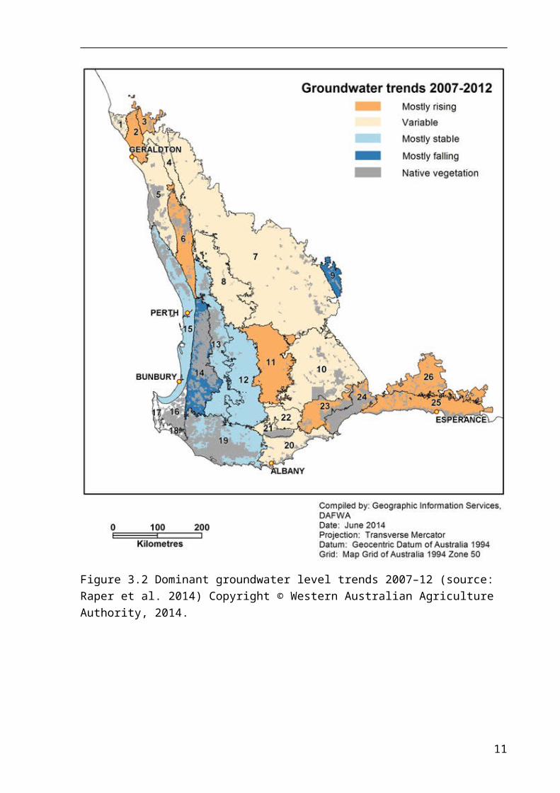
Figure 3.4 Decision tree for assessing tree planting proposals under the Carbon Farming Initiative: Salinity guidelines, Part A: projects that qualify as environmental plantings
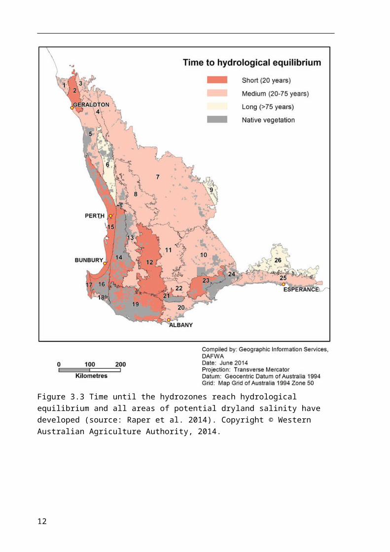
Figure 3.5 Decision tree for assessing tree planting proposals under the Carbon Farming Initiative: Salinity guidelines, Part B: projects that do not qualify as environmental plantings
3.2 Scale issues
The south-west agricultural region, for which the salinity risk assessment was made in DAFWA (2013), covers about 25 million hectares and is reported at the hydrozone-scale, which range from 89 000 to 6.2 million hectares. At this spatial scale, there is potential for variation in the level of salinity risk within hydrozones and some is noted in DAFWA (2013) and Raper et al. (2014). Because of this variability, there is potential for hydrozones with a low risk to contain areas or catchments with moderate or high dryland salinity risk (Figure 3.1).
Should a carbon bio-sequestration planting be proposed in an area of moderate or high dryland salinity risk, the CFI salinity guidelines provide Method 3 for the proponent to demonstrate that the project would mitigate dryland salinity (see Section 1). Method 3 places the burden of proof that a proposal would mitigate dryland salinity more heavily on the proponent. Some of the datasets in Table 3.1 may provide some supporting evidence.
3.3 Changes to water resources legislation
The DoW manages the state’s water resources to ensure the supply of uncontaminated, potable water and the preservation of environmental water quality. It does so under six separate acts of parliament. It currently has no legislative power to license water interception by plantations.
Under the Country Areas Water Supply Act 1947, DoW can create by-laws to prevent high-risk land use activities in public drinking water source areas and these would apply to plantations. By-laws are broad and aimed at protecting water quantity and quality.
DoW’s role in managing and maintaining water resource availability, as it may be affected by plantation forestry, is through advice to local government authorities. Local government authorities have the authority to regulate land use within their boundaries and can refer proposed plantation developments to DoW for advice on water resource management issues. DoW can also take water interception by existing plantations into consideration when establishing or reviewing water resource management plans and setting allocation limits.
DoW is currently in the process of having new water resource management legislation drafted (Department of Water 2013). It proposes to include the impacts of plantations in the development of statutory water allocation plans and statutory allocation limits, but it is anticipated that existing plantations will remain unregulated, although the impacts of large-scale (greater than 20 hectares) plantations would be monitored. DoW has also raised the possibility that the regulation of interception by plantations could be regulated only where robust, site-specific analysis identifies risks and benefits to the water resource, other water users or the environment.
14
The decision tree for assessing carbon bio-sequestration tree plantings presented in Figure 3.4 is based on DoW’s current regulatory framework and the CFI salinity guidelines (Department of Climate Change and Energy Efficiency 2011). When DoW’s new legislation is in place, the decision tree will need revising.
15
4 ConclusionsUnder the current CFI arrangements, regional NRM organisations have a role to play in assessing carbon bio-sequestration tree plantings. The Carbon Credits (Carbon Farming Initiative) Regulations 2011 stipulate that in areas receiving more than 600mm average annual rainfall, a plantation must help to mitigate dryland salinity to qualify as a carbon offset project. The Carbon Farming Initiative: Salinity guidelines (Department of Climate Change and Energy Efficiency 2011) outline how a proponent may demonstrate that a plantation in a particular location will contribute to the mitigation of dryland salinity. In WA, the prescribed method most likely to be applicable is Method 2: the reference to an approved salinity hazard map.
This report outlines a process that a regional NRM organisation in WA can apply to a carbon bio-sequestration tree planting proposal that is compliant with Method 2. The process also aims to protect water resources, taking into consideration the water resources legislation currently operating in this state. DoW is currently having new water resource management legislation drafted (Department of Water 2013), when this legislation is enacted the processes recommended in this report will need to be revised.
16
ReferencesCarbon Credits (Carbon Farming Initiative) Act 2011, no. 101, 2011 as amended
(ComLaw Authoritative Act C2013C00497).
Carbon Credits (Carbon Farming Initiative) Regulations 2011. This compilation was prepared on 4 July 2012 taking into account amendments up to SLI 2012 No. 125, prepared by the Office of Legislative Drafting and Publishing, Attorney-General’s Department, Canberra.
Caccetta, P, Dunne, R, George, R & McFarlane, D 2010, 'A methodology to estimate the future extent of dryland salinity in the southwest of Western Australia', Journal of Environmental Quality, vol. 39, no.1, pp. 26–34.
Coram, JE, Dyson, PR, Houlder, PA & Evans, WR 2000, Australian groundwater flow systems contributing to dryland salinity, Project Report to National Land and Water Resources Audit Dryland Salinity Theme Bureau of Rural Sciences, Canberra, ACT.
Department of Agriculture and Food, Western Australia 2013, Report card on sustainable natural resource use in agriculture, Department of Agriculture and Food, Western Australia, Perth.
Department of Climate Change and Energy Efficiency 2011, Carbon Farming Initiative: Salinity guidelines, Canberra, ACT.
Department of Water 2009, Plantation forestry and water management guideline, Department of Water, Perth.
Department of Water 2012, Plantations in public drinking water source areas, Water quality protection note 121, Department of Water, Western Australia, Perth.
Department of Water 2013, Securing Western Australia's water future, Position paper – reforming water resource management, Department of Water, Perth.
National Water Commission 2013, Carbon farming initiative, Carbon Credits (Carbon Farming Initiative) Regulations 2011, Regulation 3.37(4).
Raper, GP, Speed, R, Simons, J, Kendle, A, Blake, A, Ryder, A, Smith, R, Stainer, G & Bourke, L 2014, ‘Groundwater trend analysis for south-west Western Australia 2007–12’, Resource management technical report 388, Department of Agriculture and Food, Western Australia, Perth.
Spies, B & Woodgate, P 2005, Salinity mapping methods in the Australian context: Results of a review by the Academy of Science and the Academy of Technological Science & Engineering, Technical Report Natural Resource Management Ministerial Council, Land and Water Australia and National Dryland Salinity Council, Canberra, ACT.
17