Embed Size (px)
Citation preview
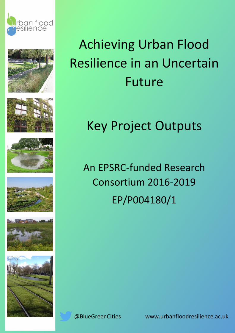
Achieving Urban Flood
Resilience in an Uncertain
Future
Key Project Outputs
An EPSRC-funded Research
Consortium 2016-2019
EP/P004180/1
@BlueGreenCities www.urbanfloodresilience.ac.uk
Urban Flood Resilience refers to a city’s capacity to maintain future flood risk at tolerable levels by
preventing deaths and injuries, minimising damages and disruption during floods, and recovering
quickly afterwards, while ensuring social equity, and economic and cultural vitality.
Achieving urban flood resilience nationally requires a transformative change in planning, design and
implementation of existing and new urban water systems. Flood risk, wastewater and stormwater
management should be re-envisaged and transformed to: ensure satisfactory service delivery under
flood, normal and drought conditions, and; enhance and extend the useful lives of ageing grey assets
by supplementing them with multifunctional Blue-Green infrastructure.
The multidisciplinary Urban Flood Resilience research project, which launched in 2016 and comprises
academics from nine UK institutions, is investigating how such transformative change may be possible
through a whole systems approach to urban flood and water management. Research is conducted
under five work streams: resilience under change, stormwater as a resource, interoperability, citizens’
interactions and resilience in practice.
This research builds on the Blue-Green Cities project (2013-2016) and moves beyond multiple benefit
evaluation of Blue-Green infrastructure to investigating the resource potential of integrated Blue-
Green and grey systems and developing new approaches that put flood risk management at the heart
of urban planning.
Key outputs (to date) from the five main work packages are presented in this document.
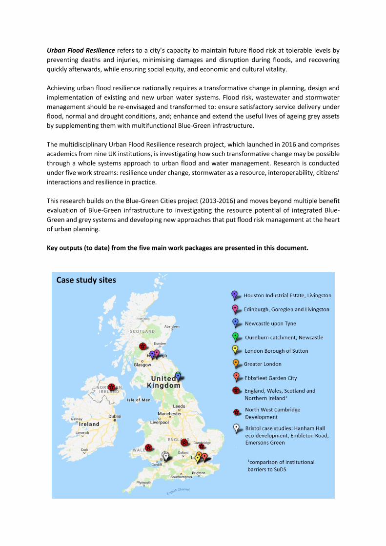
Case study sites
Project team
The Urban Flood Resilience project is led by Colin Thorne and lead research and project coordinator
Emily O’Donnell, University of Nottingham. The research team comprise:
Heriot-Watt University: Scott Arthur, Vladimir Krivtsov, Sikhululekile Ncube
Newcastle University: Chris Kilsby, Greg O’Donnell, Stephen Birkinshaw, Vassilis Glenis
Nottingham Trent University: Nigel Wright
The Open University: Karen Potter, Tudor Vilcan
University of Cambridge: Richard Fenner, Leon Kapetas
University of Exeter: David Butler, Sangaralingam Ahilan, Zoran Kapelan
University of Leeds: David Dawson, Kim Vercruysse
University of Nottingham: Colin Thorne, Emily O’Donnell, Shaun Maskrey, Lindsey Air
University of the West of England: Jessica Lamond, Glyn Everett
Please contact Emily O’Donnell (Emily.O’[email protected]) for further information.
The Urban Flood Resilience Research Consortium are supported by:
@BlueGreenCities www.urbanfloodresilience.ac.uk
KEY OUTPUTS
WP1. Adaptation Pathways for Drainage Infrastructure
Planning
Research aims
Existing urban drainage infrastructure that has been developed to meet specific performance requirements can require retrofit interventions to deal with pressures from extreme storm events due to climate change and urban densification that are expected to increase in the future. The extent of change in these drivers is uncertain giving rise to the possibility of introducing costly solutions that are overdesigned or inadequate system extensions that fail to provide the necessary additional capacity. Making good judgement on such projections is a hard task and has significant economic implications. This creates a need for flexible/adaptive designs that allow incremental investments in infrastructure, matching the performance requirements while maintaining cost-effectiveness. In comparing possible future pathways other criteria can complement the conventional Cost Benefit Analysis, such as adaptiveness, flexibility and ease of implementation and a valuation of the wider multiple benefits that can delivered by SuDS and blue-green options. Our work has developed guidance on how a range of flexible adaptation pathways can be comprehensively assessed as part of a long term planning and design approach for drainage infrastructure. The methodology is designed to answer the question “what is the most effective mix of blue-green and grey systems in any given location at any time?”. The procedures examine the desired performance threshold and analyse how different interventions might combine one with the other over their expected design lives. Based on a wide set of appraisal criteria, a series of potential adaptation pathways can be explored and prioritised. The approach provides a pragmatic response to climate change and urbanisation and allows real options evaluation techniques to help determine the scale of interventions that are required and when they should be implemented.
Main outputs
The procedures have been applied to the case study area of Carshalton, in the London Borough of Sutton, and have been used to develop a roadmap for adaptation over the next 40 years. The roadmap can be updated following regular monitoring of climate change, urbanisation rates and performance of blue-green and grey assets. Hydrodynamic models are used to identify when service thresholds are exceeded and so trigger the need for further interventions. Techniques for monetised and spatial assessment of multiple benefits arising from both grey and blue-green options are considered so as to evaluate the right mix of drainage infrastructure as well as suitable moments for intervention.
Key findings
The integration of a variety of appraisal techniques offers a new perspective to help inform the time and place of blue-green interventions, whilst acknowledging future uncertainties. As an envelope of possible climatic and urbanisation rates are considered, a viable planning horizon becomes evident. Also, as several other priorities are considered (e.g. air quality, wellbeing) more informed decisions over type and timing of infrastructure are can be made.
Further information
The following research articles and working papers provide details on the concept of multiple benefit assessment and adaptation pathways appraisal:
- Morgan & Fenner (2017) Spatial evaluation of the multiple benefits of sustainable drainage systems , Volume 172, Issue 1, Water Management (https://www.icevirtuallibrary.com/doi/10.1680/jwama.16.00048)
- Kapetas & Fenner (2018) Economic appraisals of SuDS - (http://www.urbanfloodresilience.ac.uk/publications/factsheets.aspx) - Kapetas L. and Fenner R.A. (2019) Procedures for adaptation planning of urban drainage infrastructure (in
preparation)
For more information, please contact Dr Leon Kapetas, email: [email protected]
Research aims
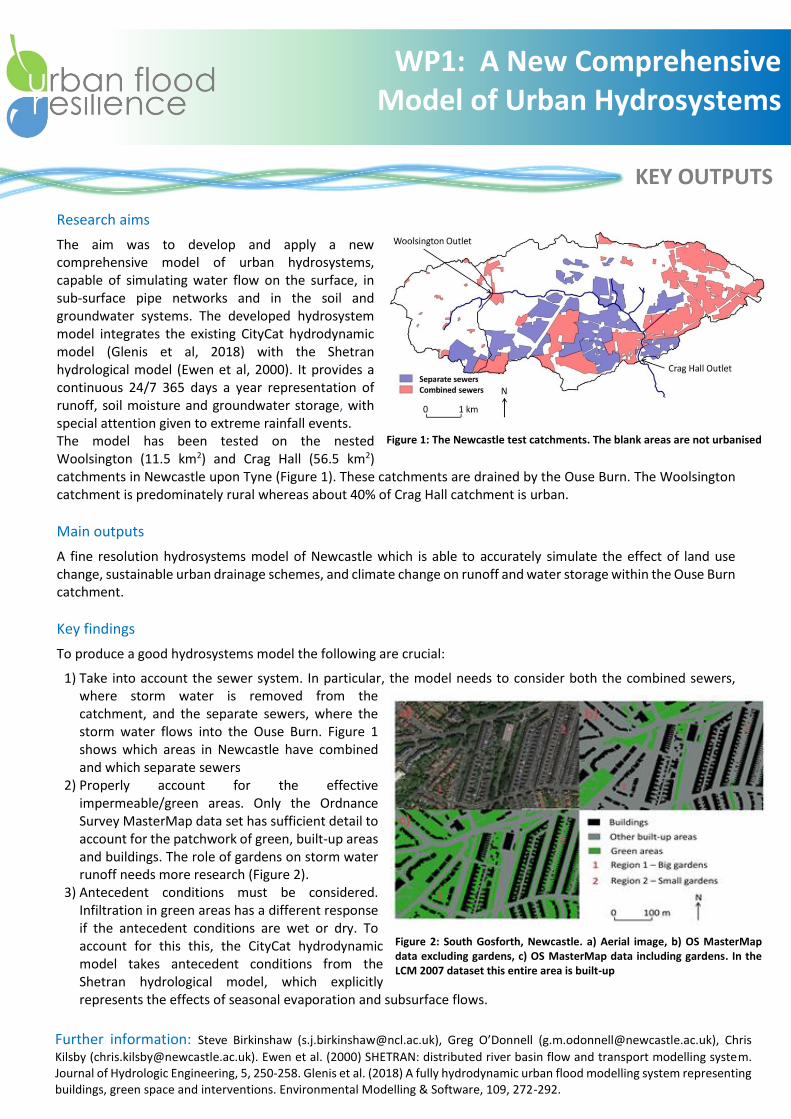
The aim was to develop and apply a new comprehensive model of urban hydrosystems, capable of simulating water flow on the surface, in sub-surface pipe networks and in the soil and groundwater systems. The developed hydrosystem model integrates the existing CityCat hydrodynamic model (Glenis et al, 2018) with the Shetran hydrological model (Ewen et al, 2000). It provides a continuous 24/7 365 days a year representation of runoff, soil moisture and groundwater storage, with special attention given to extreme rainfall events. The model has been tested on the nested Woolsington (11.5 km2) and Crag Hall (56.5 km2) catchments in Newcastle upon Tyne (Figure 1). These catchments are drained by the Ouse Burn. The Woolsington catchment is predominately rural whereas about 40% of Crag Hall catchment is urban.
Main outputs
A fine resolution hydrosystems model of Newcastle which is able to accurately simulate the effect of land use change, sustainable urban drainage schemes, and climate change on runoff and water storage within the Ouse Burn catchment.
Key findings
To produce a good hydrosystems model the following are crucial:
1) Take into account the sewer system. In particular, the model needs to consider both the combined sewers, where storm water is removed from the catchment, and the separate sewers, where the storm water flows into the Ouse Burn. Figure 1 shows which areas in Newcastle have combined and which separate sewers
2) Properly account for the effective impermeable/green areas. Only the Ordnance Survey MasterMap data set has sufficient detail to account for the patchwork of green, built-up areas and buildings. The role of gardens on storm water runoff needs more research (Figure 2).
3) Antecedent conditions must be considered. Infiltration in green areas has a different response if the antecedent conditions are wet or dry. To account for this this, the CityCat hydrodynamic model takes antecedent conditions from the Shetran hydrological model, which explicitly represents the effects of seasonal evaporation and subsurface flows.
Figure 1: The Newcastle test catchments. The blank areas are not urbanised
KEY OUTPUTS
Figure 2: South Gosforth, Newcastle. a) Aerial image, b) OS MasterMap data excluding gardens, c) OS MasterMap data including gardens. In the LCM 2007 dataset this entire area is built-up
WP1: A New Comprehensive Model of Urban Hydrosystems
Further information: Steve Birkinshaw ([email protected]), Greg O’Donnell ([email protected]), Chris
Kilsby ([email protected]). Ewen et al. (2000) SHETRAN: distributed river basin flow and transport modelling system. Journal of Hydrologic Engineering, 5, 250-258. Glenis et al. (2018) A fully hydrodynamic urban flood modelling system representing buildings, green space and interventions. Environmental Modelling & Software, 109, 272-292.

KEY OUTPUTS
WP1 and 2: BGI Ponds SPM, Water Quality,
Biodiversity & Ecosystem Functioning
Research aims: The focus of this work, led by Heriot Watt University, is a study of suspended particulate matter (SPM)
and water quality (WP1), and the ecosystem functioning and services/benefits provided by Blue-Green infrastructure (WP2), with a particular focus on SuDS ponds. One of the aims is characterising suspended particulates and understanding their interactions with pond ecology. We are also studying the provision of multiple benefits, including biodiversity and amenity values.
Main outputs Characterisation of sediments and SPM by particle size distribution (PSD) and SEM EDX analysis (Figure 1)
Biodiversity assessment of all sites (Figure 2) and seasonal changes in water quality and biological community
Hydrological modelling using CityCAT and SHETRAN (cooperation with Newcastle University (Figure 3)
Figure 1. Examples of: change in particle size distribution (left), SEM image of sampled particulates (lower right) and its chemical spectrum (upper right)
Key findings SPM in these ponds includes particles of both biological and abiotic origin, the former being predominant;
considerable proportion of SPM is smaller than 100 microns.
BGI ponds have reasonably high species richness, providing important contribution to ecosystem services, and should be utilised as a recreational and educational resources.
The simulations enhance the understanding of the ponds’ functioning and provide predictions of what would happen in the rare events (e.g. 100 years return period rainfall)
Figure 2. Plant species richness at the sites studied (preliminary results) Figure 3. CityCat modelling of a 100 year storm at Granton
For more information contact Vladimir Krivtsov ([email protected]), Scott Arthur ([email protected]) and Steve Birkinshaw ([email protected]). Also see: Krivtsov V., S. Arthur, J. Buckman, J. Bischoff, D. Christie, S. Birkinshaw, K. Takezawa, D. Chamberlain and R. Pereira (2019) Monitoring and Modelling SUDS Retention Ponds: Case Studies from Scotland. ICONHIC 2019 (submitted).
-1
0
1
2
3
4
5
6
7
8
0.01 0.1 1 10 100 1000
Vo
lum
e c
on
cen
trat
ion
(%
)
Particle Size (microns)
AppletonApr
AppletonMay

KEY OUTPUTS
WP2. Stormwater as a Resource
Research aims Captured stormwater resources can provide a number of positive benefits ranging from non-potable uses within buildings, to irrigating Blue-Green Infrastructure, mitigating drought through groundwater recharge, energy generation utilising small scale micro-hydropower and enhancing recreational spaces and ecosystems services. Our research focuses on the potential to recover energy from stormwater and the viability for utilisation in Managed Aquifer Recharge (MAR) schemes.
Main Outputs: Energy Recovery A screening tool has been developed which assesses the feasibility of energy recovery based on the key physical/site and climatic characteristics as well as scheme economics. The approach looks at how a retention pond can decouple the problem of intermittent rainfall and continuous energy generation. A comparison is made between existing run-off river (i.e. with no storage) schemes and systems where a pond can slowly release water to generate energy through a carefully selected turbine
Two cases studies in the UK and USA have been analysed with respect to the potential to generate energy from stormwater. In both cases the revenue generated was insufficient to justify the investment. However, under more favourable physical conditions this might be possible. The methodological approach to evaluate the potential is presented in the paper by Costa, Fenner and Kapetas (2018).
Main Outputs: Managed Aquifer Recharge The potential for aquifer recharge and storage using stormwater has been evaluated. The work appraises the factors that influence stormwater use in MAR (climatic, hydrogeologic, water quality etc.) and the techniques available (e.g. passive infiltration vs well injection). An analysis of the current policies hindering the application was carried out and recommendations made.
The analysis has shown that the following factors will affect the potential for a SuDS/MAR conjunctive system: volume and spatio-temporal distribution of stormwater for recharge, access to suitable aquifers (location, storage potential), land for SuDS development, existing infrastructure to support the scheme, and presence of groundwater source protection zones. A case study of the River Cray catchment in SE London has been completed, with groundwater flows and travel times established using FeFlow, and the use of stormwater injection for streamflow augmentation in low-flow rivers examined.
Key findings The energy screening tool can provide rapidly evaluate whether there is potential for energy recovery from collected stormwater in a specific urban environment location. Significant head fall is critical to the economic case, as a small turbine system can produce energy for a long discharge period by controlling the release rate at a retention pond. However, operating rules need to be carefully selected as allowing slow release of stormwater should not restrict the storage available during the following subsequent rainfall events. When variable flow control is necessary, efficiency will be somewhat lower depending on turbine selection. Dynamic management can, in some cases, increase system efficiency. The quality of stormwater is currently a barrier for incorporation in MAR schemes without further treatment, although when suitable underlying geology exists then the potential to mitigate potential drought episodes is significant.
Further information The following research articles and documentation provide details on the concept of multiple benefit assessment and adaptation pathways appraisal. - Costa, Fenner & Kapetas (2018) Assessing the potential for energy recovery from the discharge of storm water run-off,
Engineering Sustainability (https://www.icevirtuallibrary.com/doi/abs/10.1680/jensu.18.00035) - Saleh, Kapetas, Fenner (2109) The use of captured stormwater in managed aquifer recharge schemes (in preparation)
For more information, please contact Dr Leon Kapetas, email: [email protected]
WP2 From Rainwater Harvesting to
Rainwater Management
Research aim: To demonstrate the emerging transition from single function rainwater harvesting systems (RWH) to multi-functional rainwater management systems (RMS). In this work, the performance of a rainwater management system (RMS) is investigated at a case study location. Approach: To illustrate the potential for RMS, a 3-bedroom house with a roof area of 80 m2 located in Newcastle-upon Tyne, NE England has been evaluated in terms of water saving and stormwater control efficiencies. This has been carried out using a continuous mass balance simulation of historical rainfall events at 15-minute resolution over a 30-year period (1984-2013). In addition, 100 equiprobable 30-year, daily rainfall time series were used in the simulation to evaluate the potential impact of future rainfall patterns under a ‘high emissions’ scenario. The British Code of Practice (BS 8515) was adopted to design the tank size. Main outputs: Results indicate that a rainwater harvesting system which is primarily designed for water supply augmentation with a tank volume of 2.4 m3 contributed 64% of non-potable demand (toilet flushing) and a 77% (median) reduction of stormwater peak runoff into the sewer system. A larger system (6.5 m3) which was sized for both water supply augmentation and flood management provided 70% non-potable water supply and 100% (median) reduction of stormwater peak runoff. However, both tanks were unable to cope with the most extreme 2012 historical rainfall event. The 2.4 m3 and 6.5 m3 tanks provided just 0% and 9% flood peak attenuation for this event. However, performance was improved by an actively managed 2.4 m3 RMS which provided a 54% flood peak reduction for the 2012 event. A 30% increase in tank size would be required to retain the existing water supply efficiency over the next 30 years to cope with extreme climate change scenarios. Key findings:
All RMS systems deliver water saving and stormwater management benefits to varying degrees.
Where supply is low relative to demand (e.g. Newcastle), tanks are likely to be emptied frequently so water supply yield is relatively low, but this provides significant potential for stormwater control.
Multi-functional, multi-benefit systems are the future as exemplified by rainwater management systems.
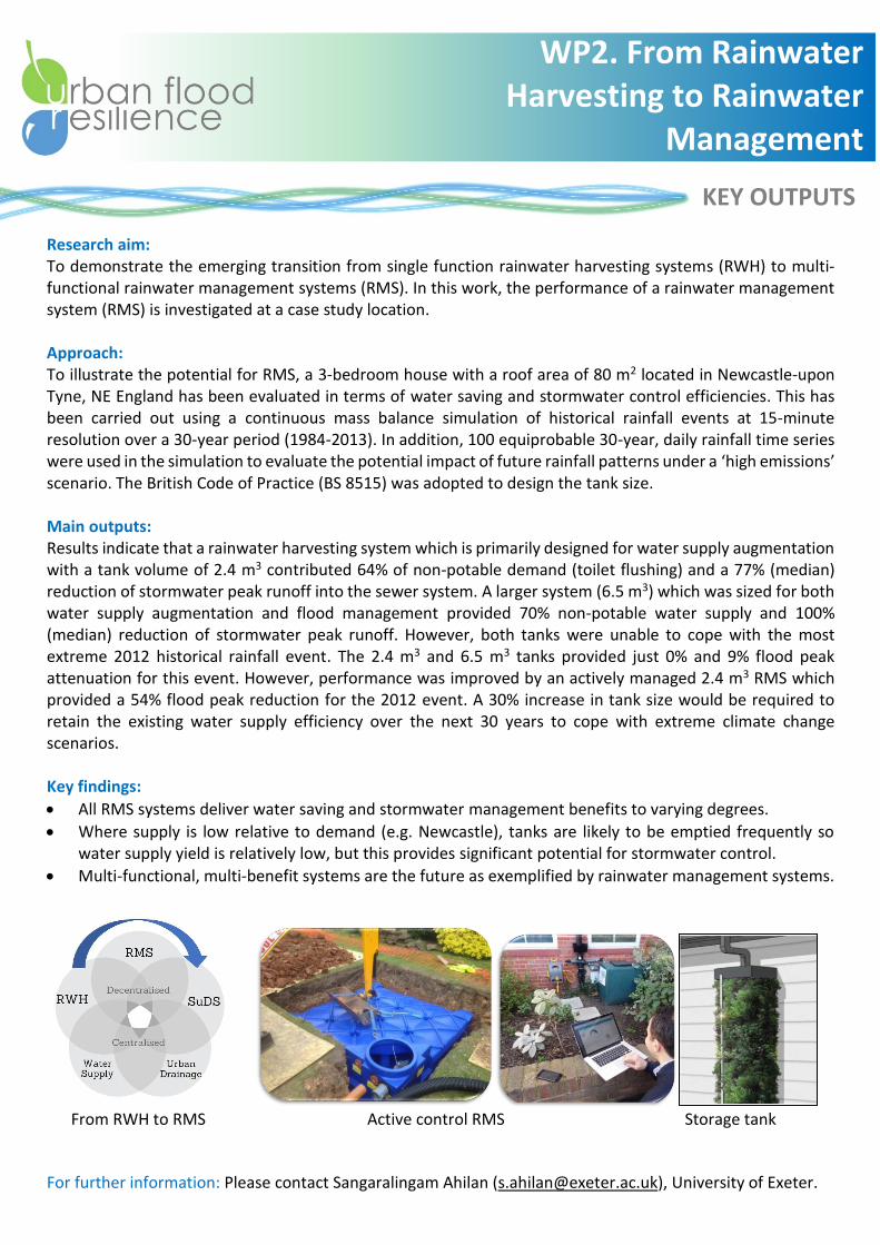
From RWH to RMS Active control RMS Storage tank
For further information: Please contact Sangaralingam Ahilan ([email protected]), University of Exeter.
KEY OUTPUTS
WP2. From Rainwater Harvesting to Rainwater
Management
KEY OUTPUTS
WP3 Interoperability
Research aims
WP3 aimed to generate the knowledge and approach necessary to facilitate interoperability in urban flood management, i.e. actively manage connections between infrastructure systems to increase the functionality of the whole system (i.e. city) to deal with water exceedance events. To this end, (i) interoperability was defined in the context of integrated urban flood management; (ii) insights and spatial data were compiled from different disciplines in flood research relevant to promoting interoperability in practice; and (iii) a spatial analysis framework was developed to systematically identify flood hazard alongside opportunities and challenges for interoperable flood management.
Main outputs
- Defining interoperability: A conceptual paper (accepted for publication) (1) defines interoperability and how it can guide the adaptive design process from a system with single multi-functional assets towards an interoperable “system-of-systems” to enhance flood resilience. The paper also identifies two main research needs to operationalise interoperability: (i) better understand how flood prone areas are linked to flood source areas within the urban catchment; and (ii) identify opportunities were stormwater can be captured or transferred along its pathways.
- Source-to-impact sensitivity analysis: A transferable modelling approach (using CityCAT) is designed to systematically identify locations contributing the most to flood hazard within a catchment (2).
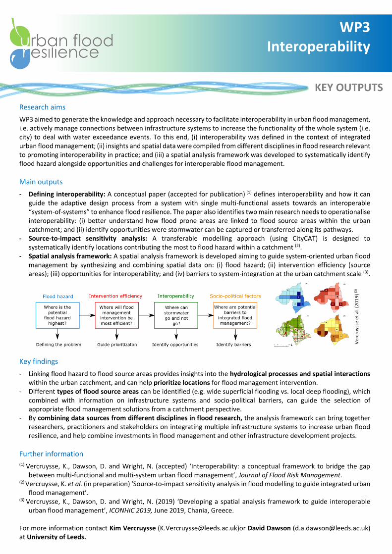
- Spatial analysis framework: A spatial analysis framework is developed aiming to guide system-oriented urban flood management by synthesizing and combining spatial data on: (i) flood hazard; (ii) intervention efficiency (source areas); (iii) opportunities for interoperability; and (iv) barriers to system-integration at the urban catchment scale (3).
Key findings
- Linking flood hazard to flood source areas provides insights into the hydrological processes and spatial interactions within the urban catchment, and can help prioritize locations for flood management intervention.
- Different types of flood source areas can be identified (e.g. wide superficial flooding vs. local deep flooding), which combined with information on infrastructure systems and socio-political barriers, can guide the selection of appropriate flood management solutions from a catchment perspective.
- By combining data sources from different disciplines in flood research, the analysis framework can bring together researchers, practitioners and stakeholders on integrating multiple infrastructure systems to increase urban flood resilience, and help combine investments in flood management and other infrastructure development projects.
Further information
(1) Vercruysse, K., Dawson, D. and Wright, N. (accepted) ‘Interoperability: a conceptual framework to bridge the gap between multi-functional and multi-system urban flood management’, Journal of Flood Risk Management.
(2) Vercruysse, K. et al. (in preparation) ‘Source-to-impact sensitivity analysis in flood modelling to guide integrated urban flood management’.
(3) Vercruysse, K., Dawson, D. and Wright, N. (2019) ‘Developing a spatial analysis framework to guide interoperable urban flood management’, ICONHIC 2019, June 2019, Chania, Greece.
For more information contact Kim Vercruysse ([email protected])or David Dawson ([email protected]) at University of Leeds.
Ver
cru
ysse
et
al. (
20
19
) (3
)

Research aim: To improve understanding of the distinctive features underlying effective Community Engagement (CE) around Blue-Green Infrastructure (BGI) installations. To articulate the principles that could encourage a greater sense of ownership, appreciation and care.
Main outputs: The researchers reviewed academic and non-academic literature and considered closely several case studies. The work analysed the way CE was framed and communities understood, drawing out and developing a typology of modes of BGI-CE and a set of guiding principles for best practice.
Key findings: Community engagement is critical to getting BGI ‘right’ and producing more sustainable solutions. However, understandings of engagement often differ, and some remain difficult to resolve. Distinctive challenges for CE around BGI include possible community resistance to BGI, due to fears around: water -related health and safety; loss of green-space to water; belief in the efficacy of BGI, and concerns over longer-term management and maintenance. Further, to maximise BGI’s function and multiple benefits, potentially requiring behaviour change, BGI-CE may need to be more developed and longer-term than other engagement efforts around hard engineered approaches. It should encompass the entire life of installations. The work therefore challenges the ‘passive recipient’ understanding of communities and argues that they can be ‘agents’ of change, with relevant knowledge and understanding that projects can benefit from. Engagement with communities around BGI installation needs to consider Who (as wide a variety of publics as possible, going beyond ‘usual suspects’), What (two-way engagement, redistributing power, co-learning and shared responsibilities), Why (clarity around practitioners’ & communities’ goals), How (working with diverse communities’ knowledge needs and understandings) and When (engagement beginning early and being longer-term, to encourage co-ownership). BGI-CE will vary in levels of acceptance (taking communities ideas on board) and influence (communities having influence over actual decision-making); analysis of the literature and case studies suggests that the most effective and sustainable installations followed from high acceptance, high influence BGI-CE. The researchers developed a typology of five fundamental principles to guide more effective BGI-CE work (Figure 1).
Further information: Please contact Glyn Everett ([email protected])
People: Two-way engagement building
communities’ capacity, awareness &
understanding, but also practitioners’ knowledge
of communities’ perceptions, interests and
needs
Procedure: The establishment of BGI
should be collaborative, efficient and sustainable.
All community perspectives should be sought and considered
seriously such that the BGI feels co-designed and not
imposed
Design: Devices should be as low and lay
maintenance as possible, and fit into their local context. Provision of
multiple benefits should be informed by the
engagement process
Engagement: Local understanding and
participation should be developed, to encourage
democratic outcomes and ensure that different
relevant communities’ perspectives are heard
Power: Existing relationships within and between communities
should be recognised and negotiated, to ensure engagement does not
reinforce existing social inequalities. Aim to improve community
integration where possible.
KEY OUTPUTS
WP4. Blue-Green Infrastructure and
Community Engagement
Figure 1. A typology of fundamental guiding principles for more effective Blue-Green Infrastructure Community Engagement (BGI-CE)
KEY OUTPUTS
WP4. Uncovering implicit perceptions of SuDS
Research aim: to better understand preferences for Blue-Green infrastructure in public open space, moving beyond stated preference studies where attitudes are openly articulated (e.g. questionnaires) to developing new implicit tests that measure hidden perceptions and subconscious attitudes. This provides an unbiased insight into peoples’ preferences, and overcomes issues with respondents giving ‘socially acceptable’ responses of ‘liking’ blue-green space.
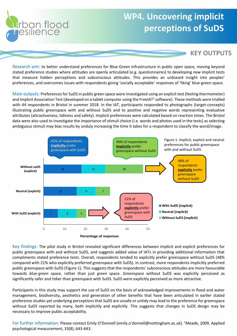
Main outputs: Preferences for SuDS in public green space were investigated using an explicit test (feeling thermometer) and Implicit Association Test (developed on a tablet computer using the FreeIAT1 software). These methods were trialled with 44 respondents in Bristol in summer 2018. In the IAT, participants responded to photographs (target-concepts) illustrating public greenspace with and without SuDS and to positive and negative words representing evaluative attributes (attractiveness, tidiness and safety). Implicit preferences were calculated based on reaction times. The Bristol data were also used to investigate the importance of stimuli choice (i.e. words and photos used in the tests) as selecting ambiguous stimuli may bias results by unduly increasing the time it takes for a respondent to classify the word/image.
Key findings: The pilot study in Bristol revealed significant differences between implicit and explicit preferences for public greenspace with and without SuDS, and suggests added value of IATs in providing additional information that compliments stated preference tests. Overall, respondents tended to explicitly prefer greenspace without SuDS (48% compared with 21% who explicitly preferred greenspace with SuDS). In contrast, more respondents implicitly preferred public greenspace with SuDS (Figure 1). This suggests that the respondents’ subconscious attitudes are more favourable towards blue-green space, rather than just green space. Greenspace without SuDS was explicitly perceived as significantly safer and tidier than greenspace with SuDS. SuDS were explicitly perceived as more attractive.
Participants in this study may support the use of SuDS on the basis of acknowledged improvements in flood and water management, biodiversity, aesthetics and generation of other benefits that have been articulated in earlier stated preference studies yet underlying perceptions that SuDS are unsafe or untidy may lead to the preference for greenspace without SuDS reported by many, both implicitly and explicitly. This suggests that changes in SuDS design may be necessary to improve public acceptability.
For further information: Please contact Emily O’Donnell (emily.o’[email protected]). 1Meade, 2009, Applied psychological measurement, 33(8), 643-643.
7
16
18
9
9
11
5
7
18
0 10 20 30 40 50
With SuDS (explicit)
Neutral (explicit)
Without suDS(explicit)
Percentage of responses
41% of respondents implicitly prefer greenspace with SuDS
30% of respondents implicitly prefer greenspace without SuDS
48% of respondents explicitly prefer greenspace without SuDS
21% of respondents explicitly prefer greenspace with SuDS
Figure 1. Implicit, explicit and neutral preferences for public greenspace with and without SuDS
KEY OUTPUTS
Background and research aim
Sustainable (urban) drainage systems (SuDS) are considered a progressive approach to dealing with the challenges posed by flooding and environmental change, while also providing a host of additional benefits. SuDS, such as swales, ponds, green roofs or rain gardens, provide reductions in water quantity, but also improvement in water quality, amenity and biodiversity amongst other benefits. After the summer floods of 2007, SuDS were recognised as one of the vital approaches to tacking the risk of surface water flooding. In 2010, the Flood and Water Management Act (FWMA) proposed the enactment of Schedule 3, which would have made SuDS mandatory on new planning proposals. However, in England, the implementation of Schedule 3 was resisted and in 2014, the Government announced that SuDS would be implemented through a strengthened planning system. Our research takes a broader governance perspective and investigates the implementation of SuDS through this strengthened planning system to date.
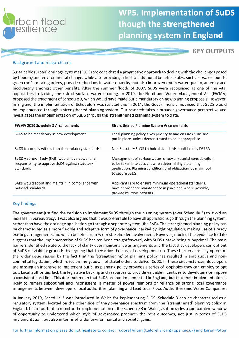
FWMA 2010 Schedule 3 Arrangements Strengthened Planning System Arrangements
SuDS to be mandatory in new development Local planning policy gives priority to and ensures SuDS are put in place, unless demonstrated to be inappropriate
SuDS to comply with national, mandatory standards
Non Statutory SuDS technical standards published by DEFRA
SuDS Approval Body (SAB) would have power and responsibility to approve SuDS against statutory standards
Management of surface water is now a material consideration to be taken into account when determining a planning application. Planning conditions and obligations as main tool to secure SuDS
SABs would adopt and maintain in compliance with national standards
Applicants are to ensure minimum operational standards, have appropriate maintenance in place and where possible, provide multiple benefits
Key findings
The government justified the decision to implement SuDS through the planning system (over Schedule 3) to avoid an increase in bureaucracy. It was also argued that it was preferable to have all applications go through the planning system, rather than have the drainage application go through a separate system (the SAB). The strengthened planning policy can be characterised as a more flexible and adaptive form of governance, backed by light regulation, making use of already existing arrangements and which benefits from wider stakeholder involvement. However, much of the evidence to date suggests that the implementation of SuDS has not been straightforward, with SuDS uptake being suboptimal. The main barriers identified relate to the lack of clarity over maintenance arrangements and the fact that developers can opt out of SuDS on viability grounds, by arguing that they drive the cost of development up. These barriers are a symptom of the wider issue caused by the fact that the ‘strengthening’ of planning policy has resulted in ambiguous and non-committal legislation, which relies on the goodwill of stakeholders to deliver SuDS. In these circumstances, developers are missing an incentive to implement SuDS, as planning policy provides a series of loopholes they can employ to opt out. Local authorities lack the legislative backing and resources to provide valuable incentives to developers or impose a consistent hard-line. This does not mean that SuDS are not implemented in England, but that their implementation is likely to remain suboptimal and inconsistent, a matter of power relations or reliance on strong local governance arrangements between developers, local authorities (planning and Lead Local Flood Authorities) and Water Companies.
In January 2019, Schedule 3 was introduced in Wales for implementing SuDS. Schedule 3 can be characterised as a regulatory system, located on the other side of the governance spectrum from the ‘strengthened’ planning policy in England. It is important to monitor the implementation of the Schedule 3 in Wales, as it provides a comparative window of opportunity to understand which style of governance produces the best outcomes, not just in terms of SuDS implementation, but also in terms of wider environmental and societal gains. For further information please do not hesitate to contact Tudorel Vilcan ([email protected]) and Karen Potter ([email protected]).
WP5. Implementation of SuDS though the strengthened planning system in England
KEY OUTPUTS
Research aims: Practitioner and community engagement are fundamental in the Urban Flood Resilience project for dissemination of co-produced knowledge, data, analyses and methods. WP5 aligns research in other work packages with end-user needs elicited from practitioner feedback at regular stakeholder meetings. Our aim is to create effective platforms for discussion of innovative Blue-Green infrastructure solutions that align with a range of stakeholder objectives, for subsequent incorporation into practice, policy, hearts and minds. Learning and Action Alliances (LAAs) in Ebbsfleet and Newcastle, our retrofit and new build case studies respectively, were established to enable social learning to build capacity and help overcome the socio-political barriers to delivering innovative Blue-Green infrastructure.
What are LAAs? LAAs are collaborations where participants come together to address issues of common interest. They are open and informal arrangements where stakeholders from different institutions and backgrounds come to learn from one another, identify common problems and try to advance solutions. LAAs have emerged in response to increasingly louder calls for integrative solutions to ‘wicked problems’, which are communal problems that cannot be solved by science or traditional top-down governance alone, such as sustainable flood risk management or climate change adaptation. Wicked problems are beyond the remit of individual stakeholders or organisations, which operate in isolation (or in ‘silos’). LAAs facilitate collaboration, trust and social learning between stakeholders and organisations to help them address wicked problems together.
Ebbsfleet LAA Newcastle LAA
Location Ebbsfleet Garden City, Kent Newcastle upon Tyne
Key issue Sustainable water use in the Garden City Innovative flood risk management solutions
Core stakeholders Ebbsfleet Development Corporation, Southern and Thames Water, Local Authorities, Kent County Council, Environmental NGOs
Newcastle City Council, Northumbrian Water, Environment Agency, Newcastle and Durham Universities, consultancies (e.g. Arup, Royal HaskoningDHV, Stantec), major landowners
Current focus Development of a system dynamics model that investigates current and future water use in Ebbsfleet
Promoting Blue-Green infrastructure in Newcastle flood and water management practice and policy (e.g. the Newcastle Blue-Green Declaration), opportunistic intervention, dissemination of best practice
Impact The model will be used to generate future water use scenarios and provide a policy basis for future local policy making
Incorporation of Blue-Green infrastructure in policy, e.g. Newcastle Local Flood Risk Management Plan, Newcastle City Strategic Surface Water Management Plan
WP5. Learning and Action Alliances (LAAs)
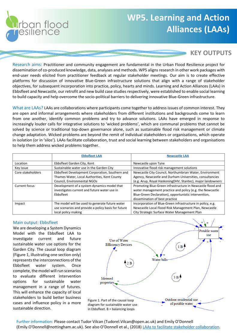
Main output: Ebbsfleet We are developing a System Dynamics Model with the Ebbsfleet LAA to investigate current and future sustainable water use options for the Garden City. The causal loop diagram (Figure 1, illustrating one section only) represents the interconnections of the Ebbsfleet water system. Once complete, the model will run scenarios to evaluate different intervention options for sustainable water management in a range of futures. This will enhance the capacity of local stakeholders to build better business cases and influence policy in a more sustainable direction.
Further information: Please contact Tudor Vilcan ([email protected]) and Emily O’Donnell (Emily.O'[email protected]). See also O’Donnell et al., (2018) LAAs to facilitate stakeholder collaboration.
Figure 1. Part of the causal loop diagram for sustainable water use in Ebbsfleet. B = balancing loops