Embed Size (px)
Citation preview
© Roads and Maritime Services
For further enquirieswww.rms.nsw.gov.au | 13 22 13
June 2016RMS/Pub. 16.168
Achievements in road and maritimeinfrastructure projects
Achievem
ents in road and maritim
e infrastructure projects | Ro
ads an
d M
aritime
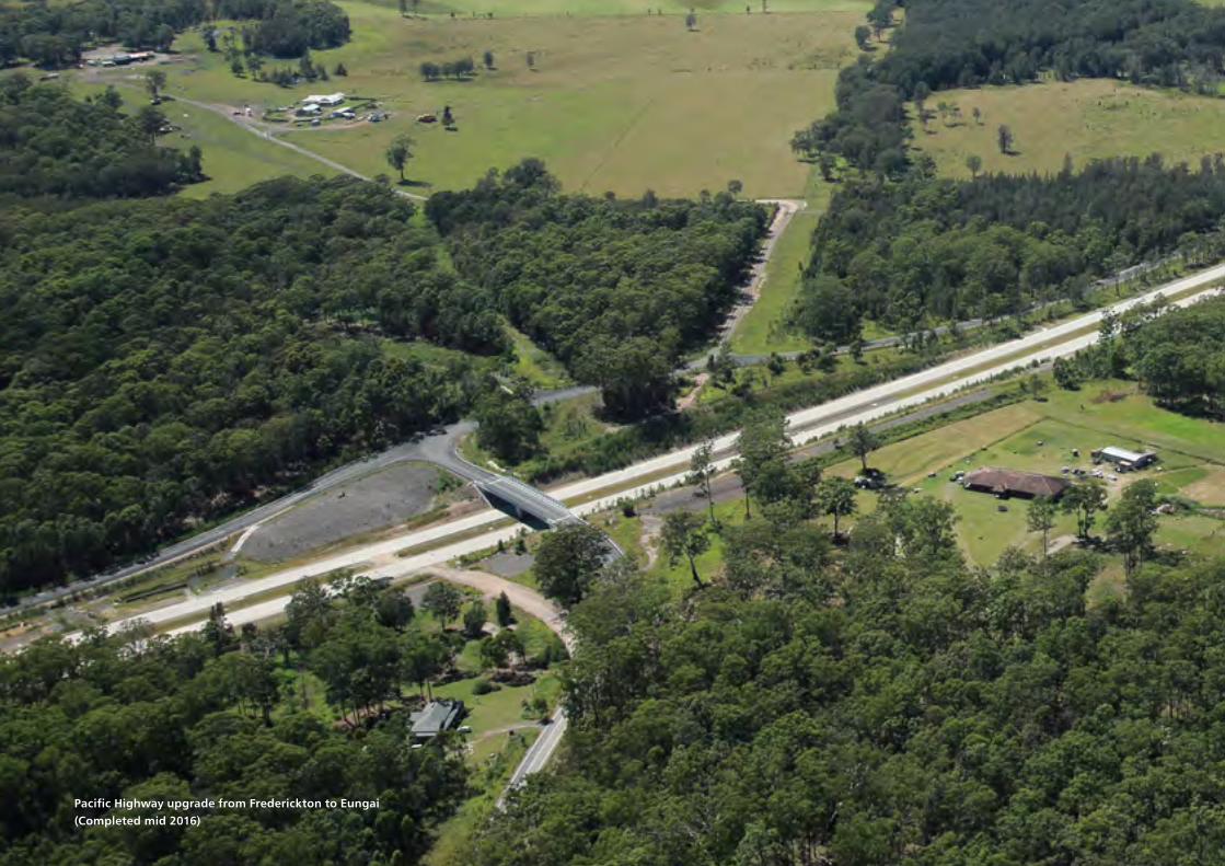
Pacific Highway upgrade from Frederickton to Eungai (Completed mid 2016)

Cover photograph
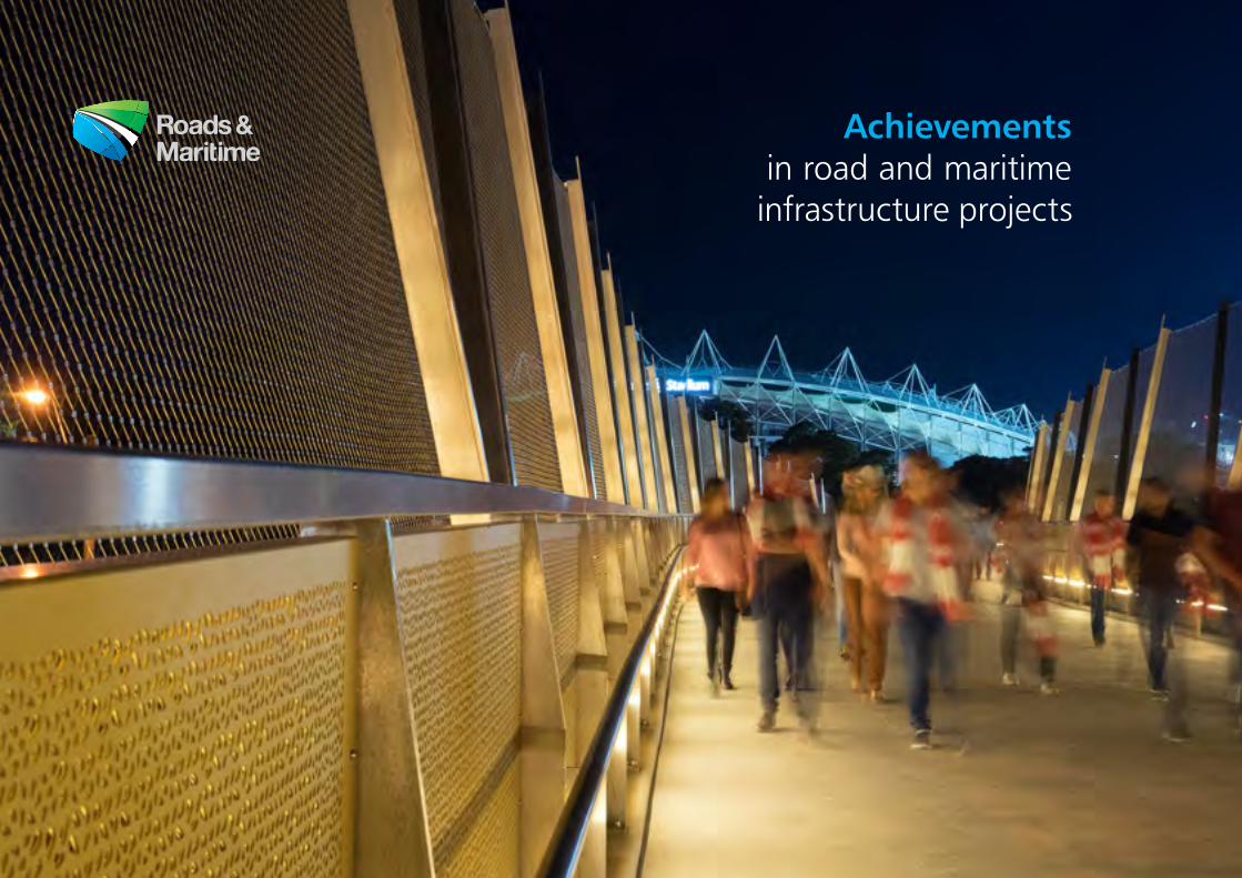
Football fans on the Albert 'Tibby' Cotter Walkway
Acknowledgements
Prepared and compiled by the Roads and Maritime Services Centre for Urban Design with contributions from project teams across the
organisation. Photographs courtesy of Roads and Maritime unless otherwise indicated.
Contents
Minister’s Foreword 2
Chief Executive’s Foreword 3
Pacific Highway Upgrade ∕ Tintenbar to Ewingsdale 4
Camden Valley Way ∕ South West Sydney 6
Albert ‘Tibby’ Cotter Walkway ∕ Sydney 8
Princes Highway Upgrade ∕ Gerringong 10
Moree Bypass Stage Two ∕ Moree 12
Great Western Highway Upgrade ∕ Bullaburra 14
Feature lighting ∕ NSW 16
Princes Highway Upgrade ∕ South Nowra 18
Newcastle Inner City Bypass ∕ Shortland to Sandgate 20
Pacific Highway Upgrade ∕ Sapphire to Woolgoolga 22
Hunter Expressway 24
Rest Area Signage ∕ NSW Road Network 26
ANZAC Bridge Maintenance Project ∕ Sydney 28
Commuter Wharf Upgrade Program ∕ Sydney 30
Central Coast Highway Upgrade ∕ Erina and Wamberal 32
M2 Motorway Upgrade ∕ Sydney 34
Hume Highway Duplication ∕ Southern Town Bypasses 36
Pacific Highway Upgrade ∕ Bulahdelah Bypass 38
Pacific Highway Upgrade ∕ Kempsey Bypass 40
M1 Pacific Motorway ∕ Tuggerah Interchange 42
Princes Highway Upgrade ∕ Victoria Creek 44
Epping Road Pedestrian Bridge ∕ Marsfield 46
Pacific Highway Upgrade ∕ Banora Point 48
Great Western Highway Upgrade ∕ Lawson 50
Great Western Highway Upgrade ∕ Wentworth Falls East 52
Pacific Highway Upgrade ∕ Glenugie 54
Cammeray Bus Layover ∕ Warringah Freeway 56
Third Crossing of the Hunter River ∕ Maitland 58
Better Boating Program ∕ NSW waterways 60
Pacific Highway Upgrade ∕ Ballina 62
Greening corridors ∕ NSW 64
Working in the Network ∕ Parramatta, Rozelle and Milsons Point 66
Creative solutions ∕ NSW road network 68
Roads and Maritime Services Urban Design Guidelines 70
1
There has never been a more exciting time to be involved in road and maritime infrastructure in NSW. Better infrastructure means less time commuting and more time spent productively at work, home or with family.
Everywhere you look in NSW there is action on the ground and this book focuses on the excellent work of Roads and Maritime Services and highlights the quality of projects completed and sets a benchmark for future work.
I am proud of what we have achieved; the new ferry wharfs for commuters and tourists, Pacific Highway upgrades in northern NSW, Princes Highway upgrades, essential pedestrian bridges for safe crossings and new roads in Western Sydney. We need to continue this excellent work and get more outstanding and well-designed projects completed in the future.
The historic investment in infrastructure by the NSW government means more work, more jobs, better cities and most importantly it means great business and economic confidence for our state.
The projects in this book demonstrate we are focused on doing the job right for the people of NSW and for generations to come.
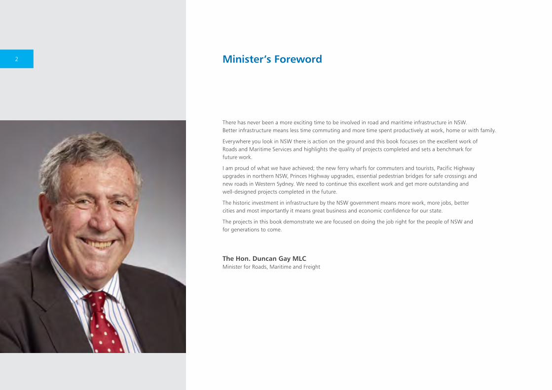
The Hon. Duncan Gay MLC Minister for Roads, Maritime and Freight
Minister’s Foreword2
Roads and Maritime Services is proactive in its efforts to deliver high-quality infrastructure and first-rate projects for all communities throughout NSW.
This latest edition of Achievements in Road and Maritime Infrastructure Projects is testament to the significant body of work recently finished and highlights the major improvements in road and maritime safety.
Our organisation maintains its focus to work to integrate engineering and urban design to ensure all of our projects are sensitive to the landscape and environmental settings.
We have great examples of quality design and construction in this book that responds to the needs of the economy, nearby communities, environment and the travelling public.
Achievements in Road and Maritime Infrastructure Projects is an opportunity to recognise the efforts of staff and contractors who have contributed to the planning, design and construction of Road and Maritime projects.
We trust you will take inspiration from the projects showcased in this publication and we look forward to many more editions.
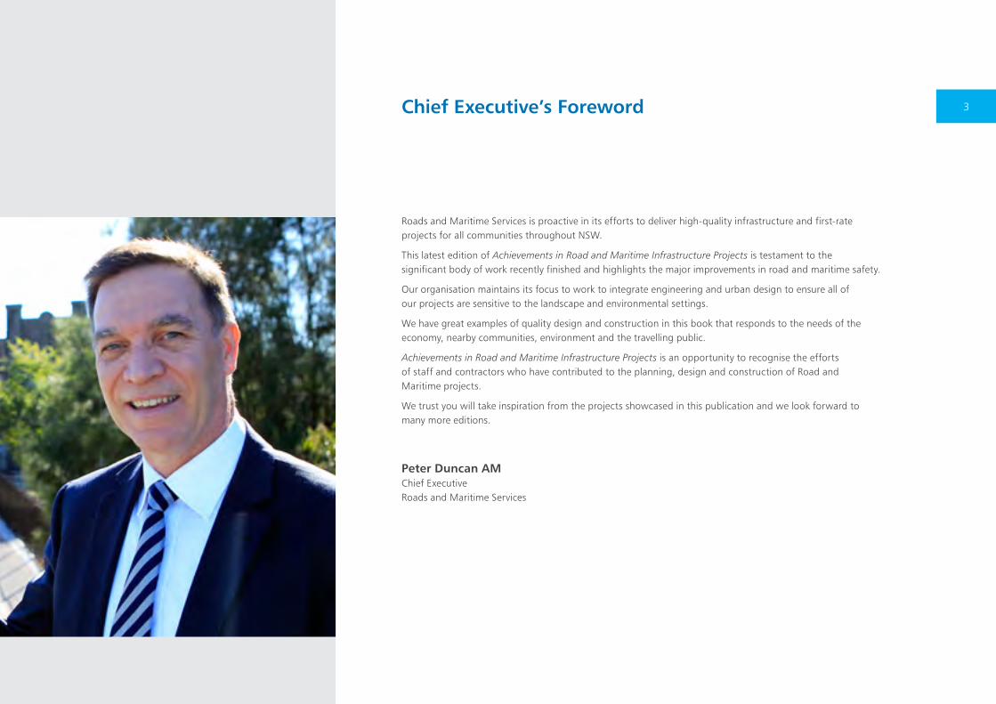
Peter Duncan AM Chief Executive Roads and Maritime Services
Chief Executive’s Foreword 3
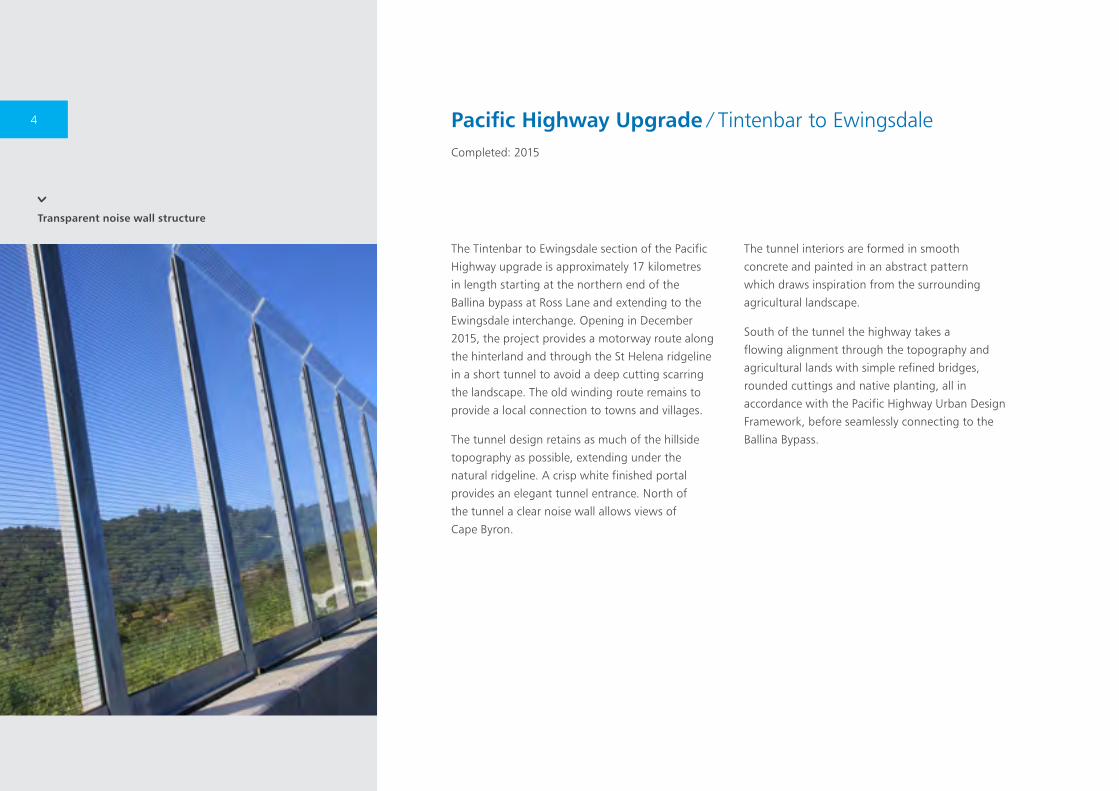
Transparent noise wall structure
The Tintenbar to Ewingsdale section of the Pacific
Highway upgrade is approximately 17 kilometres
in length starting at the northern end of the
Ballina bypass at Ross Lane and extending to the
Ewingsdale interchange. Opening in December
2015, the project provides a motorway route along
the hinterland and through the St Helena ridgeline
in a short tunnel to avoid a deep cutting scarring
the landscape. The old winding route remains to
provide a local connection to towns and villages.
The tunnel design retains as much of the hillside
topography as possible, extending under the
natural ridgeline. A crisp white finished portal
provides an elegant tunnel entrance. North of
the tunnel a clear noise wall allows views of
Cape Byron.
The tunnel interiors are formed in smooth
concrete and painted in an abstract pattern
which draws inspiration from the surrounding
agricultural landscape.
South of the tunnel the highway takes a
flowing alignment through the topography and
agricultural lands with simple refined bridges,
rounded cuttings and native planting, all in
accordance with the Pacific Highway Urban Design
Framework, before seamlessly connecting to the
Ballina Bypass.
Pacific Highway Upgrade ∕ Tintenbar to EwingsdaleCompleted: 2015
4
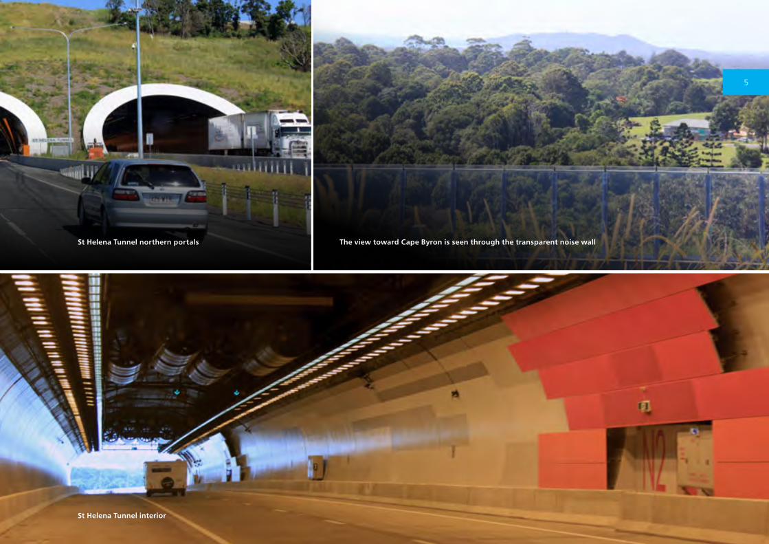
St Helena Tunnel interior
St Helena Tunnel northern portals The view toward Cape Byron is seen through the transparent noise wall
5
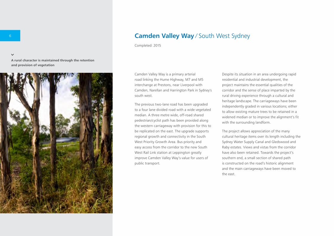
A rural character is maintained through the retention and provision of vegetation
Camden Valley Way is a primary arterial
road linking the Hume Highway, M7 and M5
interchange at Prestons, near Liverpool with
Camden, Narellan and Harrington Park in Sydney's
south west.
The previous two-lane road has been upgraded
to a four lane divided road with a wide vegetated
median. A three metre wide, off-road shared
pedestrian/cyclist path has been provided along
the western carriageway with provision for this to
be replicated on the east. The upgrade supports
regional growth and connectivity in the South
West Priority Growth Area. Bus priority and
easy access from the corridor to the new South
West Rail Link station at Leppington greatly
improve Camden Valley Way’s value for users of
public transport.
Despite its situation in an area undergoing rapid
residential and industrial development, the
project maintains the essential qualities of the
corridor and the sense of place imparted by the
rural driving experience through a cultural and
heritage landscape. The carriageways have been
independently graded in various locations; either
to allow existing mature trees to be retained in a
widened median or to improve the alignment’s fit
with the surrounding landform.
The project allows appreciation of the many
cultural heritage items over its length including the
Sydney Water Supply Canal and Gledswood and
Raby estates. Views and vistas from the corridor
have also been retained. Towards the project’s
southern end, a small section of shared path
is constructed on the road’s historic alignment
and the main carriageways have been moved to
the east.
Camden Valley Way ∕ South West SydneyCompleted: 2015
6
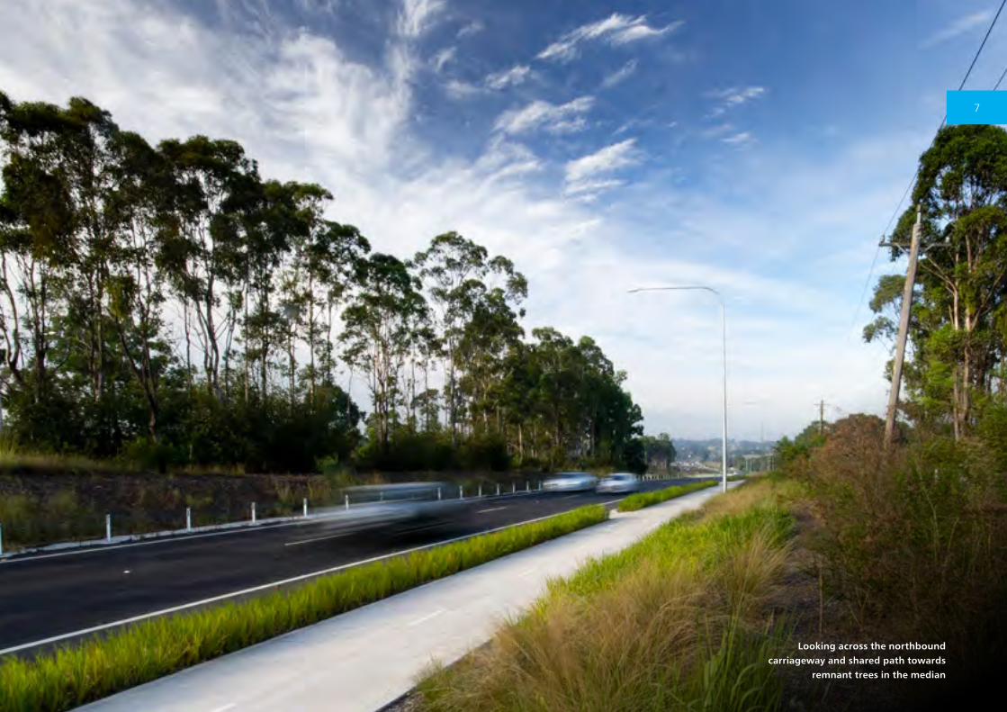
Looking across the northbound carriageway and shared path towards
remnant trees in the median
7
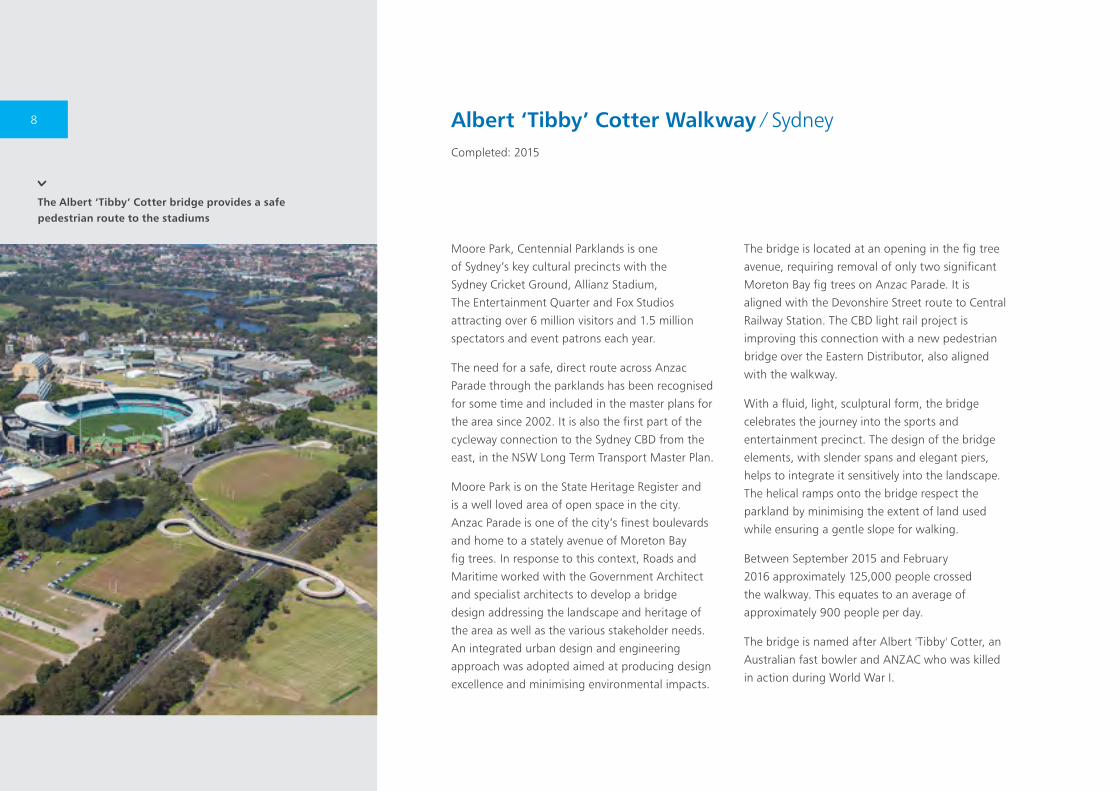
The Albert ‘Tibby’ Cotter bridge provides a safe pedestrian route to the stadiums
Moore Park, Centennial Parklands is one
of Sydney’s key cultural precincts with the
Sydney Cricket Ground, Allianz Stadium,
The Entertainment Quarter and Fox Studios
attracting over 6 million visitors and 1.5 million
spectators and event patrons each year.
The need for a safe, direct route across Anzac
Parade through the parklands has been recognised
for some time and included in the master plans for
the area since 2002. It is also the first part of the
cycleway connection to the Sydney CBD from the
east, in the NSW Long Term Transport Master Plan.
Moore Park is on the State Heritage Register and
is a well loved area of open space in the city.
Anzac Parade is one of the city’s finest boulevards
and home to a stately avenue of Moreton Bay
fig trees. In response to this context, Roads and
Maritime worked with the Government Architect
and specialist architects to develop a bridge
design addressing the landscape and heritage of
the area as well as the various stakeholder needs.
An integrated urban design and engineering
approach was adopted aimed at producing design
excellence and minimising environmental impacts.
The bridge is located at an opening in the fig tree
avenue, requiring removal of only two significant
Moreton Bay fig trees on Anzac Parade. It is
aligned with the Devonshire Street route to Central
Railway Station. The CBD light rail project is
improving this connection with a new pedestrian
bridge over the Eastern Distributor, also aligned
with the walkway.
With a fluid, light, sculptural form, the bridge
celebrates the journey into the sports and
entertainment precinct. The design of the bridge
elements, with slender spans and elegant piers,
helps to integrate it sensitively into the landscape.
The helical ramps onto the bridge respect the
parkland by minimising the extent of land used
while ensuring a gentle slope for walking.
Between September 2015 and February
2016 approximately 125,000 people crossed
the walkway. This equates to an average of
approximately 900 people per day.
The bridge is named after Albert 'Tibby' Cotter, an
Australian fast bowler and ANZAC who was killed
in action during World War I.
Albert ‘Tibby’ Cotter Walkway ∕ SydneyCompleted: 2015
8
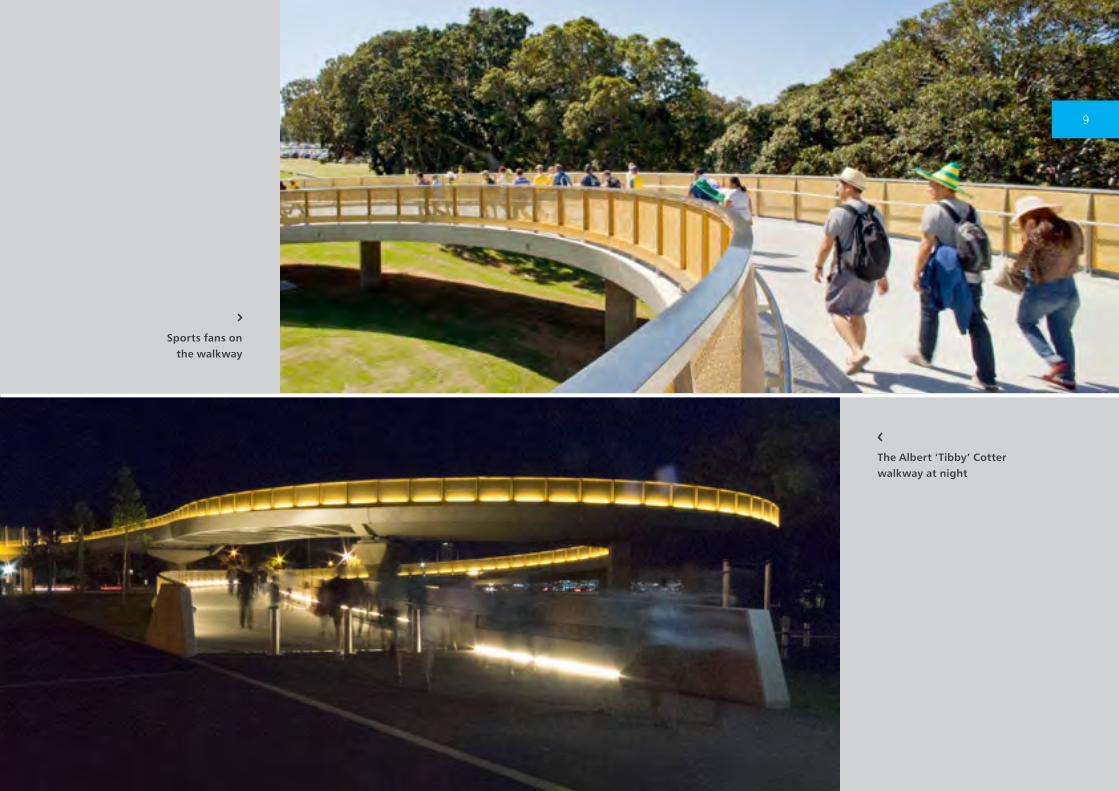
Sports fans on the walkway
The Albert ‘Tibby’ Cotter walkway at night
9
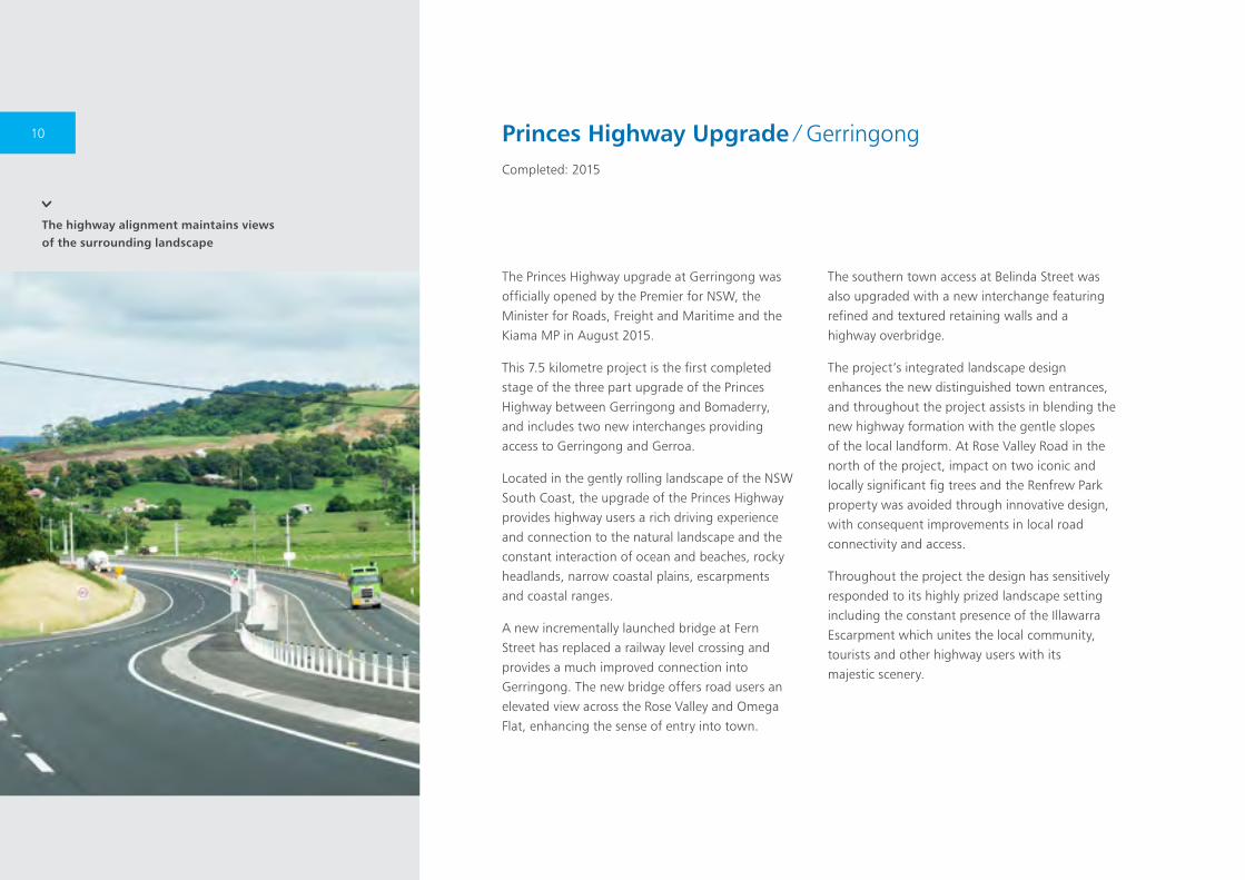
The highway alignment maintains views of the surrounding landscape
Princes Highway Upgrade ∕ GerringongCompleted: 2015
The Princes Highway upgrade at Gerringong was officially opened by the Premier for NSW, the Minister for Roads, Freight and Maritime and the Kiama MP in August 2015.
This 7.5 kilometre project is the first completed stage of the three part upgrade of the Princes Highway between Gerringong and Bomaderry, and includes two new interchanges providing access to Gerringong and Gerroa.
Located in the gently rolling landscape of the NSW South Coast, the upgrade of the Princes Highway provides highway users a rich driving experience and connection to the natural landscape and the constant interaction of ocean and beaches, rocky headlands, narrow coastal plains, escarpments and coastal ranges.
A new incrementally launched bridge at Fern Street has replaced a railway level crossing and provides a much improved connection into Gerringong. The new bridge offers road users an elevated view across the Rose Valley and Omega Flat, enhancing the sense of entry into town.
The southern town access at Belinda Street was also upgraded with a new interchange featuring refined and textured retaining walls and a highway overbridge.
The project’s integrated landscape design enhances the new distinguished town entrances, and throughout the project assists in blending the new highway formation with the gentle slopes of the local landform. At Rose Valley Road in the north of the project, impact on two iconic and locally significant fig trees and the Renfrew Park property was avoided through innovative design, with consequent improvements in local road connectivity and access.
Throughout the project the design has sensitively responded to its highly prized landscape setting including the constant presence of the Illawarra Escarpment which unites the local community, tourists and other highway users with its majestic scenery.
10
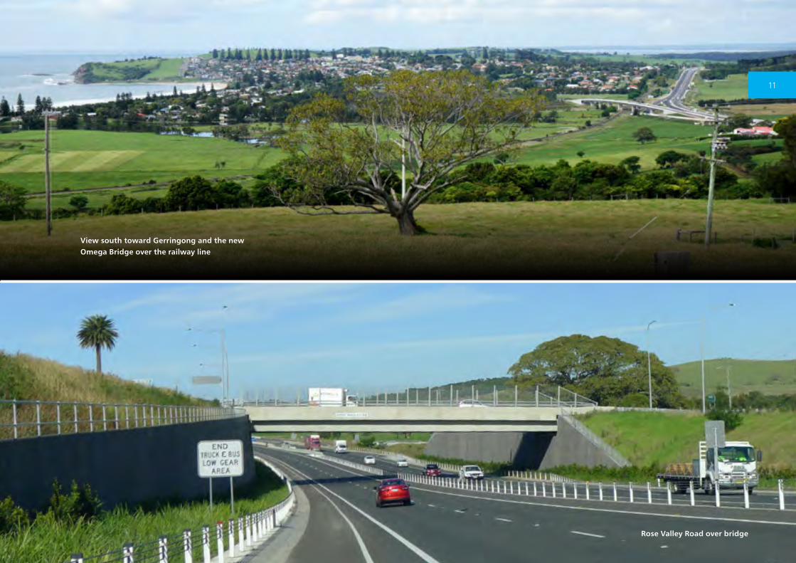
Rose Valley Road over bridge
View south toward Gerringong and the new Omega Bridge over the railway line
11
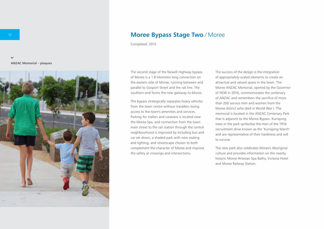
The second stage of the Newell Highway bypass
of Moree is a 1.8 kilometre long connection on
the eastern side of Moree, running between and
parallel to Gosport Street and the rail line. The
southern end forms the new gateway to Moree.
The bypass strategically separates heavy vehicles
from the town centre without travellers losing
access to the town's amenities and services.
Parking for trailers and caravans is located near
the Moree Spa, and connection from the town
main street to the rail station through the central
neighbourhood is improved by including bus and
car set down, a shaded park with new seating
and lighting, and streetscape chosen to both
complement the character of Moree and improve
the safety at crossings and intersections.
The success of the design is the integration
of appropriately-scaled elements to create an
attractive and valued space in the town. The
Moree ANZAC Memorial, opened by the Governor
of NSW in 2016, commemorates the centenary
of ANZAC and remembers the sacrifice of more
than 200 service men and women from the
Moree district who died in World War I. The
memorial is located in the ANZAC Centenary Park
that is adjacent to the Moree Bypass. Kurrajong
trees in the park symbolise the men of the 1916
recruitment drive known as the ‘Kurrajong March’
and are representative of their hardiness and will
to survive.
The new park also celebrates Moree's Aboriginal
culture and provides information on the nearby
historic Moree Artesian Spa Baths, Victoria Hotel
and Moree Railway Station.
Moree Bypass Stage Two ∕ MoreeCompleted: 2015
ANZAC Memorial – plaques
12
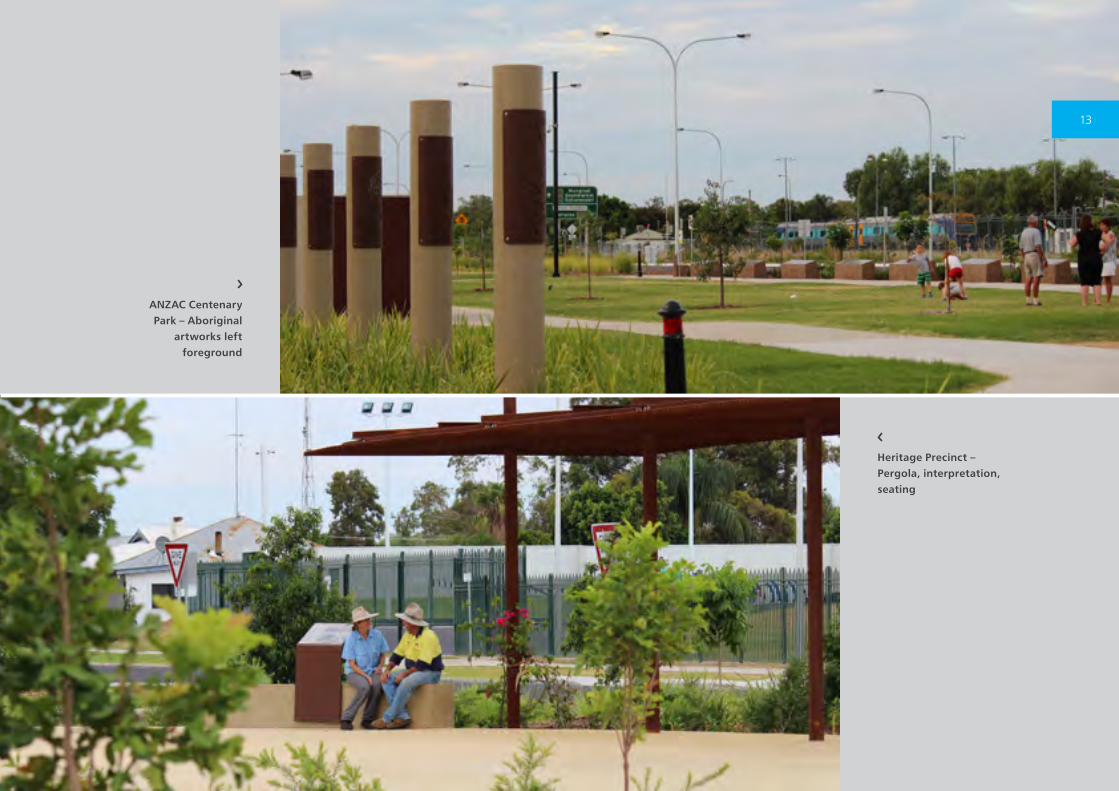
Heritage Precinct – Pergola, interpretation, seating
ANZAC Centenary Park – Aboriginal
artworks left foreground
13
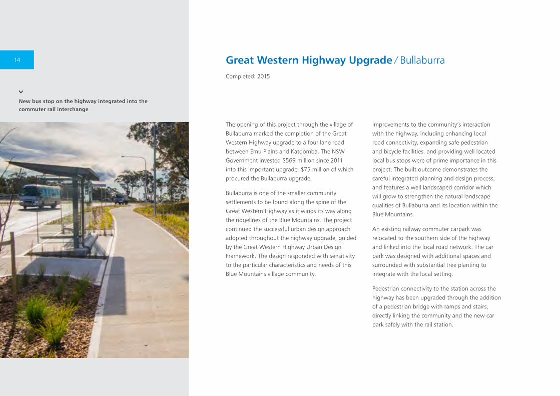
New bus stop on the highway integrated into the commuter rail interchange
The opening of this project through the village of
Bullaburra marked the completion of the Great
Western Highway upgrade to a four lane road
between Emu Plains and Katoomba. The NSW
Government invested $569 million since 2011
into this important upgrade, $75 million of which
procured the Bullaburra upgrade.
Bullaburra is one of the smaller community
settlements to be found along the spine of the
Great Western Highway as it winds its way along
the ridgelines of the Blue Mountains. The project
continued the successful urban design approach
adopted throughout the highway upgrade, guided
by the Great Western Highway Urban Design
Framework. The design responded with sensitivity
to the particular characteristics and needs of this
Blue Mountains village community.
Improvements to the community’s interaction
with the highway, including enhancing local
road connectivity, expanding safe pedestrian
and bicycle facilities, and providing well located
local bus stops were of prime importance in this
project. The built outcome demonstrates the
careful integrated planning and design process,
and features a well landscaped corridor which
will grow to strengthen the natural landscape
qualities of Bullaburra and its location within the
Blue Mountains.
An existing railway commuter carpark was
relocated to the southern side of the highway
and linked into the local road network. The car
park was designed with additional spaces and
surrounded with substantial tree planting to
integrate with the local setting.
Pedestrian connectivity to the station across the
highway has been upgraded through the addition
of a pedestrian bridge with ramps and stairs,
directly linking the community and the new car
park safely with the rail station.
Great Western Highway Upgrade ∕ BullaburraCompleted: 2015
14
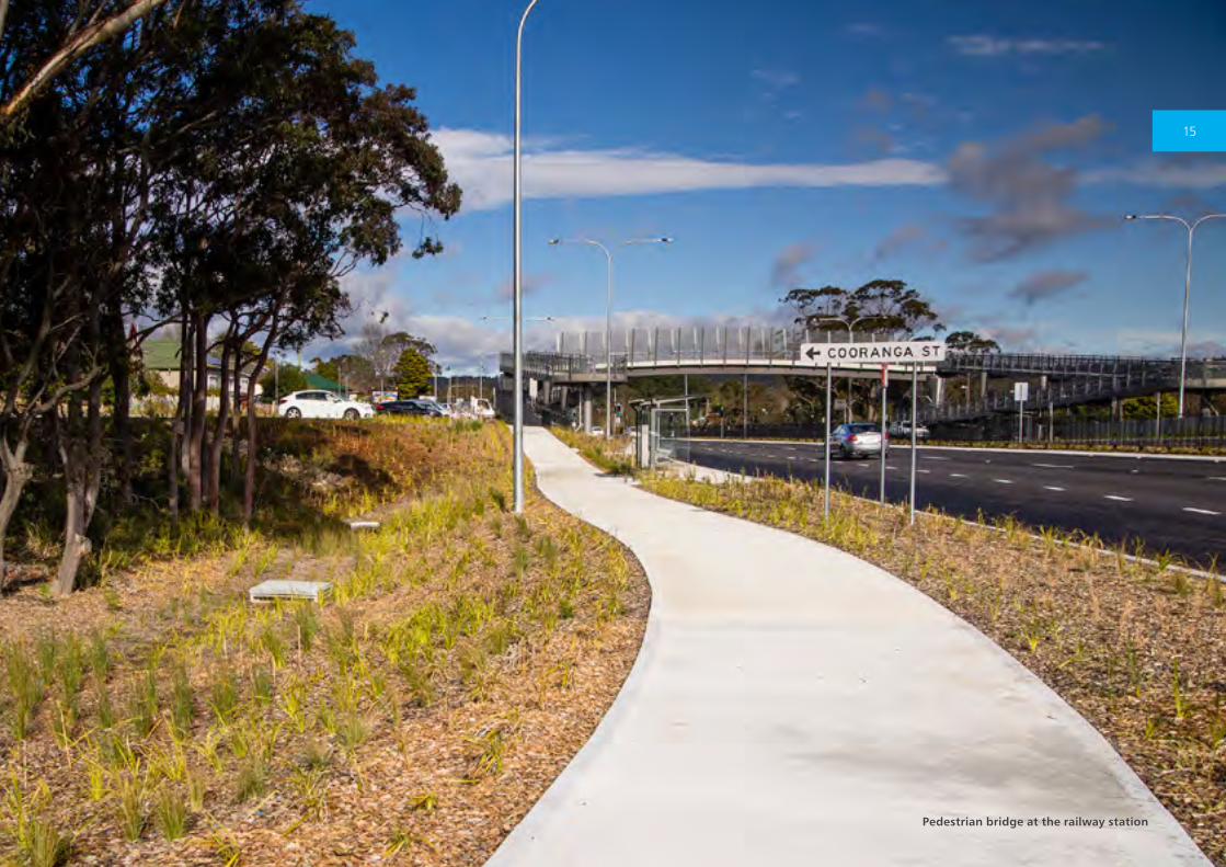
Pedestrian bridge at the railway station
15
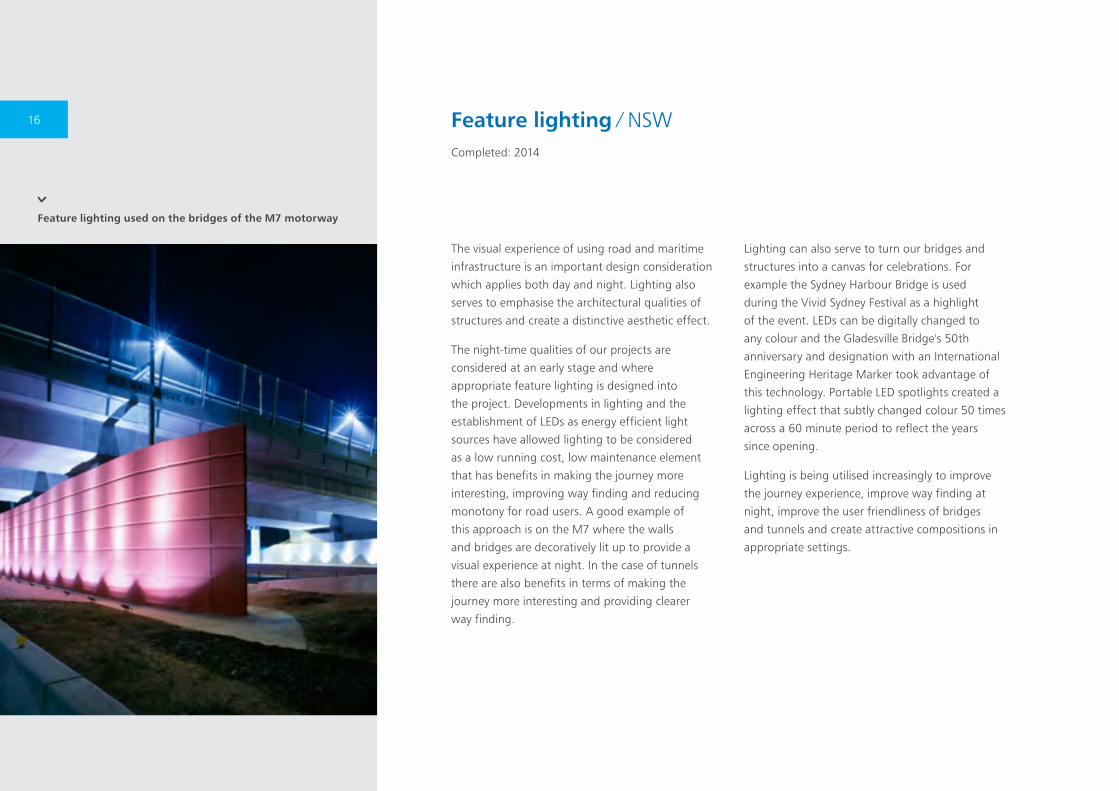
Feature lighting used on the bridges of the M7 motorway
The visual experience of using road and maritime
infrastructure is an important design consideration
which applies both day and night. Lighting also
serves to emphasise the architectural qualities of
structures and create a distinctive aesthetic effect.
The night-time qualities of our projects are
considered at an early stage and where
appropriate feature lighting is designed into
the project. Developments in lighting and the
establishment of LEDs as energy efficient light
sources have allowed lighting to be considered
as a low running cost, low maintenance element
that has benefits in making the journey more
interesting, improving way finding and reducing
monotony for road users. A good example of
this approach is on the M7 where the walls
and bridges are decoratively lit up to provide a
visual experience at night. In the case of tunnels
there are also benefits in terms of making the
journey more interesting and providing clearer
way finding.
Lighting can also serve to turn our bridges and
structures into a canvas for celebrations. For
example the Sydney Harbour Bridge is used
during the Vivid Sydney Festival as a highlight
of the event. LEDs can be digitally changed to
any colour and the Gladesville Bridge's 50th
anniversary and designation with an International
Engineering Heritage Marker took advantage of
this technology. Portable LED spotlights created a
lighting effect that subtly changed colour 50 times
across a 60 minute period to reflect the years
since opening.
Lighting is being utilised increasingly to improve
the journey experience, improve way finding at
night, improve the user friendliness of bridges
and tunnels and create attractive compositions in
appropriate settings.
Feature lighting ∕ NSWCompleted: 2014
16
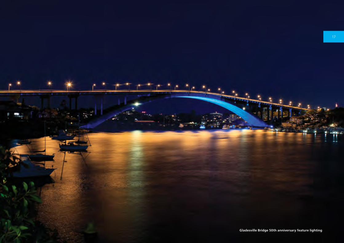
Gladesville Bridge 50th anniversary feature lighting
17
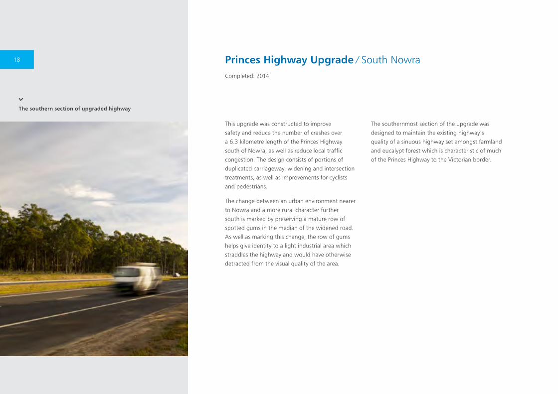
The southern section of upgraded highway
This upgrade was constructed to improve
safety and reduce the number of crashes over
a 6.3 kilometre length of the Princes Highway
south of Nowra, as well as reduce local traffic
congestion. The design consists of portions of
duplicated carriageway, widening and intersection
treatments, as well as improvements for cyclists
and pedestrians.
The change between an urban environment nearer
to Nowra and a more rural character further
south is marked by preserving a mature row of
spotted gums in the median of the widened road.
As well as marking this change, the row of gums
helps give identity to a light industrial area which
straddles the highway and would have otherwise
detracted from the visual quality of the area.
The southernmost section of the upgrade was
designed to maintain the existing highway’s
quality of a sinuous highway set amongst farmland
and eucalypt forest which is characteristic of much
of the Princes Highway to the Victorian border.
Princes Highway Upgrade ∕ South NowraCompleted: 2014
18

The upgraded highway with spotted gums in the median
19

View of the bypass looking north
The 1.8 kilometre Shortland to Sandgate project
forms the northern extent of the Newcastle Inner
City Bypass.
Although relatively short, the project takes in a
number of features which make this an interesting
route from the road user’s perspective. The road
descends from a ridge at its northern extent across
the Main Northern Rail Line and a tributary of
Ironbark Creek. Adjacent to the north east is the
historic Sandgate Cemetery. Hunter Wetlands
Centre, a regionally significant ecological and
educational facility, sits to the west. The southern
extent joins onto a previously completed stage of
the bypass at a new bridge under Sandgate Road.
Existing vegetation is primarily grazing land with
groups and lines of natives and introduced trees.
This combination of relatively flat land with trees
generally blocks long distance views, however on
the higher areas panoramic views above the trees
are available. New bridges cross the creek tributary
and the railway line.
The intersection at the Pacific Highway at the
northern extent is marked by a grove of Araucaria
trees, which reflect the cultural planting in
Sandgate Cemetery. The retaining walls in the
project are articulated with texture and oxide to
add interest. Terraced areas behind the retaining
walls at the southern limit of work at the
underpass beneath Sandgate Road have created
flatter ground to increase the amount of planting
possible. As the project passes over watercourses
and the Main Northern Railway Line, low planting
and open barriers are used to allow views of
the landscape.
Newcastle Inner City Bypass ∕ Shortland to SandgateCompleted: 2014
20
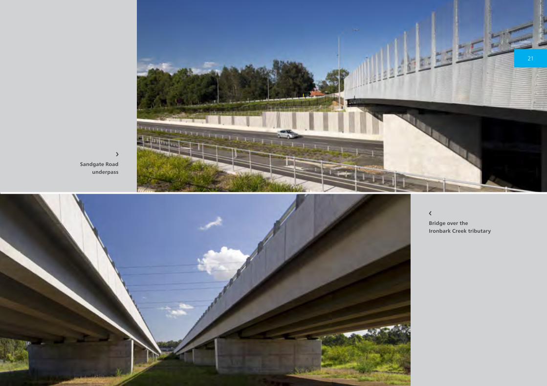
Bridge over the Ironbark Creek tributary
Sandgate Road underpass
21
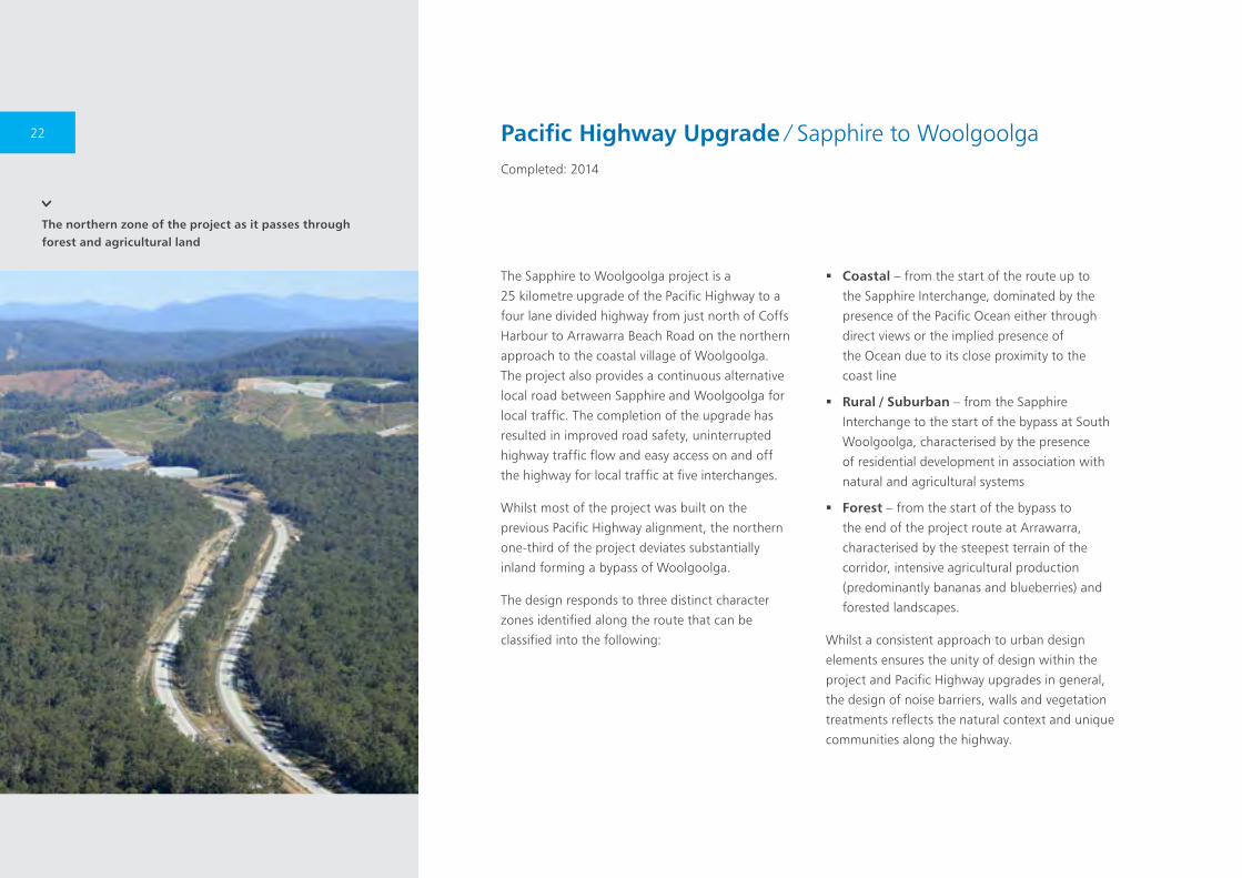
The northern zone of the project as it passes through forest and agricultural land
The Sapphire to Woolgoolga project is a
25 kilometre upgrade of the Pacific Highway to a
four lane divided highway from just north of Coffs
Harbour to Arrawarra Beach Road on the northern
approach to the coastal village of Woolgoolga.
The project also provides a continuous alternative
local road between Sapphire and Woolgoolga for
local traffic. The completion of the upgrade has
resulted in improved road safety, uninterrupted
highway traffic flow and easy access on and off
the highway for local traffic at five interchanges.
Whilst most of the project was built on the
previous Pacific Highway alignment, the northern
one-third of the project deviates substantially
inland forming a bypass of Woolgoolga.
The design responds to three distinct character
zones identified along the route that can be
classified into the following:
� Coastal – from the start of the route up to
the Sapphire Interchange, dominated by the
presence of the Pacific Ocean either through
direct views or the implied presence of
the Ocean due to its close proximity to the
coast line
� Rural / Suburban – from the Sapphire
Interchange to the start of the bypass at South
Woolgoolga, characterised by the presence
of residential development in association with
natural and agricultural systems
� Forest – from the start of the bypass to
the end of the project route at Arrawarra,
characterised by the steepest terrain of the
corridor, intensive agricultural production
(predominantly bananas and blueberries) and
forested landscapes.
Whilst a consistent approach to urban design
elements ensures the unity of design within the
project and Pacific Highway upgrades in general,
the design of noise barriers, walls and vegetation
treatments reflects the natural context and unique
communities along the highway.
Pacific Highway Upgrade ∕ Sapphire to WoolgoolgaCompleted: 2014
22
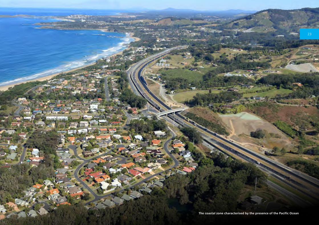
The coastal zone characterised by the presence of the Pacific Ocean
23

The alignment through the Sugarloaf Range
The 40 kilometre Hunter Expressway delivers a
four-lane motorway link between the M1 Pacific
Motorway, near Seahampton and the New
England Highway, west of Branxton. One of the
largest infrastructure projects ever undertaken
in NSW, the Hunter Expressway provides
significant improvements in travel time and
safety for motorists travelling in this part of the
Hunter region.
Heading west from the M1, travellers encounter
pristine bushland through the mountainous
Sugarloaf Range. Views from viaducts into the
bushland alternating with cuttings up to 30 metres
deep characterise this part of the project. The
motorway emerges from the Sugarloaf Range
onto the Buchanan floodplain, a broad valley with
expansive views both sides of the corridor fringed
by eucalypt forest.
Further west, more bushland in a gentle
undulating topography is experienced before
a high point is reached near Allandale, where
panoramic views to distant mountain ranges are
visible in both directions. The Spotted Gum Forest
east of Branxton, and Black Creek lowlands and
river, mark the point where the motorway rejoins
the existing New England Highway.
The project pioneered a method of revegetation
in which seed and mulch-rich soil was returned
immediately to finished batters. This has resulted
in successful re-establishment of native vegetation
without the need to purchase the quantity of seed
which would traditionally be required.
Winner of the ‘2013 Australian Engineering Excellence Award’ and a finalist in the ‘Building Infrastructure’ category of the 2014 Premier’s Public Sector Award.
Hunter ExpresswayCompleted: 2014
24
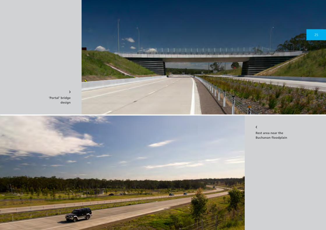
Rest area near the Buchanan floodplain
‘Portal’ bridge design
25
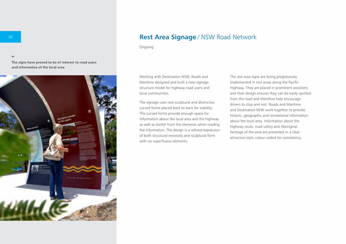
The signs have proved to be of interest to road users and informative of the local area
Working with Destination NSW, Roads and
Maritime designed and built a new signage
structure model for highway road users and
local communities.
The signage uses two sculptural and distinctive
curved forms placed back to back for stability.
The curved forms provide enough space for
information about the local area and the highway
as well as shelter from the elements when reading
the information. The design is a refined expression
of both structural necessity and sculptural form
with no superfluous elements.
The rest area signs are being progressively
implemented in rest areas along the Pacific
Highway. They are placed in prominent positions
and their design ensures they can be easily spotted
from the road and therefore help encourage
drivers to stop and rest. Roads and Maritime
and Destination NSW work together to provide
historic, geographic and recreational information
about the local area. Information about the
highway route, road safety and Aboriginal
heritage of the area are presented in a clear
attractive style, colour coded for consistency.
Rest Area Signage ∕ NSW Road NetworkOngoing
26

Hunter Expressway rest area
On the Pacific Highway the signage provides a sequential mapping and description of the Pacific Coast’s landscape, history and communities
27
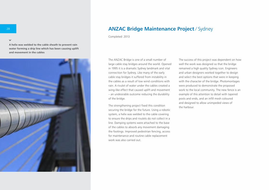
A helix was welded to the cable sheath to prevent rain water forming a drip line which has been causing uplift and movement in the cables
The ANZAC Bridge is one of a small number of
large cable stay bridges around the world. Opened
in 1995 it is a dramatic Sydney landmark and vital
connection for Sydney. Like many of the early
cable stay bridges it suffered from instability in
the cables as a result of low wind conditions with
rain. A rivulet of water under the cables created a
wing-like effect that caused uplift and movement
– an undesirable outcome reducing the durability
of the bridge.
The strengthening project fixed this condition
securing the bridge for the future. Using a robotic
system, a helix was welded to the cable covering
to ensure the drips and rivulets do not collect in a
line. Damping systems were attached to the base
of the cables to absorb any movement damaging
the footings. Improved pedestrian fencing, access
for maintenance and routine cable replacement
work was also carried out.
The success of this project was dependent on how
well the work was designed so that the bridge
remained a high quality Sydney icon. Engineers
and urban designers worked together to design
and select the best options that were in keeping
with the character of the bridge. Photomontages
were produced to demonstrate the proposed
work to the local community. The new fence is an
example of this attention to detail with tapered
posts and ends, and an infill mesh coloured
and designed to allow unimpeded views of
the harbour.
ANZAC Bridge Maintenance Project ∕ SydneyCompleted: 2013
28
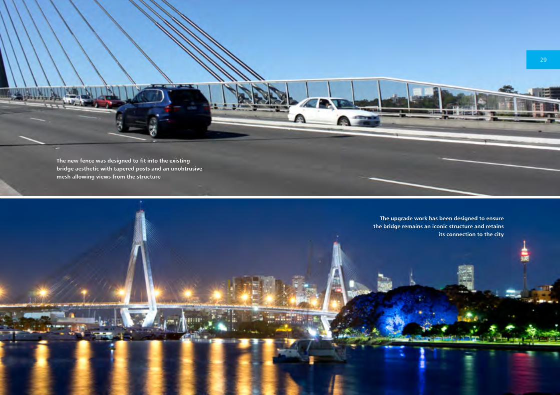
The new fence was designed to fit into the existing bridge aesthetic with tapered posts and an unobtrusive mesh allowing views from the structure
The upgrade work has been designed to ensure the bridge remains an iconic structure and retains
its connection to the city
29

Rose Bay
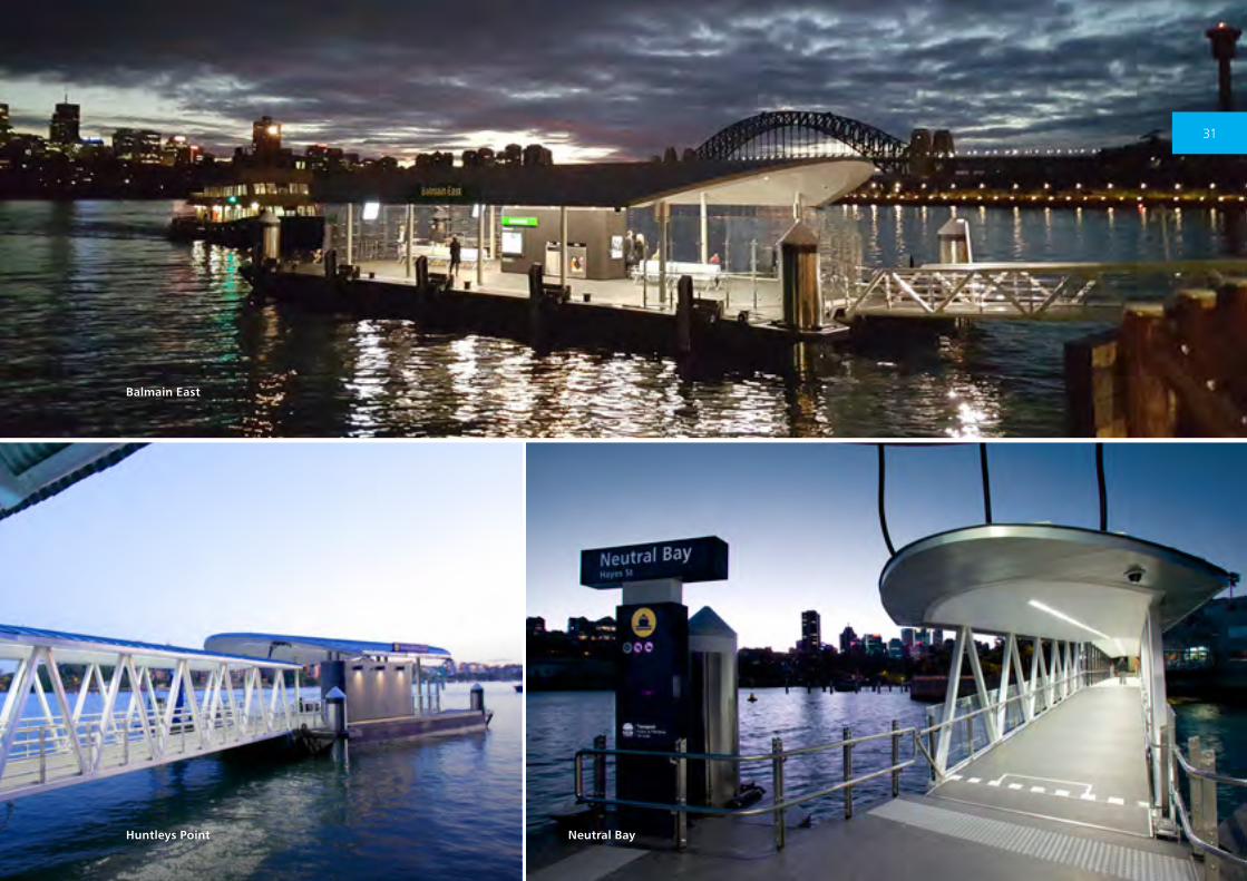
Commuter Wharf Upgrade Program ∕ SydneyOngoing
Around 14.7 million trips are made on the Sydney
Harbour ferry network every year. There are 47
commuter wharves in Sydney Harbour and the
Parramatta River. The Wharf Upgrade Program
aims to modernise wharves and represents a new
approach to ferry infrastructure.
The new wharves, developed from the prototype
constructed at Milsons Point, are architect
designed and purpose built to provide a
sophisticated public space for commuters and
tourists. Optimising the vistas available at wharf
locations on Sydney Harbour is a major factor in
design considerations. Comfort and functionality
are of paramount concern in the design, ensuring
adequate space and amenity is provided to
patrons. Generously proportioned ramps and
pathways facilitate easy passenger flow.
The new designs allow for the use of dual
gangways to reduce dwell times at wharves as
well as providing wheelchair access, hearing
loops for the hearing impaired, aids for visual
impairment, improved customer information and
the new Opal ticketing system. Value for money
was provided through the selection of materials
that minimise ongoing maintenance costs.
Since 2010 the Commuter Wharf Upgrade
Program has delivered new wharves at Milsons
Point, Neutral Bay, Rose Bay, Balmain (Thames
Street), Huntleys Point, Mosman Bay, Balmain East,
Cremorne Point, Drummoyne, Sydney Olympic
Park, and Pyrmont. Further wharf upgrades will be
progressively delivered in the coming years.
30
Neutral BayHuntleys Point
Balmain East
31
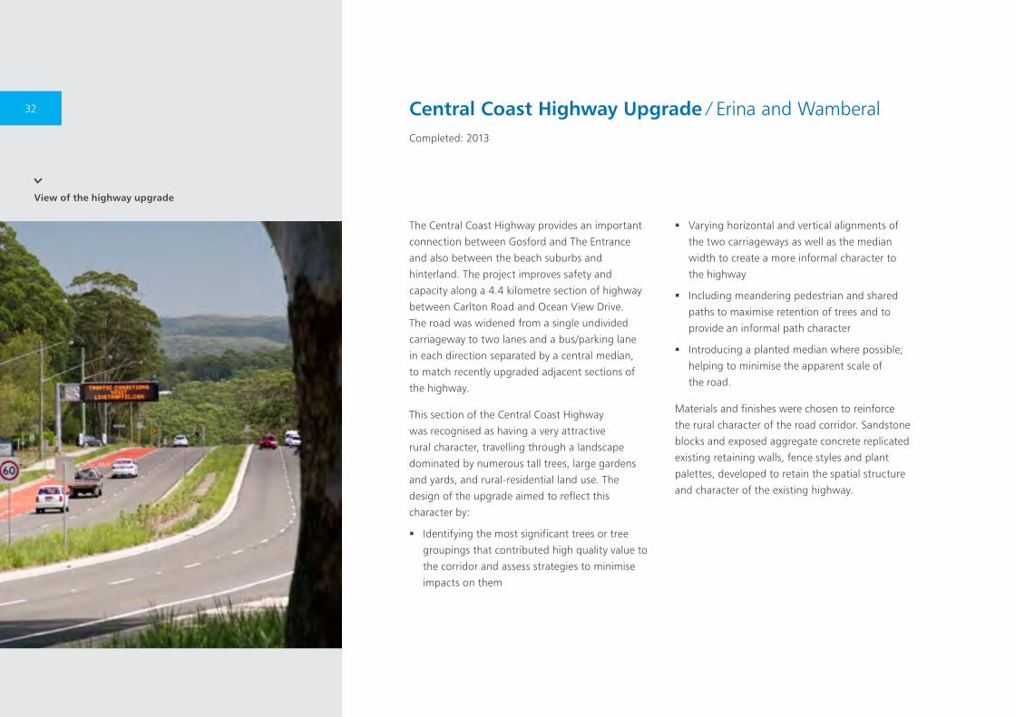
View of the highway upgrade
The Central Coast Highway provides an important
connection between Gosford and The Entrance
and also between the beach suburbs and
hinterland. The project improves safety and
capacity along a 4.4 kilometre section of highway
between Carlton Road and Ocean View Drive.
The road was widened from a single undivided
carriageway to two lanes and a bus/parking lane
in each direction separated by a central median,
to match recently upgraded adjacent sections of
the highway.
This section of the Central Coast Highway
was recognised as having a very attractive
rural character, travelling through a landscape
dominated by numerous tall trees, large gardens
and yards, and rural-residential land use. The
design of the upgrade aimed to reflect this
character by:
� Identifying the most significant trees or tree
groupings that contributed high quality value to
the corridor and assess strategies to minimise
impacts on them
� Varying horizontal and vertical alignments of
the two carriageways as well as the median
width to create a more informal character to
the highway
� Including meandering pedestrian and shared
paths to maximise retention of trees and to
provide an informal path character
� Introducing a planted median where possible;
helping to minimise the apparent scale of
the road.
Materials and finishes were chosen to reinforce
the rural character of the road corridor. Sandstone
blocks and exposed aggregate concrete replicated
existing retaining walls, fence styles and plant
palettes, developed to retain the spatial structure
and character of the existing highway.
Central Coast Highway Upgrade ∕ Erina and WamberalCompleted: 2013
32

Low sandstone retaining walls were used to protect the
roots of existing trees being retained
The highway upgrade at Brooks Hill, with a split carriageway and retaining wall to achieve a better fit of the project with topography
33
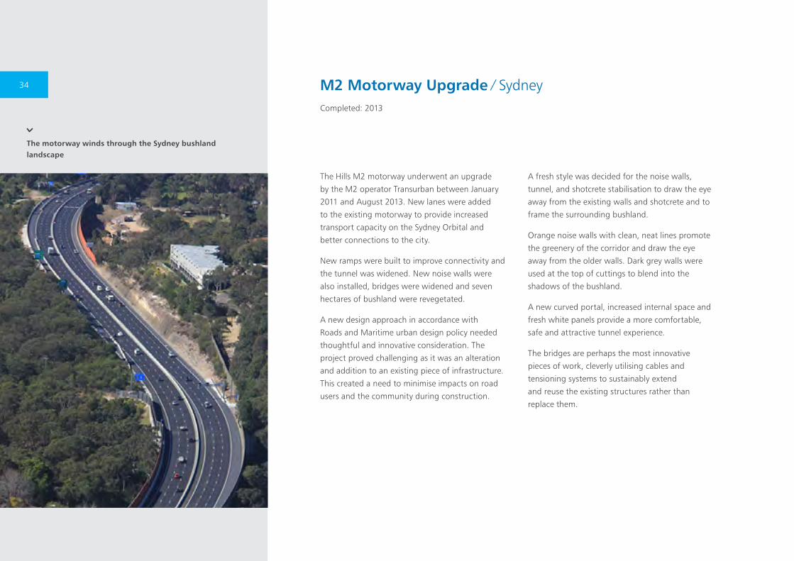
The motorway winds through the Sydney bushland landscape
The Hills M2 motorway underwent an upgrade
by the M2 operator Transurban between January
2011 and August 2013. New lanes were added
to the existing motorway to provide increased
transport capacity on the Sydney Orbital and
better connections to the city.
New ramps were built to improve connectivity and
the tunnel was widened. New noise walls were
also installed, bridges were widened and seven
hectares of bushland were revegetated.
A new design approach in accordance with
Roads and Maritime urban design policy needed
thoughtful and innovative consideration. The
project proved challenging as it was an alteration
and addition to an existing piece of infrastructure.
This created a need to minimise impacts on road
users and the community during construction.
A fresh style was decided for the noise walls,
tunnel, and shotcrete stabilisation to draw the eye
away from the existing walls and shotcrete and to
frame the surrounding bushland.
Orange noise walls with clean, neat lines promote
the greenery of the corridor and draw the eye
away from the older walls. Dark grey walls were
used at the top of cuttings to blend into the
shadows of the bushland.
A new curved portal, increased internal space and
fresh white panels provide a more comfortable,
safe and attractive tunnel experience.
The bridges are perhaps the most innovative
pieces of work, cleverly utilising cables and
tensioning systems to sustainably extend
and reuse the existing structures rather than
replace them.
M2 Motorway Upgrade ∕ SydneyCompleted: 2013
34
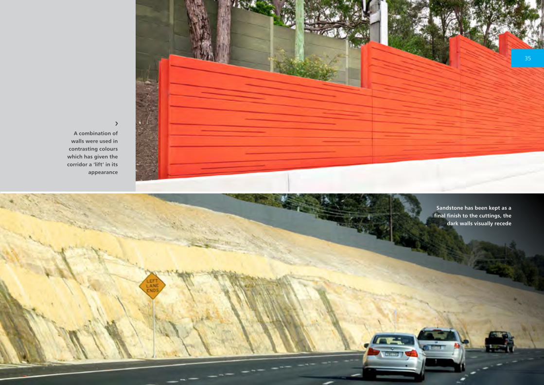
Sandstone has been kept as a final finish to the cuttings, the
dark walls visually recede
A combination of walls were used in
contrasting colours which has given the corridor a ‘lift’ in its
appearance
35
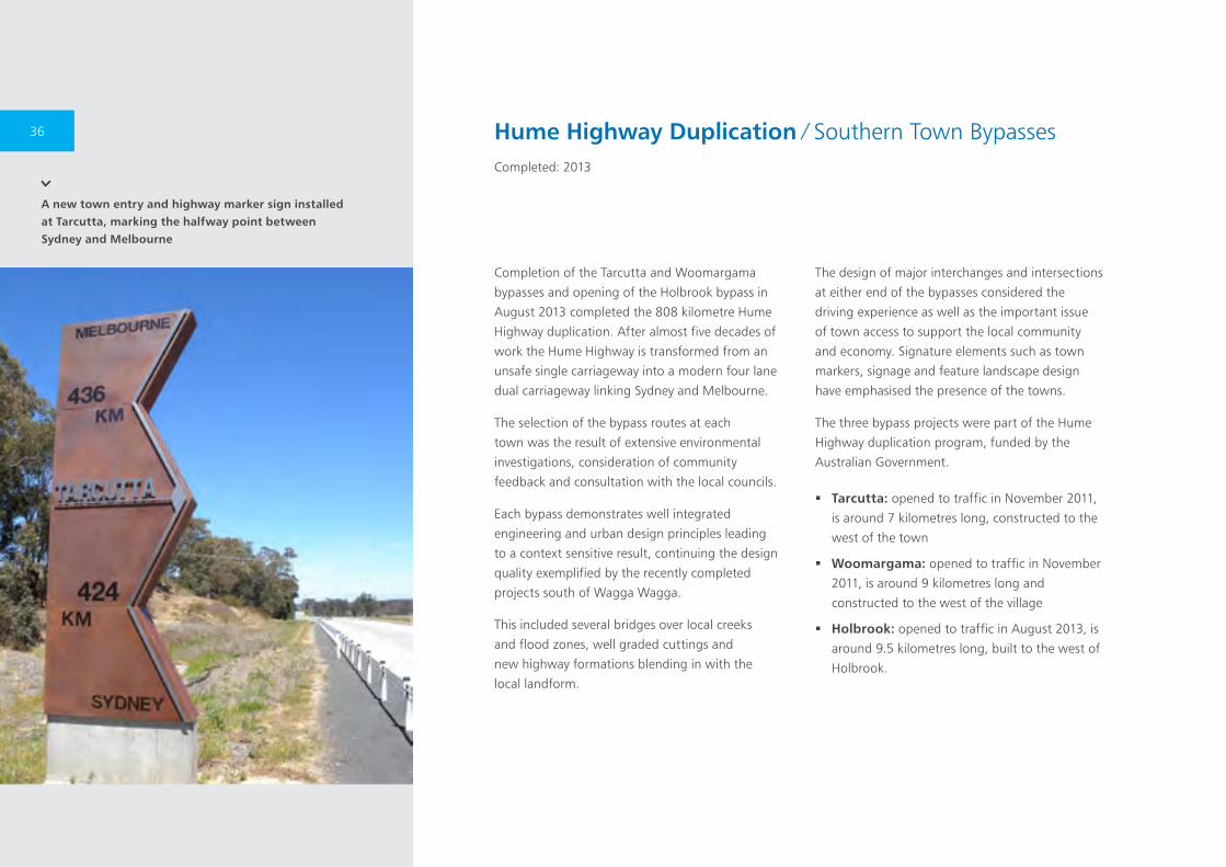
A new town entry and highway marker sign installed at Tarcutta, marking the halfway point between Sydney and Melbourne
Completion of the Tarcutta and Woomargama
bypasses and opening of the Holbrook bypass in
August 2013 completed the 808 kilometre Hume
Highway duplication. After almost five decades of
work the Hume Highway is transformed from an
unsafe single carriageway into a modern four lane
dual carriageway linking Sydney and Melbourne.
The selection of the bypass routes at each
town was the result of extensive environmental
investigations, consideration of community
feedback and consultation with the local councils.
Each bypass demonstrates well integrated
engineering and urban design principles leading
to a context sensitive result, continuing the design
quality exemplified by the recently completed
projects south of Wagga Wagga.
This included several bridges over local creeks
and flood zones, well graded cuttings and
new highway formations blending in with the
local landform.
The design of major interchanges and intersections
at either end of the bypasses considered the
driving experience as well as the important issue
of town access to support the local community
and economy. Signature elements such as town
markers, signage and feature landscape design
have emphasised the presence of the towns.
The three bypass projects were part of the Hume
Highway duplication program, funded by the
Australian Government.
� Tarcutta: opened to traffic in November 2011,
is around 7 kilometres long, constructed to the
west of the town
� Woomargama: opened to traffic in November
2011, is around 9 kilometres long and
constructed to the west of the village
� Holbrook: opened to traffic in August 2013, is
around 9.5 kilometres long, built to the west of
Holbrook.
Hume Highway Duplication ∕ Southern Town BypassesCompleted: 2013
36
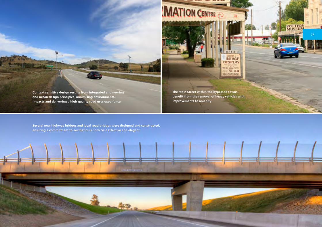
Several new highway bridges and local road bridges were designed and constructed, ensuring a commitment to aesthetics is both cost effective and elegant
Context sensitive design results from integrated engineering and urban design principles, minimising environmental impacts and delivering a high quality road user experience
The Main Street within the bypassed towns benefit from the removal of heavy vehicles with improvements to amenity
37
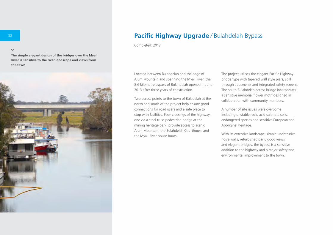
The simple elegant design of the bridges over the Myall River is sensitive to the river landscape and views from the town
Located between Bulahdelah and the edge of
Alum Mountain and spanning the Myall River, the
8.6 kilometre bypass of Bulahdelah opened in June
2013 after three years of construction.
Two access points to the town of Buladelah at the
north and south of the project help ensure good
connections for road users and a safe place to
stop with facilities. Four crossings of the highway,
one via a steel truss pedestrian bridge at the
mining heritage park, provide access to scenic
Alum Mountain, the Bulahdelah Courthouse and
the Myall River house boats.
The project utilises the elegant Pacific Highway
bridge type with tapered wall style piers, spill
through abutments and integrated safety screens.
The south Bulahdelah access bridge incorporates
a sensitive memorial flower motif designed in
collaboration with community members.
A number of site issues were overcome
including unstable rock, acid sulphate soils,
endangered species and sensitive European and
Aboriginal heritage.
With its extensive landscape, simple unobtrusive
noise walls, refurbished park, good views
and elegant bridges, the bypass is a sensitive
addition to the highway and a major safety and
environmental improvement to the town.
Pacific Highway Upgrade ∕ Bulahdelah BypassCompleted: 2013
38
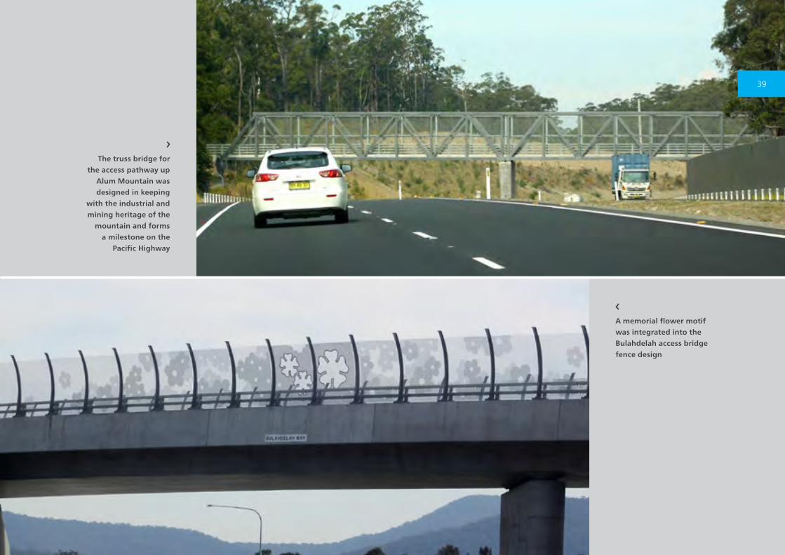
The truss bridge for the access pathway up
Alum Mountain was designed in keeping
with the industrial and mining heritage of the
mountain and forms a milestone on the
Pacific Highway
A memorial flower motif was integrated into the Bulahdelah access bridge fence design
39
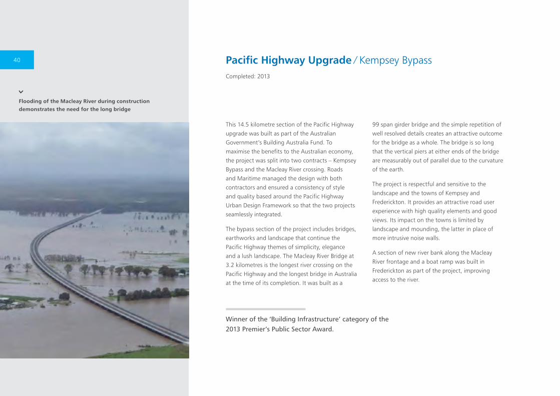
Flooding of the Macleay River during construction demonstrates the need for the long bridge
Pacific Highway Upgrade ∕ Kempsey BypassCompleted: 2013
This 14.5 kilometre section of the Pacific Highway
upgrade was built as part of the Australian
Government’s Building Australia Fund. To
maximise the benefits to the Australian economy,
the project was split into two contracts – Kempsey
Bypass and the Macleay River crossing. Roads
and Maritime managed the design with both
contractors and ensured a consistency of style
and quality based around the Pacific Highway
Urban Design Framework so that the two projects
seamlessly integrated.
The bypass section of the project includes bridges,
earthworks and landscape that continue the
Pacific Highway themes of simplicity, elegance
and a lush landscape. The Macleay River Bridge at
3.2 kilometres is the longest river crossing on the
Pacific Highway and the longest bridge in Australia
at the time of its completion. It was built as a
99 span girder bridge and the simple repetition of
well resolved details creates an attractive outcome
for the bridge as a whole. The bridge is so long
that the vertical piers at either ends of the bridge
are measurably out of parallel due to the curvature
of the earth.
The project is respectful and sensitive to the
landscape and the towns of Kempsey and
Frederickton. It provides an attractive road user
experience with high quality elements and good
views. Its impact on the towns is limited by
landscape and mounding, the latter in place of
more intrusive noise walls.
A section of new river bank along the Macleay
River frontage and a boat ramp was built in
Frederickton as part of the project, improving
access to the river.
Winner of the ‘Building Infrastructure’ category of the 2013 Premier’s Public Sector Award.
40
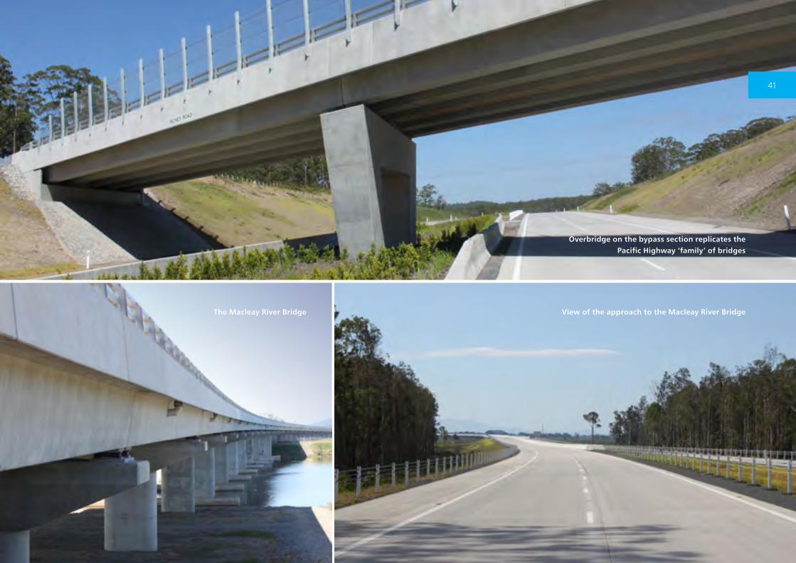
Overbridge on the bypass section replicates the Pacific Highway ‘family’ of bridges
View of the approach to the Macleay River BridgeThe Macleay River Bridge
41
View of the new commuter car park
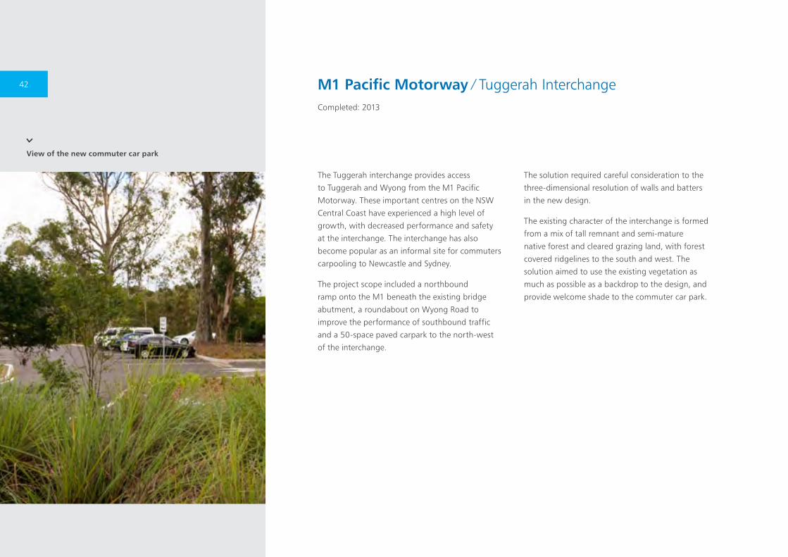
M1 Pacific Motorway ∕ Tuggerah InterchangeCompleted: 2013
The Tuggerah interchange provides access
to Tuggerah and Wyong from the M1 Pacific
Motorway. These important centres on the NSW
Central Coast have experienced a high level of
growth, with decreased performance and safety
at the interchange. The interchange has also
become popular as an informal site for commuters
carpooling to Newcastle and Sydney.
The project scope included a northbound
ramp onto the M1 beneath the existing bridge
abutment, a roundabout on Wyong Road to
improve the performance of southbound traffic
and a 50-space paved carpark to the north-west
of the interchange.
The solution required careful consideration to the
three-dimensional resolution of walls and batters
in the new design.
The existing character of the interchange is formed
from a mix of tall remnant and semi-mature
native forest and cleared grazing land, with forest
covered ridgelines to the south and west. The
solution aimed to use the existing vegetation as
much as possible as a backdrop to the design, and
provide welcome shade to the commuter car park.
42
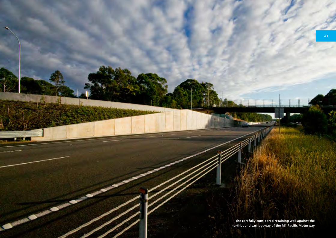
The carefully considered retaining wall against the northbound carriageway of the M1 Pacific Motorway
43
The upgraded highway pictured between remnant spotted gums and Gulaga
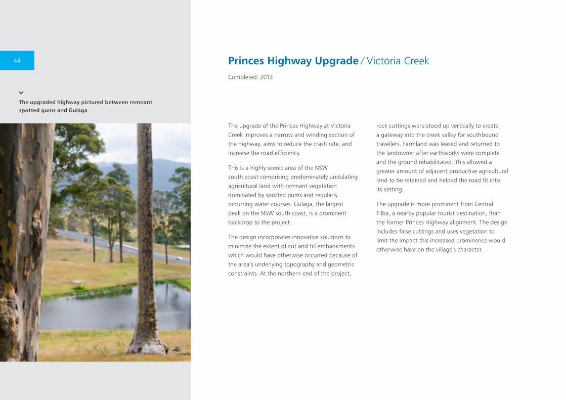
The upgrade of the Princes Highway at Victoria
Creek improves a narrow and winding section of
the highway, aims to reduce the crash rate, and
increase the road efficiency.
This is a highly scenic area of the NSW
south coast comprising predominately undulating
agricultural land with remnant vegetation
dominated by spotted gums and regularly
occurring water courses. Gulaga, the largest
peak on the NSW south coast, is a prominent
backdrop to the project.
The design incorporates innovative solutions to
minimise the extent of cut and fill embankments
which would have otherwise occurred because of
the area’s underlying topography and geometric
constraints. At the northern end of the project,
rock cuttings were stood up vertically to create
a gateway into the creek valley for southbound
travellers. Farmland was leased and returned to
the landowner after earthworks were complete
and the ground rehabilitated. This allowed a
greater amount of adjacent productive agricultural
land to be retained and helped the road fit into
its setting.
The upgrade is more prominent from Central
Tilba, a nearby popular tourist destination, than
the former Princes Highway alignment. The design
includes false cuttings and uses vegetation to
limit the impact this increased prominence would
otherwise have on the village's character.
Princes Highway Upgrade ∕ Victoria CreekCompleted: 2013
44
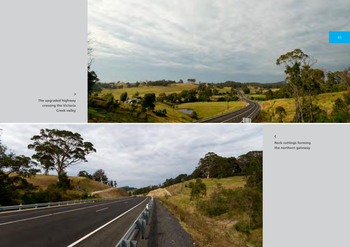
The upgraded highway crossing the Victoria
Creek valley
Rock cuttings forming the northern gateway
45
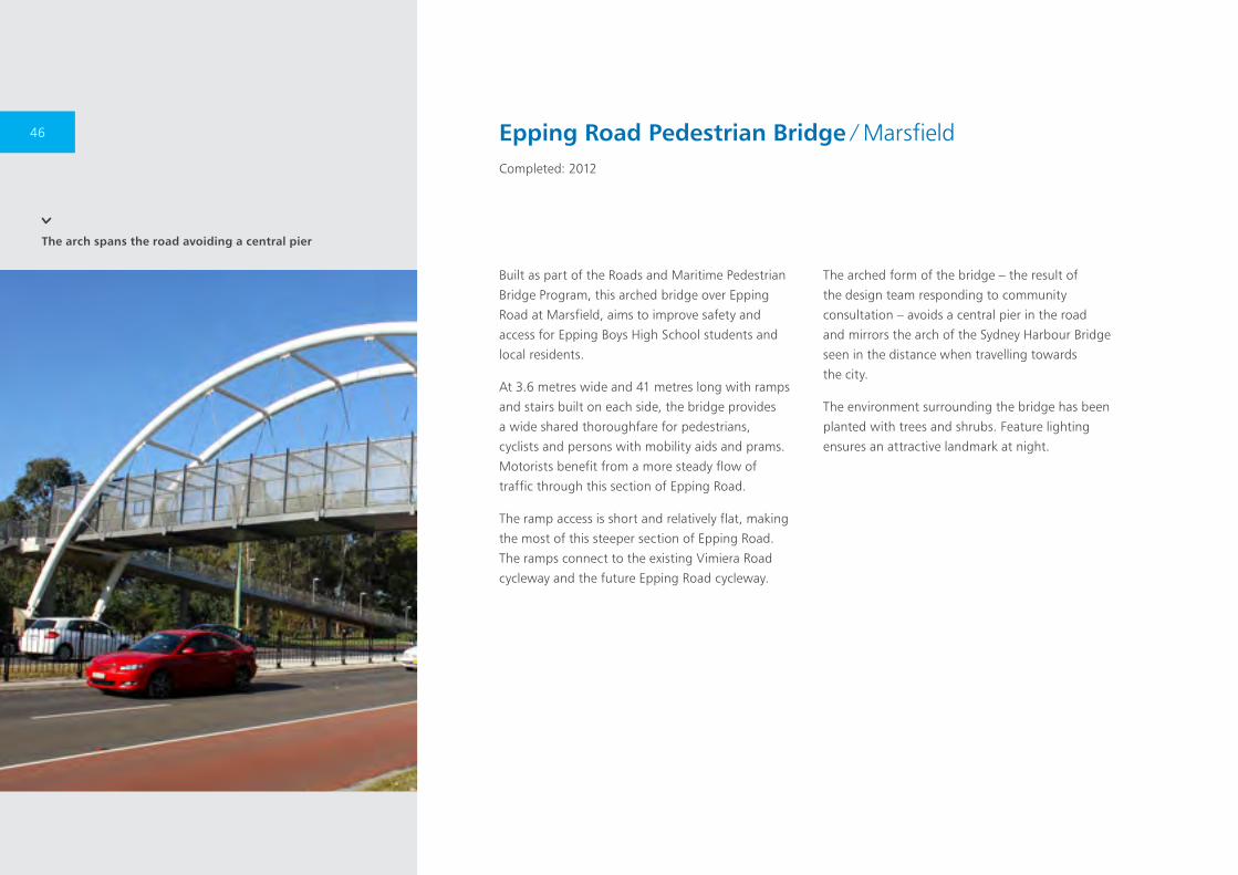
The arch spans the road avoiding a central pier
Built as part of the Roads and Maritime Pedestrian
Bridge Program, this arched bridge over Epping
Road at Marsfield, aims to improve safety and
access for Epping Boys High School students and
local residents.
At 3.6 metres wide and 41 metres long with ramps
and stairs built on each side, the bridge provides
a wide shared thoroughfare for pedestrians,
cyclists and persons with mobility aids and prams.
Motorists benefit from a more steady flow of
traffic through this section of Epping Road.
The ramp access is short and relatively flat, making
the most of this steeper section of Epping Road.
The ramps connect to the existing Vimiera Road
cycleway and the future Epping Road cycleway.
The arched form of the bridge – the result of
the design team responding to community
consultation – avoids a central pier in the road
and mirrors the arch of the Sydney Harbour Bridge
seen in the distance when travelling towards
the city.
The environment surrounding the bridge has been
planted with trees and shrubs. Feature lighting
ensures an attractive landmark at night.
Epping Road Pedestrian Bridge ∕ MarsfieldCompleted: 2012
46

The project considered both the bridge
design and landscape design, to help
integrate the bridge into the surrounding
environment
Epping Road was closed during the night to allow the bridge structure to be craned into place
47
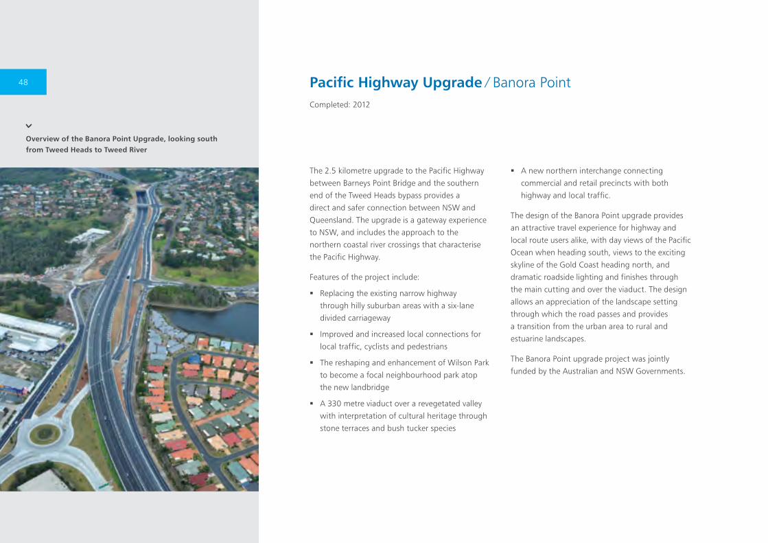
Overview of the Banora Point Upgrade, looking south from Tweed Heads to Tweed River
The 2.5 kilometre upgrade to the Pacific Highway
between Barneys Point Bridge and the southern
end of the Tweed Heads bypass provides a
direct and safer connection between NSW and
Queensland. The upgrade is a gateway experience
to NSW, and includes the approach to the
northern coastal river crossings that characterise
the Pacific Highway.
Features of the project include:
� Replacing the existing narrow highway
through hilly suburban areas with a six-lane
divided carriageway
� Improved and increased local connections for
local traffic, cyclists and pedestrians
� The reshaping and enhancement of Wilson Park
to become a focal neighbourhood park atop
the new landbridge
� A 330 metre viaduct over a revegetated valley
with interpretation of cultural heritage through
stone terraces and bush tucker species
� A new northern interchange connecting
commercial and retail precincts with both
highway and local traffic.
The design of the Banora Point upgrade provides
an attractive travel experience for highway and
local route users alike, with day views of the Pacific
Ocean when heading south, views to the exciting
skyline of the Gold Coast heading north, and
dramatic roadside lighting and finishes through
the main cutting and over the viaduct. The design
allows an appreciation of the landscape setting
through which the road passes and provides
a transition from the urban area to rural and
estuarine landscapes.
The Banora Point upgrade project was jointly
funded by the Australian and NSW Governments.
Pacific Highway Upgrade ∕ Banora PointCompleted: 2012
48
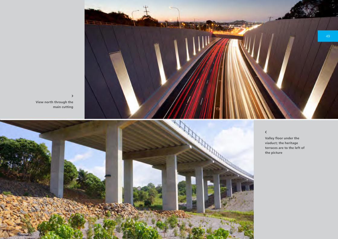
View north through the main cutting
Valley floor under the viaduct; the heritage terraces are to the left of the picture
49
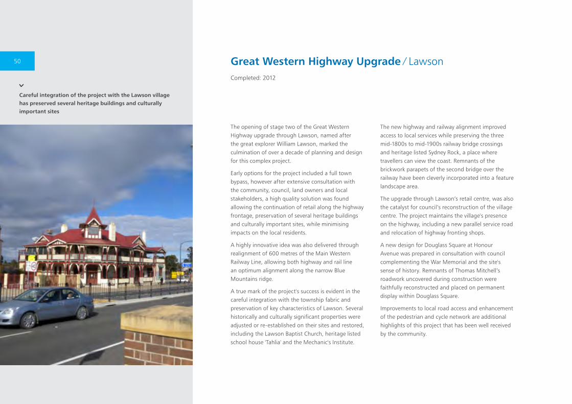
Careful integration of the project with the Lawson village has preserved several heritage buildings and culturally important sites
The opening of stage two of the Great Western Highway upgrade through Lawson, named after the great explorer William Lawson, marked the culmination of over a decade of planning and design for this complex project.
Early options for the project included a full town bypass, however after extensive consultation with the community, council, land owners and local stakeholders, a high quality solution was found allowing the continuation of retail along the highway frontage, preservation of several heritage buildings and culturally important sites, while minimising impacts on the local residents.
A highly innovative idea was also delivered through realignment of 600 metres of the Main Western Railway Line, allowing both highway and rail line an optimum alignment along the narrow Blue Mountains ridge.
A true mark of the project's success is evident in the careful integration with the township fabric and preservation of key characteristics of Lawson. Several historically and culturally significant properties were adjusted or re-established on their sites and restored, including the Lawson Baptist Church, heritage listed school house 'Tahlia' and the Mechanic's Institute.
The new highway and railway alignment improved access to local services while preserving the three mid-1800s to mid-1900s railway bridge crossings and heritage listed Sydney Rock, a place where travellers can view the coast. Remnants of the brickwork parapets of the second bridge over the railway have been cleverly incorporated into a feature landscape area.
The upgrade through Lawson’s retail centre, was also the catalyst for council’s reconstruction of the village centre. The project maintains the village's presence on the highway, including a new parallel service road and relocation of highway fronting shops.
A new design for Douglass Square at Honour Avenue was prepared in consultation with council complementing the War Memorial and the site's sense of history. Remnants of Thomas Mitchell’s roadwork uncovered during construction were faithfully reconstructed and placed on permanent display within Douglass Square.
Improvements to local road access and enhancement of the pedestrian and cycle network are additional highlights of this project that has been well received by the community.
Great Western Highway Upgrade ∕ LawsonCompleted: 2012
50
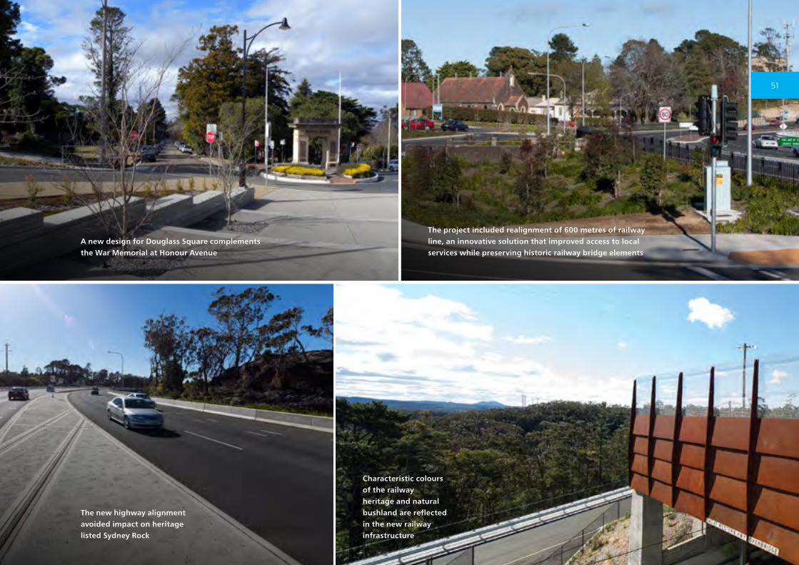
Characteristic colours of the railway heritage and natural bushland are reflected in the new railway infrastructure
The project included realignment of 600 metres of railway line, an innovative solution that improved access to local services while preserving historic railway bridge elements
The new highway alignment avoided impact on heritage listed Sydney Rock
A new design for Douglass Square complements the War Memorial at Honour Avenue
51
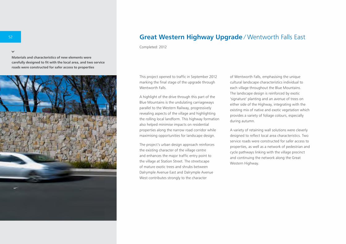
Materials and characteristics of new elements were carefully designed to fit with the local area, and two service roads were constructed for safer access to properties
This project opened to traffic in September 2012
marking the final stage of the upgrade through
Wentworth Falls.
A highlight of the drive through this part of the
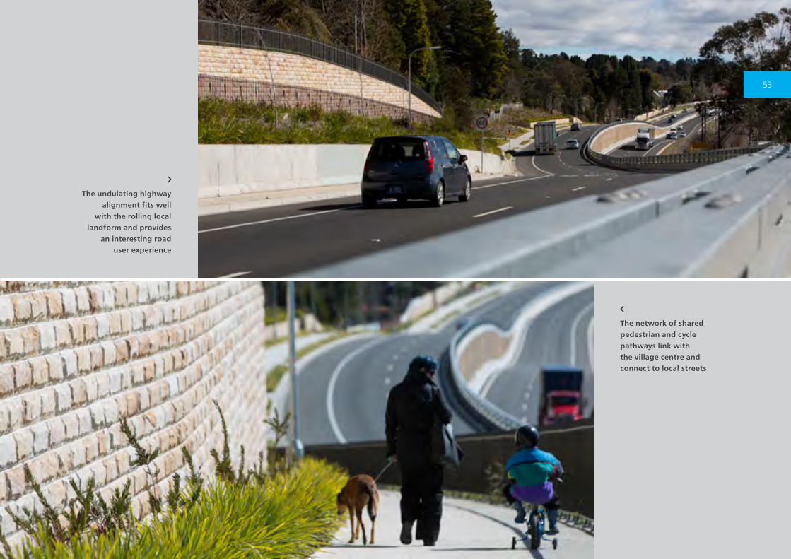
Blue Mountains is the undulating carriageways
parallel to the Western Railway, progressively
revealing aspects of the village and highlighting
the rolling local landform. This highway formation
also helped minimise impacts on residential
properties along the narrow road corridor while
maximising opportunities for landscape design.
The project’s urban design approach reinforces
the existing character of the village centre
and enhances the major traffic entry point to
the village at Station Street. The streetscape
of mature exotic trees and shrubs between
Dalrymple Avenue East and Dalrymple Avenue
West contributes strongly to the character
of Wentworth Falls, emphasising the unique
cultural landscape characteristics individual to
each village throughout the Blue Mountains.
The landscape design is reinforced by exotic
‘signature’ planting and an avenue of trees on
either side of the Highway, integrating with the
existing mix of native and exotic vegetation which
provides a variety of foliage colours, especially
during autumn.
A variety of retaining wall solutions were cleverly
designed to reflect local area characteristics. Two
service roads were constructed for safer access to
properties, as well as a network of pedestrian and
cycle pathways linking with the village precinct
and continuing the network along the Great
Western Highway.
Great Western Highway Upgrade ∕ Wentworth Falls EastCompleted: 2012
52
The undulating highway alignment fits well
with the rolling local landform and provides
an interesting road user experience
The network of shared pedestrian and cycle pathways link with the village centre and connect to local streets
53
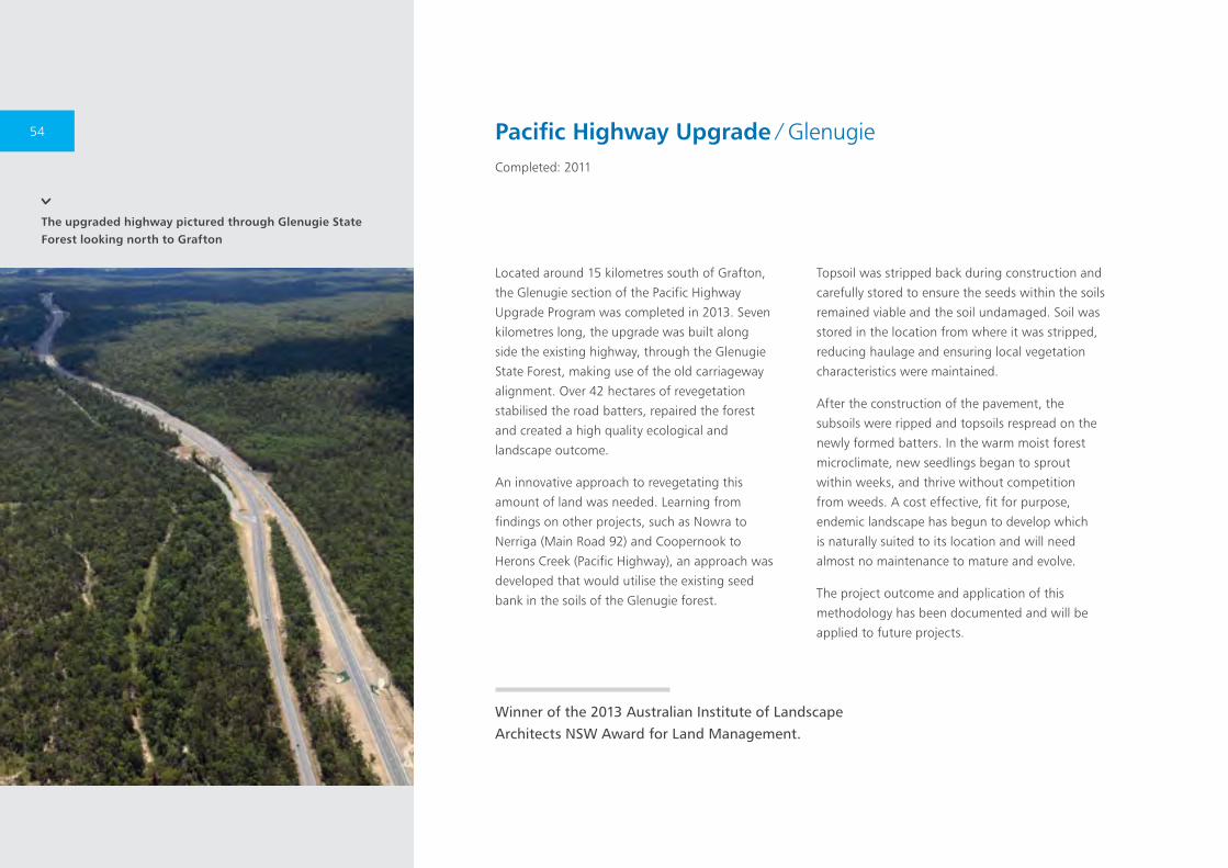
The upgraded highway pictured through Glenugie State Forest looking north to Grafton
Located around 15 kilometres south of Grafton,
the Glenugie section of the Pacific Highway
Upgrade Program was completed in 2013. Seven
kilometres long, the upgrade was built along
side the existing highway, through the Glenugie
State Forest, making use of the old carriageway
alignment. Over 42 hectares of revegetation
stabilised the road batters, repaired the forest
and created a high quality ecological and
landscape outcome.
An innovative approach to revegetating this
amount of land was needed. Learning from
findings on other projects, such as Nowra to
Nerriga (Main Road 92) and Coopernook to
Herons Creek (Pacific Highway), an approach was
developed that would utilise the existing seed
bank in the soils of the Glenugie forest.
Topsoil was stripped back during construction and
carefully stored to ensure the seeds within the soils
remained viable and the soil undamaged. Soil was
stored in the location from where it was stripped,
reducing haulage and ensuring local vegetation
characteristics were maintained.
After the construction of the pavement, the
subsoils were ripped and topsoils respread on the
newly formed batters. In the warm moist forest
microclimate, new seedlings began to sprout
within weeks, and thrive without competition
from weeds. A cost effective, fit for purpose,
endemic landscape has begun to develop which
is naturally suited to its location and will need
almost no maintenance to mature and evolve.
The project outcome and application of this
methodology has been documented and will be
applied to future projects.
Winner of the 2013 Australian Institute of Landscape Architects NSW Award for Land Management.
Pacific Highway Upgrade ∕ GlenugieCompleted: 2011
54
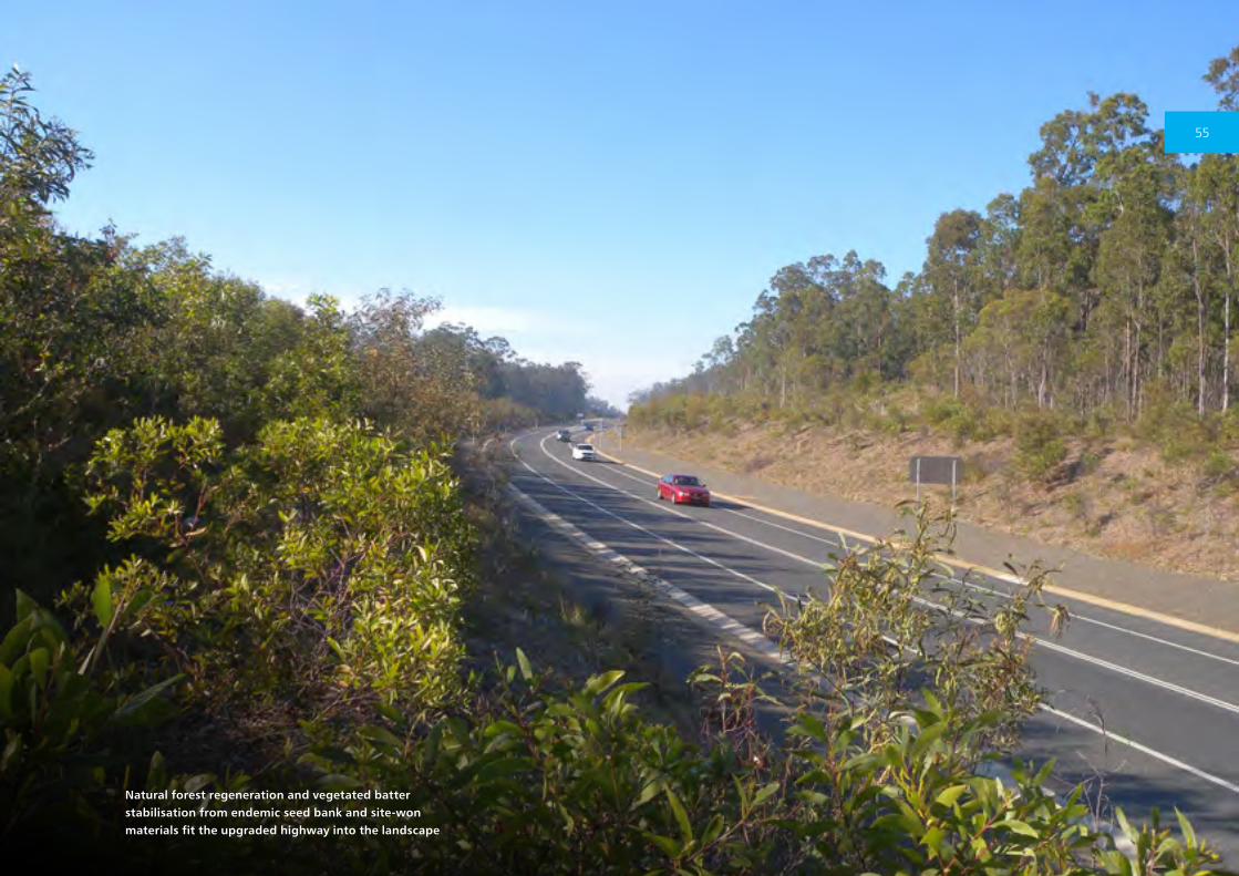
Natural forest regeneration and vegetated batter stabilisation from endemic seed bank and site-won materials fit the upgraded highway into the landscape
55

The scale and weathering of the sandstone cutting matches the existing freeway whilst retaining and adding to the landscape buffer for the residences above
The Cammeray bus layover provides parking
for around 30 buses waiting to access the CBD
for commuters during the afternoon peak.
The layover improves bus reliability and avoids
unnecessary bus travel on local streets or buses
parking inappropriately.
The layover makes use of a wider section of the
Warringah Freeway. Additional space was created
by excavation into the existing sandstone cutting
and the use of the landscaped verge. As part of
the project, the opportunity was taken to provide
a new separated cycleway along the edge of
Cammeray Golf Course.
The project was designed to respect the character
of the Warringah Freeway. Completed in the
1960s, the freeway is notable for its sandstone
cuttings and stone block work as well as the
predominantly native landscape design. It is an
important gateway to North Sydney, the Sydney
Harbour Bridge, CBD and beyond.
The cuttings are either left in a natural cut
sandstone state or where stabilisation is necessary,
sensitively in-filled with sandstone block work. The
driver facilities are inset into the cutting reducing
their impact. Sandstone block work has been used
around the base of the facility to reflect the local
North Sydney vernacular. The sandstone block
work retaining wall at the top of the cuttings –
also a hallmark of the Warringah Freeway design
– was removed, stored and replaced at the end of
the project.
Planting of native gums and swathes of native
grasses on the cutting and verge helps integrate
the project into the area. Planting of semi-mature
Melaleuca quinquenervia alongside the golf course
helps create a buffer for the golfers and a stately
row of trees along the freeway.
Cammeray Bus Layover ∕ Warringah FreewayCompleted: 2011
56

The natural sandstone cutting with blockwork
in-fill reducing the impact of the driver
facilities
New plantings of native grasses and trees under mature trees planted for the original freeway retain the leafy character of the road corridor and integrate the project into the area
57
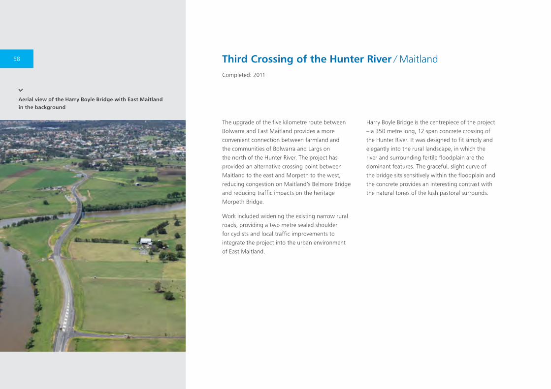
Aerial view of the Harry Boyle Bridge with East Maitland in the background
The upgrade of the five kilometre route between
Bolwarra and East Maitland provides a more
convenient connection between farmland and
the communities of Bolwarra and Largs on
the north of the Hunter River. The project has
provided an alternative crossing point between
Maitland to the east and Morpeth to the west,
reducing congestion on Maitland’s Belmore Bridge
and reducing traffic impacts on the heritage
Morpeth Bridge.
Work included widening the existing narrow rural
roads, providing a two metre sealed shoulder
for cyclists and local traffic improvements to
integrate the project into the urban environment
of East Maitland.
Harry Boyle Bridge is the centrepiece of the project
– a 350 metre long, 12 span concrete crossing of
the Hunter River. It was designed to fit simply and
elegantly into the rural landscape, in which the
river and surrounding fertile floodplain are the
dominant features. The graceful, slight curve of
the bridge sits sensitively within the floodplain and
the concrete provides an interesting contrast with
the natural tones of the lush pastoral surrounds.
Third Crossing of the Hunter River ∕ MaitlandCompleted: 2011
58
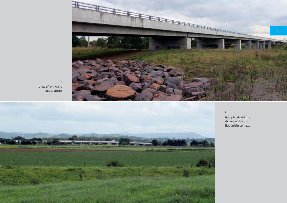
View of the Harry Boyle Bridge
Harry Boyle Bridge sitting within its floodplain context
59
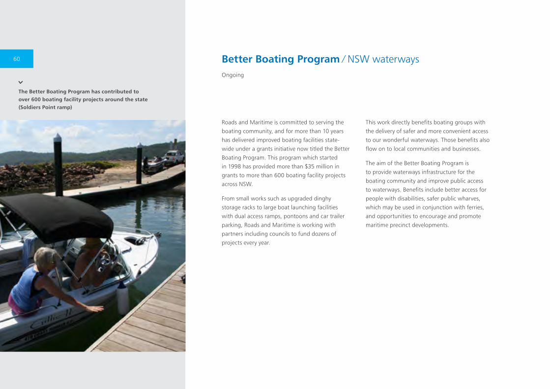
The Better Boating Program has contributed to over 600 boating facility projects around the state (Soldiers Point ramp)
Roads and Maritime is committed to serving the
boating community, and for more than 10 years
has delivered improved boating facilities state-
wide under a grants initiative now titled the Better
Boating Program. This program which started
in 1998 has provided more than $35 million in
grants to more than 600 boating facility projects
across NSW.
From small works such as upgraded dinghy
storage racks to large boat launching facilities
with dual access ramps, pontoons and car trailer
parking, Roads and Maritime is working with
partners including councils to fund dozens of
projects every year.
This work directly benefits boating groups with
the delivery of safer and more convenient access
to our wonderful waterways. Those benefits also
flow on to local communities and businesses.
The aim of the Better Boating Program is
to provide waterways infrastructure for the
boating community and improve public access
to waterways. Benefits include better access for
people with disabilities, safer public wharves,
which may be used in conjunction with ferries,
and opportunities to encourage and promote
maritime precinct developments.
Better Boating Program ∕ NSW waterwaysOngoing
60
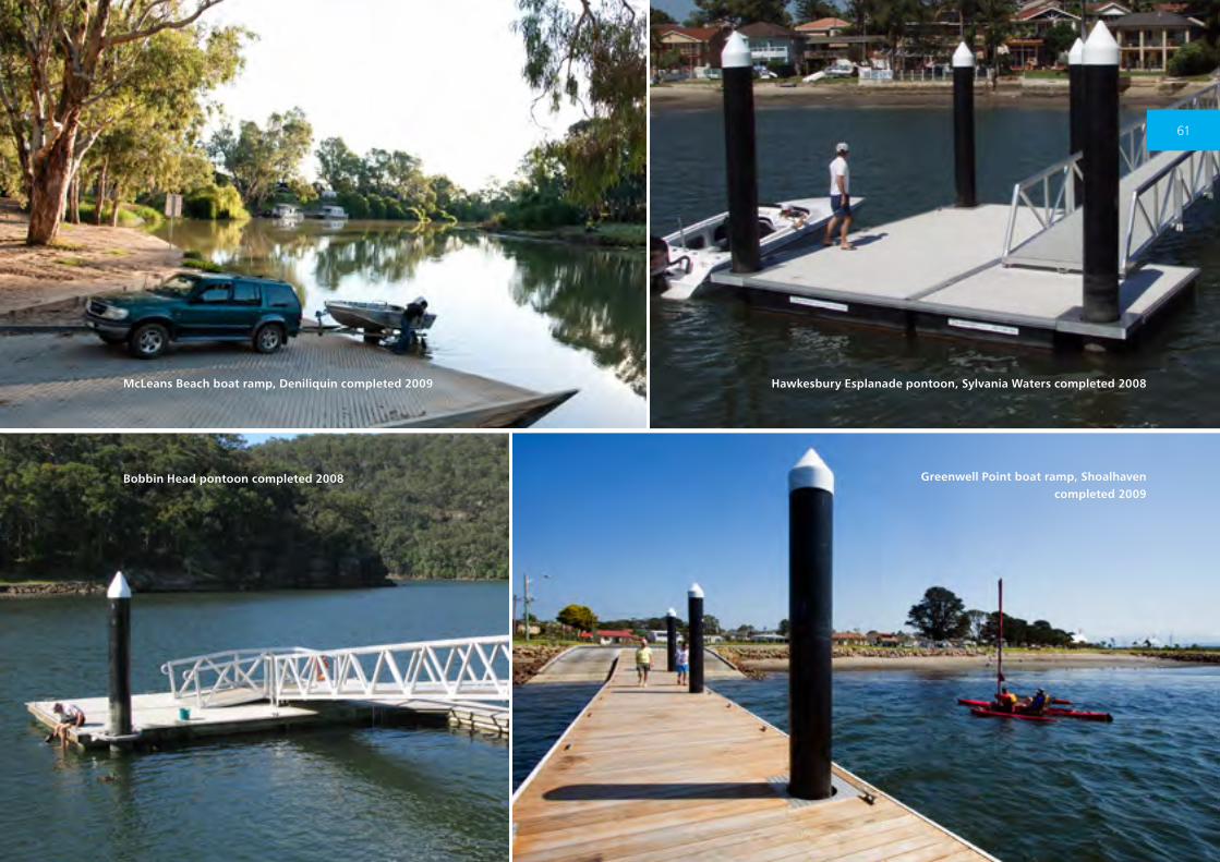
McLeans Beach boat ramp, Deniliquin completed 2009 Hawkesbury Esplanade pontoon, Sylvania Waters completed 2008
Bobbin Head pontoon completed 2008 Greenwell Point boat ramp, Shoalhaven completed 2009
61
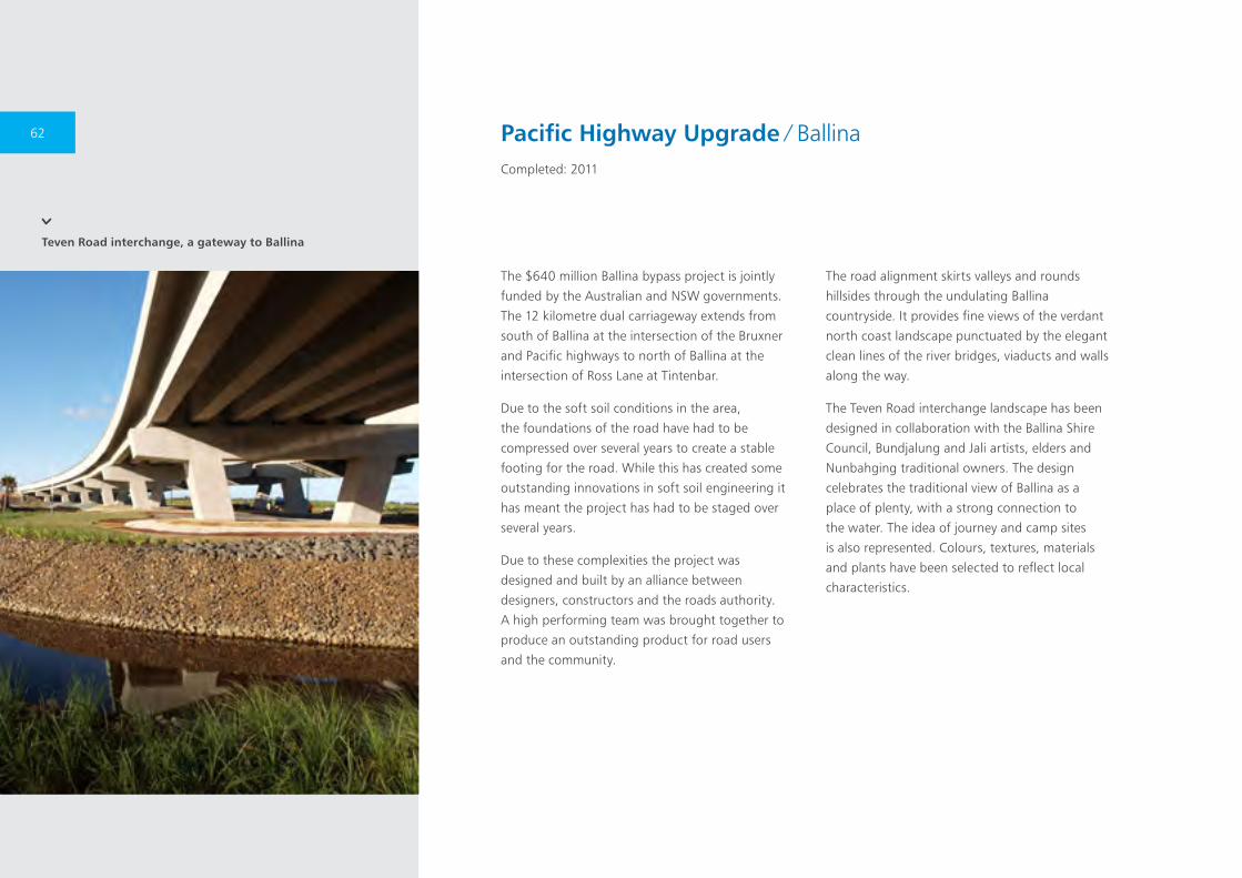
Teven Road interchange, a gateway to Ballina
Pacific Highway Upgrade ∕ BallinaCompleted: 2011
The $640 million Ballina bypass project is jointly
funded by the Australian and NSW governments.
The 12 kilometre dual carriageway extends from
south of Ballina at the intersection of the Bruxner
and Pacific highways to north of Ballina at the
intersection of Ross Lane at Tintenbar.
Due to the soft soil conditions in the area,
the foundations of the road have had to be
compressed over several years to create a stable
footing for the road. While this has created some
outstanding innovations in soft soil engineering it
has meant the project has had to be staged over
several years.
Due to these complexities the project was
designed and built by an alliance between
designers, constructors and the roads authority.
A high performing team was brought together to
produce an outstanding product for road users
and the community.
The road alignment skirts valleys and rounds
hillsides through the undulating Ballina
countryside. It provides fine views of the verdant
north coast landscape punctuated by the elegant
clean lines of the river bridges, viaducts and walls
along the way.
The Teven Road interchange landscape has been
designed in collaboration with the Ballina Shire
Council, Bundjalung and Jali artists, elders and
Nunbahging traditional owners. The design
celebrates the traditional view of Ballina as a
place of plenty, with a strong connection to
the water. The idea of journey and camp sites
is also represented. Colours, textures, materials
and plants have been selected to reflect local
characteristics.
62
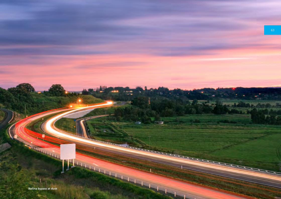
Ballina bypass at dusk
63
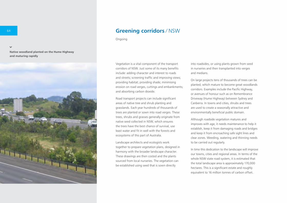
Native woodland planted on the Hume Highway and maturing rapidly
Vegetation is a vital component of the transport
corridors of NSW. Just some of its many benefits
include: adding character and interest to roads
and streets; screening traffic and improving views;
providing habitat; providing shade; minimising
erosion on road verges, cuttings and embankments;
and absorbing carbon dioxide.
Road transport projects can include significant
areas of native tree and shrub planting and
grasslands. Each year hundreds of thousands of
trees are planted or sown into road verges. These
trees, shrubs and grasses generally originate from
native seed collected in NSW, which ensures
the trees have the best chance of survival, use
least water and fit in well with the forests and
ecosystems of this part of Australia.
Landscape architects and ecologists work
together to prepare vegetation plans, designed in
harmony with the broader landscape character.
These drawings are then costed and the plants
sourced from local nurseries. The vegetation can
be established using seed that is sown directly
into roadsides, or using plants grown from seed
in nurseries and then transplanted into verges
and medians.
On large projects tens of thousands of trees can be
planted, which mature to become great woodlands
corridors. Examples include the Pacific Highway,
or avenues of honour such as on Remembrance
Driveway (Hume Highway) between Sydney and
Canberra. In towns and cities, shrubs and trees
are used to create a seasonally attractive and
environmentally beneficial public domain.
Although roadside vegetation matures and
improves with age, it needs maintenance to help it
establish, keep it from damaging roads and bridges
and keep it from encroaching safe sight lines and
clear zones. Weeding, watering and thinning needs
to be carried out regularly.
In time this dedication to the landscape will improve
our towns, cities and regional areas. In terms of the
whole NSW state road system, it is estimated that
the total landscape area is approximately 170,000
hectares. This is a significant estate and roughly
equivalent to 16 million tonnes of carbon offset.
Greening corridors ∕ NSWOngoing
64
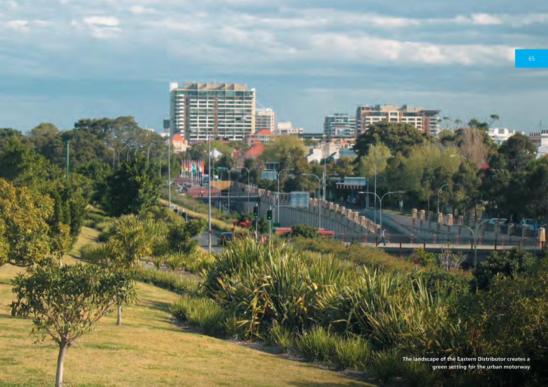
The landscape of the Eastern Distributor creates a green setting for the urban motorway
65
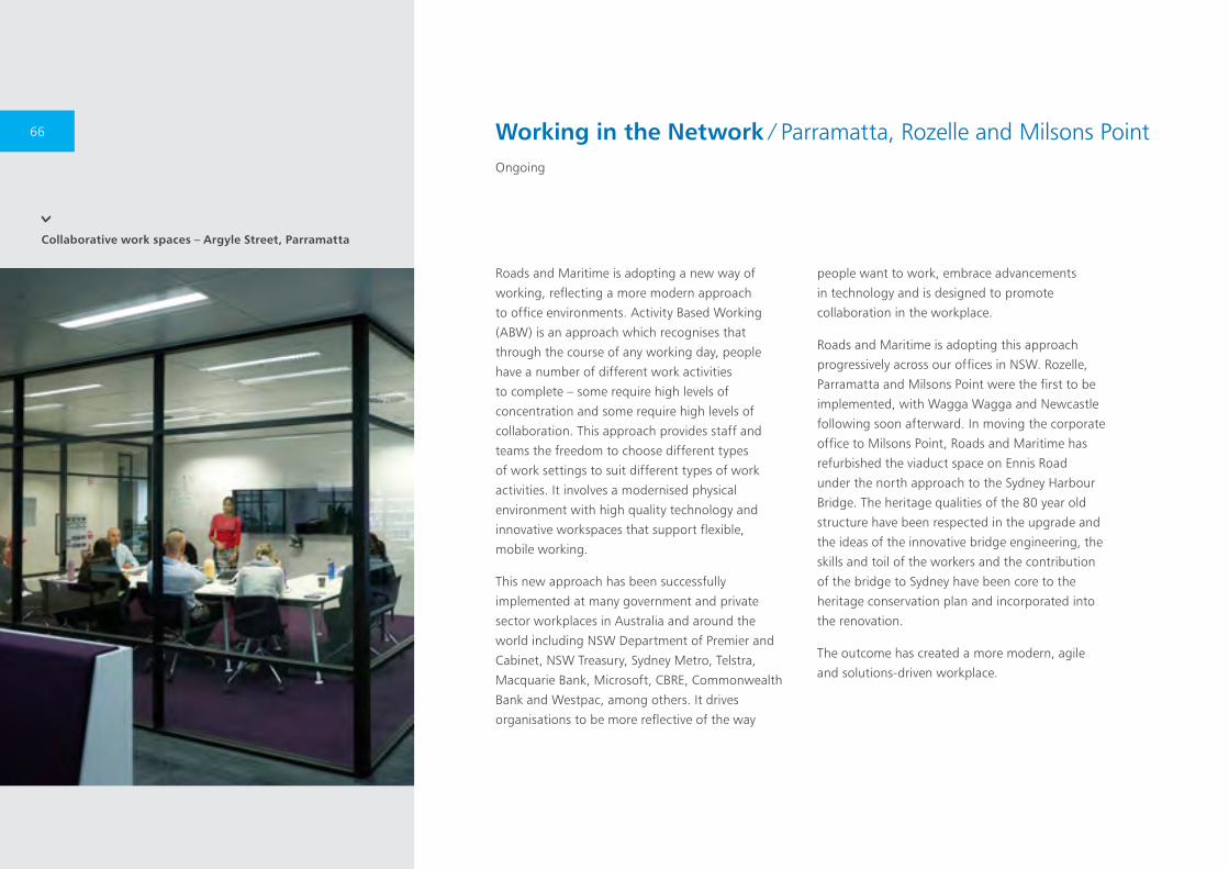
Collaborative work spaces – Argyle Street, Parramatta
Roads and Maritime is adopting a new way of
working, reflecting a more modern approach
to office environments. Activity Based Working
(ABW) is an approach which recognises that
through the course of any working day, people
have a number of different work activities
to complete – some require high levels of
concentration and some require high levels of
collaboration. This approach provides staff and
teams the freedom to choose different types
of work settings to suit different types of work
activities. It involves a modernised physical
environment with high quality technology and
innovative workspaces that support flexible,
mobile working.
This new approach has been successfully
implemented at many government and private
sector workplaces in Australia and around the
world including NSW Department of Premier and
Cabinet, NSW Treasury, Sydney Metro, Telstra,
Macquarie Bank, Microsoft, CBRE, Commonwealth
Bank and Westpac, among others. It drives
organisations to be more reflective of the way
people want to work, embrace advancements
in technology and is designed to promote
collaboration in the workplace.
Roads and Maritime is adopting this approach
progressively across our offices in NSW. Rozelle,
Parramatta and Milsons Point were the first to be
implemented, with Wagga Wagga and Newcastle
following soon afterward. In moving the corporate
office to Milsons Point, Roads and Maritime has
refurbished the viaduct space on Ennis Road
under the north approach to the Sydney Harbour
Bridge. The heritage qualities of the 80 year old
structure have been respected in the upgrade and
the ideas of the innovative bridge engineering, the
skills and toil of the workers and the contribution
of the bridge to Sydney have been core to the
heritage conservation plan and incorporated into
the renovation.
The outcome has created a more modern, agile
and solutions-driven workplace.
Working in the Network ∕ Parramatta, Rozelle and Milsons PointOngoing
66

Working in the Network ∕ Parramatta, Rozelle and Milsons PointOngoing
Collaborative work spaces – Argyle Street, Parramatta
Collaborative work spaces – Ennis Road, Milsons Point
67
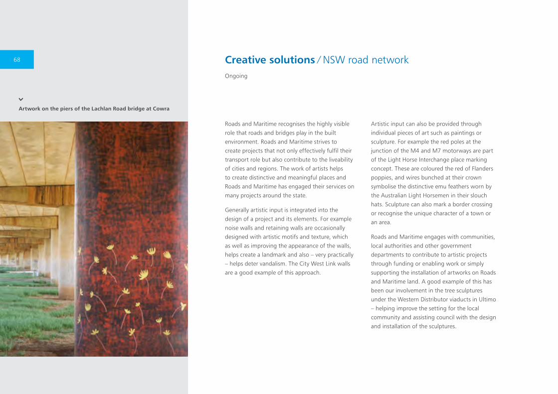
Artwork on the piers of the Lachlan Road bridge at Cowra
Creative solutions ∕ NSW road networkOngoing
Roads and Maritime recognises the highly visible
role that roads and bridges play in the built
environment. Roads and Maritime strives to
create projects that not only effectively fulfil their
transport role but also contribute to the liveability
of cities and regions. The work of artists helps
to create distinctive and meaningful places and
Roads and Maritime has engaged their services on
many projects around the state.
Generally artistic input is integrated into the
design of a project and its elements. For example
noise walls and retaining walls are occasionally
designed with artistic motifs and texture, which
as well as improving the appearance of the walls,
helps create a landmark and also – very practically
– helps deter vandalism. The City West Link walls
are a good example of this approach.
Artistic input can also be provided through
individual pieces of art such as paintings or
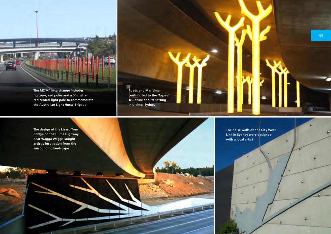
sculpture. For example the red poles at the
junction of the M4 and M7 motorways are part
of the Light Horse Interchange place marking
concept. These are coloured the red of Flanders
poppies, and wires bunched at their crown
symbolise the distinctive emu feathers worn by
the Australian Light Horsemen in their slouch
hats. Sculpture can also mark a border crossing
or recognise the unique character of a town or
an area.
Roads and Maritime engages with communities,
local authorities and other government
departments to contribute to artistic projects
through funding or enabling work or simply
supporting the installation of artworks on Roads
and Maritime land. A good example of this has
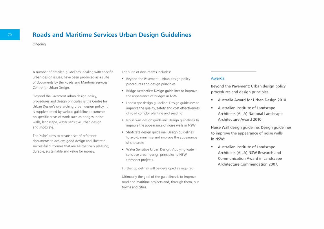
been our involvement in the tree sculptures
under the Western Distributor viaducts in Ultimo
– helping improve the setting for the local
community and assisting council with the design
and installation of the sculptures.
68
Roads and Maritime contributed to the ‘Aspire’ sculpture and its setting in Ultimo, Sydney
The noise walls on the City West Link in Sydney were designed with a local artist
The design of the Lizard Tree bridge on the Hume Highway near Wagga Wagga sought artistic inspiration from the surrounding landscape
The M7/M4 interchange includes fig trees, red poles and a 55 metre red central light pole to commemorate the Australian Light Horse Brigade
69
A number of detailed guidelines, dealing with specific
urban design issues, have been produced as a suite
of documents by the Roads and Maritime Services
Centre for Urban Design.
‘Beyond the Pavement urban design policy,
procedures and design principles' is the Centre for
Urban Design’s overarching urban design policy. It
is supplemented by various guideline documents
on specific areas of work such as bridges, noise
walls, landscape, water sensitive urban design
and shotcrete.
The ‘suite’ aims to create a set of reference
documents to achieve good design and illustrate
successful outcomes that are aesthetically pleasing,
durable, sustainable and value for money.
The suite of documents includes:
� Beyond the Pavement: Urban design policy
procedures and design principles
� Bridge Aesthetics: Design guidelines to improve
the appearance of bridges in NSW
� Landscape design guideline: Design guidelines to
improve the quality, safety and cost effectiveness
of road corridor planting and seeding
� Noise wall design guideline: Design guidelines to
improve the appearance of noise walls in NSW
� Shotcrete design guideline: Design guidelines
to avoid, minimise and improve the appearance
of shotcrete
� Water Sensitive Urban Design: Applying water
sensitive urban design principles to NSW
transport projects.
Further guidelines will be developed as required.
Ultimately the goal of the guidelines is to improve
road and maritime projects and, through them, our
towns and cities.
Roads and Maritime Services Urban Design GuidelinesOngoing
Awards
Beyond the Pavement: Urban design policy procedures and design principles:
� Australia Award for Urban Design 2010
� Australian Institute of Landscape Architects (AILA) National Landscape Architecture Award 2010.
Noise Wall design guideline: Design guidelines to improve the appearance of noise walls in NSW:
� Australian Institute of Landscape Architects (AILA) NSW Research and Communication Award in Landscape Architecture Commendation 2007.
70

71
Caption TBC
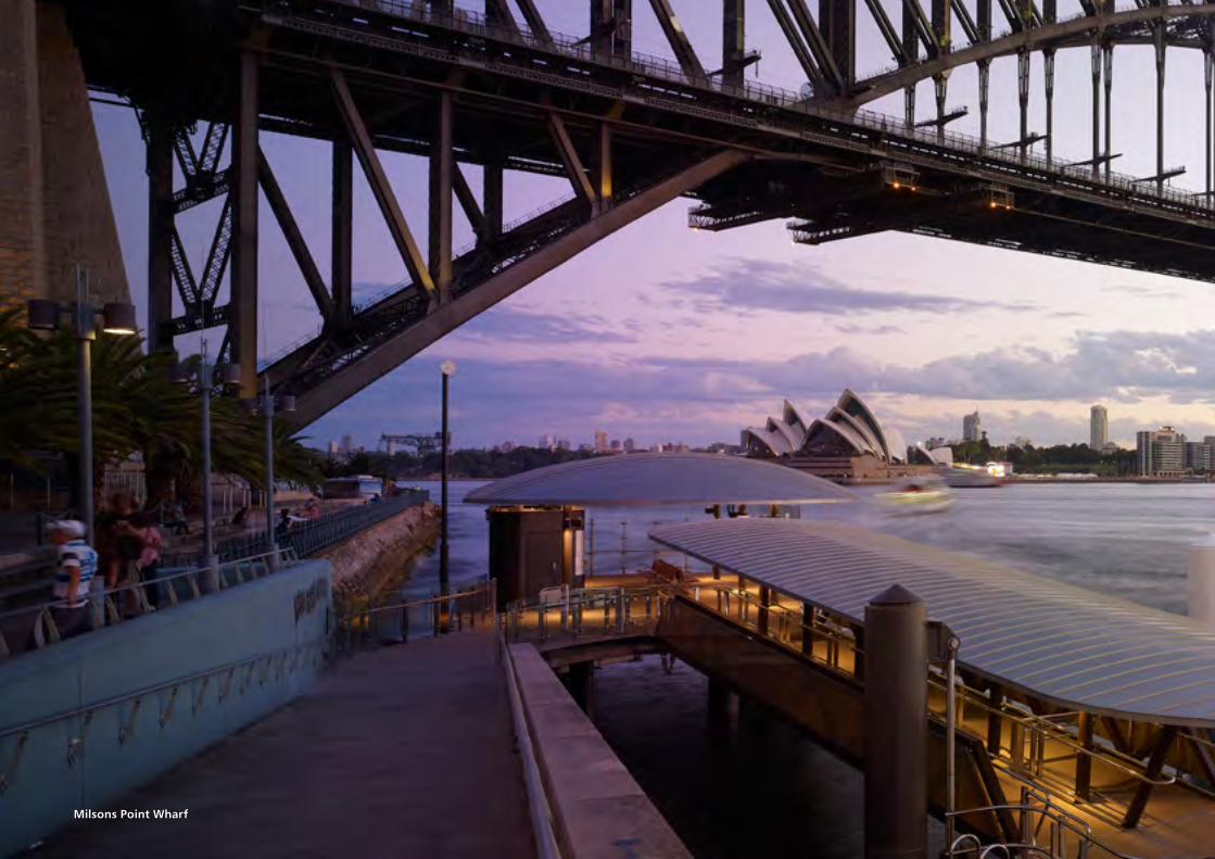
Milsons Point Wharf
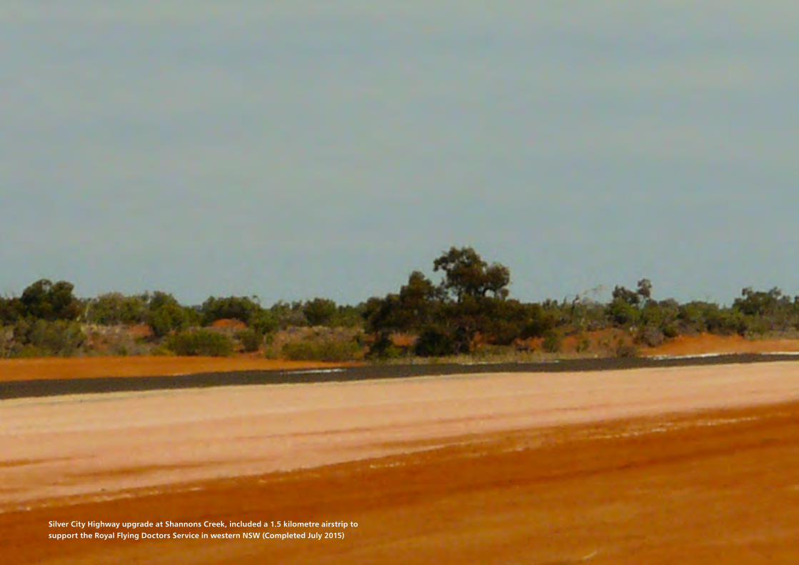
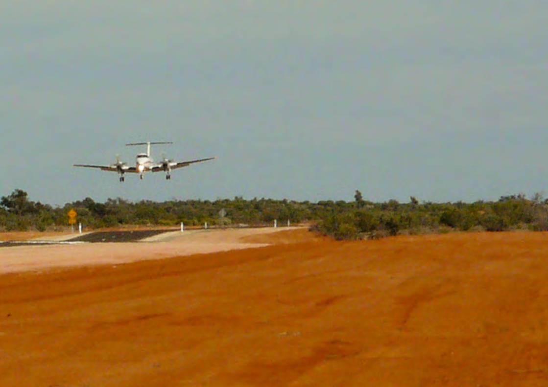
Silver City Highway upgrade at Shannons Creek, included a 1.5 kilometre airstrip to support the Royal Flying Doctors Service in western NSW (Completed July 2015)
© Roads and Maritime Services
For further enquirieswww.rms.nsw.gov.au | 13 22 13
June 2016RMS/Pub. 16.168
Achievements in road and maritimeinfrastructure projects
Achievem
ents in road and maritim
e infrastructure projects | Ro
ads an
d M
aritime