Embed Size (px)
Citation preview

We are committed to providing accessible customer service.If you need accessible formats or communications supports, please contact us.
Nous tenons à améliorer l’accessibilité des services à la clientèle.Si vous avez besoin de formats accessibles ou d’aide à la communication, veuillez nous contacter.
1

1
Barrick Gold Inc.
Work Assessment Report
Bomby Township, Thunder Bay Mining District
Thunder Bay District Beth Leduc
April 25, 2017 Project Coordinator

2
TABLE OF CONTENTS
1.0 Introduction………………………………………………………………………………………………………………. p.2
2.0 Property Location……………………………………………………………………………. ………….. …………..p.2
3.0 Geology…………………………………………………………………………………………………………………….. p.2
4.0 Drill Program…………………………………………………………………………………………………………….. p.10
5.0 References………………………………………………………………………………………………………………… p.13
List of Figures
Figure 1. Regional Property Location Map
Figure 2. Local Property Location Map
Figure 3. Ontario ClaiMaps Claim Locations with Drillhole Collars
Figure 4. Plan view of Drillhole Collars and Traces
Figure 5a. Detailed section of DDH W1617
Figure 5b. Detailed section of DDH W1620
Figure 5c. Detailed section of DDH W1621
Figure 5d. Detailed section of DDH W1622
Figure 5e. Detailed section of DDH W1626
Figure 5f. Detailed section of DDH W1623
Appendices
Appendix A Hemlo Geology Logging Legend
Appendix B DDH W1617 Drill Logs
Appendix C DDH W1620 Drill Logs
Appendix D DDH W1621 Drill Logs
Appendix E DDH W1622 Drill Logs
Appendix F DDH W1623 Drill Logs
Appendix G DDH W1626 Drill Logs
Appendix H Boreal Drilling Invoices
Appendix I Contact Information
Appendix J Certificate of Qualifications

3
1.0 INTRODUCTION
In February 2016, the second year of the Open Pit Adit Exploration Diamond Drilling Program was
started at William’s Mine. Thirty two holes were drilled from January to April. This assessment report
will document 6 holes totalling 2,952 meters. Holes W1617, W1620, W1621, W1622, W1623 and
W1626 are contained within this report. All drilling for this program was done north of the west rock
pile, and was exploring for the westerly extents of mineralization in the area.
Drilling was performed on Barrick Gold Corporation’s Lease Claim 274, with assessment credits being
distributed to other contiguous claim groups. No physical work was conducted off of the William’s Mine
footprint.
2.0 PROPERTY LOCATION
Barrick Gold Corporation’s Hemlo Mines are located in northwestern Ontario, approximately 300 km
east of Thunder Bay (Figure 1). The group of claims sits to the north and south of the Trans-Canada
Highway (Hwy 17) just west of the junction with Hwy 614 (Figure 2). The claim is located approximately
40 km east of Marathon, Ontario.
Most claims are accessible directly by road (Hwy 17, Hwy 614, Philips Creek Road, Williams and David
Bell Mines’ Tailings access roads). Claims that do not have direct road access are within 1-2 km of a
roadway and can be accessed by foot.
Lease Claim 274, on which drilling for this report was completed, are part of the Williams Mine property.
Williams is one of three mines comprising the Hemlo Camp. The former Golden Giant and David Bell
Mines are just east of Williams, spread approximately 5 km along the highway.
3.0 GEOLOGY
Exploration History
Mineralization was discovered in the 1940’s by the Moses family. Later in 1945, Harry Ollmann and Dr. J. K. Williams staked 11 claims (the Ollmann-Williams property). Adjoining claims were staked in 1946 and optioned to Lake Superior Mining Corporation. These were optioned to Teck-Hughes Gold Mining in 1951, who drilled six holes, and then dropped and returned the claims to Lake Superior Mining. Lake Superior Mining Corporation Ltd. optioned their ground to Cusco Mines Ltd. in 1958 and more diamond drilling was carried out. The claims eventually lapsed. In 1973, the former Lake Superior property was staked by Ardel Explorations Ltd., and three diamond drill holes were completed. It was subsequently picked up by Cypress Resources Ltd., who dropped the claims. R.G. Newman staked claims that adjoined the western boundary of the Williams patented claim group in 1976.

4
In December 1979, prospectors Donald McKinnon and John Larche staked a large block of claims surrounding the 11 patented claims comprising the Williams claim block. Corona Resources Ltd. (later named International Corona Resources Limited) optioned a portion of these claims. Drilling resulted in a resource estimate of 340,000 tonnes at 6 g/t. In May 1981, while Corona was negotiating with Lola Williams for the Williams property, representatives of Corona and Long Lac Minerals (Lac Minerals) exchanged information with the intent of formulating a joint-venture agreement. Lac Minerals went on to get an agreement directly with Mrs. Williams. In October 1981, Corona alleged that Lac Minerals was in breach of fiduciary agreement and launched a lawsuit over the ownership of the Williams claims. The ensuing three year court battle would become one of the best known legal disputes in Canadian mining history. Corona, needing financial support for their legal dispute with Lac Minerals and for the development of a newly discovered zone (the East Zone), entered into a joint venture agreement with Teck Corporation in November 1981. The remainder of Larche and McKinnon’s claims were optioned to Goliath Gold Mines Ltd (Goliath) in 1981. Claims located west of the Williams block were placed into the holdings of Golden Sceptre Resources Ltd. (Golden Sceptre). Drilling on the Golden Sceptre property began in August 1982. In 1982, Goliath Gold Mines and Golden Sceptre Resources signed an agreement with Noranda
Exploration Company Ltd for development of their Goliath and Golden Sceptre properties. This gave
Noranda a controlling interest in what would become the second largest mine in the Hemlo camp.
In March, 1986, the Supreme Court of Ontario decided in favor of Corona over Lac Minerals. Lac Minerals lost an appeal to the Ontario Court of Appeal in October 1987, and subsequently to the Supreme Court of Canada. The property was turned over to Corona, and the name of the mine was shortened to the Williams Mine. Homestake Mining Corporation purchased the assets of International Corona Resources in 1991 and Homestake was later purchased by Barrick Gold Inc. in 1999. In January, 1987 Golden Sceptre Resources Ltd., Goliath Gold Mines Ltd., and Noranda Minerals Inc. amalgamated their holdings and formed Hemlo Gold Mines Inc. (Hemlo Gold). As a result of corporate restructuring in 1992, Noranda Minerals Inc. transferred all of its gold assets to Hemlo Gold. Ownership of Golden Giant changed to Battle Mountain Canada Ltd. in 1996 and then to Newmont Canada Ltd. in 2001. In 1998, Williams acquired the surface and mineral rights of the Sceptre claims from Battle Mountain Canada to the 9450 elevation of the Williams Mine grid. In 1999, Williams also acquired the surface and mining rights on the Horizon claims from Battle Mountain Canada to the 10150 elevation of the Williams Mine grid. These acquisitions would permit pit expansion to the west, and allow evaluation of underground mining of the down dip extension of the C-Zone pit. In addition to these two exchanges and as part of the same 1998 agreement, the David Bell Mine agreed to transfer the upper quarter claim and the M3 and M4 blocks of the C zone to Battle Mountain Canada. Battle Mountain Canada also agreed to transfer Block 5 east and the Upper Block 5 to David Bell. Both of these latter exchanges were completed to facilitate mining for the parties involved.

5
In 2002, Williams acquired the surface and mineral rights from surface to the 10150 level on lease 273 and the remainder of lease 274 from Newmont Canada Ltd., providing an area for barren waste stockpiles from the expanded pit. In 2006, Williams acquired the surface and mineral rights on lease 106623 from Newmont Canada Ltd. This acquisition allowed Williams to mine C Zone mineralization above the 9450 level as well as the down dip extension of the C Zone mineralization on the Interlake property. In August, 2008 Newmont and Williams entered into an agreement to allow WOC to extend its underground mining operations on the WOC property through a 60 m restricted area (Boundary Pillar). The Williams Mine is currently 100% owned by Barrick Gold after it purchased Teck’s 50% interest in April of 2009. The mining claims at the Williams Mine are subject to three net smelter royalties totaling a net effective rate of 2.18% based on expansion mine plans. With the acquisition of the Newmont’s Golden Giant Mine in March 2010, Barrick now owns all three Hemlo mines. The Golden Giant Mine had been dormant since 2006, but mining restarted in Q3, 2010. Golden Giant Mine claims have a royalty of 3% on the first 50,000 ounces and 3.5% on ounces thereafter payable to Newmont Canada for ore mined from this area. An additional 3% royalty will be payable to McKinnon and Larche on all Shaft Pillar and Quarter Claim ounces. In May 2014, production ceased from the David Bell Mine and David Bell Extension, i.e., the remnant mining at the Golden Giant Mine. Therefore the Williams Underground and Pit are the only remaining mines in production in the Hemlo camp. In March 2015, Barrick-Hemlo finalized a deal to purchase certain lands to the west and north of the Williams Mine, as well as claims underlying the Tailings Management Facility from Newmont Canada. These are the leases known as CLM 271, CLM 272, CLM 284, CLM 277, CLM 278, as well as the portions of CLM 273 and CLM 274, including the Sceptre and Horizon claims that had not already been dealt to Barrick-Hemlo. As a result, no royalty is owed on the Sceptre claims and a 3% NSR royalty is owed on any future mineral production from the remainder of these claims. The Williams Mine ore body has been systematically drilled over the years to maintain good quality information for ore definition purposes. By the end of 2016, just over 7545 diamond drill holes had been completed at Williams Mine, with 79,900 meters planned for underground and surface site drilling,. Production from the Williams Mine began in mid-1985 from the A Zone open pit located at the east end
of the property. This was augmented by underground ore from the same area to sustain an initial 3000
tonnes/day mining rate. The completion of the main shaft, the B-Zone infrastructure and a mill
expansion program in 1988 facilitated an increase to 6300 tonnes/day. The closing of the David Bell mill
in 1999, (treating David Bell ore through the Williams mill), and increased production from the C Zone
pit brought mill throughput to 10,000 tonnes/day to the end of 2006. Since then and until the end of the
life of mine, throughput is budgeted at between 9,000 to 10,000 tonnes/day.
Regional
The Williams Mine and surrounding claims lay on the east-west trending Schreiber-Hemlo greenstone
belt of the Wawa subprovince of the Archean Superior province (Lin, 2001; Muir, 2002).

6
The Schreiber-Hemlo greenstone belt consists of a sequence of sedimentary and felsic, intermediate,
and mafic volcanic rocks ranging from ≥2720 Ma to approximately 2688 Ma (Lin, 2001; Muir, 2002). The
belt is bounded by metamorphic batholiths and is intruded by several granitoid plutons (Lin, 2001; Muir,
2002).
Regional metamorphic grade increases from upper greenschist in the west to middle-amphibolite in the
east (Lin, 2001 Muir, 2002). The greenstone belt has undergone several phases of deformation resulting
in large-scale shearing and folding (Diagram 1)(Lin, 2001; Muir, 2002).
Deposit
The ore zones at the Williams open pit strike roughly east-west and dip steeply to the north. Ore reserves at the Williams Mine are grouped into two main areas: the B and C Zones. The B Zone is further divided into the main zone and footwall zone. The A Zone has been mined out. The A and B Zones are geologically the same continuous zone, with the B Zone being the down-plunge westerly extension of the A Zone, which subcropped at surface. The C Zone represents multiple sub-parallel lenses of irregular, generally narrow, gold mineralization. C
Zone ore is stratigraphically different from the main zone and occurs in two broad geological domains,
the porphyritic felsic metavolcanics and the intermediate to felsic volcaniclastic sediment unit. The open
pit is located within the C Zone.
Hemlo Mines
Diagram 1:

7
C Zone
The general stratigraphy from south to north is Lower Metasedimentary rocks, Porphyritic Felsic
Metavolcanics (Moose Lake Porphyry), Quartz Eye Muscovite Schist, Intermediate to Felsic Volcaniclastic
Sediments (fragmental unit) and the Upper Metasedimentary rock sequence. Lower and upper denote
the relative structural positions of the metasedimentary rock units as the younging directions are
unclear. All of the major rock units are highly deformed with multiple events of deformation. Structural
geology is complex. Rocks in the deposit area exhibit high strain. At the deposit scale, rocks in the area
are tightly isoclinally folded. Most of the ore bodies occur on one or more limbs of these folds. Local
drag folding can be seen in the ore. Occasional transverse faults offset ore and wall rock units up to a
few meters, and there is some shearing along major contacts. Regional metamorphism is up to
amphibolite grade. The deposit has also been cut by a number of north-south trending diabase and
lamprophyre dikes which post-date mineralization.
Lower Metasedimentary Sequence
The lower metasedimentary sequence is roughly 100 m thick. It can be divided into three units with gradational contacts. The lower unit is laminated and well foliated. Its feldspathic nature is reflected in its light grey color, hardness, and low ferromagnesian mineral content. It is typified by small quartz eyes and light colored streaks and bands, which contain coarse amphibole crystals. The middle unit of the sequence is well banded, foliated, medium grain, and purplish grey in color. They are typified by 5% to 10% dark calc-silicate bands, 5 cm to 10 cm thick. Staurolite, minor garnet and kyanite occur in this unit. The upper unit of this metasedimentary sequence is characterized by its elevated muscovite content. It
is light greenish-grey in color. Thin shears, rich in muscovite, are common in the planes of foliation and
small quartz eyes are often visible. Banding is generally poorly defined, possibly due to deformation, and
approximately 5% of the unit is made up of dark green calc-silicate bands. The muscovite content of this
unit generally increases towards the contact with the felsic unit.
Porphyritic Felsic Metavolcanics (Moose Lake Porphyry)
Felsic rocks structurally overlie the lower metasediments. Current workers favor an intrusive origin for this unit. Overall the unit can best be described as a variably sheared, quartz-feldspar porphyritic felsic rock defined by quartz eyes and/or feldspar phenocrysts and/or fragments. Highly variable alteration and deformation result in a highly variable appearance. In general, the unit consists of between 30 and 60% white feldspar phenocrysts and 10% quartz phenocrysts set in a matrix composed of variable amounts of biotite, sericite and fine grained feldspar/silica alteration. Carbonate is absent or else present in small amounts (<5%). Planes of weakness are narrow (0.5-2 m) sericitic shears parallel to foliation and 1-10 cm wide chloritic shears/cataclasite zones parallel to sub-parallel to foliation. These chloritic shears have been the cause of hanging wall failures in the long hole stopes. The 300 series (320, 332, and 333 lenses)
of mineralized lenses are located in this unit. The ore extends from the pit and economic intervals pinch
out below 9800 elevation. The grade in the 300 lenses is more consistent than in the 100 lenses.

8
Quartz Eye Muscovite Schist
This unit is muscovite rich and contains approximately 5% quartz eyes 1 to 3 mm long. It is interpreted to be the altered, sheared equivalent of the Moose Lake Porphyry. Tourmaline is common as randomly oriented crystals, concentrated in thin bands along foliation planes, and in minor quartz veins. Green vanadium mica is common in the schist. The marker quartz eye muscovite schist between the Moose Lake Porphyry and the fragmental unit is
best developed at surface and thins with depth. The hanging wall contact with the fragmental unit is
distinct while the footwall contact is gradational with alternating bands of porphyry and schist.
Intermediate to Felsic Volcaniclastic Sediments (Fragmental Unit)
A 100 to 180 m thick intermediate to felsic fragmental unit occurs along the contact between the Moose Lake Porphyry and overlying metasedimentary unit in C Zone. There are at least two distinctive units with gradations between them. The intermediate tuff / volcaniclastic sediments consist of a series of relatively thickly bedded (2-10 m
thick) units interpreted as volcaniclastic sediments or reworked tuffs. The unit is composed of (40-60%)
biotite with generally fewer and smaller fragments than the felsic lapilli-tuff. Elongated, fine grained
felsic clasts (10-50%) and elongate mafic clasts (0-15%) are set in a fine grained matrix. The matrix varies
from dark brown (biotitic) to light grey (sericitic). Fine, pervasive calcite is also present, typically
between 10 and 40%. Clasts (which are not always present) are often concentrated within 1-3 m wide
zones. Laminated sections, often with calc-silicate banding are also present locally, but are not nearly as
prevalent as in the hanging wall sediments. Tight, isoclinal folding is prominent within parts of this unit
in field exposures.
These rocks tend to part along bedding/foliation. An important, less competent, subunit is characterized by hematite staining and closely spaced joints, both parallel to and cutting foliation, which are filled by calcite/anhydrite. Another important incompetent subunit is characterized by moderate to strong sericitization parallel/subparallel to bedding. These sericitic zones tend to be schistose. The Felsic Lapilli-Tuff unit consists of primarily coarse buff or light grey stretched feldspathic fragments
(up to football sized) within a usually feldspathized matrix. The matrix can also be biotitic or sericitic.
There are more and larger fragments than in the Intermediate Tuff. Fine (<1 mm) quartz eyes are often
visible within the fragments. Fragments of biotitic and calcareous material and of feldspar porphyry are
also present, but are usually smaller (1-5cm) and less than 5% of the fragment population. These rocks
should be competent except for the planes of weakness along narrow (0.3-1 m) sericitic shears and
boudinaged calcite veins (1-10 cm wide). The veins are usually parallel to foliation but locally bifurcate in
both plan and section creating wedge-shaped blocks of ground. The 100 series (130, 131, 140 and 150
lenses) of mineralized lenses occur in this rock unit. These lenses have some very high grade
intersections, which are less consistent on plan and in section than in the 300 lenses. The 140 and 150
lenses are currently interpreted to extend onto the Interlake property.
Upper Metasedimentary Sequence
The hanging wall metasedimentary sequence is primarily composed of fine to medium grained, banded, laminated pelitic metasediments, with some minor tuffaceous layers. The metasedimentary
rocks are fine to medium grained and purplish grey in color with the bands typically being 1 cm to 1 m

9
wide. The unit is typified by the presence of 5% to 10% dark green calc-silicate bands up to 10 cm thick.
Kyanite, staurolite and garnet are locally present in the metasediments within 100 m of the hanging
wall. Tuffaceous lenses are represented by more muscovite-rich units that lack amphibole carbonate
banding and have many small quartz eyes. While well banded and laminated in drill core, in outcrop
individual bands are usually discontinuous.
Intrusive Rock
The major intrusive rocks, in decreasing order of age, are intermediate to felsic dikes and felsic porphyry dikes, altered, biotite-rich dikes, diabase, and lamprophyre. The dikes (except for Diabase) are
typically less than 1 meter thick.
Felsic Dike
These are light grey intrusive dikes with/without feldspar phenocrysts. Most of the felsic dikes are
parallel to subparallel to foliation, but can dip steeply to moderately to the South. Most have little effect
on the structural integrity of the surrounding rocks because their contacts are not foliated. They tend to
fail along steeply dipping, chlorite lined fractures roughly perpendicular to contacts.
Intermediate Dike
These are medium to dark grey intrusives with a biotite matrix. The dikes are typically less than 1 meter
thick. The intermediate dikes usually cut foliation at a low angle, which has little effect on the structural
integrity of the surrounding rocks. The dikes can cut at a higher angle and dip moderately to the
southeast.
Mafic Dike
These dikes are black to green intrusives rich in amphiboles. The dikes are typically less than 1 meter
thick. Most of the mafic dikes are parallel to subparallel to foliation, but locally dip steeply to
moderately to the South (e.g. northwest corner of the pit). Mafic dikes can be a plane of weakness with
their sheared chloritic contacts and some dip south cutting foliation.
Diabase
Diabase dikes are late intrusives composed of amphiboles and feldspars. They occur as major structures 3 to 12 meters wide cross cutting foliation at approximately 90 degrees. This greatly reduces the structural integrity of the surrounding rocks. The margins of the dikes are cut by numerous joints producing blocky incompetent rock. They are subvertical or generally dip steeply to the east.
Lamprophyre
Lamprophyre dikes are also late intrusives consisting of carbonate, felted biotite, magnetite and pyroxene. They appear to fill late fault zones. Lamprophyres are rare in CZone underground. The one lamprophyre observed in the pit is less than 1 meter thick and cuts across foliation. The contacts are major planes of weakness.
Mineralization
The most significant mineralizing event (Au-Mo-K event) introduced Au, S, Mo, Zn, As, Sb, Hg, Tl, and W and the alteration elements K, Si, Fe and V during the early stages of the major regional deformation event (G2) and prior to peak metamorphism. Pervasive potassium-dominated alteration resulted in a core of feldspathization (microcline-quartz) coincident with the ore zone and an outer halo of

10
muscovitization (muscovite-quartz). Significant pyritization, with biotitization and silicification are associated with alteration. Subsequent to the Au-Mo-K event, remobilization of Au-Sb-Si resulted in quartz veins with gold and stibnite, an Au-Ca event resulted in redistribution of gold with calc-silicate alteration assemblages, and an Au-As-Hg event precipitated low temperature sulphide minerals, such as realgar, orpiment and cinnabar from retrograde fluids. Molybdenite and green vanadiferous mica are the best visual mineralogical indicators of gold content in the Hemlo deposit. Enrichment of Au, Mo and lithophile elements suggests that magmatic fluids transported the metals;
however, the source of the fluids has not been identified. The fluids were channeled along the feldspar
quartz porphyry-metasediment interface and mafic fragmental in the restraining bend of a regional
sinistral, ductile shear zone. The barite horizon contributed to competency contrast and may have
triggered gold precipitation.
K, Si, Fe, V enrichment and Ca, Mg, Na depletion produces distinct alteration haloes, both across and along strike from the deposit. The K enrichment produces a strong radiometric anomaly. Associated pyritization results in subtle but distinct VLF-EM and IP anomalies detected in both airborne and ground surveys. As, Sb, and Hg haloes are locally present as a result of metal redistribution during late alteration events. The Hemlo deposit has several distinct mineralogical characteristics. High Hg content is a distinguishing feature of Hemlo native gold. Microcline related to alteration and mineralization has high Ba and muscovite has high Ba and V. Rutile in the ore zone is enriched in V, W and Sb. The C Zone mineralization is approximately 400 to 600 meters west of the B Zone and distinctly different from the B-Zone. Several zones or lenses typify it; most of which are thin, low to medium grade mineralization. These extend eastward roughly 700 meters from the western boundary of the Williams property and vertically from surface to a depth of at least 1300 meters. The Interlake resource is the down dip extension of the C Zone mineralization. The C Zone mineralization generally strikes at approximately 100 degrees, dips 68 degrees to the North and rakes at 45 to 60 degrees to the west. The higher-grade cores of the lenses are mined by underground methods where ore body widths are generally less than 10 m. Ore bodies in the C Zone generally occur along contacts between the fragmental units or as lenses that parallel the foliation. Individual lenses display `pinch and swell' features and large variances in grade can occur within each lens. Pre-existing geologic structures appear to have exerted the strongest controls on mineralization. The influence of later deformational events is not well understood. All of the major rock units are highly deformed with multiple events of deformation. Regional metamorphism is up to amphibolite grade. There is a key marker muscovite schist, which pinches out at depth, between the porphyry and the fragmental unit. The 300 series of lenses are contained in the porphyritic felsic metavolcanics (Moose Lake Porphyry).
The lens numbers increase to the south with the 320, 332, and 333 being the economic lenses
underground. The C332/333 zone displays the greatest continuity of all of the zones and has been
traced 500 meters along strike and over 400 meters down-dip. The 100 series are contained in the
intermediate to felsic volcaniclastic sediments (fragmental) unit. The 130, 131, 140 and 150 lenses make
ore grade in different areas underground. The Interlake ore is the down dip extension of the 140 and
150 lenses.

11
4.0 DRILL PROGRAM
Two drill rigs, thirty two diamond drill holes, collared at twenty four different locations, were planned
for the 2016 Open Pit Program at Williams. This report contains information from drillholes W1617,
W1620-W1623 and W1626 (Figures 3, 4 and 5a-e).
Boreal Drilling was contracted to perform all diamond drilling for the 2016 program.
Drilling began in January, 2016, and was completed in April, 2016. Appendix G contains invoices for this
period. Total cost for DDH W1617, W1620-W1623 and W1626 was $228,885.14.
All holes were drilled using a KMB 1.4 S-3 diamond drill. The drilling schedule was two weeks on, one
week off, with two 12-hour shifts per day. Each two-man crew consists of a Runner and a Helper.
All holes were sampled and sent for Au assay (not submitted for assessment credit). Detailed drill logs
are provided in Appendices B – F. Drill hole sections are provided in Figures 5a-e.
Hole ID Easting (mE)
Northing (mN)
Elevation (mASL)
Azimuth (degrees)
Dip (degrees)
Length (m)
W1617 578142.2 5394734 357.439 180 -56 660
W1620 577887.9 5394762 364.11 180 -45 501
W1621 577828.3 5394745 364.11 180 -45 456
W1622 577767.7 5394745 371.242 180 -46 468
W1623 577647.9 5394756 371.088 179 -45.9 447
W1626 577947.9 5394766 362.267 180 -47 420
Table 1. Diamond drillhole collar and orientation details.
General Lithology
All drillholes were collared in hanging walll metasediments, intersecting the felsic fragmental, Moose
Lake porphyry and toeing out in the foot wall metasediments.
W1617 hit bedrock at 2m down hole into the HW sediments rock unit. For the first 203m of drilling, the
core was logged as alternating fragmental sediments to muscovite rich sediment and calc silicate rich
sediment. Within the 203m there were 5 mafic intrusive intersections.
203m-372m was logged as the intermediate volcaniclastic sediments. Throughout this interval there
was a fragmental unit consisting of alternating intervals of biotitic rich and sericitic rich units. There
were 3 mafic intrusive’s identified and at 328.61m-328.86m a Lamprophyr dyke was identified. At the
302m marking it was noted that feldspathization is being identified. This coincides with the contact into
the next major lithology unit of Moose Lake porphyry, a high feldspathized unit typically considered ore.
372m-456m was logged intermittently as feldspathized and fragmental with occasional high amounts of
biotite. Disseminated pyrite and molybdenite were noted throughout this major lithological interval as
well as an interesting 60cm quartz vein that was identified which had pyrite and molybdenite within the
interval.
Interval 456m-488m was logged similar to the interval 201m-272m as volcaniclastic sediments with high
biotite content.

12
The Moose Lake Porphyry was as well logged again from 488m-562m, granidiortic porphyry’s are noted
within this major lithology unit and the contact at the end of the Moose Lake Porphyry is at a one meter
wide mafic intrusive dyke.
The hole was concluded in the foot wall metasediments 563m-660m, with several granodioritic
porphyry’s alternating with calc silicate banding intervals, which contained Pyrrohtite Two mafic
intrusive dyke’s less than one meter wide were also observed.
W1620-W1623 and W1626 had 60m spacing between collars roughly along the same northing.
(Refer to Figure 3 for hole collar locations).
The below table summarizes the general lithology for holes W1620-W1623 and W1626. They are listed
from westerly collar to east collar.
Lithology W1623 W1622 W1621 W1620 W1626
HW Metasediment
6-240m 2.5-200m 6-240m 2.4-224 6-252
Muscovite Schist
No interval No interval No interval No interval 210-211
Intermediate Volcaniclastic Sediments
240-351m 200-361m 240-342m 224-359m 252-337m
Felsic Metavolcanic/ Volcaniclastic
351-401m 361-416m 342-421m 359-432m 337-420m EOH
Intermediate Volcaniclastic Sediments
401-434m 416-424m 421-456m EOH No interval
FW Metasediment
434-447m EOH 424-468m EOH 432-501m EOH
HW Metasediment- Within this banded rock unit, the above holes alternated through calc silicate
laminations and strong sericitic alteration, as well as some laminated feldpathization. A very narrow
quartz vein was observed in W1623, W1622 and W1621 but NOT in W1620 or W1626. The quartz vein
was not mineralized.
W1623 mineralization was within a sericitic alteration, as well as a higher grade mineralization zone
within a feldspathized fragmental unit.
W1622, W1621 and W1626 identified mineralization in the sericitic alteration of the sediments with
localized pyrite banding. W1620 identified mineralization in the calc-silicate banding.
Muscovite Schist- W1626 was the sole hole that a muscovite schist interval that was logged within the
metasediment rock.
Intermediate Vocaniclastic Sediment- The holes above were identified as strongly foliated biotitic/calcite
unit with alternating feldspathization in the fine grained matrix. There were smaller intervals identified

13
as a fragmental unit within this unit. This fragmental unit was mineralized in W1621. Mineralization
was identified in the biotitic unit. W1626 had a showing of visible gold in a feldspathized fragmental
unit.
Felsic Metavolcanic/Volcaniclastic- This unit is identified in the above collars as the Moose Lake
Porphyry. Unit is fine grained and alternates through a sericitic muscovite alteration and a highly
feldspathized alteration. Pervassive molybdentite and disseminated pyrite are present in mineralized
intervals. There is a mafic intrusion seen in all the above holes in this unit.
End Of Hole Analysis- W1623, W1622 and W1621 drilled through another interval of the volcaniclastic
sediments before ending the hole in the foot wall sedimants along with W1620. W1623 had a one
meter interval of amphibole rich banding.

14
5.0 REFERENCES
Muir, T.L. 1985. Geology of the Hemlo – Heron Bay area. In Gold and copper–zinc metallogeny, Hemlo –
Manitouwadge – WinstonLake, Ontario, Canada. Edited by R.H. MacMillan and D.J.Robinson.
Mineral Deposits Division, Geological Association of Canada, and Geology Division, Canadian
Institute of Mining and Metallurgy, pp. 30–38.
Muir, T.L. 1997. Precambrian geology, Hemlo gold deposit area. Ontario Geological Survey report, ISSN
0704-2582; 289.
Patterson, GC, 1985. Exploration history and field stop descriptions of the Hemlo area. . In Gold and
copper–zinc metallogeny, Hemlo – Manitouwadge – WinstonLake, Ontario, Canada. Edited by
R.H. MacMillan and D.J.Robinson. Mineral Deposits Division, Geological Association of Canada,
and Geology Division, Canadian Institute of Mining and Metallurgy.

0 0
U')
540000
'
James Bay
ONTARIO
Lake Superior
,,c
,su,,u
Esri, HERE, Delo Mapmylndia, © OpenStreetMap contributors, and the GIS user community
Lake Superior,
560000 I
H 17
0 5 10 20 30
--==--===-----c:======:::::::i Kilometers
Legend
D Barrick Detailed Claims
Magnetic Declination: 6deg 30 minW
580000 I
Hemlo Mine
•
Manitouwadge
600000
I
White Lake
Barrick Gold Inc., Hemlo Project Bomby Township, Ontario, Canada
Thunder Bay Mining District
Figure 1 UTM Nad 1983 Zone 16N
Regional Property Created by: Beth Leduc
Location Map Date: April 25, 2017

4261118
4266201
4261120
4261123
4261119
4266203
4258148
4266202
1227332
4247825
4222578
4261122
1227333
4214170
4263499
4214151
4258150 4258149
4247826
1242630
CLM275
TB549612
TB673886
TB673888TB673887
TB673889
CLM271
CLM272
CLM277
CLM284
CLM272
CLM278
CLM285CLM285 TB687196
TB701692TB701691
TB701689
TB687195TB701682TB701684 TB701683TB701681
TB577527
TB554005
TB577521
TB549611
TB555067TB577526
TB555062
TB549609TB555061 TB555066TB549610 TB554006
TB555065
TB549608
TB555064
TB555063
CLM273
CLM274
CLM302
TB32055
TB32054 TB32155
TB32052 TB32156
TB32053
TB32051
TB32159
TB32157
TB32154 TB32158
TB609035TB646504
Esri, HERE, DeLorme, MapmyIndia, © OpenStreetMap contributors, and the GIS user community
572500 575000 577500 580000 582500 585000
5390
000
5392
500
5395
000
5397
500
5400
000
¯
Barrick Detailed Claims
Barrick Gold Inc. Hemlo Project
Hwy 17
Hwy 614
Bomby Township, Ontario, CanadaThunder Bay Mining District
Figure 2Local PropertyLocation Map
UTM Nad 1983 Zone 16NCreated by: Beth Leduc
Date: April 25, 2017
Magnetic Declination: 6 deg 30 min W
0 1.5 3 4.5 60.75Kilometers

!
!"
!.!.!.!.!.!.
CLM274CLM273
TB32055
TB32054
TB32052
TB32051
TB32154
TB701683TB701684 TB701682
577500 578000 578500 57900053
9400
053
9450
053
9500
0 ¯
Legend!. 2016 Drillhole Collars
HydroSurface/mining Rights! Freehold Patent" Leasehold Patent
Barrick Gold Inc., Hemlo ProjectBomby Township, Ontario, Canada
Thunder Bay Mining DistrictFigure 3
2016 Drillhole CollarsUTM Nad 1983 Zone 16NCreated by: Beth Leduc
Date: April 25, 2017
Magnetic Declination: 6 deg 30 min W
W1617W1621
W1622
W1626
W1620W1623

!.!.!.!.!.!.
TB701683TB701684 TB701682
577500 578000 578500 57900053
9400
053
9450
053
9500
0 ¯
Legend!. 2016 Drillhole Collars
Drillhole TraceHydro
Barrick Gold Inc., Hemlo ProjectBomby Township, Ontario, Canada
Thunder Bay Mining DistrictFigure 4
2016 Drillhole TracesUTM Nad 1983 Zone 16NCreated by: Beth Leduc
Date: April 25, 2017
Magnetic Declination: 6 deg 30 min W
W1617W1621
W1622W1626
W1620
0 125 250 375 50062.5Meters
W1623

1 Mafic Metavolcanic
2 Intermediate Metavolcaniclastic
3 Felsic Metavolcanic Volcaniclastic
4 Metasedimentary
5 Baritic (>25%) barite)
6 Massive to Foliated Feldspathic
7 Biotitic – includes schists and fragments
8 Muscovite Schist
9 Felsic Porphyritic Intrusive
10 Felsic Intrusive
11 Intermediate Intrusive
12 Mafic Intrusive
13 Diabase Dykes
14 Lamprophyre Dykes
15 Breccia Pipe
16 Quartz vein
Collar 2.0m
W1617
E.O.H 660m
Azimuth 180 deg Dip -56 deg
N
Mineralization Identified
Rock Units
Barrick Gold Inc., Hemlo project Lease Claim274, Bomby Township, Ontario, Canada
Thunder Bay Mining District (NOTE: Plotted grid is in local “C” Zone Grid)
Created by: Beth Leduc Date:April25, 2017
Figure 5a: DDH W1617 Cross Section, Major Lithology Section Along 78140 E

1 Mafic Metavolcanic
2 Intermediate Metavolcaniclastic
3 Felsic Metavolcanic Volcaniclastic
4 Metasedimentary
5 Baritic (>25%) barite)
6 Massive to Foliated Feldspathic
7 Biotitic – includes schists and fragments
8 Muscovite Schist
9 Felsic Porphyritic Intrusive
10 Felsic Intrusive
11 Intermediate Intrusive
12 Mafic Intrusive
13 Diabase Dykes
14 Lamprophyre Dykes
15 Breccia Pipe
16 Quartz vein
Rock Units
N
W1620
Barrick Gold Inc., Hemlo project Lease Claim274, Bomby Township, Ontario, Canada
Thunder Bay Mining District (NOTE: Plotted grid is in local “C” Zone Grid)
Created by: Beth Leduc Date:April25, 2017
Figure 5b: DDH W1620 Cross Section, Major Lithology Section Along 77886 E
Collar 2.4m
E.O.H 501m
Azimuth 180 deg Dip -45 deg
Mineralization Identified

N 1 Mafic Metavolcanic
2 Intermediate Metavolcaniclastic
3 Felsic Metavolcanic Volcaniclastic
4 Metasedimentary
5 Baritic (>25%) barite)
6 Massive to Foliated Feldspathic
7 Biotitic – includes schists and fragments
8 Muscovite Schist
9 Felsic Porphyritic Intrusive
10 Felsic Intrusive
11 Intermediate Intrusive
12 Mafic Intrusive
13 Diabase Dykes
14 Lamprophyre Dykes
15 Breccia Pipe
16 Quartz vein
Rock Units
Barrick Gold Inc., Hemlo project Lease Claim274, Bomby Township, Ontario, Canada
Thunder Bay Mining District (NOTE: Plotted grid is in local “C” Zone Grid)
Created by: Beth Leduc Date:April25, 2017
Figure 5c: DDH W1621 Cross Section, Major Lithology Section Along 77826 E
W1621
Collar 6.0m
E.O.H 456m
Azimuth 180 deg Dip -45 deg
Mineralization Identified

1 Mafic Metavolcanic
2 Intermediate Metavolcaniclastic
3 Felsic Metavolcanic Volcaniclastic
4 Metasedimentary
5 Baritic (>25%) barite)
6 Massive to Foliated Feldspathic
7 Biotitic – includes schists and fragments
8 Muscovite Schist
9 Felsic Porphyritic Intrusive
10 Felsic Intrusive
11 Intermediate Intrusive
12 Mafic Intrusive
13 Diabase Dykes
14 Lamprophyre Dykes
15 Breccia Pipe
16 Quartz vein
Rock Units
W1622
Collar 2.5m
E.O.H 468m
Azimuth 180 deg Dip -46 deg
Barrick Gold Inc., Hemlo project Lease Claim274, Bomby Township, Ontario, Canada
Thunder Bay Mining District (NOTE: Plotted grid is in local “C” Zone Grid)
Created by: Beth Leduc Date:April25, 2017
Figure 5d: DDH W1622 Cross Section, Major Lithology Section Along 77765 E
N
Mineralization Identified

1 Mafic Metavolcanic
2 Intermediate Metavolcaniclastic
3 Felsic Metavolcanic Volcaniclastic
4 Metasedimentary
5 Baritic (>25%) barite)
6 Massive to Foliated Feldspathic
7 Biotitic – includes schists and fragments
8 Muscovite Schist
9 Felsic Porphyritic Intrusive
10 Felsic Intrusive
11 Intermediate Intrusive
12 Mafic Intrusive
13 Diabase Dykes
14 Lamprophyre Dykes
15 Breccia Pipe
16 Quartz vein
Rock Units
W1626
Collar 6.0m
E.O.H 420m
Azimuth 180 deg Dip -46 deg
N
Mineralization Identified
Barrick Gold Inc., Hemlo project Lease Claim274, Bomby Township, Ontario, Canada
Thunder Bay Mining District (NOTE: Plotted grid is in local “C” Zone Grid)
Created by: Beth Leduc Date:April25, 2017
Figure 5e: DDH W1626 Cross Section, Major Lithology Section Along 77765 E

1 Mafic Metavolcanic
2 Intermediate Metavolcaniclastic
3 Felsic Metavolcanic Volcaniclastic
4 Metasedimentary
5 Baritic (>25%) barite)
6 Massive to Foliated Feldspathic
7 Biotitic – includes schists and fragments
8 Muscovite Schist
9 Felsic Porphyritic Intrusive
10 Felsic Intrusive
11 Intermediate Intrusive
12 Mafic Intrusive
13 Diabase Dykes
14 Lamprophyre Dykes
15 Breccia Pipe
16 Quartz vein
Rock Units
W1623
Collar 6.0m
E.O.H 447m
Azimuth 179 deg Dip -46 deg
Mineralization Identified
Figure 5f: DDH W1623 Cross Section, Major Lithology Section Along 77656 E
Barrick Gold Inc., Hemlo project Lease Claim274, Bomby Township, Ontario, Canada
Thunder Bay Mining District (NOTE: Plotted grid is in local “C” Zone Grid)
Created by: Beth Leduc Date:April25, 2017
N

Appendix A
Hemlo Geology Logging Legend

�
BARRI Cl( HEM LO

�
BARRI Cl( HEMLO GEOLOGY LEGEND
HEM LO
GEOLOGY LEGEND
FROM-TO Defines the interval over which a particular rock type or characteristic occurs.
ROCK TYPE Includes geological and structural units. May also include textural designations and/or minerals.
A: GEOLOGICAL UNITS AND SUBUNITS
REFER TO APPENDIX I
0) No Core00) Casing1) Mafic metavolcanic rocks2) Intermediate metavolcaniclastic rocks3) Felsic metavolcanic/volcaniclastic rocks4) Metasedimentary rocks5) Baritic rocks(> 25% Barite)6) Massive to Foliated Feldspathic Rock7) Biotitic rocks - includes schists and fragmentals8) Muscovite schist9) Felsic porphyritic intrusive rocks10) Felsic intrusive rocks11) Intermediate intrusive rocks12) Mafic intrusive rocks13) Diabase dykes14) Lamprophyre dykes15) Breccia pipe16) Quartz Vein
B: DESCRIPTORS
REFER TO APPENDIX I AND II
a) coating or envelopesb) blebsc) fragmentald) disseminatede) quartz eyesf) feldspar phenocrystsg) interstitialh) schistosei) lenses/augenj) foliated
n) shearo) brecciatedp) pervasiveq) massiver) red colourations) feldspathict) calc-silicate bandsu) quilts or patchesv) veinw) books

�
BARRI Cl( h=itii·
k) bandedI) laminatedm) nodules or spots
LC -lost core PC -popcorn -like phenocrysts
HEMLO GEOLOGY LEGEND
x) sheetingy) magneticz) tarnish and stain
C: ROCK FORMING MINERALS OF UNITS AND SUBUNITS
Ac- Actinolite Ak -Ankerite Am -Amphibole Ah -Anhydrite Ap-Apatite As -Arsenopyrite Ba -Barite Bi-Biotite Bo -Bornite Ca-Calcite Cb -Carbonate Cd -Chloritoid Cl -Chlorite Cp -Chalcopyrite Hg -Cinnibar
ALTERATION
Dr-Dravite Ep-Epidote Fl -Fluorite Fx -Feldspar Gr -Graphite Gt-Garnet Pb-Galena Vg -Visible Gold Hm -Hematite Kf -Potassic Feldspar Ky-Kyanite Mg -Magnetite Mo -Molybdenite Mu -Muscovite Or -Orpiment Ph -Phlogopite Py-Pyrite
Po -Pyrrhotite Pn -Pyroxene Oz-Quartz Re-Rhodochrosite Re-Realgar Ro -Roscoelite Ru -Rutile SI -Sillimanite St -Staurolite Sb -Stibnite Sp -Sphalerite Te -Tellurides Ti-Sphene To -Tourmaline Tr -Tremolite Ze-Zeolite
Describe the type and intensity of the three most important alteration types.
Alteration
Cx Cz Ax Ex Rd Fx Mx Sx Ox
Carbonatization Chloritization Amphibolitic Alteration Epidotization Reddish (Potassic/Hematitic) Feldspathitization Muscovite Silicification Oxidation
�
BARRI Cl{ HEMLO GEOLOGY LEGEND
HEM LO
ALTERATION INTENSITY
w
WM M MS s
dk med It
gy blu grn vio pnk brn rd yel blk wht
weak weak to moderate moderate moderate to strong strong
SI I
strong to intense intense
Shade and Colour Index for Mineral Description
dark medium light
grey blue green purple pink brown red yellow black white
*
•
(eg. 12 dykes)
(eg. B's)
GRAIN SIZE: Grain size description of rocks and/or minerals.
Abbreviations
Vfg = Very Fine Grained - indistinguishable fg = Fine Grained = s 0.5 mm mg = Medium Grained = 0.5 - 1.9 mm cg = Coarse Grained = 2: 2 mm
Fracture count; defined as the average number of fractures in 1 m of core for any particular unit.
An estimate of RQD for the rock unit being described. This must be an integer from 0-100, with 100 being the most competent rock. Replaces competence scale inprevious Legend.
Description and dip angle of STRUCTURAL FEATURE (S) in a unit. Dip is measured from a plane perpendicular to the core axis (core normal angle).
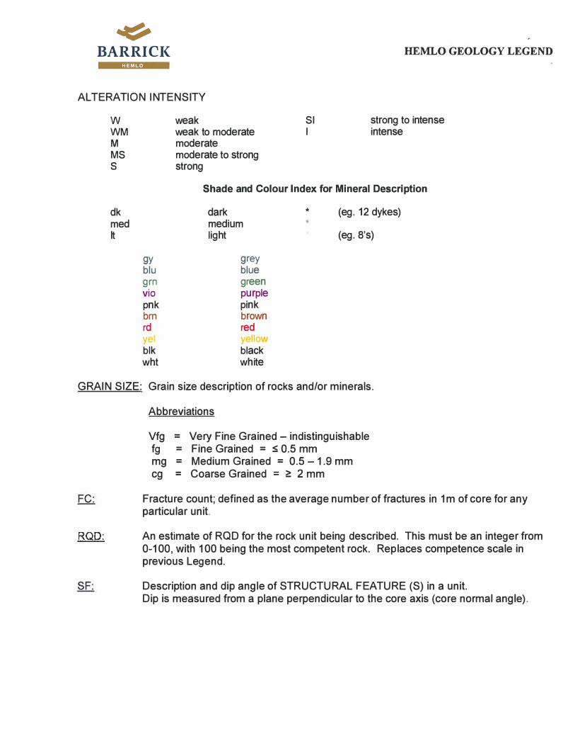
�
BARRI Cl( HEM LO
FD-folded FT -fault/slip GO-gouge
CT-contact CL -cleavage BD-bedding av - quartz vein LN -lineation FR -fracture or joint SK -slickensides
FROM -TO Range or location (metres) of a structural feature.
MINERALOGY
HEMLO GEOLOGY LEGEND
Observed minerals described by mode of occurrence/texture and percentage of the total rock. Use the same guide as Part B: Rock Names (refer to Appendix I and II)
ZONE Used for highlighting information
MZ1 S FW MZ2 MZ3 N HW
FZ-1 N FW FZ-2 FZ-3 S FWS

�
BARRI Cl( HEMLO GEOLOGY LEGEND
h:ft,14·
APPENDIX I
ROCK NAMES
Listed below are standard rock names which are to be used for all mapping and core logging. Local variations can be noted as comments in the log and can also be shown in the alteration and mineralogy tables. It must be recognized that all of the supra-crustal rocks at Hem lo are foliated and metamorphosed to some degree. This legend attempts to emphasize the most important features associated with the gold mineralization ie structure, sericite, k-spar and silica alteration, the presence of molybdenite and pyrite.
Equally important, faults should be logged/mapped as separate lithological units wherever they are recognized. The format is "rock"FT. This could be any lithological subtype, but faulted in some way. The intent here is to clearly identify potential ground control problems at an early stage. This includes gouge, closely spaced fracture zones and slips along which displacement has occurred. Lamprophyres always form planes of weakness and should always be logged as a major unit if greater than 10 cm wide in core.
Notes:The term "fragmental" is not meant to have any specific genetic connotation. It is used here as a field term to describe a rock consisting of pieces of rock within a fine grained matrix.
The term "breccia" refers rocks which are obviously the product of some sort of brittle deformation and/or intrusion or phreatic process.
(1) Mafic Metavolcanic Rocks (Playter Harbour Sequence)- composed of amphibole (actinolite, hornblende, tremolite)- fine grained, dark greenish black (darker than intermediate rocks)- strongly magnetic except in chloritic sections- moderately to strongly foliated- includes pillowed flows and volcaniclastic sections, often difficult to distinguish in core.
1 Am: Typical Mafic Volcanics
1 Cln: Sheared, chloritic, mafic volcanics.
1 FT: Fault Zone Usually contains significant sections of gouge material.
(2) Intermediate Volcaniclastic Sediments- generally thickly bedded, equigranular/massive with local banded/laminated sections and
local tuff/lapilli-tuff sections. Strongly foliated. - has greater% of disseminated carbonate than the metasediments, often dark brownish in
colour.- likely originally a series of reworked volcaniclastic debris flows/lahars.- occasional thin beds of calc-silicate banded sediments.- composed mostly of feldspar, biotite and quartz with minor garnet

�
BARRI Cl( HEMLO GEOLOGY LEGEND
HEM LO
2Bi: Biotitic Volcaniclastics Fine grained, weakly to strongly foliated, thickly bedded brownish volcaniclastic sediments. Moderate to strong calcite alteration throughout. Often has weak to moderate sericite alteration.
2Mu: Sericitic Volcaniclastics Fine grained, weakly to strongly foliated, thickly bedded tan coloured volcaniclastic sediments with moderate to strong sericite (muscovite) alteration. Moderate to strong calcite alteration throughout. Often has weak to moderate biotite alteration
2kt: Cale-silicate Banded Volcaniclastics lnterbedded fine grained volcaniclastic material and calc-silicate banded sediments.
2c: Fragmental Intermediate Volcaniclastics Fine to medium grained foliated calcareous unit, variably biotitic and sericitic matrix with > 5% fragments 5-50mm long and lineated. Heterolithic, but fragments are most often subrounded to sub-angular leucocratic to bone white and feldspathic.
2s: Feldspathized Intermediate Volcaniclastics Fine grained, calcareous volcaniclastic unit with moderately to strongly feldspathic, biotitic unit. Can be medium to dark grey to brownish. May be intermixed with 2Bi.
2cs: Feldspathized Fragmental Intermediate Volcaniclastic Fine grained, moderately to strongly felspathic, biotitic, sericitic and calcitic matrix. With >5% fragments 5-50mm long. Heterolithic, but fragments are most often bone white andfeldspathic.
2FT: Fault Zone
(3) Felsic MetavolcanicNolcaniclastic Rocks- light coloured felsic rock with a porphyritic texture- defined by quartz eyes and/or feldspar phenocrysts and/or fragments- composed of feldspar (30-60%), quartz (10-15%) within a fine grained matrix consisting
of variable amounts of sericite, biotite and quartzo-feldspathic minerals.
- weakly to strongly foliated, variable intensities of sericite, biotite and feldspathic alteration.- carbonate is absent or else present in small amounts (<5%).
3e: Felsic Tuffite Very fine grained, light grey to grey green finely laminated siliceous rock (may in part be chemical sediments/cherts) containing narrow biotite schist interbeds. 3-5% quartz eyes 1-3 mm long are common. Finely disseminated pyrite (1-3%) along bedding planes.
3er: Hematized Feldspathic Schist

� BARRI CI< HEMLO GEOLOGY LEGEND
HEM LO
Fine grained to aphanitic pink to quite red, hematized and I or potassium feldspar rich schist which is typically low grade ore to barren. Chlorite occurs as fine clots and on fracture planes. Pyrite content is generally less than 2%.
3f: Moose Lake Porphyry
3fMu: Sericitic (Muscovite-Altered) MLP.
3fs: Feldspathized/Silicified MLP Fine to medium grained, light grey, with moderate to strong feldspathization and silicification. Feldspar phenocrysts are still visible, but quartz phenocrysts are generally obliterated. Often weakly to moderately sericitic. Often contains 1-5% pyrite and minor molybdenite. May constitute ore.
3sr: Feldspathized/Hematized MLP. Fine to medium grained, hard, feldspathic with a distinctive pinkish-red colour due to moderate to strong Kf-Hm alteration. Overlaps with, but generally overprints sericite and biotite alteration. Most common in the FW of B Zone, where it is almost always waste. Also present near chloritic shears and felsic dykes (9f) in the C Zone, where it may constitute part of the ore.
"
--- --:... . .. ... - "' �----- ... -- - ·--. -
. . ...... ·,
3sPy: Pyritic Feldspathization
Ill•....... ..
•
Fine grained, light grey feldspathization with fracture filling and disseminated pyrite. Mo may also be present, but Py dominates. VG or gold-telluride common along fractures.

�
BARRI Cl{ HEMLO GEOLOGY LEGEND
HEM LO
3sMo: Molybdenitic Feldspathization Fine grained, light to dark bluish grey feldspathization/silicification. Generally has a hard, pearly lustre. Py may also be present, but Mo dominates.
3c: Fragmental Felsic Volcanics. Strongly foliated, light grey rock, consisting of fine grained, sericitic or biotitic matrix with up to 50% heterolithic fragments from 5 to >50mm long. Fragments commonly have feldspar and quartz phenocrysts, similar in appearance to the MLP. 5% dark green, mafic fragments may also be present.

�
BARRI Cl( HEMLO GEOLOGY LEGEND
HEM LO
3cs: Feldspathized Fragmental Felsic rocks. As above, but with moderate to strong feldspathization and variable sericite, biotite and carbonate. Generally has a hard, pearly lustre. Molybdenite and 2-10% pyrite are common. Often constitutes ore.
3cRo: Quartz Pod and Green Mica Zone Medium to coarse grained light grey sericite and/or muscovite rich schist containing abundant green mica and quartz veins. Up to 15% pyrite and trace MoS5 . Rare stibnite, barite and realgar. Typical high grade ore with visible gold.
3sMu Fine grained, strongly feldspathic, moderately to strongly sericitic, light grey rock. Variable pyrite and molybdenite.
3FT: Fault Zone
(4) Metasedimentary Rocks- generally a banded/or laminated politic rock primarily composed of quartz, biotite and feldspar usually containing calc-silicate (green) bands. Usually fine to medium grained.- in H.W. sediments above the main zone the primary metamorphic minerals include
kyanite, garnets, staurolite and minor arsenopyrite.

�
BARRI Cl( HEMLO GEOLOGY LEGEND
IUl?,II•
4k: Metapelite Fine to medium grained, dark grey to black biotite sericite schists and minor gneisses containing abundant staurolite and garnet with less frequent chloritoid and sillimanite.
4kt: Cale-silicate Banded Sediments Very fine grained to fine grained, banded brown, green or purplish, laminated sediments and dark green calc-silicate bands. Generally biotitic, with varying amounts of garnet, staurolite, kyanite or silimanite.
4q Fine grained, thickly bedded, dark grey to brownish grey sediment. Lacks pervasive carbonate. May contain garnet, kyanite, staurolite or sillimanite. Locally contains fine grained feldspathic fragments. Locally contains calc-silicate bands.
4Mu: Sericitic Sediments Moderate to strong sericite alteration. Parts readily along the lamination/foliation.
4MuMo: Mineralized Metasiltstone Fine to medium grained, dark grey to brown quartz biotite sericite schists and gneisses. Typically thickly bedded sediments with scattered MoS2 traces.
4s: Feldspathic Sediments Moderate to strong feldspathization/silicification. Laminated sediments are altered to a bone white colour.
4Am: Amphibolitic Sediments Present as part of the FW sediment package. Laminated and well foliated. Quartzofeldspathic and light grey in colour, hard. It is typified by small quartz eyes and light coloured streaks and bands which contain coarse amphibole crystals.
4jAm: Mafic Wacke Medium to coarse grained, olive to dark green hornblende schists within the HW metasedimentary sequence.
4c: Fragmental Sedimentary Rocks/metaconglomerate Fine to medium grained, typically banded to laminated sediments containing pebble-cobble size fragments. Fragments may be heterolithic and elongated, locally feldspathized. A surface example of which can be seen on Heritage outcrop, fragments there are an example of fold related fragments.
4FT: Fault Zone

� BARRI Cl( HEMLO GEOLOGY LEGEND
HEM LO
(5) Baritic Rocks- > 25% barite. White to light grey barite occurring as laminate, stringers and veins both parallel to and cutting foliation. - usually associated with 6 unit in the B Zone.- usually has varying amounts of pyrite, molybdenite.
5FT: Fault Zone
(6) Feldspathic Rocks- the "6" unit should be reserved for the most intensely feldspathized rocks- massive or brecciated; fine grained; light-medium grey coloured unit(microcline rich rock)- composed mainly of feldspars, silica- commonly contains barite, pyrite, molybdenite and vanadium rich mica- molybdenite is the best indicator to determine grade- pyrite is the most common sulphide mineralization followed by molybdenite,stibnite and realgar, orpiment, arsenopyrite and cinnabar.
6Py: 6 unit with pyrite as the main sulphide mineral, little to no Mo. Includes semi-massive to massive pyritic bands within the 6 unit.
6PyMo: Typical B Zone ore material. May contain up to 5% barite.

BARRI Cl{ HEMLO GEOLOGY LEGEND
HEM LO
6BaPyMo: Typical B Zone ore with 5-25% barite.
6Mo: 6 unit with molybdenite as the main sulphide mineral.
6n: Chloritic, biotitic or sericitic shear within 6 unit. May show Mo, Py or other oreassociated minerals along the shear planes (to be noted separately in the Mineralogy Table).
6v: Quartz veined or silica-flooded zone (>25% quartz veins).
6Mu: Sericitic 6 unit Strongly feldspathic material with moderate to strong sericite (muscovite) alteration. Mo and Py content variable.
60: Brecciated 6 unit. Feldspathic rock that has intense barite and/or anhydrite in anastomising veinlets/stringers
6FT: Fault Zone
:1\-.9

�
BARRI Cl( HEMLO GEOLOGY LEGEND
HEM LO
(7) Biotite - Rich Breccia- similar to (2) unit mineralogically, but confined in areal extent in B Zone.- biotitic matrix supporting sub-angular, heterolithic fragments which includes ore
- ambiguous relationship with B Zone ore, as the unit appears to include orefragments, but is also locally mineralized in the matrix - often used for thin highly altered or deformed intermediate units; often schistose ofindeterminate origin- also used for biotite intermediate fragmental unit @ east end of A Zone
?FT: Fault Zone
(8) Muscovite Schist- Schistose, fine grained, light grey to light yellowish coloured rock.- Usually has fine quartz eyes, < 1 mm in diameter.- Often pyritic and may also have weak feldspathization, local roscoelite.- Tourmaline is common as randomly oriented crystals, concentrated along foliation planes.
Be: Quartz-eye Muscovite Schist Schistose, fine to medium grained, light grey to light yellowish coloured matrix with quartz augen 4-6mm long. May show ghosts of highly altered feldspar phenocrysts and lithones of less deformed material. Generally interpreted as sericitized and deformed MLP.
Bs: Feldspathized/Silicified Muscovite schist Strongly foliated to schistose, fine to medium grained quartzo-feldspathic rock with distinct feldspathization and/or silicification. Roscoelite common. Often pyritic and may also have significant Mo.
BFT: Fault Zone Any 8 unit showing prominent faulting, fracture zones or discrete gouge seams. Common near the HW sediment contact and Be (MLP) contacts.
(9) Felsic Porphyry- relatively late felsic intrusive rock with feldspar phenocrysts- light to medium grey.- occurs as sill-like units parallel to foliation and as cross-cutting dykes.
9f: Granodioritic porphyry White subhedral to euhedral medium grained feldspar within a groundmass of black biotite and quartz. May be massive or weakly to moderately foliated. Usually light to medium grey in colour.
9PC: Popcorn Porphyry Medium to coarse grained porphyritic and glomeroporphyritic white feldspar within a fine grained dark groundmass.

�
BARRI Cl( HEMLO GEOLOGY LEGEND
HEMLO
9Mu: Sericitized 9f Moderately sericitized, often foliated, almost white to creamy coloured porphyritic intrusive. Often contains milky white to glassy quartz veins.
9FT: Fault Zone
(10) Felsic Intrusive- other felsic intrusive rocks. Comments should include a good description of the unit beingconsidered.- includes: Granite, Granodiorite and Granitic gneiss- also applies to a late, steeply south dipping, crowded feldspar porphyry dyke occurring inthe C Zone Pit.
1 OFT: Fault Zone
1 OKf : Pegmatite
1 Oq : Aplitic sills Pale grey to white, fine grained, massive felsic sills and dykes with abundant fine grey porphyroblasts.
(11) Intermediate Intrusive- could be porphyritic- medium to dark grey, fine grained matrix- biotite rich matrix- typically occurs as sills and dykes
(12) Mafic Intrusive- dark grey to black to green- amphibole or chlorite rich
- dykes are typically less than 1 metre thick.- generally parallel or sub parallel to foliation but locally dip steeply to moderately to theSouth and are locally folded.
12FT: Fault Zone Can be used for narrow (5-10 cm) chloritic, sill-like structures found in C-Zone.
(13) Diabase- medium to fine grained dyke composed of amphiboles and feldspar.- generally massive and equigranular
(14) Lamprophyre- composed of carbonates, felted biotite, magnetite and pyroxenes- cross cutting to foliation- should be logged as a major unit if greater than 10 cm wide in core.

BARRI Cl( HEMLO GEOLOGY LEGEND HEM LO
(15) Breccia- rock made up of highly angular, coarse fragments lying in a fine to medium grained maficmatrix. Unit is confined to C Zone and is kept in the legend for historical purposes.
(16) Quartz Vein
APPENDIX II
STRUCTURAUTEXTURAL DEFINITIONS
(a) coating or envelopes - (i.e. biotite)
(b) blebs - non circular occurrences
(c) fragmental - describe the size (mm), composition, contacts of the fragments;fragment composition to the matrix composition
- % - how often they occur- broken material moved from place of origin
compare
(d) disseminated - mineral grains scattered throughout the matrix in a non uniform manner,compared to pervasive which is evenly dispersed throughout the unit
(e) quartz eyes - note size (mm) and %
(f) feldspar phenocrysts - note size (mm) and %
(g) interstitial - occurs between grains
(h) schistose - parts readily along foliation (ie. (8) unit)
(i) lenses/augen/eyes - note size (mm) and %
G) foliated - minerals are random in one plane, but does not necessarily part that way- most obvious for mica minerals
(k) banded - > 1 cm thick bands- alternating layers of different composition
(I) laminated - < 1 cm thick bands
(m) nodules/spots - circular or near circular occurrences
(n) shear - incremental displacement (step like displacement)- ductile movement

�
BARRI Cl( HEMLO GEOLOGY LEGEND
HEM LO
- usually mud/or clay- movement taken up by parallel planes as in displacement of a deck of cards
(o) brecciated - fragments usually are sharp, angular and coarse- fragments/matrix are of 2 different compositions or textures- fragments are in a matrix which is a later intrusive or has been disrupted by later
mineralization or tectonic activity
(p) pervasive - uniformly disseminated throughout the unit- not necessarily referring to a mineral could be pervasive alteration/weathering etc.
(q) massive - homogeneous unit that lacks any linear features (ie. dykes may be massive)- usually equigranular
(r) red colouration - red in colour (visually) (ie. 3er)- red colouration due to hematite dusting in feldspar crystals
(s) feldspathic - containing feldspar as the principal group of minerals (orthoclase, microcline,plagioclase, albite, anorthite)
- refers to abnormally hard, often lighter coloured sections of a unit, where the alteration is dueto feldspathitization and/or silification. It is generally not possible to visually distinguishbetween these two alterations.
(t) calc-silicate bands - high % of carbonates- commonly found in metasediments- fine to medium grain, green in colour
(u) quilts/or patches - similar to a bleb but with transitional contacts
(v) vein - a tabular or sheet-like body of minerals which has been intruded into a joint or fissure,or system of joints and fissures, in rocks, often irregular and discontinuing.
(w) books - layering of a mineral (stack) (ie. biotite; muscovite)
(x) sheeting - a mineral that occurs along slip surfaces (ie. molybdenite or mica)
(y) tarnish or stain - very thin coating or discolouration on a surface
Appendix B
DDH W1617 Drill Logs

DDH W1617 Major Lithology Log
LoggedDate From To
Major Rock
Name
Rock
Colour
Grain
Size Texture 1 Intensity Texture 2 Intensity Texture 3 Intensity Mineralization
Percentage
Mineralization
4-Feb-16 0 2 0
4-Feb-16 2 41.07 4q medgy-dkgy f-mg q M
4-Feb-16 41.07 46.27 4c medgy-dkgy f-mg c MS
4-Feb-16 46.27 50.96 4s ltgy-dkgy f-mg k M
8-Feb-16 50.96 62.83 4q brngy f-mg j M
8-Feb-16 62.83 64.07 12 blk f-mg q
8-Feb-16 64.07 73.32 4q brngy f-mg j M
8-Feb-16 73.32 77.9 4Mu brngy f-mg k M
8-Feb-16 77.9 78.57 12 dkgy f-mg j WM
8-Feb-16 78.57 81.12 4Mu brngy f-mg k MS
8-Feb-16 81.12 92.2 4q medgy-dkgy f-mg j WM
8-Feb-16 92.2 98.3 12 grngry f-mg q
8-Feb-16 98.3 98.7 4q ltgy-dkgy f-mg j WM
8-Feb-16 98.7 99.8 12 grngry f-mg q WM
8-Feb-16 99.8 107.75 4q brngy f-mg j M
8-Feb-16 107.75 109.87 4kt ltgy-dkgy f-mg k M
8-Feb-16 109.87 110.63 4c medgy f-mg c M
8-Feb-16 110.63 114.66 4kt brngy f-mg k M
8-Feb-16 114.66 115.74 12 grngry f-mg q
8-Feb-16 115.74 124.95 4c medgy-dkgy f-mg c M
9-Feb-16 124.95 136.9 4kt brngy f-mg k WM
9-Feb-16 136.9 139.57 4Mu ltgy-medgy f-mg k MS
9-Feb-16 139.57 141.06 4kt ltgy-dkgy f-mg k M
9-Feb-16 141.06 141.99 4c brngy f-mg c WM
9-Feb-16 141.99 144.53 4q medgy f-mg q WM
9-Feb-16 144.53 145.24 4c medgy-dkgy f-mg c WM
9-Feb-16 145.24 149.1 4kt medgy-dkgy f-mg k
9-Feb-16 149.1 151.71 4q brngy f-mg q M
9-Feb-16 151.71 152.55 4Mu ltgy-medgy f-mg j M
9-Feb-16 152.55 156.4 4q brngy f-mg q WM
9-Feb-16 156.4 156.8 12 grngry f-mg j WM
9-Feb-16 156.8 189.06 4q medgy f-mg q M
9-Feb-16 189.06 189.71 4Mu ltgy-medgy f-mg k M
9-Feb-16 189.71 190.69 4q ltgy-medgy f-mg j WM
9-Feb-16 190.69 203.28 4Mu ltgy-medgy f-mg k WM
9-Feb-16 203.28 212.59 2Bi brngy f-mg j WM
9-Feb-16 212.59 215.75 2c medgy-dkgy f-mg c M
9-Feb-16 215.75 227 2Bi medgy f-mg j WM
9-Feb-16 227 229.81 2s grngry f-mg j WM
9-Feb-16 229.81 231.84 2Bi medgy-dkgy f-mg j M
9-Feb-16 231.84 234.41 2c ltgy-dkgy f-mg c MS
9-Feb-16 234.41 234.76 12 dkgy f-mg q M
9-Feb-16 234.76 241.61 2c medgy-dkgy f-mg c MS
9-Feb-16 241.61 285.82 2Bi medgy-dkgy f-mg j M
10-Feb-16 285.82 289.1 2c medgy f-mg c M
10-Feb-16 289.1 292.25 2Bi medgy f-mg j M
10-Feb-16 292.25 293.09 12 blk f-mg j WM
10-Feb-16 293.09 293.69 2Mu ltgy-medgy f-mg j MS
10-Feb-16 293.69 294 12 blk f-mg j S
10-Feb-16 294 295.7 2c medgy f-mg c M
10-Feb-16 295.7 302.44 2Bi dkgy f-mg j W
10-Feb-16 302.44 306.18 2cs ltgy f-mg c WM
10-Feb-16 306.18 306.99 2Bi dkgy f-mg j W
10-Feb-16 306.99 328.61 2s ltgy-medgy f-mg j WM
10-Feb-16 328.61 328.86 14 blk f-mg j W
10-Feb-16 328.86 329.59 2s medgy f-mg j WM
10-Feb-16 329.59 330.23 2Bi dkgy f-mg j W
10-Feb-16 330.23 331.08 2s ltgy-dkgy f-mg j W
10-Feb-16 331.08 333.91 2Bi dkgy f-mg j W
10-Feb-16 333.91 336.11 2s ltgy-medgy f-mg j W
Interval (m)
Hole ID: W1617 Project Code: WOC_Pit
Logged By: twilliams
Collar Depth: 2.0 m Hole Depth: 660 m
Planned by: bgraham
Collar Coordinates: 578142.2mE 5394734mN (UTM NAD83)
Mining Land Number: Lease Claim 274
Core Size: NQ
Drilling Start Date: Feb 2, 2016
Drilling End Date: Feb 16, 2016
Drilled by: Boreal Drilling
Azimuth: 180 degrees Dip: -56 degrees
5/3/2017

DDH W1617 Major Lithology Log
LoggedDate From To
Major Rock
Name
Rock
Colour
Grain
Size Texture 1 Intensity Texture 2 Intensity Texture 3 Intensity Mineralization
Percentage
Mineralization
Interval (m)
Hole ID: W1617 Project Code: WOC_Pit
Logged By: twilliams
Collar Depth: 2.0 m Hole Depth: 660 m
Planned by: bgraham
Collar Coordinates: 578142.2mE 5394734mN (UTM NAD83)
Mining Land Number: Lease Claim 274
Core Size: NQ
Drilling Start Date: Feb 2, 2016
Drilling End Date: Feb 16, 2016
Drilled by: Boreal Drilling
Azimuth: 180 degrees Dip: -56 degrees
10-Feb-16 336.11 341.12 2Bi medgy f-mg j M
10-Feb-16 341.12 342.06 2c medgy f-mg c M
10-Feb-16 342.06 343.31 2s medgy-dkgy f-mg j WM
10-Feb-16 343.31 345.05 3fs ltgy f-mg f MS
10-Feb-16 345.05 348.47 12 grngry f-mg j W
10-Feb-16 348.47 358.63 2c medgy-dkgy f-mg c W
10-Feb-16 358.63 365.88 2Bi medgy f-mg j WM
10-Feb-16 365.88 367.08 2Mu ltgy-medgy f-mg j M
10-Feb-16 367.08 372.61 2Bi ltgy-medgy f-mg j WM
10-Feb-16 372.61 390.14 3fs ltgy f-mg f MS
10-Feb-16 390.14 402.16 3Bi ltgy-medgy f-mg j WM
10-Feb-16 402.16 405.06 3c medgy f-mg c MS
10-Feb-16 405.06 406 3sMu medgy-dkgy f-mg j WM
10-Feb-16 406 410.49 3Bi medgy f-mg f WM
10-Feb-16 410.49 420.62 3c medgy-dkgy fg c MS
11-Feb-16 420.62 421.82 3Bi ltgy-dkgy f-mg f M
11-Feb-16 421.82 425.43 3c medgy f-mg c MS
11-Feb-16 425.43 426.41 3fs ltgy f-mg f MS
11-Feb-16 426.41 427.08 3c ltgy-medgy f-mg c WM
11-Feb-16 427.08 427.71 16 wht f-mg
11-Feb-16 427.71 430.86 3c ltgy-medgy f-mg c MS
11-Feb-16 430.86 444.56 3fs ltgy f-mg f MS
11-Feb-16 444.56 446.52 3f medgy f-mg f WM
11-Feb-16 446.52 447 3c medgy-dkgy f-mg f WM
11-Feb-16 447 449.47 3Bi medgy-dkgy f-mg f WM
11-Feb-16 449.47 451.16 3fs ltgy f-mg f MS
11-Feb-16 451.16 454.62 3c ltgy-medgy f-mg f M
11-Feb-16 454.62 456.67 2Bi medgy-dkgy f-mg j WM
11-Feb-16 456.67 457.05 2c medgy f-mg c MS
11-Feb-16 457.05 461.74 2Bi medgy-dkgy f-mg j WM
11-Feb-16 461.74 472.25 2s ltgy-medgy f-mg j M
11-Feb-16 472.25 480.37 2Bi medgy-dkgy f-mg j WM
11-Feb-16 480.37 480.75 12 grngry f-mg j M
11-Feb-16 480.75 482.43 2Bi medgy-dkgy f-mg j WM
11-Feb-16 482.43 484 2Mu ltgy-medgy f-mg j WM
11-Feb-16 484 488 2Bi ltgy-medgy f-mg j M
11-Feb-16 488 495.18 3sMu ltgy-medgy f-mg j WM
11-Feb-16 495.18 498.23 3Bi medgy-dkgy f-mg j M
11-Feb-16 498.23 516.75 3sMu ltgy-medgy f-mg j MS
16-Feb-16 516.75 526.12 3Bi medgy-dkgy f-mg f WM
16-Feb-16 526.12 527.07 9f grngry f-mg f MS
16-Feb-16 527.07 529 3fs medgy-dkgy f-mg f M
16-Feb-16 529 533.8 3sMu ltgy-medgy f-mg j MS
16-Feb-16 533.8 534.32 16 wht f-mg q
16-Feb-16 534.32 536.19 3fs ltgy-medgy f-mg f WM
16-Feb-16 536.19 539.49 3sMu ltgy-medgy f-mg j M
16-Feb-16 539.49 543.25 3fs ltgy-medgy f-mg j WM
16-Feb-16 543.25 545.94 3sMu ltgy-medgy f-mg j M
16-Feb-16 545.94 549.56 3Bi medgy-dkgy f-mg j M
16-Feb-16 549.56 550.19 16 ltgy-medgy f-mg j MS
16-Feb-16 550.19 550.71 9f medgy-dkgy f-mg f MS
16-Feb-16 550.71 561.29 3Bi medgy f-mg j WM
16-Feb-16 561.29 562.28 9f medgy f-mg f WM
16-Feb-16 562.28 563.39 12 blk fg j W
16-Feb-16 563.39 576.11 4Mu ltgy-medgy f-mg j MS
16-Feb-16 576.11 577.72 4q medgy f-mg j M
16-Feb-16 577.72 580.18 9f medgy-dkgy f-mg f M
16-Feb-16 580.18 581.61 4q medgy-dkgy v-mg j WM
16-Feb-16 581.61 582.43 9f medgy f-mg f M
16-Feb-16 582.43 584.71 4q medgy-dkgy f-mg j WM
5/3/2017

DDH W1617 Major Lithology Log
LoggedDate From To
Major Rock
Name
Rock
Colour
Grain
Size Texture 1 Intensity Texture 2 Intensity Texture 3 Intensity Mineralization
Percentage
Mineralization
Interval (m)
Hole ID: W1617 Project Code: WOC_Pit
Logged By: twilliams
Collar Depth: 2.0 m Hole Depth: 660 m
Planned by: bgraham
Collar Coordinates: 578142.2mE 5394734mN (UTM NAD83)
Mining Land Number: Lease Claim 274
Core Size: NQ
Drilling Start Date: Feb 2, 2016
Drilling End Date: Feb 16, 2016
Drilled by: Boreal Drilling
Azimuth: 180 degrees Dip: -56 degrees
16-Feb-16 584.71 585.3 9f medgy-dkgy f-mg f M
16-Feb-16 585.3 587.38 4k brngy f-mg j M
16-Feb-16 587.38 588.04 9f medgy-dkgy f-mg f MS
16-Feb-16 588.04 595.74 4kt brngy f-mg k M
16-Feb-16 595.74 596.92 9f medgy-dkgy f-mg f M
16-Feb-16 596.92 597.49 4kt brngy f-mg k WM
16-Feb-16 597.49 599.33 9f ltgy-medgy f-mg f M
16-Feb-16 599.33 605.2 4kt brngy f-mg k M
16-Feb-16 605.2 606.5 4Mu ltgy-dkgy f-mg k M
16-Feb-16 606.5 611.97 4kt brngy f-mg k M
16-Feb-16 611.97 615 4q brngy f-mg q WM
16-Feb-16 615 618.65 12 medgy-dkgy f-mg j W
16-Feb-16 618.65 628.84 4q brngy f-mg q M
16-Feb-16 628.84 629.15 12 medgy-dkgy f-mg j W
17-Feb-16 629.15 632.1 4q medgy-dkgy f-mg j WM
17-Feb-16 632.1 637.62 4kt grngry f-mg k WM
17-Feb-16 637.62 649.88 4Mu ltgy-dkgy f-mg k M
17-Feb-16 649.88 650.43 4kt grngry f-mg k M
17-Feb-16 650.43 652.54 4Mu ltgy-medgy f-mg j WM
17-Feb-16 652.54 654.2 9Mu medgy-dkgy f-mg f WM
17-Feb-16 654.2 656.25 4Mu ltgy-medgy f-mg j WM
17-Feb-16 656.25 660 9Mu medgy-dkgy v-mg f WM
5/3/2017

DDH W1617 Minor Lithology Log
From To
Minor Rock
Name Rock Colour
Grain
Size Texture 1 Intensity Texture 2 Intensity
Major Surrounding
Rock Type
6.34 6.51 16 wht f-mg o M 16
23.8 24.1 16 wht f-mg q 16
34.34 34.43 16 wht f-mg q 16
35.05 35.35 16 wht f-mg q 16
91.47 91.6 12 dkgy f-mg q WM 12
114.1 114.28 12 grngry f-mg q 12
114.48 114.55 12 grngry f-mg q 12
239.25 239.37 12 blk f-mg j WM 12
279.34 279.42 12 blk f-mg j S 12
279.7 279.89 12 blk f-mg j S 12
281.01 281.05 12 blk f-mg j S 12
289.96 290.26 2c ltgy-dkgy f-mg c M 2c
290.58 290.74 12 blk f-mg j S 12
291.82 292.12 2c ltgy-dkgy f-mg c M 2c
294.23 294.27 12 blk f-mg j MS 12
322.73 322.83 12 blk f-mg j MS 12
325.45 325.75 2cs ltgy-dkgy f-mg c WM 2cs
343.8 344.06 12 medgy-dkgy f-mg j WM 12
344.72 345.05 2Bi dkgy f-mg j WM 2Bi
357.81 358 16 wht f-mg q 16
377.45 377.52 12 blk f-mg j M 12
440.54 440.63 12 dkgy f-mg 12
440.73 440.76 12 dkgy f-mg 12
483.34 483.48 16 wht f-mg q 16
483.74 484 16 wht f-mg q 16
489.84 490.02 16 wht f-mg q 16
490.34 490.51 12 blk f-mg q W 12
511.94 512.12 9f ltgy-medgy f-mg f MS 9f
541.57 541.78 12 medgy-dkgy f-mg j W 12
542.61 542.83 9f ltgy-medgy f-mg f M 9f
546.1 546.34 9f ltgy-medgy f-mg f M 9f
546.55 546.6 12 medgy-dkgy f-mg j WM 12
547.2 547.46 9f medgy-dkgy f-mg f M 9f
552 552.16 16 wht f-mg q WM 16
559.49 559.68 9f ltgy-medgy f-mg f WM 9f
576.25 576.53 9f medgy f-mg f W 9f
577.1 577.21 9f medgy f-mg f WM 9f
577.52 577.58 9f medgy f-mg f WM 9f
578.09 578.37 4q medgy f-mg j WM 4q
578.9 579.06 4q medgy f-mg j W 4q
579.69 579.98 4q medgy-dkgy f-mg j WM 4q
597.69 597.9 4kt brngy f-mg k W 4kt
598.05 598.15 4kt brngy f-mg k W 4kt
626.1 626.4 16 wht f-mg q 16
645.28 645.44 4kt grngry f-mg k WM 4kt
645.52 645.71 4kt grngry f-mg k WM 4kt
651.62 651.84 15 15
659.18 659.38 4kt medgy-dkgy f-mg k WM 4kt
659.74 660 4kt medgy-dkgy f-mg k W 4kt
Interval (m)
Hole ID: W1617 Project Code: WOC_Pit
Planned by: bgraham Logged By: twilliamsCollar Depth: 2.0 m
Drilled by: Boreal Drilling
Core Size: NQ
Mining Land Number: Lease Claim 274
Hole Depth: 660 mCollar Coordinates: 578142.2mE 5394734mN (UTM NAD83)
Azimuth: 180 degrees Dip: -56 degrees
Drilling End Date: Feb 16, 2016
Drilling Start Date: Feb 2, 2016

DDH W1617 Alteration Log
From To
Major Rock
Name Alteration 1 Intensity Mode Alteration 2 Intensity Mode Alteration 3 Intensity Mode AlterationComments
2 22.83 4q Bx M p Cx WM k Mx WM u
22.83 41.07 4c Cz WM p Mx WM p Cx WM ps
41.07 46.27 4c Bx MS p Fx M p Mx WM u
46.27 50.96 4s Bx M p Fx M k Mx W k
50.96 62.83 4q Cz WM p Bx WM p Cx WM ps
62.83 64.07 12 Cz WM p Ax WM p
64.07 73.32 4q Bx M p Mx M u Cx M k
73.32 77.9 4Mu Mx M p Bx WM k Cx M k
77.9 78.57 12 Cz WM p Ax WM p
78.57 81.12 4Mu Mx M p Bx WM k Cx M k
81.12 92.2 4q Bx M p Cx M ps Fx WM ps
92.2 98.3 12 Cz WM p Ax WM p
98.3 98.7 4q Bx M p Mx M ps Cx WM v
98.7 99.8 12 Cz WM p Ax WM p
99.8 107.75 4q Bx M p Mx WM ps Fx WM ps
107.75 109.87 4kt Bx M p Mx WM k Cx WM k
109.87 110.63 4c Bx M p Cx WM k Fx WM ps
110.63 114.66 4kt Bx M p Mx WM k Cx WM k
114.66 115.74 12 Cz WM p Ax WM p
115.74 124.95 4c Bx M p Mx WM ps Fx WM ps
124.95 136.9 4kt Bx M p Mx WM k Cx WM u
136.9 139.57 4Mu Mx MS p Bx M u Fx WM u
139.57 141.06 4kt Bx M p Mx WM k Cx WM u
141.06 141.99 4c Bx M p Mx WM ps Fx WM ps
141.99 144.53 4q Bx M p Mx M ps Cx WM v
144.53 145.24 4c Bx M p Fx M k Mx WM k
145.24 149.1 4kt Bx M p Mx M k Cx WM u
149.1 151.71 4q Bx M p Mx WM k Cx WM u
151.71 152.55 4Mu Mx MS p Bx WM u Fx WM u
152.55 156.4 4q Bx MS p Mx M k Cx M k
156.4 156.8 12 Cz WM p Ax WM p
156.8 189.06 4q Bx MS p Mx WM k Cx M k
189.06 189.71 4Mu Mx MS p Bx M u Fx WM u
189.71 190.69 4q Bx MS p Mx M k Cx M k
190.69 203.28 4Mu Mx M p Bx WM u Rd W u
203.28 212.59 2Bi Bx MS p Mx WM u Cx W v
212.59 215.75 2c Bx M p Cx M m Fx WM u
215.75 227 2Bi Bx MS p Mx WM u Cx W v
227 229.81 2s Fx MS p Cx M p Mx WM u
229.81 231.84 2Bi Bx M p Cx M p Mx WM u
231.84 234.41 2c Bx M p Cx M m Fx WM u
234.41 234.76 12 Cz WM p Ax WM p
234.76 241.61 2c Bx M p Cx M m Fx WM u
241.61 285.82 2Bi Bx M p Cx M p Mx WM u
285.82 289.1 2c Bx M p Cx M m Fx WM u
289.1 292.25 2Bi Bx M p Cx M p Mx WM u
292.25 293.09 12 Cz WM p Ax WM p
293.09 293.69 2Mu Mx MS p Bx WM u Fx W u
293.69 294 12 Cz WM p Ax WM p Cx M v
294 295.7 2c Bx M p Fx M p Cx M u
295.7 302.44 2Bi Bx W p Fx W u Cx W m
302.44 306.18 2cs Fx MS p Bx WM u Cx WM m
306.18 306.99 2Bi Bx W p Fx W u Cx W m
306.99 318 2s Fx MS p Cx WM m Bx WM u
318 320 2s Fx MS p Bx WM p Cx W m
320 320.8 2s Fx MS p Mx WM p Cx WM m
320.8 322.83 2s Fx MS p Bx WM u Cx WM m
322.83 323.5 2s Fx MS p Mx WM p Cx WM m
323.5 328.61 2s Fx MS p Bx WM ps Cx WM m
328.86 329.59 2s Fx MS p Mx WM p Cx WM m
329.59 330.23 2Bi Bx W p Fx W u Cx W m
330.23 331.08 2s Fx MS p Bx WM p Cx W m
331.08 333.91 2Bi Bx W p Fx W u Cx W m
333.91 336.11 2s Fx MS p Cx WM m Bx WM u
336.11 341.12 2Bi Bx M p Cx M p Fx WM ps
341.12 342.06 2c Bx M p Fx M p Cx M u
342.06 343.31 2s Fx MS p Bx M p Cx WM k
343.31 345.05 3fs Fx MS p Sx WM p Cx W m
345.05 348.47 12 Cz WM p Ax WM p
348.47 358.63 2c Bx M p Fx M p Cx M v
358.63 365.88 2Bi Bx WM p Cx M k Fx W u
365.88 367.08 2Mu Mx MS p Bx W u Fx W u
367.08 372.61 2Bi Bx WM p Cx M k Fx W u
372.61 376.37 3fs Fx MS p Sx WM p Cx W m
this core has adistinct colour difference than the previous alteration which
was more grey-purple in colour. Actual mineral identifcation
here is difficult.
Interval (m)
Hole ID: W1617 Project Code: WOC_Pit
Planned by: bgraham Logged By: twilliams
Collar Depth: 2.0 m Hole Depth: 660 m
Collar Coordinates: 578142.2mE 5394734mN (UTM NAD83)
Azimuth: 180 degrees Dip: -56 degrees
Drilling End Date: Feb 16, 2016
Drilling Start Date: Feb 2, 2016
Drilled by: Boreal Drilling
Core Size: NQ
Mining Land Number: Lease Claim 274

DDH W1617 Alteration Log
From To
Major Rock
Name Alteration 1 Intensity Mode Alteration 2 Intensity Mode Alteration 3 Intensity Mode AlterationComments
Interval (m)
Hole ID: W1617 Project Code: WOC_Pit
Planned by: bgraham Logged By: twilliams
Collar Depth: 2.0 m Hole Depth: 660 m
Collar Coordinates: 578142.2mE 5394734mN (UTM NAD83)
Azimuth: 180 degrees Dip: -56 degrees
Drilling End Date: Feb 16, 2016
Drilling Start Date: Feb 2, 2016
Drilled by: Boreal Drilling
Core Size: NQ
Mining Land Number: Lease Claim 274
376.37 390.14 3fs Fx MS p Cx M u Mx WM u
390.14 402.16 3Bi Fx MS p Bx WM p Mx WM u
402.16 405.06 3c Fx MS p Bx WM p Cx WM k
405.06 406 3sMu Fx M p Mx MS p Bx WM p
406 410.49 3Bi Fx MS p Bx WM p Mx WM u
410.49 420.62 3c Fx MS p Bx WM p Cx WM k
420.62 421.82 3Bi Fx MS p Mx WM k Bx WM k
421.82 425.43 3c Fx MS p Bx WM p Cx WM k
425.43 426.41 3fs Fx MS p Bx W u Cx WM m
426.41 427.08 3c Fx MS p Bx WM p Cx WM k
427.08 427.71 16 Sx SI p Bx W u Cx W u
427.71 430.86 3c Fx MS p Bx WM p Cx WM k
430.86 444.56 3fs Fx MS p Bx W u Cx WM m
444.56 446.52 3f Fx W ps Bx W u Cx W m
446.52 447 3c Fx MS p Bx WM p Cx WM k
447 449.47 3Bi Fx MS p Mx WM k Bx WM k
449.47 451.16 3fs Fx W ps Bx W u Cx W m
451.16 454.62 3c Fx MS p Bx WM p Cx WM k
454.62 456.67 2Bi Bx M p Cx WM p Fx W u
456.67 457.05 2c Bx M p Fx M p Cx M v
457.05 461.74 2Bi Bx M p Cx WM p Fx W u
461.74 472.25 2s Fx M p Bx W p Cx WM m
472.25 480.37 2Bi Bx M p Cx WM p Fx W u
480.37 480.75 12 Cz WM p Ax WM p
480.75 482.43 2Bi Bx M p Cx WM p Fx W u
482.43 484 2Mu Mx MS p Fx WM u Bx W u
484 488 2Bi Bx M p Fx WM u Mx WM u
488 495.18 3sMu Mx MS p Fx WM u Bx W u
495.18 498.23 3Bi Bx M p Fx WM u Mx WM u
498.23 516.75 3sMu Mx MS p Fx WM u Bx W u
516.75 526.12 3Bi Bx MS p Fx WM p Mx WM u
526.12 527.07 9f Fx W p Bx WM u Mx WM u
527.07 529 3fs Fx MS p Bx M p Mx WM u
529 533.8 3sMu Mx MS p Fx WM u Bx W u
534.32 536.19 3fs Fx MS p Bx MS p Mx WM u
536.19 539.49 3sMu Mx MS p Fx WM u Bx W u
539.49 543.25 3fs Fx MS p Bx MS p Mx WM u
543.25 545.94 3sMu Mx MS p Fx WM u Bx W u
545.94 549.56 3Bi Bx MS p Fx WM p Mx WM u
549.56 550.19 16 Cx S p Bx WM k Mx WM u
550.19 550.71 9f Bx MS p Fx WM u Cx WM u
550.71 561.29 3Bi Bx MS p Mx WM p Fx WM u
561.29 562.28 9f Fx W p Bx WM u Mx WM u
562.28 563.39 12 Cz WM p Ax WM p
563.39 576.11 4Mu Mx MS p Bx M u Fx WM u
576.11 577.72 4q Bx MS p Mx M k Cx M k
577.72 580.18 9f Fx W p Bx WM u Mx WM u
580.18 581.61 4q Bx MS p Mx M k Cx M k
581.61 582.43 9f Fx W p Bx WM u Mx WM u
582.43 584.71 4q Bx MS p Mx M k Cx M k
584.71 585.3 9f Fx W p Bx WM u Mx WM u
585.3 587.38 4k Bx M p Mx WM u Cx WM k
587.38 588.04 9f Fx W p Bx WM u Mx WM u
588.04 595.74 4kt Bx MS p Mx M k Cx M k
595.74 596.92 9f Fx W p Bx WM u Mx WM u
596.92 597.49 4kt Bx MS p Mx M k Cx M k
597.49 599.33 9f Fx W p Bx WM u Mx WM u
599.33 605.2 4kt Bx MS p Mx M k Cx M k
605.2 606.5 4Mu Mx MS p Bx M u Fx WM u
606.5 611.97 4kt Bx MS p Mx M k Cx M k
611.97 615 4q Bx M p Mx W u Fx WM ps
615 618.65 12 Cz WM p Ax WM p
618.65 628.84 4q Bx M p Mx W u Fx WM ps
628.84 629.15 12 Cz WM p Ax WM p
629.15 632.1 4q Bx M p Mx W u Fx WM ps
632.1 637.62 4kt Bx MS p Mx M k Cz WM k
637.62 649.88 4Mu Mx MS p Bx M u Fx WM u
649.88 650.43 4kt Bx MS p Mx M k Cz WM k
650.43 652.54 4Mu Mx MS p Fx WM p Bx W u
652.54 654.2 9Mu Bx MS p Mx W p Fx W p
654.2 656.25 4Mu Mx MS p Bx WM u Fx WM u
656.25 660 9Mu Bx MS p Mx WM p Fx W p

DDH W1617 Mineralization Log
From To
Ore
Mineral 1
Mineralization
Mode
Mineralization
Percentage
Ore
Mineral 2
Mineralization
Percentage
Major Surrounding
Rock Type Comments
2 41.07 Py d 0.1 4q
41.07 46.27 Py d 0.1 4c
46.27 50.96 Py d 0.05 4s
50.96 62.83 Py d 0.01 4q
62.83 64.07 Py d 0.01 12
64.07 73.32 Py d 0.01 4q
73.32 77.9 Py d 0.01 4Mu
77.9 78.57 Py d 0.01 12
78.57 81.12 Py d 0.01 4Mu
81.12 92.2 Py d 0.05 4q
92.2 98.3 Py d 0.01 12
98.3 98.7 Py d 0.01 4q
98.7 99.8 Py d 0.01 12
99.8 107.75 Py d 0.01 4q
107.75 109.87 Py d 0.05 4kt
109.87 110.63 Py d 0.05 4c
110.63 114.66 Py d 0.1 4kt
114.66 115.74 Py 0.01 12
115.74 124.95 Py d 0.05 4c
124.95 136.9 Py d 0.01 4kt
136.9 139.57 Py d 0.01 4Mu
139.57 141.06 Py d 0.01 4kt
141.06 141.99 Py d 0.01 4c
141.99 144.53 Py d 0.01 4q
144.53 145.24 Py d 0.01 4c
145.24 149.1 Py d 0.01 4kt
149.1 151.71 Py d 0.01 4q
151.71 152.55 Py d 0.01 4Mu
152.55 156.4 Py d 0.01 4q
156.4 156.8 Py d 0.01 12
156.8 189.06 Py d 0.01 4q
189.06 189.71 Py d 0.01 4Mu
189.71 190.69 Py d 0.01 4q
190.69 203.28 Py d 0.01 4Mu
203.28 212.59 Py d 0.05 2Bi
212.59 215.75 Py 0.075 2c
215.75 227 Py d 0.1 2Bi
227 229.81 Py d 0.05 2s
229.81 231.84 Py d 0.1 2Bi
231.84 234.41 Py d 0.1 2c
234.41 234.76 Py d 0.01 12
234.76 241.61 Py d 0.1 2c
241.61 285.82 Py d 0.1 2Bi
285.82 289.1 Py d 0.1 2c
289.1 292.25 Py d 0.1 2Bi
292.25 293.09 Py d 0.1 12
293.09 293.69 Py d 0.01 2Mu
Interval (m)
Hole ID: W1617 Project Code: WOC_Pit
Planned by: bgraham Logged By: twilliams
Collar Depth: 2.0 m Hole Depth: 660 m
Collar Coordinates: 578142.2mE 5394734mN (UTM NAD83)
Azimuth: 180 degrees Dip: -56 degrees
Mining Land Number: Lease Claim 274
Core Size: NQ
Drilling Start Date: Feb 2, 2016
Drilling End Date: Feb 16, 2016
Drilled by: Boreal Drilling

DDH W1617 Mineralization Log
From To
Ore
Mineral 1
Mineralization
Mode
Mineralization
Percentage
Ore
Mineral 2
Mineralization
Percentage
Major Surrounding
Rock Type Comments
Interval (m)
Hole ID: W1617 Project Code: WOC_Pit
Planned by: bgraham Logged By: twilliams
Collar Depth: 2.0 m Hole Depth: 660 m
Collar Coordinates: 578142.2mE 5394734mN (UTM NAD83)
Azimuth: 180 degrees Dip: -56 degrees
Mining Land Number: Lease Claim 274
Core Size: NQ
Drilling Start Date: Feb 2, 2016
Drilling End Date: Feb 16, 2016
Drilled by: Boreal Drilling
293.69 294 Py d 0.1 12
294 295.7 Py d 0.1 2c
295.7 302.44 Py d 0.05 2Bi
302.44 306.18 Py d 0.1 2cs
306.18 306.99 Py d 0.05 2Bi
306.99 328.61 Py d 0.1 Mo 0.01 2s
328.86 329.59 Py d 0.2 2s
329.59 330.23 Py d 1 2Bi
330.23 331.08 Py d 1 2s
331.08 333.91 Py d 1 2Bi
333.91 336.11 Py d 0.1 2s
336.11 341.12 Py d 1 2Bi
341.12 342.06 Py d 0.05 2c
342.06 343.31 Py k 1 2s
343.31 345.05 Py d 0.05 3fs
345.05 348.47 Py d 0.1 12
348.47 358.63 Py d 0.05 2c
358.63 365.88 Py d 0.1 2Bi
365.88 367.08 Py d 0.01 2Mu
367.08 372.61 Py d 1 2Bi
372.61 390.14 Py d 0.1 3fs
390.14 402.16 Py d 1 3Bi
402.16 405.06 Py d 1 3c
405.06 406 Py d 0.05 3sMu
406 410.49 Py d 0.05 3Bi
410.49 420.62 Py d 1 3c
420.62 421.82 Py d 1 3Bi
421.82 425.43 Py d 1 Mo 0.3 3c
425.43 426.41 Py d 1 3fs
426.41 427.08 Py d 1 3c
427.08 427.71 Py p 1 Mo 0.2 16
427.71 430.86 Py d 1 3c
430.86 444.56 Py d 1 Mo 0.4 3fs
444.56 446.52 Py d 1 Mo 0.1 3f
446.52 447 Py d 1 3c
447 449.47 Py d 1 3Bi
449.47 451.16 Py d 1 Mo 0.1 3fs
451.16 454.62 Py d 1 3c
454.62 456.67 Py d 0.5 2Bi
456.67 457.05 Py k 1 2c
457.05 461.74 Py p 0.5 2Bi
461.74 472.25 Py d 0.5 Mo 0.7 2s
472.25 480.37 Py d 0.5 2Bi
480.37 480.75 Py d 0.5 12
480.75 482.43 Py d 0.5 2Bi
482.43 484 Py d 1 2Mu
484 488 Py d 1 2Bi

DDH W1617 Mineralization Log
From To
Ore
Mineral 1
Mineralization
Mode
Mineralization
Percentage
Ore
Mineral 2
Mineralization
Percentage
Major Surrounding
Rock Type Comments
Interval (m)
Hole ID: W1617 Project Code: WOC_Pit
Planned by: bgraham Logged By: twilliams
Collar Depth: 2.0 m Hole Depth: 660 m
Collar Coordinates: 578142.2mE 5394734mN (UTM NAD83)
Azimuth: 180 degrees Dip: -56 degrees
Mining Land Number: Lease Claim 274
Core Size: NQ
Drilling Start Date: Feb 2, 2016
Drilling End Date: Feb 16, 2016
Drilled by: Boreal Drilling
488 495.18 Py 1 3sMu
495.18 498.23 Py d 1 3Bi
498.23 516.75 Py d 1 3sMu
516.75 526.12 Py 1.5 3Bi
526.12 527.07 Py 0.05 9f
527.07 529 Py d 1.5 3fs
529 533.8 Py k 1 3sMu
533.8 534.32 Py a 0.1 16
534.32 536.19 Py d 1.5 3fs
536.19 539.49 Py d 0.75 3sMu
539.49 543.25 Py k 1 3fs
543.25 545.94 Py k 0.5 3sMu
545.94 549.56 Py d 0.75 3Bi
549.56 550.19 Py d 0.05 16
550.19 550.71 Py d 0.01 9f
550.71 561.29 Py d 0.05 3Bi
561.29 562.28 Py d 0.01 9f
562.28 563.39 Py 0.01 12
563.39 576.11 Py d 0.1 4Mu
576.11 577.72 Py 0.01 4q
577.72 580.18 Py d 0.01 9f
580.18 581.61 Py d 0.01 4q
581.61 582.43 Py d 0.05 9f
582.43 584.71 Py d 0.01 4q
584.71 585.3 Py d 0.01 9f
585.3 587.38 Py d 0.01 4k
587.38 588.04 Py d 0.01 9f
588.04 595.74 Py d 0.01 4kt
595.74 596.92 Py d 0.1 9f
596.92 597.49 Py d 0.01 4kt
597.49 599.33 Py d 0.01 4Mu
599.33 605.2 Py d 0.01 4kt
605.2 606.5 Py d 0.01 4q
606.5 611.97 Py d 0.1 12
611.97 615 Py k 0.75 4q
615 618.65 Py d 0.01 12
618.65 628.84 Py d 0.75 Po 0.5 4q
628.84 629.15 Py d 0.01 4kt
629.15 632.1 Py d 0.75 Po 0.5 4Mu
632.1 637.62 Py d 0.3 Po 0.3 4kt
637.62 649.88 Py d 0.75 4Mu
649.88 650.43 Py d 0.05 Po 0.05 4kt
650.43 652.54 Py d 0.01 4Mu
652.54 660 Py d 0.01 4Mu

DDH W1617 Structural Log
Hole ID: W1617
Planned by: bgraham
Collar Depth: 2.0 m
Azimuth: 180 degrees
Core Size: NQ
Depth Major Surrounding
Rock Type
Structure
Type
Structure
Subtype
Structure
Infill
Alpha
Angle
Gange
Mineral
Roughness Thickness
(mm) Structure Comments
47.14 4s FT gou S3 55 Smooth
62.83 12 CT N 30 Smooth
64.07 12 CT N 30 Smooth
80.8 4mu FT gou S2 60 Smooth
98.3 12 CT N 25 Smooth
114.66 12 CT N 25 Smooth
119.8 4kt CT N 30 Smooth
123.73 4c FT gou S2 60 Smooth
138.9 4mu FT fau S3 60 Smooth
155.53 4q FT gou S2 60 Smooth
222.1 2ci FT fau S3 65 Smooth
222.24 2bi FT fau S2 65 Smooth
239.25 2c CT N 55 Smooth
239.37 2c CT N 55 Smooth
251.17 2bi FT fau S3 65 Smooth
268.9 2bi FT fau H2 45 Smooth
284.71 2bi FT gou S2 65 Smooth
288.66 2c FT gou S2 70 Smooth
317.26 2s FT fau S3 60 Smooth
321 2s FT fau S3 60 Smooth
322.83 2s FT S2 50 Smooth
331.73 2bi FT fau S3 40 Smooth
345.05 3fs CT S2 40 Smooth
348.47 12 CT S2 25 Smooth
350.6 2c FT shz S2 70 Smooth
371.9 2bi FT shz S3 50 Smooth
377.45 3fs CT S2 50 Smooth
377.52 3fs CT S2 50 Smooth
396.23 3bi FT gou S2 60 Smooth
396.77 3bi FT gou S2 70 Smooth
396.93 3bi FT gou S2 70 Smooth
397.25 3bi FT gou S2 70 Smooth
397.47 3bi FT gou S2 70 Smooth
437.83 3fs FT fau S3 65 Smooth
618.65 4q CT N 70 Smooth
Project Code: WOC_Pit
Logged By: twilliams
Drilled by: Boreal Drilling
Mining Land Number: Lease Claim 274
Hole Depth: 660 m
Collar Coordinates: 578142.2mE 5394734mN (UTM NAD83)
Dip: -56 degrees
Drilling End Date: Feb 16, 2016
Drilling Start Date: Feb 2, 2016

DDH W1617 Geotechnical Log
From To
Total
Recovery (m)
RQD Measurement
(m)
Rock
Strength Weathering
Number of
Discontinuity Sets
Alpha
Angle Frequency Infill Length Roughness Type
Alpha
Angle Frequency Infill Length Roughness Type
Alpha
Angle Frequency Infill Length Roughness Type Comments
2 3 1 0.92 R4 W1
3 6 3.04 3 R4 W1
6 9 3.09 3.09 R4 W1
9 12 3.15 3.01 R4 W1
12 15 2.81 2.68 R4 W1
15 18 3 2.95 R4 W1
18 21 2.75 2.7 R4 W1
21 24 2.96 2.91 R4 W1
24 27 2.88 2.78 R4 W1
27 30 3 2.97 R4 W1
30 33 3.08 3.01 R4 W1
33 36 2.88 2.75 R4 W1
36 39 3 2.77 R4 W1
39 42 3.05 3.01 R4 W1
42 45 2.95 2.8 R4 W1
45 48 2.9 2.83 R4 W1
48 51 3 2.94 R4 W1
51 54 2.98 2.86 R4 W1
54 57 2.96 2.96 R4 W1
57 60 3.04 2.94 R4 W1
60 63 3.06 3.02 R4 W1
63 66 3.05 2.93 R4 W1
66 69 2.86 2.79 R4 W1
69 72 2.95 2.87 R4 W1
72 75 3.08 3.08 R4 W1
75 78 3 3 R4 W1
78 81 2.95 2.47 R4 W1
81 84 2.93 2.73 R4 W1
84 87 3.05 2.93 R4 W1
87 90 3.05 3.02 R4 W1
90 93 3.07 2.91 R4 W1
93 96 3 3 R4 W1
96 99 3 2.79 R4 W1
99 102 2.95 2.86 R4 W1
102 105 3.03 2.98 R4 W1
105 108 2.97 2.9 R4 W1
108 111 3.03 3.03 R4 W1
111 114 3.03 2.94 R4 W1
114 117 2.91 2.77 R4 W1
117 120 3.1 3.1 R4 W1
120 123 2.89 2.83 R4 W1
123 126 3 2.96 R4 W1
126 129 3 2.91 R4 W1
Drilled by: Boreal Drilling
Discontinuity Set 1 Discontinuity Set 2 Discontinuity Set 3
Collar Coordinates: 578142.2mE 5394734mN (UTM NAD83)Azimuth: 180 degrees Dip: -56 degrees
Interval (m)
Core Size: NQ
Drilling Start Date: Feb 2, 2016
Drilling End Date: Feb 16, 2016
Hole ID: W1617 Project Code: WOC_Pit
Planned by: bgraham Logged By: twilliams
Collar Depth: 2.0 m Hole Depth: 660 m
Mining Land Number: Lease Claim 274

DDH W1617 Geotechnical Log
From To
Total
Recovery (m)
RQD Measurement
(m)
Rock
Strength Weathering
Number of
Discontinuity Sets
Alpha
Angle Frequency Infill Length Roughness Type
Alpha
Angle Frequency Infill Length Roughness Type
Alpha
Angle Frequency Infill Length Roughness Type Comments
Drilled by: Boreal Drilling
Discontinuity Set 1 Discontinuity Set 2 Discontinuity Set 3
Collar Coordinates: 578142.2mE 5394734mN (UTM NAD83)Azimuth: 180 degrees Dip: -56 degrees
Interval (m)
Core Size: NQ
Drilling Start Date: Feb 2, 2016
Drilling End Date: Feb 16, 2016
Hole ID: W1617 Project Code: WOC_Pit
Planned by: bgraham Logged By: twilliams
Collar Depth: 2.0 m Hole Depth: 660 m
Mining Land Number: Lease Claim 274
129 132 2.89 2.86 R4 W1
132 135 3 2.87 R4 W1
135 138 2.9 2.83 R4 W1
138 141 2.89 2.78 R4 W1
141 144 2.98 2.98 R4 W1
144 147 3.08 3.08 R4 W1
147 150 3.03 2.95 R4 W1
150 153 2.95 2.91 R4 W1
153 156 2.7 2.5 R4 W1
156 159 3 2.9 R4 W1
159 162 3.16 3.16 R4 W1
162 165 3.1 3.02 R4 W1
165 168 3.05 3.05 R4 W1

Appendix C
DDH W1620 Drill Logs

DDH W1620 Major Lithology Log
LoggedDate From To
Major Rock
Name
Rock
Colour
Grain
Size Texture 1 Intensity Texture 2 Intensity Texture 3 Intensity Mineralization
Percentage
Mineralization
23-Feb-16 0 2.4 0
23-Feb-16 2.4 7.5 4q medgy v-fg j WM k W c W
23-Feb-16 7.5 9.75 4s ltgy-medgy v-fg k WM j W
23-Feb-16 9.75 14.96 4q medgy fg j WM t W
23-Feb-16 14.96 16.77 4s ltgy-medgy v-fg k WM j W
23-Feb-16 16.77 17.22 12 dkgy fg n M
23-Feb-16 17.22 18.85 4s medgy v-fg k WM j W
23-Feb-16 18.85 20.91 4Mu ltgy-medgy v-fg k M j W
23-Feb-16 20.91 26.8 4c medgy v-mg c WM k WM j W
23-Feb-16 26.8 35.83 4c ltgy-medgy v-mg k WM j WM c W
23-Feb-16 35.83 42.97 4c medgy v-mg c WM k WM j W
23-Feb-16 42.97 46 4q medgy vfg j WM k W
23-Feb-16 46 47 4FT medgy fg j W q
23-Feb-16 47 57.09 4q medgy vfg j WM k W
23-Feb-16 57.09 60.96 4c medgy v-mg c WM j WM
23-Feb-16 60.96 64.7 4q medgy vfg j WM k W
23-Feb-16 64.7 72.82 4c grngry v-mg k WM c W
23-Feb-16 72.82 76.64 4Mu ltgy-medgy v-fg k M j W
24-Feb-16 76.64 98.21 4q medgy v-fg j WM k W
24-Feb-16 98.21 100.08 4Mu ltgy v-fg k MS t WM j W
24-Feb-16 100.08 106.44 4kt medgy v-fg k MS t WM j W
24-Feb-16 106.44 108.09 4q medgy v-fg j WM k W
24-Feb-16 108.09 109.36 4kt medgy v-fg k MS t WM j W
24-Feb-16 109.36 114.67 4q medgy v-fg j WM k W
24-Feb-16 114.67 116.82 4kt medgy v-fg k MS t WM j W
24-Feb-16 116.82 129.92 4q ltgy-medgy v-fg j WM k W
24-Feb-16 129.92 133.9 4kt medgy v-fg k M t WM j W
24-Feb-16 133.9 138.93 4c ltgy-medgy v-mg c M k WM j WM
24-Feb-16 138.93 155.62 4q ltgy-medgy v-fg j WM k W
24-Feb-16 155.62 182.35 4c ltgy-medgy v-mg c M k WM j WM
25-Feb-16 182.35 197.18 4q ltgy-medgy v-fg k WM j W
25-Feb-16 197.18 208.64 4kt ltgy-medgy v-fg k M t WM j W
25-Feb-16 208.64 215.73 4q ltgy-medgy v-fg k WM j W
25-Feb-16 215.73 216.11 12 dkgy fg n
25-Feb-16 216.11 222.52 4q ltgy-medgy v-fg k WM j W
25-Feb-16 222.52 224.3 4kt ltgy-medgy v-fg k M t WM j W
25-Feb-16 224.3 234.53 2c blugy v-mg c M k WM j W
25-Feb-16 234.53 235.9 2Bi medgy v-fg k W t W
25-Feb-16 235.9 240.55 2c ltgy-medgy v-mg c M k WM j W
25-Feb-16 240.55 241.92 11 medgy fg k WM
25-Feb-16 241.92 243.33 2c ltgy-medgy v-mg c M k WM j W
25-Feb-16 243.33 243.67 11 medgy fg k W
25-Feb-16 243.67 247.1 2c blugy v-mg c M k WM j W
25-Feb-16 247.1 248.75 11 medgy fg q
25-Feb-16 248.75 249.08 2c blugy v-mg c M k WM j W
25-Feb-16 249.08 249.54 11 medgy fg q
25-Feb-16 249.54 256.53 2c ltgy-medgy v-mg c M k WM j W
25-Feb-16 256.53 259.88 2Bi medgy v-fg k W c W
25-Feb-16 259.88 269.9 2c ltgy-medgy v-mg c M k WM j W
25-Feb-16 269.9 271.7 2Bi medgy v-fg k W
25-Feb-16 271.7 272.32 12 medgy-dkgy v-fg n WM j W
25-Feb-16 272.32 276.24 2cs ltgy-medgy v-mg c M j W
26-Feb-16 276.24 278.6 2s ltgy v-fg k WM
25-Feb-16 278.6 282.91 2cs ltgy-medgy v-mg c M j W
26-Feb-16 282.91 285.02 12 dkgy fg n M
26-Feb-16 285.02 285.53 2c medgy v-mg c WM j W
26-Feb-16 285.53 287.04 12 dkgy fg n M
25-Feb-16 287.04 289.7 2Bi medgy v-fg k W c W
26-Feb-16 289.7 291.16 12 dkgy fg n WM
25-Feb-16 291.16 295.39 2Bi medgy v-fg k W c W
Interval (m)
Hole ID: W1620 Project Code: WOC_Pit
Logged By: jquinn
Collar Depth: 2.4 m Hole Depth: 501 m
Planned by: bgraham
Collar Coordinates: 577887.9mE 5394762mN (UTM NAD83)
Mining Land Number: Lease Claim 274
Core Size: NQ
Drilling Start Date: Feb 17, 2016
Drilling End Date: Feb 21, 2016
Drilled by: Boreal Drilling
Azimuth: 180 degrees Dip: -45 degrees

DDH W1620 Major Lithology Log
LoggedDate From To
Major Rock
Name
Rock
Colour
Grain
Size Texture 1 Intensity Texture 2 Intensity Texture 3 Intensity Mineralization
Percentage
Mineralization
Interval (m)
Hole ID: W1620 Project Code: WOC_Pit
Logged By: jquinn
Collar Depth: 2.4 m Hole Depth: 501 m
Planned by: bgraham
Collar Coordinates: 577887.9mE 5394762mN (UTM NAD83)
Mining Land Number: Lease Claim 274
Core Size: NQ
Drilling Start Date: Feb 17, 2016
Drilling End Date: Feb 21, 2016
Drilled by: Boreal Drilling
Azimuth: 180 degrees Dip: -45 degrees
25-Feb-16 295.39 307.07 2c ltgy-medgy v-mg c M k WM j W
25-Feb-16 307.07 313.02 2Bi medgy v-fg k W c W t W
26-Feb-16 313.02 317.48 12 dkgy fg t W
25-Feb-16 317.48 324.21 2c ltgy-medgy v-mg c M k WM j W
26-Feb-16 324.21 325.76 12 dkgy fg n WM
25-Feb-16 325.76 329.93 2Bi medgy v-fg k W c W
25-Feb-16 329.93 332.7 2c ltgy-medgy v-mg c M k WM j W
26-Feb-16 332.7 334.31 12 dkgy fg n W
25-Feb-16 334.31 343.35 2c ltgy-medgy v-mg c M k WM j W
25-Feb-16 343.35 347.82 2Bi medgy v-fg k W c W
25-Feb-16 347.82 349.95 2c ltgy-medgy v-mg c M k WM j W
26-Feb-16 349.95 351.54 2FT ltgy-medgy fg o M n WM
26-Feb-16 351.54 359.71 2cs ltgy v-mg c M k WM j WM
26-Feb-16 359.71 364.83 3f ltgy-medgy v-mg f M j W
26-Feb-16 364.83 366.74 3c ltgy-medgy v-mg c M f WM j W
26-Feb-16 366.74 368.73 3f ltgy-medgy v-mg f M j W
26-Feb-16 368.73 369.58 11 medgy fg n WM
1-Mar-16 369.58 370.65 3f ltgy-medgy v-mg f M j W
1-Mar-16 370.65 376.07 2Bi medgy v-fg j WM k W f W
1-Mar-16 376.07 390.39 3f ltgy-medgy v-mg f M k WM j W
1-Mar-16 390.39 391.91 3Bi medgy fg f W k W
1-Mar-16 391.91 403.43 3f ltgy-medgy v-mg f M k WM j W
1-Mar-16 403.43 405.49 12 dkgy fg n M f W
1-Mar-16 405.49 411.05 3fs ltgy v-mg f M j W
1-Mar-16 411.05 412.55 12 dkgy fg n M o WM
1-Mar-16 412.55 419.77 3fs ltgy v-mg f M j W k W
1-Mar-16 419.77 420.47 3sMo blugy v-mg f WM n W
1-Mar-16 420.47 425.32 3fs ltgy v-mg f M j W k W
1-Mar-16 425.32 426.06 3sMo blugy v-mg f WM n W
1-Mar-16 426.06 431.17 3fs ltgy v-mg f M j W k W
1-Mar-16 431.17 431.84 4s blugy v-fg k M f W
1-Mar-16 431.84 432.56 3fs ltgy v-mg f M j W k W
1-Mar-16 432.56 435.25 4s blugy v-fg k M f W
1-Mar-16 435.25 436.17 12 dkgy fg n M
1-Mar-16 436.17 444.6 4s medgy v-fg k M
2-Mar-16 444.6 448.95 4c medgy v-mg c WM j W t W
2-Mar-16 448.95 457.25 4kt ltgy-medgy v-fg k M t WM c W
2-Mar-16 457.25 462.72 4c medgy v-mg c WM j W t W
2-Mar-16 462.72 474.56 4q medgy v-fg k WM t W c W
2-Mar-16 474.56 481.2 4c medgy v-mg c WM j W t W
2-Mar-16 481.2 485.42 4kt ltgy-medgy v-fg k M t WM c W
2-Mar-16 485.42 489.07 4c medgy v-mg c WM j W t W
2-Mar-16 489.07 495.1 4Mu ltgy-medgy v-fg k M t W c W
2-Mar-16 495.1 501 4c medgy v-mg c WM t WM j W

DDH W1620 Minor Lithology Log
From To
Minor Rock
Name
Rock
Colour
Grain
Size Texture 1 Intensity Texture 2 Intensity
Major Surrounding
Rock Type
17.79 18 16 wht vfg q 4s
50.7 50.8 9f medgy mg f M 4q
86.25 86.42 4c ltgy v-mg c MS j w 4q
175.44 175.58 16 wht vfg q 4c
202.86 202.95 16 wht vfg n 4kt
206.26 206.41 16 wht vfg n 4kt
259.63 259.82 16 wht vfg q 2Bi
271.91 272.02 16 wht vfg q 12
349.95 350.13 12 dkgy fg n 2c
351.25 351.54 12 dkgy fg n 2c
367.93 368.11 12 dkgy fg n M 3f
370.68 370.83 12 dkgy fg n M 2Bi
377.84 377.98 12 dkgy fg n M 3f
379.41 379.56 12 dkgy f-mg o M n wm 3f
382.11 382.24 12 dkgy fg n M 3f
442.93 443.04 16 wht vfg q 4s
Interval (m)
Hole ID: W1620 Project Code: WOC_Pit
Planned by: bgraham Logged By: jquinn
Collar Depth: 2.4 m
Drilled by: Boreal Drilling
Core Size: NQ
Mining Land Number: Lease Claim 274
Hole Depth: 501 m
Collar Coordinates: 577887.9mE 5394762mN (UTM NAD83)
Azimuth: 180 degrees Dip: -45 degrees
Drilling End Date: Feb 21, 2016
Drilling Start Date: Feb 17, 2016

DDH W1620 Alteration Log
From To
Major Rock
Name Alteration 1 Intensity Mode Alteration 2 Intensity Mode Alteration 3 Intensity Mode AlterationComments
2.4 7.5 4q Bx WM p Fx WM p Cx W ps
7.5 9.75 4s Fx MS p Bx WM ps Sx W v
9.75 14.96 4q Bx M p Fx WM ps Cx W k
14.96 16.77 4s Fx MS p Bx WM ps Sx W v
16.77 17.22 12 Cx M k
17.22 18.85 4s Fx MS p Bx WM ps Sx WM v
18.85 20.91 4Mu Bx M k Mx WM k Ex W v
20.91 26.8 4c Bx M ps Fx WM ps Sx W v
26.8 35.83 4c Bx M p Fx WM ps Mx W k
35.83 42.97 4c Bx M ps Fx WM ps Sx W v
42.97 46 4q Bx M p Fx WM ps Rd W ps
46 47 4FT Bx M p Rd WM ps Ax W ps
47 57.09 4q Bx M p Fx WM ps Rd W ps
57.09 60.96 4c Bx M p Fx W ps
60.96 64.7 4q Bx M p Fx WM ps Ex W v
64.7 72.82 4c Bx M p Ex WM k Mx WM k
72.82 76.64 4Mu Bx M p Mx WM k Cx W k
76.64 98.21 4q Bx M ps Fx WM ps Sx W v
98.21 100.08 4Mu Mx MS ps Bx WM k Cx WM k
100.08 106.44 4kt Bx M k Mx WM k Cx W k
106.44 108.09 4q Bx M p Mx WM ps Sx W v
108.09 109.36 4kt Bx M k Mx WM k Ax WM k
109.36 114.67 4q Bx M p Mx WM ps Sx W v
114.67 116.82 4kt Bx M k Mx WM k Ax WM k
116.82 129.92 4q Mx M ps Bx WM ps Sx W v
129.92 133.9 4kt Bx M k Ax WM k Cx WM k
133.9 138.93 4c Bx WM p Fx WM ps Sx W v
138.93 155.62 4q Bx M ps Mx WM ps Sx W v
155.62 160 4c Bx M p Mx WM ps Fx W ps
160 165 4c Bx M p Fx WM ps Mx W ps
165 172 4c Bx M p Mx WM ps Fx W ps
172 175 4c Bx WM p Fx WM ps Rd W v
175 182.35 4c Bx M ps Mx WM ps Sx W v
182.35 186 4q Bx M p Cx WM k Fx W ps
186 191 4q Bx WM k Mx WM k Ex W k
191 197.18 4q Bx M p Cx WM k Sx W v
197.18 208.64 4kt Bx M k Cx WM k Sx WM v
208.64 215.73 4q Bx M ps Cx WM ps Sx W v
215.73 216.11 12 Sx WM v
216.11 222.52 4q Bx M ps Cx WM ps Sx W v
222.52 224.3 4kt Bx M k Cx WM k Fx W ps
224.3 234.53 2c Bx WM ps Fx WM ps Sx W v
234.53 235.9 2Bi Bx M p Cx WM ps Fx W ps
235.9 240.55 2c Fx M p Cx WM ps Bx WM k
240.55 241.92 11 Cx M p Bx WM k
241.92 243.33 2c Cx WM p Bx WM ps Fx W ps
243.33 243.67 11 Cx M p Bx WM k
243.67 247.1 2c Bx WM ps Bx WM p Sx W v
247.1 248.75 11 Cx M p
248.75 249.08 2c Cx M p Bx WM ps Fx W ps
249.08 249.54 11 Cx M p
249.54 256.53 2c Bx M ps Fx WM ps Mx W k
256.53 259.88 2Bi Bx M p Sx WM v Cx W ps
Interval (m)
Hole ID: W1620 Project Code: WOC_Pit
Planned by: bgraham Logged By: jquinn
Collar Depth: 2.4 m Hole Depth: 501 m
Collar Coordinates: 577887.9mE 5394762mN (UTM NAD83)
Azimuth: 180 degrees Dip: -45 degrees
Drilling End Date: Feb 21, 2016
Drilling Start Date: Feb 17, 2016
Drilled by: Boreal Drilling
Core Size: NQ
Mining Land Number: Lease Claim 274

DDH W1620 Alteration Log
From To
Major Rock
Name Alteration 1 Intensity Mode Alteration 2 Intensity Mode Alteration 3 Intensity Mode AlterationComments
Interval (m)
Hole ID: W1620 Project Code: WOC_Pit
Planned by: bgraham Logged By: jquinn
Collar Depth: 2.4 m Hole Depth: 501 m
Collar Coordinates: 577887.9mE 5394762mN (UTM NAD83)
Azimuth: 180 degrees Dip: -45 degrees
Drilling End Date: Feb 21, 2016
Drilling Start Date: Feb 17, 2016
Drilled by: Boreal Drilling
Core Size: NQ
Mining Land Number: Lease Claim 274
259.88 269.9 2c Bx M ps Sx WM v Cx W k
269.9 271.7 2Bi Bx M ps Cx WM k Fx W ps
271.7 272.32 12 Cx M ps Sx WM v Fx W ps
272.32 276.24 2cs Ax M ps Cx WM p Fx W ps
276.24 278.6 2s Ax M p Fx WM p Cx WM ps
278.6 282.91 2cs Fx M ps Ax WM ps Bx WM k
282.91 285.02 12 Cx M p Sx W v
285.02 285.53 2c Fx WM p Bx W k Mx W k
285.53 287.04 12 Cx M p Sx W v
287.04 289.7 2Bi Bx M k Fx WM ps Cx W k
289.7 291.16 12 Cx WM k
291.16 295.39 2Bi Bx M k Fx WM ps Cx W k
295.39 307.07 2c Bx M ps Fx WM ps Cx WM k
307.07 313.02 2Bi Bx M ps Fx WM ps Cx WM k
313.02 317.48 12 Cx WM p
317.48 324.21 2c Bx WM k Fx WM ps Cx W k
324.21 325.76 12 Cx M k
325.76 329.93 2Bi Bx M ps Fx WM ps Cx W ps
329.93 332.7 2c Bx M ps Fx WM ps Cx WM ps
332.7 334.31 12 Cx WM p
334.31 343.35 2c Bx M ps Fx M ps Cx WM ps
343.35 347.82 2Bi Bx M ps Cx WM ps Fx WM ps
347.82 349.95 2c Bx WM ps Fx WM ps Cx W ps
349.95 351.54 2FT Fx WM p Bx WM ps Cx W ps
351.54 359.71 2cs Fx MS p Cx WM ps Bx W k
359.71 364.83 3f Fx M p Bx W ps Cx W k
364.83 366.74 3c Fx M p Bx WM k Cx WM ps
366.74 368.73 3f Fx WM ps Cx W ps Sx W v
368.73 369.58 11 Cx MS p Bx M ps Sx W v
369.58 370.65 3f Fx WM ps Cx W v Bx W k
370.65 376.07 2Bi Bx M p Cx WM ps Sx W v
376.07 390.39 3f Fx WM ps Bx WM k Cx W k
390.39 391.91 3Bi Bx M p Cx WM p Fx W ps
391.91 403.43 3f Bx WM ps Fx WM ps Sx W v
403.43 405.49 12 Cx MS p Bx WM ps Fx W ps
405.49 411.05 3fs Fx M p Bx WM ps Cx W k
411.05 412.55 12 Cx MS p Sx WM v Bx W ps
412.55 419.77 3fs Fx M p Bx WM k Cx W k
419.77 420.47 3sMo Sx MS ps Cx WM ps Fx WM ps
420.47 425.32 3fs Fx M p Bx WM k Cx W k
425.32 426.06 3sMo Sx MS ps Cx WM ps Fx WM ps
426.06 431.17 3fs Fx M p Bx WM k Sx W v
431.17 431.84 4s Fx MS p Bx WM k Cx W k
431.84 432.56 3fs Fx M p Bx WM k Cx W k
432.56 435.25 4s Fx MS b Bx WM k Cx W k
435.25 436.17 12 Cx M p Sx WM v
436.17 444.6 4s Fx MS b Bx WM k Cx W k
444.6 448.95 4c Bx M ps Ax W k Cx W k
448.95 457.25 4kt Bx M ps Fx WM ps Ax W k
457.25 462.72 4c Bx M ps Fx WM ps Ax WM ps
462.72 474.56 4q Bx M ps Ax WM k Fx WM ps
474.56 481.2 4c Bx WM ps Fx WM ps Ax W k
481.2 485.42 4kt Bx M ps Mx WM k Ax W k

DDH W1620 Alteration Log
From To
Major Rock
Name Alteration 1 Intensity Mode Alteration 2 Intensity Mode Alteration 3 Intensity Mode AlterationComments
Interval (m)
Hole ID: W1620 Project Code: WOC_Pit
Planned by: bgraham Logged By: jquinn
Collar Depth: 2.4 m Hole Depth: 501 m
Collar Coordinates: 577887.9mE 5394762mN (UTM NAD83)
Azimuth: 180 degrees Dip: -45 degrees
Drilling End Date: Feb 21, 2016
Drilling Start Date: Feb 17, 2016
Drilled by: Boreal Drilling
Core Size: NQ
Mining Land Number: Lease Claim 274
485.42 489.07 4c Bx WM ps Ax W k Mx W k
489.07 495.1 4Mu Bx WM k Mx WM k Sx W v
495.1 501 4c Bx WM ps Cx WM ps Ax W ps

DDH W1620 Mineralization Log
From To
Ore
Mineral 1
Mineralization
Mode
Mineralization
Percentage
Ore
Mineral 2
Mineralization
Percentage
Major Surrounding
Rock Type Comments
20.91 26.8 Py k 0.01 4c
72.82 76.64 Py k 0.01 4Mu
76.64 98.21 Py d 0.01 4q
129.92 133.9 Py d 0.02 4kt
133.9 138.93 Py d 0.03 4c
138.93 155.62 Py d 0.01 4q
182.35 197.18 Py k 0.01 4q
197.18 208.64 Py k 0.05 4kt
208.64 215.73 Py k 0.1 4q
215.73 216.11 Py d 0.2 12
216.11 222.52 Py k 0.01 4q
222.52 224.3 Py k 0.05 4kt
224.3 234.53 Py d 0.01 2c
240.55 241.92 Py v 0.1 11
241.92 243.33 Py d 0.01 2c
243.33 243.67 Py d 0.2 11
247.1 248.75 Py d 0.1 11
249.54 256.53 Py k 0.05 2c
256.53 259.88 Py d 0.01 2Bi
259.88 269.9 Py k 0.01 2c
269.9 271.7 Py d 0.02 2Bi
271.7 272.32 Py d 0.1 12
276.24 278.6 Py d 0.01 2s
278.6 282.91 Py d 0.02 2cs
282.91 285.02 Py d 0.5 12
285.53 287.04 Py d 0.5 12
287.04 289.7 Py d 0.3 2Bi
289.7 291.16 Py d 0.2 12
291.16 295.39 Py d 0.1 2Bi
295.39 307.07 Py k 0.05 2c
307.07 313.02 Py k 0.01 2Bi
317.48 324.21 Py k 0.01 2c
325.76 329.93 Py d 0.01 2Bi
329.93 332.7 Py d 0.01 2c
332.7 334.31 Py d 0.05 12
334.31 343.35 Py d 0.05 2c
343.35 347.82 Py k 0.25 2Bi
347.82 349.95 Py k 0.25 2c
349.95 351.54 Py d 0.1 2FT
351.54 359.71 Py d 0.02 2cs
359.71 364.83 Py d 0.1 3f
364.83 366.74 Py d 0.02 3c
366.74 368.73 Py d 0.05 3f
368.73 369.58 Py d 0.5 11
369.58 370.65 Py d 0.02 3f
376.07 390.39 Py d 0.05 3f
390.39 391.91 Py d 0.01 3Bi
Interval (m)
Hole ID: W1620 Project Code: WOC_Pit
Planned by: bgraham Logged By: jquinn
Collar Depth: 2.4 m Hole Depth: 501 m
Collar Coordinates: 577887.9mE 5394762mN (UTM NAD83)
Azimuth: 180 degrees Dip: -45 degrees
Mining Land Number: Lease Claim 274
Core Size: NQ
Drilling Start Date: Feb 17, 2016
Drilling End Date: Feb 21, 2016
Drilled by: Boreal Drilling

DDH W1620 Mineralization Log
From To
Ore
Mineral 1
Mineralization
Mode
Mineralization
Percentage
Ore
Mineral 2
Mineralization
Percentage
Major Surrounding
Rock Type Comments
Interval (m)
Hole ID: W1620 Project Code: WOC_Pit
Planned by: bgraham Logged By: jquinn
Collar Depth: 2.4 m Hole Depth: 501 m
Collar Coordinates: 577887.9mE 5394762mN (UTM NAD83)
Azimuth: 180 degrees Dip: -45 degrees
Mining Land Number: Lease Claim 274
Core Size: NQ
Drilling Start Date: Feb 17, 2016
Drilling End Date: Feb 21, 2016
Drilled by: Boreal Drilling
391.91 403.43 Py d 0.01 3f
403.43 405.49 Py d 0.02 12
405.49 411.05 Py d 0.01 3fs
411.05 412.55 Py d 0.1 12
412.55 419.77 Py d 0.01 3fs
419.77 420.47 Py d 0.05 Mo 0.025 3sMo
420.47 425.32 Py d 0.025 3fs
425.32 426.06 Py d 0.05 Mo 0.025 3sMo
426.06 431.17 Py d 0.01 3fs
431.17 431.84 Py d 0.05 Mo 0.01 4s
431.84 432.56 Py d 0.01 3fs
432.56 435.25 Py d 0.5 4s
435.25 436.17 Py d 0.25 12
436.17 444.6 Py d 0.5 4s
444.6 448.95 Py d 0.1 4c
448.95 457.25 Py k 0.05 4kt
457.25 462.72 Py d 0.025 4c
462.72 474.56 Py d 0.01 4q
474.56 481.2 Py k 0.025 4c
481.2 485.42 Py k 0.01 4kt
485.42 489.07 Py k 0.01 4c

DDH W1620 Structural Log
Hole ID: W1620
Planned by: bgrahamCollar Depth: 2.4 m
Azimuth: 180 degrees
Core Size: NQ
Depth Major Surrounding
Rock Type
Structure
Type
Structure
Subtype
Structure
Infill
Alpha
Angle
Gange
Mineral
Roughness Thickness
(mm) Structure Comments
8.72 4s FO N 66 Smooth16.21 4s FO N 61 Smooth25.1 4c FR S3 7 Smooth
31.95 4c FR N 25 Smooth35.4 4c FR N 39 Smooth37.2 4c FO N 61 Smooth38.6 4c FR N 10 Smooth45.2 4q FO S3 58 Smooth
46.2 4q FT S2 8 Smooth
46.82 4q FT S3 48 Smooth
49 4q FR S3 25 Smooth
51.3 4q FR S3 7 Smooth
51.75 4q FO N 65 Smooth
60.86 4c FO N 66 Smooth
70.73 4c FO N 60 Smooth
74.77 4mu FO N 57 Smooth
85.69 4q FR N 36 S_rough
86.06 4q FO N 72 Smooth
92 4q FR N 67 Smooth
99.7 4mu FO S3 64 Slicken
101.9 4kt FR N 54 Smooth
106.08 4kt FO N 66 Smooth
116.62 4kt FO N 61 Smooth
117.95 4q FR H3 32 S_rough
120.6 4q FR H3 14 Smooth
123.3 4q FO S3 61 Smooth
125.03 4q FT S3 67 Smooth
128.3 4q FO S3 66 Smooth
138.18 4c FO N 66 Smooth
153.57 4q FO N 73 Smooth
160.5 4c FO N 66 Smooth
167.3 4c FR S3 20 Smooth
168.68 4c FO N 70 Smooth
170.2 4c FR H3 32 S_rough
176.07 4c FO N 62 Smooth
179.6 4c FR H3 25 Smooth
183.74 4q FO N 68 Smooth
190.4 4q FT S2 68 Smooth
191.8 4q FR H3 11 S_rough
192.5 4q FO N 63 Smooth
198.84 4kt FO N 66 Smooth
203.75 4kt FO N 66 Smooth
216.11 12 CT N 66 Smooth
227.35 2c FR N 19 Smooth
240.55 2c CT N 20 Smooth
255.33 2c FO S3 64 Smooth
256.15 2c FT S2 69 Smooth
258.9 2bi FO N 69 Smooth
259.82 2bi FR N 45 S_rough
265.32 2c FO N 61 Smooth
270.84 2bi FO N 70 Smooth
278.4 2s FO N 63 Smooth
279.25 2cs FR N 59 Smooth
279.6 2cs FR N 43 Smooth
280.74 2cs FO N 66 Smooth
282.25 2cs FR N 40 Smooth
282.96 12 FT S2 58 Smooth
Project Code: WOC_Pit
Logged By: jquinn
Drilled by: Boreal Drilling
Mining Land Number: Lease Claim 274
Hole Depth: 501 mCollar Coordinates: 577887.9mE 5394762mN (UTM NAD83)
Dip: -45 degrees
Drilling End Date: Feb 21, 2016Drilling Start Date: Feb 17, 2016

DDH W1620 Structural Log
Hole ID: W1620
Planned by: bgrahamCollar Depth: 2.4 m
Azimuth: 180 degrees
Core Size: NQ
Depth Major Surrounding
Rock Type
Structure
Type
Structure
Subtype
Structure
Infill
Alpha
Angle
Gange
Mineral
Roughness Thickness
(mm) Structure Comments
Project Code: WOC_Pit
Logged By: jquinn
Drilled by: Boreal Drilling
Mining Land Number: Lease Claim 274
Hole Depth: 501 mCollar Coordinates: 577887.9mE 5394762mN (UTM NAD83)
Dip: -45 degrees
Drilling End Date: Feb 21, 2016Drilling Start Date: Feb 17, 2016
283.44 2c FR N 58 Smooth
285.75 12 FO N 66 Smooth
290.92 12 FR N 76 Smooth
296.6 2c FR S3 21 Smooth
299.05 2c FR N 78 Smooth
303.87 2c FR N 53 Smooth
305.08 2c FO N 64 Smooth
309.08 2bi FR N 50 Smooth
310.5 2bi FO N 66 Smooth
319.23 2c FO N 63 Smooth
323.27 2c FT S2 69 Smooth
323.37 2c FT S2 58 Smooth
326.25 2bi FO N 70 Smooth
327.3 2bi FR H3 14 Smooth
328.25 2bi FR H3 15 Smooth
331.65 2c FR H3 20 Smooth
349.75 2c FO N 69 Smooth
350.12 2c FT S1 64 Smooth
350.36 2c FT S1 43 Smooth
351.08 2c FT S1 43 Smooth
351.3 2c FT S1 38 Smooth
353 2cs FO N 68 Smooth
354.86 2cs FR N 36 Smooth
359.65 2cs FO N 73 Smooth
361.1 3f FR N 45 Smooth
363.58 3f FR N 30 Smooth
363.72 3f FR N 35 Smooth
367.98 3f FR N 36 Smooth
369.35 11 FR N 46 Smooth
373.47 2bi FR H3 26 Smooth
379.41 3f CT N 52 Smooth
381.72 3f FO N 66 Smooth
386.31 3f FR N 61 Smooth
389.03 3f FO N 66 Smooth
389.37 3f FR N 55 Smooth
391.77 3bi FR H3 35 S_rough
393.85 3f FR H3 34 S_rough
397.13 3f FO N 67 Smooth
402.35 3f FO N 61 Smooth
403.8 12 FR N 46 Smooth
405.13 12 FR N 74 Slicken
406.48 3fs FR H3 40 S_rough
409.05 3fs FR H3 22 S_rough
410.27 3fs FO N 69 Smooth
411.23 12 FT S2 64 Smooth
412.5 12 FO N 66 Smooth
414.45 3fs FR N 58 Smooth
416.02 3fs FR H3 23 S_rough
416.65 3fs FO N 73 Slicken
417.98 3ffs FR N 35 S_rough
419.62 3fs FR N 54 Smooth
422.03 3fs FO N 78 Smooth
423.83 3fs FR N 26 Smooth
424.11 3fs FO N 68 Smooth
426.62 3fs FR N 35 S_rough
429 3fs FR H3 33 S_rough

DDH W1620 Structural Log
Hole ID: W1620
Planned by: bgrahamCollar Depth: 2.4 m
Azimuth: 180 degrees
Core Size: NQ
Depth Major Surrounding
Rock Type
Structure
Type
Structure
Subtype
Structure
Infill
Alpha
Angle
Gange
Mineral
Roughness Thickness
(mm) Structure Comments
Project Code: WOC_Pit
Logged By: jquinn
Drilled by: Boreal Drilling
Mining Land Number: Lease Claim 274
Hole Depth: 501 mCollar Coordinates: 577887.9mE 5394762mN (UTM NAD83)
Dip: -45 degrees
Drilling End Date: Feb 21, 2016Drilling Start Date: Feb 17, 2016
431.3 4s FO N 72 Smooth
433.25 4s FR N 4 Smooth
434 4s FO N 64 Smooth
435.25 4s CT N 60 Smooth
436.15 12 FO N 65 Smooth
452.96 4kt FO N 71 Smooth
455.11 4kt FR N 78 Smooth
457.1 4kt FR H3 18 S_rough
462.45 4c FR H3 27 S_rough
463.87 4q FO N 68 Smooth
466.52 4q FO N 74 Smooth
472.8 4q FR H3 35 S_rough
474.72 4c FR N 46 S_rough
482.38 4kt FO N 71 Smooth
484.52 4kt FR H3 30 S_rough
491.35 4mu FR H3 30 S_rough
494.35 4mu FO N 68 Smooth
500.03 4c FO N 71 Smooth

DDH W1620 Geotechnical Log
From To
Total Recovery
(m)
RQD Measurement
(m)
Rock
Strength Weathering
Number of
Discontinuity Sets
Alpha
Angle Frequency Infill Length Roughness Type
Alpha
Angle Frequency Infill Length Roughness Type
Alpha
Angle Frequency Infill Length Roughness Type Comments
2.4 6 3.6 3.6 R4 W1 J0 0-2.4m has no core. Heavily fractured due to drilling. S.O.H
6 9 2.96 2.9 R4 W1 J1 66 3 N 3 Smooth FO
9 12 3.03 3.03 R4 W1 J1 66 1 N 3 Smooth FO
12 15 3.04 3.04 R4 W1 J0
15 18 2.99 2.87 R4 W1 J1 61 4 N 3 Smooth FO
18 21 3.02 3.02 R4 W1 J0
21 24 3.2 3.2 R4 W1 J0
24 27 3.01 3.01 R4 W1 J1 7 1 S3 3 Smooth FR
27 30 3.07 3.07 R4 W1 J0
30 33 2.99 2.99 R4 W1 J1.5 56 1 N 3 Smooth FO 25 1 N 3 Smooth FR
33 36 2.97 2.87 R4 W1 J1 39 2 N 3 Smooth FR
36 39 2.82 2.56 R4 W1 J2.5 58 3 N 3 Smooth FO 55 2 N 3 Smooth FR 10 1 S3 3 Smooth FR
39 42 3.04 2.98 R4 W1 J1 43 2 N 3 Smooth FR
42 45 3.12 2.9 R4 W1 J1 61 6 S3 3 Smooth FO
45 48 2.99 2.88 R4 W1 J2.5 58 4 S3 3 Smooth FO 48 1 S1 3 Smooth F 8 2 S2 3 Smooth FR
48 51 3.02 2.96 R4 W1 J1 66 2 N 3 Smooth FO
51 54 2.99 2.9 R4 W1 J1 65 2 N 3 Smooth FO
54 57 2.96 2.96 R4 W1 J0
57 60 2.99 2.99 R4 W1 J0
60 63 3.08 3.08 R4 W1 J0
63 66 2.94 2.94 R4 W1 J0
66 69 2.97 2.97 R4 W1 J0
69 72 3 2.96 R4 W1 J1 60 2 N 3 Smooth FO
72 75 2.98 2.98 R4 W1 J1 57 1 N 3 Smooth FO
75 78 2.92 2.84 R4 W1 J1 74 3 N 3 Smooth FO
78 81 3.01 3.01 R4 W1 J0
81 84 2.96 2.96 R4 W1 J0
84 87 2.98 2.96 R4 W1 J1.5 72 1 N 3 Smooth FO 36 1 N 3 S_rough FR
87 90 2.98 2.98 R4 W1 J0
90 93 2.99 2.95 R4 W1 J1 67 1 N 3 Smooth J
93 96 3.04 3.04 R4 W1 J0
96 99 3.02 2.93 R4 W1 J1 66 4 N 3 Smooth FO
99 102 2.92 2.42 R4 W1 J1.5 64 10 S3 3 Slicken FO 54 1 N 3 Smooth J
102 105 2.99 2.89 R4 W1 J1.5 65 4 S3 3 Smooth FO 65 1 S2 3 Smooth F
105 108 2.99 2.96 R4 W1 J1 66 2 N 3 Smooth FO
108 111 2.98 2.98 R4 W1 J0
111 114 3.08 3.06 R4 W1 J1 26 2 N 3 S_rough FR
114 117 2.96 2.89 R4 W1 J1 61 5 N 3 Smooth FO
117 120 2.96 2.72 R4 W1 J1.5 70 7 N 3 Smooth FO 32 1 H3 3 S_rough FR
120 123 2.88 2.75 R4 W1 J1.5 66 5 N 3 Smooth FO 14 1 S3 3 Smooth FR
123 126 2.9 2.77 R4 W1 J1.5 61 4 S3 3 Smooth FO 67 1 S3 3 Smooth F
126 129 3 2.9 R4 W1 J1 66 6 S3 3 Smooth FO
129 132 2.99 2.91 R4 W1 J1 68 4 N 3 Smooth FO
132 135 2.91 2.91 R4 W1 J0
135 138 3 3 R4 W1 J0
138 141 2.97 2.97 R4 W1 J1 66 1 S3 3 Smooth FO
141 144 2.98 2.98 R4 W1 J0
144 147 3.05 3.05 R4 W1 J0
147 150 2.96 2.96 R4 W1 J0
150 153 2.9 2.9 R4 W1 J1 9 1 S3 3 Smooth FR
153 156 3 3 R4 W1 J1 70 2 N 3 Smooth FO
156 159 2.97 2.97 R4 W1 J1 71 2 N 3 Smooth FO
Drilled by: Boreal Drilling
Discontinuity Set 1 Discontinuity Set 2 Discontinuity Set 3
Collar Coordinates: 577887.9mE 5394762mN (UTM NAD83)Azimuth: 180 degrees Dip: -45 degrees
Interval (m)
Core Size: NQDrilling Start Date: Feb 17, 2016
Drilling End Date: Feb 21, 2016
Hole ID: W1620 Project Code: WOC_Pit
Planned by: bgraham Logged By: jquinn
Collar Depth: 2.4 m Hole Depth: 501 m
Mining Land Number: Lease Claim 274

DDH W1620 Geotechnical Log
From To
Total Recovery
(m)
RQD Measurement
(m)
Rock
Strength Weathering
Number of
Discontinuity Sets
Alpha
Angle Frequency Infill Length Roughness Type
Alpha
Angle Frequency Infill Length Roughness Type
Alpha
Angle Frequency Infill Length Roughness Type Comments
Drilled by: Boreal Drilling
Discontinuity Set 1 Discontinuity Set 2 Discontinuity Set 3
Collar Coordinates: 577887.9mE 5394762mN (UTM NAD83)Azimuth: 180 degrees Dip: -45 degrees
Interval (m)
Core Size: NQDrilling Start Date: Feb 17, 2016
Drilling End Date: Feb 21, 2016
Hole ID: W1620 Project Code: WOC_Pit
Planned by: bgraham Logged By: jquinn
Collar Depth: 2.4 m Hole Depth: 501 m
Mining Land Number: Lease Claim 274
159 162 2.96 2.85 R4 W1 J1 68 6 N 3 Smooth FO
162 165 3.01 3.01 R4 W1 J1 66 2 N 3 Smooth FO
165 168 2.98 2.9 R4 W1 J1 20 1 S3 3 Smooth FR
168 171 2.96 2.88 R4 W1 J2 70 3 N 3 Smooth FO 32 3 H3 3 S_rough FR

Appendix D
DDH W1621 Drill Logs

DDH W1621 Major Lithology Log
LoggedDate From To
Major Rock
Name Rock Colour
Grain
Size Texture 1 Intensity Texture 2 Intensity Texture 3 Intensity Mineralization
Percentage
Mineralization
29-Feb-16 0 6 0
29-Feb-16 6 8.83 4q brngy fg q MS k WM
29-Feb-16 8.83 10.32 4q dkgy f-mg q MS VS MS f WM
29-Feb-16 10.32 16.1 4q dkgy f-mg q MS c WM f WM
29-Feb-16 16.1 25.24 4q ltgy-dkgy fg k M c W
29-Feb-16 25.24 25.64 16 wht cg
29-Feb-16 25.64 35 4q dkgy fg k WM c W q S
29-Feb-16 35 37.17 4c dkgy f-mg c MS f M
29-Feb-16 37.17 42.43 4q pnk f-mg k M q MS
29-Feb-16 42.43 49 4c dkgy f-mg c MS q S
29-Feb-16 49 53.65 4q grngry fg c WM f WM q MS
29-Feb-16 53.65 55.13 4c dkgy f-mg f M c M
29-Feb-16 55.13 69.67 4q ltgy-dkgy f-mg k M c W f MS
1-Mar-16 69.67 84.39 4c dkgy f-mg c M f WM q S
1-Mar-16 84.39 87 4q dkgy f-mg k S f WM
1-Mar-16 87 91.89 4Mu ltgy-dkgy f-mg k S f M
1-Mar-16 91.89 92.5 4q dkgy fg q S
1-Mar-16 92.5 94.11 4Mu ltgy-dkgy f-mg k S
1-Mar-16 94.11 96.23 4c dkgy f-mg c MS f S
1-Mar-16 96.23 97.43 4Mu ltgy-dkgy f-mg k S f WM
1-Mar-16 97.43 101.55 4q dkgy f-mg f MS q S
1-Mar-16 101.55 119.23 4Mu ltgy-dkgy f-mg k S f M c W
1-Mar-16 119.23 121 4kt ltgy-dkgy fg k M
1-Mar-16 121 126.16 4c grngry f-mg c MS
1-Mar-16 126.16 132.4 4kt ltgy-dkgy fg k MS c W
1-Mar-16 132.4 135.4 4kt grngry f-mg c W k M
1-Mar-16 135.4 139.58 4q dkgy fg PS WM k WM
1-Mar-16 139.58 142.47 4FT dkgy fg k WM PS WM
1-Mar-16 142.47 162.08 4q dkgy f-mg k M PS WM c WM
2-Mar-16 162.08 175.5 4kt dkgy f-mg k MS c WM PS WM
2-Mar-16 175.5 180.76 4q ltgy-dkgy fg k MS
2-Mar-16 180.76 183.24 4q dkgy f-mg k WM c W
2-Mar-16 183.24 199.33 4Mu ltgy-dkgy fg k MS PS WM c W
2-Mar-16 199.33 199.69 12 grn fg n WM
2-Mar-16 199.69 202.72 4Mu ltgy-dkgy fg k M PS WM
2-Mar-16 202.72 210.23 4q dkgy f-mg c W PS M
2-Mar-16 210.23 217.27 4q dkgy f-mg c W k W
2-Mar-16 217.27 230 4c ltgy-dkgy f-mg c MS k M
2-Mar-16 230 232.44 4c pnk f-mg c M
2-Mar-16 232.44 234.13 4c ltgy-dkgy f-mg c MS
2-Mar-16 234.13 240.31 4q ltgy-dkgy f-mg q S k WM c W
3-Mar-16 240.31 249.24 2c ltgy-dkgy f-mg c M k M
3-Mar-16 249.24 254.55 2cs medgy f-mg c M
3-Mar-16 254.55 255.09 12 blk f-mg n M
3-Mar-16 255.09 266.8 2cs ltgy-medgy f-mg c M
3-Mar-16 266.8 267.34 12 blk f-mg n MS
3-Mar-16 267.34 270.86 2cs medgy f-mg c M
3-Mar-16 270.86 271.76 2Bi blk f-mg k W c W
3-Mar-16 271.76 273.48 2cs medgy f-mg c MS k WM
3-Mar-16 273.48 281.85 2Bi dkgy fg k WM
3-Mar-16 281.85 295.47 2c medgy f-mg c M
3-Mar-16 295.47 303 2Bi dkgy fg k WM
3-Mar-16 303 307.04 2cs medgy f-mg c M
3-Mar-16 307.04 307.89 2Bi dkgy fg k WM
3-Mar-16 307.89 308.6 12 blk f-mg n MS
3-Mar-16 308.6 308.91 2Bi dkgy f-mg k W
3-Mar-16 308.91 316.94 2cs medgy f-mg c M k WM
3-Mar-16 316.94 318.39 2Bi dkgy fg k W
3-Mar-16 318.39 329.46 2cs medgy f-mg c M k WM
3-Mar-16 329.46 336.14 2c dkgy f-mg c M
3-Mar-16 336.14 338.09 2FT dkgy f-mg c M
4-Mar-16 338.09 342.53 2Bi dkgy fg c W
4-Mar-16 342.53 343.56 12 blk f-mg n MS
Interval (m)
Hole ID: W1621 Project Code: WOC_Pit
Logged By: mmcleod
Collar Depth: 6.0 m Hole Depth: 456 m
Planned by: bgraham
Collar Coordinates: 577828.3mE 5394745mN (UTM NAD83)
Mining Land Number: Lease Claim 274
Core Size: NQDrilling Start Date: Feb 22, 2016
Drilling End Date: Feb 27, 2016
Drilled by: Boreal Drilling
Azimuth: 180 degrees Dip: -45 degrees

DDH W1621 Major Lithology Log
LoggedDate From To
Major Rock
Name Rock Colour
Grain
Size Texture 1 Intensity Texture 2 Intensity Texture 3 Intensity Mineralization
Percentage
Mineralization
Interval (m)
Hole ID: W1621 Project Code: WOC_Pit
Logged By: mmcleod
Collar Depth: 6.0 m Hole Depth: 456 m
Planned by: bgraham
Collar Coordinates: 577828.3mE 5394745mN (UTM NAD83)
Mining Land Number: Lease Claim 274
Core Size: NQDrilling Start Date: Feb 22, 2016
Drilling End Date: Feb 27, 2016
Drilled by: Boreal Drilling
Azimuth: 180 degrees Dip: -45 degrees
4-Mar-16 343.56 350.27 3f medgy f-mg e M f S
4-Mar-16 350.27 359.35 2Bi dkgy fg c W PS WM k WM
4-Mar-16 359.35 381.56 3f medgy f-mg e M f S c W
4-Mar-16 381.56 382.22 3FT medgy f-mg e M f S
4-Mar-16 382.22 393.48 3f medgy f-mg e M f S c W
4-Mar-16 393.48 394 12 blk f-mg n MS
4-Mar-16 394 395.85 3f dkgy f-mg e W f MS
4-Mar-16 395.85 397 12 blk f-mg n MS
4-Mar-16 397 398.43 3f medgy f-mg f MS
4-Mar-16 398.43 399 12 blk f-mg n MS
4-Mar-16 399 402.91 3f medgy f-mg e W f S
4-Mar-16 402.91 403.6 12 blk f-mg n MS
4-Mar-16 403.6 405.82 3f medgy f-mg e W f MS
4-Mar-16 405.82 407.93 12 blk f-mg n MS
4-Mar-16 407.93 409.34 3f medgy f-mg f MS
4-Mar-16 409.34 411.68 12 blk f-mg n MS
4-Mar-16 411.68 417 3sMu ltgy-medgy f-mg e W f MS
4-Mar-16 417 421.15 3fMu medgy f-mg e W f MS
4-Mar-16 421.15 423.24 2Bi dkgy fg c WM k WM
4-Mar-16 423.24 426.62 3fMu medgy f-mg f MS
4-Mar-16 426.62 439.64 2Bi dkgy f-mg c MS
8-Mar-16 439.64 456 4Mu brngy fg k M c W

DDH W1621 Minor Lithology Log
From To
Minor Rock
Name
Rock
Colour
Grain
Size Texture 1 Intensity Texture 2 Intensity
Major Surrounding
Rock Type
24.81 24.92 16 wht cg 4q
36.62 36.78 9f ltgy-dkgy f-mg f MS 4c
37.11 37.17 9f medgy f-mg f MS 4c
55.11 55.28 9f dkgy f-mg f S 4q
55.75 55.86 9f dkgy f-mg f S 4q
55.96 56.16 9f dkgy f-mg f S 4q
60.74 61.42 9f dkgy f-mg f MS c WM 4q
73.82 73.93 16 wht cg 4c
89.28 89.68 9f dkgy f-mg f MS 4mu
104.87 105.28 9f dkgy f-mg f MS 4mu
105.44 105.6 9f dkgy f-mg f MS 4mu
118.71 119 4s ltgy-dkgy fg 4mu
137.81 137.92 16 wht cg 4q
148.98 149.03 16 wht cg 4q
149.1 149.19 16 wht cg 4q
171.09 171.17 16 wht cg 4kt
176.26 176.37 16 wht cg 4q
199.69 199.78 16 wht cg 4mu
204.91 205.17 8e ltgy f-mg e WM 4q
225.18 225.3 11 blugy fg n WM 2cs
233.72 233.85 11 dkgy fg n WM 4c
240.52 240.6 16 wht cg 2cs
246.44 246.63 12 blk f-mg 1c
268.94 269.17 12 blk f-mg n MS 2cs
284.84 285.02 12 blk f-mg n M 2c
285.78 285.82 12 blk f-mg n MS 2c
308.29 308.38 2Bi dkgy fg 12
353.3 353.77 16 wht cg 3f
359.35 359.46 16 wht cg 3f
368.87 368.95 16 wht cg 3f
383.76 383.82 12 blk f-mg n WM 3f
387.97 388.03 12 blk f-mg n 3f
394 394.6 12 blk f-mg n MS 3f
395.85 396 3f 12
396.24 396.48 3f 3f
397 397.67 12 3f
407.45 407.93 3f 3f
408 408.62 12 3f
410.27 410.58 16 wht cg 12
415.67 415.72 12 blk f-mg n MS 3sMu
416.82 417.02 12 blk f-mg 3fMu
417.13 417.59 16 wht cg 3fMu
426.76 426.87 3f 2Bi
433.46 433.52 12 blk f-mg n MS 2Bi
436.45 436.58 16 wht cg 2Bi
446.9 447.01 16 wht cg 4mu
447.54 447.67 16 wht cg 4mu
Interval (m)
Hole ID: W1621 Project Code: WOC_Pit
Planned by: bgraham Logged By: mmcleod
Collar Depth: 6.0 m
Drilled by: Boreal Drilling
Core Size: NQ
Mining Land Number: Lease Claim 274
Hole Depth: 456 mCollar Coordinates: 577828.3mE 5394745mN (UTM NAD83)
Azimuth: 180 degrees Dip: -45 degrees
Drilling End Date: Feb 27, 2016
Drilling Start Date: Feb 22, 2016

DDH W1621 Alteration Log
From To
Major Rock
Name Alteration 1 Intensity Mode Alteration 2 Intensity Mode Alteration 3 Intensity Mode AlterationComments
6 8.83 4q Cx MS k Mx WM k Ax WM k Section exhibits weak pervasive feldspathization.
8.83 10.32 4q Cx MS p Bx WM p
10.32 16.1 4q Cx MS p Mx W k Fx W ps This section also exhibits selectively pervasive weak-moderate biotite alteration.
16.1 25.24 4q Cx MS k Mx WM k Fx WM p Weak-moderate amphibole alteration is also present as small discrete bands and as interstitial agglomerates.
25.24 25.64 16 Cx WM g Ax WM g
25.64 35 4q Cx MS k Ax WM k Fx W p
35 37.17 4c Cx MS k Fx WM k Rd WM k
37.17 42.43 4q Cx MS k Rd M ps Ax WM p Potassic alteration is selectively pervasive and occurs as small discrete bands in this section.
42.43 49 4c Cx MS k Fx WM c Ax W p
49 53.65 4q Cx MS k Ax WM ps Fx W p
53.65 55.13 4c Fx WM p Ax WM p
55.13 69.67 4q Fx WM p Mx WM k Ax WM k
69.67 84.39 4c Cx MS k Mx WM k Fx W k
84.39 87 4q Mx M k Fx WM k Ax WM k
87 91.89 4Mu Cx MS k Mx M k Fx WM p
91.89 92.5 4q Mx W k Fx W p
92.5 94.11 4Mu Cx MS k Mx M k Fx WM p
94.11 96.23 4c Cx M m Mx WM u Ax WM k
96.23 97.43 4Mu Cx MS k Mx M k Fx WM p
97.43 101.55 4q Cx MS k Fx WM k Ax WM k
101.55 119.23 4Mu Cx MS k Mx M ps Fx W p weak-moderate epidote alteration is present as infills
119.23 121 4kt Cx MS k Ax MS k Mx WM k Pervasive weak feldspathization is exhibited.
121 126.16 4c Cx MS u Mx WM p Fx W p
126.16 132.4 4kt Cx MS k Ax MS k Mx WM k This section exhibits pervasive weak feldspathization; localized bands of weak-moderate strength (feldspathization) are present as well.
132.4 135.4 4kt Cx MS k Ax MS k Mx WM ps
135.4 139.58 4q Cx M k Mx WM k Fx W p
139.58 142.47 4FT Cx MS k Ax MS k Mx WM ps
142.47 162.08 4q Cx MS k Ax MS k Fx WM k This section also exhibits weak-moderate muscovite alteration bands.
162.08 175.5 4kt Ax MS k Fx WM k Rd WM k This section also exhibits weak-moderate banded muscovite alteration and carbonate alteration. This section also exhibits weak-moderate epidote alteration as nodules and spots.
175.5 180.76 4q Ax M k Mx WM k Fx WM k
180.76 183.24 4q Ax MS k Ex M v Mx W ps
183.24 199.33 4Mu Ax MS k Mx WM k Fx WM k
199.33 199.69 12 Ax WM p
199.69 202.72 4Mu Ax M k Fx WM k Mx WM k Moderate-strong carbonate alteration is exhibited as bands and is associated with the amphibole bands.
202.72 210.23 4q Cx MS k Mx WM k Fx WM k Section also exhibits selectively pervasive weak-moderate amphibole alteration.
210.23 217.27 4q Cx MS ps Ax M k Mx WM k Section also exhibits weak-moderate banded feldspathization -
217.27 230 4c Cx MS k Ax M k Fx M k The section also exhibits banded weak-moderate muscovite alteration. This unit may be interpreted as a 2c
230 232.44 4c Cx M p Fx M p Rd WM ps Section also exhibits moderate amphibole and biotite alteration as nodules and spots.
232.44 234.13 4c Cx MS k Ax M k Fx M k The section also exhibits banded weak-moderate muscovite alteration. This unit may be interpreted as a 2c
234.13 240.31 4q Cx MS u Fx M k Mx WM k weak-moderate amphibole alteration is present as small patches
240.31 249.24 2c Fx MS k Cx MS ps Bx WM a
249.24 254.55 2cs Fx MS p Cx MS k Bx M g
255.09 266.8 2cs Fx MS p Cx MS ps Bx WM a
267.34 270.86 2cs Fx MS p Cx MS g Bx M g
270.86 271.76 2Bi Cx WM k Fx W p
271.76 273.48 2cs Fx MS p Cx MS ps Bx WM a
273.48 281.85 2Bi Cx MS k Bx M a Carbonate alteration is also selectively pervasive. Biotite coatings rim carbonate nodules/bands.
281.85 295.47 2c Fx M u Cx M ps Bx M a Fragments are feldspathized
295.47 303 2Bi Cx MS k Bx M a Sx M v Bioitite rims carbonate bands/nodules.
303 307.04 2cs Fx MS p Cx M ps Bx M k
307.04 307.89 2Bi Cx MS k Bx M a Fx W p
308.6 308.91 2Bi Cx M p Bx WM p Fx W p
308.91 316.94 2cs Fx MS p Cx M ps Bx WM k
316.94 318.39 2Bi Cx MS k Bx M a Fx W k
318.39 329.46 2cs Fx MS p Cx MS ps Bx WM k In some cases
329.46 336.14 2c Cx M ps Fx M c Bx M p
336.14 338.09 2FT Cx M ps Fx M c Bx M p
338.09 342.53 2Bi Cx MS k Bx WM a Fx WM c Fragments are feldspathized - carbonate bands are rimmed by biotite.
343.56 350.27 3f Fx M k Cx WM m Bx WM p Although feldspathization primarily occurs as bands in this unit
350.27 359.35 2Bi Cx MS k Fx M k Sx M v
359.35 381.56 3f Cx MS m Mx WM p Bx WM a Biotite rims carbonate nodules
381.56 382.22 3FT Cx MS m Mx WM p Bx WM a Biotite rims carbonate nodules
382.22 393.48 3f Cx MS m Mx WM ps Bx WM k Biotite rims carbonate nodules
394 395.85 3f Cx M m Bx WM k Mx W p
397 398.45 3f Cx MS m Bx WM a Mx W p
399 402.91 3f Cx MS k Mx WM p Fx WM k Weak-moderate biotite alteration rims carbonate bands/nodules.
403.6 405.82 3f Cx MS k Mx WM p Bx WM k
407.93 409.34 3f Cx MS k Mx WM p Bx WM k
411.68 417 3sMu Cx MS k Mx M p Fx WM k weak-moderate biotite alteration rims and coats carbonate bands and nodules.
417 421.15 3fMu Cx MS m Mx M p Bx WM k
421.15 423.24 2Bi Cx MS k Bx M a Fx W ps
423.24 426.62 3fMu Cx MS k Bx MS k Mx WM p
426.62 439.64 2Bi Cx M u Bx M p Mx WM k
439.64 456 4Mu Cx MS k Mx WM k Fx WM k Section also exhibits weak-moderate banded biotite alteration
Interval (m)
Hole ID: W1621 Project Code: WOC_Pit
Planned by: bgraham Logged By: mmcleod
Collar Depth: 6.0 m Hole Depth: 456 m
Collar Coordinates: 577828.3mE 5394745mN (UTM NAD83)
Azimuth: 180 degrees Dip: -45 degrees
Drilling End Date: Feb 27, 2016
Drilling Start Date: Feb 22, 2016
Drilled by: Boreal Drilling
Core Size: NQ
Mining Land Number: Lease Claim 274

DDH W1621 Mineralization Log
From To
Ore
Mineral 1
Mineralization
Mode
Mineralization
Percentage
Ore
Mineral 2
Mineralization
Percentage
Major Surrounding
Rock Type Comments
10.32 16.1 Py d 0.1 4q
16.1 25.24 Po k 0.35 4q
35 37.17 Py m 0.25 4c
55.13 69.67 Py k 0.1 4q
87 91.89 Po k 0.1 4Mu
126.16 132.4 Py k 0.1 4kt
142.47 162.08 Py m 0.15 4q
175.5 180.76 Py k 0.25 4q
183.24 199.33 Py k 0.4 4Mu
199.69 202.72 Py k 0.1 4Mu
202.72 210.23 Py k 1 4q
210.23 217.27 Py m 0.1 4q
217.27 230 Py m 0.1 4c
230 232.44 Py m 0.1 4c
232.44 234.13 Py k 0.25 4c
255.09 266.8 Mo u 0.3 Po 0.1 2cs
267.34 270.86 Py d 0.2 Mo 0.2 2cs
270.86 271.76 Py d 0.3 2Bi
271.76 273.48 Py d 0.4 2cs
273.48 281.85 Py d 0.1 2Bi
281.85 295.47 Py k 2 2c
295.47 303 Py d 0.25 2Bi
303 307.04 Py k 0.25 Mo 0.1 2cs
307.04 307.89 Py d 0.25 2Bi
308.6 308.91 Py d 0.1 2Bi
308.91 316.94 Mo k 0.1 2cs
316.94 318.39 Py k 0.25 2Bi
318.39 329.46 Py k 1 2cs
329.46 336.14 Py k 0.4 2c
338.09 342.53 Py k 0.5 2Bi
343.56 350.27 Py k 0.2 3f
350.27 359.35 Py k 0.3 2Bi
359.35 381.56 Py k 0.1 3f
403.6 405.82 Py k 0.1 3f
411.68 417 Py k 0.5 3sMu
421.15 423.24 Py k 1 2Bi
423.24 426.62 Py m 0.1 3fMu
426.62 439.64 Py d 0.1 2Bi
Interval (m)
Hole ID: W1621 Project Code: WOC_Pit
Planned by: bgraham Logged By: mmcleod
Collar Depth: 6.0 m Hole Depth: 456 m
Collar Coordinates: 577828.3mE 5394745mN (UTM NAD83)
Azimuth: 180 degrees Dip: -45 degrees
Mining Land Number: Lease Claim 274
Core Size: NQ
Drilling Start Date: Feb 22, 2016
Drilling End Date: Feb 27, 2016
Drilled by: Boreal Drilling

DDH W1621 Structural Log
Hole ID: W1621
Planned by: bgrahamCollar Depth: 6.0 m
Azimuth: 180 degrees
Core Size: NQ
Depth Major Surrounding
Rock Type
Structure
Type
Structure
Subtype
Structure
Infill
Alpha
Angle
Gange
Mineral
Roughness Thickness
(mm) Structure Comments
16.52 4q FT H1 55 Smooth18.44 4q FT S1 60 Smooth It is difficult to determine the correct alpha angle of this structure37.17 4c CT S3 65 Smooth37.54 4q FT H1 Smooth Cannot discern alpha angle for this structure.39.46 4q FT H1 S_rough It is difficult to discern an alpha angle for this structural feature.39.85 4q FT S2 57 Smooth40.98 4q FT S2 55 Smooth41.4 4q FT S2 65 Smooth
43.02 4c FT H1 70 Smooth
68.65 4q FT H1 65 Smooth
88.66 4mu FT S2 65 Smooth
101.97 4mu FT S2 70 Smooth
103.08 4mu FT S2 60 Smooth
135.79 4q FT S2 70 Smooth
139.62 4q FT S2 80 Smooth
140.28 4q FT S2 70 Smooth
140.96 4q FT S2 70 Smooth
141.15 4q FT S2 70 Smooth
141.68 4q FT S2 68 Smooth
142.1 4q FT S2 70 Smooth
150.5 4q FT S2 60 Smooth
156.38 4q FT S2 60 Smooth
167.11 4kt FT S1 65 Smooth
177.64 4q FT S2 65 Smooth
202.37 4mu FT S2 60 Smooth
202.45 4mu FT S2 60 Smooth
202.55 4mu FT S2 60 Smooth
214.58 4q FT S2 62 Smooth
217.28 4c FT S2 61 Smooth
217.35 4c FT S2 62 Smooth
224.44 4c FT S2 65 Smooth
225.18 4c CT S3 65 Smooth
225.3 4c CT S3 60 Smooth
236.49 4q FT S2 62 Smooth
236.82 4q FT S2 63 Smooth
247 4c FT S2 50 Smooth
248.62 4c FT S2 75 Smooth
248.83 4c FT S2 20 Smooth
250.18 2cs FT S2 60 Smooth
251.73 2cs FT S2 75 Smooth
253.87 2cs FT S2 65 Smooth
259.37 2cs FT S2 35 Smooth
260.71 2cs FT S1 75 Smooth
263.84 2cs FT S2 70 Smooth
264.18 2cs FT S2 60 Smooth
268.83 2cs FT S2 70 Smooth
269 2cs FT S2 70 Smooth
269.7 2cs FT S2 70 Smooth
270.04 2cs FT S2 70 Smooth
Project Code: WOC_Pit
Logged By: mmcleod
Drilled by: Boreal Drilling
Mining Land Number: Lease Claim 274
Hole Depth: 456 mCollar Coordinates: 577828.3mE 5394745mN (UTM NAD83)
Dip: -45 degrees
Drilling End Date: Feb 27, 2016Drilling Start Date: Feb 22, 2016

DDH W1621 Structural Log
Hole ID: W1621
Planned by: bgrahamCollar Depth: 6.0 m
Azimuth: 180 degrees
Core Size: NQ
Depth Major Surrounding
Rock Type
Structure
Type
Structure
Subtype
Structure
Infill
Alpha
Angle
Gange
Mineral
Roughness Thickness
(mm) Structure Comments
Project Code: WOC_Pit
Logged By: mmcleod
Drilled by: Boreal Drilling
Mining Land Number: Lease Claim 274
Hole Depth: 456 mCollar Coordinates: 577828.3mE 5394745mN (UTM NAD83)
Dip: -45 degrees
Drilling End Date: Feb 27, 2016Drilling Start Date: Feb 22, 2016
270.86 2bi CT S3 70 Smooth
271.63 2bi FT S2 80 Smooth
283.13 2c FT S2 60 Smooth
284.84 2c CT S3 35 Smooth
285.82 2c CT S3 76 Smooth
288.7 2c CT S3 66 Smooth
296.41 2bi FT S2 70 Smooth
313.01 2cs FT S2 85 Smooth
317.69 2bi FT H1 60 Smooth
320.84 2cs FT S2 68 Smooth
321 2cs FT S2 75 Smooth
327.38 2cs FT S2 75 Smooth
336.14 2c FT S1 70 Smooth
336.49 2c FT S2 70 Smooth
336.96 2c FT S2 65 Smooth
337.43 2c FT S2 70 Smooth
337.81 2c FT S2 70 Smooth
338.05 2bi FT S1 60 Smooth
342.58 12 FT S2 45 Smooth
343.56 12 CT S3 80 Smooth
351.5 2bi FT S2 35 Smooth
391.85 3f FT S2 15 Smooth
394 12 FT S2 10 Smooth
394.2 3f FT S2 2 Smooth A structure that is both a contact and a fault exists from approximately 394m-394.60m. This structure runs approximately parallel to the core axis and separates the 12 dyke and the 3f lithologies.
396.21 12 CT S2 3 Smooth A structure that is both a contact and a fault exists from approximately 395.85m-396.15m. This structure runs approximately parallel to the core axis and separates the 12 dyke and the 3f lithologies.
396.34 12 CT S2 1 Smooth A structure that is both a contact and a fault exists from approximately 396.24m-396.48m. This structure runs approximately parallel to the core axis and separates the 12 dyke and the 3f lithologies.
398.43 12 CT S2 65 Smooth
399 12 CT S3 55 Smooth
402.91 3f CT S2 30 Smooth
403.39 12 FT S2 15 Smooth
405.59 12 FT S2 1 Smooth
406.05 12 FT S2 3 Smooth This fault runs approximately parallel to the core-axis and extends from approximately 406.05m-407.93m.
407.93 3f FT S2 80 Smooth
408.48 3f FT S2 2 Smooth This structure runs approximately parallel to the core-axis and extends from approximately 408m-408.62m.
409.54 12 FT S2 25 Smooth
409.86 12 FT S1 60 Smooth
410.32 12 FT S2 2 Smooth This fault exists from approximately 410.20m-411.34. This structure runs approximately parallel to the core axis.
413.18 3sMu FT H1 70 Smooth
413.57 3sMu FT S2 72 Smooth
415.67 3sMu CT S2 50 Smooth
422.65 2bi FT S2 45 Smooth
426.76 2bi CT N 70 Smooth
432.92 2bi FT S2 15 Smooth
433.46 2bi CT N 80 Smooth

DDH W1621 Geotechnical Log
From To
Total Recovery
(m)
RQD Measurement
(m)
Rock
Strength Weathering
Number of
Discontinuity Sets
Alpha
Angle Frequency Infill Length Roughness Type
Alpha
Angle Frequency Infill Length Roughness Type
Alpha
Angle Frequency Infill Length Roughness Type Comments
6 9 3.02 2.26 R3 W1 Start of Hole; the first 6m of this hole is representative of casing.
9 12 2.97 2.23 R3 W1
12 15 2.94 2.55 R4 W1
15 18 2.96 2 R3 W1 55 1 H1 3 Smooth F The fault is oriented sub-parallel to foliation.
18 21 2.98 2.55 R4 W1 60 1 S1 3 Smooth F
21 24 3.09 2.56 R4 W1
24 27 3.07 2.66 R4 W1
27 30 3.09 2.86 R4 W1
30 33 3.02 2.85 R4 W1
33 36 2.94 2.68 R4 W1
36 39 2.95 2.58 R4 W1 65 1 S3 3 Smooth CO
39 42 2.95 2.29 R3 W1 57 2 S2 3 Smooth F 65 1 S2 3 Smooth F Faults are oriented sub-parallel to foliation.
42 45 2.96 2.76 R4 W1 70 1 H1 3 Smooth F
45 48 2.85 2.3 R3 W1
48 51 2.89 2.69 R4 W1
51 54 2.95 2.89 R4 W1
54 57 3.03 2.97 R4 W1
57 60 3.12 2.81 R4 W1
60 63 3.09 2.92 R4 W1
63 66 2.98 2.89 R4 W1
66 69 3.07 3.01 R4 W1 65 1 H1 3 Smooth F Fault is oriented parallel to foliation.
69 72 3.03 2.79 R4 W1
72 75 3.02 2.88 R4 W1
75 78 2.91 2.82 R4 W1
78 81 3.01 3.01 R4 W1
81 84 3.02 2.11 R3 W1
84 87 2.92 2.65 R4 W1
87 90 3.04 2.44 R4 W1 65 1 S2 3 Smooth F Fault is oriented sub-parallel to foliation.
90 93 2.84 2.11 R3 W1
93 96 2.91 2.56 R4 W1
96 99 2.98 2.82 R4 W1
99 102 3.05 2.84 R4 W1 70 1 S2 3 Smooth F Fault is oriented sub-parallel to foliation.
102 105 2.94 2.33 R3 W1 60 1 S2 3 Smooth F Fault is oriented sub-parallel to foliation.
105 108 3.05 2.28 R3 W1
108 111 2.93 2.21 R3 W1
111 114 3.05 3.05 R4 W1
114 117 2.98 2.59 R4 W1
117 120 2.96 2.66 R4 W1
120 123 3 2.97 R4 W1
123 126 2.95 2.85 R4 W1
126 129 2.99 2.69 R4 W1
129 132 3.04 2.98 R4 W1
132 135 2.9 2.58 R4 W1
135 138 3.04 2.96 R4 W1 65 1 H1 3 Smooth F 70 1 S2 3 Smooth F Faults are oriented sub-parallel to foliation.
138 141 3.04 2.53 R4 W1 80 1 S2 3 Smooth F 50 1 S2 3 Smooth F 70 5 S2 3 Smooth F Faults are oriented sub-parallel to foliation.
141 144 3.09 2.43 R4 W1 70 12 S2 3 Smooth F
144 147 2.92 2.74 R4 W1
147 150 2.99 2.92 R4 W1
150 153 2.9 2.8 R4 W1 60 1 S2 3 Smooth F Fault is oriented sub-parallel to foliation.
153 156 2.99 2.99 R4 W1
156 159 3.02 2.88 R4 W1 60 1 S2 3 Smooth F 70 2 S2 3 Smooth F Faults are oriented sub-parallel to foliation.
159 162 3.03 3.03 R4 W1
162 165 2.97 2.97 R4 W1
165 168 2.99 2.65 R4 W1 65 1 S1 3 Smooth F Fault is oriented sub-parallel to foliation.
168 171 3.04 3.04 R4 W1
171 174 2.9 2.64 R4 W1
Hole ID: W1621 Project Code: WOC_Pit
Planned by: bgraham Logged By: mmcleodCollar Depth: 6.0 m Hole Depth: 456 m
Mining Land Number: Lease Claim 274
Drilled by: Boreal Drilling
Discontinuity Set 1 Discontinuity Set 2 Discontinuity Set 3
Collar Coordinates: 577828.3mE 5394745mN (UTM NAD83)Azimuth: 180 degrees Dip: -45 degrees
Interval (m)
Core Size: NQDrilling Start Date: Feb 22, 2016Drilling End Date: Feb 27, 2016

Appendix E
DDH W1622 Drill Logs

DDH W1622 Major Lithology Log
LoggedDate From To
Major Rock
Name Rock Colour
Grain
Size Texture 1 Intensity Texture 2 Intensity Texture 3 Intensity Mineralization
Percentage
Mineralization
3-Mar-16 0 2.5 0
3-Mar-16 2.5 14.29 4q dkgy v-mg j W
3-Mar-16 14.29 14.7 16 wht
3-Mar-16 14.7 16.88 4q dkgy v-mg j W
3-Mar-16 16.88 18.75 4s medgy-dkgy f-mg k M t W
3-Mar-16 18.75 20.1 14 blk f-mg f
3-Mar-16 20.1 32.5 4q dkgy v-mg j W
3-Mar-16 32.5 33 4FT dkgy
3-Mar-16 33 34 4c dkgy c M
3-Mar-16 34 37.18 4q dkgy v-mg j W
3-Mar-16 37.18 37.73 14 blk v-mg f M
3-Mar-16 37.73 47 4q dkgy v-mg j W
3-Mar-16 47 53 4c dkgy v-mg c W
3-Mar-16 53 53.2 4FT grn vfg
3-Mar-16 53.2 91 4q dkgy v-mg c W
3-Mar-16 91 99.49 4Mu ltgy-medgy v-mg t W c W
11-Mar-16 99.49 102.23 4c brngy f-mg c WM
11-Mar-16 102.23 105.75 4Mu grngry f-mg j WM
11-Mar-16 105.75 107.65 4c brngy f-mg c WM
11-Mar-16 107.65 128.91 4Mu grngry f-mg j WM
11-Mar-16 128.91 140.58 4kt grngry f-mg k M
11-Mar-16 140.58 151.24 4kt brngy f-mg j M
11-Mar-16 151.24 155.05 4Mu brngy f-mg j WM
11-Mar-16 155.05 168.8 4kt brngy f-mg k WM
11-Mar-16 168.8 172.15 4Mu ltgy-medgy f-mg j M
11-Mar-16 172.15 181.88 4kt brngy f-mg k WM
11-Mar-16 181.88 193.9 4Mu ltgy-medgy f-mg j M
11-Mar-16 193.9 194.69 12q grn f-mg j M
11-Mar-16 194.69 200.27 4Mu grngry fg j M
12-Mar-16 200.27 224.27 2c medgy f-mg c M
12-Mar-16 224.27 229.9 2Bi brngy f-mg j WM
12-Mar-16 229.9 239.79 2s ltgy-medgy f-mg j WM
12-Mar-16 239.79 242.75 2c ltgy-medgy f-mg j WM
12-Mar-16 242.75 243.42 2cs ltgy f-mg c WM
12-Mar-16 243.42 245.53 2Bi ltgy-medgy f-mg j WM
12-Mar-16 245.53 261.56 2s ltgy-medgy f-mg j WM
12-Mar-16 261.56 264.05 2Bi dkgy f-mg j M
12-Mar-16 264.05 267.89 2s ltgy f-mg j WM
12-Mar-16 267.89 276.65 2Bi dkgy f-mg j WM
12-Mar-16 276.65 292.95 2s ltgy-medgy f-mg j WM
12-Mar-16 292.95 296.48 2Bi dkgy f-mg j WM
14-Mar-16 296.48 302.91 2c ltgy-medgy v-fg c M
14-Mar-16 302.91 309.99 2s ltgy-medgy f-mg j W
14-Mar-16 309.99 325.21 2Mu ltgy-medgy f-mg j WM
14-Mar-16 325.21 326.25 2Bi medgy f-mg j WM
14-Mar-16 326.25 327.8 2Mu ltgy-medgy f-mg j WM
14-Mar-16 327.8 331.7 2Bi ltgy-dkgy f-mg j M
14-Mar-16 331.7 333.16 12 blk f-mg j MS
14-Mar-16 333.16 339.6 2Bi medgy f-mg j WM
14-Mar-16 339.6 341.76 12 grngry f-mg j M
14-Mar-16 341.76 343.69 2Bi dkgy f-mg j WM
14-Mar-16 343.69 344.4 12 grngry f-mg j WM
14-Mar-16 344.4 345.68 11 dkgy f-mg j W
14-Mar-16 345.68 346.38 12 blk f-mg j MS
14-Mar-16 346.38 347.12 3f ltgy f-mg f MS
14-Mar-16 347.12 348.72 2Bi medgy f-mg j WM
14-Mar-16 348.72 349.6 2s ltgy-medgy f-mg j WM
14-Mar-16 349.6 352.65 2Bi medgy-dkgy f-mg j WM
14-Mar-16 352.65 353.8 12 grngry f-mg j M
14-Mar-16 353.8 355.71 2Bi medgy-dkgy f-mg j WM
14-Mar-16 355.71 356.8 12 grngry f-mg j M
14-Mar-16 356.8 359.17 2Bi medgy-dkgy f-mg j M
Interval (m)
Hole ID: W1622 Project Code: WOC_Pit
Logged By: twilliamsCollar Depth: 2.5 m Hole Depth: 468 mPlanned by: bgraham
Collar Coordinates: 577767.7mE 5394745mN (UTM NAD83)
Mining Land Number: Lease Claim 274
Core Size: NQDrilling Start Date: Feb 28, 2016Drilling End Date: Mar 11, 2016
Drilled by: Boreal Drilling
Azimuth: 180 degrees Dip: -46 degrees

DDH W1622 Major Lithology Log
LoggedDate From To
Major Rock
Name Rock Colour
Grain
Size Texture 1 Intensity Texture 2 Intensity Texture 3 Intensity Mineralization
Percentage
Mineralization
Interval (m)
Hole ID: W1622 Project Code: WOC_Pit
Logged By: twilliamsCollar Depth: 2.5 m Hole Depth: 468 mPlanned by: bgraham
Collar Coordinates: 577767.7mE 5394745mN (UTM NAD83)
Mining Land Number: Lease Claim 274
Core Size: NQDrilling Start Date: Feb 28, 2016Drilling End Date: Mar 11, 2016
Drilled by: Boreal Drilling
Azimuth: 180 degrees Dip: -46 degrees
14-Mar-16 359.17 360.56 3f ltgy-medgy f-mg f M
14-Mar-16 360.56 361.31 2Bi medgy-dkgy f-mg j M
14-Mar-16 361.31 363.52 3f medgy f-mg f M
14-Mar-16 363.52 364.22 12 blk f-mg j M
14-Mar-16 364.22 374.63 3f ltgy-medgy f-mg f M
14-Mar-16 374.63 376.3 3fs ltgy f-mg f M
14-Mar-16 376.3 393.82 3f ltgy-medgy f-mg f M
14-Mar-16 393.82 398.83 3fs ltgy-medgy f-mg f M
14-Mar-16 398.83 406.18 3f ltgy-medgy f-mg f M
14-Mar-16 406.18 413.72 3fs ltgy f-mg f WM
14-Mar-16 413.72 416.82 3f ltgy-medgy f-mg f M
14-Mar-16 416.82 420.26 2s medgy f-mg j W
14-Mar-16 420.26 423.97 2Mu ltgy-medgy f-mg j M
14-Mar-16 423.97 430.31 4Mu brngy f-mg j M
14-Mar-16 430.31 433.23 4q medgy-dkgy f-mg j WM
14-Mar-16 433.23 468 4Mu brngy f-mg j WM

DDH W1622 Minor Lithology Log
From To
Minor Rock
Name
Rock
Colour Grain Size Texture 1 Intensity Texture 2 Intensity
Major Surrounding
Rock Type
93.94 94.18 4q f-mg 4mu
115.93 116.05 16 wht f-mg 4mu
140.13 140.19 15 ltgy-medgy f-mg o M 4kt
166.38 166.54 12q grn f-mg j MS 4kt
240.04 240.44 2s ltgy 2c
241.56 241.81 2s ltgy 2c
242.4 242.59 2s ltgy 2cs
291.75 292.03 2Bi dkgy f-mg j WM 2Bi
293.35 293.47 16 wht f-mg 2Bi
303.64 303.91 12 blk f-mg j MS 2s
308.18 308.42 12 blk f-mg j MS 2s
336.13 336.31 2s ltgy f-mg 2Bi
337.81 338.11 12 blk f-mg j MS 2Bi
361.18 361.31 12 blk f-mg j M 2Bi
372.08 372.38 12 blk f-mg j MS 3fs
402.11 402.35 3fMu ltgy-medgy f-mg 3f
415.7 416 3fMu ltgy-medgy f-mg j WM 3f
434.75 434.94 2s medgy f-mg j W 4mu
Interval (m)
Hole ID: W1622 Project Code: WOC_Pit
Planned by: bgraham Logged By: twilliams
Collar Depth: 2.5 m
Drilled by: Boreal Drilling
Core Size: NQ
Mining Land Number: Lease Claim 274
Hole Depth: 468 m
Collar Coordinates: 577767.7mE 5394745mN (UTM NAD83)
Azimuth: 180 degrees Dip: -46 degrees
Drilling End Date: Mar 11, 2016
Drilling Start Date: Feb 28, 2016

DDH W1622 Alteration Log
From To
Major Rock
Name Alteration 1 Intensity Mode Alteration 2 Intensity Mode Alteration 3 Intensity Mode AlterationComments
12 14.29 4q Cx WM p
14.7 16.88 4q Fx W p Cx W p Ax W v
16.88 18.75 4s Fx M p Ax WM k Cx W p
20.1 22 4q Fx WM p
22 23.5 4q Rd WM v Cx WM v
23.5 26 4q Cx W v
37.73 46 4q Cx W v
46 47 4q Rd W v
47 53 4c Rd W v Cx WM v
53.2 57 4q Fx WM p Mx W k
57 61 4q Mx W k
69 87.5 4q Cx W p
87.5 91 4q Mx W k Cx W k
91 99.49 4Mu Mx WM k Cx M p Fx WM p
99.49 102.23 4c Fx WM p Bx WM p Mx W u
102.23 105.75 4Mu Mx WM p Fx WM u Ax WM k
105.75 107.65 4c Fx WM p Bx WM p Mx W u
107.65 128.91 4Mu Mx M p Fx WM u Ax WM k
128.91 140.58 4kt Mx M u Ax M k Fx WM u
140.58 151.24 4kt Bx M p Ax M k Fx WM u
151.24 155.05 4Mu Mx WM p Ax WM u Fx WM u
155.05 168.8 4kt Bx WM p Ax WM k Mx WM u
168.8 172.15 4Mu Mx M p Bx WM ps Ax WM u
172.15 181.88 4kt Bx M p Ax M k Mx WM u
181.88 193.9 4Mu Mx MS p Bx WM ps Fx WM u
193.9 194.69 12q Ax MS p
194.69 200.27 4Mu Mx MS p Bx WM ps Fx WM u
200.27 224.27 2c Bx M p Cx WM p Fx WM p
224.27 229.9 2Bi Bx WM m Cx WM p Mx W ps
229.9 239.79 2s Fx M p Mx WM p Cx WM ps
239.79 242.75 2c Bx M p Cx WM p Fx M u
242.75 243.42 2cs Fx MS p Cx WM p Ax WM m
243.42 245.53 2Bi Bx WM p Fx WM u Cx WM p
245.53 261.56 2s Fx MS p Cx WM p Ax WM m
261.56 264.05 2Bi Bx M p Fx WM u Cx WM u
264.05 267.89 2s Fx MS p Cx WM p Bx W u
267.89 276.65 2Bi Bx M p Fx WM u Cx WM u
276.65 292.95 2s Fx MS p Cx WM ps Bx WM u
292.95 296.48 2Bi Bx M p Fx WM u Cx WM u
296.48 302.91 2c Bx M ps Fx M ps Cx WM ps
302.91 309.99 2s Fx MS p Bx WM u Cx WM ps
309.99 325.21 2Mu Mx M p Fx M ps Cx WM ps
325.21 326.25 2Bi Bx M p Cx WM p Fx M u
326.25 327.8 2Mu Mx M p Fx M ps Cx WM ps
327.8 331.7 2Bi Bx M p Mx WM u Cx WM ps
331.7 333.16 12 Ax WM p Cx WM p
333.16 339.6 2Bi Bx M p Mx WM ps Cx WM p
339.6 341.76 12 Ax M p Cx WM p
341.76 343.69 2Bi Bx M p Cx WM p Fx WM u
343.69 344.4 12 Ax M p Cx M p
344.4 345.68 11 Cx M p Ax WM p
345.68 346.38 12 Ax M p Cx M p
346.38 347.12 3f Bx W p Mx W ps Fx W u
347.12 348.72 2Bi Bx M p Cx WM ps Fx M u
348.72 349.6 2s Fx M p Mx WM u Cx WM u
349.6 352.65 2Bi Bx M p Mx WM u Cx W v
352.65 353.8 12 Ax M p Cx M p
353.8 355.71 2Bi Bx M p Mx WM u Cx W v
355.71 356.8 12 Ax M p Cx M p
356.8 359.17 2Bi Bx M p Mx WM u Cx W v
359.17 360.56 3f Bx W p Mx W ps Fx W u
360.56 361.31 2Bi Bx M p Fx M u Cx WM u
361.31 363.52 3f Bx W p Mx W ps Fx W u
363.52 364.22 12 Ax M p Cx M p
364.22 374.63 3f Bx M p Mx WM u Fx M u
374.63 376.3 3fs Fx M p Mx WM u Bx W u
376.3 393.82 3f Bx M p Mx WM ps Fx M u
393.82 398.83 3fs Fx M p Mx WM u Bx W u
398.83 406.18 3f Bx WM p Mx WM ps Fx W u
406.18 413.72 3fs Fx M p Mx WM u Bx WM u
413.72 416.82 3f Fx WM p Mx WM ps Bx WM ps
416.82 420.26 2s Fx M p Bx WM p Mx WM u
420.26 423.97 2Mu Mx MS p Bx WM ps Cx WM ps
423.97 430.61 4Mu Mx MS p Bx WM p Fx WM u
Interval (m)
Hole ID: W1622 Project Code: WOC_Pit
Planned by: bgraham Logged By: twilliams
Collar Depth: 2.5 m Hole Depth: 468 m
Collar Coordinates: 577767.7mE 5394745mN (UTM NAD83)
Azimuth: 180 degrees Dip: -46 degrees
Drilling End Date: Mar 11, 2016
Drilling Start Date: Feb 28, 2016
Drilled by: Boreal Drilling
Core Size: NQ
Mining Land Number: Lease Claim 274

DDH W1622 Alteration Log
From To
Major Rock
Name Alteration 1 Intensity Mode Alteration 2 Intensity Mode Alteration 3 Intensity Mode AlterationComments
Interval (m)
Hole ID: W1622 Project Code: WOC_Pit
Planned by: bgraham Logged By: twilliams
Collar Depth: 2.5 m Hole Depth: 468 m
Collar Coordinates: 577767.7mE 5394745mN (UTM NAD83)
Azimuth: 180 degrees Dip: -46 degrees
Drilling End Date: Mar 11, 2016
Drilling Start Date: Feb 28, 2016
Drilled by: Boreal Drilling
Core Size: NQ
Mining Land Number: Lease Claim 274
430.61 433.21 4q Bx M p Cx WM m Fx WM u
433.23 468 4Mu Mx MS p Bx WM p Fx WM u

DDH W1622 Mineralization Log
From To
Ore
Mineral 1
Mineralization
Mode
Mineralization
Percentage
Ore
Mineral 2
Mineralization
Percentage
Major Surrounding
Rock Type Comments
12 14.29 Py d 0.5 4q
14.7 16.88 Py d 0.5 4q
16.88 18.75 Py d 0.5 4s
57 58 Py b 0.5 4q
66 69 Py d 0.5 4q
168.8 172.15 Py d 0.1 4Mu
181.88 193.9 Py d 0.1 4Mu
200.27 210 Py k 0.3 2c
210 224.27 Py d 1 2c
224.27 229.9 Py d 0.1 2Bi
229.9 239.79 Py d 0.1 2s
239.79 242.75 Py d 0.5 2c
242.75 243.42 Py d 0.5 2cs
243.42 245.53 Py d 0.5 2Bi
245.53 261.56 Py d 0.5 Mo 0.1 2s
261.56 264.05 Py d 1 2Bi
264.05 267.89 Py d 0.75 Mo 0.05 2s
267.89 276.65 Py d 1 2Bi
276.65 292.95 Py d 0.75 Mo 0.3 2s
292.95 296.48 Py d 1 2Bi
296.48 302.91 Py d 0.85 Mo 0.5 2c
302.91 309.99 Py d 0.75 Mo 0.75 2s
309.99 325.21 Py d 0.5 Mo 0.5 2Mu
325.21 326.25 Py d 1 2Bi
326.25 327.8 Py d 0.5 Mo 0.1 2Mu
327.8 331.7 Py d 0.5 2Bi
331.7 333.16 Py d 0.5 12
333.16 339.6 Py d 1 Mo 0.1 2Bi
339.6 341.76 Py d 0.5 12
341.76 343.69 Py d 0.5 2Bi
343.69 344.4 Py d 0.5 12
344.4 345.68 Py d 0.5 11
345.68 346.38 Py d 1 12
346.38 347.12 Py d 0.5 3f
347.12 348.72 Py d 1 Mo 0.5 2Bi
348.72 349.6 Py d 0.5 2s
349.6 352.65 Py d 0.25 2Bi
352.65 353.8 Py d 0.1 12
353.8 355.71 Py d 0.25 2Bi
355.71 356.8 Py d 0.1 12
356.8 359.17 Py d 0.75 2Bi
359.17 360.56 Py d 0.5 3f
360.56 361.31 Py d 1 2Bi
361.31 363.52 Py d 1 3f
363.52 364.22 Py d 0.1 12
364.22 374.63 Py d 1 3f
374.63 376.3 Py d 1 Mo 0.2 3fs
Interval (m)
Hole ID: W1622 Project Code: WOC_Pit
Planned by: bgraham Logged By: twilliams
Collar Depth: 2.5 m Hole Depth: 468 m
Collar Coordinates: 577767.7mE 5394745mN (UTM NAD83)
Azimuth: 180 degrees Dip: -46 degrees
Mining Land Number: Lease Claim 274
Core Size: NQ
Drilling Start Date: Feb 28, 2016
Drilling End Date: Mar 11, 2016
Drilled by: Boreal Drilling
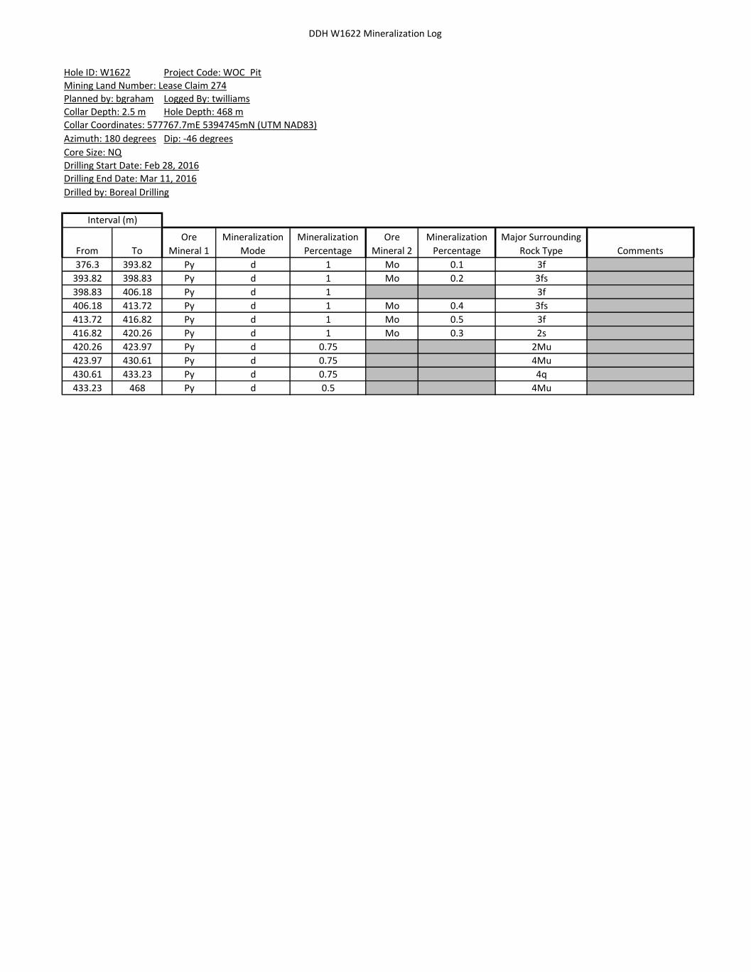
DDH W1622 Mineralization Log
From To
Ore
Mineral 1
Mineralization
Mode
Mineralization
Percentage
Ore
Mineral 2
Mineralization
Percentage
Major Surrounding
Rock Type Comments
Interval (m)
Hole ID: W1622 Project Code: WOC_Pit
Planned by: bgraham Logged By: twilliams
Collar Depth: 2.5 m Hole Depth: 468 m
Collar Coordinates: 577767.7mE 5394745mN (UTM NAD83)
Azimuth: 180 degrees Dip: -46 degrees
Mining Land Number: Lease Claim 274
Core Size: NQ
Drilling Start Date: Feb 28, 2016
Drilling End Date: Mar 11, 2016
Drilled by: Boreal Drilling
376.3 393.82 Py d 1 Mo 0.1 3f
393.82 398.83 Py d 1 Mo 0.2 3fs
398.83 406.18 Py d 1 3f
406.18 413.72 Py d 1 Mo 0.4 3fs
413.72 416.82 Py d 1 Mo 0.5 3f
416.82 420.26 Py d 1 Mo 0.3 2s
420.26 423.97 Py d 0.75 2Mu
423.97 430.61 Py d 0.75 4Mu
430.61 433.23 Py d 0.75 4q
433.23 468 Py d 0.5 4Mu

DDH W1622 Structural Log
Hole ID: W1622
Planned by: bgraham
Collar Depth: 2.5 m
Azimuth: 180 degrees
Core Size: NQ
Depth Major Surrounding
Rock Type
Structure
Type
Structure
Subtype
Structure
Infill
Alpha
Angle
Gange
Mineral
Roughness Thickness
(mm) Structure Comments5.36 4q BD 64
14.29 16 CT 4218.75 14 CT 22
20.1 4q CT 2229.92 4q FO 63
37.18 14 CT 3337.73 4q CT 3249.33 4c FO 69
53.1 4 FT gou S1 49 20cm wide green-grey fault gouge
59.39 4q FO 66
67.85 4q FO 66
76.95 4q FO 66
92.81 4q CT 66
103.27 4mu FT fau S3 60 Smooth
116 4mu VN fgr 90 Cb 5
140.19 4kt CT S3 55 Smooth
164.55 4kt FT gou S2 55 Smooth
166.38 4kt FT gou S2 65 Smooth
169.64 4mu FT gou S3 60 Smooth
169.74 4mu FT gou S3 60 Smooth
171.52 4kt FT gou S2 61 Smooth
184.5 4mu FR S3 10 Smooth fracture/jjoint runs paralell to core axis 3ocm in either dirrection
188.74 4mu FT gou S3 70 Smooth
190.23 12q FT gou S3 65 Smooth
196.54 4mu FT gou S2 70 Smooth
197.11 4mu FT gou S2 75 Smooth
235.57 2Bi FT gou S2 65 Smooth
236.3 2s FT gou S3 65 Smooth
236.64 2s FT gou S3 65 Smooth
240.8 2c FT gou S3 48 Smooth
259.3 2c FT gou S3 48 Smooth
261.1 2Bi FT gou S2 70 Smooth
261.15 2Bi FT gou S3 70 Smooth
261.56 2Bi CT S3 45 Smooth
264.17 2s FT S3 60 Smooth
264.3 2s FT gou S3 60 Smooth
264.55 2s FT gou S3 60 Smooth
266.39 2s FT gou S3 60 Smooth
267.15 2s FT gou S3 65 Smooth
274.1 2Bi VN stw 60 Ca 30
281.35 2s FT gou S3 60 Smooth
285.5 2s FT gou S3 30 Smooth
297.6 2Bi FT gou S2 55 Smooth
303.66 2s FT gou S3 61 Smooth
308.18 2s CT S3 67 Smooth
308.27 2s FT gou S3 62 Smooth
308.42 2s CT S3 70 Smooth
323.75 2Bi FT gou S2 75 Smooth
323.89 2Mu FT gou S2 71 Smooth
331.75 12 FT gou S2 45 Smooth
331.8 12 FT gou S2 50 Smooth
332.1 12 FT gou S2 45 Smooth
332.12 12 FT gou S2 43 Smooth
333.1 12 FT gou S2 46 Smooth
333.13 12 FT gou S2 46 Smooth
337.8 2Bi FT gou S3 57 Smooth
340 12 FR S3 10 Smooth runs paralell to core 1m down dip
345.68 11 FT gou S3 51 Smooth
349.07 2Bi FT gou S3 45 Smooth
351.83 2Bi FT gou S3 49 Smooth
361.29 2Bi CT S3 48 Smooth
365.84 3f FT gou S3 35 Smooth
375.83 3f FR S3 15 Smooth joint runs 20cm in either direction.
408.33 3fs FR N 5 Smooth fracture runs paralell to core for 30cm in either direction.
416.61 3f FT gou S2 70 Smooth
417.45 2s FT gou S2 76 Smooth
Project Code: WOC_Pit
Logged By: twilliams
Drilled by: Boreal Drilling
Mining Land Number: Lease Claim 274
Hole Depth: 468 mCollar Coordinates: 577767.7mE 5394745mN (UTM NAD83)
Dip: -46 degrees
Drilling End Date: Mar 11, 2016Drilling Start Date: Feb 28, 2016

DDH W1622 Geotechnical Log
From To
Total Recovery
(m)
RQD Measurement
(m)
Rock
Strength Weathering
Number of
Discontinuity Sets
Alpha
Angle Frequency Infill Length Roughness Type
Alpha
Angle Frequency Infill Length Roughness Type
Alpha
Angle Frequency Infill Length Roughness Type Comments
2.5 6 3.5 1.68 R2 W1 J1.5 69 20 N 3 Smooth FO
6 9 2.94 2.13 R2 W1 J1.5 64 9 N 3 Smooth FO
9 12 2.83 2.05 R2 W1 J1.5 64 6 N 3 S_rough FO
12 15 2.92 1.6 R2 W1 J1.5 60 8 N 3 Smooth FO
15 18 2.99 2.28 R2 W1 J1.5 53 5 N 3 S_rough FR
18 21 2.9 2.13 R2 W1 J1.5 66 7 N 3 Smooth FO
21 24 3 2.45 R2 W1 J1.5 66 12 N 3 Smooth FO
24 27 3.15 2.87 R2 W1 J1.5 63 9 N 3 S_rough FO
27 30 2.94 2.78 R2 W1 J1.5 65 7 N 3 Smooth FO
30 33 3 2.19 R2 W1 J5
33 36 2.95 2.77 R2 W1 J1.5 62 4 N 3 S_rough FO
36 39 2.93 2.37 R2 W1 J1.5 65 8 N 3 S_rough FO
39 42 2.92 2.13 R2 W1 J1.5 64 6 N 3 Smooth FO
42 45 2.99 2.26 R2 W1 J1.5 38 2 N 3 Smooth FR
45 48 2.77 1.71 R2 W1 J1.5 65 6 N 3 S_rough FO
48 51 2.69 1.01 R2 W1 J5
51 54 2.9 1.24 R2 W1 J5
54 57 2.7 2.48 R2 W1 J1.5 66 7 N 3 Smooth FO
57 60 2.89 2.78 R2 W1 J1.5 66 5 N 3 Smooth FO
60 63 2.99 2.97 R2 W1 J1.5 66 3 N 3 S_rough FO
63 66 3 1.94 R2 W1 J1.5 68 5 N 3 S_rough FO
66 69 2.89 2.63 R2 W1 J1.5 66 2 N 3 S_rough FO
69 72 2.83 2.08 R2 W1 J1.5 55 6 N 3 Smooth FO
72 75 3 2.88 R2 W1 J1.5 67 5 N 3 Smooth FO
75 78 3.27 2.8 R3 W1 J1.5 69 10 N 3 Smooth FO
78 81 2.91 2.46 R3 W1 J1.5 63 8 N 3 Smooth FO
81 84 2.97 2.61 R3 W1 J1.5 62 8 N 3 Smooth FO
84 87 2.99 2.85 R3 W1 J1.5 67 11 N 3 Smooth FO
87 90 3 2.83 R3 W1 J1 66 10 N 3 S_rough FO
90 93 2.95 2.95 R3 W1 J1 64 6 N 3 Smooth FO
93 96 2.99 2.11 R3 W1 J1.5 66 17 N 3 Smooth FO
96 99 2.98 2.89 R3 W1 J1.5 70 4 S3 3 Smooth FO 45 1 N 3 Smooth FR
99 102 3.04 3.04 R3 W1 J2 70 3 S3 3 Smooth FO 75 2 S3 3 Smooth FR
102 105 2.96 2.76 R3 W1 J3 60 1 S2 3 Smooth F 60 6 S3 3 Smooth FO 38 2 N 3 Smooth J
105 108 3.02 2.95 R3 W1 J3 35 4 N 3 Smooth J 67 3 S3 3 Smooth FO 51 3 N 3 Smooth FR
108 111 2.96 2.9 R3 W1 J1 63 15 S3 3 Smooth FO
111 114 3 3 R3 W1 J1 65 3 N 3 Smooth FO
114 117 2.93 2.93 R3 W1 J1.5 70 4 S3 3 Smooth FO 90 1 N 3 Smooth V
117 120 2.99 2.9 R3 W1 J2 34 1 N 3 Smooth FR 15 1 N 3 Smooth FR 70 3 S3 3 Smooth FO
120 123 3 2.98 R3 W1 J1 70 6 S3 3 Smooth FO
123 126 2.9 2.83 R3 W1 J2 55 4 N 3 Smooth FR 68 3 S3 3 Smooth FO
126 129 2.96 2.96 R3 W1 J2 65 4 S3 3 Smooth FO 45 2 N 3 Smooth FR
129 132 2.9 2.87 R3 W1 J2 30 2 N 3 Smooth FR 65 2 S3 3 Smooth FO
132 135 3.04 3.04 R3 W1 J2 68 7 S3 3 Smooth FO 39 2 N 3 Smooth FR
135 138 2.96 2.93 R3 W1 J1.5 65 4 S3 3 Smooth FO 40 1 N 3 Smooth FR
138 141 2.93 2.84 R3 W1 J3 57 5 S3 3 Smooth FO 30 2 N 3 Smooth J 45 1 N 3 Smooth CO
141 144 2.86 2.86 R3 W1 J1 65 6 S3 3 Smooth FO
144 147 3.05 3.02 R3 W1 J1.5 70 7 S3 3 Smooth FO 35 1 N 3 Smooth FR
147 150 3.07 3.07 R3 W1 J2 60 2 S3 3 Smooth FO 38 3 N 3 Smooth J
150 153 2.92 2.92 R3 W1 J1 70 5 S3 3 Smooth FO
153 156 2.72 2.6 R3 W1 J1 60 6 S3 3 Smooth FO
156 159 3.03 2.94 R3 W1 J2 60 5 S3 3 Smooth FO 35 2 N 3 Smooth FR
159 162 3.09 3.09 R3 W1 J1.5 25 1 N 3 Smooth FR 48 1 S3 3 Smooth FR 60 4 S3 3 Smooth FO
162 165 2.84 2.8 R3 W1 J1.5 65 4 S3 3 Smooth FO 55 1 S2 3 Smooth F
165 168 2.89 2.79 R3 W1 J2.5 45 1 S2 3 Smooth F 70 3 S3 3 Smooth FO 25 1 S3 3 Smooth FR
168 171 3 2.77 R3 W1 J2 65 8 S3 3 Smooth FO 60 2 S2 3 Smooth F
171 174 2.92 2.83 R3 W1 J1.5 70 11 S3 3 Smooth FO 30 1 N 3 Smooth FR 61 1 S2 3 Smooth F
174 177 2.82 2.69 R3 W1 40 2 N 3 Smooth FR 70 6 S3 3 Smooth FO
Hole ID: W1622 Project Code: WOC_Pit
Planned by: bgraham Logged By: twilliamsCollar Depth: 2.5 m Hole Depth: 468 m
Mining Land Number: Lease Claim 274
Drilled by: Boreal Drilling
Discontinuity Set 1 Discontinuity Set 2 Discontinuity Set 3
Collar Coordinates: 577767.7mE 5394745mN (UTM NAD83)
Azimuth: 180 degrees Dip: -46 degrees
Interval (m)
Core Size: NQDrilling Start Date: Feb 28, 2016Drilling End Date: Mar 11, 2016

DDH W1622 Geotechnical Log
From To
Total Recovery
(m)
RQD Measurement
(m)
Rock
Strength Weathering
Number of
Discontinuity Sets
Alpha
Angle Frequency Infill Length Roughness Type
Alpha
Angle Frequency Infill Length Roughness Type
Alpha
Angle Frequency Infill Length Roughness Type Comments
Hole ID: W1622 Project Code: WOC_Pit
Planned by: bgraham Logged By: twilliamsCollar Depth: 2.5 m Hole Depth: 468 m
Mining Land Number: Lease Claim 274
Drilled by: Boreal Drilling
Discontinuity Set 1 Discontinuity Set 2 Discontinuity Set 3
Collar Coordinates: 577767.7mE 5394745mN (UTM NAD83)
Azimuth: 180 degrees Dip: -46 degrees
Interval (m)
Core Size: NQDrilling Start Date: Feb 28, 2016Drilling End Date: Mar 11, 2016
177 180 2.95 2.95 R3 W1 J1 65 6 S3 3 Smooth FO
180 183 3.03 2.92 R3 W1 J1.5 60 2 S3 3 Smooth FO 10 1 S3 3 Smooth J
183 186 2.93 2.73 R3 W1 J1 70 12 S3 3 Smooth FO
186 189 2.85 2.72 R3 W1 J2 65 13 S3 3 Smooth FO 65 1 S3 3 Smooth F
189 192 3.02 2.94 R3 W1 J2 65 8 S3 3 Smooth FO 65 1 S2 3 Smooth F
192 195 2.97 2.86 R3 W1 J1 65 8 S3 3 Smooth FO
195 198 2.81 2.69 R3 W1 J2 70 2 S3 3 Smooth F 65 5 S3 3 Smooth FO
198 201 2.94 2.94 R3 W1 J1 60 5 S3 3 Smooth FO
201 204 3.09 3.01 R3 W1 J2 65 4 S3 3 Smooth FO 40 2 S3 3 Smooth FR
204 207 3.02 2.99 R3 W1 J2 60 5 S3 3 Smooth FO 60 3 S3 3 Smooth FR
207 210 2.93 2.93 R3 W1 J1.5 60 4 S3 3 Smooth FO 30 1 N 3 Smooth FR
210 213 2.98 2.98 R3 W1 J2 60 5 S3 3 Smooth FO 45 2 S3 3 Smooth FR
213 216 3 3 R3 W1 J2 60 1 S3 3 Smooth FO 65 3 N 3 Smooth FR
216 219 3.01 3.01 R3 W1 J1.5 70 3 N 3 Smooth FR 50 1 N 3 Smooth FR
219 222 2.98 2.93 R3 W1 J1.5 65 4 S3 3 Smooth FO 40 1 S3 3 Smooth FR
222 225 2.97 2.97 R3 W1 J1 6 4 N 3 Smooth FR
225 228 2.97 2.88 R3 W1 J1.5 65 6 S3 3 Smooth FO 70 2 N 3 Smooth FR
228 231 2.97 2.88 R3 W1 J2 70 5 S3 3 Smooth FO 48 2 S3 3 Smooth FR
231 234 3 2.9 R3 W1 J1 60 12 S3 3 Smooth FO
234 237 2.7 2.45 R3 W1 J2 68 3 S3 3 Smooth F 70 16 S3 3 Smooth FO
237 240 2.81 2.71 R3 W1 J1 60 6 S3 3 Smooth FO
240 243 2.97 2.95 R3 W1 J2 68 5 S3 3 Smooth FO 48 1 S2 3 Smooth F
243 246 2.82 2.75 R3 W1 J2 65 5 S3 3 Smooth FO 30 2 N 3 Smooth FR
246 249 3.1 2.97 R3 W1 J1 60 13 S3 3 Smooth FO
249 252 2.95 2.89 R3 W1 J2 15 3 N 3 Smooth FR 60 3 S3 3 Smooth FO
252 255 3.04 2.96 R3 W1 J1 70 9 S3 3 Smooth FO
255 258 2.91 2.85 R3 W1 J3 65 6 S3 3 Smooth FO 65 2 N 3 Smooth FR 15 1 S3 3 Smooth FR
258 261 3 2.9 R3 W1 J2 65 10 S3 3 Smooth FO 50 3 N 3 Smooth FR
261 264 2.93 2.87 R3 W1 J4 70 4 S3 3 Smooth FO 70 2 S3 3 Smooth F 30 2 N 3 Smooth J
264 267 2.95 2.75 R3 W1 J2 60 4 S3 3 Smooth F 60 12 S3 3 Smooth FO
267 270 2.92 2.65 R3 W1 J2 65 1 S2 3 Smooth F 55 20 S3 3 Smooth FO
270 273 2.95 2.92 R3 W1 J1 55 5 S3 3 Smooth FO
273 276 3.11 3.08 R3 W1 J2 60 8 S3 3 Smooth FO 60 1 S3 3 Smooth V
276 279 3 2.91 R3 W1 J1 60 4 S3 3 Smooth FO
279 282 2.86 2.75 R3 W1 J1.5 65 3 S3 3 Smooth FO 60 1 S3 3 Smooth F
282 285 2.91 2.84 R3 W1 J1 65 5 S3 3 Smooth FO
285 288 3.03 2.93 R3 W1 J1 30 1 S2 3 Smooth F 65 4 S3 3 Smooth FO 55 3 N 3 Smooth FR
288 291 3 2.92 R3 W1 J2 35 2 N 3 Smooth FR 50 6 S3 3 Smooth FO
291 294 2.93 2.86 R3 W1 J2 50 1 S2 3 Smooth F 55 2 S3 3 Smooth FO
294 297 3.07 3.01 R3 W1 J1.5 75 4 S3 3 Smooth FO 43 1 S3 3 Smooth FR
297 300 2.89 2.89 R3 W1 60 3 S3 3 Smooth FO
300 303 2.91 2.91 R3 W1 J1 70 4 S3 3 Smooth FO
303 306 3.08 3.04 R3 W1 J1.5 61 1 S2 3 Smooth F 70 5 S3 3 Smooth FO
306 309 2.95 2.87 R3 W1 J3 68 2 S3 3 Smooth CO 62 1 S3 3 Smooth F 70 7 S3 3 Smooth FO
309 312 3.02 3.02 R3 W1 J1 70 8 S3 3 Smooth FO
312 315 2.98 2.96 R3 W1 J1 70 4 S3 3 Smooth FO
315 318 2.94 2.94 R3 W1 J2 44 2 N 3 Smooth FR 60 3 N 3 Smooth FO
318 321 3.02 3.02 R3 W1 J1.5 65 6 S3 3 Smooth FO 45 1 N 3 Smooth FR
321 324 3.05 2.98 R3 W1 J2 71 2 S2 3 Smooth F 60 2 N 3 Smooth FR
324 327 3.04 3.02 R3 W1 J1 60 5 S3 3 Smooth FO 30 1 N 3 Smooth FR
327 330 2.87 2.85 R3 W1 J1.5 30 1 N 3 Smooth FR 70 5 S3 3 Smooth FO
330 333 2.8 2.35 R3 W1 J2.5 45 4 S2 3 Smooth F 70 4 S3 3 Smooth FO 45 6 S3 3 Smooth FO
333 336 2.96 2.93 R3 W1 J3 46 1 S2 3 Smooth F 35 2 N 3 Smooth FR 60 2 S3 3 Smooth FO
336 339 2.96 2.83 R3 W1 J3 57 1 S3 3 Smooth F 65 6 S3 3 Smooth FO 43 1 S3 3 Smooth FR
339 342 2.94 2.01 R3 W1 60 6 S3 3 Smooth FO 56 2 S3 3 Smooth FR 10 2 S3 3 Smooth J
342 345 3.1 2.78 R3 W1 J1 48 3 N 3 Smooth FR
345 348 3 2.89 R3 W1 J2 51 1 S3 3 Smooth F 57 10 S3 3 Smooth FO
348 351 2.97 2.8 R3 W1 J2 55 8 S3 3 Smooth FO 46 1 S3 3 Smooth F

DDH W1622 Geotechnical Log
From To
Total Recovery
(m)
RQD Measurement
(m)
Rock
Strength Weathering
Number of
Discontinuity Sets
Alpha
Angle Frequency Infill Length Roughness Type
Alpha
Angle Frequency Infill Length Roughness Type
Alpha
Angle Frequency Infill Length Roughness Type Comments
Hole ID: W1622 Project Code: WOC_Pit
Planned by: bgraham Logged By: twilliamsCollar Depth: 2.5 m Hole Depth: 468 m
Mining Land Number: Lease Claim 274
Drilled by: Boreal Drilling
Discontinuity Set 1 Discontinuity Set 2 Discontinuity Set 3
Collar Coordinates: 577767.7mE 5394745mN (UTM NAD83)
Azimuth: 180 degrees Dip: -46 degrees
Interval (m)
Core Size: NQDrilling Start Date: Feb 28, 2016Drilling End Date: Mar 11, 2016
351 354 3.05 2 R3 W1 J3 61 11 S3 3 Smooth FO 49 1 S3 3 Smooth F 45 3 S3 3 Smooth FO
354 357 3.02 2.88 R3 W1 J2 38 2 S3 3 Smooth FR 75 5 S3 3 Smooth FO
357 360 3.05 2.84 R3 W1 J2 50 4 S3 3 Smooth J 34 1 S3 3 Smooth FR
360 363 3 2.43 R3 W1 J2.5 48 1 S3 3 Smooth CO 45 2 S3 3 Smooth FO 65 3 S3 3 Smooth FO
363 366 3 2.42 R3 W1 J3 35 1 S3 3 Smooth F 60 7 S3 3 Smooth FO 30 2 S3 3 Smooth FR
366 369 2.92 2.82 R3 W1 J1.5 30 1 S3 3 Smooth FR 55 2 S3 3 Smooth FO
369 372 2.99 2.99 R3 W1 J2 65 8 S3 3 Smooth FO 45 2 N 3 Smooth FR
372 375 3.05 2.99 R3 W1 J1.5 70 6 S3 3 Smooth FO 3
375 378 3.03 2.43 R3 W1 J2 15 1 S3 3 Smooth J 60 9 S3 3 Smooth FO
378 381 2.95 2.74 R3 W1 J1.5 65 6 S3 3 Smooth FO 30 1 N 3 Smooth FR
381 384 3.02 3.02 R3 W1 J2 58 1 S3 3 Smooth FR 70 2 S3 3 Smooth FO
384 387 3.01 2.77 R3 W1 J2 70 3 S3 3 Smooth FO 43 1 S3 3 Smooth FR
387 390 2.92 2.92 R3 W1 J1 70 4 S3 3 Smooth FO
390 393 3.02 3.02 R3 W1 J1 70 5 S3 3 Smooth FO
393 396 2.95 2.95 R3 W1 J1 70 4 S3 3 Smooth FO
396 399 2.99 2.99 R3 W1 J1.5 45 1 S3 3 Smooth FR 70 6 S3 3 Smooth FO
399 402 3.03 3.03 R3 W1 J2 43 2 S2 3 Smooth FR 65 4 S3 3 Smooth FO
402 405 3.06 3.06 R3 W1 J1 72 5 S3 3 Smooth FO
405 408 2.93 2.84 R3 W1 J1 75 8 S3 3 Smooth FO
408 411 3.08 3.01 R3 W1 J3 5 1 N 3 Smooth J 70 8 S3 3 Smooth FO 1 22 N 3 Smooth FR
411 414 3.07 3.03 R3 W1 J1 70 6 S3 3 Smooth FO
414 417 3 2.9 R3 W1 J1.5 70 11 S3 3 Smooth FO 70 1 S2 3 Smooth F
417 420 2.99 2.96 R3 W1 J3 75 9 S2 3 Smooth FO 38 1 N 3 Smooth FR 76 1 S2 3 Smooth F
420 423 2.98 2.98 R3 W1 J2 70 6 S3 3 Smooth FO 45 2 N 3 Smooth FR
423 426 2.97 2.97 R3 W1 J2 16 1 S3 3 Smooth FR 70 5 S3 3 Smooth FO
426 429 2.94 2.88 R3 W1 J2 25 3 N 3 Smooth FR 65 4 S3 3 Smooth FO
429 432 2.95 2.95 R3 W1 J1 72 6 S3 3 Smooth FO
432 435 3.05 3.05 R3 W1 J2 70 6 S3 3 Smooth FO 50 2 N 3 Smooth FR
435 438 2.98 2.98 R3 W1 J1 65 11 S3 3 Smooth FO
438 441 3.05 3.05 R3 W1 J1 70 7 S3 3 Smooth FO
441 444 2.89 2.89 R3 W1 J1.5 70 7 S3 3 Smooth FO 35 1 S3 3 Smooth FR
444 447 2.94 2.82 R3 W1 J2 70 8 S3 3 Smooth FO 35 1 N 3 Smooth FR
447 450 3 3 R3 W1 J2 60 5 S3 3 Smooth FO 35 2 N 3 Smooth FR
450 453 2.93 2.82 R3 W1 J2 65 11 S3 3 Smooth FO 30 1 N 3 Smooth FR
453 456 2.95 2.91 R3 W1 J2 65 6 S3 3 Smooth FO 39 2 N 3 Smooth FR
456 459 3 3 R3 W1 J2 60 7 S3 3 Smooth FO 39 2 N 3 Smooth FR
459 462 3 3 R3 W1 J2 65 9 S3 3 Smooth FO 50 2 N 3 Smooth FR
462 465 2.95 2.87 R3 W1 J2 65 5 S3 3 Smooth FO 10 1 N 3 Smooth FR
465 468 2.87 2.76 R3 W1 J2 65 11 S3 3 Smooth FO 20 1 N 3 Smooth FR

Appendix F
DDH W1623 Drill Logs

DDH W1623 Major Lithology Log
LoggedDate From To
Major Rock
Name Rock Colour
Grain
Size Texture 1 Intensity Texture 2 Intensity Texture 3 Intensity Mineralization
Percentage
Mineralization
10-Mar-16 0 6 0
10-Mar-16 6 16.73 4q dkgy c WM q k MS
10-Mar-16 16.73 17.17 12 blk f-mg n MS
10-Mar-16 17.17 22.17 4q dkgy fg q k WM
10-Mar-16 22.17 26.34 4q dkgy f-mg k M
10-Mar-16 26.34 29.16 4s ltgy-medgy fg k WM
10-Mar-16 29.16 42 4q dkgy fg c WM k WM q
10-Mar-16 42 45.96 4q dkgy f-mg k WM
10-Mar-16 45.96 51.36 4q dkgy fg c WM k W
10-Mar-16 51.36 57.06 4c ltgy-dkgy f-mg c M k WM
10-Mar-16 57.06 60 4q dkgy fg k W q
10-Mar-16 60 60.56 4c ltgy-dkgy f-mg c MS
10-Mar-16 60.56 65.15 4q dkgy fg k WM
10-Mar-16 65.15 65.76 4c ltgy-dkgy f-mg c MS
10-Mar-16 65.76 66.39 4s ltgy fg
10-Mar-16 66.39 69.41 4c ltgy-dkgy f-mg c M
10-Mar-16 69.41 91.48 4q dkgy fg c W PS WM q
10-Mar-16 91.48 102.35 4q dkgy fg PS M
11-Mar-16 102.35 102.87 4q dkgy fg q
11-Mar-16 102.87 104.53 4q ltgy-dkgy fg k M
11-Mar-16 104.53 105.34 4s pnk fg k WM
11-Mar-16 105.34 110.57 4FT brngy fg k MS
11-Mar-16 110.57 110.87 16 wht cg
11-Mar-16 110.87 111.37 4FT brngy fg
11-Mar-16 111.37 114.25 4c dkgy f-mg c M
11-Mar-16 114.25 124.37 4Mu ltgy-dkgy f-mg k M
11-Mar-16 124.37 127.52 4c dkgy f-mg c M
11-Mar-16 127.52 137.26 4Mu ltgy-dkgy fg k M
11-Mar-16 137.26 139.53 4c blugy f-mg c M
11-Mar-16 139.53 140.54 14 blk f-mg
11-Mar-16 140.54 141.88 4c blugy f-mg c MS
11-Mar-16 141.88 142.17 14 blk f-mg
11-Mar-16 142.17 142.45 4c blugy f-mg c MS
11-Mar-16 142.45 145.48 4q grngry fg k WM
11-Mar-16 145.48 146.42 4s grngry fg k M
11-Mar-16 146.42 151.51 4q ltgy-dkgy fg PS WM k WM
11-Mar-16 151.51 160.15 4kt ltgy-dkgy fg k MS t M
11-Mar-16 160.15 177.75 4Mu ltgy-dkgy fg k MS t WM PS WM
11-Mar-16 177.75 178.48 12q grn f-mg
11-Mar-16 178.48 187.1 4Mu ltgy-dkgy fg k MS PS WM
11-Mar-16 187.1 188.45 4q dkgy fg PS WM
11-Mar-16 188.45 189.49 4q grngry fg
11-Mar-16 189.49 191.45 4Mu ltgy-dkgy fg k MS
11-Mar-16 191.45 192.74 4Am grn f-mg
11-Mar-16 192.74 199.72 4Mu ltgy-dkgy fg k MS
15-Mar-16 199.72 213.72 4c ltgy-dkgy f-mg c MS k MS
15-Mar-16 213.72 216.39 4s ltgy-medgy fg c WM k M
15-Mar-16 216.39 219.16 4c ltgy-dkgy f-mg c M k M
15-Mar-16 219.16 222.35 4q dkgy fg k WM
15-Mar-16 222.35 225.2 4c ltgy-dkgy f-mg c MS k WM
15-Mar-16 225.2 225.71 4q dkgy fg q
15-Mar-16 225.71 231.73 4c ltgy-dkgy f-mg c MS k WM
15-Mar-16 231.73 232.07 14 blk f-mg
15-Mar-16 232.07 235.78 4c ltgy-dkgy f-mg c M k WM
15-Mar-16 235.78 240 4q dkgy fg c W
15-Mar-16 240 241.13 2s medgy fg
15-Mar-16 241.13 242.6 12 blk f-mg n MS
15-Mar-16 242.6 242.97 2Bi dkgy f-mg c W
15-Mar-16 242.97 243.54 12 blk f-mg n MS
15-Mar-16 243.54 254.3 2Bi ltgy-dkgy f-mg c WM k M
15-Mar-16 254.3 258.25 2Bi dkgy fg k WM c WM
15-Mar-16 258.25 262.95 2s medgy fg c WM
Interval (m)
Hole ID: W1623 Project Code: WOC_Pit
Logged By: mmcleodCollar Depth: 6 m Hole Depth: 447 mPlanned by: bgraham
Collar Coordinates: 577647.9mE 5394756.9mN (UTM NAD83)
Mining Land Number: Lease Claim 274
Core Size: NQDrilling Start Date: 29-Feb-2016Drilling End Date: 11-Mar-2016
Drilled by: Boreal Drilling
Azimuth: 179 degrees Dip: -45.9 degrees

DDH W1623 Major Lithology Log
15-Mar-16 262.95 263.46 2Bi dkgy fg k WM c W
15-Mar-16 263.46 269.12 2s ltgy-medgy fg c W
15-Mar-16 269.12 273.51 2cs medgy f-mg c MS
15-Mar-16 273.51 275.8 2cs ltgy-medgy f-mg c MS
15-Mar-16 275.8 279.89 2cs ltgy-dkgy f-mg c M
15-Mar-16 279.89 280.15 14 blk f-mg
15-Mar-16 280.15 281.18 2cs dkgy f-mg k WM
15-Mar-16 281.18 282.68 2Bi dkgy fg k WM
15-Mar-16 282.68 285.19 2cs ltgy-medgy f-mg
15-Mar-16 285.19 286 14 blk f-mg
15-Mar-16 286 288.62 2s medgy f-mg c W
16-Mar-16 288.62 295.36 2Bi dkgy fg k M
16-Mar-16 295.36 298.53 2s ltgy-medgy f-mg c W k W
16-Mar-16 298.53 299.37 2Bi medgy-dkgy f-mg c W
16-Mar-16 299.37 300.87 2c medgy-dkgy f-mg c MS
16-Mar-16 300.87 302.7 2cs ltgy-medgy f-mg c MS
16-Mar-16 302.7 304.64 2c medgy-dkgy v-mg c M
16-Mar-16 304.64 305.49 2cs blugy f-mg c MS
16-Mar-16 305.49 308.34 2Bi medgy fg c W j MS
16-Mar-16 308.34 309.89 2Bi dkgy fg k WM
16-Mar-16 309.89 311.39 2cs medgy f-mg c WM
16-Mar-16 311.39 312.54 2s medgy fg c W
16-Mar-16 312.54 313.03 12 blk f-mg n MS
16-Mar-16 313.03 314.56 2Bi dkgy fg
16-Mar-16 314.56 318.19 2s medgy f-mg c W
16-Mar-16 318.19 322.3 2FT medgy-dkgy f-mg c MS
16-Mar-16 322.3 324.77 14 blk f-mg
16-Mar-16 324.77 325.66 2cs blugy f-mg c MS
16-Mar-16 325.66 328.45 14 blk f-mg
16-Mar-16 328.45 331 2cs medgy f-mg c MS
16-Mar-16 331 333.27 2s medgy fg
16-Mar-16 333.27 333.63 12 blk f-mg n MS
16-Mar-16 333.63 337.17 2Bi medgy-dkgy f-mg
16-Mar-16 337.17 338.3 2cs medgy f-mg c MS
16-Mar-16 338.3 338.5 14 blk f-mg
16-Mar-16 338.5 346.91 2cs medgy f-mg c S
17-Mar-16 346.91 350 2Bi medgy-dkgy f-mg c W k W
17-Mar-16 350 350.45 2c ltgy-dkgy f-mg c M
17-Mar-16 350.45 351.16 2Bi ltgy-dkgy fg c W
17-Mar-16 351.16 354.46 3f medgy f-mg e WM f S
17-Mar-16 354.46 372.82 2Bi dkgy fg c WM
17-Mar-16 372.82 392 3f medgy f-mg e WM f S
17-Mar-16 392 392.84 3fMu ltgy-medgy f-mg e WM f MS
17-Mar-16 392.84 395.8 3f medgy f-mg f MS e WM
17-Mar-16 395.8 396.19 12 blk f-mg n S
17-Mar-16 396.19 401.45 3fMu medgy f-mg e WM f MS
17-Mar-16 401.45 402.33 2Bi medgy fg k WM c W
17-Mar-16 402.33 402.77 12 blk f-mg n MS
17-Mar-16 402.77 405.66 3c ltgy-medgy f-mg c M f M
17-Mar-16 405.66 413.81 2cs medgy f-mg c MS
17-Mar-16 413.81 415.08 2c ltgy-dkgy f-mg c M
17-Mar-16 415.08 418.1 2Bi dkgy fg k W
17-Mar-16 418.1 420.12 2s ltgy-medgy fg c W
17-Mar-16 420.12 420.76 2Bi dkgy fg c WM
17-Mar-16 420.76 423.32 2s medgy fg c WM k WM
17-Mar-16 423.32 425 2FT medgy f-mg
17-Mar-16 425 425.58 2s medgy fg
17-Mar-16 425.58 425.91 2cs medgy f-mg c MS
17-Mar-16 425.91 434.29 2s medgy fg
18-Mar-16 434.29 445.65 4Mu ltgy-medgy fg k M PS W t W
18-Mar-16 445.65 446.35 4Am grn f-mg
18-Mar-16 446.35 447 4Mu ltgy-dkgy fg k MS

DDH W1623 Minor Lithology Log
From To
Minor Rock
Name Rock Colour
Grain
Size Texture 1 Intensity Texture 2 Intensity
Major Surrounding
Rock Type
9.14 9.25 16 wht cg 16
16.61 16.73 16 wht cg 16
17.23 17.3 16 wht cg 16
17.46 17.48 12 blk f-mg n MS 12
18.57 18.67 16 wht cg 16
21.02 21.14 16 wht cg 16
25.36 25.43 16 wht cg 16
40.14 40.54 4c 4
41.6 41.84 16 wht cg 16
43.61 43.65 4s 4
67.11 67.36 4s 4
74.14 74.2 16 wht cg 16
76.23 76.31 16 wht cg 16
83.52 83.62 16 wht cg 16
96.97 97 12 grn f-mg 12
98.06 98.18 12 grn f-mg n MS 12
105.17 105.34 16 wht cg 16
106.05 106.12 15 15
108.39 108.56 15 15
111.1 111.21 16 wht cg 16
120.4 120.66 16 wht cg 16
121.22 121.38 15 pnk 15
122.37 122.49 9f dkgy f-mg f S 9
123.01 123.08 16 wht cg 16
131.52 131.73 16 wht cg 16
138.09 138.21 14 blk 14
140.23 140.54 4c 4
140.54 140.74 14 14
153.64 153.72 16 wht cg 16
170.87 170.94 16 wht cg 16
186.51 186.61 16 wht cg 16
186.86 187.1 16 wht cg 16
215.51 215.73 11 ltgy fg 11
222.05 222.1 12 blk f-mg n MS 12
225.75 225.78 12 blk f-mg n MS 12
231.45 231.49 12 blk f-mg n MS 12
236.67 236.79 12 blk f-mg n MS 12
238.67 238.92 12 blk f-mg n MS 12
241.51 241.66 16 wht cg 16
242.9 243.1 16 wht cg 16
244.64 244.74 12 blk f-mg n MS 12
246.24 246.34 16 wht cg 16
261.28 261.34 11 dkgy fg 11
285.19 285.41 2cs ltgy-medgy 2
295.36 295.47 16 wht cg 16
304.68 304.73 12 blk f-mg n MS 12
318.78 318.83 12 blk f-mg n MS 12
324.77 324.99 14 blk f-mg 14
325.37 325.66 14 blk f-mg 14
337.24 337.4 12 blk f-mg n MS 12
337.91 338.07 12 blk f-mg n MS 12
339.9 339.99 12 blk f-mg n M 12
351.16 351.26 3sPy 3
354.46 354.53 16 wht cg 16
370.49 370.64 16 wht cg 16
375.7 375.79 16 wht cg 16
376 376.06 16 wht cg 16
376.73 376.78 16 wht cg 16
380.58 380.79 12 blk f-mg n MS 12
389.52 389.58 11 dkgy fg 11
396.46 396.69 12 blk f-mg n S 12
397.25 397.31 12 blk f-mg n MS 12
398 398.04 12 blk f-mg n MS 12
399.11 399.17 12 blk f-mg n MS 12
405 405.4 3FT 3
434.7 434.81 12 blk fg n MS 12
445.71 446.26 16 wht cg 16
Interval (m)
Hole ID: W1623 Project Code: WOC_Pit
Planned by: bgraham Logged By: mmcleodCollar Depth: 6 m
Drilled by: Boreal Drilling
Core Size: NQ
Mining Land Number: Lease Claim 274
Hole Depth: 447 mCollar Coordinates: 577647.9mE 5394756.9mN (UTM NAD83)
Azimuth: 179 degrees Dip: -45.9 degrees
Drilling End Date: 11-Mar-2016Drilling Start Date: 29-Feb-2016

DDH W1623 Alteration Log
From To
Major Rock
Name Alteration 1 Intensity Mode Alteration 2 Intensity Mode Alteration 3 Intensity Mode AlterationComments
6 16.73 4q Cx M k Fx WM k Mx WM k Section also exhibits sparse moderate-strength bands of potassic alteration. Epidote alteration is also present as small veins (weak-moderate strength). Moderate strength biotite alteration is also present as small bands.
17.17 22.17 4q Cx MS k Mx WM k Fx W k
22.17 26.34 4q Cx MS k Fx WM k Mx WM k Section also exhibits weak selectively pervasive amphibole alteration.
26.34 29.16 4s Cx MS g Fx WM p Ax W k
29.16 42 4q Cx MS k Fx WM c
42 45.96 4q Cx M k Ax WM p Bx WM a
45.96 51.36 4q Cx MS k Fx WM c Mx W k
51.36 57.06 4c Cx M k Fx WM c Rd WM u Section also exhibits weak banded muscovite alteration.
57.06 60 4q Cx MS k Rd M k Mx W k
60 60.56 4c Fx WM c Ax W u
60.56 65.15 4q Cx WM m Fx WM k Ax WM k Section also exhibits weak-moderate banded/selectively pervasive muscovite alteration.
65.15 65.76 4c Fx WM c Mx W k
65.76 66.39 4s Fx M p Cx M k
66.39 69.41 4c Cx MS g Fx M ps Mx W k Fragments in section are feldspathized. Section also exhibits banded weak-moderate biotite alteration.
69.41 91.48 4q Cx MS k Fx WM k Ex M v Section also exhibits weak-moderate banded muscovite alteration
91.48 102.35 4q Cx MS k Rd MS u Ex M g This section also exhibits weak selectively pervasive amphibole alteration and muscovite alteration.
102.35 102.87 4q Rd WM k
102.87 104.53 4q Cx WM k Mx WM k Fx WM k
104.53 105.34 4s Fx M ps Rd WM k Mx W k Weak-moderate carbonate alteration is present as small veins/bands in this section.
105.34 110.57 4FT Cx MS u Mx WM k Fx WM k Reddish colouration is exhibited as small bands in this section - attributed to weak-moderate potassic alteration.
110.87 111.37 4FT Cx MS u Mx WM k Fx WM k Reddish colouration is exhibited as small bands in this section - attributed to weak-moderate potassic alteration.
111.37 114.25 4c Ax MS v Cx MS u Mx WM k
114.25 124.37 4Mu Cx MS k Fx WM k Mx WM p At the beginning of this section sparse bands of moderate-strong amphibole alteration are present; similarly
124.37 127.52 4c Mx WM p Cx WM u Bx WM p
127.52 137.26 4Mu Mx WM p Cx WM u Fx WM k
137.26 139.53 4c Cx MS ps Ax M ps Mx WM ps Selectively pervasive blue colouration is indicative of sodium-rich amphibole riebeckite that was introduce to the sediments in this area by lamprophyres. This section exhibits pervasive weak-moderate feldspathization.
140.54 141.88 4c Cx MS v Ax M p Fx W p Selectively pervasive blue colouration is indicative of sodium-rich amphibole riebeckite that was introduce to the sediments in this area by lamprophyres. This section exhibits pervasive weak-moderate feldspathization.
142.17 142.45 4c Cx MS v Ax M p Fx W p Selectively pervasive blue colouration is indicative of sodium-rich amphibole riebeckite that was introduce to the sediments in this area by lamprophyres. This section exhibits pervasive weak-moderate feldspathization.
142.45 145.48 4q Cx MS k Mx WM ps Fx W p
145.48 146.42 4s Fx M k Mx WM p Cx WM k
146.42 151.51 4q Cx MS u Ax M k Mx WM ps
151.51 160.15 4kt Cx MS k Ax MS k Mx WM k Muscovite alteration
160.15 177.75 4Mu Cx MS k Ax M k Mx WM p Moderate-strong bands of muscovite alteration are present throughout this section; the presence of muscovite is greater than the number of calc-silicate bands in this section; hence the 4Mu designation
177.75 178.48 12q Cx MS m Rd M m
178.48 187.1 4Mu Cx MS k Ax M k Mx M k Muscovite alteration
187.1 188.45 4q Cx WM k Ax WM k Fx W p
188.45 189.49 4q Rd M u Ex M v Mx W p Section also exhibits weak pervasive feldspathization.
189.49 191.45 4Mu Cx MS k Mx WM k Fx WM k
191.45 192.74 4Am Ax MS p Cx WM p
192.74 199.72 4Mu Fx M k Mx WM k Ax WM k Moderate-strong carbonate alteration is present as nodules and spots within this section. Muscovite alteration
199.72 213.72 4c Cx MS k Fx WM p Mx WM p Although muscovite and feldspathization are pervasive
213.72 216.39 4s Cx MS k Fx M p Mx WM p This section also exhibits weak banded potassic alteration.
216.39 219.16 4c Cx MS k Fx M k Mx WM k
219.16 222.35 4q Cx MS g Bx M a Biotite alteration coats carbonate nodules and bands.
222.35 225.2 4c Cx MS u Fx WM p Mx WM k
225.2 225.71 4q Cx WM p
225.71 231.73 4c Mx WM p Cx WM ps Fx WM k
231.73 235.78 4c Cx M ps Fx WM ps Mx WM k Section also exhibits weak-moderate potassic alteration as a quilt/patch in this unit.
235.78 240 4q Cx MS u Fx WM ps Mx WM ps Section exhibits weak-moderate potassic alteration as small nodules
240 241.13 2s Fx M p Mx M p Bx WM g Sparse moderate-strong carbonate alteration exists as nodules
Interval (m)
Hole ID: W1623 Project Code: WOC_Pit
Planned by: bgraham Logged By: mmcleod
Collar Depth: 6 m Hole Depth: 447 m
Collar Coordinates: 577647.9mE 5394756.9mN (UTM NAD83)
Azimuth: 179 degrees Dip: -45.9 degrees
Drilling End Date: 11-Mar-2016
Drilling Start Date: 29-Feb-2016
Drilled by: Boreal Drilling
Core Size: NQ
Mining Land Number: Lease Claim 274

DDH W1623 Mineralization Log
From To
Ore
Mineral 1
Mineralization
Mode
Mineralization
Percentage
Ore
Mineral 2
Mineralization
Percentage
Major Surrounding
Rock Type Comments
6 16.73 Py m 0.1 4q
26.34 29.16 Py k 0.2 4s
45.96 51.36 Py k 0.1 4q
60.56 65.15 Po m 0.1 4q
192.74 199.72 Py k 0.1 4Mu
199.72 213.72 Py m 0.3 4c
213.72 216.39 Py k 0.4 4s
216.39 219.16 Py k 0.1 4c
232.07 235.78 Py k 0.3 4c
243.54 254.3 Py m 0.2 2Bi
258.25 262.95 Py m 0.1 2Bi
263.46 269.12 Py k 0.75 2s
273.51 275.8 Py k 0.2 2cs
275.8 279.89 Py d 0.4 2cs
280.15 281.18 Py k 0.1 2cs
281.18 282.68 Py d 0.5 2Bi
282.68 285.19 Py k 0.3 2cs
288.62 295.36 Py k 0.3 2Bi
295.36 298.53 Py k 0.2 2s
300.87 302.7 Py k 2 Mo 0.05 2cs
302.7 304.64 Py 0.1 2c
305.49 308.34 Py k 1 2Bi
308.34 309.89 Py d 0.1 2Bi
309.89 311.39 Py k 0.1 2cs
314.56 318.19 Py k 0.4 2s
318.19 322.3 Py d 0.2 2
331 333.27 Py k 0.2 2s
337.17 338.33 Py k 0.1 2cs
338.5 346.91 Py d 0.3 2cs
346.91 350 Py k 0.3 2Bi
350 350.45 Py d 0.1 2c
350.45 351.16 Py m 0.1 2Bi
351.16 354.46 Py k 0.2 3f
354.46 372.82 Py k 0.3 2Bi
372.82 392 Py k 0.5 3f
396.19 401.45 Py m 0.1 3fMu
401.45 402.33 Py k 0.3 2Bi
402.77 405.66 Py m 0.1 3c
405.66 413.81 Py k 0.2 2cs
413.81 415.08 Py d 0.1 2c
415.08 418.1 Py k 0.1 2Bi
420.12 420.76 Py d 0.1 2Bi
420.76 423.32 Py k 0.3 2s
425 425.58 Py d 0.1 2s
Interval (m)
Hole ID: W1623 Project Code: WOC_Pit
Planned by: bgraham Logged By: mmcleod
Collar Depth: 6 m Hole Depth: 447 m
Collar Coordinates: 577647.9mE 5394756.9mN (UTM NAD83)
Azimuth: 179 degrees Dip: -45.9 degrees
Mining Land Number: Lease Claim 274
Core Size: NQ
Drilling Start Date: 29-Feb-2016
Drilling End Date: 11-Mar-2016
Drilled by: Boreal Drilling

DDH W1623 Mineralization Log
425.58 425.91 Py m 0.3 2cs
434.29 445.65 Py k 0.1 4Mu
445.65 446.35 Py m 0.3 4Am
446.35 447 Py d 0.1 4Mu

DDH W1623 Structural Log
Depth Major Surrounding
Rock Type
Structure
Type
Structure
Subtype
Structure
Infill
Alpha
Angle
Gange
Mineral
Ore
Mineral
Thickness
(mm) Structure Comments
17.17 12 CT S3 55 Smooth17.46 4q CT S3 55 Smooth
98.1 4q FT S1 35 Smooth
106.05 4FT FT S1 60 Smooth106.28 4FT FT S1 58 Smooth
106.87 4FT FT S2 65 Smooth108.25 4FT FT S2 65 Smooth
109 4FT FT S2 20 Smooth
109.77 4FT FT S2 70 Smooth
110.11 4FT FT S2 70 Smooth
111.33 4FT FT S2 60 Smooth
115.63 4Mu FT S2 65 Smooth
116.09 4Mu FT S2 68 Smooth
120.07 4Mu FT S2 65 Smooth
124.39 4c FT S2 65 Smooth
130 4Mu FT S2 25 Smooth
130.3 4Mu FT S2 60 Smooth
130.47 4Mu FT S2 30 Smooth
135.9 4Mu FT S2 75 Smooth
189.15 4q FT S2 50 Smooth
231.49 4c CT S3 55 Smooth
231.73 4q CT S3 55 Smooth
236.67 4q CT S3 60 Smooth
240.37 2s FT S1 40 Smooth
240.7 2s FT S1 63 Smooth
240.84 2s FT S1 Smooth It is impossible to determine an alpha angle for this fault
243.73 2Bi FT S2 55 Smooth
249.71 2Bi FT S1 55 Smooth
251.72 2Bi FT S2 70 Smooth
261.51 2s FT S2 60 Smooth
264.64 2s FT S2 60 Smooth
264.87 2s FT S2 55 Smooth
265.67 2s FT S2 65 Smooth
265.99 2s CT S3 70 Smooth
269.08 2s FT S2 70 Smooth
278.34 2cs FT S2 65 Smooth
281.18 2cs FT S2 70 Smooth
285.19 2cs CT S3 10 Smooth
285.89 2Bi FT H1 Smooth It is clear that a fault is present in this location; however
318.63 2FT FT S2 60 Smooth
319.82 2FT FT S1 Smooth
321 2FT FT S1 1 Smooth
321.32 2FT FT S1 0 Smooth
321.66 2FT FT S1 40 Smooth
321.86 2FT FT S2 55 Smooth
322.18 2FT FT S2 45 Smooth
325.25 2cs FT S1 40 Smooth
325.84 14 FT S2 26 Smooth
328.61 2cs FT S1 15 Smooth
333.27 2s CT S3 55 Smooth
333.55 12 FT S1 65 Smooth
337.29 2cs CT S3 70 Smooth
338.07 2cs CT S3 60 Smooth
339.99 2cs CT S3 50 Smooth
351.21 3f FT S2 85 Smooth
356.21 2Bi FT S2 75 Smooth
372.86 3f FT S2 64 Smooth
376.2 3f FT S2 65 Smooth
376.78 3f CT S3 75 Smooth
396.35 3fMu CT S3 50 Smooth
397.25 3fMu CT S3 50 Smooth
398.4 3fMu FT S2 55 Smooth
Hole ID: W1623 Project Code: WOC_Pit
Planned by: bgraham Logged By: mmcleod
Collar Depth: 6 m
Drilled by: Boreal Drilling
Core Size: NQ
Mining Land Number: Lease Claim 274
Hole Depth: 447 mCollar Coordinates: 577647.9mE 5394756.9mN (UTM NAD83)
Azimuth: 179 degrees Dip: -45.9 degrees
Drilling End Date: 11-Mar-2016
Drilling Start Date: 29-Feb-2016

DDH W1623 Structural Log
402.43 2Bi FT S2 60 Smooth
405.4 3c FT S2 52 Smooth
406.52 2cs FT S2 78 Smooth
408.41 2cs FT S2 80 Smooth
410.92 2cs FT S2 11 Smooth
411.49 2cs FT S1 50 Smooth
420.12 2s FT S2 75 Smooth
420.95 2s FT S2 70 Smooth
424.97 2FT FT S2 35 Smooth
434.7 4Mu CT S3 65 Smooth
434.94 4Mu FT S2 65 Smooth

DDH W1623 Geotechnical Log
From To
Total Recovery
(m)
RQD Measurement
(m)
Rock
Strength Weathering
Number of
Discontinuity Sets
Alpha
Angle Frequency Infill Length Roughness Type
Alpha
Angle Frequency Infill Length Roughness Type
Alpha
Angle Frequency Infill Length Roughness Type Comments
6 9 3.13 2.94 R4 W1 0-6m was determined to be casing.
9 12 3.01 2.92 R4 W1
12 15 3.1 2.53 R4 W1
15 18 3.11 2.79 R4 W1 55 2 S3 3 Smooth CO 70 1 N 3 Rough CO Contacts dipping 55 degrees are oriented sub-parallel to foliation.
18 21 3.15 3.01 R4 W1
21 24 3.03 2.87 R4 W1
24 27 2.96 2.58 R4 W1
27 30 3.06 2.77 R4 W1
30 33 3.05 3.05 R4 W1
33 36 2.99 2.85 R4 W1
36 39 3.11 2.78 R4 W1
39 42 3.01 2.7 R4 W1
42 45 3.01 3.01 R4 W1
45 48 2.97 2.59 R4 W1
48 51 2.96 2.53 R4 W1
51 54 2.9 2.52 R4 W1
54 57 2.97 2.67 R4 W1
57 60 2.95 2.65 R4 W1
60 63 2.99 2.67 R4 W1
63 66 2.94 2.64 R4 W1
66 69 2.92 2.32 R3 W1
69 72 2.97 2.83 R4 W1
72 75 2.96 2.88 R4 W1
75 78 3.09 2.91 R4 W1
78 81 2.9 2.8 R4 W1
81 84 3.08 3.04 R4 W1
84 87 3.03 2.99 R4 W1
87 90 2.99 2.83 R4 W1
90 93 3.03 2.96 R4 W1
93 96 2.95 2.71 R4 W1
96 99 3.08 2.64 R4 W1 35 1 S1 3 Smooth F Section contains evidence for the existence of another fault in this section; however
99 102 3.09 2.86 R4 W1
102 105 3.08 2.75 R4 W1
105 108 3.01 2 R3 W1 62 2 S2 3 Smooth F 60 2 S1 3 Smooth F 30 1 S2 3 Smooth F Faults dipping 60 degrees are oriented sub-parallel to foliation.
108 111 2.87 1.18 R2 W1 22 2 S1 3 Smooth F 67 9 S2 3 Smooth F 60 1 S1 3 Smooth F Faults dipping 60 and 67 degrees are oriented sub-parallel to foliation.
111 114 2.93 2.6 R4 W1 60 1 S2 3 Smooth F Fault is oriented sub-parallel to foliation.
114 117 2.99 2.59 R4 W1 65 6 S2 3 Smooth F Faults are oriented sub-parallel to foliation.
117 120 3.01 2.81 R4 W1
120 123 3.06 2.78 R4 W1 65 1 S2 3 Smooth F Fault is oriented sub-parallel to foliaiton.
123 126 2.94 2.85 R4 W1 65 1 S2 3 Smooth F Fault is oriented sub-parallel to foliation.
126 129 3.03 2.77 R4 W1
129 132 2.94 2.82 R4 W1 27 1 S2 3 Smooth F 60 1 S2 3 Smooth F Fault dipping 60 degrees is oriented sub-parallel to foliation.
132 135 3.02 3.02 R4 W1
135 138 2.98 2.57 R4 W1 75 1 S2 3 Smooth F Fault is oriented sub-parallel to foliation.
138 141 3.08 2.87 R2 W1 This section contains a large lamprophyre; hence
141 144 3.04 2.99 R2 W1 Section contains a large lamprophyre; hence
144 147 3.07 2.91 R4 W1
147 150 3.04 3.04 R4 W1
150 153 3.01 2.9 R4 W1
153 156 3 2.39 R3 W1
156 159 2.97 2.77 R4 W1
159 162 2.91 2.56 R4 W1
Drilled by: Boreal Drilling
Discontinuity Set 1 Discontinuity Set 2 Discontinuity Set 3
Collar Coordinates: 577647.9mE 5394756.9mN (UTM NAD83)Azimuth: 179 degrees Dip: -45.9 degrees
Interval (m)
Core Size: NQDrilling Start Date: 29-Feb-2016
Drilling End Date: 11-Mar-2016
Hole ID: W1623 Project Code: WOC_Pit
Planned by: bgraham Logged By: mmcleod
Collar Depth: 6 m Hole Depth: 447 m
Mining Land Number: Lease Claim 274

DDH W1623 Geotechnical Log
162 165 3 2.82 R4 W1
165 168 2.94 2.75 R4 W1
168 171 3.05 2.83 R4 W1
171 174 2.73 2.43 R4 W1

Appendix G
DDH W1626 Drill Logs

DDH W1626 Major Lithology Log
LoggedDate From To
Major Rock
Name Rock Colour
Grain
Size Texture 1 Intensity Texture 2 Intensity Texture 3 Intensity Mineralization
Percentage
Mineralization
18-Mar-16 0 6 0
18-Mar-16 6 7.4 4s pnk fg
18-Mar-16 7.4 7.7 4q dkgy fg
18-Mar-16 7.7 10.68 4s pnk fg
18-Mar-16 10.68 12.76 4q dkgy f-mg
18-Mar-16 12.76 16 4s dkgy fg k
18-Mar-16 16 20.56 4q dkgy fg q
18-Mar-16 20.56 24.83 4q dkgy fg k WM
18-Mar-16 24.83 26.89 4Mu ltgy-dkgy f-mg k
18-Mar-16 26.89 29.17 4c dkgy f-mg c WM
18-Mar-16 29.17 35.64 4q dkgy fg
18-Mar-16 35.64 41 4q dkgy fg
18-Mar-16 41 43.93 4Mu ltgy-dkgy
18-Mar-16 43.93 47.17 4c dkgy f-mg c M
22-Mar-16 47.17 49.47 4FT dkgy f-mg q
22-Mar-16 49.47 62.8 4q dkgy f-mg k W q
22-Mar-16 62.8 64.82 4c dkgy f-mg c M
22-Mar-16 64.82 70.45 4q dkgy f-mg k W q
22-Mar-16 70.45 76.9 4kt dkgy f-mg t M k W
22-Mar-16 76.9 81.34 4q dkgy f-mg k W q
22-Mar-16 81.34 82.98 4Mu dkgy f-mg k WM
22-Mar-16 82.98 94.46 4q dkgy f-mg k W q
22-Mar-16 94.46 97 4FT dkgy f-mg k W
23-Mar-16 97 105 4Mu dkgy f-mg k WM t W
23-Mar-16 105 114.88 4Mu ltgy-dkgy f-mg k MS
23-Mar-16 114.88 121.2 4q dkgy f-mg k W q
23-Mar-16 121.2 125.09 4Mu ltgy-dkgy f-mg k M
23-Mar-16 125.09 128.28 4q dkgy f-mg
23-Mar-16 128.28 140.69 4Mu ltgy-dkgy fg k MS
23-Mar-16 140.69 153.45 4Mu ltgy-dkgy fg k S c W
23-Mar-16 153.45 166.63 4q dkgy f-mg k W c WM
23-Mar-16 166.63 183.81 4Mu fg c W
23-Mar-16 183.81 184.86 4c ltgy-dkgy f-mg c WM
23-Mar-16 184.86 185.44 4Mu ltgy-dkgy fg k WM
23-Mar-16 185.44 186.3 4FT
23-Mar-16 186.3 191 4Mu ltgy-dkgy fg k WM
23-Mar-16 191 196 4c ltgy-dkgy f-mg c M
23-Mar-16 196 200.57 4q dkgy fg c W PS W k W
23-Mar-16 200.57 209.95 4Mu ltgy-dkgy f-mg
23-Mar-16 209.95 211.12 8e ltgy fg j MS
23-Mar-16 211.12 212.28 4Mu ltgy-dkgy fg k MS c W
23-Mar-16 212.28 218.5 4Mu ltgy-dkgy fg k WM c W PS W
23-Mar-16 218.5 227.81 4q dkgy f-mg k WM c W
23-Mar-16 227.81 235.4 4Mu medgy-dkgy fg k WM PS W
23-Mar-16 235.4 237.48 4s ltgy-dkgy fg k WM
23-Mar-16 237.48 246 4Mu medgy fg k WM
23-Mar-16 246 246.33 12 blk fg n MS
23-Mar-16 246.33 248 4c ltgy-dkgy f-mg c M k WM
23-Mar-16 248 252.47 4Mu ltgy-dkgy fg k M c W
23-Mar-16 252.47 261.26 2cs ltgy-dkgy f-mg c MS f M
23-Mar-16 261.26 265.42 2cs medgy f-mg c MS
23-Mar-16 265.42 266.36 12 blk f-mg n WM
23-Mar-16 266.36 283.06 2cs ltgy-medgy f-mg c MS
23-Mar-16 283.06 283.98 12 blk f-mg
23-Mar-16 283.98 289.92 2cs ltgy-dkgy f-mg c MS
24-Mar-16 289.92 290.55 12 blk f-mg n M
24-Mar-16 290.55 299.29 2s brngy f-mg c WM
24-Mar-16 299.29 300.53 2s grngry f-mg c WM
24-Mar-16 300.53 312.5 2Bi dkgy f-mg c WM k WM
24-Mar-16 312.5 324.59 2cs ltgy-dkgy f-mg c MS k WM
24-Mar-16 324.59 333 2Bi dkgy fg k WM
24-Mar-16 333 335.55 2cs ltgy-dkgy f-mg c MS
Interval (m)
Hole ID: W1626 Project Code: WOC_Pit
Logged By: twilliamsCollar Depth: 6.0 m Hole Depth: 420 mPlanned by: bgraham
Collar Coordinates: 577947.9mE 5394766mN (UTM NAD83)
Mining Land Number: Lease Claim 274
Core Size: NQDrilling Start Date: Mar 12, 2016Drilling End Date: Mar 15, 2016
Drilled by: Boreal Drilling
Azimuth: 180 degrees Dip: -47 degrees

DDH W1626 Major Lithology Log
LoggedDate From To
Major Rock
Name Rock Colour
Grain
Size Texture 1 Intensity Texture 2 Intensity Texture 3 Intensity Mineralization
Percentage
Mineralization
Interval (m)
Hole ID: W1626 Project Code: WOC_Pit
Logged By: twilliamsCollar Depth: 6.0 m Hole Depth: 420 mPlanned by: bgraham
Collar Coordinates: 577947.9mE 5394766mN (UTM NAD83)
Mining Land Number: Lease Claim 274
Core Size: NQDrilling Start Date: Mar 12, 2016Drilling End Date: Mar 15, 2016
Drilled by: Boreal Drilling
Azimuth: 180 degrees Dip: -47 degrees
24-Mar-16 335.55 337.19 2Bi dkgy fg k W
24-Mar-16 337.19 346.94 3cs ltgy-medgy f-mg c MS k MS f WM
24-Mar-16 346.94 347.45 3Bi dkgy f-mg e W f WM
24-Mar-16 347.45 350.96 3cs ltgy-medgy f-mg c MS k MS f WM
24-Mar-16 350.96 351.52 12 blk f-mg n MS
24-Mar-16 351.52 352.82 3cs ltgy-medgy f-mg c MS f WM
24-Mar-16 352.82 353.48 12 blk f-mg n MS
24-Mar-16 353.48 372.51 3cs ltgy-medgy f-mg c MS k WM f W
24-Mar-16 372.51 376.86 2Bi dkgy fg c W k W
24-Mar-16 376.86 383.28 3f medgy f-mg e WM f S
24-Mar-16 383.28 415.82 3fMu ltgy-medgy f-mg f S e WM
24-Mar-16 415.82 420 3f medgy f-mg e WM f S

DDH W1626 Minor Lithology Log
From To
Minor Rock
Name
Rock
Colour
Grain
Size Texture 1 Intensity Texture 2 Intensity
Major Surrounding
Rock Type
36.58 36.86 9f dkgy f-mg f S 4q
108.24 108.35 16 wht cg 4mu
142.27 142.38 16 wht cg 4mu
146 146.15 16 wht 4mu
216.53 216.63 16 wht cg 4mu
251.75 252 11 dkgy fg 4mu
252.25 252.47 11 dkgy fg 2cs
265.1 265.42 12 blk f-mg 2cs
275.4 275.5 12 blk f-mg n MS 2cs
283.76 283.84 16 wht cg 2cs
294.49 294.77 12 blk f-mg n MS 2s
310.79 310.97 2Bi 2s
312.26 312.48 12 2cs
332.77 332.83 16 wht cg 2Bi
333.45 333.51 16 wht cg 2cs
338.46 338.73 2Bi dkgy fg 3cs
347.05 347.1 12 blk f-mg n MS 3Bi
353.56 353.82 12 blk f-mg n MS 3cs
366.05 366.21 16 wht cg 3cs
367.97 368.07 3sPy 3cs
369.53 369.79 12 blk f-mg n MS 3cs
373.15 373.21 12 blk f-mg n MS 2Bi
375.06 375.12 12 blk f-mg n MS 2Bi
376.47 376.61 16 wht cg 2Bi
385.44 385.52 12 blk f-mg n MS 3fmu
411.17 411.25 16 wht cg 3fmu
412.12 412.26 16 wht cg 3fmu
413 413.16 16 wht cg 3fmu
413.59 413.75 16 wht cg 3fmu
Interval (m)
Hole ID: W1626 Project Code: WOC_Pit
Planned by: bgraham Logged By: twilliams
Collar Depth: 6.0 m
Drilled by: Boreal Drilling
Core Size: NQ
Mining Land Number: Lease Claim 274
Hole Depth: 420 m
Collar Coordinates: 577947.9mE 5394766mN (UTM NAD83)
Azimuth: 180 degrees Dip: -47 degrees
Drilling End Date: Mar 15, 2016
Drilling Start Date: Mar 12, 2016

DDH W1626 Alteration Log
From To
Major Rock
Name Alteration 1 Intensity Mode Alteration 2 Intensity Mode Alteration 3 Intensity Mode AlterationComments
6 7.4 4s Rd MS ps Ex M a Fx W p
7.4 7.7 4q Cx WM m Sx WM v
7.7 10.68 4s Rd MS ps Ex MS k Fx W p
10.68 12.76 4q Cx MS m Fx W p Bx W p
12.76 16 4s Rd MS k Ex M a Fx W p
16 20.56 4q Cx M m Sx M v Mx WM ps
20.56 24.83 4q Cx M m Fx WM p Mx W k
24.83 26.89 4Mu Cx MS k Mx WM p Fx W p
26.89 29.17 4c Mx WM k Rd WM k Fx W p
29.17 35.64 4q Cx MS m Rd M u Mx W k
35.64 41 4q Cx MS k Mx WM u Fx W
41 43.93 4Mu Cx MS u Mx WM p Bx WM k
43.93 47.17 4c Cx MS u Mx WM k Bx WM k
47.17 49.47 4FT Cx M p Mx M p Bx WM p
49.47 62.8 4q Cx WM p Mx M p Bx WM p
62.8 64.82 4c Cx WM p Mx WM p Bx WM p
64.82 70.45 4q Cx WM p Mx WM p Bx WM p
70.45 76.9 4kt Bx WM p Mx WM p Cx W p
76.9 81.34 4q Bx WM p Mx WM p Cx WM p
81.34 82.98 4Mu Mx M p Bx WM p Cx WM p
82.98 94.46 4q Bx WM p Mx WM p
94.46 97 4FT Cx MS p Bx WM p Mx WM p
97 105 4Mu Bx M p Mx M p Cx WM p
105 114.88 4Mu Mx M k Ax WM k Fx WM k Section exhibits weak-moderate banded carbonate alteration
114.88 121.2 4q Cx MS k Ax W k Mx W u
121.2 125.09 4Mu Mx M k Ax M k Fx WM k Section also exhibits banded weak-moderate carbonate alteration.
125.09 128.28 4q Cx M k Mx W p
128.28 140.69 4Mu Cx MS k Ax M k Mx WM p Section also exhibits weak banded feldspathization.
140.69 153.45 4Mu Ax MS k Mx M k Fx M k Sparse
153.45 166.63 4q Cx MS k Mx WM k Ax WM k
166.63 183.81 4Mu Cx M u Mx WM ps Ax WM k Weak selectively pervasive feldspathization is exhibited in this section.
183.81 184.86 4c Mx M k Bx WM k Fx W k
184.86 186.3 4Mu Mx M k Bx WM k Fx W k
186.3 191 4FT Mx M k Bx WM k Fx W p
191 196 4Mu Cx MS u Mx WM k Fx W p Section also exhibits moderate banded biotite alteration.
196 200.57 4c Cx MS m Ax MS k Mx W p
200.57 209.95 4q Ax MS k Mx WM p Fx W ps
209.95 211.12 4Mu Mx MS p Fx W p
211.12 212.28 8e Mx M k Bx WM k Fx WM k
212.28 218.5 4Mu Cx MS k Ax M k Mx WM p
218.5 227.81 4Mu Cx MS k Ax M k Mx W p Section also exhibits weak bands of feldspathization
227.81 235.4 4q Cx MS k Mx WM ps Ax WM k
Weak selectively pervasive feldspathization is also present near the
beginning of this section.
235.4 237.48 4Mu Cx MS k Fx M p Ax M k weak-moderate banded muscovite alteration is also present in this section.
237.48 246 4s Cx MS k Mx WM p Ax WM k Weak banded feldspathization is also present in this section.
246.33 248 4Mu Cx MS k Mx WM k Fx W p
248 252.47 12 Cx M u Mx WM p Ax WM k Section also exhibits selectively pervasive weak feldspathization.
252.47 261.26 4c Fx M p Mx WM ps Ax WM k
This section also exhibits banded weak-moderate biotite alteration as well as
nodules and spots of moderate-strong strength carbonate alteration.
261.26 265.42 4Mu Cx MS m Fx MS p Ax M ps Section exhibits weak-moderate pervasive muscovite alteration.
266.36 283.06 2cs Cx MS p Fx MS p Ax WM p Section also exhibits banded moderate biotite alteration
283.98 289.92 2cs Cx MS u Fx MS p Bx M k
290.55 299.29 2s Cx MS m Fx MS p Mx WM k
299.29 300.53 2s Cx MS p Fx M p Bx WM k
Entire section appears as though it exhibits pervasive weak-moderate
chlorite alteration.
300.53 312.5 2Bi Cx MS k Fx WM u Bx WM a Biotite alteration coats carbonate bands
312.5 324.59 2cs Cx MS k Fx MS p Bx M p Biotite alteration occurs as rims and coatings around carbonate nodules
324.59 333 2Bi Cx MS k Bx WM a Fx W p Biotite coats/rims carbonate nodules
333 335.55 2cs Cx MS u Fx MS p Bx M p
335.55 337.19 2Bi Cx MS k Bx M u Fx W p Section exhibits weak pervasive muscovite alteration.
337.19 346.94 3cs Fx MS p Cx MS k Bx M k Biotite alteration coats carbonate nodules
346.94 347.45 3Bi Fx M p Mx W p Bx W p
347.45 350.96 3cs Fx MS p Cx MS k Bx M k Biotite alteration coats carbonate nodules
351.52 352.85 3cs Fx MS p Bx M k Ax WM p Biotite alteration coats carbonate nodules
Interval (m)
Hole ID: W1626 Project Code: WOC_Pit
Planned by: bgraham Logged By: twilliams
Collar Depth: 6.0 m Hole Depth: 420 m
Collar Coordinates: 577947.9mE 5394766mN (UTM NAD83)
Azimuth: 180 degrees Dip: -47 degrees
Drilling End Date: Mar 15, 2016
Drilling Start Date: Mar 12, 2016
Drilled by: Boreal Drilling
Core Size: NQ
Mining Land Number: Lease Claim 274

DDH W1626 Alteration Log
From To
Major Rock
Name Alteration 1 Intensity Mode Alteration 2 Intensity Mode Alteration 3 Intensity Mode AlterationComments
Interval (m)
Hole ID: W1626 Project Code: WOC_Pit
Planned by: bgraham Logged By: twilliams
Collar Depth: 6.0 m Hole Depth: 420 m
Collar Coordinates: 577947.9mE 5394766mN (UTM NAD83)
Azimuth: 180 degrees Dip: -47 degrees
Drilling End Date: Mar 15, 2016
Drilling Start Date: Mar 12, 2016
Drilled by: Boreal Drilling
Core Size: NQ
Mining Land Number: Lease Claim 274
353.48 372.51 3cs Fx MS p Cx MS m Bx M k Section also exhibits weak-moderate muscovite alteration
372.51 376.86 2Bi Mx MS u Bx M k Cx W k
376.86 383.28 3f Mx W u Bx W k Fx W p
383.28 415.82 3fmu Bx M m Mx WM ps Fx W ps Section also exhibits sparse moderate-strong carbonate alteration as nodules
415.82 420 3f Cx MS m Bx M k Fx W p
Section also exhibits weak pervasive muscovite alteration. Biotite alteration
also rims and coats carbonate alteration.

DDH W1626 Mineralization Log
From To
Ore
Mineral 1
Mineralization
Mode
Mineralization
Percentage
Ore
Mineral 2
Mineralization
Percentage
Major Surrounding
Rock Type Comments
105 114.88 Py 0.1 4mu
200.57 209.95 Py k 0.2 4mu
209.95 211.12 Py k 0.5 8e
211.12 212.28 Po k 0.05 Py 0.05 4mu
235.4 237.48 Py d 0.05 4s
252.47 261.26 Py m 0.1 2cs
261.26 265.42 Py k 0.1 VG 2cs VG was found in a calc-silicate band at approximately 264.85m.
266.36 283.06 Py d 0.3 2cs
283.98 289.92 Py d 0.4 2cs
290.55 299.29 Py k 0.2 2s
300.53 312.5 Py u 2 2Bi Although pyrite mineralization is primarily disseminated
312.5 324.59 Py k 0.2 2cs
324.59 333 Py d 0.1 2Bi
333 335.55 Py m 0.1 2cs
335.55 337.19 Py d 0.1 3cs
337.19 346.94 Py k 0.3 3cs
347.45 350.96 Py k 0.1 Mo 0.1 3cs
351.52 352.85 Py m 0.1 3cs
353.48 372.51 Py k 1.5 Mo 0.1 3cs
372.51 376.86 Py m 0.75 2Bi
415.82 420 Py k 0.5 3f
Interval (m)
Hole ID: W1626 Project Code: WOC_Pit
Planned by: bgraham Logged By: twilliamsCollar Depth: 6.0 m Hole Depth: 420 mCollar Coordinates: 577947.9mE 5394766mN (UTM NAD83)
Azimuth: 180 degrees Dip: -47 degrees
Mining Land Number: Lease Claim 274
Core Size: NQDrilling Start Date: Mar 12, 2016Drilling End Date: Mar 15, 2016
Drilled by: Boreal Drilling

DDH W1626 Structural Log
Hole ID: W1626
Planned by: bgraham
Collar Depth: 6.0 m
Azimuth: 180 degrees
Core Size: NQ
Depth Major Surrounding
Rock Type
Structure
Type
Structure
Subtype
Structure
Infill
Alpha
Angle
Gange
Mineral
Roughness Thickness
(mm) Structure Comments6.52 4s FT S2 50 Smooth
7.22 4q FO S3 60 Smooth9.69 4s FT S2 55 Smooth
15 4s FO S3 60 Smooth17.74 4q FT S2 65 Smooth
32.05 4q FO S3 55 Smooth33.31 4q FT S2 25 Smooth35.32 4q FT S1 25 Smooth
35.41 4q FT S1 40 Smooth
43.25 4mu FT S2 15 Smooth
52.81 4q FO N 65 Smooth
67.49 4q FR N 15 S_rough
74.41 4kt FO N 55 Smooth
91.22 4q FT S2 65 Slicken
91.3 4q FT S1 65 Slicken
91.46 4q FT S1 65 Slicken
91.52 4q FT S2 65 Slicken
91.84 4q FT S2 65 Slicken
93.79 4q FT S2 65 Slicken
94.34 4q FT S1 65 Slicken
94.61 4q FT S1 65 Slicken
94.81 4mu FT S1 65 Slicken
94.91 4mu FT S1 65 Slicken
95.35 4 FT S1 65 Slicken
95.54 4 FT S1 65 Slicken
95.73 4 FT S1 65 Slicken
95.89 4 FT S1 65 Slicken
96.09 4 FT S1 65 Slicken
96.52 4mu FT S1 65 Slicken
96.71 4mu FT S1 65 Slicken
96.90 4mu FT S1 65 Slicken
101.34 4mu FO N 60 Smooth
107.38 4mu FR H3 10 Smooth
108.88 4mu FO N 65 Smooth
109.19 4mu FT S2 65 Slicken
117.39 4q FT S2 65 Slicken
124.61 4mu FO N 65 Smooth
125.71 4q VN 40 Qz 9
136.45 4mu FO N 65 Smooth
139.94 4mu FR H1 20 Smooth
140.7 4mu FT S3 60 Slicken
145.58 4mu FO N 65 Smooth
146.05 4mu FR H2 25 Smooth
159.68 4q FO N 65 Smooth
170.65 4mu FO N 65 Smooth
185.2 4 FO N 65 Smooth
186.2 4 FT N Rough Fault zone from 185.90-186.46m
194.08 4c FO N 65 Smooth
202.78 4mu FR N 20 Smooth
206.61 4mu FO N 65 Smooth
211.22 4mu FT S2 65 Slicken
211.24 4mu FT S3 65 Slicken
211.28 4mu FT S1 65 Slicken
219.14 4q FO N 65 Smooth
231.61 4mu CT H1 25 S_rough
232.92 4mu FO N 65 Smooth
244.78 4mu FR N 10 Smooth
248.51 4mu VN 50 Qz 4
258.32 2cs FO N 65 Smooth
272.76 2cs FO N 70 Smooth
283.98 12 CT H3 65 Smooth
293.69 2s FO N 60 Smooth
294.63 2s FT S2 60 Slicken
295.07 2s FT S2 55 Slicken
295.6 2s FT S3 65 Slicken
295.68 2s FT S2 65 Slicken
295.74 2s FT S1 65 Slicken
295.8 2s FT S2 65 Slicken
Project Code: WOC_Pit
Logged By: twilliams
Drilled by: Boreal Drilling
Mining Land Number: Lease Claim 274
Hole Depth: 420 mCollar Coordinates: 577947.9mE 5394766mN (UTM NAD83)
Dip: -47 degrees
Drilling End Date: Mar 15, 2016Drilling Start Date: Mar 12, 2016

DDH W1626 Structural Log
Hole ID: W1626
Planned by: bgraham
Collar Depth: 6.0 m
Azimuth: 180 degrees
Core Size: NQ
Depth Major Surrounding
Rock Type
Structure
Type
Structure
Subtype
Structure
Infill
Alpha
Angle
Gange
Mineral
Roughness Thickness
(mm) Structure Comments
Project Code: WOC_Pit
Logged By: twilliams
Drilled by: Boreal Drilling
Mining Land Number: Lease Claim 274
Hole Depth: 420 mCollar Coordinates: 577947.9mE 5394766mN (UTM NAD83)
Dip: -47 degrees
Drilling End Date: Mar 15, 2016Drilling Start Date: Mar 12, 2016
296.54 2s FT S2 65 Slicken
307.55 2Bi FO N 65 Smooth
317.21 2cs FT S2 70 Slicken
319.41 2cs CT H2 70 Smooth
323.46 2cs CT H3 70 Smooth
325 2Bi FR H3 10 Slicken
327.7 2Bi FR H3 5 Smooth
330.5 2Bi FR H2 5 Smooth
332.33 2Bi FR H3 10 Smooth
332.81 2Bi FT S1 65 Slicken
332.88 2Bi FT S1 60 Slicken
334.13 2Bi FO N 65 Smooth
337.9 2Bi FR S3 15 S_rough
339.76 3cs FT S2 65 Smooth
340.42 3cs FT S2 70 Smooth
341.65 3cs FO N 60 Smooth
351.52 12 CT S3 15 Smooth
352.85 3cs CT S3 45 Smooth
353.82 3cs CT S3 60 Slicken
355.98 3cs CT N 65 Smooth
357.15 3cs CT S3 15 Smooth
357.93 3cs FT S1 70 Slicken
357.98 3cs FT S2 70 Slicken
358.14 3cs FT S2 70 Slicken
358.2 3cs FT S2 70 Slicken
358.71 3cs FT S3 75 Slicken
359.63 3cs FT S2 65 Slicken
361.32 3cs FT S2 75 Slicken
367.53 3cs FT S2 70 Slicken
375.06 2Bi CT S2 75 Smooth
382.43 3f FT H2 55 Slicken
388.14 3fmu CT S3 65 Slicken
388.17 3fmu FT S2 60 Slicken
389.93 3fmu FT S3 60 Slicken
398.51 3fmu FT S3 20 Slicken
400.7 3fmu FT S3 65 Slicken
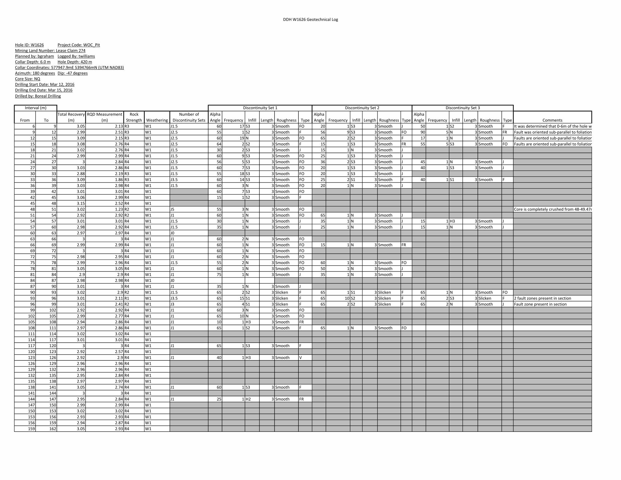
DDH W1626 Geotechnical Log
From To
Total Recovery
(m)
RQD Measurement
(m)
Rock
Strength Weathering
Number of
Discontinuity Sets
Alpha
Angle Frequency Infill Length Roughness Type
Alpha
Angle Frequency Infill Length Roughness Type
Alpha
Angle Frequency Infill Length Roughness Type Comments
6 9 3.05 2.13 R3 W1 J1.5 60 17 S3 3 Smooth FO 20 1 S3 3 Smooth J 50 1 S2 3 Smooth F It was determined that 0-6m of the hole was casing. Start of Hole.
9 12 2.99 2.51 R3 W1 J2.5 55 1 S2 3 Smooth F 56 9 S3 3 Smooth FO 90 5 N 3 Smooth FR Fault was oriented sub-parallel to foliation.
12 15 3.09 2.15 R3 W1 J2.5 60 19 N 3 Smooth FO 65 2 S2 3 Smooth F 17 1 N 3 Smooth J Faults are oriented sub-parallel to foliation.
15 18 3.08 2.76 R4 W1 J2.5 64 2 S2 3 Smooth F 15 1 S3 3 Smooth FR 55 5 S3 3 Smooth FO Faults are oriented sub-parallel to foliation.
18 21 3.02 2.76 R4 W1 J1.5 30 2 S3 3 Smooth J 15 1 N 3 Smooth J
21 24 2.99 2.99 R4 W1 J1.5 60 9 S3 3 Smooth FO 25 1 S3 3 Smooth J
24 27 3 2.84 R4 W1 J2.5 56 5 S3 3 Smooth FO 36 2 S3 3 Smooth J 45 1 N 3 Smooth J
27 30 3.03 2.86 R4 W1 J1.5 60 7 S3 3 Smooth FO 20 1 S3 3 Smooth J 40 1 S3 3 Smooth J
30 33 2.88 2.19 R3 W1 J1.5 55 18 S3 3 Smooth FO 20 1 S3 3 Smooth J
33 36 3.09 1.86 R3 W1 J3.5 60 14 S3 3 Smooth FO 25 2 S1 3 Smooth F 40 1 S1 3 Smooth F
36 39 3.03 2.98 R4 W1 J1.5 60 3 N 3 Smooth FO 20 1 N 3 Smooth J
39 42 3.01 3.01 R4 W1 60 7 S3 3 Smooth FO
42 45 3.06 2.99 R4 W1 15 1 S2 3 Smooth F
45 48 3.15 2.52 R4 W1
48 51 3.02 1.23 R2 W1 J5 55 3 N 3 Smooth FO Core is completely crushed from 48-49.47m
51 54 2.92 2.92 R2 W1 J1 60 1 N 3 Smooth FO 65 1 N 3 Smooth J
54 57 3.01 3.01 R4 W1 J1.5 30 1 N 3 Smooth J 35 1 N 3 Smooth J 15 1 H3 3 Smooth J
57 60 2.98 2.92 R4 W1 J1.5 35 1 N 3 Smooth J 25 1 N 3 Smooth J 15 1 N 3 Smooth J
60 63 2.97 2.97 R4 W1 J0
63 66 3 3 R4 W1 J1 60 2 N 3 Smooth FO
66 69 2.99 2.99 R4 W1 J1 60 1 N 3 Smooth FO 15 1 N 3 Smooth FR
69 72 3 3 R4 W1 J1 60 1 N 3 Smooth FO
72 75 2.98 2.95 R4 W1 J1 60 2 N 3 Smooth FO
75 78 2.99 2.96 R4 W1 J1.5 55 2 N 3 Smooth FO 60 1 N 3 Smooth FO
78 81 3.05 3.05 R4 W1 J1 60 1 N 3 Smooth FO 50 1 N 3 Smooth J
81 84 2.9 2.9 R4 W1 J1 75 1 N 3 Smooth J 35 1 N 3 Smooth J
84 87 2.98 2.98 R4 W1 J0
87 90 3.01 3 R4 W1 J1 35 1 N 3 Smooth J
90 93 3.02 2.9 R2 W1 J1.5 65 2 S2 3 Slicken F 65 1 S1 3 Slicken F 65 1 N 3 Smooth FO
93 96 3.01 2.11 R1 W1 J3.5 65 15 S1 3 Slicken F 65 10 S2 3 Slicken F 65 2 S3 3 Slicken F 2 fault zones present in section
96 99 3.01 2.41 R2 W1 J3 65 4 S1 3 Slicken F 65 2 S2 3 Slicken F 65 2 N 3 Smooth J Fault zone present in section
99 102 2.92 2.92 R4 W1 J1 60 3 N 3 Smooth FO
102 105 2.99 2.77 R4 W1 J1 65 10 N 3 Smooth FO
105 108 2.94 2.86 R4 W1 J1 10 1 H3 3 Smooth FR
108 111 2.97 2.86 R4 W1 J1 65 1 S2 3 Smooth F 65 1 N 3 Smooth FO
111 114 3.02 3.02 R4 W1
114 117 3.01 3.01 R4 W1
117 120 3 3 R4 W1 J1 65 1 S3 3 Smooth F
120 123 2.92 2.57 R4 W1
123 126 2.92 2.9 R4 W1 J1 40 1 H3 3 Smooth V
126 129 2.96 2.96 R4 W1
129 132 2.96 2.96 R4 W1
132 135 2.95 2.84 R4 W1
135 138 2.97 2.97 R4 W1
138 141 3.05 2.74 R4 W1 J1 60 1 S3 3 Smooth F
141 144 3 3 R4 W1
144 147 2.95 2.84 R4 W1 J1 25 1 H2 3 Smooth FR
147 150 2.99 2.99 R4 W1
150 153 3.02 3.02 R4 W1
153 156 2.93 2.93 R4 W1
156 159 2.94 2.87 R4 W1
159 162 3.05 2.93 R4 W1
Drilled by: Boreal Drilling
Discontinuity Set 1 Discontinuity Set 2 Discontinuity Set 3
Collar Coordinates: 577947.9mE 5394766mN (UTM NAD83)Azimuth: 180 degrees Dip: -47 degrees
Interval (m)
Core Size: NQDrilling Start Date: Mar 12, 2016
Drilling End Date: Mar 15, 2016
Hole ID: W1626 Project Code: WOC_Pit
Planned by: bgraham Logged By: twilliams
Collar Depth: 6.0 m Hole Depth: 420 m
Mining Land Number: Lease Claim 274

DDH W1626 Geotechnical Log
From To
Total Recovery
(m)
RQD Measurement
(m)
Rock
Strength Weathering
Number of
Discontinuity Sets
Alpha
Angle Frequency Infill Length Roughness Type
Alpha
Angle Frequency Infill Length Roughness Type
Alpha
Angle Frequency Infill Length Roughness Type Comments
Drilled by: Boreal Drilling
Discontinuity Set 1 Discontinuity Set 2 Discontinuity Set 3
Collar Coordinates: 577947.9mE 5394766mN (UTM NAD83)Azimuth: 180 degrees Dip: -47 degrees
Interval (m)
Core Size: NQDrilling Start Date: Mar 12, 2016
Drilling End Date: Mar 15, 2016
Hole ID: W1626 Project Code: WOC_Pit
Planned by: bgraham Logged By: twilliams
Collar Depth: 6.0 m Hole Depth: 420 m
Mining Land Number: Lease Claim 274
162 165 3.05 3.05 R4 W1
165 168 2.94 2.94 R4 W1
168 171 2.98 2.89 R4 W1 J1 65 1 N 3 Smooth FO
171 174 3 3 R4 W1
Appendix J
Certificate of Qualifications

Rodney Barber Certificate of Qualified Person
I, Rodney Barber, P.Geo., do hereby that:
1. I am a practicing member of the Association of Professional Geoscientists of Ontario.
2. I am a graduate of Laurentian University, Sudbury, Ontario in 1988 with an Honours
Bachelor of Science degree in Geology.
3. I have practiced my profession from 1988 to present.
4. I have previously worked for 13 years as an exploration geologist engaged in exploration for
gold, base metals, and industrial minerals and for the last 17 years as a geologist employed
by Williams Operating Corporation, including 3.5 years as the Mine Geologist at the David
Bell Mine.
5. I have overseen the work contained within this report and that I have verified the contents
of this report and believe this to be reasonably accurate and complete .
('I... Rodney Barber, P.Geo.
:� Geology Superintendent·
Barrick Hernia
Date

Beth Leduc Certificate of Qualifications
I, Beth Leduc, do hereby certify that:
1. I am an active member of OACETI (Ontario Association of Certified Engineering Technicians
and Technologists) as a C.Tech (Certified Technician) since 2011.
2. I have practiced my profession from 2008 to the present.
3. I have previously worked for Barrick at the David Bell mine as an under ground geological
technician for 4 years.
4. I have previously worked as a technician in the Forestry/G.I.S industry for 8 years.
5. I have verified the contents of this report and believe this to be reasonable accurate and
complete.
Beth Leduc
Project Coordinator
Barrick Hernia
Date