Embed Size (px)
Citation preview
We are committed to providing accessible customer service.If you need accessible formats or communications supports, please contact us.
Nous tenons à améliorer l’accessibilité des services à la clientèle.Si vous avez besoin de formats accessibles ou d’aide à la communication, veuillez nous contacter.
1
1
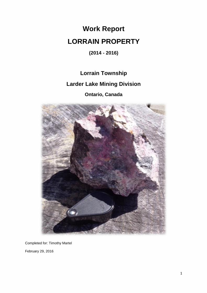
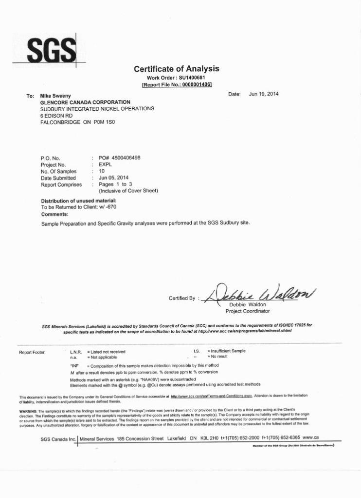
Work Report
LORRAIN PROPERTY
(2014 - 2016)
Lorrain Township
Larder Lake Mining Division
Ontario, Canada
Completed for: Timothy Martel
February 29, 2016
2
Table of Contents
Location ................................................................................................................................ 3
Ownership ............................................................................................................................. 3
Ownership Status .................................................................................................................. 4
Summary .............................................................................................................................. 5
Accessibility and Infrastructure .............................................................................................. 5
History .................................................................................................................................. 6
Previous Exploration ............................................................................................................. 6
Mine Dump No.1 Shaft .......................................................................................................... 7
Geology .............................................................................................................................. 10
2014 Work Summary .......................................................................................................... 11
Site Visit: May 8, 2014 ........................................................................................................ 11
Work Results ...................................................................................................................... 13
Recommendation ................................................................................................................ 14
Figure 1: Lorrain Property Location Key Map ........................................................................ 3
Figure 2: 4 Unit Claim, Patent and MDI ................................................................................. 4
Figure 3: Lorrain Property Claim Block .................................................................................. 4
Figure 4: Shaft No. 1 1998 Muck Pile Sampling .................................................................... 7
Figure 5: May 8th,2014 Shallow Grid Sampling Over Muck Pile ............................................. 9
Figure 6: Selected Samples from Muck Pile ........................................................................ 10
Figure 7: Access Route ....................................................................................................... 12
Figure 8: Location of Grid Sampling .................................................................................... 12
Figure 9: Satellite Image of Work Area ................................................................................ 13
2014 SGS Assay Certificates & MNDM Buk Sample Permit Guidelines
3
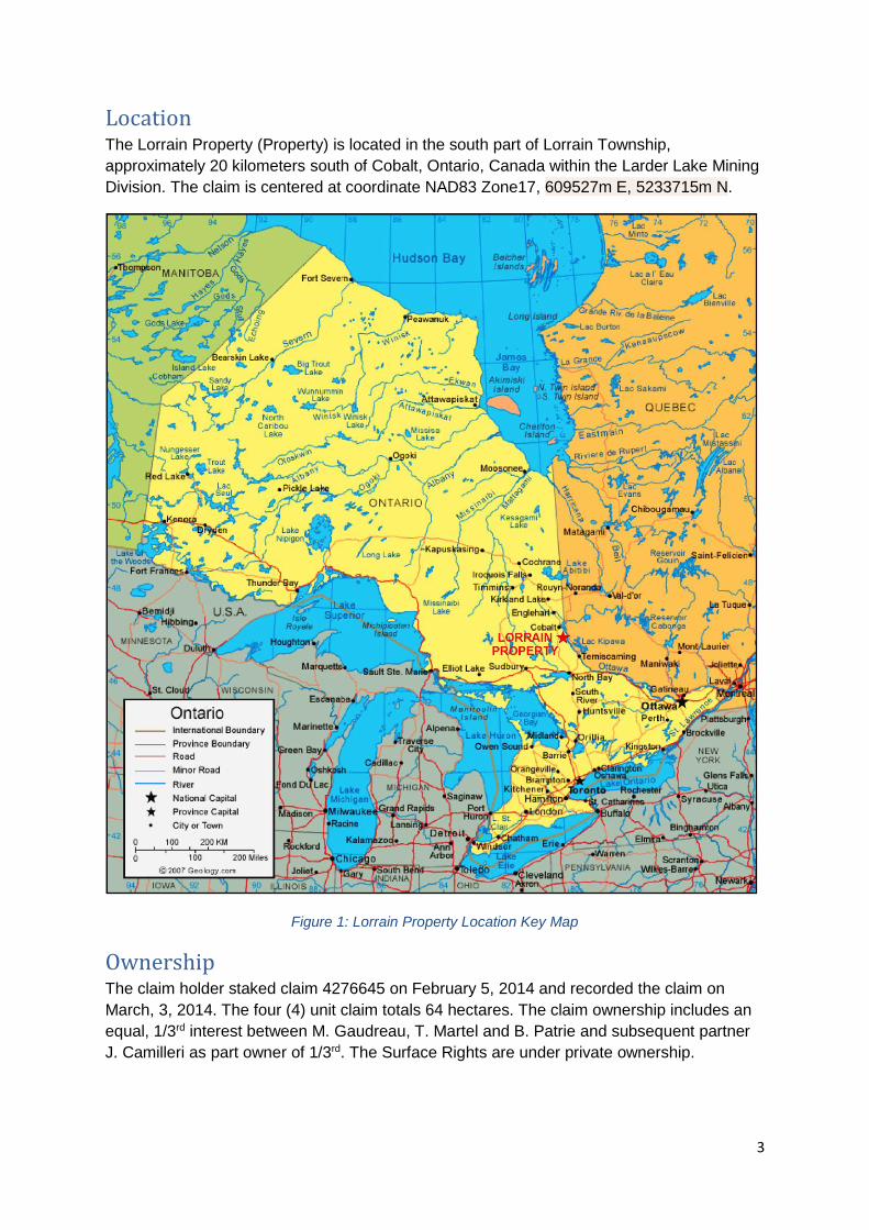
Location The Lorrain Property (Property) is located in the south part of Lorrain Township,
approximately 20 kilometers south of Cobalt, Ontario, Canada within the Larder Lake Mining
Division. The claim is centered at coordinate NAD83 Zone17, 609527m E, 5233715m N.
Figure 1: Lorrain Property Location Key Map
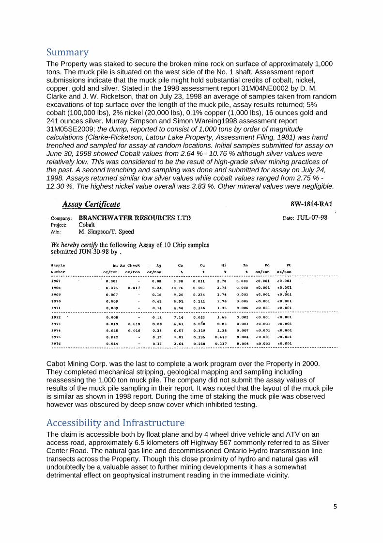
Ownership The claim holder staked claim 4276645 on February 5, 2014 and recorded the claim on
March, 3, 2014. The four (4) unit claim totals 64 hectares. The claim ownership includes an
equal, 1/3rd interest between M. Gaudreau, T. Martel and B. Patrie and subsequent partner
J. Camilleri as part owner of 1/3rd. The Surface Rights are under private ownership.
4
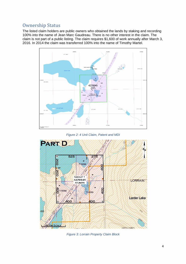
Ownership Status The listed claim holders are public owners who obtained the lands by staking and recording 100% into the name of Jean Marc Gaudreau. There is no other interest in the claim. The claim is not part of a public listing. The claim requires $1,600 of work annually after March 3, 2016. In 2014 the claim was transferred 100% into the name of Timothy Martel.
Figure 2: 4 Unit Claim, Patent and MDI
Figure 3: Lorrain Property Claim Block
5
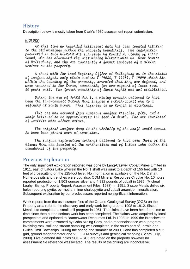
Summary The Property was staked to secure the broken mine rock on surface of approximately 1,000 tons. The muck pile is situated on the west side of the No. 1 shaft. Assessment report submissions indicate that the muck pile might hold substantial credits of cobalt, nickel, copper, gold and silver. Stated in the 1998 assessment report 31M04NE0002 by D. M. Clarke and J. W. Ricketson, that on July 23, 1998 an average of samples taken from random excavations of top surface over the length of the muck pile, assay results returned; 5% cobalt (100,000 lbs), 2% nickel (20,000 lbs), 0.1% copper (1,000 lbs), 16 ounces gold and 241 ounces silver. Murray Simpson and Simon Wareing1998 assessment report 31M05SE2009; the dump, reported to consist of 1,000 tons by order of magnitude calculations (Clarke-Ricketson, Latour Lake Property, Assessment Filing, 1981) was hand trenched and sampled for assay at random locations. Initial samples submitted for assay on June 30, 1998 showed Cobalt values from 2.64 % - 10.76 % although silver values were relatively low. This was considered to be the result of high-grade silver mining practices of the past. A second trenching and sampling was done and submitted for assay on July 24, 1998. Assays returned similar low silver values while cobalt values ranged from 2.75 % - 12.30 %. The highest nickel value overall was 3.83 %. Other mineral values were negligible.
Cabot Mining Corp. was the last to complete a work program over the Property in 2000. They completed mechanical stripping, geological mapping and sampling including reassessing the 1,000 ton muck pile. The company did not submit the assay values of results of the muck pile sampling in their report. It was noted that the layout of the muck pile is similar as shown in 1998 report. During the time of staking the muck pile was observed however was obscured by deep snow cover which inhibited testing.
Accessibility and Infrastructure
The claim is accessible both by float plane and by 4 wheel drive vehicle and ATV on an access road, approximately 6.5 kilometers off Highway 567 commonly referred to as Silver Center Road. The natural gas line and decommissioned Ontario Hydro transmission line transects across the Property. Though this close proximity of hydro and natural gas will undoubtedly be a valuable asset to further mining developments it has a somewhat detrimental effect on geophysical instrument reading in the immediate vicinity.
6
History Description below is mostly taken from Clark’s 1980 assessment report submission.
Previous Exploration
The only significant exploration reported was done by Lang-Caswell Cobalt Mines Limited in 1911, east of Latour Lake wherein the No. 1 shaft was sunk to a depth of 155 feet with 13 feet of crosscutting on the 125-foot level. No information is available on the No. 2 shaft. Numerous pits and trenches were dug also. ODM Mineral Resources Circular No. 10 notes reported production of 1,503 ounces silver and 4,932 pounds of cobalt in 1936, (Micheal Leahy, Bishop Property Report, Assessment Files, 1988). In 1951, Siscoe Metals drilled six holes reporting pyrite, pyrrhotite, minor chalcopyrite and cobalt arsenide mineralization. Subsequent exploration by our predecessors reported no significant information. Work reports from the assessment files of the Ontario Geological Survey (OGS) on the Property area refer to the discovery and early work being around 1908 to 1912. Siscoe Metals Ltd completed a small drill program in 1951. The claims have been held from time to time since then but no serious work has been completed. The claims were acquired by local prospectors and optioned to Branchwater Resources Ltd. in 1998. In 1999 the Branchwater commitments were assumed by Cabo Mining Corp. and a reconnaissance work program involving rock, soil and stream sampling was completed in the south part of Lorrain and Gillies Limit Townships. During the spring and summer of 2000, Cabo has completed a cut grid, ground magnetometer and V.L.F.-EM surveys and geological mapping (Sears, July, 2000). Five diamond drill holes SC1 – SC5 are noted on the property however no assessment file reference was located. The results of the drilling are inconclusive.
7
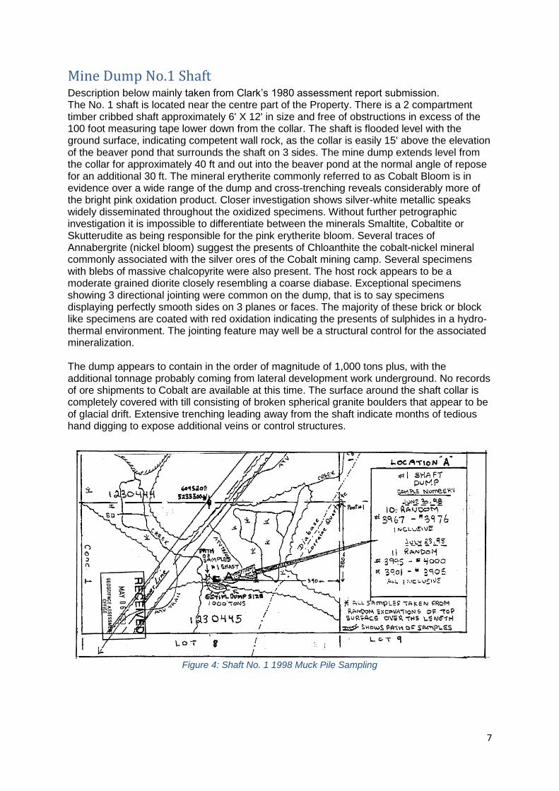
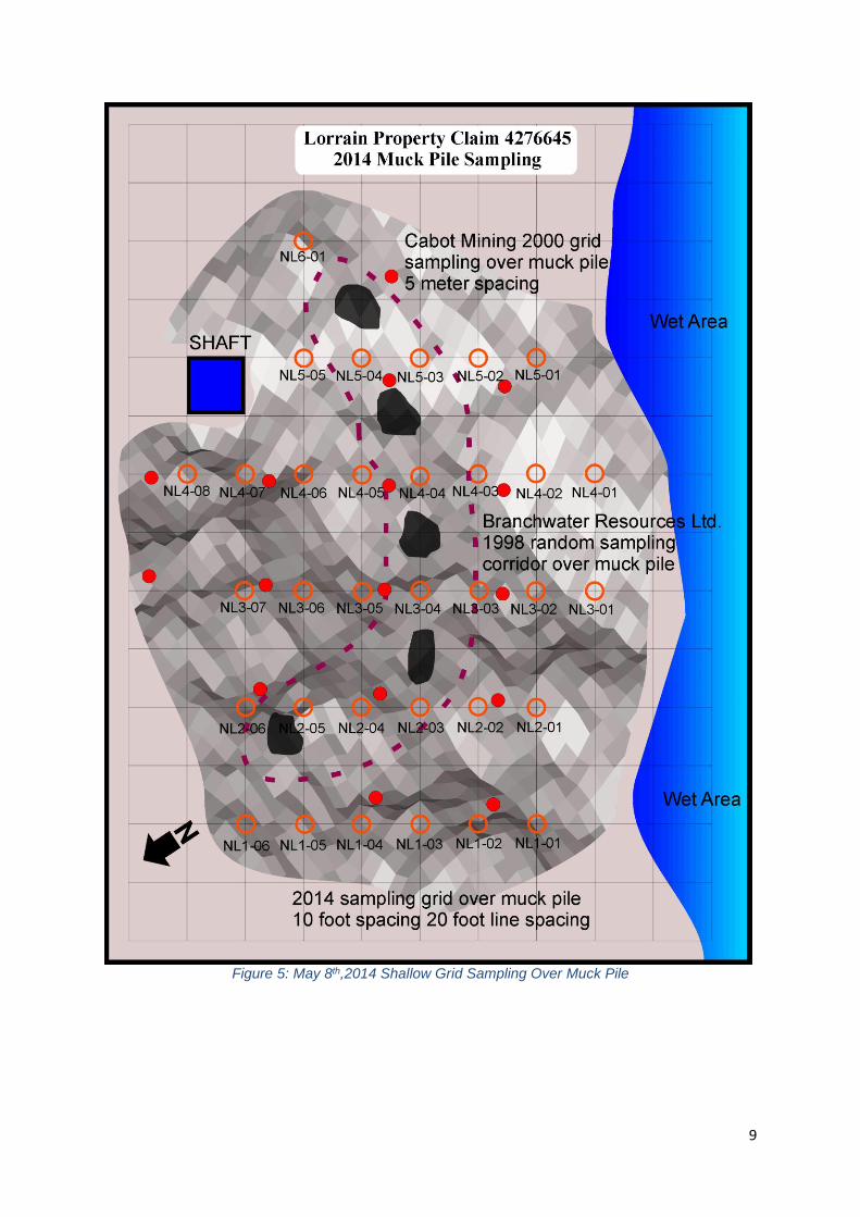
Mine Dump No.1 Shaft Description below mainly taken from Clark’s 1980 assessment report submission. The No. 1 shaft is located near the centre part of the Property. There is a 2 compartment timber cribbed shaft approximately 6' X 12' in size and free of obstructions in excess of the 100 foot measuring tape lower down from the collar. The shaft is flooded level with the ground surface, indicating competent wall rock, as the collar is easily 15' above the elevation of the beaver pond that surrounds the shaft on 3 sides. The mine dump extends level from the collar for approximately 40 ft and out into the beaver pond at the normal angle of repose for an additional 30 ft. The mineral erytherite commonly referred to as Cobalt Bloom is in evidence over a wide range of the dump and cross-trenching reveals considerably more of the bright pink oxidation product. Closer investigation shows silver-white metallic speaks widely disseminated throughout the oxidized specimens. Without further petrographic investigation it is impossible to differentiate between the minerals Smaltite, Cobaltite or Skutterudite as being responsible for the pink erytherite bloom. Several traces of Annabergrite (nickel bloom) suggest the presents of Chloanthite the cobalt-nickel mineral commonly associated with the silver ores of the Cobalt mining camp. Several specimens with blebs of massive chalcopyrite were also present. The host rock appears to be a moderate grained diorite closely resembling a coarse diabase. Exceptional specimens showing 3 directional jointing were common on the dump, that is to say specimens displaying perfectly smooth sides on 3 planes or faces. The majority of these brick or block like specimens are coated with red oxidation indicating the presents of sulphides in a hydro-thermal environment. The jointing feature may well be a structural control for the associated mineralization. The dump appears to contain in the order of magnitude of 1,000 tons plus, with the additional tonnage probably coming from lateral development work underground. No records of ore shipments to Cobalt are available at this time. The surface around the shaft collar is completely covered with till consisting of broken spherical granite boulders that appear to be of glacial drift. Extensive trenching leading away from the shaft indicate months of tedious hand digging to expose additional veins or control structures.
Figure 4: Shaft No. 1 1998 Muck Pile Sampling
8
9
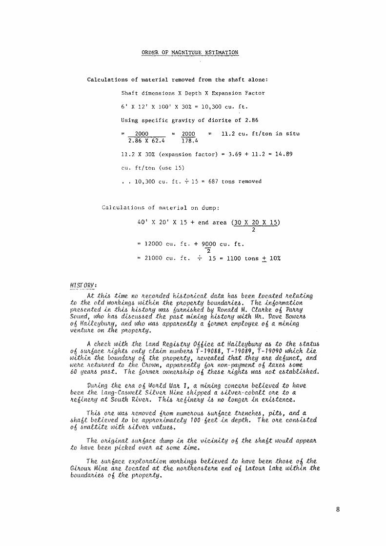
Figure 5: May 8th,2014 Shallow Grid Sampling Over Muck Pile
10
Figure 6: Selected Samples from Muck Pile
Geology
Description below manly taken from Clark’s 1980 assessment report submission. The mineralization appears to be associated with carbonate breccia and calcite +I- quartz veins in a Nipissing diabase sill. They appear to be localized at the intersection of NS-SW and NW-SE trending structures. The Property is located in the southern part of the Cobalt mining camp and north of the Silver City mining camp and thus has not been well studied. It was mapped by the Ontario Geological Survey in 1978 (Lovell et al.). The Property is situated at the eastern end of a large Nipissing Diabase sill the marks the south shore of Latour and Anderson Lakes. The eastern end of the diabase intrudes Huronian aged Lorrain Formation sediments. The No. 1 shaft (125 feet deep with underground workings) is the main target on the property. Two other very deep pits or short shafts were located along with
11
numerous other very deep pits, trenches and open cuts. Cobalt bloom is abundant on the muck pile around the main shaft. Muck from many of the other overgrown or flooded pits also exhibits this mineral. Other mineralization noted includes chalcopyrite and pyrite.
2014 Work Summary
The title search to determine if there is a Surface Right Owner (SRO) has been completed. The SRO has been informed that work under the Mining Act might be completed in the form of prospecting and evaluation of broken rock. The proposed work is structured around testing the broken rock pile to determine if it meets the grade to process at a smelter/refinery in Greater Sudbury. Unfortunately, the muck pile testing by Glencore Xstrata did not qualify as a feasible project. The gridded surface sampling to test the broken rock from the historical shaft and lateral working did not contain sufficient mineralization. Hypothesis to why the muck pile did not return similar historical results may be due to over 50 years of surface weathering. The 2014 sampling was completely non-discriminating of sample selection and the sampling was limited to 20cm excavations and non-evasive as to minimize disruption of the existing material.
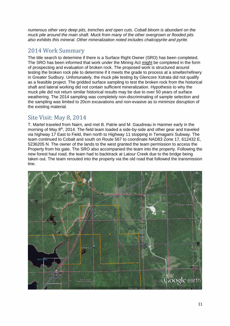
Site Visit: May 8, 2014
T. Martel traveled from Nairn, and met B. Patrie and M. Gaudreau in Hanmer early in the morning of May 8th, 2014. The field team loaded a side-by-side and other gear and traveled via highway 17 East to Field, then north to Highway 11 stopping in Temagami Subway. The team continued to Cobalt and south on Route 567 to coordinate NAD83 Zone 17, 612432 E, 5236205 N. The owner of the lands to the west granted the team permission to access the Property from his gate. The SRO also accompanied the team into the property. Following the new forest haul road, the team had to backtrack at Latour Creek due to the bridge being taken out. The team rerouted into the property via the old road that followed the transmission line.
12
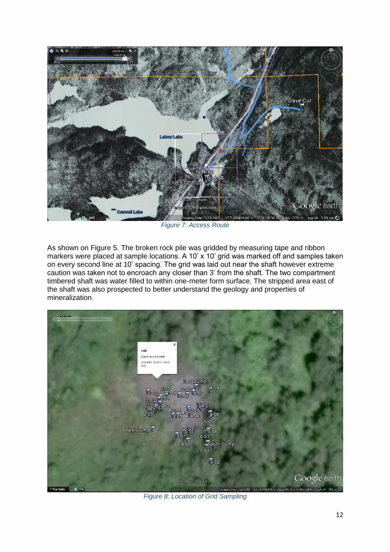
Figure 7: Access Route
As shown on Figure 5. The broken rock pile was gridded by measuring tape and ribbon markers were placed at sample locations. A 10’ x 10’ grid was marked off and samples taken on every second line at 10’ spacing. The grid was laid out near the shaft however extreme caution was taken not to encroach any closer than 3’ from the shaft. The two compartment timbered shaft was water filled to within one-meter form surface. The stripped area east of the shaft was also prospected to better understand the geology and properties of mineralization.
Figure 8: Location of Grid Sampling
13
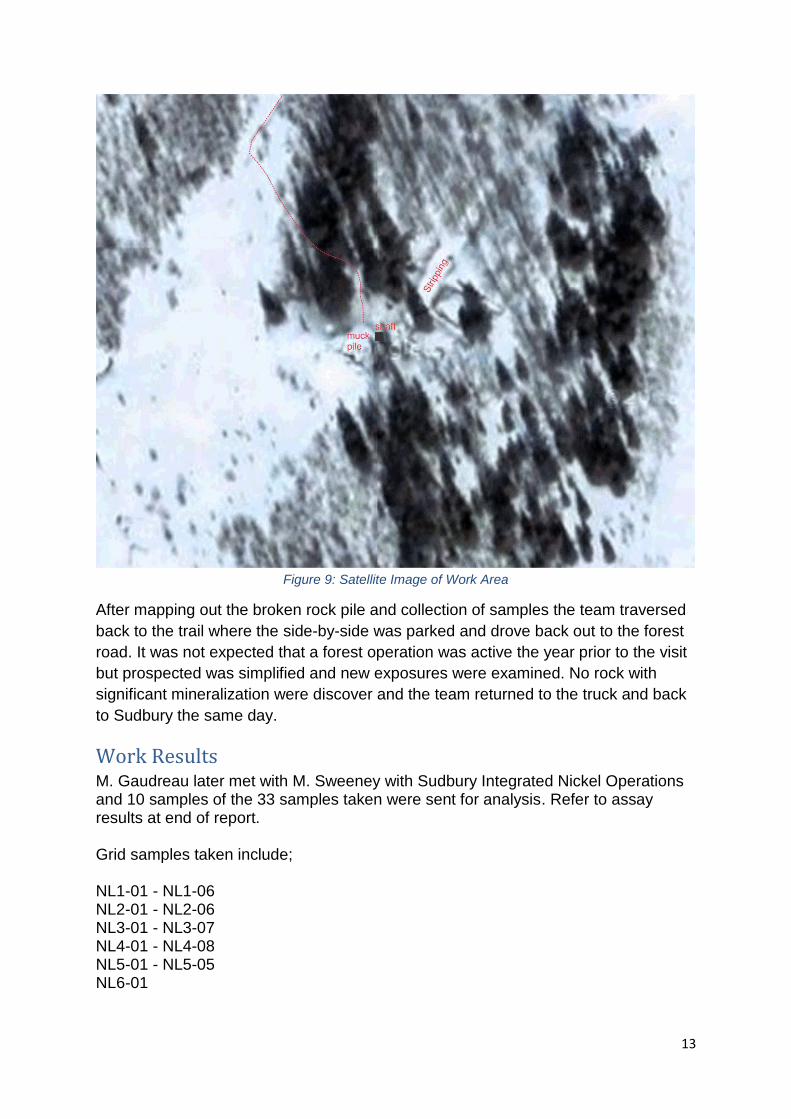
Figure 9: Satellite Image of Work Area
After mapping out the broken rock pile and collection of samples the team traversed
back to the trail where the side-by-side was parked and drove back out to the forest
road. It was not expected that a forest operation was active the year prior to the visit
but prospected was simplified and new exposures were examined. No rock with
significant mineralization were discover and the team returned to the truck and back
to Sudbury the same day.
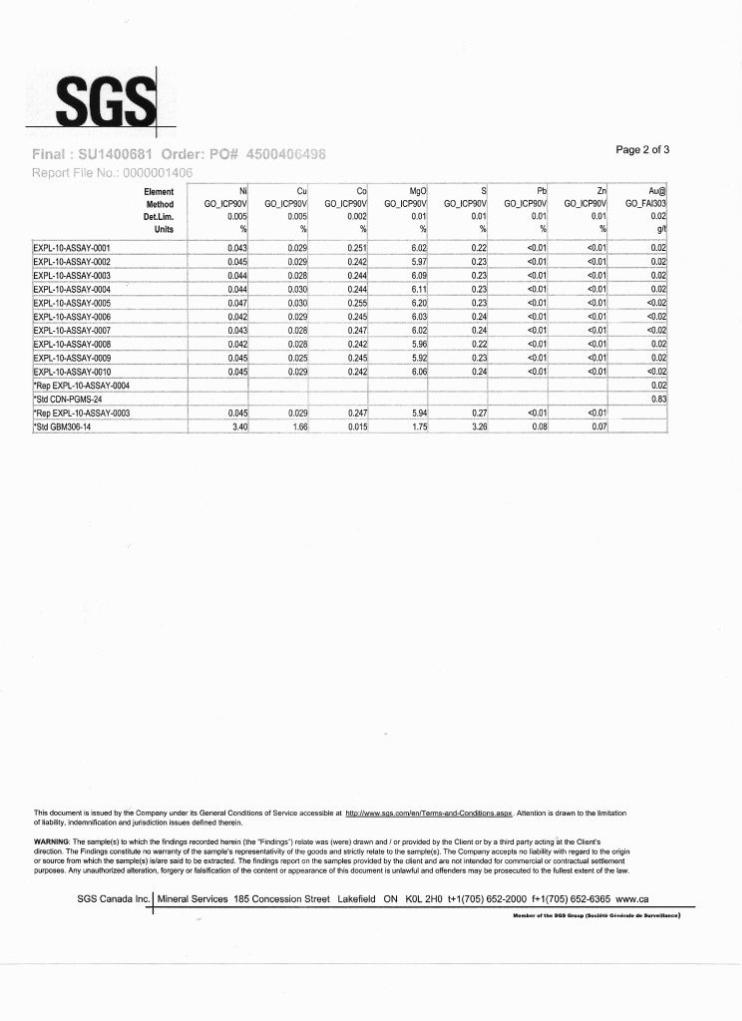
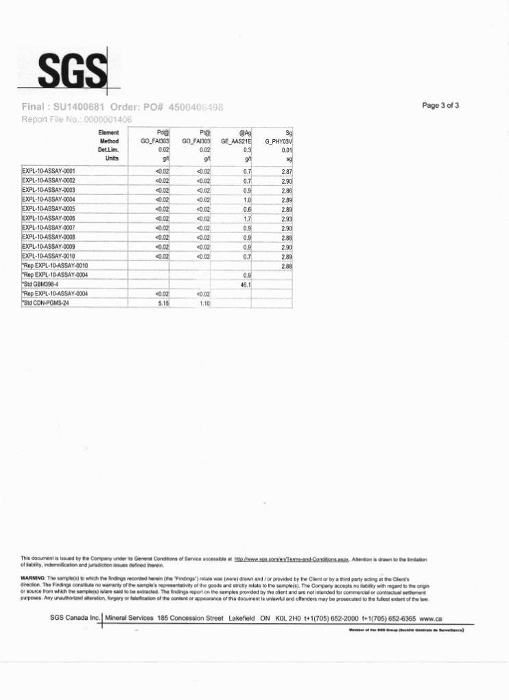
Work Results M. Gaudreau later met with M. Sweeney with Sudbury Integrated Nickel Operations and 10 samples of the 33 samples taken were sent for analysis. Refer to assay results at end of report. Grid samples taken include; NL1-01 - NL1-06 NL2-01 - NL2-06 NL3-01 - NL3-07 NL4-01 - NL4-08 NL5-01 - NL5-05 NL6-01
14
Selected samples for assayed include: EXPL-10-ASSAY-0001 NL1-04 EXPL-10-ASSAY-0002 NL2-01 EXPL-10-ASSAY-0003 NL2-05 EXPL-10-ASSAY-0004 NL3-04 EXPL-10-ASSAY-0005 NL3-07 EXPL-10-ASSAY-0006 NL4-03 EXPL-10-ASSAY-0007 NL4-06 EXPL-10-ASSAY-0008 NL5-02 EXPL-10-ASSAY-0009 NL5-04 EXPL-10-ASSAY-0010 NL6-01 Selected samples included visible cobalt bloom and massive sulfides and other pyrite mineralization. Although the samples were taken unbiased the samples that were sent to SGS Minerals Services (Lakefield) did not return values that were within the range for processing the broken rock. Note 1: At the time of writing this report some of the original field notes and pictures were not located. GPS locations of the samples were available however not used herein due to the accuracy being +/- 3 – 5 meters were not as accurate as the grid sampling layout accurate to within 12 inches. Note 2: The property was revisited on two subsequent field visits. 1. By B. Patrie and J. Camilleri – examination of the test area and prospecting a number of existing mineralized areas and also prospected to the north and northeast part of Latour Lake. 2. J. Camilleri and G. Roy. The results of these prospecting visits will be submitted in the form of a supplemental report at a later date.
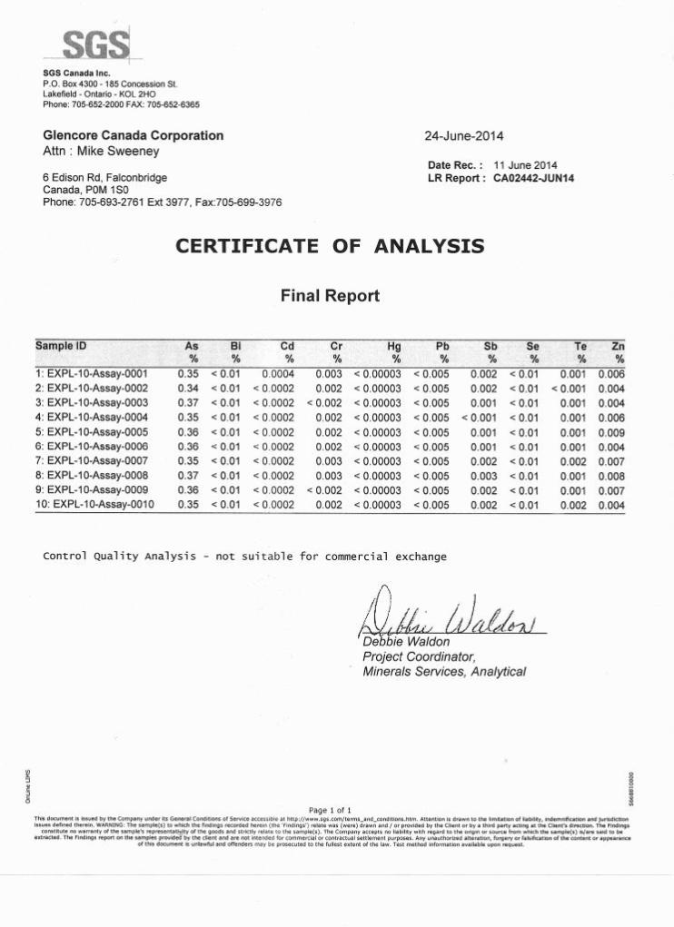
Recommendation Although the claim holders confirmed from the shallow grid sampling project that the broken rock pile, as noted by SGS assay results 24-June-2014 (Control Quality Analysis - not suitable for commercial exchange) does not qualify to request a bulk sample permit to remove for smelter processing the claim holder feel the material on surface did at one time, as noted in historical assessment reports, contain economic mineral grades. After thorough review of historical assessment work personal communication with others that have worked on the property in the past and It has also been assessed that a deep Induced Polarization (IP) survey might determine if the mineralized trend (EW) is continuous to depth. Therefore, the claim holders plan to complete an IP some time in the future to test this hypothesis.
Ontario's Modernized Mining Act
Bulk Samples – Permission to Test Mineral Content
The Ministry of Northern Development and Mines (MNDM) has changed the process for obtaining permission to extract bulk samples for testing under Section 52 of the Mining Act. Effective November 1, 2012, those applying for permission to test a bulk sample for mineral content on a mining claim (proponent) will be required to follow a new process.
How will the permission to test mineral content process work?
1. Permission to test mineral content: Proponents are still required to apply for and obtain permission to test mineral content prior to extracting a bulk sample. Thresholds have been established in regulation to identify what amount of material extracted constitutes a bulk sample.
2. Permission to dispose of material: If the intention is to sell/dispose the end product after processing and testing, it is necessary to include a request for this permission as part of the bulk sample permission application.
3. The activity undertaken to extract the bulk sample (e.g. excavating or drilling) will be subject to the Exploration Plans and Exploration Permits regulation or the Mine Development and Closure Regulation ( Ontario Regulation 240/00) if it meets the threshold for advanced exploration.
What You Need to Know...
• Proponents must apply for a bulk sample permission using the approved application form, and if they intend to sell the end product of the bulk sample, they must request permission for this in their bulk sample application.
• The threshold for a bulk sample for most material is 100 tonnes, below which no Section 52 permission is required. For semi-precious, lapidary or precious stones (except diamonds) the bulk sample threshold is greater than 100 kilograms.
• If the bulk sample exceeds 1000 tonnes, the activity is considered to be advanced exploration and this requires a closure plan under Part VII of the Mining Act.
• Proponents must comply with the Exploration Plan and Exploration Permit Regulation with respect to the activity of extracting the sample, in addition to the Bulk Sample Permission. A plan is required if material extracted is greater than 1m3 and a permit is required if the material extracted is greater than 3m3 but less than 1000 tonnes.
• Once sampling and testing are complete, a certified report that outlines the material extracted, tests carried and the associated cost for the work must be submitted to MNDM.
• MNDM’s bulk sample permission is subject to the Environmental Assessment Act and will be screened and evaluated through MNDM’s environmental assessment process.
This is intended as general introductory information only. For more information, including links to the Mining Act, regulations and applicable policies, and copies of forms and applications, or to find an MNDM office near you, visit our website at www.ontario.ca/miningact.