Embed Size (px)
Citation preview
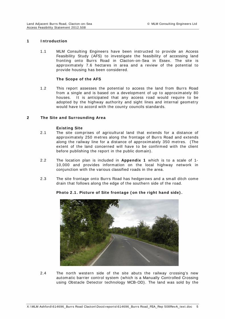
Access Feasibility Study
Land Adjacent to Burrs Road Clacton-on-Sea
R E Giles & Sons

Land Adjacent Burrs Road, Clacton-on-Sea © MLM Consulting Engineers Ltd Access Feasibility Statement 2012.508 RevA
X:\MLM Ashford\614696_Burrs Road Clacton\Docs\reports\614696_Burrs Road_FEA_Rep 508RevA_text.doc
Project Revision Sheet Revision No Date Status Changes Author Approved
0 Sep 2012 Final n/a
A Oct 2012 Final Minor changes
Land Adjacent Burrs Road, Clacton-on-Sea © MLM Consulting Engineers Ltd Access Feasibility Statement 2012.508 RevA
X:\MLM Ashford\614696_Burrs Road Clacton\Docs\reports\614696_Burrs Road_FEA_Rep 508RevA_text.doc
Contents Page 1 Introduction 5
2 The Site and Surrounding Area 5
3 Development Proposal – Traffic Generation 11
4 Access To site 11
5 Conclusions 13
Appendices Appendix 1: Location Plan (figure 1)
Appendix 2: Existing Highway Network (SK01), (SK02), (SK03)
Appendix 3: Traffic Model - Data
Appendix 4 September Traffic Data - Graph
Appendix 5 Proposed Site Access Layout (SK04)
Land Adjacent Burrs Road, Clacton-on-Sea © MLM Consulting Engineers Ltd Access Feasibility Statement 2012.508
X:\MLM Ashford\614696_Burrs Road Clacton\Docs\reports\614696_Burrs Road_FEA_Rep 508RevA_text.doc 5
1 Introduction
1.1 MLM Consulting Engineers have been instructed to provide an Access
Feasibility Study (AFS) to investigate the feasibility of accessing land fronting onto Burrs Road in Clacton-on-Sea in Essex. The site is approximately 7.6 hectares in area and a review of the potential to provide housing has been considered. The Scope of the AFS
1.2 This report assesses the potential to access the land from Burrs Road
from a single and is based on a development of up to approximately 80 houses. It is anticipated that any access road would require to be adopted by the highway authority and sight lines and internal geometry would have to accord with the county councils standards.
2 The Site and Surrounding Area
Existing Site
2.1 The site comprises of agricultural land that extends for a distance of approximately 250 metres along the frontage of Burrs Road and extends along the railway line for a distance of approximately 350 metres. (The extent of the land concerned will have to be confirmed with the client before publishing the report in the public domain).
2.2 The location plan is included in Appendix 1 which is to a scale of 1-
10,000 and provides information on the local highway network in conjunction with the various classified roads in the area.
2.3 The site frontage onto Burrs Road has hedgerows and a small ditch come
drain that follows along the edge of the southern side of the road.
Photo 2.1. Picture of Site frontage (on the right hand side).
2.4 The north western side of the site abuts the railway crossing’s new automatic barrier control system (which is a Manually Controlled Crossing using Obstacle Detector technology MCB-OD). The land was sold by the

Land Adjacent Burrs Road, Clacton-on-Sea © MLM Consulting Engineers Ltd Access Feasibility Statement 2012.508
X:\MLM Ashford\614696_Burrs Road Clacton\Docs\reports\614696_Burrs Road_FEA_Rep 508RevA_text.doc 6
landowner and transferred to Network Rail approximately 3 years ago. Highway Network
2.5 Burrs Road is an unclassified road that links the south eastern side of Clacton-on-Sea with the business park to the north west. Sladbury’s Lane, to the eastern side of Burrs Lane, is an unclassified road that is approximately 5.5 metres in width as it extends from Keswick Avenue to the south up to Smythies Farm at its junction with Burrs Road. The section of highway from Burrs Road junction with Sladbury’s Lane up to the railway crossing is generally 4.2 metres in width with informal passing opportunities where the road has been narrowed down due to shrubbery and vegetation close to the roadside edge nearby.
2.6 Within 40 metres of the eastern side of the railway crossing the highway
extends to a width of approximately 5.5 metres and is supplemented by white lines, signs and lines associated with the railway crossing in conjunction with street lighting.
2.7 The street lighting extends from the western side of Burrs Road railway
crossing to the business park off Telford Road, Gorse Lane Industrial Estate, the estate roads to the west. Photographs of the local road network are included below and the drawing in Appendix 2 also highlights the local road network in more detail, in conjunction with providing an aerial photograph of the surrounding network.
Photo 2.2 – Burrs Road – Railway Crossing
2.8 Traffic data within the public domain has been reviewed in order to
provide traffic flows to accompany this report. In 2011 a transport assessment was prepared for an extension of the Telford Road Industrial Estate in which a traffic model was prepared and concluded that additional development in the area would not compromise local junctions in the area.

Land Adjacent Burrs Road, Clacton-on-Sea © MLM Consulting Engineers Ltd Access Feasibility Statement 2012.508
X:\MLM Ashford\614696_Burrs Road Clacton\Docs\reports\614696_Burrs Road_FEA_Rep 508RevA_text.doc 7
2.9 The assessment was undertaken by MLM Consulting Engineers and the relevant data is shown in the tables below. In conjunction with the above the traffic model is included in Appendix 3.
Figure 2.3- Traffic Counts undertaken – Close to Site
2.10 The flows are set out below:-
Table 2.4 – Telford Road/Burrs Road Existing Peak Hour Vehicle Turning Flows
AM Peak Hour (0815-0915 Hours)
Origin/Destination A B C Total
A 0 164 52 216
B 92 0 22 114
Burrs East 59 61 0 120
Total 151 225 74 450
PM Peak Hour (1630-1730 Hours)
Origin/Destination A B C Total
A 0 93 28 121
B 164 0 71 235
Burrs East 43 16 0 59
Total 207 109 99 415
A = Burrs Road West, B=Telford Road East, C=Burrs Road East

Land Adjacent Burrs Road, Clacton-on-Sea © MLM Consulting Engineers Ltd Access Feasibility Statement 2012.508
X:\MLM Ashford\614696_Burrs Road Clacton\Docs\reports\614696_Burrs Road_FEA_Rep 508RevA_text.doc 8
2.11 Additional surveys were undertaken and are included in Appendix 4. The two way flows on Burrs Road are low. The surveys also included monitoring how long the barriers were in position whilst a train was due.
2.12 The local speed limit in the area is 30mph along Burrs Road, on the
western side of the railway line. On the eastern side it is derestricted. Based on the nature of this stretch of road between Sladbury’s Lane and the railway line the road, width, hedgerows, geometrical alignment and based on the site visit is akin to less than 30mph.
2.13 Although on the eastern side of the railway crossing there are no street
lights nor repeater plates the national speed limit is in force. Based on a speed limit of 30mph as recommended in Manual for Streets 1, in table 7.1 a sight line of 43m is recommended servicing any access nearby. Any future development along Burrs Road would entail extending her speed limit over this stretch.
2.14 Burrs Road is a typical rural road serving only a few properties in the
locality. The traffic flows monitored at the railway crossing are consequently relatively low and any increase in traffic along Burrs Road is liable to have a large increase in impact but in relative terms is likely to be relatively low. Sustainable Multi-Modal Travel
2.15 The local network has been reviewed and there are footways are provided on both sides of Burrs Road on the western side of the rail crossing and over a short length on the eastern side only.
Bus Services 2.16 Bus services have been investigated and on Telford Road the data is
shown below:
Table 2.5 – Bus Service Summary
No. Route Day First Bus
Last Bus
Peak Freq
Off-Peak Freq
2 Mistley-Weeley- Mon-Fri 0827 1905 1 bus Every 2

Land Adjacent Burrs Road, Clacton-on-Sea © MLM Consulting Engineers Ltd Access Feasibility Statement 2012.508
X:\MLM Ashford\614696_Burrs Road Clacton\Docs\reports\614696_Burrs Road_FEA_Rep 508RevA_text.doc 9
hours Clacton-on-Sea
Sat 0827 1905 1 bus Every 2 hours
Mon-Fri 0647 1717 1 bus Every 2 hours Clacton-on-Sea-
Weeley-Mistley
Sat 0647 1717 1 bus Every 2 hours
Mon-Fri 1024 1624 N/A Every 2 hours Harwich-Thorpe Le
Soken – Clacton-on-Sea
Sat 1024 1624 N/A Every 2 hours
Mon-Fri 0849 1614 1 bus Every 2 hours
4
Clacton-on-Sea – Thorpe Le Soken -
Harwich Sat 0849 1614 1 bus
Every 2 hours
Mon-Fri 0648 2229 2 per hour
2 per hour
Clacton-on-Sea –Pier Avenue – Three Jays – Tower Camp
Sat 0720 2229 2 per hour
2 per hour
Mon-Fri 0739 2323 2 per hour
2 per hour
10/11
Tower Camp – Three Jays –Pier
Avenue – Clacton-on-Sea
Sat 0816 2323 2 per hour
2 per hour
Mon-Fri 0811 1812 2 per hour
2 per hour
Sat 0912 1812 2 per hour
2 per hour
137
Pier Avenue-Cemetery-Telford Road-Retail Park
(Circular)
Sun 0911 1712 2 per hour
2 per hour
2.17 The above table summarises the main bus services routing on the local
highway network. It provides confirmation that there are local services nearby. Rail Services
2.18 The Clacton-on-Sea rail station is located approximately 3 km southwest of the proposed development. The rail station is located on Skelmersdale Road, close to Clacton-on-Sea town centre. The rail station is therefore within reasonable cycling distance (15 minutes) from the proposed development and can also be accessed via the existing bus routes from Telford Road.
Land Adjacent Burrs Road, Clacton-on-Sea © MLM Consulting Engineers Ltd Access Feasibility Statement 2012.508
X:\MLM Ashford\614696_Burrs Road Clacton\Docs\reports\614696_Burrs Road_FEA_Rep 508RevA_text.doc 10
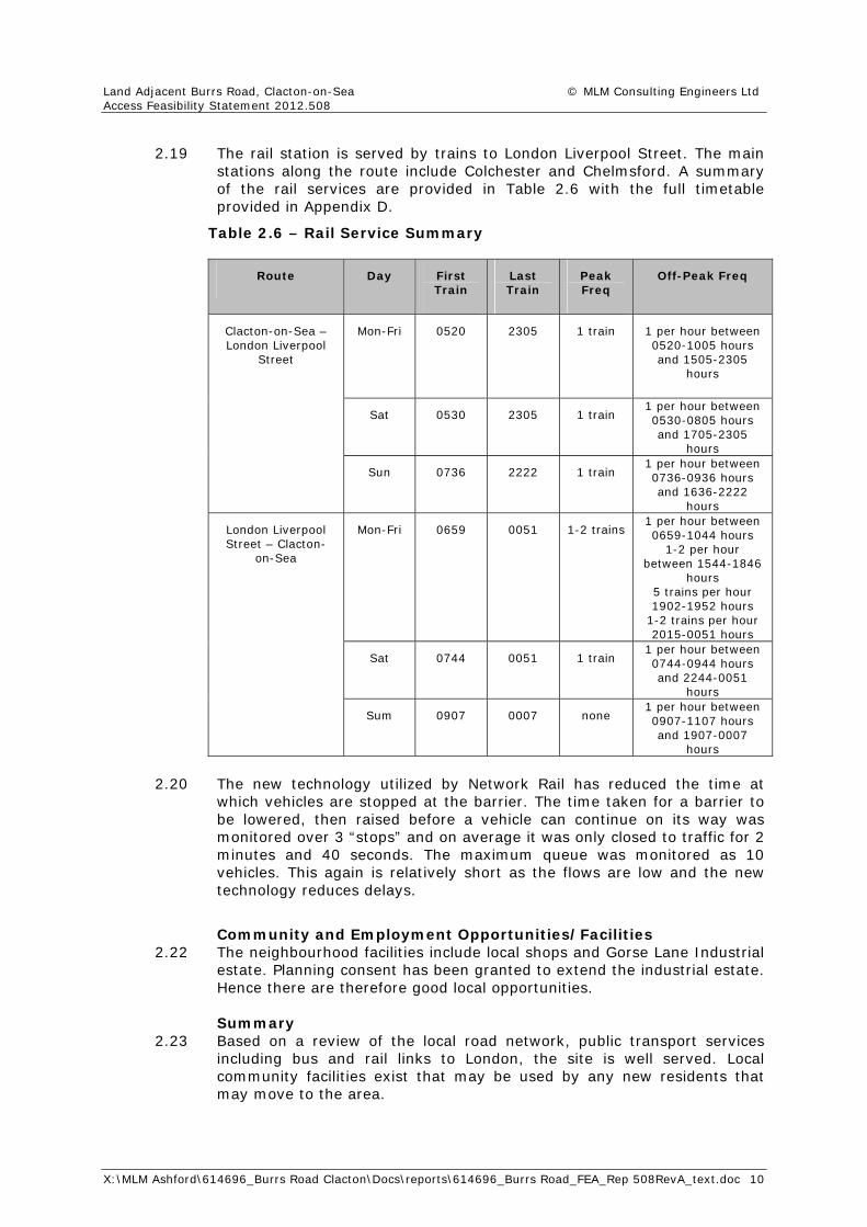
2.19 The rail station is served by trains to London Liverpool Street. The main stations along the route include Colchester and Chelmsford. A summary of the rail services are provided in Table 2.6 with the full timetable provided in Appendix D.
Table 2.6 – Rail Service Summary
Route Day First Train
Last Train
Peak Freq
Off-Peak Freq
Mon-Fri 0520 2305 1 train 1 per hour between 0520-1005 hours and 1505-2305
hours
Sat 0530 2305 1 train 1 per hour between 0530-0805 hours and 1705-2305
hours
Clacton-on-Sea – London Liverpool
Street
Sun 0736 2222 1 train 1 per hour between 0736-0936 hours and 1636-2222
hours
Mon-Fri 0659 0051 1-2 trains 1 per hour between 0659-1044 hours
1-2 per hour between 1544-1846
hours 5 trains per hour 1902-1952 hours
1-2 trains per hour 2015-0051 hours
Sat 0744 0051 1 train 1 per hour between 0744-0944 hours and 2244-0051
hours
London Liverpool Street – Clacton-
on-Sea
Sum 0907 0007 none 1 per hour between 0907-1107 hours and 1907-0007
hours
2.20 The new technology utilized by Network Rail has reduced the time at
which vehicles are stopped at the barrier. The time taken for a barrier to be lowered, then raised before a vehicle can continue on its way was monitored over 3 “stops” and on average it was only closed to traffic for 2 minutes and 40 seconds. The maximum queue was monitored as 10 vehicles. This again is relatively short as the flows are low and the new technology reduces delays.
Community and Employment Opportunities/Facilities 2.22 The neighbourhood facilities include local shops and Gorse Lane Industrial
estate. Planning consent has been granted to extend the industrial estate. Hence there are therefore good local opportunities.
Summary
2.23 Based on a review of the local road network, public transport services including bus and rail links to London, the site is well served. Local community facilities exist that may be used by any new residents that may move to the area.
Land Adjacent Burrs Road, Clacton-on-Sea © MLM Consulting Engineers Ltd Access Feasibility Statement 2012.508
X:\MLM Ashford\614696_Burrs Road Clacton\Docs\reports\614696_Burrs Road_FEA_Rep 508RevA_text.doc 11
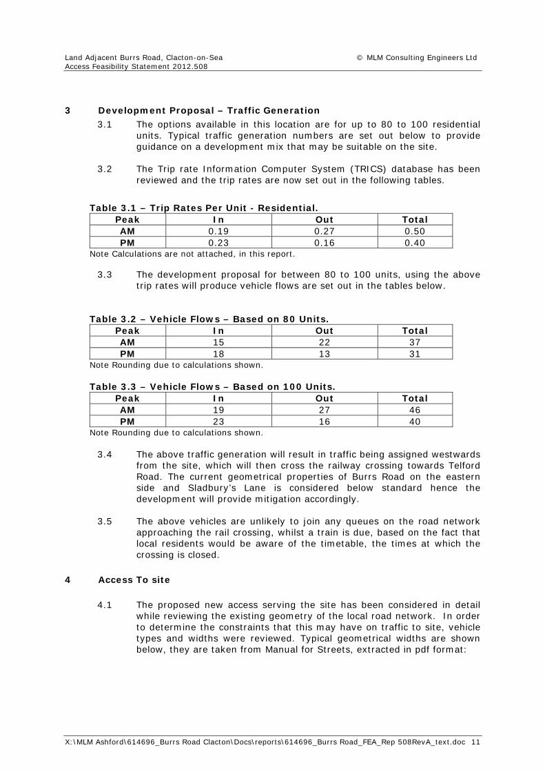
3 Development Proposal – Traffic Generation 3.1 The options available in this location are for up to 80 to 100 residential
units. Typical traffic generation numbers are set out below to provide guidance on a development mix that may be suitable on the site.
3.2 The Trip rate Information Computer System (TRICS) database has been
reviewed and the trip rates are now set out in the following tables.
Table 3.1 – Trip Rates Per Unit - Residential. Peak In Out Total AM 0.19 0.27 0.50 PM 0.23 0.16 0.40
Note Calculations are not attached, in this report.
3.3 The development proposal for between 80 to 100 units, using the above trip rates will produce vehicle flows are set out in the tables below.
Table 3.2 – Vehicle Flows – Based on 80 Units. Peak In Out Total AM 15 22 37 PM 18 13 31
Note Rounding due to calculations shown. Table 3.3 – Vehicle Flows – Based on 100 Units.
Peak In Out Total AM 19 27 46 PM 23 16 40
Note Rounding due to calculations shown. 3.4 The above traffic generation will result in traffic being assigned westwards
from the site, which will then cross the railway crossing towards Telford Road. The current geometrical properties of Burrs Road on the eastern side and Sladbury’s Lane is considered below standard hence the development will provide mitigation accordingly.
3.5 The above vehicles are unlikely to join any queues on the road network
approaching the rail crossing, whilst a train is due, based on the fact that local residents would be aware of the timetable, the times at which the crossing is closed.
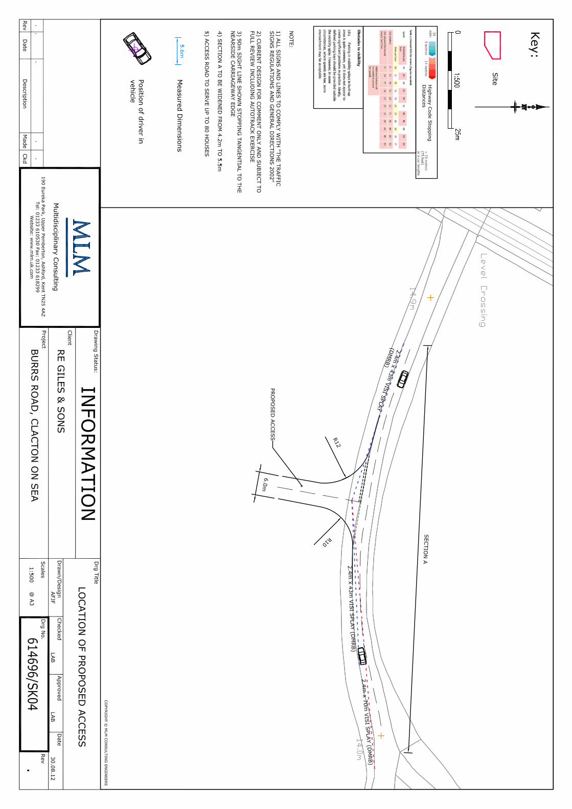
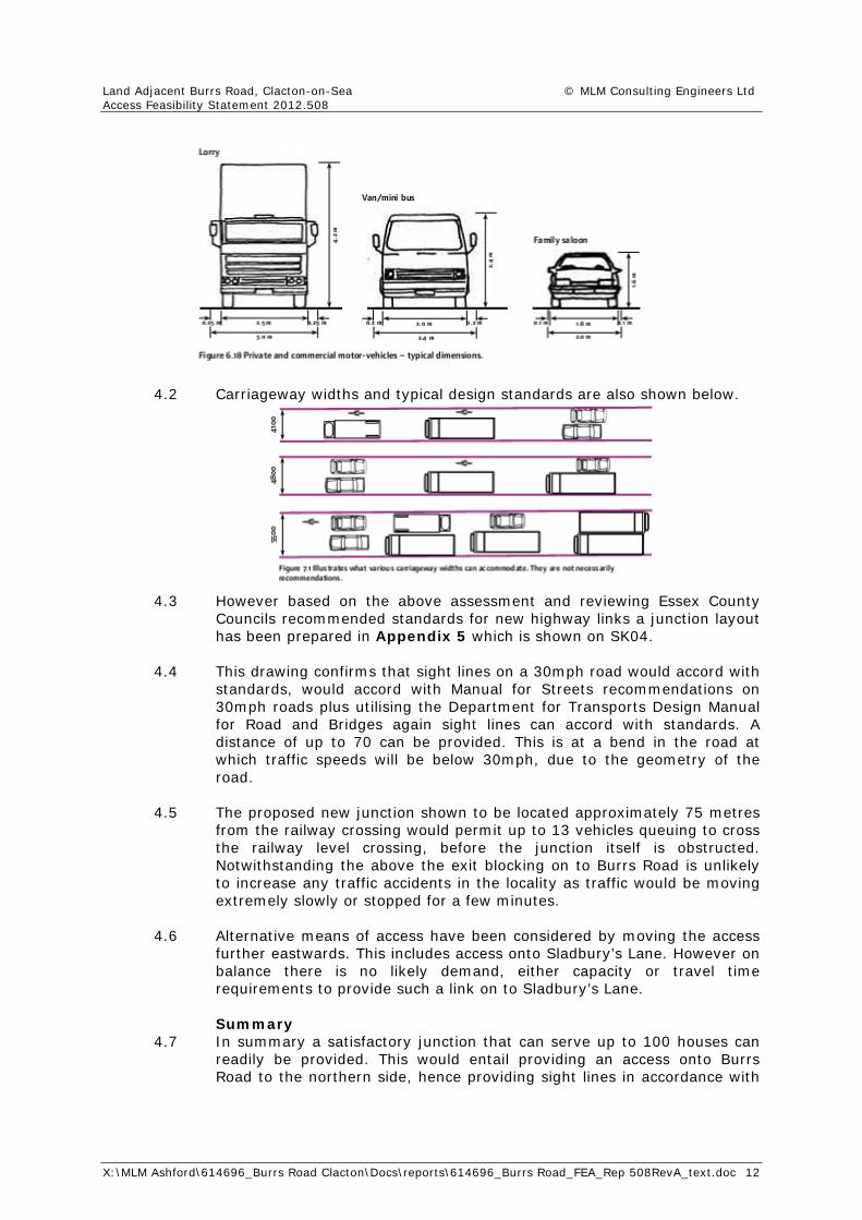
4 Access To site 4.1 The proposed new access serving the site has been considered in detail
while reviewing the existing geometry of the local road network. In order to determine the constraints that this may have on traffic to site, vehicle types and widths were reviewed. Typical geometrical widths are shown below, they are taken from Manual for Streets, extracted in pdf format:
Land Adjacent Burrs Road, Clacton-on-Sea © MLM Consulting Engineers Ltd Access Feasibility Statement 2012.508
X:\MLM Ashford\614696_Burrs Road Clacton\Docs\reports\614696_Burrs Road_FEA_Rep 508RevA_text.doc 12
4.2 Carriageway widths and typical design standards are also shown below.
4.3 However based on the above assessment and reviewing Essex County
Councils recommended standards for new highway links a junction layout has been prepared in Appendix 5 which is shown on SK04.
4.4 This drawing confirms that sight lines on a 30mph road would accord with
standards, would accord with Manual for Streets recommendations on 30mph roads plus utilising the Department for Transports Design Manual for Road and Bridges again sight lines can accord with standards. A distance of up to 70 can be provided. This is at a bend in the road at which traffic speeds will be below 30mph, due to the geometry of the road.
4.5 The proposed new junction shown to be located approximately 75 metres
from the railway crossing would permit up to 13 vehicles queuing to cross the railway level crossing, before the junction itself is obstructed. Notwithstanding the above the exit blocking on to Burrs Road is unlikely to increase any traffic accidents in the locality as traffic would be moving extremely slowly or stopped for a few minutes.
4.6 Alternative means of access have been considered by moving the access
further eastwards. This includes access onto Sladbury’s Lane. However on balance there is no likely demand, either capacity or travel time requirements to provide such a link on to Sladbury’s Lane.
Summary 4.7 In summary a satisfactory junction that can serve up to 100 houses can
readily be provided. This would entail providing an access onto Burrs Road to the northern side, hence providing sight lines in accordance with
Land Adjacent Burrs Road, Clacton-on-Sea © MLM Consulting Engineers Ltd Access Feasibility Statement 2012.508
X:\MLM Ashford\614696_Burrs Road Clacton\Docs\reports\614696_Burrs Road_FEA_Rep 508RevA_text.doc 13
recommended standards. The works would include widening the existing 4.2 metre wide carriageway up to 5.5 metres overall. The extent of the widening to be agreed with the highway authority.
4.8 Mitigation measures to encourage drivers to turn westwards rather than
eastwards from the site can be introduced by supplementing a road narrows signs in the locality in conjunction with physical features that would not have a detrimental impact on agricultural machinery and vehicles in the area. Access by emergency services along the local routes would also be maintained ensuring road safety is maintained.
5 Conclusions
5.1 This report has considered the development potential of land to
accommodate up to 100 houses off Burrs Road in Clacton. The proposed site is in a sustainable location with good transport and road links with ready access to local employment opportunities and with local shopping facilities to provide for day to day needs.
5.2 A number of access options have been considered and reviewed and the
most appropriate solution would be to provide an access onto Burrs Road approximately 75 metres from the recently upgraded controlled level crossing on the western side.
5.3 The short length of carriageway from the access road to the railway line
would require to be widened to approximately 5.5 metres in width, a pedestrian link provided either roadside or within the new estate to link across the level crossing in conjunction with landscaping the road frontage.
5.4 An alternative access on to Sladbury’s Lane is not considered necessary
or appropriate as links to the station, local employment, the industrial estate on the western side of the railway line, access to the A routes linking to Colchester etc does not require an alternative route strategy to be provided.
5.5 Mitigation measures to encourage people/drivers to use the western side
of the access road linking to Burrs Road can be implemented in consultation with the county council highway authority, emergency services and road safety representatives.
5.6 The assessment concludes that the access proposed in this report can
provide capacity, road safety mitigation measures and improvements in the locality.

Appendix 1
Location Plan (Figure 1)


Appendix 2
Existing Highway Network (SK01, SK02, SK03)


������������� �������������

����������� ���� � ���� ��� �� ��� ���� ��� �������������� �� ����� � � �� ��� ����� ��� �� �� ��� ������������� � ����� �� � �� ��������� ��� �� � ������������ ���� ���� ����� � �� �� � ����������
����� ������ ������ ���� � ��� !���������� � ���� ��� "#$$�����%��&� '����()�*$+,�-./0�1234-,�-./0�1234
567.

������������� ���������������� �������

X:\MLM Ashford\614696_Burrs Road Clacton\Calcs_traffic\[Traffic survey Sep 11 2012.xls]Sheet1
Traffic Survey conducted on the Burrs Road Level Crossing in Clacton.
11th September 2012.Eastbound Westbound
Time Vehicle movements
Vehicle movements
Two‐way
BST From Burrs To Burrs1635 2 0 2
1636 2 0 1 Bicycle 2
1637 5 0 5
1638 2 2 4
1639 1 5 6
1640 2 0 2
1641
1642
16431644 2 1 3
1645 2 0 2
1646 1 0 1
1647 1 2 3
1648 0 2 2
1649 2 0 2
1650 2 2 4
1651 0 2 2
1652 3 1 4
1653 2 3 5
1654 0 2 2
1655 0 3 3
1656 3 3 6
1657 0 0 0
1658 2 1 3
1659 2 2 4
1700 4 0 4
1701 2 2 4
1702 0 1 1
1703 9 1 Scooter 3 12
1704 0 2 Bicycles 2 2
1705 8 0 8
1706 3 1 4
1707
1708
17091710 1 0 1
1711 5 0 5
1712 3 1 4
1713 1 2 3
1714 2 2 4
1715 3 0 3
1716 3 2 5
1717 2 3 5
1718 1 0 1
1719 3 0 3
1720 5 2 7
1721 2 0 2
1722 2 1 3
1723 4 1 5
1724 0 0 0
1725 3 2 5
1726 2 2 4
1727 1 1 2
1728 4 0 4
1729 0 0 0
1730 2 3 5
1731 1 2 3
1732 3 1 Motorcycle 0 3
1733 2 0 2
1734 1 0 1
1735 4 0 4
1736 1 3 4
1737
1738
1739
Train to Clacton: Lights then Barrier down at 17:37
2 mins 40 Secs the time the traffic was halted.
10 vehicles held from Burrs & 4 vehicles held to Burrs.
6 vehicles held from Burrs & 3 vehicles held to Burrs.
Train from Clacton: Lights then Barrier down at 17:07
2 mins 40 Secs the time the traffic was halted.
9 vehicles held from Burrs & 4 vehicles held to Burrs.
Other Other
Train to Clacton: Lights then Barrier down at 16:41
2 mins 40 Secs the time the traffic was halted.
Survey at Level Crossing 11 th September 2012
0.00
1.00
2.00
3.00
4.00
5.00
6.00
7.00
8.00
9.00
10.00
1635
1637
1639
1641
1643
1645
1647
1649
1651
1653
1655
1657
1659
1701
1703
1705
1707
1709
1711
1713
1715
1717
1719
1721
1723
1725
1727
1729
1731
1733
Time
Veh
icle
s
From Burrseastbound
To BurrsWestbound
x:\mlm\614696_Burrs Rd Clacton \ calcs\ traffic survey Sept 2012 l
Barrier down 2min 40 seconds delay
Barrier down 2min 40 seconds delay
Barrier down 2min 40 seconds delay

������������� ������������������������