Embed Size (px)
Citation preview

1
Sharing the use of water resources by means of negotiated allocation at the Pipiripau River Basin
Oliveira, Hudson Rocha; VIANNA, Juliana Santos; ROCHA, José Bento.
Abstract
This work intends to present the sharing of the use of water resources, by means of the negotiated allocation of water, having the water basin as a basic unit for the implementation of the water resources policy and the creation of local water resources management councils – formed with the participation of users and communities – as an instrument necessary for the sharing of water use. Allocation of available water resources in a water basin can be achieved through optimized sharing, in which the goals of all user sectors are taken into account. The main objective is to promote the multiple uses of water resources, through a harmonious management that takes into account the individual and collective goals of all those involved, generating benefits for the environment and society.
Keywords: Management of water resources, water basins, water resources uses sharing, negotiated water allocation.
2
1. INTRODUCTION Water is an element of nature of vital and fundamental importance for the existence of humankind. It is used for public, industrial and agricultural supply, for the preservation of aquatic life, recreation and transportation.
Over time, humankind has been confronted with a number of global problems, including environmental ones, which are becoming increasingly important due to increased demands. These demands are a result of the impact of industrial development; population growth; intensive and accelerated land use; and increased use of natural resources imposed by modern standards of comfort and well-being, with the consequent susceptibility of contamination and amplified risk of waterborne diseases.
According to Clark and King (2005), the volume of fresh water on the Earth's surface is fixed and cannot increase or decrease. Thus, as the population grows, and the aspirations of individuals increase, there is less water available per person.
Clark and King (2005) present a worrying reality, stating that many people already face water shortages in many parts of the world. By 2050, it is estimated that more than 4 billion people - nearly half of the world's population - will be living in countries with chronic water shortages. Therefore, it is up to the people to become aware of the need to preserve this indispensable resource of life.
The management of water resources has an essential role in order to meet the social need and seek a turnaround of the current situation, since the existing rhythm of water resources exploitation is utterly contrary to the notion of sustainable development, which states that the needs of the present must be met without compromising future generations. Faced with this reality, there is an individual and collective necessity to seek ways to raise awareness of the people. However, the following problem arises: how to deal with the water supply / demand ratio?
In recent decades, water has been gradually recognized as a scarce resource on a world scale, both because its qualitative limitations, due to pollution, and its quantitative limitations, which in turn derive from climatic adversities, increasing demands and its inefficient use.
As a result of the fundamental role of water in various human activities, it is not difficult to predict that conflicts can easily arise in situations of scarcity, both in the face of high demand and inadequate management. Conflicts stemming from water scarcity have been increasingly frequent across the globe. Gleick (2000) reports 62 international conflicts over water use in the past 500 years, ranging from the conflict between Pisa and Florence in Italy, in 1503, to the conflicts in the Ganges River in India, in the 1990s.
2. BASIN CHARACTERIZATION The Basin of the Pipiripau stream occupies a total area of 23,527 hectares, located in the northeast part of the Federal District, on the border with the municipality of Formosa / GO. Figure 01 shows the location of the basin. Most of its area is located in the Federal District (90.3%), and the region that is home to the spring of the main stream is located in Goiás.

3
Figure 1. Location of the Pipiripau stream Basin.
The relief of the basin is predominantly flat, and slightly undulating. This factor is essential to determine the flow pattern of the basin, which makes it difficult for floods to occur in the area. The altitudes of the region vary between 905 and 1,225 meters.
Geologically, the Pipiripau basin is located within the Paranoá group, and the Pipiripau Chapada is on Sandy Metarithmites and Slates. Quartzites characterize the flat boundaries of the tops of the chapadas. The edges of these chapadas present morphology in the form of long and convex branches on Metarithmites (EMBRAPA, 2004).
Various activities of interest to society, such as the production of fruits, grains and meat, leisure, environmental protection and collection of water for human consumption are found in this basin. The total area used for agriculture is 13,337 ha (71% of the basin).
Due to the rural characteristics of the region, the economically active population is involved with agriculture. In the basin, it was possible to identify owners and lessees with higher income, and rural workers and aggregates or temporary workers with lower income.
The basin covers the Pipiripau and Taquara Rural Centers, which are parts of the rural area of the city of Planaltina, the Santos Dumont Center and the area surrounding Vale do Amanhecer. Due to the great population growth observed in the last years, the city of Arapoanga also extended part of its territory into the area of the basin, shown in Figure 2.
Although the practice of no-tillage has grown a lot in recent years, soil management is not entirely according to recommended practices. Mechanical conservation practices have been used sparingly. As for pastures, most of them are degraded, a fact evidenced by faults in the soil cover, presence of invasive plants and signs of laminar erosion.
The Pipiripau Basin is part of the Cerrado Biome. The most representative types of vegetation are the gallery forest, the cerrado sensu stricto savanna, and, in a smaller scale, the campos, murunduns and cerradão.

4
Figure 2: Basin sectors and division of urban centers.
2.1 Climate and Hydrology
The Pipiripau stream is part of the São Bartolomeu River basin, which is the largest river basin in the Federal District and a tributary of the Paranaíba and Paraná river basins. In this basin, are located parts of the Administrative Regions of Sobradinho, Planaltina, Paranoá, São Sebastião and Santa Maria.
The main tributaries of the Pipiripau basin are the Maria Velha, Sítio Novo, Engenho, Taquara and Capão Grande streams. The basin has a total of 122 km of water courses, and the total length of its main bed is 41km from the source to the mouth. Figure 3 shows the annual average precipitation of the Pipiripau stream basin. The period of intense rainfall is from October to March, when approximately 85% of the total annual rainfall occurs. The highest rainfall month is January and the least rainy month is July.
Figure 03: Average rainfall of the basin.
The annual rainfall in the Pipiripau basin, obtained by a rain gauge in its central region for the past 32 years, is quite variable. In the period between 1972 and 2004, the average annual rainfall was 1,306 mm (CHAVES and PIAU, 2008).
AverageannualrainfallinthePipiripaustreamBasinWaterlevelatraingauge250.00200.00150.00100.0050.000.00JanfebmaraprmayjunjulaugsepoctnovdecSeries1
5
Due to its low degree of compaction (c = 0.39), the basin is not prone to flooding. As the basin has 122 km of water courses and a total area of 235.27 km², its drainage density, an index that reflects the type of climate, the vegetation cover and the permeability of the soil, is equal to 0.52 km / km² .
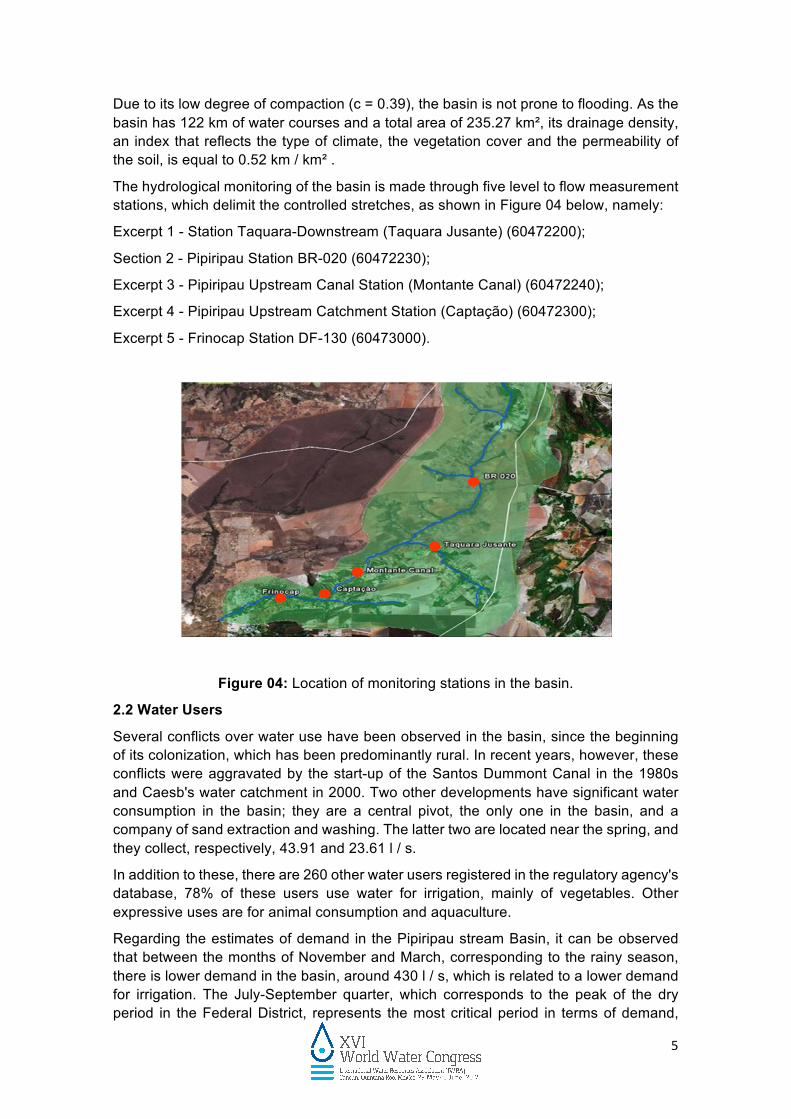
The hydrological monitoring of the basin is made through five level to flow measurement stations, which delimit the controlled stretches, as shown in Figure 04 below, namely:
Excerpt 1 - Station Taquara-Downstream (Taquara Jusante) (60472200);
Section 2 - Pipiripau Station BR-020 (60472230);
Excerpt 3 - Pipiripau Upstream Canal Station (Montante Canal) (60472240);
Excerpt 4 - Pipiripau Upstream Catchment Station (Captação) (60472300);
Excerpt 5 - Frinocap Station DF-130 (60473000).
Figure 04: Location of monitoring stations in the basin.
2.2 Water Users
Several conflicts over water use have been observed in the basin, since the beginning of its colonization, which has been predominantly rural. In recent years, however, these conflicts were aggravated by the start-up of the Santos Dummont Canal in the 1980s and Caesb's water catchment in 2000. Two other developments have significant water consumption in the basin; they are a central pivot, the only one in the basin, and a company of sand extraction and washing. The latter two are located near the spring, and they collect, respectively, 43.91 and 23.61 l / s.
In addition to these, there are 260 other water users registered in the regulatory agency's database, 78% of these users use water for irrigation, mainly of vegetables. Other expressive uses are for animal consumption and aquaculture.
Regarding the estimates of demand in the Pipiripau stream Basin, it can be observed that between the months of November and March, corresponding to the rainy season, there is lower demand in the basin, around 430 l / s, which is related to a lower demand for irrigation. The July-September quarter, which corresponds to the peak of the dry period in the Federal District, represents the most critical period in terms of demand,

6
ranging from 770 l / s to 920 l / s, or nearly twice the demand in relation to the rainy season.
An aggravating factor in relation to these figures is that most of the water demand in the basin is destined to food production, and, thus, has a consumptive nature, with a small rate of return. In other words, the water withdrawn from the river, after being used, does not return to it.
Figure 05: Estimation of the seasonal demand of users.
The exploration of groundwater as a solution to the demand for water for consumptive use, a very common practice in this basin, is a delicate activity, since a hydrological system is an integrated set of elements and processes, to the extent that surface and groundwater are definitely interrelated.
Thus, the overexploitation of the fractured aquifer will determine a reduction in the amount of water in the porous aquifer, which will reduce the amount of water from the sources.
2.2.1 Human Supply
Water catchment for human supply in the Pipiripau basin, which began operating in the year 2000, is part of the Sobradinho / Planaltina Integrated System, Figure 06. This integrated system is currently composed of 8 surface catchment points and 15 deep wells.
The Pipiripau subsystem includes a catchment point with a concrete small dam that creates a pondage, which is, thereby, operated by a run-of-the-river system. The water collected from Pipiripau is piped to the simplified treatment unit, located in Planaltina, and then conducted for supply.
Demand
Janfebmaraprmayjunjulaugsepoctnovdec
Month

7
Figure 06: Integrated human supply system Sobradinho - Planaltina.
The project has an authorization to collect 400 l / s, notwithstanding an installed capacity for the catchment of 720 l / s. However, as a result of long periods of drought and water quality often unfit for abstraction, this subsystem has operated with an average value of 280 l / s.
Currently, the Pipiripau stream supplies 180,000 inhabitants of the city of Planaltina. If there were conditions for the authorized value (400 l / s) to be fully collected throughout the year, 265,000 people could be supplied (CAESB, 2009).
Figure 07: Images downstream and upstream of the Pipiripau stream catchment point.
2.2.2 The Santos Dumont channel
The Santos Dumont Rural center is made up of 84 rural plots with an average area of 7 hectares each, and it is mainly focused on the olericulture, which makes irrigation (conventional sprinkler / micro sprinkler) indispensable from March to October. Each plot has the potential to produce 336 tons of vegetables per year, which can generate from 800 to 1000 direct jobs.
The irrigation canal of the Santos Dumont Rural Center, built in 1984 and in operation since 1989, receives water from Pipiripau stream and reaches the rural properties of this community by gravity. It consists of a main channel with 9,800 meters (1,900 m covered with concrete and 7,900 m uncoated) and 08 secondary channels (8,790 m uncoated).

8
Figure 08: Channel Santos Dumont.
Santos Dumont Canal has an authorization to collect 350 l / s. However, the average flow losses in the Canal from March to October are around 267 l / s. This value represents losses due to infiltration into the canal, infiltration and evaporation in existing reservoirs in properties and irrigation systems.
In addition, in recent years, the canal has been experiencing several problems, such as infiltrations, lateral leaks and the destruction of most of its floodgates, rendering water supply unfeasible for lots located in the final stretch of the system.
In order to optimize its use it would be of utmost importance to coat the main channel, the individual reservoirs and the secondary channel piping. Other recommendable actions would include the maintenance of the floodgates in the sub-canals and the installation of registers in the secondary canals that are connected with the farms, striving for preventive maintenance
3. INSTRUMENTS OF MANAGEMENT The process of sharing the use of water resources in the Federal District, especially in the Pipiripau stream basin, where this technique was first implemented, presents important advances in the participatory management of water resources, since decisions that involve conflicts over the use of water are decentralized and count on the participation of local society. In this model, some management instruments were instituted:
• Granting the right to use water resources: is the administrative act by which the licensing authority provides the licensed, previously or by the right to water resource use, for a specified period, according to the terms and conditions expressed in the respective act, the use of water, taking into account the specific legislation in force;
• Regulatory framework: a set of defined rules negotiated by ANA and other organs and licensing authorities, with the participation of users of water resources, as the milestone of water use regulation;
9
• Monitoring committee: committee formed by government bodies that implement water policy and water users to discuss the management of water resources in the basin.
• Enforcement: the act of controlling and monitoring the uses of water resources, aimed at ensuring multiple uses of water.
4. WATER ALLOCATION PROCESS According to Campos (2002), the allocation of water encompasses activities from the evaluation of the available water to those of reallocation, which only takes place after the allocation of all resources.
The allocation of water resources is rapidly gaining importance, especially in recent years, since, as population and economic activities expand, there are greater demands for a relatively limited water supply (Campos and Studart, 2001).
A resource is efficiently allocated when it is used to maximize its value. A large number of different and partially competing uses can be predicted for water: agriculture, human supply, industrial supply, tourism, leisure, aquaculture, etc. Achieving efficiency often means changing water use, or reallocating it, between intra or inter-sectors, as between low and high value crops and from agriculture to industry, respectively (Kemper, 1996).
According to Campos and Studart (2001), integrated, decentralized, and, above all, participative planning and management mechanisms are required for water to be used and controlled at satisfactory levels of quantity and quality, either by current or future generations.
With the establishment of the District Water Resources Policy in 2001, the water user became a major participant as a decision maker in the management and use of this natural resource. Previously, management was centralized by federal and state agencies, while the use of water was practiced in disarray and according to the convenience of the user.
4.1 Water resources use sharing in the Pipiripau stream Basin
The drainage basin of Pipiripau stream consists of a main watercourse, state-owned (Pipiripau stream itself), and by watercourses owned by the Federal District (its tributaries). This basin is an indispensable source of water for various use purposes, among which, the main uses of the basin are human supply and irrigation.
During periods of low rainfall (April to October), the flows of the watercourses in the basin are significantly reduced, and it is often necessary to allocate and reduce the uses of water, in order to ensure that the ecological flow, priority uses and multiple uses are maintained.
The management of water resources in the basin is carried out in a negotiated manner, between water management bodies (ADASA and ANA) and users of the basin. This management is carried out based on the Regulatory Framework established by the regulatory agencies.
Summing up, decisions are made in a meeting between regulatory agencies, public agencies with an interest in the basin and users of water resources. Accurate information on the supply and demand of water is needed to conduct this process. In summary, the process of negotiated allocation of water has the following characteristics:

10
• Regularization campaigns: register and authorization;
• Elaboration of the regulatory framework of procedures and criteria for granting the right to use water resources;
• Creation of a monitoring committee;
• Conduction of seminars with the following analyzes:
• Current status of water sources (hydrological monitoring);
• Forecast of future flows;
• Evaluation of water supply and demand in the basin;
• Decision-making on the sharing of water use;
• Communication of decisions to users of water resources; and
• Supervision and enforcement to verify compliance with the rules established in the regulatory acts, authorizations and decisions of the monitoring committees.
In 2004, the Pipiripau stream regularization campaign registered 260 rural producers. Next, the collected information was studied by the technicians of the regulatory agency, which granted the right of water use in the basin.
The authorization acts shall observe the restrictions arising from the balance between water availability and demand, in quantitative terms, carried out in an integrated manner within the Basin, and the need to maintain minimum flows at the Control Points at the end of each of the Basin’s stretches.
In 2006, the regulatory framework of procedures and criteria for granting the right to use water resources in the Pipiripau stream Basin was published. Considering the regularization of interventions and uses at that time, the monitoring committee for the basin was created.
The monitoring meeting of the committee takes place annually in May and in following months to discuss and present the situation of water resources, propose strategies for use optimization, define criteria for the entry of new users and for the reallocation of uses. The meeting may be convened at any time, when necessary.
Through daily flow rate monitoring in the five stations in the basin, it is possible to carry out simulations to predict the behavior of water bodies during the dry season, having in mind predicted water demands. From these simulations, one can infer the respective water balance from the five monitoring stretches established by the Basin Regulatory Framework. Among the rules established in this framework is the value of the minimum flows that must be observed at each control point in the basin. These values represent 30% of Q95 and are described in Figure 09 below:

11
Figure 09: Minimum flow rates in the monitoring points.
In these studies, data from the five level to flow measurement stations located in the basin is used and, through correlation equations and determination coefficients for the recession period (April to October), it is possible to estimate the minimum drought flows that should occur in each year, based on the average flow rate for April and considering the average monthly demand.
When flow monitoring in the basin showcase lower rates than the values established in Figure 09 at any of the monitoring points, it is possible to allocate uses in the basin, by rescaling the quantitative percentages, in determined months, for each user sector, in each stretch of the basin, in order to guarantee priority uses.
In the years in which there is a need for reallocation of water uses, the criteria will be defined in a participatory way between the agencies and the users of the basin, through plenary meetings coordinated by the Monitoring Committee.
The criteria defined in the water reallocation process will be established by the competent licensing authorities, by means of a specific Resolution.
The users of water resources are informed of the publication of the act that establishes the water use sharing through leaflets and publishing in a specific portal of the regulatory body.
When necessary, after taking into account the analysis of the situation of the water springs, prediction of future flows and evaluation of the supply and demand of water in the basin, proposals are made to allocate and reduce the uses, in the critical months, to be implemented by the basin users.
Thus, it is possible to determine the necessity of rationing of the water use for a certain period, as well as the percentage of this rationing. With the identification of rationing

12
percentages well in advance, users can be alerted and water shortage problems are minimized, through the distribution of this information after a participatory negotiation process.
Figure 10: Negotiated allocation proposal implemented in Pipiripau stream in 2015.
4.2 Conflict analysis
The historical analysis of the conflict shows some important points:
1. The waters of the river basin belong to the government, which resulted in the participation of two management institutions - the National Water Agency - ANA in the federal level - and Water, Energy and Basic Sanitation of the Federal District - Adasa, at the district level.
2. The political character of the water management can be inferred from the analysis of the participating institutions in the process of conflict mediation. ANA and Adasa, as regulatory bodies; users are involved as stakeholders; as well as associations and representatives of the Basin Committees.
3. There is a need for constant observation by society, since water retention by upstream users is recurrent at times of water crises;
4. The agreements in the negotiated allocations demonstrated an excellent advance in the form of negotiation, as they established a common ground and provided many peaceful actions, such as the suspension of catchment in a given period of the day.
13
5. CONCLUSIONS
In the Federal District, negotiated water allocation occurs annually, after the rainy season, through seminars on the current situation, flow forecasting, demand assessment, flow rate to be released definition, and formation of a commission of users, with due record of the agreed decisions.
The negotiating model demonstrated several positive points in its participatory aspect. It should be observed that the water allocation agreement was achieved after much negotiation and, especially, with no armed conflict, as was the case in the past in disputes over water use.
In essence, water management is composed of a set of political and participative acts. The case study analyzed shows the emergence of another culture of negotiation, involving several segments of society. Substantially, the practice of water management in the search for solutions to conflicts results in a process of societal empowerment.
Decentralization of decision-making - combined with the centralization of guidelines and the democratization of the organs of this system - can be a sign of a milestone in the experience of institutionalizing the participation of society in the formulation, implementation and evaluation of public policies in Brazil. A system with this complexity, without a central guideline, could become innocuous, fail to present results or lose its systemic character. Without decentralization, decisions and actions could be lost in administrative irrationality. Without democratization, which transfers the power of state structures to a new shared public space with new meanings, the legitimacy of decisions could be gone astray in the lack of transparency.
The process of sharing the use of water resources allows to efficiently combining public command and control policy instruments - such as authorizing water use - with economic instruments - such as charging for its use.
Above all, the system is efficient in its strategy of converging various public bodies, water users and civil society, often with contradictory interests, into the same decision space, allowing for the interests of each sector and the inherent social costs to be openly discussed. Thus, the interests are mutually regulated. This indicates a possibility of equating agency problems that involve the relations of the State with society.
REFERENCES CAMPOS, E. T; NASCIMENTO, D. T; SCHENINI P. C. Org. (2006) Planejamento, gestão e legislação territorial urbana: uma abordagem sustentável. Florianópolis: Fepese. Papa-Livro.
CAMPOS, J.N.B.; STUDART, T.M.C.; COSTA, A.M. (2002) Alocação e realocação do direito de uso da água: uma proposta de modelo limitado no espaço. Revista Brasileira de Recursos Hídricos, Porto Alegre, v. 7., n. 2.
CHAVES, H.M.L., PIAU, L.P. (2008). Efeito da variabilidade da precipitação pluvial e do uso e manejo do solo sobre o escoamento superficial e o aporte de sedimento de uma bacia hidrográfica do Distrito Federal. R. Bras. Ci. Solo, 32:333-343
CLARK, R; KING, J. (2005) O Atlas da água. Trad. Anna Maria Quirino. São Paulo. Publiofolha,
14
EMBRAPA. Unidades de paisagem do Distrito Federal, escala !:100.000. Èder de Souza Martins... (et al). – Planaltina, DF: Embrapa Cerrados.
EMBRAPA (2004). Sistema Brasileiro de Classificação de Solos. Rio de janeiro: Embrapa Solos.
GLEICK, P.H.. (2000) Water conflict chronology. Studies in development, environment and security. The Pacific Institute.
KEMPER, K.E. (1996). O custo da água gratuita: alocação e uso dos recursos hídricos no vale do Curu, Ceará, Nordeste brasileiro. Porto Alegre: ABRH.
Socio-environmental Assessment Report of the Pipiripau stream Basin. http://produtordeagua.ana.gov.br/Portals/0/DocsDNN6/documentos/Relatorio_Diagnostico_Pipiripau_PRODUTOR_DE_AGUA2.pdf (acessed in January 25, 2015).