Embed Size (px)
Citation preview

Aboriginal Community Liaison for the Core
Consultative Committee on Waste
Nyaarla Projects 2 Uppsala Place
Pty Ltd Canning Vale WA 6155
PO Box 944 Subiaco WA 6904
Australia May 2006 Telephone 08 9256 4911
Aboriginal Community Liaison for the Core Consultative Committee on Waste
Email: [email protected]
ACN 105 187 568

Nyaarla Projects Pty Ltd
This document is the property of Nyaarla Projects Pty Ltd ("Nyaarla"). This document and the information contained in it are solely for the use of the authorised recipient and this document may not be used, copied or reproduced in whole or part for any purpose other than that for which it was supplied by Nyaarla. Nyaarla makes no representation, undertakes no duty and accepts no responsibility to any third party who may use or rely upon this document or the information contained in it. This report is the property of Nyaarla Projects Pty Ltd and is not to be altered, amended or quoted without express permission from the authors or agents to which these rights have expressly been assigned.
Authored by: Linda E. Villiers
Approved by: Alan Beattie
Signed: .................................................................................
Date: 7June 2006

Aboriginal Community Liaison for the Core Consultative Committee on Waste
1
Contents
Page Number
Executive Summary 4
1. Introduction 7
1.1 Requirements 7
1.2 Methodology 7
1.3 Consultation Strategy 9
1.4 Key Concepts 10 1.4.1 Relationship to Country 10 1.4.2 Timing of Consultations 11
1.5 Limitations of the Consultation Process 12 1.5.1 Pilbara – Port Hedland 12 1.5.2 Pilbara – Karratha 13 1.5.3 Goldfields 14 1.5.4 South West 14
2. Community Consultations Pilbara 16
2.1 Port Hedland 16 2.1.1 Consultations 16 2.1.2 Meetings 16 2.1.3 Native Title on Boodarie, P09 20 2.1.4 Anthropological and Archaeological Background 21 2.1.5 Heritage Sites on Boodarie Industrial Estate (BIE) 22 2.1.6 Consultation Summary 24 2.1.7 Organisations Contacted 25
2.2 Karratha 25 2.2.1 Consultations 25 2.2.2 Meetings 26 2.2.3 Consultation Summary 31 2.2.4 Organisations Contacted 32 2.2.5 Native Title: Karratha NW072, 074,075 32 2.2.6 Anthropological and Archaeological Background 33 2.2.7 Heritage Sites on NW072, 074,075 34
3. Community Consultations Goldfields 36
3.1 Consultations 36
3.2 Meetings 36
Aboriginal Community Liaison for the Core Consultative Committee on Waste
2
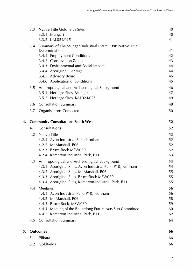
3.3 Native Title Goldfields Sites 40 3.3.1 Mungari 40 3.3.2 KAL024/025 41
3.4 Summary of The Mungari Industrial Estate 1998 Native Title Determination 41 3.4.1 Employment Conditions 42 3.4.2 Conservation Zones 43 3.4.3 Environmental and Social Impact 44 3.4.4 Aboriginal Heritage 44 3.4.5 Advisory Board 45 3.4.6 Application of conditions 45
3.5 Anthropological and Archaeological Background 46 3.5.1 Heritage Sites, Mungari 47 3.5.2 Heritage Sites, KAL024/025 49
3.6 Consultation Summary 49
3.7 Organisations Contacted 50
4. Community Consultations South West 52
4.1 Consultations 52
4.2 Native Title 52 4.2.1 Avon Industrial Park, Northam 52 4.2.2 Mt Marshall, P06 52 4.2.3 Bruce Rock MSW039 52 4.2.4 Kemerton Industrial Park, P11 53
4.3 Anthropological and Archaeological Background 53 4.3.1 Aboriginal Sites, Avon Industrial Park, P10, Northam 54 4.3.2 Aboriginal Sites, Mt Marshall, P06 55 4.3.3 Aboriginal Sites, Bruce Rock MSW039 55 4.3.4 Aboriginal Sites, Kemerton Industrial Park, P11 55
4.4 Meetings 56 4.4.1 Avon Industrial Park, P10, Northam 56 4.4.2 Mt Marshall, P06 58 4.4.3 Bruce Rock, MSW039 59 4.4.4 Meeting of the Ballardong Future Acts Sub-Committee 60 4.4.5 Kemerton Industrial Park, P11 62
4.5 Consultation Summary 64
5. Outcomes 66
5.1 Pilbara 66
5.2 Goldfields 66
Aboriginal Community Liaison for the Core Consultative Committee on Waste
3
5.3 South West 67
6. Improving Aboriginal Public Consultation Mechanisms 69
7. Recommendations 71
Bibliography 73
Appendices Appendix A – Plates Appendix B – Maps Appendix C – 1998 Mungari Native Title Determination Appendix D – Native Title Documents Appendix E – Community Briefing Documents

Aboriginal Community Liaison for the Core Consultative Committee on Waste
4
Executive Summary
Nyaarla Projects was commissioned in July 2005 to undertake liaison with Aboriginal stakeholders to maximise their involvement in and understanding of the process to identify suitable sites for hazardous waste treatment precincts in Western Australia. The project brief required the development of relationships and liaison with Aboriginal stakeholders during the site assessment processes and exhibition period, as well as identification of their needs so that the stakeholders could effectively participate in the Stakeholder Involvement Program.
As the nomination of sites was verified by GIS analysis only it was necessary to clarify the native title situation for the nominated sites and verify and expand the heritage criteria at each location.
The short-listed sites were opened up for a four month public exhibition and comment period on the 31st of October 2005.This period was later extended by a month.
In the Pilbara, the selected sites included the Boodarie Industrial Estate outside Port Hedland and three contiguous blocks (NW072, 074,075) outside of Karratha. In the Goldfields, the Mungari Industrial Estate to the west of Kalgoorlie and two contiguous blocks south of the town (KAL024, 025) were selected. In the South West of the state four locations were short-listed: the Avon Industrial Park at Northam; a block of farmland at Mt Marshall; a bush block at Bruce Rock and the Kemerton Industrial Park at Australind.
Each region required a somewhat differing approach to establishing and maintaining the consultative processes. After identification of Aboriginal stakeholders, development of relationships and the provision of background information, site consultations and site visits to each of the short-listed locations were undertaken. This included two visits to the Goldfields, two to the Pilbara and one to each of the four South West sites.
In the Pilbara, while people acknowledged the need to treat hazardous waste and protect the environment both nominated sites were rejected as being quite unsuitable for such a project. Consultations revealed that the objections were based on a number of issues revolving around environmental criteria and the social and customary (in the sense of historical Aboriginal customs) use of the locations.
As the coastal zones of the Boodarie location are a major recreation area for the entire population here, it is crucial that access to these zones is not impeded in any way should this location be chosen. There are a number of known heritage sites on the Boodarie location and a high likelihood of heritage sites occurring on the Karratha location. The Karratha location also appears to lie in an area of unsuitable soils. Native title would have to be negotiated for both of these short-listed sites.
In the Goldfields there was a general acceptance of the two nominated sites. The Mungari location is unique in that the native title rights have already been acquired by the State and this was seen as a plus for that location by some. The 1998 Mungari Native Title determination (Appendix 2) sets out a number of conditions which must be fulfilled by any developers of that site. Assessment of the relative ecological merits of the two locations by local people resulted in concerns being expressed about the clearing of the Mungari site.

Aboriginal Community Liaison for the Core Consultative Committee on Waste
5
The known heritage site on Mungari is already protected through the terms of the 1998 determination.
Native title would have to be negotiated for the second Goldfields location, KAL024/025 and it is not yet known if any heritage sites occur there.
In the South West, the Mt Marshall location emerged as the clear choice for the hazardous waste treatment precinct of all those consulted. This was determined on the basis of all criteria including heritage and native title.
The three other short-listed locations were all objected to on a number of criteria. The Northam site received objections based primarily on heritage and drainage issues. As large areas of the Kemerton Industrial Park at Australind are occupied by swamps and wetlands the environmental sensitivities of the location were the primary concern. The location at Bruce Rock was judged to be totally unsuitable as the environmental values created by the intact bush covering the block were seen to be extremely valuable and rare for the area.
In all regions a major concern to emerge from these consultations has been the employment of local Aboriginal people in the projects. Suggestions have been made that Aboriginal companies and workers be involved right from the start with the ground clearing and fencing components of the jobs.
Specific requests were made that the planning of methods of involving and training local Aboriginal people be commenced immediately so that a pool of trained personnel would be available for hiring once the precincts were opened. Mechanisms to appropriately weight Aboriginal tenders already exist within the WA government and these may be adapted to this project.
It will be necessary to involve local Aboriginal people in the monitoring of the operation of the precincts. In view of the heavy demands made on the time of Aboriginal people for consultations on various developments, some form of payment should be considered.
The appointment of at least one representative from each major group in the area should also be considered. It is recommended that in the Goldfields and at Karratha a representative from each of the relevant native title claimant or socio-linguistic groups be invited.
Future engagement with Aboriginal communities should occur through the established organisations already operating in the area and communication maintained by regular contacts, including visits. As far as is possible, it is recommended that the personnel who form the point of contact remain the same to avoid the time-consuming process of re-establishing confidence and trust.
All precinct sites selected will require comprehensive ethnographic and archaeological surveys for sites. The methodology of these surveys should include sufficient time for consultations with all appropriate Aboriginal people and their involvement in the fieldwork.
In each area of Western Australia it was specifically requested that when the final locations for the hazardous waste treatment precincts were selected, the sites should be fenced to a standard sufficient to exclude all fauna. This includes the netting of the

Aboriginal Community Liaison for the Core Consultative Committee on Waste
6
evaporation ponds to exclude birds, bats and insects. This is to prevent any inadvertent poisoning of animals in the human food chain as customary hunting and gathering still occurs in most areas of the state.

Aboriginal Community Liaison for the Core Consultative Committee on Waste
7
1. Introduction
1.1 Requirements
The Request for Quotation specified that:
“The role of the consultant(s) will be to undertake specialist Aboriginal Community Development tasks for the effective implementation of a Stakeholder Involvement Program for siting of hazardous/industrial waste.
More specifically, the consultant will be required to -
a) Identify Aboriginal stakeholders and networks in areas around the proposed sites
b) Provide the 3C with regular three weekly progress reports for tabling at each meeting of the 3C
c) Advise Executive Support staff of stakeholder contacts to facilitate the maintenance and updating of a stakeholder database
d) Submit report/s with evaluation and assessment of heritage values with respect to the nominated sites and adjacent buffer zones and with due regard to the requirements of Section 18 of the Aboriginal Heritage Act 1972 (Consent to certain uses) and
e) Submit a final report to the 3C, within 3 weeks of the conclusion of the period of engagement, which includes but is not limited to-
a review and evaluation of the program of work undertaken, the networks identified and the outcomes of the community development role
comment / recommendations which may help to improve the effectiveness of future community development and engagement work with Aboriginal communities and with reference to public consultation mechanisms in Western Australia.”
1.2 Methodology
The methodology adopted for this project was based on the public participation spectrum developed by the International Association for Public Participation (IAP2). The public participation spectrum has five levels of involvement:
Inform
Consult

Aboriginal Community Liaison for the Core Consultative Committee on Waste
8
Involve
Collaborate
Empower
Other key elements to the public participation spectrum are the:
Public Participation Goals and
Promise to the Public (in this case the Aboriginal community).
Nyaarla Projects presented and discussed options and draft wording related to the public participation spectrum at Core Consultative Committee (3C) meetings held in July and September 2005.
The 3C decided that that level of public participation for the project should be at the Involvement level and agreed to the following wording:
Public Participation Goal: To work with the Aboriginal community throughout the process to ensure that their (the Aboriginal communities) concerns and aspirations are consistently understood and considered.
Promise to the Public (Aboriginal Community): We will keep you informed, listen to and acknowledge concerns and aspirations and provide feedback on how your (the Aboriginal community) input influenced the 3C’s recommendation to State Cabinet
The methodology undertaken by Nyaarla Projects included a five stage process:

Aboriginal Community Liaison for the Core Consultative Committee on Waste
9
Stage I – Confirm with 3C approach /methodology, scope of work/key deliverables, time-frame and level of public participation
Stage II - Aboriginal site register search and analysis
Stage III - Identification and development of relationships with Aboriginal stakeholders
Stage IV – Site consultation (exhibition period)
Stage V – Preparation and presentation of draft and then final report.
Nyaarla Projects proposed that the client, the Department of Environment, and the consultant, Nyaarla Projects, agree to recognise the following consultation principles:
Aboriginal people have spiritual and social obligations to their county and heritage
Aboriginal people are the primary source of information about their heritage and its value
Aboriginal communities/people must be active participants in the selection process for the hazardous waste treatment facilities locations; and
Aboriginal people identified as having rights and interests in the potential sites should have an opportunity to be consulted by the Department of Environment, via Nyaarla Projects (the consultant), in relation to the proposed use of the country for the purpose of a hazardous waste treatment facility.
These consultation principles have been adopted and promoted by Nyaarla Projects during the consultation process.
1.3 Consultation Strategy
The initial approach to identify Aboriginal stakeholders was through the primary Indigenous representative body and the major government and non-government organisations operating in the area.
Indigenous organisations in the areas were contacted and their inputs on the issue solicited. Traditional informants, as well as people with significant knowledge of the short listed areas, were identified. All the major cultural groups of the area and key personnel in the community were identified and engaged in the consultation process. The activation of informal personal and professional networks of both Aboriginal and non-Aboriginal members of Nyaarla Projects also contributed to the identification process.
The contacts generated in this manner were then circulated with the 3C information pack containing the ‘Short-Listing and Verification of the Short Listed Sites’ and invited to participate in the consultations.

Aboriginal Community Liaison for the Core Consultative Committee on Waste
10
The first mail out was to ensure that all relevant individuals and organisations received detailed information on the project. In some cases material was sent to multiple contacts within an organisation. These were usually read but not responded to, as became clear when telephone contact was made. Wherever possible individuals were contacted by phone and preliminary discussions of the heritage values and other main issues involved were held. These phone contacts generated further people in the area who were then brought into the consultation process.
Key personnel in the community were identified during this phase and a second mail-out of information compiled by Nyaarla Projects was sent. This included a condensation of the 3C material on site selection criteria, as well as summaries of the major pros and cons of each location in the region and the known heritage situation.
1.4 Key Concepts
1.4.1 Relationship to Country
This is an aspect of Aboriginal relationships to land that many Europeans find difficult to comprehend. At its core is the powerful and emotional connection to country which is almost physical in its strength and is central to a person’s conception and definition of self. It is a complex set of interrelationships which are animated by socially sanctioned information about specific places. It also entails a responsibility to care for the land in a physical as well as spiritual capacity.
The kinship system activates the allocation of land to people and certain people have responsibilities to certain areas, depending on where they were born, which clan or sub-group they belong to, who they marry and what knowledge they inherit. Their age, ability and interest in matters are also factored in.
In its simplest sense, this ‘care’ was traditionally seen as keeping the land healthy by performing the required rituals and ceremonies. It also entailed ensuring that no damage was done to the land, the waters or the life systems dependent on them. This included keeping waters flowing and free from pollution, preventing over-utilisation of resources and guarding against actual damage or desecration of significant sites.
Today this “looking after land” can be described as encompassing the roles of guardian and environmentalist to protect the land from pollution and abuse. If this occurs it is believed that the health and in some cases, the very life, of those responsible for that area may be forfeit as a result of the failure to protect the land from the abuse. It is not that they will be punished by some omnipotent third party- it is the intimacy and immediacy of their physical, spiritual and psychic connection to the land which ensures that if it is damaged they too will sicken and possibly die.

Aboriginal Community Liaison for the Core Consultative Committee on Waste
11
This makes Aboriginal concerns for the health of their lands a very immediate and personal matter which is not immediately apparent to outsiders. It is not a responsibility that is lightly taken or made up, as some Europeans seem to think. When people make statements about their lands in these terms it is the most emphatic assertion that whatever is being proposed is wrong for the health of the land and, if it is proceeded with may well result in damage or death to themselves.
1.4.2 Timing of Consultations
Perhaps the most critical factor in undertaking consultations with Indigenous communities is the provision of sufficient time for the process. Closely connected with this is the need to be aware of the demands of the long-established cultural calendar which operates in all areas of Western Australia.
It takes longer to get issues out to Aboriginal communities and gather feedback for a number of reasons which have been known and apparent for a long time now and which should be factored into project design and operation.
The Law season covers a period from December to March when traditional law matters are attended to. People disperse from regional centres and meet up at traditional law grounds to undertake the necessary business to maintain the social and cultural functions for their language group. No ‘white fella business ‘ is possible during this period.
This cultural requirement is most marked in the Kimberley’s and the Pilbara regions, along with parts of the Goldfields region. It is most closely associated with the groups which practiced circumcision. It does not apply in the South West where the Nyungars did not follow this practice.
A second matter affecting the timing of Indigenous consultations is that it takes time for people to consider proposals, communicate them to all who should be informed and discuss them until a group consensus is achieved. People may be very reluctant to make any statement about an issue if it has not already gone through this lengthy process and been considered by all who have a right to speak on the matter. This can lead to impatience on the part of non-Indigenous people who are used to a world of off-the-cuff comments and sound bytes. Acquiring feedback from and communicating it to Aboriginal groups invariably requires more time than has been allocated to it by the bureaucracy.
Attempting to cut corners and hurry up the process leads to perceptions of tokenism and the value of simply ‘going through the motions’ of consultation with Indigenous communities must be questioned.
The period allocated for the public exhibition process may have been acceptable for the non-Indigenous community but it was not adequate for Indigenous consultations, given the summer law period and Christmas breaks which occurred in the middle of it.

Aboriginal Community Liaison for the Core Consultative Committee on Waste
12
If the original time table envisaged for this project had been adhered to quite a number of these problems may have been avoided. As consultations progressed, Nyaarla Projects relayed a number of questions raised by people to the 3C in the regular monthly meetings. Some answers were received and communicated back to the Indigenous groups, but as the tempo of all consultations increased in early 2006 the responses to these queries ceased. It had been intended to ascertain responses to this feedback from 3C directly from participants and include these in the final report. However the lack of time allowed for the feedback process has meant that this has not been possible except in a few instances. Feedback was still being received from people even as this report was being written.
Another factor which needs to be allowed for is that the extensive family connections of many Aboriginal people, coupled with an often shorter life expectancy, means that funerals may interrupt matters. This occurred once during these consultations in the Goldfields and interfered with follow up meetings and site visits. Ideally there should be sufficient flexibility built into the consultation process to allow for postponement of meetings until such time as people were available.
1.5 Limitations of the Consultation Process
1.5.1 Pilbara – Port Hedland
The creation of representative bodies has occurred to fulfil functions under the Native Title Act (1993). These bodies are “empowered to assist in consultations, negotiations and proceedings relating to …future acts on claimants’ territories” (ATNS Agreements Database, http://atns.net.au/biogs/A000682b.htm). As such, they are the appropriate bodies to approach in order to initiate contact with native title claimant groups and it is viewed as correct protocol to do so.
However in the case of Port Hedland, problems were encountered from the outset in eliciting any sort of a response from the representative body to our enquiries. Contact with the appropriate personnel proved difficult. Repeated attempts to have the hazardous waste treatment plant matter brought before meetings of the Kariyarra native title working party at Pilbara Native Title Service failed.
It should be noted that the original 3C schedule envisaged that the exhibition period would occur between July and September, 2005. The delay in the public release of the nominated sites until October led to further difficulties in accessing the native title claimant group. The representative body cited a backlog of matters awaiting the urgent attention of the native title claimant group before the Christmas break and the start of the Law season as the main difficulty in bringing the matter forward for consideration and declined to raise the matter before March 2006.

Aboriginal Community Liaison for the Core Consultative Committee on Waste
13
It also appears that funding constraints have led to priority being given to matters involving resource companies and the waste treatment plant was not regarded in the same light. In this instance, negotiations resulted in agreement to place the waste treatment plant issue at the end of the agenda of the February special meeting of the Kariyarra working party, organised by a resource company. However, four days before the meeting PNTS notified Nyaarla Projects that the matter would not be raised at this meeting. Information packs were sent up to Hedland for distribution at this meeting in order to at least get the issue before the relevant people.
The service appeared reluctant to call a meeting at short notice, with conflicting statements about the availability of meeting dates for the year being made by different personnel. At other times it appeared that if the Department of Environment was willing to pay a meeting later in the year (i.e. after the end of the exhibition period) a meeting might be possible. Due to the difficulty in gaining a firm commitment from the representative body within the time limit set for the exhibition period, the idea of a special meeting had to be abandoned.
A number of people, both indigenous and non-indigenous made comments about the rise of a sort of “cash for comment “mentality becoming apparent in the operations of the representative body and its conflict with the need to ‘look after country’.
However a parallel approach had been adopted at the outset of consultations in Hedland with the identification of significant Indigenous organisations operating there. Initial consultations with Bloodwood Tree during the first visit to Port Hedland led to a second larger meeting being arranged in February which encompassed a number of traditional land owners for the Boodarie area. Other people with links to the area were contacted individually and met with to discuss the proposal.
The first round of meetings was conducted from 5-9 December 2005. Both Port Hedland and Karratha were visited and site visits undertaken. A second round of meetings was held on 6-10 February 2006. For clarity, the contents of both rounds of meetings have been summarised under the appropriate organisational headings.
1.5.2 Pilbara – Karratha
As had been the case with the Port Hedland consultations, letters and informative material was sent out to make initial contact with Aboriginal groups.
The Pilbara Native Title Service in Karratha was contacted as a courtesy although they no longer handle the native title issues for the claimant groups here. The Department of Indigenous Affairs suggested a core group but the contact details were out of date. Tom Parker, who is the anthropologist of choice for the Ngarluma/ Yindjibarndi people, was consulted and provided with a full set of information on the Pilbara sites.

Aboriginal Community Liaison for the Core Consultative Committee on Waste
14
Few if any problems were encountered in identifying, contacting and meeting with people here. The main difficulty was encountered in finding a suitable time to arrange meetings due to competing demands on people’s time being made by other government departments and business concerns. It is difficult for non-Aboriginal people to comprehend just how time-consuming this compliance with bureaucratic processes can be. Meeting fatigue is a real phenomenon for many, yet in every case our requests were met with unfailing courtesy and good humour.
1.5.3 Goldfields
The Goldfields Land and Sea Council is the representative body for this area and the same problem encountered in the Pilbara was experienced here, albeit to a lesser extent. The sheer volume of mining and development proposals being put to the land council means that meeting agendas are set months ahead and there is little if any ability to factor in extra meetings.
The destruction of traditional Aboriginal societies here occurred quite early on in the history of colonisation in WA. The gold rushes brought large populations of people with only one thing on their mind and Aboriginal people adapted to living on the fringes of European settlements.
Profound physical and socio-cultural dislocation has resulted in the loss of much traditional knowledge and the blurring of distinctions between groups. The competition for resources, rapid social change and the more recent drive to regain autonomy has seen great changes occurring here. The situation in the Goldfields is complicated by an acrimonious history between the various native title and family groups. Aboriginal organisations have come and gone with each alteration of federal Aboriginal policy and the 1998 native title determination over the Mungari Industrial Estate saw another reorganisation of alliances and associations. Most recently, the demise of ATSIC has seen a number of organisations collapsing, with one closing its doors between the making of the appointment and our arrival.
Kurrawang is a flourishing, well organised community and is animated by a shared Christian ethos. People do not belong to any particular socio-cultural grouping and while the community is ideally placed to take advantage of economic opportunities which may present if the Mungari site is chosen for the waste treatment plant, it should be noted that it is not culturally appropriate for them to comment on heritage issues relating to the Aboriginal sites located on or near the Mungari site.
1.5.4 South West
The consultations for the South West sites followed a somewhat different pattern to the rest of the state. The native title representative body, the South West Land and Sea Council (SWALSC) is very active in representing the various native title claimant groups which come under it and has developed an efficient procedure for raising future act matters with the relevant working parties.

Aboriginal Community Liaison for the Core Consultative Committee on Waste
15
Once the matter had been brought before the relevant future act working party the members return to country and discuss the issue with others. The final comments are then conveyed to SWALSC, which relays them to the proponent.
This procedure was followed for the Ballardong claimant group which encompasses the Northam, Mt Marshall and Bruce Rock areas and the Gnaala Karla Boodja claimant group which has authority over the Kemerton area.
For the South West, information was also sent to Aboriginal organisations in the towns nearest each nominated site. No feedback was received from this method of contact. DIA was unable to supply an up-to-date listing and many Indigenous organisations have folded due to the recent abolishment of ATSIC. This has caused serious dislocation in many rural towns for Aboriginal people as they attempt to clarify how they fit into the established (and complicated) procedures for accessing community funding prevalent in the white community.

Aboriginal Community Liaison for the Core Consultative Committee on Waste
16
2. Community Consultations Pilbara
2.1 Port Hedland
2.1.1 Consultations
At Port Hedland the Kariyarra people are the registered native title claimants for the area of the Boodarie Industrial Estate (Map 1). The claim over the Hedland area is active (WC99/003; WAD6169/98) and there are no overlapping claims on the Boodarie industrial estate. The Pilbara Native Title Service is the prescribed body corporate representing the native title claimants in matters involving the future act regime.
Meetings were held at Pilbara Meta Maya, Bloodwood Tree, Pilbara Native Title Service, Wirraka Maya Health Service and the Wangka Maya Language Centre. Nearly every person spoken to during these consultations was familiar with the site and had been out there, as Boodarie is one of the most popular local recreation sites, second only to the renowned Pretty Pool.
Consultations and site visits were held over the weeks of 5 December 2005 and 6 February 2006.
2.1.2 Meetings
(i) Bloodwood Tree: B. Neville, E. Fisher, N. Walker, R. Tittums, W. Barker, R. Watkins, J. Oswald, T.Turland, S. Slattery
The committee of Bloodwood Tree are all traditional owners of the Hedland area and they undertook to arrange meetings with the right people.
a) Flooding of the site was a major concern. The HBI plant was under water 3 years ago during cyclone Steve and they stated that the Boodarie site is not above the 100 year flood level (Plate1).
b) The Turner River is a source of drinking water for Hedland. The pumps there are evidently due for replacement.
c) The area is on seismic fault and Hedland experiences 3 or 4 earthquakes a year. People said this did not appear to have been factored in.
d) The drainage system on Boodarie is apparently complicated by the presence of limestone channels under the surface and is subject to tidal surges as well.
e) Boodarie is a popular recreation area used by all locals for fishing, boating and picnics. Indigenous people further use the area for hunting.

Aboriginal Community Liaison for the Core Consultative Committee on Waste
17
Considerable concern was expressed that the recreational areas around Hedland (in short supply to start with) were progressively being cut off from public access by development.
f) There is scepticism about exactly what emissions will be blown across South Hedland by the plant. This matter was also raised by Julie Walker at the Wirraka Maya Health Service, who stated that South Hedland already has a high incidence of asthma.
g) The effects of storm events were repeatedly raised as there can be over 200mm of rain in an hour here. Questions were asked of how the plant would cope with this and control overflow.
h) Questions were asked about what controls would there be on the hazardous waste disposal process- would it be compulsory for businesses to use the facility? How would this be enforced? How would illegal disposal be treated? Would the legislative framework be put into place before the treatment plants were built?
i) Questions were asked about exactly what types of waste would be treated at the site and if mercury and other heavy metals would be included and if so, how they would be neutralised?
j) Bloodwood Tree has already drawn up plans to use the area for youth training in conjunction with BHP, although the project was on hold at present.
k) Time and again the fragility of the land at Boodarie was raised – it is too close to a public drinking water supply, to fishing creeks, mangroves and other sensitive ecosystems and land uses. It was felt that insufficient consideration had been given to the flash floods, weather effects, recreation uses, water sources and drainage in the location assessment criteria.
l) While fully agreeing that a hazardous waste treatment plant was needed, the meeting could not understand why such a sensitive piece of land had been chosen. There was consensus that a site further inland, away from the problematical water issues would be a more logical choice.
(ii) Karriyarra native title claimant group: D. Robinson, A. Captain and F. Brown
They were unified in their opposition to the development: “we don’t want our country damaged…..every place is significant to Aboriginal people.”
Ms Robinson and her husband are used to travelling all over Boodarie: “we use it to fish and hunt things. Gather up that bush stuff. We don’t eat it all the time, we eat the other food but bush food is good for you. We cook it the Aboriginal way too. There are plenty of plants out there and we don’t want that land closed up to us.”

Aboriginal Community Liaison for the Core Consultative Committee on Waste
18
Ms Robinson said development was getting closer all the time and all the places they liked to go to were being closed of to them.
Frank Brown: “there’s hardly any place around town now for us to go to. We don’t want to be locked out of our places.”
They commented on the boggy nature of land in the west of Boodarie and attributed it to tidal action. He said there were “lots” of sites out there and the FMG surveys apparently support this.
(iii) Ngarda Ngarli Yarndu Foundation: Barry Taylor
Barry Taylor is the son of noted Kariyarra elder and Hedland man Peter Coppin. He was against the site going on Boodarie for the same reasons as mentioned above: the land is low lying, prone to flooding and is a popular hunting and recreational fishing area. He mentioned that the overflow from sewerage ponds in South Hedland ends up in South West Creek after cyclones and storms.
He asked about the availability of waste treatment plants case studies from the US or Europe which may have dealt with their effects on nearby communities.
He said Boodarie was one of the main recreation areas in Port Hedland because of its proximity to Finucane Island and the whole system of tidal mangrove creeks.
“The fragility of this country knocks this site out” he said, “the other locations don’t have the floodplain or the drinking water source we got on Boodarie.”
He asked since they already had a rubbish tip site at Karratha why don’t they put the site next to it?
(iv) Wangka Maya Language Centre: Fran Haintz, Lorraine Injie
A single page flyer summarising the issue and calling for comment was prepared and sent to Wangka Maya for distribution among Aboriginal people. The matter was publicised through the centre. Some members of the Kariyarra group such as R.Gordon work with this organisation.
Through the resources available to this organisation contacts were checked and added to and suggestions made for bringing the matter up with the PNTS. Questions were asked about whether there were any case studies from Europe as to how these plants work near communities and what the effects on health may be.
(v) Pilbara Meta Maya: S. Murphy, Buddy Cassidy, Cheryl Wallace.
The single page flyer was also sent to this organisation and was widely distributed in the area. It was questioned why 3C did not use large advertisements in the local press to publicise the matter. It was also asked if the land users closest to Boodarie (the Turner River estate, the golf course and stables) had been contacted for their views.

Aboriginal Community Liaison for the Core Consultative Committee on Waste
19
Comments were made about the sheet flooding of the Boodarie area and the drainage problems. The exact location of the plant in the BIE was speculated on as “everyone in Hedland” uses the site for recreation.
(vi) Wirraka Maya Aboriginal Health Corporation: Julie Walker
A number of Kariyarra people are part of this organisation, including S. Brown, A and C. Barker. Ms Walker felt the plant would have a huge effect on their efforts to attract doctors into the town. She stated that South Hedland already had an image problem and this would only compound the difficulties they faced.
Asthma is the second most prevalent chronic disease on their database and “it’s due to environmental factors”. The prevailing winds blow pollutants from BHP over the town and children suffer from numerous respiratory problems. It was felt that the plant would only add to these problems.
It was stated that South Hedland was not a healthy community and if the plant went in at Boodarie then the local community should benefit in some manner. The lack of youth recreation facilities was mentioned as a need which should be addressed
It was asked what the decommissioning plans for the plant were.
(vii) Pilbara Native Title Service: S. Singh, H. Lawrence, M. Ryan, J. Carter, C. Davies, A. Cheedy.
Methods of informing members of the native title claimant group about the plant and the scheduling of meetings were discussed at various times, either by phone, email or in person.
(viii) Fortescue Metals Group: D. Rowe, S. Brand
Dan Rowe described the plans to build a railway across the top of Boodarie to connect with the new port being built for their operations. On following up this information in Perth it was found that there have been a number of heritage surveys done so far, but these have evidently only dealt with the port operations area.
The Section 18 applications for these sites were considered by the Aboriginal Material Cultural Committee (ACMC) at DIA in February 2006. By the time of the writing of this report these survey reports were still not available from DIA for examination. FMG plans for further heritage surveys on the areas to be impacted by the railway line to be undertaken soon.

Aboriginal Community Liaison for the Core Consultative Committee on Waste
20
(ix) Other meetings
A local historian, Trish Parker, was contacted and the remnant European heritage road discussed with her. A number of useful references were supplied by her together with contacts for the former owners of Boodarie Station.
Kelly Howlett of the Care for Hedland Environmental group made the point that there was no Department of Environment presence on the ground in Port Hedland to undertake enforcement of regulations for the plant. She also said that the community resented the role being foisted on it as there were no resources or funding to undertake the monitoring and regulation duties envisaged for it. The group opposed the Boodarie site primarily on environmental grounds which were virtually the same as those put forward by everyone spoken to during this consultation i.e. flood risks associated with cyclones and storm surges, fragility of the area.
The archaeologists working for BHP Billiton were contacted and while they were not able to add to the archaeological picture at Boodarie they very kindly made some of Louis Warren’s reports on his surveys of the area available to the author.
2.1.3 Native Title on Boodarie, P09
The traditional land owners for the Port Hedland region are the Kariyarra-speaking people (Radcliffe Brown 1912, 1913).
The area selected at Boodarie is composed of a number of different blocks, each with a somewhat different title situation. Boodarie is in Forrest Location 203, LR 3128/641 and LR3114/618; Forest Loc 116, LR3098/804 with a large portion of Unallocated Crown Land in the middle (the former stock route). BHP Billiton apparently has leases over certain parts of the site.
The Kariyarra claim extends over 17,052sq.km. of the Pilbara, including the town of Port Hedland, was lodged in 1998 (Appendix D). Research into the native title on the proposed Boodarie industrial estate revealed that the state government has been in negotiations to compulsorily acquire these rights over the Boodarie estate since 2001. The Department of Planning and Infrastructure was running these negotiations but with the mothballing of the BHP HBI site the matter has apparently stalled. The Northern Strategic Areas Assessment by the Office of Major Projects is dealing with all areas up to Port Hedland for industry and presumably would be involved in both the Boodarie and Karratha site selection process.
Native title still exists over Boodarie and, if the site is selected for the waste treatment plant, it should be possible for the Department of Environment to become a party to the negotiations for the acquisition of native title if and when they recommence. Failing this, the matter would have to be negotiated with the registered native title claimants.

Aboriginal Community Liaison for the Core Consultative Committee on Waste
21
In 2002 a Heads of Agreement was signed between the Kariyarra and the town of Port Hedland which agreed that the Kariyarra were the traditional land owners, established a working party to develop an ILUA, appointed a Native Title officer and commenced negotiations on a number of matters (NNTT 2002)
2.1.4 Anthropological and Archaeological Background
A number of historical accounts of the Aboriginal people of this area are given by Curr (1886), Richardson (1886), Withnell (1901) and Clement (1903). The anthropologist Radcliffe-Brown studied the Kariyarra in 1910 (Radcliffe-Brown 1912, 1913). McDonald et al (1994) and others have summarised the ethnographic component as well as some of the archaeological surveys which have occurred.
The near neighbours of the Kariyarra are the Ngarla to the east and the Ngarluma to the south-west. While the desktop study undertaken by Nyaarla Projects revealed that there were a number of archaeological sites on Boodarie, the site visit together with further research led to an appreciation of a more complex archaeological picture than had initially been apparent.
Evidence for occupation of the littoral zone during the Pleistocene is equivocal at best as, during the last glacial maxima, the coastline would have lain up to 130km further west and Hedland would have been situated in an arid hinterland. During this period between 17-10,000 years BP, glacial aridity worldwide is marked by stress on communities and a decline in their archaeological visibility. It has been suggested that Aboriginal communities may have retreated to biogeographic refuges until climatic conditions slowly improved after about 10,000 years BP (Veth 1989). Coastal resources may have created favoured occupation zones as the coastline retreated inland (Morse 1993: 268-9) and this may explain why the Hedland area lacks evidence of Pleistocene occupation, as these sites would now be under water.
The sea stabilised at its present levels during the Holocene (recent) period, and from this time there is plentiful evidence of coastal occupation along the Pilbara coast. Over 50 radiocarbon dates have been obtained from coastal sites, ranging from 8520± 80 years BP to 98.1 ±7BP, (Lorblanchet 1976, Veth and O’Brien 1986, Vinnicombe 1987, Bradshaw 1995).
Analysis of material from stratified excavations reveals that Aboriginal economic patterns were sensitive to changes in local environmental conditions (McDonald Hales 1988:7). A shift from mangrove conditions to sand/mudflat environments is reflected in the shellfish species occurring in middens- i.e. from Terebralia spp. to Anadara spp. While there is a lack of securely dated sites in the Hedland area two unconfirmed dates recovered from a Hedland midden may indicate this shift: a date of 300 ±60 BP was attribute to the Terebralia spp. strata and 170 ± 60 BP to the Anadara granosa levels (McDonald Hales 1988: 8).
Archaeological surveys tend to reflect the pattern of development and a number of surveys were undertaken in the Boodarie area for the BHP Hot Briquetted
Aboriginal Community Liaison for the Core Consultative Committee on Waste
22
Iron plant in the nineties (Warren, 1995a, 1995b, McDonald Hales 1994, Hovingh and Choo 1998, Harris and O’Reilly 2003). A second series of surveys has just been completed for the proposed new port facilities and associated railway line that Fortescue Metals Group (FMG) anticipates building across the northern and western sections of Boodarie (Hamm et al 2006, Hammond 2006, Hook 2006, Green et al 2006, Rapley 2006)
A search of the Department of Indigenous Affairs Sites Register (prior to the recent FMG surveys in the Boodarie area being included) listed 24 surveys impinging on the search polygon placed over the general area of the Boodarie Industrial Estate (Map 2). Of these, only four included survey of parts of the Boodarie area (Warren 1994, 1995a, 1995b, Harris and O’Reilly 2003).
These surveys all concentrated on the area towards the coast where development has concentrated. Numerous sites have been found in the mangal zones, along drainage lines, in sand dunes and on limestone outcrops of this zone. Warren (1994, 1995a, 1995b) has undertaken a number of investigations in the Boodarie area and he records that middens are “the ubiquitous feature of the Pilbara coastline” (Warren 1995b:12).
These middens tend to be associated primarily with the mangrove-lined mouths of creeks and rivers and at various intervals along them. Warren (1994:3) notes that stratigraphically there is little depth to them as they are usually thin lenses of material covering extensive areas. Middens are sometimes without associated artefacts but cultural souveniring could be considered in these cases.
Warrens’ surveys of the HBI facility locations used a combination of systematic and purposive sampling strategies which revealed the suggestion of a site location pattern: no sites were found on the sandplain, four sites were found on drainage lines and one site was found on the mudflats/limestone ridge feature which borders the Boodarie site to the west (Warren 1994:5).
Harris and O’Reilly also located a midden on a drainage line entering the mangrove zone along the coast (2006, pers.comm).
Sparse though these results are it is sufficient to formulate a prediction regarding site location which could be tested in the field: Aboriginal sites in this area tend to be midden sites located along drainage lines and in mangrove zones along the coast and the limestone ridges found along the coast often hold engraving sites.
The recent survey of the proposed new port facility for FMG has apparently recorded over 117 such sites on the north-west margins of Boodarie (Hamm, Shawcross, Mitchell 2006, Green et al 2006). These reports were unavailable for public perusal at DIA at the time of writing this report. The Sites register
2.1.5 Heritage Sites on Boodarie Industrial Estate (BIE)
While the desktop research undertaken indicated known Aboriginal heritage sites on the Boodarie site, further research together with the site visit led to the

Aboriginal Community Liaison for the Core Consultative Committee on Waste
23
formulation of a more complex archaeological picture than was initially apparent from the literature.
The Boodarie Industrial Estate was visited in December 2005. The area is still predominately a shrub steppe with some trees, lying within the Fortescue botanical district of the Pilbara, which is part of the Eremaean Botanical Province.
The BHP Billiton hot briquetted iron plant occupies the top north-west corner of the area and is now mothballed (Plate 2). A dirt track signed “No through road” runs through the site in a southerly direction towards South West Creek.
Stops were made at various locations along the dirt track (Plate 3) and forays made into the bush on either side. On one of these, the remains of an old road made of hewn sandstone blocks were found running parallel to the track. The road was roughly two metres wide and appeared remarkably well preserved for a structure which appeared to date from the late 1800’s (Plates 4, 5, 6)
The road is not part of the De Grey-Mullewa stock route which lies further to the north of here. However, it may have been part of the road to the first telegraph station, which was established at Boodarie Station in 1892 (Hardie 1988:190). This in turn may have become part of the first coastal highway which now lies a little to the east. The road continues south to intersect with South West Creek. It represents a rare fragment of colonial history for this region and one which should probably be preserved as it has potential to be added to the historical trails already found at Port Hedland.
A short walk along approximately ½ km of a section of the bed of South West Creek revealed a thin but extensive lens of midden material eroding from a level some 1-1.5metres below the northern bank of the creek (Plate 7 & Plate 9). Quite a lot of material has already been eroded out and redeposited in the creek bed (Plate 8). This included large fragments of baler shell (reported in the literature as being used to carry freshwater) and some stone artefacts of varying lithologies (Plate 10). Much of this material had clearly been concentrated by episodic and forceful water flow.
These remains appear to relate to Site 17023, New Site (Marlinyiura) recorded by Warren. This site was described as:
“A midden in the bed and banks of South West creek on either side of where the original North West Coastal highway crosses the creek. It contains eroded and reworked midden material from a number of original deposition points and extends downstream (northwards) over an estimated 500m and spreads across the creek bed. Lenses are visible at a number of locations in the vertically incised sand banks of the creek. The lenses are thin and contain low numbers of anadara granosa, all redeposited by high energy flood events. There are a number of in situ clusters of shell at two locations where the material is eroding out - at the southern end of the site in the creek banks and in the northern creek bank “(Warren 1994:16).

Aboriginal Community Liaison for the Core Consultative Committee on Waste
24
This site is located approximately six kilometres from the coast which suggests that not only can midden sites be found for quite some distance from the present coast, but that all drainage features should be regarded as zones of high probability for site location.
Site 164, Finucane Is. East 09 and Site 15905 Boodarie 31 are also midden sites located along or in close vicinity to South West Creek in this area (Map 3, Boodarie Sites). These sites are mapped on the DIA Sites Register as being fairly close together and it is far from clear wether they are indeed separate sites, are part of a so-far undetermined complex of sites or are the remains of an extensive occupation horizon in the area reflecting a seasonal focus on harvesting seafood.
These middens are typologically important for their potential to answer a number of research questions and should be seen as only indicative of the extensive Aboriginal use of the area, rather than a complete inventory for the Boodarie Industrial Estate.
It follows that if Boodarie is selected as the site for a hazardous waste treatment plant, it should be ensured that all drainage lines crossing the site are adequately represented in the sampling strategy of the archaeological survey which will be required for the site. It would be expected, given the site criteria utilised by 3C, that any development would occur well away from drainage lines and consequently that none of these sites would be impacted. However, burials are known to occur in sand dunes along the West Australian coast and development would also have to avoid these, which occur in the north-west section of the BIE. The engravings on limestone outcrops which fringe the coast here are regarded as the second most concentrated engraving zone in Western Australia after the Burrup Peninsula. While these zones do not lie within the area of the BIE presently favoured for the hazardous waste treatment plant, they do illustrate the considerable cultural heritage sensitivities associated with this location.
If this area is selected for the plant it is recommended that a program of cultural heritage protection be put into place to safeguard the sites which do occur here.
2.1.6 Consultation Summary
In Port Hedland while most people approved of the idea of a hazardous waste treatment plant, all were united in opposition to the Boodarie site for its location. Both Aboriginal and European communities use the BIE constantly for recreational purposes. These include fishing, hunting, picnicking and boating.
A second theme which was raised in every consultation was the ecological fragility of the area. This was closely associated with discussions of the flooding, storm surge and drainage problems of the site as well as the existence of a nearby drinking water source in the Turner River.
All Aboriginal people spoken to were aware of the existence of archaeological sites out on the BIE and they all suggested that many more would be found if

Aboriginal Community Liaison for the Core Consultative Committee on Waste
25
further surveys were undertaken there. The associations between limestone ridges and engravings, sand dunes and burials and midden sites on drainage lines in the area are well known.
The strength of opposition to Boodarie as the site for a hazardous waste treatment plant was emphatic.
2.1.7 Organisations Contacted
The following organisations were contacted and their members met with:
Department of Indigenous Affairs: Perth and Hedland offices
Pilbara Meta Maya, South Hedland and Wedgefield
Bloodwood Tree, South Hedland
Wirraka Maya Aboriginal Health Corporation, South Hedland
Pilbara Native Title Service: Perth and Hedland offices
Wangka Maya Aboriginal Language Centre, South Hedland
Indigenous Coordination Centre, Port Hedland
BHP Billiton Community Affairs and Cultural Heritage, Perth
Department of Industry and Resources Library, Perth
Department of Land Information, Perth
Kariyarra Native Title Claimant Group, South and Port Hedland
Ngarda Ngarli Yarndu Foundation Inc., South Hedland
Hedland Action Group, Port Hedland
BHP Billiton Community Affairs and Cultural Heritage, Perth
Fortescue Minerals Group Ltd, South Hedland and Perth
Department of Industry and Resources Library, Perth
Department of Land Information, Perth.
2.2 Karratha
2.2.1 Consultations
Consultations and site visits were held in Karratha over the weeks of 5 December 2005 and 6 February 2006.

Aboriginal Community Liaison for the Core Consultative Committee on Waste
26
2.2.2 Meetings
(i) Roeburne TAFE Minurmarghali campus: P. Lockyer, R. Churnside, T. Solomon, K. Churnside, G. Ranger, J. Shaw, B. Simmonds, J. Churnside, R. Little
a) This meeting was notable for the number of women who attended and the breadth of discussions about the plant location. Participants requested information on what has happened to the waste previously generated by mining and industry. Has it been stockpiled and will the plant have to deal with this backlog once it is operating? How much material has been lying around for years and does 3C have any information on the problem of illegal dumping of hazardous waste?
b) The point was made that everyone goes hunting out on the site and it is ‘crab-hole country’ (this refers specifically to the soft, marshy nature of the soil there which is riddled with large holes).
c) “We go there shooting, camping, doing our business.”
d) It was asked why it was that new developments were always put on Aboriginal land, “It’s always on the land we hunt, fish or camp on.”
e) It was also stated that, “we get punished if we don’t look after our country”. This point was mentioned a number of times by different people at various meetings.
f) Much scepticism was expressed about the future expansion of the plant. The Burrup was given as an example of buffer zones being declared by industry then further development occurring without consultation.
g) There was a feeling that they were being treated as ‘guinea pigs’ with the introduction of ‘new technologies’ to run the plant.
h) A lot of concern was expressed about the effect of the plant on groundwater. They were not convinced by explanations that the ponds would be concrete and lined as well as having early warning systems.
i) The consensus after much discussion of various aspects of the plant was that, although people could see the need for the plant, they all opposed it being sited on that particular piece of land. It was regarded as a much-used area that was completely unsuitable for a waste treatment plant as the area was so prone to marshiness.
(ii) Wong-goo-tt-oo: Wilfred Hicks
The Wong-goo-tt-oo are seen as being the sea ‘side’ people of the wider Ngarluma group. Mr Hicks expressed concern over the land being marshy clay ‘crab-hole country’ which he felt was unsuitable for the project. He commented that it was a very popular area, with people going out to hunt there frequently.

Aboriginal Community Liaison for the Core Consultative Committee on Waste
27
He asked what would happen if Karratha expands and gets too close to the site, as well as how the prevailing wind patterns would affect the town.
Mr Hicks was also concerned about the effect not only on the commonly hunted food animals (kangaroos, goannas, etc) but also on birds, butterflies and insects and reptiles. If they get poisoned by contact with the water in the evaporation ponds, what effect would that have in humans who eat them? The need for sufficiently strong and effective fencing and netting was raised as something not yet considered by the 3C.
He agreed it’s better to have waste treated, commenting that “I know that they’re just burying the stuff underground.” But he was totally against the plant being located on the selected area as it was too close to people and communities living out there (Peter Heymans, Chirrita community, Karratha Station) and the land was unsuitable for such a use. He said there were artefact scatters on the site. He also commented that there were plenty of other locations around Karratha which would be more suitable as they were not on sensitive land which was important to large segments of the local community.
In May, while at a meeting in Perth on another matter, Mr Hicks discussed the progress of site selection and expressed his deep concern about the possibility of the Karratha location being chosen. He rang a few days later to enquire what else could be done to prevent the selection of the Karratha block and further reiterated the opposition of the group he represented to its selection. His opposition to this location for the plant typifies the general response among Aboriginal people to the Karratha site.
(iii) Site Visit with Ngarluma and Yindjibarndi people: R. Churnside, J. Horace, K. Churnside, B. Simmonds, J. Shaw, V. Adams
The whole area is low-lying and slightly tilted towards the Maitland River in the south. Drainage however appears to be fragmented. The soil is very spongy clay, with large holes formed in it, some of which are used as burrows by fauna. With the recent cyclonic rains (Plate 11) this swampy, boggy area is defined by the growth of bright green grass, different in colour to surrounding areas. The site is the same on both sides of the Hamersley Iron (HI) railway which bisects it - flat with soft marshy clays and green grass cover (Plate 12).
Hunting occurs frequently here (and the grass growth after rain indicates why this area is favoured) and it was pointed out that the area floods as well. A fence line south of, and parallel to the HI railway, had been bent over and clumps of dead grass had been swept against it by flood water.
Everyone thought it was a “terrible site” for a plant and characterised the area as a “no go zone”.
Mr Adams pointed out that the natural drainage of this flat swampy area has been cut in half by the HI railway, interrupting the normal drainage of the area. In effect two drainage basins had been created, one on each side of the railway line. Mr Adams has done surveys with the water corporation and said the drainage of the whole area had been mapped by them (he also spent 10 years

Aboriginal Community Liaison for the Core Consultative Committee on Waste
28
working for Woodside and then PNTS). He said the water table is very high here.
Jimmy Horace, a senior man, said that any camp sites would not have been located on this flat swampy area but up on the higher ground. He said he did not know of any particular sites on the proposed development area (PDA).
An isolated nosed flake (retouched) was found while walking around and Mr Horace called it “nothing” (i.e. not important, just a sign that people used the area).
The ladies said that the area “was not a good place for a building”.
The main concerns were that everyone hunts over this land all the time; the drainage to the Maitland River and the effect the plant will have on this water. Another concern is that once the door has been opened by allowing a hazardous waste treatment plant, what other “nasties” may then be placed out here.
While we were inspecting the area a station hand on a motor bike rode up to round up a small group of cattle grazing on the north side of the HI line. The group (Plate 13) then asked if 3C had spoken to the people out at Karratha Station and Hamersley Iron about the proposed plant.
There apparently is a law ground out near the Chirritta community, a nearby settlement located about four kilometres south of the Dingo siding on the HI railway.
(iv) Chirritta (Weymul) Community: T. Mowarie, Big Maxie Sambo, J. Churnside
These Ngarluma people have been living on country for a long time now. Mr Mowarie was born at Mt Welcome and is now 54. He never leaves this place.
Thomas was adamantly against the project, stating, “Put it in Howard’s back yard”.
He was deeply suspicious of motives behind the plant saying that “they will expand it later to cope with other stuff like uranium. Once you give ‘em a little bit they always want more. “
There is a real apprehension that the government will sooner or later want to bury radioactive wastes somewhere out here.
Their community had been flooded during the recent cyclones and the clumps of dry grass swept up against the fences could be seen here too.
The use of the land selected for the plant for hunting and collecting and its marshiness were primary objections, together with its closeness to the community and the potential for emissions.
(v) Ngarluma Yindjibarndi Foundation: Michelle Adams

Aboriginal Community Liaison for the Core Consultative Committee on Waste
29
Ms Adams brought up the matter of Burrup Fertilisers as a project which started out small and became big by using its buffer zone to expand into without community consultation.
She too was against the development because of the unsuitable boggy nature of the country and its recreational and food procurement use by people.
Ms Adams rang me on Monday 13th February 2006 to reiterate her opposition to the plant on environmental and community impact grounds.
(vi) Gumala Mirnuwarni Enrichment Centre, Roeburne TAFE: Susan Mowarie, Yaburara/Mardudhunera
Mrs Mowarie was brought up locally on Karratha Station and has married into the Mowarie clan. She reiterated the fact that everyone, herself included, used that country “to hunt and swim when the creeks are running.”
Because of this customary use of the country, she is against its use for a hazardous waste plant.
(vii) Chirritta community (Weymul Corporation) Site visit: Thomas Mowarie, Jean Churnside and Maxie Sambo, (Ngarluma); Kevin Cosmos, (Yaburara)
The community is roughly a ten minute drive from the PDA, off the HI railway. The turn off to the community is signposted at Dingo siding. Pioneer heritage stone buildings and stock yards with stone walls are visible from the track leading to the community.
The Chirritta community numbers between six to twelve people, including a number of children (Plate 14). Ms Churnside is “dead set against it,” (the plant).
“It will affect everything around here. A lot of people go shooting there, camping and fishing. We go for our kangaroo and goanna there”.
When asked his opinion by Ms Churnside , Mr Cosmos deferred to them saying, “you mob are closer to it.”
Ms Churnside wanted to know if the people at Karratha Station had been spoken to by the 3C.
Mr Mowarie was suspicious of the ultimate use of the site: “that place will be full soon and they’ll be looking to put more (industries) in”.
He also questioned the buffer zone idea, asking what would stop expansion into the designated area.
The “hidden agenda” of the government was a concern: “We been caught out a few times before with this”.
It was stated that waste from the Burrup should be treated on the Burrup. When told it had been rejected as a possible site they replied, “Yeh, that’s because there’s no money in it and all the Burrup is already taken up”.

Aboriginal Community Liaison for the Core Consultative Committee on Waste
30
Everyone is emphatically against the plant going in at this site, “they can go somewhere else, we don’t want it. “
Kevin Cosmos pointed out Fox Resources nickel mine in the hills on the other side of the HI line as we drove out. He said that fumes smelling of rotten egg gas blow across Chiritta. He asked where the waste from this mine was being disposed.
He didn’t think it was a good idea to put the plant on the chosen site because of the boggy nature of the soil.
(viii) Mardudhunera, R. Boona
He thought it was a good idea for industry to treat its waste and not just dump it. In his opinion this should have been done years ago.
While expressing some reservations about the location of the site, he said he cannot speak for other people. He wanted to make sure we spoke to Valerie Holborrow, Trevor Solomon and others.
Mr Boona wanted to ensure that the 3C Information pack was delivered to Ron Parker, the anthropologist dealing with Mardudhunera, to see if he had done any surveys in the area.
He then made some comments about the reaction of Europeans to Aboriginal cultural concerns. He was reluctant to call it racism but said he got the impression during his talks and consultations that industry thought the Aborigines were “just making it up” when they talked about their connection to the land and the importance of certain sites (e.g. art sites). He explained the belief that if certain sites are destroyed they believe this can result in the actual death or sickness of people who have a responsibility for the area. He took the matter very seriously and felt this would be a poor location for such an industry.
He seemed resigned that whites will destroy the sites on the Burrup just for the sake of money.
(ix) Ngarluma, Jill Churnside
Ms Churnside is chairperson of the Mawarnkarra Health Service in Roeburne. Her sister and family live at Chirritta Community (Weymul) – Jean and Thomas Mowarie.
“We’re trying to keep our country as pristine as we can and we’ve got railway lines, gas lines, water lines, cable and phone lines all through it to feed a rich resource area and we’ve profited very little from it. I for one would not like to see this plant happen. It is something that is not going to produce any benefit for Indigenous people.”
She talked about the destruction of the sites on the Burrup Peninsula and the arrogance of whites in now asking them to put forward arguments and crow about it for World Heritage listing.

Aboriginal Community Liaison for the Core Consultative Committee on Waste
31
She was sceptical of the few employment opportunities the treatment plant would generate saying, “we’ve got so much employment and training coming out of our ears now I don’t want to be talking about that anymore”.
Her stance was “I’m not keen for it to go on our country. We’re not going to be compensated in any way. Few of our people have the necessary technical skills to be employed on it. We’ve got enough rip, tip and ship here already. If there’s no money in it for my community they can go and put it somewhere else”.
(x) Yaburara, V. Holborrow
Ms Holborrow raised safety concerns about the site’s operation and its effect on the drainage of the area, but thought that on the whole thought it is a good idea to treat waste.
“It’s pretty scary that what’s going on out on the Burrup. You hear little rumours about things leaking in the pipes and stuff being dumped. I’ve voiced my concerns and you get told it’s all under control”.
Kevin Cosmos is her brother.
(xi) Mingullatharndoo Community: M. Smith
This community of more than a dozen people is some 9km north of Roeburne. Mr Smith breeds horses out here and works for the Department of Justice.
He said Wong-goo-tt-oo means sea side people and is not a tribal or language group. He listed the traditional people of the area as Ngarluma, Yindjibardi, Banjima, Yaburara and Mardudhunera.
Mr Smith was keen for us to talk to the senior Ngarluma and Yindjibarndi people and did not make any direct comment about the project.
2.2.3 Consultation Summary
The consultations for the NW blocks site (Map 4) included people from each of the five major cultural-linguistic groupings represented in the Karratha region. The Ngarluma/Yindjibarndi grouping, who are also the registered native title claimants for the area, were quite emphatic that the site was unsuitable for the proposed facility. People representing the Mardudhunera, Wong-goo-tt-oo, and Yaburara groupings generally deferred to them but also expressed concern about the possible environmental effects of the plant, particularly on drainage and water and air quality, as well as the unsuitability of the clay soils.
Everyone objected to the site as it was an area frequently used for hunting and gathering and there was potential for damage to the environment. The possible effects on nearby residents were also a major concern.

Aboriginal Community Liaison for the Core Consultative Committee on Waste
32
2.2.4 Organisations Contacted
The following organisations were contacted and met with:
Pilbara Native Title Service, Perth and Karratha office
Chirritta Community ( Weymul)
Pilbara TAFE (Roeburne Minurmarghali campus)
Roeburne Aboriginal Church
Mingullatharndoo Community
Mawarnkarra Health Service, Roeburne
Gumala Mirnuwarni Enrichment Centre, Roeburne
Ngarluma Yindjibarndi Foundation, Roeburne
Yaburara group, Roeburne and Karratha
Mardudhunera group, Roeburne and Karratha
Ngarluma group Roeburne and Karratha
Yindjibarndi group, Roeburne and Karratha
Wong-goo-tt-oo group, Roeburne and Karratha
Department of Justice, Roeburne
Department of Planning and Infrastructure, Perth.
2.2.5 Native Title: Karratha NW072, 074,075
The three contiguous blocks of land outside Karratha lie on unallocated crown land (UCL), part of the De Grey Mullewa stock route. They are bisected by the Hamersley Iron Dampier- Tom Price railway. The stock route does not have a reserve number, having not been formalised and compulsory acquisition of native title would have to take place if the blocks were chosen.
The Ngarluma and Indjibarndi claim was lodged in 1994 over some 25,000sq.km of land south-west of Port Hedland (Appendix D). In 2003 the Federal Court recognised non-exclusive native title rights relating to access, the right to conduct rituals and ceremonies, the right to hunt, fish, forage and to collect bush foods, medicine, ochre, flora, fauna and water. They also have the right to protect and care for sites and objects. The finding clarified that native title does not exist in the sea areas of the claim beyond the low water mark. At that time the court found that native title over the Burrup no longer existed.
The Daniel v Western Australia, (2005) FCA 536 (WAG6017) determination recognised the Ngarluma and Yindjibarndi had a continuing connection to their land and found that non-exclusive native title rights and interests exist in relation to the Ngarluma Native Title Area for the Ngarluma people and in relation to the Yindjibarndi Native Title Area for the Yindjibarndi people.

Aboriginal Community Liaison for the Core Consultative Committee on Waste
33
The native title rights entailed the exercise of rights and interests exercised in accordance with traditional laws and customs for personal, domestic and non-commercial communal purposes
However the Court also found that native title had been extinguished in certain areas, notably the Burrup Peninsula, offshore waters, Depuch Island, Hamersley Ranges area and certain areas inland.
Examination of the map accompanying the determination (Map 5) shows that the NW072/074/075 site for the treatment plant lies just outside the Total Extinguishment Area. It lies within the claim area of the Ngarluma/ Yindjibarndi people, WC99- 014. The involvement of private enterprise in the operation of the plant engages the full right to negotiate under the Future Act regime and will increase the time frame for the acquisition process.
2.2.6 Anthropological and Archaeological Background
Surveys in this area are almost uniformly only carried out in response to development applications and a result they have clustered across the Burrup, in mining areas further inland and along the routes of rail, power and pipe lines. Within the Ngarluma/ Yindjibarndi native title claim area, DIA records indicate that there have been a minimum of 273 surveys. More will have been carried out but these are not necessarily recorded on DIA’s heritage system.
McDonald Hales desktop review of heritage sites in the proposed Karratha heavy industry estate (Murphy et al, 1994) notes that the majority of sites recorded in the general vicinity were artefact scatters (10), middens with artefacts scatters (2), quarries (2) and single stone arrangement and engraving sites.
O’Connor and Veth (1983: 91), in discussing the occurrence of sites along the coastal plain between Karratha and Port Hedland, comment that the patterning of sites is suggestive. Extensive habitation sites, assuming a reasonably high degree of permanency, are all located in association with water storage and drainage features. They note that water sources, even when ephemeral, provided a focus for prehistoric movement while the larger habitation sites are found at gnamma holes and semi-permanent river pools. These larger sites display a complex range of artefact types which were used for “a variety of wood tool maintenance activities, food processing and the manufacture of everyday items” and the margins of most of the drainage systems have continuous, low density artefact scatters, often in a secondary depositional context (ibid: 92). Claypans represent short-lived water sources on the coastal plain after periodic rains and often have medium sized sites associated with them.
Given that the NW blocks lie on an ephemeral claypan area it may be predicted that any sites occurring here would be sparse-medium sized artefact scatters. A search over the area encompassed by the proposed waste treatment plant indicated there have been five heritage surveys in the general area between Karratha and the PDA.

Aboriginal Community Liaison for the Core Consultative Committee on Waste
34
2.2.7 Heritage Sites on NW072, 074,075
A search of the Heritage Register at DIA revealed a number of sites in the general area of the proposed plant site. As the Dampier-Tom Price railway was built in the mid-1960’s, before the implementation of the Aboriginal Heritage Act (AHA, 1972), no surveys were carried out prior to its construction. However, the proposed Karratha- Tom Price road which follows the route of the HI railway was surveyed in 2002 (Quatermaine, 2002). A number of sites were reported along its extent and those sites recorded in the general area of the Karratha NW blocks are given in the following table (Table 1).
Table 1: Sites in the general area of the NW072, 074,075
ID Name Map ref Site type Status
11921 Ktp/fs18 4990028mE7666453mN Artefacts I
11918 Ktp/fs15 485151mE7682273mN Artefacts I
19917 Ktp/fs14 477164mE7697370mN Artefacts, grinding patches/grooves
I
11504 Ngarlina Chiratta Station
490639mE7675655mN Engraving P
11380 Pinderi Hills 489639mE7675655mN Painting, engraving P
627 Yannery Hills 495639mE7670755mN Artefacts, grinding patches
P
423 Snells Well 481711mE7691830mN Artefacts P
KEY
I – Interim Register (not yet assessed by ACMC)
P – Permanent Register (assessed as a site by ACMC)
S – Stored Data (assessed by ACMC as being not a site or having insufficient information to enable a determination)
A single retouched artefact was found on the site during a site visit. What appeared to be a large grinding-stone base was found on one of the blocks and photographed for the Glew report, commissioned by the Port Hedland community (Best, 2006:11). The finding of grinding stones accords with previous survey’s identification of them at rock outcrops and suggests repeated seasonal use of the area for seed harvesting, an activity which occurred regularly over favourable areas of the Pilbara. The grinding of pigments or implements is a possible secondary activity occurring at these sites. The three blocks comprising the proposed site are all located on mostly flat, clay soils with a cover of grassland with mixed Acacia species.
There is a reasonable likelihood of sites connected with hunting and foraging occurring on the Karratha blocks and the Indigenous heritage survey will need to be comprehensive in its coverage to allay some of the concerns people have about this area.

Aboriginal Community Liaison for the Core Consultative Committee on Waste
35
Aboriginal Community Liaison for the Core Consultative Committee on Waste
36
3. Community Consultations Goldfields
3.1 Consultations
A number of groups are involved in native title claims in the Goldfields area and antagonism exists between some of them. Initial research at the National Native Title Tribunal indicated that the Central West (WC99/029) and Widji People (WC98/027) claims covered the area of both sites proposed for the hazardous waste plant (Appendix D). These claims have a number of component groups which were contacted, provided with the 3C information pack containing the ‘Short-Listing and Verification of the Short Listed Sites’ for the Goldfields and invited to participate in the consultation process.
The first in-field consultations and site visits occurred between 3-5 November 2005 and the follow-up meetings were held on 3-4 February 2006.
3.2 Meetings
(i) Ninga Mia Aboriginal Corporation: P. Scott, M. Meredith, C. Nelson, R. Scott.
a) The Mungari Industrial estate (Map6) was described as a beautiful area with many wildflowers. Even though it had been earmarked as an industrial estate some 10-12 years ago no development has yet occurred on the site.
b) The community stated that it cannot speak for the areas earmarked for the waste sites as they only have the responsibility to look out for their own area. Their primary concern was with the pollution from Loongana Lime next door to them. An air quality monitor had been recently installed in the community.
c) However, being located almost mid-way between the two sites they expressed concern with protecting the environment in both locations.
d) As earthquakes are regularly felt in the area they queried what precautions had been taken to safeguard the plant.
e) The employment of indigenous people was raised and then community wanted to know what opportunities would be available to the Aboriginal community.
f) They also queried where the water for the site would be sourced from, how much would be required and what effect this would have on the surrounding area. As the area was one of low water, they were concerned

Aboriginal Community Liaison for the Core Consultative Committee on Waste
37
that this development would not deprive the Goldfields community of this resource.
g) As a community they expressed a preference for the KAL025 site for the plant as it was not such an environmentally sensitive an area as the Mungari location.
(ii) Kurrawang Aboriginal Christian Community Inc.: J. Nettles, V. Sambo, L. Tucker, M. McGuiness and others.
a) The former mission has approximately 130 residents, is run by a community board and is the closest habitation to the Mungari site (Plate 33).
b) The community was familiar with the proposal for the waste treatment plant as Mr Astill from the Department of the Environment has been meeting with the community.
c) Training and employment for Kurrawang people are very important. They stated that training for jobs needs to start prior to plant construction so local people can be involved both in the construction and operation of the facility.
d) Concern was expressed with keeping children away from the roads and ponds of the plant.
e) The community has had problems with pollution from the Gidji roaster and Western Mining and now has an air monitor permanently stationed on the grounds. There was concern about wether the plant would add to the pollutant load and increase their problems.
f) Questions were asked about air pollution, how wildlife could be kept away from the ponds and how local people could be involved in employment at the plant. Their approval of the development was conditional on there being no negative impacts on:
Flora and fauna ( i.e. the local food chain)
The Kurrawang community (emissions etc)
g) There also needs to be real employment outcomes for the Kurrawang community and they want to be involved as part of the local monitoring committee.
h) Generally the community does not oppose the development going in at Mungari. There was agreement that it was better to treat the rubbish rather than having it spread all over the country.

Aboriginal Community Liaison for the Core Consultative Committee on Waste
38
(iii) Department of Indigenous Affairs: J. Baker, F. Martin, B. McKain (ICC), D. Kirk (ICC).
a) The main issue raised at this meeting concerned employment on the project. It was stated that at least half of the available jobs should be earmarked for Aboriginal people and that the involvement should be right from the start of the project with clearing, fencing etc.
b) The suggestion was made that Indigenous tenders for various aspects of the work should be given a weighting in the selection process.
c) The Brambles scheme for training Aboriginal people as security personnel was discussed and, as this could operate at all the proposed plants in the state, it was suggested that 3C should contact John Alexander at Brambles Perth office to initiate the process.
d) The unanimous conclusion stated at the end of the meeting was that planning for the employment opportunities should commence immediately as it would take time and training to develop a competent workforce.
(iv) Goldfields Land and Sea Council (GLSC): T. Ranger, D. Forrest.
Some difficulty was experienced in contacting the appropriate people at GLSC and securing appointments. Multiple information packs were given to various staff and the matter was canvassed with each contact. A meeting at the GLSC office confirmed that representatives of the major groups involved in the two possible plant locations had been identified and contacted.
(v) The Champion Family
The Champion’s are one of the traditional owners of the Kalgoorlie area and are part of the Gubrun claimant group. They have a long history of active involvement in community and Indigenous affairs in the area.
a. Their concerns with the development were environmental and locational. They were concerned that if the Mungari site was chosen then care should be taken to site the plant well away from the granite outcrops in the north-east parts of the estate block where the gnamma hole sites were located.
b. They alluded to a site located in swampy country during a survey of the smelter site near KAL024/025 (Map 7). This report had not been passed on to DIA (this occurs fairly frequently and is often a reflection of local distrust of the operations and perceived intent of DIA).
c. The Mungari location was cautiously supported for the plant as it had been through the compulsory acquisition process. It was also pointed out that less infrastructure would be needed. They stated that if the KAL024/025 site was chosen they would object immediately as native title claimants. They would also expect something in exchange for the land.
Aboriginal Community Liaison for the Core Consultative Committee on Waste
39
(vi) Dimer Family
Dorothy and Olin Dimer are part of the Central West native title claimant group which covers both the Goldfields locations. Dorothy’s mother was born on Mungari Station.
On a visit to the KAL024/025 site they said they did not think that the area contained any significant Aboriginal sites nor were there any impediments that would prohibit the usage of the location for a waste treatment plant.
They were aware of the registered gnamma hole site (Site 1094) at Mungari but were unsure of its location. Although the Mungari block contains trees of significance to Aboriginal people (Blackbutt, Salmon Gum, Gimlet), the Dimer’s were of the view that a location that minimised destruction of these trees should be chosen for the plant.
They did not think that the mythological site just outside the MIP was in fact a genuine Aboriginal site. For reasons given below this statement should be treated with caution. They advised that there are hunting grounds north of the railway line at Mungari, closer to the fresh and salt water lakes there.
The Dimer’s clearly indicated that the MIP would be the preferred location for the hazardous waste treatment plant as it has already been excised for industrial purposes and they knew of no other significant Aboriginal sites or impediments that would prohibit the use of the area for the waste treatment plant. In their view if the KAL024/025 block were selected it would be yet more bush cleared for development and this was not desirable.
(vii) Gubrun People: E. Sambo, D. Sambo, T. Champion
The Gubrun people’s claim encompasses the area containing both of the Goldfields locations.
During a visit to the KAL024/025 site (Plate 28) they were concerned that the drainage of the site was towards Red Lake (approximately 5km west of the railway line). Red Lake is a significant place but they expressed reservations about registering the site with DIA.
They advised that the waste treatment plant should not be located near the culverts along the road beside the Fimiston water supply line as this indicated there was substantial run-off in these areas after rain (Plate 30). The preferred siting for the plant is an area to the right of the railway line, south of the smelter.
The group indicated that the KAL024 / KAL025 location was sandplain country where spinifex was abundant. Spinifex growth indicates there is good drainage and run-off (Plate 29). As such, this location is their preferred site. Mungari has greater significance and more potential problems regarding its geomorphology and related drainage.

Aboriginal Community Liaison for the Core Consultative Committee on Waste
40
They were all aware of Site 1094, the Gnamma Hole site at Mungari and were confident of its location within the MIP. They also said there was another as yet unrecorded gnamma hole on the MIP. They said that the previous heritage surveys did not cover the entire MIP area and a new survey will have to be undertaken. They also questioned whether Site 1745 was a genuine Aboriginal site saying that the original informants (both now deceased) were not from this area.
They stated that the drainage from the MIP is towards the lakes in the north of the park. They did not want to see the waste treatment plant sited at Mungari as this is granite country, the area is still used for hunting and camping, and there are likely to be more Aboriginal sites than those currently recorded.
Concerns were expressed regarding road usage and access to the Mungari site by the main Kalgoorlie-Coolgardie Road. This would require substantial widening for safety.
The Gubrun group thought the establishment of the Monitoring Committee was a good idea and that the management committee should include an Indigenous representative. They had been involved in the consultations for the Mt Walton waste site located 125km north-west of Kalgoorlie and were aware that promises made during this process had not been kept.
They stressed that whichever site is chosen a detailed Aboriginal heritage survey needs to be conducted and through his process new information may be revealed. If new roads were to be built for access to the plants heritage issues would be involved. Native title negotiations will also need to be undertaken on both sites.
3.3 Native Title Goldfields Sites
3.3.1 Mungari
This area is given as lot 100 on Deposited Plan 220062 Mungari, Vol 2161, Folio 966. It is Juardi Location 80, Location 81 and Location 82, approximately 13km north-east of Coolgardie and 26 km south-west of Kalgoorlie. The land is now owned by Landcorp (Map 6).
The Mungari Industrial Estate (MIP) is the sole location short listed by the DoE to have had a native title determination made. It was the subject of one of the first compulsory acquisitions of native title (Application No: WF97/4) carried out by the NNTT. The judgement laid down certain conditions relating to the development and operation of the business park the involvement of Aboriginal people, including employment, which will have relevance to any future occupiers of the park (Appendix 2).

Aboriginal Community Liaison for the Core Consultative Committee on Waste
41
3.3.2 KAL024/025
This location is apparently part of a somewhat unusual parcel of land called the Hampton lands which were granted during colonial times. It apparently has layers of title including reserves and freehold and will require a historical search at the Department of Land Information to unravel. A pastoral lease is held over most of the site and the station is apparently up for sale. The area is given as Reserve 33948 (unmanaged, for government requirements), Hampton Locations 101,102. Vol 3095, folio 931 in the Department of Land Information search.
If this site is selected the acquisition of native title will have to be negotiated with the claimants which are the same as for the Mungari site: WC99/029 (WAD65/98) Central West Goldfields People and WC98/027 (WAD6243/98) Widji People (Appendix D). The overlapping claims from the Maduwongga and Widji groups have not met the registration test. (The NNTT definition of this is: “A set of conditions under the Native Title Act 1993 which is applied to native title claimants applications. If an application meets all the conditions it is entered on the register of Native Title Claims and the native title claimants then gain the right to negotiate together with certain other rights, while the outcome of the native title application is under way”).
3.4 Summary of The Mungari Industrial Estate 1998 Native Title Determination
NOTE: this is a brief listing of some of the main points of a lengthy legal document and the reader is referred to the Summary in Appendix 2 and the original determination which may be accessed on the NNTT website by its application number WF97/4. The numbering in this summary is different to that in the original document as it follows the sequence for the main Consultation Report.
A hearing was held before the Hon C. J. Sumner, Member, NNTT, on 20 February 1998. The native title claimants represented in the hearing were:
Marjorie May Strickland and Anne Joyce Nudding on behalf of the Maduwongga People
Brian and Dave Champion
Cadley and Dennis Sambo
George Wilson and Clem Donaldson for their respective (Gubrun) families
Dorothy Dimer, Ollan Dimer and Henry Richard Dimer on behalf of Mingarwee (Maduwongga) People.
Aboriginal Community Liaison for the Core Consultative Committee on Waste
42
Minister for Lands, State of Western Australia
The matter involved an application to the National Native Title tribunal for a determination in relation to a future act. The act was the proposal by the State of WA to compulsorily acquire native title rights and interests for the purpose of conferring rights or interests in relation to the land or waters concerned on persons other than the Government party to establish a heavy industrial estate- the Mungari Industrial Estate.
The decision makes a number of important points regarding Native Title at Mungari and sets out conditions which must be adhered to in the development of the Industrial Estate.
A key point is that this decision does not extinguish or remove native title over the land known as the Mungari Industrial Estate.
As Justice Sumner pointed out in his General Conclusions "taken overall there will be very little effect on the native title rights and interests of the native title parties."
While he found that the evidence for native title rights and interests is weak and generally limited to hunting and gathering activities undertaken on an infrequent basis he concluded "that the act of compulsory acquisition does not preclude the exercise of native title rights over the land until a subsequent extinguishing or inconsistent act occurs."
The application of the non-extinguishment principle means that native title rights may be fully exercised until such time as the government party takes steps which are inconsistent with the existence of native title.
Condition 1 in the judgement expressly permits "the exercise of some native title rights until the Government party develops the site and disposes of the land to third parties." In this vein he also said that "compensation is better left to determination once native title has been determined and the full impact of the Park proposal is known".
None of the members of the native title parties were resident at or part of the Kurrawang community.
Further, he observed that given the history of disputes and tension among the Goldfields people "it is obvious that the resolution of who has native title in the disputed areas is going to involve a complicated factual inquiry …"
3.4.1 Employment Conditions
It should be noted that the decision specifies certain conditions which must be fulfilled at Mungari.

Aboriginal Community Liaison for the Core Consultative Committee on Waste
43
3.4.4.1 The Government party is required to:
(a) give information and assistance to Associated Entities nominated in writing to the Government party by the native title parties, to enable the Associated Entities to identify contract opportunities in respect of the Park Area and to apply for prequalification to tender for contracts for major works in respect of the Park Area. The giving of information and assistance must include, if requested in writing by one or more Associated Entities, post-tender briefings to explain why a tender was unsuccessful;
(b) give to pre-qualified Associated Entities 14 days prior written notice of its intention to call tenders for major works in respect of the Park Area; and
(c) call for tenders for all major works in respect of the Park Area from its prequalified contractors and consultants, and must assess such tenders fairly and objectively based on compliance with tender conditions.
3.4.1.2 In order to facilitate the participation of the native title parties in employment and training opportunities in respect of the development and maintenance of the Mungari Industrial Estate and the establishment and operation of industries within the Mungari Industrial Estate:
(a) the native title parties may provide the Government party with a list of
Eligible Persons seeking employment or training, such list to include the availability, qualifications, experience and contact details of each person on the list; and
(b) where the Government party is provided with a list referred to in condition
4.1(a) above, the Government party must ensure that a copy of the list is:
(i) included in all tender documents for major works, for the information of the tenderers; and
(ii) provided to all Purchasers.
The judgement also included the following:
3.4.2 Conservation Zones
3.4.2.1 The Government party must not grant to another person (other than a body corporate on behalf of a native title party which is determined to hold or have held immediately prior to the compulsory acquisition of the Park Area native title in respect of the Gnamma Hole Area and the Landscape Protection Area) any interest in the Gnamma Hole Area or the Landscape Protection Area. This condition does not prohibit the vesting of a reserve in respect of the Gnamma Hole Area or the Landscape Protection Area in any person, except by reason of the vesting of the reserve in accordance with Condition 4.2.3 below.

Aboriginal Community Liaison for the Core Consultative Committee on Waste
44
3.4.2.2 The Government party must, within 180 days of the compulsory acquisition of the Park Area, declare the Gnamma Hole Area and the Landscape Protection Area to be reserves under the Land Administration Act 1997.
3.4.2.3 If a native title party is determined to hold (or have held immediately prior to the compulsory acquisition of the Park Area) native title in respect of the Gnamma Hole Area and the Landscape Protection Area (either alone or in conjunction with other persons), then the native title party may by notice in writing to the Government party request that the Government party vest one or both of the reserves in respect of the Gnamma Hole Area and the Landscape Protection Area in a body corporate nominated by the native title party. Within 180 days of receiving such a request the Government party must vest the Gnamma Hole area and or the Landscape Protection Area (as the case may be) in the nominated body corporate.
3.4.2.4 The Government party must ensure that the native title parties at all times have a means of access to the Landscape Protection Area and the Gnamma Hole Area. The Government party may from time to time limit or prohibit access by the native title parties to the Landscape Protection Area and the Gnamma Hole Area in accordance with condition 1.2 above.
3.4.3 Environmental and Social Impact
3.4.3.1 The Government party must notify in writing the Environmental Protection Authority and the native title parties of any firm proposal by a Purchaser to conduct industrial activities within the Park Area.
3.4.3.2. Within 14 days after conferring an interest in land within the Park Area upon a Purchaser, the Government party must give notice in writing of that fact to the native title parties.
3.4.4 Aboriginal Heritage
3.4.4.1 Within 14 days after conferring an interest in land within the Park Area upon a Purchaser, the Government party must:
(a) by notice in writing inform the Purchaser of the terms of the Aboriginal
Heritage Act 1972 (WA); and
(b) provide the Purchaser with a copy of the report of an:
Aboriginal Site Survey, Mungari Industrial Estate by Wati Yinangu Tjutundpa Mirl Mirl Association dated December 1992; and
Aboriginal Heritage Site Survey, Proposed Mungari Industrial Estate by McDonald Hales and Associates dated May 1993; and
Ethnographic Survey II under the Aboriginal Heritage Act, Mungari Industrial Estate by Australian Interaction Consultants dated September 1997.

Aboriginal Community Liaison for the Core Consultative Committee on Waste
45
3.4.5 Advisory Board
3.4.5.1 The Mungari Advisory Board must consist of at least one dedicated position to be occupied by a representative of the native title party which is determined to be (or have been immediately prior to the compulsory acquisition of the Park Area) the native title holder in respect of the Park Area.
3.4.5.2 The native title party referred to in condition 4.5.1 above may nominate in writing to the Government party a representative for the purpose of condition 4.5.1 above.
3.4.5.3 The Government party may reject a nomination of a representative or may remove a representative appointed for the purpose of condition 4.5.1 above, however if it does so it must give written reasons to the native title party for the rejection or removal (as the case may be).
3.4.5.4 In the event the Government party disbands the Mungari Advisory Board and replaces it with some other body (incorporated or unincorporated) to undertake community liaison or consultation, or to give management or other advice to the Government party, in respect of the Mungari Industrial Estate, then the Government party must dedicate at least one position on that body to a representative of the native title party which is determined to be (or have been immediately prior to the compulsory acquisition of the Park Area) the native title holder in respect of the Park Area, and conditions 4.5.2 and 4.5.3 will correspondingly apply in respect of that body.
3.4.6 Application of conditions
3.4.5.1 These conditions will cease to apply if the notice under the Land Acquisitions and Public Works Act 1902 (WA) whereby native title rights and interests in respect of the Park Area are set apart, taken or resumed is annulled.
3.4.5.2 These conditions apply only while the whole or part of the Park Area remains subject to:
(a) one or more of the native title claims; or
(b) another native title claim made by or on behalf of the native title parties (either alone or in conjunction with other persons); or
(c) an approved determination that one or more of the native title parties hold.native title to the whole or part of the Park Area (either alone or in conjunction with other persons), or held native title immediately prior to the compulsory acquisition of the Park Area.
3.4.5.3 If an approved determination is made that only one of the native title parties holds native title to the whole or part of the Park Area, or held native title immediately prior to the compulsory acquisition of the Park Area, then these conditions apply only in respect of that native title party.

Aboriginal Community Liaison for the Core Consultative Committee on Waste
46
Currently the following claims exist over the area: WC99/029 (WAD65/98) Central West Goldfields People and WC98/027 (WAD6243/98) Widji People.
3.5 Anthropological and Archaeological Background
Like the rest of the state, surveys are generally only carried out in response to development proposals and coverage in the Goldfields is very patchy, despite the long history of European presence and mining activity in the area. The length of this presence has also meant that there has been greater disturbance to the landscape and subsequently more destruction and disturbance to archaeological sites.
The only Pleistocene dates (20,000 years plus) recovered so far come from the Katumpul rockshelter near Leinster and shelter deposits near Newman (Maynard 1980). Puntutjarpa rockshelter near Warburton recorded continuous occupation from 10,000 ears to the present (Gould 1977) and a macrozamia nut fermentation pit at Cheetup shelter, near Esperance, was dated to 13,345 years ago (Smith 1993).
Development surveys have identified the basic site location patterns and site types occurring in the area (Corsini 1996; Harris 1992, 1996, 1997; MacIntyre and Mattner 1993; Quatermaine 2001, et al). A linear study of the general Goldfields region (Anthropos, 1994) found that 51% of sites found were artefact scatters, and 21% were quarries. The study also found that 38% of artefact sites were located in breakaways while 34% were located on claypans or drainage lines.
An archival study of land within 15 kilometres of the Eastern Highway Bypass and Mount Monger Road found that a high proportion of registered sites were located on lake margins and the majority of sites were artefact scatters (Quatermaine 2001:5).
McGann (2001, 6) sets out a predictive model for site location in the Goldfields, with water and stone sources being the focal point for Aboriginal activity in the area and the majority of sites being artefact scatters. She lists site types which can be expected to occur in the survey area as follows:
Camp sites- small scatters, including brief or sporadic occupation, at task specific sites or ephemeral water sources
Quarry sites- artefacts including debitage, flakes and cores occur at sources of knappable stone
Reduction sites- sites with evidence of manufacture of stone tools or the forming of blanks for tool production which may occur near quarry sites
Rockshelters- cavities or rock overhangs with stone tools or other evidence of Aboriginal occupation

Aboriginal Community Liaison for the Core Consultative Committee on Waste
47
Stone arrangements- placed stones forming lines, patterns or standing stones
Engravings- may be associated with rockshelters
Gnamma holes- on exposed rock surfaces and may be associated with stone arrangements. Often are sign posts to water supplies
Burial sites-are usually located with ethnographic information. They are rare in stony country with sand dunes preferred for burials
Scarred trees- result from bark removals for making bowls, shields, and spear throwers
Grinding patches- on rock outcrops and exposures often near water and usually associated with seed-grinding activity
Post-contact camp and quarry sites- usually associated with European campsites, settlements and bottle dumps which were used as a source of raw materials (glass, metal and ceramics) for tool manufacture.
She notes that while the area she surveyed (between the Trans-Australia railway and Mount Monger Road and some kilometres north-east of the possible plant location of KAL024/025) appeared to have not been utilised because of a lack of natural resources in pre-contact times, “the advent of European activity in the area changed the spatial pattern of Aboriginal activity” (op cit: 12). After contact, Aboriginal camps were made near European settlements (Hunt 1986, Von Bamberger 1980). Pastoral activities disrupted traditional food sources and the fencing off of resources drew Aboriginal people to the towns and camps. Here they were able to still maintain some of their traditional responsibilities, for a while at least.
3.5.1 Heritage Sites, Mungari
In 1993 a survey of the proposed Mungari Industrial Estate was undertaken by Lantzke and Edwards for McDonald Hales and Associates (1993). This survey recorded a previously unrecorded artefact scatter associated with a gnamma hole and a number of isolated finds.
Site 1094, the gnamma hole, was located on a granite outcrop in the north west of the MIP. The location given in the DIA Sites Register appears to be incorrect. The Champion family reported it as being under the powerlines, just down from the railway line. The site visit confirmed this as the correct area for the site, not in the middle of the MIP as given in the DIA site report .
The gnamma hole has a capacity of some 20-30 litres and a number of other shallow water-filled depressions were noted in the same location. Discussions with informants suggest that other gnamma holes here were destroyed during the process of blasting for rock (a commercial activity which has apparently only recently ceased).

Aboriginal Community Liaison for the Core Consultative Committee on Waste
48
The artefacts associated with the water source were made of a variety of lithic materials including quartz, chert and basic volcanics. None were retouched and the authors considered the assemblage represented task-specific activities (Lantzke and Edwards 1993:7).
As the site was an open site “typical of many similar scatters associated with ephemeral water sources in the Goldfields” it was argued to be of “low archaeological research significance” in the report (ibid: 9). Even then however the authors noted that there were very few undisturbed sites remaining in the general area and recommended that the site be protected (op. cit.10).
Since that time so many sites have been destroyed by development and mining that it may be argued that there is now a pressing case for the preservation of at least some of these “typical” sites.
In the case of Mungari this site is afforded somewhat more protection than is usual under the AHA (1972), in that it is specified as a Conservation Zone and Landscape Protection Area in the 1998 NNTT determination under clause 4. It is a declared reserve to which the native title parties must have access to at all times. Informants for the site, including members of Wati Yinangu Tjuturdja Mirl Mirl and the Gubrun group, have always requested protection for the site.
Isolated artefacts at Mungari were widely dispersed and indicate Aboriginal utilisation of the area. They may also indicate the possibility of further sites occurring along ridge lines or drainage features of the MIP.
The native title claimant groups with responsibility to the area were unanimous in desiring the protection of the gnamma hole and artefact scatter (op.cit.10).
Site 1745, 568 Mile Peg, a mythological site, was originally located across the site the Kalgoorlie-Coolgardie Road but with the realignment of the highway the site now lies to the south of the road. According to an ethnographic survey (Parker, 1997:3) the site “does not impinge on the Mungari project area.”
In the 1998 NNTT determination it was acknowledged that this site was mythological site connected with the Seven Sisters story and was of particular significance to the Maduwongga people. This suggests that it may have originally been a women’s site. It is apparent that with the original informants having passed away and the continuing dissolution of traditional knowledge the original significance of this site has been lost.
Statements about the site made by people from other cultural affiliations in the Goldfields area, particularly men, should be treated with caution.
It should also be noted that the people with knowledge of the ethnographic and archaeological sites for the Mungari area and traditional rights and obligations to the area are not the same as the inhabitants of the Kurrawang community. In this regard it must be pointed out that in the report of the independent community review (SKM2006: 17) the issue has been blurred and it is the “relevant community representatives” rather than the Kurrawang community which should be consulted on heritage matters. The sensitivities associated

Aboriginal Community Liaison for the Core Consultative Committee on Waste
49
with the various competing native title claims makes this a particularly important point to be kept in mind for any future development of the area.
3.5.2 Heritage Sites, KAL024/025
In the case of the second possible location, KAL024/025, no archaeological surveys have been yet been carried out over the site. Two archaeological surveys have been carried out nearby (Quatermaine 2001; O’Reilly1996)
Site 1335, Camel’s Hump/Kuntipilari, a mythological site, is located to the north east of the PDE, on the eastern side of the highway. The site is recorded as being ‘Closed’ at DIA and no information is available about it.
A series of artefact scatters have been recorded associated with Hannan Lake, also on the eastern side of the highway and almost directly opposite the nickel smelter (O’Reilly1996). These five sites are artefact scatters situated around the margins of the lake. Some of them were judged to have stratigraphic potential (i.e. deposits which could be excavated), had the full range of artefact types present (including retouched tools) and had artefact numbers in the hundreds. Their assessment of having a ‘low to moderate level’ of significance was based on their size, number of artefacts, disturbance and stratigraphic potential, these sites are representative of what occurs in the area.
A scarred tree, possibly in association with a sparse scatter of artefacts made on glass (signifying a post-contact date for the site) has been recorded even further away, near the railway line in the vicinity of Mount Monger Road, to the north-east of the KAL024/025 site (op. cit:14).
The occurrence of large seams of good quality quartz was noted in the area during a site visit and it was suggested by people consulted that there may be sites around the swampy areas and drainage features of the KAL024/025 location. Taken together with the site location models discussed above there is therefore a reasonable likelihood of artefact scatters occurring on this parcel of land.
3.6 Consultation Summary
As the Mungari site has already been set aside as an industrial estate and gone through the process of the compulsory acquisition of native title there was an acceptance, among some people, of its suitability as a site for a hazardous waste treatment plant.
The acceptance was by no means unanimous however and a number of people pointed out that the area was in a hollow which was subject to frequent fogs. Some concerns were expressed about clearing the bush as it was in good condition with a healthy range of flora present. Concerns were also expressed about the drainage of the site, as well as the possibility of airborne pollutants emanating from the plant.

Aboriginal Community Liaison for the Core Consultative Committee on Waste
50
The need for adequate fencing of the site, i.e. fencing which was buried in the earth to prevent animals digging under it and high enough to prevent animals going over the top, was stressed. It was frequently stated that in these dry areas any standing water would act as a magnet for wildlife. People still engage in hunting and gathering activities in the bush and it would be incumbent on the proponents to install physical security of a standard able to exclude all fauna and prevent animals being poisoned. This would include birds, bats and reptiles and would probably require some form of netting the surface of the evaporation ponds.
Associated with this concern was the need expressed by the Kurrawang community for an education program to deter youngsters from exploring the ponds. The community as a whole has requested information on the toxicity of the waters in the ponds.
The source of water for the operation of the plant was an issue raised by a number of those consulted. Information on the amount of water required for the plant and what effect this allocation would have on the Goldfields was requested.
Everyone met in these consultations raised the issue of employment. The clear involvement of the native title claimants in employment on the MIP is required by the terms of the 1998 NNTT determination.
There is an expectation in the community that, at the very least, some effort will be put into securing employment for local indigenous businesses and in training people to undertake some of the jobs associated with the plant’s operation, wherever it is sited in the Goldfields.
It would be to the benefit of the project if the 3C was seen to be active in making representations for the active involvement of the local communities in employment at all of the final locations chosen for the plants.
The Kurrawang community, the Champion family and the Dimer family are in favour of the Mungari site.
The Ninga Mia community are in favour of the KAL024/025 site, as are the Sambo family and Mr T. Champion.
3.7 Organisations Contacted
Ninga Mia Aboriginal Corporation, Kalgoorlie
Kurrawang Aboriginal Christian Centre, Kalgoorlie
Indigenous Coordination Centre, Kalgoorlie
Department of Indigenous Affairs, Perth and Kalgoorlie
National Native Title Tribunal, Perth

Aboriginal Community Liaison for the Core Consultative Committee on Waste
51
Goldfields Land and Sea Council, Kalgoorlie
Central West Land Claimant Group, Kalgoorlie
Maduwongga Native Title Group, Kalgoorlie
Gubrun Native Title Group, Kalgoorlie
Bega Garnbirringu Health Services, Kalgoorlie
Zilkens and Company, Perth
Native Title Claimant Group Representatives:
V. Cooper
D. Sambo
S. Wyatt
N. Wilson
D. and O. Dimer
T. Champion
B. Champion (Snr)
P and C. Donaldson
L. Champion
E. Sambo
C. Sceghi
J. and A. Nudding
B. Indich
B. Champion (Jnr)

Aboriginal Community Liaison for the Core Consultative Committee on Waste
52
4. Community Consultations South West
4.1 Consultations
Consultations and site visits to all four locations in the South West were held during the week of 3 April 2006. The matter of the hazardous waste disposal locations was brought before the Region 3, Future Acts Sub-Committee of the Gnaala Karla Boodja claimant group on 24 January 2006 and the Future Acts Sub-Committee of the Ballardong claimant group on 7 April 2006. A meeting with Mr R. Garlett, of the Avon Catchment Council, occurred in Perth in March to brief him about the project and supply information for the Northam community.
4.2 Native Title
4.2.1 Avon Industrial Park, Northam
The centre of the Avon Industrial Park is approximately 16km east of Northam along the Great Eastern Highway. The site area covers approximately 639 hectares (Map 8).
Avon Location 14810 and the land to the east of Grass Valley comprise freehold land and as such would not be subject to any native title claims. Landcorp is administering the park.
The registered native title claimant group for the surrounding area are the Ballardong People, WC97/56. The claim is administered by the South West Land and Sea Council.
4.2.2 Mt Marshall, P06
The site location is approximately 9km southeast of Bencubbin on the Koorda-Bullfinch road. This is a parcel of privately owned freehold farmland. As such it is not subject to any native title claims (Map 9).
The registered native title claimant group for the surrounding area are the Ballardong People, WC97/56. The claim is administered by the South West Land and Sea Council.
4.2.3 Bruce Rock MSW039
The site is located approximately 9km north of Bruce Rock along the Merredin road (Map 10). Reserve 27452 is set aside for the purpose of “Conservation of Flora and Fauna” and is managed by Conservation Commission of Western

Aboriginal Community Liaison for the Core Consultative Committee on Waste
53
Australia. Reserve 27451 is set aside for the purpose of “gravel” and the department of Planning and Infrastructure is the responsible agency. The site is owned by the state.
The registered native title claimant group for the surrounding area are the Ballardong People, WC97/56. The claim is administered by the South West Land and Sea Council.
All the above three areas were brought before a meeting of the Region 2 (Ballardong) Future Acts Sub-Committee, held at SWALSC headquarters in Perth on the 7 April 2006.
4.2.4 Kemerton Industrial Park, P11
The centre of the site is approximately 18km north of Bunbury and 5km northeast of Australind. The KIP is owned by the state (Map 11) and the registered native title claimant group for the surrounding area are the Gnaala Karla Boodja People. The claim is administered by the South West Land and Sea Council.
This area was brought before a meeting of the Region 3 Future Acts Sub Committee held at the offices of SWALSC in Perth on 24 January 2006.
4.3 Anthropological and Archaeological Background
The people of the South West formed a distinct socio-cultural bloc, who spoke a separate language known as Nyungar. This in turn was sub-divided into several distinct dialects, most of which were mutually understandable having derived from the core language (Howard 1979:90). The word yung-ar was recorded by Moore (1842) as the name the people of the South West used to describe themselves.
The records show that the social organisation of these people was quite diverse. The Ballardong and Nyaginyagi were distinguished from the other two main groups in the South West by having alternating endogamous moieties for reckoning kinship systems.
Armstrong (in Green 1979:194) recorded some ethnographic information after 1829 during his work in the colony. He noted that “land appears to be apportioned to different families and not held in common by the tribe….All the sons appear to succeed equally to their father’s lands.”
As a further point of difference with other areas of Western Australia various observers had noted that “in tribal matters women had more say than has generally been emphasised,” (Berndt 1979:85-6) and some of the early reports noted the power and influence of women in political activities (Roth 1902).

Aboriginal Community Liaison for the Core Consultative Committee on Waste
54
The traditional form of social organisation for the South West has been described as centering on the family band. This unit shared specific stretches of country and particular socio-cultural practices and beliefs with several other adjoining bands. Such bands interacted in various ways and shared a sense of common identity. Larger groupings were more ceremonial in nature and those living along the southern coast saw themselves as distinct from those living in the central and north west areas and vice versa (Berndt 1979:91). Trade occurred throughout the region.
Early European settlement destroyed or removed the traditional sources of physical and social sustenance as well as spreading diseases which rapidly killed large numbers of people. The social disruption and destruction meant that by the 1890’s traditional life had disappeared in the South West and family ‘runs’ had become a primary means of identification. Birdsall (1990:152) describes runs as a set of towns utilised by a family which are a product of family history. These can be verified by official documents as every aspect of people’s lives was seen, until comparatively recently, as the legitimate subject of bureaucratic scrutiny and control (Villiers 2002: 9).
The oldest known dates for the occupation of Western Australia come from the cave site of Devil’s Lair in the South West. Excavations have revealed that people were living in the area and using the cave over 30,000 years ago. Some of Australia’s earliest bone implements and ornaments were recovered from this site. Tunnel Cave in the Naturaliste region provided dates of 22,000 to 8,000 years BP and it is clear that Aboriginal people have a long and complex history in this region (Mulvaney and Kamminga 1999:177-8).
4.3.1 Aboriginal Sites, Avon Industrial Park, P10, Northam
The traditional people for this area were the Ballardong who occupied a large area around Northam and York. A search of the DIA Sites Register revealed two Aboriginal heritage sites have been recorded on the Avon Industrial Park: Stony Hills 1, Site 3403 and Stony Hills 2, Site 3404 (Map 12 in Appendix D).
These sites are apparently highly disturbed, sparse artefact scatters beside an ephemeral watercourse. They contained cores, flakes and a hammerstone and the range of artefacts indicates that lithic reduction (tool manufacture) occurred here. Local stone was used for the artefacts with no curated pieces being brought in from elsewhere. This could indicate either a casual utilisation of available stone sources and only occasional use of the site, or that the site has been collected from or cleared for farming earlier, so reducing the amount and variety of artefacts found on the sites.
The site was given a low significance by the recording archaeologist and the ACMC placed the site in Stored Data (i.e. insufficient information available to determine if this is a site. See Table 1).
There are sixteen other sites listed in the DIA Sites register as occurring in the area immediately surrounding the Avon Industrial Park (enclosed by the MGA

Aboriginal Community Liaison for the Core Consultative Committee on Waste
55
coordinates 480000E, 6505000N, and 490000 E, 6495000N,Map 12, Appendix D).
These are all artefact scatters with the exception of a scarred tree and an engraving site. Six of the sites are on the Interim register awaiting assessment, one artefact scatter is a Permanent site and the rest (9 sites) have been placed in Stored Data.
This is suggestive of traditional presence and resource utilisation having occurred in the area. It also indicates that there is a relatively high probability of locating further sites on the Avon Industrial Park through a comprehensive survey.
4.3.2 Aboriginal Sites, Mt Marshall, P06
This area is also part of the traditional range of the Ballardong peoples. No Aboriginal sites have been recorded on this location or from anywhere nearby. A search of the DIA Site Register returned no results for the area enclosed by MGA coordinates 585000E, 659000N and 595000E, 6585000N (Map 15, Appendix D).
Bearing in mind the usual caveat that surveys occur as a response to development applications since 1972, this lack of sites should not be seen as evidence for a lack of traditional Aboriginal presence in the area. Any existing sites may have been destroyed through agricultural activity or simply not yet been located. Given that, it still remains unlikely that any sites will be found on the area proposed for the plant as there are no immediately obvious resources located there to attract the attention of people.
4.3.3 Aboriginal Sites, Bruce Rock MSW039
The area south and east of Kellerberrin and including Bruce Rock is recorded as having been Nyaginyagi country (Berndt 1979:82). A search of the DIA sites register showed no records for any sites in the vicinity of the Bruce Rock location (MGA 610000E, 6485000N and 615000E, 6475000N Map 13, Appendix D). As for Mt Marshall, this should not be taken to indicate a lack of former Aboriginal occupation in the area but more a reflection of the lack of development having occurred in this area since 1972 and the relatively intact nature of the bush here.
4.3.4 Aboriginal Sites, Kemerton Industrial Park, P11
Bunbury is in the area of the Ganeang dialectical unit, bordered by the Bindjareb to the immediate north (Berndt 1979: 82).
Thirteen sites are listed in the DIA Site Register for the area bounded by the coordinates 380000E, 6330000N and 390000E, 6320000N (Map 14 in Appendix D). Of these five are mythological sites associated with rivers and

Aboriginal Community Liaison for the Core Consultative Committee on Waste
56
wetlands. The rest of the sites are artefact scatters of varying size, density and composition indicative of a constant presence in this area.
Two sites have been recorded on the proposed Kemerton location. Site 4887, Marriott Road, (3857901E, 6323050N) is a moderate density scatter of quartz and chert artefacts, mostly flakes. They were exposed in a road cutting on Marriott Rd where it crosses the Wellesley River and there is a similar occurrence on the other side of the river. This suggests there is some depth to the deposit. Possible fragments of a grinding slab were also noted in the eastern cutting. The site has been placed on the Permanent Register.
The other site, Brunswick Junction 56, Site 5809, is simply described as an open scatter of artefacts. It was reported in 1976 with no usable means of accurately re-locating the site. It has been placed on the Stored Data register.
A survey of part of the Kemerton location undertaken in 1983 found isolated artefacts, mostly quartz, eroding from yellow sands on road verges. It also noted artefacts exposed in cuttings of the banks of the Wellesley River. The report noted that areas favoured for occupation here were near the eastern border of the Leschenault Inlet, on the edges of large swamps and on river banks. The sites “may occur at irregular intervals in those areas and precautions should be taken if any development is planned.” (Pearce and Mulvaney, 1983).
To summarise, given the existence of the river and the mosaic of wetlands in the Kemerton location and the wildlife they would have attracted, it is to be expected that further Aboriginal sites will be found here, especially around the swamps and wetlands of the KIP.
4.4 Meetings
The consultation process for the South West sites followed a somewhat different pattern to the rest of the state. The native title representative body, the South West Land and Sea Council (SWALSC) is very active in representing the various native title claimant groups which come under it and has developed an efficient procedure for raising future act matters with the relevant working parties.
Once the matter has been brought before the future act working party they return to country and discuss the issue with others. The final comments are conveyed to SWALSC which then relays them to the proponent (Appendix D). Information was also sent to Aboriginal organisations in the towns nearest each nominated site.
4.4.1 Avon Industrial Park, P10, Northam
The Aboriginal community in Northam is fragmented and it proved difficult to identify people willing to comment on the development. The Wheatbelt Aboriginal Corporation, the Northam Aboriginal Community Progress Association, the Department of Indigenous Affairs, the Avon Catchment

Aboriginal Community Liaison for the Core Consultative Committee on Waste
57
Council and the Department of Sport and Recreation were contacted. It soon became apparent that the Wheatbelt Aboriginal Corporation and the Avon Catchment Council were the keys for this area and both were included in the consultation process. The work undertaken by Rod Garlett and others at the ACC has substantially raised the profile of this organisation and the local community refer to him in all environmental matters as the one who can bring people together to comment on issues.
(i) Wheatbelt Aboriginal Corporation: G. Kickett, S. Rock, D. Davis, T. Garlett, C. Martin, W. Kickett
The issue of the location of the hazardous waste treatment plant was not a priority for the group although people were aware of the location. There was a general acceptance of the need for the plant and C. Martin said, “If it (the plant) is there to treat the problem of waste I don’t have a problem with it”.
Questions were asked about the prevailing wind (easterly in summer) and whether it would blow fumes over town.
There were no other questions and no strong objections were voiced.
(ii) Avon Catchment Council: R. Garlett
Mr Garlett has worked in Northam for most of his life and is looked to as a pivotal person to organise responses for environmental issues by the local community.
He had raised the matter of the Avon location with a number of elders and other Northam people (T. Stack, S.Egan and M.Winmar) who were engaged in other meetings and unavailable today. They had all previously been sent information on the site location by mail.
The site visit with Mr Garlett to the Avon Industrial Park (AIP) raised a number of questions. While there are two businesses already open in the AIP most of the site is cleared, rolling grazing land (Plate 15). There is a marked slope to the site. It is apparent that a working farm operates over at least part of the location with sheep grazing in the paddocks and a homestead sited some 300-400m from the fenceline (Plate 16). It was asked if this constituted a sensitive land use.
The land slopes generally from the southwest down towards the northeast, with a number of drainage lines across the site (Plate 17). Runoff into these and the possibility of groundwater contamination was raised as a significant concern.
The comment was made that it has been a problem in the Northam area to encourage farmers to rehabilitate the land and the revegetation visible from the site had all been done by school students and volunteers.
The ACC goals are to repair and revegetate the land and a use such as the hazardous waste treatment plant would conflict with this.

Aboriginal Community Liaison for the Core Consultative Committee on Waste
58
In relation to the archaeological sites already reported for this site, it was noted that there a lot of quartz occurs on the ground and it outcrops throughout the area.
In the follow up to the site visit Mr Garlett indicated that the matter had been raised with those absent today and no objections other than the above had been raised.
(iii) Meeting with Oral McGuire
Mr Oral McGuire, is a member of the Ballardong group who grew up in Northam.
Mr McGuire’s main concerns were with economic opportunities which he viewed as an important component of the proposed plants. If one was to be built in Northam he would expect to see Nyungars included as significant stakeholders in the project.
“We would want to enter into negotiations for economic benefits, of which employment is one strategy. From that perspective our heritage is an absolute key principle of the whole development. We would support the development if there are firm commitments for economic enterprises such as truck haulage. We want to achieve outcomes on our own terms.”
4.4.2 Mt Marshall, P06
Mr K. Davis, Wyalkatchem; Mr K. Trustum, Landcare Technical Officer
Mr Davis is a long time resident of Wyalkatchem and sits on the governing committee of the Wheatbelt Aboriginal Corporation. He was familiar with the area proposed for the plant along the Koorda-Bullfinch road and had gone through the 3C material which had been sent to him in some detail.
He questioned the depth to groundwater (13m) and wether this was sufficient to protect the underlying and adjoining drainage. He also raised the matter of regular earth tremors which he said are felt out here all the time.
While he did not know of any heritage sites in the vicinity of the location he was concerned with the possible effect of any emissions from the plant on wildlife in the adjacent nature reserve.
“As long as it doesn’t impact on the wildlife,” he had no objections to this location for the plant.
The site was inspected with Mr Kevin Trustum, the Landcare officer at Bencubbin Shire. The land is flat and was apparently cleared for agriculture back in the 1940’s (Plate 18). The site boundaries follow planted tree lines. There is an earth dam on the top NE corner.
The soils are heavy red clays which are not very conductive. There were no rock outcrops or drainage lines visible across the site (Plate 19). The vegetation prior to clearing would have been open, dry, eucalyptus woodland.

Aboriginal Community Liaison for the Core Consultative Committee on Waste
59
The Lake McDermott Nature Reserve is directly across the road. This would appear to be rather close for an industry which may generate some hazardous waste effluvia and it was the only matter which was questioned. We were told that locals are very proud of their success in bringing back the bush turkey in this district and some evidently live in the nature reserve.
Mr Trustum told us there are some 120 people in town and they are keen to have the development go ahead here as even 15 workers will mean a substantial increase to the local population.
The railway runs along the eastern boundary and it described as ideal for hauling waste in on. A gazetted road runs right along the western boundary. There are no other uses along this road which would interfere with waste haulage.
There is a low likelihood of any Aboriginal sites occurring on this block as there are no obvious attractants here, even before clearance.
Gold occurs just west of town but it is too deep to be economical to mine yet.
4.4.3 Bruce Rock, MSW039
P. Jetta, Mark Brown, Landcare Implementation Officer, Shire of Bruce Rock.
Mrs Jetta is a Nyungar woman who was born in Kellerberrin but has lived here for 38 years. Her grandmother is a Bennell and her father’s people are from Moora. She has been actively involved in the life of the town and the promotion of Aboriginal interests, as well as looking after young people.
This is a heavily vegetated bush block (Plate 20) which is physically part of the Jura Nature Reserve which adjoins it in the south. The bush is very healthy and was teeming with bird life. It is the only remaining area of bush in the immediate vicinity of Bruce Rock. The vegetation apparently contains four different communities and includes Eucalyptus burracoppinensis over Melaleuca spp. and Allocasuarina (Plate 22). Quandong and jam trees occur here. Southern brown bandicoots are thought to be present here, as well as the rare Sun orchid.
The notification of the site in October, after the end of the wildflower flowering season, means the full floral suite of the block is yet to be assessed. The healthy state of the bush strongly suggests that other rare or remnant species may have refugia here and the 3C’s own criteria report on South West sites notes that it is likely to have significant biodiversity or conservation values (2005: 53).
Mr Brown stated that they had commenced revegetation programs in the area to provide wildlife corridors and this block was an integral component of the feature. The vegetation of the block was almost unique in the shire now and it had been proposed a few years back to include it in the Jura Nature Reserve.
The shire apparently now has an unofficial policy of not allowing clearing of native vegetation and this could create problems if the site was chosen.

Aboriginal Community Liaison for the Core Consultative Committee on Waste
60
We were informed that the creek running through the southern section of the site continues across the road and drains into a dam used by the farmer for his pig operation. This means that there is direct flow from the site and, if the site was selected, the drainage would be directly into the human food chain.
A small pea -gravel extraction pit has been dug in the north-west corner of the block (Plate 21). Soils here are clays over laterites.
Mrs Jetta said the Gidjups were the main people for this area. They had lived here for years. Ronnie Gidjup, (who now lives in a small siding town near Bunbury) knows the old stories and his parents are buried at Bruce Rock. The Garletts from Kellerberrin and Merredin and the Haydn’s (Reg Haydn is an elder at Merredin together with Nelson) are also people who can speak for the area.
Mrs Jetta stated that with the abolition of ATSIC all funding in the area had ceased and the local Aboriginal Progress Association was now defunct. She talked of her hopes to create a cultural tourism enterprise of bush tours focussed on the traditional uses of plants here as well as youth education programs (she has a long history of working with young people in the town).
Concern was expressed that the road was very narrow and not suitable for large trucks with hazardous waste. There are a number of access tracks and farm roads which intersect it and the traffic load appears fairly high. It is also a school bus route.
It was also pointed out that the rail gauge was narrow here, not standard as in Merredin. This would lead to double handling of waste.
We were informed that the town was fairly unanimous in its opposition to the development. There were 82 people at the last meeting out of a town population of 700 people. There was apparently further dissatisfaction with the reported decision that if this site was selected any workers would live in Merredin and Bruce Rock would not receive any economic benefits from the site.
4.4.4 Meeting of the Ballardong Future Acts Sub-Committee
Present were:
Tim Champion (Bruce Rock)
Dianne Taylor (Quairading, Northam)
Glenys Yarran (York, Northam)
Faye Slater (Brookton, Bruce Rock)
Arthur Slater (Northam, Kellerberrin)
4.4.4.1 The archaeological sites existing on the Avon Industrial Park at Northam and in the areas immediately surrounding it were well known and

Aboriginal Community Liaison for the Core Consultative Committee on Waste
61
were discussed, including the marked trees at Menaar. The possibility of birth and burial sites existing on the AIP was felt to be significant as those who had given birth on the site were still remembered.
A clear wish to continue the revegetation and cultural mapping work they were currently undertaking with the Avon Catchment Council was expressed. If this area was chosen they would require a complete ethnographic and ethnohistorical survey done, as well as a comprehensive archaeological survey.
The area has a personal as well as a historical significance for certain people and the general feeling was opposed to any further industrial development on the site.
After referring the matter back to the main group the Ballardong Sub Committee stated that:
It was concerned that that there were DIA registered sites on the area
There is a real possibility that further artefacts can be present
The site is too close to town
Marked trees are present
The Yarran family lived on the land and there may be burial sites in the precinct
4.4.4.2 People with links to the Mt Marshall site were discussed before the pros and cons of this site were examined. Arthur Slater, whose family live at Wyalkatchem, thought the area selected was suitable for the plant. There was agreement that there was little to have brought people to the area in the past. It was emphasised that care would have to be taken with the Lake McDermott nature reserve across the road. The request was also made that if this area was selected the prior Aboriginal presence could be recognised by the construction of a traditional/historical trail highlighting the Indigenous history of the area.
After referral, the Ballardong Sub Committee stated that:
(positives for the site were) the site had already been cleared and the railway was in close proximity
The site is preferred by the traditional land owners on the condition that an Aboriginal heritage survey must first be conducted.
4.4.4.3 The Bruce Rock site met with unanimous opposition as a site for a hazardous waste treatment plant because of its intact bush cover and the flora and fauna this supported. Any clearing of such remnant bush was thought to be extremely unwise, especially considering the rising salt levels in the Wheatbelt. It was stated that cleared bush never comes back the same and permanent damage is done to wildlife and natural systems. The site proposed was seen as being very ecologically sensitive and the group was unable to endorse its selection for a waste treatment plant.
After referral the Ballardong Sub Committee stated that:

Aboriginal Community Liaison for the Core Consultative Committee on Waste
62
The area is covered in native vegetation
There are concerns about Aboriginal heritage issues.
4.4.5 Kemerton Industrial Park, P11
4.4.5.1 Site visit with B. Bennell, South West Catchment Council.
Mr Bennell is a Nyungar man from the Bunbury area who is seen as one of the leaders in cultural heritage matters.
We first inspected the southern section of location A of the Kemerton Industrial Park (KIP), along Marriott Road (Map 11). While this section lies within the red (unsuitable) area on the map from here we were able to access the southern part of the largest green (suitable) area marked on the map. A new split log and wire fence had been strung along the southern boundary of the KIP. The estate at this location is a mix of cleared areas and native vegetation. It is part of the Bassendean System, the oldest and most inland of a series of dune systems of the Swan Coastal plain (Churchward and Macarthur, 1980). The soil is sand with a covering of scrub and weeds offering a medium level of ground visibility (Plate 23).
The vegetation is a mixture of a number of different communities at various locations of the KIP, most generally Banksia low woodland with woodlands of Melaleuca pressiana, Melaleuca rhaphiophyll and Banksia littoralis. There are a number of large eucalyptus here including E. calophylla and E. marginata.
The endangered Carnaby’s cockatoos (white-tailed cockatoos) were heard from the eastern (swamp) sections of the KIP. Dead trees with hollows (which provide nesting sites for the birds) have become extremely rare on the coastal plain over the past few years and there are quite a number remaining in this section of the site. The loss of such trees has played a major part in the decline of these cockatoos in recent years.
Mr Bennell recounted how his father and other members of his family had hunted in this area in the past. He was concerned about the effects of the plant on groundwater. He said that 3C could not give a 100% assurance that there would not be an accident and the groundwater contaminated. The Yaragadee aquifer underlies the Leederville aquifer in this area.
He also asked if the rising sea levels had been factored into the assessment of the site, as there was already evidence for increasing salinity of bores along the coastal strip.
It was noted how busy Marriott Road was with a constant flow of trucks and semi-trailers and a water-treatment plant has already been built in the south-western corner of the site.

Aboriginal Community Liaison for the Core Consultative Committee on Waste
63
From here we proceeded to the northern section of the estate along Treasure Road. Melaleuca (Paperbark) swamps were noted in this area and Mr Bennell commented that this was a sign of a high water table. We headed into the KIP site along Wellesley Road, passing pine plantations and high-tension power lines. Just before a major bend in the road there were old stock yards and the swampy areas approached the road (Plate 25).
Wellington Road intersects on the left hand side. There is an apparently abandoned farm house on the opposite side of the road just before Bernbrooke Place. We continued as far as the bridge over the Wellesley River, which was running quite high for this time of year (Plates 26 & 27). The local drainage from the swamps and creeks on the KIP flows into the Wellesley and apparently local traditional owners such as Mr J. Northover are concerned with the possible effects of the plant on the river.
The vegetation of Area B (the second largest of the 3C preferred areas) was Banksia woodland with Melaleuca spp. and a mix of Eucalyptus calophylla and E. marginata. There were large areas of swamp and wetlands visible with numerous birds calling and a surprising number of Monarch butterflies occurring here.
Mr Bennell’s comment was that out of the two areas he had seen today, Area B was definitely not the place for the plant. His main concerns were contamination of the watertable and the effect of the development on the local wildlife. He pointed out that the wetlands here attract migratory birdlife and these would have to be excluded from the evaporation ponds and prevented from becoming entangled in any covering mesh.
He asked for information on how quickly animals would die if they drank any water out of the ponds. The concern was that toxins accumulate in the livers and these were the favourite part of animals eaten.
While acknowledging a need for the plant, he stated that although the area has already been designated an industrial zone it was not a suitable location for a hazardous waste treatment plant.
Mr Bennell took the matter to traditional owners and other elders and there was a general agreement that this particular area was not suitable for the plant for the reasons given above.
4.4.5.2 Meeting with Region 3, Future Acts Sub Committee
The members of this group are drawn from the Gnaala Karla Booja Native Title claimants. Present at the meeting were the following people:
Peter Michael
Harry Thorne
Shirley Hayward
Jock Abraham

Aboriginal Community Liaison for the Core Consultative Committee on Waste
64
Barbara Stamner Corbett
The members indicated that they will take the proposed development to their members for consideration and that they would become actively involved if the site was selected.
A general concern was that any development here would cut them off even more from their customary access to land for social as well as cultural purposes. A further concern was that the area was mainly swampy, with wetlands which still retain their importance to Nyungar people. People are known to still hunt and gather in these areas.
That led to queries about how the emissions would affect the nearby market gardens and dairy farming Brunswick.
Some cynicism was expressed about any guarantees regarding “clean” emissions from the waste treatment process. Alcoa’s record was mentioned and a recent example of catching contaminated fish (fish with red or no skin) in the Murray River was described.
It was queried if the plant will be expanded further down the track to cope with increased toxic wastes.
There was a cautious agreement that the plant was probably a good step in dealing with the current situation on hazardous wastes but the suitability of its location on the Kemerton site was questioned.
After referral back to the wider Gnaala Karla Booja group further consultation was proposed and the committee felt they would only be in a position to comment on the proposal after further information was made available to them after completion of the necessary impact studies.
4.5 Consultation Summary
4.5.1. The Avon Industrial Park contains two sites within an area of a comparatively high density of recorded Aboriginal heritage sites. There is a relatively high probability of locating further heritage sites on the location.
4.5.2. Consultations with the people knowledgeable of the area indicated there is a concern with the possibility of siting the hazardous waste treatment plant at the Avon Industrial park. People know of birth and burial sites in the vicinity as the area was used by known families in the past and now carries historical significance to them.
4.5.3. No sites have been recorded for the Mt Marshall, P06 location. It is unlikely that heritage sites will be found now as there are no immediately obvious resources to attract people to the location.

Aboriginal Community Liaison for the Core Consultative Committee on Waste
65
4.5.4. The close proximity of the Lake McDermott Nature Reserve across the road from the P06 location was the only concern expressed about this site. Both the Aboriginal and local community was in favour of the selection of this location for the waste treatment plant.
4.5.5. While no sites have yet been recorded on the Bruce Rock location this is best seen as a reflection of the fact that no surveys have yet been undertaken on this relatively intact bush block. All people consulted about this location opposed its selection as it is highly ecologically sensitive, representing one of the last relatively intact stands of bush in the area. It is regarded as having significant environmental values and may contain rare or endangered flora and fauna. Concerns were also expressed about the unsuitability of the local roads for hazardous waste traffic and the suggested location of a workforce in Merredin rather than Bruce Rock.
4.5.6. At the Kemerton Industrial Park there is a relatively high concentration of mythological sites in the immediate area as well as two recorded sites on the actual park. The presence of the mythological sites suggests the possibility of sensitive issues arising if the location is selected. Significant environmental concerns were expressed with the use of this area for a hazardous waste treatment plant. The drainage, water table and the presence of wetlands were regarded as important reasons not to select this location. While most of the largest green area selected by the 3C is presently covered by pine plantation its proximity to the nearby environmentally sensitive wetlands suggests caution. The second largest green area is seen as completely unsuitable for the plant as it is within a sensitive wetlands zone.

Aboriginal Community Liaison for the Core Consultative Committee on Waste
66
5. Outcomes
5.1 Pilbara
Consultations with the relevant native title and community groups in the Pilbara revealed a uniformly negative response to the two preferred locations for the hazardous waste treatment plant put forward by the 3C.
In both Port Hedland and Karratha the blocks selected were areas which people were utilising for hunting and gathering, recreation and social purposes. The environmental sensitivities of the blocks were considered to constitute a major negative in both cases. In no respect was the response on this factor different to that of the broader community.
In Port Hedland the objections to the Boodarie site emanating from the wider community were the same as that coming from the Aboriginal community- both groups used the Boodarie area for hunting, fishing and recreation. Both groups stressed the major problems of the block as being its tendency to flooding, drainage into the local water source, and its environmental fragility.
The presence of heritage sites on the Boodarie block further complicates the matter, as does the issue of native title.
In Karratha, while it was only the Aboriginal community which utilised the NW blocks for hunting and gathering, the environmental objections to the site appeared to be very similar for the two communities. The native title issues remain to be resolved for the Karratha blocks while heritage matters represent an unknown element. Archaeological work in the surrounding area suggests that sites will be found on the proposed location.
People live in proximity to the proposed site and they are opposed to the proposed use of the block. The land is currently in use for grazing.
Although not in agreement with either of the proposed sites for the hazardous waste treatment plants, the Aboriginal communities in the Pilbara did agree with the need to establish a treatment plant so that the waste produced in the Pilbara is better managed and disposed of correctly.
5.2 Goldfields
In the Goldfields the Mungari Industrial Estate site appeared to be favoured as a site for the waste treatment plant slightly more than the KAL024/025 site. Most people considered that as the Mungari site had already gone through the process of compulsory acquisition of native title it was the logical choice.

Aboriginal Community Liaison for the Core Consultative Committee on Waste
67
However there was disquiet about the clearing of native vegetation in such good condition.
Site visits indicated that the vegetation of the KAL024/025 block was open eucalyptus and acacia woodland with spinifex grass, a widespread environment in the area. Clearing it would not constitute such a major loss of cover and faunal habitat as would the clearing of the Mungari block.
In additional favour of the KAL024/025 block, there is a large nickel smelter just to the north of the block which could be said to be a suitable neighbour for the proposed development. Cattle are currently grazed on the block but there are no nearby residences or communities so airborne emissions would not necessarily constitute a problem.
Kurrawang community has requested an educational program to be run if the Mungari site is selected to inform local children of the hazards of the plant and deter them from exploration.
The situation with regard to the rising salinity levels in the surrounding land and the effect of clearing either block on these levels is one which has not been explicitly addressed in the selection criteria for the sites. This is a curious omission given the magnitude of the problem in WA.
5.3 South West
In the South West there was virtually unanimous agreement that the Mt Marshall site was the best location for the plant, judged an all criteria. As it was already devoid of vegetation its use as a plant would not impact on local salinity levels; it was not near any residences or farms; and it was a distance from town. It is well situated with regard to transport and apparently not connected to any sensitive drainage systems.
The physiography of the location is such that it is unlikely that any Aboriginal sites will be found and its selection for the treatment plant is supported by the native title claimants. The residents of Bencubbin also support the site choice.
The presence of the nature reserve across the road was the only possible drawback people identified for this site.
The Northam block received objections based on a number of criteria, including the presence of a number of heritage sites, slope and drainage, nearby residences and farms, possibility of effluvia over Northam and pollution of the nearby river.
Everyone consulted objected to the selection of this site and considerable opposition exists in the wider community of the Northam area.
The Bruce Rock location was the most intact and lush parcel of bushland after the Mungari block. Opposition to its selection as the site for a hazardous waste
Aboriginal Community Liaison for the Core Consultative Committee on Waste
68
treatment plant was unanimous and emphatic. It is likely to have significant biodiversity and conservation values as it represents remnant vegetation which has been cleared elsewhere in the Shire. Rare species of flora and fauna have been anecdotally reported as existing here. The site visit indicated a substantial population of birds and the same could be said for reptiles, insects and possibly some larger fauna.
The clearing of this bush block could be expected to have further impacts on local salinity problems.
There may be Aboriginal sites on the block and the site is subject to the Ballardong native title claim.
There are a number of problems associated with transport at this location, including road narrowness, other sensitive road uses, and inappropriate rail gauge. There are nearby homes and farms and the site drainage is apparently directly connected to a water source used in food production.
The townspeople of Bruce Rock are opposed to the development and also object to the location of the proposed workforce in Merredin.
The selection of the Kemerton Industrial Park is opposed on primarily environmental grounds. Large sections of the site constitute sensitive wetlands, endangered species occur on the site, rare habitats occur here, and the drainage to the Wellesley River is a potential problem.
A large number of Aboriginal sites occur in the area immediately surrounding the location, including five mythological sites which could indicate potentially sensitive issues arising if development occurs here.
Two sites are currently known from the Kemerton block and there is a high likelihood of more being found due to the association with the wetlands and the formerly rich resources which would have existed here. The native title issue would also have to be negotiated with the Gnaala Karla Boodja claimant group.

Aboriginal Community Liaison for the Core Consultative Committee on Waste
69
6. Improving Aboriginal Public Consultation Mechanisms
The project brief included the requirement to:
Comment/recommendations which may help to improve the effectiveness of future community development and engagement work with Aboriginal communities and with reference to public consultation mechanisms in Western Australia.
The Department of Environment and the Core Consultative Committee on Waste are to be commended for recognising the spiritual and physical connection that Aboriginal people have with the land. The specific consultation with the affected Aboriginal groups and individuals has been welcomed by those persons consulted, as has been the approach to ask where the hazardous waste treatment plants should be located.
There are however two factors that have impinged upon our capacity to undertake a thorough consultation process:
a. The delay in finalising the potential hazardous waste treatment plant locations meant that the public exhibition period coincided with the worst time of the year for Aboriginal consultation. During the period November to February many Aboriginal people are not available for consultation due to: cultural reasons (law business)
environmental/physical reasons (e.g. flooding due to cyclones or monsoonal rains)
movement during the Christmas / New Year period and school holidays
b. Coupled with this delay in finalising the potential hazardous waste treatment plant site locations was the fact that the deadline for the consultation did not match the initial delay resulting in a shortened consultation period.
With regards to improving the effectiveness of future community development and engagement work with Aboriginal communities we concur with the requirements specified in the RFQ. These are that persons undertaking the consultation need to:
a) be skilled in cross cultural communication;
b) understand the social circumstances and methods of decision making in Aboriginal communities;
c) have knowledge of Aboriginal language, including contemporary Aboriginal English;

Aboriginal Community Liaison for the Core Consultative Committee on Waste
70
d) have knowledge of both State and Federal Native Title and Aboriginal Heritage Legislation;
e) be experienced in facilitating Aboriginal groups;
f) be prepared to travel to regional areas and engage in meetings with Aboriginal groups and interested parties.
We also believe that the following elements are also required:
a) A knowledge and understanding of the historical circumstances that have created the current circumstances in which Aboriginal people are now living
b) A knowledge and understanding of the considerable variation in the current circumstances that Aboriginal people are now living in
c) An understanding of how the public participation process communicates and meets the process needs of participants (which may vary from region to region, community to community and individual to individual)
d) An understanding of how the process seeks out and facilitates the participation of those potentially affected (by appropriate timing, locations, venues etc.)
e) An understanding of how the public participation process should provide participants with the information they need to in order to participate in a meaningful way (by usage of appropriate language, visuals etc.)
f) An understanding of how the public participation process provides feedback to participants on how their input affected the decision
Allowing adequate time to undertake the required consultation is critical to any consultation process involving Aboriginal people. It should also be recognised that at times multiple meetings may be required to enable a group to reach consensus and formulate a decision. This requires flexibility to be built into the consultation process and timetable.
One of the most productive steps which can be taken is to try and ensure as much as is possible that the person of contact for Indigenous issues within the organisation remains the same. Having an officer dedicated to dealing with Indigenous matters through whom all communications are channelled does much to ensuring that Indigenous people remain engaged with the consultative process, receive all necessary communications and feel encouraged to provide feedback. Frequently changing points of contact with bureaucracies often leads to frustration and disengagement in those who encounter it.
It is also necessary to show how their input has affected outcomes if the involvement is expected to continue over an extended period of time.
Aboriginal Community Liaison for the Core Consultative Committee on Waste
71
7. Recommendations
1. Employment of local Aboriginal people is the key issue which arose in all of the locations short-listed for the hazardous waste treatment plants. Even though it is not envisaged that a large workforce will be necessary to run the plants, in every region it was requested that the 3C commence planning methods of involving and training local Aboriginal people immediately.
2. To maximise the local Aboriginal employment opportunities that will come from the hazardous waste treatment plants it is recommended that:
an overall Indigenous training and employment strategy be developed
the jobs, skills and training/education opportunities that will arise from these plants be identified so that local Aboriginal people can acquire the necessary skills
a training and employment plan be developed for the three final hazardous waste treatment plant sites, in conjunction with the local Aboriginal community
tender documents related to the construction and ongoing management of the hazardous waste treatment plant sites specify the requirement for the employment of local Aboriginal people
3. All sites selected for the hazardous waste treatment plants will need to be fenced to a standard adequate to prevent access to the evaporation ponds by fauna, including small reptiles. As kangaroos and dingos are known to dig under fences it will be necessary to bury the fences as well.
4. All selected sites will need to have the evaporation ponds netted to exclude fauna including birds, bats and insects.
5. The effect of clearing the vegetation of the selected sites on local salinity levels will need to be assessed for most of the sites that have been selected.
6. All precinct sites will require comprehensive ethnographic and archaeological surveys to be carried out. Sufficient time to undertake these studies must be allowed to ensure the appropriate Aboriginal people are consulted.
7. That where required negotiations in good faith be held with all relevant native title claimants with respect to land for the hazardous waste treatment plants and access roads.
8. If the Mungari Industrial Estate is selected, the terms of the 1998 Compulsory Acquisition of Native Title Rights by the State of Western

Aboriginal Community Liaison for the Core Consultative Committee on Waste
72
Australia (Appendix C) will have to be taken into account by the developing body as well as the eventual lessee of the hazardous waste treatment precinct.
9. Future community development and engagement with Aboriginal communities should occur through the established organisations already operating in each area. Communication with key people identified in this study should be maintained by regular visits.
10. Some form of ongoing community involvement in the monitoring of the operations of the treatment plants should occur. The appointment of at least one Aboriginal representative from each major group in the area should be included on the ongoing management committee. One or two reserve members should also be appointed to ensure that contact and communication are retained at all times with the surrounding Aboriginal groups.
11. In view of the heavy demands made on the time of Aboriginal people for consultations on various developments, some form of payment (sitting fee) should be made.
12. In the case of the Goldfields and Karratha it would be politic if representatives from each of the relevant native title claimant or socio-linguistic groups are invited to participate on the ongoing management committee.
13. The Core Consultative Committee should ensure that once a decision is made by cabinet with regards to the location of the three precincts (Pilbara, Goldfields and South West) that feedback mechanisms be implemented so that all Aboriginal groups/persons consulted during the consultation process are advised of the outcomes.

Aboriginal Community Liaison for the Core Consultative Committee on Waste
73
Bibliography Anderson,J. 1981: Archaeological Investigation along the Proposed Realignment of Great Eastern Highway Northam-Menaar, WA. Unpublished report for Department of State Development. Anthropos 1994: Report on an Aboriginal Heritage Survey of the Southern Section of the Goldfields Gas Transmission Pipeline Route and Corridor. Unpublished report for Goldfields Gas Transmission Pty Ltd. Australian Interaction Consultants 2004: Ethnographic Site Avoidance Survey under the Aboriginal Heritage Act (1972). West Pilbara Investigative Drilling Project at Roeburne WA. Beard, J.S. 1982: Explanatory notes to Sheets 4,7,1:1,000,000. Vegetation Survey of Western Australia. University of Western Australia, Perth. Beard, J. S. 1990: Plant Life of Western Australia. Kangaroo Press, Perth. Berndt, R.M.and C.H. (eds) 1979: Aborigines of the South West. In Aborigines of the West: Their Past and Their Present. University of Western Australia Press, Perth. BHP, Oct 1994: Port Hedland Heavy Industry Site Study, Engineering and Environmental Assessment. Unpublished report for DRD and Landcorp. Birdsall, C. 1990: All One family- Family and Social Identity Among urban Aborigines in Western Australia. Unpublished Doctorate thesis, University of Western Australia. Bradshaw, E. 1994: A Report on Archaeological Work in the Coastal Pilbara, Western Australia. Centre for Archaeology, University of Western Australia. Corsini, S.1996: Report on a Survey for Archaeological Sites, Blackjack Prospect, Menzies. Unpublished report for Pancontinental Mines. Clement, E.1903: Ethnological notes on the Western Australian Aborigines. Internationales Arcive fur Ethnographie. XVI: 1-29. Curr, E.M.1886: The Australian Race. Government Printer, Melbourne. Dobson, B; McIntyre, K; Harris, J. 1992: Report of an Ethnographic and Archaeological Survey at the Proposed Menaar Industrial Park. Unpublished report for Department of State Development. Dortch, C. 1977: Early and Late Stone Industrial Phases in Western Australia. In Wright, R. (Ed) Stone Tools as Cultural Markers. A.I.A.S. Canberra.

Aboriginal Community Liaison for the Core Consultative Committee on Waste
74
EPA Bulletin 874, Dec 1997: Boodarie Resource Development Processing Estate Port Hedland. For Landcorp. Environmental Report, May 1996: Boodarie Resource Processing Estate. Department of Resource Development, Landcorp and AGC Woodward Clyde. Green, N. 1979: Nyungar, the People. Aboriginal Customs in the South west of Australia. Mt Lawley College, Perth. Green, N. 2001: A Preliminary Ethnographic Assessment of a Proposed Railway Corridor from Port Hedland to the Proposed Hope Downs Mine Site and an Ethnographic Assessment of Aboriginal Sites within the Proposed Mine Site in the Pilbara region of WA. Unpublished report for Hope Downs Management Services Pty Ltd. Green, N. Jackson, G. Stedman, J. Bunting, D. 2006: The Report of an Aboriginal Heritage Survey and Cultural Impact Assessment of the Proposed Port and Load out Facility at Port Hedland, Pilbara, WA. Unpublished report for Fortescue Metals Group. Gould, R. 1980: Living Archaeology. Cambridge University Press. Cambridge. Gould, R. 1977: Puntutjatrpa Rockshelter and Desert Culture. Anthropological Papers of the American Museum of Natural History, 54 (1). Hamm, G. Shawcross, W. Mitchell. 2006: Report of Aboriginal Heritage Survey of Fortescue Metal’s Group Proposed Port Facility Development: Port Hedland. Unpublished report for Fortescue Metals Group. Hamm, G. 2006: Additional information for Report of Aboriginal Heritage Survey of Proposed Port Facility Development: Port Hedland. Unpublished report for Fortescue Metals Group. Hammond, C. 2006: The Report of Additional Archaeological Reporting of Aboriginal Sites in the Proposed Fortescue Metal’s Group Port Facility: Port Hedland. Unpublished report for Fortescue Metals Group. Hardie, J. 1988: Nor’Westers of the Pilbara Breed. Hesperian Press. Shire of Port Hedland. Harris, J. 1992: Report on an Archaeological Survey at the Lady Gladys Project, Mulline Area. Unpublished report for Pancontinental Goldmining Areas Pty Ltd. Harris, J. 1996: Report on an Archaeological Survey at golden Ridge, SE of Kalgoorlie. Unpublished report for Copperfield Gold NL. Harris, J. 1997: Report on an Archaeological Survey at Woodcutters, East of Broad Arrow. Unpublished report for AGC Woodward Clyde.

Aboriginal Community Liaison for the Core Consultative Committee on Waste
75
Harris, J. O’Reilly, T. 2003: Report of an Archaeological Survey on Proposed Residual Storage Areas, HBI Plant Boodarie. Unpublished report for BHP Pty Ltd. Hook, F. 2006: Consolidation Report of Aboriginal Archaeological Sites in the Proposed Fortescue Metal’s Group Load Out Facility, Port Hedland. Unpublished report for Fortescue Metals Group. Hovingh, R. Choo, S.1998: A Report of an Aboriginal Heritage Survey of the Proposed Boodarie Industrial Estate, Port Hedland. Unpublished report for Department of Resource Development. McDonald Hales and Associates. Howard, M.C.1979: Aboriginal Society in south-western Australia. In Berndt, RM and Berndt, CH. (eds) Aborigines of the West. Their past and present. University of Western Australia Press, Perth. Hunt, S. 1986: Spinifex and Hessian, Women in the North West Australia, 1860-1900. UWA Press, Nedlands. Lantzke, D. 1993: Report of an Aboriginal Heritage Survey, Proposed Mungari Industrial Park, West of Kalgoorlie, WA. Unpublished report for Goldfields Esperance Development Authority. McDonald Hales and Associates. Lantzke, D; Edwards, K.1993: Report on the Mungari Industrial Park. Prepared for Wati Yinangu Tjuturdpa Mirl Mirl Association by for McDonald Hales and Associates. Lorblanchet, M.1976: Report on the excavation of a Shell Midden at Skew Valley, Dampier, WA. Working paper, AIAS, Canberra. Main Roads WA, 2005: Aboriginal Heritage Management Plan for Main Roads, Millstream Link Karratha-Tom Price Road, Stage 2. Maynard, L. 1980: A Pleistocene date from an Occupation Deposit in the Pilbara region, WA. Australian Archaeology 10:3-8. McDonald, E.et al, 1994: Desktop Review and Preliminary Field Investigations of Aboriginal Heritage Issues Associated with the proposed Karratha and Port Hedland Heavy Industry Estates. Unpublished report for AGC Woodward Clyde. McDonald Hales and Associates, 1994: Desktop Review of Aboriginal Heritage Issues Associated with the Proposed Pilbara Industrial Sites and Preliminary Field Investigation. Unpublished report for AGC Woodward Clyde. McDonald, E; Campbell Smith, S; Edwards, K; Murphy, A; Lantzke, D; Prince, C. 1994: Report of an Aboriginal Heritage Survey Proposed Karratha-South

Aboriginal Community Liaison for the Core Consultative Committee on Waste
76
Hedland Gas Pipeline and Power Station. Unpublished report for Pilbara Energy Ltd. McGann, S. 1997: Report of an Archaeological Survey for Aboriginal Sites, New Hampton Gala Lease Coolgardie. McGann, S. 2001: Report on an Archaeological Survey for Aboriginal Sites between the Trans-Australia Railway Line and Mount Monger Road. Unpublished report for Kalgoorlie Consolidated Gold Mines. McIntyre, K. 1993: Report on a Survey fro Aboriginal Sites at Kurrawang prospect, Eastern Goldfields. Unpublished report for Pancontinental Gold Operations Pty Ltd. Morse, K. 1988: Mandu Mandu Creek Rockshelter, Pleistocene Human Coastal Occupation of North West Cape, Western Australia. Archaeology in Oceania 23:81-88. Morse, K. 1993: Shell Beads from Mandu Mandu Rockshelter, Cape Range Peninsula, WA, dated before 30,000 b.p. Antiquity, 67:877-83. Moore, G.F. 1842: Descriptive Australian Vocabulary. Orr and Co, London. Murphy, A; Edwards, K; Campbell Smith, S. 1994: Desktop Review and Preliminary Field Investigations of Aboriginal Heritage Issues Associated with the Proposed Karratha and Port Hedland Heavy Industry Areas. Unpublished report for AGC Woodward Clyde Pty Ltd. McDonald Hales and Associates. Mulvaney, D.J, Kamminga J. 1999: Prehistory of Australia. Allen & Unwin St Leonards. O’Connor, R. 2001: Report on an Ethnographic survey of the proposed Eaton to Kemerton pressure mains. Unpublished report O’Connor, R; Veth, P. 1983a: Report on the Survey for Aboriginal Sites in the Vicinity of the Proposed 220kv Overhead Powerline Route From Cape Lambert to Port Hedland. Unpublished report for State Energy Commission of Western Australia. O’Connor, R; Quatermaine G 1988: Report on a survey for Aboriginal Sites at a proposed Satellite Gold Roaster near Kalgoorlie. Unpublished report for Dames and Moore. O’Connor, R, Veth, P 1983: Report of a Survey for Aboriginal Sites, Proposed Powerline West Roeburne to Port Hedland. Unpublished report for State Energy Commission. O’Reilly T. 1996: Report of an Aboriginal Heritage Survey Archaean Gold-Nimbus deposit, Kalgoorlie. For McDonald Hales and Associates.

Aboriginal Community Liaison for the Core Consultative Committee on Waste
77
Parker, T. 1997: Ethnographic Survey under the Aboriginal Heritage Act (1972) Mungari Industrial Park. Unpublished report for Landcorp. Pearce, R. Mulvaney K. 1983: Archaeological Survey at Kemerton. Unpublished report for Kinhill Stearns. Quatermaine, G. 1987: Report of an Archaeological Survey of the proposed 66kv powerline Route, South Hedland to Goldsworthy. Unpublished report for State Energy Commission. Quatermaine, G. 2000: Report on an Archaeological Investigation for Aboriginal Sites, Kemerton. WWTP Project Area. Quatermaine, G. 2001: Report on an Archaeological Investigation of Aboriginal Sites Eastern Bypass Realignment and Mt Monger Road Deviation, Kalgoorlie. Unpublished report for Kalgoorlie Consolidated Gold Mines. Quatermaine, G. 2002: Report on an Archaeological Investigation of Aboriginal Sites Karratha to Tom Price Road Stages 2-4, Pilbara Region. Unpublished report for Dept. of Main Roads. Radcliffe Brown 1912: The Distribution of Native Tribes in parts of Western Australia. Man, 75. Radcliffe Brown 1913: Three Tribes of Western Australia. Royal Anthropological Institute Journal, V.43. Rapley, S. 2006: Desktop research of Previously Recorded Indigenous Heritage Sites at Fortescue Metal’s Group Proposed Facility and Rail Loop, Port Hedland. Unpublished report for Fortescue Metals Group. Richardson, 1886: The Nickol Bay Tribe. In Curr E.M. (ed) The Australian Race, Government Printer, Melbourne. Rosenfeld, A. 1975: Report of a Fieldtrip in the Port Hedland Area of the Pilbara WA. Roth, 1902: Notes of Savage Life in the early days of the West Australian Settlement. Proceedings of the Royal Society of Queensland, Vol.17: 115-169. SKM 2006: Mungari Hazardous Waste Precinct: Community Review. Prepared for the Coolgardie Representative Community Group. Sauman, D. 2003: Archaeological and Ethnographic Site Identification Survey under the Aboriginal Heritage Act (1972) of the Proposed Industrial Park Power Station at Kemerton, WA.
Aboriginal Community Liaison for the Core Consultative Committee on Waste
78
Smith, M.A. 1987: Pleistocene occupation in Arid Central Australia. Nature 228:710-711. Smith, M.A. 1993: Biogeography, Human Ecology and Prehistory in the Sandridge Deserts. Australian Archaeology 37: 35-50. Tindale, N.B.1974: Aboriginal Tribes of Australia. ANU Press, Canberra, Veitch, B. 1995: The report of an Archaeological Dating Programme for Shell Scatter P73703 in Port Hedland WA. Unpublished report for BHP Pty Ltd. Veth, P. 1989: Islands in the Interior: A Model for the Colonisation of Australia’s Arid Zone. Archaeology in Oceania 24 (3): 81-92. Veth, P. 1990: Report of an Archaeological Survey of Wiluna Mine Site and Lake Way Pipeline, South of Wiluna,WA. Veth, P.O’Brien, B.1986-: Middens on the Abydos Plain, Northwest Australia.. Australian Archaeology. Villiers, L.E. 2002: Research into Aboriginal beliefs Regarding the Swan, Canning and related river Systems of Western Australia. Prepared for the Aboriginal Material Cultural Committee, DIA, Perth. Vinnicombe, P. 1987: Dampier Archaeological Project: Resource Document, Survey and Salvage of Aboriginal Sites, Burrup Peninsula, WA. Department of Aboriginal Sites, WA Museum. Von Bamberger, M. 1980: Aboriginal Socialisation, a West Australian Example. Unpub. PhD Thesis, University of WA. Warren, L. 1994: A Report of a Preliminary Archaeological and Ethnographic Survey of a Number of Facility Locations for a Proposed Hot Bricketed Iron Plant near Port Hedland, WA. Unpublished report for BHP Pty Ltd. Warren, L. 1995a: A Report of a Preliminary Archaeological Survey of Proposed Hot Bricketed Iron Quarry Areas on Boodarie Station, near Port Hedland,WA and Heritage Recommendations. Unpublished report for BHP Pty Ltd. Warren, L. 1995b: Final Archaeological Survey of a Number of Facility Locations for a Proposed Hbi Plant near Port Hedland, WA. Unpublished report for BHP Pty Ltd. Webb, E. 2002: Final Report on Numerous Cultural Heritage Surveys between Kalgoorlie and Perth to Clear a Route for the Fibre Optic Cable Installation. Unpublished report for Visionstream Pty Ltd.

Aboriginal Community Liaison for the Core Consultative Committee on Waste
79
Withnall, J.1901: The Customs and traditions of the Aboriginal natives of Western Australia. Private Printing, Roeburne.


![Images Catalogue · P2357 Aboriginal Liaison Unit - Kingswood [University of Western Sydney - Nepean (UWSN)] 14/06/1905 P3136 Aboriginal Unistart Program - Group of Students 25/11/1994](https://img.pdfslide.us/doc/110x75/5fd13875383c933f5c07c682/images-catalogue-p2357-aboriginal-liaison-unit-kingswood-university-of-western.jpg)