Embed Size (px)
Citation preview
00986 1st pages / page 1 of 19
Abandonment of Unaweep Canyon (1.4–0.8 Ma), western Colorado: Effects of stream capture and anomalously rapid Pleistocene river incision
Andres Aslan1,*, William C. Hood2, Karl E. Karlstrom3, Eric Kirby4, Darryl E. Granger5, Shari Kelley6, Ryan Crow3, Magdalena S. Donahue3, Victor Polyak3, and Yemane Asmerom3
1Department of Physical and Environmental Sciences, Colorado Mesa University, Grand Junction, Colorado 81501, USA2Grand Junction Geological Society, 515 Dove Court, Grand Junction, Colorado 81501, USA3Department of Earth and Planetary Sciences, University of New Mexico, Northrop Hall 141, Albuquerque, New Mexico 87131, USA4College of Earth, Ocean and Atmospheric Sciences, Oregon State University, 202D Wilkinson Hall, Corvallis, Oregon 97330, USA5Department of Earth and Atmospheric Sciences, Purdue University, 550 Stadium Mall Drive, West Lafayette, Indiana 47907, USA6New Mexico Bureau of Geology and Mineral Resources, New Mexico Institute of Mining and Technology, 801 Leroy Place, Socorro, New Mexico 87801, USA
ABSTRACT
Cosmogenic-burial and U-series dating, identifi cation of fl uvial terraces and lacus-trine deposits, and river profi le reconstruc-tions show that capture of the Gunnison River by the Colorado River and abandon-ment of Unaweep Canyon (Colorado, USA) occurred between 1.4 and 0.8 Ma. This event led to a rapid pulse of incision unlike any documented in the Rocky Mountains. Fol-lowing abandonment of Unaweep Canyon by the ancestral Gunnison River, a wave of inci-sion propagated upvalley rapidly through Mancos Shale at rates of ~90–440 km/m.y. The Gunnison River removed 400–500 km3 of erodible Mancos Shale and incised as deep as 360 m in 0.17–0.76 m.y. (incision rates of ~470–2250 m/m.y.). Prior to canyon aban-donment, long-term (ca. 11–1 Ma) Gunnison River incision averaged ~100 m/m.y.
The wave of incision also caused the sub-sequent capture of the Bostwick–Shinn Park River by the ancestral Uncompahgre River ca. 0.87–0.64 Ma, at a location ~70 km upval-ley from Unaweep Canyon. This event led to similarly rapid (to ~500 m/m.y.) but local-ized river incision. As regional river incision progressed, the juxtaposition of resistant Precambrian bedrock and erodible Mancos Shale within watersheds favored the devel-opment of signifi cant relief between adjacent
stream segments that led to stream piracy. The response of rivers to the abandonment of Unaweep Canyon illustrates how the mode and tempo of long-term fl uvial incision are punctuated by short-term geomorphic events such as stream piracy. These short-term events can trigger signifi cant landscape changes, but the effects are more localized relative to regional climatically or tectoni-cally driven events.
INTRODUCTION
Stream capture is a well-known process, but our understanding of its effects on rates and magnitudes of fl uvial incision is hampered by poor preservation of associated landforms and uncertainties involving the timing of capture events (Prince et al., 2011). Whereas tectonism and climate are known to drive landscape change (e.g., Hoffman and Grotzinger, 1993; Harkins et al., 2007; Bonnet, 2009), the effects of auto-cyclic processes such as stream capture have received considerably less attention (Hasbargen and Paola, 2000; Prince et al., 2011). Although tectonic and climatic events set the stage for stream capture, the effects of stream piracy on spatial and temporal patterns of fl uvial erosion must be evaluated carefully in order to formulate accurate interpretations of landscape evolution.
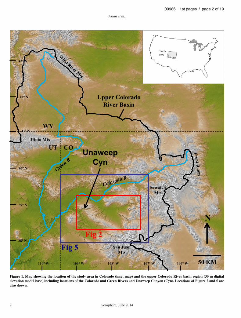
Unaweep Canyon (Colorado, USA) is the most spectacular example of stream piracy resulting in canyon abandonment in the upper Colorado River system (Hunt, 1969, p. 78) (Fig. 1). The present canyon is 40 km long, 5 km wide, as much as 700 m deep, and is cut mostly through resistant Precambrian bedrock (Fig. 2).
It has no major river at its base, and is currently drained by two underfi t streams, East and West Creeks, which drain the northeast and southwest ends of the canyon, respectively. Starting with the Hayden Survey (Peale, 1877), geologists recognized Unaweep as an abandoned canyon that was once occupied by the Gunnison River (Peale, 1877; Cater, 1966, 1970), the Colorado River (Gannett, 1882), or both (Lohman, 1965, 1981; Sinnock, 1981; Aslan et al., 2008a; Hood, 2011). Subsequent debate has focused on which river or rivers cut the canyon, over what time period incision occurred, the timing and causes of abandonment, and the amount of fi ll in the valley. There has also been debate over whether Unaweep Canyon has both a Quaternary and Paleozoic component to its history (Soreghan et al., 2007). Recent drilling has resolved the thickness of fi ll to be at least 320 m locally (Soreghan et al., 2007; as predicted by Oesleby, 1983, 2005a). This result demonstrates that Unaweep is a partially fi lled bedrock canyon, at least 1 km deep, rivaling the Black Canyon of the Gunnison and the inner gorge of the Grand Canyon in depth (Donahue et al., 2013).
The purpose of this paper is to document the context, timing, and geomorphic effects of the Unaweep Canyon abandonment. Specifi cally, we describe how canyon abandonment initi-ated a wave of fl uvial incision that propagated upstream along the Gunnison River system, triggered at least one additional stream capture event, and produced anomalously rapid short-term river incision rates. The rates and mag-nitudes of landscape change brought about by this single event are compared with longer term fl uvial incision governed by tectonic processes
For permission to copy, contact [email protected]© 2014 Geological Society of America
1
*Email: Aslan: aaslan@ coloradomesa .edu; Hood: whood@ bresnan .net; Karlstrom: kek1@ unm .edu; Granger: dgranger@ purdue .edu; Crow: crow .ryan@ gmail .com; Donahue: magdalena .donahue@ gmail .com.
Geosphere; June 2014; v. 10; no. 3; p. 1–19; doi:10.1130/GES00986.1;18 fi gures; 3 tables; 3 supplemental fi les.Received 24 September 2013 ♦ Revision received 18 February 2014 ♦ Accepted 9 April 2014 ♦ Published online XX Month 2014
CRevolution 2: Origin and Evolution of the Colorado River System II themed issue
Aslan et al.
2 Geosphere, June 2014
00986 1st pages / page 2 of 19
N
WY
UT CO
50 KM
Fig 2
Upper ColoradoRiver Basin
41° N
40° N
39° N
38° N
42° N
43° N
110° W 109° W 108° W 107° W 106° W
UnaweepCyn
San JuanMts
Uinta Mts
SawatchMts
Fig 5
Figure 1. Map showing the location of the study area in Colorado (inset map) and the upper Colorado River basin region (30 m digital elevation model base) including locations of the Colorado and Green Rivers and Unaweep Canyon (Cyn). Locations of Figure 2 and 5 are also shown.
Abandonment of Unaweep Canyon
Geosphere, June 2014 3
00986 1st pages / page 3 of 19
that have operated over the past ~10 m.y. in the upper Colorado River basin (Aslan et al., 2010; Karlstrom et al., 2012).
METHODS
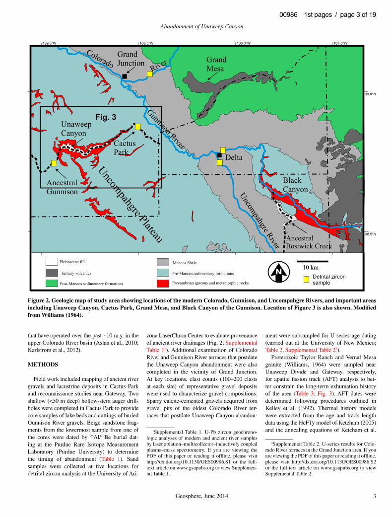
Field work included mapping of ancient river gravels and lacustrine deposits in Cactus Park and reconnaissance studies near Gateway. Two shallow (<50 m deep) hollow-stem auger drill-holes were completed in Cactus Park to provide core samples of lake beds and cuttings of buried Gunnison River gravels. Beige sandstone frag-ments from the lowermost sample from one of the cores were dated by 26Al/10Be burial dat-ing at the Purdue Rare Isotope Measurement Labora tory (Purdue University) to determine the timing of abandonment (Table 1). Sand samples were collected at fi ve locations for detrital zircon analysis at the University of Ari-
zona LaserChron Center to evaluate provenance of ancient river drainages (Fig. 2; Supplemental Table 11). Additional examination of Colorado River and Gunnison River terraces that postdate the Unaweep Canyon abandonment were also completed in the vicinity of Grand Junction. At key locations, clast counts (100–200 clasts at each site) of representative gravel deposits were used to characterize gravel compositions. Sparry calcite-cemented gravels acquired from gravel pits of the oldest Colorado River ter-races that postdate Unaweep Canyon abandon-
ment were subsampled for U-series age dating (carried out at the University of New Mexico; Table 2, Supplemental Table 22).
Proterozoic Taylor Ranch and Vernal Mesa granite (Williams, 1964) were sampled near Unaweep Divide and Gateway, respectively, for apatite fi ssion track (AFT) analysis to bet-ter constrain the long-term exhumation history of the area (Table 3; Fig. 3). AFT dates were determined following procedures outlined in Kelley et al. (1992). Thermal history models were extracted from the age and track length data using the HeFTy model of Ketcham (2005) and the annealing equations of Ketcham et al.
GrandMesa
UnaweepCanyon
CactusPark
ColoradoRiver
AncestralGunnison
Gunnison River
Uncompahgre River
AncestralBostwick Creek
BlackCanyon
Uncompahgre Plateau
GrandJunction
Delta
10 kmPre-Mancos sedimentary formations
Precambrian igneous and metamorphic rocks
Mancos Shale
Post-Mancos sedimentary formations
Pleistocene fill
Tertiary volcanics
38.5°N
39.0°N
109.0°W 108.5°W 108.0°W 107.5°W
Fig. 3
Detrital zirconsample
Figure 2. Geologic map of study area showing locations of the modern Colorado, Gunnison, and Uncompahgre Rivers, and important areas including Unaweep Canyon, Cactus Park, Grand Mesa, and Black Canyon of the Gunnison. Location of Figure 3 is also shown. Modifi ed from Williams (1964).
1Supplemental Table 1. U-Pb zircon geochrono-logic analyses of modern and ancient river samples by laser ablation–multicollector–inductively coupled plasma–mass spectrometry. If you are viewing the PDF of this paper or reading it offl ine, please visit http:// dx .doi .org /10 .1130 /GES00986 .S1 or the full-text article on www .gsapubs .org to view Supplemen-tal Table 1.
2Supplemental Table 2. U-series results for Colo-rado River terraces in the Grand Junction area. If you are viewing the PDF of this paper or reading it offl ine, please visit http:// dx .doi .org /10 .1130 /GES00986 .S2 or the full-text article on www .gsapubs .org to view Supplemental Table 2.

Aslan et al.
4 Geosphere, June 2014
00986 1st pages / page 4 of 19
(1999). No apatite chemistry or (U-Th)/He data are currently available for the samples. Dpar (diameter of etched spontaneous FTs measured parallel to the crystallographic c-axis) values of 1.2–1.5 µm are consistent with a fl uorapatite composition. A mean annual modern surface temperature of 11 °C was used in the thermal history modeling, based on data for nearby Grand Junction.
This diverse suite of data allows us to improve our understanding of the timing of Unaweep Canyon abandonment, and evaluate its infl uence on drainage evolution along the western slope of the Colorado Rockies.
POST-CRETACEOUS EXHUMATION IN THE VICINITY OF UNAWEEP CANYON
The geologic record in the vicinity of Unaweep Canyon provides clues about the exhumation and burial history of the Uncompahgre Uplift. The Cutler Formation laps onto the south fl ank of this Ancestral Rocky Mountain uplift, placing the Proterozoic rocks that form the core of the uplift at the surface ca. 300 Ma. The Protero zoic basement was subsequently buried by ~350 m of Mesozoic rocks (Triassic Moenkopi to Cre-taceous Burro Canyon) that were deposited in eolian and fl uvial environments prior to the incursion of the Western Interior Seaway ca. 110 Ma (Nuccio and Roberts, 2003). Marine deposition in this area gave way to marginal marine and fl uvial deposition of the Mesaverde
Group. Cretaceous deposition ended ca. 66 Ma (Nuccio and Roberts, 2003). According to Nuccio and Roberts (2003), the average thick-ness of Cretaceous rocks in the Piceance Basin north of the Uncompahgre Uplift is 3000–3400 m; 1500–1700 m of the section is com-posed of Mancos Shale.
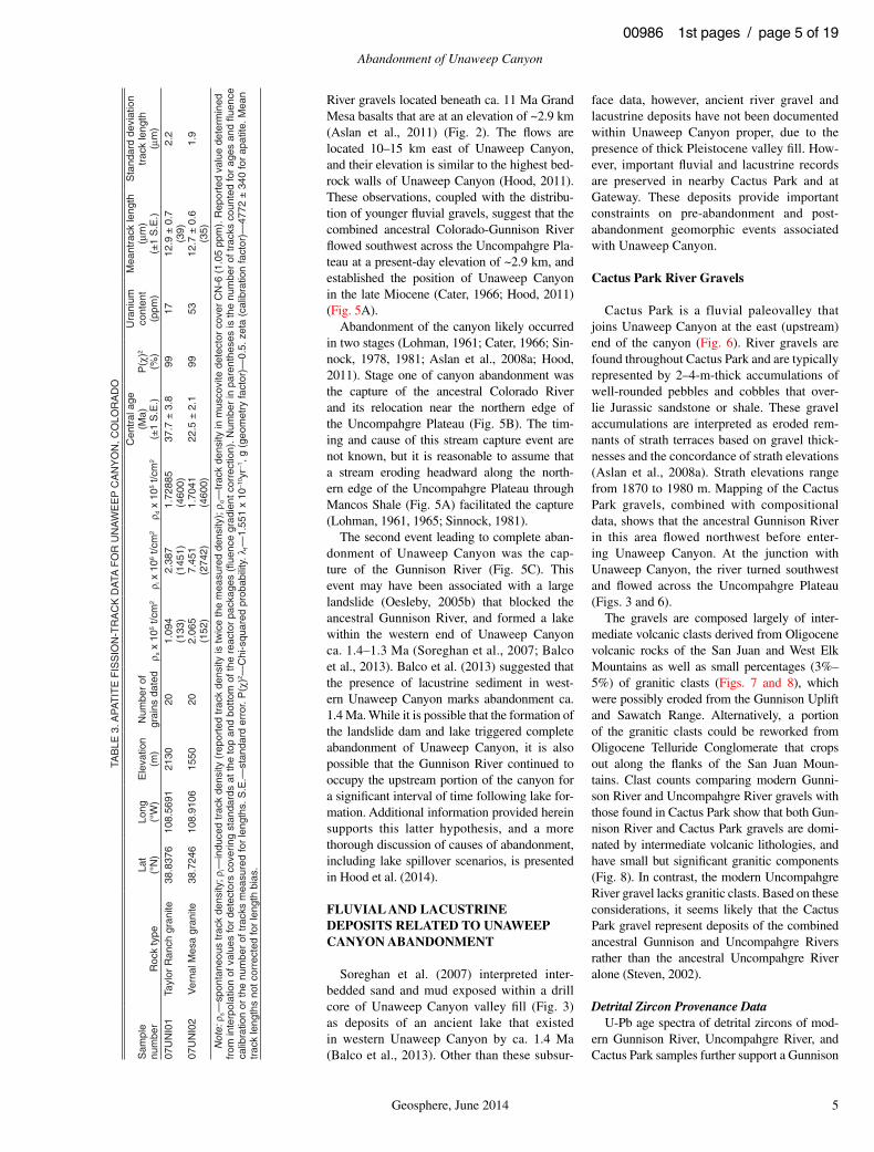
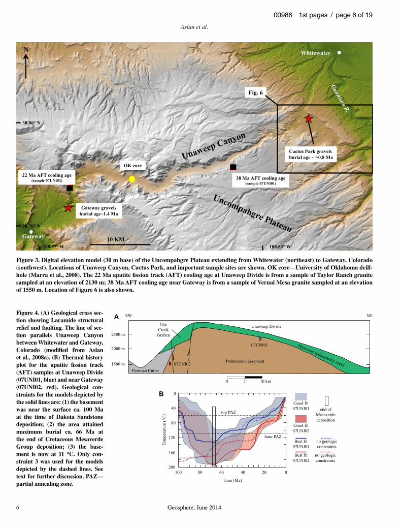
New AFT cooling ages were determined help to constrain the timing of the post-Cretaceous exhumation of the northern Uncompahgre Pla-teau. Two samples were acquired from Protero-zoic granitic rocks located along the south rim of the canyon at Unaweep Divide (elevation 2130 m) and at the lowermost outcrop (elevation 1550 m) of Proterozoic rocks on the west side of Unaweep Canyon near Gateway, Colorado (Fig. 3). A geologic cross section that shows the context of the samples is shown in Figure 4A. The two samples are separated by ~1 km of vertical relief. The samples have AFT cool-ing ages of 22–38 Ma and mean track lengths of 12.7–12.9 µm (Table 3), indicative of slow cool-ing during mid-Cenozoic time.
HeFTy was used to construct 20 thermal his-tories using the geologic constraints outlined above; 2 sets of models were run without geo-logic constraints for comparison. Four represen-tative thermal histories are illustrated in Figure 4B. Note that the curves for the constrained and the unconstrained models are quite simi-lar within and below the apatite partial anneal-ing zone, suggesting that the data and not the constraints are controlling the calculated histo-
ries. The young AFT apparent ages do little to constrain the Cretaceous burial history of the region, as indicated by the wide zones of good fi t prior to 40 Ma. The thermal blanketing effects of the 1.5–1.7-km-thick, low thermal conductiv-ity shales, which can have interval gradients of 40–60 °C/km, even in terrains with average heat fl ow (Kelley and Chapin, 2004), were suf-fi cient to totally reset the fi ssion track system in the basement rocks during Late Cretaceous time. The sampled portion of the Uncompahgre Uplift was not strongly exhumed by Laramide deformation, although faulting of Laramide age has been recognized. Instead, this area was exhumed beginning in Eocene to Oligocene time. Erosion through the sedimentary cover of the Uncompahgre Uplift eventually exposed resistant Precambrian rocks in the vicinity of present-day Unaweep Canyon at elevations of 2.5–2.8 km. Continued exhumation and the presence of these resistant rocks set the stage for the subsequent development and abandonment of Unaweep Canyon. The AFT data suggest a couple of pulses of exhumation or cooling, one at 45–40 Ma that was recorded by the shallower sample and another at 25–30 Ma recorded by the deeper sample; the latter event could be related to relaxation of isotherms as activity in the San Juan volcanic fi eld waned. An apparent pulse of accelerated exhumation during the past 10 m.y. is shown in the thermal history of the deeper of the 2 samples and needs to be tested with (U-Th)/He dating.
SUMMARY OF EVENTS LEADING UP TO ABANDONMENT OF UNAWEEP CANYON
Onset of Canyon Cutting and Stages of Unaweep Canyon Abandonment
The connection of Unaweep Canyon with the upper Colorado River drainage probably began in the late Miocene. This interpretation is based on the presence of ancestral Colorado
TABLE 1. COSMOGENIC NUCLIDE DATA AND BURIAL AGES, CACTUS PARK, COLORADO
SampleLat(°N)
Long(°W)
[10Be](103 atm/g)
[26Al](103 atm/g)
Minimum burial age(m.y.)
CP3 38.84235 108.45962 50 ± 3 221 ± 31 0.92 ± 0.31CP3A 38.84235 108.45962 53 ± 8 268 ± 31 0.62 ± 0.39Average 0.80 ± 0.24
Note: 10Be/9Be measured at Purdue Rare Isotope Measurement Laboratory (Purdue University, West Lafayette, Indiana); sample CP3 against National Institute of Standards and Technology standards adjusted by a factor of 0.9 for consistency with Nishiizumi et al. (2007), and sample CP3A against Nishiizumi et al. (2007). Burial ages calculated by iteration following Granger and Muzikar (2001), ignoring postburial production by muons. Age of CP3 differs from Aslan et al. (2008b) due to adoption of a new 10Be standard (Nishiizumi et al., 2007) and half-life (Chmeleff et al., 2010). Source area production rates of 10Be and 26Al taken as 35 and 240 atm/g/yr for lat 38°N, elevation 3 km. Burial age is not sensitive to source area production rate.
TABLE 2. U-SERIES AGES AND RESULTING INCISION RATES FROM COLORADO RIVER TERRACES NEAR GRAND JUNCTION, COLORADO
Sample numberLat(°N)
Long(°W)
Height(m)
Corrected U/Th age
(ka) ± 2σ error
Minimum 234U model age
(ka)δ234Ui = 1000
Maximum 234U model age
(ka)δ234Ui = 4000
Incision rate(m/m.y.) ±2σ error
CR160-101811-3D 39.01411 108.40714 158 679 1170 171 +62–36CR160-101811-3CA 39.01411 108.40714 158 716 1207 164 +56–33
13–15+151312132764113114.80157910.93B2-908211RC01–01+23408.5–31.6+37.45201148044.8017610.931-21014-RC13–32+47197.76–15.821+91.18510179994.80189610.932-21014-RC
5–5+68441.2–71.2+14.62201178544.80166520.93E1-3146-001RC3–3+13491.1–02.1+25.5517643004.80149560.93AA1-2188-08TQ
CRG60-71912-1 39.06568 108.40045 64 199 690 144 +178–51CR60-6513 39.06557 108.40033 62 182 673 145 +195–53
Note: Model age–constrained incision rates were calculated using a median age between the minimum and maximum model ages. Full analytical results are in Supplemental Table 2 (see footnote 2). Strikethrough sample numbers represent samples that exhibited open-system behavior, and were not used to estimate maximum ages of terraces.
Abandonment of Unaweep Canyon
Geosphere, June 2014 5
00986 1st pages / page 5 of 19
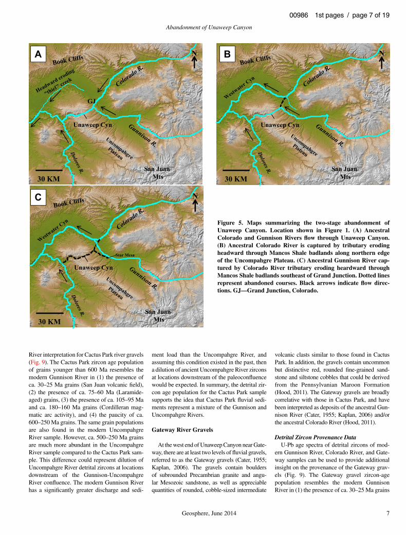
River gravels located beneath ca. 11 Ma Grand Mesa basalts that are at an elevation of ~2.9 km (Aslan et al., 2011) (Fig. 2). The fl ows are located 10–15 km east of Unaweep Canyon, and their elevation is similar to the highest bed-rock walls of Unaweep Canyon (Hood, 2011). These observations, coupled with the distribu-tion of younger fl uvial gravels, suggest that the combined ancestral Colorado-Gunnison River fl owed southwest across the Uncompahgre Pla-teau at a present-day elevation of ~2.9 km, and established the position of Unaweep Canyon in the late Miocene (Cater, 1966; Hood, 2011) (Fig. 5A).
Abandonment of the canyon likely occurred in two stages (Lohman, 1961; Cater, 1966; Sin-nock, 1978, 1981; Aslan et al., 2008a; Hood, 2011). Stage one of canyon abandonment was the capture of the ancestral Colorado River and its relocation near the northern edge of the Uncompahgre Plateau (Fig. 5B). The tim-ing and cause of this stream capture event are not known, but it is reasonable to assume that a stream eroding headward along the north-ern edge of the Uncompahgre Plateau through Mancos Shale (Fig. 5A) facilitated the capture (Lohman, 1961, 1965; Sinnock, 1981).
The second event leading to complete aban-donment of Unaweep Canyon was the cap-ture of the Gunnison River (Fig. 5C). This event may have been associated with a large landslide (Oesleby, 2005b) that blocked the ancestral Gunnison River, and formed a lake within the western end of Unaweep Canyon ca. 1.4–1.3 Ma (Soreghan et al., 2007; Balco et al., 2013). Balco et al. (2013) suggested that the presence of lacustrine sediment in west-ern Unaweep Canyon marks abandonment ca. 1.4 Ma. While it is possible that the formation of the landslide dam and lake triggered complete abandonment of Unaweep Canyon, it is also possible that the Gunnison River continued to occupy the upstream portion of the canyon for a signifi cant interval of time following lake for-mation. Additional information provided herein supports this latter hypothesis, and a more thorough discussion of causes of abandonment, including lake spillover scenarios, is presented in Hood et al. (2014).
FLUVIAL AND LACUSTRINE DEPOSITS RELATED TO UNAWEEP CANYON ABANDONMENT
Soreghan et al. (2007) interpreted inter-bedded sand and mud exposed within a drill core of Unaweep Canyon valley fi ll (Fig. 3) as deposits of an ancient lake that existed in western Unaweep Canyon by ca. 1.4 Ma (Balco et al., 2013). Other than these subsur-
face data, however, ancient river gravel and lacustrine deposits have not been documented within Unaweep Canyon proper, due to the presence of thick Pleistocene valley fi ll. How-ever, important fl uvial and lacustrine records are preserved in nearby Cactus Park and at Gateway. These deposits provide important constraints on pre-abandonment and post-abandonment geomorphic events associated with Unaweep Canyon.
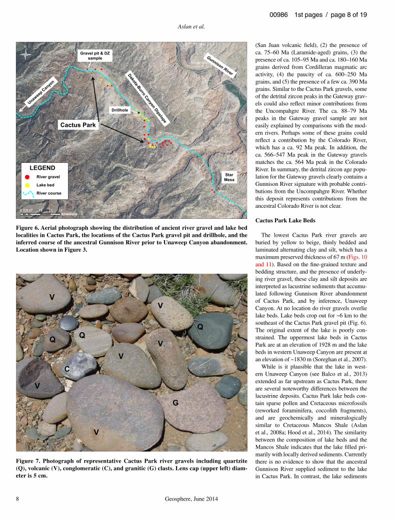
Cactus Park River Gravels
Cactus Park is a fluvial paleovalley that joins Unaweep Canyon at the east (upstream) end of the canyon (Fig. 6). River gravels are found throughout Cactus Park and are typically represented by 2–4-m-thick accumulations of well-rounded pebbles and cobbles that over-lie Jurassic sandstone or shale. These gravel accumulations are interpreted as eroded rem-nants of strath terraces based on gravel thick-nesses and the concordance of strath elevations (Aslan et al., 2008a). Strath elevations range from 1870 to 1980 m. Mapping of the Cactus Park gravels, combined with compositional data, shows that the ancestral Gunnison River in this area fl owed northwest before enter-ing Unaweep Canyon. At the junction with Unaweep Canyon, the river turned southwest and fl owed across the Uncompahgre Plateau (Figs. 3 and 6).
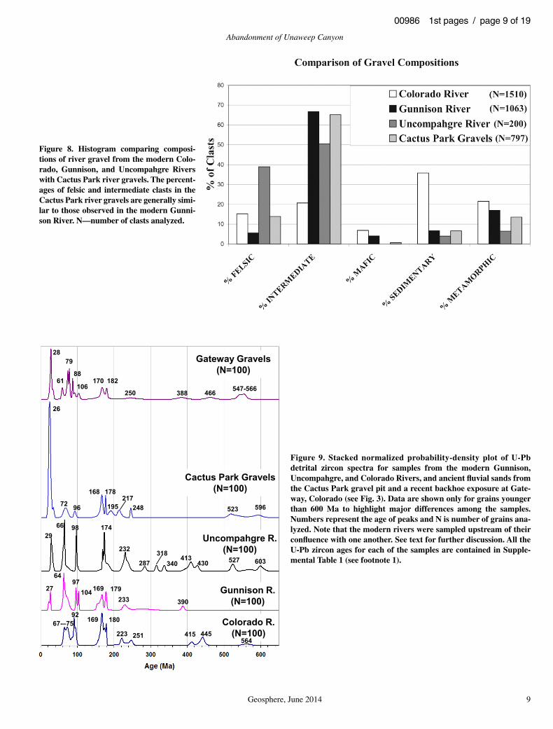
The gravels are composed largely of inter-mediate volcanic clasts derived from Oligocene volcanic rocks of the San Juan and West Elk Mountains as well as small percentages (3%–5%) of granitic clasts (Figs. 7 and 8), which were possibly eroded from the Gunnison Uplift and Sawatch Range. Alternatively, a portion of the granitic clasts could be reworked from Oligo cene Telluride Conglomerate that crops out along the fl anks of the San Juan Moun-tains. Clast counts comparing modern Gunni-son River and Uncompahgre River gravels with those found in Cactus Park show that both Gun-nison River and Cactus Park gravels are domi-nated by intermediate volcanic lithologies, and have small but signifi cant granitic components (Fig. 8). In contrast, the modern Uncompahgre River gravel lacks granitic clasts. Based on these considerations, it seems likely that the Cactus Park gravel represent deposits of the combined ancestral Gunnison and Uncompahgre Rivers rather than the ancestral Uncompahgre River alone (Steven, 2002).
Detrital Zircon Provenance DataU-Pb age spectra of detrital zircons of mod-
ern Gunnison River, Uncompahgre River, and Cactus Park samples further support a Gunnison
TAB
LE 3
. AP
AT
ITE
FIS
SIO
N-T
RA
CK
DA
TA F
OR
UN
AW
EE
P C
AN
YO
N, C
OLO
RA
DO
Sam
ple
num
ber
Roc
k ty
peLa
t(°
N)
Long
(°W
)E
leva
tion
(m)
Num
ber
of
grai
ns d
ated
ρ s x
105
t/cm
2ρ i
x 1
06 t/c
m2
ρ d x
105
t/cm
2
Cen
tral
age
(Ma)
(±1
S.E
.)P
(χ)2
(%)
Ura
nium
co
nten
t(p
pm)
Mea
ntra
ck le
ngth
(μm
)(±
1 S
.E.)
Sta
ndar
d de
viat
ion
trac
k le
ngth
(μm
)07
UN
I01
Tayl
or R
anch
gra
nite
38.8
376
108.
5691
2130
201.
094
(133
)2.
387
(145
1) 1
.728
85(4
600)
37.7
± 3
.899
1712
.9 ±
0.7
(39)
2.2
07U
NI0
2V
erna
l Mes
a gr
anite
38.7
246
108.
9106
1550
202.
065
(152
)7.
451
(274
2)1.
7041
(460
0)22
.5 ±
2.1
9953
12.7
± 0
.6(3
5)1.
9
Not
e:ρ s
—sp
onta
neou
s tr
ack
dens
ity; ρ
i—in
duce
d tr
ack
dens
ity (
repo
rted
trac
k de
nsity
is tw
ice
the
mea
sure
d de
nsity
); ρ
d—
trac
k de
nsity
in m
usco
vite
det
ecto
r co
ver
CN
-6 (
1.05
ppm
). R
epor
ted
valu
e de
term
ined
fr
om in
terp
olat
ion
of v
alue
s fo
r de
tect
ors
cove
ring
stan
dard
s at
the
top
and
botto
m o
f the
rea
ctor
pac
kage
s (fl
uen
ce g
radi
ent c
orre
ctio
n). N
umbe
r in
par
enth
eses
is th
e nu
mbe
r of
trac
ks c
ount
ed fo
r ag
es a
nd fl
uenc
eca
libra
tion
or th
e nu
mbe
r of
trac
ks m
easu
red
for
leng
ths.
S.E
.—st
anda
rd e
rror
. P(χ
)2 —C
hi-s
quar
ed p
roba
bilit
y. λ
f—1.
551
x 10
–10 y
r–1, g
(ge
omet
ry fa
ctor
)—0.
5. z
eta
(cal
ibra
tion
fact
or)—
4772
± 3
40 fo
r ap
atite
. Mea
n tr
ack
leng
ths
not c
orre
cted
for
leng
th b
ias.
Aslan et al.
6 Geosphere, June 2014
00986 1st pages / page 6 of 19
Gateway
Whitewater
Cactus Park gravels burial age ~ >0.8 Ma
Gateway gravelsburial age~1.4 Ma
OK core
22 Ma AFT cooling age(sample 07UNI02) 38 Ma AFT cooling age
(sample 07UNI01)
Fig. 6
10 KM
N
38.86° N
38.70° N
108.97° W 108.53° W
Figure 3. Digital elevation model (30 m base) of the Uncompahgre Plateau extending from Whitewater (northeast) to Gateway, Colorado (southwest). Locations of Unaweep Canyon, Cactus Park, and important sample sites are shown. OK core—University of Oklahoma drill-hole (Marra et al., 2008). The 22 Ma apatite fi ssion track (AFT) cooling age at Unaweep Divide is from a sample of Taylor Ranch granite sampled at an elevation of 2130 m; 38 Ma AFT cooling age near Gateway is from a sample of Vernal Mesa granite sampled at an elevation of 1550 m. Location of Figure 6 is also shown.
2500 m
2000 m
1500 m
0 5 10 km
07UNI01
Permian Cutler
Proterozoic basement
Unaweep Divide
SW NE
Best fit07UNI01
Good fit07UNI02
Good fit07UNI01
Best fit07UNI02
Time (Ma)
020406080100
0
40
80
120
160
200
Tem
pera
ture
(°C
)
end ofMesaverdedeposition
base PAZ
top PAZ
no geologicconstraints
no geologicconstraints
Mesozoic sedimentary rocks
UteCreek
Graben
07UNI02
A
B
Figure 4. (A) Geological cross sec-tion showing Laramide structural relief and faulting. The line of sec-tion parallels Unaweep Canyon between Whitewater and Gateway, Colorado (modifi ed from Aslan et al., 2008a). (B) Thermal history plot for the apatite fi ssion track (AFT) samples at Unaweep Divide (07UNI01, blue) and near Gateway (07UNI02, red). Geological con-straints for the models depicted by the solid lines are: (1) the basement was near the surface ca. 100 Ma at the time of Dakota Sandstone deposition; (2) the area attained maximum burial ca. 66 Ma at the end of Cretaceous Mesaverde Group deposition; (3) the base-ment is now at 11 °C. Only con-straint 3 was used for the models depicted by the dashed lines. See text for further discussion. PAZ—partial annealing zone.
Abandonment of Unaweep Canyon
Geosphere, June 2014 7
00986 1st pages / page 7 of 19
River interpretation for Cactus Park river gravels (Fig. 9). The Cactus Park zircon age population of grains younger than 600 Ma resembles the modern Gunnison River in (1) the presence of ca. 30–25 Ma grains (San Juan volcanic fi eld), (2) the presence of ca. 75–60 Ma (Laramide-aged) grains, (3) the presence of ca. 105–95 Ma and ca. 180–160 Ma grains (Cordilleran mag-matic arc activity), and (4) the paucity of ca. 600–250 Ma grains. The same grain populations are also found in the modern Uncompahgre River sample. However, ca. 500–250 Ma grains are much more abundant in the Uncompahgre River sample compared to the Cactus Park sam-ple. This difference could represent dilution of Uncompahgre River detrital zircons at locations downstream of the Gunnison-Uncompahgre River confl uence. The modern Gunnison River has a signifi cantly greater discharge and sedi-
ment load than the Uncompahgre River, and assuming this condition existed in the past, then a dilution of ancient Uncompahgre River zircons at locations downstream of the paleoconfl uence would be expected. In summary, the detrital zir-con age population for the Cactus Park sample supports the idea that Cactus Park fl uvial sedi-ments represent a mixture of the Gunnison and Uncompahgre Rivers.
Gateway River Gravels
At the west end of Unaweep Canyon near Gate-way, there are at least two levels of fl uvial gravels, referred to as the Gateway gravels (Cater, 1955; Kaplan, 2006). The gravels contain boulders of subrounded Precambrian granite and angu-lar Mesozoic sandstone, as well as appreciable quantities of rounded, cobble-sized intermediate
volcanic clasts similar to those found in Cactus Park. In addition, the gravels contain uncommon but distinctive red, rounded fi ne-grained sand-stone and siltstone cobbles that could be derived from the Pennsylvanian Maroon Formation (Hood, 2011). The Gateway gravels are broadly correlative with those in Cactus Park, and have been interpreted as deposits of the ancestral Gun-nison River (Cater, 1955; Kaplan, 2006) and/or the ancestral Colorado River (Hood, 2011).
Detrital Zircon Provenance DataU-Pb age spectra of detrital zircons of mod-
ern Gunnison River, Colorado River, and Gate-way samples can be used to provide additional insight on the provenance of the Gateway grav-els (Fig. 9). The Gateway gravel zircon-age population resembles the modern Gunnison River in (1) the presence of ca. 30–25 Ma grains
Unaweep Cyn
San JuanMts30 KM
N
Unaweep Cyn
San JuanMts30 KM
N
Unaweep Cyn
San JuanMts30 KM
NA B
C
GJ
Star Mesa
Figure 5. Maps summarizing the two-stage abandonment of Unaweep Canyon. Location shown in Figure 1. (A) Ancestral Colo rado and Gunnison Rivers fl ow through Unaweep Canyon. (B) Ancestral Colorado River is captured by tributary eroding headward through Mancos Shale badlands along northern edge of the Uncompahgre Plateau. (C) Ancestral Gunnison River cap-tured by Colorado River tributary eroding heardward through Mancos Shale badlands southeast of Grand Junction. Dotted lines represent abandoned courses. Black arrows indicate fl ow direc-tions. GJ—Grand Junction, Colorado.
Aslan et al.
8 Geosphere, June 2014
00986 1st pages / page 8 of 19
(San Juan volcanic fi eld), (2) the presence of ca. 75–60 Ma (Laramide-aged) grains, (3) the presence of ca. 105–95 Ma and ca. 180–160 Ma grains derived from Cordilleran magmatic arc activity, (4) the paucity of ca. 600–250 Ma grains, and (5) the presence of a few ca. 390 Ma grains. Similar to the Cactus Park gravels, some of the detrital zircon peaks in the Gateway grav-els could also refl ect minor contributions from the Uncompahgre River. The ca. 88–79 Ma peaks in the Gateway gravel sample are not easily explained by comparisons with the mod-ern rivers. Perhaps some of these grains could refl ect a contribution by the Colorado River, which has a ca. 92 Ma peak. In addition, the ca. 566–547 Ma peak in the Gateway gravels matches the ca. 564 Ma peak in the Colorado River. In summary, the detrital zircon age popu-lation for the Gateway gravels clearly contains a Gunnison River signature with probable contri-butions from the Uncompahgre River. Whether this deposit represents contributions from the ancestral Colorado River is not clear.
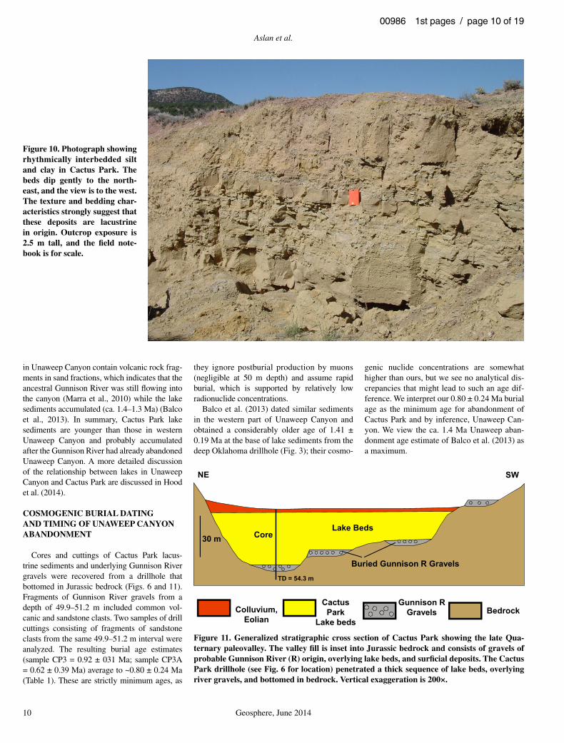
Cactus Park Lake Beds
The lowest Cactus Park river gravels are buried by yellow to beige, thinly bedded and laminated alternating clay and silt, which has a maximum preserved thickness of 67 m (Figs. 10 and 11). Based on the fi ne-grained texture and bedding structure, and the presence of underly-ing river gravel, these clay and silt deposits are interpreted as lacustrine sediments that accumu-lated following Gunnison River abandonment of Cactus Park, and by inference, Unaweep Canyon. At no location do river gravels overlie lake beds. Lake beds crop out for ~6 km to the southeast of the Cactus Park gravel pit (Fig. 6). The original extent of the lake is poorly con-strained. The uppermost lake beds in Cactus Park are at an elevation of 1928 m and the lake beds in western Unaweep Canyon are present at an elevation of ~1830 m (Soreghan et al., 2007).
While is it plausible that the lake in west-ern Unaweep Canyon (see Balco et al., 2013) extended as far upstream as Cactus Park, there are several noteworthy differences between the lacustrine deposits. Cactus Park lake beds con-tain sparse pollen and Cretaceous microfossils (reworked foraminifera, coccolith fragments), and are geochemically and mineralogically similar to Cretaceous Mancos Shale (Aslan et al., 2008a; Hood et al., 2014). The similarity between the composition of lake beds and the Mancos Shale indicates that the lake fi lled pri-marily with locally derived sediments. Currently there is no evidence to show that the ancestral Gunnison River supplied sediment to the lake in Cactus Park. In contrast, the lake sediments
Cactus Park
StarMesa
Gravel pit & DZsample
Drillhole
LEGENDRiver gravel
Lake bed
River course
Kilometers0 0.35 0.7 1.4 2.1 2.8
Figure 6. Aerial photograph showing the distribution of ancient river gravel and lake bed localities in Cactus Park, the locations of the Cactus Park gravel pit and drillhole, and the inferred course of the ancestral Gunnison River prior to Unaweep Canyon abandonment. Location shown in Figure 3.
V
V
VV
V
G
C
QQQ
V
Figure 7. Photograph of representative Cactus Park river gravels including quartzite (Q), volcanic (V), conglomeratic (C), and granitic (G) clasts. Lens cap (upper left) diam-eter is 5 cm.
Abandonment of Unaweep Canyon
Geosphere, June 2014 9
00986 1st pages / page 9 of 19
28
61
79
88
106182170
388 547-566466
Gateway Gravels(N=100)
72 96 248 523 596
26
178217
195
168
2966 98 174
232
287318
340413
430 527 603
Uncompahgre R.(N=100)
Cactus Park Gravels(N=100)
27
64
10497
179169233 390
Gunnison R.(N=100)
Colorado R.(N=100)
9267-–75 169 180
251 415 445564
223
250
Figure 9. Stacked normalized probability-density plot of U-Pb detrital zircon spectra for samples from the modern Gunnison, Uncompahgre, and Colorado Rivers, and ancient fl uvial sands from the Cactus Park gravel pit and a recent backhoe exposure at Gate-way, Colorado (see Fig. 3). Data are shown only for grains younger than 600 Ma to highlight major differences among the samples. Numbers represent the age of peaks and N is number of grains ana-lyzed. Note that the modern rivers were sampled upstream of their confl uence with one another. See text for further discussion. All the U-Pb zircon ages for each of the samples are contained in Supple-mental Table 1 (see footnote 1).
Figure 8. Histogram comparing composi-tions of river gravel from the modern Colo-rado, Gunnison, and Uncompahgre Rivers with Cactus Park river gravels. The percent-ages of felsic and intermediate clasts in the Cactus Park river gravels are generally simi-lar to those observed in the modern Gunni-son River. N—number of clasts analyzed.
Aslan et al.
10 Geosphere, June 2014
00986 1st pages / page 10 of 19
in Unaweep Canyon contain volcanic rock frag-ments in sand fractions, which indicates that the ancestral Gunnison River was still fl owing into the canyon (Marra et al., 2010) while the lake sediments accumulated (ca. 1.4–1.3 Ma) (Balco et al., 2013). In summary, Cactus Park lake sediments are younger than those in western Unaweep Canyon and probably accumulated after the Gunnison River had already abandoned Unaweep Canyon. A more detailed discussion of the relationship between lakes in Unaweep Canyon and Cactus Park are discussed in Hood et al. (2014).
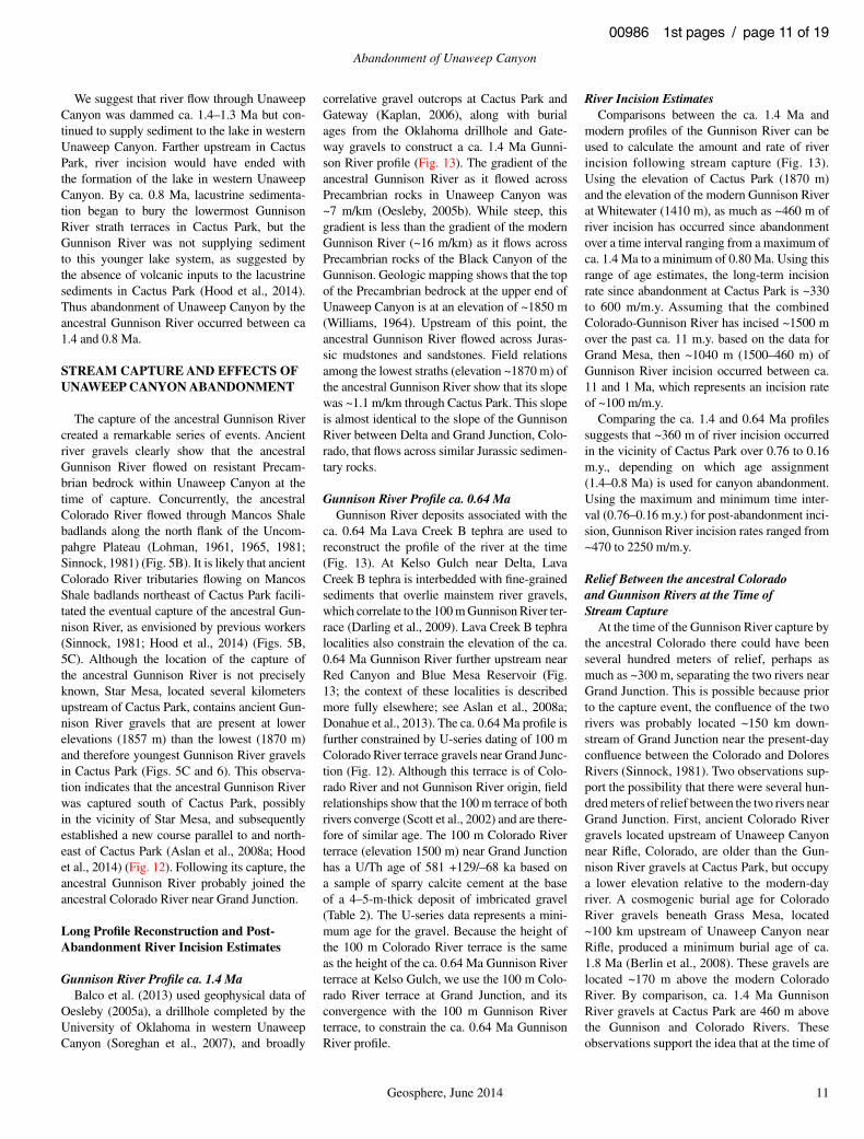
COSMOGENIC BURIAL DATING AND TIMING OF UNAWEEP CANYON ABANDONMENT
Cores and cuttings of Cactus Park lacus-trine sediments and underlying Gunnison River gravels were recovered from a drillhole that bottomed in Jurassic bedrock (Figs. 6 and 11). Fragments of Gunnison River gravels from a depth of 49.9–51.2 m included common vol-canic and sandstone clasts. Two samples of drill cuttings consisting of fragments of sandstone clasts from the same 49.9–51.2 m interval were analyzed. The resulting burial age estimates (sample CP3 = 0.92 ± 031 Ma; sample CP3A = 0.62 ± 0.39 Ma) average to ~0.80 ± 0.24 Ma (Table 1). These are strictly minimum ages, as
they ignore postburial production by muons (negligible at 50 m depth) and assume rapid burial, which is supported by relatively low radionuclide concentrations.
Balco et al. (2013) dated similar sediments in the western part of Unaweep Canyon and obtained a considerably older age of 1.41 ± 0.19 Ma at the base of lake sediments from the deep Oklahoma drillhole (Fig. 3); their cosmo-
genic nuclide concentrations are somewhat higher than ours, but we see no analytical dis-crepancies that might lead to such an age dif-ference. We interpret our 0.80 ± 0.24 Ma burial age as the minimum age for abandonment of Cactus Park and by inference, Unaweep Can-yon. We view the ca. 1.4 Ma Unaweep aban-donment age estimate of Balco et al. (2013) as a maximum.
Figure 10. Photograph showing rhythmically interbedded silt and clay in Cactus Park. The beds dip gently to the north-east, and the view is to the west. The texture and bedding char-acteristics strongly suggest that these deposits are lacustrine in origin. Outcrop exposure is 2.5 m tall, and the fi eld note-book is for scale.
30 m
Colluvium,Eolian
CactusPark
Lake beds
Gunnison RGravels Bedrock
Lake Beds
Buried Gunnison R Gravels
Core
NE SW
TD = 54.3 m
Figure 11. Generalized stratigraphic cross section of Cactus Park showing the late Qua-ternary paleovalley. The valley fi ll is inset into Jurassic bedrock and consists of gravels of probable Gunnison River (R) origin, overlying lake beds, and surfi cial deposits. The Cactus Park drillhole (see Fig. 6 for location) penetrated a thick sequence of lake beds, overlying river gravels, and bottomed in bedrock. Vertical exaggeration is 200×.
Abandonment of Unaweep Canyon
Geosphere, June 2014 11
00986 1st pages / page 11 of 19
We suggest that river fl ow through Unaweep Canyon was dammed ca. 1.4–1.3 Ma but con-tinued to supply sediment to the lake in western Unaweep Canyon. Farther upstream in Cactus Park, river incision would have ended with the formation of the lake in western Unaweep Canyon. By ca. 0.8 Ma, lacustrine sedimenta-tion began to bury the lowermost Gunnison River strath terraces in Cactus Park, but the Gunnison River was not supplying sediment to this younger lake system, as suggested by the absence of volcanic inputs to the lacustrine sediments in Cactus Park (Hood et al., 2014). Thus abandonment of Unaweep Canyon by the ancestral Gunnison River occurred between ca 1.4 and 0.8 Ma.
STREAM CAPTURE AND EFFECTS OF UNAWEEP CANYON ABANDONMENT
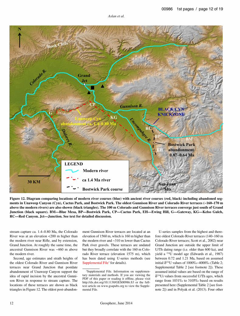
The capture of the ancestral Gunnison River created a remarkable series of events. Ancient river gravels clearly show that the ancestral Gunnison River fl owed on resistant Precam-brian bedrock within Unaweep Canyon at the time of capture. Concurrently, the ancestral Colorado River fl owed through Mancos Shale badlands along the north fl ank of the Uncom-pahgre Plateau (Lohman, 1961, 1965, 1981; Sinnock, 1981) (Fig. 5B). It is likely that ancient Colorado River tributaries fl owing on Mancos Shale badlands northeast of Cactus Park facili-tated the eventual capture of the ancestral Gun-nison River, as envisioned by previous workers (Sinnock, 1981; Hood et al., 2014) (Figs. 5B, 5C). Although the location of the capture of the ancestral Gunnison River is not precisely known, Star Mesa, located several kilometers upstream of Cactus Park, contains ancient Gun-nison River gravels that are present at lower elevations (1857 m) than the lowest (1870 m) and therefore youngest Gunnison River gravels in Cactus Park (Figs. 5C and 6). This observa-tion indicates that the ancestral Gunnison River was captured south of Cactus Park, possibly in the vicinity of Star Mesa, and subsequently established a new course parallel to and north-east of Cactus Park (Aslan et al., 2008a; Hood et al., 2014) (Fig. 12). Following its capture, the ancestral Gunnison River probably joined the ancestral Colorado River near Grand Junction.
Long Profi le Reconstruction and Post-Abandonment River Incision Estimates
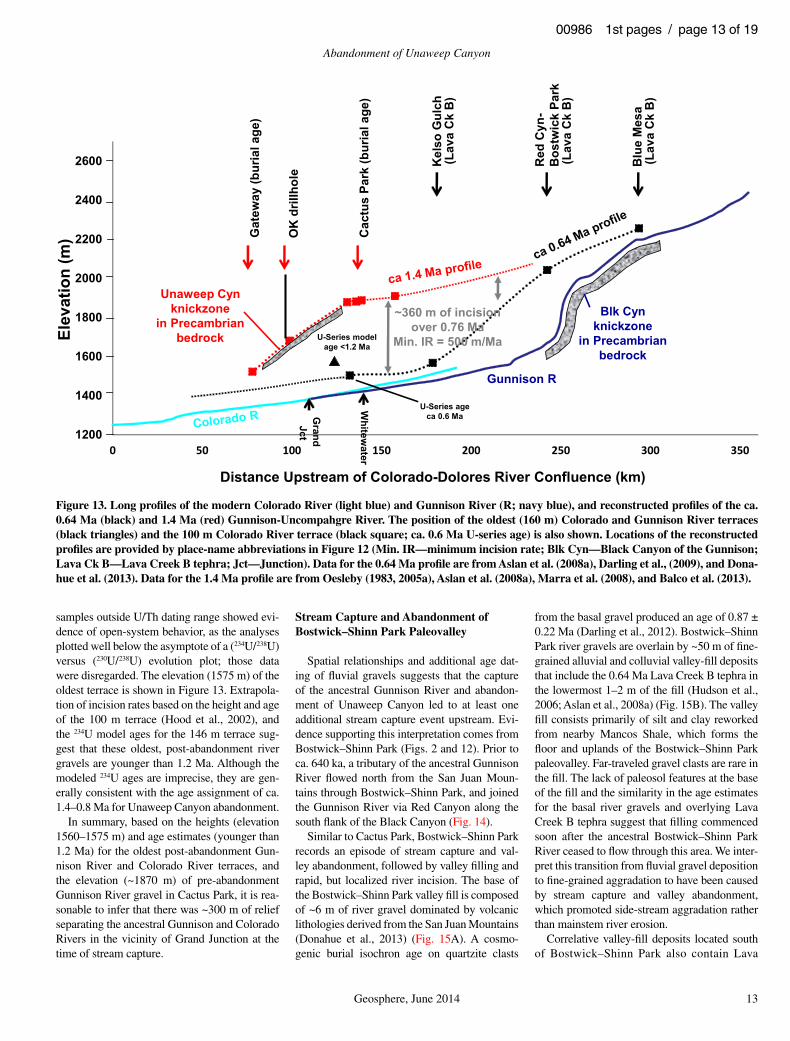
Gunnison River Profi le ca. 1.4 MaBalco et al. (2013) used geophysical data of
Oesleby (2005a), a drillhole completed by the University of Oklahoma in western Unaweep Canyon (Soreghan et al., 2007), and broadly
correlative gravel outcrops at Cactus Park and Gateway (Kaplan, 2006), along with burial ages from the Oklahoma drillhole and Gate-way gravels to construct a ca. 1.4 Ma Gunni-son River profi le (Fig. 13). The gradient of the ancestral Gunnison River as it fl owed across Precambrian rocks in Unaweep Canyon was ~7 m/km (Oesleby, 2005b). While steep, this gradient is less than the gradient of the modern Gunnison River (~16 m/km) as it fl ows across Precambrian rocks of the Black Canyon of the Gunnison. Geologic mapping shows that the top of the Precambrian bedrock at the upper end of Unaweep Canyon is at an elevation of ~1850 m (Williams, 1964). Upstream of this point, the ancestral Gunnison River fl owed across Juras-sic mudstones and sandstones. Field relations among the lowest straths (elevation ~1870 m) of the ancestral Gunnison River show that its slope was ~1.1 m/km through Cactus Park. This slope is almost identical to the slope of the Gunnison River between Delta and Grand Junction, Colo-rado, that fl ows across similar Jurassic sedimen-tary rocks.
Gunnison River Profi le ca. 0.64 MaGunnison River deposits associated with the
ca. 0.64 Ma Lava Creek B tephra are used to reconstruct the profi le of the river at the time (Fig. 13). At Kelso Gulch near Delta, Lava Creek B tephra is interbedded with fi ne-grained sediments that overlie mainstem river gravels, which correlate to the 100 m Gunnison River ter-race (Darling et al., 2009). Lava Creek B tephra localities also constrain the elevation of the ca. 0.64 Ma Gunnison River further upstream near Red Canyon and Blue Mesa Reservoir (Fig. 13; the context of these localities is described more fully elsewhere; see Aslan et al., 2008a; Donahue et al., 2013). The ca. 0.64 Ma profi le is further constrained by U-series dating of 100 m Colorado River terrace gravels near Grand Junc-tion (Fig. 12). Although this terrace is of Colo-rado River and not Gunnison River origin, fi eld relationships show that the 100 m terrace of both rivers converge (Scott et al., 2002) and are there-fore of similar age. The 100 m Colorado River terrace (elevation 1500 m) near Grand Junction has a U/Th age of 581 +129/–68 ka based on a sample of sparry calcite cement at the base of a 4–5-m-thick deposit of imbricated gravel (Table 2). The U-series data represents a mini-mum age for the gravel. Because the height of the 100 m Colorado River terrace is the same as the height of the ca. 0.64 Ma Gunnison River terrace at Kelso Gulch, we use the 100 m Colo-rado River terrace at Grand Junction, and its convergence with the 100 m Gunnison River terrace, to constrain the ca. 0.64 Ma Gunnison River profi le.
River Incision EstimatesComparisons between the ca. 1.4 Ma and
modern profi les of the Gunnison River can be used to calculate the amount and rate of river incision following stream capture (Fig. 13). Using the elevation of Cactus Park (1870 m) and the elevation of the modern Gunnison River at Whitewater (1410 m), as much as ~460 m of river incision has occurred since abandonment over a time interval ranging from a maximum of ca. 1.4 Ma to a minimum of 0.80 Ma. Using this range of age estimates, the long-term incision rate since abandonment at Cactus Park is ~330 to 600 m/m.y. Assuming that the combined Colorado-Gunnison River has incised ~1500 m over the past ca. 11 m.y. based on the data for Grand Mesa, then ~1040 m (1500–460 m) of Gunnison River incision occurred between ca. 11 and 1 Ma, which represents an incision rate of ~100 m/m.y.
Comparing the ca. 1.4 and 0.64 Ma profi les suggests that ~360 m of river incision occurred in the vicinity of Cactus Park over 0.76 to 0.16 m.y., depending on which age assignment (1.4–0.8 Ma) is used for canyon abandonment. Using the maximum and minimum time inter-val (0.76–0.16 m.y.) for post-abandonment inci-sion, Gunnison River incision rates ranged from ~470 to 2250 m/m.y.
Relief Between the ancestral Colorado and Gunnison Rivers at the Time of Stream Capture
At the time of the Gunnison River capture by the ancestral Colorado there could have been several hundred meters of relief, perhaps as much as ~300 m, separating the two rivers near Grand Junction. This is possible because prior to the capture event, the confl uence of the two rivers was probably located ~150 km down-stream of Grand Junction near the present-day confl uence between the Colorado and Dolores Rivers (Sinnock, 1981). Two observations sup-port the possibility that there were several hun-dred meters of relief between the two rivers near Grand Junction. First, ancient Colorado River gravels located upstream of Unaweep Canyon near Rifl e, Colorado, are older than the Gun-nison River gravels at Cactus Park, but occupy a lower elevation relative to the modern-day river. A cosmogenic burial age for Colorado River gravels beneath Grass Mesa, located ~100 km upstream of Unaweep Canyon near Rifl e, produced a minimum burial age of ca. 1.8 Ma (Berlin et al., 2008). These gravels are located ~170 m above the modern Colorado River. By comparison, ca. 1.4 Ma Gunnison River gravels at Cactus Park are 460 m above the Gunnison and Colorado Rivers . These observations support the idea that at the time of
Aslan et al.
12 Geosphere, June 2014
00986 1st pages / page 12 of 19
stream capture ca. 1.4–0.80 Ma, the Colorado River was at an elevation <200 m higher than the modern river near Rifl e, and by extension, Grand Junction. At roughly the same time, the ancestral Gunnison River was ~460 m above the modern river.
Second, age estimates and strath heights of the oldest Colorado River and Gunnison River terraces near Grand Junction that postdate abandonment of Unaweep Canyon support the idea of rapid incision by the ancestral Gunni-son River in response to stream capture. The locations of these terraces are shown as black triangles in Figure 12. The oldest post-abandon-
ment Gunnison River terraces are located at an elevation of 1560 m, which is 160 m higher than the modern river and ~310 m lower than Cactus Park river gravels. These terraces are undated but they broadly correlate with the 160 m Colo-rado River terrace (elevation 1575 m), which has been dated using U-series methods (see Supplemental File3 for details).
U-series samples from the highest and there-fore oldest Colorado River terraces (140–160 m Colorado River terraces; Scott et al., 2002) near Grand Junction are outside the upper limit of U/Th dating range (i.e. older than 600 ka), and yield a 234U model age (Edwards et al., 1987) between 0.72 and 1.21 Ma, based on assumed initial δ234U values of 1000‰–4000‰ (Table 2; Supplemental Table 2 [see footnote 2]). These assumed initial values are based on the range of δ234Ui values from successful U/Th ages, which range from 1031‰ to 3105‰ based on results presented here (Supplemental Table 2 [see foot-note 2]) and in Polyak et al. (2013). Four other
Grand Jct
Unaweep Cynabandonment ca. 1.4–0.80 Ma
San JuanMts
BLACK CYNKNICKZONE
Bostwick Parkabandonment 0.87–0.64 Ma
30 KM
G
CP
KG
RC
BMBP
EH
N
Modern river
ca 1.4 Ma river
Bostwick Park course
LEGEND
Figure 12. Diagram comparing locations of modern river courses (blue) with ancient river courses (red, black) including abandoned seg-ments in Unaweep Canyon (Cyn), Cactus Park, and Bostwick Park. The oldest Gunnison River and Colorado River terraces (~160–170 m above the modern rivers) are also shown (black triangles). The 100 m Colorado and Gunnison River terraces converge just south of Grand Junction (black square). BM—Blue Mesa, BP—Bostwick Park, CP—Cactus Park, EH—Ewing Hill, G—Gateway, KG—Kelso Gulch, RC—Red Canyon. Jct—Junction. See text for detailed discussion.
3Supplemental File. Information on supplemen-tary materials and methods. If you are viewing the PDF of this paper or reading it offl ine, please visit http:// dx .doi .org /10 .1130 /GES00986 .S3 or the full-text article on www .gsapubs .org to view the Supple-mental File.
Abandonment of Unaweep Canyon
Geosphere, June 2014 13
00986 1st pages / page 13 of 19
samples outside U/Th dating range showed evi-dence of open-system behavior, as the analyses plotted well below the asymptote of a (234U/238U) versus (230U/238U) evolution plot; those data were disregarded. The elevation (1575 m) of the oldest terrace is shown in Figure 13. Extrapola-tion of incision rates based on the height and age of the 100 m terrace (Hood et al., 2002), and the 234U model ages for the 146 m terrace sug-gest that these oldest, post-abandonment river gravels are younger than 1.2 Ma. Although the modeled 234U ages are imprecise, they are gen-erally consistent with the age assignment of ca. 1.4–0.8 Ma for Unaweep Canyon abandonment.
In summary, based on the heights (elevation 1560–1575 m) and age estimates (younger than 1.2 Ma) for the oldest post-abandonment Gun-nison River and Colorado River terraces, and the elevation (~1870 m) of pre-abandonment Gunnison River gravel in Cactus Park, it is rea-sonable to infer that there was ~300 m of relief separating the ancestral Gunnison and Colorado Rivers in the vicinity of Grand Junction at the time of stream capture.
Stream Capture and Abandonment of Bostwick–Shinn Park Paleovalley
Spatial relationships and additional age dat-ing of fl uvial gravels suggests that the capture of the ancestral Gunnison River and abandon-ment of Unaweep Canyon led to at least one additional stream capture event upstream. Evi-dence supporting this interpretation comes from Bostwick–Shinn Park (Figs. 2 and 12). Prior to ca. 640 ka, a tributary of the ancestral Gunnison River fl owed north from the San Juan Moun-tains through Bostwick–Shinn Park, and joined the Gunnison River via Red Canyon along the south fl ank of the Black Canyon (Fig. 14).
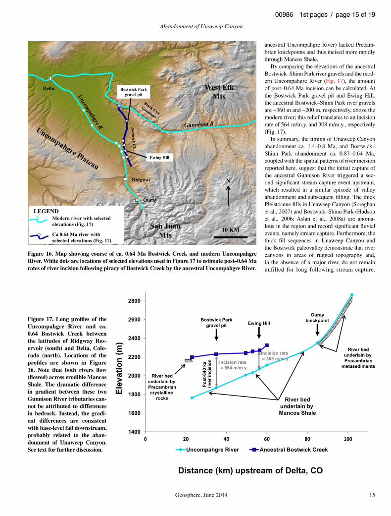
Similar to Cactus Park, Bostwick–Shinn Park records an episode of stream capture and val-ley abandonment, followed by valley fi lling and rapid, but localized river incision. The base of the Bostwick–Shinn Park valley fi ll is composed of ~6 m of river gravel dominated by volcanic lithologies derived from the San Juan Mountains (Donahue et al., 2013) (Fig. 15A). A cosmo-genic burial isochron age on quartzite clasts
from the basal gravel produced an age of 0.87 ± 0.22 Ma (Darling et al., 2012). Bostwick–Shinn Park river gravels are overlain by ~50 m of fi ne-grained alluvial and colluvial valley-fi ll deposits that include the 0.64 Ma Lava Creek B tephra in the lowermost 1–2 m of the fi ll (Hudson et al., 2006; Aslan et al., 2008a) (Fig. 15B). The valley fi ll consists primarily of silt and clay reworked from nearby Mancos Shale, which forms the fl oor and uplands of the Bostwick–Shinn Park paleovalley. Far-traveled gravel clasts are rare in the fi ll. The lack of paleosol features at the base of the fi ll and the similarity in the age estimates for the basal river gravels and overlying Lava Creek B tephra suggest that fi lling commenced soon after the ancestral Bostwick–Shinn Park River ceased to fl ow through this area. We inter-pret this transition from fl uvial gravel deposition to fi ne-grained aggradation to have been caused by stream capture and valley abandonment, which promoted side-stream aggradation rather than mainstem river erosion.
Correlative valley-fi ll deposits located south of Bostwick–Shinn Park also contain Lava
1200
1400
1600
1800
2000
2200
2400
2600
0 50 100 150 200 250 300 350
Elev
atio
n (m
)
Distance Upstream of Colorado-Dolores River Confluence (km)
Gat
eway
(bur
ial a
ge)
Cac
tus
Park
(bur
ial a
ge)
Kel
so G
ulch
(Lav
a C
k B
)
Red
Cyn
-B
ostw
ick
Park
(Lav
a C
k B
)
Blu
e M
esa
(Lav
a C
k B
)
Gunnison R
Blk Cynknickzone
in Precambrianbedrock
Unaweep Cynknickzone
in Precambrianbedrock U-Series model
age <1.2 Ma
GrandJct
U-Series ageca 0.6 Ma
OK
dril
lhol
e
Whitew
ater
~360 m of incisionover 0.76 Ma
Min. IR = 500 m/Ma
Figure 13. Long profi les of the modern Colorado River (light blue) and Gunnison River (R; navy blue), and reconstructed profi les of the ca. 0.64 Ma (black) and 1.4 Ma (red) Gunnison-Uncompahgre River. The position of the oldest (160 m) Colorado and Gunnison River terraces (black triangles) and the 100 m Colorado River terrace (black square; ca. 0.6 Ma U-series age) is also shown. Locations of the reconstructed profi les are provided by place-name abbreviations in Figure 12 (Min. IR—minimum incision rate; Blk Cyn—Black Canyon of the Gunnison; Lava Ck B—Lava Creek B tephra; Jct—Junction). Data for the 0.64 Ma profi le are from Aslan et al. (2008a), Darling et al., (2009), and Dona-hue et al. (2013). Data for the 1.4 Ma profi le are from Oesleby (1983, 2005a), Aslan et al. (2008a), Marra et al. (2008), and Balco et al. (2013).
Aslan et al.
14 Geosphere, June 2014
00986 1st pages / page 14 of 19
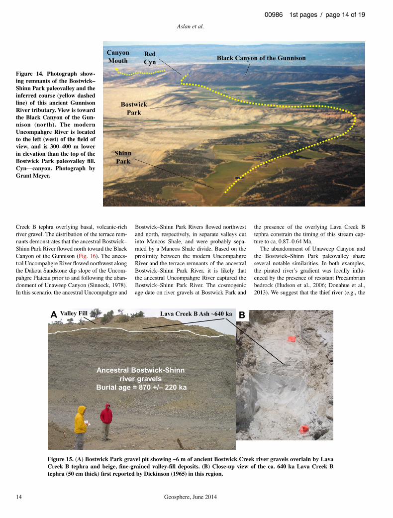
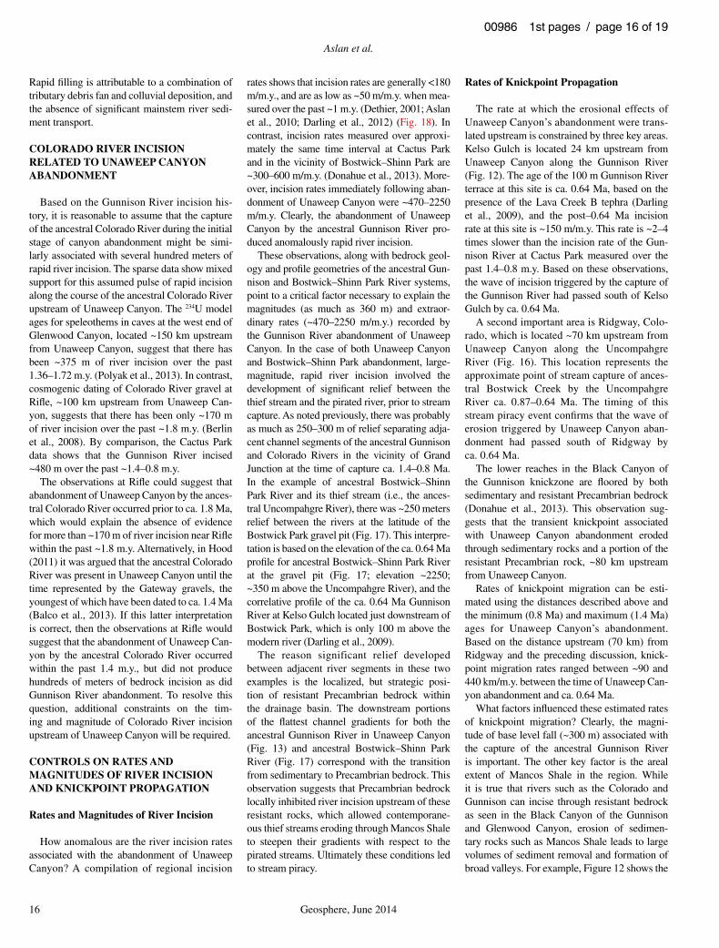
Creek B tephra overlying basal, volcanic-rich river gravel. The distribution of the terrace rem-nants demonstrates that the ancestral Bostwick–Shinn Park River fl owed north toward the Black Canyon of the Gunnison (Fig. 16). The ances-tral Uncompahgre River fl owed northwest along the Dakota Sandstone dip slope of the Uncom-pahgre Plateau prior to and following the aban-donment of Unaweep Canyon (Sinnock, 1978). In this scenario, the ancestral Uncompahgre and
Bostwick–Shinn Park Rivers fl owed northwest and north, respectively, in separate valleys cut into Mancos Shale, and were probably sepa-rated by a Mancos Shale divide. Based on the proximity between the modern Uncompahgre River and the terrace remnants of the ancestral Bostwick–Shinn Park River, it is likely that the ancestral Uncompahgre River captured the Bostwick–Shinn Park River. The cosmogenic age date on river gravels at Bostwick Park and
the presence of the overlying Lava Creek B tephra constrain the timing of this stream cap-ture to ca. 0.87–0.64 Ma.
The abandonment of Unaweep Canyon and the Bostwick–Shinn Park paleovalley share several notable similarities. In both examples, the pirated river’s gradient was locally infl u-enced by the presence of resistant Precambrian bedrock (Hudson et al., 2006; Donahue et al., 2013). We suggest that the thief river (e.g., the
BostwickPark
Black Canyon of the Gunnison
ShinnPark
RedCyn
CanyonMouth
Lava Creek B Ash ~640 kaA B
Ancestral Bostwick-Shinnriver gravels
Burial age = 870 +/– 220 ka
Valley Fill
Figure 14. Photograph show-ing remnants of the Bostwick–Shinn Park paleovalley and the inferred course (yellow dashed line) of this ancient Gunnison River tributary. View is toward the Black Canyon of the Gun-nison (north). The modern Uncompahgre River is located to the left (west) of the fi eld of view, and is 300–400 m lower in elevation than the top of the Bostwick Park paleovalley fi ll. Cyn—canyon. Photograph by Grant Meyer.
Figure 15. (A) Bostwick Park gravel pit showing ~6 m of ancient Bostwick Creek river gravels overlain by Lava Creek B tephra and beige, fi ne-grained valley-fi ll deposits. (B) Close-up view of the ca. 640 ka Lava Creek B tephra (50 cm thick) fi rst reported by Dickinson (1965) in this region.
Abandonment of Unaweep Canyon
Geosphere, June 2014 15
00986 1st pages / page 15 of 19
ancestral Uncompahgre River) lacked Precam-brian knickpoints and thus incised more rapidly through Mancos Shale.
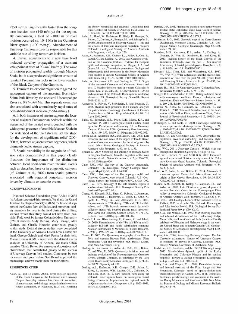
By comparing the elevations of the ancestral Bostwick–Shinn Park river gravels and the mod-ern Uncompahgre River (Fig. 17), the amount of post–0.64 Ma incision can be calculated. At the Bostwick Park gravel pit and Ewing Hill, the ancestral Bostwick–Shinn Park river gravels are ~360 m and ~200 m, respectively, above the modern river; this relief translates to an incision rate of 564 m/m.y. and 308 m/m.y., respectively (Fig. 17).
In summary, the timing of Unaweep Canyon abandonment ca. 1.4–0.8 Ma, and Bostwick–Shinn Park abandonment ca. 0.87–0.64 Ma, coupled with the spatial patterns of river incision reported here, suggest that the initial capture of the ancestral Gunnison River triggered a sec-ond signifi cant stream capture event upstream, which resulted in a similar episode of valley abandonment and subsequent fi lling. The thick Pleistocene fi lls in Unaweep Canyon (Soreghan et al., 2007) and Bostwick–Shinn Park (Hudson et al., 2006; Aslan et al., 2008a) are anoma-lous in the region and record signifi cant fl uvial events, namely stream capture. Furthermore, the thick fi ll sequences in Unaweep Canyon and the Bostwick paleovalley demonstrate that river canyons in areas of rugged topography and, in the absence of a major river, do not remain unfilled for long following stream capture.
N
San JuanMts
West ElkMts
10 KM
Bostwick Parkgravel pit
Ewing Hill
Delta
Ouray
Ridgway
Modern river with selectedelevations (Fig. 17)
Ca 0.64 Ma river withselected elevations (Fig. 17)
LEGEND
1400
1600
1800
2000
2200
2400
2600
2800
0 20 40 60 80 100
Uncompahgre River Ancestral Bostwick Creek
Elev
atio
n (m
)
Distance (km) upstream of Delta, CO
Post
-640
ka
river
inci
sion Incision rate
= 564 m/m.y.
Incision rate= 308 m/m.y.
Bostwick Parkgravel pit Ewing Hill
River bedunderlain by Mancos Shale
River bedunderlain by Precambriancrystalline
rocks
River bedunderlain by Precambrian
metasediments
Ourayknickpoint
Figure 16. Map showing course of ca. 0.64 Ma Bostwick Creek and modern Uncompahgre River. White dots are locations of selected elevations used in Figure 17 to estimate post–0.64 Ma rates of river incision following piracy of Bostwick Creek by the ancestral Uncompahgre River.
Figure 17. Long profi les of the Uncompahgre River and ca. 0.64 Bostwick Creek between the latitudes of Ridgway Res-ervoir (south) and Delta, Colo-rado (north). Locations of the profi les are shown in Figure 16. Note that both rivers fl ow (fl owed) across erodible Mancos Shale. The dramatic difference in gradient between these two Gunnison River tributaries can-not be attributed to differences in bedrock. Instead, the gradi-ent differences are consistent with base-level fall downstream, probably related to the aban-donment of Unaweep Canyon. See text for further discussion.
Aslan et al.
16 Geosphere, June 2014
00986 1st pages / page 16 of 19
Rapid fi lling is attributable to a combination of tributary debris fan and colluvial deposition, and the absence of signifi cant mainstem river sedi-ment transport.
COLORADO RIVER INCISION RELATED TO UNAWEEP CANYON ABANDONMENT
Based on the Gunnison River incision his-tory, it is reasonable to assume that the capture of the ancestral Colorado River during the initial stage of canyon abandonment might be simi-larly associated with several hundred meters of rapid river incision. The sparse data show mixed support for this assumed pulse of rapid incision along the course of the ancestral Colorado River upstream of Unaweep Canyon. The 234U model ages for speleothems in caves at the west end of Glenwood Canyon, located ~150 km upstream from Unaweep Canyon, suggest that there has been ~375 m of river incision over the past 1.36–1.72 m.y. (Polyak et al., 2013). In contrast, cosmogenic dating of Colorado River gravel at Rifl e, ~100 km upstream from Unaweep Can-yon, suggests that there has been only ~170 m of river incision over the past ~1.8 m.y. (Berlin et al., 2008). By comparison, the Cactus Park data shows that the Gunnison River incised ~480 m over the past ~1.4–0.8 m.y.
The observations at Rifl e could suggest that abandonment of Unaweep Canyon by the ances-tral Colorado River occurred prior to ca. 1.8 Ma, which would explain the absence of evidence for more than ~170 m of river incision near Rifl e within the past ~1.8 m.y. Alternatively, in Hood (2011) it was argued that the ancestral Colorado River was present in Unaweep Canyon until the time represented by the Gateway gravels, the youngest of which have been dated to ca. 1.4 Ma (Balco et al., 2013). If this latter interpretation is correct, then the observations at Rifl e would suggest that the abandonment of Unaweep Can-yon by the ancestral Colorado River occurred within the past 1.4 m.y., but did not produce hundreds of meters of bedrock incision as did Gunnison River abandonment. To resolve this question, additional constraints on the tim-ing and magnitude of Colorado River incision upstream of Unaweep Canyon will be required.
CONTROLS ON RATES AND MAGNITUDES OF RIVER INCISION AND KNICKPOINT PROPAGATION
Rates and Magnitudes of River Incision
How anomalous are the river incision rates associated with the abandonment of Unaweep Canyon? A compilation of regional incision
rates shows that incision rates are generally <180 m/m.y., and are as low as ~50 m/m.y. when mea-sured over the past ~1 m.y. (Dethier, 2001; Aslan et al., 2010; Darling et al., 2012) (Fig. 18). In contrast, incision rates measured over approxi-mately the same time interval at Cactus Park and in the vicinity of Bostwick–Shinn Park are ~300–600 m/m.y. (Donahue et al., 2013). More-over, incision rates immediately following aban-donment of Unaweep Canyon were ~470–2250 m/m.y. Clearly, the abandonment of Unaweep Canyon by the ancestral Gunnison River pro-duced anomalously rapid river incision.
These observations, along with bedrock geol-ogy and profi le geometries of the ancestral Gun-nison and Bostwick–Shinn Park River systems, point to a critical factor necessary to explain the magnitudes (as much as 360 m) and extraor-dinary rates (~470–2250 m/m.y.) recorded by the Gunnison River abandonment of Unaweep Canyon. In the case of both Unaweep Canyon and Bostwick–Shinn Park abandonment, large-magnitude, rapid river incision involved the development of signifi cant relief between the thief stream and the pirated river, prior to stream capture. As noted previously, there was probably as much as 250–300 m of relief separating adja-cent channel segments of the ancestral Gunnison and Colorado Rivers in the vicinity of Grand Junction at the time of capture ca. 1.4–0.8 Ma. In the example of ancestral Bostwick–Shinn Park River and its thief stream (i.e., the ances-tral Uncompahgre River), there was ~250 meters relief between the rivers at the latitude of the Bostwick Park gravel pit (Fig. 17). This interpre-tation is based on the elevation of the ca. 0.64 Ma profi le for ancestral Bostwick–Shinn Park River at the gravel pit (Fig. 17; elevation ~2250; ~350 m above the Uncompahgre River), and the correlative profi le of the ca. 0.64 Ma Gunnison River at Kelso Gulch located just downstream of Bostwick Park, which is only 100 m above the modern river (Darling et al., 2009).
The reason significant relief developed between adjacent river segments in these two examples is the localized, but strategic posi-tion of resistant Precambrian bedrock within the drainage basin. The downstream portions of the fl attest channel gradients for both the ancestral Gunnison River in Unaweep Canyon (Fig. 13) and ancestral Bostwick–Shinn Park River (Fig. 17) correspond with the transition from sedimentary to Precambrian bedrock. This observation suggests that Precambrian bedrock locally inhibited river incision upstream of these resistant rocks, which allowed contemporane-ous thief streams eroding through Mancos Shale to steepen their gradients with respect to the pirated streams. Ultimately these conditions led to stream piracy.
Rates of Knickpoint Propagation
The rate at which the erosional effects of Unaweep Canyon’s abandonment were trans-lated upstream is constrained by three key areas. Kelso Gulch is located 24 km upstream from Unaweep Canyon along the Gunnison River (Fig. 12). The age of the 100 m Gunnison River terrace at this site is ca. 0.64 Ma, based on the presence of the Lava Creek B tephra (Darling et al., 2009), and the post–0.64 Ma incision rate at this site is ~150 m/m.y. This rate is ~2–4 times slower than the incision rate of the Gun-nison River at Cactus Park measured over the past 1.4–0.8 m.y. Based on these observations, the wave of incision triggered by the capture of the Gunnison River had passed south of Kelso Gulch by ca. 0.64 Ma.
A second important area is Ridgway, Colo-rado, which is located ~70 km upstream from Unaweep Canyon along the Uncompahgre River (Fig. 16). This location represents the approximate point of stream capture of ances-tral Bostwick Creek by the Uncompahgre River ca. 0.87–0.64 Ma. The timing of this stream piracy event confi rms that the wave of erosion triggered by Unaweep Canyon aban-donment had passed south of Ridgway by ca. 0.64 Ma.
The lower reaches in the Black Canyon of the Gunnison knickzone are fl oored by both sedimentary and resistant Precambrian bedrock (Donahue et al., 2013). This observation sug-gests that the transient knickpoint associated with Unaweep Canyon abandonment eroded through sedimentary rocks and a portion of the resistant Precambrian rock, ~80 km upstream from Unaweep Canyon.
Rates of knickpoint migration can be esti-mated using the distances described above and the minimum (0.8 Ma) and maximum (1.4 Ma) ages for Unaweep Canyon’s abandonment. Based on the distance upstream (70 km) from Ridgway and the preceding discussion, knick-point migration rates ranged between ~90 and 440 km/m.y. between the time of Unaweep Can-yon abandonment and ca. 0.64 Ma.
What factors infl uenced these estimated rates of knickpoint migration? Clearly, the magni-tude of base level fall (~300 m) associated with the capture of the ancestral Gunnison River is important. The other key factor is the areal extent of Mancos Shale in the region. While it is true that rivers such as the Colorado and Gunnison can incise through resistant bedrock as seen in the Black Canyon of the Gunnison and Glenwood Canyon, erosion of sedimen-tary rocks such as Mancos Shale leads to large volumes of sediment removal and formation of broad valleys. For example, Figure 12 shows the

Abandonment of Unaweep Canyon
Geosphere, June 2014 17
00986 1st pages / page 17 of 19
narrow incision made by rivers through resistant Precambrian rocks of Unaweep Canyon and the Black Canyon of the Gunnison. In contrast, the Grand Valley near Grand Junction and the Uncompahgre River valley were once fi lled by thick sequences of Mancos Shale. In the case of the abandonment of Unaweep Canyon, we esti-mate that the affected area is ~65 km long and as much as 15–20 km wide. Excavation of ~400 m of material means 400–500 km3 of shale was removed in no more than ~1.4 m.y., and perhaps as little as 0.8 m.y.
CONCLUSIONS
1. Unaweep Canyon is the most spectacular example of stream capture in the upper Colo-rado River system. The canyon was probably carved by both the ancestral Colorado and Gun-nison Rivers, although the early stages of the canyon’s history are poorly known due to the presence of thick Pleistocene valley fi ll that accumulated following canyon abandonment.
2. Capture of the ancestral Gunnison River by the Colorado River ca. 1.4–0.8 Ma represents
the fi nal stage of Unaweep Canyon abandon-ment. Lake beds that overlie a fl ight of buried Gunnison River strath terraces in Cactus Park record this fi nal stage.
3. Abandonment of Unaweep Canyon trig-gered a series of major fl uvial adjustments and rapid and widespread erosion in the Gunnison River system. Specifi c adjustments include ~460 m of post-abandonment incision by the ancestral Gunnison River, with the majority of the incision occurring prior to ca. 0.64 Ma. Rates of post-abandonment incision range from 470 to
95
164 105
132100
150
308
76
152
San Juan Mts
Uinta Mts
159
54 101-123
67
555
100
52
96
85-87
N20 km
162-180
Glenwood
Lodore
BlackCyn
343-593
124
Figure 18. Map showing regional river incision rates in western Colorado, eastern Utah, and southwestern Wyo-ming over ca. 3–0.6 Ma. (Wind R Mts—Wind River Moun-tains). Numeric values in the fi g-ure refer to incision rates (mea-sured in m/m.y.). The rates are based primarily on the presence of Lava Creek B tephra (simi-lar to Dethier, 2001). Additional rates are based on 40Ar/39Ar dat-ing of lava fl ows and cosmogenic burial dating. Sites are charac-terized by slow (<90 m/m.y.; yellow dots), intermediate (90–170 m/m.y.; blue dots), and fast (>300 m/m.y.; red dots) incision rates. Data are from Larson et al. (1975), Izett and Wilcox (1982), Willis and Biek (2001), Lange et al. (2000), Kunk et al. (2002), Counts (2005), Hudson et al. (2006), Kelley et al. (2007), Aslan et al. (2008b, 2010), Berlin et al. (2008), Darling et al. (2009, 2012), and Balco et al. (2013).
Aslan et al.
18 Geosphere, June 2014
00986 1st pages / page 18 of 19
2250 m/m.y., signifi cantly faster than the long-term incision rate (140 m/m.y.) for the region. By comparison, a total of ~1000 m of river incision occurred ca. 10–1 Ma in the Gunnison River system (~100 m/m.y.). Abandonment of Unaweep Canyon is directly responsible for this variable rate of long-term river incision.
4. Fluvial adjustments to a new base level included upvalley propagation of a transient knickpoint at rates of 90–440 km/m.y. The wave of incision propagated readily through Mancos Shale, but it also produced signifi cant erosion of resistant Precambrian rocks in the lower reaches of the Black Canyon of the Gunnison.
5. Transient knickpoint migration triggered the subsequent capture of the ancestral Bostwick–Shinn Park River by the ancestral Uncompahgre River ca. 0.87–0.64 Ma. This separate event was also associated with anomalously rapid rates of post-abandonment incision (to 564 m/m.y.).
6. In both instances of stream capture, the loca-tion of resistant Precambrian bedrock within the watershed of the pirated rivers, coupled with the widespread presence of erodible Mancos Shale in the watershed of the thief streams, set the stage for the development of signifi cant relief (200–300 m) between adjacent stream segments, which ultimately led to stream capture.
7. Spatial variability in the magnitude of inci-sion rates demonstrated in this paper clearly illustrates the importance of the distinction between local short-term river incision events such as described here or in epigenetic canyons (cf. Ouimet et al., 2009) from spatial patterns associated with regional long-term incision driven by climatic or tectonic events.
ACKNOWLEDGMENTS
National Science Foundation grant EAR-1119635 (to Aslan) supported this research. We thank the Grand Junction Geological Society (GJGS) for fi nancial sup-port of the Cactus Park drillholes, and numerous soci-ety members for help in the fi eld during the drilling, without which this study would not have been pos-sible. Field work by former Colorado Mesa University (CMU) students Andy Darling, Mary Benage, Alex Garhart, and Charlie Knowles contributed greatly to this study. Detrital zircon studies were completed at the University of Arizona LaserChron Center; we thank George Gehrels and Mark Pecha for their help. Marisa Boraas (CMU) aided with the detrital zircon analyses at University of Arizona. We thank GJGS member Chuck Betton for numerous discussions and observations that contributed greatly to the success of Unaweep Canyon fi eld studies. Comments by two reviewers and guest editor Sue Beard improved the manuscript, and we thank them for their efforts.
REFERENCES CITED
Aslan, A., and 13 others, 2008a, River incision histories of the Black Canyon of the Gunnison and Unaweep Canyon: Interplay between late Cenozoic tectonism, climate change, and drainage integration in the western Rocky Mountains, in Raynolds, R.G., ed., Roaming
the Rocky Mountains and environs: Geological fi eld trips: Geological Society of America Field Guide 10, p. 175–202, doi: 10 .1130 /2007 .fl d010 (09) .
Aslan, A., Hood, W., Karlstrom, K., Kirby, E., Granger, D., Betton, C., Darling, A., Benage, M., and Schoepfer, S., 2008b, Abandonment of Unaweep Canyon ~1 Ma and the effects of transient knickpoint migration, western Colorado: Geological Society of America Abstracts with Programs, v. 40, no. 6, p. 220.
Aslan, A., Karlstrom, K.E., Crossey, L.J., Kelley, S., Cole, R., Lazear, G., and Darling, A., 2010, Late Cenozoic evolu-tion of the Colorado Rockies: Evidence for Neogene uplift and drainage integration, in Morgan, L.A., and Quane, S.L., eds., Through the generations: Geologic and anthropogenic fi eld excursions in the Rocky Mountains from modern to ancient: Geological Society of America Field Guide 18, p. 21–54, doi: 10 .1130 /2010 .0018 (02) .
Aslan, A., Karlstrom, K.E., and Darling, A., 2011, Origin of the ancestral Colorado and Gunnison Rivers and post-10 Ma river incision rates in western Colorado, in Beard, L.S., et al., eds., 2011, CRevolution 2—Origin and evolution of the Colorado River system, workshop abstracts: U.S. Geological Survey Open-File Report 2011–1210, p. 22.
Asmerom, Y., Polyak, V., Schwieters, J., and Bouman, C., 2006, Routine high-precision U-Th isotope analyses for paleoclimate chronology: Geochimica et Cosmo-chimica Acta, v. 70, no. 18, p. A24–A24, doi: 10 .1016 /j .gca .2006 .06 .061 .
Balco, G., Sorgehan, G.S., Sweet, D.E., Marra, K.R., and Bierman, P., 2013, Cosmogenic-burial nuclide burial ages for Pleistocene sedimentary fill in Unaweep Canyon, Colorado, USA: Quaternary Geochronology, v. 18, p. 149–157, doi: 10 .1016 /j .quageo .2013 .02 .002 .
Berlin, M.M., Anderson, R.S., and Larson, E.E., 2008, Late Cenozoic incision rates of the upper Colorado River, western Colorado, constrained by burial of gravels by basalt debris fl ows: Geological Society of America Abstracts with Programs, v. 40, no. 1, p. 35.
Bonnet, S., 2009, Shrinking and splitting of drainage basins in orogenic landscapes from the migration of the main drainage divide: Nature Geoscience, v. 2, p. 766–771, doi: 10 .1038 /ngeo666 .
Cater, F.W., 1955, Geology of the Gateway quadrangle, Colo rado: U.S. Geological Survey Geologic Quad-rangle Map GQ-55, scale 1:24,000.
Cater, F.W., 1966, Age of the Uncompahgre uplift and Unaweep Canyon, west-central Colorado: U.S. Geo-logical Survey Professional Paper 550-C, p. C86–C92.
Cater, F.W., 1970, Geology of the salt anticline region in southwestern Colorado: U.S. Geological Survey Pro-fessional Paper 637, 80 p.
Cheng, H., Edwards, R.L., Shen, C., Polyak, V., Asmerom, Y., Woodhead, J., Hellstrom, J., Wang, Y., Kong, X., Spotl, C., Wang, X., and Alexander, E.C., 2013, Improvements in 230Th dating, 230Th and 234U half-life values, and U-Th isotopic measurements by multi-collector inductively coupled plasma mass spectrom-etry: Earth and Planetary Science Letters, v. 371-372, p. 82–91, doi: 10 .1016 /j .epsl .2013 .04 .006 .
Chmeleff, J., von Blanckenburg, F., Kossert, K., and Jakob, D., 2010, Determination of the 10Be half-life by multi-collector ICP-MS and liquid scintillation counting: Nuclear Instruments & Methods in Physics Research, v. 268, p. 192–199, doi: 10 .1016 /j .nimb .2009 .09 .012 .
Counts, R., 2005, The Quaternary stratigraphy of the Henrys Fork and western Browns Park, northeastern Uinta Mountains, Utah and Wyoming [M.S. thesis]: Logan, Utah State University, 159 p.
Darling, A., Karlstrom, K., Aslan, A., Cole, R.D., Betton, C., and Wan, E., 2009, Quaternary incision rates and drainage evolution of the Uncompahgre and Gunnison Rivers , western Colorado, as calibrated by the Lava Creek B ash: Rocky Mountain Geology, v. 44, p. 71–83, doi: 10 .2113 /gsrocky .44 .1 .71 .
Darling, A.L., Karlstrom, K.E., Granger, D.E., Aslan, A., Kirby, E., Ouimet, W.B., Lazear, G.D., Coblentz, D., and Cole, R.D., 2012, New incision rates along the Colorado River system based on cosmogenic burial dating of terraces: Implications for regional controls on Quaternary incision: Geosphere, v. 8, p. 1020–1041, doi: 10 .1130 /GES00724 .1 .
Dethier, D.P., 2001, Pleistocene incision rates in the western United States calibrated using Lava Creek B tephra: Geology, v. 29, p. 783–786, doi: 10 .1130 /0091 -7613 (2001)029 <0783: PIRITW>2 .0 .CO;2 .
Dickinson, R.G., 1965, Geologic map of the Cerro Summit Quadrangle, Montrose County, Colorado: U.S. Geo-logical Survey Geologic Quadrangle Map GQ-486, scale 1:24,000.
Donahue, M.S., Karlstrom, K.E., Aslan, A., Darling, A., Granger, D., Wan, E., Dickinson, R., and Kirby, E., 2013, Incision history of the Black Canyon of the Gunnison, Colorado, over the past ~1 Ma inferred from dating of fl uvial gravel deposits: Geosphere, v. 9, p. 815–826, doi: 10 .1130 /GES00847 .1 .
Edwards, R.L., Chen, J.H., and Wasserburg, G.J., 1987, 238U-234U-230Th-232Th systematics and the precise mea-surement of time over the past 500,000 years: Earth and Planetary Science Letters, v. 81, p. 175–192, doi: 10 .1016 /0012 -821X (87)90154 -3 .
Gannett, H., 1882, The Unaweep Canyon (Colorado): Popu-lar Science Monthly, v. 20, p. 781–786.
Granger, D.E., and Muzikar, P., 2001, Dating sediment burial with cosmogenic nuclides: Theory, techniques, and limitations: Earth and Planetary Science Letters, v. 188, p. 269–281, doi: 10 .1016 /S0012 -821X (01)00309 -0 .
Harkins, N., Kirby, E., Heimsath, A., Robinson, R., and Reiser, U., 2007, Transient fl uvial incision in the head-waters of the Yellow River, northeastern Tibet, China: Journal of Geophysical Research, v. 112, F03S04, doi: 10 .1029 /2006JF000570 .
Hasbargen, L., and Paola, C., 2000, Landscape instability in an experimental drainage basin: Geology, v. 28, p. 1067–1070, doi: 10 .1130 /0091 -7613 (2000)28 <1067: LIIAED>2 .0 .CO;2 .
Hoffman, P.F., and Grotzinger, J.P., 1993, Orographic pre-cipitation, erosional unloading, and tectonic style: Geology, v. 21, p. 195–198, doi: 10 .1130 /0091 -7613 (1993)021 <0195: OPEUAT>2 .3 .CO;2 .
Hood, W.C., 2011, Unaweep Canyon—Which river ran through it?: Mountain Geologist, v. 48, p. 45–57.
Hood, W.C., Carrara, P.E., and Scott, R.B., 2002, Estimated ages of terraces and Pleistocene migration of the Colo-rado River near Grand Junction, Colorado: Geological Society of America Abstracts with Programs, v. 34, no. 6, p. 322.
Hood, W.C., Aslan, A., and Betton, C., 2014, Aftermath of a stream capture: Cactus Park lake spillover and the origin of East Creek: Geosphere, v. 10, doi: 10 .1130 /GES00970 .1 (in press) .
Hudson, A.M., Kaproth, B., Kelley, S., Landman, R.L., and Aslan, A., 2006, Late Pleistocene gravel deposits of ancient Bostwick Creek in the Uncompahgre River valley of southwestern Colorado: Geological Society of America Abstracts with Programs, v. 38, no. 6, p. 34.
Hunt, C.B., 1969, Geologic history of the Colorado River, in Rabbitt, M.C., et al., eds., The Colorado River region and John Wesley Powell: U.S. Geological Survey Pro-fessional Paper 669, p. C59–C130.
Izett, G.A., and Wilcox, R.E., 1982, Map showing localities and inferred distributions of the Huckleberry Ridge, Mesa Falls, and Lava Creek ash beds (Pearlette Family ash beds) of Pliocene and Pleistocene age in the west-ern United States and southern Canada: U.S. Geologi-cal Survey Miscellaneous Investigations Map I-1325, scale 1:4,000,000.
Kaplan, S.A., 2006, Revealing Unaweep Canyon: The late Cenozoic exhumation history of Unaweep Canyon as recorded by gravels in Gateway, Colorado [M.S. thesis ]: Norman, University of Oklahoma, 52 p.
Karlstrom, K.E., 16 others, and the CREST Working Group, 2012, Mantle-driven dynamic uplift of the Rocky Mountains and Colorado Plateau and its surface response: Toward a unifi ed hypothesis: Lithosphere, v. 4, p. 3–22, doi: 10 .1130 /L150 .1 .
Kelley, S.A., and Chapin, C.E., 2004, Denudation history and internal structure of the Front Range and Wet Mountains, Colorado, based on apatite-fi ssion-track thermochronology, in Cather, S.M., et al., compilers, Tectonics, geochronology, and volcanism in the south-ern Rocky Mountains and Rio Grande Rift: New Mex-ico Bureau of Geology and Mineral Resources Bulletin 160, p. 41–78.

Abandonment of Unaweep Canyon
Geosphere, June 2014 19
00986 1st pages / page 19 of 19
Kelley, S.A., Chapin, C.E., and Corrigan, J., 1992, Late Mesozoic to Cenozoic cooling histories of the fl anks of the northern and central Rio Grande Rift, Colorado and New Mexico: New Mexico Bureau of Geology and Mineral Resources Bulletin 145, 40 p.
Kelley, S.E., Hudson, A.M., Kaproth, B.M., Landman, R.L., and Aslan, A., 2007, Long profi le analysis of the Pleisto cene Bostwick River with implications for the incision of the Black Canyon of the Gunnison: Geological Society of America Abstracts with Pro-grams, v. 39, no. 6, p. 306.
Ketcham, R.A., 2005, Forward and inverse modeling of low-temperature thermochronometry data: Reviews in Min-eralogy and Geochemistry, v. 58, p. 275, doi: 10 .2138 /rmg .2005 .58 .11 .
Ketcham, R.A., Donelick, R.A., and Carlson, W.D., 1999, Variability of apatite fi ssion-track annealing kinetics III: Extrapolation to geological time scales: American Mineralogist, v. 84, p. 1235–1255.
Kunk, M.J., Budahn, J.R., Unruh, D.M., Stanley, J.O., Kirkham, R.M., Bryant, B., Scott, R.B., Lidke, D.J., and Streufert, R.K., 2002, 40Ar/39Ar ages of late Ceno-zoic volcanic rocks within and around the Carbondale and Eagle collapse centers, Colorado: Constraints on the timing of evaporate-related collapse and incision of the Colorado River, in Kirkham, R.M., et al., eds., Late Cenozoic evaporate tectonism and volcanism in west-central Colorado: Geological Society of America Special Paper 366, p. 213–234, doi: 10 .1130 /0 -8137 -2366 -3 .213 .
Lange, R.A., Carmichael, I.S.E., and Hall, C.M., 2000, 40Ar/39Ar chronology of the Leucite Hills, Wyoming: Eruption rates, erosion rates, and an evolving tempera-ture structure of the underlying mantle: Earth and Plan-etary Science Letters, v. 174, p. 329–340, doi: 10 .1016 /S0012 -821X (99)00267 -8 .
Larson, E.E., Ozima, M., and Bradley, W.C., 1975, Late Cenozoic basic volcanism in northwest Colorado and its implications concerning tectonism and origin of the Colorado River system, in Curtis, B.F., ed., Cenozoic history of the southern Rocky Mountains: Geological Society of America Memoir 144, p. 155–178, doi: 10 .1130 /MEM144 -p155 .
Lohman, S.W., 1961, Abandonment of Unaweep Canyon, Mesa County, Colorado, by capture of the Colorado and Gunnison Rivers, in Geological survey research 1961: Short papers in the geologic and hydrologic sci-ences: U.S. Geological Survey Professional Paper 424-B, p. B144–B146.
Lohman, S.W., 1965, Geology and artesian water supply of the Grand Junction area, Colorado: U.S. Geological Survey Professional Paper 451, 149 p.
Lohman, S.W., 1981, Ancient drainage changes in and south of Unaweep Canyon, southwestern Colorado, in Epis, R.C., and Callender, J.F., eds., Western Slope (western Colorado and eastern Utah): New Mexico Geological Society Guidebook 32, p. 137–143.
Marra, K.R., Soreghan, M.J., and Soreghan, G.S., 2008, New constraints on the late Cenozoic fi ll history of Unaweep Canyon, CO: Geological Society of America Abstracts with Programs, v. 40, no. 1, p. 42.
Marra, K.R., Soreghan, G.S., Soreghan, M.J., and Balco, G., 2010, Late Cenozoic evolution of Unaweep Can-yon (Colorado Plateau) from new sedimentologic and geochronologic results: Geological Society of America Abstracts with Programs, v. 42, no. 5, p. 76.
Nishiizumi, K., Imamura, M., Caffee, M.W., Southon, J.R., Finkel, R.C., and McAninch, J., 2007, Absolute cali-bration of 10Be AMS standards: Nuclear Instruments & Methods in Physics Research, v. 258, p. 403–413, doi: 10 .1016 /j .nimb .2007 .01 .297 .
Nuccio, V.F., and Roberts, L.N.R., 2003, Thermal maturity and oil and gas generation history of petroleum systems in the Uinta-Piceance Province, Utah and Colorado, in USGS Uinta-Piceance Assessment Team, Petroleum systems and geologic assessment of oil and gas in the Uinta-Piceance Province, Utah and Colorado: U.S. Geological Survey Digital Data Series DDS–69–B.
Oesleby, T.W., 1983, Geophysical measurement of valley fi ll thickness Unaweep Canyon, west central Colorado, in Averett, W., ed., Northern Paradox Basin–Uncom-pahgre Uplift: Grand Junction Geological Society 1983 Field Trip Guidebook, p. 71–72.
Oesleby, T.W., 2005a, Thick sediment fi ll in Unaweep Can-yon: Implications for the history of the Uncompahgre Uplift, western Colorado: Geological Society of Amer-ica Abstracts with Programs, v. 37, no. 6, p. 16.
Oesleby, T.W., 2005b, Abandonment of Unaweep Canyon, western Colorado: Stream piracy aided by major land-slide: Geological Society of America Abstracts with Programs, v. 37, no. 7, p. 297.
Ouimet, W.B., Whipple, K.X., and Granger, D.E., 2009, Beyond threshold hillslopes: Channel adjustment to base-level fall in tectonically active mountain ranges: Geology, v. 37, p. 579–582, doi: 10 .1130 /G30013A .1 .
Peale, A.C., 1877, Geological report on the Grand River dis-trict, in Survey of the territories, embracing Colorado and parts of adjacent territories: F.V. Hayden in charge:
Washington, D.C., U.S. Geological and Geographical Survey Annual Report, v. 9, p. 31–102.
Polyak, V., DuChene, H.R., Davis, D.G., Palmer, A.N., Palmer, M.V., and Asmerom, Y., 2013, Incision his-tory of Glenwood Canyon, Colorado, USA, from the uranium-series analyses of water-table speleothems: International Journal of Speleology, v. 42, p. 193–202, doi: 10 .5038 /1827 -806X .42 .3 .3 .
Prince, P.S., Spotila, J.A., and Henika, W.S., 2011, Stream capture as driver of transient landscape evolution in a tectonically quiescent setting: Geology, v. 39, p. 823–826, doi: 10 .1130 /G32008 .1 .
Scott, R.B., Carrara, P.E., Hood, W.C., and Murray, K.E., 2002, Geologic map of the Grand Junction quadrangle, Mesa County, Colorado: U.S. Geological Survey Mis-cellaneous Field Studies Map MF-2363, 20 p., scale 1:24,000.
Sinnock, S., 1978, Geomorphology of the Uncompahgre Plateau and Grand Valley, western Colorado, U.S.A. [Ph.D. thesis]: West Lafayette, Indiana, Purdue Uni-versity, 201 p.
Sinnock, S., 1981, Pleistocene drainage changes in Uncom-pahgre Plateau–Grand Valley region of western Colorado, including formation and abandonment of Unaweep Canyon; a hypothesis, in Epis, R.C., and Cal-lender, J.F., eds., Western Slope (western Colorado and eastern Utah): New Mexico Geological Society Guide-book 32, p. 127–136.
Soreghan, G.S., Sweet, D.E., Marra, K.R., Eble, C.F., Soreghan, M.J., Elmore, R.D., Kaplan, S.A., and Blum, M.D., 2007, An exhumed late Paleozoic canyon in the Rocky Mountains: Journal of Geology, v. 115, p. 473–481, doi: 10 .1086 /518075 .
Steven, T.A., 2002, Late Cenozoic tectonic and geomorphic framework surrounding the evaporite dissolution area in west-central Colorado, in Kirkham, R.M., et al., eds., Late Cenozoic evaporite tectonism and volcanism in west-central Colorado: Geological Society of America Special Paper 366, p. 15–30, doi: 10 .1130 /0 -8137 -2366 -3 .15 .
Williams, P.L., 1964, Geology, structure, and uranium deposits of the Moab quadrangle, Colorado and Utah: U.S. Geological Survey Miscellaneous Investigations Series Map I-360, scale 1:250,000.
Willis, G.C., and Biek, R.F., 2001, Quaternary incision rates of the Colorado River and major tributaries in the Colo-rado Plateau, Utah, in Young, R.A., and Spanner, E.E., eds., Colorado River: Origin and evolution: Grand Canyon, Arizona, Grand Canyon Association Mono-graph 12, p. 119–124.