Embed Size (px)
Citation preview
TO REPORT AN ACCIDENT OR INCIDENTPLEASE CALL OUR 24 HOUR REPORTING LINE
01252 512299
AAIB Bulletin 1/2016
Air Accidents Investigation BranchFarnborough House
Berkshire Copse RoadAldershot
Hants GU11 2HH
Tel: 01252 510300Fax: 01252 376999
Press enquiries: 0207 944 3118/4292http://www.aaib.gov.uk
AAIB Bulletins and Reports are available on the Internethttp://www.aaib.gov.uk
AAIB Bulletin: 1/2016
GLOSSARY OF ABBREVIATIONS
aal aboveairfieldlevelACAS Airborne Collision Avoidance SystemACARS Automatic Communications And Reporting SystemADF Automatic Direction Finding equipmentAFIS(O) AerodromeFlightInformationService(Officer)agl above ground levelAIC Aeronautical Information Circularamsl above mean sea levelAOM Aerodrome Operating MinimaAPU Auxiliary Power UnitASI airspeed indicatorATC(C)(O) AirTrafficControl(Centre)(Officer)ATIS Automatic Terminal Information SystemATPL Airline Transport Pilot’s LicenceBMAA British Microlight Aircraft AssociationBGA British Gliding AssociationBBAC British Balloon and Airship ClubBHPA British Hang Gliding & Paragliding AssociationCAA Civil Aviation AuthorityCAVOK CeilingAndVisibilityOK(forVFRflight)CAS calibrated airspeedcc cubic centimetresCG Centre of Gravitycm centimetre(s)CPL Commercial Pilot’s Licence°C,F,M,T Celsius, Fahrenheit, magnetic, trueCVR Cockpit Voice RecorderDFDR Digital Flight Data RecorderDME Distance Measuring EquipmentEAS equivalent airspeedEASA European Aviation Safety AgencyECAM Electronic Centralised Aircraft MonitoringEGPWS Enhanced GPWSEGT Exhaust Gas TemperatureEICAS Engine Indication and Crew Alerting SystemEPR Engine Pressure RatioETA Estimated Time of ArrivalETD Estimated Time of DepartureFAA Federal Aviation Administration (USA)FIR Flight Information RegionFL Flight Levelft feetft/min feet per minuteg acceleration due to Earth’s gravityGPS Global Positioning SystemGPWS Ground Proximity Warning Systemhrs hours (clock time as in 1200 hrs)HP high pressure hPa hectopascal (equivalent unit to mb)IAS indicated airspeedIFR Instrument Flight RulesILS Instrument Landing SystemIMC Instrument Meteorological ConditionsIP Intermediate PressureIR Instrument RatingISA International Standard Atmospherekg kilogram(s)KCAS knots calibrated airspeedKIAS knots indicated airspeedKTAS knots true airspeedkm kilometre(s)kt knot(s)
lb pound(s)LP low pressure LAA Light Aircraft AssociationLDA Landing Distance AvailableLPC LicenceProficiencyCheckm metre(s)mb millibar(s)MDA Minimum Descent AltitudeMETAR a timed aerodrome meteorological report min minutesmm millimetre(s)mph miles per hourMTWA Maximum Total Weight AuthorisedN NewtonsNR Main rotor rotation speed (rotorcraft)Ng Gas generator rotation speed (rotorcraft)N1 engine fan or LP compressor speedNDB Non-Directional radio Beaconnm nautical mile(s)NOTAM Notice to AirmenOAT Outside Air TemperatureOPC OperatorProficiencyCheckPAPI Precision Approach Path IndicatorPF Pilot FlyingPIC Pilot in CommandPNF Pilot Not FlyingPOH Pilot’s Operating HandbookPPL Private Pilot’s Licencepsi pounds per square inchQFE altimeter pressure setting to indicate height
above aerodromeQNH altimeter pressure setting to indicate
elevation amslRA Resolution Advisory RFFS Rescue and Fire Fighting Servicerpm revolutions per minuteRTF radiotelephonyRVR Runway Visual RangeSAR Search and RescueSB Service BulletinSSR Secondary Surveillance RadarTA TrafficAdvisoryTAF Terminal Aerodrome ForecastTAS true airspeedTAWS Terrain Awareness and Warning SystemTCAS TrafficCollisionAvoidanceSystemTGT Turbine Gas TemperatureTODA Takeoff Distance AvailableUHF Ultra High FrequencyUSG US gallonsUTC Co-ordinated Universal Time (GMT)V Volt(s)V1 Takeoff decision speedV2 Takeoff safety speedVR Rotation speedVREF Reference airspeed (approach)VNE Never Exceed airspeedVASI Visual Approach Slope IndicatorVFR Visual Flight RulesVHF Very High FrequencyVMC Visual Meteorological ConditionsVOR VHF Omnidirectional radio Range
This bulletin contains facts which have been determined up to the time of compilation.
Extractsmaybepublishedwithoutspecificpermissionprovidingthatthesourceisdulyacknowledged,thematerialisreproduced accurately and it is not used in a derogatory manner or in a misleading context.
Published 14 January 2016 Cover picture courtesy of Stephen R Lynn(www.srlynnphotography.co.uk)
© Crown copyright 2016 ISSN 0309-4278
Published by the Air Accidents Investigation Branch, Department for TransportPrintedintheUKonpapercontainingatleast75%recycledfibre
AAIB investigations are conducted in accordance with Annex 13 to the ICAO Convention on International Civil Aviation,
EU Regulation No 996/2010 and The Civil Aviation (Investigation ofAir Accidents and Incidents) Regulations 1996.
The sole objective of the investigation of an accident or incident under these Regulations is the prevention of future accidents and incidents. It is not the
purpose of such an investigation to apportion blame or liability.
Accordingly, it is inappropriate that AAIB reports should be used to assign fault or blame or determine liability, since neither the investigation nor the reporting
process has been undertaken for that purpose.
i© Crown copyright 2016
AAIB Bulletin: 1/2016
CONTENTS
SPECIAL BULLETINS / INTERIM REPORTS
AAIB CORRESPONDENCE INVESTIGATIONS
AAIB FIELD INVESTIGATIONS
SUMMARIES OF AIRCRAFT ACCIDENT (‘FORMAL’) REPORTS
None
COMMERCIAL AIR TRANSPORTAirbus A320-214 G-EZUH 16-Jul-15 81Vickers-Armstrongs Ltd Spitfire T9 D-FMKN 07-Sep-15 84
GENERAL AVIATIONCessna 172P Skyhawk G-BNRR 04-Sep-15 85CZAW Sportcruiser G-OCRZ 02-Sep-15 86Enstrom 480 G-IGHH 09-Sep-15 87Europa G-IKRK 11-Jul-15 88Europa G-JHYS 11-Jul-15 89
None
COMMERCIAL AIR TRANSPORTFIXED WING
Beech 95-B55 Baron G-RICK 03-May-15 11Gulfstream G200 EC-KRN 14-Jan-15 27
ROTORCRAFT
None
GENERAL AVIATIONFIXED WING
Bristell NG5 Speed Wing G-GARD 15-Apr-15 36Piper PA-28-140 Cherokee G-BHXK 04-Apr-15 37
ROTORCRAFT
Agusta Bell 206B Jet Ranger II G-SUEX 16-Sep-14 49
SPORT AVIATION / BALLOONS
Pegasus Quik G-CBYE 03-Jul-15 66
SAFETY STUDY
1/2016 - Airworthiness of Aircraft Registered Overseas and Resident in the UK 3
ii© Crown copyright 2016
AAIB Bulletin: 1/2016
CONTENTS Cont
AAIB CORRESPONDENCE INVESTIGATIONS Cont
ADDENDA and CORRECTIONSNone
List of recent aircraft accident reports issued by the AAIB 121(ALL TIMES IN THIS BULLETIN ARE UTC)
MISCELLANEOUS
GENERAL AVIATION ContGlasair RG G-TRUK 03-Sep-15 90Piper PA-16 EI-AEL 03-Oct-15 92Piper PA-18-150 (Modified) Super Cub G-BJCI 17-Sep-15 93Practavia Sprite Series 2 G-BCVF 30-Jun-15 95Robin DR 400-180 F-GSBM 30-Apr-15 98SAS Wildthing radio-controlled model glider N/A Socata TB21 N377C 09-Oct-15 109Cessna 152 G-WACF YAK-52 G-CDJJ 18-Jun-15 111
SPORT AVIATION / BALLOONSEV-97 Teameurostar UK Eurostar G-CEDX 29-Jul-15 113Pegasus Quantum 15 G-BZWU 26-Sep-15 114Pegasus Quik G-CWVY 25-Oct-15 115Quik GT450 G-CDUH 10-Oct-15 117
∫∫
∫∫
1© Crown copyright 2016
AAIB Bulletin: 1/2016
AAIB SAFETY STUDIESAAIB safety studies consider a factor or factors
common to several occurrences, and are intended to support safety action where a factor is not causal to
an individual occurrence or where a series of occurrences indicates a trend.

3© Crown copyright 2016
AAIB Safety Study - 1/2016
Farnborough HouseBerkshire Copse RoadAldershot, Hants GU11 2HH
Tel: 01252 510300Fax: 01252 376999www.aaib.gov.uk
AAIBAir Accidents Investigation Branch
AIRWORTHINESS OF AIRCRAFT REGISTERED OVERSEAS AND RESIDENT IN THE UK
Introduction
Article 17(2) of Regulation (EU) 996/2010, concerning the investigation and prevention of accidents and incidents in civil aviation, states:
‘A safety investigation authority may also issue safety recommendations on the basis of studies or analysis of a series of investigations or other activities conducted in accordance with Article 4(4).’
Since 2008, the AAIB investigations of several general aviation (GA) fatal accidents involving aircraft registered overseas revealed common airworthiness issues. A safety study was initiated by the AAIB to determine if these issues were associated with aircraft not registered in the UK, but resident1 and operated within it.
Initial information
The investigations of several fatal accidents2 involving foreign registered General Aviation (GA) aircraft identified the following:
● Aircraft not registered in a European Aviation Safety Agency (EASA) Member State, but operated and resident in the UK, which have not complied with the requirements of the Air Navigation Order (ANO).
● Aircraft not registered in an EASA Member State, but operated and resident in the UK, which had no effective airworthiness oversight from the State of Registration or the UK Civil Aviation Authority (CAA).
● Aircraft registered in another EASA Member State, but operated and resident in the UK, which did not comply with EASA airworthiness requirements or the requirements of the ANO.
● Aircraft registered in another EASA Member State, but operated and resident in the UK, which had no effective airworthiness oversight from the State of Registration or the UK CAA.
Footnote1 Consistent with UK Department for Transport rules on foreign vehicles imported into the UK, the safety study considers aircraft operated and based in the country for six months or more to be permanently resident.2 Registrations YU-HEW, HA-LFB and RA-3585K – see www.aaib.gov.uk
This study contains facts which have been determined up to the time of issue. It is published to inform the aviation industry and the public of the general circumstances and should be regarded as tentative and subject to alteration or correction if additional evidence becomes available.
4© Crown copyright 2016
AAIB Safety Study: 1/2016
Additional aircraft inspections
In order to determine if these issues were unique to the aircraft investigated, others that had not been involved in reportable occurrences were inspected by the AAIB on an opportunity basis3 and the maintenance records of several EASA and non-EASA registered aircraft were examined. The records showed that each of these aircraft had been registered in EASA Member States previously and that a transfer of registration had coincided with the need to overhaul major components such as the engine. Discussion with maintenance organisations revealed that re-registration of the aircraft had been carried out to take advantage of lower maintenance costs in the new State of Registration.
Common issues
The additional inspections identified issues common with the original accident investigations.
Maintenance records indicated that, immediately after the transfer of registration, aircraft had expensive life-controlled components replaced that had been overhauled by a maintenance organisation in the new State of Registration or a non-EASA Member State. Information provided by the National Airworthiness Authority (NAA) responsible for these organisations highlighted inconsistencies in the organisations’ approvals to complete this work and to release and fit components to aircraft holding an EASA Certificate of Airworthiness.
The serial numbers of several replacement components indicated that they had been manufactured under licence for use only on military variants of the aircraft type. Discussion with the Original Equipment Manufacturers (OEM) confirmed that no agreement was in place to allow these components to be installed on aircraft holding an EASA Certificate of Airworthiness. The OEMs also confirmed that since the early 1990s, when the military licence agreements lapsed, no approved maintenance or manufacturing documentation had been provided to the overhaul organisations concerned.
Aircraft which had previously been on the register of a non-EASA Member State and recently transferred to an EASA Member State’s register, had been issued with full EASA Certificates of Airworthiness by the Member State. Inspection of the associated records showed that large numbers of life-limited components had been recertified with EASA ‘Form 1s’4 during the transfer of registry. The maintenance histories of some components, including engines, were incomplete and the maintenance organisations were unable to demonstrate that all the actions necessary to confirm that these components met EASA requirements had been carried out prior to recertifying them. Continued airworthiness standards
The current international standards for the continued airworthiness of aircraft are defined in the ICAO Airworthiness Manual (Doc 9760) published in 2001 and in Annex 6 - Operation
Footnote3 With the cooperation of their owners and maintenance providers.4 This is the certificate of release to service following manufacture or repair/overhaul which states that all work on the component has been completed in accordance with the appropriate regulations. A Form 1 is required for each component replaced in order for the aircraft’s Certificate of Airworthiness to remain valid.
5© Crown copyright 2016
AAIB Safety Study: 1/2016
of Aircraft, and Annex 8 - Airworthiness of Aircraft of the 1944 ICAO Chicago Convention. The Airworthiness Manual contains standards and recommended practices intended to ensure consistent airworthiness standards are applied across all contracting States.
The EASA was created in 2003. Since then, control of civil aviation airworthiness standards within European Member States (for aircraft subject to the essential requirements of Annex 1 of the EASA Basic Regulation responsibility) has been gradually transferred from the individual States’ NAAs to the EASA, a process which is now complete.
The NAAs still exist, but their role has changed to domestic implementation and oversight of the common rules developed by the EASA, as enforcement measures can only be taken under the domestic legal system of the State in question.
The Flight Standards Directorate of the EASA is responsible for the standardisation of Member State NAAs. The Directorate undertakes standardisation audits to ensure that airworthiness requirements are being applied consistently across all Member States.
With the application of common airworthiness requirements across Europe, aircraft with an EASA Certificate of Airworthiness are now permitted to operate and reside within any European Member State, such as the UK, without the need to request permission from the NAAs of the countries they visit, or the need to advise them of entry and exit dates, or the likely location of the aircraft.
Aircraft registered in States which are members of the European Civil Aviation Conference (ECAC) have also been granted a general exemption to operate in the UK for 28 days without requiring permission from the CAA. Aircraft registered in non-European States, but which have a Certificate of Airworthiness issued by an International Civil Aviation Organisation (ICAO) Member State, are permitted to reside temporarily in the UK after permission has been sought and granted from the CAA. Hence, the CAA do not monitor foreign registered aircraft resident in the UK.
In the United Kingdom, continued airworthiness standards are defined in CAP 393 – Air Navigation: The Order and Regulations, also referred to as the Air Navigation Order (ANO). Aircraft registered in an EASA State are assumed, by virtue of EASA standardisation, to be compliant with the EASA requirements or the ANO, and are therefore able to operate within the UK indefinitely, without having to demonstrate compliance to the CAA. However, the operator of an aircraft which either does not meet the EASA requirements or comply with the ANO is required to apply for an exemption to the requirements from the CAA. The exemption, if granted, is usually granted for a limited period and is subject to conditions which restrict the aircraft’s operation.
Under the ANO the CAA retains the ability to prevent an aircraft from flying if it is considered to be unsafe.
6© Crown copyright 2016
AAIB Safety Study: 1/2016
Communication with the CAA
Since June 2012 the AAIB has, on several occasions, met or contacted representatives of the UK CAA to highlight the AAIB’s safety concerns, and to request that the CAA inspect other aircraft and their records to determine the prevalence of the issues identified so far. The AAIB provided a list of aircraft suitable for such inspections and has, to date, been made aware of the findings of three inspections.
The AAIB also requested that the CAA confirm the status of approvals held by foreign maintenance organisations necessary to conduct component overhaul and certification as identified during the AAIB investigation. The AAIB has received no response.
Performance-based regulation
Performance-based regulation (PBR) is a process of regulatory oversight which is based on the identification of known risks and safety performance. PBR is central to the EASA’s and ICAO’s future regulatory strategy. In June 2014 the CAA published Civil Airworthiness Publication (CAP) 1184 titled: ‘The transformation to performance-based regulation’. This document defined the transition process that the CAA has adopted to move from the current system of oversight to PBR. CAP 1184 states:
‘A performance-based approach will help us to identify the safety outcomes. This will allow us to target our resources strategically to the areas with the greatest potential to deliver safety improvements. Our safety experts will support the industry to better understand their own risks in the context of the total aviation system and take proactive steps to manage them.’
Coroner’s recommendation
An inquest on 25 March 2013, concerning one of the fatal accidents considered in this safety study, heard evidence of airworthiness issues identified as a result of the original investigation conducted by the AAIB. The Coroner, under Schedule 5 of the Coroners and Justice Act 2009, asked The Secretary of State for the Department of Transport to consider:
‘Reviewing the arrangements which apply to the operation of helicopters based and flown in this country which are registered in other countries, including the issue of record keeping, maintenance and airworthiness.’
The Coroner recorded that the Secretary of State responded, in part, as follows:
‘The department is aware that there are a number of helicopters based and operated in the UK that are registered in other countries. The department is working with Civil Aviation Authority (CAA) to understand whether there are similar issues with other foreign helicopters as part of the UK State Safety Programme.’
7© Crown copyright 2016
AAIB Safety Study: 1/2016
And:
‘The department has asked the CAA to conduct inspection/surveys on other foreign registered Gazelle aircraft, notably from Serbia and Hungary. This work is ongoing and remains a priority for the department. The CAA has been in touch with both the Hungarian and Serbian Authorities and are working together to improve the oversight of these helicopters.’
The AAIB has not been made aware of any airworthiness action, such as the assessment of additional aircraft and their component records, taken by the CAA that addresses the concerns raised by the Secretary of State.
Safety issues
The Safety Study has highlighted a number of concerns regarding the potential airworthiness of non-UK registered aircraft permanently based and operated in the UK. Registering GA aircraft in a state other than the one in which it is intended to reside can offer significant cost savings. However, in the cases investigated as part of this safety study these savings were achieved in circumstances where non-EASA compliant standards were accepted or overlooked by owners, Part 145 maintenance organisations and the relevant NAA.
The oversight responsibilities for these aircraft remain with the state of registry, despite the NAA having no jurisdiction within the state where the aircraft is based. The NAA of the state where the aircraft is resident has no mandate to ‘adopt’ airworthiness oversight responsibility for these aircraft, but does have provision to conduct audits of the aircraft and its records. However, this is complicated by the absence of any requirement to declare the whereabouts or movements of these aircraft, or for their records to be held in the state of residence or in its official language. The reduction in NAA resources that has followed the transfer of responsibilities to the EASA exacerbates the challenge of addressing this problem.
Airworthiness standards are not being applied rigorously or consistently across all EASA Member States. This has resulted in a demonstrated variation in airworthiness standards between the UK and other EASA Member States, and in aircraft operating effectively unregulated, outside the control of their parent NAA. Given the unrestricted right for EASA registered aircraft to operate in any other Member State without additional checks by the host NAA, there is nothing to prevent this issue existing in all EASA Member States. Consequently, the potential exists for a significant reduction in airworthiness standards in Europe. Whilst the evidence identified to date relates to aircraft used privately, EASA Part 145 approved maintenance organisations have been implicated. The recent introduction of EASA defined but NAA administered, EU Ops requirements will also increase the risk of similar standardisation-related issues existing within commercial transport operations.
The Flight Standards Directorate of the EASA is responsible for the standardisation of Member State NAAs. Under this system one NAA typically has no authority to audit the activities of another NAA, and must accept that it is operating to the required standard.
8© Crown copyright 2016
AAIB Safety Study: 1/2016
Furthermore the move by the CAA towards a risk-based approach of regulatory oversight will result in fewer aircraft and records inspections being conducted by airworthiness authority personnel on organisations or sectors of aviation deemed to be low risk. Given the acknowledged absence of any auditing of foreign registered aircraft in the UK and the move to similar arrangements for operations oversight, it is unclear how any evidence would come to the attention of the CAA in order to raise the risk profile of foreign registered aircraft based in the UK, to the extent that inspections would begin to be conducted. The move to risk-based oversight is therefore likely to exacerbate the problem of airworthiness issues affecting non-UK registered aircraft operating in the UK remaining undetected.
In the absence of effective audits, individual States cannot be confident in the airworthiness of aircraft resident within their borders but registered elsewhere. Therefore the following Safety Recommendation is made:
Safety Recommendation 2015-039
It is recommended that the European Aviation Safety Agency determine the extent to which airworthiness standards of aircraft resident within a Member State but registered elsewhere are being applied consistently across Member States, and publish its findings.
In the UK, the CAA retains the power to prevent aircraft which fail to comply with the ANO from operating within the UK. Therefore the following Safety Recommendation is made:
Safety Recommendation 2015-040
It is recommended that the United Kingdom Civil Aviation Authority take urgent action to ensure that foreign registered aircraft, permanently based and/or operated in the United Kingdom, comply with the requirements of the Air Navigation Order and their Certificate of Airworthiness.
The AAIB will continue to study this issue and will report further as necessary.
9© Crown copyright 2016
AAIB Bulletin: 1/2016
AAIB Field Investigation ReportsA field investigation is an independent investigation in which
AAIB investigators collect, record and analyse evidence.
The process may include, attending the scene of the accidentor serious incident; interviewing witnesses;
reviewing documents, procedures and practices;examining aircraft wreckage or components;
and analysing recorded data.
The investigation, which can take a number of months to complete,will conclude with a published report.

11© Crown copyright 2016
AAIB Bulletin: 1/2016 G-RICK EW/C2015/05/01
ACCIDENTAircraft Type and Registration: Beech 95-B55 Baron, G-RICK
No & Type of Engines: 2 Continental Motors Corp IO-470-L piston engines
Year of Manufacture: 1972 (Serial no: TC-1472)
Date & Time (UTC): 3 May 2015 at 1113 hrs
Location: West of Abernyte, near Dundee, Scotland
Type of Flight: Private
Persons on Board: Crew - 1 Passengers - 1
Injuries: Crew - 1 (Fatal) Passengers - 1 (Fatal)
Nature of Damage: Aircraft destroyed
Commander’s Licence: Airline Transport Pilot’s Licence
Commander’s Age: 37 years
Commander’s Flying Experience: 3,900 hours (of which 100 were on type) Last 90 days - 60 hours Last 28 days - 33 hours
Information Source: AAIB Field Investigation
Synopsis
The aircraft was cleared for an ILS/DME approach to Runway 09 at Dundee Airport. Although it was raining and windy, the weather conditions were suitable for the approach. The pilot made a radio transmission reporting he was 4 nm to the west of the runway, on final approach, but the aircraft failed to arrive. A Search and Rescue helicopter located the aircraft wreckage on high ground 6.7 nm west of the airport. The investigation determined that it was likely that the instrument approach, carried out in IMC, was flown using range information based on the GPS distance from the ‘DND’ NDB, located 2.6 nm west of the airport, instead of using DME distance from the runway.
History of the flight
Shortly after 1015 hrs on Sunday 3 May 2015, the pilot of G-RICK telephoned ATC at Inverness to ‘book out to Dundee’. He passed the following details: two people on board; the flight would take 30 minutes; three hours fuel endurance, and he planned to route direct, VFR at FL70. The pilot stated that he would be requesting a Basic Service1 and when asked about the time of his return, he explained that the aircraft would not be returning to Inverness for a couple of weeks. The purpose of the flight was to position the aircraft to Dundee for its annual inspection.
Footnote1 Air Traffic providers in the UK offer different levels of Air Traffic Service: Basic, Traffic, Deconfliction and Procedural. These are described in the UK CAA Publication CAP 774.
12© Crown copyright 2016
AAIB Bulletin: 1/2016 G-RICK EW/C2015/05/01
The pilot was familiar with G-RICK and had flown it many times before, including flying it into Dundee. He asked the owner if he would like to join him on the flight, but the owner had a previous engagement, so a friend joined him instead. The friend held a PPL, but was not qualified to fly G-RICK.
At 1030 hrs, G-RICK took off from Inverness and climbed to FL70. The pilot initially requested a Basic Service, but soon asked for this to be upgraded to a Traffic Service. At 1059 hrs he called Dundee ATC to report that they were 16 nm to the north of Dundee, at FL50, and requested an ILS approach to Runway 09. They were given a Procedural Service, asked to route to the ‘DND2’ NDB, and were cleared to descend to 3,000 ft. At 1105 hrs, G-RICK was cleared for the ILS/DME 09 and asked to call beacon outbound, which was acknowledged. G-RICK’s next call of “localiser established”, was made at 1110 hrs. The pilot then called “four miles” and shortly afterwards, at 11:12.55 hrs, the pilot of G-RICK read back his clearance to land.
Late that morning, a CAA examiner at Perth Airport, approximately 11 nm west of Dundee Airport, heard a light twin aircraft fly quite low overhead. He could not see anything as the cloud base was too low, but he noted it was unusual, as IFR traffic did not normally transit low through the Perth Airport overhead.
Another earwitness, a flying instructor, recalled that around midday (1100 hrs UTC) he was inside his house, approximately 5.2 nm from the ‘DND’, when he heard a twin-engine piston aircraft at quite a high power setting, flying close by. He commented that the engines sounded loud, but they seemed to be operating normally. He did not see the aircraft because of low cloud, but heard it clearly, even though his house was fitted with double glazed windows. He thought it very unusual, as aircraft did not normally fly so low in that area.
The ATC controller at Dundee waited for G-RICK to appear, and was concerned when, after a few minutes, it was still not in sight and did not respond to radio calls. The weather conditions were suitable for the ILS approach and previous aircraft had not reported any problems during the approach to land. At 1117 hrs the controller asked RAF Leuchars and then Scottish Radar if they knew the whereabouts of G-RICK. When both reported they had no contact with the aircraft, he initiated overdue action.
At approximately 1145 hrs, the Managing Director (MD) of the maintenance company was called at home and informed that ATC had lost contact with G-RICK. He drove to the airport locality to see if he could assist. A SAR helicopter arrived at 1257 hrs and commenced a search, but it was initially unable to locate the aircraft. The MD, who is also a flying instructor, suggested via ATC that the SAR helicopter should conduct a search in the area 4 nm to the west of the ‘DND’ NDB, as students he flew with often confused DME range with the GPS distance from the NDB.
Footnote2 The ‘DND’ is the NDB facility which is the Initial Approach Fix for the ILS/DME procedure for Runway 09 at Dundee.
13© Crown copyright 2016
AAIB Bulletin: 1/2016 G-RICK EW/C2015/05/01
At 1353 hrs, the SAR helicopter located the wreckage at a position 6.7 nm west of the threshold of Runway 09, 4.0 nm to the west of the ‘DND’. It landed nearby and the winch operator and winchman walked to the accident site. It quickly became evident that neither occupant had survived the accident.
Medical and pathological information
Post-mortem examinations of the pilot and passenger of G-RICK were conducted. The pathologist concluded that they had both died from multiple injuries, consistent with having been caused during the impact sequence. There were no medical or toxicological factors that may have contributed to the accident.
Recorded data
Radar and GNSS3 data
Radar data, including altitude information, covering the majority of the accident flight was available from several of the NATS4-operated radar heads. A Garmin GPSMAP 696 receiver was recovered from the accident site which, although damaged, contained non-volatile memory that was successfully removed and downloaded at the AAIB. The track of the accident flight was subsequently extracted from the download. The track recording started with the aircraft taxiing at Inverness Airport, before getting airborne at 1030 hrs. It ended at 1113 hrs, at a position within 400 metres of where the aircraft wreckage was located.
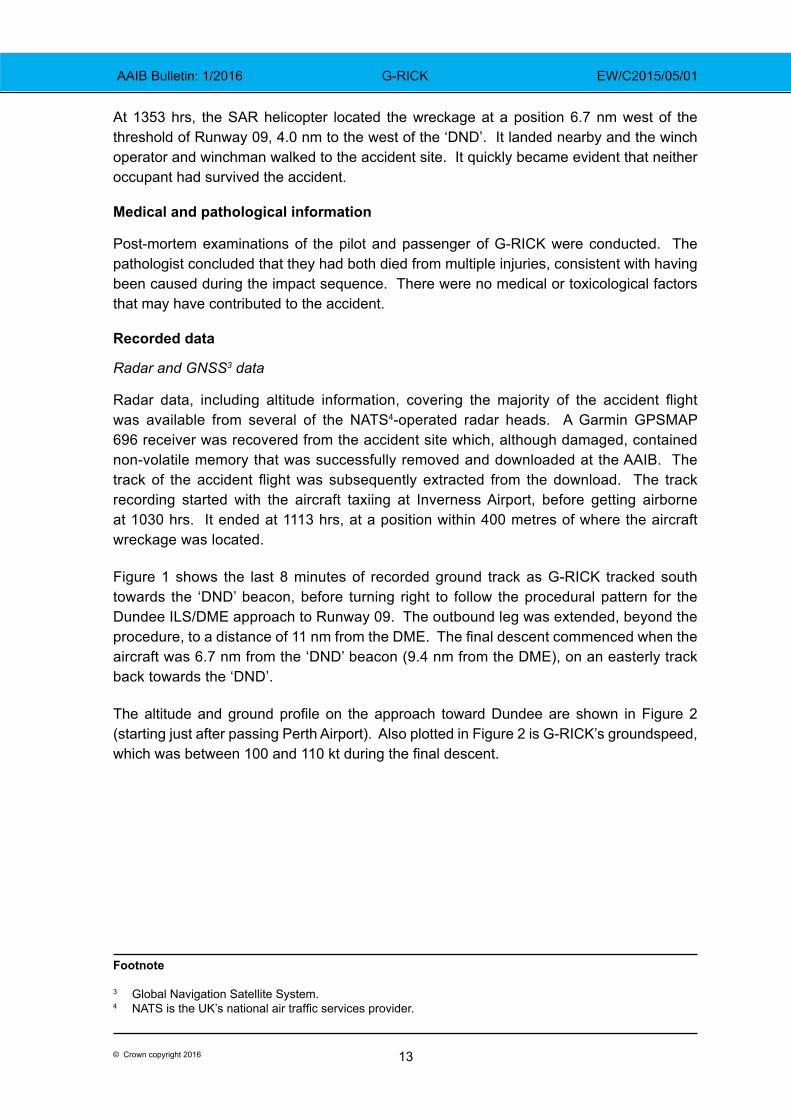
Figure 1 shows the last 8 minutes of recorded ground track as G-RICK tracked south towards the ‘DND’ beacon, before turning right to follow the procedural pattern for the Dundee ILS/DME approach to Runway 09. The outbound leg was extended, beyond the procedure, to a distance of 11 nm from the DME. The final descent commenced when the aircraft was 6.7 nm from the ‘DND’ beacon (9.4 nm from the DME), on an easterly track back towards the ‘DND’.
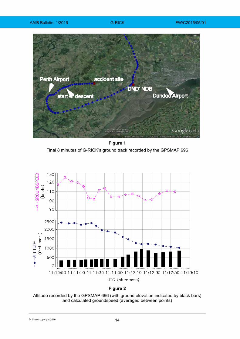
The altitude and ground profile on the approach toward Dundee are shown in Figure 2 (starting just after passing Perth Airport). Also plotted in Figure 2 is G-RICK’s groundspeed, which was between 100 and 110 kt during the final descent.
Footnote
3 Global Navigation Satellite System.4 NATS is the UK’s national air traffic services provider.
14© Crown copyright 2016
AAIB Bulletin: 1/2016 G-RICK EW/C2015/05/01
Figure 1Final 8 minutes of G-RICK’s ground track recorded by the GPSMAP 696
Figure 2Altitude recorded by the GPSMAP 696 (with ground elevation indicated by black bars)
and calculated groundspeed (averaged between points)
accident site
‘DND’ NDBDundee Airport
Perth Airport
start of descent
15© Crown copyright 2016
AAIB Bulletin: 1/2016 G-RICK EW/C2015/05/01
Aircraft information
The Beech Baron is a light twin-engine aircraft designed to be operated by a single pilot. G-RICK was equipped for flight in IMC. In 2009, the avionics equipment was updated by the installation of a Garmin GNS 530W into the Com/Nav 1 position, along with a new antenna and navigation indicator. A terrain database was included in the unit fitted to this aircraft.
The aircraft was also fitted with a Bendix King KNS80 in the Nav 2 positon, installed below the GNS 530W and to the right of the engine instruments. In addition to being able to display navigation and ILS information, it also included a DME receiver. The owner reported that the DME receiver was known to be intermittent, although engineers had been unable to locate a fault.
The aircraft was equipped with an autopilot, but this was unserviceable and the owner reported that the aircraft was always flown manually.
Maintenance history
The Airworthiness Review Certificate (ARC) for the aircraft was issued on 23 October 2014, with an expiry of 20 December 2015. The last scheduled maintenance, a 50 hour/6-monthly inspection, was completed on 24 October 2014 and the next maintenance, an annual inspection, was due on 18 March 2015.
The maintenance organisation had been in discussion with the aircraft owner about completing the overdue annual inspection and the possibility of the aircraft being flown to Dundee. The pilot was aware of these discussions.
As the aircraft had not flown since November 2014, the owner and the pilot of the accident flight flew the aircraft on 17 April 2015 to check for defects before the aircraft went into maintenance. The owner reported that on that flight everything had operated as expected.
In order for the aircraft to be flown with the overdue annual inspection, an application should have been made to the CAA, by the aircraft owner or the maintenance organisation, for a temporary Permit to Fly. There was no evidence that this application had been made.
Accident site
The aircraft first contacted the ground, about 900 ft amsl, on the downslope of a hill approximately 6.7 nm to the west of Dundee Airport and 0.27 nm north of the Runway 09 extended centreline. The aircraft was on a heading of approximately 098°(M), in a wings-level attitude, with the landing gear extended.
The initial contact was with soft ground covered in dense heather; a second contact on similar ground showed evidence of the rotating propellers striking the ground. The aircraft, still in a wings-level attitude, then struck trees on the edge of a lightly wooded area and became fragmented. There were several small localised fuel fires and a scorched area indicated that a brief flash fire had occurred, probably caused by the ignition of atomised fuel ejected from the ruptured fuel tanks.
16© Crown copyright 2016
AAIB Bulletin: 1/2016 G-RICK EW/C2015/05/01
Examination of the evidence at the accident site indicated that the aircraft was intact prior to the impact and the two altimeters had the correct barometric pressure set. The wreckage was then recovered by the AAIB for more detailed examination.
Wreckage examination
Although the wreckage was fragmented and parts had suffered fire damage, it was possible to determine that both engines were producing power at the time of impact. Within the limitations of the impact damage, no evidence was found of any failures that could have contributed to the accident.
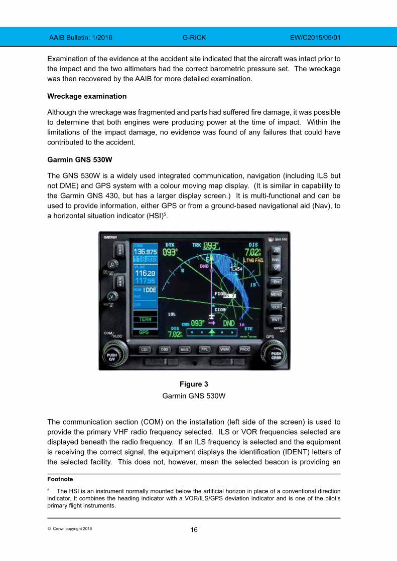
Garmin GNS 530W
The GNS 530W is a widely used integrated communication, navigation (including ILS but not DME) and GPS system with a colour moving map display. (It is similar in capability to the Garmin GNS 430, but has a larger display screen.) It is multi-functional and can be used to provide information, either GPS or from a ground-based navigational aid (Nav), to a horizontal situation indicator (HSI)5.
Figure 3Garmin GNS 530W
The communication section (COM) on the installation (left side of the screen) is used to provide the primary VHF radio frequency selected. ILS or VOR frequencies selected are displayed beneath the radio frequency. If an ILS frequency is selected and the equipment is receiving the correct signal, the equipment displays the identification (IDENT) letters of the selected facility. This does not, however, mean the selected beacon is providing an
Footnote5 The HSI is an instrument normally mounted below the artificial horizon in place of a conventional direction indicator. It combines the heading indicator with a VOR/ILS/GPS deviation indicator and is one of the pilot’s primary flight instruments.
17© Crown copyright 2016
AAIB Bulletin: 1/2016 G-RICK EW/C2015/05/01
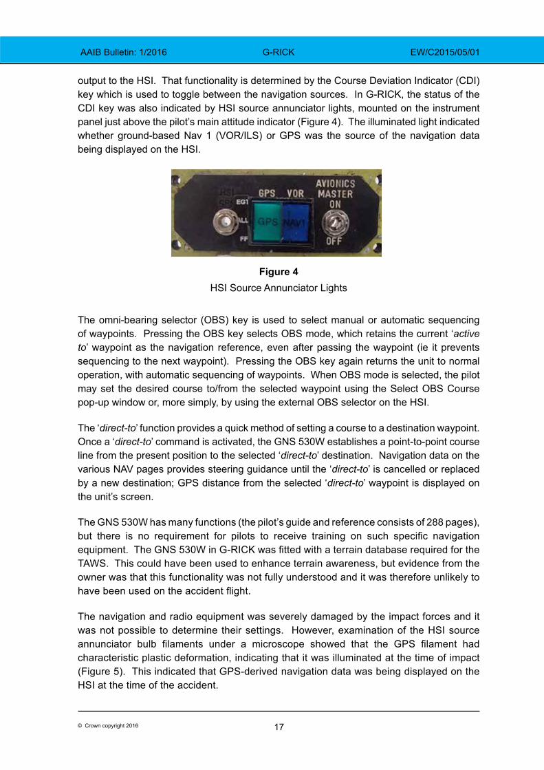
output to the HSI. That functionality is determined by the Course Deviation Indicator (CDI) key which is used to toggle between the navigation sources. In G-RICK, the status of the CDI key was also indicated by HSI source annunciator lights, mounted on the instrument panel just above the pilot’s main attitude indicator (Figure 4). The illuminated light indicated whether ground-based Nav 1 (VOR/ILS) or GPS was the source of the navigation data being displayed on the HSI.
Figure 4HSI Source Annunciator Lights
The omni-bearing selector (OBS) key is used to select manual or automatic sequencing of waypoints. Pressing the OBS key selects OBS mode, which retains the current ‘active to’ waypoint as the navigation reference, even after passing the waypoint (ie it prevents sequencing to the next waypoint). Pressing the OBS key again returns the unit to normal operation, with automatic sequencing of waypoints. When OBS mode is selected, the pilot may set the desired course to/from the selected waypoint using the Select OBS Course pop-up window or, more simply, by using the external OBS selector on the HSI.
The ‘direct-to’ function provides a quick method of setting a course to a destination waypoint. Once a ‘direct-to’ command is activated, the GNS 530W establishes a point-to-point course line from the present position to the selected ‘direct-to’ destination. Navigation data on the various NAV pages provides steering guidance until the ‘direct-to’ is cancelled or replaced by a new destination; GPS distance from the selected ‘direct-to’ waypoint is displayed on the unit’s screen.
The GNS 530W has many functions (the pilot’s guide and reference consists of 288 pages), but there is no requirement for pilots to receive training on such specific navigation equipment. The GNS 530W in G-RICK was fitted with a terrain database required for the TAWS. This could have been used to enhance terrain awareness, but evidence from the owner was that this functionality was not fully understood and it was therefore unlikely to have been used on the accident flight.
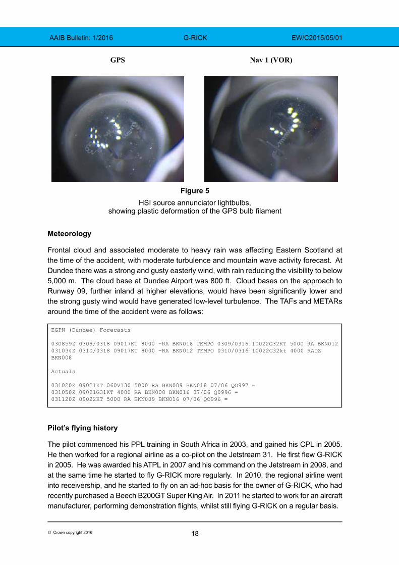
The navigation and radio equipment was severely damaged by the impact forces and it was not possible to determine their settings. However, examination of the HSI source annunciator bulb filaments under a microscope showed that the GPS filament had characteristic plastic deformation, indicating that it was illuminated at the time of impact (Figure 5). This indicated that GPS-derived navigation data was being displayed on the HSI at the time of the accident.
18© Crown copyright 2016
AAIB Bulletin: 1/2016 G-RICK EW/C2015/05/01
Figure 5 HSI source annunciator lightbulbs,
showing plastic deformation of the GPS bulb filament
Meteorology
Frontal cloud and associated moderate to heavy rain was affecting Eastern Scotland at the time of the accident, with moderate turbulence and mountain wave activity forecast. At Dundee there was a strong and gusty easterly wind, with rain reducing the visibility to below 5,000 m. The cloud base at Dundee Airport was 800 ft. Cloud bases on the approach to Runway 09, further inland at higher elevations, would have been significantly lower and the strong gusty wind would have generated low-level turbulence. The TAFs and METARs around the time of the accident were as follows:
Pilot’s flying history
The pilot commenced his PPL training in South Africa in 2003, and gained his CPL in 2005. He then worked for a regional airline as a co-pilot on the Jetstream 31. He first flew G-RICK in 2005. He was awarded his ATPL in 2007 and his command on the Jetstream in 2008, and at the same time he started to fly G-RICK more regularly. In 2010, the regional airline went into receivership, and he started to fly on an ad-hoc basis for the owner of G-RICK, who had recently purchased a Beech B200GT Super King Air. In 2011 he started to work for an aircraft manufacturer, performing demonstration flights, whilst still flying G-RICK on a regular basis.
GPS Nav 1 (VOR)
EGPN (Dundee) Forecasts
030859Z 0309/0318 09017KT 8000 –RA BKN018 TEMPO 0309/0316 10022G32KT 5000 RA BKN012031034Z 0310/0318 09017KT 8000 –RA BKN012 TEMPO 0310/0316 10022G32kt 4000 RADZ BKN008
Actuals
031020Z 09021KT 060V130 5000 RA BKN009 BKN018 07/06 QO997 =031050Z 09021G31KT 4000 RA BKN008 BKN016 07/06 Q0996 =031120Z 09022KT 5000 RA BKN009 BKN016 07/06 QO996 =
19© Crown copyright 2016
AAIB Bulletin: 1/2016 G-RICK EW/C2015/05/01
In 2014 he was employed on a part-time contract, as a first officer, by an airline operating the Boeing 737. During the winter months he was given time off from the airline and he used this time to continue to fly the King Air, and occasionally G-RICK. The pilot was familiar with Dundee, having flown there many times.
The investigation was unable to locate a valid multi-engine piston (MEP) rating for the pilot. His records showed he had a valid King Air rating and Single Pilot Instrument Rating, but the last MEP validation, recorded on his JAA licence, had expired on 31 August 2012. Since that date the pilot’s logbook showed 13 flights in G-RICK prior to the accident flight.
A review of the pilot’s training records held by his previous two employers revealed that he had satisfactorily completed all the required training and testing. There was nothing in his training files considered relevant to the accident.
Dundee Airport
Dundee Airport is located 0.5 nm south of Dundee City and is operated by Highlands and Islands Airports Limited (HIAL). Its Air Traffic Control Zone (ATZ) is located in Class G6 airspace, to the north-west of the RAF Leuchars Military Air Traffic Zone (MATZ). Dundee Airport is not equipped with radar, and ATC provide a Procedural Service to aircraft conducting instrument approaches. There were no approved ATC procedures at Dundee that included the use of GPS-derived information. There is high ground approximately 6 nm to the west of the airport, rising to around 1,200 ft amsl.
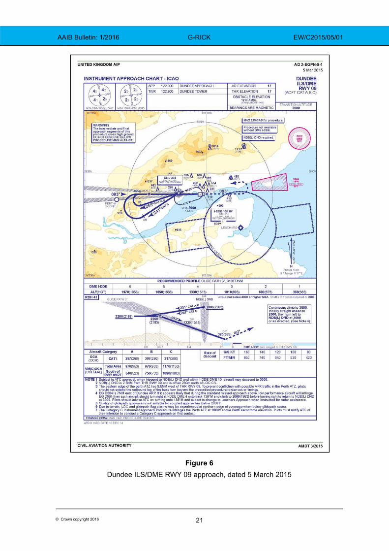
Dundee ILS/DME RWY 09
The ILS/DME procedure for Runway 09 at Dundee, dated 15 March 2015, as published in the UK AIP, was approved by the CAA and was in accordance with International Civil Aviation Organisation (ICAO) Document 8168, Procedures for Air Navigation Services (PANS), Aircraft Operations (OPS), Volume II, Construction of Visual and Instrument Flight Procedures. It is coded I-DDE and transmits on frequency 110.1 MHz. The localiser is aligned with the final approach track for Runway 09, on a magnetic track of 093°. The associated glidepath signal radiates on the frequency-paired channel 334.7 MHz, at a glidepath angle of 3°. The DME, which is frequency-paired with the ILS, indicates zero nautical miles at the threshold of Runway 09.
The ILS/DME procedure begins at the Initial Approach Fix (IAF) - the ‘DND’ NDB. This radiates on the frequency 394.0 kHz and is located 2.6 nm from the threshold of Runway 09, 230 m north of the localiser centreline. Navigation using NDBs is less intuitive for a pilot than navigation using GPS. Anecdotal evidence suggests this may encourage some pilots to use GPS navigation, even where its use is not approved.
Footnote6 Uncontrolled airspace.
20© Crown copyright 2016
AAIB Bulletin: 1/2016 G-RICK EW/C2015/05/01
The UK AIP contains numerous notes concerning this approach, including:
‘Due to terrain, LOC and Glidepath flag alarms may be experienced at northern edge of coverage when below glidepath sector’
‘procedure not available without DME I-DDE’
‘the eastern edge of the Perth ATZ lies 9.5 nm west of THR RWY 09. To prevent conflict with possible VFR traffic in the Perth ATZ pilots should not extend the outbound leg of the base turn beyond the prescribed procedural distances or timings.’
The published procedure (Figure 6) required the aircraft to fly over the ‘DND’ beacon at an altitude of 3,000 ft, then turn onto an outbound track (255° for this category of aircraft) and descend to 2,200 ft amsl. At a distance of 8 nm from the DME, pilots should commence a level right turn and use ILS guidance to intercept the localiser. Pilots should continue to fly level until they intercept the glidepath. As a cross-check, the approach chart indicates that glidepath interception at 2,200 ft should occur when the aircraft is 6.7 nm from the DME. The pilot should then follow the localiser and glidepath guidance down to the decision altitude. There are additional advisory heights on the approach chart at each nautical mile from touchdown.
There is a separate, but very similar, approach chart for aircraft conducting a Localiser/DME approach. This is a non-precision approach, where lateral guidance is provided by the ILS localiser, and the chart provides a recommended profile, with target heights for specified DME distances. This approach has a higher minimum than the ILS and it is used for training, or when the ILS glidepath is not available.
The pilot of an aircraft who flew the ILS approach immediately prior to G-RICK experienced no problems with the guidance during his approach. The ILS was withdrawn from service as a precaution immediately after the accident. The following day it was flight-checked and found to be fully serviceable.
A CAA review of the approach procedures at Dundee Airport concluded that the equipment was serviceable, and that its installation, operating procedures, the Instrument Approach Procedure (IAP), and ATC procedures associated with the approach, all complied with the applicable regulations.
21© Crown copyright 2016
AAIB Bulletin: 1/2016 G-RICK EW/C2015/05/01
Figure 6Dundee ILS/DME RWY 09 approach, dated 5 March 2015
22© Crown copyright 2016
AAIB Bulletin: 1/2016 G-RICK EW/C2015/05/01
Investigation flight
A test flight was conducted in a Beech Baron, fitted with a Garmin GNS 530 feeding navigational information to the HSI, as part of the investigation. Three instrument approaches were flown to Dundee Runway 09 in VFR conditions. The published procedure was flown on the first approach. On the second approach, the ILS/DME was selected on the GNS 530 and the approach was flown leaving GPS as the navigational feed to the HSI. The third approach was flown using the GPS ‘direct to’ function to the ‘DND’. Then, after pressing the OBS button on the GNS 530, the outbound radial from the NDB was selected using the external OBS selector on the HSI, and the aircraft was flown to 8 nm from the ‘DND’ rather than the DME. The inbound radial to the ILS was selected, but the CDI key was not pressed (leaving the GPS source navigating the aircraft to the ‘DND’). On the first two approaches the aircraft’s track was to the south of the accident site, on the third, with the HSI steer bar indicating on track, the test aircraft first flew directly over Perth Airport and then the accident site.
Previous CFIT accidents at Dundee Airport
The investigation reviewed previous CFIT accidents that had occurred on approach in IMC to the same runway at Dundee Airport.
In 1983, G-OCAL, a Partenavia P68B, collided with the ground whilst conducting the NDB approach. The pilot, who held a CPL, descended below the specified descent profile. Later that year G-AZYI, a Cessna 310Q, crashed approximately 200 m from where G-OCAL struck the ground; the pilot, the holder of a Senior CPL, was attempting to fly the NDB approach. In 1988 G-BRAD, a Beech B55 Baron crashed 7.5 nm from the threshold whilst conducting an NDB approach.
At the time of these accidents, the NDB was the only approach aid available at Dundee. The ILS DME for Runway 09 was installed in 1999 to provide a precision approach capability.
Other relevant incidents
The investigation asked several flying instructors, who flew the instrument approach at Dundee regularly, whether they were aware of any issues with the approach. Some instructors reported that it was not uncommon for pilots of GPS-equipped aircraft to mistake GPS ranges from the NDB with DME ranges from the threshold. The instructors stated that one of the key learning points taught to their students was to appreciate the difference between DME and GPS range. Another common mistake was for students to forget to select the CDI key, leaving the HSI to take its information from the GPS source rather than the intended ILS source; many flying schools discourage the mixing of procedural and GPS navigation.
In order to determine if the additional emphasis flight instructors were paying to the problem was effective, CAA examiners, using Dundee for instrument flight tests, were asked if they had observed students mistaking GPS range for DME range, or leaving the HSI in GPS mode during the ILS approach. The examiners confirmed that some students
23© Crown copyright 2016
AAIB Bulletin: 1/2016 G-RICK EW/C2015/05/01
under test were still making these mistakes. One examiner recounted an occasion when a student under test in VMC, but with instrument screens fitted, used GPS referenced distance to the ‘DND’ NDB rather than DME and commenced his descent 2.7 nm early. The aircraft would have come dangerously close to the ground had the examiner not terminated the test.
Bowtie risk model and hierarchy of hazard control
The ‘Bowtie’ is a barrier risk model used by the CAA7, and other organisations, to assist in the identification and management of risk. The AAIB, with assistance from the CAA, created a bowtie model for this accident. The model considered the threats and the preventative controls intended to eliminate the threats entirely, or prevent them from progressing to an unsafe condition. It also considered those controls which should prevent the unsafe condition resulting in an accident.
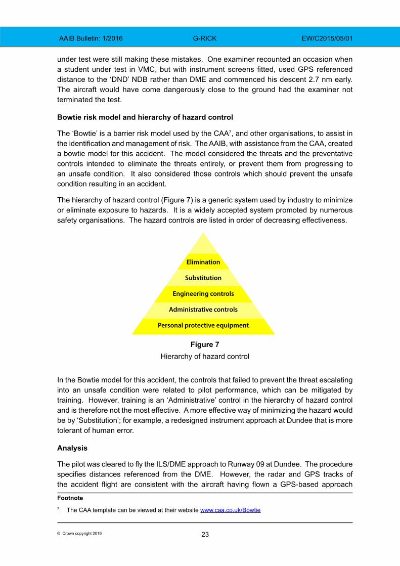
The hierarchy of hazard control (Figure 7) is a generic system used by industry to minimize or eliminate exposure to hazards. It is a widely accepted system promoted by numerous safety organisations. The hazard controls are listed in order of decreasing effectiveness.
Figure 7Hierarchy of hazard control
In the Bowtie model for this accident, the controls that failed to prevent the threat escalating into an unsafe condition were related to pilot performance, which can be mitigated by training. However, training is an ‘Administrative’ control in the hierarchy of hazard control and is therefore not the most effective. A more effective way of minimizing the hazard would be by ‘Substitution’; for example, a redesigned instrument approach at Dundee that is more tolerant of human error.
Analysis
The pilot was cleared to fly the ILS/DME approach to Runway 09 at Dundee. The procedure specifies distances referenced from the DME. However, the radar and GPS tracks of the accident flight are consistent with the aircraft having flown a GPS-based approach
Footnote7 The CAA template can be viewed at their website www.caa.co.uk/Bowtie
Elimination
Substitution
Engineering controls
Administrative controls
Personal protective equipment
24© Crown copyright 2016
AAIB Bulletin: 1/2016 G-RICK EW/C2015/05/01
to the ‘DND’ NDB. The GPS annunciator bulb confirmed that the HSI was being fed by the GPS rather than the ILS and the pilot’s “four mile” R/T call, made when the aircraft was approximately 7 nm from the runway threshold, indicates that he had lost situational awareness8.
Having navigated to the ‘DND’, it is probable that the pilot intentionally flew the outbound radial using the GPS feed to the HSI. The ILS frequency should have been selected on the GNS 530W prior to commencing the approach and its IDENT would have been displayed near the distance to the selected waypoint in use (the ‘DND’). Evidence suggests, however, that the pilot mistook the GPS distance from the ‘DND’ for the distance from the DME; flying instructors and examiners indicated this was a common error.
As he carried out the base turn, the pilot is likely to have selected the ILS inbound course on the HSI but, by omitting to press the CDI key, the HSI would have continued to display GPS, rather than ILS information. This would have presented the pilot with sensible lateral guidance but, with no glideslope information, the glidepath indicator on the HSI should have displayed an ‘Off’ flag. An ‘Off’ flag on the glideslope would concern a pilot wishing to fly an ILS approach. It is possible, however, that the pilot in this accident believed the lack of a glidepath was connected to the warning note on the approach chart about glidepath and localiser flag alarms.
With no glideslope guidance, the pilot may have reverted to a Localiser/DME approach. This required a descent to start at 6.7 nm from the DME. However, the pilot commenced his descent at 9.4 nm from the DME; 6.7 nm from the ‘DND’. This was probably the GPS distance displayed on the GNS 530W. If the pilot was flying the Localiser/DME approach profile to the ‘DND’; he should have been at a height of 1,330 ft amsl at a distance of 4 nm, but the accident occurred with the aircraft at 900 ft amsl. The reason why the aircraft was so low is not clear. However, hill effect9 and turbulent conditions may have been contributory factors.
The accident site was approximately two degrees north of the correct inbound track for the ILS. If ILS data had been selected as the source for the HSI, the steer bar, at this position, would have shown nearly full scale deflection to the right and the glideslope indication would have been full ‘fly up’. Had the pilot programmed the GNS 530W to provide guidance for the ILS approach, the aircraft would probably have followed the track of the correct procedure, as demonstrated by the test flight. With GPS data being displayed, and the GNS 530W selected to navigate ‘direct to’ the ‘DND’, the HSI steer bar would have shown the aircraft to have been on track, albeit with no glideslope indication.
TAWS may have alerted the pilot to the proximity of terrain, had it been selected. However, the screen that would have displayed terrain information was outside the pilot’s primary instrument scan and G-RICK’s GNS 530W was not equipped with any audio terrain alert.
Footnote8 The aircraft’s actual situation is not accurately reflected by the pilot’s perception.9 Hill effect is where an increase in wind speed as air flows over a hill, causes a localised reduction in pressure.
25© Crown copyright 2016
AAIB Bulletin: 1/2016 G-RICK EW/C2015/05/01
Previous accidents at Dundee occurred when the airport was only equipped with an NDB. The ILS/DME provides for a more accurate approach to be flown, increasing the level of safety, but the procedure still commences at the offset NDB. Anecdotal evidence suggests that some pilots may choose to navigate to the ILS using the GPS instead of the NDB, as it is easier to follow. This is not an approved procedure.
This accident can be categorised as Controlled Flight into Terrain (CFIT). The CAA have identified CFIT as one of their ‘Significant 7’, these being the seven top safety concerns identified by CAA safety analysis. In their report (CAA Paper 2011/03) the CAA identified loss of situational awareness as a major factor in the lead up to a CFIT accident. In this accident the pilot’s use of GPS and the approach design probably contributed to his loss of situational awareness. The risk of CFIT was increased by the poor weather and the high terrain on the approach. Radar surveillance, had it been available, would have shown that G-RICK had flown 11 nm outbound from the airport, not the required 8 nm, and the inbound track flown was to the north of the correct track. This might have alerted ATC, but Dundee Airport is not equipped with radar and therefore ATC were unable to observe the aircraft deviating from the published instrument approach procedure.
Discussion
The evidence suggests the GPS was being used in its simplest (‘direct to’) mode. This probably contributed to the pilot confusing GPS distance from the ‘DND’ with DME distance. Modern aircraft GPS units are very capable and complex pieces of navigational equipment. Differences training is required before pilots are permitted to fly aircraft equipped with electronic flight instrument systems (EFIS), yet no formal training is required before pilots can fly with a complex GPS system such as the GNS 530W. Pilots are, however, encouraged to become familiar with the GPS equipment they operate before relying on it. CAA Safety Sense Leaflet 25: ‘Use of GPS’ contains valuable information for pilots on the correct use of GPS.
Despite training and a raised awareness of the risk, even experienced airline pilots can mistake GPS information with information from ground-based navigational aids. Pilots flying an approach in VMC and inadvertently navigating to the wrong position using GPS however, will have sight of the ground before reaching their minima and will be able to recover the situation without endangering the aircraft. Many of these situations probably go unreported and it is likely, therefore, that while GPS-equipped aircraft continue to fly procedures involving offset beacons, errors of this kind will continue.
The CAA commented: ‘the procedures are designed to be flown in a prescribed manner that all IR pilots will be trained for and competent in; going outside SOPs (Standard Operating Procedures) is a factor not related to the design or procedure itself and something that we cannot mitigate’. However, if an approach were designed to start at the airfield, either using an airfield-based beacon or a GPS-defined position (an RNAV waypoint), the risk of a pilot commencing a descent in the wrong place would be significantly reduced. Until recently, the design criteria for instrument approaches did not allow the CAA to grant approval for approach procedures to ground-based navigational aids that commenced at an RNAV waypoint. However, the ICAO design criteria have been amended and the new design criteria, which will allow such approvals, become effective from November 2016.
26© Crown copyright 2016
AAIB Bulletin: 1/2016 G-RICK EW/C2015/05/01
Safety actions
Dundee Airport has high ground on the approach, an offset NDB and no radar surveillance. This combination can result in a pilot inadvertently letting down to the NDB instead of the runway in IMC conditions, with no effective ‘safety net’. Aviation should however, in so far as possible, be an ‘error tolerant’ environment.
As a result of this accident HIAL have implemented a number of immediate safety actions, including amending the ATIS broadcast to include the statement: ‘Pilots are reminded that the NDB and DME are not co-located’.
HIAL have also commissioned a safety survey, to be conducted by a Joint Working Group, with representatives invited from NATS, the CAA and relevant aircraft operators. The survey will investigate the hazards and potential risks associated with the Dundee instrument approach procedures and the remotely located NDB. Its scope is intended to be broad, but will consider the feasibility of:
● relocating the remote NDB to within the airport grounds; ● installing Air Traffic Monitoring in the Visual Control Room; ● amending the notes section of the Dundee instrument approach charts
in the UK-AIP; ● installing power amplifiers to ‘balance’ the output signal from the Glide
Path, in order to remove the warning about localiser and glidepath flag alarms on the instrument approach plate;
● reviewing the Dundee’s RNAV procedure designs, which were submitted to the CAA for approval in June 2014, with a view to establishing RNAV approaches within a reasonable timescale;
● using Automatic Dependant Surveillance Broadcasting (ADS-B10) as an ATC situational awareness tool, as well as other administrative and training mitigations.
The final report of the safety survey, including recommendations made, is expected to be available by the end of January 2016.
Conclusion
The aircraft collided with high ground 6.7 nm to the west of Dundee Airport whilst conducting an instrument approach to Runway 09 in IMC. Evidence indicates that the pilot probably mistook the distances on his GPS, which were from the NDB, as DME distances from the threshold of Runway 09, and therefore commenced his descent too early. Anecdotal evidence suggests that mistaking GPS distance from the ‘DND’ NDB with DME distance is a common error made by pilots. The operator of Dundee Airport is taking safety actions, intended to prevent a recurrence.Footnote10 ADS–B is a cooperative surveillance technology in which an aircraft determines its position via satellite navigation and periodically broadcasts it, enabling it to be tracked.
27© Crown copyright 2016
AAIB Bulletin: 1/2016 AAIB Bulletin: 1/2016 EC-KRN EW/C2015/01/03
SERIOUS INCIDENT
Aircraft Type and Registration: Gulfstream G200, EC-KRN
No & Type of Engines: 2 Pratt & Whitney PW306A turbofan engines
Year of Manufacture: 2008 (Serial no: 188)
Date & Time (UTC): 14 January 2015 at 2127 hrs
Location: London Luton Airport
Type of Flight: Commercial Air Transport (Passenger)
Persons on Board: Crew - 3 Passengers - 3
Injuries: Crew - None Passengers - None
Nature of Damage: Damage to four mainwheels and tyres
Commander’s Licence: Airline Transport Pilot’s Licence
Commander’s Age: 40 years
Commander’s Flying Experience: 3,169 hours (of which 2,010 were on type) Last 90 days - 65 hours Last 28 days - 33 hours
Information Source: Aircraft Accident Report Form submitted by the pilot and further enquiries by the AAIB
Synopsis
Within a second of touchdown, a tyre, probably the right outboard, burst. The flight crew were aware of the burst tyre and perceived that a second tyre had also burst on the right side. They experienced directional control and braking difficulties which resulted in them selecting the emergency braking system. The crew brought the aircraft to a stop on the runway, after which it was found that all four mainwheel tyres had burst.
History of the flight
The aircraft had departed from Dakhla Airport, Morocco, and was on approach to London Luton airport. The commander was the pilot flying (PF) and the co-pilot was not flying (PNF). The aircraft’s Digital Flight Data Recorder (DFDR) did not record the incident flight, so the following series of events was established from the Cockpit Voice Recorder (CVR).
The descent was normal with the aircraft vectored onto the ILS approach for Runway 26. The ATIS, which the crew listened to during the descent, reported turbulence with the wind from 180° at 17 kt gusting 31 kt, variable from between 140° and 210° and the runway reported as “wet-wet-wet”. Having established the aircraft on the final approach, the crew commented about the strong crosswind from the left. The aircraft was fully configured for landing and, having transferred to the tower frequency, was cleared to land, with the controller advising the wind was from 190° at 18 kt gusting 28 kt. Earlier the crew had verbalised the before-descent and approach checklist items.
28© Crown copyright 2016
AAIB Bulletin: 1/2016 AAIB Bulletin: 1/2016 EC-KRN EW/C2015/01/03
The crew disconnected the autopilot at approximately 1,800 ft, following which the PNF managed the thrust levers, at the request of the PF, due to the turbulent conditions, with the approach speed set at VREF +10 kt; VREF was 129 kt based on a landing weight of 25,400 lb. As the aircraft approached the ILS minima, the airspeed was reduced to VREF +5 kt and at about 50 ft the thrust levers were retarded towards the idle position. Within a second of touchdown, a loud bang was recorded on the CVR; from the automatic height callouts the rate of descent at touchdown did not appear to be excessive. This was immediately followed by the PF advising of braking difficulties and the PNF saying “we have a burst tyre”. The PNF encouraged the PF to continue to apply the brakes, but the PF again queried their effectiveness at slowing the aircraft. In response, the PNF called for emergency braking to be selected (this was about 16 seconds after touchdown)1. Two seconds later the emergency brake position was set and two seconds after that a ‘grinding’ sound of varying intensity started; it is likely that this sound was generated by a wheel rim coming into contact with the runway surface. Eight seconds after the emergency brake had been set, a loud short duration sound was recorded, followed by two further similar sounds, two and seven seconds later. These sounds were probably the three remaining tyres bursting. The grinding sound then ceased as the aircraft came to a stop on the runway, 38 seconds after it had initially touched down. The fire service attended the scene but were not needed.
Commander’s report of the incident
The commander believed that after touchdown the aircraft suffered a burst of both right mainwheel tyres, with a couple of seconds delay between them; he thought both tyres had burst because he felt the aircraft lean to the right followed by a more pronounced inclination to the right. Maximum reverse thrust was selected. He stated that his anti skid off light illuminated while the crew were regaining directional control and it was only after the aircraft came to a rest that he realised that all four mainwheel tyres had burst.
Description of the aircraft
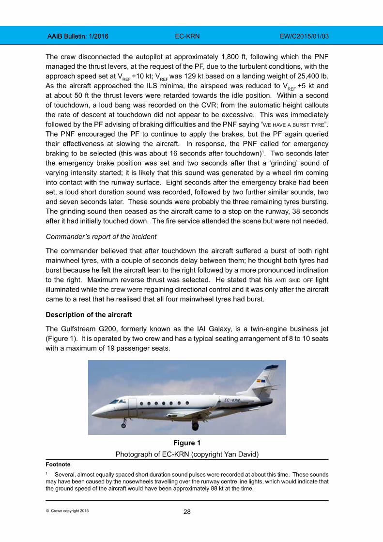
The Gulfstream G200, formerly known as the IAI Galaxy, is a twin-engine business jet (Figure 1). It is operated by two crew and has a typical seating arrangement of 8 to 10 seats with a maximum of 19 passenger seats.
Figure 1
Photograph of EC-KRN (copyright Yan David)Footnote1 Several, almost equally spaced short duration sound pulses were recorded at about this time. These sounds may have been caused by the nosewheels travelling over the runway centre line lights, which would indicate that the ground speed of the aircraft would have been approximately 88 kt at the time.
29© Crown copyright 2016
AAIB Bulletin: 1/2016 AAIB Bulletin: 1/2016 EC-KRN EW/C2015/01/03
Brake system description
The aircraft is equipped with a normal and emergency hydraulic wheel brake system. Brake pedals actuate brake units on each of the four main landing gear wheels. Under normal operation, when the brake pedals are pressed, pressure from the right hydraulic system is metered by a Power Brake Valve (PBV) to two anti-skid control valves, then via fuse and shuttle valves to each of the four brake units.
The emergency braking system is selected by placing the ‘park/emerg’ handle in the emergency position. Under emergency operation, when the brake pedals are pressed, pressure from the left hydraulic system is metered by the PBV via shuttle valves to each of the four brake units. The anti-skid control valves are bypassed under emergency operation so there is no anti-skid protection under emergency braking.
In normal mode the PBV supplies a braking pressure of 1600 ±50 psi and, in emergency mode, a lower pressure with a reduced pedal sensitivity to minimise the probability of tyre skid. However, the aircraft manufacturer has stated that without anti-skid:
‘it takes very little brake pedal application to provide sufficient pressure to the brakes to cause them to skid and eventually blow the tires.’
Parking brake system description
The parking brake is selected by placing the park/emerg handle in the park position. A parking brake on caution message appears on the EICAS2 whenever the parking brake is engaged. A t/o unsafe parking warning message appears on the EICAS with an aural warning if the parking brake is engaged with the aircraft on the ground and the thrust lever set beyond the ‘cruise’ range.
Anti-skid system description
The anti-skid system prevents wheel skidding by limiting the metered brake pressure to the brakes. Maximum braking efficiency is obtained when all wheels are at a maximum rate of deceleration, short of a skidding wheel. Wheel speed sensors in each wheel transmit signals to an anti-skid Electronic Control Unit (ECU) which sends corresponding signals to the anti-skid control valves to vary brake pressure as required.
Prior to and after touchdown the anti-skid system prevents brake pressure being applied (‘anti-skid touchdown protection’) until the wheels have spun up to above 35 kt, or 2.5 to 3.5 seconds have elapsed since transition of one weight-on-wheel switch, whichever occurs first.
The anti-skid pushbutton is located on the left side of the glareshield and serves as the on/off button and also illuminates anti skid off when a failure is detected; a further anti skid off light is located on the right side of the glareshield. There is no associated aural warning with an anti-skid failure and no EICAS message.Footnote2 EICAS is the Engine Indication and Crew Alert System, located centrally on the instrument panel.
30© Crown copyright 2016
AAIB Bulletin: 1/2016 AAIB Bulletin: 1/2016 EC-KRN EW/C2015/01/03
The anti-skid system provides for ‘locked wheel protection’ which will remove brake pressure on both paired wheels whenever the wheel speed on one or both of the wheels drops below 30% of groundspeed. The Gulfstream G200 Airplane Flight Manual (AFM)3 states:
‘After a tire burst at speeds higher than 30 knots a locked wheel condition is detected when the burst wheel speed decreases under 30% of the aircraft groundspeed and braking is lost on both wheels (anti skid off light comes on). The anti-skid system is to be switched off and braking continues.’
The aircraft manufacturer has clarified that, if a tyre bursts at a speed above 30 kt, the burst tyre’s wheel speed can drop below 30% of the aircraft groundspeed. If this occurs, and the wheel speed remains below 35% groundspeed for at least 1 second, then a ‘locked wheel’ condition will be detected and the anti skid off light will illuminate. This will result in all brake pressure being removed from the wheel with the burst tyre and from its adjacent wheel. It will not be possible to apply any brake pressure to either wheel (even if the speed goes back above 35% groundspeed) until either the anti-skid button is pressed or emergency braking is selected. Even though the anti skid off light is illuminated, anti-skid is still operational on the opposite landing gear leg. Pressing the anti-skid button in this situation will completely deactivate anti-skid and will permit normal brake pressure to reach all wheels. Selecting emergency braking in this situation will also result in brake pressure being restored to all wheels, but at a lower pressure, with reduced pedal sensitivity.
Quick Reference Handbook procedure for anti skid off illumination
The Gulfstream G200 Quick Reference Handbook (QRH)4 section for ‘Anti-Skid System Failure’ includes the following:
‘ANTI-SKID OFF light illuminates during landing roll for more than one second:
1. Wheel Brakes…………………………..RELEASE
If light goes out:
2. Wheel Brakes…..............APPLY (AS REQUIRED)
If light remains illuminated:
3. ANTI-SKID Pushbutton………….…..PRESS OFF
CAUTION: when one of the anti-skid off lights illuminate, anti-skid should be turned off to prevent possible asymmetric braking.
4. Wheel Brakes…………….APPLY CAUTIOUSLY
(Consider runway distance and condition.)
Footnote3 Gulfstream G200 Airplane Flight Manual Revision 19, 9 February 2014.4 Gulfstream G200 Quick Reference Handbook Revision 19, 9 February 2014.
31© Crown copyright 2016
AAIB Bulletin: 1/2016 AAIB Bulletin: 1/2016 EC-KRN EW/C2015/01/03
Aircraft manufacturers typically highlight certain emergency QRH procedures as ‘memory items’, procedures to be performed without reference to the QRH. The aircraft manufacturer of the G200 has stated that none of their QRH procedures were ‘memory items’ and that, once a pilot had been trained to fly a G200, they would have been exposed to all types of abnormal and emergency procedures where they would have handled the initial situations without reference to ‘memory items’ in a checklist; examples include a hot engine start, engine failure during takeoff, engine fire, dual generator failure, and a blown tyre during takeoff or landing. It further stated that:
‘pilot actions in such situations are performed in a reflex manner without reference to a check list and can be considered basic airmanship being common to most airplanes’
and that:
‘In the case of an anti-skid failure, all pilots know that heavy braking will cause blown tires. First instinct is get off the brakes if braking is in progress and reapply brakes with less force. If braking is totally lost, the next reflex action is to use the emergency brake to stop the airplane. If directional control is an issue, use of rudder and nose wheel steering is the first reaction to stay on the runway. A G200 pilot familiar with the specific check list may also include the anti-skid off action.’
Commander’s explanation of actions following tyre burst
The commander confirmed that the anti skid off light QRH procedure is not a ‘memory item’ and commented that it is impractical to search for this QRH procedure during a landing roll. He said that, in this instance, he had focussed on maintaining directional control of the aircraft, which he achieved, and stopping the aircraft in the runway distance remaining, which he also achieved. He did not consider turning the anti-skid off and he selected emergency braking because he felt that the normal braking system was not responding properly as they were nearing the end of the runway.
Aircraft examination
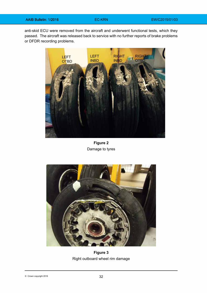
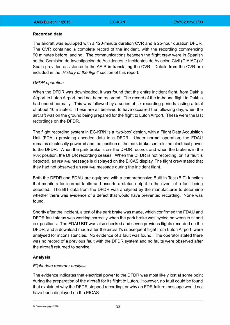
The aircraft was not examined by the AAIB but photographs taken by the operator revealed that all four tyres had flat spots which had worn through the tyre and carcass (Figure 2). The damage to the left tyres and the right inboard tyre appeared to be similar, while the damage to the right outboard tyre covered a more elongated area. All four wheels had suffered rim damage, but the most substantial rim damage was to the right outboard wheel (Figure 3).
Functional tests were carried out on the aircraft which did not reveal any faults with the brakes, anti-skid system, or the parking brake system. The checks included functional tests of the ‘anti-skid system locked wheel protection’, the ‘anti-skid touchdown protection’ and the wiring from the anti-skid transducers to the anti-skid ECU were inspected with no faults found. The DFDR was also tested and operated correctly. The parking brake valve and
32© Crown copyright 2016
AAIB Bulletin: 1/2016 AAIB Bulletin: 1/2016 EC-KRN EW/C2015/01/03
anti-skid ECU were removed from the aircraft and underwent functional tests, which they passed. The aircraft was released back to service with no further reports of brake problems or DFDR recording problems.
Figure 2Damage to tyres
Figure 3Right outboard wheel rim damage
33© Crown copyright 2016
AAIB Bulletin: 1/2016 AAIB Bulletin: 1/2016 EC-KRN EW/C2015/01/03
Recorded data
The aircraft was equipped with a 120-minute duration CVR and a 25-hour duration DFDR. The CVR contained a complete record of the incident, with the recording commencing 90 minutes before landing. The communications between the flight crew were in Spanish so the Comisión de Investigación de Accidentes e Incidentes de Aviación Civil (CIAIAC) of Spain provided assistance to the AAIB in translating the CVR. Details from the CVR are included in the ‘History of the flight’ section of this report.
DFDR operation
When the DFDR was downloaded, it was found that the entire incident flight, from Dakhla Airport to Luton Airport, had not been recorded. The record of the in-bound flight to Dakhla had ended normally. This was followed by a series of six recording periods lasting a total of about 10 minutes. These are all believed to have occurred the following day, when the aircraft was on the ground being prepared for the flight to Luton Airport. These were the last recordings on the DFDR.
The flight recording system in EC-KRN is a ‘two-box’ design, with a Flight Data Acquisition Unit (FDAU) providing encoded data to a DFDR. Under normal operation, the FDAU remains electrically powered and the position of the park brake controls the electrical power to the DFDR. When the park brake is off the DFDR records and when the brake is in the park position, the DFDR recording ceases. When the DFDR is not recording, or if a fault is detected, an fdr fail message is displayed on the EICAS display. The flight crew stated that they had not observed an fdr fail message during the incident flight.
Both the DFDR and FDAU are equipped with a comprehensive Built In Test (BIT) function that monitors for internal faults and asserts a status output in the event of a fault being detected. The BIT data from the DFDR was analysed by the manufacturer to determine whether there was evidence of a defect that would have prevented recording. None was found.
Shortly after the incident, a test of the park brake was made, which confirmed the FDAU and DFDR fault status was working correctly when the park brake was cycled between park and off positions. The FDAU BIT was also checked and seven previous flights recorded on the DFDR, and a download made after the aircraft’s subsequent flight from Luton Airport, were analysed for inconsistencies. No evidence of a fault was found. The operator stated there was no record of a previous fault with the DFDR system and no faults were observed after the aircraft returned to service.
Analysis
Flight data recorder analysis
The evidence indicates that electrical power to the DFDR was most likely lost at some point during the preparation of the aircraft for its flight to Luton. However, no fault could be found that explained why the DFDR stopped recording, or why an FDR failure message would not have been displayed on the EICAS.
34© Crown copyright 2016
AAIB Bulletin: 1/2016 AAIB Bulletin: 1/2016 EC-KRN EW/C2015/01/03
Analysis of tyre bursts
Within a second of touchdown there was a loud bang which was most likely one of the tyres bursting. The right outboard tyre and wheel had suffered the most damage so it was probably this tyre that burst first. The commander perceived that a second tyre burst on the right side a couple of seconds later but there was no associated sound on the CVR for this. The first tyre burst probably caused its wheel speed to drop below 30% of the aircraft’s groundspeed so the ‘locked wheel’ condition was detected, which explains the triggering of the anti skid off light. This would have resulted in a loss of brake pressure not only to the wheel with the burst tyre but also to its adjacent wheel. The remaining brake effectiveness would therefore have been 50% of normal braking effectiveness. This loss of braking, combined with the wet runway surface, was probably the reason why the flight crew were reporting braking difficulties on the CVR and it is what prompted them to select the emergency braking system5. Eight seconds after the emergency brake system was selected there were three loud short-duration sounds, within about seven seconds of each other. These were probably the sounds of the three remaining tyres bursting as a result of flat spots incurred during skidding. Without the protection of anti-skid very little brake pedal application is required to skid a tyre. These three tyres suffered less damage and made less noise when they burst than when the first tyre burst, probably because the aircraft had decelerated by this time and therefore there was less energy in the tyres.
It was considered whether the first tyre burst could have been caused by a failure of the ‘anti-skid touchdown protection’, but this system was tested after the incident with no faults found. The anti-skid ECU was also tested, with no faults. It is therefore possible that the first tyre burst as a result of foreign object damage (FOD). The commander perceived that the right inboard tyre burst a couple of seconds later due to an additional lean to the right, and it is possible that this tyre also burst due to FOD. However, the lack of a second loud bang indicated that it more likely burst later, with the two left tyres, after the emergency braking system was selected.
The QRH procedure for an anti skid off light illumination calls for the anti-skid pushbutton to be pressed off. This is in order to restore brake pressure to any tyres that have not burst and thus prevent asymmetric braking. If the flight crew had pressed this button they would have had normal brake pressure to all four wheels, but without anti-skid the remaining tyres might still have burst as a result of excessive brake pedal application.
The more significant factor that contributed to the long landing ground roll was the approximately 16 second period between the first tyre bursting and the emergency braking system being selected. During this 16 second period only the left two brakes were operational.
Footnote5 Note: selecting the emergency brake system causes the loss of anti-skid but it does not cause the anti skid off light to illuminate.
35© Crown copyright 2016
AAIB Bulletin: 1/2016 AAIB Bulletin: 1/2016 EC-KRN EW/C2015/01/03
‘Memory items’ and the QRH
The aircraft manufacturer expected flight crew to be able to perform the ‘anti skid off’ QRH procedure as a result of training rather than as a result of memorising it. However, highlighting important ‘memory items’ in the QRH can serve as reminders to flight crew and operators as to which procedures need to be rehearsed in recurring training.
Safety actions
Aircraft manufacturer
As a result of this serious incident the aircraft manufacturer has stated that it is reviewing the anti-skid QRH procedure to emphasise the operation of the anti-skid during initial and recurring training.
The AFM system description for the case of a tyre burst was not clear. The text: ‘braking is lost on both wheels (anti skid off light comes on)’ could be interpreted to mean that anti-skid braking is lost, when it is intended to mean that complete braking is lost. It is also not clear whether ‘both wheels’ means adjacent wheels or opposite paired wheels. The fact that brake pressure is lost to both adjacent wheels means that asymmetric braking will occur, but this consequence is not stated in the system description – it only appears in the QRH.
The aircraft manufacturer has stated that it is considering an AFM revision to clarify the procedure in case of a tyre burst.
Aircraft operator
The aircraft operator has stated that it has initiated a process of internal research with the participation of their most experienced G200 pilots to establish suitable mitigation measures to prevent a repeat incident.
36© Crown copyright 2016
AAIB Bulletin: 1/2016 AAIB Bulletin: 1/2016 G-GARD EW/C2015/04/06
ACCIDENT
Aircraft Type and Registration: Bristell NG5 Speed Wing, G-GARD
No & Type of Engines: 1 Jabiru 3300 piston engine
Year of Manufacture: 2014 (Serial no: LAA 385-15269)
Date & Time (UTC): 15 April 2015 at 1010 hrs
Location: Field in Nutfield, near Redhill Aerodrome, Surrey
Type of Flight: First flight of newly built aircraft
Persons on Board: Crew - 1 Passengers - None
Injuries: Crew - None Passengers - N/A
Nature of Damage: Damaged beyond economic repair
Commander’s Licence: Private Pilot’s Licence
Commander’s Age: 55 years
Commander’s Flying Experience: 800 hours (of which 150 were on type) Last 90 days - 6 hours Last 28 days - 6 hours
Information Source: Aircraft Accident Report Form submitted by the pilot and subsequent AAIB enquiries
This was the aircraft’s first flight. The pilot carried out engine ground runs, then performed fast taxi runs, selecting each fuel tank and checking the engine with and without carb heat applied. Prior to takeoff, he selected the carb heat on and turned on the electric fuel pump. The takeoff and climb out were uneventful, and at 1,000 ft he switched off the fuel boost pump. He reported downwind for a low approach and go-around but, shortly afterwards, the engine stopped suddenly. The pilot selected the other fuel tank and turned the electric fuel pump on, but was unable to restart the engine. He could not make the airfield and so he elected to land in a small field. The landing was hard and the aircraft came to a stop before the trees at the end of the field. The pilot exited without injury.
The engine was inspected by an engineer experienced on the engine type. The engine was removed and ran satisfactorily on a test rig after new coils were fitted. It was not possible to determine conclusively why the engine had stopped, but fuel starvation or double coil failure were considered possible causes.
37© Crown copyright 2016
AAIB Bulletin: 1/2016 G-BHXK EW/C2015/04/01
ACCIDENT
Aircraft Type and Registration: Piper PA-28-140 Cherokee, G-BHXK
No & Type of Engines: 1 Lycoming O-320-E2A piston engine
Year of Manufacture: 1965 (Serial no: 28-21106)
Date & Time (UTC): 4 April 2015 at 1030 hrs
Location: Near Loch Etive, Oban, Argyll and Bute
Type of Flight: Private
Persons on Board: Crew - 1 Passengers - 1
Injuries: Crew - 1 (Fatal) Passengers - 1 (Fatal)
Nature of Damage: Aircraft destroyed
Commander’s Licence: Private Pilot’s Licence
Commander’s Age: 28 years
Commander’s Flying Experience: 150 hours1 (of which 100 were on type) Last 90 days - 62 hours Last 28 days - 19 hours
Information Source: AAIB Field Investigation
Synopsis
The aircraft was on a private flight from Dundee Airport to Tiree Airport. While established in the cruise at an altitude of 6,500 ft it entered a gentle right turn, the rate of which gradually increased with an associated high rate of descent and increase in airspeed. The aircraft struck the western slope of a mountain, Beinn nan Lus, in a steep nose-down attitude. Both persons on board were fatally injured.
No specific cause for the accident could be identified but having at some point entered IMC, the extreme aircraft attitudes suggest that the pilot was experiencing some form of spatial disorientation and the recorded data and impact parameters suggest that the accident followed a loss of control, possibly in cloud.
History of the flight
The pilot had arranged to fly to Tiree with his wife for a family visit, departing on Saturday, 4 April, the day of the accident, and returning on Monday evening. They were recorded on CCTV arriving at the airport with luggage and some boxes, which they loaded into the aircraft. The pilot spoke briefly to the duty instructor at the flying club, where he kept his aircraft, but did not use their flight planning facilities as he had his own flight planning application on his iPad. This provided the capability to enter the route from Dundee to Tiree Footnote1 The pilot’s first log book was not available to the investigation and the total hours stated are derived from a number of sources.
38© Crown copyright 2016
AAIB Bulletin: 1/2016 G-BHXK EW/C2015/04/01
and access the relevant information such as weather and NOTAMs. It was later established from the software provider that the pilot had accessed the web site on 3 April 2015, the day before the accident, and again on the morning of the accident flight. It was not possible to establish the times or activity carried out during those sessions.
The weather that morning is covered in detail in the Meteorology section of this report, but the pilots of several other aircraft who had considered flying west from Dundee, elected not to do so due to the presence of a warm front over the west coast of Scotland. The pilot’s wife had contacted a relative in Tiree the evening before the flight and on the morning of the flight texted the relative asking what the weather conditions were like. When she was told it was misty she responded that the pilot had checked the weather and had said that it was due to clear at 1100 hrs, although it was not stated whether this was local time or UTC. The relative sent a picture of the conditions to the pilot’s wife.
Having loaded the aircraft, the pilot taxied the aircraft to the refuelling point, where one of the flying club instructors filled both wing tanks to full. Having signed for the fuel, the pilot started the aircraft and requested taxi for a flight to Tiree, with two persons on board and five hours endurance. This was approved and the aircraft taxied in accordance with ATC instructions to Holding Point Alpha before being cleared to line up on Runway 27. The aircraft was cleared for take-off and departed Dundee at 0938 hrs. It climbed to 6,500 ft and the pilot contacted Scottish Information at 0948 hrs. The aircraft was allocated a transponder code 7401, Mode C and received a basic service. The pilot also made a brief courtesy call to the AFISO at Perth on his other radio, to make him aware of the aircraft’s position, height and routing.
The aircraft was fitted with a Garmin 295 GPS navigation system, which the pilot normally used to enter his route and he also carried a 1:500,000 aviation chart covering the route to be flown.
The aircraft continued on its westerly track (Figure 1), maintaining the same altitude on the regional QNH of 1023 HPa.
At 1027 hrs G-BHXK was approximately 15 nm east of Oban Airport, when a commercial aircraft inbound for Tiree contacted Scottish Information who transmitted the 0950 hrs Tiree METAR; “the tiree 950 is an automatic metar, surface wind three zero zero one two knots, visibility three thousand eight hundred metres in mist, overcast at two hundred feet, the system unable to detect towering cumulus or cb, temperature plus niner, dew point plus eight and the tiree qnh 1025 ”. The pilot of the commercial aircraft responded, “we’ll not be going there then, qnh 1025, and that’s 950, as i say we’ll give you a call back in ten minutes or so just to see if you’ve got the latest”. This was monitored and also acknowledged by the pilot of G-BHXK who transmitted “thanks very much, golf xray kilo”.
At 10:28:28 hrs, as the pilot of G-BHXK acknowledged the weather report, the aircraft commenced a gentle turn to the right, maintaining its altitude. After some 40 seconds, the rate of turn increased and the aircraft entered a tightening turn to the right, with a significant rate of descent. If not already in cloud, at some point during the descent the aircraft would have entered IMC which would have persisted all the way to the ground.

39© Crown copyright 2016
AAIB Bulletin: 1/2016 G-BHXK EW/C2015/04/01
Later analysis of the recorded data showed that, with the extreme attitude and rapid change of direction, the accuracy of the radar-derived and GPS-derived track and height information became unreliable. It is possible that a final 360° tight turn was completed before the aircraft impacted the ground at high speed on a westerly heading.
The SAR helicopter which was deployed from Prestwick to search for G-BHXK was unable to reach the accident site due to the low cloud base in the area. Following its search, the helicopter climbed to 4,000 ft for the return flight to Prestwick. The commander of the helicopter noted that they were VMC ‘on top’ of the layer of stratus cloud at that altitude but that there were cumulus clouds appearing to break through the top of the stratus layer.
Pilot qualifications and experience
The pilot had started flying training on 11 April 2012 and his PPL was issued on 10 June 2014. He held a Class 2, Joint Aviation Authorities Medical Certificate with no limitations, issued on 18 May 2012 and valid to 18 May 2017. He commenced his IMC rating training on 3 November 2014 and successfully passed the flight test on 31 January 2015. He completed his Night Rating test on 27 March 2015. At the time of the accident, the pilot had not submitted the forms to the CAA to have the IMC and Night Ratings endorsed on his licence.
Whilst on holiday abroad in December 2014, the pilot’s Flying Log Book was stolen and he started a new log book with the first entry on 3 November 2014. The investigation was
G-BHXK GPS track Direct route from Dundee to Tiree
Accident site
Dundee Airport
Figure 11:500,000 chart showing MSA, G-BHXK track (red) and direct route to
Tiree from Dundee (black)
40© Crown copyright 2016
AAIB Bulletin: 1/2016 G-BHXK EW/C2015/04/01
unable to establish accurately his total flying hours but these would have been in excess of the 130 hours recorded in his training records, known previous flights and his new log book.
It was reported that, during his IMC training and his test, the pilot had demonstrated an above average standard and had been keen to experience actual IMC rather than flying under a ‘hood’ or ‘foggles’. His instructor could not recall the pilot ever having experienced any spatial disorientation episodes during the course. The course included recovery from unusual attitudes and again, the pilot had demonstrated a good level of ability. The same instructor had accompanied the pilot on a cross-country flight in IMC during which the pilot had been operating a radio or navigation system and the aircraft had entered a gentle right turn. The instructor made the pilot aware of his deviation from heading, which he promptly corrected.
The pilot had previously demonstrated a responsible approach to poor weather when, on a flight to Tiree, the weather had deteriorated after his arrival. Instead of attempting to fly back, his wife travelled on a commercial flight to Dundee to attend her work and the pilot waited for an improvement in the weather before departing.
Aircraft history
The aircraft was built in 1965 and accumulated in excess of 8,700 flight hours at the time of the accident. The aircraft’s registration records indicated that it was first registered in the United Kingdom in 1980, since when it had five changes of ownership, with the final owner (the pilot) acquiring it in July 2014. The engine installed in the airframe was constructed in 1990 and had achieved approximately 1,300 hours since its last overhaul. The engine was removed in July 2012, at around 1,180 operating hours, due to worn camshaft lobes and, following repair, was re-installed in October of the same year. During the repair, a modification was embodied that increased the engine power from 140 to 160 hp.
The aircraft documentation included engine and airframe log books, which indicated that the most recent maintenance was an Annual Inspection, carried out on 2 December 2014. In addition there was an Airworthiness Review Certificate that was valid until 7 July 2015. The log book entries contained no records of flights after 4 November 2014 (the last flight before the Annual Inspection). Inquiries suggested that flights were routinely recorded in a separate log, before being periodically transferred to the aircraft log books. The pilot’s flying log book indicated that he had flown G-BHXK on at least 12 days between 4 November 2014 and 25 February 2015, sometimes with two or three flights per day, which totalled more than 21 hours.
Accident site details
The aircraft crashed on the down-slope on the western flank of Beinn nan Lus at an elevation of approximately 500 m amsl. The distribution of the wreckage indicated that the impact track was approximately 265°M. The terrain was rugged, with the ground consisting of grass-covered boggy earth, with outcrops of rock. The slope in the area of the impact was approximately 20° and was aligned with the impact track. The flight path angle, assessed from items such as the wing tip structural components that had penetrated the ground, was around 20-25° relative to the local slope, so the dive angle
41© Crown copyright 2016
AAIB Bulletin: 1/2016 G-BHXK EW/C2015/04/01
of the aircraft was probably around 45°. A small number of airframe fragments had been ejected up to around 20 m rearwards from the impact point, with a large quantity of debris being projected some 60 m down the track.
The impact was severe, with the bulk of the airframe being brought to a halt in the soft earth over a distance of 1-2 m. This had resulted in the disintegration of the airframe, with chordwise crumpling of the wing structure releasing the upper skins of each wing. There was similar longitudinal crushing of the fuselage, resulting in the door separating into two pieces and being found a few metres beyond the fuselage. The empennage had sustained the least damage and had landed on top of the main wreckage. Forward of the wing leading edges, the aircraft had fragmented in the impact, with debris from the cockpit, including instruments and flying control components, forming the bulk of the wreckage items downhill from the impact point. The engine had penetrated the earth to a depth of around 0.8 m before striking a large rock. This had resulted in extensive damage to the underside of the crankcase and the removal of the carburettor and air box, together with other accessories, including the magnetos, from the rear of the accessory gearbox. The remaining bulk of the engine had emerged from the crater it had made and rolled some 35 m down the hillside. The propeller had become detached at impact and was found close to the engine; the blades had sustained chordwise scuffing, with significant damage to one leading edge, indicating that the engine was developing power at impact.
The disruption of the wreckage was consistent with a high-speed impact, likely to have been considerably higher than the maximum cruise speed of around 125 kt. The disposition of the wreckage, with the ground marks and probable dive angle, indicated that the aircraft struck the ground in an upright attitude, with a small amount of roll to the left. The wing tip fairings had remained in the holes in the ground they had made at impact and the distance between them was 30 ft, the wingspan of this aircraft type. It was thus concluded that there had been no significant airframe overload distortion prior to impact, such as might have resulted from a violent flight control input.
Following the on-site examination the wreckage was collected together and air-lifted by helicopter to the base of the mountain, from where it was taken to the AAIB’s facility at Farnborough.
Detailed examination of the wreckage
General
The wreckage was subjected to detailed examination of the structure, flying controls, engine and as many of the instruments as could be identified. The investigation was hampered by the severe damage to the aircraft that had occurred during the impact. All the structural failures were identified as being the result of the ground impact, with no evidence of a pre-impact structural failure. Despite the damage to the wing skins, the fuel filler caps had remained in place. The pieces of the door were examined and the damage to the latch mechanism indicated that the door was closed at the time of the impact.
42© Crown copyright 2016
AAIB Bulletin: 1/2016 G-BHXK EW/C2015/04/01
Flying controls
The primary flight controls on this aircraft type are conventional and simple, with a cable system used between the cockpit controls and the surfaces. The cables had remained attached to the surfaces but had sustained overload failures in the areas of maximum disruption, close to where they had been attached to the rudder pedals and control yokes. It was concluded that there had been no pre-impact disconnect.
The elevator trim system consisted of a trim tab operated by a handle in the cockpit roof. The handle was connected via a cable loop to a screwjack mounted below the rudder; the jack was in turn connected to the tab. The nature of the impact would have relieved the tension in the cable circuit, thus tending to preserve the pre-impact setting. This was found to be in the approximate neutral position.
The flap operating lever, together with the ratchet/detent plate at its base, had been heavily damaged in the impact. A roller that engaged with a detent at each flap position was missing and there was no compelling evidence as to which setting had been engaged prior to the impact. However, the flap positions relative to the (heavily distorted) wing trailing edges suggested they had been retracted at impact.
Engine
Due to the engine damage it was not possible to determine the position of the carburettor heat control or to test the magnetos.
Through a hole in the crankcase underside it was apparent that the forward end of the crankshaft had been bent through an angle of around 15°, causing it to fracture the crankcase around the front journal bearing. The spark plugs and cylinders were removed and examined. The plugs were normal in appearance, as were the combustion deposits on the piston crowns and cylinder heads. The cylinder bores were free from scores or any other evidence of pre-impact distress. Removal of the accessory gearbox cover revealed that the gear wheels were still in mesh. The crankcase was split to gain access to the internal components and it was found that the bearings and inserts, the camshaft lobes and cam followers were all in good condition, with no evidence of pre-impact mechanical distress or lubrication failure.
Cockpit
The extreme damage to the instrument panel and instruments meant that there was little meaningful or reliable information to be obtained from them. The altimeter subscale was found to be set to approximately 1023 HPa, which was the Regional QNH.
The face of the airspeed indicator had become separated from its mechanism: a straight scratch on the surface was roughly aligned with the 180 kt area of the scale, although there was no evidence that confirmed the mark had been made by the indicating needle at impact. The attitude indicator had been severely crushed and it was not possible to establish an impact attitude indication. The instrument contained a gyroscope, powered by suction generated by a vacuum pump mounted on the engine accessory gearbox. Disassembly
43© Crown copyright 2016
AAIB Bulletin: 1/2016 G-BHXK EW/C2015/04/01
of the pump revealed that some of the spring-loaded carbon vanes were fractured but the lack of small fragments indicated they had not been rotating in this condition, so the vane damage is likely to have occurred at impact.
Indication of the vacuum pressure (suction) generated by the pump is provided by the suction gauge; the front face of this instrument, together with its aneroid capsule, were recovered and the indicating needle was found between 4 and 5 psi. This represented a typical in-flight value, although there was no supporting evidence that it was a pre-impact indication.
Most of the fuel pressure gauge was recovered, with the indicator needle approximately in the centre of the green ‘operating range’. This was a ‘moving coil’ type of instrument, the delicate mechanism of which does not lend itself to the preservation of evidence. However, the needle had been firmly pressed onto the scale by an object striking the front of the instrument and, as with the suction gauge, the indication was a typical in-flight value.
The fuel selector on this aircraft type is a rotary knob operating a three-way valve and is located on the left wall of the cockpit. It is used to select fuel from either the left or right wing tanks. Thus the three available selections are left, right and off. In this case the impact had destroyed the selector knob, and had broken off the right tank feed line fitting from the valve body. Examination of the component indicated that the left tank was selected at the time of the impact.
In summary, the examination of the wreckage did not provide any evidence of an aircraft defect before the impact with the ground.
Meteorology
On the day of the accident, the surface analysis charts valid at 0600 and 1200 showed a high pressure system centred to the west of Ireland. A warm front orientated north-south was moving eastwards, affecting western Scotland, and at the time of the accident was passing over the area of the accident site. The weather on the east coast of Scotland was good, following the passage of an earlier occluded front. The METARs for Dundee (EGPN) covering the time of departure were:
METAR EGPN 040920Z 26007KT 9999 FEW049 08/05 Q1023=METAR EGPN 040950Z 24007KT 9999 FEW049 09/06 Q1023=
These indicated a light westerly wind with visibility in excess of 10 km and 1 to 2 oktas at 4,900 ft.
There were no TAFs available for Tiree and Oban at or before the time of the accident. The Islay (EGPI) TAFs were probably the closest representative forecasts for the destination airfield and these were:
44© Crown copyright 2016
AAIB Bulletin: 1/2016 G-BHXK EW/C2015/04/01
TAF EGPI 040501Z 0406/0415 28008KT 6000 BKN010 TEMPO 0406/0412 3000 BR BKN005 PROB30 TEMPO 0406/0410 0600 FG BKN001 PROB40 TEMPO0412/0415 4000 BR BKN008=
TAF EGPI 040800Z 0409/0418 28007KT 6000 FEW010 BKN015 TEMPO 0409/0410 0600 FG BKN000 TEMPO 0410/0412 3000 DZ BR BKN005 PROB40 TEMPO 0412/0418 4000 BR BKN008=
These TAFs, which would have been available to the pilot, indicated a visibility of 6,000 m with a significant cloud base of 1,500 ft, with temporary reductions to 600 m in fog and cloud to the surface until 1000 hrs, with temporary reductions of visibility 3,000 m in drizzle and mist and cloud at 500 ft at the time of the accident.
Tiree was recording auto METARs throughout the period, which were available prior to departure and, when airborne, through Scottish Information. The winds were north-westerly at about 10 to 12 kt. The visibility was variable and at the time of departure from Dundee the visibility at Tiree was 2,300 m in mist. The cloud base throughout the period of the flight was 5 to 7 oktas at 200 ft, with some observations recording a second broken layer above this at 1,800 ft. The airport elevation is 18 ft.
Oban, the closest airfield to the accident site, had light east to south-easterly winds. The visibility fluctuated between 1,500 and 6,000 m in slight or moderate drizzle. Cloud bases varied throughout the period. At the closest observation of the accident (1020 hrs) the cloud bases were 1 or 2 oktas at 1,000 ft and 8 oktas at 1,200 ft. The 1050 observation showed a deterioration in visibility, with mist developing.
The cloud forecast to the east of the warm front was broken or overcast stratus or stratocumulus, with tops at 4,000 to 7,000 ft, and areas of broken or overcast stratus with tops of 1,000 ft. To the west of the warm front the cloud forecast was scattered or broken (locally ‘few’ to the lee of mountains) cumulus or stratocumulus, with tops at 4,000 to 6,000 ft, with occasional (‘isolated’ from 1100 hrs) broken stratus with tops at 1,500 ft.
The freezing level recorded by an aircraft equipped with the Aircraft Meteorological Data Relay (ADMAR) system departing at 1020 hrs from Glasgow Airport was 6,000 ft. At this height, around the cruising altitude of G-BHXK, there would have been a risk of moderate icing in cloud.
Weight and Centre of Gravity
The maximum permissible weight for the aircraft was 2,150 lbs with the Centre of Gravity (CG) datum defined as 78.4 inches ahead of the wing leading edge. The forward CG limit for 1,950 lbs is 86.5 inches aft of the datum and for 2,150 lbs is 90.1 inches aft of the datum. The aft CG limit is 94.0 inches at all weights.
The weight and balance for the aircraft at the time of the accident was estimated from available data as 2,013 lbs with a CG position of 88.25 inches aft of the datum. The aircraft therefore appears to have been operated within its permitted weight and CG envelope throughout the flight.
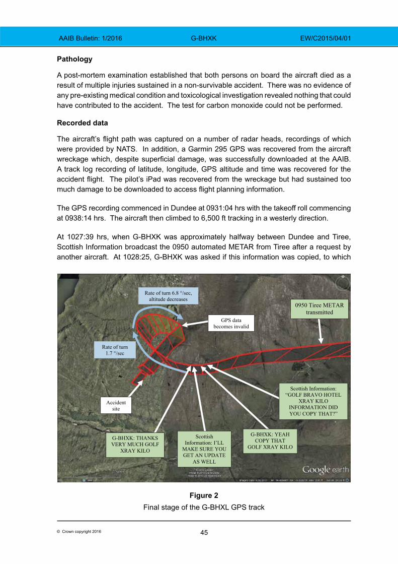
45© Crown copyright 2016
AAIB Bulletin: 1/2016 G-BHXK EW/C2015/04/01
Pathology
A post-mortem examination established that both persons on board the aircraft died as a result of multiple injuries sustained in a non-survivable accident. There was no evidence of any pre-existing medical condition and toxicological investigation revealed nothing that could have contributed to the accident. The test for carbon monoxide could not be performed.
Recorded data
The aircraft’s flight path was captured on a number of radar heads, recordings of which were provided by NATS. In addition, a Garmin 295 GPS was recovered from the aircraft wreckage which, despite superficial damage, was successfully downloaded at the AAIB. A track log recording of latitude, longitude, GPS altitude and time was recovered for the accident flight. The pilot’s iPad was recovered from the wreckage but had sustained too much damage to be downloaded to access flight planning information.
The GPS recording commenced in Dundee at 0931:04 hrs with the takeoff roll commencing at 0938:14 hrs. The aircraft then climbed to 6,500 ft tracking in a westerly direction.
At 1027:39 hrs, when G-BHXK was approximately halfway between Dundee and Tiree, Scottish Information broadcast the 0950 automated METAR from Tiree after a request by another aircraft. At 1028:25, G-BHXK was asked if this information was copied, to which
0950 Tiree METAR transmitted
Scottish Information: “GOLF BRAVO HOTEL
XRAY KILO INFORMATION DID YOU COPY THAT?”
G-BHXK: YEAH COPY THAT
GOLF XRAY KILO
Scottish Information: I’LL
MAKE SURE YOU GET AN UPDATE
AS WELL
G-BHXK: THANKS VERY MUCH GOLF
XRAY KILO
Accident site
Rate of turn 1.7 °/sec
Rate of turn 6.8 °/sec, altitude decreases
GPS data becomes invalid
Figure 2Final stage of the G-BHXL GPS track
46© Crown copyright 2016
AAIB Bulletin: 1/2016 G-BHXK EW/C2015/04/01
G-BHXK replied at 1028:28 hrs “yeah copy that golf xray kilo”. At the same time that this transmission was made, the aircraft heading began to slowly increase at an approximately constant rate over the next 38 seconds, from 252°T to 317°T, (1.7°/second). During this time, the recorded altitude remained constant at 6,500 ft but the derived groundspeed reduced from 98 kt to 71 kt.
Just after the heading began to increase, at 1028:31 hrs, Scottish Information advised “i’ll make sure you get an update as well” to which G-BHXK replied “thanks very much golf xray kilo” at 1028:33 hrs.
At 1029:08 hrs, the rate of turn and groundspeed began to increase and the altitude decreased, with the final valid GPS position recorded 21 seconds later. At this point, the aircraft’s heading was 123°T, representing an average rate of turn over the 21 seconds of 6.8 °/second. After 1029:08 hrs, the recorded GPS position and altitude became erratic and unreliable. In previous accidents investigated by the AAIB, when an aircraft enters a tight turn it can lead to obscuration of the GPS antenna by the aircraft structure. This can have an effect on the positional accuracy and, considering the increased rate of turn encountered by G-BHXK, this is likely to have been the case.
The Mode C altitude continued to be recorded by the radar, with the final recording of 3,900 ft at 1029:39 hrs. This gave an average vertical speed during the descent of 5,200 ft/min. With the accident site elevation of approximately 1,250 ft, there may have been an additional turn which was not recorded.
Analysis
Engineering
The examination of the accident site and the wreckage indicated that the aircraft had struck the ground at high speed, in an erect attitude and with a flight path angle of around 45° to the horizontal. The steepness of this flight path suggests that the aircraft was not fully under control at the time, although the lack of significant bank angle could also suggest that the pilot was in the process of recovering from the dive. There was no evidence of pre-impact structural failure or detachment, or of any flying control disconnect.
Examination of the engine indicated that it had been developing power at impact and that the internal components had been in good condition. Further, evidence from some of the cockpit instruments suggested that the engine had been operating normally. The attitude indicator was too badly damaged to provide evidence as to its indication at the time of the impact; however, the vacuum pump, an essential component in this system, appears to have been operating normally.
Prevailing weather conditions for the flight
The aircraft departed Dundee Airport in fine aviation conditions with a light westerly wind, 1 to 2 oktas of high cloud at 4,900 ft and visibility in excess of 10 km. As the flight progressed
47© Crown copyright 2016
AAIB Bulletin: 1/2016 G-BHXK EW/C2015/04/01
westwards towards Tiree, it would have encountered a deterioration in the weather as it flew towards the warm front which was moving eastwards across the region. From the surface observations, broken and overcast stratus was widely reported from 200 ft at Tiree to 1,400 ft at Oban, and was becoming lower at the time of the accident. Given Oban airfield’s elevation of 18 ft and the height of Beinn nan Lus mountain, the accident site, about 12 nm east north east of Oban, would have been in the cloud.
The cloud tops were forecast as 4,000 to 6,000 ft to the west of the front and 4,000 to 7,000 ft to the east. The freezing level was forecast at 6,000 to 8,000 ft but the ADMAR report at Glasgow Airport accurately recorded it at 6,000 ft. There would have been a risk of moderate icing in cloud above this height.
The flight planning application on the pilot’s iPad had accessed information on the morning of the accident. It would have provided weather information and, although no TAF was available for Tiree, the TAF for Islay would have been an indication of the forecast for Tiree. The automated METARs for Tiree were available and would have shown the weather was not suitable for a VFR ‘surface contact’ flight, but a VMC ‘on top’ transit flight might be achievable, subject to conditions en route and weather at the destination permitting a VMC arrival. The pilot also had a laptop computer and mobile phone with which he may have accessed the Met Office web site but all this equipment was damaged in the accident and the data was not retrieved.
The flight
The pilot had filled the aircraft fuel tanks which, as he had declared to Dundee ATC, gave him five hours endurance. This would have been sufficient to overfly Tiree and, if there was no improvement in the weather, return to Dundee. It is not known whether this was the pilot’s intention.
From the forecast tops of the clouds, it is probable that the initial part of the flight was in VMC above the cloud. As the flight progressed to the west and the height of the cloud tops increased it is possible that the aircraft entered IMC. Flying above the cloud would have placed a greater reliance on the Garmin 295 GPS navigation system than on the pilot’s 1:500,000 chart and navigation aids such as VOR and DME were available to him, enabling calculation of Minimum Safe Altitudes (MSA).
It is significant that when the Tiree 0950 METAR was passed to the commercial flight at 10:27:38 hrs, and acknowledged by the pilot of G-BHXK at 10:28:28, the aircraft commenced a controlled, and initially level, right turn. It is likely that the pilot realised that it was not going to be possible to continue the flight and decided to return to Dundee or another airfield, although he did not state this to ATC at the time.
Whilst the pilot had successfully completed his IMC rating course and passed the flight test, he had not submitted the documentation to have the rating endorsed on his licence. He was therefore legally limited to flights in Visual Meteorological Conditions (VMC). During the IMC training his instructor could not recall the pilot having suffered any spatial disorientation
48© Crown copyright 2016
AAIB Bulletin: 1/2016 G-BHXK EW/C2015/04/01
and the only instance of a significant deviation from an intended heading was when the pilot was operating a radio navigation system and not fully monitoring his flight instruments.
Loss of control
The recorded data indicates that the apparently level and controlled turn developed into a spiral dive, consistent with some form of spatial disorientation. In the absence of any evident technical or physiological reason for the descending manoeuvre, it is likely that the aircraft, prior to or during the right turn, had entered cloud or that the pilot had experienced some loss of, or false, visual horizon. The gentle initial right turn is likely to have been the commencement of a deliberate turn back to the east or from the pilot carrying out some cockpit activity, such as adjusting the navigation equipment while not monitoring the flight instruments, as had occurred with his instructor. This in turn may have led to him becoming disorientated.
At the moment of impact, the aircraft was in an extreme nose-down attitude but with the roll attitude almost wings level. This suggests that the pilot had recovered from the turn and was in the process of recovering from the unusual pitch attitude but there was insufficient height available to recover fully.
The aircraft was flying close to the freezing level of 6,000 ft. The aircraft was equipped with pitot heating but no airframe de-icing equipment. Due to the damage to the aircraft, it was not possible to locate the pitot heat selector switch although it was reported that the pilot normally flew with the pitot heat selected on. Had the aircraft been flying in cloud, the Met Office aftercast indicated that moderate icing was likely at the cruising altitude. Blockage of the pitot system or ice accretion on the airframe could also have been the initiating event for a turn back, to exit the icing conditions, and a deterioration in the aircraft’s handling characteristics.
Conclusion
The pilot was properly licensed to conduct the flight in VMC and the aircraft appears to have been serviceable. No specific cause for the accident could be identified but the descent in IMC with extreme aircraft attitudes suggests that the pilot was experiencing some form of spatial disorientation; the recorded data and impact parameters suggest that the accident occurred following a loss of control, possibly in cloud. Whether this was due to an attempted turn back manoeuvre or simply loss of control in IMC is not known. In addition, the meteorological conditions were conducive to airframe icing, which had the potential to degrade the aerodynamic characteristics of the aircraft and thus may have been a factor in this accident.
49© Crown copyright 2016
AAIB Bulletin: 1/2016 G-SUEX EW/C2014/09/02
ACCIDENT
Aircraft Type and Registration: Agusta Bell 206B Jet Ranger II, G-SUEX
No & Type of Engines: 1 Allison 250-C20B turboshaft engine
Year of Manufacture: 1978 (Serial no: 8567)
Date & Time (UTC): 16 September 2014 at 1241 hrs
Location: Flamborough Head, Yorkshire
Type of Flight: Public Transport (Helicopter)
Persons on Board: Crew - 1 Passengers - 1
Injuries: Crew - 1 (Fatal) Passengers - 1 (Fatal)
Nature of Damage: Destroyed
Commander’s Licence: Commercial Pilot’s Licence (Helicopter)
Commander’s Age: 58 years
Commander’s Flying Experience: Estimated 4,000 hours (of which n/k were on type) Last 90 days - n/k hours Last 28 days - n/k hours
Information Source: AAIB Field Investigation
Synopsis
The helicopter was on a transit flight, at low level, on the seaward side of cliffs near Flamborough Head, Yorkshire. Loss of power from the single engine probably led the pilot to attempt an autorotation to the cliff top. This was unsuccessful and having lost rotor rpm the helicopter struck the surface of the sea at the base of the cliffs. Both the pilot and his passenger were fatally injured.
Background
The helicopter was based in the south of England but had operated a series of flights in locations across Scotland during the weekend. It was scheduled to depart from its temporary base at Bankhead Farm, near Edinburgh, and position back to the company’s base at Manston on Monday, 15 September 2014. However, the weather was not suitable for the flight and the pilot delayed his departure.
History of the flight
On Tuesday, 16 September the weather near Edinburgh had improved and the pilot, accompanied by a friend, departed with the intention of initially flying to Humberside Airport to refuel. The pilot was in the front right seat and his passenger occupied the front left seat.
The helicopter initially routed overland and reached the east coast about 20 nm north of Newcastle upon Tyne. It then proceeded south along the coast. Radar data, combined
50© Crown copyright 2016
AAIB Bulletin: 1/2016 G-SUEX EW/C2014/09/02
with eyewitness accounts, suggested that the helicopter’s track varied from being over the land to being over the sea. The evidence indicated that, during this stage of the helicopter’s transit, it operated at times at less than 100 ft above sea level.
At about 1130 hrs, the helicopter landed in a field near Boggle Hole car park, near Robin Hood’s Bay, Yorkshire. The landowner, having heard the helicopter, located it at about 1150 hrs. He described the weather as thick fog, with visibility about 50 m. He reported that he offered the crew accommodation or a lift to a nearby train station but his offers were not taken up, so he left to continue with other activities and did not see the helicopter when it departed.
Prior to landing, the pilot had been in radio contact with Durham Tees Valley ATC and, after landing, he phoned them to confirm that he had landed. At 1137 hrs, the pilot phoned Humberside Airport, 50 nm to the south, to confirm their weather and check that, when he was able to depart, he could continue to use the assigned transponder code. On the phone recording the pilot advised the ATCO that he estimated he would be on the ground for up to an hour. The ATCO told the pilot that Humberside’s cloudbase was broken at 700 ft and overcast at 1,100 ft. He said the weather was due to improve in the next 30 minutes, with the cloudbase lifting to 1,800 ft and the visibility increasing to 9 km.
It was reported that, while on the ground the pilot also telephoned a member of staff at his company. This call was not recorded. The staff member later recalled the pilot telling him that he had tried to route around bad weather, by heading offshore, but that he had encountered further bad weather and had returned inland. He also recalled the pilot saying that he was due to carry out his Operator’s Proficiency Check (OPC) that afternoon. He informed the staff member that, in order to conduct his OPC, he would route to Biggin Hill Airport after Humberside.
No further relevant messages were received by the company or air traffic service providers to advise them that the helicopter was departing from the field landing site.
Subsequently, a witness in a house 100 m from the top of the cliff at Hunmanby Gap, about 17.5 nm south of Robin Hood’s Bay, saw the helicopter flying along the coast and estimated that it was no more than 60 ft above the foreshore. He described there being a heavy sea fog, with visibility on the shore between 800 m and 1.2 km.
Eyewitnesses to the final minutes of the helicopter’s flight were located along the coastline either on or in the vicinity of Flamborough Head Golf Course. They reported that visibility was in the order of 5 km, with the coastline clearly visible. The witnesses reported that the helicopter was operating offshore, a short distance from the cliff top. One witness on the cliff path, just north-west of the eventual accident site, stated they could see directly through the passenger cabin windows and out the other side of the helicopter, suggesting that it was level with or just above the top of the approximately 200 ft high cliff.
One set of witnesses stated that as the helicopter passed them it appeared to turn slightly left, away from the cliff, as if to route round a headland. It then turned abruptly to the right, back towards the cliff, before descending steeply and passing out of sight below the top of the cliff.
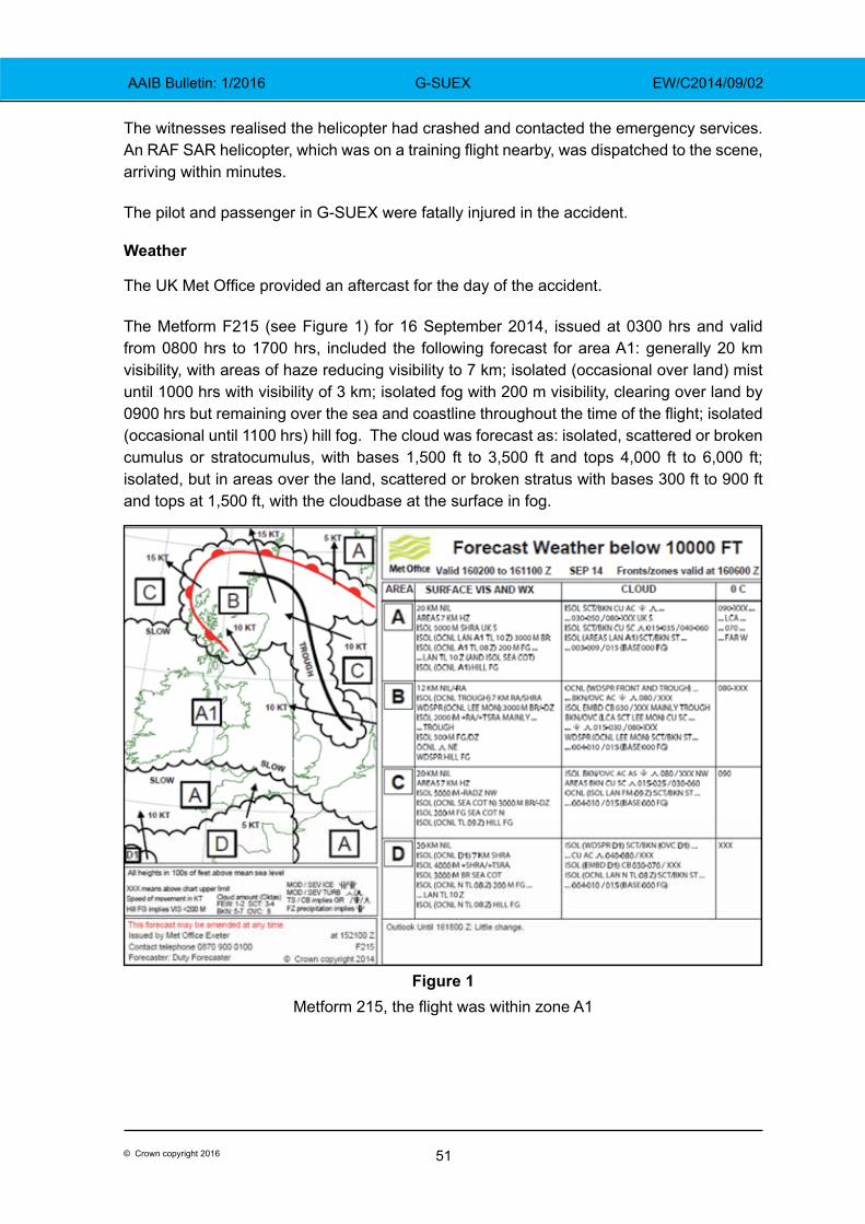
51© Crown copyright 2016
AAIB Bulletin: 1/2016 G-SUEX EW/C2014/09/02
The witnesses realised the helicopter had crashed and contacted the emergency services. An RAF SAR helicopter, which was on a training flight nearby, was dispatched to the scene, arriving within minutes.
The pilot and passenger in G-SUEX were fatally injured in the accident.
Weather
The UK Met Office provided an aftercast for the day of the accident.
The Metform F215 (see Figure 1) for 16 September 2014, issued at 0300 hrs and valid from 0800 hrs to 1700 hrs, included the following forecast for area A1: generally 20 km visibility, with areas of haze reducing visibility to 7 km; isolated (occasional over land) mist until 1000 hrs with visibility of 3 km; isolated fog with 200 m visibility, clearing over land by 0900 hrs but remaining over the sea and coastline throughout the time of the flight; isolated (occasional until 1100 hrs) hill fog. The cloud was forecast as: isolated, scattered or broken cumulus or stratocumulus, with bases 1,500 ft to 3,500 ft and tops 4,000 ft to 6,000 ft; isolated, but in areas over the land, scattered or broken stratus with bases 300 ft to 900 ft and tops at 1,500 ft, with the cloudbase at the surface in fog.
Figure 1 Metform 215, the flight was within zone A1
52© Crown copyright 2016
AAIB Bulletin: 1/2016 G-SUEX EW/C2014/09/02
Departure
At the approximate time of departure from the temporary base at Bankhead Farm, the nearest airport, Edinburgh Airport, reported light winds, visibility above 10 km and 1 to 2 oktas of cloud at 800 ft, with scattered cloud at 2,100 ft.
Weather at Flamborough Head
The SAR Sea King helicopter, based at RAF Leconfield, was on exercise approximately 7 nm south of the accident site when the emergency services were alerted to the accident. The helicopter immediately routed towards the site and the commander later provided an assessment of the weather conditions in the area.
He reported that they had been operating with a cloudbase of 700 ft to 800 ft above mean sea level (amsl), though he described conditions below the cloud as “goldfish bowl like1”. As they descended, approaching the accident site, the visibility improved to about 9 km at 200 ft amsl. The wind was from 080° at less than 5 kt.
Recorded data
GNSS (Global Navigation Satellite System) receivers
Two GNSS receivers were recovered from the wreckage but no track data for the accident flight was recorded.
Radar
Radar data was recovered from Edinburgh, Newcastle and Durham Tees Valley Airports, together with various elements of the NATS operated en-route system. For significant portions of the flights on 16 September, no radar contact was made with G-SUEX due to line-of-sight limitations when the helicopter was below radar coverage. An overview of the recorded track is at Figure 2
The helicopter was initially detected by Edinburgh’s Primary Surveillance Radar (PSR) and the Secondary Surveillance Radar (SSR) feed from NATS Lowther Hill radar. The helicopter’s transponder was reporting altitude via Mode C, which has an accuracy of ±50 ft. This was converted to altitude, amsl, using the appropriate QNH. There was radar contact between 0938 hrs and 0959 hrs, during which the helicopter operated at an average calculated ground speed of 100 kt and at an altitude of between 800 ft and 1,300 ft amsl.
G-SUEX was next detected by Newcastle Airport radar, between 1021 hrs and 1051 hrs (see Figures 2 and 3). At 1025 hrs the helicopter was at 1,000 ft amsl. Then, over the next seven minutes, it descended to below 200 ft amsl. Between 1032 hrs and 1051 hrs the helicopter’s reported altitude varied between 130 ft amsl and 30 ft amsl and the groundspeed was 100 kt ±10 kt.
Footnote1 ‘Goldfish bowl like’ is a common aviation term to describe conditions where the visibility at the surface is fair but with increasing altitude the horizon becomes increasingly hazy and indistinct.
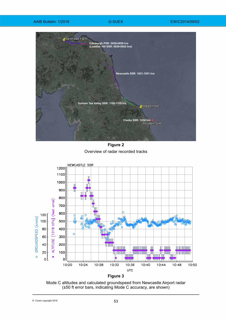
53© Crown copyright 2016
AAIB Bulletin: 1/2016 G-SUEX EW/C2014/09/02
Edinburgh PSR: 0938-0959 hrs(Lowther Hill SSR: 0939-0952 hrs)
Newcastle SSR: 1021-1051 hrs
Durham Tee Valley SSR: 1100-1115 hrs
Claxby SSR: 1238 hrs
Figure 2Overview of radar recorded tracks
Figure 3Mode C altitudes and calculated groundspeed from Newcastle Airport radar
(±50 ft error bars, indicating Mode C accuracy, are shown)
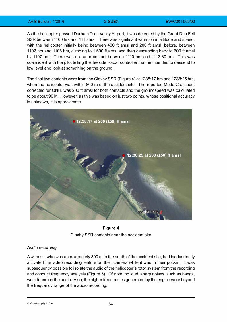
54© Crown copyright 2016
AAIB Bulletin: 1/2016 G-SUEX EW/C2014/09/02
As the helicopter passed Durham Tees Valley Airport, it was detected by the Great Dun Fell SSR between 1100 hrs and 1115 hrs. There was significant variation in altitude and speed, with the helicopter initially being between 400 ft amsl and 200 ft amsl, before, between 1102 hrs and 1106 hrs, climbing to 1,600 ft amsl and then descending back to 600 ft amsl by 1107 hrs. There was no radar contact between 1110 hrs and 1113:30 hrs. This was co-incident with the pilot telling the Teeside Radar controller that he intended to descend to low level and look at something on the ground.
The final two contacts were from the Claxby SSR (Figure 4) at 1238:17 hrs and 1238:25 hrs, when the helicopter was within 800 m of the accident site. The reported Mode C altitude, corrected for QNH, was 200 ft amsl for both contacts and the groundspeed was calculated to be about 90 kt. However, as this was based on just two points, whose positional accuracy is unknown, it is approximate.
Figure 4Claxby SSR contacts near the accident site
Audio recording
A witness, who was approximately 800 m to the south of the accident site, had inadvertently activated the video recording feature on their camera while it was in their pocket. It was subsequently possible to isolate the audio of the helicopter’s rotor system from the recording and conduct frequency analysis (Figure 5). Of note, no loud, sharp noises, such as bangs, were found on the audio. Also, the higher frequencies generated by the engine were beyond the frequency range of the audio recording.
12:38:17 at 200 (±50) ft amsl
12:38:25 at 200 (±50) ft amsl
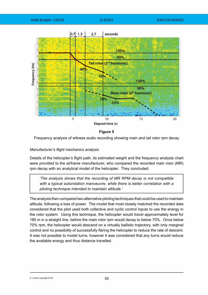
55© Crown copyright 2016
AAIB Bulletin: 1/2016 G-SUEX EW/C2014/09/02
Figure 5Frequency analysis of witness audio recording showing main and tail rotor rpm decay
Manufacturer’s flight mechanics analysis
Details of the helicopter’s flight path, its estimated weight and the frequency analysis chart were provided to the airframe manufacturer, who compared the recorded main rotor (MR) rpm decay with an analytical model of the helicopter. They concluded:
‘The analysis shows that the recording of MR RPM decay is not compatible with a typical autorotation manoeuvre, while there is better correlation with a piloting technique intended to maintain altitude.’
The analysis then compared two alternative piloting techniques that could be used to maintain altitude, following a loss of power. The model that most closely matched the recorded data considered that the pilot used both collective and cyclic control inputs to use the energy in the rotor system. Using this technique, the helicopter would travel approximately level for 180 m in a straight line, before the main rotor rpm would decay to below 70%. Once below 70% rpm, the helicopter would descend on a virtually ballistic trajectory, with only marginal control and no possibility of successfully flaring the helicopter to reduce the rate of descent. It was not possible to model turns, however it was considered that any turns would reduce the available energy and thus distance travelled.
5 10 15 20 Elapsed time (s)
Freq
uenc
y (H
z)
100%
90%
100%
90%
Tail rotor (2nd harmonic)
Main rotor (6th harmonic)
80%
70%
70%53%
0.7 1.3 2.7 seconds
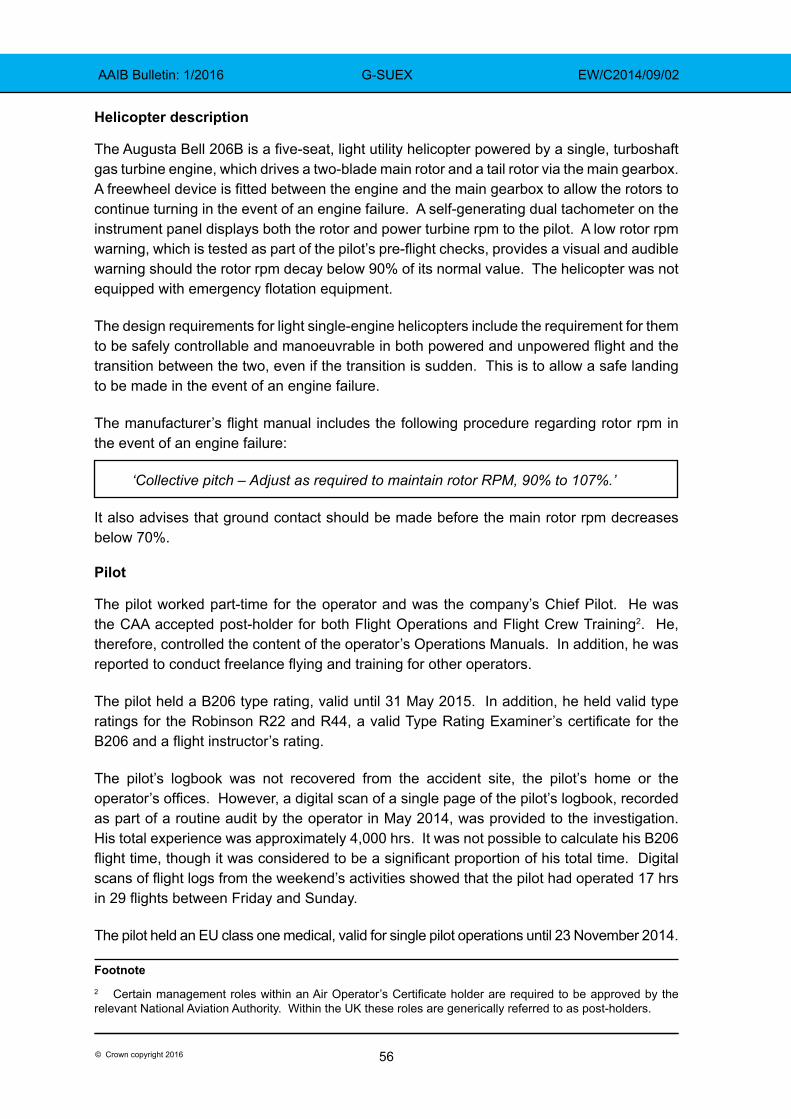
56© Crown copyright 2016
AAIB Bulletin: 1/2016 G-SUEX EW/C2014/09/02
Helicopter description
The Augusta Bell 206B is a five-seat, light utility helicopter powered by a single, turboshaft gas turbine engine, which drives a two-blade main rotor and a tail rotor via the main gearbox. A freewheel device is fitted between the engine and the main gearbox to allow the rotors to continue turning in the event of an engine failure. A self-generating dual tachometer on the instrument panel displays both the rotor and power turbine rpm to the pilot. A low rotor rpm warning, which is tested as part of the pilot’s pre-flight checks, provides a visual and audible warning should the rotor rpm decay below 90% of its normal value. The helicopter was not equipped with emergency flotation equipment.
The design requirements for light single-engine helicopters include the requirement for them to be safely controllable and manoeuvrable in both powered and unpowered flight and the transition between the two, even if the transition is sudden. This is to allow a safe landing to be made in the event of an engine failure.
The manufacturer’s flight manual includes the following procedure regarding rotor rpm in the event of an engine failure:
‘Collective pitch – Adjust as required to maintain rotor RPM, 90% to 107%.’
It also advises that ground contact should be made before the main rotor rpm decreases below 70%.
Pilot
The pilot worked part-time for the operator and was the company’s Chief Pilot. He was the CAA accepted post-holder for both Flight Operations and Flight Crew Training2. He, therefore, controlled the content of the operator’s Operations Manuals. In addition, he was reported to conduct freelance flying and training for other operators.
The pilot held a B206 type rating, valid until 31 May 2015. In addition, he held valid type ratings for the Robinson R22 and R44, a valid Type Rating Examiner’s certificate for the B206 and a flight instructor’s rating.
The pilot’s logbook was not recovered from the accident site, the pilot’s home or the operator’s offices. However, a digital scan of a single page of the pilot’s logbook, recorded as part of a routine audit by the operator in May 2014, was provided to the investigation. His total experience was approximately 4,000 hrs. It was not possible to calculate his B206 flight time, though it was considered to be a significant proportion of his total time. Digital scans of flight logs from the weekend’s activities showed that the pilot had operated 17 hrs in 29 flights between Friday and Sunday.
The pilot held an EU class one medical, valid for single pilot operations until 23 November 2014.
Footnote2 Certain management roles within an Air Operator’s Certificate holder are required to be approved by the relevant National Aviation Authority. Within the UK these roles are generically referred to as post-holders.
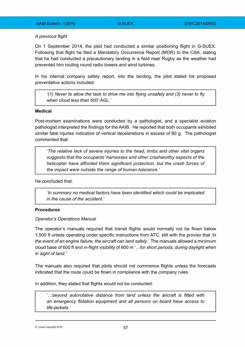
57© Crown copyright 2016
AAIB Bulletin: 1/2016 G-SUEX EW/C2014/09/02
A previous flight
On 1 September 2014, the pilot had conducted a similar positioning flight in G-SUEX. Following that flight he filed a Mandatory Occurrence Report (MOR) to the CAA, stating that he had conducted a precautionary landing in a field near Rugby as the weather had prevented him routing round radio towers and wind turbines.
In his internal company safety report, into the landing, the pilot stated his proposed preventative actions included:
‘(1) Never to allow the task to drive me into flying unsafely and (3) never to fly when cloud less than 600’ AGL.’
Medical
Post-mortem examinations were conducted by a pathologist, and a specialist aviation pathologist interpreted the findings for the AAIB. He reported that both occupants exhibited similar fatal injuries indicative of vertical decelerations in excess of 80 g. The pathologist commented that:
‘The relative lack of severe injuries to the head, limbs and other vital organs suggests that the occupants’ harnesses and other crashworthy aspects of the helicopter have afforded them significant protection, but the crash forces of the impact were outside the range of human tolerance.’
He concluded that:
‘In summary no medical factors have been identified which could be implicated in the cause of the accident.’
Procedures
Operator’s Operations Manual
The operator’s manuals required that transit flights would normally not be flown below 1,500 ft unless operating under specific instructions from ATC, still with the proviso that ‘in the event of an engine failure, the aircraft can land safely.’ The manuals allowed a minimum cloud base of 600 ft and in-flight visibility of 800 m ‘…for short periods, during daylight when in sight of land.’
The manuals also required that pilots should not commence flights unless the forecasts indicated that the route could be flown in compliance with the company rules.
In addition, they stated that flights would not be conducted:
‘…beyond autorotative distance from land unless the aircraft is fitted with an emergency flotation equipment and all persons on board have access to life-jackets.’
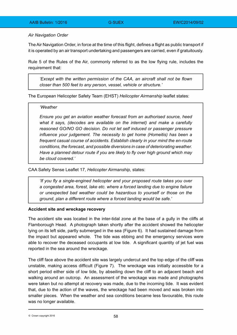
58© Crown copyright 2016
AAIB Bulletin: 1/2016 G-SUEX EW/C2014/09/02
Air Navigation Order
The Air Navigation Order, in force at the time of this flight, defines a flight as public transport if it is operated by an air transport undertaking and passengers are carried, even if gratuitously.
Rule 5 of the Rules of the Air, commonly referred to as the low flying rule, includes the requirement that:
‘Except with the written permission of the CAA, an aircraft shall not be flown closer than 500 feet to any person, vessel, vehicle or structure.’
The European Helicopter Safety Team (EHST) Helicopter Airmanship leaflet states:
‘Weather
Ensure you get an aviation weather forecast from an authorised source, heed what it says, (decodes are available on the internet) and make a carefully reasoned GO/NO GO decision. Do not let self induced or passenger pressure influence your judgement. The necessity to get home (Homeitis) has been a frequent casual course of accidents. Establish clearly in your mind the en-route conditions, the forecast, and possible diversions in case of deteriorating weather. Have a planned detour route if you are likely to fly over high ground which may be cloud covered.’
CAA Safety Sense Leaflet 17, Helicopter Airmanship, states:
‘If you fly a single-engined helicopter and your proposed route takes you over a congested area, forest, lake etc. where a forced landing due to engine failure or unexpected bad weather could be hazardous to yourself or those on the ground, plan a different route where a forced landing would be safe.’
Accident site and wreckage recovery
The accident site was located in the inter-tidal zone at the base of a gully in the cliffs at Flamborough Head. A photograph taken shortly after the accident showed the helicopter lying on its left side, partly submerged in the sea (Figure 6). It had sustained damage from the impact but appeared whole. The tide was ebbing and the emergency services were able to recover the deceased occupants at low tide. A significant quantity of jet fuel was reported in the sea around the wreckage.
The cliff face above the accident site was largely undercut and the top edge of the cliff was unstable, making access difficult (Figure 7). The wreckage was initially accessible for a short period either side of low tide, by abseiling down the cliff to an adjacent beach and walking around an outcrop. An assessment of the wreckage was made and photographs were taken but no attempt at recovery was made, due to the incoming tide. It was evident that, due to the action of the waves, the wreckage had been moved and was broken into smaller pieces. When the weather and sea conditions became less favourable, this route was no longer available.
59© Crown copyright 2016
AAIB Bulletin: 1/2016 G-SUEX EW/C2014/09/02
Figure 6 Showing helicopter lying at the base of the cliffs shortly after the accident
(Courtesy Trevor Norton)
Figure 7 General view of the accident site
60© Crown copyright 2016
AAIB Bulletin: 1/2016 G-SUEX EW/C2014/09/02
Specialists were able to access the accident site by boat and once the wreckage had been loaded into bags, it was lifted to the cliff top. The AAIB deployed its Un-manned Aerial System (UAS) to provide a real time view over the cliff, which proved most useful in assisting the recovery operation.
There was only one witness mark on the cliff, approximately 30 cm above the beach level, which appeared to be a main rotor blade strike. There was no evidence of the helicopter having made any other contact with the cliff.
As the wreckage was brought to the cliff top, it was initially inspected and protected from the effects of contact with sea water, before being transported to the AAIB facilities at Farnborough.
Examination of the airframe wreckage
The wreckage was inspected in the hangar at the AAIB facilities in Farnborough, with the assistance of technical representatives from the airframe and engine manufacturers.
The airframe had suffered severe damage and fragmentation, due to the action of the waves, whilst it was lying in the inter-tidal zone before recovery. Many of the magnesium alloy based parts had corroded significantly due to their immersion in sea water.
Deformation to the lower parts of the fuselage indicated that the helicopter had sustained a high vertical impact load, initially with the surface of the water but also when the skids contacted boulders on the sea bed. Based on witness reports, it was estimated that the water was between 0.5 m and 1 m deep.
The damage to the main rotors, the drive train, its couplings and mountings suggested that there was low energy in them (low rotor rpm) at the time of impact. The freewheel device between the engine and gearbox operated normally. The remote oil reservoir and oil cooler fan were severely damaged and sea water was found in the scavenge oil filter, as the oil lines had been broken by wave action. The fuel filter smelt of fuel but also contained sea water, due to the broken fuel lines. The remainder of the fuel system was compromised and no meaningful conclusions could be drawn.
A warning panel consisting of a number of warning captions was fitted to the instrument panel. These included warnings for engine failure and low rotor rpm. The engine failure warning illuminates if the engine gas generator rpm drops below its normal operating speed. The low rotor rpm illuminates if the rotor rpm decays below 90%. The filament associated with the low rotor rpm caption was not recovered.
An analysis of each recovered filament was undertaken to determine if any showed signs of being illuminated. None of the filaments examined showed any signs of the characteristic plastic deformation associated with an impact whilst illuminated.
The inspection did not identify any pre-accident anomalies with the airframe, its controls or drive train. Dual controls were found fitted to the left seat position.
61© Crown copyright 2016
AAIB Bulletin: 1/2016 G-SUEX EW/C2014/09/02
Examination of the engine
The engine consists of a gas generator assembly, which includes both axial and centrifugal compressor stages, a combustion section and an axial flow turbine section connected to the compressor. The remaining hot gases then pass through an axial flow power turbine assembly which, through the power output gear, provides the power output to the main rotor gearbox via a freewheel device (Figure 8).
Figure 8General arrangement of engine
The engine assembly was taken to an approved maintenance organisation with specialist experience in this type of engine. A full disassembly inspection was carried out, with the technical representatives of the engine and airframe manufacturer in attendance.
The compressor assembly was dismantled and found to be in good condition, apart from some impact damage to a few blades at the front of the compressor which was determined to be a result of the accident. Chopped seaweed was found throughout the compressor air passages. The seaweed found on the beach was in long strips, and finely chopped seaweed material was found inside the engine. This suggested that the gas generator part of the engine had been rotating at the time of the accident. However, it was not possible to determine the engine’s speed at that moment.
62© Crown copyright 2016
AAIB Bulletin: 1/2016 G-SUEX EW/C2014/09/02
The oil pump appeared to be in good condition and no blockages were found within the internal oil passages. The pressure filter was not obstructed and oil appeared to have been present throughout the lubrication system. The magnetic chip detectors had collected debris but it was not possible to draw any conclusions due to the large quantities of corrosion products resulting from the immersion in sea water.
The engine fuel control unit and governor were disassembled and examined. They were found to be in a satisfactory condition with no pre-accident defects. Several of the pneumatic air lines were dented but their connection fittings were all secure.
When the turbine assembly was dismantled, the No 5 and No 8 bearings (Figure 9) were found to have suffered severe thermal distress (see Figure 10). The No 6 and No 7 bearings had also suffered damage. The No 5 bearing and No 8 bearings are ball bearings and provide axial and radial location for the turbine assembly. Damage to the turbine rotors and adjacent components indicated they had come into contact with each other.
The engine, including the failed and damaged bearings, was returned to the engine manufacturer for detailed evaluation.
Figure 9General arrangement of turbine assembly and bearings
63© Crown copyright 2016
AAIB Bulletin: 1/2016 G-SUEX EW/C2014/09/02
The No 5 and No 8 turbine thrust bearings exhibited severe thermal distress which had led to the bearings ceasing to position the turbine rotors axially and radially. The No 6 bearing also exhibited damage which indicated it had ceased to position the power turbine rotor radially.
The No 8 bearing exhibited an approximately 0.75 inch long circumferential fatigue crack in the outer ring, originating at the corner of the key slot, which did not extend into the bearing raceway. This was typical of a crack caused by the outer raceway trying to rotate against its key due to friction within the bearing. The bearing was comprised of the material types specified by the engineering drawing but it was not possible to determine the original hardness or microstructure of the part due to the severe thermal distress.
The engine manufacturer concluded:
‘The primary failed component was unable to be identified due to the advanced stage of distress to many of the turbine bearings, as well as the engine’s exposure to seawater.’
Maintenance records
The helicopter was being maintained to an approved maintenance programme and had a valid airworthiness review certificate (ARC). The last scheduled maintenance was a 100-hour inspection, which was carried out on 12 September, 2014. In addition to the routine items, a number of minor defects were rectified. Since then, the helicopter had flown for approximately 17 hours on 29 flights.
The engine turbine assembly had been overhauled in November 2011 and had been fitted with new bearings (No 5 to No 8), which had been manufactured under a Parts Manufacturer Approval (PMA) issued by the FAA. During the build process, the PMA No 8 bearing was replaced with an original equipment manufacturer (OEM) supplied part, for an unspecified reason. The overhauled turbine assembly was released from the overhaul organisation in September 2012.
Figure 10 Example of bearing damage, in this case No 5 bearing
64© Crown copyright 2016
AAIB Bulletin: 1/2016 G-SUEX EW/C2014/09/02
Whilst the use of PMA parts is acceptable, the authorised Release Certificate did not note that PMA parts had been fitted, as required by EASA Decision 2007/003/C. The overhauled turbine assembly was fitted to the engine on 19 September 2013 and the helicopter had subsequently operated for approximately 370 hours. The turbine bearings do not have a defined life, but instead they are inspected at each turbine overhaul for condition and replaced if required.
Analysis
The pilot held the appropriate licences and ratings to operate the flight; he was experienced, current and familiar with the task and route. The helicopter had been maintained to the required standards and there were no known defects before the flight.
On the day of the accident, the weather near Edinburgh was suitable for both departure and en-route flight, within the constraints laid down by the company’s operations manual. However, the forecast contained within the F215 chart, for the portion of the flight towards the east coast of England, was less favourable. The evidence indicated that, after 1032 hrs, the helicopter was being operated, for extended periods, below 600 ft agl and in some cases below 100 ft agl, in weather conditions which appeared to be below the limits contained within the operations manual.
Flight at low level would have mitigated, to some extent, the risk of inadvertent entry into a degraded visual environment but, in doing so, it exposed the helicopter to other risks. Specifically, it was probably flown into positions from which a safe autorotation and landing could not be assured, following a loss of power.
As on a previous occasion, the pilot interrupted the flight by landing in a field due to poor weather conditions. After about 50 minutes on the ground, during which he discussed the weather with Humberside Airport and called his company, the helicopter departed the field, which was near Robin Hood’s Bay.
As the helicopter approached Flamborough Head, about 24 nm south of Robin Hood’s Bay, it seems to have entered an area of improved weather. The SAR helicopter commander subsequently reported good visibility near the surface, deteriorating with altitude towards a cloudbase at about 800 ft.
The final radar recordings and eyewitness accounts, shortly before the helicopter suffered a loss of power, indicated that it was transiting on the offshore side of the cliff top at a height that varied from level to slightly above the top of the cliff. This suggested that the pilot was probably endeavouring to maintain good visual conditions, by flying at low level, while remaining compliant with Rule 5 of the Rules of the Air, by being laterally clear of people on the cliff top path.
The loss of engine power was due to the failure of bearings supporting the turbine assembly. However, the wreckage of the helicopter was severely damaged by wave action and its immersion in sea water. Due to this damage and the thermal distress suffered by the failed turbine bearings, it was not possible to determine the cause of the bearing failure. No pre-accident anomalies with the airframe, its controls or drive train were found.
65© Crown copyright 2016
AAIB Bulletin: 1/2016 G-SUEX EW/C2014/09/02
The degradation of the power turbine assembly removed drive from the rotor system. The gas generator part of the engine was still rotating and, therefore, the engine-out warning tone and caption may not have activated. This may have increased the pilot’s response time to the loss of power. However, the helicopter would have reacted to the change in torque, possibly explaining the slight turn to the left described by some of the eyewitnesses, and this could have alerted the pilot. The helicopter was then seen to turn towards the cliff, before descending below cliff top height and out of sight of the witnesses.
The audio analysis showed a significant and sustained reduction in the rotor rpm, inconsistent with entry into normal autorotation3. The single strike mark near the foot of the cliff and the nature of the damage to the rotor drive train were indicative of very low energy in the rotor system at impact. Also, the injuries identified at the post-mortem examination were consistent with a vertical impact of greater than 80 g, suggesting an unarrested descent.
The evidence suggests that the pilot probably attempted to land at the top of the cliff. The helicopter was not fitted with flotation equipment and the company’s Operations Manual stated that, in such circumstances, the helicopter should not be flown beyond autorotative distance of land. On this occasion, minimal height loss would have been required to reach the top of the cliff. However, there was insufficient energy within the rotor system to achieve this. The loss of rotor rpm then prevented a reduction in the rate of descent as the helicopter approached the surface, at the bottom of the cliff.
Conclusion
The helicopter was transiting at low level along a section of coastline dominated by cliffs. It was not equipped with flotation equipment, was offshore and either level with or slightly above the cliff top. A loss of engine power occurred due to the failure of bearings within the turbine assembly, the cause of which could not be determined. When the loss of engine power occurred, the helicopter was not in a position from which it could land safely. The pilot probably attempted to land on the top of the cliff but there was insufficient energy within the rotor system to achieve this. The helicopter then descended rapidly and struck the surface of the sea, fatally injuring the pilot and his passenger.
Bulletin correction
This report included a graphical display of the main and tail rotor rpm decay, based on the frequency analysis of the witness audio recording (see Figure 5 on page 55). Figure 5 was incorrectly labelled. Reference to the tail rotor should have been to the main rotor, and vice versa. The time axis labels and harmonic references were also incorrect. However, the supporting text, analysis and conclusions were unaffected by these labelling errors.
The graphic was amended online on 29 January 2016 and a correction was placed in the March 3/2016 Bulletin.
Footnote3 Had the helicopter successfully entered autorotation, the rotor rpm could have been maintained between 90% and 107% until a short distance above the surface, when a flare manoeuvre and application of collective pitch to the main rotor system could have cushioned the touchdown, while rapidly slowing the rotor rpm.
66© Crown copyright 2016
AAIB Bulletin: 1/2016 G-CBYE EW/C2015/07/01
ACCIDENT
Aircraft Type and Registration: Pegasus Quik, G-CBYE
No & Type of Engines: 1 Rotax 912ULS piston engine
Year of Manufacture: 2003 (Serial no: 7933)
Date & Time (UTC): 3 July 2015 at 1830 hrs
Location: Enstone Airfield, Oxfordshire
Type of Flight: Private
Persons on Board: Crew - 1 Passengers - 1
Injuries: Crew - 1 (Fatal) Passengers - 1 (Fatal)
Nature of Damage: Extensive
Commander’s Licence: National Private Pilot’s Licence
Commander’s Age: 62
Commander’s Flying Experience: 213 hours (of which 163 were on type) Last 90 days - 2 hours Last 28 days - 2 hours
Information Source: AAIB Field Investigation
Synopsis
The aircraft made an approach towards the upwind end of a grass runway at Enstone Airfield. It touched down approximately 145 m before the end of the runway and, after rolling for approximately 80 m, the power was increased. The aircraft, which was overweight, remained on the ground and veered to the right passing through a fence and colliding with a vehicle trailer parked beside other equipment, close to the end of the runway. The pilot and his passenger both suffered fatal injuries.
The pilot had not flown with an instructor in a flex-wing microlight since gaining his licence in 2006 and his Microlight Rating had lapsed.
History of the flight
The pilot arrived at Enstone at approximately 1730 hrs accompanied by four relatives. The aircraft had already been moved from its hangar by three people, in order to gain access and work on a different microlight. The pilot made some pre-flight preparations and briefed one of his relatives who was to be a passenger for a first flight in a microlight. He was heard to ask the passenger for his weight and was told it was 113 kg.
There was little other flying activity at Enstone that evening and witness evidence suggested that visibility was good with no low cloud but with some large cumulus clouds south of the airfield. Shortly before the flight commenced, the pilot was heard to state that it was a bit blustery and he would let the wind drop before departing. The wind velocity
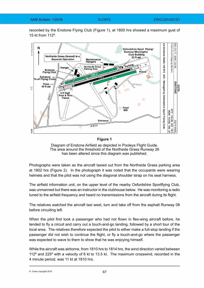
67© Crown copyright 2016
AAIB Bulletin: 1/2016 G-CBYE EW/C2015/07/01
recorded by the Enstone Flying Club (Figure 1), at 1800 hrs showed a maximum gust of 15 kt from 112º.
Figure 1Diagram of Enstone Airfield as depicted in Pooleys Flight Guide.
The area around the threshold of the Northside Grass Runway 26 has been altered since this diagram was published.
Photographs were taken as the aircraft taxied out from the Northside Grass parking area at 1802 hrs (Figure 2). In the photograph it was noted that the occupants were wearing helmets and that the pilot was not using the diagonal shoulder strap on his seat harness. The airfield information unit, on the upper level of the nearby Oxfordshire Sportflying Club, was unmanned but there was an instructor in the clubhouse below. He was monitoring a radio tuned to the airfield frequency and heard no transmissions from the aircraft during its flight.
The relatives watched the aircraft taxi west, turn and take off from the asphalt Runway 08 before circuiting left.
When the pilot first took a passenger who had not flown in flex-wing aircraft before, he tended to fly a circuit and carry out a touch-and-go landing, followed by a short tour of the local area. The relatives therefore expected the pilot to either make a full-stop landing if the passenger did not wish to continue the flight, or fly a touch-and-go where the passenger was expected to wave to them to show that he was enjoying himself.
While the aircraft was airborne, from 1810 hrs to 1814 hrs, the wind direction varied between 112º and 225º with a velocity of 6 kt to 13.5 kt. The maximum crosswind, recorded in the 4 minute period, was 11 kt at 1810 hrs.
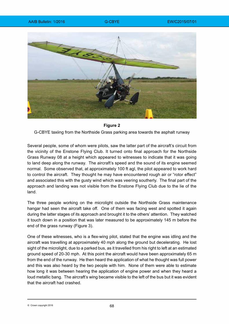
68© Crown copyright 2016
AAIB Bulletin: 1/2016 G-CBYE EW/C2015/07/01
Figure 2G-CBYE taxiing from the Northside Grass parking area towards the asphalt runway
Several people, some of whom were pilots, saw the latter part of the aircraft’s circuit from the vicinity of the Enstone Flying Club. It turned onto final approach for the Northside Grass Runway 08 at a height which appeared to witnesses to indicate that it was going to land deep along the runway. The aircraft’s speed and the sound of its engine seemed normal. Some observed that, at approximately 100 ft agl, the pilot appeared to work hard to control the aircraft. They thought he may have encountered rough air or “rotor effect” and associated this with the gusty wind which was veering southerly. The final part of the approach and landing was not visible from the Enstone Flying Club due to the lie of the land.
The three people working on the microlight outside the Northside Grass maintenance hangar had seen the aircraft take off. One of them was facing west and spotted it again during the latter stages of its approach and brought it to the others’ attention. They watched it touch down in a position that was later measured to be approximately 145 m before the end of the grass runway (Figure 3).
One of these witnesses, who is a flex-wing pilot, stated that the engine was idling and the aircraft was travelling at approximately 40 mph along the ground but decelerating. He lost sight of the microlight, due to a parked bus, as it travelled from his right to left at an estimated ground speed of 20-30 mph. At this point the aircraft would have been approximately 65 m from the end of the runway. He then heard the application of what he thought was full power and this was also heard by the two people with him. None of them were able to estimate how long it was between hearing the application of engine power and when they heard a loud metallic bang. The aircraft’s wing became visible to the left of the bus but it was evident that the aircraft had crashed.
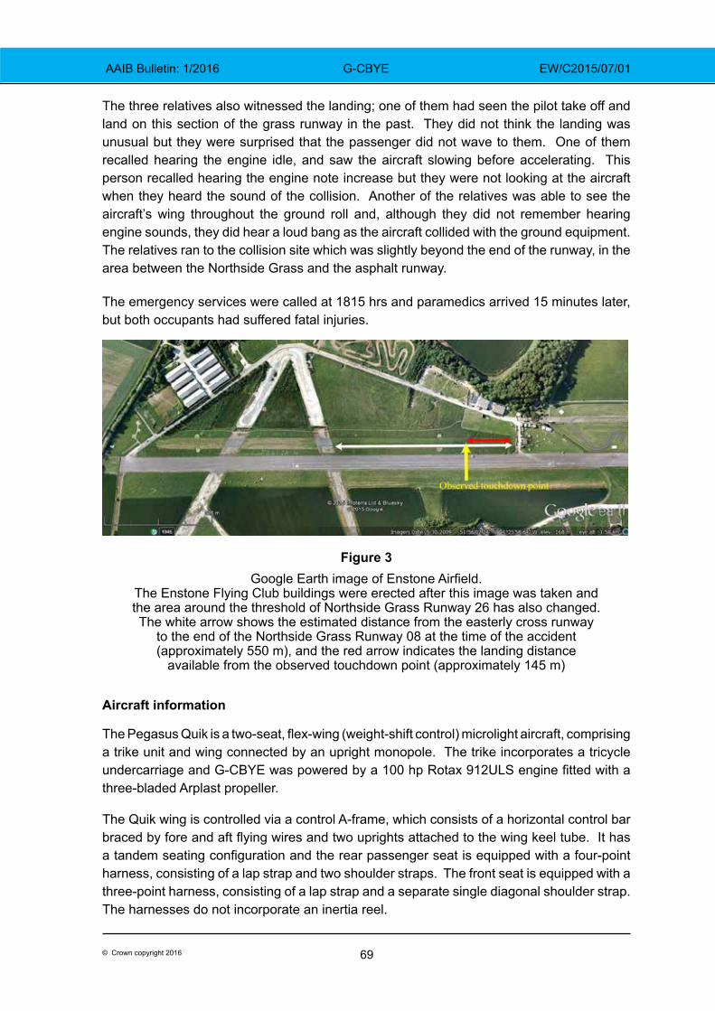
69© Crown copyright 2016
AAIB Bulletin: 1/2016 G-CBYE EW/C2015/07/01
The three relatives also witnessed the landing; one of them had seen the pilot take off and land on this section of the grass runway in the past. They did not think the landing was unusual but they were surprised that the passenger did not wave to them. One of them recalled hearing the engine idle, and saw the aircraft slowing before accelerating. This person recalled hearing the engine note increase but they were not looking at the aircraft when they heard the sound of the collision. Another of the relatives was able to see the aircraft’s wing throughout the ground roll and, although they did not remember hearing engine sounds, they did hear a loud bang as the aircraft collided with the ground equipment. The relatives ran to the collision site which was slightly beyond the end of the runway, in the area between the Northside Grass and the asphalt runway.
The emergency services were called at 1815 hrs and paramedics arrived 15 minutes later, but both occupants had suffered fatal injuries.
Figure 3Google Earth image of Enstone Airfield.
The Enstone Flying Club buildings were erected after this image was taken and the area around the threshold of Northside Grass Runway 26 has also changed. The white arrow shows the estimated distance from the easterly cross runway
to the end of the Northside Grass Runway 08 at the time of the accident (approximately 550 m), and the red arrow indicates the landing distance
available from the observed touchdown point (approximately 145 m)
Aircraft information
The Pegasus Quik is a two-seat, flex-wing (weight-shift control) microlight aircraft, comprising a trike unit and wing connected by an upright monopole. The trike incorporates a tricycle undercarriage and G-CBYE was powered by a 100 hp Rotax 912ULS engine fitted with a three-bladed Arplast propeller.
The Quik wing is controlled via a control A-frame, which consists of a horizontal control bar braced by fore and aft flying wires and two uprights attached to the wing keel tube. It has a tandem seating configuration and the rear passenger seat is equipped with a four-point harness, consisting of a lap strap and two shoulder straps. The front seat is equipped with a three-point harness, consisting of a lap strap and a separate single diagonal shoulder strap. The harnesses do not incorporate an inertia reel.
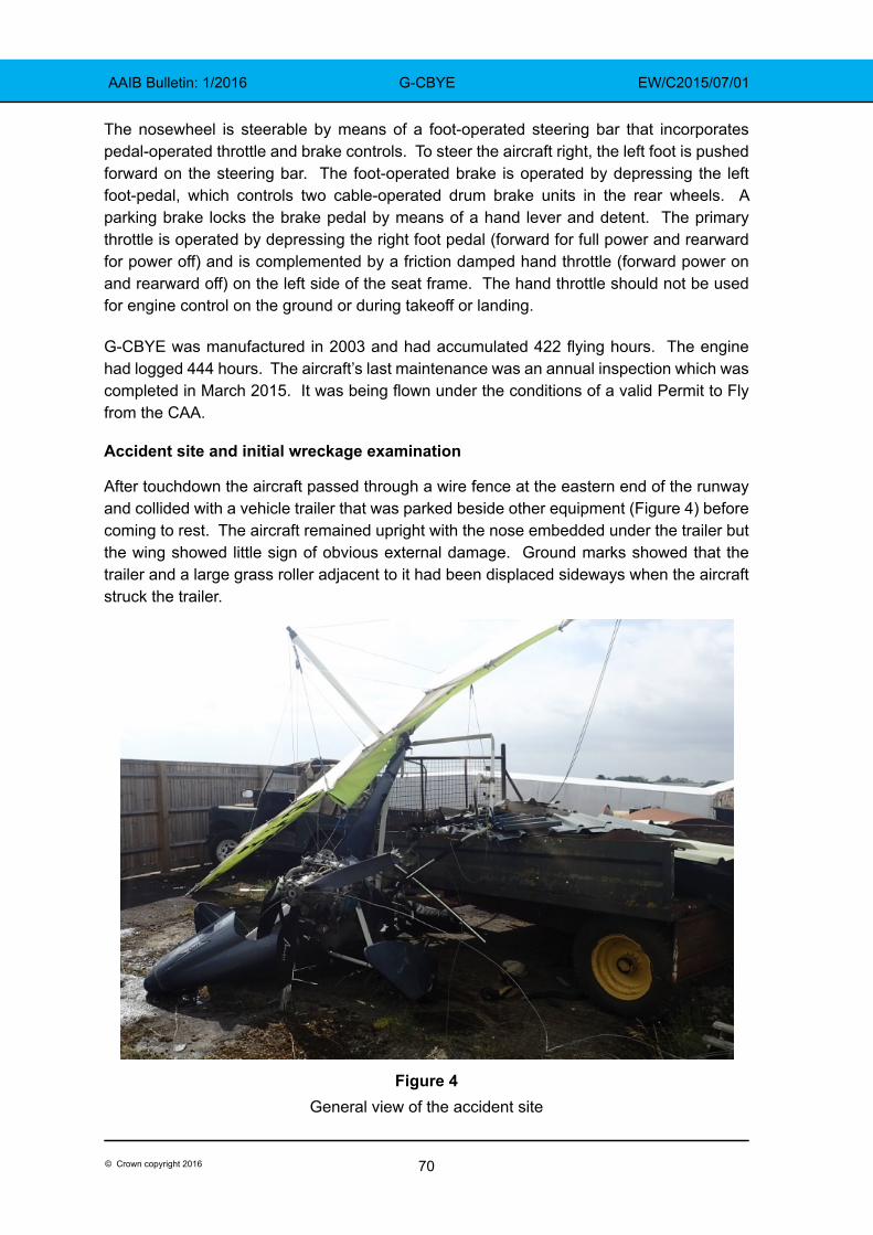
70© Crown copyright 2016
AAIB Bulletin: 1/2016 G-CBYE EW/C2015/07/01
The nosewheel is steerable by means of a foot-operated steering bar that incorporates pedal-operated throttle and brake controls. To steer the aircraft right, the left foot is pushed forward on the steering bar. The foot-operated brake is operated by depressing the left foot-pedal, which controls two cable-operated drum brake units in the rear wheels. A parking brake locks the brake pedal by means of a hand lever and detent. The primary throttle is operated by depressing the right foot pedal (forward for full power and rearward for power off) and is complemented by a friction damped hand throttle (forward power on and rearward off) on the left side of the seat frame. The hand throttle should not be used for engine control on the ground or during takeoff or landing.
G-CBYE was manufactured in 2003 and had accumulated 422 flying hours. The engine had logged 444 hours. The aircraft’s last maintenance was an annual inspection which was completed in March 2015. It was being flown under the conditions of a valid Permit to Fly from the CAA.
Accident site and initial wreckage examination
After touchdown the aircraft passed through a wire fence at the eastern end of the runway and collided with a vehicle trailer that was parked beside other equipment (Figure 4) before coming to rest. The aircraft remained upright with the nose embedded under the trailer but the wing showed little sign of obvious external damage. Ground marks showed that the trailer and a large grass roller adjacent to it had been displaced sideways when the aircraft struck the trailer.
Figure 4General view of the accident site
71© Crown copyright 2016
AAIB Bulletin: 1/2016 G-CBYE EW/C2015/07/01
The engine was intact and approximately 38.5 litres of fuel remained in the fuel tank. The fuel shut-off was found open and the hand-operated throttle lever was in the idle position. All three propeller blades had sustained tip damage and one blade had detached at the root. A canvas type bag, with a Pegasus logo, lying adjacent to and slightly forward of the aircraft, contained a protective trike cover and tooling used to rig the wing. It was concluded that the bag was onboard G-CBYE at the time of the accident and had been ejected from the trike when it struck the trailer.
The touchdown point could not be identified but tyre marks in the grass leading to the accident site were consistent with the aircraft veering to the right as it approached the end of the runway.
Pilot’s experience
The pilot gained a National Private Pilot’s Licence (NPPL) in June 2006, after completing a course of flying training on flex-wing microlights at Enstone. He had purchased G-CBYE in November 2005 and his log book records that this was the only aircraft he flew after that, except for one trial flight in a Piper PA-28 in April 2013. That instructional flight was his only recorded flight with an instructor after 2006. The CAA publishes a series of Safety Sense leaflets for the general aviation community. Safety Sense leaflet No 1 (Good Airmanship)1 advises pilots to have refresher training with an instructor at least once a year to allow them to revise their basic knowledge and skills.
The Microlight (Land) Rating in the pilot’s licence became invalid on 9 July 2007 and was not revalidated or renewed thereafter. Until 2008, Microlight (Land) Ratings were valid for 13 months and a licence could be revalidated by an authorised person who was satisfied that the pilot had completed a requisite amount of flying in the previous period. Since 2008, such ratings are valid for 24 months. Article 69(1) of the UK Air Navigation Order 2009 (ANO) states that a holder of an NPPL is not entitled to exercise the privileges of a rating unless a certificate of revalidation has been issued and is valid.
Schedule 7, Part C, Section 3 to the ANO lays out certain requirements to revalidate a rating on the basis of the pilot’s experience during the period of validity of the current rating. During this (24 month) period the pilot must have logged at least 12 hours flight time (including 8 hours as pilot in command) and have undertaken at least one hour of training with an instructor on aeroplanes of the same class. However, to renew a rating when a certificate of revalidation has expired for more than 5 years, the pilot must pass an NPPL General Skill Test and an oral knowledge exam with an authorised examiner.
The pilot of G-CBYE was a member of the Enstone Microlights Club but he had limited interaction with the club or its members. The club’s annual membership renewal form asked for the ‘Date of last Certificate of Experience or Flight Test’. This terminology was Footnote1 CAA Safety Sense leaflet 1 can be downloaded in pdf format at: http://www.caa.co.uk/docs/33/20130121SSL01.pdf
72© Crown copyright 2016
AAIB Bulletin: 1/2016 G-CBYE EW/C2015/07/01
out-dated but was essentially asking for licence validity details; on the most recent form the pilot had filled-in ‘9 April 2014’. This date did not accord with any entry in his licence or his logbook, although the aircraft’s Permit to Fly had been valid until 8 April 2014 (and subsequently renewed).
The pilot had logged almost 6 hours total flight time in the 12 months before the accident and a little less than 9 hours in the last 24 months. The instructor who had trained the pilot ceased instructing at Enstone soon after the pilot obtained his licence but remains a qualified CAA examiner. He stated that he had observed the pilot flying his aircraft at Enstone on a blustery day during the summer of 2014. He commented that he was surprised to see a flex-wing flying in those conditions but thought that the pilot coped with the conditions and he was “quite impressed” after watching the aircraft land on the asphalt Runway 08.
Medical and pathological information
The pilot had made an appropriate Medical Declaration which was current and had been countersigned by his General Practioner on 7 December 2011.
The post-mortem reports stated that the pilot and passenger both died after suffering multiple injuries. Neither of them were wearing their helmets when the witnesses reached the aircraft, but both helmets were found at the accident site and the photograph taken before departure shows them both wearing helmets. Their head injuries were consistent with helmets being worn and neck injuries were indicative of high deceleration forces while supporting a helmet and headset.
The examination of the pilot and associated toxicology tests found no sign of disease that might have caused incapacity or have been a contributory factor. The pilot’s clothed weight was recorded as 83.8 kg and the passenger’s weight was 118.1 kg
Aircraft
The hand and foot throttles were checked and no anomalies were noted. The brakes and steering were checked and confirmed operational. The tyres were in good condition and inflated.
The four flying wires between the A-frame and the wing were intact. The left front wire from the A-frame had been severed in the accident and the right rear wire had failed due to overload. The right A-frame upright and wing keel tube were broken and the base bar was deformed. The fractures were commensurate with ductile overload caused by loads imparted during the accident. There was no evidence of any rigging anomalies.
The rear seat four-point harness lap strap was found undone and the right hand shoulder strap had been cut by the emergency services to release the occupant. The front seat lap strap was found undone and the condition of the diagonal shoulder strap was consistent with it not being worn at the time of the accident.
73© Crown copyright 2016
AAIB Bulletin: 1/2016 G-CBYE EW/C2015/07/01
Powerplant examination
The engine had not sustained any visible damage apart from the propeller and the right carburettor, which had separated from the attachment flange. The propeller damage was consistent with it rotating when the accident occurred but the power setting could not be established. The aircraft was also equipped with a FlyDAT engine instrument which records peak engine parameters, at six minute intervals whilst the engine is running and at shutdown. The maximum engine speed recorded during the final period was 5,210 rpm and exhaust gas temperatures, oil temperature, oil pressure and cylinder head temperature were all within normal ranges.
The carburettor was reattached and a test run of the engine using a test propeller demonstrated that engine response was normal, indicating that the engine was capable of producing full power prior to the accident.
Weight calculations
The operator’s manual for the Pegasus Quik states that the aircraft’s maximum all-up weight (MAUW) and its maximum takeoff weight are both 409 kg. The maximum weight limit for each seat is 110 kg and the maximum cockpit weight is 200 kg. The manual requires there to be a placard in the cockpit that displays the trade-off between the fuel load and the cockpit load. The placard in G-CBYE indicated an empty weight of 205 kg.
The manual instructs pilots to carry out calculations before each flight to ensure the MAUW is not exceeded. The post-mortem report gave the pilot’s clothed weight as 83.8 kg and the passenger’s clothed weight as 118.1 kg. The bag, containing the rigging tooling and canvas cover, was later weighed at 4.2 kg and the helmets and headsets had a total weight of 3.4 kg. 38.5 litres of fuel, weighing 27.8 kg (assuming a specific gravity of 0.72 kg/litre), was later removed from the 49 litre fuel tank thus, at the time of the accident, the aircraft weighed approximately 442.3 kg. This would have placed the aircraft around 33 kg or 8% above the MAUW.
The aircraft last flew on 18 June 2015 and the passenger on that occasion saw the fuel tank replenished afterwards to ¾ full. This would have been its fuel load for the accident flight. In 2013 the pilot had drawn out a table showing his own weight as 82 kg and indicating that a 96 kg passenger could be flown with a ¾ full tank of fuel (weighing 35 kg) and a 113 kg passenger with a ¼ full tank (weighing 12 kg). This table, which made no mention of helmets or other equipment, was found in the pilot’s car.
Passenger briefing
In a Pegasus Quik, the two occupants sit close together in tandem, with the passenger’s legs positioned on either side of the pilot who sits in front. The hand throttle, on the left side of the cockpit, is within reach of the passenger should his arms be placed on the cockpit coaming. In order to make a small adjustment to his seating position, a passenger is likely to place his hands on the coaming to help ease his weight.
74© Crown copyright 2016
AAIB Bulletin: 1/2016 G-CBYE EW/C2015/07/01
The relatives recalled that the pilot briefed the passenger to keep his feet off the steering bar during the flight. It is not known if he briefed the passenger about the hand throttle or other controls. The passenger was strapped in using the four-point harness fitted for the rear seat occupant.
Enstone Airfield
Enstone is an unlicensed airfield with split ownership of the land. The Oxfordshire Sportflying Club leases the asphalt runway and the southern grass runway and has planning permission for flying activities during certain hours of operation. The Club follows the guidance provided in CAA publication CAP 793 ‘Safe Operating Practices at Unlicensed Aerodromes’, and flying training is undertaken using both these runways, which are available without charge to Club members and to Enstone Microlight Club members. An arrangement is also in place for use of these runways by the Enstone Flying Club and landings and takeoffs are recorded.
The area on which the Northside Grass runway is situated is owned and operated by a separate organisation which has been granted ‘Lawful Use’ of the land for flying activities but without planning permission. Pilots are not required to record landings or takeoffs on this runway and available aeronautical information states, ‘all movements at pilot’s own risk’. There is a fence between the Northside Grass runway and the asphalt runway with access points for aircraft to taxi between the two.
Figures 1 and 3 illustrate that the three runways are staggered and the Northside Grass runway is positioned furthest west. Any lateral markers or cues a pilot uses to help judge his position along one of these runways, may not be appropriate during takeoff or landing on one of the other runways. For example, when landing from the west on Northside Grass Runway 08, a pilot will pass abeam the first of the maintenance hangars closer to the end of that runway than he would have been to the end of the asphalt Runway 08, if he had been landing on that instead.
The Northside Grass runway is shown by Pooleys Flight Guide to be 1,020 m long, and the two cross runways are depicted as disused (Figure 1). The pilot of G-CBYE had previously flown from the asphalt runway and the Northside Grass runway. He had been observed using the section of the Northside Grass runway which is approximately 550 m long and lies east of the cross runways.
CAA Safety Sense leaflet 1 recommends that touchdowns are made near a runway’s threshold. It suggests that a go-around should be initiated if the aircraft has not landed in the first third of a runway.
Runway end markings and obstacles
CAP 793 states that paint or markers can be used to indicate the end of a runway and that:
‘Anything that, because of its height or position, could be a hazard to an aircraft landing or taking off should be conspicuously marked if it cannot be practicably removed or minimised.’
75© Crown copyright 2016
AAIB Bulletin: 1/2016 G-CBYE EW/C2015/07/01
Additionally it states:
‘To prepare for the event of an aircraft overrunning the end of a runway, overrun areas may be provided, either directly beyond the runway or slightly to either side if the ground in these areas would reduce the hazard arising from an overrun.’
There were no markings at the end of the Northside Grass Runway 08 and there were a number of vehicles and other obstructions in the overrun and immediately adjacent to it. These were not marked or mentioned in available aeronautical information. A CAA Inspector visited the site after the accident and stated that it is an unlicensed airfield with no requirement for an overrun area (runway strip end) beyond the notified landing distance available. He noted that while it may not be sensible to place obstacles in this area, there are no regulations to prevent this. It is the same at licensed airfields where obstacles can exist beyond the runway strip end, provided they do not infringe the prescribed vertical surfaces for aircraft takeoff or approach/climb requirements.
CAP 793 suggests a minimum runway length of 250 m for microlight operations and recommends that obstructions at the runway ends (hedges etc) are no more than 2 m high.
Aircraft operation
The operator’s manual for the Pegasus Quik instructs pilots to make an early decision to go-around if the speed and/or altitude are too high on an approach. The manual states that the maximum crosswind limit that an experienced pilot must consider for takeoff and landing is 10 kt.
Performance data in the manual indicates that, at MAUW, a distance of 292 m is required to takeoff and reach an altitude of 15 m while 225 m is required to land from this height. The aircraft designer estimated that the takeoff and landing rolls for an aircraft weighing 442 kg would increase by 17%. Data from flight tests of a comparable (but not identical) aircraft, ballasted to 450 kg indicates a ground roll of approximately 150 m is needed from touchdown, on short dry grass with no headwind. The designer also considered the ground distance needed by a Pegasus Quik weighing 450 kg to takeoff and clear a 2 m high obstacle. From a speed of 30 mph it would require a minimum of 117 m with a 10 kt headwind.
The reason for the 110 kg seat limit but a total cockpit limit of 200 kg is that the structure has been tested in accordance with airworthiness requirements up to 220 kg but for this model it has been limited to 200 kg to facilitate flight with a reasonable fuel load. The designer considered the effect of a heavy passenger on the aircraft’s Centre of Gravity and stated that he did not believe this would have caused any control problem.
A flex-wing instructor, who had not flown with the pilot of G-CBYE, stated that he had occasionally seen student pilots in the process of attempting to apply maximum braking, using their left foot, pushing forward on the left side of the steering bar. This causes the aircraft to turn right and moves the other side of the steering bar back towards the student’s right foot. This, in turn, causes the pilot’s right foot to depress the foot throttle and results in an involuntary application of power.
76© Crown copyright 2016
AAIB Bulletin: 1/2016 G-CBYE EW/C2015/07/01
Analysis
The pilot made an approach to land on the eastern section of the Northside Grass Runway 08. For reasons that are undetermined, he landed deep in this section, possibly with insufficient distance available to prevent the overweight aircraft from overrunning the end of the runway. During the ground roll the aircraft slowed before power was applied, either deliberately or inadvertently, for an unknown length of time and the aircraft was seen to accelerate. There was insufficient distance remaining for the aircraft to takeoff and the application of power meant that an overrun was inevitable. The aircraft deviated to the right of the grass runway and collided with a fence and trailer parked close to the end of the runway.
Aircraft examination
The damage to the wing and trike was consistent with the aircraft passing through the fence and impacting the trailer in the compound near the runway. The speed at which the accident occurred could not be established but the propeller damage was consistent with it turning and a test of the engine after the accident demonstrated that it was capable of producing power. Testing of the steering and brakes showed both systems were operational.
There was no evidence of any pre-existing anomalies with the aircraft prior to the accident.
Pilot’s skills
The pilot did not have a current Microlight Rating and had not flown a microlight with an instructor for nine years. Because his rating had not been valid for more than five years, he would have had to pass an NPPL General Skill Test and an oral exam to renew it. It was possible that the pilot did not appreciate how the rating system worked and had apparently mis-understood a question about this on his flying club renewal form.
Although he was in recent flying practice, the pilot had logged only nine flying hours in the preceding two years. By not flying with an instructor regularly, he had not had the opportunity to revise his basic knowledge and skills, as advised by the CAA.
Aircraft weight
The pilot had fuelled the aircraft with a ¾-full tank after his previous flight and his passenger told him he weighed 113 kg. Using that information and without allowing for the weight of ancillary items, such as headsets and tools, earlier calculations made by the pilot showed that the aircraft would exceed its MAUW by 26 kg. Information available after the accident showed that the aircraft’s weight exceeded the MAUW by at least 33 kg when the collision occurred.
Data provided by the aircraft designer indicated that the distance available from the point of touchdown may have been insufficient to bring the overweight aircraft to a complete halt. However, even if the aircraft had not been over-loaded, there was insufficient distance remaining to take off again from the point at which power was re-applied. The extra weight is considered to have been a contributory factor to the accident.
77© Crown copyright 2016
AAIB Bulletin: 1/2016 G-CBYE EW/C2015/07/01
Weather conditions
The pilot apparently assessed the prevailing wind to be marginal because he was heard to say that he was waiting for the wind to drop. During the flight, the aircraft’s crosswind limit of 10 kt may have been slightly exceeded as the wind direction varied and gusted up to 13.5 kt. An examiner had previously observed the pilot flying in blustery conditions and he had seemed to cope well. On this occasion, witnesses thought that the pilot was working hard to control the aircraft in turbulent conditions when making his final approach.
The approach
A circuit normally involves a takeoff and landing using the same runway, unless the weather or traffic dictate otherwise. On this evening, the pilot took off from the asphalt runway and landed on the parallel Northside Grass runway, which is partially offset to the west of the asphalt runway. He was familiar with both and had previously used the eastern section of the grass runway. This is approximately 550 m long and sufficient for Pegasus Quik operations but, as CAA Safety Sense leaflet 1 suggests, it is prudent to use the entire available runway length. It was apparent from the witness evidence that, before the pilot encountered the apparent turbulence, he was already aiming to land on the eastern section of the grass runway.
It may be that after negotiating turbulence, the aircraft was higher or further along the grass runway than the pilot had planned. If he was more used to landing on the asphalt runway, he may have been using lateral markers appropriate to that runway and as a result may not have appreciated how close he was to the end of the grass runway. It is also possible that he was distracted by his passenger or by some other factor during the approach. For whatever reason, safety margins were eroded by touching down deep, approximately 145 m before the end of the runway. This is more than ⅔ of the way along the 550 m eastern section of the grass runway. The Safety Sense leaflet 1 advocates that a go-around is initiated if an aircraft has not landed in the first ⅓ of a runway and the operator’s manual advocates an early decision is made to go-around if the aircraft is too high.
The ground roll
After landing, the aircraft was seen to slow down before accelerating and the engine note was heard to increase. The pilot’s original intention was believed to have been to touch-and-go, provided the passenger was content. It is possible that the pilot was unaware of how close he was to the end of the runway and applied power to take off again before appreciating that there was insufficient runway remaining. Alternatively, he may have been attempting a full-stop landing but realised the aircraft was not slowing down sufficiently and made a last minute decision to attempt a touch-and-go. However, having slowed to approximately 30 mph and with no more than 65 m of the runway remaining, there was insufficient distance left to take off.
Another possibility is that the throttle was advanced unintentionally during a full-stop landing. There is anecdotal evidence of student pilots unintentionally moving the steering bar when depressing the footbrake. This turns the aircraft right and may lead to the foot
78© Crown copyright 2016
AAIB Bulletin: 1/2016 G-CBYE EW/C2015/07/01
throttle being depressed inadvertently through contact with the pilot’s right foot. This pilot was experienced although he had logged only nine hours flying in the preceding two years.
It is also feasible that power was applied inadvertently if the passenger moved the hand throttle. He may have reached out along the sides of the cockpit coaming to lift his body a little and adjust his seating position while on the ground. This could have caused his left hand to accidentally push the hand throttle forwards and increase engine power. It would have taken the pilot a few moments to comprehend what had happened and to react.
The collision
There were numerous obstructions beyond and close to the end of the runway. Although it is not sensible for there to be obstructions in this area, there are no regulations concerning this and the pilot would have been aware of the runway surroundings when planning his flight.
The aircraft departed the runway to the right and continued past the end of the prepared grass area. The right turn may have been due to an unintentional movement of the steering bar or it may have been because the pilot realised at the last moment that the clearest path was in the direction of the asphalt runway. He may have started turning this way under braking, but was unable to turn the aircraft sufficiently to avoid colliding with the obstructions.
Conclusion
The aircraft landed deep and the late application of power made a runway overrun inevitable. The fact that the aircraft was overweight contributed to the accident.
AAIB Comment
The pilot had not flown a microlight with an instructor since gaining his licence and his rating had lapsed.
The CAA publishes Safety Sense leaflets and leaflet 1e ‘Good Airmanship’ provides advice to general aviation pilots and states:
‘4 REFRESHER TRAINING
Revise your basic knowledge and skills by having a regular flight, at least every year, with an instructor which includes:…
● take-offs and landings, including normal, cross-wind, flapless and short;…’
The leaflet also provides advice on weight and balance, aircraft performance, destination (including awareness of obstacles), turbulence and landing amongst others. In the summary it states:
‘..Keep in current flying practice…
Don’t over-load the aircraft.
Make sure the runway is long enough in the conditions….’
79© Crown copyright 2016
AAIB Correspondence ReportsThese are reports on accidents and incidents which
were not subject to a Field Investigation.
They are wholly, or largely, based on information provided by the aircraft commander in an
Aircraft Accident Report Form (AARF)and in some cases additional information
from other sources.
The accuracy of the information provided cannot be assured.
AAIB Bulletin: 1/2016

81© Crown copyright 2016
AAIB Bulletin: 1/2016 G-EZUH EW/G2015/07/11
SERIOUS INCIDENT
Aircraft Type and Registration: Airbus A320-214, G-EZUH
No & Type of Engines: 2 CFM CFM56-5B4/3 turbofan engines
Year of Manufacture: 2011 (Serial no: 4708)
Date & Time (UTC): 16 July 2015 at 1435 hrs
Location: London Luton Airport
Type of Flight: Commercial Air Transport (Passenger)
Persons on Board: Crew - 6 Passengers - 178
Injuries: Crew - None Passengers - None
Nature of Damage: None
Commander’s Licence: Airline Transport Pilot’s Licence
Commander’s Age: 41 years
Commander’s Flying Experience: 6,995 hours (of which 4,841 were on type) Last 90 days - 199 hours Last 28 days - 43 hours
Information Source: Aircraft Accident Report Form submitted by the pilot and further enquiries by the AAIB
Synopsis
Before pushback, takeoff performance was calculated for a departure using the full length of Runway 08 at London Luton Airport. When the aircraft was at the holding point, prior to takeoff, it became apparent that an intersection departure may be required, due to an aircraft holding on the runway threshold. The performance was recalculated for this, with a change in flap setting. The aircraft then took off from Intersection Bravo with performance calculated assuming the full length of the runway was available.
History of the flight
The aircraft was on a scheduled flight from London Luton Airport to Montpellier Airport, France. The co-pilot was to be the pilot flying and commander the pilot monitoring.
Prior to pushback the commander calculated the takeoff performance figures for a departure from Runway 08, assuming its full length was available and the use of flap 1, using his Electronic Flight Bag (EFB). These were crosschecked by the co-pilot and entered into the aircraft’s Flight Management Guidance Computer (FMGC).
When the aircraft reached Holding Point Bravo One there was an aircraft holding on the threshold of Runway 08. This aircraft was advised by ATC that there was a problem obtaining its clearance from the next ATC sector. The commander of G-EZUH asked ATC if it would be appropriate to plan for a takeoff from Intersection Bravo One; they advised it was.
82© Crown copyright 2016
AAIB Bulletin: 1/2016 G-EXUH EW/G2015/07/11
The commander then calculated the takeoff performance for Runway 08 using flap 2 and the full length of Runway 08. This was crosschecked by the co-pilot, with an emphasis on the change in configuration to flap 2. The new takeoff speeds and engine thrust setting were entered into the FMGC.
The takeoff proceed normally but, as the aircraft approached V1, the commander noticed that the remaining runway was shorter than expected so he decided to commit to the takeoff without adjusting the engine thrust. The aircraft became airborne with approximately 180 m of runway remaining. The pilots discussed the takeoff en route and re-calculated the takeoff performance, and realised that the engine thrust setting and takeoff speeds used were incorrect. The remainder of the flight was uneventful.
Commander’s comments
The commander later commented that he did attempt to change the runway selected to reflect a departure from Intersection Bravo. However it is likely that, when trying to select this, Runway 08 remained selected due to the combination of his finger size and the calibration of the EFB’s touch screen. He also believed he was distracted from confirming the runway selection by the need to confirm the change in the flap setting with the co-pilot.
Airport information
The following are the applicable distances of Runway 08 at London Luton Airport:
Runway designator TORA1 ASDA2
08 2,162 m 2,162 m
08 - Takeoff from Intersection Bravo 1,688 m 1,688 m
Recorded data
The aircraft’s Flight Data Monitoring system captured the incident, showing that the aircraft departed from Runway 08 at Intersection Bravo, at a takeoff weight of 67.8 tonnes and a takeoff distance available of 1,688 m. As the aircraft accelerated through an estimated V1 of 132 KIAS there was about 580 m of runway remaining. At initiation of rotation, at 142 KIAS, approximately 430 m of runway remained, and the aircraft became airborne at 148 KIAS with approximately 180 m of runway remaining. The aircraft passed over the runway end at a height of 117 ft, as measured by the aircraft’s radio altimeter.
Other recent events
G-EZIV
On 16 October 2015 an Airbus A319, registration G-EZIV, took off from Runway 21 at Lisbon Airport, Portugal with takeoff performance calculated using Runway 03.
Footnote1 TORA – Take Off Run Available.2 ASDA – Accelerate Stop Distance Available.
83© Crown copyright 2016
AAIB Bulletin: 1/2016 G-EZUH EW/G2015/07/11
G-EZAA
On 25 June 2015 an Airbus A319, registration, G-EZAA, took off from Intersection Bravo on Runway 25 at Belfast International Airport with takeoff performance calculated using the full length of Runway 07.
Both these incidents are the subject of separate investigation by the AAIB.
Safety actions
As a result of this and other recent incidents the operator will publish an article in the next edition of its Flight Safety Bulletin outlining their severity and the hazards of not crosschecking all performance calculations.
Also, the operator has added a briefing note on all of its Operational Flight Plans highlighting the importance of crosschecking takeoff performance calculations when changes are made as a result of intersection departures or other last-minute changes to aircraft configuration or takeoff distances.
84© Crown copyright 2016
AAIB Bulletin: 1/2016 D-FMKN EW/G2015/09/06
ACCIDENT
Aircraft Type and Registration: Vickers-Armstrongs Ltd Spitfire T9, D-FMKN
No & Type of Engines: 1 Rolls-Royce Merlin 66 piston engine
Year of Manufacture: 1943
Date & Time (UTC): 7 September 2015 at 0847 hrs
Location: Field near Woodchurch, Ashford, Kent
Type of Flight: Private
Persons on Board: Crew - 1 Passengers - None
Injuries: Crew - None Passengers - N/A
Nature of Damage: Left wing detached, damage to underwing radiator units and propeller
Commander’s Licence: Private Pilot’s Licence
Commander’s Age: 68 years
Commander’s Flying Experience: 5,299 hours (of which 30 were on type) Last 90 days - 56 hours Last 28 days - 32 hours
Information Source: Aircraft Accident Report Form submitted by the pilot
The aircraft had taken off from Woodchurch, an airstrip southwest of Ashford, and was heading for Biggin Hill Airport. In the cruise at about 1,200 ft agl the pilot set 2,000 engine rpm and a boost of +1. About 30 seconds later he sensed a reduction in power but a check of all the engine gauges and controls did not reveal any abnormalities. He advanced the throttle but this resulted in a series of misfires and backfires, so he decided to return to Woodchurch, finding that the engine would only run smoothly at idle – any attempt to increase throttle resulted in it misfiring or cutting completely.
The pilot realised that he would not make the airfield, so trimmed for best glide speed of 85-90 kt and selected the largest suitable field for a wheels-up forced landing. This was successful but the soft stubble surface appeared to allow the underwing radiators to dig into the soil and the resulting drag detached the left wing at its root.
85© Crown copyright 2016
AAIB Bulletin: 1/2016 G-BNRR EW/G2015/09/02
ACCIDENT
Aircraft Type and Registration: Cessna 172P Skyhawk, G-BNRR
No & Type of Engines: 1 Lycoming O-320-D2J piston engine
Year of Manufacture: 1981 (Serial no: 172-74013)
Date & Time (UTC): 4 September 2015 at 0955 hrs
Location: North Weald Airfield, Essex
Type of Flight: Private Persons on Board: Crew - 1 Passengers - None
Injuries: Crew - None Passengers - N/A
Nature of Damage: Left wing leading edge, lower spar, and rear window
Commander’s Licence: Private Pilot’s Licence
Commander’s Age: 32 years
Commander’s Flying Experience: 170 hours (of which 168 were on type) Last 90 days - 7 hours Last 28 days - 1 hour
Information Source: Aircraft Accident Report Form submitted by the pilot
After landing at North Weald Airfield the aircraft was taxiing to the allocated parking area following the taxiway centreline. As it approached a vehicle which was parked on the edge of the taxiway, the pilot was distracted by some children that he saw running in the direction of his aircraft with no physical barrier to prevent them from becoming a hazard. The left wingtip of the aircraft struck the parked vehicle and yawed left before stopping. The pilot shut down and vacated the aircraft normally. The aircraft’s rear right window had cracked in the accident.
The pilot stated that whilst distracted by the children he misjudged the space available on the taxiway between his aircraft and the parked vehicle.
86© Crown copyright 2016
AAIB Bulletin: 1/2016 G-OCRZ EW/G2015/09/14
ACCIDENT
Aircraft Type and Registration: CZAW Sportcruiser, G-OCRZ
No & Type of Engines: 1 Rotax 912 ULS piston engine
Year of Manufacture: 2008 (Serial no: PFA 338-14668)
Date & Time (UTC): 2 September 2015 at 1530 hrs
Location: Firs Farm, Newbury, Berkshire
Type of Flight: Private
Persons on Board: Crew - 1 Passengers - 1
Injuries: Crew - None Passengers - None
Nature of Damage: Damage to landing gear and fuselage structure behind seats
Commander’s Licence: Private Pilot’s Licence
Commander’s Age: 45 years
Commander’s Flying Experience: 330 hours (of which 6 were on type) Last 90 days - 11 hours Last 28 days - 8 hours
Information Source: Aircraft Accident Report Form submitted by the pilot and further inquiries by the AAIB
The pilot flew from Firs Farm to Kemble, where he completed a number of circuits before landing. He flew back to Firs Farm, completed additional circuits and landed for a short break of approximately 15 minutes. He took off with the intention of more circuits but on his first approach, he misjudged the height of the flare and landed heavily. Both occupants were uninjured and the aircraft was taxied back to the hangar where structural damage was discovered.
87© Crown copyright 2016
AAIB Bulletin: 1/2016 G-IGHH EW/G2015/09/13
ACCIDENT
Aircraft Type and Registration: Enstrom 480, G-IGHH
No & Type of Engines: 1 Allison 250-C20W turboshaft engine
Year of Manufacture: 1998 (Serial no: 5034)
Date & Time (UTC): 9 September 2015 at 1600 hrs
Location: Church Farm House, Aldbury, Hertfordshire
Type of Flight: Private
Persons on Board: Crew - 1 Passengers - None
Injuries: Crew - 1 (Minor) Passengers - N/A
Nature of Damage: Aircraft destroyed
Commander’s Licence: Private Pilot’s Licence
Commander’s Age: 48 years
Commander’s Flying Experience: 736 hours (of which 652 were on type) Last 90 days - 13 hours Last 28 days - 3 hours
Information Source: Aircraft Accident Report Form submitted by the pilot
The pilot was planning to take off from a private site. Having lifted vertically to about 30 ft agl, to clear a barn that was directly in front, the helicopter was flown forward followed by a right turn. The pilot then descended the helicopter slightly to accelerate. At this point he saw, about 80 m ahead, some power cables which had become visible against the sky as the helicopter descended. The pilot attempted to turn right and climb over the cables but the helicopter’s left skid caught the cables, causing the helicopter to roll upright and nose down before the cable snapped.
The pilot managed to regain some control but because the helicopter was still attached to the cable he attempted an emergency landing. As the helicopter landed, its skids dug into the recently ploughed field and it rolled inverted. The pilot vacated the helicopter without assistance having suffered minor injuries.
The pilot commented that he misjudged where the cables crossed the field and lost sight of them against the ploughed field. The low sun may also have been a factor.
88© Crown copyright 2016
AAIB Bulletin: 1/2016 G-IKRK EW/G2015/07/09
ACCIDENT
Aircraft Type and Registration: Europa, G-IKRK
No & Type of Engines: 1 Rotax 912ULS piston engine
Year of Manufacture: 2002 (Serial no: PFA 247-12903)
Date & Time (UTC): 11 July 2015 at 1415 hrs
Location: Laddingford Aerodrome, Kent
Type of Flight: Private
Persons on Board: Crew - 1 Passengers - None
Injuries: Crew - None Passengers - N/A
Nature of Damage: Damage to propeller, leading edge of left wing, lower cowling and exhaust stub
Commander’s Licence: Private Pilot’s Licence
Commander’s Age: 55 years
Commander’s Flying Experience: 564 hours (of which 412 were on type) Last 90 days - 13 hours Last 28 days - 6 hours
Information Source: Aircraft Accident Report Form submitted by the pilot
The pilot carried out an overhead join to the airfield and ended up high on final approach to Runway 29. The wind was estimated at 5 to 10 kt from 270° to 330°. The aircraft crossed the runway threshold a “bit fast” (possibly 65 to 70 kt) and then bounced on touchdown. The owner’s manual for the aircraft states that final approach should be flown at 60 to 65 kt with a touchdown at 45 to 50 kt. The pilot applied power to get airborne, but the aircraft touched down again to the left of the runway where he lost directional control due to the long grass. The aircraft came to rest in a drainage ditch. The pilot shut down the aircraft and exited via the left side.
Another Europa aircraft, G-JHYS, went off the runway in a similar position some 35 minutes earlier. (See page 89 of this Bulletin.)
89© Crown copyright 2016
AAIB Bulletin: 1/2016 G-JHYS EW/G2015/07/08
ACCIDENT
Aircraft Type and Registration: Europa, G-JHYS
No & Type of Engines: 1 Rotax 914-UL piston engine
Year of Manufacture: 2001 (Serial no: PFA 247-13307)
Date & Time (UTC): 11 July 2015 at 1340 hrs
Location: Laddingford Aerodrome, Kent
Type of Flight: Private
Persons on Board: Crew - 1 Passengers - None
Injuries: Crew - None Passengers - N/A
Nature of Damage: Propeller, undercarriage and underside of aircraft
Commander’s Licence: Private Pilot’s Licence
Commander’s Age: 74 years
Commander’s Flying Experience: 465 hours (of which 27 were on type) Last 90 days - 12 hours Last 28 days - 8 hour
Information Source: Aircraft Accident Report Form submitted by the pilot
The into-wind approach to grass Runway 29 at Laddingford Aerodrome, Kent, involved flying over some trees in conditions that were described as “bumpy”. The pilot reported there was “quite a bit of turbulence on final approach” and the aircraft landed to the left of the centreline. It then continued drifting left and its left wingtip made contact with long grass at the edge of the runway, which yawed it further left until the aircraft was completely off the runway. It entering a drainage ditch and stopped abruptly, damaging its propeller, landing gear, and underside. The pilot, who was uninjured, made the aircraft safe and vacated it normally.
The pilot thought the initial drift was probably caused by the turbulent conditions. He was unable to explain why he could not regain runway heading before the aircraft left the runway. Another Europa aircraft, G-IKRK, went off the runway in a similar position some 35 minutes later. (See page 88 of this Bulletin.)
90© Crown copyright 2016
AAIB Bulletin: 1/2016 G-TRUK EW/G2015/09/01
ACCIDENT
Aircraft Type and Registration: Glasair RG, G-TRUK
No & Type of Engines: 1 Lycoming O-320-D1A piston engine
Year of Manufacture: 1989 (Serial no: PFA 149-11015)
Date & Time (UTC): 3 September 2015 at 1048 hrs
Location: Fairoaks Airport, Surrey
Type of Flight: Private
Persons on Board: Crew - 1 Passengers - None
Injuries: Crew - None Passengers - N/A
Nature of Damage: Engine shock-loaded and propeller, engine and exhaust damaged
Commander’s Licence: Private Pilot’s Licence
Commander’s Age: 84 years
Commander’s Flying Experience: 1,991 hours (of which 1,253 were on type) Last 90 days - 13 hours Last 28 days - 4 hours
Information Source: Aircraft Accident Report Form submitted by the pilot and additional information from the LAA
Synopsis
After selecting the landing gear to down, the right main landing gear failed to extend. After several further attempts, the pilot returned to Fairoaks and performed an intentional wheels up landing. Subsequent examination identified that the right main landing gear wheel well aperture was slightly undersized and as a result of a slight bend in the right main landing gear oleo and a displacement of the gear attachment bracket this caused the gear to become jammed in the wheel well.
History of the flight
The pilot flew from Fairoaks to Old Sarum but after selecting the landing gear down, only the left main landing gear and nose landing gear were indicating down and locked. The pilot cycled the landing gear a number of times but the right main landing gear did not extend. A visual check by Air Traffic Control confirmed that only the left main landing gear and nose landing gear were extended.
The pilot returned to Fairoaks and after additional unsuccessful attempts to resolve the problem he circled the area to reduce fuel before retracting the left main landing gear and nose landing gear and performing an intentional wheels up landing on the grass. The pilot was uninjured.
91© Crown copyright 2016
AAIB Bulletin: 1/2016 G-TRUK EW/G2015/09/01
Aircraft examination
Examination by the Light Aircraft Association (LAA) established that the right main landing gear had jammed in the wheel well, the aperture of which was measured to be slightly undersize. The aircraft was homebuilt and the wheel wells were cut to a template provided by the manufacturer; it was purchased by the current owner in 1995 but he did not build the aircraft, which was first registered in 1984. Further examination also identified a slight bend in the right main landing gear oleo and the gear attachment bracket was displaced.
The LAA will highlight this occurrence in an article within their ‘Light Aviation’ publication, reminding operators of aircraft with retractable undercarriages that an annual retraction check should be performed at the permit renewal.
92© Crown copyright 2016
AAIB Bulletin: 1/2016 EI-AEL EW/G2015/10/03
IDENT
Aircraft Type and Registration: Piper PA-16, EI-AEL
No & Type of Engines: 1 x Lycoming O-235-C1B piston engine
Year of Manufacture: 1949
Date & Time (UTC): 3 October 2015 at 1328 hrs
Location: Enniskillen Airport, County Fermanagh
Type of Flight: Private
Persons on Board: Crew - 1 Passengers - 1
Injuries: Crew - None Passengers - None
Nature of Damage: Damage to right main landing gear, propeller and right wing
Commander’s Licence: Private Pilot’s Licence
Commander’s Age: 73 years
Commander’s Flying Experience: 1,623 hours (of which 1,520 were on type) Last 90 days - 24 hours Last 28 days - 11 hours
Information Source: Aircraft Accident Report Form submitted by the pilot
The aircraft was landing on Runway 15 at Enniskillen, having flown in from Letterkenny Airfield, County Donegal. Following an approach which was “entirely stable in terms of height and speed”, the aircraft touched down but immediately ground-looped to the right, coming to rest with the right main landing gear collapsed inwards underneath the fuselage. Examination showed that several structural elements of the right main landing gear had broken, apparently in overload, consistent with right sideslip being present at touchdown. The pilot is unsure whether the ground loop occurred as a result of the collapse or had precipitated the collapse. He suggested that the right brake may have been locked on for some reason, although the wheel was found to rotate normally.
93© Crown copyright 2016
AAIB Bulletin: 1/2016 G-BJCI EW/G2015/09/30
ACCIDENT
Aircraft Type and Registration: Piper PA-18-150 (Modified) Super Cub, G-BJCI
No & Type of Engines: 1 Lycoming O-360-C2A piston engine
Year of Manufacture: 1958 (Serial no: 18-6658)
Date & Time (UTC): 17 September 2015 at 0930 hrs
Location: Milfield Airfield, Northumberland
Type of Flight: Private
Persons on Board: Crew - 1 Passengers - None
Injuries: Crew - None Passengers - N/A
Nature of Damage: Minor damage to right elevator and slight damage to parked vehicle
Commander’s Licence: Private Pilot’s Licence
Commander’s Age: 64 years
Commander’s Flying Experience: 1,347 hours (of which 225 were on type) Last 90 days - 1 hour Last 28 days - 0 hours
Information Source: Aircraft Accident Report Form submitted by the pilot and additional inquiries by the AAIB
Synopsis
The aircraft was being prepared to embark on a series of glider aerotows. However, when the engine fired, it ran up to a high power level and started to move forwards towards a parked car. The pilot tried to turn the aircraft away from the car but the right elevator struck the rear of the vehicle. Damage to both was slight. A loose clamp on the throttle cable is thought to have been responsible for the uncommanded high power setting.
History of the flight
The pilot (Pilot A) intended to undertake a glider tow using G-BJCI. Having completed the daily inspection without finding any discrepancies, he placed his feet upon the heel brakes and, after a few attempts, started the engine which immediately ran up to much higher power than he expected. Closing the throttle had no effect on the rpm and, despite having his heels on the brakes, the aircraft started to move towards a car parked about 20 ft away. Despite trying to turn left to avoid the car, he heard something strike the aircraft and, when he had shut down the engine and climbed out to investigate, he found damage to the right elevator and corresponding damage to a rear light lens of the car.
On the morning of the day before, a different pilot (Pilot B) had started ‘CI with a view to performing a short test circuit before commencing aerotow duties. However, as he was performing the pre-takeoff power checks, the engine had run up to full power without being
94© Crown copyright 2016
AAIB Bulletin: 1/2016 G-BJCI EW/G2015/09/30
commanded. Having rolled forward for a few seconds, he shut down the engine and had the aircraft pushed back to its hangar. He completed his first morning’s towing duties using a different type of aircraft.
Pilot B was later informed that ‘CI was ready to test again, so he took it for a single circuit, during which the aircraft performed normally and a further seven successful tows were performed before breaking for lunch. After lunch, the pilot was tasked with towing a club glider to 2,500 ft but, immediately after release, the engine again ran up uncommanded to full power; he immediately shut down the engine and commenced a glide approach to the airfield. The subsequent engine-off landing was successful, the aircraft was pushed into its hangar and Pilot B resumed towing using the aircraft he had flown earlier in the day.
Upon finishing for the day, he spoke to the club safety officer about the problem and left a telephone message for the tugmaster. He followed the latter up with an email and, in a later reply from the tugmaster, he was informed that Pilot A would be “coming to the site the next day to look at the Cub”.
Discussion
A licensed technician who attended to assess the damage to the aircraft, knew that the reported behaviour of the engine was consistent with a known problem when a clamp on the throttle cable becomes loose and allows the cable outer to move. A spring on the throttle, intended as a fail-safe feature in case of cable failure, then drives the throttle to fully open. The technician tightened the clamp but did not run the engine to confirm that this was the defect responsible for the uncommanded power increase. It is not known who had told Pilot B the previous day that the aircraft was ready for a test after the first occurrence or what, if anything, had been done.
Pilot A, when he had reported as duty tug pilot, was evidently unaware of the previous day’s events (or thought the defect had been rectified) and treated the engine start as routine. The club did not keep technical logs for their tugs, although reportedly some form of system existed for passing information between pilots, but it did not appear to have been used in this instance.
The club received a visit from the Chief Technical Officer of the British Gliding Association (BGA) to assist with implementing measures to prevent a recurrence of this accident, which could have had more serious consequences. The measures included restricting airside vehicle access and introducing a system of using chocks at refuelling and start-up points. There was a general perception that the Super Cub’s brakes were incapable of holding the aircraft against the thrust of full power, although that is considered a misconception if the brakes are properly maintained and adjusted.
95© Crown copyright 2016
AAIB Bulletin: 1/2016 G-BCVF EW/G2015/06/28
ACCIDENT
Aircraft Type and Registration: Practavia Sprite Series 2, G-BCVF
No & Type of Engines: 1 Continental Motors Corp C125-1 piston engine
Year of Manufacture: 1978 (Serial no: PFA 1362)
Date & Time (UTC): 30 June 2015 at 1330 hrs
Location: Bruntingthorpe Aerodrome, Leicestershire
Type of Flight: Private
Persons on Board: Crew - 1 Passengers - None
Injuries: Crew - None Passengers - N/A
Nature of Damage: Canopy detached, loss of VOR antenna, minor fuselage damage
Commander’s Licence: Commercial Pilot’s Licence
Commander’s Age: 47 years
Commander’s Flying Experience: 1,010 hours (of which 0 hours were on type) Last 90 days - 24 hours Last 28 days - 8 hours
Information Source: Aircraft Accident Report Form submitted by the pilot and subsequent AAIB enquiries
Synopsis
During a flight between Tatenhill and Sywell Aerodromes, the pilot noted that the engine temperature was abnormally high and the oil pressure was low, so he elected to divert to Bruntingthorpe Aerodrome. However, while doing so, a portable carbon monoxide monitor in the cockpit began to emit an alarm. The pilot opened the canopy to allow ventilation but this resulted in the canopy detaching from the aircraft. The aircraft landed safely at Bruntingthorpe and there were no subsequent reports of damage or injury on the ground.
History of the flight
The pilot had recently purchased the aircraft and planned to fly it from Tatenhill to his base at Earls Colne Airfield, with a planned stop at Sywell. During the climb, the pilot noted that the engine temperature was abnormally high and the oil pressure was low. He levelled-off in an attempt to achieve engine cooling; however, it soon became apparent that the temperature and pressure readings had not stabilised. The pilot elected to land at Bruntingthorpe, one of his planned diversion airfields. While routing to Bruntingthorpe, a portable carbon monoxide monitor in the cockpit began to emit an audible alarm. The pilot opened the sliding canopy to allow ventilation, but this resulted in the canopy detaching from the aircraft.
The aircraft landed safely at Bruntingthorpe and there were no subsequent reports of damage or injury on the ground.
96© Crown copyright 2016
AAIB Bulletin: 1/2016 G-BCVF EW/G2015/06/28
Background
The pilot had purchased the aircraft in April 2015, with a view to refurbishing it. Prior to purchase, he had inspected the aircraft and considered that although it was somewhat neglected, it was structurally sound and airworthy. The aircraft had a current and valid Permit to Fly but had only flown a single flight in the preceding 12 months. As a condition of the purchase, the aircraft canopy was replaced because the original glazing had been in poor condition. The pilot’s nominated Light Aircraft Association (LAA) Inspector inspected the canopy replacement.
The pilot carried out a number of checks and servicing tasks, including engine ground runs and fuel line checks. When he was satisfied that the aircraft was fit to fly, he carried out a circuit at Tatenhill. During the circuit he noted that the engine temperature seemed higher and the oil pressure lower, than he expected. The pilot subsequently consulted the previous owner, who informed him that the temperatures and pressures he had reported were normal operating parameters for this aircraft, and had not changed for many years.
Taking this into account, the pilot considered that the aircraft was in a suitable condition for a flight to his base at Earl’s Colne Aerodrome, where he planned to undertake a full rebuild of the aircraft. As this was to be his first flight in the aircraft since its purchase, the pilot planned the flight to route overhead a number of potential diversion airfields and to avoid overflying built-up areas. He also planned to stop at Sywell to refuel and to check the engine.
Discussion
As the pilot was unfamiliar with the aircraft and its performance, he took the prudent step of planning the flight to include a number diversion airfields and this proved necessary when it became apparent that the engine performance was sub-optimal.
The pilot subsequently considered that it may have been an error of judgement to open the canopy in flight. However, the indication of carbon monoxide fumes, and the lack of any other means of introducing ventilation to the cockpit, meant he considered it a reasonable action to take at the time. Due to the particular canopy assembly on the Practavia Sprite, the canopy is only secured to the airframe when fully closed. There was no evidence that the canopy detachment was related to its recent replacement.
Subsequent examination of the engine revealed a large crack in the engine casing, which is likely to have been the cause of the poor engine performance and carbon monoxide fumes, experienced during the flight.
The pilot reported the accident to the LAA, which manages the Permit to Fly scheme for the accident aircraft, and it undertook an internal investigation. The LAA identified a number of a concerns with the airworthiness of the aircraft, including its general state of neglect and the use of a banned PVC fuel hose in the fuel system. The incident, and the condition of the aircraft, were reviewed with the LAA Inspector who had supervised the previous annual inspection for renewal of the aircraft’s Certificate of Validity. While
97© Crown copyright 2016
AAIB Bulletin: 1/2016 G-BCVF EW/G2015/06/28
he acknowledged that the aircraft was not in the best condition, the Inspector stated that the aircraft was airworthy at the time of his inspection. The LAA have provided additional guidance to this Inspector, and will monitor future inspection activity as part of the LAA inspector oversight programme.
Safety actions
The LAA is in the process of updating the Operating Limitations Documents for Practavia Sprite aircraft, to require fitment of a placard which states: ‘THIS CANOPY MUST NOT BE OPENED IN FLIGHT.’ Additionally, incidents with multiple contributory factors are frequently discussed in the ‘Safety Spot’ section of the LAA’s monthly membership magazine. This incident will be discussed in the December 2015 edition.
98© Crown copyright 2016
AAIB Bulletin: 1/2016 F-GSBM and SAS Wildthing EW/G2015/04/27
SERIOUS INCIDENT
Aircraft Type and Registration: (1) Robin DR 400-180, F-GSBM (2) SAS Wildthing radio-controlled model glider
No & Type of Engines: (1) 1 Lycoming O-360-A3A piston engine (2) Unpowered
Year of Manufacture: (1) 1997 (2) Unknown
Date & Time (UTC): 30 April 2015 at 0953 hrs
Location: Near Shoreham Airport, West Sussex
Type of Flight: (1) Private (2) Private Persons on Board: (1) Crew - 1 Passengers - 2 (2) Crew - N/A Passengers - N/A
Injuries: (1) Crew - None Passengers - None (2) Crew - N/A Passengers - N/A
Nature of Damage: (1) Right wing leading edge scrape damage (2) Minor damage to aileron and rudder
Commander’s Licence: (1) Private Pilot’s Licence (2) N/A
Commander’s Age: (1) 32 years (2) Unknown
Commander’s Flying Experience: (1) 1,083 hours (of which 861 were on type) Last 90 days - 33 hours Last 28 days - 15 hours (2) N/A
Information Source: Aircraft Accident Report Forms submitted by both pilots and further enquiries by the AAIB
Synopsis
A Robin DR400 (F-GSBM) was descending on base leg to land on Runway 20 at Shoreham when its right wing struck a radio-controlled model glider. The Robin suffered minor damage and landed safely. The pilot of the Robin had not seen the glider and the pilot of the glider had not heard or seen the Robin approaching until it was too late to take avoiding action. The model glider is considered to be an unmanned aircraft and the Civil Aviation Authority and the European Aviation Safety Agency are considering new regulations on the operation of small light-weight unmanned aircraft. In the meantime, the Shoreham airport operator is taking steps to increase pilots’ awareness of the model gliding site, located 1 nm from the Runway 20 threshold, near the turn from base leg to final.
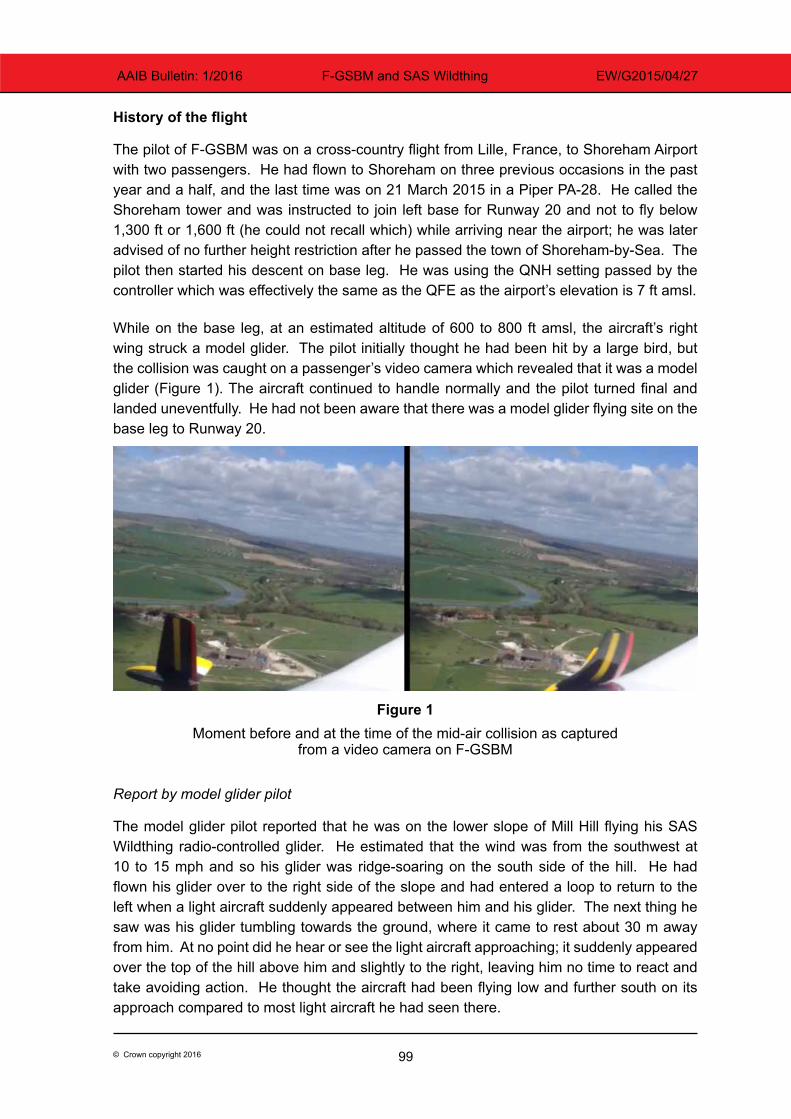
99© Crown copyright 2016
AAIB Bulletin: 1/2016 F-GSBM and SAS Wildthing EW/G2015/04/27
History of the flight
The pilot of F-GSBM was on a cross-country flight from Lille, France, to Shoreham Airport with two passengers. He had flown to Shoreham on three previous occasions in the past year and a half, and the last time was on 21 March 2015 in a Piper PA-28. He called the Shoreham tower and was instructed to join left base for Runway 20 and not to fly below 1,300 ft or 1,600 ft (he could not recall which) while arriving near the airport; he was later advised of no further height restriction after he passed the town of Shoreham-by-Sea. The pilot then started his descent on base leg. He was using the QNH setting passed by the controller which was effectively the same as the QFE as the airport’s elevation is 7 ft amsl.
While on the base leg, at an estimated altitude of 600 to 800 ft amsl, the aircraft’s right wing struck a model glider. The pilot initially thought he had been hit by a large bird, but the collision was caught on a passenger’s video camera which revealed that it was a model glider (Figure 1). The aircraft continued to handle normally and the pilot turned final and landed uneventfully. He had not been aware that there was a model glider flying site on the base leg to Runway 20.
Figure 1Moment before and at the time of the mid-air collision as captured
from a video camera on F-GSBM
Report by model glider pilot
The model glider pilot reported that he was on the lower slope of Mill Hill flying his SAS Wildthing radio-controlled glider. He estimated that the wind was from the southwest at 10 to 15 mph and so his glider was ridge-soaring on the south side of the hill. He had flown his glider over to the right side of the slope and had entered a loop to return to the left when a light aircraft suddenly appeared between him and his glider. The next thing he saw was his glider tumbling towards the ground, where it came to rest about 30 m away from him. At no point did he hear or see the light aircraft approaching; it suddenly appeared over the top of the hill above him and slightly to the right, leaving him no time to react and take avoiding action. He thought the aircraft had been flying low and further south on its approach compared to most light aircraft he had seen there.
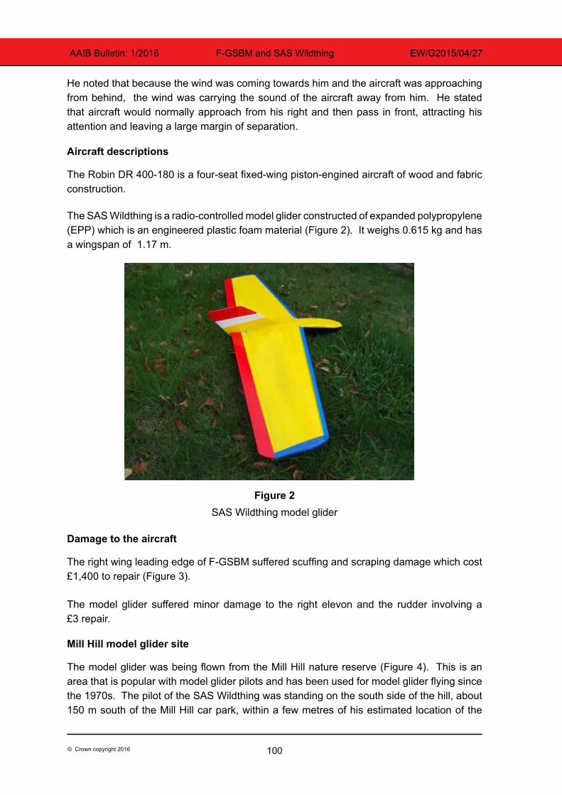
100© Crown copyright 2016
AAIB Bulletin: 1/2016 F-GSBM and SAS Wildthing EW/G2015/04/27
He noted that because the wind was coming towards him and the aircraft was approaching from behind, the wind was carrying the sound of the aircraft away from him. He stated that aircraft would normally approach from his right and then pass in front, attracting his attention and leaving a large margin of separation.
Aircraft descriptions
The Robin DR 400-180 is a four-seat fixed-wing piston-engined aircraft of wood and fabric construction.
The SAS Wildthing is a radio-controlled model glider constructed of expanded polypropylene (EPP) which is an engineered plastic foam material (Figure 2). It weighs 0.615 kg and has a wingspan of 1.17 m.
Figure 2SAS Wildthing model glider
Damage to the aircraft
The right wing leading edge of F-GSBM suffered scuffing and scraping damage which cost £1,400 to repair (Figure 3).
The model glider suffered minor damage to the right elevon and the rudder involving a £3 repair.
Mill Hill model glider site
The model glider was being flown from the Mill Hill nature reserve (Figure 4). This is an area that is popular with model glider pilots and has been used for model glider flying since the 1970s. The pilot of the SAS Wildthing was standing on the south side of the hill, about 150 m south of the Mill Hill car park, within a few metres of his estimated location of the
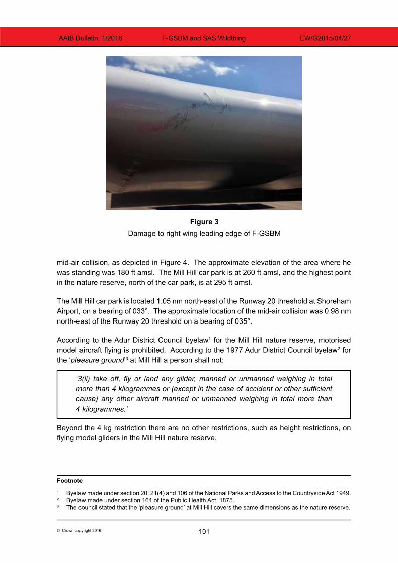
101© Crown copyright 2016
AAIB Bulletin: 1/2016 F-GSBM and SAS Wildthing EW/G2015/04/27
mid-air collision, as depicted in Figure 4. The approximate elevation of the area where he was standing was 180 ft amsl. The Mill Hill car park is at 260 ft amsl, and the highest point in the nature reserve, north of the car park, is at 295 ft amsl.
The Mill Hill car park is located 1.05 nm north-east of the Runway 20 threshold at Shoreham Airport, on a bearing of 033°. The approximate location of the mid-air collision was 0.98 nm north-east of the Runway 20 threshold on a bearing of 035°.
According to the Adur District Council byelaw1 for the Mill Hill nature reserve, motorised model aircraft flying is prohibited. According to the 1977 Adur District Council byelaw2 for the ‘pleasure ground’3 at Mill Hill a person shall not:
‘3(ii) take off, fly or land any glider, manned or unmanned weighing in total more than 4 kilogrammes or (except in the case of accident or other sufficient cause) any other aircraft manned or unmanned weighing in total more than 4 kilogrammes.’
Beyond the 4 kg restriction there are no other restrictions, such as height restrictions, on flying model gliders in the Mill Hill nature reserve.
Footnote1 Byelaw made under section 20, 21(4) and 106 of the National Parks and Access to the Countryside Act 1949.2 Byelaw made under section 164 of the Public Health Act, 1875.3 The council stated that the ‘pleasure ground’ at Mill Hill covers the same dimensions as the nature reserve.
Figure 3Damage to right wing leading edge of F-GSBM
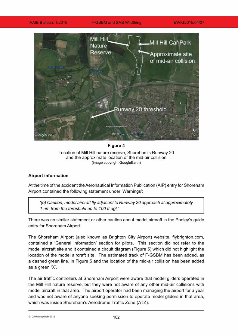
102© Crown copyright 2016
AAIB Bulletin: 1/2016 F-GSBM and SAS Wildthing EW/G2015/04/27
Figure 4Location of Mill Hill nature reserve, Shoreham’s Runway 20
and the approximate location of the mid-air collision(image copyright GoogleEarth)
Airport information
At the time of the accident the Aeronautical Information Publication (AIP) entry for Shoreham Airport contained the following statement under ‘Warnings’:
‘(e) Caution, model aircraft fly adjacent to Runway 20 approach at approximately 1 nm from the threshold up to 100 ft agl.’
There was no similar statement or other caution about model aircraft in the Pooley’s guide entry for Shoreham Airport.
The Shoreham Airport (also known as Brighton City Airport) website, flybrighton.com, contained a ‘General Information’ section for pilots. This section did not refer to the model aircraft site and it contained a circuit diagram (Figure 5) which did not highlight the location of the model aircraft site. The estimated track of F-GSBM has been added, as a dashed green line, in Figure 5 and the location of the mid-air collision has been added as a green ‘X’.
The air traffic controllers at Shoreham Airport were aware that model gliders operated in the Mill Hill nature reserve, but they were not aware of any other mid-air collisions with model aircraft in that area. The airport operator had been managing the airport for a year and was not aware of anyone seeking permission to operate model gliders in that area, which was inside Shoreham’s Aerodrome Traffic Zone (ATZ).
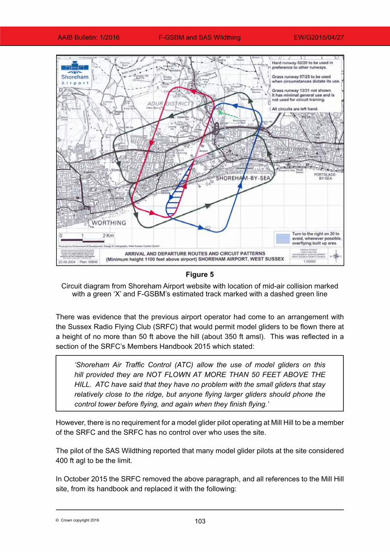
103© Crown copyright 2016
AAIB Bulletin: 1/2016 F-GSBM and SAS Wildthing EW/G2015/04/27
Figure 5Circuit diagram from Shoreham Airport website with location of mid-air collision marked
with a green ‘X’ and F-GSBM’s estimated track marked with a dashed green line
There was evidence that the previous airport operator had come to an arrangement with the Sussex Radio Flying Club (SRFC) that would permit model gliders to be flown there at a height of no more than 50 ft above the hill (about 350 ft amsl). This was reflected in a section of the SRFC’s Members Handbook 2015 which stated:
‘Shoreham Air Traffic Control (ATC) allow the use of model gliders on this hill provided they are NOT FLOWN AT MORE THAN 50 FEET ABOVE THE HILL. ATC have said that they have no problem with the small gliders that stay relatively close to the ridge, but anyone flying larger gliders should phone the control tower before flying, and again when they finish flying.’
However, there is no requirement for a model glider pilot operating at Mill Hill to be a member of the SRFC and the SRFC has no control over who uses the site.
The pilot of the SAS Wildthing reported that many model glider pilots at the site considered 400 ft agl to be the limit.
In October 2015 the SRFC removed the above paragraph, and all references to the Mill Hill site, from its handbook and replaced it with the following:
104© Crown copyright 2016
AAIB Bulletin: 1/2016 F-GSBM and SAS Wildthing EW/G2015/04/27
‘There are many slope soaring sites within our area, none of which are administered by SRFC but may come under the control of other clubs. Members at these sites should make themselves aware of any local rules, byelaws or NOTAMs which may apply.’
Regulations on small unmanned aircraft
Any model aircraft of less than 20 kg is classified by the Civil Aviation Authority (CAA) as a Small Unmanned Aircraft (SUA). The Air Navigation Order4 (ANO) contains the legal requirements for the operation of SUA. Article 166 states that:
‘(2) The person in charge of a small unmanned aircraft may only fly the aircraft if reasonably satisfied that the flight can safely be made.
(3) The person in charge of a small unmanned aircraft must maintain direct, unaided visual contact with the aircraft sufficient to monitor its flight path in relation to other aircraft, persons, vehicles, vessels and structures for the purpose of avoiding collisions.’
There are height restrictions and airspace restrictions for SUA with a mass greater than 7 kg, but none for SUA of less than 7 kg. The SAS Wildthing, as it is less than 7 kg, can be operated inside an ATZ without obtaining permission from air traffic control and up to any height as long as it remains within unaided visual contact of the pilot.
However, the guidance in CAP 6585 ‘Model aircraft: A Guide to Safe Flying’ is that pilots of model aircraft should obtain permission from the appropriate air traffic control unit before flying inside controlled airspace or an ATZ.
The CAA has also published a ‘Drone code’ (CAP 1202) which states ‘stay well clear of airports and airfields’, although no distance guidelines are provided.
Similar event
On 5 April 2015 a Pioneer 300 (G-OPFA) light aircraft collided with a ‘Valenta Ray X’ radio-controlled glider at a height of about 630 ft while flying in uncontrolled airspace near Upton-upon-Severn, Worcestershire. The Pioneer 300 sustained minor damage and landed uneventfully while the glider, which weighed 1.8 kg, sustained serious damage and crashed into a field. For further details see AAIB Bulletin 10/2015.
Proposed changes to regulations on small unmanned aircraft
At present the regulations on unmanned aircraft below 150 kg are set by the CAA, but in future the regulations on all unmanned aircraft will be set by the European Aviation Safety Agency (EASA). In July 2015 EASA published A-NPA 2015-10 ‘Introduction of a regulatory framework for the operation of drones’. This document proposes creating an ‘Open’ category Footnote4 CAP 393 Air Navigation: The Order and the Regulations (30 April 2015).5 CAP 658 Model aircraft: A Guide to Safe Flying, 4th edition February 2012 including amendment 1/2013 dated June 2013.
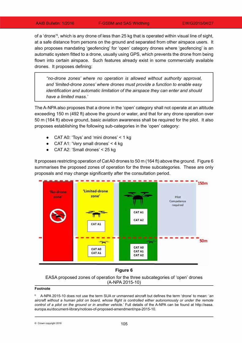
105© Crown copyright 2016
AAIB Bulletin: 1/2016 F-GSBM and SAS Wildthing EW/G2015/04/27
of a ‘drone’6, which is any drone of less than 25 kg that is operated within visual line of sight, at a safe distance from persons on the ground and separated from other airspace users. It also proposes mandating ‘geofencing’ for ‘open’ category drones where ‘geofencing’ is an automatic system fitted to a drone, usually using GPS, which prevents the drone from being flown into certain airspace. Such features already exist in some commercially available drones. It proposes defining:
‘‘no-drone zones’ where no operation is allowed without authority approval, and ‘limited-drone zones’ where drones must provide a function to enable easy identification and automatic limitation of the airspace they can enter and should have a limited mass.’
The A-NPA also proposes that a drone in the ‘open’ category shall not operate at an altitude exceeding 150 m (492 ft) above the ground or water, and that for any drone operation over 50 m (164 ft) above ground, basic aviation awareness shall be required for the pilot. It also proposes establishing the following sub-categories in the ‘open’ category:
● CAT A0: ‘Toys’ and ‘mini drones’ < 1 kg ● CAT A1: ‘Very small drones’ < 4 kg ● CAT A2: ‘Small drones’ < 25 kg
It proposes restricting operation of Cat A0 drones to 50 m (164 ft) above the ground. Figure 6 summarises the proposed zones of operation for the three subcategories. These are only proposals and may change significantly after the consultation period.
Figure 6EASA proposed zones of operation for the three subcategories of ‘open’ drones
(A-NPA 2015-10)Footnote6 A-NPA 2015-10 does not use the term SUA or unmanned aircraft but defines the term ‘drone’ to mean: ‘an aircraft without a human pilot on board, whose flight is controlled either autonomously or under the remote control of a pilot on the ground or in another vehicle.’ Full details of the A-NPA can be found at http://easa.europa.eu/document-library/notices-of-proposed-amendment/npa-2015-10.
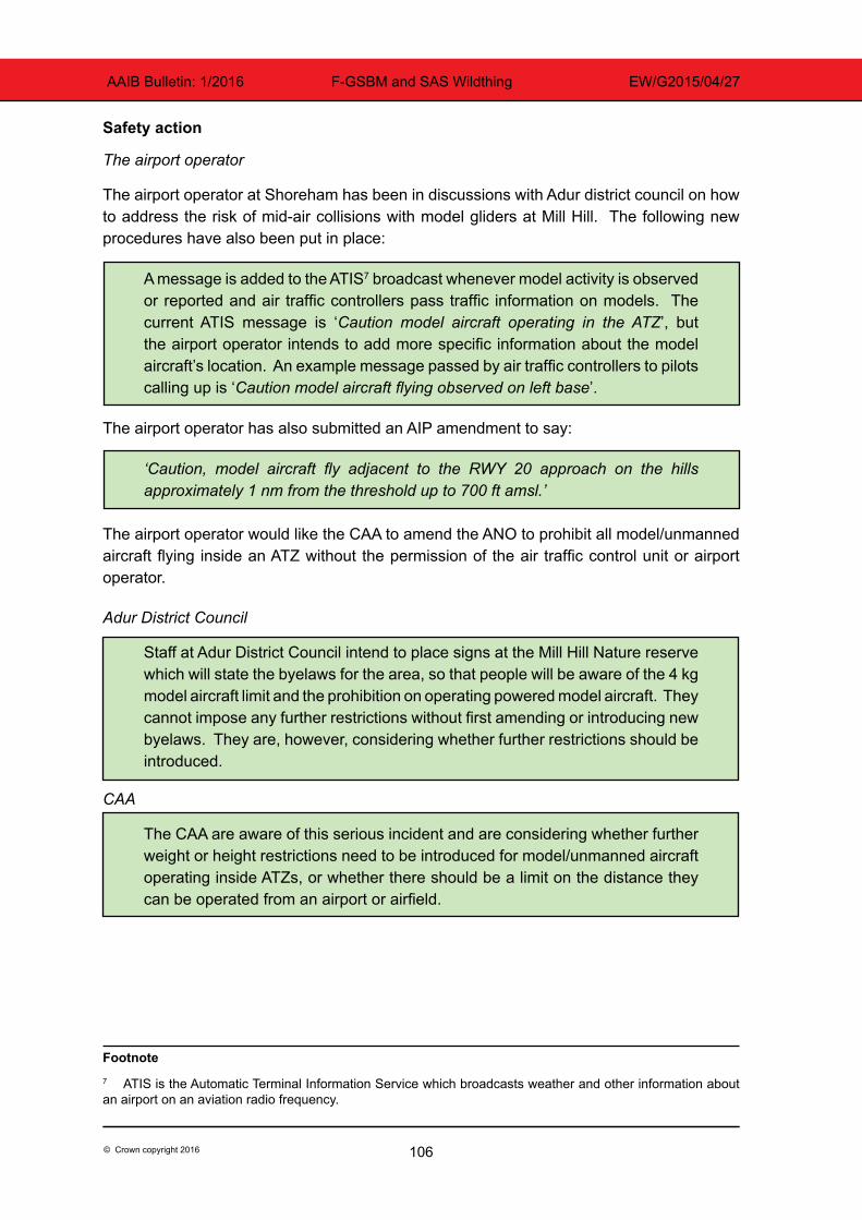
106© Crown copyright 2016
AAIB Bulletin: 1/2016 F-GSBM and SAS Wildthing EW/G2015/04/27
Safety action
The airport operator
The airport operator at Shoreham has been in discussions with Adur district council on how to address the risk of mid-air collisions with model gliders at Mill Hill. The following new procedures have also been put in place:
A message is added to the ATIS7 broadcast whenever model activity is observed or reported and air traffic controllers pass traffic information on models. The current ATIS message is ‘Caution model aircraft operating in the ATZ’, but the airport operator intends to add more specific information about the model aircraft’s location. An example message passed by air traffic controllers to pilots calling up is ‘Caution model aircraft flying observed on left base’.
The airport operator has also submitted an AIP amendment to say:
‘Caution, model aircraft fly adjacent to the RWY 20 approach on the hills approximately 1 nm from the threshold up to 700 ft amsl.’
The airport operator would like the CAA to amend the ANO to prohibit all model/unmanned aircraft flying inside an ATZ without the permission of the air traffic control unit or airport operator.
Adur District Council
Staff at Adur District Council intend to place signs at the Mill Hill Nature reserve which will state the byelaws for the area, so that people will be aware of the 4 kg model aircraft limit and the prohibition on operating powered model aircraft. They cannot impose any further restrictions without first amending or introducing new byelaws. They are, however, considering whether further restrictions should be introduced.
CAA
The CAA are aware of this serious incident and are considering whether further weight or height restrictions need to be introduced for model/unmanned aircraft operating inside ATZs, or whether there should be a limit on the distance they can be operated from an airport or airfield.
Footnote7 ATIS is the Automatic Terminal Information Service which broadcasts weather and other information about an airport on an aviation radio frequency.
107© Crown copyright 2016
AAIB Bulletin: 1/2016 F-GSBM and SAS Wildthing EW/G2015/04/27
Analysis
Cause of the mid-air collision
This mid-air collision occurred because neither pilot saw the other aircraft until it was too late. It is unlikely that a light aircraft pilot, approaching at 80 to 100 kt, would be able to detect a 1 m size object that was on a direct collision course in sufficient time to take avoiding action. However, a model aircraft pilot would normally be able to hear and see a light aircraft in sufficient time to take avoiding action, but in this case the aircraft approached from behind a hill, downwind, so the model aircraft pilot did not see or hear F-GSBM until it was too late to take avoiding action.
The model aircraft pilot reported that most light aircraft turned behind the hill, more closely following the blue line on the circuit diagram (Figure 5) which passes outside the nature reserve, so separation was not an issue. It is probable that many locally-based pilots follow a circuit pattern closely matching the blue line, but there is no requirement to follow the blue line. The circuit diagram is not part of the AIP and therefore it only serves as guidance to pilots. There is no requirement to check an airfield’s website so some visiting pilots will not be aware of the circuit diagram. Many visiting pilots will fly a circuit that is of similar size to the one at their home airport, and the circuit flown by the pilot of F-GSBM was well within what would be considered normal.
The pilot of F-GSBM estimated that he was at 600 to 800 ft amsl on left base when the collision occurred. The view of the surrounding terrain in Figure 1 indicates that he could have been as low as 400 to 500 ft amsl but probably not lower; this would have placed him about 220 to 320 ft agl at the point of collision. Although this might seem low, being at 400 to 500 ft aal (given that the runway was at sea-level) at 1 nm from the runway threshold is within the normal range. The PAPI8 angle for Runway 20 is 4.5° which means that an aircraft would be on the correct flight path at 500 ft aal at 1 nm from the threshold.
There is evidence that the Sussex Radio Flying Club (SRFC) had agreed with the previous airport operator not to operate more than 50 ft above the hill. If the summit of the hill is taken to be the highest point in the nature reserve, then this is about 350 ft amsl. This provides for a very small safety margin if aircraft pass over at 400 ft to 500 ft amsl.
The pilot of F-GSBM was operating his aircraft within normal boundaries. The pilot of the model glider was operating his aircraft in accordance with the local byelaws and the ANO; however, he had not followed the CAP 658 guidance to request permission from air traffic control or the airport operator, and his glider was probably above the ‘50 ft above hill’ (350 ft amsl) limit indicated in the SRFC Members Handbook at that time. There was evidence that many other model glider pilots operated above this height and without requesting permission from Shoreham Airport. As there was no requirement to be a member of the SRFC to operate from the site, many pilots would not have been aware of the limit. The pilot of the model glider appeared to be operating his aircraft in accordance with common practice at the Mill Hill site.Footnote8 PAPI means Precision Approach Path Indicator and is a set of lights that helps guide aircraft along a set flightpath angle to the runway. The PAPI for Runway 20 at Shoreham is displaced 90 m beyond the threshold.
108© Crown copyright 2016
AAIB Bulletin: 1/2016 F-GSBM and SAS Wildthing EW/G2015/04/27
Mid-air collision hazard and means to mitigate against it
In this incident the damage caused to F-GSBM by the 0.6 kg glider was minor, albeit expensive to repair. However, according to the local byelaws the glider could have been as heavy as 4 kg, which would have caused significantly more damage to the aircraft, potentially affecting its safety of flight. At a relative speed of 90 kt9 an impact with a 4 kg glider has 4.29 MJ of kinetic energy, which is 6.7 times more energy than a 0.6 kg glider at the same speed. The ANO permits unmanned aircraft up to 7 kg to operate in an ATZ without permission which would have a kinetic energy 11.7 times greater than a 0.6 kg glider at 90 kt.
If model aircraft were prevented from flying at the Mill Hill site the hazard would be eliminated and the Adur district council is considering taking such action. This would require a change to the byelaws, which could take some time and would not prevent other unmanned aircraft up to 7 kg operating in other ATZs without height restrictions. The CAA are considering whether further weight and/or height restrictions should be imposed on unmanned aircraft or whether there should be a limit on the distance they can be operated from an airport or airfield, but this would require a change to the ANO. The proposed changes to the EASA regulations on unmanned aircraft will also take time to be reviewed and implemented.
In the meantime, pilots of manned aircraft operating in and out of Shoreham Airport need knowledge about the location of the model glider site and knowledge about the altitudes the model gliders may be operating up to, so that pilots can avoid the area. The airport operator has submitted an amendment to the AIP to change the caution about model aircraft to include reference to the ‘hills’ at the site, and to change the height of operation from 100 ft agl to 700 ft amsl. However, the statement on location,
‘adjacent to the RWY 20 approach on the hills approximately 1 nm from the threshold,’
would be made clearer by adding bearing information, which the airport operator is considering. Pilots would also be helped if the circuit diagram on the website were amended to highlight the Mill Hill model glider site; the airport operator will consider this and has said it will contact Pooley’s to suggest they add information on the model glider site.
Footnote9 90 kt is within the typical range of a light aircraft’s airspeed on base leg.
109© Crown copyright 2016
AAIB Bulletin: 1/2016 N377C and G-WACF EW/G2015/10/05
ACCIDENT
Aircraft Type and Registration: 1) Socata TB21, N377C 2) Cessna 152, G-WACF
No & Type of Engines: 1) 1 Lycoming T10-540-AB1AD piston engine 2) 1 Lycoming O-235-L2C piston engine
Year of Manufacture: 1) 2005 2) 1980 (Serial no: 84852)
Date & Time (UTC): 9 October 2015 at 1600 hrs
Location: Wycombe Air Park, Buckinghamshire
Type of Flight: 1) Private 2) Training
Persons on Board: 1) Crew - 1 Passengers - 1 2) Crew - 2 Passengers - None
Injuries: 1) Crew - None Passengers - None 2) Crew - None Passengers - N/A
Nature of Damage: Propeller on N377C and wingtip on G-WACF damaged
Commander’s Licence: 1) Private Pilot’s Licence 2) Private Pilot’s Licence
Commander’s Age: 1) 69 years 2) 55 years
Commander’s Flying Experience: 1) 2,218 hours (of which 345 were on type) Last 90 days - 14 hours Last 28 days - 6 hours
2) 1,085 hours (of which 209 were on type) Last 90 days - 69 hours Last 28 days - 18 hours
Information Source: Aircraft Accident Report Form submitted by the pilots
Summary
While manoeuvring in the maintenance area at Wycombe Air Park, a ground collision occurred between a Socata TB21 and a Cessna 152.
Reports of the collision
Overview
A ground collision occurred between a Socata TB21, registration N377C, and a Cessna 152, registration G-WACF, in the aircraft maintenance area at Wycombe Air Park. The maintenance area formed a cul-de-sac bounded by four hangars, with the entry / exit located at the east side of the apron. The maintenance area was not under the control of Air Traffic Control (ATC) and pilots only needed to request taxi clearance if they were
110© Crown copyright 2016
AAIB Bulletin: 1/2016 N377C and G-WACF EW/G2015/10/05
going to enter the aircraft manoeuvring area. The collision occurred at 1600 hrs; sunset was at 1822 hrs.
Report from pilot of N377C
The pilot of N377C reported that following his flight he parked the aircraft outside the maintenance hangar. As he was shutting the engine down he was approached by a ground engineer who indicated with his hands and movement of his mouth that he was to move the aircraft. The pilot said that he believed, from the engineer’s hand and mouth movements, that there was some urgency and that he was to perform a 180º turn and taxi further into the cul-de-sac. After checking that the area was clear, the pilot commenced the manoeuvre but after turning approximately 130º his passenger alerted him to an aircraft that was approaching from the right. The pilot brought the aircraft to a halt just as the left wing of G-WACF passed over his right wing and struck his propeller.
Report from pilot of G-WACF
The pilot of G-WACF reported that after landing he was cleared to taxi to the apron and then to the hangars. The taxi light and anti-collision beacon on his aircraft were illuminated when he taxied into the maintenance area. He saw N377C parked next to the hangar door and could see a ground engineer indicating to the pilot of N377C that he should move his aircraft away from the hangar. The pilot of G-WACF said that he slowly taxied past N377C before bringing his aircraft to a halt to allow the ground crew to push another aircraft out of the way. Shortly after stopping he felt a slight impact through the control column and was conscious of a sharp increase in ambient noise before becoming aware that his left wingtip had been struck by the propeller on N377C.
Report from engineer
The engineer reported that it was the end of the day and the flying school aircraft were being moved into the hangar for the night. He observed N377C taxiing into the cul-de-sac between the hangars before turning back towards the apron and parking outside the hangar. The engineer said he attracted the pilot’s attention and made a gesture for him to move forward to clear the front of the hangar. There was a PA-28 parked in front of N377C, but he felt there was sufficient room for the pilot to taxi forward 25 to 30 feet. N377C moved forward and then turned back into the cul-de-sac. During the manoeuvre the propeller on N377C stuck the left wingtip of G-WACF, which was taxiing into the cul-de-sac.
Report from ATC
ATC reported that the collision occurred behind them and they first became aware of what had happened when they heard a loud bang and turned round and saw what appeared to be debris from the wing of G-WACF on the ground.
Damage
Neither of the pilots or passengers in the aircraft were injured. The propeller on N377C and the left wingtip on G-WACF were damaged.

111© Crown copyright 2016
AAIB Bulletin: 1/2016 G-CDJJ EW/G2015/06/14
ACCIDENT
Aircraft Type and Registration: YAK-52, G-CDJJ
No & Type of Engines: 1 Vedeneyev M-14P-400 piston engine
Year of Manufacture: 1989 (Serial no: 899912)
Date & Time (UTC): 18 June 2015 at 1553 hrs
Location: North Weald Airfield, Essex
Type of Flight: Private
Persons on Board: Crew - 1 Passengers - None
Injuries: Crew - None Passengers - N/A
Nature of Damage: Left landing gear, left wing and flap, and propeller
Commander’s Licence: Private Pilot’s Licence
Commander’s Age: 82 years
Commander’s Flying Experience: 876 hours (of which 435 were on type) Last 90 days - 2 hours Last 28 days - 0 hours
Information Source: Aircraft Accident Report Form submitted by the pilot
Synopsis
While landing, the aircraft descended low on final approach and struck a fence in the undershoot. This damaged the landing gear, which collapsed during the landing roll. The airfield operator has since repainted the lead-in lines to the displaced threshold of the runway.
History of the flight
The pilot was completing a short post-maintenance check flight, before returning to his home base at Shoreham. He had taken off from Runway 02 but, on return, the duty runway had changed to Runway 30. On approach, the pilot was aware of another aircraft on the runway. The aircraft was slower to vacate than he expected, which he later considered may have been a distraction. He descended low on final approach and the aircraft struck a fence in the undershoot to Runway 30. This caused damage to the landing gear, which subsequently failed during the landing roll.
The pilot commented that, although familiar with North Weald, he had never used Runway 30 before and was unaware of the fence in the undershoot. He did not see the fence during his approach to land, and considered that the limited visibility over the nose of the aircraft and the reduced visual contrast created by the sunlight at the time may have been factors.
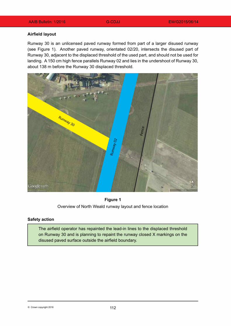
112© Crown copyright 2016
AAIB Bulletin: 1/2016 G-CDJJ EW/G2015/06/14
Airfield layout
Runway 30 is an unlicensed paved runway formed from part of a larger disused runway (see Figure 1). Another paved runway, orientated 02/20, intersects the disused part of Runway 30, adjacent to the displaced threshold of the used part, and should not be used for landing. A 150 cm high fence parallels Runway 02 and lies in the undershoot of Runway 30, about 138 m before the Runway 30 displaced threshold.
Figure 1Overview of North Weald runway layout and fence location
Safety action
The airfield operator has repainted the lead-in lines to the displaced threshold on Runway 30 and is planning to repaint the runway closed X markings on the disused paved surface outside the airfield boundary.
Fenc
e
Runw
ay 0
2 Runway 30
113© Crown copyright 2016
AAIB Bulletin: 1/2016 G-CEDX EW/G2015/07/23
ACCIDENT
Aircraft Type and Registration: EV-97 Teameurostar UK Eurostar, G-CEDX
No & Type of Engines: 1 Rotax 912-UL piston engine
Year of Manufacture: 2006 (Serial no: 2827)
Date & Time (UTC): 29 July 2015 at 1230 hrs
Location: Dunkeswell Airfield, Devon
Type of Flight: Private
Persons on Board: Crew - 1 Passengers - None
Injuries: Crew - None Passengers - N/A
Nature of Damage: Left aileron damaged
Commander’s Licence: National Private Pilot’s Licence
Commander’s Age: 50 years
Commander’s Flying Experience: 271 hours (of which 271 were on type) Last 90 days - 3 hours Last 28 days - 0 hours
Information Source: Aircraft Accident Report Form submitted by the pilot
The pilot was carrying out a flight from Gloucestershire Airport to Culdrose, with a refuelling stop at Dunkeswell. The weather on departure from Gloucester was: surface wind 300º/20 kt, 10 km visibility, with occasional showers. The flight to Dunkeswell was uneventful and, on arrival, an approach was flown to Runway 35 with three stages of flap set. The pilot noted that there was a strong crosswind from the left and made a “crabbing” approach, which was aborted at about 100 ft due to “instability”. He flew a go-around and noticed that the wind was from about 270º and that Runway 22 was more into wind. With approval, he made an approach to Runway 22, again with three stages of flap, but just before touchdown a gust of wind caused the aircraft to bank to the left and the left aileron struck the ground. The pilot went around and diverted to Exeter. However, due to turbulence on approach to Runway 26 at Exeter, he returned to Gloucester following a handling check, landing there safely.
Having discussed the incident with an instructor, it was suggested that a flapless approach, with the higher resultant airspeed, would have been more appropriate.
114© Crown copyright 2016
AAIB Bulletin: 1/2016 G-BZWU EW/G2015/09/31
ACCIDENT
Aircraft Type and Registration: Pegasus Quantum 15, G-BZWU
No & Type of Engines: 1 Rotax 912-UL piston engine
Year of Manufacture: 2001 (Serial no: 7831)
Date & Time (UTC): 26 September 2015 at 1310 hrs
Location: Maypole Airfield, Kent
Type of Flight: Training
Persons on Board: Crew - 1 Passengers - None
Injuries: Crew - None Passengers - N/A
Nature of Damage: Propeller, wing, pylon and front strut damaged
Commander’s Licence: Student
Commander’s Age: 61 years
Commander’s Flying Experience: 54 hours (of which 48 were on type) Last 90 days - 13 hours Last 28 days - 4 hours
Information Source: Aircraft Accident Report Form submitted by the pilot
The student was on his first solo cross-country flight from Rochester to Maypole Airfield in Kent. While on the downwind leg of the circuit at Maypole Airfield, the student noticed a tractor cutting the grass on the runway, so he flew a go-around. The second circuit was uneventful and the aircraft touched down normally, slightly left of the centre line. However, the pilot reported that during the ground roll, the right wheel appeared to lock and the aircraft swung to the right before tipping over onto its left side. The pilot was uninjured, but the wing, front strut, pylon and propeller were all damaged.
The reason why the aircraft veered to the right during the ground roll was not determined.
115© Crown copyright 2016
AAIB Bulletin: 1/2016 G-CWVY EW/G2015/10/09
ACCIDENT
Aircraft Type and Registration: Pegasus Quik, G-CWVY
No & Type of Engines: 1 Rotax 912ULS piston engine
Year of Manufacture: 2003 (Serial no: 7984)
Date & Time (UTC): 25 October 2015 at 1140 hrs
Location: Old Park Farm Airfield, near Port Talbot
Type of Flight: Private
Persons on Board: Crew - 1 Passengers - 1
Injuries: Crew - 1 (Minor) Passengers - 1 (Serious)
Nature of Damage: Major damage to wing and trike
Commander’s Licence: National Private Pilot’s Licence
Commander’s Age: 64 years
Commander’s Flying Experience: 640 hours (of which 444 were on type) Last 90 days - 27 hours Last 28 days - 4 hours
Information Source: Aircraft Accident Report Form submitted by the pilot
Synopsis
The pilot judged that his groundspeed was too high after touchdown and decided to initiate a go-around. He admits that he was late in making the decision and the aircraft struck several obstacles before coming to an abrupt halt beyond the end of the runway.
History of the flight
The pilot was positioning the aircraft for a standard rejoin to Runway 36 at Old Park Farm, which is 350 m long. Upon establishing on the base leg, he carried out the landing checks which included trimming the aircraft to maintain 60 mph and checking that the hand throttle was closed. He commenced a descent, which he controlled using the foot throttle, with the aim of turning finals at 500 ft agl. Having turned onto finals, he took his foot off the throttle, noting from the windsock that there was zero wind, and commenced a glide approach maintaining 60 mph.
Upon touchdown, it immediately became apparent that the groundspeed was too high and the pilot applied the footbrake to slow down as well as pulling the control bar back to increase aerodynamic drag from the wing. Despite this, limited reduction in speed was achieved and he decided to go around, releasing the brakes, applying full power and levelling the wing. He sensed the aircraft accelerating but it struck the airfield boundary fence upon becoming airborne. It then ran across a lane before striking a hedge atop a small embankment, before coming to rest with the trike separated into two pieces. He
116© Crown copyright 2016
AAIB Bulletin: 1/2016 G-CWVY EW/G2015/10/09
initially thought that, like himself, his passenger had only suffered minor injuries but it was later found that he had a spinal injury.
The pilot attributes the accident to his late decision to go around.
117© Crown copyright 2016
AAIB Bulletin: 1/2016 G-CDUH EW/G2015/10/04
ACCIDENT
Aircraft Type and Registration: Quik GT450, G-CDUH
No & Type of Engines: 1 Rotax 912-UL piston engine
Year of Manufacture: 2006 (Serial no: 8167)
Date & Time (UTC): 10 October 2015 at 1300 hrs
Location: Cromarty Firth
Type of Flight: Private
Persons on Board: Crew - 1 Passengers - 1
Injuries: Crew - None Passengers - None
Nature of Damage: Damaged beyond economic repair
Commander’s Licence: National Private Pilot’s Licence
Commander’s Age: 53 years
Commander’s Flying Experience: 125 hours (of which 125 were on type) Last 90 days - 10 hours Last 28 days - 2 hours
Information Source: Aircraft Accident Report Form submitted by the pilot
The aircraft had taken off from Easterton Airfield, near Elgin, Morayshire and was en route to Invergordon via Nairn. The pilot flew at an altitude of 5,500 ft across the Moray Firth, but found the temperature cold. He therefore descended to 2,000 ft to cross the Cromarty Firth and again to approximately 20 ft to fly along the shore.
When the pilot attempted to apply power to climb, the engine did not respond and the aircraft descended towards the water. He decided to ditch the aircraft because the shore, although close by, was rocky. The aircraft flipped inverted as it entered the water. The pilot unfastened his seatbelt and escaped from the pod, followed by his passenger. The pilot conjectured that the loss of power may have been caused by carburettor icing during the two previous descents.

119© Crown copyright 2016
AAIB Bulletin: 1/2016
MiscellaneousThis section contains Addenda, Corrections
and a list of the ten most recentAircraft Accident (‘Formal’) Reports published
by the AAIB.
The complete reports can be downloaded fromthe AAIB website (www.aaib.gov.uk).

121© Crown copyright 2016
AAIB Bulletin: 1/2016
Unabridged versions of all AAIB Formal Reports, published back to and including 1971,are available in full on the AAIB Website
http://www.aaib.gov.uk
TEN MOST RECENTLY PUBLISHED FORMAL REPORTS
ISSUED BY THE AIR ACCIDENTS INVESTIGATION BRANCH
2/2014 Eurocopter EC225 LP Super Puma G-REDW, 34 nm east of Aberdeen, Scotland on 10 May 2012 and G-CHCN, 32 nm south-west of Sumburgh, Shetland Islands on 22 October 2012. Published June 2014.
3/2014 Agusta A109E, G-CRST Near Vauxhall Bridge, Central London on 16 January 2013.
Published September 2014.
1/2015 Airbus A319-131, G-EUOE London Heathrow Airport on 24 May 2013. Published July 2015.
2/2015 Boeing B787-8, ET-AOP London Heathrow Airport on 12 July 2013. Published August 2015.
3/2015 Eurocopter (Deutschland) EC135 T2+, G-SPAO Glasgow City Centre, Scotland on 29 November 2013. Published October 2015.
7/2010 Aerospatiale (Eurocopter) AS 332L Super Puma, G-PUMI at Aberdeen Airport, Scotland on 13 October 2006. Published November 2010.
8/2010 Cessna 402C, G-EYES and Rand KR-2, G-BOLZ near Coventry Airport on 17 August 2008. Published December 2010.
1/2011 Eurocopter EC225 LP Super Puma, G-REDU near the Eastern Trough Area Project Central Production Facility Platform in the North Sea on 18 February 2009. Published September 2011.
2/2011 Aerospatiale (Eurocopter) AS332 L2 Super Puma, G-REDL 11 nm NE of Peterhead, Scotland on 1 April 2009. Published November 2011.
1/2014 Airbus A330-343, G-VSXY at London Gatwick Airport on 16 April 2012. Published February 2014.

Air Accidents Investigation BranchFarnborough House
Berkshire Copse RoadAldershot
Hants GU11 2HH
Tel: 01252 510300Fax: 01252 376999
Press enquiries: 0207 944 3118/4292http://www.aaib.gov.uk
AAIB Bulletins and Reports are available on the Internethttp://www.aaib.gov.uk
AAIB Bulletin: 1/2016
GLOSSARY OF ABBREVIATIONS
aal aboveairfieldlevelACAS Airborne Collision Avoidance SystemACARS Automatic Communications And Reporting SystemADF Automatic Direction Finding equipmentAFIS(O) AerodromeFlightInformationService(Officer)agl above ground levelAIC Aeronautical Information Circularamsl above mean sea levelAOM Aerodrome Operating MinimaAPU Auxiliary Power UnitASI airspeed indicatorATC(C)(O) AirTrafficControl(Centre)(Officer)ATIS Automatic Terminal Information SystemATPL Airline Transport Pilot’s LicenceBMAA British Microlight Aircraft AssociationBGA British Gliding AssociationBBAC British Balloon and Airship ClubBHPA British Hang Gliding & Paragliding AssociationCAA Civil Aviation AuthorityCAVOK CeilingAndVisibilityOK(forVFRflight)CAS calibrated airspeedcc cubic centimetresCG Centre of Gravitycm centimetre(s)CPL Commercial Pilot’s Licence°C,F,M,T Celsius, Fahrenheit, magnetic, trueCVR Cockpit Voice RecorderDFDR Digital Flight Data RecorderDME Distance Measuring EquipmentEAS equivalent airspeedEASA European Aviation Safety AgencyECAM Electronic Centralised Aircraft MonitoringEGPWS Enhanced GPWSEGT Exhaust Gas TemperatureEICAS Engine Indication and Crew Alerting SystemEPR Engine Pressure RatioETA Estimated Time of ArrivalETD Estimated Time of DepartureFAA Federal Aviation Administration (USA)FIR Flight Information RegionFL Flight Levelft feetft/min feet per minuteg acceleration due to Earth’s gravityGPS Global Positioning SystemGPWS Ground Proximity Warning Systemhrs hours (clock time as in 1200 hrs)HP high pressure hPa hectopascal (equivalent unit to mb)IAS indicated airspeedIFR Instrument Flight RulesILS Instrument Landing SystemIMC Instrument Meteorological ConditionsIP Intermediate PressureIR Instrument RatingISA International Standard Atmospherekg kilogram(s)KCAS knots calibrated airspeedKIAS knots indicated airspeedKTAS knots true airspeedkm kilometre(s)kt knot(s)
lb pound(s)LP low pressure LAA Light Aircraft AssociationLDA Landing Distance AvailableLPC LicenceProficiencyCheckm metre(s)mb millibar(s)MDA Minimum Descent AltitudeMETAR a timed aerodrome meteorological report min minutesmm millimetre(s)mph miles per hourMTWA Maximum Total Weight AuthorisedN NewtonsNR Main rotor rotation speed (rotorcraft)Ng Gas generator rotation speed (rotorcraft)N1 engine fan or LP compressor speedNDB Non-Directional radio Beaconnm nautical mile(s)NOTAM Notice to AirmenOAT Outside Air TemperatureOPC OperatorProficiencyCheckPAPI Precision Approach Path IndicatorPF Pilot FlyingPIC Pilot in CommandPNF Pilot Not FlyingPOH Pilot’s Operating HandbookPPL Private Pilot’s Licencepsi pounds per square inchQFE altimeter pressure setting to indicate height
above aerodromeQNH altimeter pressure setting to indicate
elevation amslRA Resolution Advisory RFFS Rescue and Fire Fighting Servicerpm revolutions per minuteRTF radiotelephonyRVR Runway Visual RangeSAR Search and RescueSB Service BulletinSSR Secondary Surveillance RadarTA TrafficAdvisoryTAF Terminal Aerodrome ForecastTAS true airspeedTAWS Terrain Awareness and Warning SystemTCAS TrafficCollisionAvoidanceSystemTGT Turbine Gas TemperatureTODA Takeoff Distance AvailableUHF Ultra High FrequencyUSG US gallonsUTC Co-ordinated Universal Time (GMT)V Volt(s)V1 Takeoff decision speedV2 Takeoff safety speedVR Rotation speedVREF Reference airspeed (approach)VNE Never Exceed airspeedVASI Visual Approach Slope IndicatorVFR Visual Flight RulesVHF Very High FrequencyVMC Visual Meteorological ConditionsVOR VHF Omnidirectional radio Range
This bulletin contains facts which have been determined up to the time of compilation.
Extractsmaybepublishedwithoutspecificpermissionprovidingthatthesourceisdulyacknowledged,thematerialisreproduced accurately and it is not used in a derogatory manner or in a misleading context.
Published 14 January 2016 Cover picture courtesy of Stephen R Lynn(www.srlynnphotography.co.uk)
© Crown copyright 2016 ISSN 0309-4278
Published by the Air Accidents Investigation Branch, Department for TransportPrintedintheUKonpapercontainingatleast75%recycledfibre
AAIB investigations are conducted in accordance with Annex 13 to the ICAO Convention on International Civil Aviation,
EU Regulation No 996/2010 and The Civil Aviation (Investigation ofAir Accidents and Incidents) Regulations 1996.
The sole objective of the investigation of an accident or incident under these Regulations is the prevention of future accidents and incidents. It is not the
purpose of such an investigation to apportion blame or liability.
Accordingly, it is inappropriate that AAIB reports should be used to assign fault or blame or determine liability, since neither the investigation nor the reporting
process has been undertaken for that purpose.
TO REPORT AN ACCIDENT OR INCIDENTPLEASE CALL OUR 24 HOUR REPORTING LINE
01252 512299
AAIB Bulletin 1/2016
AA
IB B
ulletin 1/2016 AAIB Bulletin 1/2016
AAIBAir Accidents Investigation Branch


![AAIB Bulletin 3/2020 - GOV UK · AAIB Bulletin: 3/2020 G-ATBJ EW/C2018/02/01 it [auxiliary hydraulic pressure] we haven’t got enough oomph in the systems now”. During the after‑start](https://img.pdfslide.us/doc/110x75/5f6478f23476ee446a4119ec/aaib-bulletin-32020-gov-uk-aaib-bulletin-32020-g-atbj-ewc20180201-it-auxiliary.jpg)