Embed Size (px)
Citation preview

Virginia Department of Transportation
Jurisdiction Report
Daily Traffic Volume EstimatesIncluding Vehicle Classification Estimates
Town of Troutdale
Town of FriesTown of Independence
where available
Grayson County
2010
Prepared ByVirginia Department of Transportation
Traffic Engineering Division
In Cooperation WithU.S. Department of TransportationFederal Highway Administration
38

Virginia Department of TransportationTraffic Engineering DivisionTraffic Monitoring Section
The Virginia Department of Transportation (VDOT) conducts a program where trafficcount data are gathered from sensors in or along streets and highways and other sources.From these data, estimates of the average number of vehicles that traveled each segmentof road are calculated. VDOT periodically publishes booklets listing these estimates.
One of these booklets, titled “Average Daily Traffic Volumes with Vehicle ClassificationData, on Interstate, Arterial and Primary Routes”includes a list of each Interstate andPrimary highway segment with the estimated Annual Average Daily Traffic (AADT) forthat segment. AADT is the total annual traffic estimate divided by the number of days inthe year. This booklet also includes information such as estimates of the percentage ofthe AADT made up by 6 different vehicle types, ranging from cars to double trailertrucks; estimated Annual Average Weekday Traffic (AAWDT), which is the number ofvehicles estimated to have traveled the segment of highway during a 24 hour weekdayaveraged over the year; as well as Peak Hour and Peak Direction factors used by plannersto formulate design criteria.
In addition to the Primary and Interstate publication, one hundred books are publishedperiodically, one for each of 100 areas across the state defined by VDOT for recordkeeping purposes. These books include traffic volume estimates for roads within thecounty, cities, and towns within the area. These books are titled “Daily Traffic VolumesIncluding Vehicle Classification Estimates, where available; Jurisdiction Report numbers00 through 99”.
Also available are a number of reports summarizing the average Vehicle Miles Traveled(VMT) in selected jurisdictions and other categories of highways. There are manydifferent ways to present traffic volume summary information. Because the userdetermines the value of each presentation, the reports have been redesigned based on userrequests and feedback. The people of the VDOT Traffic Engineering Division TrafficMonitoring Section who produce these books welcome requests for other helpful ways ofpresenting the summary information.
A compact disc (CD) is available that includes files in the Adobe® Portable DocumentFormat (PDF) that can be displayed, searched, and printed using common desktopcomputer equipment. The CD includes the publications described above as well as anumber of other reports, including specialized VMT summaries and smaller AADTreports for each city and town separately.

Publication Notes
Parallel Roads
For road inventory and management purposes, some roadways are counted separately bydirection and have separately published traffic estimates for each direction of travel.Examples of such roadways are the interstate system and routes with separated facilitiesand (usually) oneway traffic facilities in urban areas. In these publications, they arereferred to as parallel roads. As a convenience for the users of the publication, the listingfor segments of roads with parallel segments are published with both the traffic estimatesfor their own direction of travel (e.g. I95 Northbound) as well as the estimate of the totalof all traffic on the same route including parallel roadways (all directions of I95). Thepublication will have a “Combined Traffic Estimates for Parallel Roadways on thisRoute” or “Combined Traffic” identifiers for the combined direction of travel estimates.
Roadways such as I395 with a North segment, a South segment and a separateReversible lane segment will have the estimate for more than two parallel roadwaysincluded in the entire combined traffic estimate.
Some routes have very complicated paths through cities and towns. These parallel pathsmay be too complex to allow a relationship between nearby sections of the oppositedirection on the same route. In this case, to indicate that the traffic estimates for such aroad segment may not include all directions of traffic on that route, the line that wouldlist the combined values will indicate “NA” for not available.
VDOT’s traffic monitoring program includes more than 100,000 segments of roads andhighways ranging from several mile sections of Interstate highways to very short sectionsof city streets. Due to problems experienced obtaining some traffic count data, and thelevel of quality necessary to maintain confidence in the data, no estimate is currentlyavailable for some segments of roadway. These segments are included in thepublications indicating “NA” for not available. It is the intention of the VDOT TrafficEngineering Division Traffic Monitoring group to obtain the data necessary and to reporttraffic volume estimates on all road segments included in these publications.
Many of the road segments in this program are local secondary roads. The amount anddetail of data collected on these roads are not as great as the data collected on highervolume roads. The vehicle classification, average weekday traffic volumes, and thetheoretical design hour traffic volumes are not calculated for these roads. Thepublications indicate “NA” for the information that is not available.
This publication is based on a traffic monitoring program initiated in 1997. Because thedata collection techniques and statistical evaluation processes are different than thoseused in previous years, comparison with previous publications may be misleading.
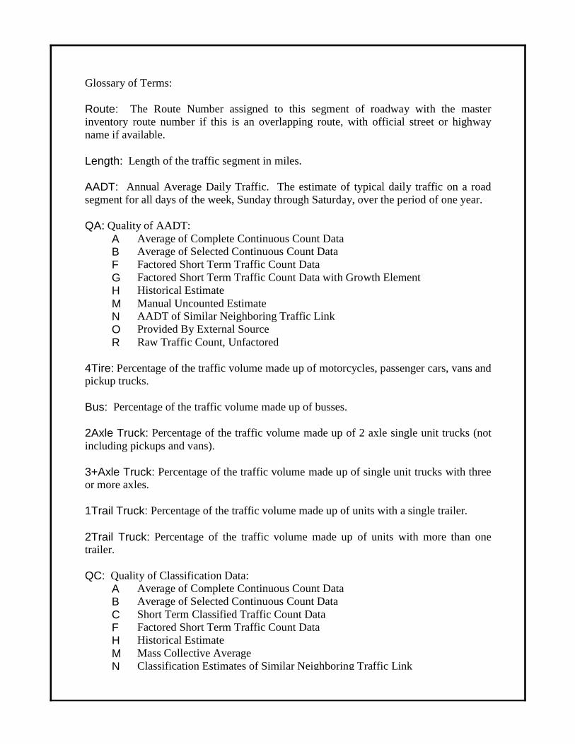
Glossary of Terms:
Route: The Route Number assigned to this segment of roadway with the masterinventory route number if this is an overlapping route, with official street or highwayname if available.
Length: Length of the traffic segment in miles.
AADT: Annual Average Daily Traffic. The estimate of typical daily traffic on a roadsegment for all days of the week, Sunday through Saturday, over the period of one year.
QA: Quality of AADT:A Average of Complete Continuous Count DataB Average of Selected Continuous Count DataF Factored Short Term Traffic Count DataG Factored Short Term Traffic Count Data with Growth ElementH Historical EstimateM Manual Uncounted EstimateN AADT of Similar Neighboring Traffic LinkO Provided By External SourceR Raw Traffic Count, Unfactored
4Tire: Percentage of the traffic volume made up of motorcycles, passenger cars, vans andpickup trucks.
Bus: Percentage of the traffic volume made up of busses.
2Axle Truck: Percentage of the traffic volume made up of 2 axle single unit trucks (notincluding pickups and vans).
3+Axle Truck: Percentage of the traffic volume made up of single unit trucks with threeor more axles.
1Trail Truck: Percentage of the traffic volume made up of units with a single trailer.
2Trail Truck: Percentage of the traffic volume made up of units with more than onetrailer.
QC: Quality of Classification Data:A Average of Complete Continuous Count DataB Average of Selected Continuous Count DataC Short Term Classified Traffic Count DataF Factored Short Term Traffic Count DataH Historical EstimateM Mass Collective AverageN Classification Estimates of Similar Neighboring Traffic Link

K Factor: The estimate of the portion of the traffic volume traveling during the peak houror design hour.
QK: Quality of the K Factor estimate:A Factor based on 30th Highest Hour Observed During at least 250 days of
Continuous Traffic DataB Factor based on other Hour Observed During Less than 250 days of
Continuous Traffic DataF Factor based on Highest Hour Collected at in a 48 Hour Weekday PeriodM Factor based on Manual Estimate of design hourN Design Hour Factor (K Factor) of Similar Neighboring Traffic LinkO Provided by External Source
Dir Factor: The estimate of the portion of the traffic volume traveling in the peakdirection during the peak hour..
AAWDT: Average Annual Weekday Traffic. The estimate of typical traffic over theperiod of one year for the days between Monday through Thursday inclusive.
QW: Quality of AAWDT:A Average of Complete Continuous Count DataB Average of Selected Continuous Count DataF Factored Short Term Traffic Count DataG Factored Short Term Traffic Count Data with Growth ElementM Manual Uncounted EstimateN AAWDT of Similar Neighboring Traffic LinkO Provided by External Source
Year: Year for which the published values are appropriate. If the Quality of AADT(QA) is “R”, the year is the year that the raw traffic count was collected, and if available,

Bus
29
600
7
29
North
81
154600
Interstate Route
US Route
Virginia State Route
ALT Alternate Route
Bus Business RouteBypas Bypass RouteTruck Truck Route
Wye Wye Route connector
Secondary Route
The VDOT Maintainenance Jurisdiction number is displayed below the Secondary RouteNumber if the Maintenance Jurisdiction is different than the jurisdiction in the title of the report.
P Parallel Route; Southbound or Westbound direction lanes of a numbered route wherethey are on a different road facility than the other direction.
ALT
220
11P
Traffic volume data for Interstate Routes and some other routes arereported separately by direction, as well as combined.
Route Shield Legend
Route Systems
Special Routes
Frontage Road (F precedes frontage route number)F241

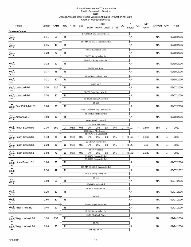
Virginia Department of TransportationTraffic Engineering Division
2010Annual Average Daily Traffic Volume Estimates By Section of Route
Grayson Maintenance Area
Route Jurisdiction AADT1Trail 2Trail
4TireK
QA2Axle 3+Axle
QC QKBusLengthTruck
FactorAAWDT QW
DirFactor
1100 1% 1% 0.099 1200G F1% 8% C GNorth Carolina State Line
US 58 Troutdale Hwy89%
From:
To:
From:
Grayson County 4.06 0%16 Jefferson Hwy
US 58 Mouth of Wilson
0.556
1600 1% 1% 0.093 1700G F1% 8% F GUS 58 Volney
89%
From:
To:
Grayson County58 3.99 0%16 Troutdale Hwy
US 58 Highlands Pkwy
0.515
1100 1% 1% 0.098 1200G F1% 8% F G
ECL Troutdale
89%
From:To:
Grayson County 5.66 0%16 Troutdale Hwy 0.522
1100 1% 1% 0.101 1200G F1% 8% F G
WCL Troutdale
89%
From:To:
Town of Troutdale (Maint: 38) 2.26 0%16 Troutdale Hwy 0.540
1100 1% 1% 0.102 1100G F1% 8% F GSmyth County Line
89%To:
Grayson County 0.82 0%16 Troutdale Hwy 0.818
1900 0% 1% 0.096 2000G F0% 6% C GNorth Carolina State Line
SCL Independence
92%
From:To:
From:
Grayson County221 3.39 0%21 New River Pkwy
1900 0% 1% 0.096 2000N N0% 6% N N
US 58 Main St
92%
From:To:
Town of Independence (Maint: 38)221 0.47 0%21
1900 0% 1% 0.118 2000A A1% 1% C A
NCL Independence
97%
From:To:
Town of Independence (Maint: 38) 1.64 0%21 0.581
1900 0% 1% 0.118 2000N N1% 1% N N
38791 Country Ln
97%
From:To:
Grayson County 8.72 0%21 0.581
1600 0% 1% 0.098 1600G F1% 1% F G
38805 Spring Valley Rd
97%
From:To:
Grayson County 1.45 0%21 Elk Creek Pkwy 0.509
1400 0% 1% 0.091 1500G F1% 1% F GWythe County Line
97%To:
Grayson County 1.37 0%21 Elk Creek Pkwy 0.561
560 NA NAONorth Carolina State Line
SR 89From:To:
From:
Grayson County (Maint: US ) 1.1348 Blue Ridge Parkway
560 NA NAOGrayson County LineTo:
Grayson County (Maint: US ) 3.5648 Blue Ridge Parkway
670 0% 1% 0.101 700G F2% 1% F GWashington County Line
SR 362 Grayson Highlands State Park
95%
From:To:
From:
Grayson County 9.57 0%58 Highlands Pkwy; Jeb Stuart Hwy 0.511
480 0% 1% 0.13 500G F2% 1% F G
38740 North of Rugby
95%
From:To:
Grayson County 3.76 0%58 Highlands Pkwy 0.516
710 0% 1% 0.100 740G F2% 1% F GSR 16 Troutdale Hwy
95%
From:
To:
Grayson County 3.99 0%58 Highlands Pkwy
SR 16; Highlands Pkwy
0.696
1600 1% 1% 0.093 1700G F1% 8% F GSR 16 Jefferson Hwy
89%To:
Grayson County16 3.99 0%58 Troutdale Hwy 0.515
76/30/2011

Virginia Department of TransportationTraffic Engineering Division
2010Annual Average Daily Traffic Volume Estimates By Section of Route
Grayson Maintenance Area
Route Jurisdiction AADT1Trail 2Trail
4TireK
QA2Axle 3+Axle
QC QKBusLengthTruck
FactorAAWDT QW
DirFactor
1900 1% 2% 0.090 2000G F3% 5% F GSR 16 Jefferson Hwy
38711 Fox Creek Rd
90%
From:To:
From:
Grayson County 3.79 0%58 Wilson Hwy 0.556
2500 1% 2% 0.094 2700G F3% 5% C G
WCL Independence
90%
From:To:
Grayson County 8.04 0%58 Wilson Hwy 0.704
2500 1% 2% 0.094 2700N N3% 5% N N
US 21 Independence Ave
90%
From:To:
Town of Independence (Maint: 38) 0.86 0%58 W Main St 0.704
7300 1% 1% 0.11 7700G F1% 4% F G
ECL Independence
92%
From:To:
Town of Independence (Maint: 38)221 1.20 0%58 E Main St 0.63
7300 1% 1% 0.11 7700N N1% 4% N N
SR 274 Riverside Dr
92%
From:To:
Grayson County221 1.55 0%58 Grayson Pkwy 0.63
5400 1% 1% NA 5600G 1% 4% C G
SR 94 Riverside Dr
92%
From:To:
Grayson County221 8.68 0%58 Grayson Pkwy
8700 1% 1% 0.094 9100G F1% 4% F GWCL Galax
92%To:
Grayson County221 1.36 0%58 Grayson Pkwy
5200 0% 1% 0.089 5500G F0% 2% C GNorth Carolina State Line
SCL Galax97%
To:
From:
Grayson County 4.89 0%89 Skyline Hwy
760 0% 3% 0.102 790G F7% 4% C GNorth Carolina State Line
US 58 Near Mouth Of Wilson86%
To:
From:
Grayson County 0.92 0%93 Wilson Hwy 0.554
2000 0% 1% 0.108 2100G F1% 2% C GUS 58 West of Galax
SR 274 Riverside Dr
96%
From:To:
From:
Grayson County 4.22 0%94 Riverside Dr 0.676
2000 1% 1% 0.109 2100G F0% 1% F G
38805 Southwest of Fries Spring Valley
96%
From:To:
Grayson County 2.05 0%94 Scenic Rd 0.699
2000 1% 1% 0.092 2100G F0% 1% C G
WCL Fries
96%
From:To:
Grayson County 2.20 0%94 Scenic Rd 0.571
2000 1% 1% 0.092 2100N N0% 1% N N
381001 W Main St
96%
From:To:
Town of Fries (Maint: 38) 0.48 0%94 0.571
2000 1% 1% 0.095 2100G F0% 1% F G
NCL Fries
96%
From:To:
Town of Fries (Maint: 38) 0.56 0%94 Scenic Rd 0.573
2000 1% 1% 0.095 2100N N0% 1% N NCarroll County Line
96%To:
Grayson County 0.63 0%94 0.573
2600 0% 1% 0.09 2700G F1% 0% C GECL Galax
Carroll County Line98%
To:
From:
Grayson County 0.78 0%97 Pipers Gap Rd
1900 0% 1% 0.096 2000G F0% 6% C GNorth Carolina State Line
CL Independence92%
To:
From:
Grayson County21 3.39 0%221 New River Pkwy
86/30/2011

Virginia Department of TransportationTraffic Engineering Division
2010Annual Average Daily Traffic Volume Estimates By Section of Route
Grayson Maintenance Area
Route Jurisdiction AADT1Trail 2Trail
4TireK
QA2Axle 3+Axle
QC QKBusLengthTruck
FactorAAWDT QW
DirFactor
1900 0% 1% 0.096 2000N N0% 6% N NCL Independence
US 58 INDEPENDENCE
92%
From:To:
From:
Town of Independence (Maint: 38)21 0.47 0%221
7300 1% 1% 0.11 7700G F1% 4% F G
CL Independence
92%
From:To:
Town of Independence (Maint: 38)58 1.20 0%221 E Main St 0.63
7300 1% 1% 0.11 7700N N1% 4% N N
SR 274 East of Independence
92%
From:To:
Grayson County58 1.55 0%221 Grayson Pkwy 0.63
5400 1% 1% NA 5600G 1% 4% C G
SR 94 WEST OF GALAX
92%
From:To:
Grayson County58 8.68 0%221 Grayson Pkwy
8700 1% 1% 0.094 9100G F1% 4% F GWCL Galax
92%To:
Grayson County58 1.36 0%221 Grayson Pkwy
880 0% 1% 0.133 920G F1% 2% F GUS 58 Grayson Pkwy
SR 94 Scenic Rd; Riverside Dr96%
To:
From:
Grayson County 7.36 0%274 Riverside Dr 0.805
96/30/2011

Virginia Department of TransportationTraffic Engineering Division
2010Annual Average Daily Traffic Volume Estimates By Section of Route
Grayson Maintenance Area
Route AADT1Trail 2Trail
4TireK
QA2Axle 3+Axle
QC QKBusLengthTruck
FactorAAWDT QW Year
DirFactor
NA NA NA38626 Old Baywood Rd
Dead EndTo:
From:
0.23
Grayson County
F685
NA NA NAUS 58; 38626
Dead EndTo:
From:
0.13F686
20 NA NAR38606
Grayson County LineTo:
From:
170.40 11/28/2007732 Lincoln Rd
60 NA NARNorth Carolina State Line
38751From:To:
From:
0.30 11/08/2005600
90 NA NARUS 58 E, Highlands Pkwy
From:
To:
2.30 11/08/2005600
US 58 W, Highlands Pkwy150 1% 0% 0.151 150G F4% 2% C G
Smyth County Line94%
To:
3.00 0% 2010600 Whitetop Rd 0.524
200 0% 2% 0.175 210G F1% 1% F GSmyth County Line
38658 Comers Rock Rd96%
From:
To:
From:
7.43 0% 2010601 Flat Ridge Rd
38658 S, Flatridge Rd
0.557
190 0% 2% 0.111 200G F1% 1% F G
38679 Buck Mountain Rd
96%
From:To:
1.32 0% 2010601 Old Bridle Creek Rd 0.773
270 0% 2% 0.118 290G F1% 1% F G
38803 Hardwood Lane
96%
From:To:
3.60 0% 2010601 Old Bridle Creek Rd 0.7
290 0% 2% 0.134 300G F1% 1% C GUS 58 AL Philpot Mem Hwy
96%
From:
To:
1.84 0% 2010601 Old Bridle Creek Rd
US 58 Wilson Hwy; AL Philpot Mem Hwy
0.806
100 0% 2% 0.204 100G F1% 1% F G
38711 N Battlefield Dr
96%
From:To:
1.62 0% 2010601 Old Bridle Creek Rd 0.512
160 0% 1% 0.111 170G F1% 0% C G
38708 N River Bend Rd
98%
From:To:
1.41 0% 2010601 Cox Chapel Rd 0.588
150 0% 2% 0.157 150G F1% 1% F G
38708 S, Potato Creek Rd
96%
From:To:
0.96 0% 2010601 Cox Chapel Rd 0.622
90 NA NARNorth Carolina State LineTo:
0.25 02/17/2006601 Cox Chapel Rd
80 NA NARWythe County Line
38653 Arrowhead DrFrom:To:
From:
0.50 02/10/2006602
120 3% 1% 0.115 130G F3% 1% C GCarroll County Line
92%To:
3.30 0% 2010602 Brush Creek Rd 0.533
200 1% 1% 0.134 210G F1% 1% F GSmyth County Line
38741 Homestead Rd
97%
From:To:
From:
1.90 0% 2010603 Fairwood Rd 0.509
200 1% 1% 0.121 210G F1% 1% F GWCL Troutdale
97%To:
2.87 0% 2010603 Fairwood Rd 0.617
310 1% 1% 0.115 330G F1% 1% C GWCL Troutdale
SR 16 N, Troutdale Hwy97%
From:
To:
From:
1.00 0%
Town of Troutdale
2010603 Fairwood Dr
SR 16 S, Troutdale Hwy
0.605
260 NA NARECL TroutdaleTo:
0.85 12/29/2005603 Fairwood Rd
260 NA NANECL Troutdale
38732 Laurel Creek RdTo:
From:
1.60
Grayson County
12/29/2005603 Ripshin Rd
106/30/2011

Virginia Department of TransportationTraffic Engineering Division
2010Annual Average Daily Traffic Volume Estimates By Section of Route
Grayson Maintenance Area
Route AADT1Trail 2Trail
4TireK
QA2Axle 3+Axle
QC QKBusLengthTruck
FactorAAWDT QW Year
DirFactor
60 NA NAR38732 Laurel Creek Rd
Jefferson Forest BndyFrom:To:
From:
2.00
Grayson County
01/06/2006603 Ripshin Rd
45 NA NAR38601 N, Flat Ridge Rd
From:
To:
2.00 01/06/2006603 Ripshin Rd
38601 S, Flat Ridge Rd80 NA NAR
38675 Glen Wood RdTo:
1.90 01/06/2006603 Lostlake Rd
70 NA NAR38805 W, Spring Valley Rd
38655From:To:
From:
0.10 02/07/2006604 Jerusalem Rd
30 NA NAR38805 MID
From:
To:
0.90 02/07/2006604 Jerusalem Rd
38805 E, Spring Valley Rd60 NA NAR
38776From:To:
0.60 02/07/2006604 Jerusalem Rd
50 NA NAR
38760 Liberty Hill RdFrom:To:
1.00 02/07/2006604 Jerusalem Rd
90 1% 1% 0.134 90G F0% 0% F G
38644 Winding Rd
98%
From:To:
4.60 0% 2010604 Rabbit Hollow Rd 0.8
310 1% 1% 0.111 320G F0% 0% C G38647 Stevens Creek
98%
From:
To:
1.10 0% 2010604 Liberty Hill
38647 Steavens Creek Rd
0.639
540 NA NARCarroll County LineTo:
0.20 02/10/2006604
280 NA NAR38644 Freedom Lane
0.60 MN 38644 Freedom LaneFrom:To:
From:
0.60 1999605
140 NA NARCarroll County LineTo:
0.20 1999605
240 2% 1% 0.113 250G F1% 0% C GNCL Galax
38634 Water Wheel Rd
96%
From:To:
From:
0.54 0% 2010606 Water Wheel Rd 0.5
110 NA NAR
38809From:To:
1.05 1999606
90 NA NAR
38642From:To:
0.15 1999606
80 NA NAR
17732 Lincoln RdFrom:To:
0.75 1999606
30 NA NAR
RoadFrom:To:
0.65 1999606
NA NA NADead End; GapTo:
0.35606
5 NA NARSCL Fries; Gap
381001 E Main StFrom:To:
From:
0.15
Town of Fries
1995606
3100 0% 1% 0.096 3300G F1% 0% C GECL Fries Carrol Co Line
98%To:
0.18 0% 2010606 Fries Rd
170 2% 1% 0.135 180G F0% 0% F G38613 Edmonds Rd
38787 Davis Knob Rd
97%
From:To:
From:
3.00 0%
Grayson County
2010607 Meadow Creek Rd 0.651
820 2% 1% 0.105 860G F0% 0% F G38618 Mt Vale Rd
97%To:
1.70 0% 2010607 Meadow Creek Rd 0.798
116/30/2011

Virginia Department of TransportationTraffic Engineering Division
2010Annual Average Daily Traffic Volume Estimates By Section of Route
Grayson Maintenance Area
Route AADT1Trail 2Trail
4TireK
QA2Axle 3+Axle
QC QKBusLengthTruck
FactorAAWDT QW Year
DirFactor
420 2% 1% 0.148 440G F0% 0% F G38618 Mt Vale Rd
38617 White Pine Rd
97%
From:To:
From:
1.40 0%
Grayson County
2010607 Meadow Creek Rd 0.609
330 2% 1% 0.128 340G F0% 0% C GUS 58 Grayson Pkwy
97%
From:
To:
1.62 0% 2010607 Meadow Creek Rd
Dead End
0.651
240 NA NAR
NCL GalaxFrom:To:
0.12 1999607
990 1% 1% 0.091 1000G F1% 0% C GCarroll County Line
96%To:
0.26 0% 2010607 Fries Rd 0.606
350 1% 1% 0.098 370G F1% 0% C GSR 97; Carroll County Line
Carroll County Line97%
To:
From:
1.10 0% 2010608 Coal Creek Rd 0.541
100 NA NARBlue Ridge Pkwy
38799From:To:
From:
2.60 07/12/2002609
70 NA NAR
38613From:To:
0.30 07/12/2002609
140 NA NARCarroll County LineTo:
2.20 1999609
340 NA NAR38785
SR 89 Skyline HwyTo:
From:
0.50 1999610
130 NA NARUS 21
38668 Big Ridge RdFrom:To:
From:
1.50 02/01/2006611 Caty Sage
110 NA NAR
38665 Stones Chapel RdFrom:To:
1.00 01/24/2006611 Pheasant Run Lane
60 NA NAR
38664 Serenity RdFrom:To:
0.80 01/24/2006611 Stones Chapel Rd
80 NA NAR
38662From:To:
1.30 06/11/2002611
80 NA NAR
38671 Mt Zion RdFrom:To:
1.20 02/01/2006611 Caty Sage
140 NA NAR38658 Comers Rock RdTo:
0.70 02/01/2006611 Caty Sage
70 NA NARBlue Ridge Pkwy
Carroll County LineTo:
From:
1.20 07/12/2002612
1500 0% 2% 0.085 1600G F2% 1% F G38615 Savannah Rd; North Carolina State Line
38785 Fishers Gap Rd95%
From:
To:
From:
1.56 0% 2010613 Edmonds Rd
38785 Fishers Gap
0.572
1400 0% 2% 0.093 1400G F2% 1% C G
SR 89 Skyline Hwy
95%
From:To:
1.14 0% 2010613 Edmonds Rd 0.516
470 NA NAR38609To:
2.41 1999613
220 NA NAR38659 Tiny Wood Lane; Valley View Rd
US 21; 38791To:
From:
0.40 1999614
130 NA NARDead End
38624 Delhart RdFrom:To:
From:
1.30 07/16/2002615
480 1% 4% 0.095 510G F6% 3% C G38613 Edmonds Rd; North Carolina State Line
87%To:
3.10 0% 2010615 Savannah Rd 0.571
126/30/2011

Virginia Department of TransportationTraffic Engineering Division
2010Annual Average Daily Traffic Volume Estimates By Section of Route
Grayson Maintenance Area
Route AADT1Trail 2Trail
4TireK
QA2Axle 3+Axle
QC QKBusLengthTruck
FactorAAWDT QW Year
DirFactor
230 NA NAR38622 Delhart Rd
38626To:
From:
2.00
Grayson County
07/16/2002616
170 NA NAR38622 Delhart Rd
38621From:To:
From:
1.20 1999617
150 NA NAR38607 Meadow Creek RdTo:
0.70 07/16/2002617
590 NA NAR38607
SR 89 Skyline HwyTo:
From:
0.60 1999618
320 NA NAR38607 Meadow Creek Rd
38643From:To:
From:
0.80 1999619
90 NA NARSCL GalaxTo:
1.49 07/16/2002619
20 NA NAR38604 Rabbit Hollow Rd
38604 Rabbit Hollow RdTo:
From:
0.21 02/10/2006620 Round Hill Circle
110 NA NAR38622 Delhart Rd
38617To:
From:
0.70 07/16/2002621
130 NA NAR38625
38624 W, Crossroads DrFrom:
To:
From:
2.00 07/16/2002622
38624 East Delhart Rd830 0% 1% 0.130 870G F1% 0% F G
38616 Link Rd
97%
From:To:
1.70 0% 2010622 Delhart Rd 0.601
730 0% 1% 0.135 760G F1% 0% F G
38617 White Pine Rd
97%
From:To:
0.90 0% 2010622 Delhart Rd 0.533
820 0% 1% 0.137 860G F1% 0% F G
38621 Nexus Rd
97%
From:To:
1.50 0% 2010622 Delhart Rd 0.535
900 0% 1% 0.122 950G F1% 0% C G38626 Old Baywood
97%To:
0.70 0% 2010622 Delhart Rd 0.591
140 NA NAR38622 Delhart Rd
38626 SOUTHFrom:
To:
From:
3.04 1999623
38626 NORTH60 NA NAR
US 58 Grayson PkwyFrom:To:
0.31 1999623
590 0% 1% 0.097 620G F1% 0% C G38636 Rock Chimney Rd
97%To:
1.09 0% 2010623 Beech Grove Ln 0.517
1100 0.096 1100G F GNorth Carolina State Line
38622 East Delhart RdFrom:To:
From:
1.30 2010624 Delhart Rd 0.52
460 0.114 490G F G
38626 Old Baywood RdFrom:To:
3.30 2010624 Crossroads Dr 0.703
560 NA NARUS 58 Grayson PkwyTo:
0.38 1999624
4 NA NARNorth Carolina State Line
0.20 MN NC State LineFrom:To:
From:
0.20 1991625
8 NA NAR38622To:
0.50 07/16/2002625
136/30/2011

Virginia Department of TransportationTraffic Engineering Division
2010Annual Average Daily Traffic Volume Estimates By Section of Route
Grayson Maintenance Area
Route AADT1Trail 2Trail
4TireK
QA2Axle 3+Axle
QC QKBusLengthTruck
FactorAAWDT QW Year
DirFactor
20 NA NAR38622
38707From:To:
From:
0.45
Grayson County
07/16/2002625
50 NA NAR
38633From:To:
0.45 07/16/2002625
110 NA NAR38626To:
1.60 07/16/2002625
50 NA NAR38632 SOUTH
38627From:To:
From:
1.60 1999626
60 NA NAR
1.51 MN 38627From:To:
1.51 1999626
70 NA NAR
38629From:To:
0.10 1999626
480 NA NAR
38624 Crossroads DrFrom:To:
2.49 1999626
610 1% 1% 0.136 640G F0% 1% C G38636 Haystack Rd; Old Baywood Rd
97%
From:
To:
0.30 0% 2010626 Old Baywood Rd
38636 Haystack Rd
0.671
210 NA NAR
38622 Delhart RdFrom:To:
3.40 1999626
1200 1% 1% 0.112 1200G F0% 1% F GUS 58; 221
97%To:
0.09 0% 2010626 Old Baywood Rd 0.58
30 NA NARDead End
38626To:
From:
0.25 1999627
20 NA NARNorth Carolina State Line
38629 EASTFrom:
To:
From:
1.90 1999628
38629 WESTNA NA NA
Dead EndTo:
0.50628
30 NA NARNorth Carolina State Line
38628 WESTFrom:To:
From:
3.20 1999629
40 NA NAR
38628 EASTFrom:To:
0.20 1999629
50 NA NAR
1.02 MN 38628From:To:
1.02 1999629
50 NA NAR38626To:
0.22 1999629
47 NA NAR38824
Dead EndTo:
From:
0.16 1999630
200 NA NARUS 58 Grayson Pkwy
0.03 MN US 58From:To:
From:
0.03 1999631
160 NA NAR
38634From:To:
0.92 06/06/2002631
30 NA NAR
38635From:To:
1.70 06/06/2002631
20 NA NAR
38779From:To:
1.30 06/06/2002631
40 NA NAR38636 WESTTo:
0.55 06/06/2002631
146/30/2011

Virginia Department of TransportationTraffic Engineering Division
2010Annual Average Daily Traffic Volume Estimates By Section of Route
Grayson Maintenance Area
Route AADT1Trail 2Trail
4TireK
QA2Axle 3+Axle
QC QKBusLengthTruck
FactorAAWDT QW Year
DirFactor
90 NA NAR38636 EAST
38637To:
From:
1.20
Grayson County
06/06/2002631
2 NA NARDead End
0.12 MW Dead EndFrom:To:
From:
0.12 1999632
40 NA NAR
38626 SOUTHFrom:To:
1.01 1999632
110 NA NAR38626 NORTHTo:
1.70 1999632
50 NA NAR38625
38624 S, Crossroads DrFrom:
To:
From:
0.80 07/16/2002633
38624 N, Crossroads Dr60 NA NAR
38623To:
0.85 07/16/2002633
130 NA NARDead End
38631From:To:
From:
1.80 06/06/2002634
330 NA NAR
38636 WESTFrom:To:
1.40 1999634
530 1% 1% 0.115 560G F0% 0% C G
38636 E, Beach Grove Ln
98%
From:To:
0.10 0% 2010634 Beech Grove Ln 0.742
130 NA NAR
38637From:To:
1.40 1999634
100 NA NARSR 94; Gap
From:
To:
2.30 05/29/2002634
38882; Gap150 NA NAR
38868From:To:
0.30 1999634
140 NA NAR
0.40 ME 38868From:To:
0.40 05/29/2002634
110 NA NAR38640 WEST
From:
To:
0.20 1999634
38640 East Greenville Rd390 1% 1% 0.109 410G F4% 3% C G
38893 Turnip Ln
91%
From:To:
1.07 0% 2010634 Water Wheel Rd 0.630
200 1% 1% 0.164 210G F4% 3% F G
38641 Pattons Mill Rd
91%
From:To:
0.19 0% 2010634 Water Wheel Rd 0.603
190 1% 1% 0.125 200G F4% 3% F G38606 Water Wheel Rd
91%To:
0.50 0% 2010634 Water Wheel Rd 0.558
9 NA NARDead End
38631From:To:
From:
0.50 06/06/2002635
120 NA NAR38634To:
1.70 06/06/2002635
170 NA NAR389513
38626 Old Baywood RdFrom:To:
From:
0.15 1999636
770 1% 1% 0.15 810G F1% 0% C GUS 58; 221
96%
From:
To:
0.39 0% 2010636 Haystack Rd
US 58 Grayson Pkwy
0.573
220 2% 0% 0.133 230G F0% 0% C G
38623 Beach Grove Ln
98%
From:To:
0.94 0% 2010636 Rock Chimney rd 0.5
660 1% 1% 0.119 690G F1% 0% F G38634 W Longview Ln
96%To:
0.70 0% 2010636 Beach Grove Ln 0.629
156/30/2011

Virginia Department of TransportationTraffic Engineering Division
2010Annual Average Daily Traffic Volume Estimates By Section of Route
Grayson Maintenance Area
Route AADT1Trail 2Trail
4TireK
QA2Axle 3+Axle
QC QKBusLengthTruck
FactorAAWDT QW Year
DirFactor
340 NA NAR38634 W, Beech Grove Ln
38631 EASTFrom:To:
From:
0.80
Grayson County
1999636
110 NA NAR
38631 WESTFrom:To:
0.50 06/06/2002636
70 NA NAR
38779From:To:
0.20 06/06/2002636
50 NA NAR
38637From:To:
1.00 06/06/2002636
5 NA NARDead EndTo:
1.06 06/06/2002636
40 NA NAR38634
38631From:To:
From:
1.60 06/06/2002637
40 NA NAR38636To:
1.40 06/06/2002637
260 NA NARSR 94 S, Riverside Dr
38640 SOUTHFrom:To:
From:
1.70 05/29/2002638
120 NA NAR
38640 NORTHFrom:To:
0.20 05/29/2002638
150 NA NAR
38639From:To:
0.50 05/29/2002638
460 NA NARSR 94 N, Scenic RdTo:
0.80 05/29/2002638
220 NA NAR38638
38880From:To:
From:
0.40 1999639
70 NA NARDead EndTo:
0.90 05/29/2002639
40 NA NARSR 94 Riverside Dr
38638 SOUTHFrom:
To:
From:
0.80 05/29/2002640
38638 NORTH40 NA NAR
Dead End; GapFrom:To:
0.90 05/29/2002640
130 NA NAR
38634 WESTFrom:To:
2.30 05/29/2002640
340 NA NAR38634 EAST
From:
To:
0.15 1999640
38634 East Water Wheel Rd550 0% 1% 0.107 580G F2% 2% F G
38780 Mockingbird Ln
95%
From:To:
0.59 0% 2010640 Greenville Rd 0.606
830 0% 1% 0.11 870G F2% 2% C GWCL Galax
95%To:
0.15 0% 2010640 Greenville Rd 0.594
180 NA NAR38634 Water Wheel Rd
38642From:To:
From:
1.60 05/29/2002641
110 NA NAR
38869From:To:
1.42 05/29/2002641
8 NA NARDead EndTo:
0.88 05/29/2002641
80 NA NAR38641
38823To:
From:
0.94 05/29/2002642
166/30/2011

Virginia Department of TransportationTraffic Engineering Division
2010Annual Average Daily Traffic Volume Estimates By Section of Route
Grayson Maintenance Area
Route AADT1Trail 2Trail
4TireK
QA2Axle 3+Axle
QC QKBusLengthTruck
FactorAAWDT QW Year
DirFactor
90 NA NAR38823
38606To:
From:
0.06
Grayson County
05/29/2002642
320 NA NAR38619
WCL GalaxTo:
From:
1.07 1999643
670 0% 1% 0.095 700G F0% 0% C GSR 94 Ivennue Rd
38605 Eagle Bottom
98%
From:To:
From:
0.40 0% 2010644 Winding Rd 0.58
620 0% 1% 0.136 650G F0% 0% F G
38770 Quarry Rd
98%
From:To:
0.12 0% 2010644 Winding Rd 0.776
300 0% 1% 0.141 310G F0% 0% F G38647 Stevens Creek
98%
From:
To:
0.49 0% 2010644 Winding Rd
38647 Stevens Creek Rd
0.566
200 NA NAR
38604 Liberty Hill; Rabbit Hollow RdFrom:To:
1.43 1999644
170 NA NAR
38855 Crusader LaneFrom:To:
0.04 02/10/2006644
130 NA NAR
38645From:To:
0.06 02/10/2006644
100 NA NARDead EndTo:
0.40 02/10/2006644
80 NA NAR38644
Dead EndTo:
From:
0.40 02/10/2006645
350 NA NAR38648
38604 Rabbit Hollow RdTo:
From:
2.60 1999646
240 1% 1% 0.137 250G F2% 0% F G38815 Tanglewood Rd
38759 Cattle Dr
95%
From:To:
From:
0.70 0% 2010647 Stevens Creek Rd 0.547
310 1% 1% 0.123 320G F2% 0% C G
38644 Winding Rd
95%
From:To:
0.70 0% 2010647 Stevens Creek Rd 0.585
250 1% 1% 0.128 260G F2% 0% F G
38770 Quarry Rd
95%
From:To:
0.50 0% 2010647 Stevens Creek Rd 0.566
390 1% 1% 0.136 410G F2% 0% F G38604 Liberty Hill
95%To:
0.40 0% 2010647 Stevens Creek Rd 0.65
90 NA NARSR 94 S, Scenic Rd
SR 94 N, Scenic RdFrom:To:
From:
0.10 1999648
400 NA NAR38805 Spring Valley RdTo:
1.40 1999648
180 NA NAR38805 S, Spring Valley Rd
38713From:To:
From:
3.25 1999649
240 NA NAR38805 MID
From:
To:
0.70 05/07/2002649
38805 N, Spring Valley Rd260 NA NAR
38646To:
2.10 1999649
20 NA NARDead End
38660 W, Carsonville RdFrom:
To:
From:
0.45 02/10/2006650
38660 E, Carsonville Rd40 NA NAR
1.76 MN 38660 Carsonville RdTo:
1.76 02/10/2006650
176/30/2011
Virginia Department of TransportationTraffic Engineering Division
2010Annual Average Daily Traffic Volume Estimates By Section of Route
Grayson Maintenance Area
Route AADT1Trail 2Trail
4TireK
QA2Axle 3+Axle
QC QKBusLengthTruck
FactorAAWDT QW Year
DirFactor
50 NA NAR1.76 MN 38660 Carsonville Rd
1.87 MN 38660 E, Carsonville RdFrom:To:
From:
0.11
Grayson County
02/10/2006650
48 NA NAR
38833 Knob Fork LaneFrom:To:
0.15 02/10/2006650
70 NA NAR38805 Spring Valley RdTo:
1.28 02/10/2006650
90 NA NAR38805 S, Spring Valley Rd
38773 Issac LaneFrom:To:
From:
0.32 02/10/2006651
48 NA NAR
38892 Bear Hollow LaneFrom:To:
0.77 02/10/2006651
80 NA NAR
38805 MIDFrom:To:
0.11 02/10/2006651
120 NA NAR
38652 Briar Patch Mtn RdFrom:To:
0.70 02/07/2006651 Leafwood Rd
30 NA NAR38805 N, Spring Valley RdTo:
0.70 02/07/2006651 Loafwood Rd
60 NA NAR38660
38651 Loafwood Rd; Leafwood RdTo:
From:
3.60 02/07/2006652 Briar Patch Mtn Rd
30 NA NAR38604 Rabbit Hollow Rd
38602 Brush Creek RdTo:
From:
4.60 02/10/2006653 Arrowhead Dr
150 0% 2% 0.107 150G F2% 1% C GUS 21 Elk Creek Pkwy
38686 West Mtn Breeze Ln96%
From:
To:
From:
2.30 0% 2010654 Peach Bottom Rd
38686 W Mtn Breeze Rd
0.667
80 0% 2% 0.174 80G F2% 1% F G
38689 Greenhouse Rd
96%
From:To:
1.40 0% 2010654 Peach Bottom Rd 0.667
80 0% 2% 0.147 90G F2% 1% F G
38695 Vista Rd
96%
From:To:
2.20 0% 2010654 Peach Bottom Rd 0.63
70 0% 2% 0.162 80G F2% 1% F G38660 W Carsonville Rd
96%
From:
To:
2.60 0% 2010654 Peach Bottom Rd
38660 E, Carsonville Rd
0.539
80 NA NAR
1.00 MN 38660 E, Carsonville RdFrom:To:
1.00 02/07/2006654 Hines Branch Rd
47 NA NAR38805 Spring Valley RdTo:
2.30 05/07/2002654
50 NA NAR38656
38604 Jerusalem RdTo:
From:
3.00 02/07/2006655
60 NA NAR38660 Carsonville Rd
38655From:To:
From:
0.20 02/07/2006656
30 NA NAR
38657 Wagon Wheel RdFrom:To:
1.60 02/07/2006656
90 NA NAR38805 Spring Valley RdTo:
0.40 02/07/2006656 Pilgrim Fork Rd
130 NA NARUS 21 Elk Creek Pkwy
38791From:To:
From:
1.20 01/24/2006657 Wagon Wheel Rd
80 NA NAR0.69 ME 38791To:
0.69 01/24/2006657 Wagon Wheel Rd
186/30/2011

Virginia Department of TransportationTraffic Engineering Division
2010Annual Average Daily Traffic Volume Estimates By Section of Route
Grayson Maintenance Area
Route AADT1Trail 2Trail
4TireK
QA2Axle 3+Axle
QC QKBusLengthTruck
FactorAAWDT QW Year
DirFactor
40 NA NAR0.69 ME 38791
38656 Pilgrim Fork RdTo:
From:
0.51
Grayson County
01/24/2006657
160 0% 4% 0.127 170G F4% 0% F GSR 16 Troutdale Hwy
38731 W, Rockbridge
92%
From:To:
From:
2.08 0% 2010658 Flatridge Rd 0.714
190 0% 4% 0.134 200G F4% 0% F G
38733 Pine Branch Rd
92%
From:To:
2.10 0% 2010658 Flatridge Rd 0.571
140 0% 4% 0.116 140G F4% 0% C G38672 S, Honey Grove Ln
92%
From:
To:
3.58 0% 2010658 Flatridge Rd
38672 S Honey Grove Rd
0.5
50 0% 4% 0.185 50G F4% 0% F G38673 E Hillandale Rd
92%
From:
To:
3.23 0% 2010658 Comers Rock Rd
38673 East Hillandale Ln
0.6
170 0% 4% 0.143 170G F4% 0% F G
38670 Laurel View Rd
92%
From:To:
3.60 0% 2010658 Comers Rock Rd 0.98
300 1% 2% 0.107 310G F3% 2% F G
38672 North Blue Spring Rd
92%
From:To:
2.10 0% 2010658 Comers Rock Rd 0.8
330 1% 2% 0.101 350G F3% 2% F G38611 Mt Zion
92%
From:
To:
0.20 0% 2010658 Comers Rock Rd
38611 Mt Zion Rd
0.623
490 1% 2% 0.109 510G F3% 2% F G
38663 Caty Sage
92%
From:To:
2.59 0% 2010658 Comers Rock Rd 0.618
1100 1% 2% 0.096 1100G F3% 2% C GUS 21 Elk Creek Pkwy
92%To:
2.70 0% 2010658 Comers Rock Rd 0.644
170 NA NAR38658 Comers Rock Rd
38614From:To:
From:
0.70 01/24/2006659 Valley View Rd
40 NA NAR
38791 WESTFrom:To:
0.20 01/24/2006659 Tiny Wood Lane
180 NA NAR
1.95 MS 38791 WESTFrom:To:
1.95 01/24/2006659 Hunters Lane
30 NA NARDead EndTo:
0.30 01/24/2006659 Hunters Lane
430 1% 1% 0.121 450G F1% 1% F GUS 21 Elk Creek Pkwy
38654 E, Hines Branch Rd; Peach Bottom Rd97%
From:
To:
From:
3.30 0% 2010660 Carsonville Rd
38654 E, Hines Branch Rd
0.726
290 1% 1% 0.121 300G F1% 1% F G38650 East, Springwood Ln
97%
From:
To:
3.78 0% 2010660 Carsonville Rd
38650 E Springwood Ln
0.689
350 1% 1% 0.125 360G F1% 1% F G
38691 Pine Mtn Rd
97%
From:To:
1.09 0% 2010660 Carsonville Rd 0.612
670 1% 1% 0.107 710G F1% 1% C GSR 274 Riverside Dr
97%To:
2.60 0% 2010660 Carsonville Rd 0.708
170 NA NARDead End
38728 Dormitory Lane; Oakhill RdTo:
From:
0.25 1999661
30 NA NARDead End
38668 S, Big Ridge RdFrom:To:
From:
0.80 01/19/2006662 Logans Lane
50 NA NAR
38668 N, Big Ridge RdFrom:To:
0.04 01/19/2006662 Falls Rd
70 NA NAR38673 S, Bethel RdTo:
0.20 02/01/2006662 Falls Rd
196/30/2011

Virginia Department of TransportationTraffic Engineering Division
2010Annual Average Daily Traffic Volume Estimates By Section of Route
Grayson Maintenance Area
Route AADT1Trail 2Trail
4TireK
QA2Axle 3+Axle
QC QKBusLengthTruck
FactorAAWDT QW Year
DirFactor
20 NA NAR38673 S, Bethel Rd
38673 N, Falls RdFrom:To:
From:
0.30
Grayson County
01/19/2006662 Little Rd
40 NA NAR
38664 Serenity RdFrom:To:
2.00 01/19/2006662 Falls Rd
70 NA NAR
38670 Laurel View RdFrom:To:
0.30 01/19/2006662 Falls Rd
50 NA NAR
1.26 MN 38670 Laurel View RdFrom:To:
1.26 02/01/2006662 Falls Rd
70 NA NAR38611 W, Caty Sage
From:
To:
0.13 01/27/2006662
38611 E, Caty Sage280 NA NAR
38663 Caty Sage RdTo:
1.60 01/27/2006662
170 NA NAR38658 Comers Rock Rd
38662From:To:
From:
1.15 01/22/2006663 Caty Sage Rd
140 NA NAR38665 Stones Chapel RdTo:
2.10 01/27/2006663 Caty Sage Rd
50 NA NAR38662 Falls Rd
38764 Sweet Water RdFrom:To:
From:
0.05 01/27/2006664 Serenity Rd
49 NA NAR38611 Stones Chapel RdTo:
2.50 01/27/2006664 Serenity Rd
70 NA NAR38611 Stones Chapel Rd; Pheasant Run Lane
38864 Flag Pond LaneFrom:To:
From:
0.20 01/24/2006665 Stones Chapel Rd
180 NA NAR
38663 Caty Sage RdFrom:To:
2.20 01/24/2006665 Stones Chapel Rd
290 NA NAR38658 Comers Rock RdTo:
0.90 01/24/2006665 Stones Chapel Rd
40 NA NARDead End
US 21To:
From:
0.40 02/01/2006666 Willow Shade Lane
20 NA NARUS 21
Dead EndTo:
From:
0.25 02/01/2006667 Salom Lane
30 NA NAR38658 Comers Rock Rd
38662 W, Falls Rd; Logans LaneFrom:
To:
From:
1.60 01/19/2006668 Big Ridge Rd
38662 E, Falls Rd70 NA NAR
38673 Falls RdFrom:To:
0.70 01/19/2006668 Big Ridge Rd
70 NA NAR
38764 Sweet Water RdFrom:To:
1.00 01/19/2006668 Big Ridge Rd
130 NA NAR38611 Pheasant Run Lane; Caty SageTo:
2.20 01/19/2006668 Big Ridge Rd
120 NA NARDead End
38825 Sugar Camp LaneTo:
From:
3.10 02/01/2006669
30 NA NAR38658 Comers Rock Rd
0.50 ME 38658 Comers Rock RdFrom:To:
From:
0.50 01/27/2006670 Laurel View Rd
20 NA NAR38662 Falls RdTo:
1.30 01/27/2006670 Laurel View Rd
206/30/2011

Virginia Department of TransportationTraffic Engineering Division
2010Annual Average Daily Traffic Volume Estimates By Section of Route
Grayson Maintenance Area
Route AADT1Trail 2Trail
4TireK
QA2Axle 3+Axle
QC QKBusLengthTruck
FactorAAWDT QW Year
DirFactor
80 NA NAR38658 Comers Rock Rd
1.29 ME 38658 Comers Rock RdFrom:To:
From:
1.29
Grayson County
02/01/2006671 Mt Zion Rd
90 NA NAR38611 Caty SageTo:
0.21 02/01/2006671 Mt Zion Rd
30 NA NAR38658 Flatridge Rd
0.05 MN 38658 Flatridge RdFrom:To:
From:
0.05 01/22/2006672 Blue Spring Rd
80 NA NAR
38768From:To:
0.20 01/12/2006672 Honey Grove Rd
20 NA NAR
38674 S, Roberts Cove RdFrom:To:
1.10 01/12/2006672 Wilburns Mill Rd
45 NA NAR
38674 N, Roberts Cove RdFrom:To:
0.30 01/12/2006672 Roberts Cove Rd
47 NA NAR
0.80 MN 38674 Roberts Cove RdFrom:To:
0.80 01/27/2006672 Roberts Cove Rd
30 NA NAR
Jefferson Forest BndyFrom:To:
1.70 01/27/2006672 Blue Spring Rd
20 NA NAR
38675From:To:
3.30 01/27/2006672 Blue Spring Rd
20 NA NAR
38798From:To:
1.30 01/27/2006672 Blue Spring Rd
20 NA NAR38658 Comers Rock RdTo:
2.90 01/27/2006672 Blue Sjpring Rd
40 NA NARDead End
38658 W, Comers Rock RdFrom:
To:
From:
1.00 01/19/2006673 Hillandale Lane
38658 E, Comers Rock Rd60 NA NAR
38662 S, Little Rd; Falls RdFrom:
To:
1.20 01/19/2006673 Bethel Rd
38662 N, Falls Rd; Little Rd30 NA NAR
38668 Big Ridge RdTo:
0.40 01/19/2006673 Falls Rd
70 NA NAR38768
38672 S, Roberts Cove Rd; Wilburns Mill RdFrom:
To:
From:
1.65 01/12/2006674 Roberts Cove Rd
38672 N, Roberts Cove Rd20 NA NAR
38658 Comers Rock RdTo:
1.80 01/12/2006674 Roberts Cove Rd
30 NA NAR38601 Flat Ridge Rd
38846 W, Cornflower RdFrom:To:
From:
1.20 01/06/2006675 Panther Creek Rd
20 NA NAR
38676 Glenwood RdFrom:To:
0.40 01/06/2006675 Glen Wood Rd
20 NA NAR
38603 Lostlake RdFrom:To:
0.80 01/06/2006675 Glen Wood Rd
20 NA NAR
38846 E, Cornflower RdFrom:To:
1.55 01/27/2006675
10 NA NAR38672 Blue Spring Rd; Roberts Cove RdTo:
3.95 01/22/2006675
30 NA NAR38677 Razor Ridge Rd
38762 Hunt Club RdFrom:To:
From:
0.20 01/04/2006676 Chestnut Ridge Rd
50 NA NAR38601 S, Flat Ridge RdTo:
3.90 01/04/2006676 Chestnut Ridge Rd
216/30/2011

Virginia Department of TransportationTraffic Engineering Division
2010Annual Average Daily Traffic Volume Estimates By Section of Route
Grayson Maintenance Area
Route AADT1Trail 2Trail
4TireK
QA2Axle 3+Axle
QC QKBusLengthTruck
FactorAAWDT QW Year
DirFactor
48 NA NAR38601 N, Flat Ridge Rd
38675 Glen Wood RdTo:
From:
1.30
Grayson County
01/04/2006676 Glenwood Rd
120 NA NAR38739 Hazelwood Rd
0.20 MN 38739 Hazelwood RdFrom:To:
From:
0.20 01/04/2006677 Razor Ridge Rd
110 NA NAR
38676 Chestnut Ridge RdFrom:To:
1.10 01/04/2006677 Razor Ridge Rd
100 NA NAR
38762 Hunt Club RdFrom:To:
0.90 01/04/2006677 Razor Ridge Rd
80 NA NAR
38732 Country View RdFrom:To:
1.80 01/04/2006677 Razor Ridge Rd
70 NA NAR38601 Flat Ridge RdTo:
1.20 01/04/2006677 Razor Ridge Rd
60 NA NARUS 58 Wilson Hwy
38711 E, Fox Ridge RdFrom:
To:
From:
2.10 02/24/2006678 Fox Ridge
38711 E Fox Creek Rd130 0% 4% 0.163 130G F3% 1% C G
38658 Flat Ridge Rd92%
To:
3.20 0% 2010678 Fox Creek Rd 0.75
50 NA NAR38601 Old Bridle Creek Rd
38658 Flatridge RdTo:
From:
2.40 01/12/2006679 Buck Mountain Rd
70 NA NAR38711 Fox Ridge Rd
38601 E, Old Bridle Creek RdFrom:
To:
From:
2.20 01/12/2006680 Little Fox Creek
38601 W, Old Bridle Creek Rd47 NA NAR
Dead EndTo:
1.10 01/12/2006680 Grubbs Chapel
210 NA NAR38711
US 58 W, Wilson HwyFrom:
To:
From:
0.95 02/24/2006681 Rose Hill Rd
US 58 E, Wilson Hwy120 NA NAR
38601 Old Bridle Creek RdTo:
1.30 02/24/2006681 Rose Hill Rd
110 NA NARUS 58 Wilson Hwy
38683 Twin Oaks RdFrom:To:
From:
1.00 02/24/2006682
70 NA NARDead EndTo:
0.85 02/24/2006682
40 NA NARUS 58 Wilson Hwy
38682To:
From:
1.00 02/24/2006683 Twin Oaks Rd
90 NA NARDead End
1.04 ME Dead EndFrom:To:
From:
1.04 06/13/2002684
210 NA NAR
38883From:To:
0.29 06/13/2002684
280 NA NARWCL IndependenceTo:
0.82 1999684
320 NA NARWCL Independence
US 21From:To:
From:
0.25
Town of Independence
1999684 Elliott Place
160 NA NARDead EndTo:
0.22 1999684 Pinehurst St
226/30/2011

Virginia Department of TransportationTraffic Engineering Division
2010Annual Average Daily Traffic Volume Estimates By Section of Route
Grayson Maintenance Area
Route AADT1Trail 2Trail
4TireK
QA2Axle 3+Axle
QC QKBusLengthTruck
FactorAAWDT QW Year
DirFactor
670 NA NARUS 58, E Main St
381140From:To:
From:
0.74
Town of Independence
1999685 Power House Rd
700 NA NARECL IndependenceTo:
0.14 1999685 Power House Rd
700 NA NANECL Independence
38686; 38687From:To:
From:
0.91
Grayson County
1999685
150 NA NAR
38688From:To:
0.60 06/04/2002685
200 NA NAR
38888From:To:
0.20 06/04/2002685
160 NA NARSR 274 Riverside DrTo:
1.20 1999685
140 NA NAR38685
38654 W, Peach Bottom RdFrom:
To:
From:
1.80 06/04/2002686
38654 E, Peach Bottom Rd30 NA NAR
Dead EndTo:
0.30 06/04/2002686
220 NA NAR38685; 38686
38688From:To:
From:
1.10 1999687
100 NA NAR
38689 SOUTHFrom:To:
0.30 06/04/2002687
70 NA NAR
38689 NORTHFrom:To:
0.10 06/04/2002687
60 NA NAR38691To:
1.70 06/04/2002687
60 NA NAR38685
38687To:
From:
0.80 06/04/2002688
90 NA NAR38691
38687 SOUTHFrom:
To:
From:
1.50 06/04/2002689
38687 NORTH30 NA NAR
38654 Peach Bottom RdTo:
1.00 06/04/2002689
20 NA NARDead End
38706To:
From:
0.30 02/28/2006690 Tarny Wood Lane
140 NA NARSR 274 Riverside Dr
38689From:To:
From:
0.50 1999691
150 NA NAR
38687From:To:
1.40 06/04/2002691
140 NA NAR
38692 WESTFrom:To:
1.50 06/04/2002691
150 NA NAR
38692 EASTFrom:To:
0.10 1999691
40 NA NAR
38694From:To:
0.80 06/04/2002691
430 NA NAR38660 Carsonville RdTo:
1.10 1999691
236/30/2011

Virginia Department of TransportationTraffic Engineering Division
2010Annual Average Daily Traffic Volume Estimates By Section of Route
Grayson Maintenance Area
Route AADT1Trail 2Trail
4TireK
QA2Axle 3+Axle
QC QKBusLengthTruck
FactorAAWDT QW Year
DirFactor
190 NA NAR38694
38691 WESTFrom:
To:
From:
0.70
Grayson County
1999692
38691 EAST220 NA NAR
SR 274 Riverside DrTo:
1.30 1999692
110 NA NARUS 58 Grayson Pkwy
0.14 MN US 58From:To:
From:
0.14 1999693
70 NA NARSR 274 Riverside DrTo:
1.06 06/06/2002693
120 NA NAR38654 Peach Bottom Rd
38692From:To:
From:
0.80 06/04/2002694
200 NA NAR38691To:
1.20 1999694
160 NA NAR38654 Peach Bottom Rd
38691To:
From:
3.30 1999695
50 NA NARDead End
38654 N, Peach Bottom RdFrom:
To:
From:
0.40 02/07/2006696 Summerfield Rd
38654 S, Peach Bottom Rd30 NA NAR
38830 Dandelion LaneFrom:To:
1.50 02/07/2006696 Summerfield Rd
80 NA NAR38660 Carsonville RdTo:
1.70 02/07/2006696 Summerfield Rd
620 NA NARUS 21
38763From:To:
From:
1.19 03/02/2006697
130 NA NAR
38765From:To:
1.90 03/02/2006697
80 NA NAR
38698From:To:
0.40 03/02/2006697
80 NA NAR38700To:
1.10 03/02/2006697
120 NA NAR38697
38715From:To:
From:
0.90 03/02/2006698
390 NA NARUS 58 Grayson PkwyTo:
0.57 03/02/2006698
10 NA NARDead End
38700To:
From:
0.80 03/02/2006699
90 NA NAR38706 Pennford Rd
38702 NORTHFrom:To:
From:
1.00 02/24/2006700
60 NA NAR
38705From:To:
0.40 02/28/2006700
130 NA NAR
38702 S, Horseford LaneFrom:To:
0.60 02/28/2006700
90 NA NAR
38701From:To:
2.00 02/28/2006700
120 NA NARNorth Carolina State LineTo:
0.80 03/02/2006700
246/30/2011

Virginia Department of TransportationTraffic Engineering Division
2010Annual Average Daily Traffic Volume Estimates By Section of Route
Grayson Maintenance Area
Route AADT1Trail 2Trail
4TireK
QA2Axle 3+Axle
QC QKBusLengthTruck
FactorAAWDT QW Year
DirFactor
90 NA NARNorth Carolina State Line
38701From:To:
From:
2.60
Grayson County
03/02/2006700
60 NA NAR
38697From:To:
0.80 03/02/2006700
46 NA NAR
0.10 ME 38697From:To:
0.10 03/02/2006700
30 NA NAR
38699From:To:
0.40 03/02/2006700
10 NA NARDead EndTo:
0.20 03/02/2006700
10 NA NARUS 21 S, New River Pkwy
38700 SOUTHFrom:To:
From:
0.24 02/28/2006701
90 NA NAR
38700 NORTHFrom:To:
0.10 1999701
110 NA NARUS 21 N, New River Pkwy
From:
To:
0.49 1999701
US 21 MID90 NA NAR
0.05 ME US 21 MIDFrom:To:
0.05 1999701
50 NA NAR
38756From:To:
1.96 02/28/2006701
70 NA NAR
38757From:To:
0.50 07/26/2002701
10 NA NAR
38761From:To:
0.10 02/28/2006701
80 NA NAR38700To:
1.80 03/02/2006701
30 NA NARNorth Carolina State Line
38700 SOUTHFrom:
To:
From:
0.20 02/28/2006702 Horseford Lane
38700 NORTH270 NA NAR
38703 N, Hardin RdFrom:To:
1.90 02/28/2006702
460 NA NARSCL IndependenceTo:
1.41 02/28/2006702
460 NA NANSCL Independence
US 58 W Main StTo:
From:
0.56
Town of Independence
02/28/2006702
240 NA NARUS 21 New River Pkwy
38702 SOUTHFrom:
To:
From:
0.80
Grayson County
1999703
38702 NORTH300 NA NAR
US 58 Wilson HwyTo:
1.10 02/28/2006703 Hardin Rd
NA NA NA38703
0.60 ME 38703From:To:
From:
0.60704
30 NA NARUS 21 New River PkwyTo:
0.20 07/26/2002704
60 NA NARDead End
38700To:
From:
0.93 02/28/2006705
256/30/2011

Virginia Department of TransportationTraffic Engineering Division
2010Annual Average Daily Traffic Volume Estimates By Section of Route
Grayson Maintenance Area
Route AADT1Trail 2Trail
4TireK
QA2Axle 3+Axle
QC QKBusLengthTruck
FactorAAWDT QW Year
DirFactor
20 NA NARDead End
38690 Tarny Wood LaneFrom:To:
From:
1.25
Grayson County
07/26/2002706
50 NA NAR
38700From:To:
0.15 02/24/2006706
210 NA NARUS 58 W, Wilson Hwy
From:
To:
1.90 02/24/2006706 Pennford Rd
US 58 E, Wilson Hwy48 NA NAR
Dead EndTo:
0.60 02/24/2006706
10 NA NAR38625
Dead EndTo:
From:
0.12 07/16/2002707
190 NA NARSR 93 Wilson Hwy
38766 WESTFrom:
To:
From:
1.88 02/17/2006708
38766 W, Fox Knob Rd80 NA NAR
38766 E, Fox Knob RdFrom:To:
0.31 02/17/2006708 Potato Creek Rd
80 NA NAR
38712From:To:
0.39 02/17/2006708 Potato Creek Rd
60 0% 3% 0.156 70G F1% 1% C G38601 S Cox Chapel Rd
95%
From:
To:
2.24 0% 2010708 Potato Creek Rd
38601 MID
0.667
80 NA NAR
38709From:To:
0.66 02/17/2006708
40 NA NAR38601 N, Bridge Creek RdTo:
3.59 02/17/2006708
20 NA NARNorth Carolina State Line
38708To:
From:
0.50 02/17/2006709
20 NA NARNorth Carolina State Line
38712To:
From:
0.80 02/17/2006710
60 NA NAR38727 Pine Branch Rd
38678 N, Fox Creek RdFrom:
To:
From:
0.80 06/25/2002711
38678 S, Fox Ridge300 0% 3% 0.124 320G F5% 1% C G
US 58 Wilson Hwy
92%
From:To:
2.10 0% 2010711 Fox Ridge Rd 0.564
120 NA NAR
38714From:To:
0.20 02/24/2006711
60 NA NAR
38681 Rose Hill RdFrom:To:
2.10 02/24/2006711
160 NA NAR
38844From:To:
1.00 02/28/2006711
90 NA NAR38601 S, Bridge Creek Rd
From:
To:
1.60 02/17/2006711 Gold Hill Rd
38601 N, Bridge Creek Rd220 NA NAR
US 58 Wilson HwyTo:
3.60 02/24/2006711
20 NA NARNorth Carolina State Line
38710From:To:
From:
0.70 02/17/2006712
30 NA NAR38708 Potato Creek RdTo:
0.30 02/12/2006712
266/30/2011

Virginia Department of TransportationTraffic Engineering Division
2010Annual Average Daily Traffic Volume Estimates By Section of Route
Grayson Maintenance Area
Route AADT1Trail 2Trail
4TireK
QA2Axle 3+Axle
QC QKBusLengthTruck
FactorAAWDT QW Year
DirFactor
20 NA NARDead End
0.20 ME Dead EndFrom:To:
From:
0.20
Grayson County
05/07/2002713
90 NA NAR38649To:
1.00 05/07/2002713
70 NA NARDead End
38711To:
From:
0.70 02/24/2006714
130 NA NAR38698
1.20 ME 38698From:To:
From:
1.20 03/02/2006715
120 NA NAR
4.28 ME 38698From:To:
3.08 07/26/2002715
90 NA NARUS 58 Grayson PkwyTo:
0.12 03/02/2006715
60 NA NARNorth Carolina State Line
38767To:
From:
1.00 02/17/2006716
80 NA NAR38660 Carsonville Rd
Dead EndTo:
From:
0.25 02/10/2006717
80 NA NARNorth Carolina State Line
38767To:
From:
0.20 02/17/2006718 Deacon Rd
90 NA NARNorth Carolina State Line
38767To:
From:
0.20 02/17/2006719
260 NA NAR38821 Fairview Rd
38609From:To:
From:
2.10 1999720
160 NA NARCarroll County LineTo:
0.50 1999720
70 NA NARSR 16 Jefferson Hwy
38745From:To:
From:
1.13 12/08/2005721
30 NA NAR
38722 SOUTHFrom:To:
1.00 12/08/2005721
30 NA NAR
38722 NORTHFrom:To:
0.30 07/09/2002721
50 NA NAR
38769From:To:
1.80 12/08/2005721
60 NA NARUS 58 Troutdale HwyTo:
0.60 12/08/2005721
48 NA NARSR 16 Jefferson Hwy
38721 SOUTHFrom:
To:
From:
1.65 12/08/2005722
38721 NORTH20 NA NAR
38723From:To:
1.20 07/09/2002722
120 NA NARUS 58 Highlands PkwyTo:
1.05 12/01/2005722
110 NA NAR38743 Rugby Rd
38879To:
From:
0.50 12/01/2005723
276/30/2011

Virginia Department of TransportationTraffic Engineering Division
2010Annual Average Daily Traffic Volume Estimates By Section of Route
Grayson Maintenance Area
Route AADT1Trail 2Trail
4TireK
QA2Axle 3+Axle
QC QKBusLengthTruck
FactorAAWDT QW Year
DirFactor
46 NA NAR38879
38722To:
From:
3.20
Grayson County
12/01/2005723
30 NA NARDead End
North Carolina State LineFrom:To:
From:
0.85 1999724
10 NA NAR38725To:
0.05 1999724
160 0% 1% 0.148 170G F10% 0% F GUS 58 Highlands Pkwy
38743 S Rugby Rd88%
From:
To:
From:
0.80 0% 2010725 Tucker Rd
38743 N Rugby Rd
0.608
180 0% 1% 0.156 190G F10% 0% F G
38806 Reservation Ln
88%
From:To:
2.70 0% 2010725 Grassy Creek Rd 0.697
280 0% 1% 0.150 290G F10% 0% F G38745 W Brookgreen Rd
88%
From:
To:
0.80 0% 2010725 Grassy Creek Rd
38745 W Brook Green Rd
0.630
440 0% 1% 0.127 460G F10% 0% C G
SR 16 Jefferson Hwy
88%
From:To:
1.04 0% 2010725 Grassy Creek Rd 0.638
290 NA NARNorth Carolina State LineTo:
0.16 12/08/2005725
120 0% 3% 0.153 120G F1% 0% C GNorth Carolina State Line
38755 North; Old Park Ln96%
From:
To:
From:
1.22 0% 2010726 White Top Gap Rd
38755 N, Old Park Rd
0.611
220 NA NARUS 58 Highlands PkwyTo:
1.60 11/08/2005726
45 NA NAR38728 Oakhill Rd
1.10 MN 38728 Oakhill RdFrom:To:
From:
1.10 01/10/2006727 Pine Branch Rd
30 NA NAR
38711From:To:
2.10 01/10/2006727
20 NA NAR
38733 Pine Branch RdFrom:To:
0.20 01/10/2006727 Pine Branch Rd
60 NA NAR38678 Fox Creek RdTo:
0.30 01/10/2006727 Kindreck Rd
310 NA NARUS 58 W, Troutdale Hwy
38661From:To:
From:
0.45 01/10/2006728 Oakhill Rd
70 NA NAR
0.05 MN 38661From:To:
0.05 01/10/2006728 Dormitory Lane
60 NA NAR
38796 Fishers RdFrom:To:
0.70 01/10/2006728 Oakhill Rd
70 NA NAR
38727 Pine Branch RdFrom:To:
0.20 01/10/2006728 Oakhill Rd
120 NA NARUS 58 E, Wilson HwyTo:
1.80 01/10/2006728 Oakhill Rd
10 NA NARDead End
0.20 ME Dead EndFrom:To:
From:
0.20 02/01/2006729
70 NA NAR
38894 Pumpkin LaneFrom:To:
0.68 02/01/2006729
120 NA NARUS 21To:
0.32 02/01/2006729 Cloverdale Lane
286/30/2011

Virginia Department of TransportationTraffic Engineering Division
2010Annual Average Daily Traffic Volume Estimates By Section of Route
Grayson Maintenance Area
Route AADT1Trail 2Trail
4TireK
QA2Axle 3+Axle
QC QKBusLengthTruck
FactorAAWDT QW Year
DirFactor
70 NA NAR38740
SR 16 Troutdale HwyTo:
From:
0.90
Grayson County
12/29/2005730 Low Gap Rd
70 NA NAR38658 W, Flatridge Rd
38775 Guffey Branch LaneFrom:To:
From:
2.60 01/12/2006731 Rockbridge
30 NA NAR
38794 Rabbit Fork RdFrom:To:
0.30 01/12/2006731 Rockbridge
50 NA NAR38658 E, Flatridge RdTo:
1.00 01/12/2006731 Rabbit Fork Rd
40 NA NAR38603 Ripshin Rd
38762 Country ViewFrom:To:
From:
0.90 01/04/2006732 Laurel Creek Rd
20 NA NAR38677 Razor Ridge RdTo:
1.30 01/04/2006732 Country View Rd
40 NA NAR38727 Kindreck Rd; Pine Branch Rd
38658 Flatridge RdTo:
From:
2.80 01/10/2006733 Pine Branch Rd
110 NA NARUS 58 Troutdale Hwy
38835From:To:
From:
0.62 06/25/2002734
80 NA NAR
38735From:To:
1.08 01/10/2006734 Chestnut Grove Rd
70 NA NAR
38736 Wallens Creek RdFrom:To:
0.70 01/10/2006734 Chestnut Grove Rd
80 NA NAR38658 Flatridge RdTo:
1.10 01/10/2006734 Chestnut Grove Rd
190 NA NARSR 16 Troutdale Hwy
38734 Chestnut Grove RdTo:
From:
1.29 01/10/2006735
46 NA NARSR 16 S; 38738
SR 16 N; 38740From:To:
From:
1.30 12/29/2005736 Wallens Creek Rd
80 NA NAR
1.00 MN SR 16 NFrom:To:
1.00 12/29/2005736 Wallens Creek Rd
30 NA NAR38734 Chestnut Grove RdTo:
0.50 12/29/2005736
130 NA NARSR 16 Troutdale Hwy
38658 Flatridge RdTo:
From:
1.00 06/26/2002737
160 NA NAR38740
SR 16; 38730To:
From:
1.50 06/25/2002738 Little Wilson Rd
90 NA NAR38603 Fairwood Rd
38836 Polter RdFrom:To:
From:
3.85 12/29/2005739 Rocky Hollow Rd
110 NA NARSR 16 S, Troutdale Hwy
From:
To:
0.85 06/21/2002739
SR 16 N, Troutdale Hwy50 NA NAR
38677 Razor Ridge RdFrom:To:
0.90 12/29/2005739 Hazelwood Rd
150 NA NAR38658 Flatridge RdTo:
0.20 06/21/2002739
296/30/2011

Virginia Department of TransportationTraffic Engineering Division
2010Annual Average Daily Traffic Volume Estimates By Section of Route
Grayson Maintenance Area
Route AADT1Trail 2Trail
4TireK
QA2Axle 3+Axle
QC QKBusLengthTruck
FactorAAWDT QW Year
DirFactor
90 NA NARUS 58 Highlands Pkwy
38738 Little Wilson RdFrom:To:
From:
2.70
Grayson County
12/01/2005740
100 NA NAR
38730 Low Gap RdFrom:To:
0.40 12/01/2005740
140 NA NARSR 16; 38736To:
0.70 06/25/2002740
30 NA NAR38603 Fairwood Rd
SR 16 Troutdale HwyTo:
From:
3.70 12/29/2005741 Homestead Rd
120 NA NARNorth Carolina State Line
US 58 S, Highlands PkwyFrom:
To:
From:
2.60 07/09/2002742
US 58 N, Highlands Pkwy50 NA NAR
Dead EndTo:
1.40 11/16/2005742
200 0% 0% 0.118 210G F0% 1% F GNorth Carolina State Line
38725 S, Tucker Rd
99%
From:To:
From:
2.60 0% 2010743 Rugby Rd 0.592
270 0% 0% 0.118 290G F0% 1% F G
38725 N Grassy Creek Rd
99%
From:To:
0.20 0% 2010743 Rugby Rd 0.677
250 0% 0% 0.12 260G F0% 1% F G38723 York Ridge
99%
From:
To:
0.40 0% 2010743 Rugby Rd
38723 York Ridge Rd
0.556
240 0% 0% 0.117 250G F0% 1% C GUS 58 Highlands Pkwy
99%To:
0.70 0% 2010743 Rugby Rd 0.621
40 NA NAR38745
38807From:To:
From:
0.30 12/01/2005744
40 NA NAR38743 Rugby RdTo:
2.80 12/01/2005744
210 NA NARNorth Carolina State Line
38725 W, Grassy Creek RdFrom:
To:
From:
2.50 07/09/2002745
38725 E, Grassy Creek Rd50 NA NAR
38789From:To:
0.70 12/08/2005745
30 NA NAR38721To:
0.30 12/08/2005745
20 NA NARNorth Carolina State Line
38782From:To:
From:
0.50 11/16/2005746
60 NA NAR38797To:
0.90 11/16/2005746
100 NA NARDead End
US 58 Highlands PkwyTo:
From:
0.20 11/16/2005747
20 NA NARNorth Carolina State Line
38797From:To:
From:
1.00 11/16/2005748
40 NA NAR
38812From:To:
0.40 11/16/2005748
100 NA NARUS 58 Highlands PkwyTo:
1.00 07/09/2002748
306/30/2011

Virginia Department of TransportationTraffic Engineering Division
2010Annual Average Daily Traffic Volume Estimates By Section of Route
Grayson Maintenance Area
Route AADT1Trail 2Trail
4TireK
QA2Axle 3+Axle
QC QKBusLengthTruck
FactorAAWDT QW Year
DirFactor
48 NA NARUS 58 Highlands Pkwy
Dead EndTo:
From:
0.90
Grayson County
11/16/2005749
300 NA NARUS 58 Highlands Pkwy
38828From:To:
From:
0.74 07/09/2002750
160 NA NARDead EndTo:
1.26 11/16/2005750
60 NA NAR38600
0.27 ME 38600From:To:
From:
0.27 11/08/2005751
90 NA NAR
1.20 ME 38600From:To:
0.93 11/16/2005751
210 NA NAR
US 58 Highlands PkwyFrom:To:
1.00 11/16/2005751
470 0% 1% 0.091 490G F0% 0% C GNorth Carolina State Line
99%To:
1.10 0% 2010751 Stirgill Rd 0.587
80 NA NARDead End
38644To:
From:
0.25 05/14/2002752
40 NA NAR38726 White Top Gap Rd
38771From:To:
From:
0.90 11/08/2005753
220 NA NAR38754 Old Park RdTo:
1.30 11/08/2005753
360 0% 1% 0.106 380G F0% 0% C G38755 Firehouse Rd
US 58 Highlands Pkwy98%
To:
From:
0.80 0% 2010754 Old Park Rd 0.605
40 NA NARDead End
0.75 ME Dead EndFrom:To:
From:
0.75 11/08/2005755
110 NA NAR38726 S, White Top Gap Rd
From:
To:
1.75 11/08/2005755
38726 N, White Top Gap Rd210 0% 1% 0.13 230G F0% 1% C G
38754 Old Park Rd
98%
From:To:
1.50 0% 2010755 Old Park Rd 0.5
100 NA NARUS 58 Highlands PkwyTo:
0.40 11/08/2005755
60 NA NARUS 21 New River Pkwy
38763From:
To:
From:
1.20 07/26/2002756
3875640 NA NAR
38701To:
0.40 07/26/2002756
120 NA NAR38701
38763To:
From:
0.40 07/26/2002757
1200 0% 1% 0.087 1200G F0% 0% C G381001 Main St
Carroll County Line99%
To:
From:
0.20 0%
Town of Fries
2010758 Hilltown Rd 0.625
170 NA NAR38646
38647 Stevens CreekTo:
From:
0.80
Grayson County
05/14/2002759
316/30/2011

Virginia Department of TransportationTraffic Engineering Division
2010Annual Average Daily Traffic Volume Estimates By Section of Route
Grayson Maintenance Area
Route AADT1Trail 2Trail
4TireK
QA2Axle 3+Axle
QC QKBusLengthTruck
FactorAAWDT QW Year
DirFactor
100 0% 3% 0.15 100G F1% 0% C G38604 Jerusalem Rd
38777 Liberty Hill Rd
96%
From:To:
From:
0.30 0%
Grayson County
2010760 Liberty Hill Rd 0.688
8 NA NARDead EndTo:
0.08 04/22/2002760
70 NA NAR38701
38757To:
From:
0.08 07/26/2002761
20 NA NAR38676 Chestnut Ridge Rd
38677 Razor Ridge RdFrom:To:
From:
0.50 01/04/2006762 Hunt Club Rd
50 NA NAR
0.86 MN 38677 Razor Ridge RdFrom:To:
0.86 06/21/2002762
40 NA NAR38732 Country View Rd; Laurel Creek RdTo:
0.14 01/04/2006762 Country View
40 NA NAR38756
38757From:To:
From:
0.60 07/26/2002763
170 NA NAR38697To:
0.80 07/26/2002763
20 NA NAR38668 Big Ridge Rd
38664 Serenity RdTo:
From:
1.50 01/19/2006764 Sweet Water Rd
170 NA NAR38697
38888To:
From:
1.26 07/26/2002765
20 NA NAR38708 WEST
38852 Fox Wood LaneFrom:To:
From:
1.00 02/17/2006766
30 NA NAR38708 EASTTo:
0.90 02/17/2006766
280 NA NARSR 16 Jefferson Hwy
US 58 Wilson HwyTo:
From:
2.54 06/27/2002767
100 NA NAR38672 Wilburns Mill Rd; Blue Spring Rd
38674 Roberts Cove RdFrom:To:
From:
1.70 06/18/2002768
180 NA NAR38601 Flat Ridge RdTo:
0.35 06/18/2002768
60 NA NARSR 16 Jefferson Hwy
38721To:
From:
2.50 12/08/2005769
240 2% 0% 0.107 250G F0% 1% C G38644 Winding Rd
38647 Stevens Creek Rd97%
To:
From:
0.58 0% 2010770 Quarry Rd 0.539
20 NA NARNorth Carolina State Line
38753To:
From:
0.50 11/08/2005771
290 NA NAR38720
Dead EndTo:
From:
1.00 07/12/2002772
47 NA NAR38651
Dead EndTo:
From:
0.52 02/10/2006773 Issac Lane
326/30/2011

Virginia Department of TransportationTraffic Engineering Division
2010Annual Average Daily Traffic Volume Estimates By Section of Route
Grayson Maintenance Area
Route AADT1Trail 2Trail
4TireK
QA2Axle 3+Axle
QC QKBusLengthTruck
FactorAAWDT QW Year
DirFactor
120 NA NARDead End
38634 Water Wheel RdTo:
From:
0.81
Grayson County
05/29/2002774
9 NA NAR38731 Rockbridge
Dead EndTo:
From:
0.05 01/06/2006775 Guffey Branch Lane
30 NA NARDead End
38604 Jerusalem RdTo:
From:
0.30 02/07/2006776
120 0% 3% 0.137 120G F1% 0% C G38805 Spring Valley Rd
38760 Liberty Hill Rd96%
To:
From:
0.50 0% 2010777 Liberty Hill Rd 0.647
20 NA NARUS 21
Dead EndTo:
From:
0.22 02/01/2006778 Camp Moxley Lane
40 NA NAR38631
38636To:
From:
0.50 06/06/2002779
190 NA NARDead End
38781From:To:
From:
0.45 05/29/2002780
210 NA NAR38640 Greenville RdTo:
0.10 05/29/2002780
10 NA NARDead End
38780To:
From:
0.10 05/29/2002781
46 NA NARNorth Carolina State Line
38746To:
From:
1.00 11/16/2005782
150 NA NARUS 58 Highlands Pkwy
Jefferson Forest BndyFrom:To:
From:
1.25 11/16/2005783
60 NA NARDead EndTo:
0.75 11/16/2005783
20 NA NARNorth Carolina State Line
Dead EndTo:
From:
0.50 1995784
220 NA NAR38613 Edmonds Rd
38886From:To:
From:
1.25 07/12/2002785
250 NA NAR38607 Meadow CreekTo:
1.70 07/12/2002785
220 NA NAR38821 Fairview Rd
38859From:To:
From:
0.25 07/12/2002786
60 NA NARDead EndTo:
0.25 07/12/2002786
110 NA NARDead End
38615 Savannah RdFrom:To:
From:
0.30 07/12/2002787
100 NA NAR
2.52 MN 38615 Savannah RdFrom:To:
2.52 07/12/2002787
120 NA NAR38607 Meadow Creek; Meadow Creek RdTo:
0.13 07/12/2002787
336/30/2011

Virginia Department of TransportationTraffic Engineering Division
2010Annual Average Daily Traffic Volume Estimates By Section of Route
Grayson Maintenance Area
Route AADT1Trail 2Trail
4TireK
QA2Axle 3+Axle
QC QKBusLengthTruck
FactorAAWDT QW Year
DirFactor
60 NA NAR38649
Dead EndTo:
From:
0.31
Grayson County
05/14/2002788
20 NA NAR38745
Dead EndTo:
From:
0.50 07/09/2002789
70 NA NARBlue Ridge Pkwy
38613; 38804To:
From:
0.60 07/12/2002790
350 NA NAR38658 Comers Rock Rd
US 21; 38614From:To:
From:
1.30 05/03/2002791
110 NA NAR38657 Wagon Wheel RdTo:
1.00 04/22/2002791
45 NA NAR38658 Comers Rock Rd
38791To:
From:
3.00 01/24/2006792 Gem Stream Rd
10 NA NARDead End
38601 Flat Ridge RdTo:
From:
0.05 01/06/2006793
60 NA NAR38731 Rabbit Fork Rd; Rockbridge
38795From:To:
From:
1.10 01/06/2006794 Rabbit Fork Rd
70 NA NAR
38858From:To:
0.05 01/06/2006794 Prim Rose Lane
40 NA NAR38601 Flat Ridge RdTo:
0.25 01/06/2006794 Rockbridge Rd
8 NA NARDead End
38794 Prim Rose Lane; Rabbit Fork RdTo:
From:
0.50 06/13/2002795
30 NA NARUS 58 Troutdale Hwy
38728 Oakhill Rd; Dormitory LaneTo:
From:
1.70 01/10/2006796 Fishers Rd
80 NA NARUS 58 Highlands Pkwy
38746From:To:
From:
2.10 11/16/2005797
49 NA NAR38748To:
0.70 11/16/2005797
20 NA NAR38672 Blue Spring Rd; Blue Spring Rd
Smyth County LineTo:
From:
0.50 01/27/2006798
140 NA NAR38613
38609From:To:
From:
0.60 07/12/2002799
80 NA NARCarroll County LineTo:
0.50 07/12/2002799
20 NA NAR38636
Dead EndTo:
From:
0.10 06/06/2002800
100 NA NARUS 58 Wilson Hwy
0.50 MN US 58From:To:
From:
0.50 02/24/2006801
60 NA NARDead EndTo:
0.33 02/24/2006801
346/30/2011

Virginia Department of TransportationTraffic Engineering Division
2010Annual Average Daily Traffic Volume Estimates By Section of Route
Grayson Maintenance Area
Route AADT1Trail 2Trail
4TireK
QA2Axle 3+Axle
QC QKBusLengthTruck
FactorAAWDT QW Year
DirFactor
220 NA NAR38697
SCL IndependenceTo:
From:
0.10
Grayson County
03/02/2006802
220 NA NANSCL Independence
US 58 E Main StTo:
From:
0.63
Town of Independence
03/02/2006802
40 NA NAR38601 Old Bridle Creek Rd
Dead EndTo:
From:
0.50
Grayson County
02/24/2006803 Hardwood Lane
80 NA NAR38613; 38790
Blue Ridge PkwyTo:
From:
1.50 07/12/2002804
330 0% 3% 0.097 350G F3% 0% F GUS 21 Elk Creek Pkwy
38656 Pilgrim Fork Rd
93%
From:To:
From:
1.20 0% 2010805 Spring Valley Rd 0.657
300 0% 3% 0.114 310G F3% 0% F G
38604 W, Jerusalem Rd
93%
From:To:
3.19 0% 2010805 Spring Valley Rd 0.623
280 0% 3% 0.118 290G F3% 0% F G
38604 E, Jerusalem Rd
93%
From:To:
1.00 0% 2010805 Spring Valley Rd 0.515
290 0% 3% 0.108 300G F3% 0% F G
38654 Hines Branch Rd
93%
From:To:
0.75 0% 2010805 Spring Valley Rd 0.594
280 0% 3% 0.112 300G F3% 0% C G
38777 Liberty Hill Rd
93%
From:To:
0.85 0% 2010805 Spring Valley Rd 0.75
380 0% 3% 0.111 400G F3% 0% F G
38649 North Bainbridge Rd
93%
From:To:
2.45 0% 2010805 Spring Valley Rd 0.767
1200 0% 3% 0.135 1200G F3% 0% F G
38881 Mallard Ln
93%
From:To:
0.20 0% 2010805 Spring Valley Rd 0.554
1600 2% 2% 0.119 1700G F0% 2% F G
38648 Providence Rd
94%
From:To:
0.55 0% 2010805 Spring Valley Rd 0.551
1500 2% 2% 0.112 1500G F0% 2% C G
38649 South Turkey Knob Rd
94%
From:To:
0.78 0% 2010805 Spring Valley Rd 0.631
1500 2% 2% 0.101 1500G F0% 2% F GSR 94 Scenic Rd
94%To:
0.17 0% 2010805 Spring Valley Rd 0.637
20 NA NARDead End
38725 Grassy Creek RdTo:
From:
0.50 07/09/2002806
40 NA NARDead End
38744To:
From:
0.35 12/01/2005807
50 NA NARDead End
US 58 Wilson HwyTo:
From:
0.50 02/24/2006808 Rocky Falls Lane
310 NA NAR38606
Carroll County LineTo:
From:
1.05 05/17/2002809
70 NA NARSR 94 Riverside Dr
Dead EndTo:
From:
0.70 05/29/2002810
40 NA NARUS 58 Wilson Hwy
Dead EndTo:
From:
1.00 02/24/2006811
356/30/2011
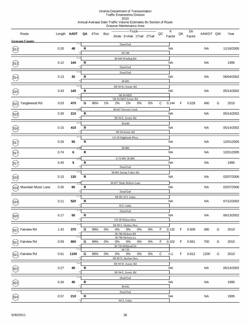
Virginia Department of TransportationTraffic Engineering Division
2010Annual Average Daily Traffic Volume Estimates By Section of Route
Grayson Maintenance Area
Route AADT1Trail 2Trail
4TireK
QA2Axle 3+Axle
QC QKBusLengthTruck
FactorAAWDT QW Year
DirFactor
48 NA NARDead End
38748To:
From:
0.20
Grayson County
11/16/2005812
140 NA NAR38644 Winding Rd
Dead EndTo:
From:
0.12 1995813
30 NA NARDead End
38695To:
From:
0.13 06/04/2002814
140 NA NARSR 94 W, Scenic Rd
SR 94 MIDFrom:
To:
From:
0.43 05/14/2002815
SR 94 MID Scenic Rd470 1% 2% 0.144 490G F1% 0% C G
38647 Stevens Creek
96%
From:To:
0.03 0% 2010815 Tanglewood Rd 0.528
210 NA NARSR 94 E, Scenic RdTo:
0.30 05/14/2002815
410 NA NAR38649
SR 94 Scenic RdTo:
From:
0.15 05/14/2002816
50 NA NARUS 58 Highlands Pkwy
38889From:To:
From:
0.26 12/01/2005817
6 NA NAR
0.74 MN 38889From:To:
0.74 12/01/2005817
5 NA NARDead EndTo:
0.40 1995817
130 NA NAR38805 Spring Valley Rd
38857 Shale Hollow LaneFrom:To:
From:
0.15 02/07/2006818
60 NA NARDead EndTo:
0.35 02/07/2006818 Mountain Music Lane
520 NA NARSR 89; SCL Galax
SCL GalaxTo:
From:
0.11 07/12/2002819
50 NA NARDead End
US 58 Wilson HwyTo:
From:
0.17 06/13/2002820
370 0% 0% 0.132 390G F0% 0% F GSR 89 S, Skyline Hwy
38786 Hickory Rd99%
From:
To:
From:
1.42 0% 2010821 Fairview Rd
38786 Hickory La
0.509
660 0% 0% 0.102 700G F0% 0% F G38720 Millpond Dr
99%
From:
To:
0.59 0% 2010821 Fairview Rd
38720
0.561
1100 0% 0% 0.1 1200G F0% 0% C GSR 89 N, Skyline Hwy
99%To:
0.61 0% 2010821 Fairview Rd 0.812
40 NA NARSR 94 W, Scenic Rd
SR 94 E, Scenic RdTo:
From:
0.27 05/14/2002822
40 NA NARDead End
38642To:
From:
0.26 1995823
210 NA NARDead End
WCL GalaxTo:
From:
0.57 1995824
366/30/2011

Virginia Department of TransportationTraffic Engineering Division
2010Annual Average Daily Traffic Volume Estimates By Section of Route
Grayson Maintenance Area
Route AADT1Trail 2Trail
4TireK
QA2Axle 3+Axle
QC QKBusLengthTruck
FactorAAWDT QW Year
DirFactor
120 NA NARUS 21
38669From:To:
From:
0.10
Grayson County
02/01/2006825 Sugar Camp Lane
60 NA NAR38611 Caty SageTo:
0.20 02/01/2006825 Sugar Camp Lane
120 NA NARDead End
38711To:
From:
1.00 02/24/2006826 Orchid Lane
60 NA NARDead End
38603 Fairwood RdTo:
From:
0.13
Town of Troutdale
02/17/2006827 Auburn Lane
130 NA NAR38750
Dead EndTo:
From:
0.50
Grayson County
11/16/2005828
40 NA NARDead End
SR 89 S, Skyline HwyFrom:
To:
From:
0.40 07/12/2002829
SR 89 N, Skyline Hwy20 NA NAR
Blue Ridge PkwyTo:
0.35 07/12/2002829
7 NA NARDead End
38696 Summerfield RdTo:
From:
0.20 02/07/2006830 Dandelion Lane
100 NA NARUS 21
Dead EndTo:
From:
0.85 02/01/2006831 Hidden Valley Lane
10 NA NAR38728 Oakhill Rd
Dead EndTo:
From:
0.60 02/24/2006832 Grassy Know Lane
30 NA NAR38650
Dead EndTo:
From:
0.42 02/10/2006833 Knob Fork Lane
10 NA NARUS 58 Troutdale Hwy
US 58 Troutdale HwyTo:
From:
0.33 02/17/2006834
100 NA NARSR 16 Troutdale Hwy
38734 Chestnut Grove RdTo:
From:
0.44 06/25/2002835
40 NA NAR38739 Rocky Hollow Rd
SR 16 Troutdale HwyTo:
From:
0.58 12/29/2005836 Polter Rd
300 NA NARSR 16 Troutdale Hwy
38603 Fairwood RdTo:
From:
0.22
Town of Troutdale
06/21/2002837 Timberline Rd
8 NA NARDead End
SR 93 Wilson HwyTo:
From:
0.79
Grayson County
01/17/2006838
30 NA NAR38658 Comers Rock Rd
Dead EndTo:
From:
0.62 01/27/2006839 Rock Quarry Lane
30 NA NARCuldeSac
SR 16 Troutdale HwyTo:
From:
0.44 12/29/2005840 Nightingale Lane
376/30/2011

Virginia Department of TransportationTraffic Engineering Division
2010Annual Average Daily Traffic Volume Estimates By Section of Route
Grayson Maintenance Area
Route AADT1Trail 2Trail
4TireK
QA2Axle 3+Axle
QC QKBusLengthTruck
FactorAAWDT QW Year
DirFactor
470 NA NAR38626
US 58 Grayson PkwyFrom:To:
From:
0.10
Grayson County
07/16/2002841
320 NA NAR
0.20 MN US 58From:To:
0.20 07/16/2002841
210 NA NARDead EndTo:
0.21 07/16/2002841
80 NA NARDead End
38805 Spring Valley RdTo:
From:
1.00 05/14/2002842
90 NA NARDead End
38692To:
From:
0.25 06/04/2002843
80 NA NARDead End
38711 Gold Hill RdTo:
From:
0.40 02/24/2006844
7 NA NAR38601 Flat Ridge Rd
Dead EndTo:
From:
0.15 01/06/2006845 Mahogany Lane
20 NA NAR38675 Glen Wood Rd; Panther Creek Rd
38675To:
From:
1.00 01/06/2006846 Cornflower Rd
50 NA NAR38603 Fairwood Rd
0.03 MN 38603 Fairwood RdFrom:To:
From:
0.03 06/21/2002847
50 NA NARDead EndTo:
0.11 06/21/2002847
40 NA NARDead End
38644 Freedom LaneTo:
From:
0.08 05/14/2002848
40 NA NARDead End
38890From:To:
From:
0.26 06/04/2002849
80 NA NARUS 58 Grayson PkwyTo:
0.09 06/04/2002849
NA NA NADead End
38870From:To:
From:
0.03850
60 NA NAR38785To:
0.22 07/12/2002850
50 NA NARDead End
38626To:
From:
0.75 07/16/2002851
6 NA NAR38766
Dead EndTo:
From:
1.00 02/17/2006852 Fox Wood Lane
80 NA NAR38648
Dead EndTo:
From:
0.30 05/14/2002853
80 NA NARSR 89 Skyline Hwy
Dead EndTo:
From:
0.25 07/12/2002854
40 NA NARDead End
38644To:
From:
0.05 02/10/2006855 Crusader Lane
386/30/2011

Virginia Department of TransportationTraffic Engineering Division
2010Annual Average Daily Traffic Volume Estimates By Section of Route
Grayson Maintenance Area
Route AADT1Trail 2Trail
4TireK
QA2Axle 3+Axle
QC QKBusLengthTruck
FactorAAWDT QW Year
DirFactor
170 NA NARNorth Carolina State Line
SR 16 Jefferson HwyTo:
From:
0.40
Grayson County
12/08/2005856
60 NA NARDead End
38818 Mountain Music LaneTo:
From:
0.75 02/07/2006857 Shale Hollow Lane
70 NA NAR38794 Rockbridge Rd; Prim Rose Lane
38601 Flat Ridge RdTo:
From:
0.20 06/13/2002858
80 NA NARDead End
38786To:
From:
0.21 07/12/2002859
30 NA NARSR 94 Scenic Rd
Dead EndTo:
From:
0.27 05/14/2002860
30 NA NARUS 21 Elk Creek Pkwy
Dead EndTo:
From:
0.10 01/24/2006861 Willow Oak Lane
90 NA NAR38821 Fairview Rd
Dead EndTo:
From:
0.20 07/12/2002862
70 NA NAR38648
0.10 MS 38648From:To:
From:
0.10 05/14/2002863
70 NA NARDead EndTo:
0.10 05/14/2002863
40 NA NARDead End
38665 Stones Chapel RdTo:
From:
0.50 01/24/2006864 Flag Pond Lane
340 NA NAR38619
38819To:
From:
0.50 07/12/2002865
60 NA NARDead End
38644To:
From:
0.10 05/14/2002866
60 NA NARSR 94 Scenic Rd
Dead EndTo:
From:
0.12 05/14/2002867
30 NA NARDead End
38634To:
From:
0.18 05/29/2002868
40 NA NARDead End
38641To:
From:
0.39 05/29/2002869
60 NA NAR38850
Dead EndTo:
From:
0.20 07/12/2002870
60 NA NARDead End
38813To:
From:
0.50 05/14/2002871
40 NA NARUS 21
Dead EndTo:
From:
0.10 02/01/2006872 Sunbow Lane
40 NA NARDead End
SR 89 Skyline HwyTo:
From:
0.35 07/12/2002873
396/30/2011

Virginia Department of TransportationTraffic Engineering Division
2010Annual Average Daily Traffic Volume Estimates By Section of Route
Grayson Maintenance Area
Route AADT1Trail 2Trail
4TireK
QA2Axle 3+Axle
QC QKBusLengthTruck
FactorAAWDT QW Year
DirFactor
90 NA NAR38660 Carsonville Rd
Dead EndTo:
From:
0.12
Grayson County
05/29/2002874
60 NA NARUS 58 Highlands Pkwy
Dead EndTo:
From:
0.70 02/01/2006875
40 NA NARDead End
SR 16 Troutdale HwyTo:
From:
0.19 06/21/2002876
130 NA NAR38805 Spring Valley Rd
Dead EndTo:
From:
0.22 05/14/2002877
90 NA NARUS 58 Highlands Pkwy
Dead EndTo:
From:
0.65 11/08/2005878
30 NA NAR38723
Dead EndTo:
From:
0.10 07/09/2002879
40 NA NARDead End
38639To:
From:
0.40 05/29/2002880
60 NA NAR38805 Spring Valley Rd
Dead EndTo:
From:
0.10 05/07/2002881
410 NA NARSR 94 Riverside Dr
WCL GalaxTo:
From:
1.50 05/29/2002882
20 NA NARDead End
38684To:
From:
0.27 06/13/2002883
70 NA NAR38613 Edmonds Rd
Dead EndTo:
From:
0.28 07/12/2002884
20 NA NAR38742
Dead EndTo:
From:
0.20 11/16/2005885
270 NA NAR38785
SR 89 Skyline HwyTo:
From:
0.34 07/12/2002886
20 NA NAR38726
Dead EndTo:
From:
0.08 11/08/2005887
45 NA NARUS 58 E, Grayson Pkwy
0.07 MS US 58From:To:
From:
0.07 07/18/2002888
45 NA NAR
38765From:To:
0.30 07/18/2002888
170 NA NAR
US 58 W, Grayson PkwyFrom:To:
0.15 06/04/2002888
170 NA NAR
0.01 MN US 58From:To:
0.01 06/04/2002888
70 NA NAR38685To:
1.14 06/04/2002888
10 NA NAR38817
Dead EndTo:
From:
0.12 07/09/2002889
406/30/2011

Virginia Department of TransportationTraffic Engineering Division
2010Annual Average Daily Traffic Volume Estimates By Section of Route
Grayson Maintenance Area
Route AADT1Trail 2Trail
4TireK
QA2Axle 3+Axle
QC QKBusLengthTruck
FactorAAWDT QW Year
DirFactor
40 NA NAR38849
Dead EndTo:
From:
0.25
Grayson County
06/04/2002890
20 NA NAR38805 Spring Valley Rd
Dead EndTo:
From:
0.50 02/07/2006891
40 NA NAR38651
Dead EndTo:
From:
0.15 02/10/2006892 Bear Hollow Lane
20 NA NAR38634 Water Wheel Rd
Dead EndTo:
From:
0.22 05/29/2002893
30 NA NARDead End
38729 Cloverdale LaneTo:
From:
0.64 02/01/2006894 Pumpkin Lane
70 NA NAR38658 Comers Rock Rd
Dead EndTo:
From:
0.22 02/01/2006895 Archery Lane
40 NA NARSR 274 Riverside Dr
Dead EndTo:
From:
0.24 05/29/2002896
70 NA NARDead End
38900From:To:
From:
0.17 05/14/2002897
140 NA NAR38805 Spring Valley RdTo:
0.04 05/14/2002897
70 NA NAR389465
Dead EndTo:
From:
0.53 07/12/2002898
70 NA NARUS 58 Wilson Hwy
CuldeSacTo:
From:
0.15 06/13/2002899
70 NA NAR38897
Dead EndTo:
From:
0.04 05/14/2002900
90 NA NAR38821 Fairview Rd
Dead EndTo:
From:
0.14 07/12/2002905
NA NA NA38791
Dead EndTo:
From:
0.18906
50 NA NAR38607 Meadow Creek Rd
Dead EndTo:
From:
0.30 1999907
NA NA NADead End
38813To:
From:
0.08908
40 NA NARDead End
38626To:
From:
0.11 07/16/2002909
100 NA NARDead End
38626To:
From:
0.15 07/16/2002910
40 NA NARDead End
38685To:
From:
0.12 06/04/2002914
416/30/2011

Virginia Department of TransportationTraffic Engineering Division
2010Annual Average Daily Traffic Volume Estimates By Section of Route
Grayson Maintenance Area
Route AADT1Trail 2Trail
4TireK
QA2Axle 3+Axle
QC QKBusLengthTruck
FactorAAWDT QW Year
DirFactor
90 NA NARSR 274 Riverside Dr
Dead EndTo:
From:
0.20
Grayson County
06/04/2002915
40 NA NARDead End
38634 Water Wheel RdTo:
From:
0.15 05/29/2002916
47 NA NAR38607 Meadow Creek Rd
Dead EndTo:
From:
0.12 1999920
20 NA NARDead End
38658 Comers Rock RdTo:
From:
0.10 01/27/2006923 Pareo Point Lane
30 NA NARUS 21
Dead EndTo:
From:
0.31 02/01/2006930
170 NA NARECL Galax
38941From:To:
From:
0.22 1995940
60 NA NARCuldeSacTo:
0.28 1995940
NA NA NA38940
Dead EndTo:
From:
0.37941
NA NA NACuldeSac
38941To:
From:
0.16942
45 NA NAR38669
Dead EndTo:
From:
0.53 02/10/2006950 Rocky Top Lane
3000 0% 1% 0.096 3200G F0% 0% F GSR 94 Scenic Rd Ivennue Rd
381005 Fire House Dr
98%
From:To:
From:
0.21 0%
Town of Fries
20101001 W Main St 0.565
2600 1% 1% 0.095 2700G F0% 0% C G
38758 Hill Town Rd
98%
From:To:
0.51 0% 20101001 W Main St 0.623
3500 0% 1% 0.108 3700G F0% 0% C G38606 Fries Rd
98%To:
0.61 0% 20101001 E Main St 0.591
280 NA NARSR 94 SOUTH
SR 94 NORTHTo:
From:
0.45
Grayson County
05/17/20021002
110 NA NAR381002
381009From:To:
From:
0.09 05/17/20021003
20 NA NARCarroll County LineTo:
0.11 05/17/20021003
90 NA NARCarroll County Line
381002To:
From:
0.30 05/17/20021004
370 NA NAR381001 W Main St
Dead EndTo:
From:
0.12
Town of Fries
05/17/20021005
90 NA NARDead End
381001 E Main StTo:
From:
0.09 05/17/20021006
426/30/2011

Virginia Department of TransportationTraffic Engineering Division
2010Annual Average Daily Traffic Volume Estimates By Section of Route
Grayson Maintenance Area
Route AADT1Trail 2Trail
4TireK
QA2Axle 3+Axle
QC QKBusLengthTruck
FactorAAWDT QW Year
DirFactor
130 NA NAR381001 E Main St
Dead EndTo:
From:
0.08
Town of Fries
05/17/20021006
140 NA NARDead End
381001 E Main StFrom:To:
From:
0.05 05/17/20021007
110 NA NARDead EndTo:
0.10 05/17/20021007
60 NA NARDead End
SR 94To:
From:
0.12
Grayson County
05/17/20021008
60 NA NARDead End
381003To:
From:
0.05 19991009
1300 NA NARSR 94 Scenic Rd
381001 W Main StTo:
From:
0.04
Town of Fries
05/17/20021010
140 NA NAR381001 E Main St
Dead EndTo:
From:
0.13 05/17/20021011 Carroll
430 NA NAR381001 W, W Main St
381001 E, W Main StTo:
From:
0.29 05/17/20021012
50 0% 1% 0.119 60G F0% 0% F G381001 N, W Main St
381001 S, E Main St98%
To:
From:
0.19 0% 20101013 Lee Dr
70 NA NAR38613 Edmonds Rd
CuldeSacTo:
From:
0.22
Grayson County
07/12/20021015
110 NA NAR38654 Peach Bottom Rd
Dead EndTo:
From:
0.24 06/04/20021020
8 NA NAR381132 Williams St
Dead EndTo:
From:
0.03
Town of Independence
19951100 Wolf Ave
1100 NA NARUS 21
381131 Anvil Rock RdFrom:To:
From:
0.24 19951101 Davis St
740 NA NAR381104; 381105To:
0.10 19951101 Davis St
720 NA NARUS 58, W Main St
US 21To:
From:
0.15 19951102 Hackler Lane
110 NA NARDead End
US 58, W Main StFrom:To:
From:
0.34 19951103 Edgewood Dr
60 NA NAR0.12 MN US 58To:
0.12 19991103 Edgewood Dr
70 NA NAR381101; 381105
Dead EndTo:
From:
0.08 19951104
436/30/2011

Virginia Department of TransportationTraffic Engineering Division
2010Annual Average Daily Traffic Volume Estimates By Section of Route
Grayson Maintenance Area
Route AADT1Trail 2Trail
4TireK
QA2Axle 3+Axle
QC QKBusLengthTruck
FactorAAWDT QW Year
DirFactor
450 NA NARUS 58, E Main St
381108 HillcrestTo:
From:
0.23
Town of Independence
19951105
600 NA NARUS 58, E Main St
381101 Davis StTo:
From:
0.05 19951106 Lonesome Ave
20 NA NAR381105
381108 HillcrestTo:
From:
0.02 19951107 Circle Dr
100 NA NAR38685 Power House Rd
Dead EndTo:
From:
0.34 19951108 Hillcrest
90 NA NARUS 21
381123From:To:
From:
0.13 19951109 Carpenter St
49 NA NARDead EndTo:
0.05 19991109 Carpenter St
8 NA NAR381108 Hillcrest
Dead EndTo:
From:
0.05 19951110
280 NA NARUS 21
38802To:
From:
0.14 19951111 Library St
49 NA NARUS 21
Dead EndTo:
From:
0.06 19991112 Moore St
30 NA NARUS 58, W Main St
Dead EndTo:
From:
0.07 19991113 Hawkins Lane
130 NA NAR381122 Grayson Ave
38685 Power House RdTo:
From:
0.07 19951114 Anders St
110 NA NARUS 21
Dead EndTo:
From:
0.26 19951115 Miles St
50 NA NAR38684 Pinehurst St
Dead EndTo:
From:
0.05 19951116 Colonial Dr
110 NA NAR381120 Round Hill Rd
US 21To:
From:
0.10 19951117 Meadow View Dr
180 NA NARDead End
US 58, E Main StTo:
From:
0.10 19951118 Mill Ave
830 NA NARDead End
US 58, E Main StTo:
From:
0.47 19951119
10 NA NARDead End
381130From:To:
From:
0.07 19951120 Round Hill Rd
60 NA NAR38684 Elliott PlaceTo:
0.15 19951120 Round Hill Rd
70 NA NARUS 58, E Main St
Dead EndTo:
From:
0.10 19951121
446/30/2011

Virginia Department of TransportationTraffic Engineering Division
2010Annual Average Daily Traffic Volume Estimates By Section of Route
Grayson Maintenance Area
Route AADT1Trail 2Trail
4TireK
QA2Axle 3+Axle
QC QKBusLengthTruck
FactorAAWDT QW Year
DirFactor
350 NA NARUS 58, E Main St
38685 Power House RdTo:
From:
0.14
Town of Independence
19951122 Grayson Ave
100 NA NARDead End
US 21To:
From:
0.20 19951123
1200 NA NARUS 58, E Main St
38685 Power House RdTo:
From:
0.26 19951124
30 NA NAR381140
Dead EndTo:
From:
0.06 19951125
280 NA NARUS 21 New River Pkwy
Dead EndTo:
From:
0.45
Grayson County
07/26/20021126
100 NA NAR381126
Dead EndTo:
From:
0.25 19951127
20 NA NAR381127
Dead EndTo:
From:
0.05 07/26/20021128
110 NA NARDead End
381126To:
From:
0.35 07/26/20021129
10 NA NAR381120 Round Hill Rd
Dead EndTo:
From:
0.09
Town of Independence
19951130
30 NA NAR381101 Davis St
0.21 MN 381101 Davis StFrom:To:
From:
0.21 19991131 Anvil Rock Rd
6 NA NARDead EndTo:
0.20 19951131 Anvil Rock Rd
60 NA NAR38802 Hilltop Dr
Dead EndTo:
From:
0.16 19951132 Williams St
7 NA NAR381101 Davis St
Dead EndTo:
From:
0.06 19911133 Poplar Ave
180 NA NARDead End
381119From:To:
From:
0.24 19951134
70 NA NARDead EndTo:
0.22 19951134
110 NA NARDead End
38685To:
From:
0.10
Grayson County
19951135
250 NA NARUS 21
Dead EndTo:
From:
0.09
Town of Independence
19951136
190 NA NARUS 58, E Main St
381101 Davis StTo:
From:
0.04 19951137 Courthouse Ave
456/30/2011

Virginia Department of TransportationTraffic Engineering Division
2010Annual Average Daily Traffic Volume Estimates By Section of Route
Grayson Maintenance Area
Route AADT1Trail 2Trail
4TireK
QA2Axle 3+Axle
QC QKBusLengthTruck
FactorAAWDT QW Year
DirFactor
70 NA NARUS 21
Dead EndTo:
From:
0.09
Town of Independence
19951138 Anderson St
220 NA NAR38802 SOUTH
38802 NORTHTo:
From:
0.17 19951139
NA NA NA381124
38685 Power House RdTo:
From:
0.341140
NA NA NA381140
Dead EndTo:
From:
0.071141
110 NA NAR38636 S, Beach Grove Ln
38636 N, Beach Grove LnTo:
From:
0.40
Grayson County
06/06/20021145
140 NA NAR38603 Fairwood Rd
Dead EndTo:
From:
0.13
Town of Troutdale
06/21/20021201 High County Ln
30 NA NARDead End
38603 Fairwood DrTo:
From:
0.43 12/29/20051202 Woodland Lane
180 NA NARElk Creek Elem School
38658 Comers Rock RdTo:
From:
0.13
Grayson County
01/27/20069175 School Lane
950 NA NARIndependence High
US 58 E Main StTo:
From:
0.11
Town of Independence
19959176
180 NA NAR38821 Fairview Rd
Fairview Elem SchoolTo:
From:
0.19
Grayson County
19919465
120 NA NARSpringvalley Elem Sch
38649To:
From:
0.08 19919512
140 NA NARWood Elem Sch
38636To:
From:
0.18 19959513
80 NA NARFlatridge Elem Sch
38601 Flat Ridge RdTo:
From:
0.06 19959916
90 NA NARBridge Creek Elem Sch
38601 Bridge Creek RdTo:
From:
0.05 19919966
120 NA NARMt Rogers High Sch
US 58 Highlands PkwyTo:
From:
0.06 19919968
466/30/2011