Embed Size (px)
Citation preview

A9 Dualling – Crubenmore to Kincraig DMRB Stage 3 Environmental Impact Assessment
Appendix 7.1 Response to ESG DMRB Stage 2 Consultation Comments

A9 Dualling – Crubenmore to Kincraig DMRB Stage 3 Environmental Impact Assessment
Contents
Tables Table 7.1 1: Response to Environmental Steering Group (ESG) DMRB Stage 2 Consultation Comments 1
A9 Dualling – Crubenmore to Kincraig DMRB Stage 3 Environmental Impact Assessment
Appendix 7.1 - Response to ESG DMRB Stage 2 Consultation Comments Page 1
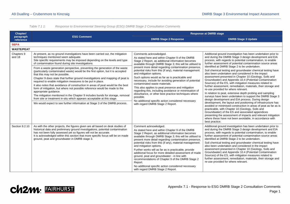
Table 7.1 1: Response to Environmental Steering Group (ESG) DMRB Stage 2 Consultation Comments
Chapter/ paragraph reference
ESG Comment Response at DMRB stage
DMRB Stage 2 Response DMRB Stage 3 Update
SEPA
WASTE/PEAT
Chapters 9 and 18
At present, as no ground investigations have been carried out, the mitigation techniques mentioned seem adequate. Site specific requirements may be imposed depending on the levels and type of contamination found during site investigations.
Comments acknowledged. As stated here and within Chapter 9 of the DMRB Stage 2 Report, as additional information becomes available through DMRB Stage 3; this will be utilised to present more detail regarding contamination presence, potential risks from this (if any), material management and mitigation options. Such options would as far as is practicable and necessary, include for avoiding generation of potential contaminated waste materials. This also applies to peat presence and mitigation regarding this, including avoidance or minimisation of disturbance, or other best practice techniques where possible. No additional specific action considered necessary with regard DMRB Stage 2 Report.
Additional ground investigation has been undertaken prior to and during the DMRB Stage 3 design development and EIA process, with regards to potential contamination, to enable further assessment of potential contamination source areas identified at DMRB Stage 2 to be undertaken. Soil chemical testing and groundwater chemical testing have also been undertaken and considered in the impact assessment presented in Chapter 10 (Geology, Soils and Groundwater) and Appendix 10.4 (Potential Contamination Sources) of the ES, with mitigation measures related to further assessment, remediation, materials, their storage and re-use provided for where relevant. In relation to peat, extensive depth probing and sampling surveys have been undertaken to support the DMRB Stage 3 design development and EIA process. During design development, the layout and positioning of infrastructure has avoided or minimised construction in areas of peat as far as is practicable, with Chapter 10 (Geology, Soils and Groundwater) of the ES and associated appendices presenting the assessment of impacts and relevant mitigation where these have not been avoidable, in accordance with best practice.
From a waste generation perspective, preventing the generation of the waste (particularly contaminated waste) would be the first option, but it is accepted that this may not be possible. Chapter 9 does state that further ground investigations and mapping of peat is required to enable mitigation measures to be put in place. It also notes that avoidance of construction in areas of peat would be the best form of mitigation, but where not possible reference would be made to the appropriate guidance. The mitigation mentioned in the Chapter 9 includes bunds for storage, removal from site or treatment in-situ which appears acceptable at this stage.
We would expect to see further information at Stage 3 of the DMRB process.
Section 9.2.10 As with the other projects, the figures given are all based on desk studies of historical data and preliminary ground investigations, potential contamination has not been fully assessed yet so figures will not be accurate. It is acknowledged within this section that more specific focus will be on made ground, peat and groundwater in DMRB stage 3.
Comment acknowledged. As stated here and within Chapter 9 of the DMRB Stage 2 Report, as additional information becomes available through DMRB Stage 3; this will be utilised to present more detail regarding contamination presence, potential risks from this (if any), material management and mitigation options. Further works will as far as is practicable, provide additional focus for more detailed assessment of made ground, peat and groundwater - in line with recommendations of Chapter 9 of the DMRB Stage 2 Report. No additional specific action considered necessary with regard DMRB Stage 2 Report.
Additional ground investigation has been undertaken prior to and during the DMRB Stage 3 design development and EIA process, with regards to potential contamination, to enable further assessment of potential contamination source areas identified at DMRB Stage 2 to be undertaken. Soil chemical testing and groundwater chemical testing have also been undertaken and considered in the impact assessment presented in Chapter 10 (Geology, Soils and Groundwater) and Appendix 10.4 (Potential Contamination Sources) of the ES, with mitigation measures related to further assessment, remediation, materials, their storage and re-use provided for where relevant.
A9 Dualling – Crubenmore to Kincraig DMRB Stage 3 Environmental Impact Assessment
Appendix 7.1 - Response to ESG DMRB Stage 2 Consultation Comments Page 2
Chapter/ paragraph reference
ESG Comment Response at DMRB stage
DMRB Stage 2 Response DMRB Stage 3 Update
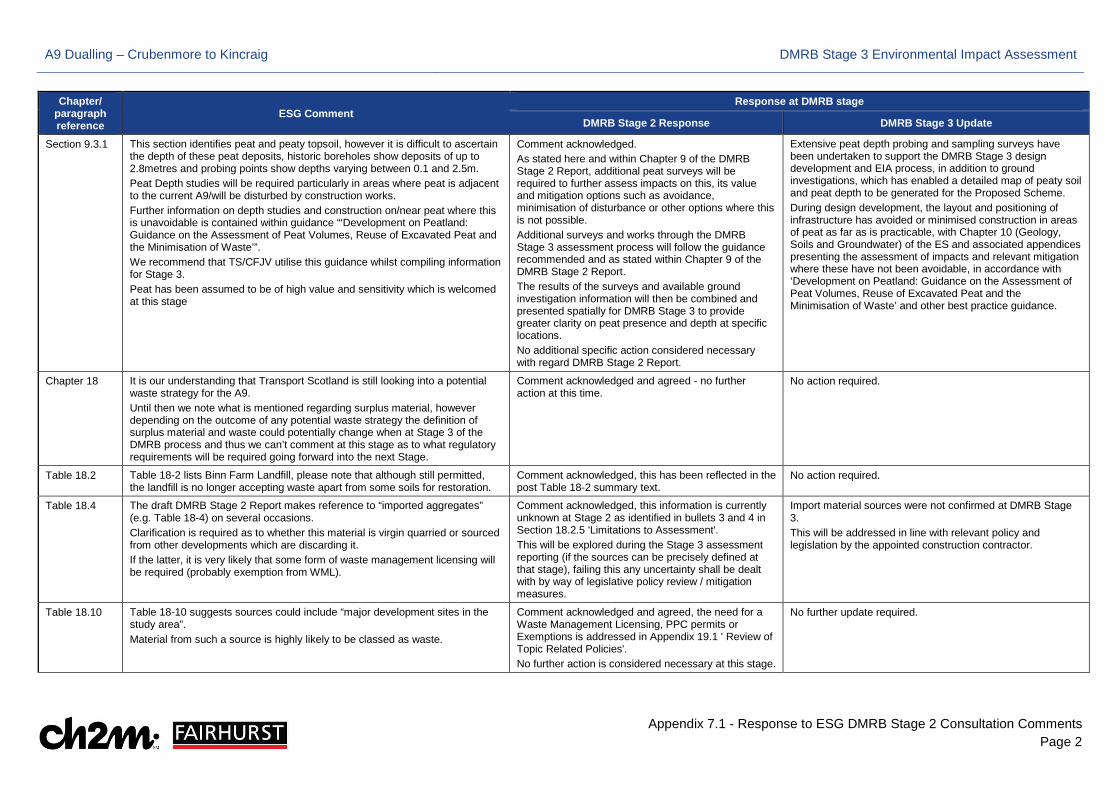
Section 9.3.1 This section identifies peat and peaty topsoil, however it is difficult to ascertain the depth of these peat deposits, historic boreholes show deposits of up to 2.8metres and probing points show depths varying between 0.1 and 2.5m. Peat Depth studies will be required particularly in areas where peat is adjacent to the current A9/will be disturbed by construction works. Further information on depth studies and construction on/near peat where this is unavoidable is contained within guidance “‘Development on Peatland: Guidance on the Assessment of Peat Volumes, Reuse of Excavated Peat and the Minimisation of Waste’”. We recommend that TS/CFJV utilise this guidance whilst compiling information for Stage 3. Peat has been assumed to be of high value and sensitivity which is welcomed at this stage
Comment acknowledged. As stated here and within Chapter 9 of the DMRB Stage 2 Report, additional peat surveys will be required to further assess impacts on this, its value and mitigation options such as avoidance, minimisation of disturbance or other options where this is not possible. Additional surveys and works through the DMRB Stage 3 assessment process will follow the guidance recommended and as stated within Chapter 9 of the DMRB Stage 2 Report. The results of the surveys and available ground investigation information will then be combined and presented spatially for DMRB Stage 3 to provide greater clarity on peat presence and depth at specific locations. No additional specific action considered necessary with regard DMRB Stage 2 Report.
Extensive peat depth probing and sampling surveys have been undertaken to support the DMRB Stage 3 design development and EIA process, in addition to ground investigations, which has enabled a detailed map of peaty soil and peat depth to be generated for the Proposed Scheme. During design development, the layout and positioning of infrastructure has avoided or minimised construction in areas of peat as far as is practicable, with Chapter 10 (Geology, Soils and Groundwater) of the ES and associated appendices presenting the assessment of impacts and relevant mitigation where these have not been avoidable, in accordance with ‘Development on Peatland: Guidance on the Assessment of Peat Volumes, Reuse of Excavated Peat and the Minimisation of Waste’ and other best practice guidance.
Chapter 18 It is our understanding that Transport Scotland is still looking into a potential waste strategy for the A9. Until then we note what is mentioned regarding surplus material, however depending on the outcome of any potential waste strategy the definition of surplus material and waste could potentially change when at Stage 3 of the DMRB process and thus we can’t comment at this stage as to what regulatory requirements will be required going forward into the next Stage.
Comment acknowledged and agreed - no further action at this time.
No action required.
Table 18.2 Table 18-2 lists Binn Farm Landfill, please note that although still permitted, the landfill is no longer accepting waste apart from some soils for restoration.
Comment acknowledged, this has been reflected in the post Table 18-2 summary text.
No action required.
Table 18.4 The draft DMRB Stage 2 Report makes reference to “imported aggregates” (e.g. Table 18-4) on several occasions. Clarification is required as to whether this material is virgin quarried or sourced from other developments which are discarding it. If the latter, it is very likely that some form of waste management licensing will be required (probably exemption from WML).
Comment acknowledged, this information is currently unknown at Stage 2 as identified in bullets 3 and 4 in Section 18.2.5 'Limitations to Assessment'. This will be explored during the Stage 3 assessment reporting (if the sources can be precisely defined at that stage), failing this any uncertainty shall be dealt with by way of legislative policy review / mitigation measures.
Import material sources were not confirmed at DMRB Stage 3. This will be addressed in line with relevant policy and legislation by the appointed construction contractor.
Table 18.10 Table 18-10 suggests sources could include “major development sites in the study area”. Material from such a source is highly likely to be classed as waste.
Comment acknowledged and agreed, the need for a Waste Management Licensing, PPC permits or Exemptions is addressed in Appendix 19.1 ' Review of Topic Related Policies'. No further action is considered necessary at this stage.
No further update required.
A9 Dualling – Crubenmore to Kincraig DMRB Stage 3 Environmental Impact Assessment
Appendix 7.1 - Response to ESG DMRB Stage 2 Consultation Comments Page 3
Chapter/ paragraph reference
ESG Comment Response at DMRB stage
DMRB Stage 2 Response DMRB Stage 3 Update
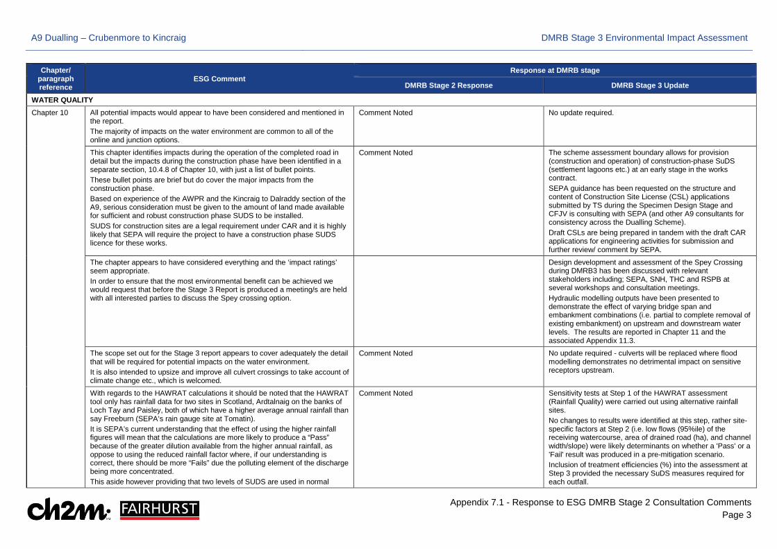
WATER QUALITY
Chapter 10 All potential impacts would appear to have been considered and mentioned in the report. The majority of impacts on the water environment are common to all of the online and junction options.
Comment Noted No update required.
This chapter identifies impacts during the operation of the completed road in detail but the impacts during the construction phase have been identified in a separate section, 10.4.8 of Chapter 10, with just a list of bullet points. These bullet points are brief but do cover the major impacts from the construction phase. Based on experience of the AWPR and the Kincraig to Dalraddy section of the A9, serious consideration must be given to the amount of land made available for sufficient and robust construction phase SUDS to be installed. SUDS for construction sites are a legal requirement under CAR and it is highly likely that SEPA will require the project to have a construction phase SUDS licence for these works.
Comment Noted The scheme assessment boundary allows for provision (construction and operation) of construction-phase SuDS (settlement lagoons etc.) at an early stage in the works contract. SEPA guidance has been requested on the structure and content of Construction Site License (CSL) applications submitted by TS during the Specimen Design Stage and CFJV is consulting with SEPA (and other A9 consultants for consistency across the Dualling Scheme). Draft CSLs are being prepared in tandem with the draft CAR applications for engineering activities for submission and further review/ comment by SEPA.
The chapter appears to have considered everything and the ‘impact ratings’ seem appropriate. In order to ensure that the most environmental benefit can be achieved we would request that before the Stage 3 Report is produced a meeting/s are held with all interested parties to discuss the Spey crossing option.
Design development and assessment of the Spey Crossing during DMRB3 has been discussed with relevant stakeholders including; SEPA, SNH, THC and RSPB at several workshops and consultation meetings. Hydraulic modelling outputs have been presented to demonstrate the effect of varying bridge span and embankment combinations (i.e. partial to complete removal of existing embankment) on upstream and downstream water levels. The results are reported in Chapter 11 and the associated Appendix 11.3.
The scope set out for the Stage 3 report appears to cover adequately the detail that will be required for potential impacts on the water environment. It is also intended to upsize and improve all culvert crossings to take account of climate change etc., which is welcomed.
Comment Noted No update required - culverts will be replaced where flood modelling demonstrates no detrimental impact on sensitive receptors upstream.
With regards to the HAWRAT calculations it should be noted that the HAWRAT tool only has rainfall data for two sites in Scotland, Ardtalnaig on the banks of Loch Tay and Paisley, both of which have a higher average annual rainfall than say Freeburn (SEPA’s rain gauge site at Tomatin). It is SEPA’s current understanding that the effect of using the higher rainfall figures will mean that the calculations are more likely to produce a “Pass” because of the greater dilution available from the higher annual rainfall, as oppose to using the reduced rainfall factor where, if our understanding is correct, there should be more “Fails” due the polluting element of the discharge being more concentrated. This aside however providing that two levels of SUDS are used in normal
Comment Noted Sensitivity tests at Step 1 of the HAWRAT assessment (Rainfall Quality) were carried out using alternative rainfall sites. No changes to results were identified at this step, rather site-specific factors at Step 2 (i.e. low flows (95%ile) of the receiving watercourse, area of drained road (ha), and channel width/slope) were likely determinants on whether a 'Pass' or a 'Fail' result was produced in a pre-mitigation scenario. Inclusion of treatment efficiencies (%) into the assessment at Step 3 provided the necessary SuDS measures required for each outfall.
A9 Dualling – Crubenmore to Kincraig DMRB Stage 3 Environmental Impact Assessment
Appendix 7.1 - Response to ESG DMRB Stage 2 Consultation Comments Page 4
Chapter/ paragraph reference
ESG Comment Response at DMRB stage
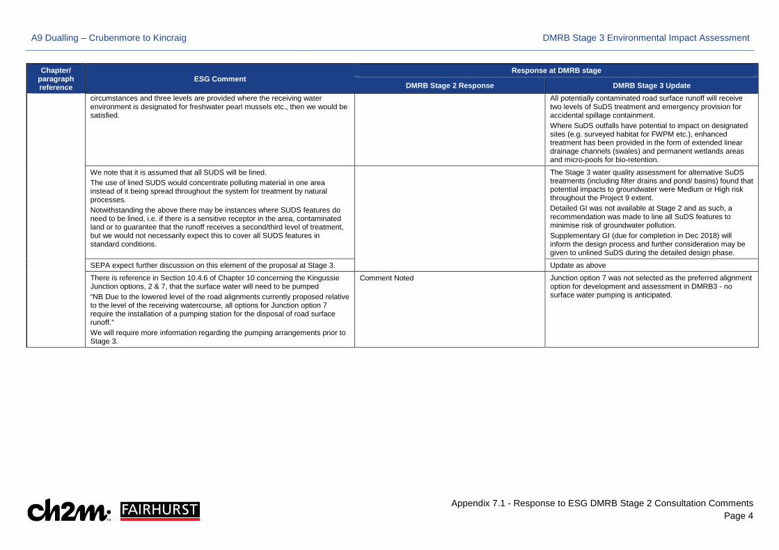
DMRB Stage 2 Response DMRB Stage 3 Update circumstances and three levels are provided where the receiving water environment is designated for freshwater pearl mussels etc., then we would be satisfied.
All potentially contaminated road surface runoff will receive two levels of SuDS treatment and emergency provision for accidental spillage containment. Where SuDS outfalls have potential to impact on designated sites (e.g. surveyed habitat for FWPM etc.), enhanced treatment has been provided in the form of extended linear drainage channels (swales) and permanent wetlands areas and micro-pools for bio-retention.
We note that it is assumed that all SUDS will be lined. The use of lined SUDS would concentrate polluting material in one area instead of it being spread throughout the system for treatment by natural processes. Notwithstanding the above there may be instances where SUDS features do need to be lined, i.e. if there is a sensitive receptor in the area, contaminated land or to guarantee that the runoff receives a second/third level of treatment, but we would not necessarily expect this to cover all SUDS features in standard conditions.
The Stage 3 water quality assessment for alternative SuDS treatments (including filter drains and pond/ basins) found that potential impacts to groundwater were Medium or High risk throughout the Project 9 extent. Detailed GI was not available at Stage 2 and as such, a recommendation was made to line all SuDS features to minimise risk of groundwater pollution. Supplementary GI (due for completion in Dec 2018) will inform the design process and further consideration may be given to unlined SuDS during the detailed design phase.
SEPA expect further discussion on this element of the proposal at Stage 3. Update as above
There is reference in Section 10.4.6 of Chapter 10 concerning the Kingussie Junction options, 2 & 7, that the surface water will need to be pumped “NB Due to the lowered level of the road alignments currently proposed relative to the level of the receiving watercourse, all options for Junction option 7 require the installation of a pumping station for the disposal of road surface runoff.” We will require more information regarding the pumping arrangements prior to Stage 3.
Comment Noted Junction option 7 was not selected as the preferred alignment option for development and assessment in DMRB3 - no surface water pumping is anticipated.
A9 Dualling – Crubenmore to Kincraig DMRB Stage 3 Environmental Impact Assessment
Appendix 7.1 - Response to ESG DMRB Stage 2 Consultation Comments Page 5
Chapter/ paragraph reference
ESG Comment Response at DMRB stage
DMRB Stage 2 Response DMRB Stage 3 Update
PRIVATE WATER
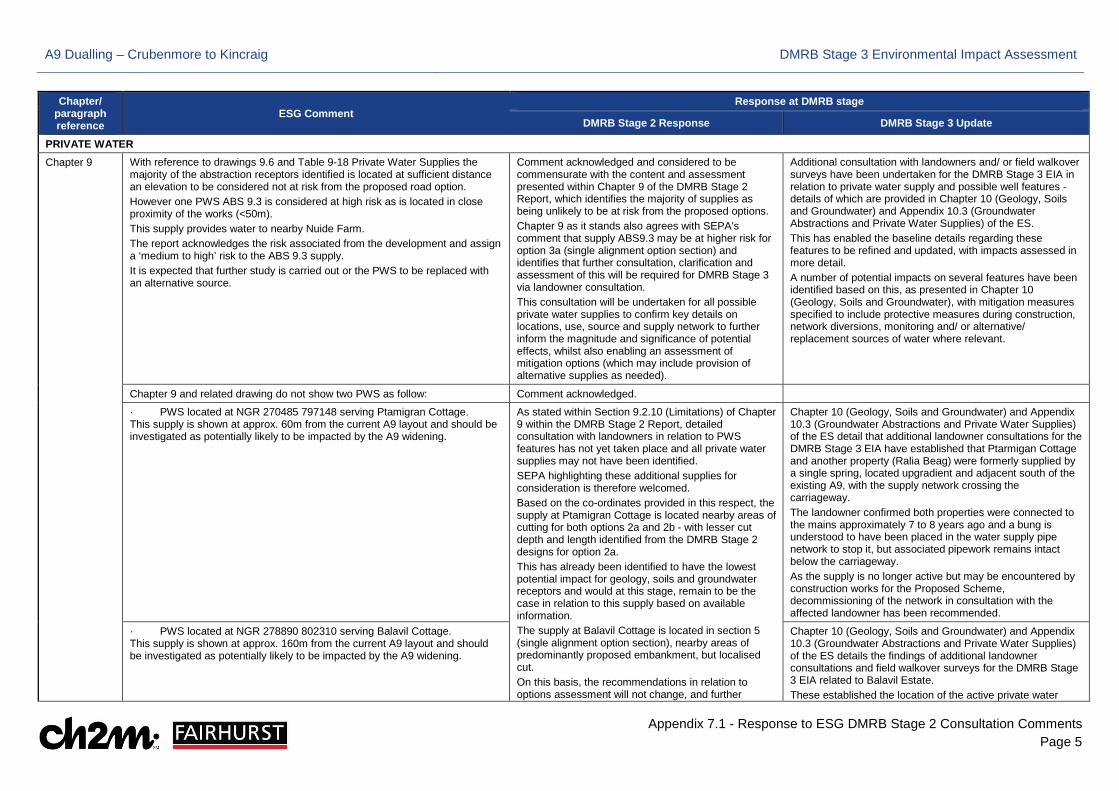
Chapter 9 With reference to drawings 9.6 and Table 9-18 Private Water Supplies the majority of the abstraction receptors identified is located at sufficient distance an elevation to be considered not at risk from the proposed road option. However one PWS ABS 9.3 is considered at high risk as is located in close proximity of the works (<50m). This supply provides water to nearby Nuide Farm. The report acknowledges the risk associated from the development and assign a ‘medium to high’ risk to the ABS 9.3 supply. It is expected that further study is carried out or the PWS to be replaced with an alternative source.
Comment acknowledged and considered to be commensurate with the content and assessment presented within Chapter 9 of the DMRB Stage 2 Report, which identifies the majority of supplies as being unlikely to be at risk from the proposed options. Chapter 9 as it stands also agrees with SEPA's comment that supply ABS9.3 may be at higher risk for option 3a (single alignment option section) and identifies that further consultation, clarification and assessment of this will be required for DMRB Stage 3 via landowner consultation. This consultation will be undertaken for all possible private water supplies to confirm key details on locations, use, source and supply network to further inform the magnitude and significance of potential effects, whilst also enabling an assessment of mitigation options (which may include provision of alternative supplies as needed).
Additional consultation with landowners and/ or field walkover surveys have been undertaken for the DMRB Stage 3 EIA in relation to private water supply and possible well features - details of which are provided in Chapter 10 (Geology, Soils and Groundwater) and Appendix 10.3 (Groundwater Abstractions and Private Water Supplies) of the ES. This has enabled the baseline details regarding these features to be refined and updated, with impacts assessed in more detail. A number of potential impacts on several features have been identified based on this, as presented in Chapter 10 (Geology, Soils and Groundwater), with mitigation measures specified to include protective measures during construction, network diversions, monitoring and/ or alternative/ replacement sources of water where relevant.
Chapter 9 and related drawing do not show two PWS as follow: Comment acknowledged.
· PWS located at NGR 270485 797148 serving Ptamigran Cottage. This supply is shown at approx. 60m from the current A9 layout and should be investigated as potentially likely to be impacted by the A9 widening.
As stated within Section 9.2.10 (Limitations) of Chapter 9 within the DMRB Stage 2 Report, detailed consultation with landowners in relation to PWS features has not yet taken place and all private water supplies may not have been identified. SEPA highlighting these additional supplies for consideration is therefore welcomed. Based on the co-ordinates provided in this respect, the supply at Ptamigran Cottage is located nearby areas of cutting for both options 2a and 2b - with lesser cut depth and length identified from the DMRB Stage 2 designs for option 2a. This has already been identified to have the lowest potential impact for geology, soils and groundwater receptors and would at this stage, remain to be the case in relation to this supply based on available information. The supply at Balavil Cottage is located in section 5 (single alignment option section), nearby areas of predominantly proposed embankment, but localised cut. On this basis, the recommendations in relation to options assessment will not change, and further
Chapter 10 (Geology, Soils and Groundwater) and Appendix 10.3 (Groundwater Abstractions and Private Water Supplies) of the ES detail that additional landowner consultations for the DMRB Stage 3 EIA have established that Ptarmigan Cottage and another property (Ralia Beag) were formerly supplied by a single spring, located upgradient and adjacent south of the existing A9, with the supply network crossing the carriageway. The landowner confirmed both properties were connected to the mains approximately 7 to 8 years ago and a bung is understood to have been placed in the water supply pipe network to stop it, but associated pipework remains intact below the carriageway. As the supply is no longer active but may be encountered by construction works for the Proposed Scheme, decommissioning of the network in consultation with the affected landowner has been recommended.
· PWS located at NGR 278890 802310 serving Balavil Cottage. This supply is shown at approx. 160m from the current A9 layout and should be investigated as potentially likely to be impacted by the A9 widening.
Chapter 10 (Geology, Soils and Groundwater) and Appendix 10.3 (Groundwater Abstractions and Private Water Supplies) of the ES details the findings of additional landowner consultations and field walkover surveys for the DMRB Stage 3 EIA related to Balavil Estate. These established the location of the active private water
A9 Dualling – Crubenmore to Kincraig DMRB Stage 3 Environmental Impact Assessment
Appendix 7.1 - Response to ESG DMRB Stage 2 Consultation Comments Page 6
Chapter/ paragraph reference
ESG Comment Response at DMRB stage
DMRB Stage 2 Response DMRB Stage 3 Update consultation on the location, source and supply network of these features will be undertaken for DMRB Stage 3. At this stage however, the DMRB Stage 2 Report and associated drawings will be updated to reflect their presence based on the co-ordinates provided and an assessment of them will be undertaken, as necessary.
supplies and connected properties within their land, and potential impacts to the supply network at some locations have subsequently been identified. Mitigation measures are specified to include protective measures during construction, network diversions, monitoring and/ or alternative/ replacement sources of water where relevant.
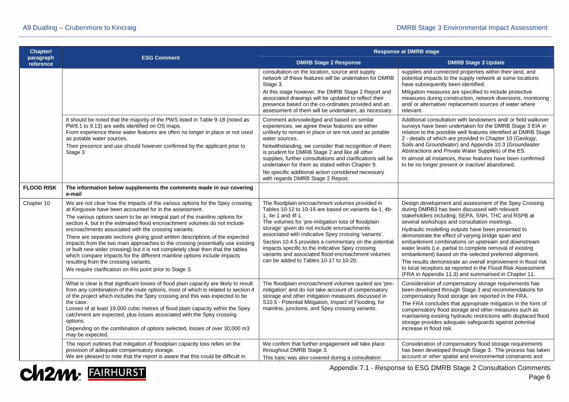
It should be noted that the majority of the PWS listed in Table 9-18 (noted as PW9.1 to 9.13) are wells identified on OS maps. From experience these water features are often no longer in place or not used as potable water sources. Their presence and use should however confirmed by the applicant prior to Stage 3
Comment acknowledged and based on similar experiences, we agree these features are either unlikely to remain in place or are not used as potable water sources. Notwithstanding, we consider that recognition of them is prudent for DMRB Stage 2 and like all other supplies, further consultations and clarifications will be undertaken for them as stated within Chapter 9. No specific additional action considered necessary with regards DMRB Stage 2 Report.
Additional consultation with landowners and/ or field walkover surveys have been undertaken for the DMRB Stage 3 EIA in relation to the possible well features identified at DMRB Stage 2 - details of which are provided in Chapter 10 (Geology, Soils and Groundwater) and Appendix 10.3 (Groundwater Abstractions and Private Water Supplies) of the ES. In almost all instances, these features have been confirmed to be no longer present or inactive/ abandoned.
FLOOD RISK The information below supplements the comments made in our covering e-mail
Chapter 10 We are not clear how the impacts of the various options for the Spey crossing at Kingussie have been accounted for in the assessment. The various options seem to be an integral part of the mainline options for section 4, but in the estimated flood encroachment volumes do not include encroachments associated with the crossing variants. There are separate sections giving good written descriptions of the expected impacts from the two main approaches to the crossing (essentially use existing or built new wider crossing) but it is not completely clear then that the tables which compare impacts for the different mainline options include impacts resulting from the crossing variants. We require clarification on this point prior to Stage 3.
The floodplain encroachment volumes provided in Tables 10-12 to 10-16 are based on variants 4a-1, 4b-1, 4e-1 and 4f-1. The volumes for ‘pre-mitigation loss of floodplain storage’ given do not include encroachments associated with indicative Spey crossing ‘variants’. Section 10.4.5 provides a commentary on the potential impacts specific to the indicative Spey crossing variants and associated flood encroachment volumes can be added to Tables 10-17 to 10-20.
Design development and assessment of the Spey Crossing during DMRB3 has been discussed with relevant stakeholders including; SEPA, SNH, THC and RSPB at several workshops and consultation meetings. Hydraulic modelling outputs have been presented to demonstrate the effect of varying bridge span and embankment combinations on upstream and downstream water levels (i.e. partial to complete removal of existing embankment) based on the selected preferred alignment. The results demonstrate an overall improvement in flood risk to local receptors as reported in the Flood Risk Assessment (FRA in Appendix 11.3) and summarised in Chapter 11.
What is clear is that significant losses of flood plain capacity are likely to result from any combination of the route options, most of which is related to section 4 of the project which includes the Spey crossing and this was expected to be the case. Losses of at least 19,000 cubic metres of flood plain capacity within the Spey catchment are expected, plus losses associated with the Spey crossing options. Depending on the combination of options selected, losses of over 30,000 m3 may be expected.
The floodplain encroachment volumes quoted are 'pre-mitigation' and do not take account of compensatory storage and other mitigation measures discussed in S10.5 - Potential Mitigation, Impact of Flooding, for mainline, junctions, and Spey crossing variants.
Consideration of compensatory storage requirements has been developed through Stage 3 and recommendations for compensatory flood storage are reported in the FRA. The FRA concludes that appropriate mitigation in the form of compensatory flood storage and other measures such as maintaining existing hydraulic restrictions with displaced flood storage provides adequate safeguards against potential increase in flood risk.
The report outlines that mitigation of floodplain capacity loss relies on the provision of adequate compensatory storage. We are pleased to note that the report is aware that this could be difficult in
We confirm that further engagement will take place throughout DMRB Stage 3. This topic was also covered during a consultation
Consideration of compensatory flood storage requirements has been developed through Stage 3. The process has taken account or other spatial and environmental constraints and
A9 Dualling – Crubenmore to Kincraig DMRB Stage 3 Environmental Impact Assessment
Appendix 7.1 - Response to ESG DMRB Stage 2 Consultation Comments Page 7
Chapter/ paragraph reference
ESG Comment Response at DMRB stage
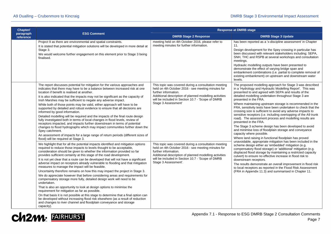
DMRB Stage 2 Response DMRB Stage 3 Update Project 9 as there are environmental and spatial constraints. It is stated that potential mitigation solutions will be developed in more detail at Stage 3. We would welcome further engagement on this element prior to Stage 3 being finalised.
meeting held on 4th October 2016, please refer to meeting minutes for further information.
has been reported as a 'x-discipline assessment' in Chapter 11. Design development for the Spey crossing in particular has been discussed with relevant stakeholders including; SEPA, SNH, THC and RSPB at several workshops and consultation meetings. Hydraulic modelling outputs have been presented to demonstrate the effect of varying bridge span and embankment combinations (i.e. partial to complete removal of existing embankment) on upstream and downstream water levels.
The report discusses potential for mitigation for the various approaches and indicates that there may have to be a balance between increased risk at one location if benefit is realised at another. It is also indicated that the impacts may not be significant as the capacity of Insh Marshes may be sufficient to negate any adverse impact. While both of those points may be valid, either approach will have to be supported by detailed and robust evidence to ensure that all decisions are informed by good information. Detailed modelling will be required and the impacts of the final route design fully investigated both in terms of local changes in flood levels, review of receptors impacted, and impacts further downstream in terms of potential changes to flood hydrographs which may impact communities further down the Spey catchment. An assessment of impacts for a large range of return periods (different sizes of flood) will be required at Stage 3.
This topic was covered during a consultation meeting held on 4th October 2016 - see meeting minutes for further information. Additional description of planned modelling activities will be included in Section 10.7 - 'Scope of DMRB Stage 3 Assessment'
The proposed modelling approach for Stage 3 was described in a 'Hydrology and Hydraulic Modelling Report'. This was presented to and agreed with SEPA and results of the detailed modelling undertaken throughout Stage 3 are presented in the FRA. Where maintaining upstream storage is recommended in the FRA, sensitivity tests have been undertaken to check that the crossing size is sufficient to avoid any adverse impacts to sensitive receptors (i.e. including overtopping of the A9 trunk road). The assessment process and modelling results are presented in the FRA. The Stage 3 scheme design has been developed to avoid and minimise loss of floodplain storage and conveyance capacity where possible. Where land raising in functional floodplain has proved unavoidable, appropriate mitigation has been included in the scheme design either as 'embedded' mitigation (e.g. compensatory flood storage) or 'additional' mitigation (e.g. displaced flood storage by maintaining a restricted capacity culvert) to ensure no effective increase in flood risk to downstream receptors. The results demonstrate an overall improvement in flood risk to local receptors as reported in the Flood Risk Assessment (FRA in Appendix 11.3) and summarised in Chapter 11.
We highlight that for all the potential impacts identified and mitigation options required to reduce those impacts to levels thought to be acceptable, consideration should be given to whether the information provided so far provides sufficient certainty at this stage of the road development. It is not yet clear that a route can be developed that will not have a significant adverse impact on receptors already vulnerable to flooding and that mitigation measures to manage the impact will be feasible. Uncertainty therefore remains on how this may impact the project in Stage 3. We do appreciate however that before considering areas and requirements for compensatory storage more fully, detailed design work will need to be undertaken. That is also an opportunity to look at design options to minimise the requirement for mitigation as far as possible. On that basis it is not possible at this stage to determine that a final option can be developed without increasing flood risk elsewhere (as a result of reduction and changes to river channel and floodplain conveyance and storage capacity).
This topic was covered during a consultation meeting held on 4th October 2016 - see meeting minutes for further information. Additional description of planned modelling activities will be included in Section 10.7 - 'Scope of DMRB Stage 3 Assessment'.
A9 Dualling – Crubenmore to Kincraig DMRB Stage 3 Environmental Impact Assessment
Appendix 7.1 - Response to ESG DMRB Stage 2 Consultation Comments Page 8
Chapter/ paragraph reference
ESG Comment Response at DMRB stage
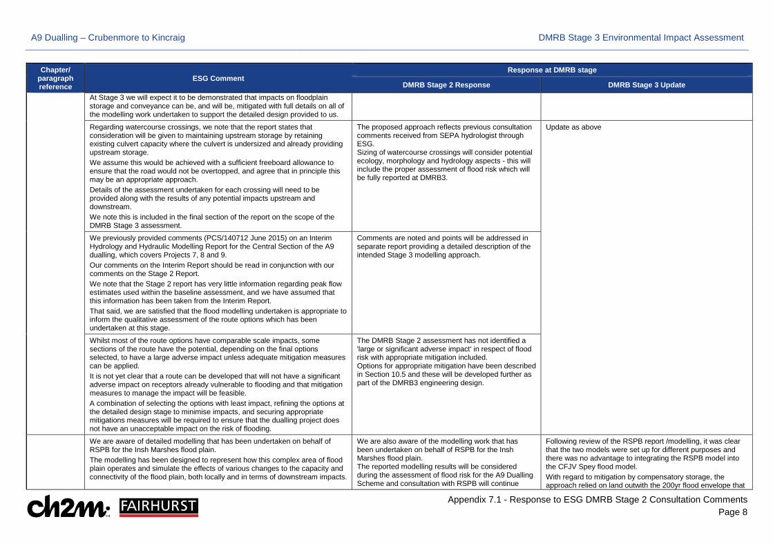
DMRB Stage 2 Response DMRB Stage 3 Update At Stage 3 we will expect it to be demonstrated that impacts on floodplain storage and conveyance can be, and will be, mitigated with full details on all of the modelling work undertaken to support the detailed design provided to us.
Regarding watercourse crossings, we note that the report states that consideration will be given to maintaining upstream storage by retaining existing culvert capacity where the culvert is undersized and already providing upstream storage. We assume this would be achieved with a sufficient freeboard allowance to ensure that the road would not be overtopped, and agree that in principle this may be an appropriate approach. Details of the assessment undertaken for each crossing will need to be provided along with the results of any potential impacts upstream and downstream. We note this is included in the final section of the report on the scope of the DMRB Stage 3 assessment.
The proposed approach reflects previous consultation comments received from SEPA hydrologist through ESG. Sizing of watercourse crossings will consider potential ecology, morphology and hydrology aspects - this will include the proper assessment of flood risk which will be fully reported at DMRB3.
Update as above
We previously provided comments (PCS/140712 June 2015) on an Interim Hydrology and Hydraulic Modelling Report for the Central Section of the A9 dualling, which covers Projects 7, 8 and 9. Our comments on the Interim Report should be read in conjunction with our comments on the Stage 2 Report. We note that the Stage 2 report has very little information regarding peak flow estimates used within the baseline assessment, and we have assumed that this information has been taken from the Interim Report. That said, we are satisfied that the flood modelling undertaken is appropriate to inform the qualitative assessment of the route options which has been undertaken at this stage.
Comments are noted and points will be addressed in separate report providing a detailed description of the intended Stage 3 modelling approach.
Whilst most of the route options have comparable scale impacts, some sections of the route have the potential, depending on the final options selected, to have a large adverse impact unless adequate mitigation measures can be applied. It is not yet clear that a route can be developed that will not have a significant adverse impact on receptors already vulnerable to flooding and that mitigation measures to manage the impact will be feasible. A combination of selecting the options with least impact, refining the options at the detailed design stage to minimise impacts, and securing appropriate mitigations measures will be required to ensure that the dualling project does not have an unacceptable impact on the risk of flooding.
The DMRB Stage 2 assessment has not identified a 'large or significant adverse impact' in respect of flood risk with appropriate mitigation included. Options for appropriate mitigation have been described in Section 10.5 and these will be developed further as part of the DMRB3 engineering design.
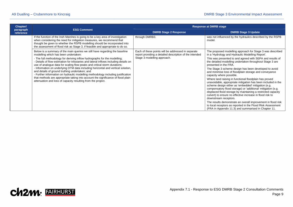
We are aware of detailed modelling that has been undertaken on behalf of RSPB for the Insh Marshes flood plain. The modelling has been designed to represent how this complex area of flood plain operates and simulate the effects of various changes to the capacity and connectivity of the flood plain, both locally and in terms of downstream impacts.
We are also aware of the modelling work that has been undertaken on behalf of RSPB for the Insh Marshes flood plain. The reported modelling results will be considered during the assessment of flood risk for the A9 Dualling Scheme and consultation with RSPB will continue
Following review of the RSPB report /modelling, it was clear that the two models were set up for different purposes and there was no advantage to integrating the RSPB model into the CFJV Spey flood model. With regard to mitigation by compensatory storage, the approach relied on land outwith the 200yr flood envelope that
A9 Dualling – Crubenmore to Kincraig DMRB Stage 3 Environmental Impact Assessment
Appendix 7.1 - Response to ESG DMRB Stage 2 Consultation Comments Page 9
Chapter/ paragraph reference
ESG Comment Response at DMRB stage
DMRB Stage 2 Response DMRB Stage 3 Update If the function of the Insh Marshes is going to be a key area of investigation when considering the need for mitigation measures, we recommend that thought be given to whether the RSPB modelling should be incorporated into the assessment of flood risk as Stage 3, if feasible and appropriate to do so.
through DMRB3. was not influenced by the hydraulics described by the RSPB model.
Below is a summary of the main queries we still have regarding the baseline modelling which has been undertaken: - The full methodology for deriving inflow hydrographs for the modelling; - Details of flow estimation for tributaries and lateral inflows including details on use of analogue data for scaling flow peaks and critical storm durations; - Information on underlying DTM data including horizontal and vertical solution, and details of ground truthing undertaken; and - Further information on hydraulic modelling methodology including justification that methods are appropriate taking into account the significance of flood plain attenuation and loss of capacity resulting from the project.
Each of these points will be addressed in separate report providing a detailed description of the intended Stage 3 modelling approach.
The proposed modelling approach for Stage 3 was described in a 'Hydrology and Hydraulic Modelling Report'. This was presented to and agreed with SEPA and results of the detailed modelling undertaken throughout Stage 3 are presented in the FRA. The Stage 3 scheme design has been developed to avoid and minimise loss of floodplain storage and conveyance capacity where possible. Where land raising in functional floodplain has proved unavoidable, appropriate mitigation has been included in the scheme design either as 'embedded' mitigation (e.g. compensatory flood storage) or 'additional' mitigation (e.g. displaced flood storage by maintaining a restricted capacity culvert) to ensure no effective increase in flood risk to downstream receptors. The results demonstrate an overall improvement in flood risk to local receptors as reported in the Flood Risk Assessment (FRA in Appendix 11.3) and summarised in Chapter 11.
A9 Dualling – Crubenmore to Kincraig DMRB Stage 3 Environmental Impact Assessment
Appendix 7.1 - Response to ESG DMRB Stage 2 Consultation Comments Page 10
Chapter/ paragraph reference
ESG Comment Response at DMRB stage
DMRB Stage 2 Response DMRB Stage 3 Update
WETLAND ECOLOGY
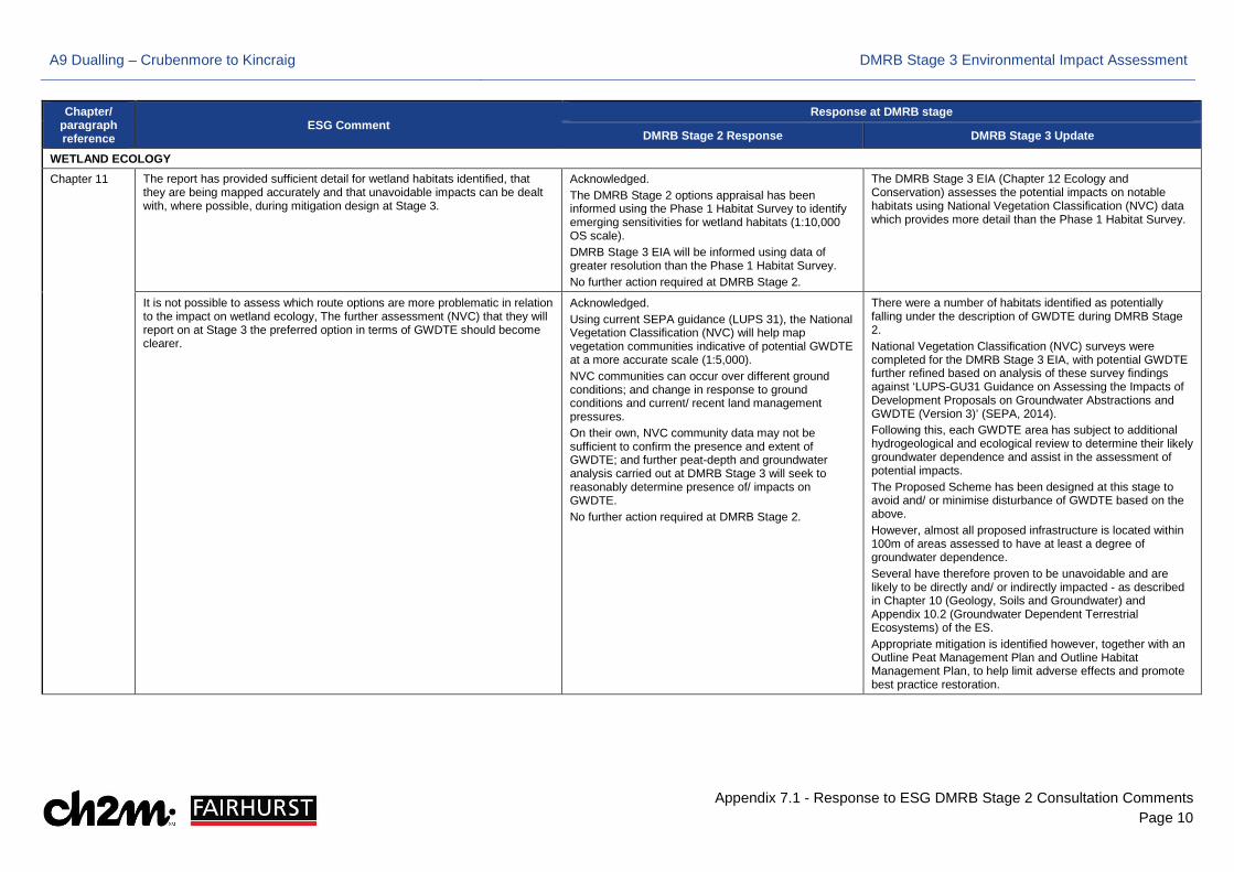
Chapter 11 The report has provided sufficient detail for wetland habitats identified, that they are being mapped accurately and that unavoidable impacts can be dealt with, where possible, during mitigation design at Stage 3.
Acknowledged. The DMRB Stage 2 options appraisal has been informed using the Phase 1 Habitat Survey to identify emerging sensitivities for wetland habitats (1:10,000 OS scale). DMRB Stage 3 EIA will be informed using data of greater resolution than the Phase 1 Habitat Survey. No further action required at DMRB Stage 2.
The DMRB Stage 3 EIA (Chapter 12 Ecology and Conservation) assesses the potential impacts on notable habitats using National Vegetation Classification (NVC) data which provides more detail than the Phase 1 Habitat Survey.
It is not possible to assess which route options are more problematic in relation to the impact on wetland ecology, The further assessment (NVC) that they will report on at Stage 3 the preferred option in terms of GWDTE should become clearer.
Acknowledged. Using current SEPA guidance (LUPS 31), the National Vegetation Classification (NVC) will help map vegetation communities indicative of potential GWDTE at a more accurate scale (1:5,000). NVC communities can occur over different ground conditions; and change in response to ground conditions and current/ recent land management pressures. On their own, NVC community data may not be sufficient to confirm the presence and extent of GWDTE; and further peat-depth and groundwater analysis carried out at DMRB Stage 3 will seek to reasonably determine presence of/ impacts on GWDTE. No further action required at DMRB Stage 2.
There were a number of habitats identified as potentially falling under the description of GWDTE during DMRB Stage 2. National Vegetation Classification (NVC) surveys were completed for the DMRB Stage 3 EIA, with potential GWDTE further refined based on analysis of these survey findings against ‘LUPS-GU31 Guidance on Assessing the Impacts of Development Proposals on Groundwater Abstractions and GWDTE (Version 3)’ (SEPA, 2014). Following this, each GWDTE area has subject to additional hydrogeological and ecological review to determine their likely groundwater dependence and assist in the assessment of potential impacts. The Proposed Scheme has been designed at this stage to avoid and/ or minimise disturbance of GWDTE based on the above. However, almost all proposed infrastructure is located within 100m of areas assessed to have at least a degree of groundwater dependence. Several have therefore proven to be unavoidable and are likely to be directly and/ or indirectly impacted - as described in Chapter 10 (Geology, Soils and Groundwater) and Appendix 10.2 (Groundwater Dependent Terrestrial Ecosystems) of the ES. Appropriate mitigation is identified however, together with an Outline Peat Management Plan and Outline Habitat Management Plan, to help limit adverse effects and promote best practice restoration.
A9 Dualling – Crubenmore to Kincraig DMRB Stage 3 Environmental Impact Assessment
Appendix 7.1 - Response to ESG DMRB Stage 2 Consultation Comments Page 11
Chapter/ paragraph reference
ESG Comment Response at DMRB stage
DMRB Stage 2 Response DMRB Stage 3 Update
SNH
Chapter 11. Ecology & Nature Conservation
Notable species
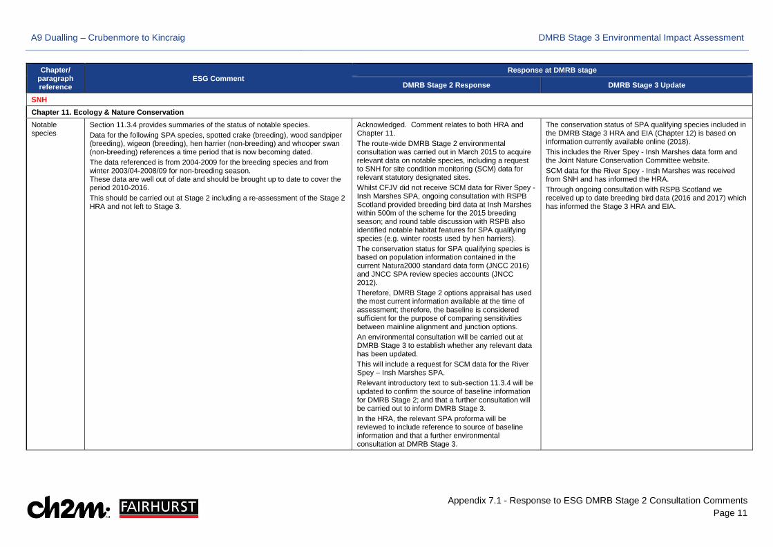
Section 11.3.4 provides summaries of the status of notable species. Data for the following SPA species, spotted crake (breeding), wood sandpiper (breeding), wigeon (breeding), hen harrier (non-breeding) and whooper swan (non-breeding) references a time period that is now becoming dated. The data referenced is from 2004-2009 for the breeding species and from winter 2003/04-2008/09 for non-breeding season. These data are well out of date and should be brought up to date to cover the period 2010-2016. This should be carried out at Stage 2 including a re-assessment of the Stage 2 HRA and not left to Stage 3.
Acknowledged. Comment relates to both HRA and Chapter 11. The route-wide DMRB Stage 2 environmental consultation was carried out in March 2015 to acquire relevant data on notable species, including a request to SNH for site condition monitoring (SCM) data for relevant statutory designated sites. Whilst CFJV did not receive SCM data for River Spey - Insh Marshes SPA, ongoing consultation with RSPB Scotland provided breeding bird data at Insh Marshes within 500m of the scheme for the 2015 breeding season; and round table discussion with RSPB also identified notable habitat features for SPA qualifying species (e.g. winter roosts used by hen harriers). The conservation status for SPA qualifying species is based on population information contained in the current Natura2000 standard data form (JNCC 2016) and JNCC SPA review species accounts (JNCC 2012). Therefore, DMRB Stage 2 options appraisal has used the most current information available at the time of assessment; therefore, the baseline is considered sufficient for the purpose of comparing sensitivities between mainline alignment and junction options. An environmental consultation will be carried out at DMRB Stage 3 to establish whether any relevant data has been updated. This will include a request for SCM data for the River Spey – Insh Marshes SPA. Relevant introductory text to sub-section 11.3.4 will be updated to confirm the source of baseline information for DMRB Stage 2; and that a further consultation will be carried out to inform DMRB Stage 3. In the HRA, the relevant SPA proforma will be reviewed to include reference to source of baseline information and that a further environmental consultation at DMRB Stage 3.
The conservation status of SPA qualifying species included in the DMRB Stage 3 HRA and EIA (Chapter 12) is based on information currently available online (2018). This includes the River Spey - Insh Marshes data form and the Joint Nature Conservation Committee website. SCM data for the River Spey - Insh Marshes was received from SNH and has informed the HRA. Through ongoing consultation with RSPB Scotland we received up to date breeding bird data (2016 and 2017) which has informed the Stage 3 HRA and EIA.
A9 Dualling – Crubenmore to Kincraig DMRB Stage 3 Environmental Impact Assessment
Appendix 7.1 - Response to ESG DMRB Stage 2 Consultation Comments Page 12
Chapter/ paragraph reference
ESG Comment Response at DMRB stage
DMRB Stage 2 Response DMRB Stage 3 Update
Consideration of permanent impacts specific to indicative Spey crossing variants
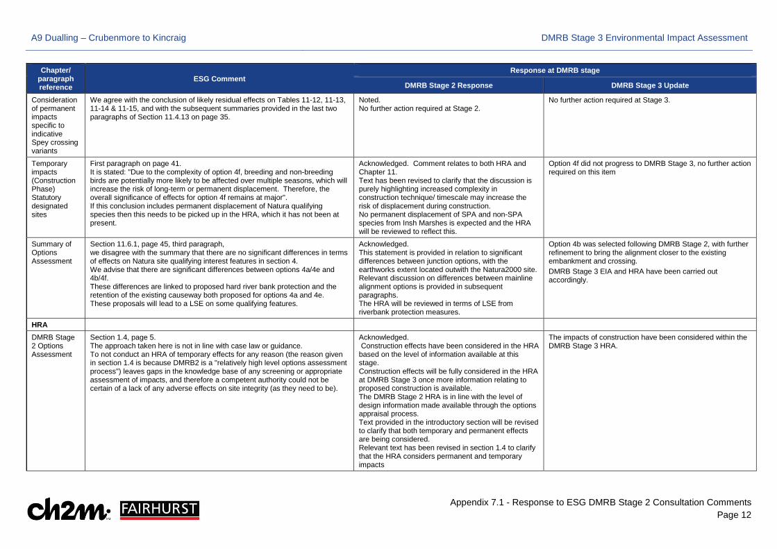
We agree with the conclusion of likely residual effects on Tables 11-12, 11-13, 11-14 & 11-15, and with the subsequent summaries provided in the last two paragraphs of Section 11.4.13 on page 35.
Noted. No further action required at Stage 2.
No further action required at Stage 3.
Temporary impacts (Construction Phase) Statutory designated sites
First paragraph on page 41. It is stated: "Due to the complexity of option 4f, breeding and non-breeding birds are potentially more likely to be affected over multiple seasons, which will increase the risk of long-term or permanent displacement. Therefore, the overall significance of effects for option 4f remains at major". If this conclusion includes permanent displacement of Natura qualifying species then this needs to be picked up in the HRA, which it has not been at present.
Acknowledged. Comment relates to both HRA and Chapter 11. Text has been revised to clarify that the discussion is purely highlighting increased complexity in construction technique/ timescale may increase the risk of displacement during construction. No permanent displacement of SPA and non-SPA species from Insh Marshes is expected and the HRA will be reviewed to reflect this.
Option 4f did not progress to DMRB Stage 3, no further action required on this item
Summary of Options Assessment
Section 11.6.1, page 45, third paragraph, we disagree with the summary that there are no significant differences in terms of effects on Natura site qualifying interest features in section 4. We advise that there are significant differences between options 4a/4e and 4b/4f. These differences are linked to proposed hard river bank protection and the retention of the existing causeway both proposed for options 4a and 4e. These proposals will lead to a LSE on some qualifying features.
Acknowledged. This statement is provided in relation to significant differences between junction options, with the earthworks extent located outwith the Natura2000 site. Relevant discussion on differences between mainline alignment options is provided in subsequent paragraphs. The HRA will be reviewed in terms of LSE from riverbank protection measures.
Option 4b was selected following DMRB Stage 2, with further refinement to bring the alignment closer to the existing embankment and crossing. DMRB Stage 3 EIA and HRA have been carried out accordingly.
HRA
DMRB Stage 2 Options Assessment
Section 1.4, page 5. The approach taken here is not in line with case law or guidance. To not conduct an HRA of temporary effects for any reason (the reason given in section 1.4 is because DMRB2 is a "relatively high level options assessment process") leaves gaps in the knowledge base of any screening or appropriate assessment of impacts, and therefore a competent authority could not be certain of a lack of any adverse effects on site integrity (as they need to be).
Acknowledged. Construction effects have been considered in the HRA based on the level of information available at this stage. Construction effects will be fully considered in the HRA at DMRB Stage 3 once more information relating to proposed construction is available. The DMRB Stage 2 HRA is in line with the level of design information made available through the options appraisal process. Text provided in the introductory section will be revised to clarify that both temporary and permanent effects are being considered. Relevant text has been revised in section 1.4 to clarify that the HRA considers permanent and temporary impacts
The impacts of construction have been considered within the DMRB Stage 3 HRA.
A9 Dualling – Crubenmore to Kincraig DMRB Stage 3 Environmental Impact Assessment
Appendix 7.1 - Response to ESG DMRB Stage 2 Consultation Comments Page 13
Chapter/ paragraph reference
ESG Comment Response at DMRB stage
DMRB Stage 2 Response DMRB Stage 3 Update
DMRB Stage 2 Options Assessment
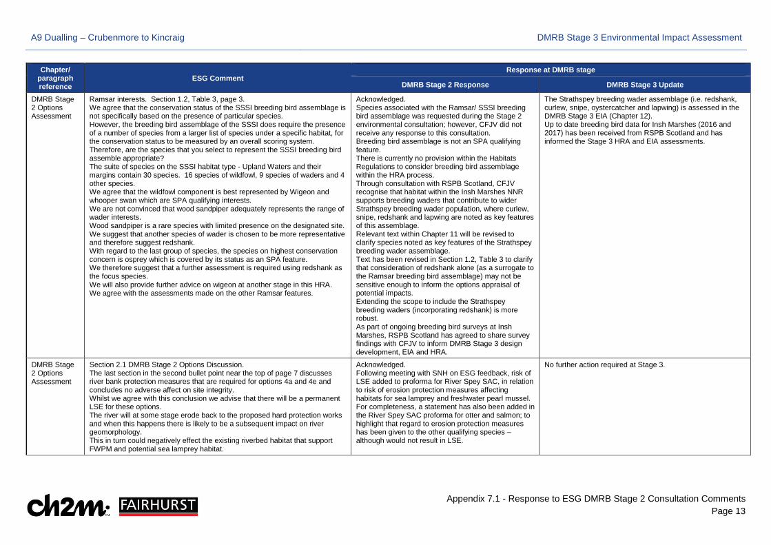
Ramsar interests. Section 1.2, Table 3, page 3. We agree that the conservation status of the SSSI breeding bird assemblage is not specifically based on the presence of particular species. However, the breeding bird assemblage of the SSSI does require the presence of a number of species from a larger list of species under a specific habitat, for the conservation status to be measured by an overall scoring system. Therefore, are the species that you select to represent the SSSI breeding bird assemble appropriate? The suite of species on the SSSI habitat type - Upland Waters and their margins contain 30 species. 16 species of wildfowl, 9 species of waders and 4 other species. We agree that the wildfowl component is best represented by Wigeon and whooper swan which are SPA qualifying interests. We are not convinced that wood sandpiper adequately represents the range of wader interests. Wood sandpiper is a rare species with limited presence on the designated site. We suggest that another species of wader is chosen to be more representative and therefore suggest redshank. With regard to the last group of species, the species on highest conservation concern is osprey which is covered by its status as an SPA feature. We therefore suggest that a further assessment is required using redshank as the focus species. We will also provide further advice on wigeon at another stage in this HRA. We agree with the assessments made on the other Ramsar features.
Acknowledged. Species associated with the Ramsar/ SSSI breeding bird assemblage was requested during the Stage 2 environmental consultation; however, CFJV did not receive any response to this consultation. Breeding bird assemblage is not an SPA qualifying feature. There is currently no provision within the Habitats Regulations to consider breeding bird assemblage within the HRA process. Through consultation with RSPB Scotland, CFJV recognise that habitat within the Insh Marshes NNR supports breeding waders that contribute to wider Strathspey breeding wader population, where curlew, snipe, redshank and lapwing are noted as key features of this assemblage. Relevant text within Chapter 11 will be revised to clarify species noted as key features of the Strathspey breeding wader assemblage. Text has been revised in Section 1.2, Table 3 to clarify that consideration of redshank alone (as a surrogate to the Ramsar breeding bird assemblage) may not be sensitive enough to inform the options appraisal of potential impacts. Extending the scope to include the Strathspey breeding waders (incorporating redshank) is more robust. As part of ongoing breeding bird surveys at Insh Marshes, RSPB Scotland has agreed to share survey findings with CFJV to inform DMRB Stage 3 design development, EIA and HRA.
The Strathspey breeding wader assemblage (i.e. redshank, curlew, snipe, oystercatcher and lapwing) is assessed in the DMRB Stage 3 EIA (Chapter 12). Up to date breeding bird data for Insh Marshes (2016 and 2017) has been received from RSPB Scotland and has informed the Stage 3 HRA and EIA assessments.
DMRB Stage 2 Options Assessment
Section 2.1 DMRB Stage 2 Options Discussion. The last section in the second bullet point near the top of page 7 discusses river bank protection measures that are required for options 4a and 4e and concludes no adverse affect on site integrity. Whilst we agree with this conclusion we advise that there will be a permanent LSE for these options. The river will at some stage erode back to the proposed hard protection works and when this happens there is likely to be a subsequent impact on river geomorphology. This in turn could negatively effect the existing riverbed habitat that support FWPM and potential sea lamprey habitat.
Acknowledged. Following meeting with SNH on ESG feedback, risk of LSE added to proforma for River Spey SAC, in relation to risk of erosion protection measures affecting habitats for sea lamprey and freshwater pearl mussel. For completeness, a statement has also been added in the River Spey SAC proforma for otter and salmon; to highlight that regard to erosion protection measures has been given to the other qualifying species – although would not result in LSE.
No further action required at Stage 3.
A9 Dualling – Crubenmore to Kincraig DMRB Stage 3 Environmental Impact Assessment
Appendix 7.1 - Response to ESG DMRB Stage 2 Consultation Comments Page 14
Chapter/ paragraph reference
ESG Comment Response at DMRB stage
DMRB Stage 2 Response DMRB Stage 3 Update
DMRB Stage 2 Options Assessment
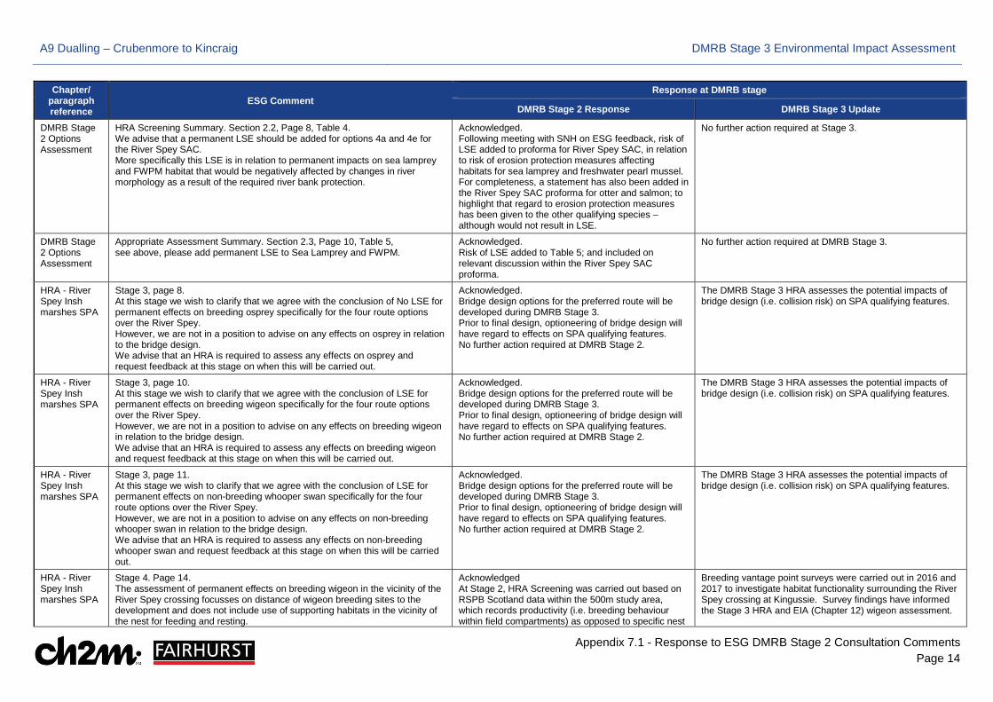
HRA Screening Summary. Section 2.2, Page 8, Table 4. We advise that a permanent LSE should be added for options 4a and 4e for the River Spey SAC. More specifically this LSE is in relation to permanent impacts on sea lamprey and FWPM habitat that would be negatively affected by changes in river morphology as a result of the required river bank protection.
Acknowledged. Following meeting with SNH on ESG feedback, risk of LSE added to proforma for River Spey SAC, in relation to risk of erosion protection measures affecting habitats for sea lamprey and freshwater pearl mussel. For completeness, a statement has also been added in the River Spey SAC proforma for otter and salmon; to highlight that regard to erosion protection measures has been given to the other qualifying species – although would not result in LSE.
No further action required at Stage 3.
DMRB Stage 2 Options Assessment
Appropriate Assessment Summary. Section 2.3, Page 10, Table 5, see above, please add permanent LSE to Sea Lamprey and FWPM.
Acknowledged. Risk of LSE added to Table 5; and included on relevant discussion within the River Spey SAC proforma.
No further action required at DMRB Stage 3.
HRA - River Spey Insh marshes SPA
Stage 3, page 8. At this stage we wish to clarify that we agree with the conclusion of No LSE for permanent effects on breeding osprey specifically for the four route options over the River Spey. However, we are not in a position to advise on any effects on osprey in relation to the bridge design. We advise that an HRA is required to assess any effects on osprey and request feedback at this stage on when this will be carried out.
Acknowledged. Bridge design options for the preferred route will be developed during DMRB Stage 3. Prior to final design, optioneering of bridge design will have regard to effects on SPA qualifying features. No further action required at DMRB Stage 2.
The DMRB Stage 3 HRA assesses the potential impacts of bridge design (i.e. collision risk) on SPA qualifying features.
HRA - River Spey Insh marshes SPA
Stage 3, page 10. At this stage we wish to clarify that we agree with the conclusion of LSE for permanent effects on breeding wigeon specifically for the four route options over the River Spey. However, we are not in a position to advise on any effects on breeding wigeon in relation to the bridge design. We advise that an HRA is required to assess any effects on breeding wigeon and request feedback at this stage on when this will be carried out.
Acknowledged. Bridge design options for the preferred route will be developed during DMRB Stage 3. Prior to final design, optioneering of bridge design will have regard to effects on SPA qualifying features. No further action required at DMRB Stage 2.
The DMRB Stage 3 HRA assesses the potential impacts of bridge design (i.e. collision risk) on SPA qualifying features.
HRA - River Spey Insh marshes SPA
Stage 3, page 11. At this stage we wish to clarify that we agree with the conclusion of LSE for permanent effects on non-breeding whooper swan specifically for the four route options over the River Spey. However, we are not in a position to advise on any effects on non-breeding whooper swan in relation to the bridge design. We advise that an HRA is required to assess any effects on non-breeding whooper swan and request feedback at this stage on when this will be carried out.
Acknowledged. Bridge design options for the preferred route will be developed during DMRB Stage 3. Prior to final design, optioneering of bridge design will have regard to effects on SPA qualifying features. No further action required at DMRB Stage 2.
The DMRB Stage 3 HRA assesses the potential impacts of bridge design (i.e. collision risk) on SPA qualifying features.
HRA - River Spey Insh marshes SPA
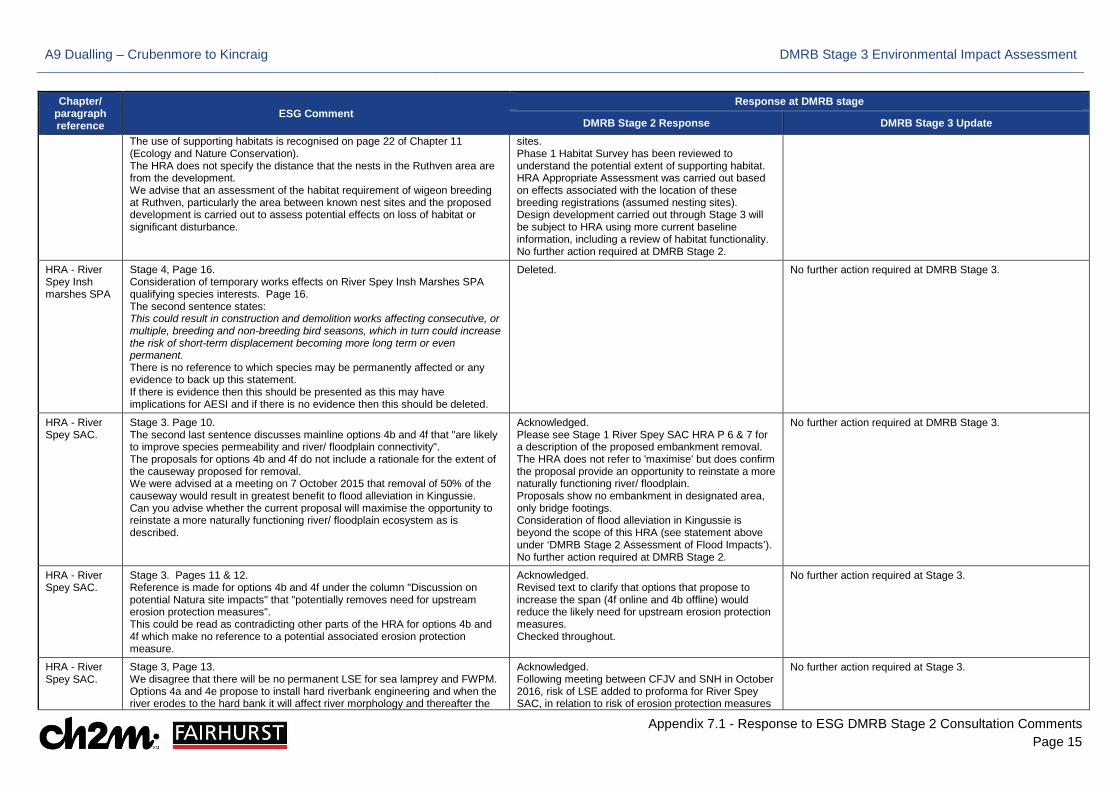
Stage 4. Page 14. The assessment of permanent effects on breeding wigeon in the vicinity of the River Spey crossing focusses on distance of wigeon breeding sites to the development and does not include use of supporting habitats in the vicinity of the nest for feeding and resting.
Acknowledged At Stage 2, HRA Screening was carried out based on RSPB Scotland data within the 500m study area, which records productivity (i.e. breeding behaviour within field compartments) as opposed to specific nest
Breeding vantage point surveys were carried out in 2016 and 2017 to investigate habitat functionality surrounding the River Spey crossing at Kingussie. Survey findings have informed the Stage 3 HRA and EIA (Chapter 12) wigeon assessment.
A9 Dualling – Crubenmore to Kincraig DMRB Stage 3 Environmental Impact Assessment
Appendix 7.1 - Response to ESG DMRB Stage 2 Consultation Comments Page 15
Chapter/ paragraph reference
ESG Comment Response at DMRB stage
DMRB Stage 2 Response DMRB Stage 3 Update The use of supporting habitats is recognised on page 22 of Chapter 11 (Ecology and Nature Conservation). The HRA does not specify the distance that the nests in the Ruthven area are from the development. We advise that an assessment of the habitat requirement of wigeon breeding at Ruthven, particularly the area between known nest sites and the proposed development is carried out to assess potential effects on loss of habitat or significant disturbance.
sites. Phase 1 Habitat Survey has been reviewed to understand the potential extent of supporting habitat. HRA Appropriate Assessment was carried out based on effects associated with the location of these breeding registrations (assumed nesting sites). Design development carried out through Stage 3 will be subject to HRA using more current baseline information, including a review of habitat functionality. No further action required at DMRB Stage 2.
HRA - River Spey Insh marshes SPA
Stage 4, Page 16. Consideration of temporary works effects on River Spey Insh Marshes SPA qualifying species interests. Page 16. The second sentence states: This could result in construction and demolition works affecting consecutive, or multiple, breeding and non-breeding bird seasons, which in turn could increase the risk of short-term displacement becoming more long term or even permanent. There is no reference to which species may be permanently affected or any evidence to back up this statement. If there is evidence then this should be presented as this may have implications for AESI and if there is no evidence then this should be deleted.
Deleted. No further action required at DMRB Stage 3.
HRA - River Spey SAC.
Stage 3. Page 10. The second last sentence discusses mainline options 4b and 4f that "are likely to improve species permeability and river/ floodplain connectivity". The proposals for options 4b and 4f do not include a rationale for the extent of the causeway proposed for removal. We were advised at a meeting on 7 October 2015 that removal of 50% of the causeway would result in greatest benefit to flood alleviation in Kingussie. Can you advise whether the current proposal will maximise the opportunity to reinstate a more naturally functioning river/ floodplain ecosystem as is described.
Acknowledged. Please see Stage 1 River Spey SAC HRA P 6 & 7 for a description of the proposed embankment removal. The HRA does not refer to 'maximise' but does confirm the proposal provide an opportunity to reinstate a more naturally functioning river/ floodplain. Proposals show no embankment in designated area, only bridge footings. Consideration of flood alleviation in Kingussie is beyond the scope of this HRA (see statement above under ‘DMRB Stage 2 Assessment of Flood Impacts’). No further action required at DMRB Stage 2.
No further action required at DMRB Stage 3.
HRA - River Spey SAC.
Stage 3. Pages 11 & 12. Reference is made for options 4b and 4f under the column "Discussion on potential Natura site impacts" that "potentially removes need for upstream erosion protection measures". This could be read as contradicting other parts of the HRA for options 4b and 4f which make no reference to a potential associated erosion protection measure.
Acknowledged. Revised text to clarify that options that propose to increase the span (4f online and 4b offline) would reduce the likely need for upstream erosion protection measures. Checked throughout.
No further action required at Stage 3.
HRA - River Spey SAC.
Stage 3, Page 13. We disagree that there will be no permanent LSE for sea lamprey and FWPM. Options 4a and 4e propose to install hard riverbank engineering and when the river erodes to the hard bank it will affect river morphology and thereafter the
Acknowledged. Following meeting between CFJV and SNH in October 2016, risk of LSE added to proforma for River Spey SAC, in relation to risk of erosion protection measures
No further action required at Stage 3.
A9 Dualling – Crubenmore to Kincraig DMRB Stage 3 Environmental Impact Assessment
Appendix 7.1 - Response to ESG DMRB Stage 2 Consultation Comments Page 16
Chapter/ paragraph reference
ESG Comment Response at DMRB stage
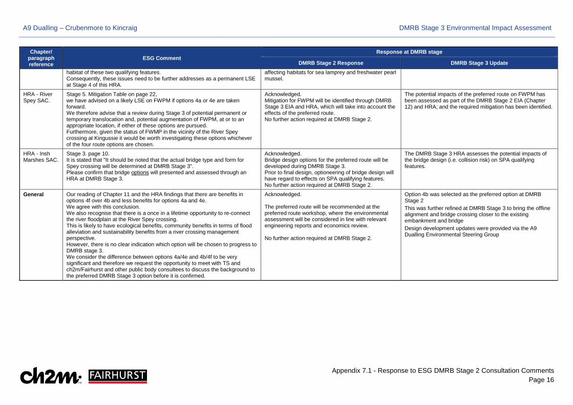
DMRB Stage 2 Response DMRB Stage 3 Update habitat of these two qualifying features. Consequently, these issues need to be further addresses as a permanent LSE at Stage 4 of this HRA.
affecting habitats for sea lamprey and freshwater pearl mussel.
HRA - River Spey SAC.
Stage 5. Mitigation Table on page 22, we have advised on a likely LSE on FWPM if options 4a or 4e are taken forward. We therefore advise that a review during Stage 3 of potential permanent or temporary translocation and, potential augmentation of FWPM, at or to an appropriate location, if either of these options are pursued. Furthermore, given the status of FWMP in the vicinity of the River Spey crossing at Kingussie it would be worth investigating these options whichever of the four route options are chosen.
Acknowledged. Mitigation for FWPM will be identified through DMRB Stage 3 EIA and HRA, which will take into account the effects of the preferred route. No further action required at DMRB Stage 2.
The potential impacts of the preferred route on FWPM has been assessed as part of the DMRB Stage 2 EIA (Chapter 12) and HRA; and the required mitigation has been identified.
HRA - Insh Marshes SAC.
Stage 3. page 10. It is stated that "It should be noted that the actual bridge type and form for Spey crossing will be determined at DMRB Stage 3". Please confirm that bridge options will presented and assessed through an HRA at DMRB Stage 3.
Acknowledged. Bridge design options for the preferred route will be developed during DMRB Stage 3. Prior to final design, optioneering of bridge design will have regard to effects on SPA qualifying features. No further action required at DMRB Stage 2.
The DMRB Stage 3 HRA assesses the potential impacts of the bridge design (i.e. collision risk) on SPA qualifying features.
General Our reading of Chapter 11 and the HRA findings that there are benefits in options 4f over 4b and less benefits for options 4a and 4e. We agree with this conclusion. We also recognise that there is a once in a lifetime opportunity to re-connect the river floodplain at the River Spey crossing. This is likely to have ecological benefits, community benefits in terms of flood alleviation and sustainability benefits from a river crossing management perspective. However, there is no clear indication which option will be chosen to progress to DMRB stage 3. We consider the difference between options 4a/4e and 4b/4f to be very significant and therefore we request the opportunity to meet with TS and ch2m/Fairhurst and other public body consultees to discuss the background to the preferred DMRB Stage 3 option before it is confirmed.
Acknowledged. The preferred route will be recommended at the preferred route workshop, where the environmental assessment will be considered in line with relevant engineering reports and economics review. No further action required at DMRB Stage 2.
Option 4b was selected as the preferred option at DMRB Stage 2 This was further refined at DMRB Stage 3 to bring the offline alignment and bridge crossing closer to the existing embankment and bridge Design development updates were provided via the A9 Dualling Environmental Steering Group
A9 Dualling – Crubenmore to Kincraig DMRB Stage 3 Environmental Impact Assessment
Appendix 7.1 - Response to ESG DMRB Stage 2 Consultation Comments Page 17
Chapter/ paragraph reference
ESG Comment Response at DMRB stage
DMRB Stage 2 Response DMRB Stage 3 Update
HES
Chapter 14 section 14.4.7, 14.4.8, 14.4.9 and 14.4.10, Appendix 14.3 and figures 14.5 and 14.6
We note the assessment of impacts of the mainline options 4a, 4b, 4e and 4f as they relate to the setting of Ruthven Barracks. We would agree that the impacts in this area are likely to be significant although for our interests much will depend on the form of the Spey Crossing in addition to the alignment of the road in this area. We would be happy to discuss this further in due course. We note the assessment of the impact of the mainline options (4a, 4b, 4e and 4f) on the setting of the scheduled monument known as Lynchat, souterrain 550m WNW of, Kingussie (SM ref 925) (identified as Raitt's Cave, souterrain, asset no 9.28 in the assessment). Our preference would be for the mainline alignment to be kept as far away as possible from this monument and away from the legally protected area. Where possible earthworks should also be reduced as far as possible in the vicinity of the monument to reduce the impact of the scheme on the monument's setting.
We welcome your offer of further discussion in the future. HES will be consulted on the form of the Spey Crossing with regards potential impacts on the setting of Ruthven Barracks. The current proposed mainline alignment is outside of the Scheduled area of SM ref 925. The preference to keep the mainline alignment as distant from the monument as possible is noted. The preference to keep earthworks as low as possible near the monument is also noted.
The River Spey crossing has been designed to be a low profile structure, that will minimise any effect on the setting of Ruthven Barracks. The mainline alignment in the vicinity of Raitt's Cave souterrain (asset no. 28) has been designed to avoid the legally protected area of the monument. The earthworks have also been designed to have minimal effect on the setting of this monument. The earthwork design has been undertaken in consultation with a Landscape Architect. The mainline alignment has been changed to be as far away from the Scheduled Monument as possible. Archaeological Evaluation work has also been undertaken in the vicinity of the monument to establish the presence of absence of archaeological remains outwith but in the vicinity of the legal boundary of the monument.
Appendix 14.3 continued
3. Results and interpretationWe have the following comments to offer:• The Raitts Cave magnetometry survey: the fact that the features labelled GP1 and GP3 follow the line of the boundary fence around the souterrain may not be a coincidence, and may indicate either field drains or ploughing. It would have been helpful for this to be discussed in the report.• The Raitts Cave resistivity survey: the low resistance linear features mirror those found in the magnetometry survey. It is not clear what this could mean as this data is not overtly discussed in the report. It would have been helpful if the survey had included the area within the enclosure, so that the responses could be compared with known features.The gaps in the report identified above leave some doubt about the survey outcomes, particularly for the scheduled monument. In turn this places more pressure on decisions to be made on an appropriate form and locations for any further archaeological evaluation. Given the stated aim in the DMRB 2 environmental assessment of archaeological trial trenching at Raitts Cave, it will be important that such interventions are based on a full understanding of the results of the survey in line with the advice below (see comments on section 14.8), to keep this activity outside the scheduled area.Finally, we note from the report the location of the digital and physical archive in England. Please clarify what level of reporting and archiving will be carried out in Scotland, in line with CIfA standards and guidance (sections 3.4 & 3.5, http://www.archaeologists.net/sites/default/files/CIfAS%26GGeophysics_2.pdf).
•The report has been expanded (section 4.2.4 and 4.2.8) to discuss the interpretation of GP 1 and GP 3, and the reasoning as to why the geology and topography of the site makes ploughing or field drains unlikely. •The report has been edited (section 4.2.13) to clarify the interpretation of the Raitts Cave resistivity survey. Sections 2.4.3, 3.3.3 and 4.2.1 of the report also explain that neither magnetometry nor resistivity surveys can be carried out across buried voids, which is why the area within the enclosure was not surveyed.HES comments are noted and the AB Heritage report has been expanded in order to address these as much as possible. Although the AB Heritage report suggests that evaluation trenching surrounding the whole of the souterrain area would be beneficial, archaeological trial trenches at Stage 3 will only be located to the south of the Scheduled Monument boundary, within the landtake for the proposed scheme. An array of trial trenches across the area potentially affected by the proposed scheme will be carried out, taking the geophysical survey results into account. This trial trenching will provide definitive evidence for the presence or absence of archaeological remains, and determine if any remains found are associated
Archaeological trial trenching was undertaken near Raitt's Cave in 2017 and the results are reported in the DMRB Stage 3 Cultural Heritage assessment Appendix 15.3. The trial trenching arrangement was informed by the geophysical survey and also evaluated blank areas. The WSI and trial trench design was approved by THC Historic Environment Team. CFJV have proposed additional trial trenching to be undertaken prior to construction. CFJV will work with HES and THC during the evaluation and keep them informed on any further evidence of archaeological remains identified.
A9 Dualling – Crubenmore to Kincraig DMRB Stage 3 Environmental Impact Assessment
Appendix 7.1 - Response to ESG DMRB Stage 2 Consultation Comments Page 18
Chapter/ paragraph reference
ESG Comment Response at DMRB stage
DMRB Stage 2 Response DMRB Stage 3 Update with the Scheduled Monument. The report now states in section 6 that, in line with CIfA standards and guidance, a copy of the report will be stored with the Highland Council Historic Environment Team, and a copy will be uploaded to the OASIS site.
Chapter 14. figure 14.1 and Appendix 14.3
There is a large number of category B and C listed buildings and sites identified within the Historic Environment Record which are not also scheduled monuments within the cultural heritage study area identified on figure 14.1. The Highland Council Historic Environment Team will be able to advise you on appropriate mitigation measures for these assets. We noted the following points from the report of the archaeological geophysical survey at Raitts Cave, Balavil Obelisk and Burial Ground and Chapelpark. • At Balavil Obelisk, the report concludes that there are no major features of archaeological interest, on the basis that the dipolar anomalies in the magnetometry survey are not related to any other feature. However, the dipolar anomalies are linked by a weakly positive arc on both the raw and processed data, which suggests that there is a feature here. • The Balavil resistivity survey: the dataset for the central 30m by 30m grid has a much higher base reading than the adjacent grids. Reasons for this are not clear but could indicate an improperly zeroed instrument. This means that it is difficult to place confidence in the conclusions as a result. This grid does not appear to have been edge-matched to the others in processing and it would be helpful for this to have been discussed in the report. • The Chapelpark magnetometry survey: the dipolar anomaly in the eastern edge of the survey area appears to be a utility pipe or similar, and not an archaeological feature. The curvilinear response (with associated dipolar response) on the south of the main survey area should also be identified and discussed. The Highland Council Historic Environment Team will be able to advise you further on these matters.
The Highland Council will be consulted with regards undesignated sites and Category B and C Listed Buildings as part of the Stage 3 assessment. In response to HES queries on the geophysical survey: Balavil Obelisk- AB Heritage cannot confirm that the dipolar anomalies are linked by a weakly positive arc and so cannot suggest that there is a feature here. The report now states in section 4.3.2, that features identified are likely of modern origin. Balavil resistivity survey – The report has been updated and AB Heritage have stated in section 4.3.5, that the high soil moisture content on the site at the time of the survey is likely to have compromised the readings from each survey grid. Although there is therefore little confidence in the resistivity survey, as stated in section 5.3.2 the magnetometry survey did not identify any features of possible archaeological origin. Chapel park magnetometry survey - The report has been updated in section 4.4.2, stating that the dipolar anomaly is most likely to relate to modern disturbance relating to a utility. As now discussed in sections 4.4.3 and 4.4.4, AB Heritage cannot clearly and confidently identify a feature where the curvilinear arrangement of dipolar responses is noted.
The Highland Council Historic Environment Team has been consulted during DMRB Stage 3.
A9 Dualling – Crubenmore to Kincraig DMRB Stage 3 Environmental Impact Assessment
Appendix 7.1 - Response to ESG DMRB Stage 2 Consultation Comments Page 19
Chapter/ paragraph reference
ESG Comment Response at DMRB stage
DMRB Stage 2 Response DMRB Stage 3 Update
CNPA
Change associated with the anticipated closure of direct accesses to/ from the A9, and via alternative access connections to A9 junctions, could affect Community and Private Assets in terms of local business and estate operations, and residents who might currently enjoy direct access. However, the provision of suitable alternative access (in particular at Glen Truim) is a key issue for design development at DMRB Stage 3.
Comment acknowledged, this will be considered at DMRB Stage 3. In accordance with the A9 Dualling junction and access strategy, the Glen Truim road has been categorised as a Tier 2 access (Class C and unclassified roads). The strategy sets out that these should be closed where reasonable alternative access can be made available. Specific proposals for this location are under consideration.
Suitable alternative access provision has been provided for Glen Truim. The potential impact on local businesses, estate operations and residents who currently have direct access to/ from the A9 has been assessed as part of the Proposed Scheme in the Environmental Statement.
Kingussie Junction option 2 on mainline alignment 4b has less potential to affect land surrounding Glebe Ponds than other options. The junction must take into consideration existing housing site with permissions at Kingussie.
Comment acknowledged, we are aware of the Davall Developments masterplan site. This will be considered further at DMRB Stage 3.
Design development at DMRB Stage 3 has reduced encroachment into the Glebe Ponds area, and mitigation planting to redundant A9 areas in proximity will provide screening The DMRB Stage 3 assessment has considered impacts on the housing development site at Kingussie, as the Proposed Scheme affects the planned access to the site from the A86.
At Section 5 there are a number of businesses and proposals which will be impacted upon by the dualling including operation of the Highland Wildlife Park, existing permission for increased extraction at Meadowside Quarry, and current planning application at Balavil.
Thank you for the comment, we are aware of the Highland Wildlife Park future plans and planning applications at Balavil and Croftcarnoch. We are actively engaged with parties progressing these plans and will continue to do so. This will be considered at DMRB Stage 3.
On-going one to one meetings have been undertaken throughout the DMRB Stage 3 design process with all affected landowners and business operators (including but not limited to the Highland Wildlife Park, Meadowside Quarry and Balavil). The planning application at Balavil was approved during DMRB Stage 3 design development and the Proposed Scheme now includes a left-in/ left-off access from the northbound carriageway.
Section 2
3. Rationale for location of proposed enhanced layby not clear – it is situated very close to Ralia which currently fulfils a similar function.
Enhanced laybys are noted on the drawing as potential mitigation and are mentioned in section 17.7- Scope of DMRB Stage 3 assessment. The enhanced laybys are currently in development and will be further developed at Stage 3.
Enhanced lay-by proposals have been progressed at Stage 3 through detailed consultation. Ralia is no longer a proposed location of an enhanced lay-by.
4. Southbound Layby 106 is noted as incorporating a demarcated disabled parking bay.
Thank you for the comment. In Chapter 17 we only mention the number of laybys and if they are used by NMUs. Drawing 17.2 identifies Southbound Layby 106 however we are not clear where the reference to a demarcated disabled parking bay is from.
No further action required at DMRB Stage 3
5. Opportunity exists to improve connectivity between Ralia and land/ NMU routes located east of the A9.
Thank you for the comment, We are aware of this desire/ opportunity from the NMU
Access between Ralia and the surrounding NMU routes have been retained and improved through the proposed left-in-left-
A9 Dualling – Crubenmore to Kincraig DMRB Stage 3 Environmental Impact Assessment
Appendix 7.1 - Response to ESG DMRB Stage 2 Consultation Comments Page 20
Chapter/ paragraph reference
ESG Comment Response at DMRB stage
DMRB Stage 2 Response DMRB Stage 3 Update Forum. This will be considered at DMRB Stage 3. Your comments will be added to this information in order to inform the proposals for NMUs.
out Ralia/Glen Truim and Ralia/ Nuide accesses and associated underpass crossings.
6. Continuity of access east via NMU4 to be considered. Proposals for NMUs are not fully considered at Stage 2 and will be developed during Stage 3. Various information has been gathered through consultation with stakeholders and NMU Forums. Your comments will be added to this information in order to inform the proposals for NMUs.
Access between Ralia and the surrounding NMU routes have been retained and improved through the proposed left-in-left-out Ralia/Glen Truim and Ralia/ Nuide accesses and associated underpass crossings.
7. Continuity of access east via NMU5 to be considered. Proposals for NMUs are not considered at Stage 2 and will be developed during Stage 3. Various information has been gathered through consultation with stakeholders and NMU Forums. Your comments will be added to this information and there will be further consultation opportunities to inform the proposals for NMUs at Stage 3.
Access to NMU5 has been retained and improved through the proposed Newtonmore Junction and associated underpass.
8. Possible use of existing Newtonmore junction by equestrian interests should be checked and confirmed. Reference should be made to findings of British Horse Society Equestrian Access Audit of the A9 for the section.
All equestrian crossings have been confirmed from the British Horse Society Audit and/or NMU consultation events as noted within the baseline section.
No further action at DMRB Stage 3, the existing junction is replaced
Section 3
1. Continuity of access from the carriageway to the south of the A9 requires consideration.
Thank you for the comment. Proposals for NMUs, accesses and crossings are not fully considered at Stage 2 and will be developed during Stage 3. Various information has been gathered through consultation with stakeholders and NMU Forums. Your comments will be added to this information and there will be further consultation opportunities to inform the proposals at Stage 3.
Rationalised underpass crossings within this area provide safe crossing opportunities connecting the NMU network across the A9.
2. Continuity of access across the carriageway (north/south) requires consideration.
Thank you for the comment. Proposals for NMUs, accesses and crossings are not fully considered at Stage 2 and will be developed during Stage 3. Various information has been gathered through consultation with stakeholders and NMU Forums. Your comments will be added to this information and there will be further consultation opportunities to inform the proposals at Stage 3.
Rationalised underpass crossings within this area provide safe crossing opportunities connecting the NMU network across the A9.
3. NMU 9 & 11 give access to Lubleathann Bothy – future continuity required. Thank you for the comment. Proposals for NMUs are not fully considered at Stage 2 and will be developed during Stage 3.
Access to NMU 9 and 11 is retained and improved through rationalised underpass crossings and connected access tracks.
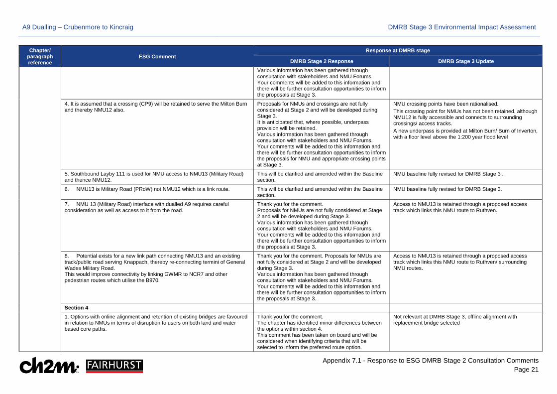
A9 Dualling – Crubenmore to Kincraig DMRB Stage 3 Environmental Impact Assessment
Appendix 7.1 - Response to ESG DMRB Stage 2 Consultation Comments Page 21
Chapter/ paragraph reference
ESG Comment Response at DMRB stage
DMRB Stage 2 Response DMRB Stage 3 Update Various information has been gathered through consultation with stakeholders and NMU Forums. Your comments will be added to this information and there will be further consultation opportunities to inform the proposals at Stage 3.
4. It is assumed that a crossing (CP9) will be retained to serve the Milton Burn and thereby NMU12 also.
Proposals for NMUs and crossings are not fully considered at Stage 2 and will be developed during Stage 3. It is anticipated that, where possible, underpass provision will be retained. Various information has been gathered through consultation with stakeholders and NMU Forums. Your comments will be added to this information and there will be further consultation opportunities to inform the proposals for NMU and appropriate crossing points at Stage 3.
NMU crossing points have been rationalised. This crossing point for NMUs has not been retained, although NMU12 is fully accessible and connects to surrounding crossings/ access tracks. A new underpass is provided at Milton Burn/ Burn of Inverton, with a floor level above the 1:200 year flood level
5. Southbound Layby 111 is used for NMU access to NMU13 (Military Road) and thence NMU12.
This will be clarified and amended within the Baseline section.
NMU baseline fully revised for DMRB Stage 3 .
6. NMU13 is Military Road (PRoW) not NMU12 which is a link route. This will be clarified and amended within the Baseline section.
NMU baseline fully revised for DMRB Stage 3.
7. NMU 13 (Military Road) interface with dualled A9 requires careful consideration as well as access to it from the road.
Thank you for the comment. Proposals for NMUs are not fully considered at Stage 2 and will be developed during Stage 3. Various information has been gathered through consultation with stakeholders and NMU Forums. Your comments will be added to this information and there will be further consultation opportunities to inform the proposals at Stage 3.
Access to NMU13 is retained through a proposed access track which links this NMU route to Ruthven.
8. Potential exists for a new link path connecting NMU13 and an existing track/public road serving Knappach, thereby re-connecting termini of General Wades Military Road. This would improve connectivity by linking GWMR to NCR7 and other pedestrian routes which utilise the B970.
Thank you for the comment. Proposals for NMUs are not fully considered at Stage 2 and will be developed during Stage 3. Various information has been gathered through consultation with stakeholders and NMU Forums. Your comments will be added to this information and there will be further consultation opportunities to inform the proposals at Stage 3.
Access to NMU13 is retained through a proposed access track which links this NMU route to Ruthven/ surrounding NMU routes.
Section 4
1. Options with online alignment and retention of existing bridges are favoured in relation to NMUs in terms of disruption to users on both land and water based core paths.
Thank you for the comment. The chapter has identified minor differences between the options within section 4. This comment has been taken on board and will be considered when identifying criteria that will be selected to inform the preferred route option.
Not relevant at DMRB Stage 3, offline alignment with replacement bridge selected
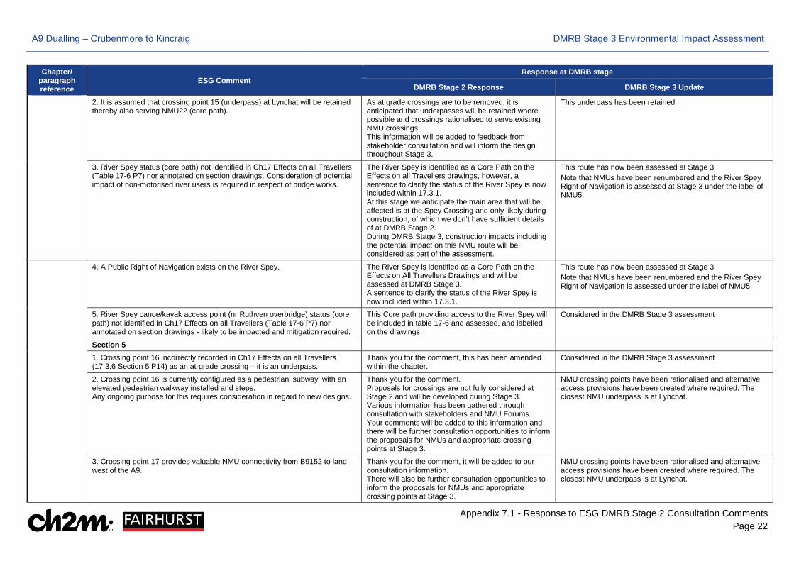
A9 Dualling – Crubenmore to Kincraig DMRB Stage 3 Environmental Impact Assessment
Appendix 7.1 - Response to ESG DMRB Stage 2 Consultation Comments Page 22
Chapter/ paragraph reference
ESG Comment Response at DMRB stage
DMRB Stage 2 Response DMRB Stage 3 Update
2. It is assumed that crossing point 15 (underpass) at Lynchat will be retained thereby also serving NMU22 (core path).
As at grade crossings are to be removed, it is anticipated that underpasses will be retained where possible and crossings rationalised to serve existing NMU crossings. This information will be added to feedback from stakeholder consultation and will inform the design throughout Stage 3.
This underpass has been retained.
3. River Spey status (core path) not identified in Ch17 Effects on all Travellers (Table 17-6 P7) nor annotated on section drawings. Consideration of potential impact of non-motorised river users is required in respect of bridge works.
The River Spey is identified as a Core Path on the Effects on all Travellers drawings, however, a sentence to clarify the status of the River Spey is now included within 17.3.1. At this stage we anticipate the main area that will be affected is at the Spey Crossing and only likely during construction, of which we don’t have sufficient details of at DMRB Stage 2. During DMRB Stage 3, construction impacts including the potential impact on this NMU route will be considered as part of the assessment.
This route has now been assessed at Stage 3. Note that NMUs have been renumbered and the River Spey Right of Navigation is assessed at Stage 3 under the label of NMU5.
4. A Public Right of Navigation exists on the River Spey. The River Spey is identified as a Core Path on the Effects on All Travellers Drawings and will be assessed at DMRB Stage 3. A sentence to clarify the status of the River Spey is now included within 17.3.1.
This route has now been assessed at Stage 3. Note that NMUs have been renumbered and the River Spey Right of Navigation is assessed under the label of NMU5.
5. River Spey canoe/kayak access point (nr Ruthven overbridge) status (core path) not identified in Ch17 Effects on all Travellers (Table 17-6 P7) nor annotated on section drawings - likely to be impacted and mitigation required.
This Core path providing access to the River Spey will be included in table 17-6 and assessed, and labelled on the drawings.
Considered in the DMRB Stage 3 assessment
Section 5
1. Crossing point 16 incorrectly recorded in Ch17 Effects on all Travellers (17.3.6 Section 5 P14) as an at-grade crossing – it is an underpass.
Thank you for the comment, this has been amended within the chapter.
Considered in the DMRB Stage 3 assessment
2. Crossing point 16 is currently configured as a pedestrian ‘subway’ with an elevated pedestrian walkway installed and steps. Any ongoing purpose for this requires consideration in regard to new designs.
Thank you for the comment. Proposals for crossings are not fully considered at Stage 2 and will be developed during Stage 3. Various information has been gathered through consultation with stakeholders and NMU Forums. Your comments will be added to this information and there will be further consultation opportunities to inform the proposals for NMUs and appropriate crossing points at Stage 3.
NMU crossing points have been rationalised and alternative access provisions have been created where required. The closest NMU underpass is at Lynchat.
3. Crossing point 17 provides valuable NMU connectivity from B9152 to land west of the A9.
Thank you for the comment, it will be added to our consultation information. There will also be further consultation opportunities to inform the proposals for NMUs and appropriate crossing points at Stage 3.
NMU crossing points have been rationalised and alternative access provisions have been created where required. The closest NMU underpass is at Lynchat.
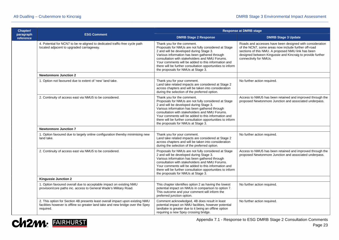
A9 Dualling – Crubenmore to Kincraig DMRB Stage 3 Environmental Impact Assessment
Appendix 7.1 - Response to ESG DMRB Stage 2 Consultation Comments Page 23
Chapter/ paragraph reference
ESG Comment Response at DMRB stage
DMRB Stage 2 Response DMRB Stage 3 Update
4. Potential for NCN7 to be re-aligned to dedicated traffic-free cycle path located adjacent to upgraded carriageway.
Thank you for the comment. Proposals for NMUs are not fully considered at Stage 2 and will be developed during Stage 3. Various information has been gathered through consultation with stakeholders and NMU Forums. Your comments will be added to this information and there will be further consultation opportunities to inform the proposals for NMUs at Stage 3.
Roads and accesses have been designed with consideration of the NCN7, some areas now include further off-road sections of this NMU. A proposed NMU link has been designed between Kingussie and Kincraig to provide further connectivity for NMUs.
Newtonmore Junction 2
1. Option not favoured due to extent of ‘new’ land take. Thank you for your comment. Land take related impacts are considered at Stage 2 across chapters and will be taken into consideration during the selection of the preferred option.
No further action required.
2. Continuity of access east via NMU5 to be considered. Thank you for the comment. Proposals for NMUs are not fully considered at Stage 2 and will be developed during Stage 3. Various information has been gathered through consultation with stakeholders and NMU Forums. Your comments will be added to this information and there will be further consultation opportunities to inform the proposals for NMUs at Stage 3.
Access to NMU5 has been retained and improved through the proposed Newtonmore Junction and associated underpass.
Newtonmore Junction 7
1. Option favoured due to largely online configuration thereby minimising new land take.
Thank you for your comment. Land take related impacts are considered at Stage 2 across chapters and will be taken into consideration during the selection of the preferred option.
No further action required.
2. Continuity of access east via NMU5 to be considered. Proposals for NMUs are not fully considered at Stage 2 and will be developed during Stage 3. Various information has been gathered through consultation with stakeholders and NMU Forums. Your comments will be added to this information and there will be further consultation opportunities to inform the proposals for NMUs at Stage 3.
Access to NMU5 has been retained and improved through the proposed Newtonmore Junction and associated underpass.
Kingussie Junction 2
1. Option favoured overall due to acceptable impact on existing NMU provision/core paths inc. access to General Wade’s Military Road.
This chapter identifies option 2 as having the lowest potential impact on NMUs in comparison to option 7. This outcome and your comment will inform the preferred junction option.
No further action required.
2. This option for Section 4B presents least overall impact upon existing NMU facilities however is offline so greater land take and new bridge over the Spey required.
Comment acknowledged, 4B does result in least potential impact on NMU facilities, however potential landtake is greater due to it being an offline option requiring a new Spey crossing bridge.
No further action required.
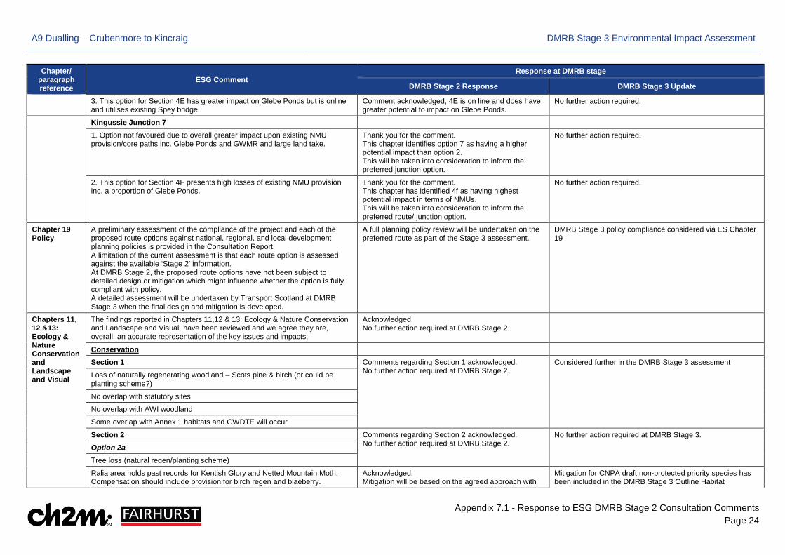
A9 Dualling – Crubenmore to Kincraig DMRB Stage 3 Environmental Impact Assessment
Appendix 7.1 - Response to ESG DMRB Stage 2 Consultation Comments Page 24
Chapter/ paragraph reference
ESG Comment Response at DMRB stage
DMRB Stage 2 Response DMRB Stage 3 Update
3. This option for Section 4E has greater impact on Glebe Ponds but is online and utilises existing Spey bridge.
Comment acknowledged, 4E is on line and does have greater potential to impact on Glebe Ponds.
No further action required.
Kingussie Junction 7
1. Option not favoured due to overall greater impact upon existing NMU provision/core paths inc. Glebe Ponds and GWMR and large land take.
Thank you for the comment. This chapter identifies option 7 as having a higher potential impact than option 2. This will be taken into consideration to inform the preferred junction option.
No further action required.
2. This option for Section 4F presents high losses of existing NMU provision inc. a proportion of Glebe Ponds.
Thank you for the comment. This chapter has identified 4f as having highest potential impact in terms of NMUs. This will be taken into consideration to inform the preferred route/ junction option.
No further action required.
Chapter 19 Policy
A preliminary assessment of the compliance of the project and each of the proposed route options against national, regional, and local development planning policies is provided in the Consultation Report. A limitation of the current assessment is that each route option is assessed against the available ‘Stage 2’ information. At DMRB Stage 2, the proposed route options have not been subject to detailed design or mitigation which might influence whether the option is fully compliant with policy. A detailed assessment will be undertaken by Transport Scotland at DMRB Stage 3 when the final design and mitigation is developed.
A full planning policy review will be undertaken on the preferred route as part of the Stage 3 assessment.
DMRB Stage 3 policy compliance considered via ES Chapter 19
Chapters 11, 12 &13: Ecology & Nature Conservation and Landscape and Visual
The findings reported in Chapters 11,12 & 13: Ecology & Nature Conservation and Landscape and Visual, have been reviewed and we agree they are, overall, an accurate representation of the key issues and impacts.
Acknowledged. No further action required at DMRB Stage 2.
Conservation
Section 1 Comments regarding Section 1 acknowledged. No further action required at DMRB Stage 2.
Considered further in the DMRB Stage 3 assessment
Loss of naturally regenerating woodland – Scots pine & birch (or could be planting scheme?)
No overlap with statutory sites
No overlap with AWI woodland
Some overlap with Annex 1 habitats and GWDTE will occur
Section 2 Comments regarding Section 2 acknowledged. No further action required at DMRB Stage 2.
No further action required at DMRB Stage 3.
Option 2a Tree loss (natural regen/planting scheme)
Ralia area holds past records for Kentish Glory and Netted Mountain Moth. Compensation should include provision for birch regen and blaeberry.
Acknowledged. Mitigation will be based on the agreed approach with
Mitigation for CNPA draft non-protected priority species has been included in the DMRB Stage 3 Outline Habitat
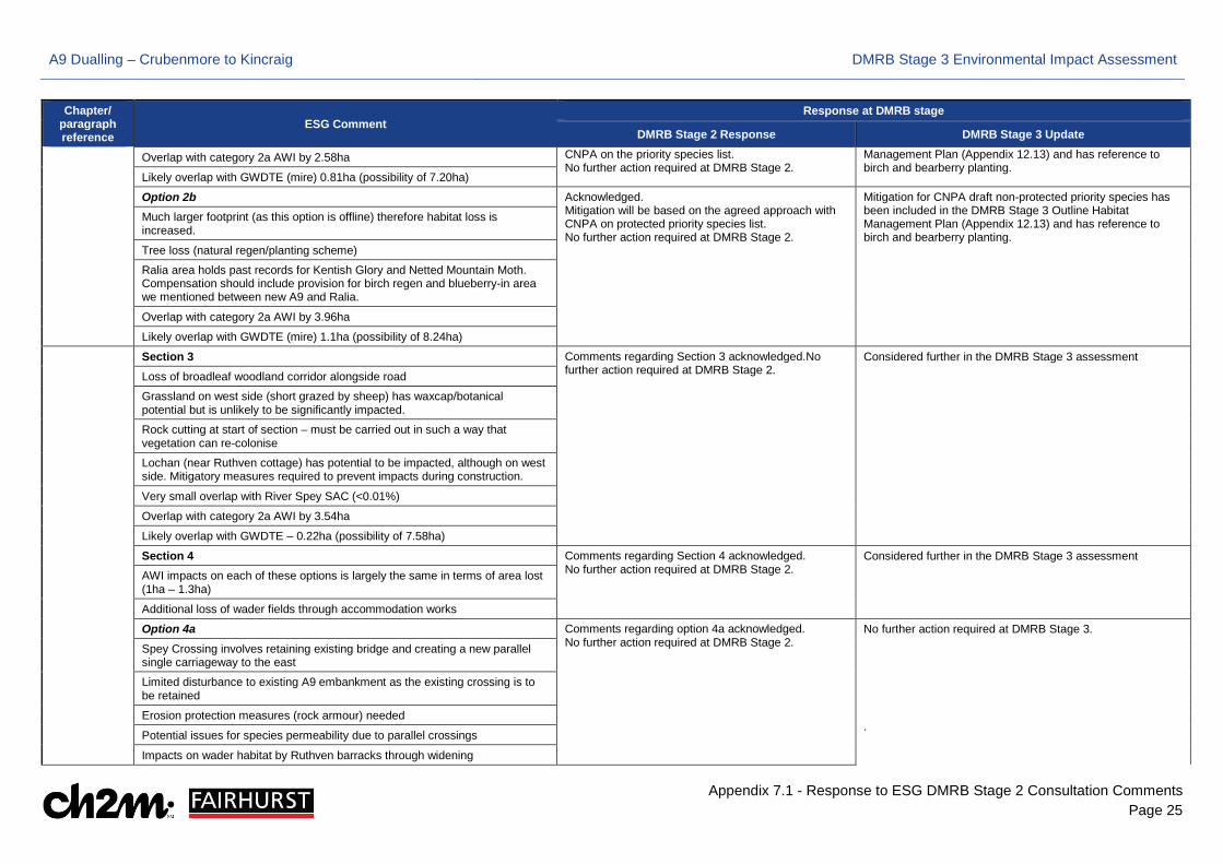
A9 Dualling – Crubenmore to Kincraig DMRB Stage 3 Environmental Impact Assessment
Appendix 7.1 - Response to ESG DMRB Stage 2 Consultation Comments Page 25
Chapter/ paragraph reference
ESG Comment Response at DMRB stage
DMRB Stage 2 Response DMRB Stage 3 Update
Overlap with category 2a AWI by 2.58ha CNPA on the priority species list. No further action required at DMRB Stage 2.
Management Plan (Appendix 12.13) and has reference to birch and bearberry planting.
Likely overlap with GWDTE (mire) 0.81ha (possibility of 7.20ha)
Option 2b Acknowledged. Mitigation will be based on the agreed approach with CNPA on protected priority species list. No further action required at DMRB Stage 2.
Mitigation for CNPA draft non-protected priority species has been included in the DMRB Stage 3 Outline Habitat Management Plan (Appendix 12.13) and has reference to birch and bearberry planting.
Much larger footprint (as this option is offline) therefore habitat loss is increased.
Tree loss (natural regen/planting scheme)
Ralia area holds past records for Kentish Glory and Netted Mountain Moth. Compensation should include provision for birch regen and blueberry-in area we mentioned between new A9 and Ralia.
Overlap with category 2a AWI by 3.96ha
Likely overlap with GWDTE (mire) 1.1ha (possibility of 8.24ha)
Section 3 Comments regarding Section 3 acknowledged.No further action required at DMRB Stage 2.
Considered further in the DMRB Stage 3 assessment
Loss of broadleaf woodland corridor alongside road
Grassland on west side (short grazed by sheep) has waxcap/botanical potential but is unlikely to be significantly impacted.
Rock cutting at start of section – must be carried out in such a way that vegetation can re-colonise
Lochan (near Ruthven cottage) has potential to be impacted, although on west side. Mitigatory measures required to prevent impacts during construction.
Very small overlap with River Spey SAC (<0.01%)
Overlap with category 2a AWI by 3.54ha
Likely overlap with GWDTE – 0.22ha (possibility of 7.58ha)
Section 4 Comments regarding Section 4 acknowledged. No further action required at DMRB Stage 2.
Considered further in the DMRB Stage 3 assessment AWI impacts on each of these options is largely the same in terms of area lost
(1ha – 1.3ha)
Additional loss of wader fields through accommodation works
Option 4a Comments regarding option 4a acknowledged. No further action required at DMRB Stage 2.
No further action required at DMRB Stage 3. .
Spey Crossing involves retaining existing bridge and creating a new parallel single carriageway to the east
Limited disturbance to existing A9 embankment as the existing crossing is to be retained
Erosion protection measures (rock armour) needed
Potential issues for species permeability due to parallel crossings
Impacts on wader habitat by Ruthven barracks through widening
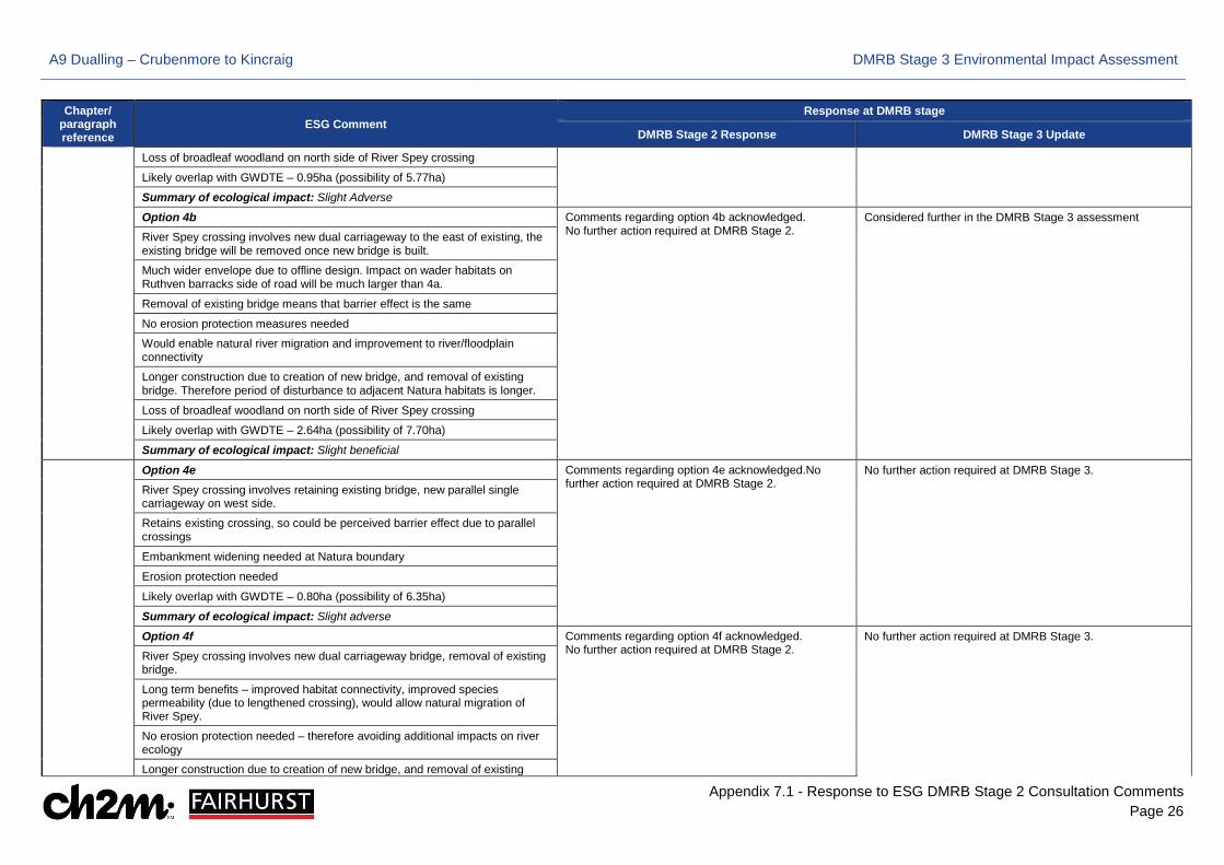
A9 Dualling – Crubenmore to Kincraig DMRB Stage 3 Environmental Impact Assessment
Appendix 7.1 - Response to ESG DMRB Stage 2 Consultation Comments Page 26
Chapter/ paragraph reference
ESG Comment Response at DMRB stage
DMRB Stage 2 Response DMRB Stage 3 Update
Loss of broadleaf woodland on north side of River Spey crossing
Likely overlap with GWDTE – 0.95ha (possibility of 5.77ha)
Summary of ecological impact: Slight Adverse
Option 4b Comments regarding option 4b acknowledged. No further action required at DMRB Stage 2.
Considered further in the DMRB Stage 3 assessment River Spey crossing involves new dual carriageway to the east of existing, the
existing bridge will be removed once new bridge is built.
Much wider envelope due to offline design. Impact on wader habitats on Ruthven barracks side of road will be much larger than 4a.
Removal of existing bridge means that barrier effect is the same
No erosion protection measures needed
Would enable natural river migration and improvement to river/floodplain connectivity
Longer construction due to creation of new bridge, and removal of existing bridge. Therefore period of disturbance to adjacent Natura habitats is longer.
Loss of broadleaf woodland on north side of River Spey crossing
Likely overlap with GWDTE – 2.64ha (possibility of 7.70ha)
Summary of ecological impact: Slight beneficial
Option 4e Comments regarding option 4e acknowledged.No further action required at DMRB Stage 2.
No further action required at DMRB Stage 3.
River Spey crossing involves retaining existing bridge, new parallel single carriageway on west side.
Retains existing crossing, so could be perceived barrier effect due to parallel crossings
Embankment widening needed at Natura boundary
Erosion protection needed
Likely overlap with GWDTE – 0.80ha (possibility of 6.35ha)
Summary of ecological impact: Slight adverse
Option 4f Comments regarding option 4f acknowledged. No further action required at DMRB Stage 2.
No further action required at DMRB Stage 3.
River Spey crossing involves new dual carriageway bridge, removal of existing bridge.
Long term benefits – improved habitat connectivity, improved species permeability (due to lengthened crossing), would allow natural migration of River Spey.
No erosion protection needed – therefore avoiding additional impacts on river ecology
Longer construction due to creation of new bridge, and removal of existing

A9 Dualling – Crubenmore to Kincraig DMRB Stage 3 Environmental Impact Assessment
Appendix 7.1 - Response to ESG DMRB Stage 2 Consultation Comments Page 27
Chapter/ paragraph reference
ESG Comment Response at DMRB stage
DMRB Stage 2 Response DMRB Stage 3 Update bridge.
Likely overlap with GWDTE – 0.80ha (possibility of 6.05ha)
Summary of impact: Moderate Beneficial
Kingussie junctions
Junction option 2 has a much smaller land take requirement than option 7. Junction 7 will require the removal of category 1a AWI woodland and category 2a AWI woodland. Junction option two will require some loss of 2a AWI woodland, but less than junction 7.
Acknowledged. No further action required at DMRB Stage 2.
No further action required at DMRB Stage 3.
Junction option 2, with the alignment 4b or 4e/4f have the smallest ecological impact (in terms of impact to Annex 1, GWDTE and AWI). Junction 2 with alignment 4b has a very small overlap with Natura.
Acknowledged. No further action required at DMRB Stage 2.
Considered further in the DMRB Stage 3 assessment
Section 5 Comments regarding section acknowledged. No further action required at DMRB Stage 2.
Considered further in the DMRB Stage 3 assessment
Annex 1 overlap: 0.09ha (possibility of 4.34ha)
GWDTE overlap: 0.84ha (possibility of 5.37ha)
AWI (category 1a) loss – anticipated to be 4.19ha. Mitigation Required.
AWI (category 2a) loss – anticipated to be 0.44ha
Raitts burn crossing – is there scope for river corridor enhancement here- linkage with RSPB aspirations , also rail crossing as requires gravel removal every year?
RSPB have not highlighted any specific aspirations for the Raitts burn crossing. No further action required at DMRB Stage 2. CFJV undertake on going consultation with RSPB, this comment will be included as we continue to consult throughout Stage 3.
RSPB have not highlighted any aspirations for enhancing Raitts Burn during DMRB Stage 3 consultation.
Landscape and Visual
Section 1 - Key issues
Tree loss, Tromie junction and necessary accommodation works, too even slopes in glacio/fluvial deposits
Thank you for the comment, this will be considered as we move into DMRB Stage 3.
These points have been considered through the Stage 3 design process. Tree loss is being mitigated at Stage 3. Level 1, 2 and 3 slope areas have been developed for all Stage 3 Projects (7, 8 and 9). These identify level of importance, with stage 3/ priority slopes being indicated for further design detailing required prior to construction. Landscape Architects have inputted into the Stage 3 slope gradients and slopes are detailed in the embedded and additional mitigation items.
Section 2 - Key issues
Uniformity of slope engineering, tree loss, width of transport corridor, degree of alteration and disturbance to natural landforms and established vegetation cover.
Thank you for the comment, this will be considered at DMRB Stage 3.
These points have been considered through the Stage 3 design process. Tree loss is being mitigated at Stage 3. Level 1, 2 and 3 slope areas have been developed for all
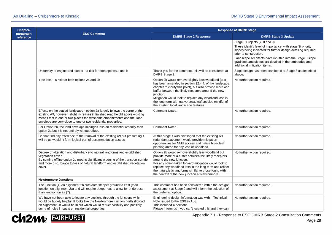
A9 Dualling – Crubenmore to Kincraig DMRB Stage 3 Environmental Impact Assessment
Appendix 7.1 - Response to ESG DMRB Stage 2 Consultation Comments Page 28
Chapter/ paragraph reference
ESG Comment Response at DMRB stage
DMRB Stage 2 Response DMRB Stage 3 Update Stage 3 Projects (7, 8 and 9). These identify level of importance, with stage 3/ priority slopes being indicated for further design detailing required prior to construction. Landscape Architects have inputted into the Stage 3 slope gradients and slopes are detailed in the embedded and additional mitigation items.
Uniformity of engineered slopes – a risk for both options a and b Thank you for the comment, this will be considered at DMRB Stage 3.
Slope design has been developed at Stage 3 as described above.
Tree loss – a risk for both options 2a and 2b Option 2b would remove slightly less woodland (text has been amended in section 12.4.4. of the landscape chapter to clarify this point), but also provide more of a buffer between the likely receptors around the new junction. Mitigation would look to replace any woodland loss in the long term with native broadleaf species mindful of the existing local landscape features
No further action required.
Effects on the settled landscape - option 2a largely follows the verge of the existing A9, however, slight increases in finished road height above existing means that in one or two places the west-side embankments and the land envelope are very close to one or two residential properties.
Comment Noted. No further action required.
For Option 2b, the land envelope impinges less on residential amenity than option 2a but it is not entirely without effect.
Comment Noted. No further action required.
Cannot find any reference to the removal of the existing A9 but presuming it will be as wouldn’t form logical part of accommodation access.
At this stage it was envisaged that the existing A9 redundant pavement would provide mitigation opportunities for NMU access and native broadleaf planting areas for any loss of woodland
No further action required.
Degree of alteration and disturbance to natural landforms and established vegetation cover. By coming offline option 2b means significant widening of the transport corridor and more disturbance to/loss of natural landform and established vegetation cover.
Option 2b would remove slightly less woodland but provide more of a buffer between the likely receptors around the new junction. For any option taken forward mitigation would look to replace any woodland loss in the long term and reflect the naturalistic landforms similar to those found within the context of the new junction at Newtonmore.
No further action required.
Newtonmore Junctions
The junction (4) on alignment 2b cuts onto steeper ground to east (than junction on alignment 2a) and will require deeper cut to allow for underpass than junction on 2a (7).
This comment has been considered within the design/ assessment at Stage 2 and will inform the selection of the preferred option.
No further action required.
We have not been able to locate any sections through the junctions which would be hugely helpful. It looks like the Newtonmore junction north sliproad on alignment 2b would be in cut which would reduce visibility and possibly some of noise impacts on residential properties.
Engineering design information was within Technical Note issued to the ESG in Aug. This included X sections. Please inform us if you can't located this and they can
No further action required.
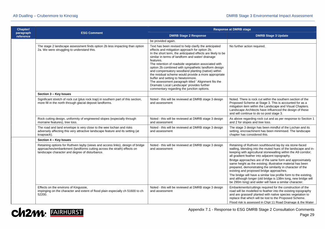
A9 Dualling – Crubenmore to Kincraig DMRB Stage 3 Environmental Impact Assessment
Appendix 7.1 - Response to ESG DMRB Stage 2 Consultation Comments Page 29
Chapter/ paragraph reference
ESG Comment Response at DMRB stage
DMRB Stage 2 Response DMRB Stage 3 Update be provided again.
The stage 2 landscape assessment finds option 2b less impacting than option 2a. We were struggling to understand this.
Text has been revised to help clarify the anticipated effects and mitigation approach for option 2b. In the short term, the anticipated effects are likely to be similar in terms of landform and water/ drainage features. The retention of roadside vegetation associated with option 2b combined with sympathetic landform design and compensatory woodland planting (native) within the residual scheme would provide a more appropriate buffer and setting to Newtonmore. The assessment paragraph titled ' Alignment fits the Dramatic Local Landscape' provides further commentary regarding the junction options.
No further action required.
Section 3 – Key Issues
Significant stretch of rock cut (plus rock trap) in southern part of this section, more fill in the north through glacial deposit landforms.
Noted - this will be reviewed at DMRB stage 3 design and assessment
Noted. There is rock cut within the southern section of the Proposed Scheme at Stage 3. This is accounted for as a mitigation item within the Landscape and Visual Chapters. Landscape Architects have influenced the design of these and will continue to do so post stage 3.
Rock cutting design, uniformity of engineered slopes (especially through morraine features), tree loss.
Noted - this will be reviewed at DMRB stage 3 design and assessment
As above regarding rock cut and as per response to Section 1 and 2 for slopes and tree loss.
The road and land envelope is very close to the wee lochan and risks adversely affecting this very attractive landscape feature and its setting (at knapsack).
Noted - this will be reviewed at DMRB stage 3 design and assessment
The stage 3 design has been mindful of the Lochan and its setting, encroachment has been minimised. The landscape chapter has considered this.
Section 4 – Key Issues
Retaining options for Ruthven layby (views and access links), design of bridge approaches/embankment (landforms cutting across the strath) effects on landscape character and degree of disturbance.
Noted - this will be reviewed at DMRB stage 3 design and assessment
Retaining of Ruthven southbound lay-by via stone-faced walling, blending into the muted hues of the landscape and in-keeping with agricultural stonewalling within the A9 corridor; all gradient feather into adjacent topography. Bridge approaches are of the same form and approximately same height as the existing; illustrative material has been prepared, demonstrating the similarity in character of the existing and proposed bridge approaches. The bridge will have a similar low profile form to the existing, and although longer (old bridge is 138m long, new bridge will be 290m long) and wider will have a similar character.
Effects on the environs of Kingussie, impinging on the character and extent of flood plain especially ch 51600 to ch 52200.
Noted - this will be reviewed at DMRB stage 3 design and assessment
Embankments/cuttings required for the construction of the road will be modelled to feather into the existing topography and are grassed/ planted with native species vegetation to replace that which will be lost to the Proposed Scheme. Flood risk is assessed in Chpt 11 Road Drainage & the Water
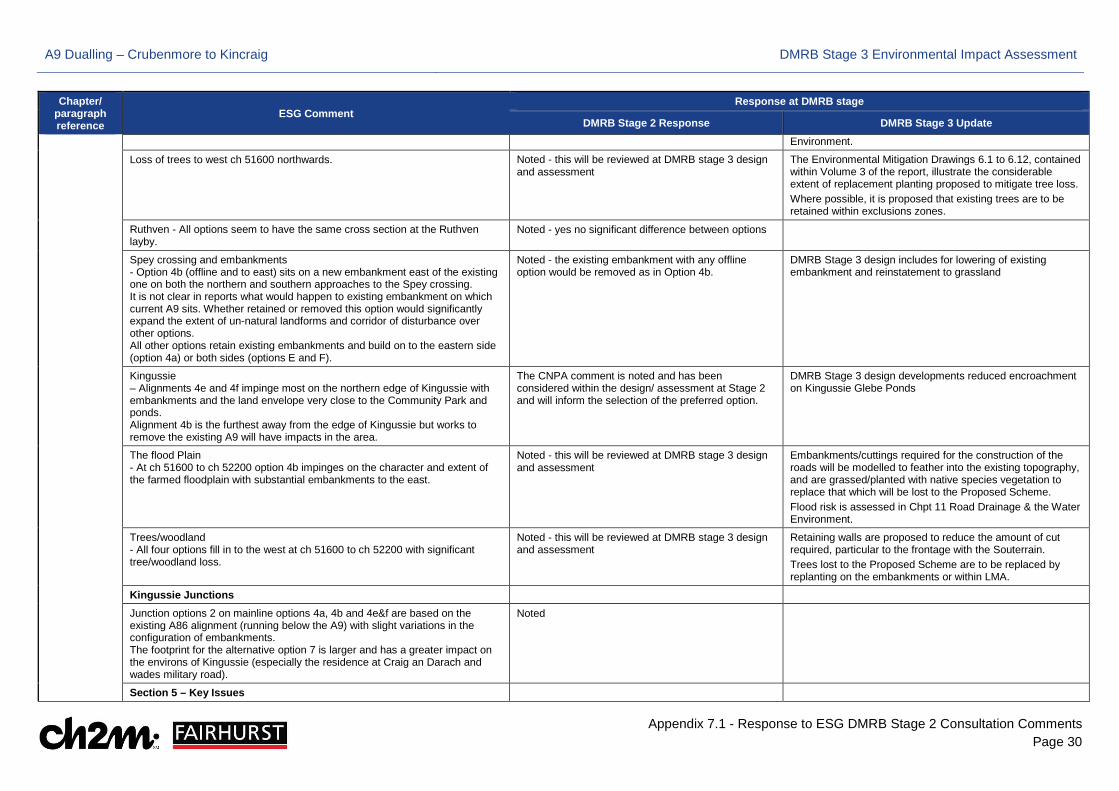
A9 Dualling – Crubenmore to Kincraig DMRB Stage 3 Environmental Impact Assessment
Appendix 7.1 - Response to ESG DMRB Stage 2 Consultation Comments Page 30
Chapter/ paragraph reference
ESG Comment Response at DMRB stage
DMRB Stage 2 Response DMRB Stage 3 Update Environment.
Loss of trees to west ch 51600 northwards. Noted - this will be reviewed at DMRB stage 3 design and assessment
The Environmental Mitigation Drawings 6.1 to 6.12, contained within Volume 3 of the report, illustrate the considerable extent of replacement planting proposed to mitigate tree loss. Where possible, it is proposed that existing trees are to be retained within exclusions zones.
Ruthven - All options seem to have the same cross section at the Ruthven layby.
Noted - yes no significant difference between options
Spey crossing and embankments - Option 4b (offline and to east) sits on a new embankment east of the existing one on both the northern and southern approaches to the Spey crossing. It is not clear in reports what would happen to existing embankment on which current A9 sits. Whether retained or removed this option would significantly expand the extent of un-natural landforms and corridor of disturbance over other options. All other options retain existing embankments and build on to the eastern side (option 4a) or both sides (options E and F).
Noted - the existing embankment with any offline option would be removed as in Option 4b.
DMRB Stage 3 design includes for lowering of existing embankment and reinstatement to grassland
Kingussie – Alignments 4e and 4f impinge most on the northern edge of Kingussie with embankments and the land envelope very close to the Community Park and ponds. Alignment 4b is the furthest away from the edge of Kingussie but works to remove the existing A9 will have impacts in the area.
The CNPA comment is noted and has been considered within the design/ assessment at Stage 2 and will inform the selection of the preferred option.
DMRB Stage 3 design developments reduced encroachment on Kingussie Glebe Ponds
The flood Plain - At ch 51600 to ch 52200 option 4b impinges on the character and extent of the farmed floodplain with substantial embankments to the east.
Noted - this will be reviewed at DMRB stage 3 design and assessment
Embankments/cuttings required for the construction of the roads will be modelled to feather into the existing topography, and are grassed/planted with native species vegetation to replace that which will be lost to the Proposed Scheme. Flood risk is assessed in Chpt 11 Road Drainage & the Water Environment.
Trees/woodland - All four options fill in to the west at ch 51600 to ch 52200 with significant tree/woodland loss.
Noted - this will be reviewed at DMRB stage 3 design and assessment
Retaining walls are proposed to reduce the amount of cut required, particular to the frontage with the Souterrain. Trees lost to the Proposed Scheme are to be replaced by replanting on the embankments or within LMA.
Kingussie Junctions
Junction options 2 on mainline options 4a, 4b and 4e&f are based on the existing A86 alignment (running below the A9) with slight variations in the configuration of embankments. The footprint for the alternative option 7 is larger and has a greater impact on the environs of Kingussie (especially the residence at Craig an Darach and wades military road).
Noted
Section 5 – Key Issues
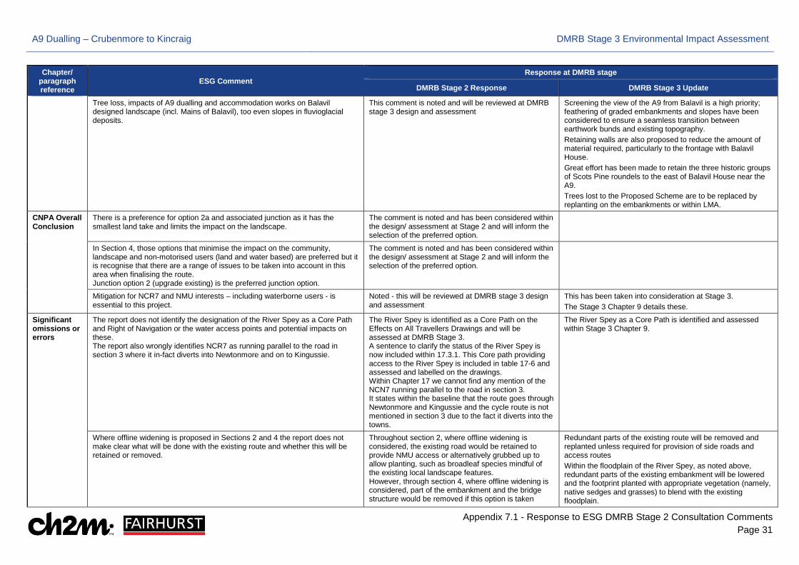
A9 Dualling – Crubenmore to Kincraig DMRB Stage 3 Environmental Impact Assessment
Appendix 7.1 - Response to ESG DMRB Stage 2 Consultation Comments Page 31
Chapter/ paragraph reference
ESG Comment Response at DMRB stage
DMRB Stage 2 Response DMRB Stage 3 Update
Tree loss, impacts of A9 dualling and accommodation works on Balavil designed landscape (incl. Mains of Balavil), too even slopes in fluvioglacial deposits.
This comment is noted and will be reviewed at DMRB stage 3 design and assessment
Screening the view of the A9 from Balavil is a high priority; feathering of graded embankments and slopes have been considered to ensure a seamless transition between earthwork bunds and existing topography. Retaining walls are also proposed to reduce the amount of material required, particularly to the frontage with Balavil House. Great effort has been made to retain the three historic groups of Scots Pine roundels to the east of Balavil House near the A9. Trees lost to the Proposed Scheme are to be replaced by replanting on the embankments or within LMA.
CNPA Overall Conclusion
There is a preference for option 2a and associated junction as it has the smallest land take and limits the impact on the landscape.
The comment is noted and has been considered within the design/ assessment at Stage 2 and will inform the selection of the preferred option.
In Section 4, those options that minimise the impact on the community, landscape and non-motorised users (land and water based) are preferred but it is recognise that there are a range of issues to be taken into account in this area when finalising the route. Junction option 2 (upgrade existing) is the preferred junction option.
The comment is noted and has been considered within the design/ assessment at Stage 2 and will inform the selection of the preferred option.
Mitigation for NCR7 and NMU interests – including waterborne users - is essential to this project.
Noted - this will be reviewed at DMRB stage 3 design and assessment
This has been taken into consideration at Stage 3. The Stage 3 Chapter 9 details these.
Significant omissions or errors
The report does not identify the designation of the River Spey as a Core Path and Right of Navigation or the water access points and potential impacts on these. The report also wrongly identifies NCR7 as running parallel to the road in section 3 where it in-fact diverts into Newtonmore and on to Kingussie.
The River Spey is identified as a Core Path on the Effects on All Travellers Drawings and will be assessed at DMRB Stage 3. A sentence to clarify the status of the River Spey is now included within 17.3.1. This Core path providing access to the River Spey is included in table 17-6 and assessed and labelled on the drawings. Within Chapter 17 we cannot find any mention of the NCN7 running parallel to the road in section 3. It states within the baseline that the route goes through Newtonmore and Kingussie and the cycle route is not mentioned in section 3 due to the fact it diverts into the towns.
The River Spey as a Core Path is identified and assessed within Stage 3 Chapter 9.
Where offline widening is proposed in Sections 2 and 4 the report does not make clear what will be done with the existing route and whether this will be retained or removed.
Throughout section 2, where offline widening is considered, the existing road would be retained to provide NMU access or alternatively grubbed up to allow planting, such as broadleaf species mindful of the existing local landscape features. However, through section 4, where offline widening is considered, part of the embankment and the bridge structure would be removed if this option is taken
Redundant parts of the existing route will be removed and replanted unless required for provision of side roads and access routes Within the floodplain of the River Spey, as noted above, redundant parts of the existing embankment will be lowered and the footprint planted with appropriate vegetation (namely, native sedges and grasses) to blend with the existing floodplain.
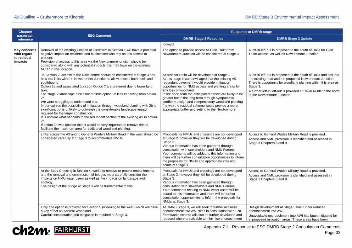
A9 Dualling – Crubenmore to Kincraig DMRB Stage 3 Environmental Impact Assessment
Appendix 7.1 - Response to ESG DMRB Stage 2 Consultation Comments Page 32
Chapter/ paragraph reference
ESG Comment Response at DMRB stage
DMRB Stage 2 Response DMRB Stage 3 Update forward.
Key concerns with regard to residual impacts
Removal of the existing junction at Glentruim in Section 1 will have a potential negative impact on residents and businesses who rely on this access at present. Provision of access to this area via the Newtonmore junction should be considered along with any potential impacts this may have on the existing NCR7 in this location.
The option to provide access to Glen Truim from Newtonmore Junction will be considered at Stage 3
A left-in-left-out is proposed to the south of Ralia for Glen Truim access, as well as Newtonmore Junction.
In Section 2, access to the Ralia centre should be considered at Stage 3 and how this links with the Newtonmore Junction to allow access both north and southbound. Option 2a and associated Junction Option 7 are preferred due to lower land take. The stage 2 landscape assessment finds option 2b less impacting than option 2a. We were struggling to understand this. In our opinion the possibility of mitigation through woodland planting with 2b is significant but is unlikely to outweigh the considerable landscape impact required for the larger construction. It is unclear what happens to the redundant section of the existing A9 in option 2b. If option 2b was chosen then it would be very important to remove this to facilitate the maximum area for additional woodland planting.
Access for Ralia will be developed at Stage 3. At this stage it was envisaged that the existing A9 redundant pavement would provide mitigation opportunities for NMU access and planting areas for any loss of woodland. In the short term the anticipated effects are likely to be greater but in the long term through sympathetic landform design and compensatory woodland planting (native) the residual scheme would provide a more appropriate buffer and setting to the Newtonmore.
A left-in-left-out is proposed to the south of Ralia and ties into the existing road and the proposed Newtonmore Junction. There is opportunity for woodland planting within this area at Stage 3. A further left-in left-out is provided at Ralia/ Nuide to the north of the Newtonmore Junction
Links across the A9 and to General Wade’s Military Road in the west should be considered carefully at Stage 3 to accommodate NMUs.
Proposals for NMUs and crossings are not developed at Stage 2, however they will be developed during Stage 3. Various information has been gathered through consultation with stakeholders and NMU Forums. Your comments will be added to this information and there will be further consultation opportunities to inform the proposals for NMUs and appropriate crossing points at Stage 3.
Access to General Wades Military Road is provided. Access and NMU provision is identified and assessed in Stage 3 Chapters 8 and 9.
At the Spey Crossing in Section 4, works to remove or protect embankments and the removal and construction of bridges must carefully consider the impacts on NMU water users as well as the impacts on landscape and ecology. The design of the bridge at Stage 3 will be fundamental to this.
Proposals for NMUs and crossings are not developed at Stage 2, however they will be developed during Stage 3. Various information has been gathered through consultation with stakeholders and NMU Forums. Your comments relating to NMU water users will be added to this information and there will be further consultation opportunities to inform the proposals for NMUs at Stage 3.
Access to General Wades Military Road is provided. Access and NMU provision is identified and assessed in Stage 3 Chapters 8 and 9.
Only one option is provided for Section 5 (widening to the west) which will have a key effect on Ancient Woodland. Careful consideration and mitigation is required at Stage 3.
At DMRB Stage 3, we will seek to further minimise encroachment into AWI sites in consultation with SNH. Earthworks extents will also be further developed and reduced where practicable to minimise encroachment
Design development at Stage 3 has further reduced encroachment into AWI. Unavoidable encroachment into AWI has been mitigated for in proposed mitigation areas. These areas have been

A9 Dualling – Crubenmore to Kincraig DMRB Stage 3 Environmental Impact Assessment
Appendix 7.1 - Response to ESG DMRB Stage 2 Consultation Comments Page 33
Chapter/ paragraph reference
ESG Comment Response at DMRB stage
DMRB Stage 2 Response DMRB Stage 3 Update into designated sites and notable habitats. Ancient woodland is an example of a notable habitat.
selected as they include 'lost AWI sites' and improve woodland connectivity.
There is great concern about the area of AWI that will be effects within this scheme. In particular the Oak woodland around Balavil and the Wildlife park. The tree ring count on the Kincraig section shows that these areas are between 200-250 years old. It is important that at stage 3 and design careful consideration is given to retaining as much as possible of this woodland and ensuring this is carried through to the construction phase by restricting the LMA and other measures.
At DMRB Stage 3, we will seek to further minimise encroachment into AWI sites in consultation with SNH. Earthworks extents will also be further developed and reduced where practicable to minimise encroachment into designated sites and notable habitats. Ancient woodland is an example of a notable habitat. This requirement will be carried through from the design to the construction stage.
Design development at Stage 3 has further reduced encroachment into AWI. Unavoidable encroachment into AWI has been mitigated for in proposed mitigation areas. These areas have been selected as they include 'lost AWI sites' and improve woodland connectivity.
Suggestions for consideration in more detail at DMRB Stage 3
The CNPA suggests the following:
a) the detailed proposals will need to be carefully considered against the policies of the National Park Partnership Plan, CNP Local Development Plan, the Cairngorms National Park Core Paths Plan and the Design Guide;
Noted - this will be reviewed at DMRB stage 3 design and assessment
Policy compliance is considered in ES Chapter 19
b) the proposed options create issues that require mitigation proposals to be explored and also present opportunities for enhancement, in particular for NMUs and NCR7, access to properties, and enhancement planting for habitat connectivity, landscape, and views;
Noted - this will be reviewed at DMRB stage 3 design and assessment
All of the items mentioned have been considered at Stage 3.
c) it is recommended that, as matter of considerable importance, all opportunity is taken to enhance (or replace with appropriate alternatives) existing features which support NMU access including car parking and improvements to public transport connectivity;
Noted - this will be reviewed at DMRB stage 3 design and assessment
Where NMU routes are affected by the proposed scheme appropriate tracks/ accesses/ temporary diversions are provided to allow continuity of all NMU routes throughout construction and operation. A new NMU link is to be provided between Kingussie and Kincraig. Potential beneficial effects are detailed within Chapter 9 at Stage 3.
d) where possible, it would be helpful to identify initial proposals for ‘accommodation works’ to accommodate those communities and owners of private assets who will be adversely impacted by the project;
Noted - this will be reviewed at DMRB stage 3 design and assessment
DMRB Stage 3 EIA does not consider ‘accommodation works’, these issues are not defined at the EIA stage However, a number of direct accesses and underpasses have been included, or locations adjusted, as a result of local stakeholder consultation
e) there should be detailed proposals to avoid detrimental impacts upon National Cycle Route 7 (NCR7) and its users, the approach should be one of seeking overall improvement to the existing standard which can be managed through a combination of design and mitigation - CNPA supports the principle of maintaining and where possible increasing, the distance of NCR7 from the carriageway;
Noted - this will be reviewed at DMRB stage 3 design and assessment
The proposed scheme has been designed with consideration of NCN7 to allow continued use of this route throughout construction and operation. These items are discussed and detailed in Chapter 9 at Stage 3.
f) where existing crossing points have been identified crossing the A9 carriageway, all viable options should be considered to allow them to continue once the upgraded A9 is operational or an alternative provided - permanent severance of existing Core Paths should be avoided;
Noted - this will be reviewed at DMRB stage 3 design and assessment
NMU crossing points have been rationalised and provided to retain connectivity of NMU routes. This is detailed in Chapter 9 at Stage 3.
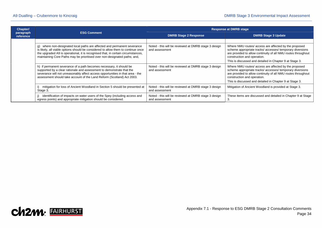
A9 Dualling – Crubenmore to Kincraig DMRB Stage 3 Environmental Impact Assessment
Appendix 7.1 - Response to ESG DMRB Stage 2 Consultation Comments Page 34
Chapter/ paragraph reference
ESG Comment Response at DMRB stage
DMRB Stage 2 Response DMRB Stage 3 Update
g) where non-designated local paths are affected and permanent severance is likely, all viable options should be considered to allow them to continue once the upgraded A9 is operational, it is recognised that, in certain circumstances, maintaining Core Paths may be prioritised over non-designated paths; and,
Noted - this will be reviewed at DMRB stage 3 design and assessment
Where NMU routes/ access are affected by the proposed scheme appropriate tracks/ accesses/ temporary diversions are provided to allow continuity of all NMU routes throughout construction and operation. This is discussed and detailed in Chapter 9 at Stage 3.
h) if permanent severance of a path becomes necessary, it should be supported by a clear rationale and assessment to demonstrate that the severance will not unreasonably affect access opportunities in that area - the assessment should take account of the Land Reform (Scotland) Act 2003.
Noted - this will be reviewed at DMRB stage 3 design and assessment
Where NMU routes/ access are affected by the proposed scheme appropriate tracks/ accesses/ temporary diversions are provided to allow continuity of all NMU routes throughout construction and operation. This is discussed and detailed in Chapter 9 at Stage 3.
i) mitigation for loss of Ancient Woodland in Section 5 should be presented at Stage 3;
Noted - this will be reviewed at DMRB stage 3 design and assessment
Mitigation of Ancient Woodland is provided at Stage 3.
j) identification of impacts on water users of the Spey (including access and egress points) and appropriate mitigation should be considered.
Noted - this will be reviewed at DMRB stage 3 design and assessment
These items are discussed and detailed in Chapter 9 at Stage 3.