Embed Size (px)
Citation preview
Wilbar Associates Ltd – Road Safety Review 1
A1 Falloden Way/ Lyttelton Road, Hampstead Garden Suburb Road Safety Review
Wilbar Associates Ltd – Road Safety Review 2
DOCUMENT CONTROL
Wilbar Associates Limited has prepared this report in accordance with the instructions from Hampstead Gardens Residents Association. Wilbar Associates Limited shall not be liable for the use of any information contained in this document for any purpose other than the sole and specific use for which it was prepared.
PROJECT DETAILS
Report title A1 Falloden Way/ Lyttelton Road, Hampstead Gardens
Road Safety Review
Date: 21/01/19
Document reference and revision: UKP-229 – Issue 02
Prepared by: Roger Harper, BSc(Eng) FIHE IEng Contact:- E: [email protected] M: 07903 696337
On behalf of Hampstead Gardens Residents Association
CONTACT:
Duncan Driver E: [email protected] Woodbrooke Farm, Toat Lane, Pulborough, West Sussex, RH20 1BX Tel/Fax: 01798 874653
Wilbar Associates Ltd – Road Safety Review 3
Contents Page
Page No.
1 Introduction
1
2 Traffic Flows
5
3 Description of route
6
4 Collision History
9
5 Section 1
13
6 Section 2
19
7 Section 3
24
8 Section 4
26
9 Summary
33
Appendices:
Appendix 1: Information on collisions involving ‘Killed or Seriously Injured’ (KSI) between 2013-17.
Appendix 2: TfL A1 Falloden Way / Ossulton Way Summary Note on Junction
Wilbar Associates Ltd – Road Safety Review 1
1. INTRODUCTION
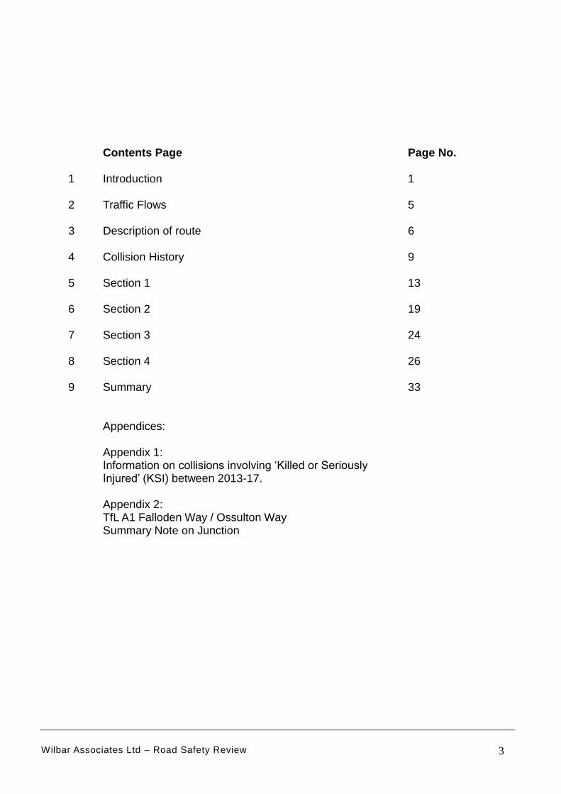
1.1 This report details the results of a road safety review on a section of the A1
Falloden Way/ Lyttelton Road, Hampstead Gardens in North West London
from east of the North Circular Road to Winnington Road, a street to the
west of the A1000. The section of route subject of this study is highlighted in
Figure 1 and is approximately 1.8km long.
Figure 1: Location of study area
[Background image taken from open source mapping]
1.2 The review comprised of a site visit on the 13th November 2018 which
involved driving, cycling and walking the route. The weather at the time of
the site visit was fine and dry. The review also includes an analysis of police
road traffic crash data. Data on the collision history has been taken from
“Crashmap” [www.crashmap.co.uk ].
Wilbar Associates Ltd – Road Safety Review 2
1.3 The following areas of road safety have been considered based around road
safety audit principals:
Visibility;
Layout of junctions;
Non-Motorised User (NMU) Provision [principally pedestrians and
cyclists];
Road Signs and carriageway markings.
Parking areas particularly laybys.
1.4 Drainage and lighting has not been assessed in detail as this is beyond the
scope of the study. On the day of the site visit many areas of the footway
were covered with leaves. This has not specifically been raised but is
considered to be a hazard and the route would benefit from inspection for
street cleansing.
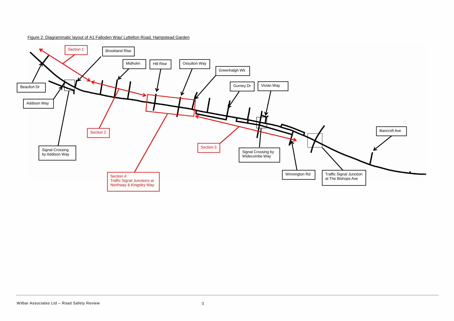
1.5 For the purposes of this study the route has been broken down into 4 distinct
sections:
Section 1 covers west of the junction of Beaufort Drive to the east of
Brookland Rise junction near the entrance to Northway Gardens;
Section 2 covers west of Westholm to east of Eastholm;
Section 3 covers the eastern part of the route east of Greenhalgh Walk
to east of the junction with Winnington Rd.
Section 4 covers the route between the traffic signal junctions of
Northway and Kingsley Way.
1.6 A Diagrammatic layout of the A1 route is shown in Figure 2 highlighting the
different sections.
Wilbar Associates Ltd – Road Safety Review 3
Figure 2: Diagrammatic layout of A1 Falloden Way/ Lyttelton Road, Hampstead Garden
Section 2
Section 3 Signal Crossing by Addison Way
Signal Crossing by Widecombe Way
Section 4: Traffic Signal Junctions at Northway & Kingsley Way
Traffic Signal Junction at The Bishops Ave
Addison Way
Ossulton Way
Bancroft Ave
Vivian Way
Hill Rise
Brookland Rise
Midholm
Greenhalgh Wk
Gurney Dr Beaufort Dr
Winnington Rd
Section 1
Wilbar Associates Ltd – Road Safety Review 4
1.7 If applicable references are made to following documents:
‘DMRB’ refers to Design Manual for Roads and Bridges which can be
found on line at: http://www.standardsforhighways.co.uk/ .
Any reference to Manual for Streets (MfS) can be found on line at:
https://www.gov.uk/government/publications/manual-for-streets
Any reference to Department for Transport (DfT) sign numbers will
generally refer to the signs in the ‘Traffic Signs Manual (TSM)’ which can
be found on line at: https://www.gov.uk/government/publications/traffic-
signs-manual or Traffic Signs Regulations and General Directions 2016
(TSR&GD16).
Any reference to Local Transport Notes (LTN) can be found on line at:
https://www.gov.uk/government/collections/local-transport-notes .
Any reference to Traffic Advisory Leaflets (TAL) can be found on line at:
https://www.gov.uk/government/collections/traffic-advisory-leaflets .
Guidance on tactile paving standards can be found on line at:
https://www.gov.uk/government/publications/guidance-on-the-use-of-
tactile-paving-surfaces
Wilbar Associates Ltd – Road Safety Review 5
2. TRAFFIC FLOWS
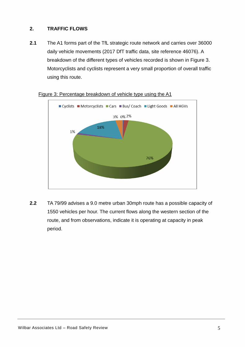
2.1 The A1 forms part of the TfL strategic route network and carries over 36000
daily vehicle movements (2017 DfT traffic data, site reference 46076). A
breakdown of the different types of vehicles recorded is shown in Figure 3.
Motorcyclists and cyclists represent a very small proportion of overall traffic
using this route.
Figure 3: Percentage breakdown of vehicle type using the A1
2.2 TA 79/99 advises a 9.0 metre urban 30mph route has a possible capacity of
1550 vehicles per hour. The current flows along the western section of the
route, and from observations, indicate it is operating at capacity in peak
period.
Wilbar Associates Ltd – Road Safety Review 6
3. DESCRIPTION OF ROUTE
3.1 The western section between Beaufort Drive and Northway is a single
carriageway. The eastern section of the route is a dual carriageway. The
western section, between a point east of Beaufort Drive and east of
Blandford Close is subject to a 30mph speed limit, with the remaining section
subject to a 40mph speed limit.
3.2 The route has the following features:
A central hatched area runs along the majority of the route with the
exception of a short length of the western end and at the traffic signals
which have a paved central reservation;
Traffic signals are installed at 2 crossroad junctions: Northway and
Kingsley Way;
Two pedestrian signalised crossings operate near the junctions with
Addison Way (toucan which includes cyclists) & Widecombe Way
(pelican);
There are 18 priority junctions with side roads, 11 on the north side and 7
on the south side (This includes the access by Heathfielde Medical
Centre). 5 of the junctions are defined by a right turn lane;
There are approximately 12 private access-ways which directly join the
route;
There are traffic islands at 13 locations with 9 of them incorporating
uncontrolled pedestrian crossing facilities.
There are 12 defined bus stops, 6 on the north side and 6 on the south
side. 8 of these bus stops are laybys.
Wilbar Associates Ltd – Road Safety Review 7
3.3 The route is covered by red route parking controls. On-street parking is
permitted in 8 different areas:
Section on north side west of Westholm;
Section on north side between Westholm and Midholm;
Section on north side between Midholm and Eastholm;
Section on north side east of Eastholm;
Section south side west of Midholm;
Section north side between Hill Rise and Ossulton Way;
Section south side between Hill Rise and Ossulton Way;
Section north side east of Ossulton Way
All the parking bays are protected in laybys with marked spaces.
3.4 The geometric design of Major/Minor priority junctions is specified in DMRB
guidance TD 4295. The guidance indicates that “Traffic on the minor road
gives way to traffic on the major road and is normally controlled by "Give
Way" signs and road markings”. There are three basic types of layout:
Simple Junction [300 vehicle two-way AADT];
Ghost Island Junction [They are considered to be highly effective in
improving safety]
Single Lane Dualling [Generally only appropriate for roads with hard
shoulders];
The type of layout will depend on the flows. The current flows of over 30000
AADT on the A1 indicate a simple design is inappropriate and any access
should have a ghost island and central hatching. This is broadly achieved at
all the priority junctions on this section of the A1 route. However as traffic
flows are so high right turning traffic will inevitably need to make the
manoeuvre in two stages which is not ideal. Visibility at these junctions is
discussed under site observations in sections 5 to 8.
Wilbar Associates Ltd – Road Safety Review 8
3.5 Fixed traffic enforcement cameras operate on this route. 3 of the cameras
operate just to the east of the study area - a red light at the signal junction
with ‘The Bishops Avenue’ and two speed cameras (east/westbound) by
Bancroft Avenue. The 2 cameras in the study area are east and westbound
speed cameras to the east of Gurney Drive junction.
3.6 In terms of the bus stop environment the following issues should be
considered as part of their design.
Security (including lighting)
Bus stop post and flag
Surface markings for buses
Bus passenger shelter and seating
Information (including timetables and maps)
Drainage
Pedestrian footway
Height and type of kerb
Adequacy of waiting area
Space for bus to straighten
Approach and exit paths for buses
Connectivity with footway
Convenience for passengers
Only specific road safety issues will be raised as part of this study under the
site observations set out in sections 5 to 8.
Wilbar Associates Ltd – Road Safety Review 9
4. COLLISION HISTORY
4.1 Data on the collision history is available on line from “Crashmap”
[www.crashmap.co.uk ]. Details of serious and fatal collisions in the past 5
years are attached in Appendix 1. To provide an overview of collision history
the past 10 years of data between 2008-17 has also been summarised.
4.2 A collision is classed according to the most severe casualty involved, and
one collision may involve several casualties. The casualty severity definition
is summarised as follows:-
Fatal injury includes only those cases where death occurs in less than 30
days as a result of the accident. Fatal does not include death from natural
causes or suicide.
Examples of serious injury are: Fracture; internal injury; severe cuts;
crushing; burns (excluding friction burns); concussion; severe general
shock requiring hospital treatment; detention in hospital as an in-patient,
either immediately or later; injuries to casualties who die 30 or more days
after the accident from injuries sustained in that accident.
Examples of slight injury are: Sprains, not necessarily requiring medical
treatment; neck whiplash injury; bruises; slight cuts; slight shock requiring
roadside attention. Persons who are merely shaken and who have no
other injury are generally not included unless they receive or appear to
need medical treatment.
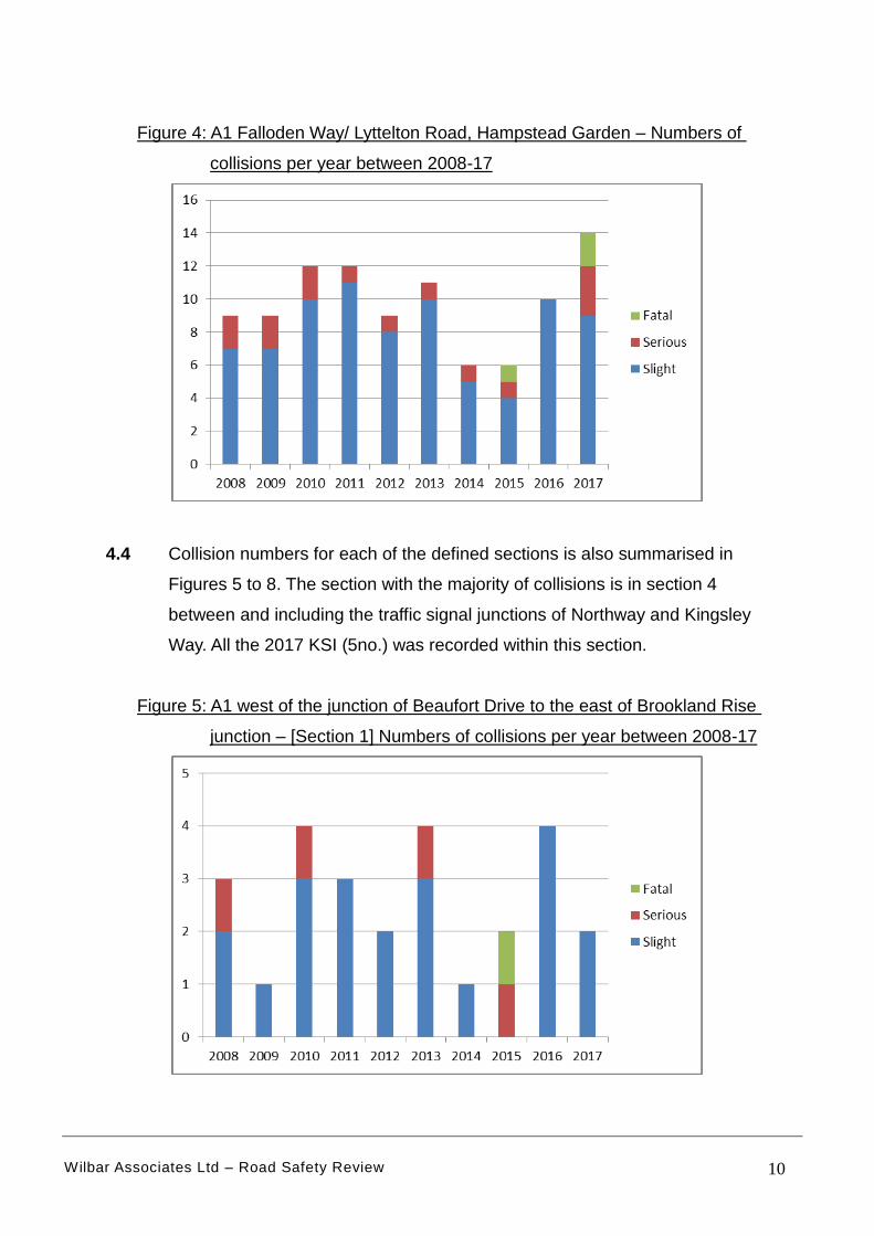
4.3 A breakdown of the number of collisions for this section of route for the past
10 years is shown in Figure 4. Overall there have been 98 collisions
involving personal injury recorded by the Police between 2008-17. The
severity of the collisions is also indicated. There have been 3 fatal and 14
serious collisions (17 (KSI) killed or serious injured). 2017 witnessed the
highest number of recorded collisions but also the worst in severity involving
5 KSI.
Wilbar Associates Ltd – Road Safety Review 10
Figure 4: A1 Falloden Way/ Lyttelton Road, Hampstead Garden – Numbers of
collisions per year between 2008-17
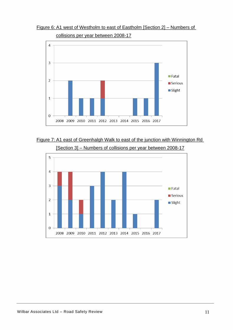
4.4 Collision numbers for each of the defined sections is also summarised in
Figures 5 to 8. The section with the majority of collisions is in section 4
between and including the traffic signal junctions of Northway and Kingsley
Way. All the 2017 KSI (5no.) was recorded within this section.
Figure 5: A1 west of the junction of Beaufort Drive to the east of Brookland Rise
junction – [Section 1] Numbers of collisions per year between 2008-17
Wilbar Associates Ltd – Road Safety Review 11
Figure 6: A1 west of Westholm to east of Eastholm [Section 2] – Numbers of
collisions per year between 2008-17
Figure 7: A1 east of Greenhalgh Walk to east of the junction with Winnington Rd
[Section 3] – Numbers of collisions per year between 2008-17
Wilbar Associates Ltd – Road Safety Review 12
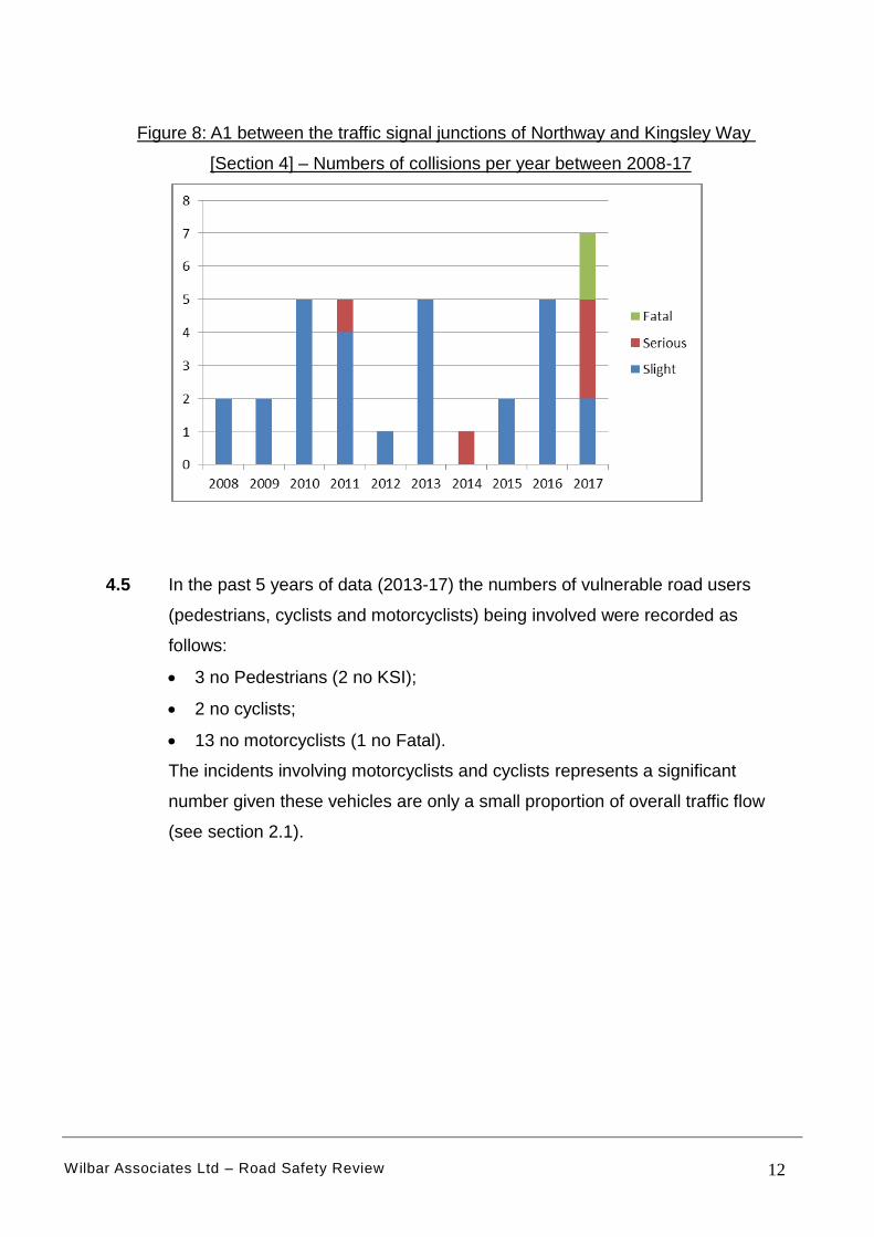
Figure 8: A1 between the traffic signal junctions of Northway and Kingsley Way
[Section 4] – Numbers of collisions per year between 2008-17
4.5 In the past 5 years of data (2013-17) the numbers of vulnerable road users
(pedestrians, cyclists and motorcyclists) being involved were recorded as
follows:
3 no Pedestrians (2 no KSI);
2 no cyclists;
13 no motorcyclists (1 no Fatal).
The incidents involving motorcyclists and cyclists represents a significant
number given these vehicles are only a small proportion of overall traffic flow
(see section 2.1).
Wilbar Associates Ltd – Road Safety Review 13
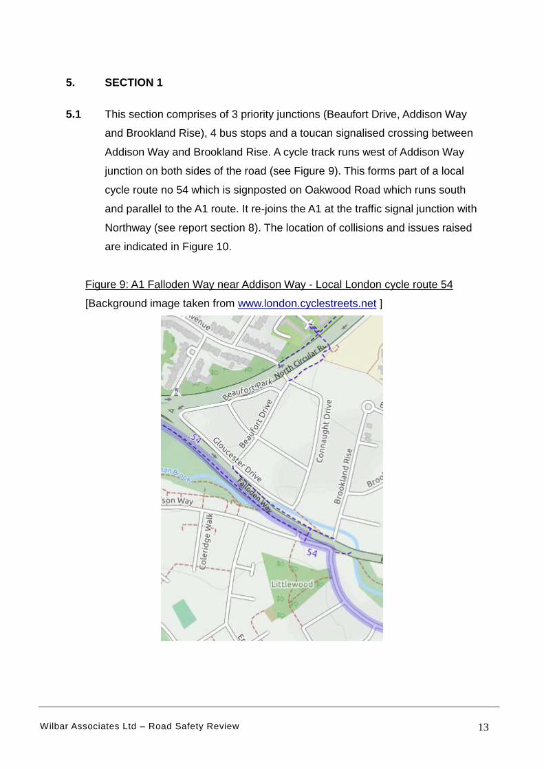
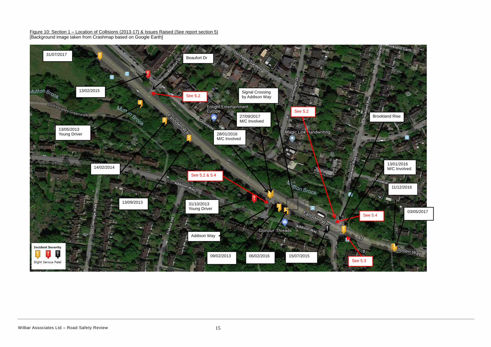
5. SECTION 1
5.1 This section comprises of 3 priority junctions (Beaufort Drive, Addison Way
and Brookland Rise), 4 bus stops and a toucan signalised crossing between
Addison Way and Brookland Rise. A cycle track runs west of Addison Way
junction on both sides of the road (see Figure 9). This forms part of a local
cycle route no 54 which is signposted on Oakwood Road which runs south
and parallel to the A1 route. It re-joins the A1 at the traffic signal junction with
Northway (see report section 8). The location of collisions and issues raised
are indicated in Figure 10.
Figure 9: A1 Falloden Way near Addison Way - Local London cycle route 54
[Background image taken from www.london.cyclestreets.net ]
Wilbar Associates Ltd – Road Safety Review 14
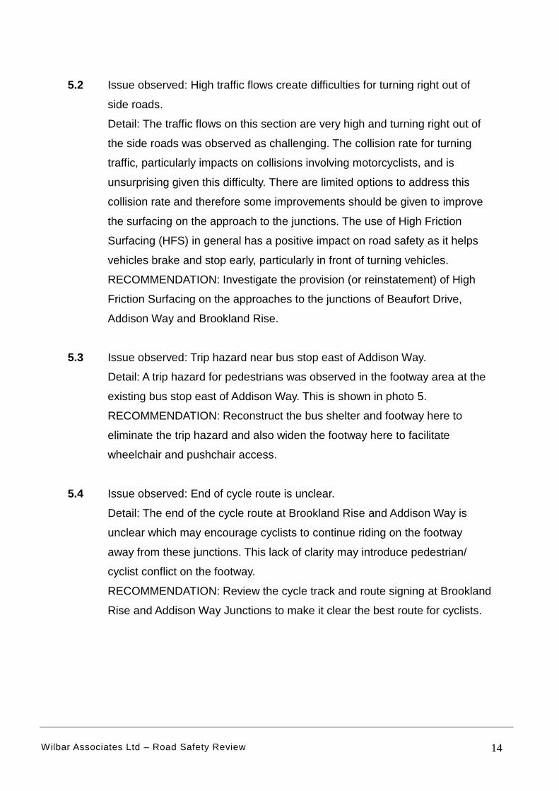
5.2 Issue observed: High traffic flows create difficulties for turning right out of
side roads.
Detail: The traffic flows on this section are very high and turning right out of
the side roads was observed as challenging. The collision rate for turning
traffic, particularly impacts on collisions involving motorcyclists, and is
unsurprising given this difficulty. There are limited options to address this
collision rate and therefore some improvements should be given to improve
the surfacing on the approach to the junctions. The use of High Friction
Surfacing (HFS) in general has a positive impact on road safety as it helps
vehicles brake and stop early, particularly in front of turning vehicles.
RECOMMENDATION: Investigate the provision (or reinstatement) of High
Friction Surfacing on the approaches to the junctions of Beaufort Drive,
Addison Way and Brookland Rise.
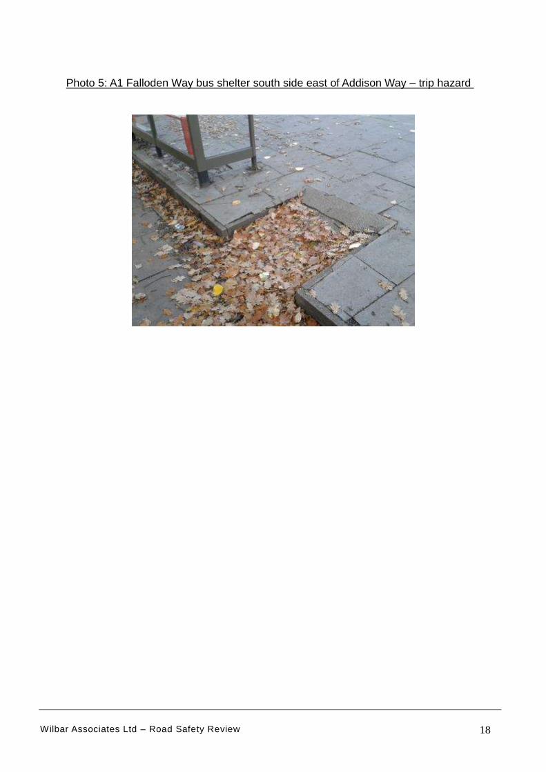
5.3 Issue observed: Trip hazard near bus stop east of Addison Way.
Detail: A trip hazard for pedestrians was observed in the footway area at the
existing bus stop east of Addison Way. This is shown in photo 5.
RECOMMENDATION: Reconstruct the bus shelter and footway here to
eliminate the trip hazard and also widen the footway here to facilitate
wheelchair and pushchair access.
5.4 Issue observed: End of cycle route is unclear.
Detail: The end of the cycle route at Brookland Rise and Addison Way is
unclear which may encourage cyclists to continue riding on the footway
away from these junctions. This lack of clarity may introduce pedestrian/
cyclist conflict on the footway.
RECOMMENDATION: Review the cycle track and route signing at Brookland
Rise and Addison Way Junctions to make it clear the best route for cyclists.
Wilbar Associates Ltd – Road Safety Review 15
Figure 10: Section 1 – Location of Collisions (2013-17) & Issues Raised (See report section 5) [Background image taken from Crashmap based on Google Earth]
See 5.2
See 5.3
Signal Crossing by Addison Way
Addison Way
Brookland Rise
13/02/2015
Beaufort Dr
See 5.4
28/01/2016 M/C Involved
06/02/2016 09/02/2013
31/10/2013 Young Driver
13/09/2013
15/07/2015
13/01/2016 M/C Involved
11/12/2016
03/05/2017
14/02/2014
13/05/2013 Young Driver
31/07/2017
27/09/2017 M/C Involved
See 5.2
See 5.2 & 5.4
Wilbar Associates Ltd – Road Safety Review 16
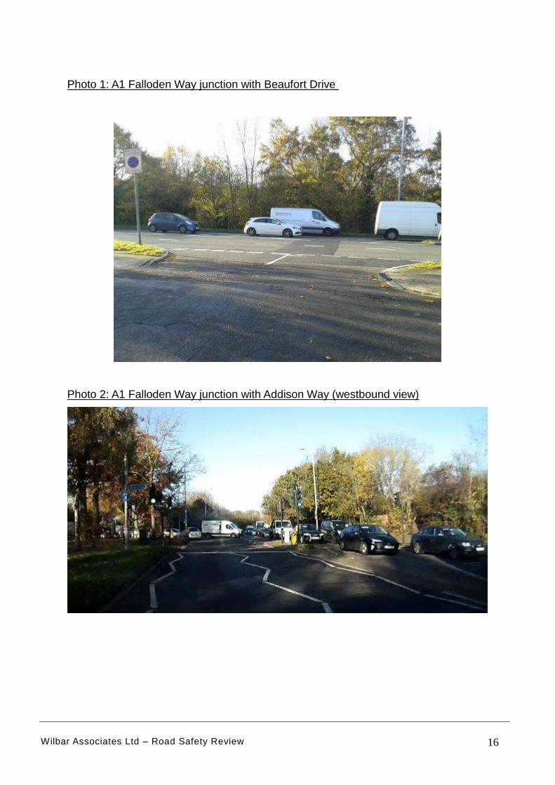
Photo 1: A1 Falloden Way junction with Beaufort Drive
Photo 2: A1 Falloden Way junction with Addison Way (westbound view)
Wilbar Associates Ltd – Road Safety Review 17
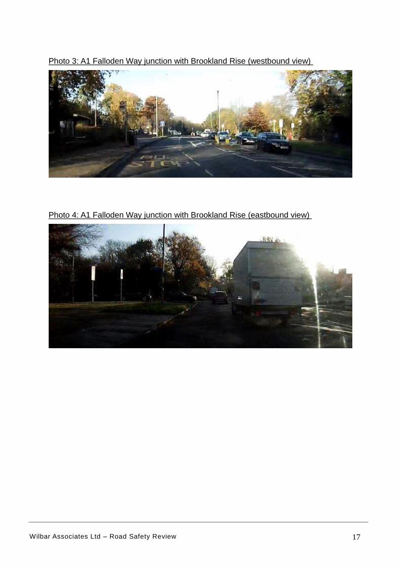
Photo 3: A1 Falloden Way junction with Brookland Rise (westbound view)
Photo 4: A1 Falloden Way junction with Brookland Rise (eastbound view)
Wilbar Associates Ltd – Road Safety Review 18
Photo 5: A1 Falloden Way bus shelter south side east of Addison Way – trip hazard
Wilbar Associates Ltd – Road Safety Review 19
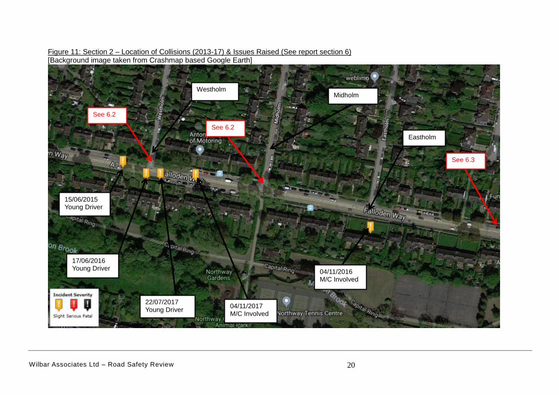
6. SECTION 2
6.1 This section comprises of 3 priority junctions (Westholm, Midholm and
Eastholm), 4 bus stops and four on-street parking laybys. Residential
properties front this section. The location of collisions and issues raised are
indicated in Figure 11.
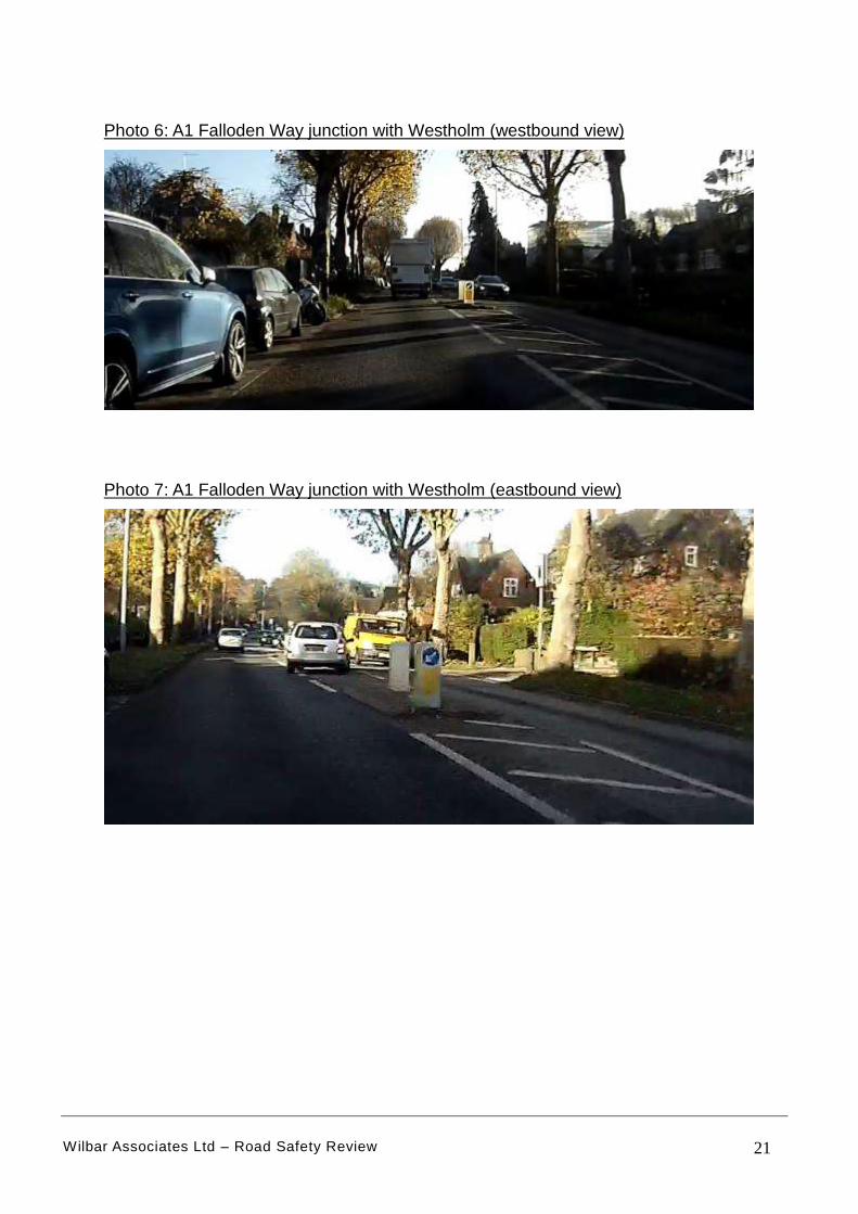
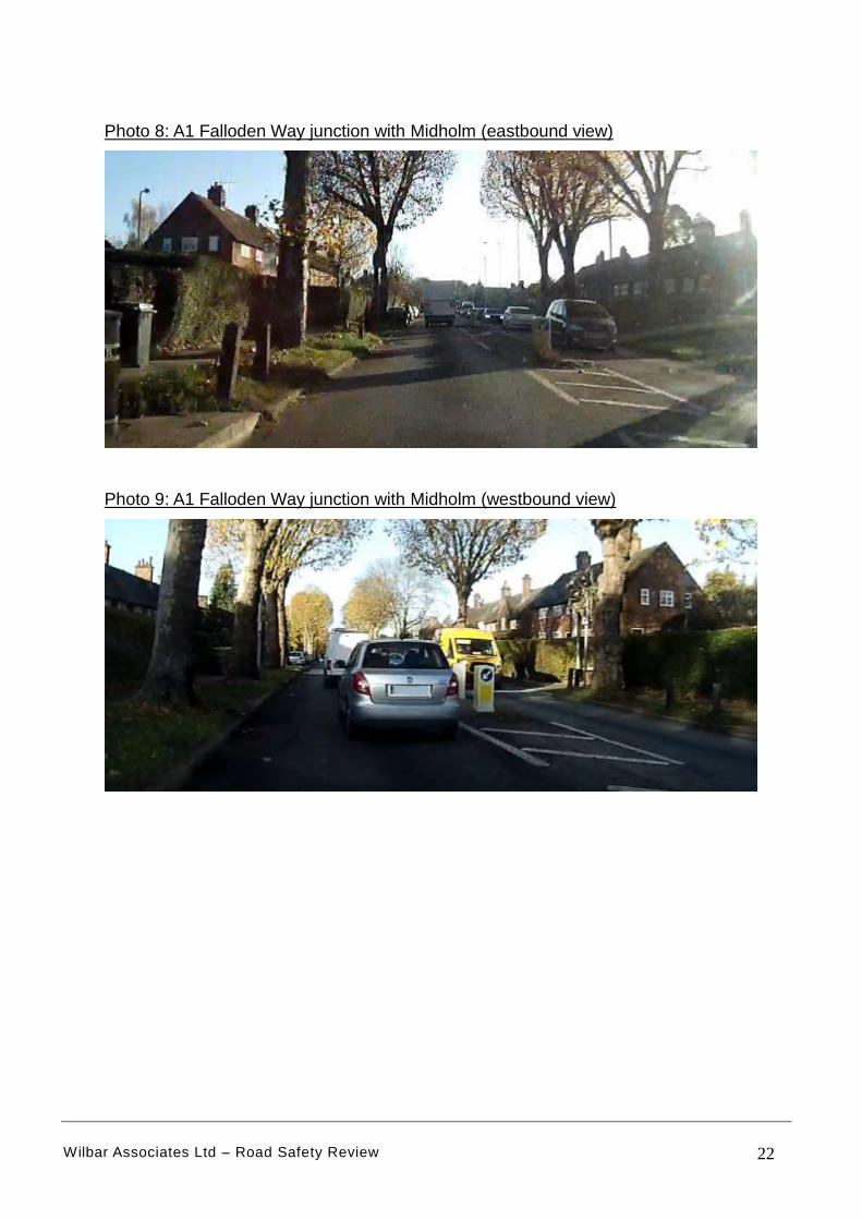
6.2 Issue observed: Poor visibility from Westholm and Midholm junctions.
Detail: The visibility on the approach to Westholm and Midholm junctions is
poor (See photos 6-9). The indications are this has influenced the number of
collisions at Westholm junction (3 in 5 years). Young drivers appear to
struggle with this junction. This is a cul-de-sac and there is no other point of
access unlike Midholm that can use Hill Top and Hill Rise. Visibility at
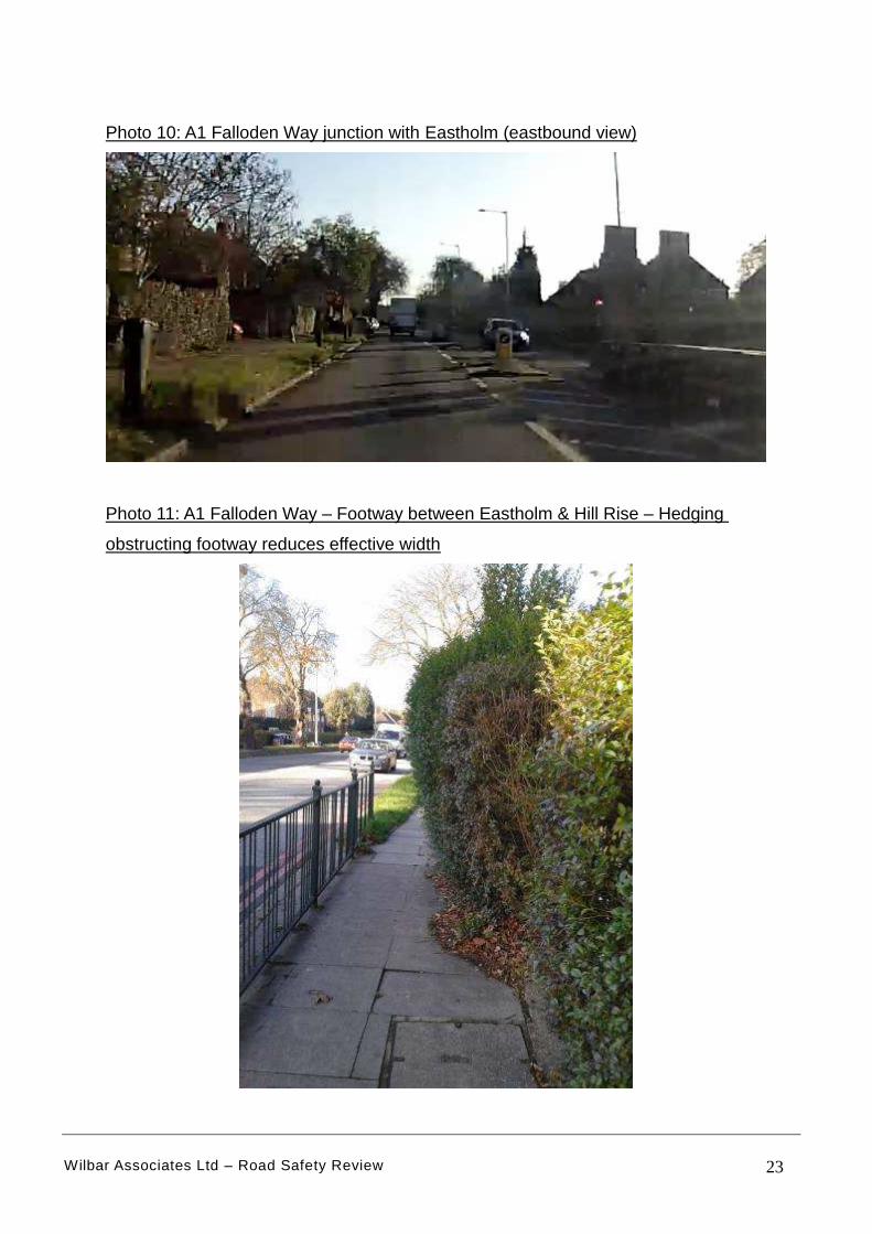
Eastholm is satisfactory.
RECOMMENDATION: Either remove the trees on the corner (which may be
a controversial issue) OR construct a new traffic island in the central
hatching on the eastbound approach to Westholm housing a speed activated
‘side road ahead’ warning sign.
6.3 Issue observed: Effective footway width reduced by overgrown hedging.
Detail: The effective width of the existing footway on the north side is
reduced due to overgrown hedging (See photo 11). This is becoming a
hazard in places and needs to be addressed before it forces pedestrians into
the carriageway
RECOMMENDATION: Liaise with Highway Authority/ Frontages to cut back
hedging to maintain effective footway width.
Wilbar Associates Ltd – Road Safety Review 20
Figure 11: Section 2 – Location of Collisions (2013-17) & Issues Raised (See report section 6) [Background image taken from Crashmap based Google Earth]
See 6.3
See 6.2
Eastholm
Westholm Midholm
See 6.2
04/11/2016 M/C Involved
04/11/2017 M/C Involved
22/07/2017 Young Driver
17/06/2016 Young Driver
15/06/2015 Young Driver
Wilbar Associates Ltd – Road Safety Review 21
Photo 6: A1 Falloden Way junction with Westholm (westbound view)
Photo 7: A1 Falloden Way junction with Westholm (eastbound view)
Wilbar Associates Ltd – Road Safety Review 22
Photo 8: A1 Falloden Way junction with Midholm (eastbound view)
Photo 9: A1 Falloden Way junction with Midholm (westbound view)
Wilbar Associates Ltd – Road Safety Review 23
Photo 10: A1 Falloden Way junction with Eastholm (eastbound view)
Photo 11: A1 Falloden Way – Footway between Eastholm & Hill Rise – Hedging
obstructing footway reduces effective width
Wilbar Associates Ltd – Road Safety Review 24
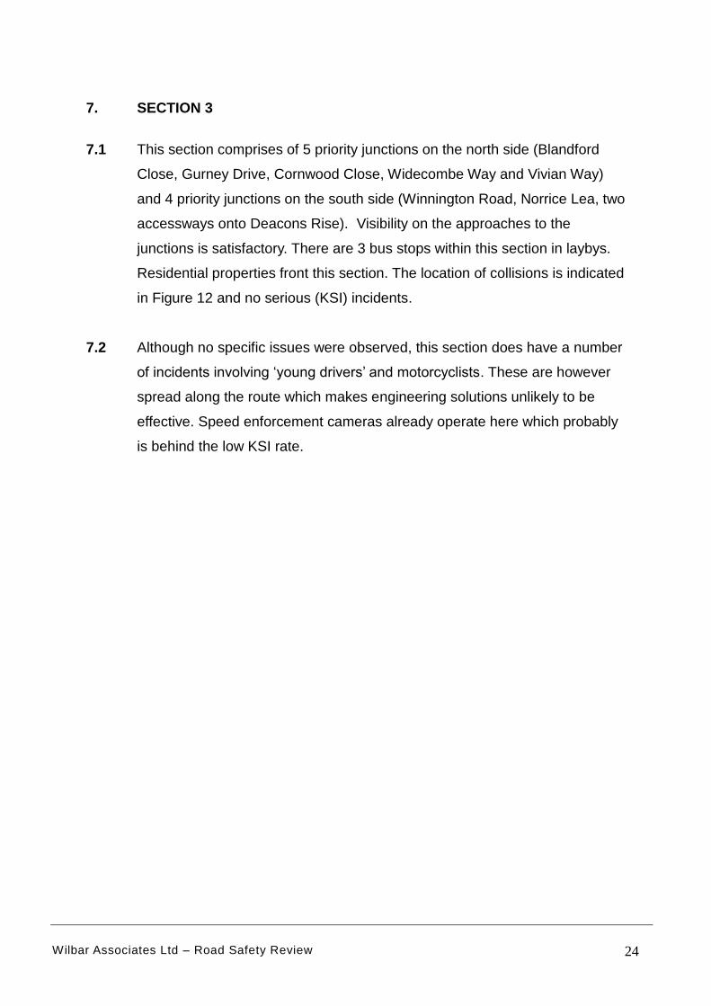
7. SECTION 3
7.1 This section comprises of 5 priority junctions on the north side (Blandford
Close, Gurney Drive, Cornwood Close, Widecombe Way and Vivian Way)
and 4 priority junctions on the south side (Winnington Road, Norrice Lea, two
accessways onto Deacons Rise). Visibility on the approaches to the
junctions is satisfactory. There are 3 bus stops within this section in laybys.
Residential properties front this section. The location of collisions is indicated
in Figure 12 and no serious (KSI) incidents.
7.2 Although no specific issues were observed, this section does have a number
of incidents involving ‘young drivers’ and motorcyclists. These are however
spread along the route which makes engineering solutions unlikely to be
effective. Speed enforcement cameras already operate here which probably
is behind the low KSI rate.
Wilbar Associates Ltd – Road Safety Review 25
Figure 12: Section 3 – Location of Collisions (2013-17) & Issues Raised (See report section 7) [Background image taken from Crashmap based Google Earth]
Signal Crossing by Widecombe Way
Cornwood Cl
Winnington Rd
Gurney Dr
15/06/2017
17/09/2013 Young Driver
Norrice Lea
Deacons Rise 29/06/2014 P/C Involved Young Driver
03/06/2014 M/C Involved
30/07/2013 Young Driver
14/05/2015
16/08/2017 M/C Involved
17/01/2014 M/C Involved Young Driver
Blandford Close
02/11/2014
Wilbar Associates Ltd – Road Safety Review 26
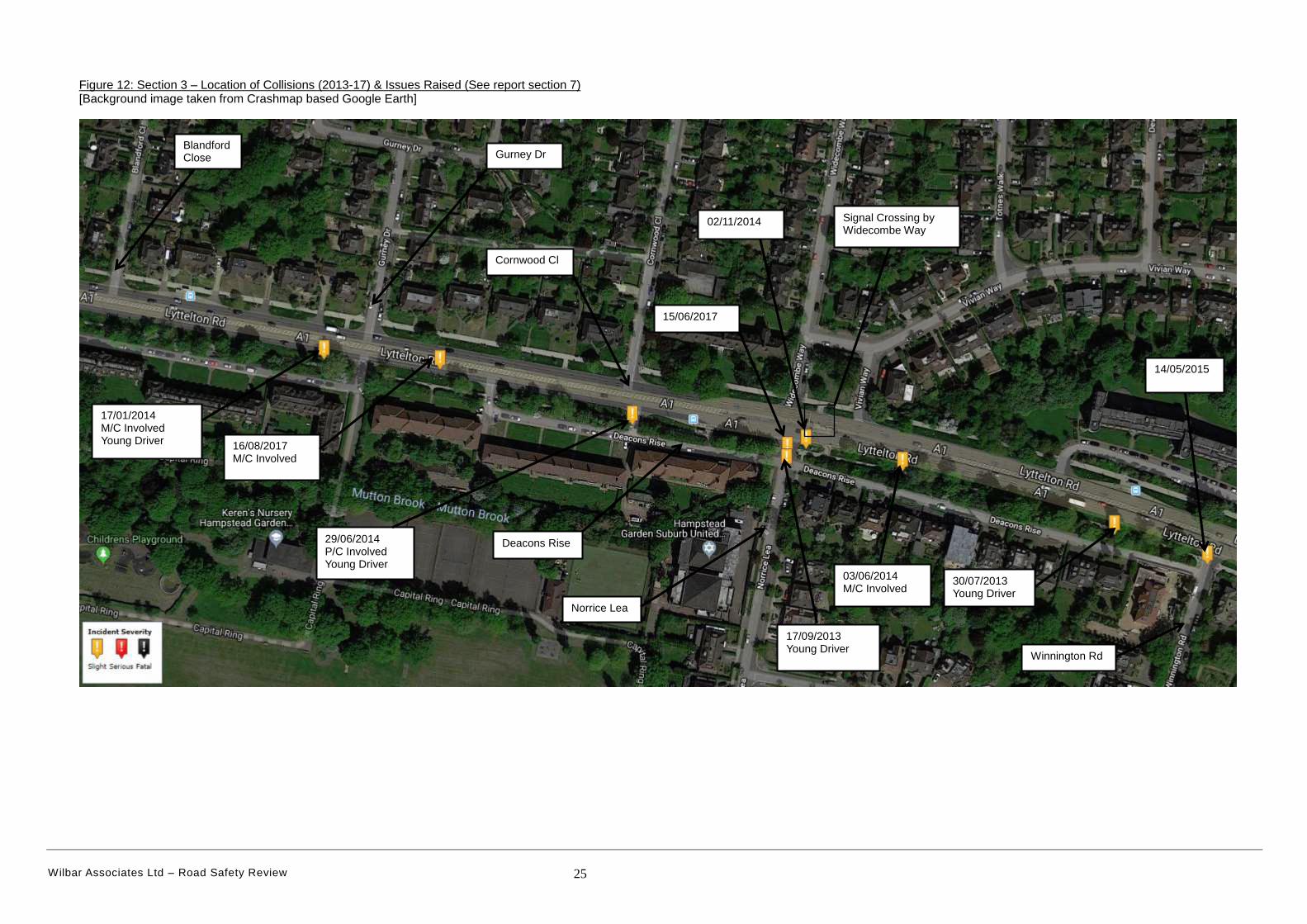
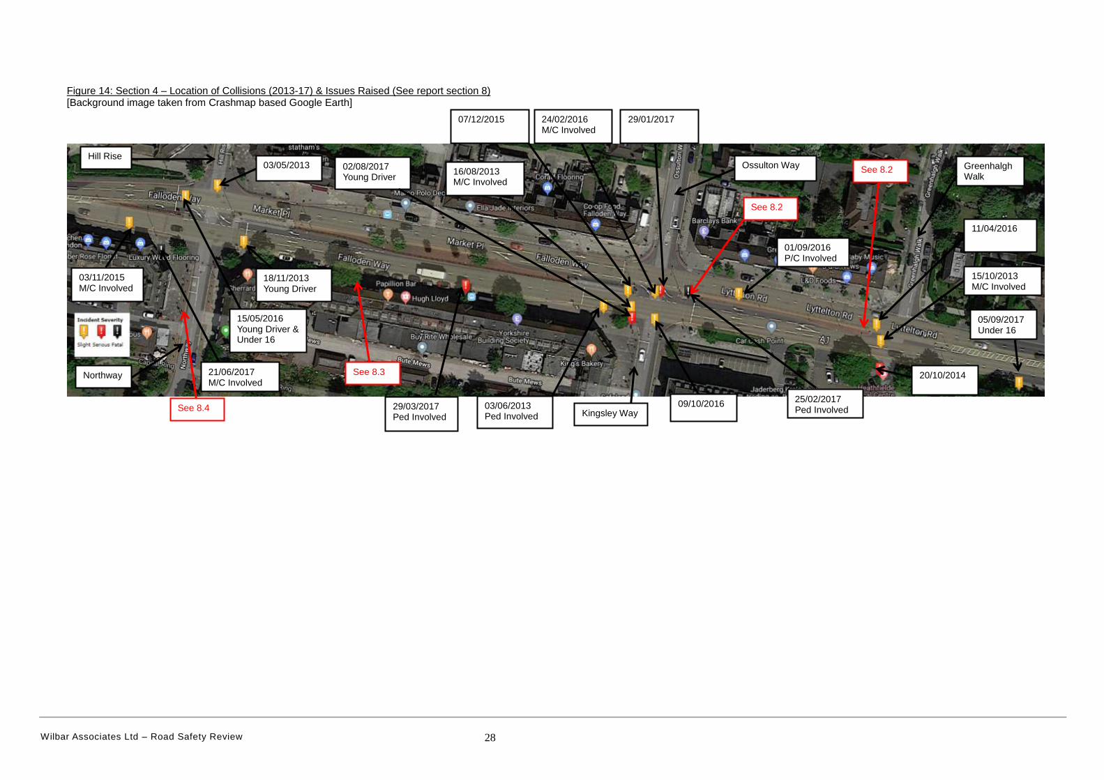
8. SECTION 4
8.1 This section comprises of 2 signal junctions and 2 priority junctions
(Greenhalgh Walk and the service road adjacent to the Medical Centre), two
bus stops and three on-street parking laybys. The frontage is a mixture of
retail, commercial and residential properties. There is a medical centre on
the south side east of Kingsley Way. A local cycle route crosses north-south
at Northway and Hill Rise traffic signals (see Figure 13). The location of
collisions and issues raised are indicated in Figure 14.
Figure 13: A1 Falloden Way near Northway - Local London cycle route 54
[Background image taken from www.london.cyclestreets.net ]
Wilbar Associates Ltd – Road Safety Review 27
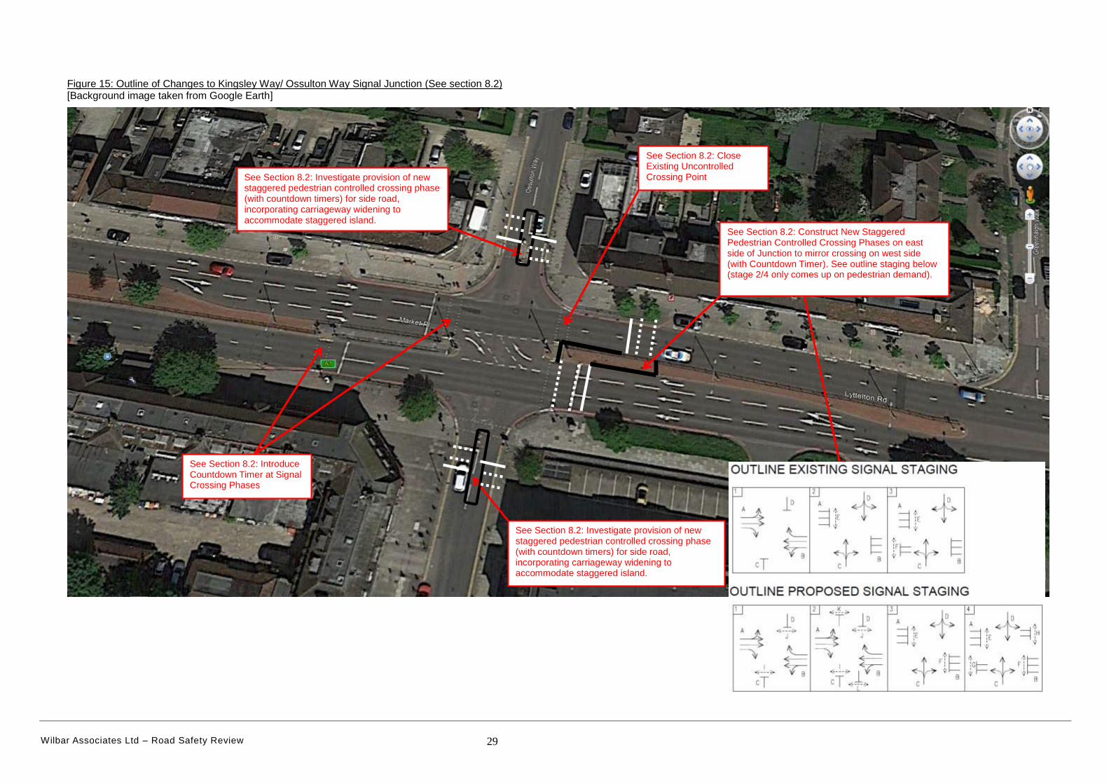
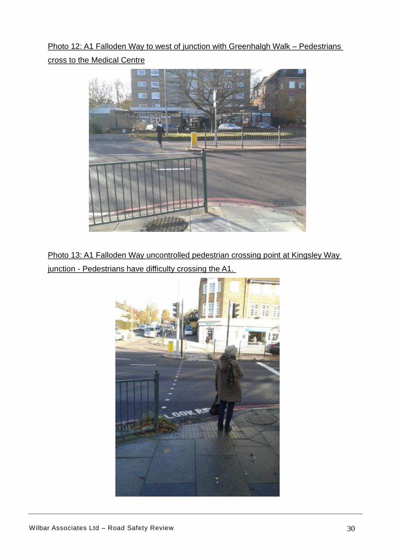
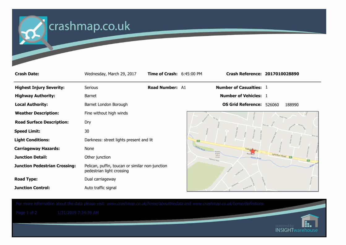
8.2 Issue observed: Poor pedestrian crossing facilities at Kingsley Way Signal
Junction.
Detail: The traffic signal junction at Kingsley Way/ Ossulton Way has been
the subject of a traffic survey and for completeness this is attached in
Appendix 2. The existing junction has a pedestrian signal phase on the west
side of the junction. All the remaining arms have no signal phase crossing
the junction, particularly the east side of the junction. An elderly pedestrian
was observed being escorted across the A1 could not cross within the gaps
created and would not have completed the manoeuvre without a van driver
showing consideration to wait for them to cross. In addition pedestrians were
observed crossing the central reservation by Greenhalgh Walk to get to the
Medical Centre. The collision history involving pedestrians (1 Fatal & 1
Slight) supports the need to review the pedestrian crossing facilities at this
junction.
RECOMMENDATION: Investigate closing the existing uncontrolled crossing
point on the east side of the junction and provide a new staggered signalised
crossing on the east side of the junction. The impact on traffic flows is
understood. The eastbound pedestrian stage can operate as a separate
phase in the same manner and mirror the westbound phase. This is currently
employed at ‘The Bishops Avenue’ signal junction just to the east of this
study area. Countdown signals should also be deployed in the same way as
at ‘The Bishops Avenue’ signals. Phasing across the north and southern
arms should also be investigated and also installed if feasible. See Figure
15.
Wilbar Associates Ltd – Road Safety Review 28
Figure 14: Section 4 – Location of Collisions (2013-17) & Issues Raised (See report section 8) [Background image taken from Crashmap based Google Earth]
See 8.2
See 8.3
Ossulton Way
Kingsley Way
Greenhalgh Walk
15/05/2016 Young Driver & Under 16
Hill Rise
See 8.2
29/03/2017 Ped Involved
09/10/2016
01/09/2016 P/C Involved
02/08/2017 Young Driver
18/11/2013 Young Driver
11/04/2016
15/10/2013 M/C Involved
05/09/2017 Under 16
21/06/2017 M/C Involved
03/11/2015 M/C Involved
03/05/2013
07/12/2015
20/10/2014 Northway
03/06/2013 Ped Involved
24/02/2016 M/C Involved
16/08/2013 M/C Involved
29/01/2017
25/02/2017 Ped Involved See 8.4
Wilbar Associates Ltd – Road Safety Review 29
Figure 15: Outline of Changes to Kingsley Way/ Ossulton Way Signal Junction (See section 8.2) [Background image taken from Google Earth]
See Section 8.2: Introduce Countdown Timer at Signal Crossing Phases
See Section 8.2: Close Existing Uncontrolled Crossing Point
See Section 8.2: Construct New Staggered Pedestrian Controlled Crossing Phases on east side of Junction to mirror crossing on west side (with Countdown Timer). See outline staging below (stage 2/4 only comes up on pedestrian demand).
See Section 8.2: Investigate provision of new staggered pedestrian controlled crossing phase (with countdown timers) for side road, incorporating carriageway widening to accommodate staggered island.
See Section 8.2: Investigate provision of new staggered pedestrian controlled crossing phase (with countdown timers) for side road, incorporating carriageway widening to accommodate staggered island.
Wilbar Associates Ltd – Road Safety Review 30
Photo 12: A1 Falloden Way to west of junction with Greenhalgh Walk – Pedestrians
cross to the Medical Centre
Photo 13: A1 Falloden Way uncontrolled pedestrian crossing point at Kingsley Way
junction - Pedestrians have difficulty crossing the A1.
Wilbar Associates Ltd – Road Safety Review 31
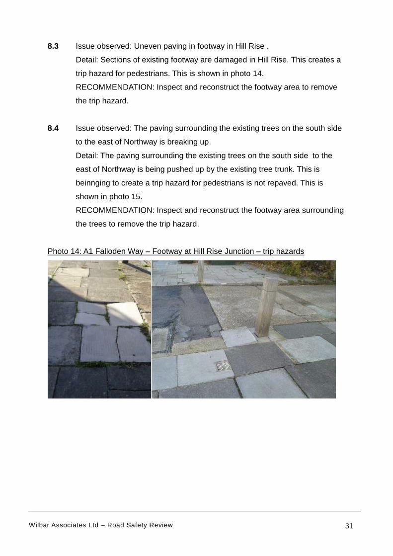
8.3 Issue observed: Uneven paving in footway in Hill Rise .
Detail: Sections of existing footway are damaged in Hill Rise. This creates a
trip hazard for pedestrians. This is shown in photo 14.
RECOMMENDATION: Inspect and reconstruct the footway area to remove
the trip hazard.
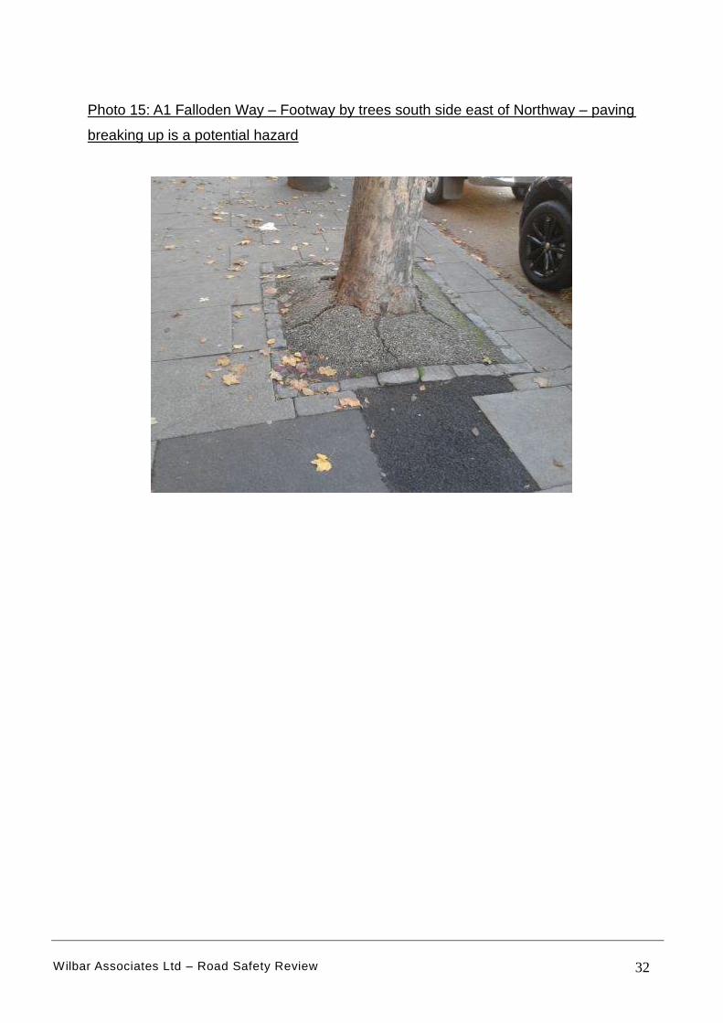
8.4 Issue observed: The paving surrounding the existing trees on the south side
to the east of Northway is breaking up.
Detail: The paving surrounding the existing trees on the south side to the
east of Northway is being pushed up by the existing tree trunk. This is
beinnging to create a trip hazard for pedestrians is not repaved. This is
shown in photo 15.
RECOMMENDATION: Inspect and reconstruct the footway area surrounding
the trees to remove the trip hazard.
Photo 14: A1 Falloden Way – Footway at Hill Rise Junction – trip hazards
Wilbar Associates Ltd – Road Safety Review 32
Photo 15: A1 Falloden Way – Footway by trees south side east of Northway – paving
breaking up is a potential hazard
Wilbar Associates Ltd – Road Safety Review 33
9. SUMMARY
9.1 This report details the results of a road safety review on a 1.8 km section of
the A1 Falloden Way/ Lyttelton Road, Hampstead Gardens in North West
London from east of the North Circular Road to Winnington Road, a street to
the west of the A1000. Overall there have been 98 collisions involving
personal injury recorded by the Police between 2008-17. There have been 3
fatal and 14 serious collisions (17 (KSI) killed or serious injured). 2017
witnessed the highest number of recorded collisions but also the worst in
severity involving 5 KSI.
9.2 For the purposes of this study the route has been broken down into 4 distinct
sections:
Section 1 covers west of the junction of Beaufort Drive to the east of
Brookland Rise junction near the entrance to Northway Gardens;
Section 2 covers west of Westholm to east of Eastholm;
Section 3 covers the eastern part of the route east of Greenhalgh Walk to
east of the junction with Winnington Rd.
Section 4 covers the route between the traffic signal junctions of
Northway and Kingsley Way.
9.3 The review incorporated a site visit which considered the current road safety
collision record but also considered standards for the following criteria:
Visibility;
Layout of junctions;
Non-Motorised User (NMU) Provision [principally pedestrians and
cyclists];
Road Signs and carriageway markings;
Parking areas particularly laybys.
A number of issues have been observed together with a range of
recommendations for sections 1, 2 and 4.
Wilbar Associates Ltd – Road Safety Review 34
9.4 The issues observed and the recommendations for route section 1 are
described in detail in Section 5.0 and summarised as follows:
High traffic flows create difficulties for turning right out of the junctions of
Beaufort Drive, Addison Way and Brookland Rise. The provision (or
reinstatement) of High Friction Surfacing on the approaches to these
junctions should be investigated.
A trip hazard for pedestrians was observed in the footway area near bus
stop east of Addison Way. The reconstruction of the bus shelter and
footway area should be investigated to eliminate the trip hazard but also
widen the footway to facilitate wheelchair and pushchair access.
The end of the cycle route at Brookland Rise and Addison Way is unclear
which may encourage cyclists to continue riding on the footway and
introduce pedestrian/ cyclist conflict on the footway. Review the cycle
track and route signing at Brookland Rise and Addison Way Junctions to
make it clear the best route for cyclists.
9.5 The issues observed and the recommendations for route section 2 are
described in detail in Section 6.0 and summarised as follows:
The visibility on the approach to Westholm junction is poor and is an
influence in the number of collisions (3 in 5 years). Either remove the
trees on the corner (which may be a controversial issue) OR construct a
new traffic island in the central hatching on the eastbound approach to
Westholm housing a speed activated ‘side road ahead’ warning sign.
The effective width of the existing footway on the north side is reduced in
places due to overgrown hedging which has become a hazard. There is a
need to liaise with the Highway Authority/ Frontages to cut back hedging
to maintain effective footway width.
Wilbar Associates Ltd – Road Safety Review 35
9.6 The issues observed and the recommendations for route section 4 are
described in detail in Section 8.0 and summarised as follows:
There is an area of uneven paving observed in Hill Rise. The footway
should be inspected and reconstructed to remove the trip hazard.
The paving surrounding the existing trees on the south side to the east of
Northway is being pushed up by the existing tree trunk and the footway
should be inspected and reconstructed to remove the trip hazard.
9.7 One of the main issues observed is the poor pedestrian crossing facilities at
Kingsley Way Signal Junction outlined in Section 8.2. The existing junction
has a pedestrian signal phase on the west side of the junction. All the
remaining arms have no signal phase crossing the junction, particularly the
east side of the junction. The collision history involving pedestrians (1 Fatal
& 1 Slight) supports the need to review the pedestrian crossing facilities at
this junction. Suggested changes to this junction are described and shown in
Figure 15 and mirror similar staging as at the ‘A1/ The Bishops Avenue’
signals east of this route.
Wilbar Associates Ltd – Road Safety Review 36
Appendix 1: Information on collisions involving ‘Killed or Seriously Injured’ (KSI) between 2013-17:
Crash Date:
Highest Injury Severity:
Highway Authority:
Local Authority:
Weather Description:
Road Surface Description:
Speed Limit:
Light Conditions:
Carriageway Hazards:
Junction Detail:
Junction Pedestrian Crossing:
Road Type:
Junction Control: Give way or uncontrolled
Single carriageway
Central refuge - no other controls
Slip road
None
Daylight: regardless of presence of streetlights
30
Wet or Damp
Fine without high winds
Barnet
Barnet
Serious
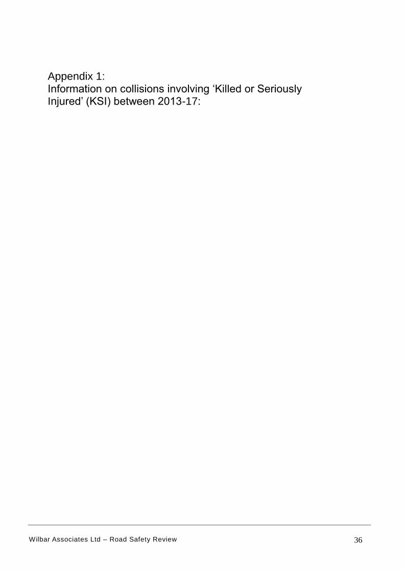
Thursday, October 31, 2013 Time of Crash:
Road Number: A1
12:15:00 PM Crash Reference:
Number of Casualties:
Number of Vehicles:
OS Grid Reference: 525330 189140
2
2
201301SX20903
Page 1 of 2 1/21/2019 7:42:15 AM
For more information about the data please visit: www.crashmap.co.uk/home/aboutthedata and www.crashmap.co.uk/home/definitions

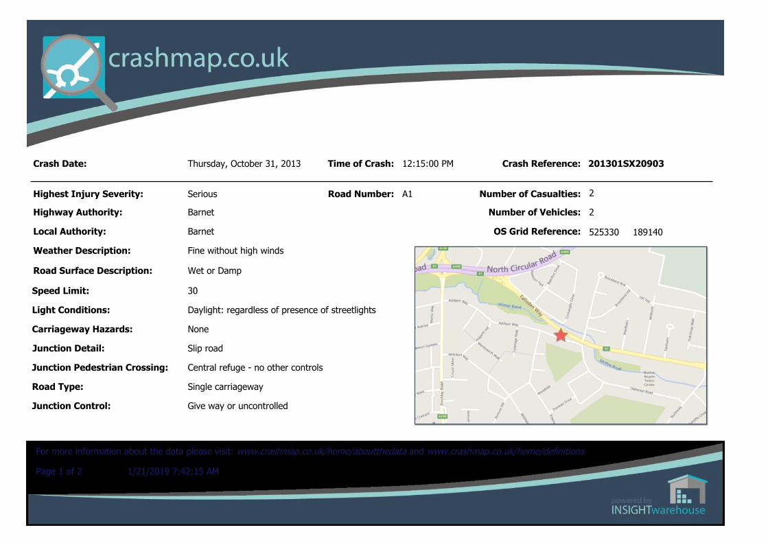
CasualtiesVehicle Ref Casualty Ref Injury Severity Casualty Class Gender Age Band Pedestrian Location Pedestrian Movement
1 1 Slight Driver or rider Male 46 - 55 Unknown or other Unknown or other
2 2 Serious Driver or rider Male 16 - 20 Unknown or other Unknown or other
Vehicles involvedVehicle Ref
Vehicle Type Vehicle Age
Driver Gender
Driver Age Band
Vehicle Maneouvre First Point of Impact
Journey Purpose
Hit Object - On Carriageway
Hit Object - Off Carriageway
2 Car (excluding private hire)
8 Male 16 - 20 Vehicle proceeding normally along the carriageway, not on a bend
Offside Other Bollard/Refuge None
1 Car (excluding private hire)
6 Male 46 - 55 Vehicle proceeding normally along the carriageway, not on a bend
Offside Other None None
Page 2 of 2 1/21/2019 7:42:15 AM
For more information about the data please visit: www.crashmap.co.uk/home/aboutthedata and www.crashmap.co.uk/home/definitions

Crash Date:
Highest Injury Severity:
Highway Authority:
Local Authority:
Weather Description:
Road Surface Description:
Speed Limit:
Light Conditions:
Carriageway Hazards:
Junction Detail:
Junction Pedestrian Crossing:
Road Type:
Junction Control: Give way or uncontrolled
Dual carriageway
No physical crossing facility within 50 metres
Using private drive or entrance
None
Daylight: regardless of presence of streetlights
40
Dry
Fine without high winds
Barnet
Barnet
Serious
Monday, October 20, 2014 Time of Crash:
Road Number: A1
1:48:00 PM Crash Reference:
Number of Casualties:
Number of Vehicles:
OS Grid Reference: 526210 188970
1
2
201401SX20887
Page 1 of 2 1/21/2019 7:39:32 AM
For more information about the data please visit: www.crashmap.co.uk/home/aboutthedata and www.crashmap.co.uk/home/definitions
CasualtiesVehicle Ref Casualty Ref Injury Severity Casualty Class Gender Age Band Pedestrian Location Pedestrian Movement
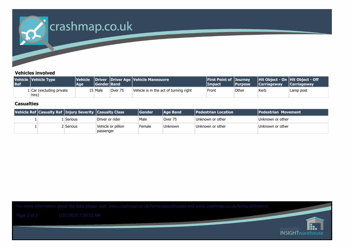
1 1 Serious Driver or rider Male Over 75 Unknown or other Unknown or other
1 2 Serious Vehicle or pillion passenger
Female Unknown Unknown or other Unknown or other
Vehicles involvedVehicle Ref
Vehicle Type Vehicle Age
Driver Gender
Driver Age Band
Vehicle Maneouvre First Point of Impact
Journey Purpose
Hit Object - On Carriageway
Hit Object - Off Carriageway
1 Car (excluding private hire)
15 Male Over 75 Vehicle is in the act of turning right Front Other Kerb Lamp post
Page 2 of 2 1/21/2019 7:39:32 AM
For more information about the data please visit: www.crashmap.co.uk/home/aboutthedata and www.crashmap.co.uk/home/definitions

Crash Date:
Highest Injury Severity:
Highway Authority:
Local Authority:
Weather Description:
Road Surface Description:
Speed Limit:
Light Conditions:
Carriageway Hazards:
Junction Detail:
Junction Pedestrian Crossing:
Road Type:
Junction Control: Give way or uncontrolled
Single carriageway
No physical crossing facility within 50 metres
Crossroads
None
Darkness: street lights present and lit
30
Wet or Damp
Raining without high winds
Barnet
Barnet
Serious
Friday, February 13, 2015 Time of Crash:
Road Number: U0
6:30:00 PM Crash Reference:
Number of Casualties:
Number of Vehicles:
OS Grid Reference: 525200 189280
2
1
201501SX20145
Page 1 of 2 1/21/2019 7:42:43 AM
For more information about the data please visit: www.crashmap.co.uk/home/aboutthedata and www.crashmap.co.uk/home/definitions
CasualtiesVehicle Ref Casualty Ref Injury Severity Casualty Class Gender Age Band Pedestrian Location Pedestrian Movement
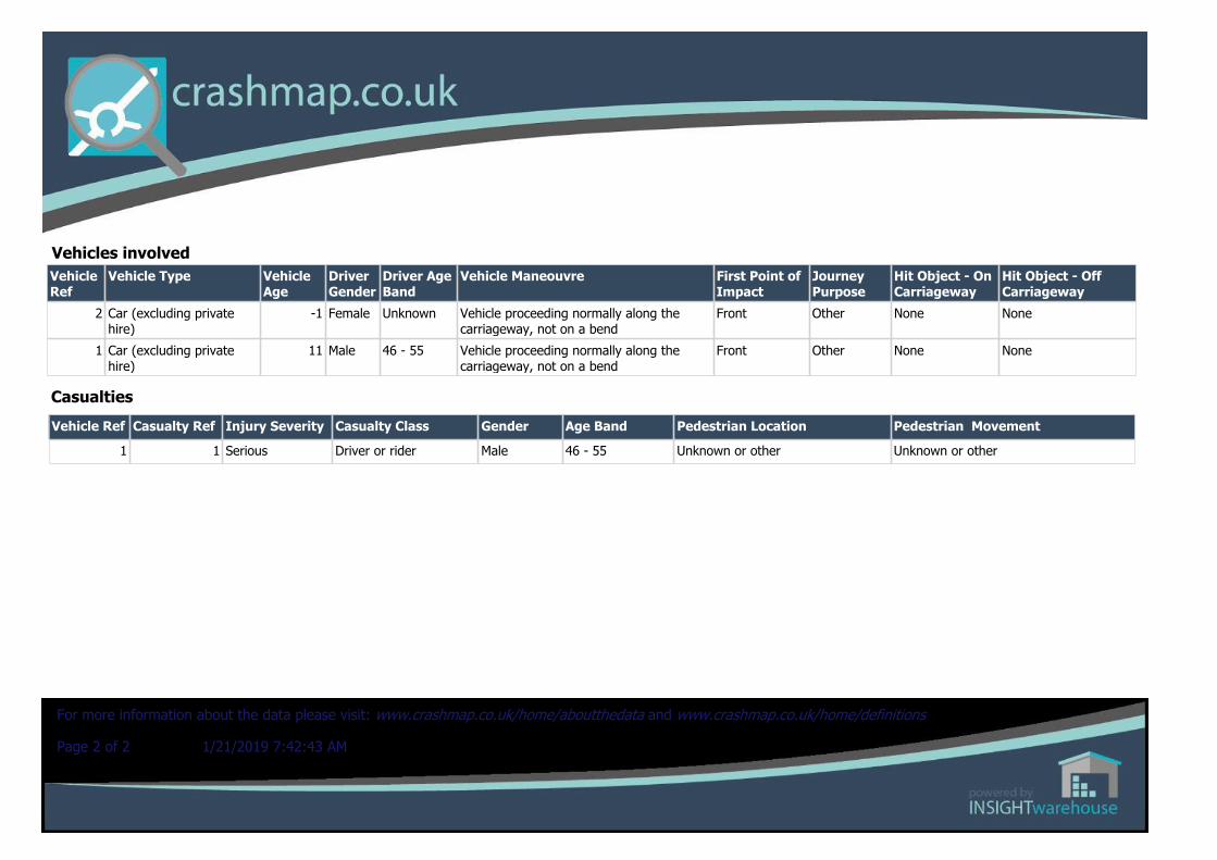
1 1 Serious Driver or rider Male 46 - 55 Unknown or other Unknown or other
Vehicles involvedVehicle Ref
Vehicle Type Vehicle Age
Driver Gender
Driver Age Band
Vehicle Maneouvre First Point of Impact
Journey Purpose
Hit Object - On Carriageway
Hit Object - Off Carriageway
2 Car (excluding private hire)
-1 Female Unknown Vehicle proceeding normally along the carriageway, not on a bend
Front Other None None
1 Car (excluding private hire)
11 Male 46 - 55 Vehicle proceeding normally along the carriageway, not on a bend
Front Other None None
Page 2 of 2 1/21/2019 7:42:43 AM
For more information about the data please visit: www.crashmap.co.uk/home/aboutthedata and www.crashmap.co.uk/home/definitions
Crash Date:
Highest Injury Severity:
Highway Authority:
Local Authority:
Weather Description:
Road Surface Description:
Speed Limit:
Light Conditions:
Carriageway Hazards:
Junction Detail:
Junction Pedestrian Crossing:
Road Type:
Junction Control: Give way or uncontrolled
Single carriageway
Footbridge or subway
T or staggered junction
None
Daylight: regardless of presence of streetlights
30
Wet or Damp
Raining without high winds
Barnet
Barnet
Fatal
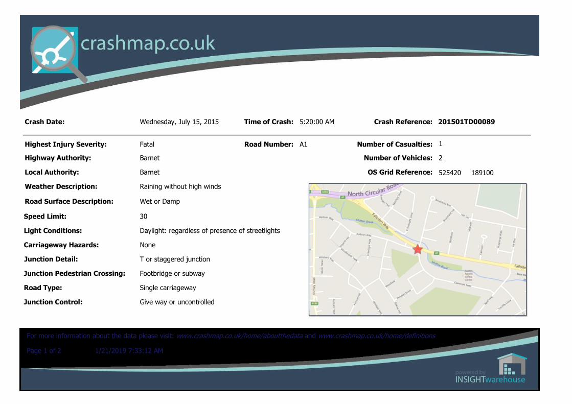
Wednesday, July 15, 2015 Time of Crash:
Road Number: A1
5:20:00 AM Crash Reference:
Number of Casualties:
Number of Vehicles:
OS Grid Reference: 525420 189100
2
1
201501TD00089
Page 1 of 2 1/21/2019 7:33:12 AM
For more information about the data please visit: www.crashmap.co.uk/home/aboutthedata and www.crashmap.co.uk/home/definitions

CasualtiesVehicle Ref Casualty Ref Injury Severity Casualty Class Gender Age Band Pedestrian Location Pedestrian Movement
1 1 Fatal Driver or rider Male 36 - 45 Unknown or other Unknown or other
Vehicles involvedVehicle Ref
Vehicle Type Vehicle Age
Driver Gender
Driver Age Band
Vehicle Maneouvre First Point of Impact
Journey Purpose
Hit Object - On Carriageway
Hit Object - Off Carriageway
2 Car (excluding private hire)
7 Male Unknown Vehicle is parked in the carriageway Nearside Other None None
1 Car (excluding private hire)
25 Male 36 - 45 Vehicle proceeding normally along the carriageway, not on a bend
Nearside Other Kerb Lamp post
Page 2 of 2 1/21/2019 7:33:12 AM
For more information about the data please visit: www.crashmap.co.uk/home/aboutthedata and www.crashmap.co.uk/home/definitions
Crash Date:
Highest Injury Severity:
Highway Authority:
Local Authority:
Weather Description:
Road Surface Description:
Speed Limit:
Light Conditions:
Carriageway Hazards:
Junction Detail:
Junction Pedestrian Crossing:
Road Type:
Junction Control: Auto traffic signal
Dual carriageway
Central refuge - no other controls
Crossroads
None
Darkness: street lights present and lit
40
Wet or Damp
Fine without high winds
Barnet London Borough
Barnet
Serious
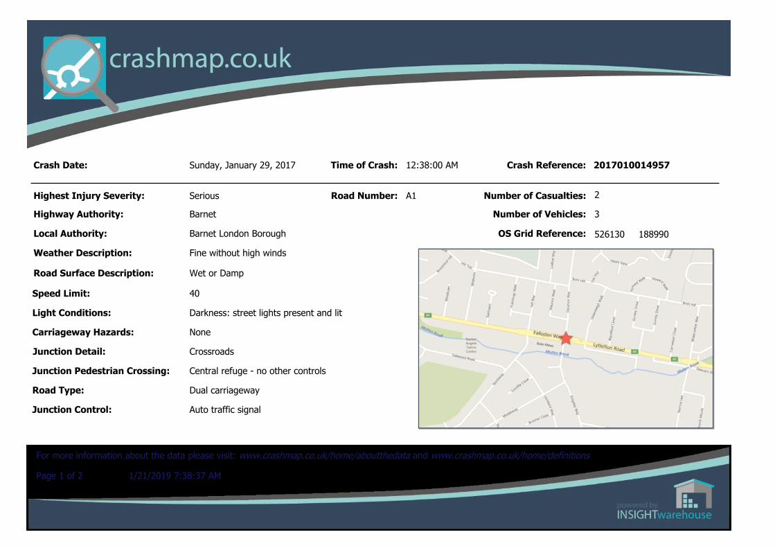
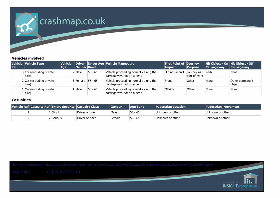
Sunday, January 29, 2017 Time of Crash:
Road Number: A1
12:38:00 AM Crash Reference:
Number of Casualties:
Number of Vehicles:
OS Grid Reference: 526130 188990
3
2
2017010014957
Page 1 of 2 1/21/2019 7:38:37 AM
For more information about the data please visit: www.crashmap.co.uk/home/aboutthedata and www.crashmap.co.uk/home/definitions
CasualtiesVehicle Ref Casualty Ref Injury Severity Casualty Class Gender Age Band Pedestrian Location Pedestrian Movement
1 1 Slight Driver or rider Male 56 - 65 Unknown or other Unknown or other
2 2 Serious Driver or rider Female 56 - 65 Unknown or other Unknown or other
Vehicles involvedVehicle Ref
Vehicle Type Vehicle Age
Driver Gender
Driver Age Band
Vehicle Maneouvre First Point of Impact
Journey Purpose
Hit Object - On Carriageway
Hit Object - Off Carriageway
3 Car (excluding private hire)
2 Male 56 - 65 Vehicle proceeding normally along the carriageway, not on a bend
Did not impact Journey as part of work
Kerb None
2 Car (excluding private hire)
3 Female 56 - 65 Vehicle proceeding normally along the carriageway, not on a bend
Front Other None Other permanent object
1 Car (excluding private hire)
1 Male 56 - 65 Vehicle proceeding normally along the carriageway, not on a bend
Offside Other None None
Page 2 of 2 1/21/2019 7:38:37 AM
For more information about the data please visit: www.crashmap.co.uk/home/aboutthedata and www.crashmap.co.uk/home/definitions
Crash Date:
Highest Injury Severity:
Highway Authority:
Local Authority:
Weather Description:
Road Surface Description:
Speed Limit:
Light Conditions:
Carriageway Hazards:
Junction Detail:
Junction Pedestrian Crossing:
Road Type:
Junction Control: Auto traffic signal
Dual carriageway
Pedestrian phase at traffic signal junction
Crossroads
None
Daylight: regardless of presence of streetlights
30
Dry
Fine without high winds
Barnet London Borough
Barnet
Fatal
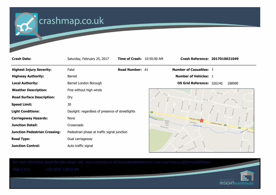
Saturday, February 25, 2017 Time of Crash:
Road Number: A1
10:50:00 AM Crash Reference:
Number of Casualties:
Number of Vehicles:
OS Grid Reference: 526140 188990
1
1
2017010021049
Page 1 of 2 1/21/2019 7:30:53 AM
For more information about the data please visit: www.crashmap.co.uk/home/aboutthedata and www.crashmap.co.uk/home/definitions
CasualtiesVehicle Ref Casualty Ref Injury Severity Casualty Class Gender Age Band Pedestrian Location Pedestrian Movement
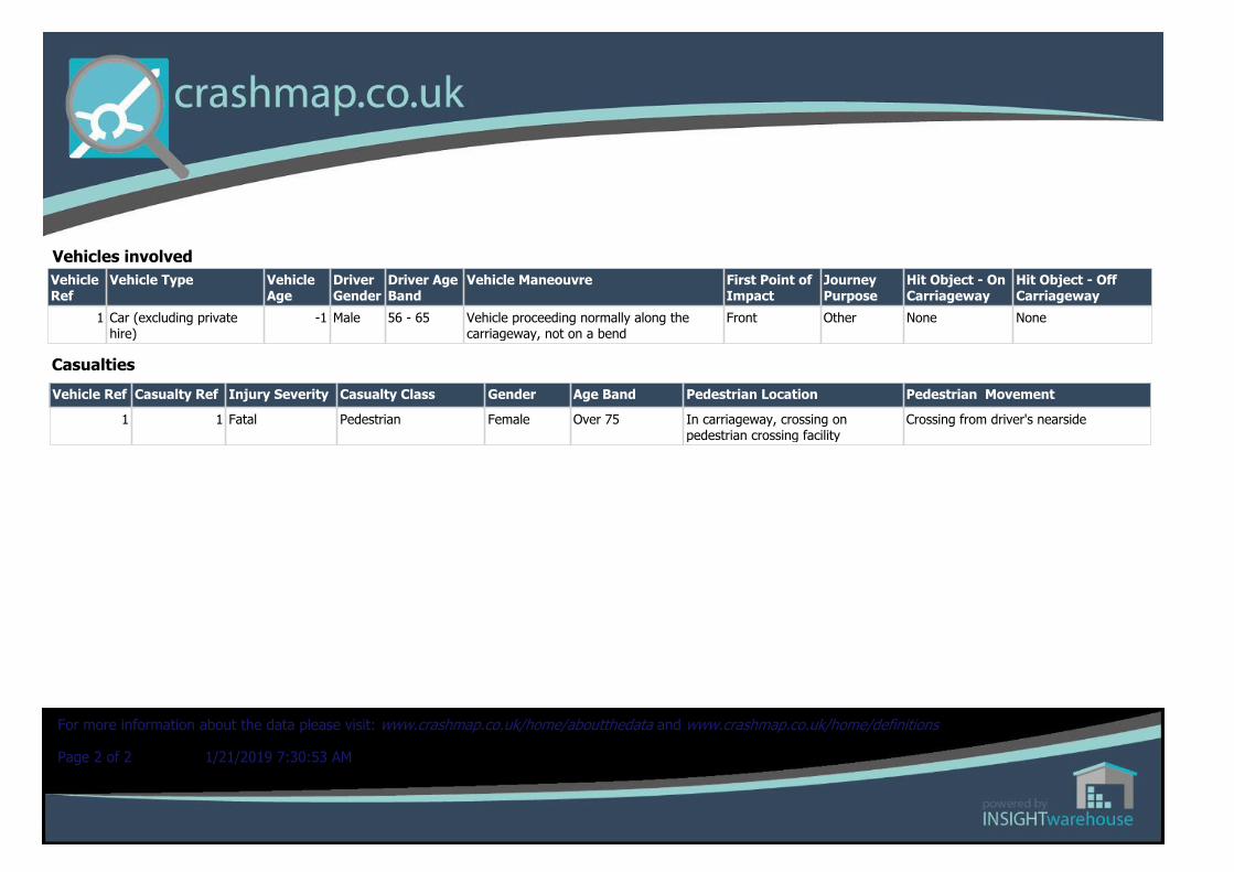
1 1 Fatal Pedestrian Female Over 75 In carriageway, crossing on pedestrian crossing facility
Crossing from driver's nearside
Vehicles involvedVehicle Ref
Vehicle Type Vehicle Age
Driver Gender
Driver Age Band
Vehicle Maneouvre First Point of Impact
Journey Purpose
Hit Object - On Carriageway
Hit Object - Off Carriageway
1 Car (excluding private hire)
-1 Male 56 - 65 Vehicle proceeding normally along the carriageway, not on a bend
Front Other None None
Page 2 of 2 1/21/2019 7:30:53 AM
For more information about the data please visit: www.crashmap.co.uk/home/aboutthedata and www.crashmap.co.uk/home/definitions
Crash Date:
Highest Injury Severity:
Highway Authority:
Local Authority:
Weather Description:
Road Surface Description:
Speed Limit:
Light Conditions:
Carriageway Hazards:
Junction Detail:
Junction Pedestrian Crossing:
Road Type:
Junction Control: Auto traffic signal
Dual carriageway
Pelican, puffin, toucan or similar non-junction pedestrian light crossing
Other junction
None
Darkness: street lights present and lit
30
Dry
Fine without high winds
Barnet London Borough
Barnet
Serious
Wednesday, March 29, 2017 Time of Crash:
Road Number: A1
6:45:00 PM Crash Reference:
Number of Casualties:
Number of Vehicles:
OS Grid Reference: 526060 188990
1
1
2017010028890
Page 1 of 2 1/21/2019 7:34:39 AM
For more information about the data please visit: www.crashmap.co.uk/home/aboutthedata and www.crashmap.co.uk/home/definitions
CasualtiesVehicle Ref Casualty Ref Injury Severity Casualty Class Gender Age Band Pedestrian Location Pedestrian Movement
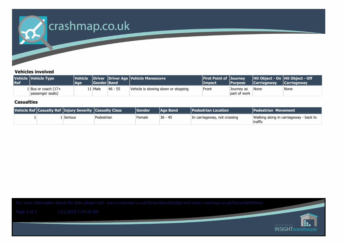
1 1 Serious Pedestrian Female 36 - 45 In carriageway, not crossing Walking along in carriageway - back to traffic
Vehicles involvedVehicle Ref
Vehicle Type Vehicle Age
Driver Gender
Driver Age Band
Vehicle Maneouvre First Point of Impact
Journey Purpose
Hit Object - On Carriageway
Hit Object - Off Carriageway
1 Bus or coach (17+ passenger seats)
11 Male 46 - 55 Vehicle is slowing down or stopping Front Journey as part of work
None None
Page 2 of 2 1/21/2019 7:34:39 AM
For more information about the data please visit: www.crashmap.co.uk/home/aboutthedata and www.crashmap.co.uk/home/definitions
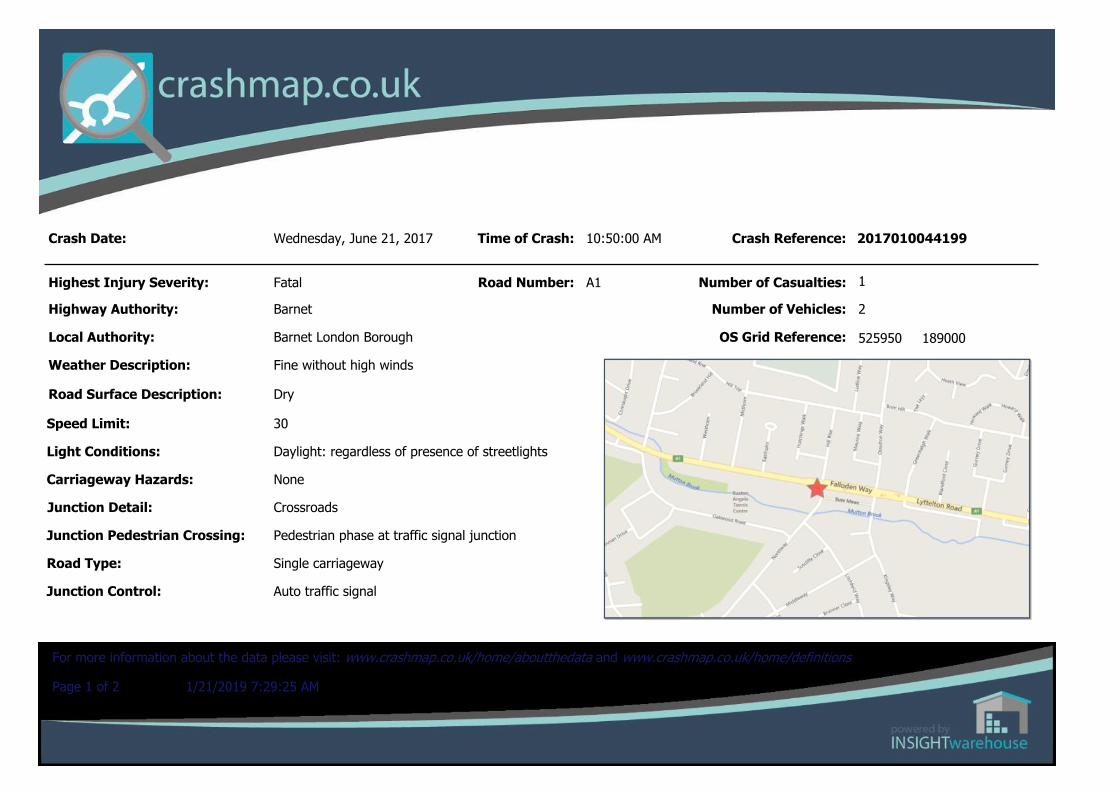
Crash Date:
Highest Injury Severity:
Highway Authority:
Local Authority:
Weather Description:
Road Surface Description:
Speed Limit:
Light Conditions:
Carriageway Hazards:
Junction Detail:
Junction Pedestrian Crossing:
Road Type:
Junction Control: Auto traffic signal
Single carriageway
Pedestrian phase at traffic signal junction
Crossroads
None
Daylight: regardless of presence of streetlights
30
Dry
Fine without high winds
Barnet London Borough
Barnet
Fatal
Wednesday, June 21, 2017 Time of Crash:
Road Number: A1
10:50:00 AM Crash Reference:
Number of Casualties:
Number of Vehicles:
OS Grid Reference: 525950 189000
2
1
2017010044199
Page 1 of 2 1/21/2019 7:29:25 AM
For more information about the data please visit: www.crashmap.co.uk/home/aboutthedata and www.crashmap.co.uk/home/definitions
CasualtiesVehicle Ref Casualty Ref Injury Severity Casualty Class Gender Age Band Pedestrian Location Pedestrian Movement
1 1 Fatal Driver or rider Male 26 - 35 Unknown or other Unknown or other
Vehicles involvedVehicle Ref
Vehicle Type Vehicle Age
Driver Gender
Driver Age Band
Vehicle Maneouvre First Point of Impact
Journey Purpose
Hit Object - On Carriageway
Hit Object - Off Carriageway
2 Car (excluding private hire)
10 Female 46 - 55 Vehicle is in the act of turning right Offside Other None None
1 Motorcycle over 500cc 17 Male 26 - 35 Vehicle proceeding normally along the carriageway, not on a bend
Front Other None None
Page 2 of 2 1/21/2019 7:29:25 AM
For more information about the data please visit: www.crashmap.co.uk/home/aboutthedata and www.crashmap.co.uk/home/definitions
Crash Date:
Highest Injury Severity:
Highway Authority:
Local Authority:
Weather Description:
Road Surface Description:
Speed Limit:
Light Conditions:
Carriageway Hazards:
Junction Detail:
Junction Pedestrian Crossing:
Road Type:
Junction Control: Auto traffic signal
Dual carriageway
Pedestrian phase at traffic signal junction
Multiple junction
None
Darkness: street lights present and lit
40
Wet or Damp
Raining with high winds
Barnet London Borough
Barnet
Serious
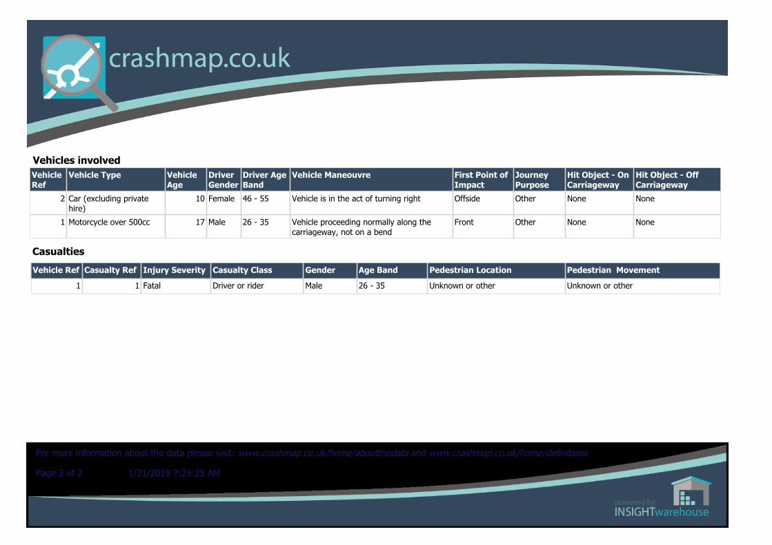
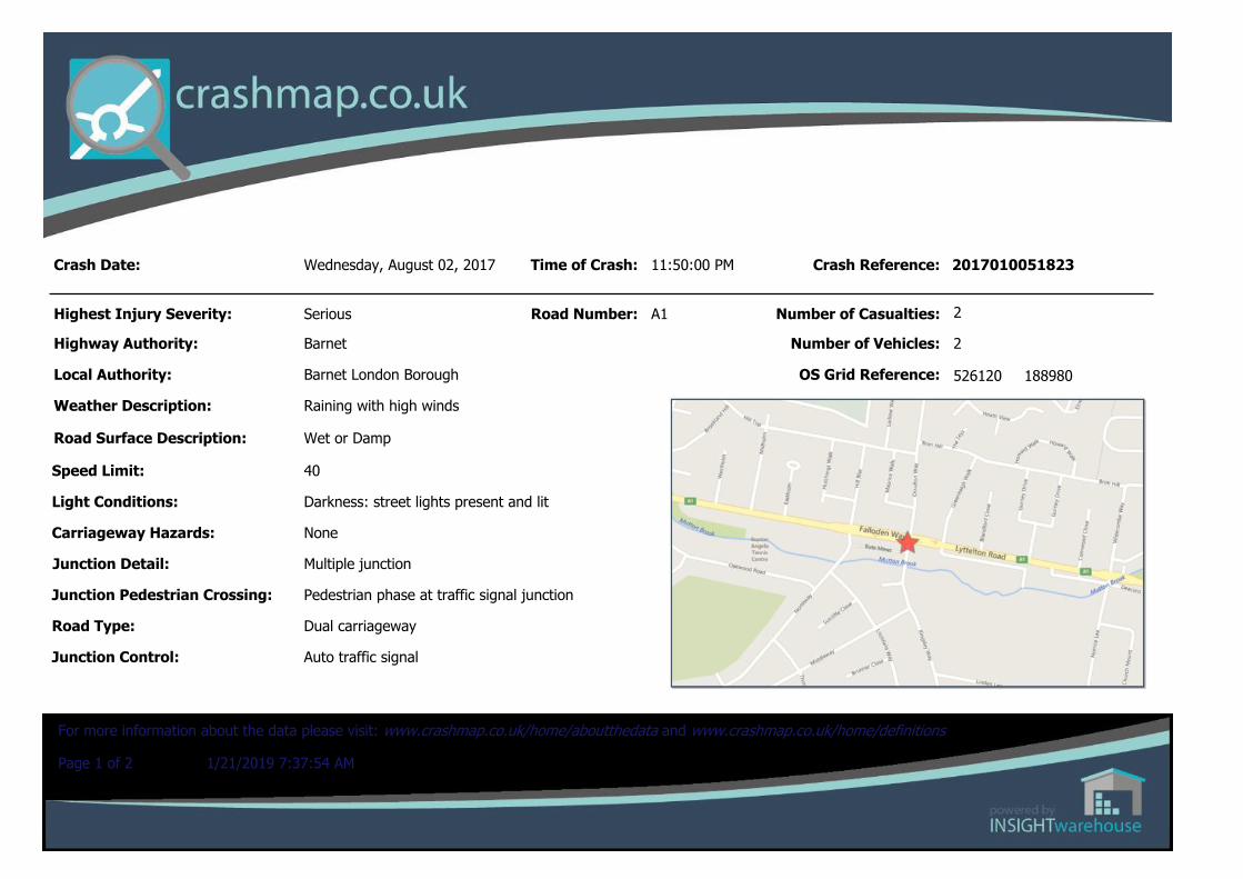
Wednesday, August 02, 2017 Time of Crash:
Road Number: A1
11:50:00 PM Crash Reference:
Number of Casualties:
Number of Vehicles:
OS Grid Reference: 526120 188980
2
2
2017010051823
Page 1 of 2 1/21/2019 7:37:54 AM
For more information about the data please visit: www.crashmap.co.uk/home/aboutthedata and www.crashmap.co.uk/home/definitions

CasualtiesVehicle Ref Casualty Ref Injury Severity Casualty Class Gender Age Band Pedestrian Location Pedestrian Movement
1 1 Serious Driver or rider Male 36 - 45 Unknown or other Unknown or other
2 2 Serious Driver or rider Male 21 - 25 Unknown or other Unknown or other
Vehicles involvedVehicle Ref
Vehicle Type Vehicle Age
Driver Gender
Driver Age Band
Vehicle Maneouvre First Point of Impact
Journey Purpose
Hit Object - On Carriageway
Hit Object - Off Carriageway
2 Car (excluding private hire)
17 Male 21 - 25 Vehicle is in the act of turning right Nearside Other None Central crash barrier
1 Car (excluding private hire)
12 Male 36 - 45 Vehicle proceeding normally along the carriageway, not on a bend
Front Other None None
Page 2 of 2 1/21/2019 7:37:54 AM
For more information about the data please visit: www.crashmap.co.uk/home/aboutthedata and www.crashmap.co.uk/home/definitions
Wilbar Associates Ltd – Road Safety Review 37
Appendix 2: TfL A1 Falloden Way / Ossulton Way Summary Note on Junction:
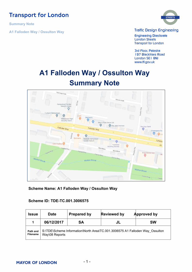
- 1 -
Summary Note
A1 Falloden Way / Ossulton Way Traffic Design Engineering Engineering Directorate London Streets Transport for London
3rd Floor, Palestra 197 Blackfriars Road London SE1 8NJ www.tfl.gov.uk
Issue Date Prepared by Reviewed by Approved by
1 06/12/2017 SA JL SW
Path and Filename
S:\TDE\Scheme Information\North Area\TC.001.3006575 A1 Falloden Way_Ossulton Way\08 Reports
Scheme Name: A1 Falloden Way / Ossulton Way
Scheme ID: TDE-TC.001.3006575
A1 Falloden Way / Ossulton Way Summary Note
- 2 -
Summary Note A1 Falloden Way / Ossulton Way
Transport for London has commissioned a number of detailed surveys at this location.
Speeds
Speed surveys (Appendix A) were carried out over 7 consecutive days in 3 locations, between Midholm and Gurney Drive. The average speed recorded at all 3 locations was 28.7mph. The 85th%ile speeds between Hill Rise and Ossulton Way did not exceed 34.1mph. The national set enforcement thresholds for speed enforcement are set at Speed Limit + 10% + 2mph, so for a 30mph limit, that is 30 + 3 + 2, so 35mph. As the 85%ile here is not above the 35 NPCC guideline or 40mph “threshold” police would generally not enforce.
Right Turners
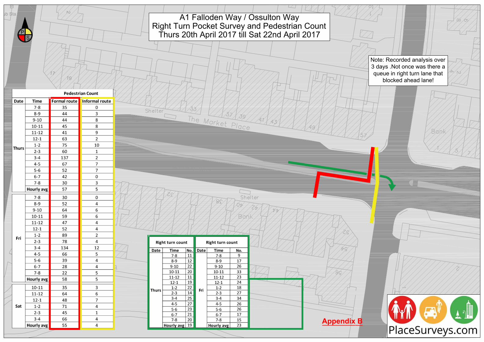
It was assumed that traffic was tailing back along Falloden Way thus extending past the existing right turn pocket which was in turn blocking the ahead movement of traffic. Following a 3 day survey (Appendix B), quantifying right turns from Falloden way to Kingsley Way the hourly average did not exceed 23 vehicles. Not one incident was recorded where right turners were blocking ahead flowing traffic.
Ped Surveys
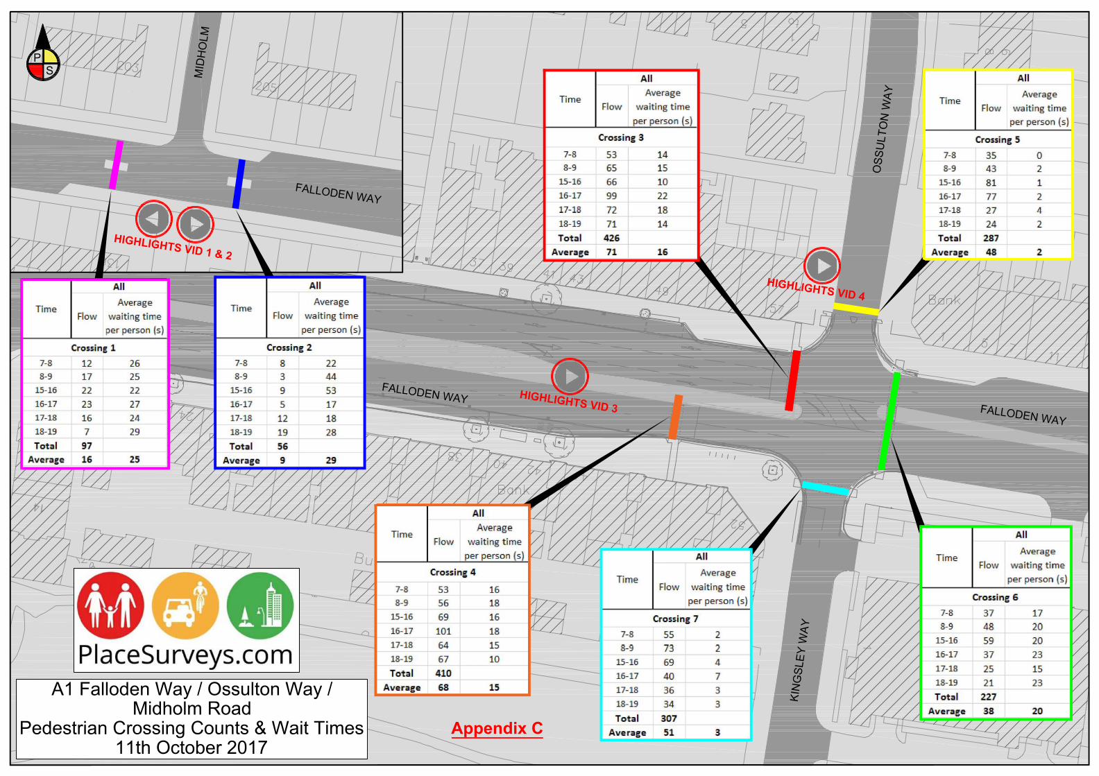
Pedestrian crossing counts and Wait times (Appendix C) Pedestrians were not waiting an excessive amount of time at any of the crossings, all waiting times were under 30seconds. This shows that the facilities are good for pedestrians particularly considering they are crossing a major road
Appendix
Please refer to appendix A, B and C for further clarification.
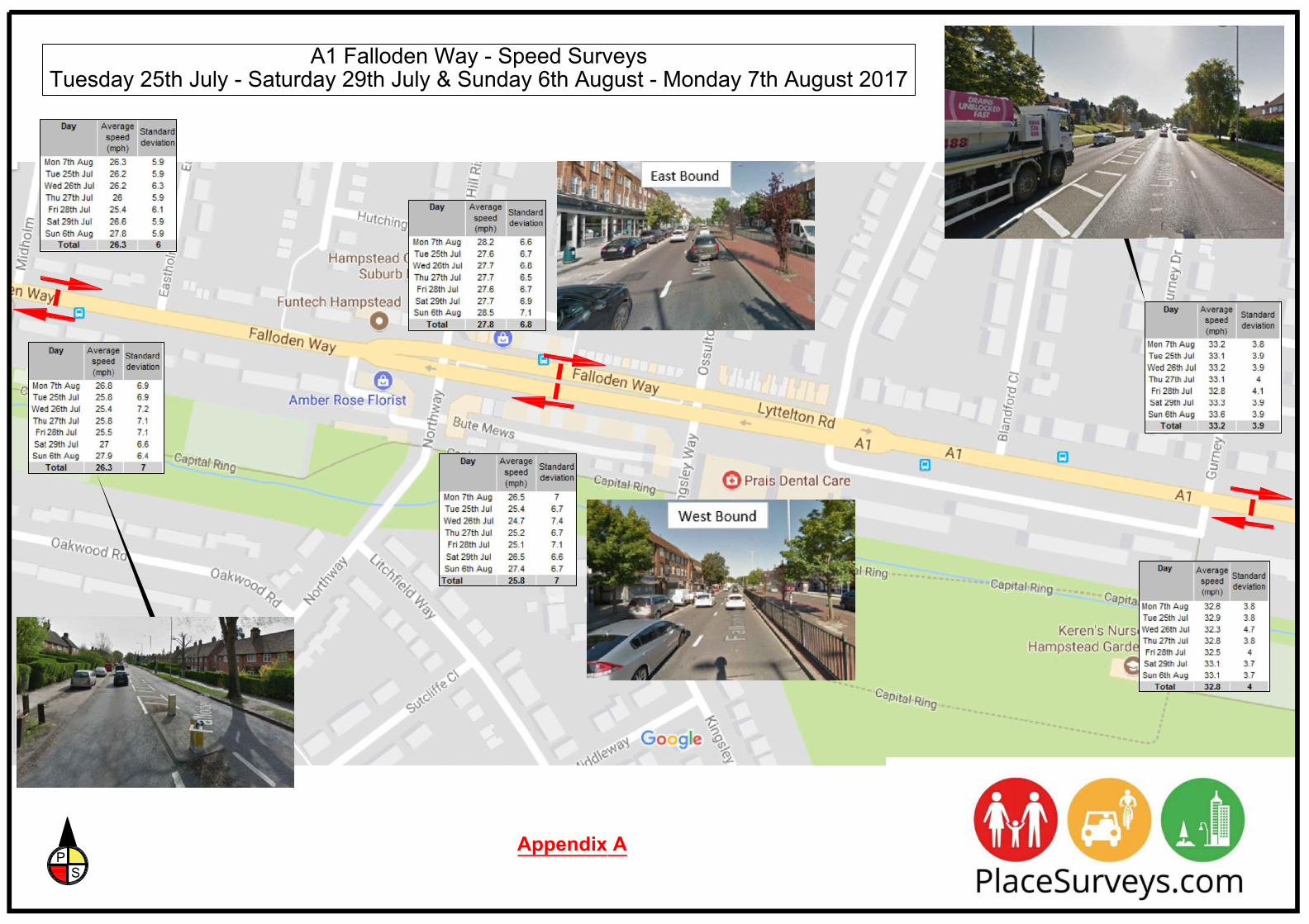
A1 Falloden Way - Speed SurveysTuesday 25th July - Saturday 29th July & Sunday 6th August - Monday 7th August 2017
PS
Appendix A
2
19
Sub StaEl
17
2218
14
A1 Falloden Way / Ossulton WayRight Turn Pocket Survey and Pedestrian Count
Thurs 20th April 2017 till Sat 22nd April 2017PS
Note: Recorded analysis over3 days .Not once was there aqueue in right turn lane that
blocked ahead lane!
Appendix B
2218
14
DISABLED
LOOK LEFTLOOK RIGHT
LOOK RIGHT
LOOK LEFT
LOADING ONLY
BUSSTOP
LOOK LEFT
LOOK RIGHT
LOOK RIGHT
LOOK LEFT
LOOK RIGH
T
LOOK RIGHT
BUS STOP
A1 Falloden Way / Ossulton Way /Midholm Road
Pedestrian Crossing Counts & Wait Times11th October 2017
PS
OSS
ULT
ON
WAY
KIN
GSL
EY W
AY
FALLODEN WAY
MID
HO
LMFALLODEN WAY
FALLODEN WAY
HIGHLIGHTS VID 1 & 2
HIGHLIGHTS VID 3
HIGHLIGHTS VID 4
Appendix C