Embed Size (px)
Citation preview

A useful FREE 3D Globe
You havE two wishEs lEFt PAGE 6
In thIs IssuE
nEW PRODuCts, nEW CAPABILItIEs
PAGE 8
2D AnD 3D thAt WILL MAKE YOu sWOOn
PAGE 12
PARALLEL COMPutInG sPEEDs uP YOuR stK
CALCuLAtIOns PAGE 14
stK In AnY FORM PAGE 19
STK 10 SPECIAL EDITION
Fall 2012 nEwslEttER
10AT A G L A N C E
sYsTeMs Tool KIT 10sYsTeMs Tool KIT 10
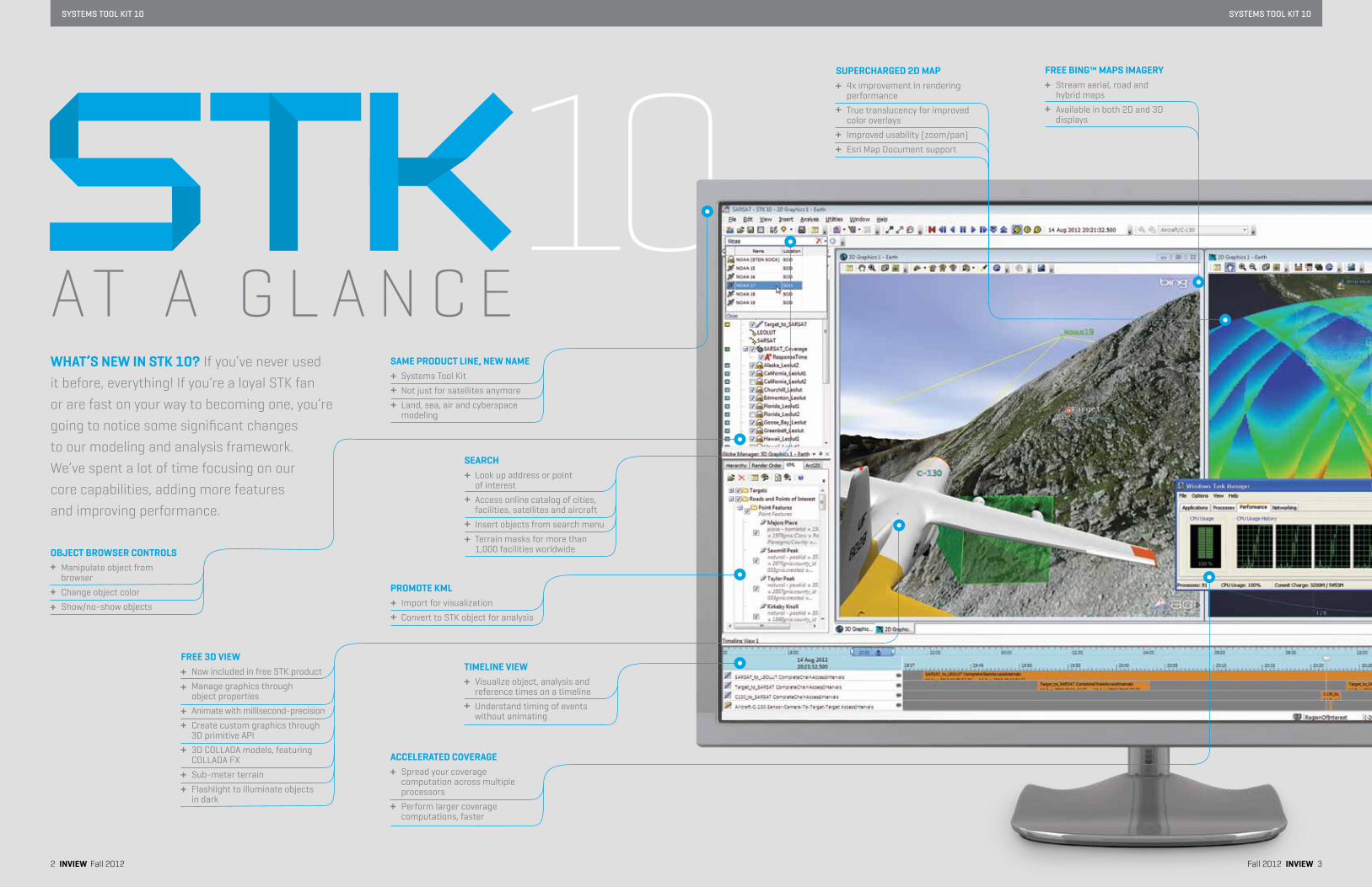
what’s nEw in stK 10? If you’ve never used it before, everything! If you’re a loyal STK fan or are fast on your way to becoming one, you’re going to notice some significant changes to our modeling and analysis framework. We’ve spent a lot of time focusing on our core capabilities, adding more features and improving performance.
saME PRoDuCt linE, nEw naME systems tool Kit
not just for satellites anymore
Land, sea, air and cyberspace modeling
aCCElERatED CovERaGE spread your coverage computation across multiple processors
Perform larger coverage computations, faster
Fall 2012 inviEw 32 inviEw Fall 2012
suPERChaRGED 2D MaP 4x improvement in rendering performance
true translucency for improved color overlays
Improved usability (zoom/pan)
Esri Map Document support
FREE 3D viEw now included in free stK product
Manage graphics through object properties
Animate with millisecond-precision
Create custom graphics through 3D primitive API
3D COLLADA models, featuring COLLADA FX
sub-meter terrain
Flashlight to illuminate objects in dark
FREE BinG™ MaPs iMaGERY stream aerial, road and hybrid maps
Available in both 2D and 3D displays
PRoMotE KMl Import for visualization
Convert to stK object for analysis
tiMElinE viEw Visualize object, analysis and reference times on a timeline
understand timing of events without animating
oBJECt BRowsER ContRols Manipulate object from browser
Change object color
show/no-show objects
sEaRCh Look up address or point of interest
Access online catalog of cities, facilities, satellites and aircraft
Insert objects from search menu
terrain masks for more than 1,000 facilities worldwide
sYsTeMs Tool KIT 10sYsTeMs Tool KIT 10
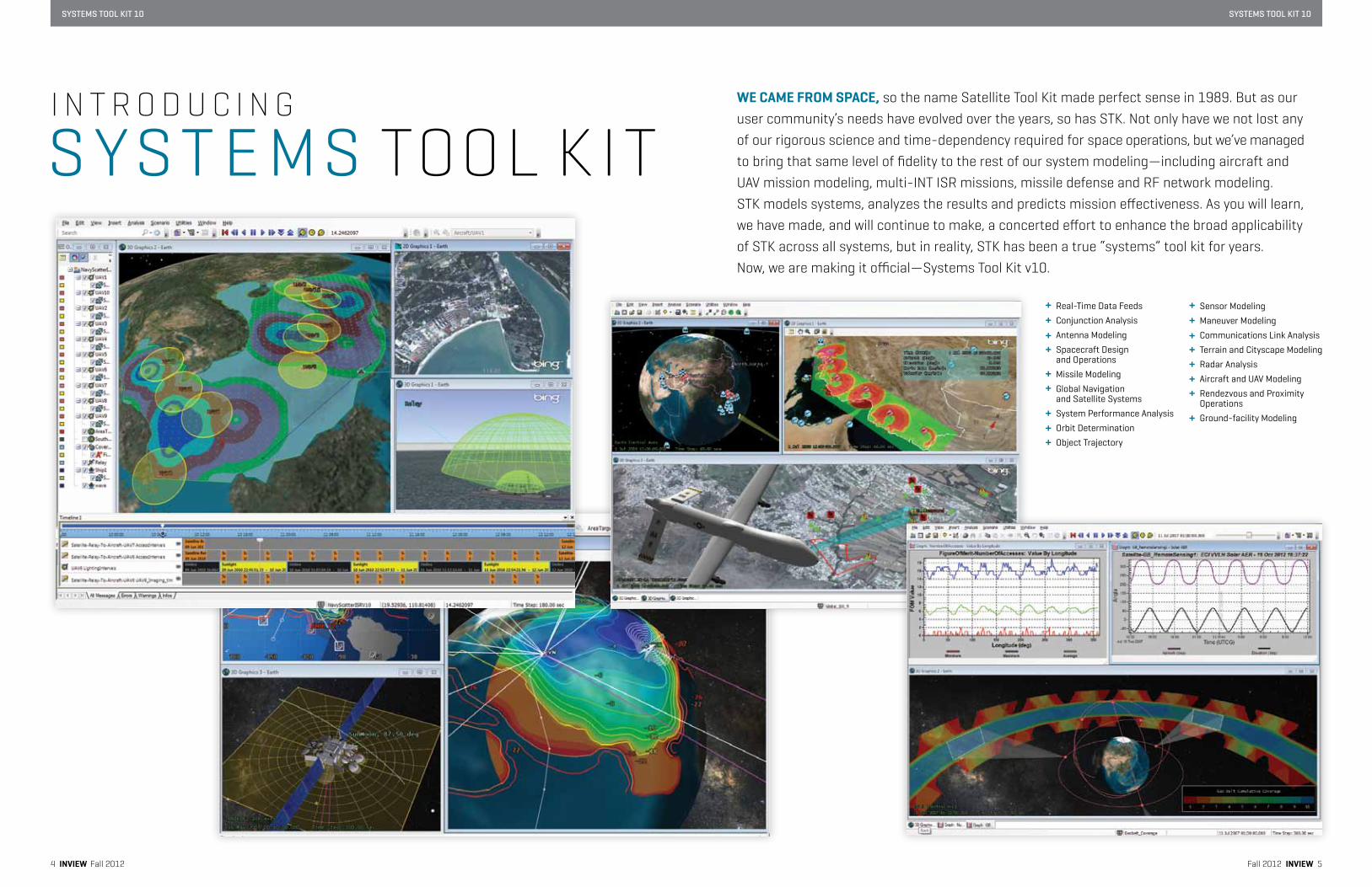
wE CaME FRoM sPaCE, so the name Satellite Tool Kit made perfect sense in 1989. But as our user community’s needs have evolved over the years, so has STK. Not only have we not lost any of our rigorous science and time-dependency required for space operations, but we’ve managed to bring that same level of fidelity to the rest of our system modeling—including aircraft and UAV mission modeling, multi-INT ISR missions, missile defense and RF network modeling. STK models systems, analyzes the results and predicts mission effectiveness. As you will learn, we have made, and will continue to make, a concerted effort to enhance the broad applicability of STK across all systems, but in reality, STK has been a true “systems” tool kit for years. Now, we are making it official—Systems Tool Kit v10.
Fall 2012 inviEw 54 inviEw Fall 2012
S YST E MS TOOL K ITI N T R O D U C I N G
sensor Modeling
Maneuver Modeling
Communications Link Analysis
terrain and Cityscape Modeling
Radar Analysis
Aircraft and uAV Modeling
Rendezvous and Proximity Operations
Ground-facility Modeling
Real-time Data Feeds
Conjunction Analysis
Antenna Modeling
spacecraft Design and Operations
Missile Modeling
Global navigation and satellite systems
system Performance Analysis
Orbit Determination
Object trajectory
sYsTeMs Tool KIT 10 sYsTeMs Tool KIT 10
6 inviEw Fall 2012 Fall 2012 inviEw 7
Get it now, it’s free agi.com/stk10
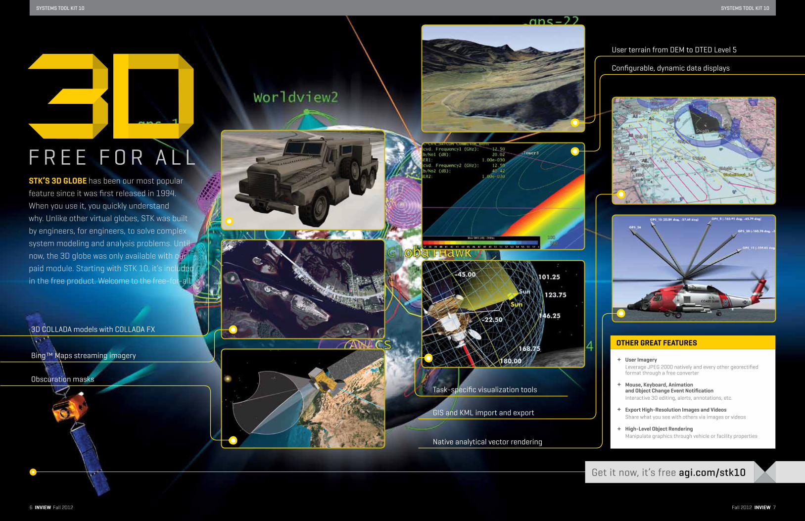
F R E E F O R A L L
10stK’s 3D GloBE has been our most popular feature since it was first released in 1994. When you use it, you quickly understand why. Unlike other virtual globes, STK was built by engineers, for engineers, to solve complex system modeling and analysis problems. Until now, the 3D globe was only available with our paid module. Starting with STK 10, it’s included in the free product. Welcome to the free-for-all.
user imageryLeverage JPEG 2000 natively and every other georectified format through a free converter
Mouse, Keyboard, animation and object Change Event notificationInteractive 3D editing, alerts, annotations, etc.
Export high-Resolution images and videosshare what you see with others via images or videos
high-level object RenderingManipulate graphics through vehicle or facility properties
othER GREat FEatuREs
GIs and KML import and export
task-specific visualization tools
user terrain from DEM to DtED Level 5
native analytical vector rendering
Configurable, dynamic data displays
3D COLLADA models with COLLADA FX
Bing™ Maps streaming imagery
Obscuration masks
sYsTeMs Tool KIT 10sYsTeMs Tool KIT 10
Fall 2012 inviEw 98 inviEw Fall 2012
s t K G A I n sG A M E-C h A n G I n GC A P A B I L I t Y
n E W s t K P R OF E E D Y O u R n E E D F O R M O R EF I D E L I t Y1997 staRtED on a wEDnEsDaY. The Hubble was fixed. The Dow crossed 8,000.
The F-22 made its first flight. James Cameron’s Titanic killed at the box office. AGI removed the price on STK.
so, You’vE DownloaDED stK and started to use it. Maybe you went through a few tutorials or maybe you tossed the instructions as soon as you opened the box. Either way, you find yourself adding vehicles, sensors and a target or two. You get sucked in by the 3D window. You can’t help but move the mouse around to get a better view.
When we made the decision to offer stK for free, the logic was simple.
Get people to use it and they will want more. no tricks. no expiration—
just free distribution of a functional, useful tool for anyone to use.
It was a win-win for everyone.
today, stK remains a powerful tool for any systems engineer
or analyst. see the sidebar for a capability refresher.
With version 10, we are bringing game-changing capability to stK.
One of our most coveted features, 3D, is now in the free product.
It’s no secret that our 3D modeling capability has been a popular
upgrade since its inception in 1994. there is no better way to analyze
your system than through a dynamic, interactive 3D simulation
environment. stK is immediately much more useful.
In addition to the 3D window, we have added access to our standard
Object Database, a library of predefined satellite, aircraft and facilities
for building system models in stK. stK 10 users also get to use the new
timeline View and vastly improved 2D map (details on these awesome
enhancements on pages 10 and 12, respectively). the good just got
a lot better.
Once you’re an stK wiz and find you need and want more—more
fidelity, more customized models, more capability to build systems—
look to stK Pro, stK Analysis Workbench, stK satPro or any of our
specialized stK modules! see page 18 for a chart explaining our
reconfigured product line, then head to www.agi.com/stk10
to download stK!
You hit the play button and watch your mission run. You are officially
an stK user. Welcome to the club. Obviously our visualization is compelling
in and of itself. But there is more to stK than just a few objects and
a pretty globe. Once you’ve modeled your system, you can evaluate
it in the context of the mission and visualize all of the critical details.
For many of you, stK is all you need. But we know that some will want
and need more—more fidelity when modeling your system and more
realism when evaluating your mission against unique requirements.
starting with stK 10, we are introducing an entry product that turns
stK silver into stK gold: stK Pro. this new module gives our free
stK users even greater ability to model their system.
If you are not an stK user yet, what are you waiting for? If you’re
just trying it out for the first time, send us a note about your
experience. We will make it worth your while. If you’ve been using
stK for some time and feel you’re an old pro—have a look at stK Pro.
You can try it for free.
Model complex systems (platforms, payloads and mission environment)
Modify system parameters • Vehicle performance • Sensor geometry
Model system limitations • Geometric (azimuth, elevation, range) • Line of sight • Attitude field of view
Combine system models • Mission scenarios • Collaborative systems • Interactive design
leverage geometries, vectors, coordinate systems and reference frames • Vehicle positions, velocities and accelerations • Sensor pointing • Attitude modeling
analyze system models in the context of a mission • Collection feasibility • Geometric and temporal conflicts
Evaluate the impact of system parameters • Thousands of qualitative and quantitative metrics • Report, graph and vary any metric
visualize the system and its performance • Smooth, time-dynamic 3D visualization • Text and graphical annotations • Display of GIS map and vector data • Camera control and flythrough
Collaborate and share models and analysis • Standard data import and export • Presentation graphics (movies, images, reports) • Import KML and promote to STK objects
Develop custom applications and workflows • Fully documented API
usE FREE stK to:
10import many standard terrain formats for both analysis and visualizationadd rate, acceleration and temporal restrictions to your systemCreate any complex sensor field of view or field of regard (While you are at it, point your sensor using advanced profiles such as targeted, spinning and grazing altitude)
Customize your own sensors and constraintsModel complex, networked systemsEvaluate one-to-many, many-to-many or any complex sequence of links
with stK PRo You Can:
BY shannon lYnChAGI PRODuCt MAnAGER
BY toM uRiEAGI DIRECtOR OF MARKEtInG OPERAtIOns
Generate system modelsvisualize in 2D and 3Dsystem performance and availability evaluationaPi for automating, customizing and embedding
stoRY hiGhliGhtsadvanced constraints using geometric, light and time-based conditionsComplex sensor modelingMulti-node analysisterrain
stoRY hiGhliGhts
sYsTeMs Tool KIT 10sYsTeMs Tool KIT 10
Fall 2012 inviEw 1110 inviEw Fall 2012
tiME toolWith the time tool you can capture, modify or create time instants
and intervals. stK automatically generates a whole slew of time
components for each object and analysis; for example, an aircraft
flight will start and end at specific “Time Instants” with the time
between those instants defined as an “Interval,” and any Access
it computes will define an “Interval List” (one interval per available
access period). using those components in the time tool we can
quickly construct custom intervals such as the time between two
separate aircraft launches, or the coincident intervals of multiple
aircraft payloads acquiring sensor data. these intervals can then
be used to define other stK properties like constraints, display
characteristics (changing object colors, models, screen annotations,
etc.) and reporting/graphing intervals (only report data during
specific intervals or at specified time instants).
then, using timeline View—a new window for displaying time-related
information—you can add multiple time components from the time
tool (access intervals, lighting intervals, etc.). By organizing your
components on multiple lines, you can then zoom and scroll through
the timeline View to quickly see information about the component
without having to bring up the panel to look at it. the timeline View
is very useful whenever you need to evaluate the relative sizes of intervals
and relative alignment between various time components. It is not
a substitute for reports and graphs, but it is a great alternative view
that is especially helpful when you start creating more and more
complicated time components.
CalCulation toolthe Calculation tool, as it implies, provides an interface for creating
custom calculations and evaluating conditions based on stK scenario
properties without writing plugin scripts or exporting data to other
applications like Excel or MAtLAB. Want to setup a calculation to estimate
at any point in time how long it would take for a uAV to return to base
from its current location in the route and how much fuel that return trip
would require? You can do that. You could then establish a condition
to monitor the fuel state data provider on that aircraft object to determine
when the fuel level drops below an acceptable threshold. the calculations
you define can be used to generate custom report values, specify unique
object constraints and/or evaluate user defined Coverage Figures of Merit.
the conditions are used to define new time Instants and Intervals based
on the satisfaction criteria for a calculation.
vECtoR GEoMEtRY toolthe Vector Geometry tool lets you build custom geometric models from
any combination of out-of-the-box or user-created vectors, points, angles,
planes, axes and coordinate system components. For an example of how
these tools work in tandem, think about using the Vector Geometry tool
to construct custom-defined vectors between multiple objects. From
there, the Calculation tool can use those vectors to create a relationship
(add/multiply/divide) and specify a threshold for the result. And finally,
with the time tool we can find the time instants or intervals that satisfy
the defined condition and use those to define other stK display,
constraint or report characteristics.
using these basic time, Calculation and Vector Geometry building
blocks, you have significantly more flexibility to introduce custom
or proprietary algorithms to your stK analyses.
BY DR. sERGEi tanYGinsEnIOR AstRODYnAMICs sPECIALIst
s t K A n A LY s I sW O R K B E n C hA t R I O O F t O O L s F O R Y O u R C O M P L E X C O M P u tAt I O n s
time tool for capturing, modifying or creating time instants and intervalstimeline view for displaying time-related information Calculation tool interface for creating custom calculationsvector Geometry tool for defining unique system constraints, building custom platform and payload orientations and importing/exporting data in any reference frame
stoRY hiGhliGhts
stK analYsis woRKBEnCh is going to completely revolutionize your STK analysis. Comprised of three individual tools: Vector Geometry (which you may already be familiar with), Time and Calculation, each tool operates within its own unique domain but can also be combined to generate more complex analyses and displays.
s t K s At P R OI n - D E P t h s PA C E t O O L s F O R s At E L L I t E s Y s t E M s
You’vE CREatED YouR sPaCECRaFt and defined its orbit in STK, but your mission requires a high-precision propagator and dynamic attitude modeling and simulation. STK SatPro provides system engineering tools to assess realistic attitude profiles in conjunction with STK’s validated ephemeris-generation capabilities. Additional propagators available in SatPro include HPOP, LOP, SP3 and 11-parameter.
With satPro, you aren’t limited to using stK’s standard attitude profiles.
Countless advanced attitude profiles can be flown and analyzed against
mission design requirements. For example, if your mission calls for
multiple maneuver sequences or mission modes, you can build multiple
attitude segments and thread them together over the vehicle ephemeris.
You can also set slew rate and acceleration constraints and evaluate
their impact on system performance. the 3D attitude view and attitude
sphere, combined with vector displays, empower you to display the
object’s attitude and track attitude changes over time.
try it out for free at agi.com/eval
leverage advanced attitude Profiles including targeted, pre-computed, multi-segment, satellite attitude slewmodes and constrained attitudesimulate perturbing forces such as gravity, sRP and drag to analyze effects on spacecraft orbitinclude plugin attitude simulators (MATLAB, VBScript, Perl)
apply advanced space-related constraints to a satelliteanalyze solar power generation based on solarillumination area over timeDefine solar array sizing, placement and orientationGenerate a tlE (two-line element set) from any ephemeris source inside of stKEstimate satellite lifetimeCreate and display B-planesRapidly configure walker ConstellationsGain Deck access visibility to a large set of objectsusing constraints
usE stK satPRo to:
satellite-specific tools for advanced modeling and analysisvalidated ephemeris generation capabilitiesRealistic attitude profiles
stoRY hiGhliGhts
BY KEllY aMaRosoAGI PRODuCt MAnAGER
sYsTeMs Tool KIT 10sYsTeMs Tool KIT 10
Fall 2012 inviEw 1312 inviEw Fall 2012
BY JiMMY tuCholsKiAGI DIRECtOR OF stK sOFtWARE DEVELOPMEnt
D I s PL AYE n h A n C EME ntst R A n s L u C E n C Y, L AY E R s, B I n G™ M A P s s t R E A M I n G I M A G E R Y, P E R-P I X E L L I G h t I n G A n D C O L L A DA F X
4x improvement in 2D map rendering frame rate3D CollaDa models, featuring CollaDa FX Create custom graphics through 3D primitive aPi
stoRY hiGhliGhts
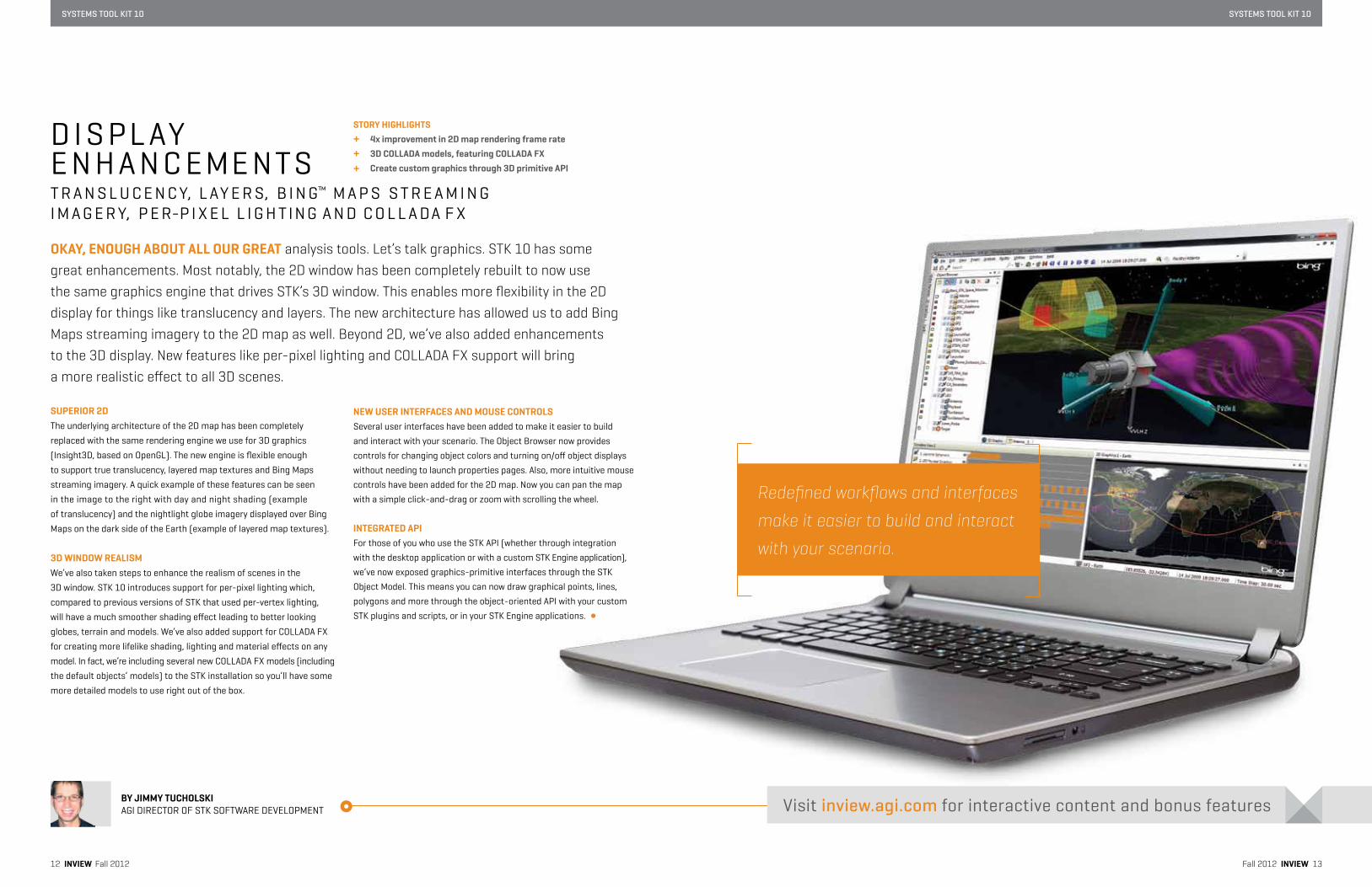
suPERioR 2Dthe underlying architecture of the 2D map has been completely
replaced with the same rendering engine we use for 3D graphics
(Insight3D, based on OpenGL). The new engine is flexible enough
to support true translucency, layered map textures and Bing Maps
streaming imagery. A quick example of these features can be seen
in the image to the right with day and night shading (example
of translucency) and the nightlight globe imagery displayed over Bing
Maps on the dark side of the Earth (example of layered map textures).
3D winDow REalisMWe’ve also taken steps to enhance the realism of scenes in the
3D window. stK 10 introduces support for per-pixel lighting which,
compared to previous versions of stK that used per-vertex lighting,
will have a much smoother shading effect leading to better looking
globes, terrain and models. We’ve also added support for COLLADA FX
for creating more lifelike shading, lighting and material effects on any
model. In fact, we’re including several new COLLADA FX models (including
the default objects’ models) to the stK installation so you’ll have some
more detailed models to use right out of the box.
nEw usER intERFaCEs anD MousE ContRolsseveral user interfaces have been added to make it easier to build
and interact with your scenario. the Object Browser now provides
controls for changing object colors and turning on/off object displays
without needing to launch properties pages. Also, more intuitive mouse
controls have been added for the 2D map. now you can pan the map
with a simple click-and-drag or zoom with scrolling the wheel.
intEGRatED aPiFor those of you who use the stK API (whether through integration
with the desktop application or with a custom stK Engine application),
we’ve now exposed graphics-primitive interfaces through the stK
Object Model. this means you can now draw graphical points, lines,
polygons and more through the object-oriented API with your custom
stK plugins and scripts, or in your stK Engine applications.
oKaY, EnouGh aBout all ouR GREat analysis tools. Let’s talk graphics. STK 10 has some great enhancements. Most notably, the 2D window has been completely rebuilt to now use the same graphics engine that drives STK’s 3D window. This enables more flexibility in the 2D display for things like translucency and layers. The new architecture has allowed us to add Bing Maps streaming imagery to the 2D map as well. Beyond 2D, we’ve also added enhancements to the 3D display. New features like per-pixel lighting and COLLADA FX support will bring a more realistic effect to all 3D scenes.
Redefined workflows and interfaces
make it easier to build and interact
with your scenario.
Visit inview.agi.com for interactive content and bonus features
14 inviEw Fall 2012
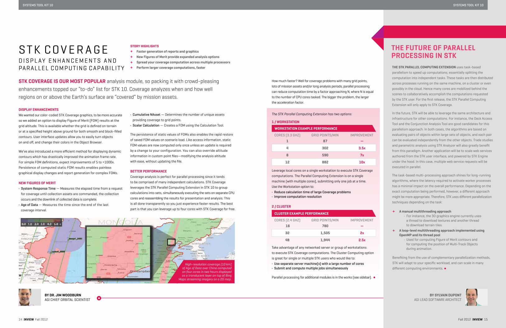
DisPlaY EnhanCEMEntsWe wanted our color-coded stK Coverage graphics, to be more accurate
so we added an option to display Figure of Merit (FOM) results at the
grid altitude. this is available whether the grid is defined on terrain
or at a specified height above ground for both smooth and block-filled
contours. user interface updates allow you to easily turn objects
on and off, and change their colors in the Object Browser.
We’ve also introduced a more efficient method for displaying dynamic
contours which has drastically improved the animation frame rate.
For simple FOM definitions, expect improvements of 5 to >1000x.
Persistence of computed static FOM results enables painless
graphical display changes and report generation for complex FOMs.
nEw FiGuREs oF MERit• System Response Time — Measures the elapsed time from a request
for coverage until collection assets are commanded, the collection
occurs and the downlink of collected data is complete.
• Age of Data — Measures the time since the end of the last
coverage interval.
• Cumulative NAsset — Determines the number of unique assets
providing coverage to grid points.
• Scalar Calculation — Creates a FOM using the Calculation tool.
the persistence of static values of FOMs also enables the rapid restore
of saved FOM values on scenario load. Like access information, static
FOM values are now computed only once unless an update is required
by a change to your configuration. You can also override altitude
information in custom point files—modifying the analysis altitude
with ease, without updating the file.
BEttER PERFoRManCECoverage analysis is perfect for parallel processing since it tends
to be comprised of many independent calculations. stK Coverage
leverages the stK Parallel Computing Extension in stK 10 to group
calculations into sets, simultaneously executing the sets on separate CPu
cores and reassembling the results for presentation and analysis. this
is all done transparently so you just experience faster results. the best
part is that you can leverage up to four cores with stK Coverage for free.
BY DR. JiM wooDBuRnAGI ChIEF ORBItAL sCIEntIst
s t K C O V E R A G ED I s P L AY E n h A n C E M E n t s A n D PARALLEL C OM PutI nG C APAB ILI tY
Faster generation of reports and graphicsnew Figures of Merit provide expanded analysis optionsspread your coverage computation across multiple processors Perform larger coverage computations, faster
stoRY hiGhliGhts
stK CovERaGE is ouR Most PoPulaR analysis module, so packing it with crowd-pleasing enhancements topped our “to-do” list for STK 10. Coverage analyzes when and how well regions on or above the Earth’s surface are “covered” by mission assets.
thE FutuRE oF PaRallEl PRoCEssinG in stKthE stK PaRallEl CoMPutinG EXtEnsion uses task-based
parallelism to speed up computations; essentially splitting the
computation into independent tasks. these tasks are then distributed
across processes running on the same machine, on a cluster or even
possibly in the cloud. hence many cores are mobilized behind the
scenes to collaboratively accomplish the computations requested
by the stK user. For the first release, the stK Parallel Computing
Extension will only apply to stK Coverage.
In the future, stK will be able to leverage the same architecture and
infrastructure for other computations. For instance, the Deck Access
tool and the Conjunction Analysis tool are good candidates for this
parallelism approach. In both cases, the algorithms are based on
evaluating pairs of objects within large sets of objects, and each pair
can be evaluated independently from the other objects. trade studies
and parametric analysis using stK Analyzer will also greatly benefit
from this paradigm. Another application will be to scale web services
authored from the stK user interface, and powered by stK Engine
under the hood. In this case, multiple web service requests will be
executed in parallel.
the task-based multi-processing approach shines for long-running
algorithms, where the latency required to activate worker processes
has a minimal impact on the overall performance. Depending on the
exact computation being performed, however, a different approach
might be more appropriate. therefore, stK uses different parallelization
techniques depending on the task:
Benefiting from the use of complementary parallelization methods,
stK will adapt to your specific workload, and can scale in many
different computing environments.
BY sYlvain DuPontAGI LEAD sOFtWARE ARChItECt
how much faster? Well for coverage problems with many grid points,
lots of mission assets and/or long analysis periods, parallel processing
can reduce computation time by a factor approaching n, where n is equal
to the number of CPu cores tasked. the bigger the problem, the larger
the acceleration factor.
The STK Parallel Computing Extension has two options:
1 / woRKstation
take advantage of any networked server or group of workstations
to execute stK Coverage computations. the Cluster Computing option
is great for single or multiple stK users who would like to:
• Use separate server machine(s) with a large number of cores• Submit and compute multiple jobs simultaneously
Parallel processing for additional modules is in the works (see sidebar).
Leverage local cores on a single workstation to execute stK Coverage
computations. the Parallel Computing Extension is on a single
machine (with multiple cores), submitting only one job at a time.
use the Workstation option to:
• Reduce calculation time of large Coverage problems• Improve computation resolution
2 / ClustER
CORES (2.4 GHZ) GRID POINTS/MIN IMPROVEMENT
16
32
48
780
1,505
1,944
—
2x
2.5x
ClustER EXaMPlE PERFoRManCE
CORES (3.3 GHZ) GRID POINTS/MIN IMPROVEMENT
1
4
8
12
87
302
590
882
—
3.5x
7x
10x
woRKstation EXaMPlE PERFoRManCE
sYsTeMs Tool KIT 10
Fall 2012 inviEw 15
a manual multithreading approach • For instance, the 3D graphics engine currently uses a thread to download textures and another thread to download terrain tiles.
a loop-level multithreading approach implemented using openMP and its thread pool • Used for computing Figure of Merit contours and for computing the position of Multi-track Objects during animation.
sYsTeMs Tool KIT 10
10
High-resolution coverage (10 km) of Age of Data over China computed on four cores in two hours displayed as a translucent layer on top of Bing
Maps streaming imagery on a 2D map.

sYsTeMs Tool KIT 10sYsTeMs Tool KIT 10
Fall 2012 inviEw 1716 inviEw Fall 2012
3D aPiYes, stK’s 3D window is now free. Yes, you can model objects, control
the camera and animate through the GuI. If you are a developer, you
also want to know if you can manipulate it through code. the answer
is yes. As part of the stK 10 visualization enhancements, we have
included the Insight3D API. so if you just want to draw a point or write
text randomly on the globe, you can. If you want to project video
on terrain or manipulate mouse behaviors and events: have at it.
We understand you have your own requirements and workflows.
We give you the flexibility to use our tools any way you want.
stanDaRD oBJECt DataBasEBy now you’ve probably heard about quickly setting up your mission
analysis with AGI’s standard Object Database—a catalog of satellites,
facilities and now, aircraft data. But that capability means nothing
if you can’t find what you are looking for. We feel your pain and have
added an improved search and data discovery interface, making
it easier to get the object you need.
stK astRoGatoR uPDatEsthanks to your feedback, solving maneuver planning and trajectory
design problems with stK Astrogator 10 is a snap. First, we’ve added
targeter graphs. next, it’s easier to set up a Mission Control sequence
with Copy/Paste functionality for components such as stopping conditions
and calculation objects. We even overhauled the user interface so it is
easier to read. By adding the secant method algorithm to the differential
corrector, target sequences converge faster. the scripting tool was also
updated for easy creation of generic “black box” sequences that can
be reused across missions; we’ve included some example sequences
to help you get started.
tERRainunlike most virtual globes, you can add your own terrain for visualization
and analysis in stK. With stK 10, it gets even better. You can now
visualize sub-meter elevations when using DtED Level 5 and hRtI
data sets. As part of this upgrade, stK now handles larger terrain
files, improving usability by keeping larger data sets intact.
BY Josh REiChERAGI APPLICAtIOn suPPORt EnGInEER
A L L t h E O t h E RG R E At s t u F FW E h AV E n’t tA L K E D A B O u t Y E t
insight3D aPi includedimproved search and data discovery interface for standard object Database visualize sub-meter elevations when using DtED level 5 and hRti data sets
stoRY hiGhliGhts
try stK 10 today at agi.com/stk10
sMaRtER KMlKML is everywhere. If you want to visualize your point, line or polygon-
georegistered data—get it into the KML format. Just about every
virtual globe or mapping application accepts this OGC™ standard.
With stK 10 you can turn simple points, lines and polygons into
facility, vehicle and area target objects in stK. this puts the power
of stK behind your simple geometry so that you can do more with
your data … fly, constrain, compute coverage, etc.
stK ConJunCtion analYsis toolsWe’ve broken out the launch window capability in stK Conjunction
Analysis tools (stK CAt) into its own Launch Window tool. It can now
use ephemeris files as secondaries and compute launch window
analysis for objects where the launch area is known, but not the
launch point. Additional graphics have also been added.
Advanced CAt has been improved to work directly with more types
of input files (*.pg, *.11param, *.sp3, *.alm, *.al3, *.yuma, *.sem,
and all external ephemeris files like *.e and *.be) and with satellites
in the scenario. several conjunction types can be computed (e.g. global
only, local only, local and global); the analysis can be run even when
an object does not have ephemeris for the entire analysis period; there
is better identification of related objects to avoid reporting conjunctions
that are of no concern; and several tolerances have been tightened.
nEw PRoPaGatoRsWe added two new satellite propagators for you space junkies,
11-Parameter and sP3. the 11-Parameter propagator uses an
element set (defined by IEss 412 Rev 2) appropriate for predicting
GEO satellite motion: it’s available for certain Intelsat, sEs newskies
and telenorsBC-maintained satellites. the sP3 propagator reads
external ephemeris in the sp3(a) and sp3(c) formats. Precision
ephemerides for GPs satellites in this format are available from nGs.
If you followed all of that then you know just how awesome they are.
We hope all of this information has intrigued you enough to upgrade
to stK 10, or try it out for the very first time. As always, we’d love
to hear what you think.
3D aPi stanDaRD oBJECt DataBasE stK astRoGatoR uPDatEs tERRain sMaRtER KMl stK ConJunCtion analYsis tools nEw PRoPaGatoRs
sYsTeMs Tool KIT 10sYsTeMs Tool KIT 10
whilE stK MEEts a lot of our user community’s needs, we’ve recognized that not everyone needs it in the desktop format. Here are some examples of how our customers are using STK as a desktop application, a development tool and as a web service. You can learn more about these products and read the full case studies at inview.agi.com!
18 inviEw Fall 2012
a DEsKtoP CasE stuDYAssessing Radar System Effectiveness for Marine Combat Operations
CHALLENGE: the u.s. Marine Corps target Acquisition Platoon needed
to upgrade its Firefinder radar systems with one with improved probability
of detection and range.
SOLUTION: stK desktop software modeled radar coverage to determine
how many of the proposed new radar systems would be needed for
Marine combat operations.
RESULTS: Initial documents had proposed that 10 replacement systems
per tAP would be required. study results revealed that six systems would
be adequate, with eight systems preferred—reducing the overall system
acquisition costs by nearly $300M.
Create and manage high-level objectsPropagate and orient vehiclesvisualize objects in 2D and 3Danimate in real or simulated time
stK DEsKtoP hiGhliGhts
an sDK CasE stuDYEnhanced 3D Situational Awareness for the Tactical Data Analysis and Connectivity System
CHALLENGE: Märzen needed a real-time 3D visualization and enhanced
geospatial analysis capability for tDACs, a routing engine that supports
connectivity, interoperability and real-time analysis of tactical data networks.
SOLUTION: stK Components was selected because it is easy to use, based
on the .nEt framework and brings object mobility handling, associated
object analysis and airspace volume depiction to tDACs.
RESULTS: A low-cost, fast time-to-market enhancement to tDACs
that includes theatre-wide real-time 3D depiction and analysis
of tactical data feeds.
application and class-level aPisBuild mission-specific workflowsCreate new applications or enhance existing onesDevelop and deploy solutions
stK soFtwaRE DEvEloPMEnt Kit hiGhliGhts
an stK sERvER usE CasEEsri uses STK Server in Imagery Data Management Solution Pattern
CHALLENGE: Esri wanted to integrate stK into its new imagery data
management solution to rapidly deploy COts ArcGIs imagery capabilities.
SOLUTION: Implemented stK server.
RESULTS: AGI products extend Esri IDM capabilities with mission and
acquisition planning, enhanced imagery discovery and collection tasking.
ArcGIS SERVER
SOURCES DATA WEB APPS &SERVICES
EXPLOITATIONTOOLS
Create, manage and distribute mission modelsPublish analytic services over a networkDynamically generate web services
stK sERvER hiGhliGhts
stK 9 satellite tool Kit
stK 10 systems tool Kit
stK Basic (free)
stK (free)
Core systems M
odules
stK Professional stK Pro
stK analysis workbench
stK satPro
2D map
standard and external propagators
Basic and external attitudes
simple conic sensors
Fixed sensor pointing
Az, el, range, line of sight constraints
Cloud-based standard Object Database
2D and 3D with Bing Maps streaming imagery
Custom reports and graphs
standard and external propagators
Basic and external attitudes
simple conic and rectangular sensor definitions
Fixed and external sensor pointing
Az, el, range, line of sight constraints
Pre-defined vectors and coordinate frames
Default calc and time components
Cloud-based standard Object Database
Attitude sphere
timeline view
Complex conic, sAR and custom sensor definitions
targeted, aligned and spinning sensor pointing
Geometric, temporal and lighting constraints
terrain visualization and analysis
Chains and constellations
Body mask, area and sensor obscuration tools
Custom vector geometry components
hPOP, LOP satellite propagators
solar panel and lifetime tools
Complex conic, sAR and custom sensor definitions
targeted, aligned and spinning sensor pointing
Geometric, temporal and lighting constraints
terrain visualization and analysis
Chains and constellations
Body mask, area and sensor obscuration tools
Custom points, vectors, axes and coordinate frames
Custom calc components and mathematical operations
Custom time instants, intervals, collections and arrays
hPOP, LOP, 11Parameter, sP3 satellite propagators
solar panel and lifetime tools
targeted, aligned and spinning attitudes
s Y s t E M s tOOL KItA n Y WAY Y O u WA n t I t
s t K 9 t O s t K 1 0P R O D u C t M A P P I n G
STK Professional v9 customers will be upgraded to STK Pro, STK Analysis Workbench and STK SatPro.
Fall 2012 inviEw 19

Analytical Graphics, Inc.220 Valley Creek BoulevardExton, PA 19341