Embed Size (px)
Citation preview
A.) Unit Overview
I. Descriptive Data
Grade level: 8th
Grade
Subjects: Oceanography, Biology, Seabirds, and Ecology
Title of Unit: Northwestern Hawaiian Islands, Marine Debris/Seabird
Interactions and Ocean Currents
Materials Needed: 1) Laptop computer(s) with access to internet
2) Digial microscopes
3) Scales
4) Dissection tools
5) Albatross Boluses
6) You Are What You Eat handout
7) Marine Animal Cards
8) Marine Animal Feeding Habits and Plastics Risk Chart
9) Video: Voyage to Kure episode (optional)
Timeline: 10-11 weeks w. 1-11/2 hr class sessions
II. Hawaii Content and Performance Standards (HCPS III):
A. Established Goals: Benchmark SC.8.1.1 (Scientific Inquiry)
- Determine the link(s) between evidence and the conclusion(s) of an
investigation
Understandings: Students will discover, invent, and investigate using the skills
necessary to engage in the scientific process.
Essential Questions: 1) How are hypotheses made and data collected to
find a conclusion? What are major parts of the
Scientific Process?
B. Established Goals: Benchmark SC.8.2.1 (Science, Technology, and Society)
- Determine the link(s) between evidence and the conclusion(s) of an
investigation
Understandings: Students will understand that science, technology, and society
are interrelated.
Essential Questions: 1) How do the influences of humans affect the oceans
and seabirds that find there food in the sea?
C. Established Goals: Benchmark SC.8.5.1 (Biological Evolution)
-Describe how changes in the physical environment affect the survival of
organisms.
Understandings: Students will understand genetics and biological evolution
and their impacts on the unity and diversity of organisms
A quiz will be implemented and used as direct evidence of
student understanding.
Essential Questions: 1) What abiotic and biotic factors select on fitness
and how do anthropogenic affects effect species of
the Northwestern Hawaiian Islands?
D. Established Goals: Benchmark SC.8.8.6 (Forces that Shape the Earth)
- Explain the relationship between density and convection currents in the
ocean and atmosphere.
Understandings: Students will understand that much of the ocean currents are
caused by convection and densities of water types and that the
currents land masses and oceans are a result of plate tectonics.
Essential Questions: 1) Explain the relationship between density and
convection currents in the ocean and atmosphere?
E. Established Goals: Benchmark SC.8.8.7 (Forces That Shape The Earth)
-Describe the physical characteristics of the ocean.
Understandings: Students will understand the earth and its processes, the
solar system, and ocean currents. Students will
demonstrate understanding via a written report and/or
PowerPoint presentation.
Essential Questions: 1) What causes ocean currents?
2) How does marine debris end up at the NWHI?
III. Topic and Driving Question
Topic: Currents, Pollution and Marine Life of the NWHI
Just because you can’t see it doesn’t mean it isn’t there. Whether it sinks,
floats, or stays suspended in the water column, plastics and other marine debris
in the ocean result in trouble, and even death for marine life and seabirds.
Driving Question: How do ocean currents influence pollution and marine debris
in the Northwestern Hawaiian Islands and how is the fragile marine life affected
by pollution? What can humans do to lessen pollution and the risk to marine
life?
IV. Rationale
This unit is relevant to students academically as it allows them to experience a
scientific inquiry-based lesson, meeting the requirement of HCPS III. As
functioning members of the community this unit will teach them how better to
recycle and how to ensure that plastics used by humans do not end up in the
oceans where currents will take them far and near- with potential to do harm to
marine life around the globe. By practicing proper recycling methods and being
as self-sustaining as possible students will learn that their efforts will have
positive effects in the future for themselves as well as marine life in the NWHI
and throughout the earths oceans. Students will also gain an understanding of
ocean currents and the newly established Northwestern Hawaiian Island
National Monument.
V. Background Information
The NWHI is a refuge for many species that rely on pristine habitats. It’s
designation as a national marine monument is hoped to help the many species
that rely on it. However, many animals that live in the ocean still come into
contact with discarded plastic via the oceans currents. Because this plastic is
not natural to their environment, the animals don’t recognize it or know what do
about it. They encounter plastics most often as a result of their feeding
behaviors. Often they get entangled in it, are cut and injured, or think it is food
and try to eat it. Results of more than ten years of volunteer beach cleanup data
indicate that 60-80% of beach debris comes from land-based sources. Plastic
marine debris affects at least 267 species worldwide, including 86% of all sea
turtle species, 44% of all sea bird species, and 43% of marine mammal species
(Algalita Marine Research Foundation).
Plastics and Marine Life
The potential for ingestion of plastic particles by open ocean filter feeders was
assessed by the Algalita Marine Research Foundation by measuring the relative
abundance (number of pieces) and mass of floating plastics and zooplankton
near the central high-pressure area of the North Pacific central gyre (the gyre is
a large recirculating area of water half-way between California and Hawaii).
Plankton abundance was approximately five times higher than that of plastic,
but mass of plastic was approximately six times greater than that of plankton.
This area is far from land, and many types of marine life feed here.
The effects of plastics on marine life can be devastating. Aquatic animals may
be harmed by plastic objects in a variety of ways, depending on the shape and

buoyancy of the object. These animals may suffer injury of even death from
their encounters with plastics. Animals can be harmed through entanglement,
laceration, suffocation, and ingestion.
The buoyant properties of water allow some plastics to float, some to sink, and
some to stay in the water column. The types of plastics marine animals may
come into contact with depend on where they live and eat: at the water’s
surface, its bottom, or floating in the water column between the surface and
bottom. All we see are the plastics on the surface, but there are many different
varieties and shapes of plastic objects below the surface. Because we can’t see
this pollution, we may forget that it exists. As cities grow and more plastics are
produced and enter the marine environment, marine species will continue to be
affected unless we make careful choices regarding plastics use and disposal.
VI. Concept Map
Northwestern Hawaiian Islands
anthropogenic effectsmarine lifecurrents pollution
whate causes them
what they carry
what are the different
types
where does it come from
whose responsibilty
is this
what species are found on the NWHI
what can humans to to
help
how does pollution
affect marine life
which types affect the NWHI the
most
are all species affected equally
proper recycling
techniques
how long can pollution
particles last in the ocean
VII. Formative Assessment
Article assessment / concept map (WKL?)
VIII. Summative Assessment Concept map
Jigsaw of article (become an expert on a paragraph of an article and then share
with class.
IX. This Unit was piloted by Roland Frayne and Kristi Martines

nwhı, currents and pollutıon
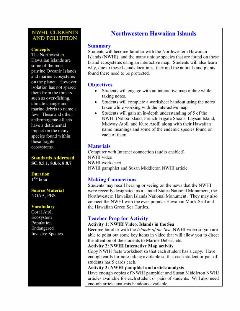
Concepts The Northwestern Hawaiian Islands are some of the most pristine Oceanic Islands and marine ecosystems on the planet. However, isolation has not spared them from the threats such as overfishing, climate change and marine debris to name a few. These and other anthropogenic affects have a detrimental impact on the many species found within these fragile ecosystems.
Standards Addressed SC.8.5.1, 8.8.6, 8.8.7
Duration 1 1/2 hour
Source Material NOAA, PBS
Vocabulary Coral Atoll Ecosystem Population Endangered Invasive Species
Northwestern Hawaiian Islands
Summary Students will become familiar with the Northwestern Hawaiian Islands (NWHI), and the many unique species that are found on these Island ecosystems using an interactive map. Students will also learn why, due to these Islands locations, they and the animals and plants found there need to be protected.
Objectives • Students will engage with an interactive map online while
taking notes. • Students will complete a worksheet handout using the notes
taken while working with the interactive map. • Students will gain an indepth understanding of 5 of the
NWHI (Nihoa Island, French Frigate Shoals, Laysan Island, Midway Atoll, and Kure Atoll) along with their Hawaiian name meanings and some of the endemic species found on each of them.
Materials Computer with Internet connection (audio enabled) NWHI video NWHI worksheet NWHI pamphlet and Susan Middleton NWHI article
Making Connections Students may recall hearing or seeing on the news that the NWHI were recently designated as a United States National Monument, the Northwestern Hawaiian Islands National Monument. They may also connect the NWHI with the everpopular Hawaiian Monk Seal and the Hawaiian Green Sea Turtles.
Teacher Prep for Activity Activity 1: NWHI Video, Islands in the Sea Become familiar with the Islands of the Sea, NWHI video so you are able to point out some key items in video that will allow you to direct the attention of the students to Marine Debris, etc. Activity 2: NWHI Interactive Map activity Copy NWHI facts worksheet so that each student has a copy. Have enough cards for notetaking available so that each student or pair of students has 5 cards each. Activity 3: NWHI pamphlet and article analysis Have enough copies of NWHI pamphlet and Susan Middleton NWHI articles available for each student or pairs of students. Will also need enough article analysis handouts available.
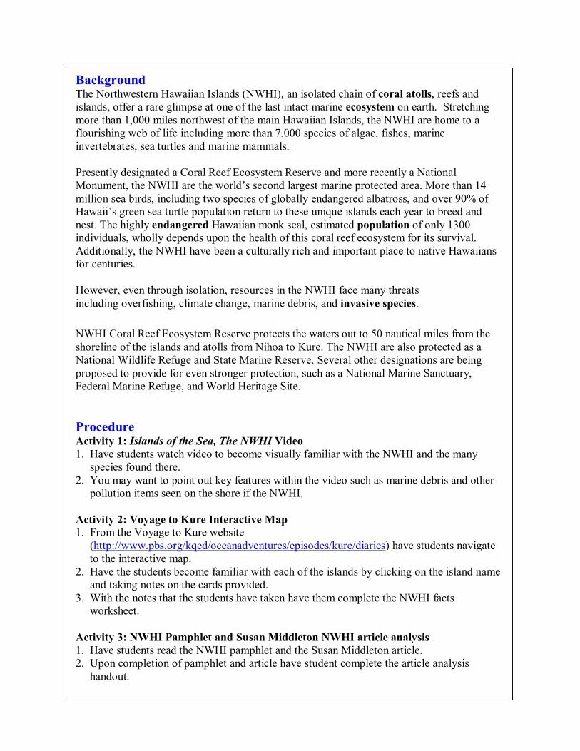
Background The Northwestern Hawaiian Islands (NWHI), an isolated chain of coral atolls, reefs and islands, offer a rare glimpse at one of the last intact marine ecosystem on earth. Stretching more than 1,000 miles northwest of the main Hawaiian Islands, the NWHI are home to a flourishing web of life including more than 7,000 species of algae, fishes, marine invertebrates, sea turtles and marine mammals.
Presently designated a Coral Reef Ecosystem Reserve and more recently a National Monument, the NWHI are the world’s second largest marine protected area. More than 14 million sea birds, including two species of globally endangered albatross, and over 90% of Hawaii’s green sea turtle population return to these unique islands each year to breed and nest. The highly endangered Hawaiian monk seal, estimated population of only 1300 individuals, wholly depends upon the health of this coral reef ecosystem for its survival. Additionally, the NWHI have been a culturally rich and important place to native Hawaiians for centuries.
However, even through isolation, resources in the NWHI face many threats including overfishing, climate change, marine debris, and invasive species.
NWHI Coral Reef Ecosystem Reserve protects the waters out to 50 nautical miles from the shoreline of the islands and atolls from Nihoa to Kure. The NWHI are also protected as a National Wildlife Refuge and State Marine Reserve. Several other designations are being proposed to provide for even stronger protection, such as a National Marine Sanctuary, Federal Marine Refuge, and World Heritage Site.
Procedure Activity 1: Islands of the Sea, The NWHI Video 1. Have students watch video to become visually familiar with the NWHI and the many
species found there. 2. You may want to point out key features within the video such as marine debris and other
pollution items seen on the shore if the NWHI.
Activity 2: Voyage to Kure Interactive Map 1. From the Voyage to Kure website
(http://www.pbs.org/kqed/oceanadventures/episodes/kure/diaries) have students navigate to the interactive map.
2. Have the students become familiar with each of the islands by clicking on the island name and taking notes on the cards provided.
3. With the notes that the students have taken have them complete the NWHI facts worksheet.
Activity 3: NWHI Pamphlet and Susan Middleton NWHI article analysis 1. Have students read the NWHI pamphlet and the Susan Middleton article. 2. Upon completion of pamphlet and article have student complete the article analysis
handout.
Assessment Worksheets completed Note cards completed on NWHI
Resources http://www.pbs.org/kqed/oceanadventures/episodes/kure/diaries National Marine Sanctuaries, Northwestern Hawaiian Islands Coral Reef Ecosystems Reserve Pamphlet. Archipelago, Portraits of the life in the World’s most remote Island Sanctuary article
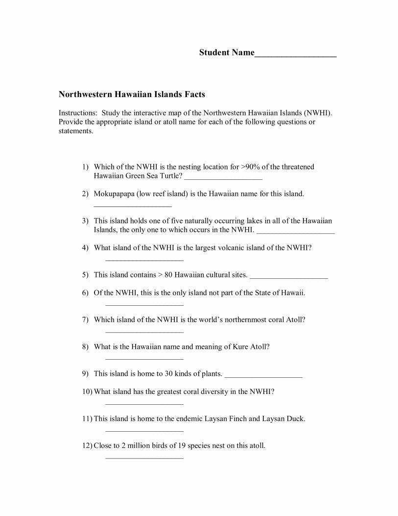
Student Name__________________
Northwestern Hawaiian Islands Facts
Instructions: Study the interactive map of the Northwestern Hawaiian Islands (NWHI). Provide the appropriate island or atoll name for each of the following questions or statements.
1) Which of the NWHI is the nesting location for >90% of the threatened Hawaiian Green Sea Turtle? ____________________
2) Mokupapapa (low reef island) is the Hawaiian name for this island. ____________________
3) This island holds one of five naturally occurring lakes in all of the Hawaiian Islands, the only one to which occurs in the NWHI. ____________________
4) What island of the NWHI is the largest volcanic island of the NWHI? ____________________
5) This island contains > 80 Hawaiian cultural sites. ____________________
6) Of the NWHI, this is the only island not part of the State of Hawaii. ____________________
7) Which island of the NWHI is the world’s northernmost coral Atoll? ____________________
8) What is the Hawaiian name and meaning of Kure Atoll? ____________________
9) This island is home to 30 kinds of plants. ____________________
10)What island has the greatest coral diversity in the NWHI? ____________________
11) This island is home to the endemic Laysan Finch and Laysan Duck. ____________________
12) Close to 2 million birds of 19 species nest on this atoll. ____________________
13)Kauo (yolk of an egg) is the Hawaiian name for what island? ____________________
14)What island is an important resting and pupping area for the endangered Hawaiian Monk Seal? ____________________
15) This Island houses the largest Laysan Albatross Colony in the world. ____________________
16)Which of the NWHI has the greatest representation of all bird species in the NWHI? ____________________
17) This island was annexed be King Kamehameha in 1857 to be part of the Hawaiian Kingdom. ____________________
18)Which island did the U.S. Navy turn over to the U.S. Fish and Wildlife Service? ____________________
19) This island holds the largest subpopulation in the world of the endangered Hawaiian Monk Seal. ____________________
20) “The loud din of birds,” Pihemanu is the Hawaiian name for this Atoll. ____________________
Northwestern Hawaiian Islands Facts
1) Which of the NWHI is the nesting location for >90% of the threatened Hawaiian Green Sea Turtle? ____________________
2) Mokupapapa (low reef island) is the Hawaiian name for this island. ____________________
3) This island holds one of five naturally occurring lakes in all of the Hawaiian Islands, the only one to which occurs in the NWHI. ____________________
4) What island of the NWHI is the largest volcanic island of the NWHI? ____________________
5) This island contains > 80 Hawaiian cultural sites. ____________________
6) Of the NWHI, this is the only island not part of the State of Hawaii. ____________________
7) Which island of the NWHI is the world’s northernmost coral Atoll? ____________________
8) What is the Hawaiian name and meaning of Kure Atoll? ____________________
9) This island is home to 30 kinds of plants. ____________________
10)What island has the greatest coral diversity in the NWHI? ____________________
11) This island is home to the endemic Laysan Finch and Laysan Duck. ____________________
12) Close to 2 million birds of 19 species nest on this atoll. ____________________
13)Kauo (yolk of an egg) is the Hawaiian name for what island? ____________________
14)What island is an important resting and pupping area for the endangered Hawaiian Monk Seal? ____________________
15) This Island houses the largest Laysan Albatross Colony in the world. ____________________
16)Which of the NWHI has the greatest representation of all bird species in the NWHI? ____________________
17) This island was annexed be King Kamehameha in 1857 to be part of the Hawaiian Kingdom. ____________________
18)Which island did the U.S. Navy turn over to the U.S. Fish and Wildlife Service? ____________________
19) This island holds the largest subpopulation in the world of the endangered Hawaiian Monk Seal. ____________________
20) “The loud din of birds,” Pihemanu is the Hawaiian name for this Atoll. ____________________
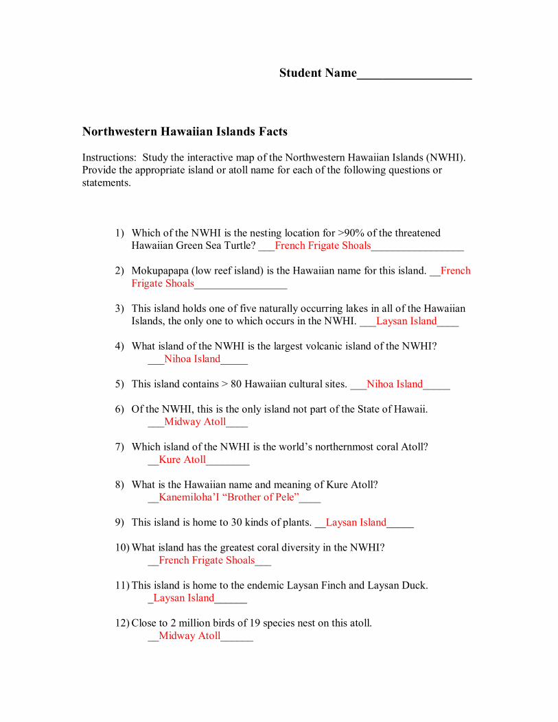
Student Name__________________
Northwestern Hawaiian Islands Facts
Instructions: Study the interactive map of the Northwestern Hawaiian Islands (NWHI). Provide the appropriate island or atoll name for each of the following questions or statements.
1) Which of the NWHI is the nesting location for >90% of the threatened Hawaiian Green Sea Turtle? ___French Frigate Shoals_________________
2) Mokupapapa (low reef island) is the Hawaiian name for this island. __French Frigate Shoals_________________
3) This island holds one of five naturally occurring lakes in all of the Hawaiian Islands, the only one to which occurs in the NWHI. ___Laysan Island____
4) What island of the NWHI is the largest volcanic island of the NWHI? ___Nihoa Island_____
5) This island contains > 80 Hawaiian cultural sites. ___Nihoa Island_____
6) Of the NWHI, this is the only island not part of the State of Hawaii. ___Midway Atoll____
7) Which island of the NWHI is the world’s northernmost coral Atoll? __Kure Atoll________
8) What is the Hawaiian name and meaning of Kure Atoll? __Kanemiloha’I “Brother of Pele”____
9) This island is home to 30 kinds of plants. __Laysan Island_____
10)What island has the greatest coral diversity in the NWHI? __French Frigate Shoals___
11) This island is home to the endemic Laysan Finch and Laysan Duck. _Laysan Island______
12) Close to 2 million birds of 19 species nest on this atoll. __Midway Atoll______
13)Kauo (yolk of an egg) is the Hawaiian name for what island? ___Laysan Island__
14)What island is an important resting and pupping area for the endangered Hawaiian Monk Seal? __Kure Atoll_____
15) This Island houses the largest Laysan Albatross Colony in the world. ___Midway Atoll_____
16)Which of the NWHI has the greatest representation of all bird species in the NWHI? __Laysan Island_____
17) This island was annexed be King Kamehameha in 1857 to be part of the Hawaiian Kingdom. ___Nihoa Island_____
18)Which island did the U.S. Navy turn over to the U.S. Fish and Wildlife Service? __Midway Atoll______
19) This island holds the largest subpopulation in the world of the endangered Hawaiian Monk Seal. ___French Frigate Shoals___
20) “The loud din of birds,” Pihemanu is the Hawaiian name for this Atoll. __Midway Atoll______
Northwestern Hawaiian Islands Facts
1) Which of the NWHI is the nesting location for >90% of the threatened Hawaiian Green Sea Turtle? ____________________
2) Mokupapapa (low reef island) is the Hawaiian name for this island. ____________________
3) This island holds one of five naturally occurring lakes in all of the Hawaiian Islands, the only one to which occurs in the NWHI. ____________________
4) What island of the NWHI is the largest volcanic island of the NWHI? ____________________
5) This island contains > 80 Hawaiian cultural sites. ____________________
6) Of the NWHI, this is the only island not part of the State of Hawaii. ____________________
7) Which island of the NWHI is the world’s northernmost coral Atoll? ____________________
8) What is the Hawaiian name and meaning of Kure Atoll? ____________________
9) This island is home to 30 kinds of plants. ____________________
10)What island has the greatest coral diversity in the NWHI? ____________________
11) This island is home to the endemic Laysan Finch and Laysan Duck. ____________________
12) Close to 2 million birds of 19 species nest on this atoll. ____________________
13)Kauo (yolk of an egg) is the Hawaiian name for what island? ____________________
14)What island is an important resting and pupping area for the endangered Hawaiian Monk Seal? ____________________
15) This Island houses the largest Laysan Albatross Colony in the world.
____________________ 16)Which of the NWHI has the greatest representation of all bird species in the
NWHI? ____________________
17) This island was annexed be King Kamehameha in 1857 to be part of the Hawaiian Kingdom. ____________________
18)Which island did the U.S. Navy turn over to the U.S. Fish and Wildlife Service? ____________________
19) This island holds the largest subpopulation in the world of the endangered Hawaiian Monk Seal. ____________________
20) “The loud din of birds,” Pihemanu is the Hawaiian name for this Atoll. ____________________
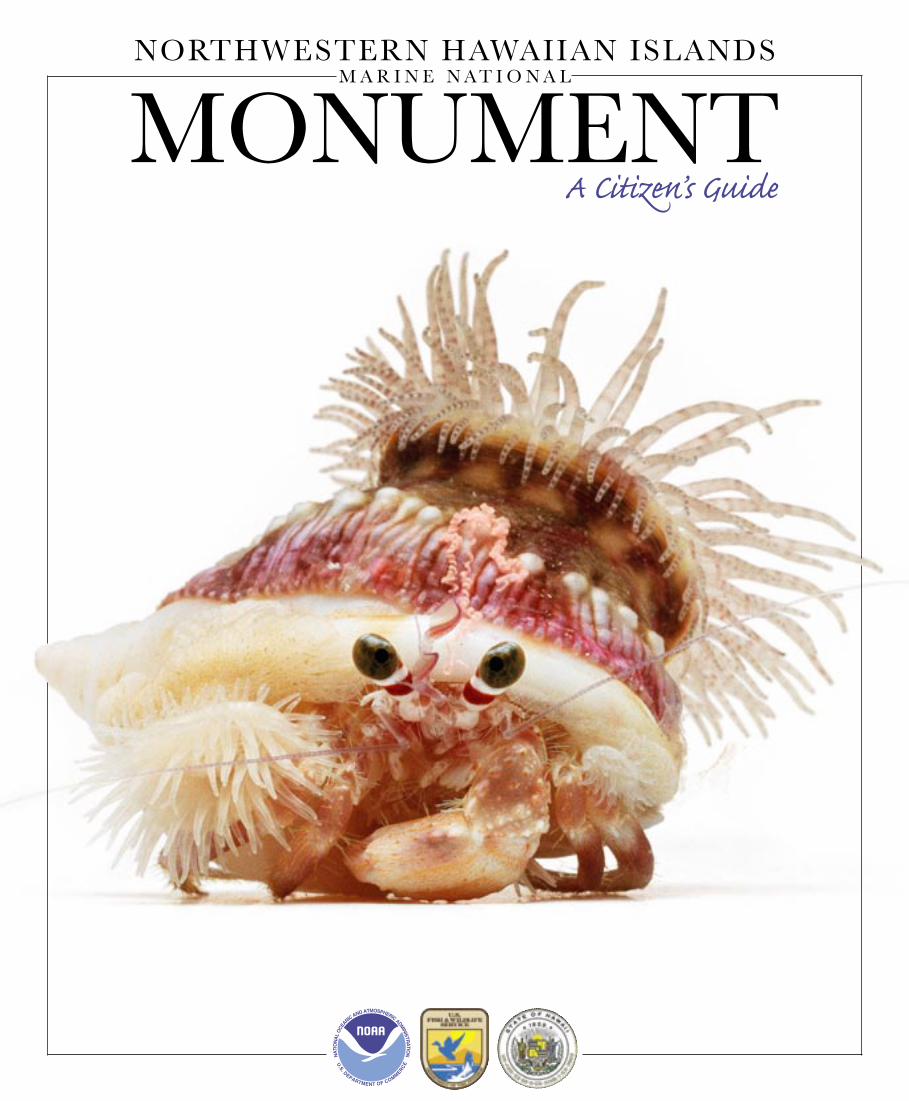
NORTHWESTERN HAWAIIAN ISLANDS
MONUMENT A Citizen’s Guide
M A R I N E N A T I O N A L

THE
NORTHWESTERN HAWAIIAN ISLANDS
Aloha,
On behalf of the National Oceanic and Atmospheric Administration, U.S. Fish and Wildlife Service and the State of Hawai‘i – co-trustee management agencies of the newly established Northwestern Hawaiian Islands Marine National Monument (monument) – mahalo for taking the time to read our “citizen’s guide” to the Northwestern Hawaiian Islands Marine National Monument. As co- trustees, we take seriously our responsibility to safeguard the natural and cultural heritage of the Northwestern Hawaiian Islands.
On June 15, 2006, President Bush signed a proclamation establishing the Northwestern Hawaiian Islands Marine National Monument. His signature marks the beginning of a mammoth undertaking to strengthen existing conservation and implement new lasting protections to ensure that this remote wilderness continues to thrive for generations to come.
We hope this guide provides you with a glimpse of the incredible natural and cultural history of the region and an understanding of the newly established monument.The guide will take you on a brief but informative virtual tour of this vast area and introduce you to the amazing plants and animals that call these islands and reefs their home. We also hope you will become inspired to learn more about the Northwestern Hawaiian Islands and join with us as active caretakers of Hawaii’s oceans.
The islands, atolls, reefs, shoals, and wildlife of this incredible area offer Hawai‘i, the United States, and the world with a natural and cultural treasure unlike any other on Earth.
Mahalo for your support,
`Aulani WilhelmWilliam RobinsonNational Oceanic and Atmospheric Administration
Barry StieglitzU.S. Fish and Wildlife Service
Peter YoungState of Hawai‘i, Department of Land and Natural Resources
National Oceanic and
Atmospheric Administration
U.S. Fish and Wildlife Service
State of Hawai‘i
Partnership Agencies Contact Information
Leopard blenny, pö‘o kauila, Exallias brevis, Kure Atoll. Photo: David Liittschwager and Susan Middleton, © 2005.Susan Middleton, © 2005.
A GLOBAL TREASURE
Beyond the main eight populated islands of Hawai‘i lie a string of tiny islands, atolls, shoals, and banks spanning 1,200 miles of the Pacifi c Ocean, the world’s largest body of water. Hundreds of miles northwest of Kaua‘i, places like Nihoa, Laysan, Pearl and Hermes, and Kure comprise the little known, rarely visited Northwestern Hawaiian Islands (NWHI). Seen from space, the area’s shallow waters appear as a string of turquoise jewels in an empty and dark blue vastness.
Thanks to their isolation, these 4,500 square miles of wild coral reefs are among the healthiest and most
extensive in the world. This marine wilderness is home to the highly endangered Hawaiian monk seal, the world’s second most endangered seal, and uninhabited sandy islets provide the nesting
grounds for 90 percent of Hawaii’s threatened green sea turtles. Though land areas are
limited, over 14 million seabirds nest here and this is the only home for four endangered land birds.
The marine habitats of the NWHI contain features not found in the main Hawaiian Islands, such as coral
atolls, and nurture thriving populations of many species once abundant in the main Hawaiian Islands, but rarely found today. Large predatory fi sh such as jacks, Hawaiian
grouper, and sharks are nearly fi fteen times as numerous in the shallow waters of NWHI compared to the heavily fi shed
main Hawaiian Islands. Many sought after aquarium species, now rare in the main Hawaiian Islands, are much
more common on these reefs as well.
Globally the NWHI are a natural and cultural treasure of outstanding scientifi c, conservation and aesthetic value. The steps we take in preserving these last undisturbed environments are gifts we give to our children’s children, and help in sustaining the ocean’s bounty that supports us today.
“These ancient volcanic remnants with their fringes of truly wild coral reefs remind us of our past—when coral reefs and sea life across the planet thrived—a time before humans became top predator in the ocean food chain.”
INTRODUCTION
Cover Photo: Pale anemone crab, unauna, Dardanus deformis. Photographed aboard NOAA ship Hi‘ialakai at Kure Atoll, © 2005, David Liittschwager and Susan Middleton.
NOAA/NOS NWHI Marine National Monument
6600 Kalaniana‘ole Hwy. # 300, Honolulu, HI 96825
Ph: (808)397-2660 • Fax: (808)397-2662
NOAA Fisheries, Pacifi c Islands Regional Offi ce
1601 Kapi‘olani Boulevard, Suite 1110, Honolulu, HI 96814
Ph: (808) 944-2200 • Fax: (808) 973-2941
U.S. Fish and Wildlife Service
300 Ala Moana Boulevard, Box 50167, Honolulu, HI 96850
Ph: (808) 792-9550 • Fax: (808) 792-9585
Department of Land and Natural Resources
Division of Aquatic Resources
1151 Punchbowl St., Rm. 330, Honolulu, HI 96813
Ph: (808) 587-0099 • Fax: (808) 587-0115
Northwestern Hawaiian Islands Marine National Monument2 Northwestern Hawaiian Islands Marine National Monument 3
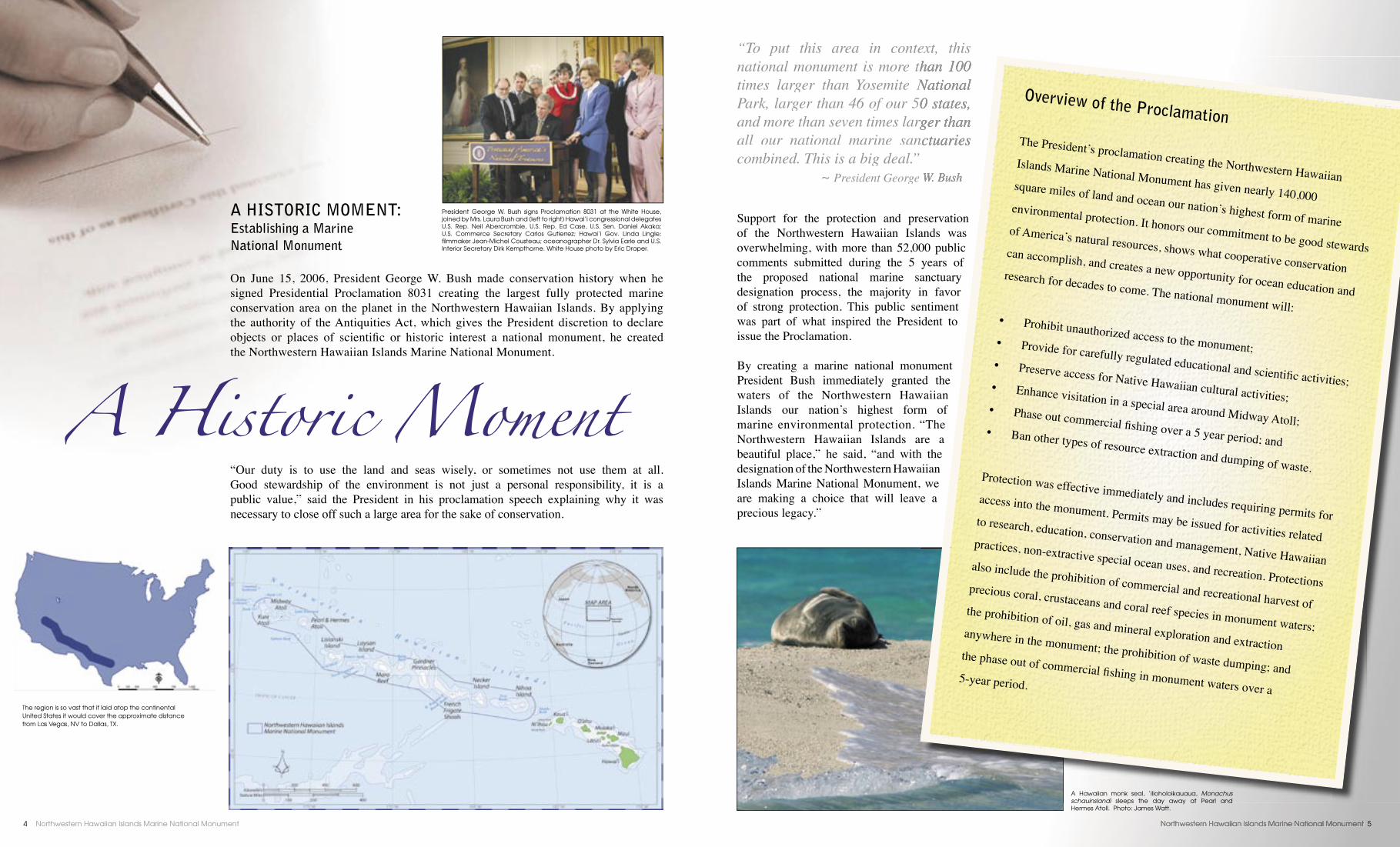
A HISTORIC MOMENT: Establishing a Marine National Monument
On June 15, 2006, President George W. Bush made conservation history when he signed Presidential Proclamation 8031 creating the largest fully protected marine conservation area on the planet in the Northwestern Hawaiian Islands. By applying the authority of the Antiquities Act, which gives the President discretion to declare objects or places of scientifi c or historic interest a national monument, he created the Northwestern Hawaiian Islands Marine National Monument.
“Our duty is to use the land and seas wisely, or sometimes not use them at all. Good stewardship of the environment is not just a personal responsibility, it is a public value,” said the President in his proclamation speech explaining why it was necessary to close off such a large area for the sake of conservation.
A Historic Moment
Support for the protection and preservation of the Northwestern Hawaiian Islands was overwhelming, with more than 52,000 public comments submitted during the 5 years of the proposed national marine sanctuary designation process, the majority in favor of strong protection. This public sentiment was part of what inspired the President to issue the Proclamation.
By creating a marine national monument President Bush immediately granted the waters of the Northwestern Hawaiian Islands our nation’s highest form of marine environmental protection. “The Northwestern Hawaiian Islands are a beautiful place,” he said, “and with the designation of the Northwestern Hawaiian Islands Marine National Monument, we are making a choice that will leave a precious legacy.”
The region is so vast that if laid atop the continental United States it would cover the approximate distance from Las Vegas, NV to Dallas, TX.
“To put this area in context, this national monument is more than 100 national monument is more than 100 times larger than Yosemite National times larger than Yosemite National Park, larger than 46 of our 50 states, Park, larger than 46 of our 50 states, and more than seven times larger than and more than seven times larger than all our national marine sanctuaries all our national marine sanctuaries combined. This is a big deal.” ~ President George W. BushPresident George W. Bush
President George W. Bush signs Proclamation 8031 at the White House, joined by Mrs. Laura Bush and (left to right) Hawai‘i congressional delegates U.S. Rep. Neil Abercrombie, U.S. Rep. Ed Case, U.S. Sen. Daniel Akaka; U.S. Commerce Secretary Carlos Gutierrez; Hawai‘i Gov. Linda Lingle; fi lmmaker Jean-Michel Cousteau; oceanographer Dr. Sylvia Earle and U.S. Interior Secretary Dirk Kempthorne. White House photo by Eric Draper.
A Hawaiian monk seal, ‘ilioholoikauaua, Monachus schauinslandi sleeps the day away at Pearl and Hermes Atoll. Photo: James Watt.
Overview of the ProclamationThe President’s proclamation creating the Northwestern Hawaiian Islands Marine National Monument has given nearly 140,000 square miles of land and ocean our nation’s highest form of marine environmental protection. It honors our commitment to be good stewards of America’s natural resources, shows what cooperative conservation can accomplish, and creates a new opportunity for ocean education and research for decades to come. The national monument will:
• Prohibit unauthorized access to the monument;• Provide for carefully regulated educational and scientifi c activities;• Preserve access for Native Hawaiian cultural activities;• Enhance visitation in a special area around Midway Atoll;• Phase out commercial fi shing over a 5 year period; and• Ban other types of resource extraction and dumping of waste.
Protection was effective immediately and includes requiring permits for access into the monument. Permits may be issued for activities related to research, education, conservation and management, Native Hawaiian practices, non-extractive special ocean uses, and recreation. Protections also include the prohibition of commercial and recreational harvest of precious coral, crustaceans and coral reef species in monument waters; the prohibition of oil, gas and mineral exploration and extraction anywhere in the monument; the prohibition of waste dumping; and the phase out of commercial fi shing in monument waters over a 5-year period.
Northwestern Hawaiian Islands Marine National Monument4 Northwestern Hawaiian Islands Marine National Monument 5

Often called the “rainforests” of the sea, coral reefs are vital to maintaining the biological diversity of our oceans. They are highly complex and productive ecosystems composed of countless millions of plants and animals dependent upon one another to survive. Building layer upon layer, coral reefs form an intricate living tapestry with more species per unit area than any other marine environment. Though coral reefs compose only about 0.2 percent of the ocean’s fl oor, scientists have estimated that they shelter and support nearly one million species of fi sh, invertebrates, and algae; many yet to be discovered.
In addition to biological value, coral reefs provide resources and services worth billions of dollars to economies world-wide. In many coastal communities adjacent to coral reefs, people rely on the reef’s bounty for the majority of their food. Around the main Hawaiian Islands, coral reefs protect our shores from storms, and they shape our famous waves that
inspired the sport of surfi ng, now exported worldwide. A 2002 study evaluated the value of coral reefs to Hawaii’s economy at $364 million each year, and some of Hawaii’s most famous ocean residents, the monk seal and green sea turtle, depend on coral reefs for their survival.
For all their biological richness and economic value, coral reefs are fragile environments that remain healthy only within a narrow window of ocean and climatic conditions. Seawater a few degrees hotter or colder than what corals are accustomed to can impact their survival, and they need clean, clear water in order to get the sunlight they need to produce food. Corals are also sensitive to physical disturbance, since only the thin outer layer of the coral structure is living tissue.
Within coral reefs, plants and animals compete for limited space and food, and a delicate balance has developed over time among species. This fragile balance can be easily
disturbed if one or more species are removed or depleted, allowing another species to grow unchecked. In some cases, such as when algae eaters like manini, kumu, cowries, or sea urchins are removed, the algae, or limu, can grow so rapidly that it overgrows and smothers the corals. These “lawnmowers of the reef” help keep reefs in balance, and are but one thread in an intricate web of life.
Given the balancing act that coral reefs must maintain, and their fragile structure, they are very susceptible to disturbances such as overfi shing, shoreline development, storms, and pollution. Coral reefs around the world are in serious decline and many are heavily compromised. This fact alone makes protection of the vast and healthy coral reefs of the Northwestern Hawaiian Islands (NWHI) all the more important.
Far Beneath the Waves The pitch-black abyss of the deep ocean harbors a strange world where deep-sea corals, odd invertebrates and bottom fi sh such as onaga and opakapaka thrive. Hawaiian monk seals descend into the dark twilight, more than a thousand feet beneath the surface, to forage among huge branching formations of gold and bamboo precious corals. This new frontier, largely unexplored by deep diving submersibles, is only now revealing to science its rich and diverse wonders.
From top: Grammatonotus macrophthalmu, an odd and iridescent deep-sea fi sh. Photo: Hawai‘i Undersea Research Laboratory (HURL).
A colony of healthy gold corals, Gerardia sp. Photo: Amy Baco-Taylor.
A diverse group of octocorals and zoanthids. Photo: Amy Baco-Taylor.
Only In Hawai`i: Endemic Species The remote location of the NWHI, thousands of miles from any continent, ensures that naturally occurring arrival of new species is rare. The Hawai‘i State Department of Land and Natural Resources estimates that before the arrival of humans, new species became established in Hawai‘i once every 70,000 years. Those species that have made their way to Hawai‘i and survived have become unique species over time as they adapted to their new environment. Approximately 25 percent of all marine species in the NWHI are unique to the Hawaiian Archipelago, one of the highest rates of marine endemism in the world. In addition, at Pearl and Hermes, Midway and Kure atolls over half of the fi sh populations are composed of these unique species. This high percentage of unique species means that the NWHI is truly a one of a kind natural wonder.
Titan scorpionfi sh, nohu, Scorpaenopsis cacopsis (endemic) at Midway Atoll. Photo: James Watt.
RAINFORESTS OF THE SEA: THE IMPORTANCE OF CORAL REEFS
Most reef systems around the world have seen a dramatic reduction of large predatory fi sh, and this is disturbing, since healthy populations of predator species are a good indicator of an ecosystem’s overall health. When predator populations are greatly reduced by fi shing and other human activities, the normal structure of the reef community is disrupted.
More than half the weight (biomass) of all fi sh on NWHI coral reefs consists of large top-level predators like sharks and jacks. In contrast, only 3 percent of the fi sh biomass on main Hawaiian Islands reefs is composed of these predatory fi sh, several of which are highly prized food and game fi shes. It is likely that this difference results from human impacts such as fi shing and habitat loss from shoreline development. These activities, largely absent in the NWHI, make it one of the last places on Earth where scientists can study the ecology of a coral reef ecosystem without large-scale human disturbance. Such studies provide new insights into how Hawaiian coral reef ecosystems function, and
the impacts of removing large predators.
Hawaiian green sea turtle, honu, Chelonia mydas, at French Frigate Shoals. Photo: James Watt.
Galapagos sharks, Carcharhinus galapagenesis (top), and a large tiger shark, Galeocerdo cuvier (bottom) are a few of the abundant top level predators in NWHI waters. Photo: James Watt.
Northwestern Hawaiian Islands Marine National Monument6 Northwestern Hawaiian Islands Marine National Monument 7
The Last Best Place: Terrestrial Environments
Although some of the Northwestern Hawaiian Islands (NWHI) were decimated by introduced mammals (rabbits, in the case of Laysan), other islets and atolls have been relatively untouched by humans. As a result, robust seabird populations and healthy insect and plant communities can still be found, and in places that were heavily impacted, seabird and plant populations are now on the mend. Nihoa Island is one of the most biologically pristine islands in the Pacifi c, and probably most closely represents the original island appearance and native species found before humans arrived in the Hawaiian Islands.
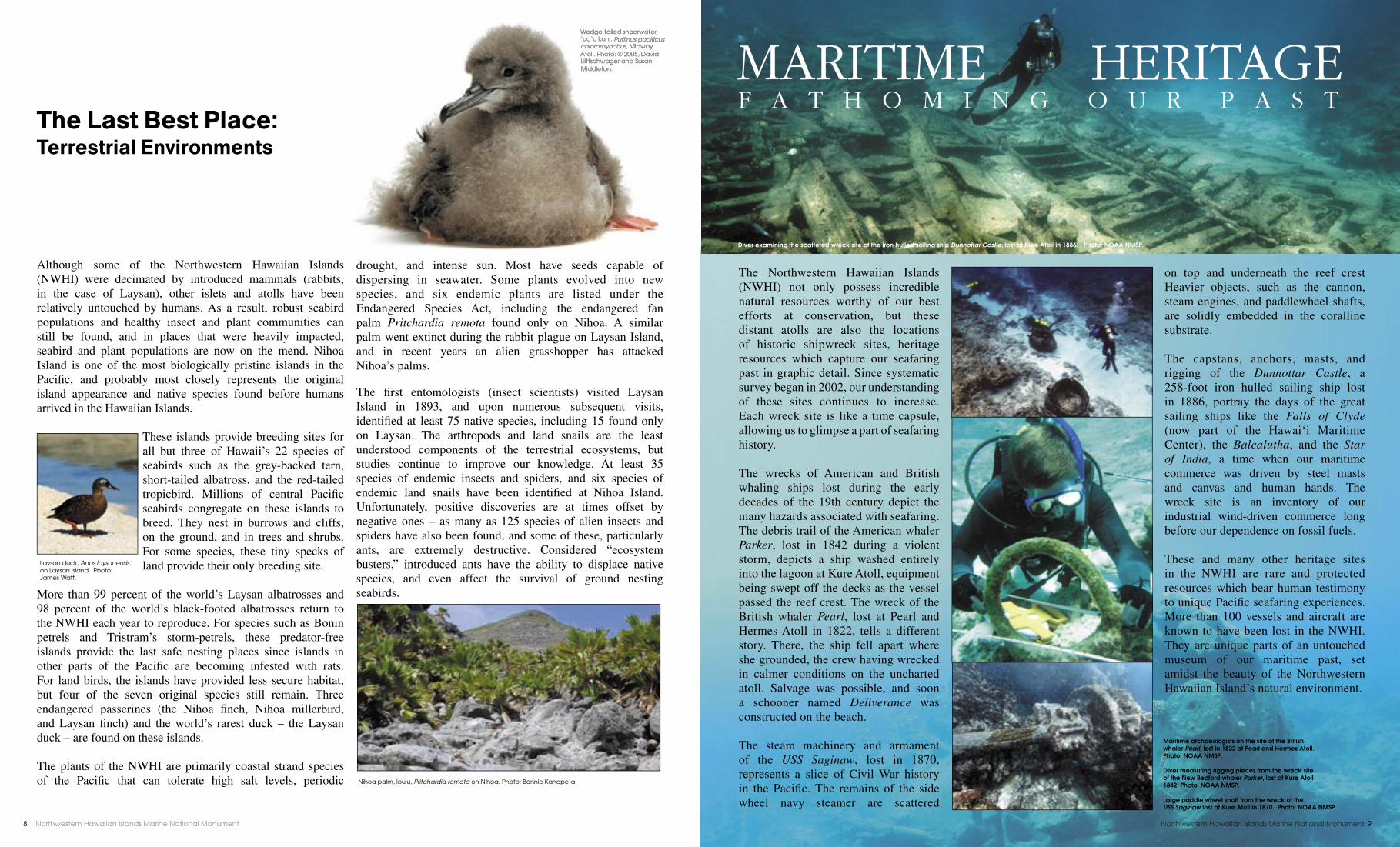
These islands provide breeding sites for all but three of Hawaii’s 22 species of seabirds such as the grey-backed tern, short-tailed albatross, and the red-tailed tropicbird. Millions of central Pacifi c seabirds congregate on these islands to breed. They nest in burrows and cliffs, on the ground, and in trees and shrubs. For some species, these tiny specks of land provide their only breeding site.
More than 99 percent of the world’s Laysan albatrosses and 98 percent of the world’s black-footed albatrosses return to the NWHI each year to reproduce. For species such as Bonin petrels and Tristram’s storm-petrels, these predator-free islands provide the last safe nesting places since islands in other parts of the Pacifi c are becoming infested with rats. For land birds, the islands have provided less secure habitat, but four of the seven original species still remain. Three endangered passerines (the Nihoa fi nch, Nihoa millerbird, and Laysan fi nch) and the world’s rarest duck – the Laysan duck – are found on these islands.
The plants of the NWHI are primarily coastal strand species of the Pacifi c that can tolerate high salt levels, periodic
drought, and intense sun. Most have seeds capable of dispersing in seawater. Some plants evolved into new species, and six endemic plants are listed under the Endangered Species Act, including the endangered fan palm Pritchardia remota found only on Nihoa. A similar palm went extinct during the rabbit plague on Laysan Island, and in recent years an alien grasshopper has attacked Nihoa’s palms.
The fi rst entomologists (insect scientists) visited Laysan Island in 1893, and upon numerous subsequent visits, identifi ed at least 75 native species, including 15 found only on Laysan. The arthropods and land snails are the least understood components of the terrestrial ecosystems, but studies continue to improve our knowledge. At least 35 species of endemic insects and spiders, and six species of endemic land snails have been identifi ed at Nihoa Island. Unfortunately, positive discoveries are at times offset by negative ones – as many as 125 species of alien insects and spiders have also been found, and some of these, particularly ants, are extremely destructive. Considered “ecosystem busters,” introduced ants have the ability to displace native species, and even affect the survival of ground nesting seabirds.
The Northwestern Hawaiian Islands (NWHI) not only possess incredible natural resources worthy of our best efforts at conservation, but these distant atolls are also the locations of historic shipwreck sites, heritage resources which capture our seafaring past in graphic detail. Since systematic survey began in 2002, our understanding of these sites continues to increase. Each wreck site is like a time capsule, allowing us to glimpse a part of seafaring history.
The wrecks of American and British whaling ships lost during the early decades of the 19th century depict the many hazards associated with seafaring. The debris trail of the American whaler Parker, lost in 1842 during a violent storm, depicts a ship washed entirely into the lagoon at Kure Atoll, equipment being swept off the decks as the vessel passed the reef crest. The wreck of the British whaler Pearl, lost at Pearl and Hermes Atoll in 1822, tells a different story. There, the ship fell apart where she grounded, the crew having wrecked in calmer conditions on the uncharted atoll. Salvage was possible, and soon a schooner named Deliverance was constructed on the beach.
The steam machinery and armament of the USS Saginaw, lost in 1870, represents a slice of Civil War history in the Pacifi c. The remains of the side wheel navy steamer are scattered
on top and underneath the reef crest Heavier objects, such as the cannon, steam engines, and paddlewheel shafts, are solidly embedded in the coralline substrate.
The capstans, anchors, masts, and rigging of the Dunnottar Castle, a 258-foot iron hulled sailing ship lost in 1886, portray the days of the great sailing ships like the Falls of Clyde (now part of the Hawai‘i Maritime Center), the Balcalutha, and the Star of India, a time when our maritime commerce was driven by steel masts and canvas and human hands. The wreck site is an inventory of our industrial wind-driven commerce long before our dependence on fossil fuels.
These and many other heritage sites in the NWHI are rare and protected resources which bear human testimony to unique Pacifi c seafaring experiences. More than 100 vessels and aircraft are known to have been lost in the NWHI. They are unique parts of an untouched museum of our maritime past, set amidst the beauty of the Northwestern Hawaiian Island’s natural environment.
Diver examining the scattered wreck site of the iron hulled sailing ship Dunnottar Castle, lost at Kure Atoll in 1886. Photo: NOAA NMSP.
F A T H O M I N G O U R P A S T MARITIME HERITAGE
Nihoa palm, loulu, Pritchardia remota on Nihoa. Photo: Bonnie Kahape‘a.
Laysan duck, Anas laysanensis, on Laysan Island. Photo: James Watt.
Wedge-tailed shearwater, ‘ua‘u kani, Puffi nus pacifi cus chlororhynchus, Midway Atoll. Photo: © 2005, David Liittschwager and Susan Middleton.
Maritime archaeologists on the site of the British whaler Pearl, lost in 1822 at Pearl and Hermes Atoll. Photo: NOAA NMSP.
Diver measuring rigging pieces from the wreck site of the New Bedford whaler Parker, lost at Kure Atoll 1842. Photo: NOAA NMSP.
Large paddle wheel shaft from the wreck of the USS Saginaw lost at Kure Atoll in 1870. Photo: NOAA NMSP.
Northwestern Hawaiian Islands Marine National Monument8 Northwestern Hawaiian Islands Marine National Monument 9
He mo‘olelo kahiko mai ka pö maiAn ancient tradition tied to creation
Native Hawaiians, the fi rst inhabitants of the Hawaiian Archipelago, have lived here for over a thousand years. Over time, they
developed complex resource management systems and specialized skill sets to survive on these remote islands with limited resources. Native Hawaiians continue to maintain their strong cultural ties to the land and sea, understanding the import-ance of managing the islands and waters as inextricably connected to one another.
In particular, the ocean, poetically referred to as ke kai pöpolohua mea a Käne (the deep dark ocean of Käne, the Hawaiian god of life and creation), played an integral role in Native Hawaiian culture as a wellspring of physical and spiritual sustenance in every-day life.
In Hawaiian traditions, the Northwestern Hawaiian Islands (NWHI) are considered a sacred place, a region of Kanaloa from which life springs and to which spirits return after death. Much of the information about the NWHI has been passed down in oral and written histories, genealogies, songs, dances, and archaeological resources. These sources enable Native Hawaiians to recount the travels of sea-faring ancestors between the NWHI and the main Hawaiian Islands.
Nä wahi küpuna ma nä mokupuni ‘o Nihoa a ‘o MokumanamanaCultural sites on Nihoa and Mokumanamana (Necker)
Nihoa and Mokumanamana (Necker) Islands are listed on both the National and State Register of Historic Places
for their cultural and historical signifi cance. Archaeological surveys conducted on the two islands have documented numerous archaeological sites and a range of cultural artifacts have been collected. Nihoa has 88 cultural sites, including ceremonial, residential and agricultural features. On Mokumanamana, there are 52 recorded cultural sites, including
ceremonial and temporary habitation features. Recent ethnological studies highlight the continuity of Native Hawaiian traditional practices in the NWHI. Only a fraction of these have been recorded; many more exist in the memories and life histories of küpuna (knowledgeable elders). The Northwestern Hawaiian Islands Marine National Monu-ment’s (monument) Native Hawaiian cultural program will be initiating research projects to collect information from both historical and living resources in order to inform management decisions and enhance cultural access to the region.
Nä huaka‘i i ka wä o ke aupuni Hawai‘iHistorical expeditions during the Kingdom period
Prior to the 1800s, the general population of Native Hawaiians knew little about the Northwestern Hawaiian Islands as few travel-ed there. Throughout the 1800s, however, Hawaiian ali‘i (royalty) initiated a number of expeditions to the NWHI. Accounts of these historical expeditions were published in great detail in the newspapers from 1857 through 1895. Title to the islands and waters of the NWHI was vested in the Kingdom of Hawai‘i throughout the 1800s, although title to Midway was unclear, and disputed until 1898.
Ka ho‘omau ‘ana i ka hana o ka po‘e kahikoThe continuation of Hawaiian cultural practices In recent years, different groups of Native Hawaiian cultural practitioners have voyaged to the NWHI to honor their ancestors and perpetuate traditional practices. In 1997, Hui Mälama i Nä Küpuna o Hawai‘i Nei, a group
dedicated to the repatriation of ancestral remains, returned sets of iwi (bones) to Nihoa and Mokumanamana. In 2003, the voyaging canoe Höküle‘a traveled to the NWHI so that a cultural protocol group could conduct ceremonies on Nihoa. In 2004, Höküle‘a sailed to Kure Atoll. In 2005, Höküle‘a returned with Höküalaka‘i to take the cultural protocol group to Mokumanamana for ceremonies on the summer solstice.
The monument allows for the continuation of Native Hawaiian practices. The defi nition of Native Hawaiian practices, along with criteria developed to evaluate permit applications, was created with substantial input from the Native Hawaiian community, including recognized cultural experts and knowledgeable küpuna.
Timeline of Events1822 Queen Ka‘ahumanu travels to Nihoa Island and claims it under the Kamehameha Monarchy.
1856Nihoa is reaffi rmed as part of the existing territory of Hawai‘i by authority of Alexander Liholiho, Kamehameha IV.
1857King Kamehameha IV voyages to Nihoa. He instructs Captain Paty on the Manuokawai to verify the existence of other lands in the northwest. Paty travels to Nihoa, Necker, Gardner, Laysan, Lisianski, and Pearl and Hermes.
1857The islands of Laysan and Lisianski are declared as new territory under the domain of the Kingdom.
1885Princess Lydia Lili‘uokalani and a scientifi c expedition visits Nihoa on the ship Iwalani.
1886King David Kaläkaua, through Special Commissioner Colonel James Harbottle-Boyd, claims possession of Kure Atoll (Ocean Island).
1893The Hawaiian government is overthrown by the Provisional government, with the assistance of Minister John L. Stevens and the U. S. military.
1898The archipelago, inclusive of the Northwestern Hawaiian Islands, are collectively ceded to the United States through a domestic resolution, called the “New Lands Resolution.”
Ka huaka‘i a PeleMigration of Pele
In Hawaiian mo‘olelo (stories, historical narratives, mythologies) there are many of versions of the epic of Pele and Hi‘iaka. In one account by N. B. Emerson, Pele migrated from Kuaihelani to Hawai‘i to escape confl ict between her and her sister Nämakaokaha‘i, a deity of the sea. Their journey led them through the Northwestern Hawaiian Islands. In the Emerson version, Pele fi rst stopped at the island of Nihoa and decided to leave Käneapua, her younger brother, behind. Pele’s journey continued down the island chain from spot to spot, until she found comfort in the pit of Halema‘uma‘u crater on the island of Hawai‘i. These travels of Pele and her family are recognized as the migration of gods to Hawai‘i and each version of the mo‘olelo gives us important information about the cultural signifi cance of these islands in the northwest.
…‘O Nihoa ka ‘äina a mäkou i pae mua aku aiLele a‘e nei mäkou, kau i uka o Nihoa‘O ka hana nö a ko‘u pöki‘i, a Käneapua,‘O ka ho‘oili i ka ihu o ka wa‘a a nou i ke kaiWaiho anei ‘o Kamohoali‘i iä Käneapua i uka o Nihoa.No‘iau ka hoe a Kamohoali‘iA pae i ka ‘äina i kapa ‘ia ‘o Lehua…
Translation:
…Nihoa is the island on which we fi rst landedWe climbed upwards until the top of NihoaThe fault of my younger brother, Käneapua,Weighing the prow of the canoe until it beat into the wavesKamohoali‘i left Käneapua on land at NihoaSkillful was the steering of Kamohoali‘iUntil we landed on the island named Lehua
In particular, the ocean, poetically referred to as ke kai pöpolohua mea a Käne (the deep dark ocean of Käne, the Hawaiian god of life and creation), played an integral role of life and creation), played an integral role in Native Hawaiian culture as a wellspring of physical and spiritual sustenance in every-day life.
In Hawaiian traditions, the Northwestern Hawaiian Islands (NWHI) are considered a sacred place, a region of Kanaloa from which life springs and to which spirits return after death. Much of the information about the NWHI has been passed down in oral and written histories, genealogies, songs, dances, and archaeological resources. These sources enable Native Hawaiians to recount the travels of sea-faring ancestors between the NWHI and the main Hawaiian Islands.
Waiho anei ‘o Kamohoali‘i iä Käneapua i uka o Nihoa.
Weighing the prow of the canoe until it beat into the waves
An ancient tradition tied to creationAn ancient tradition tied to creation
Native Hawaiians, the fi rst inhabitants of the Hawaiian Archipelago, have lived here for over a thousand years. Over time, they
to leave Käneapua, her younger brother, behind. Pele’s journey continued down the island chain from spot to spot, until she found comfort in the pit of Halema‘uma‘u crater on the island of Hawai‘i. These travels of Pele and her family are recognized as the migration of gods to Hawai‘i and each version of the mo‘olelo gives us important information about the cultural signifi cance of these islands in the northwest.
…‘O Nihoa ka ‘äina a mäkou i pae mua aku ai
developed complex resource management systems and specialized skill sets to survive on these remote islands with limited
In particular, the ocean, poetically referred
Ku‘i ‘ia ka lei moku a Kanaloa
The seas of Kanaloa string the lei of islands together
From Top: King David Kaläkaua. Voyaging canoe Höküalaka’i. Photo: Kekuewa Kikiloi. Modern day Hawaiian voyagers Keoni Kuoha and Kamana‘opono Crabbe aboard Höküle. Photo: Kekuewa Kikiloi.
Cultural sites at Mokumanamana and Nihoa indicate use of the islands by Native Hawaiians. Photo: (left) Kekuewa Kikiloi, (Right) David Boynton.
Ship Wai‘ale‘ale that visited Kure Atoll (Ocean Island) in 1886 when it was annexed by the Kingdom of Hawai‘i. Photo: Hawai‘i State Archives.
Background: Polynesian double hull voyaging canoe Höküle‘a in front of Nihoa Island. Photo: Na‘alehu Anthony.
Ke ala nui polohiwa a Kane The black shining road of Käne
Mokumanamana played a central role in Hawaiian ceremonial rites and practices a thousand years ago as it was directly in line (23˚ 34.5’ N) with the rising and setting of the equinoctial sun (23˚ 34.1’ N) on the path called the Tropic of Cancer. In Hawaiian, this path is called “ke ala polohiwa a Käne,” or “the black shining road of Käne.” Since the island sits on the northern limit of the path the sun makes throughout the year, it sits centrally on an axis between two spatial and cultural dimensions – pö (darkness, creation, and afterlife) and ao (light, existence). On the summer solstice (the longest day of the year) the sun will travel its slowest across the sky on this northern passage going directly over Mokumanamana. The strategic concentration of ceremonial sites on this island is a reminder of the important spiritual role it plays in Hawaiian culture in channeling the creation of new
life and facilitating the return to source after death.
Northwestern Hawaiian Islands Marine National Monument10 Northwestern Hawaiian Islands Marine National Monument 11Northwestern Hawaiian Islands Marine National Monument1856 Circular affi rming that Nihoa is part of the existing territory of the Kingdom.
History of Protection
The NWHI Marine National Monument is
but the most recent step taken in a century-
long history of federal and state protections
extended to preserve the NWHI’s ecological
richness.
1903 – President Theodore Roosevelt places
control of Midway Atoll under the
Navy, and sent Marines to stop the
slaughter of seabirds.
1909 – President Roosevelt establishes the
Hawaiian Islands Reservation.
1940 – President Franklin D. Roosevelt
changes the name of the Reservation
to the Hawaiian Islands National
Wildlife Refuge and increases
protections for wildlife.
1967 – President Lyndon B. Johnson
designates the land areas in
the HINWR, and surrounding
submerged lands as Research
Natural Areas.
1983 – President Ronald Reagan creates the
Exclusive Economic Zone, giving
the U.S. jurisdiction over the living
and non-living resources from 3 to
200 nautical miles from all
U.S. shorelines.
1988 – U.S. Fish and Wildlife Service and
the U.S. Navy create an overlay
National Wildlife Refuge at Midway
Atoll.
1996 – President William J. Clinton transfers
full jurisdiction of Midway from the
Navy to the U.S. Fish and Wildlife
Service.
2000 – President Clinton signs the Executive
Orders creating the NWHI Coral
Reef Ecosystem Reserve.
2004 – President George W. Bush identifi es
the NWHI as a national ocean policy
priority in the U.S. Ocean Action
Plan.
2005 – State of Hawai‘i Governor Linda
Lingle signs rules creating the
NWHI Marine Refuge.
2006 – President George W. Bush issues
Presidential Proclamation 8031
creating the NWHI Marine National
Monument.
Looking BackA History of the Region
For millions of years the Northwestern Hawaiian Islands (NWHI) remained in a pristine natural state, drifting northwestward atop the Pacifi c Plate at about 3.2 inches per year, and
slowly eroding back into the sea. Over time, new species arrived, mostly from the south; some adapted to the new surroundings while others went extinct. Early Polynesian voyagers, in their epic trans-Pacifi c voyages aboard large double-hulled sailing canoes, were the fi rst humans to arrive in these Northwestern islands as early as 1000 A.D. Evidence of permanent living sites exists only for Nihoa, with temporary settlement and cultural sites found on Mokumanamana. Early Hawaiians lived on Nihoa for an estimated 700 years, but this occupation mysteriously ceased before Captain Cook’s fi rst landing in Hawai‘i in 1778.
The 18th and 19th centuries brought increased international trade and commerce within Hawaiian waters, which in turn increased the exploitation of both the animal species and the terrestrial environments of the NWHI. Seabirds were harvested for their feathers by the hundreds of thousands. Albatross eggs were also collected, and the sand and coral rubble islands were mined for guano, which was processed into fertilizer. Entire island ecosystems were completely destroyed by over harvesting and the introduction of new species, such as rabbits to Laysan Island.
President Theodore Roosevelt created the Hawaiian Islands Reservation in 1909 through Executive Order 1019, as a response to the over harvesting of seabirds, and in recognition of the islands’ importance as seabird nesting grounds. Subsequently, the reservation became the Hawaiian Islands National Wildlife Refuge. President Roosevelt’s action was the fi rst in a series of incremental protections for the NWHI, and adjacent marine habitats, leading up to the establishment of Midway Atoll National Wildlife Refuge in 1988, Kure Atoll State Wildlife Sanctuary in 1993 and the NWHI Coral Reef Ecosystem Reserve (reserve) in 2000.
The Executive Orders that created the reserve in 2000 also initiated a process to designate the waters of the NWHI as a federal national marine sanctuary. Scoping meetings for the proposed sanctuary were held in 2002. In 2005 Governor Linda Lingle signed regulations establishing a state marine refuge in the near-shore waters of the NWHI (out to three miles, except Midway Atoll) that excluded all extractive uses of the region, except those permitted for research or other purposes that benefi ted management. In 2006, after substantial public comment in support of strong protections for the area, President George W. Bush issued Presidential Proclamation 8031, creating the Northwestern Hawaiian Islands Marine National Monument. The President’s actions followed Governor Lingle’s lead and immediately afforded the NWHI our nation’s highest form of marine environmental protection.
Partnering to Protect: The Co-TrusteesFederal and state agencies have worked for many years to conserve and manage the natural
and cultural resources of the Northwestern Hawaiian Islands (NWHI). Recent legislative
actions to provide enhanced protections to the NWHI have helped to defi ne and strengthen
these working relationships. In May 2006, a historic interagency agreement was formalized
between NWHI co-trustees – NOAA’s National Ocean Service and National Marine Fisheries
Service, U.S. Fish and Wildlife Service and the Hawai‘i State Department of Land and Natural
Resources. These agencies are also named in the proclamation that created the monument as
being jointly responsible for its co-management. The proclamation directs NOAA to use its
expertise to oversee the marine waters, and the Fish and Wildlife Service to apply their skills
and experience to the wildlife refuge areas. The proclamation does not diminish or enlarge the
jurisdiction of the State of Hawai‘i. Through coordination of effort, the co-trustees, working
together with interagency partners, Offi ce of Hawaiian Affairs, U.S. Coast Guard, Department
of Defense, and Environmental Protection Agency, seek to provide comprehensive protection
that is as seamless and interconnected as the ecosystem itself.
Galapagos sharks, manö, Carcharhinus galapagenesis at Maro Reef. Photo: James Watt.
NOAA – National Oceanic and Atmospheric Administration
The National Oceanic and Atmospheric Administration (NOAA) under the U.S. Department of Commerce, has primary management responsibilities for the marine areas of the Northwestern Hawaiian Islands Marine National Monument (monument) in consultation with the Fish and Wildlife Service. Since the area’s designation in 2000 as the Northwestern Hawaiian Islands Coral Reef Ecosystem Reserve, NOAA’s role in the management of this protected marine area greatly increased. Both the reserve and monument have been funded by, and been part of, NOAA’s Coral Reef Conservation Program, and NOAA’s National Marine Sanctuary Program (NMSP), and have been administered through the NMSP.
The NMSP serves as the trustee for a system of 14 marine protected areas. The primary purpose of the NMSP is the protection of the living and non-living resources of these nationally signifi cant areas. The NMSP works to enhance public awareness of our marine resources and marine heritage through scientifi c research, monitoring, exploration, education programs, and outreach. The program is dedicated to fulfi ll a mission to protect and preserve America’s ocean and Great Lakes treasures for this and future generations.
NOAA’s National Marine Fisheries Service (NMFS) has managed fi sheries, and conducted protected species, fi sheries and ecosystem research in the NWHI since the 1970s. NMFS plays a key role in the monument, including
the permitting and close monitoring of continued commercial fi shing activities in the monument. NMFS conducts a range of activities to protect and recover endangered and threatened sea turtles, Hawaiian monk seals and other marine mammals, and protecting the habitats of concern for fi shery resources and threatened/endangered species. Habitats of concern include coral reefs, seagrass beds, and benthic algae beds. NMFS also leads a major partnership of government agencies, businesses, and other interested parties to address the threat, accumulation, and clean up of marine debris in the NWHI. Through this effort more than 560 tons of debris has been removed over the past ten years.
U.S. Fish and Wildlife Service
The U.S. Fish and Wildlife Service (FWS) manages two National Wildlife Refuges (NWR) within the Northwestern Hawaiian Islands Marine National Monument –Hawaiian Islands NWR, and Midway Atoll NWR. In recognition of its signifi cant role in World War II, Midway Atoll NWR also is designated as the Battle of Midway National Memorial. The FWS has sole responsibility for the management of the areas of the monument that overlay these two National Wildlife Refuges and National Memorial in consultation with NOAA. The refuges are part of the National Wildlife Refuge System, a 95-million acre system of lands and waters where wildlife comes fi rst.
The FWS is the principal federal agency responsible for conserving, protecting, and enhancing fi sh, wildlife, and plants and their habitats for the continuing benefi t of the
American people. The agency enforces federal wildlife laws, administers the Endangered Species Act, manages migratory bird populations, restores nationally signifi cant fi sheries, conserves and restores wildlife habitat such as wetlands, and helps foreign governments with their conservation efforts.
State of Hawai‘i — Department of Land and Natural Resources
In September 2005, Governor Linda Lingle signed Hawai‘i Administrative Rules establishing a marine refuge in State waters surrounding the Northwestern Hawaiian Islands. The marine refuge prohibits any extractive uses, including commercial or recreational fi shing. These are the most restrictive regulations that the State could impose on the area, and in doing so the State took a signifi cant step in the process to fully preserve and protect the waters of the NWHI. “These rules set in motion the most signifi cant marine conservation initiative in the history of Hawai‘i by creating the state’s largest marine refuge,” said Governor Lingle.
In the NWHI the State of Hawai‘i Department of Land and Natural Resources (DLNR) manages the NWHI Marine Refuge, and the Kure Atoll State Wildlife Sanctuary. Kure Atoll’s land areas are the only ones in the NWHI that are not within National Wildlife Refuges. All lands and submerged features in the NWHI, with the exception of Midway Atoll, are part of the State of Hawai‘i.
The State is also in the process of nominating the NWHI as a United Nations Educational, Scientifi c, and Cultural Organization cultural and natural World Heritage Site.
A Hawaiian monk seal, ‘ilioholoikauaua, Monachus schauinslandi, © 2005, David Liittschwager and Susan Middleton.
Annexation Party on Annexation Party on Mokumanamana, 27 May, 1894. Photo: Bishop Museum.
Northwestern Hawaiian Islands Marine National Monument12 Northwestern Hawaiian Islands Marine National Monument 13
Northwestern Hawaiian Islands Marine National Monument14 Northwestern Hawaiian Islands Marine National Monument 15

Most of the threats to the ecosystems of the Northwestern Hawaiian Islands (NWHI) are posed by human activities. In the past, a number of scientifi c, military, and commercial activities have threatened the NWHI. Current uses are limited primarily to management activities by jurisdictional agencies, research, education, Native Hawaiian practices, a small scale commercial bottomfi shing and pelagic trolling operation, as well as a small number of recreational trips and visits to historical sites at Midway Atoll. The threats associated with these activities originate both inside and outside the monument, making them more diffi cult to address. The monument is working to reduce threats through an ecosystem-based approach to management.This includes the development of an effective regulatory framework, education and out-reach, preventative measures to minimize risk, and response and restoration to damaged or degraded natural resources.
VESSEL HAZARDS
Ships allow human access and make activities possible in the vast and remote NWHI. Vessels, however, can introduce specifi c hazards to the marine environment via physical impacts caused by groundings and fuel, chemical and oil spills. Biological impacts, including introduction of alien species through hull fouling or ballast water discharge, and interactions with protected marine species, are also a concern. The monument addresses threats from vessels of all types through prohibitions and permit conditions.
MARINE DEBRIS
Marine debris is a severe and chronic threat to NWHI wild-life and marine habitats. Ocean currents carry a wide array of marine debris, including derelict fi shing nets and other gear, household plastics, hazardous materials, and shore-
based debris. Currents concentrate the materials and deposit them on the reefs and beaches of the
island chain. The debris hinders the recovery of the critically endangered Hawaiian
monk seal and threatens sea turtles and other marine life through entanglement, drowning and suffocation hazards. Between 1982 and 2003 there were 238 documented monk seal entanglements in marine debris in the NWHI, though many more likely occurred. In addition,
debris frequently entangles and kills corals, leads to the death of seabirds
through entanglement in nets and accidental consumption of fl oating plastics, and poses a
navigation hazard. A successful multi-agency effort has removed more than 560 tons of debris from NWHI reefs in the past 10 years. You can do your part by properly disposing of your trash and fi shing gear, purchasing products with minimal packaging and recycling everything you can.
ALIEN AND INVASIVE SPECIES
Invasive species are causing signifi cant ecological and economic impacts worldwide. An invasive species is defi ned as a non-native (or alien) species whose introduction causes or is likely to cause economic or environmental harm or harm to human health. It is nearly impossible to determine which alien species will become invasive and have harmful impacts on an ecosystem. Therefore, a precautionary approach treats all alien species as potentially invasive.
While few alien species are now established in the waters of the NWHI, global trends suggest that that the threat is high. Once established, invasive species can be extremely costly to control and would likely be impossible to eradicate from reefs. On land, several invasive species have already dramatically damaged ecosystems. Requirements to wear new, previously frozen clothes when visiting sensitive land areas, and treating diving equipment in a dilute bleach solution help to prevent new introductions.
SEA TEMPERATURE CHANGE
Temperature anomalies present another signifi cant threat to the marine and terrestrial components of the monument. Elevated sea surface temp-eratures may be linked to coral bleaching events reported in the NWHI in recent years. These bleaching events place stress on corals, making them more susceptible to disease. Additionally, recent concerns have been raised regarding
potential sea level changes in the NWHI and the resulting impacts on monk seal and sea turtle haul-out sites, as well as ground nesting sites of shorebirds. Further study will be required to determine the extent of such threats and the need for mitigation actions.
ILLEGAL ACTIVITIES
While the remote location of the NWHI has helped to protect them, it also provides a potential source of cover for those interested in exploiting the area illegally. Illegal access to the monument, discharge, dumping, and poaching are particular causes of concern. While the establishment of the monument provides an additional layer of protection to the area, enforcement remains challenging on a practical level due to the region’s size and remoteness. Historically, enforce-ment has relied on reports passed along by fi shermen, researchers and agency personnel working in the area, as well as routine fl y-overs and vessel patrols by the U.S. Coast Guard. In addition to the existing channels of information, the monument plans to use remote surveillance (satellites, radar, vessel monitoring systems) to directly inform on-the-water law enforcement offi cers of potential violations.
CUMULATIVE IMPACTS
One of the most signifi cant threats to the NWHI is the potential for overuse. The cumulative impact of permitted activities could lead to habitat damage, wildlife habituation and other negative impacts. The monument co-trustees are developing a single integrated permitting process to allow tracking, monitoring and planning for all permitted activities within the monument. The goal is to evaluate the individual and cumulative impacts of all permitted activities, particularly the collection of organisms, and where possible reduce these impacts. Technologies such as spatial databases and mapping systems will be used to aid in this purpose.
ThreatsENVIRONMENTAL IMPACTS
ALIEN AND INVASIVE SPECIESALIEN AND INVASIVE SPECIES
Laysan albatross, moli, Phoebastria immutabilis, necropsy, Kure Atoll. The stomach of this albatross chick was perforated and impacted with 12.2 oz. of plastic and other indigestible material that may have led to its early death. The actual stomach contents can be seen below. Adult albatross collect fl oating plastics while foraging for one of their favorite foods – fl ying fi sh eggs. The eggs are attached to fl oating materials, which today are commonly plastics – lighters, toothbrushes, bottle caps - instead of wood or pumice. The adult albatross feed the digested eggs and squid, along with the plastics, to their waiting chicks. Photo (above and below) © 2005, David Liittschwager and Susan Middleton.
An estimated 40-80 tons of marine debris and derelict fi shing gear are deposited in the NWHI each year by ocean currents. A multi-agency cleanup has removed more than 560 tons of this debris over the last 10 years. Nets and other large debris entangle wildlife and bulldoze coral reefs. Photo: (Left) Amy Hall/NOAA, (Above) Jacob Asher/NOAA.
Diesel fuel and other oil products are extremely toxic to coral reef life. With tens of thousands of gallons per vessel, the damage that can be caused by vessels that run aground and break apart before fuel and oils are removed can be immense. Photo: (right) DLNR, (below) James Watt.
Abnormally high seawater temperatures, or other stressors, can cause coral to eject the algae living in their tissues. These algae are what gives the coral tissues their color, and when ejected the corals become white, or bleached. Without the algae, and the food they produce, the coral’s health and very survival is at stake. Photo: James Watt.
Northwestern Hawaiian Islands Marine National Monument16 Northwestern Hawaiian Islands Marine National Monument 17

MANAGING HUMAN ACTIVITIES: Permits and AccessAny and all human presence and activities could potentially cause unintended harm to the fragile ecosystems of the North-western Hawaiian Islands (NWHI), even when undertaken with care. The primary goals behind regulating access to the area are to: preserve the fragile marine and terrestrial habitats in their natural state, protect the unique historical and cultural resources of the region, limit any degradation of resources, and make it easier to distinguish legitimate activities from illegitimate, or illegal ones. While some activities are prohibited within the monument under any circumstances (see box text on following page), a variety of others may be allowed with an approved permit. Permits allow management agencies to regulate activities and to track where, when and how they are conducted so that cumulative impacts over time can be evaluated, and minimized.
Entering the monument is prohibited, unless the access and related activities are specifi cally allowed by permit, with certain exemptions including: uninterrupted passage, law enforcement activities, activities conducted by the armed forces including the U.S. Coast Guard, or activities necessary to respond to emergencies.
Vessels may pass through the monument without inter-ruption provided that they notify the monument prior to entering and after leaving the monument. Phone numbers and an email address are provided for this purpose. To notify the monument of passage call: toll-free in the U.S.: (866)478-NWHI (6944), or outside the U.S., via
satellite phone, or on O‘ahu: (808)395-NWHI (6944), or send an email to nwhi.notifi [email protected]. Please provide your position, vessel identifi cation, contact information of owner and operator, USCG documentation, state license or registration number, home port, intended and actual route through the monument, categories of hazardous cargo, length of vessel, and propulsion type.
Prohibitions do not repeal (or “white out”) any State of Hawai‘i or Fish and Wildlife Service regulations. Additional restrictions apply to National Wildlife Refuges, the State NWHI Marine Refuge and Kure Atoll State Wildlife Sanctuary.
CO-TRUSTEE COORDINATION:Authority over activities in the NWHI is shared by co-trustee agencies: NOAA’s National Marine Sanctuary Program (NMSP) and National Marine Fisheries Service (NMFS), U.S. Fish and Wildlife Service (FWS) and the State of Hawai‘i (State) – each agency having distinct yet often overlapping management responsibilities.
Jurisdictional AuthoritiesThe area subject to this coordinated management comprises NWHI lands (all islands, atolls, reefs, shoals, banks, and seamounts from 50 miles east of Nihoa Island in the southeast to beyond Kure Atoll in the northwest) and waters 50 miles on either side of a line drawn through those lands. The marine waters and submerged lands of the NWHI encompass an area extending approximately 1,200 miles long and include MANAGING
HUMAN ACTIVITIES PERMITS AND ACCESS
Research diver at Nihoa Island. Photo: James Watt.Northwestern Hawaiian Islands Marine National Monument18 Northwestern Hawaiian Islands Marine National Monument 19

the marine waters designated as the monument, State of Hawai‘i waters and submerged lands, Kure Atoll State Wildlife Sanctuary, Hawaiian Islands National Wildlife Refuge, Midway Atoll National Wildlife Refuge, and the Battle of Midway National Memorial.
Permits issued by the monument incorporate specifi c conditions on locations, terms of conduct, reporting, and use of best management practices to minimize threats to the ecosystem. Permitting and enforcement are becoming increasingly integrated and coordinated among jurisdictional agencies, allowing for greater capacity, effectiveness and effi ciency over time. Development of a fully integrated permit and tracking system, permit reporting criteria, understanding patterns of use, and interagency enforcement efforts are a few of the many integral aspects of the coordinated permitting process.
BIOLOGICAL PROTOCOLSEndemic (found nowhere else) plant and animal species are especially vulnerable to the introduction of competing or con-suming species, thus biological protocols have been established to minimize the risk of spreading invasive species (a few of these protocols are highlighted on the next page).
CULTURAL PROTOCOLSThe NWHI are culturally signifi cant to Native Hawaiians. The State of Hawaii’s Native Hawaiian Advisory Group, consisting of cultural practitioners and other members of the Native Hawaiian community is currently working with monument staff to develop cultural protocols which will be implemented as part of the pre-access training given to all permittees entering the monument.
TYPES OF MONUMENT PERMITSPermitting Procedures and CriteriaThe co-trustees may issue a permit if they fi nd that the activity falls into to one of the six categories listed in the paragraphs below. In addition to these activities, the proclamation allows that a limited amount of commercial
bottomfi shing and associated pelagic trolling may continue for 5 years. This activity will continue to be regulated by NMFS through commercial bottomfishing permits. Proclamation 8031 provides more detail on these criteria, or “fi ndings,” that guide the evaluation of permit applications, as well as comm-ercial fi shing restrictions. The full text of the proclamation can be found at: www.hawaiireef.noaa.gov/management/
PERMIT TYPESResearchPermits will be considered for research projects designed to enhance understanding of the monument or improve resource management decision-making. Priority will be given to research proposals that help meet the management needs of the monument and its co-trustee agencies. Some of the types of activities that will be conducted under a research permit include but are not limited to monitoring, mapping, habitat characte-rization, and submerged archaeological research.
EducationEducation permits will be considered for activities that further the educational value of the monument, enhance the un-derstanding of the NWHI ecosystems, improve resource management decision making, promote Native Hawaiian knowledge and values, and aid in enforcement and compli-ance efforts. These permits will be considered for activities that have clear educational or public outreach benefi ts, and that promote, “bringing the place to the people rather than the people to the place.” Some examples of potentially eligible projects are educator at sea programs on NOAA ships, video and photograph documentation, as well as distance learning projects.
Conservation and ManagementManagement permits will be considered for activities required for the general management of monument resources or users. This may include activities associated with resource manage-ment, such as marine debris removal. Management permits will also be issued to the appropriate entities for response, restoration and long-term monitoring activities. Management permits provide a mechanism to respond to non-emergency events in the monument that may not have been anticipated, such as coral bleaching episodes and invasive species surveys.
Native Hawaiian PracticesProclamation 8031 defi nes a Native Hawaiian Practice as, “Cultural activities conducted for the purposes of perpetuating traditional knowledge, caring for and protecting the environ-ment, and strengthening cultural and spiritual connections to the Northwestern Hawaiian Islands that have demonstrable benefi ts to the Native Hawaiian community. This may include, but is not limited to, the non-commercial use of monument re-sources for direct personal consumption while in the monument.”
Permits will be considered for Native Hawaiian cultural practices. Küpuna (knowledgeable elders) and other cultural practitioners and experts may be consulted on applications. Permit conditions and protocols will continue to be developed through consultation with the Native Hawaiian community.
Special Ocean UseProclamation 8031 defi nes Special Ocean Use as, “An activity or use of the monument that is engaged in to generate reve-nue or profi ts for one or more of the persons associated with the activity or use, and does not destroy, cause the loss of, or injure monument resources. This includes ocean-based eco-tourism and other activities such as educational and research activities that are engaged in to generate revenue, but does not include commercial fi shing for bottomfi sh or pelagic species conducted pursuant to a valid permit issued by NOAA.”
Additionally, permits issued for activities under the Special Ocean Use category must directly benefi t the conservation and man-agement of the monument. Special Ocean Use activities being permitted for the fi rst time will be restricted in duration and permitted as a special ocean use pilot project. Special Ocean Usepermits must not involve the use of a commercial passenger vessel.
RecreationPermits will be considered for recreational activities that do not involve fee-for-service transactions (noncommercial) and occur only within the Midway Atoll Special Management area. Proclamation 8031 defi nes Recreational Activity as, “An activity conducted for personal enjoyment that does not result in the extraction of monument resources and that does not involve a fee-for-service transaction. This includes, but is not limited to, wildlife viewing, SCUBA diving, snorkeling, and boating.”
PROHIBITED ACTIVITIES
• Exploring for, developing, or producing oil, gas, or minerals within the monument;
• Using or attempting to use poisons, electrical charges, or explosives in the collection or harvest of a monument resource;
• Introducing or otherwise releasing an introduced species from within or into the monument;
• Anchoring on or having a vessel anchored on any living coral with an anchor, anchor chain, or anchor rope.
Frozen ClothesThe tiny land areas of the NWHI have been isolated from each other for millions of years, and they have developed unique plant and animal communities. Although the main Hawaiian Islands have been overrun by non-natives, islands such as Nihoa preserve the last remaining examples of intact Hawaiian coastal plant communities. For this very reason it is necessary for visitors to wear new clothes that have been previously frozen for 48 hours, stored in sealed bags and worn only just prior to landing. The freezing kills insect hitchhikers, and may sterilize plant seeds. Such precautionary measures help to maintain these fragile habitats, and prevent introduction of new species by human transport. Visitors to sensitive land areas in the NWHI must plan accordingly to have separate sets of frozen gear for each area they visit.
Bleaching Scuba GearWhen diving or snorkeling, we can unknowingly pick up pieces of algae and other living matter on our gear. Some species of algae can stay alive for days, or even weeks out of the water unless thoroughly dried, and can be transported from one area to another. Certain species that grow quickly can be aggressive invaders, and can displace native algae. In the main Hawaiian Islands some coral reefs have been smothered by invasive algae, and species that grow so fast they become very diffi cult to remove. Soaking dive gear in a dilute bleach solution (about 1/8 cup bleach/gallon water) between dive locations can help prevent transporting invasive algae, coral disease pathogens and other critters to areas where they are not currently found. In the NWHI divers must soak their dive gear for 24 hours in fresh water prior to entering the NHWI and treat their dive equipment between dive locations with the bleach solution. Visual inspections of gear for algal fragments are also required.
Clean Your Hull of HitchhikersMost mariners know that if you leave your boat in the water for a while algae, barnacles and other invertebrates will eventually start growing on it. When boating around home this is not an issue, except to slow your boat down, but when traveling to new areas, especially sensitive areas like the NWHI, this can be a real problem. Your boat may be transporting hitchhikers that detach or fall off in the new area and start reproducing, possibly displacing native species. Hull inspection and cleaning before entering sensitive or new areas helps to prevent unknowingly spreading plants or animals to areas where they may cause harm. Permitted vessels must inspect their hulls and clean them, if necessary, prior to entering the monument.
Diver holding a Triton’s Trumpet, pü ‘olë, Charonia tritonis. This marine snail is one of the few predators of the coral eating crown-of-thorns sea star. Photo James Watt.
A rapid ecological assessment team at Gardner Pinnacles. Photo James Watt.
Northwestern Hawaiian Islands Marine National Monument20 Northwestern Hawaiian Islands Marine National Monument 21
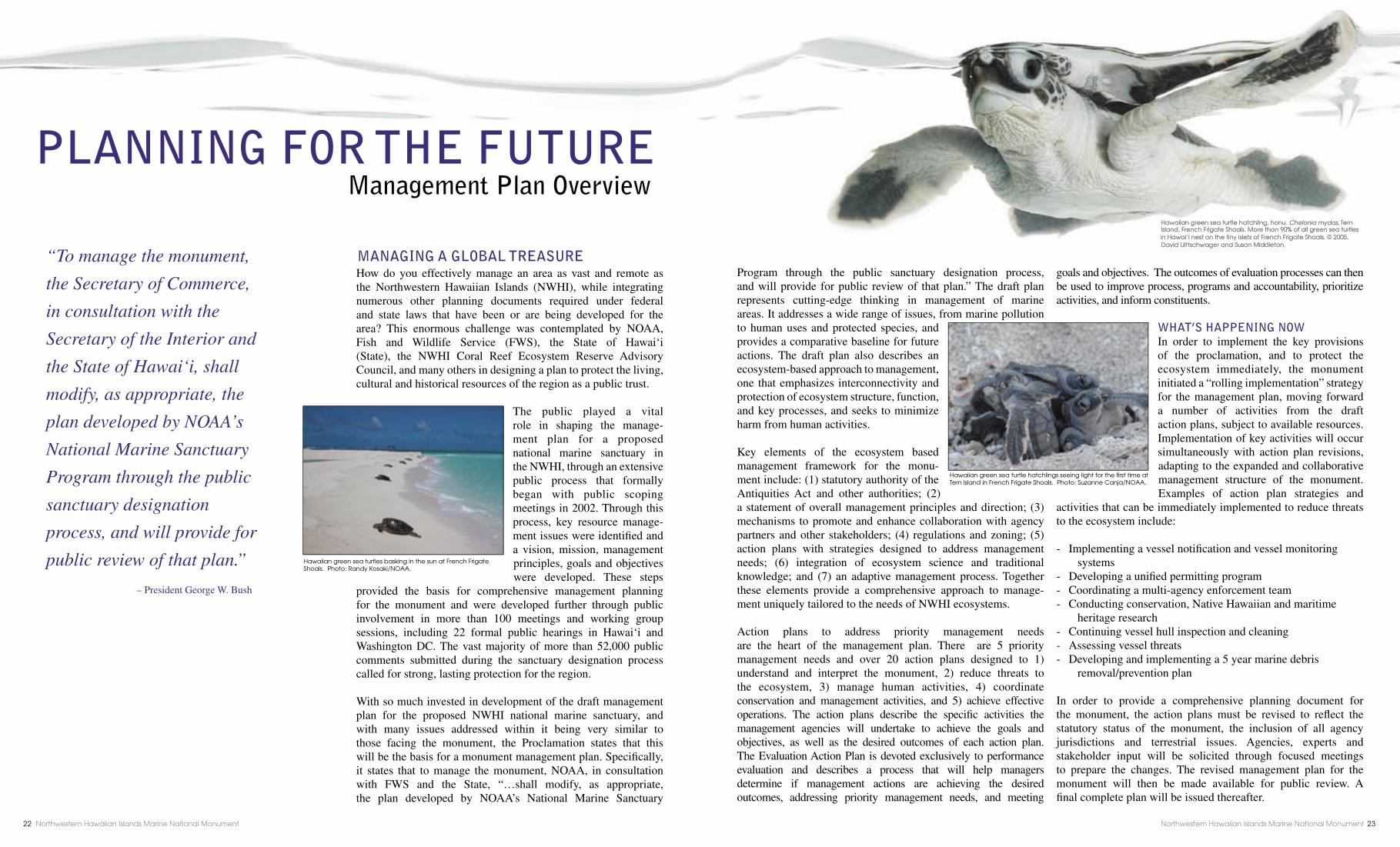
How do you effectively manage an area as vast and remote as the Northwestern Hawaiian Islands (NWHI), while integrating numerous other planning documents required under federal and state laws that have been or are being developed for the area? This enormous challenge was contemplated by NOAA, Fish and Wildlife Service (FWS), the State of Hawai‘i (State), the NWHI Coral Reef Ecosystem Reserve Advisory Council, and many others in designing a plan to protect the living, cultural and historical resources of the region as a public trust.
The public played a vital role in shaping the manage-ment plan for a proposed national marine sanctuary in the NWHI, through an extensive public process that formally began with public scoping meetings in 2002. Through this process, key resource manage-ment issues were identifi ed and a vision, mission, management principles, goals and objectives were developed. These steps
provided the basis for comprehensive management planning for the monument and were developed further through public involvement in more than 100 meetings and working group sessions, including 22 formal public hearings in Hawai‘i and Washington DC. The vast majority of more than 52,000 public comments submitted during the sanctuary designation process called for strong, lasting protection for the region.
With so much invested in development of the draft management plan for the proposed NWHI national marine sanctuary, and with many issues addressed within it being very similar to those facing the monument, the Proclamation states that this will be the basis for a monument management plan. Specifi cally, it states that to manage the monument, NOAA, in consultation with FWS and the State, “…shall modify, as appropriate, the plan developed by NOAA’s National Marine Sanctuary
Program through the public sanctuary designation process, and will provide for public review of that plan.” The draft plan represents cutting-edge thinking in management of marine areas. It addresses a wide range of issues, from marine pollution to human uses and protected species, and provides a comparative baseline for future actions. The draft plan also describes an ecosystem-based approach to management, one that emphasizes interconnectivity and protection of ecosystem structure, function, and key processes, and seeks to minimize harm from human activities.
Key elements of the ecosystem based management framework for the monu-ment include: (1) statutory authority of the Antiquities Act and other authorities; (2) a statement of overall management principles and direction; (3) mechanisms to promote and enhance collaboration with agency partners and other stakeholders; (4) regulations and zoning; (5) action plans with strategies designed to address management needs; (6) integration of ecosystem science and traditional knowledge; and (7) an adaptive management process. Together these elements provide a comprehensive approach to manage-ment uniquely tailored to the needs of NWHI ecosystems.
Action plans to address priority management needs are the heart of the management plan. There are 5 priority management needs and over 20 action plans designed to 1) understand and interpret the monument, 2) reduce threats to the ecosystem, 3) manage human activities, 4) coordinate conservation and management activities, and 5) achieve effective operations. The action plans describe the specifi c activities the management agencies will undertake to achieve the goals and objectives, as well as the desired outcomes of each action plan. The Evaluation Action Plan is devoted exclusively to performance evaluation and describes a process that will help managers determine if management actions are achieving the desired outcomes, addressing priority management needs, and meeting
goals and objectives. The outcomes of evaluation processes can then be used to improve process, programs and accountability, prioritize activities, and inform constituents.
WHAT’S HAPPENING NOWIn order to implement the key provisions of the proclamation, and to protect the ecosystem immediately, the monument initiated a “rolling implementation” strategy for the management plan, moving forward a number of activities from the draft action plans, subject to available resources. Implementation of key activities will occur simultaneously with action plan revisions, adapting to the expanded and collaborative management structure of the monument. Examples of action plan strategies and
activities that can be immediately implemented to reduce threats to the ecosystem include:
- Implementing a vessel notifi cation and vessel monitoring systems- Developing a unifi ed permitting program- Coordinating a multi-agency enforcement team- Conducting conservation, Native Hawaiian and maritime heritage research- Continuing vessel hull inspection and cleaning - Assessing vessel threats- Developing and implementing a 5 year marine debris removal/prevention plan
In order to provide a comprehensive planning document for the monument, the action plans must be revised to refl ect the statutory status of the monument, the inclusion of all agency jurisdictions and terrestrial issues. Agencies, experts and stakeholder input will be solicited through focused meetings to prepare the changes. The revised management plan for the monument will then be made available for public review. A fi nal complete plan will be issued thereafter.
“To manage the monument,
the Secretary of Commerce,
in consultation with the
Secretary of the Interior and
the State of Hawai‘i, shall
modify, as appropriate, the
plan developed by NOAA’s
National Marine Sanctuary
Program through the public
sanctuary designation
process, and will provide for
public review of that plan.”
– President George W. Bush
PLANNING FOR THE FUTURE Management Plan Overview
MANAGING A GLOBAL TREASURE
Hawaiian green sea turtle hatchling, honu, Chelonia mydas, Tern Island, French Frigate Shoals. More than 90% of all green sea turtles in Hawai‘i nest on the tiny islets of French Frigate Shoals. © 2005, David Liittschwager and Susan Middleton.
Hawaiian green sea turtles basking in the sun at French Frigate Shoals. Photo: Randy Kosaki/NOAA.
Hawaiian green sea turtle hatchlings seeing light for the fi rst time at Tern Island in French Frigate Shoals. Photo: Suzanne Canja/NOAA.
Northwestern Hawaiian Islands Marine National Monument22 Northwestern Hawaiian Islands Marine National Monument 23

What is out there and how can we use it?
An endless ocean, the vast Pacifi c, and the islands sprinkled across its surface were
seen as a resource ripe for extraction in the 19th and 20th centuries. Seabird eggs, feathers, and guano, monk
seals, sea turtles and pearl oysters were all harvested from the Northwestern Hawaiian Islands (NWHI). Most commercial enterprises quickly showed diminishing returns from the bountiful yet fragile islands, but research efforts into the 1980’s continued to focus on how the area’s resources could be
exploited to meet human needs.
Early Scientifi c Exploration in the NWHI
1902 marked the first Western scientifi c expedition to the NWHI. The U.S. Fish Commission steamer Albatross visited what they referred to as the “Leeward Islands,” including “Bird Island” (Nihoa), Laysan, and Midway. The fi rst photographs of the fl ightless Laysan rail (now extinct) were taken on this expedition, and new species of deep-water fi shes were collected. In 1923 the research vessel Tanager carried the scientists
to the western edge of the NWHI. Archaeologists and biologists conducted numerous kinds of surveys and documented archaeological sites. Scientists also collected fi lm footage. While on Laysan, the scientists witnessed the extinction of the Laysan apapane when the three remaining birds died during a storm. This may be the only time scientists have actually observed the extinction of an animal in the wild. At Nihoa and Necker Island, the researchers found artifacts and extensive ruins, some of which are unlike any known from the main Hawaiian Islands.
Pacifi c Ocean Biological Survey Program
From 1963 through 1969, a cadre of biologists from the Smithsonian Institute made ten trips to French Frigate Shoals to gather data on plants and animals. The Pacifi c Ocean Biological Survey Program (POBSP) collected a vast amount of data from a little known region. The main goals of the Pacifi c-wide program were to learn what plants and animals occurred on the islands, the seasonal variations in their numbers and reproductive activities and the distribution and population of the pelagic birds of that area. During that time, over 4 million square miles of the central Pacifi c Ocean were surveyed. Never before had such a vast area been surveyed over such an extended period of time. Today, the observations collected in the 1960s help wildlife managers appreciate the importance of long-term monitoring in island ecosystems.
The Tripartite Studies
The National Marine Fisheries Service, Fish and Wildlife Service and Hawai‘i Department of Land and Natural Resources signed the Tripartite Cooperative Agreement in 1978. This provided an unprecedented collaborative research opportunity to document relationships between species and assess how commercial fi shing and other activities might affect the region’s ecosystems. From 1976 to 1981, the agencies, along with the University of Hawai‘i Sea Grant Program, surveyed the islands, banks, reefs, shelves, and seamounts of the NWHI and amassed data on the various marine and land inhabitants.
Much of the research conducted in the 1970s and 80s was resource assessment with an eye towards consumption. A major goal was to identify resources of economic importance. Regardless, the Tripartite studies laid the groundwork for management plans covering a variety of resources ranging from fi sheries stocks to endangered and protected wildlife species. Over 100 research projects were conducted under the Tripartite agreement.
What is out there and how can we conserve it?
In the late 20th century, research efforts became more focused upon conservation of our natural world. This paradigm shift stemmed
from recognition that advances in technology and growing human populations have dramatically increased pressures upon our oceans. Our oceans are still poorly understood compared to terrestrial environments. In this new era of natural resource management, research using advanced technologies will help to increase our understanding of the marine realm. This information will allow management agencies to most effectively protect these habitats, their organisms and the natural processes that connect them.
Movement of Big Predators
Top predators such as sharks, jacks and groupers play an important role in marine ecosystems. By feeding on other organisms, they help to keep the entire ecosystem in balance.
Science-based management and protection requires an understanding of the move-
ment patterns of top predators. Researchers tag sharks and other big fi sh in order to learn about movement patterns in the Hawaiian Archipelago. These tags can relay information on the shark’s position to underwater listening stations or to satellites orbiting hundreds of miles above the Earth.
So far, research has shown that the animals are wide-ranging within the atolls and at least two species move between atolls, crossing the open ocean. One tagged tiger shark traveled from French Frigate Shoals to Kona – 700 miles away. Another traveled from French Frigate Shoals to Midway. Clear patterns of movement have also begun to emerge. Ulua (giant trevally) display regular day/night movements as well as seasonal movement patterns based on the phases of the moon.
Great Frigatebirds
Great frigatebirds, or ‘iwa, are emblematic of the splendor and the fragility of the Northwestern Hawaiian Islands. Recent research has uncovered some surprising things about frigatebirds breeding at French Frigate Shoals. Frigatebirds are very long lived, with some individuals at least 44 years
old, and genetic markers suggest that others are even older. Their reproduction is unique, requiring hard work by both parents for an entire year to raise a single offspring to independence. But unlike most seabirds, frigatebirds choose new mates each time they breed Each winter, thousands of males perform strange court-ship displays that highlight their iridescent feathers and the red balloon-like throat pouch, while a much smaller number of females fly in circles around the breeding colony, comparing the attributes of their enthusiastic suitors.
When not at the breeding colony, frigatebirds fl y long distances over the ocean. With 6-foot wingspans but a weight of only 3 pounds, they use their glider-like bodies to soar high in thermals. Birds marked with wing tags and satellite trans-mitters at French Frigate Shoals have been observed at Laysan, Midway, Johnston Atoll, Wake Island, and even the Philippines.
A Seal’s-Eye View—Monk Seals and CRITTERCAM
Hawaiian monk seals are on the brink of extinction. Only an estimated 1,300 Hawaiian monk seals survive — most of them making their home in the Northwestern Hawaiian Islands. Researchers hope that by using National Geographic’s CRITTERCAM, a video camera glued to the seals’ backs, they can fi nd out what is hindering their survival.
As the seals swim around, the cameras allow researchers to see what habitats are used as foraging areas. Some surprising footage showed adult males cruising over sandy or rocky bottoms, fl ipping over large, fl at rocks in search of food. This showed scientists that the seals were not feeding in the atolls as previously believed, but many miles out to sea and at depths greater than 200 feet.
The cameras have also given insight into seal pups’ fi shing techniques. This could be valuable information, since in recent years many seal pups have starved to death. With only 2 out of 10 pups surviving to their second birthday, juvenile mortality is a signifi cant threat to species survival. Innovative tools, like CRITTERCAM, are essential to collecting the information we need to help these remarkable animals survive.
ResearchTHEN
Research
NOW
carried the scientists to the western edge of the NWHI. Archaeologists
the three remaining birds died during a storm. This may be the only time scientists have actually observed the extinction of an animal in the wild. At Nihoa and Necker Island, the researchers found artifacts and extensive ruins, some of which are unlike any
Researchers insert an acoustic transmitter into a large tiger shark to track its movement. The transmitter data, collected by receiving stations across the Hawaiian Archipelago, will be used by managers to understand the habitat needs of these wide ranging animals. Photo: Robert Schwemmer/NOAA.
A satellite tag attached to this great frigatebird reports where the bird has traveled, and the wing tag will verify its identity. One tagged frigatebird was tracked as far as the Philippines, more than 4,500 miles away. Photo: Fish and Wildlife Service.
The discovery of the Darwin Point, and how it relates to the origin and fate of the Hawaiian Islands, was one of the major discoveries during the Tripartite studies. Compliments of Dr. Richard W. Grigg.
exploited to meet human needs.
Early Scientifi c Exploration in the NWHI
1902 marked the first Western scientifi c expedition to the NWHI. The U.S. Fish Commission steamer Albatrossto as the “Leeward Islands,” including “Bird Island” (Nihoa), Laysan, and Midway. The fi rst photographs of the fl ightless Laysan rail (now extinct) were taken on this expedition, and new species of deep-water fi shes Studying the diets of tigersharks
during the Tripartite studies, 1977. Photo: Mark J. Rauzon.
Northwestern Hawaiian Islands Marine National Monument24 Northwestern Hawaiian Islands Marine National MonumentNorthwestern Hawaiian Islands Marine National Monument 25
Field camp on Nihoa Island. Photo: Fish and Wildlife Service.
Geologically the oldest in the Hawaiian chain, the Northwestern Hawaiian Islands (NWHI) offer a glimpse back in time to when the lands and waters were healthy and teeming with life. These still-wild ecosystems contain powerful lessons for those of us in the main Hawaiian Islands who are witnessing the decline of our fi nite island resources. They teach us the importance of caring for the natural world on which our lives and livelihoods depend, and they give us a living model to guide restoration efforts. The Hawaiian Archipelago is one of the few places in the world where large-scale comparisons of impacted and un-impacted reef and island ecosystems of similar species and geography can be made.
But the remoteness of this vast ocean region presents special challenges as to how these lessons can be shared. With access strictly limited, most people are unable to experience the place directly. Thus, the monument and its partners have created a spectrum of educational and experiential opportunities that indirectly connect people with the NWHI and its biological, historical and cultural wonders – in effect, “bringing the place to the people,” rather than the people to the place.
The monument’s educational initiatives include distance learning, presentations and events promoting ocean conser-vation, teacher workshops, and the Mokupäpapa Discovery
Center for Hawaii’s Remote Coral Reefs in Hilo. In addition, a few educators each year are able to participate in expeditions to the region and subsequently share their experience with their students and communities. Articles and lesson plans from the past few years can be found at: www.hawaiianatolls.org
In 2001, the NWHI co-trustees, Bishop Museum, the Polynesian Voyaging Society and a host of other community and government agencies joined forces to form the Navigating Change educational partnership. Inspired by the vision of the late Pinky Thompson and his son Nainoa, the partnership built an educational program that extends Höküle‘a journeys to the NWHI into schools statewide. These classroom voyages of discovery challenge
students to change their values, attitudes and behaviors, and encourage them to get actively involved in community efforts to mälama and restore the marine and terrestrial environments where they live.
The Hawai‘i Maritime Center, next to Aloha Tower, also hosts an interactive Navigating Change exhibit where visitors can role-play being a scientist exploring the NWHI on a research cruise.
To learn more about Navigating Change curriculum or up-coming teacher workshops, visit: www.navigatingchange.org
WHAT YOU CAN DO
• Learn more about the NWHI and your oceans,
and how to protect them.
• Join our listserve to receive e-updates.
• Arrange a talk in your community.
• Volunteer.
• Attend our public meetings.
• Encourage others to get informed and involved.
GET INVOLVED
Whether you are just now learning about the Northwestern Hawaiian Islands, or have been actively involved with this place for years, we ask for your continued support in caring for this unique and vast ocean region.
The complete revised management plan for the monument will be made available for public review. The management plan is the document that will set the resource management framework for the monument into the future. The public review period will provide an
opportunity to offer your input on how best to conserve and manage the monument for generations to come.
We welcome your mana‘o, your thoughts on how you think the area should be managed, and hope you will take the time to get involved. The important thing to remember is that this is your ocean treasure, and for those who live in Hawai‘i, your back yard.
For more information about the Northwestern Hawaiian Islands Marine National Monument please visit our website at: http://hawaiireef.noaa.gov or contact the monument offi ce at: 808-397-2660.
GET INVOLVED
The new national monument creates a new opportunity for ocean education and
research for decades to come. Successful ocean stewardship depends on informed policy
makers and an informed public. – President George W. Bush
BRINGING THE PLACE TO THE PEOPLE
NAVIGATING CHANGE“No longer do we seek only the knowledge of how to voyage between islands. We seek lessons to carry home to our children - ways to inspire the present generation to love and preserve our Earth as a sanctuary for those who will inherit it.”
— Nainoa Thompson,
Navigator, Höküle‘a
Navigator Nainoa Thompson at Pearl and Hermes Atoll. Photo: NOAA.
Polynesian Voyaging Society Bishop MuseumU.S. Fish and Wildlife ServiceNational Fish and Wildlife FoundationNational Oceanic and Atmospheric Administration
Hawai‘i State Department of Land and Natural ResourcesHawai‘i State Department of EducationUniversity of Hawai‘i MänoaHarold K. L. Castle Foundation
Mokupäpapa Discovery Center for Hawaii’s Remote Coral Reefs, in Hilo, Hawai‘i. Photo: NOAA.
Kamehameha School students explore NWHI through interactive exhibits at Mokupäpapa Discovery Center in Hilo. Photos: James Watt.
Painting by Hilo Artist, Layne Luna. This mural covers one large wall at Mokupäpapa Discovery Center for Hawaii’s Remote Coral Reefs, in Hilo, Hawai‘i.
Volunteer Laura Thompson counts albatrosses at Midway Atoll. Photo: Fish and Wildlife Service.
Stout moray eel, puhi, Gymnothorax eurostus, at Midway Atoll. Photo: © 2005, David Liittschwager and Susan Middleton.
Northwestern Hawaiian Islands Marine National Monument26 Northwestern Hawaiian Islands Marine National Monument 27
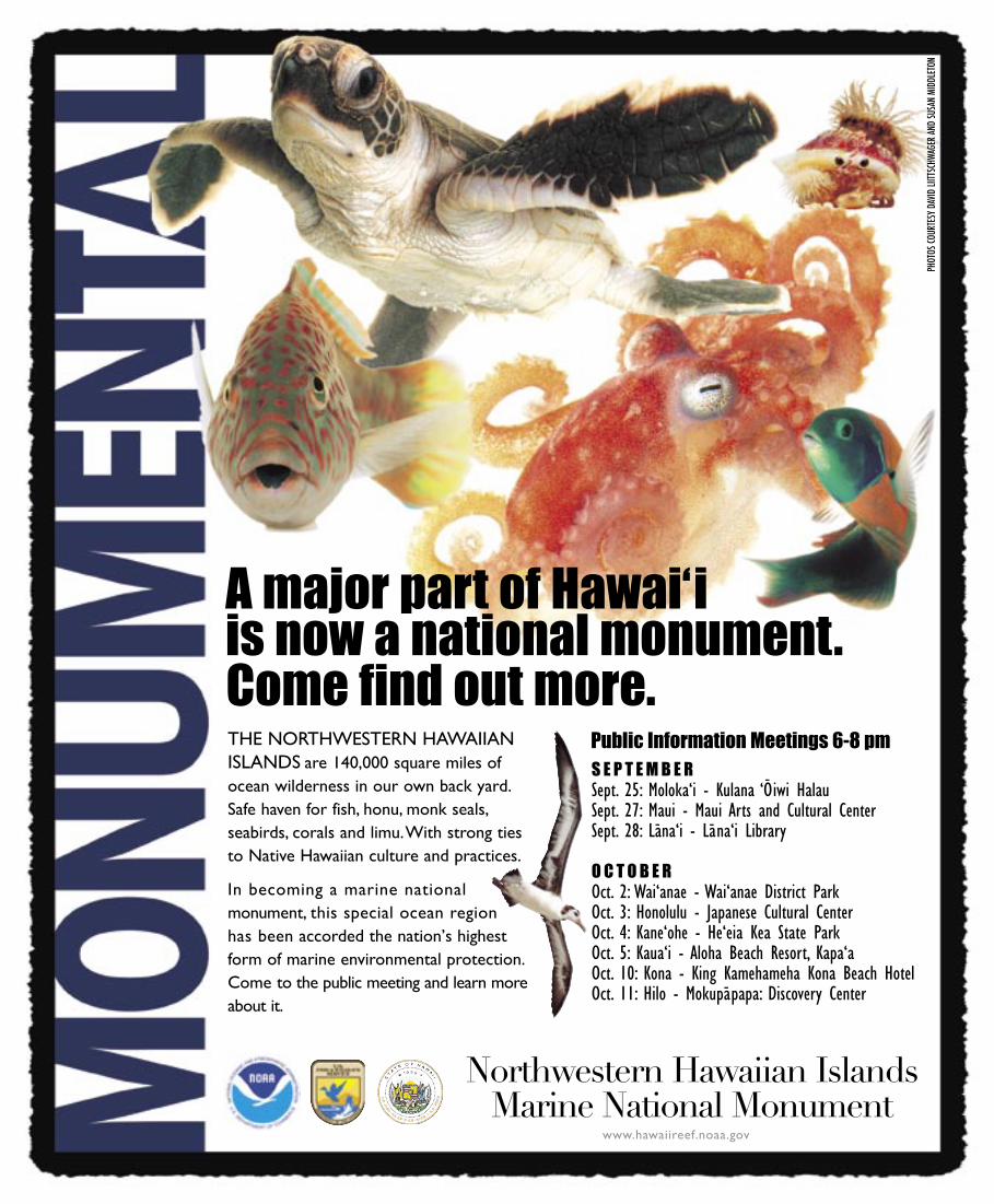
THE NORTHWESTERN HAWAIIANISLANDS are 140,000 square miles ofocean wilderness in our own back yard.Safe haven for fish, honu, monk seals,seabirds, corals and limu.With strong tiesto Native Hawaiian culture and practices.
In becoming a marine national monument, this special ocean regionhas been accorded the nation’s highestform of marine environmental protection.Come to the public meeting and learn moreabout it.
A major part of Hawai‘i is now a national monument. Come find out more.
Northwestern Hawaiian IslandsMarine National Monument
www.hawaiireef.noaa.gov
PHOT
OS CO
URTE
SY D
AVID
LIITT
SCHW
AGER
AND
SUSA
N MI
DDLE
TON
S E P T E M B E RSept. 25: Moloka‘i - Kulana ‘Oiwi HalauSept. 27: Maui - Maui Arts and Cultural CenterSept. 28: Lana‘i - Lana‘i Library
O C T O B E ROct. 2: Wai‘anae - Wai‘anae District ParkOct. 3: Honolulu - Japanese Cultural CenterOct. 4: Kane‘ohe - He‘eia Kea State ParkOct. 5: Kaua‘i - Aloha Beach Resort, Kapa‘aOct. 10: Kona - King Kamehameha Kona Beach HotelOct. 11: Hilo - Mokupapapa: Discovery Center
Public Information Meetings 6-8 pm
Article Analysis Instructions (15 points Total)
Read the entire article before doing the analysis. I know when you don't read the article because your analysis makes no sense at all so READ FIRST!
PURPOSE: (3) • Tell me why the author wrote this article? • Find a sentence in the article that shows where you got your answer from. This is how
you should write the sentence in the analysis: I know this because in the article it states "WRITE THE ENTIRE SENTENCE TN THE QUOTES", • Then explain how the sentence you found backs up or is evidence of your .answer,
POINT OF VIEW (3) • What is the author's point of view? What is the author's side?What does the
author think or want? » Find a sentence in the article that shows where you got your answer from. This is
how you should write the sentence in the analysis: I know this because in the article it states "WRITE THEENTIRE SENTENCE IN THE QUOTES". • Then explain how the sentence you found backs up or is evidence of your answer.
ASSUMPTIONS (2) » Tell me what you think about the article. DO NOT say "I agree with the author" I will
not accept it! • EXPLAIN your thoughts on the article.
CONCLUSION (3) • Tell me what solutions the article has come up with. Even if the solutions are not in
effect yet, tell me what the suggestions are. • Find a sentence in the article that shows where you got your answer from. This is how
you should write the sentence in the analysis: I know this because in the article it states "WRITE THEENTIRE SENTENCE IN THE QUOTES". • Then explain how the sentence you found backs up or is evidence of your answer,
IMPLICATIONS & CONSEQUENCES (2) » Tell me what you think about the solutions in the article. Do you think they are good
or bad and WHY? • Tell me what solutions you can come up with for this problem
CONCEPTS: (2) • List the words you do not know in this article. • Make sure you list a few.

The Last Best Place: Terrestrial Environments
Although some of the Northwestern Hawaiian Islands (NWHI) were decimated by introduced mammals (rabbits, in the case of Laysan), other islets and atolls have been relatively untouched by humans. As a result, robust seabird populations and healthy insect and plant communities can still be found, and in places that were heavily impacted, seabird and plant populations are now on the mend. Nihoa Island is one of the most biologically pristine islands in the Pacifi c, and probably most closely represents the original island appearance and native species found before humans arrived in the Hawaiian Islands.
These islands provide breeding sites for all but three of Hawaii’s 22 species of seabirds such as the grey-backed tern, short-tailed albatross, and the red-tailed tropicbird. Millions of central Pacifi c seabirds congregate on these islands to breed. They nest in burrows and cliffs, on the ground, and in trees and shrubs. For some species, these tiny specks of land provide their only breeding site.
More than 99 percent of the world’s Laysan albatrosses and 98 percent of the world’s black-footed albatrosses return to the NWHI each year to reproduce. For species such as Bonin petrels and Tristram’s storm-petrels, these predator-free islands provide the last safe nesting places since islands in other parts of the Pacifi c are becoming infested with rats. For land birds, the islands have provided less secure habitat, but four of the seven original species still remain. Three endangered passerines (the Nihoa fi nch, Nihoa millerbird, and Laysan fi nch) and the world’s rarest duck – the Laysan duck – are found on these islands.
The plants of the NWHI are primarily coastal strand species of the Pacifi c that can tolerate high salt levels, periodic
drought, and intense sun. Most have seeds capable of dispersing in seawater. Some plants evolved into new species, and six endemic plants are listed under the Endangered Species Act, including the endangered fan palm Pritchardia remota found only on Nihoa. A similar palm went extinct during the rabbit plague on Laysan Island, and in recent years an alien grasshopper has attacked Nihoa’s palms.
The fi rst entomologists (insect scientists) visited Laysan Island in 1893, and upon numerous subsequent visits, identifi ed at least 75 native species, including 15 found only on Laysan. The arthropods and land snails are the least understood components of the terrestrial ecosystems, but studies continue to improve our knowledge. At least 35 species of endemic insects and spiders, and six species of endemic land snails have been identifi ed at Nihoa Island. Unfortunately, positive discoveries are at times offset by negative ones – as many as 125 species of alien insects and spiders have also been found, and some of these, particularly ants, are extremely destructive. Considered “ecosystem busters,” introduced ants have the ability to displace native species, and even affect the survival of ground nesting seabirds.
The Northwestern Hawaiian Islands (NWHI) not only possess incredible natural resources worthy of our best efforts at conservation, but these distant atolls are also the locations of historic shipwreck sites, heritage resources which capture our seafaring past in graphic detail. Since systematic survey began in 2002, our understanding of these sites continues to increase. Each wreck site is like a time capsule, allowing us to glimpse a part of seafaring history.
The wrecks of American and British whaling ships lost during the early decades of the 19th century depict the many hazards associated with seafaring. The debris trail of the American whaler Parker, lost in 1842 during a violent storm, depicts a ship washed entirely into the lagoon at Kure Atoll, equipment being swept off the decks as the vessel passed the reef crest. The wreck of the British whaler Pearl, lost at Pearl and Hermes Atoll in 1822, tells a different story. There, the ship fell apart where she grounded, the crew having wrecked in calmer conditions on the uncharted atoll. Salvage was possible, and soon a schooner named Deliverance was constructed on the beach.
The steam machinery and armament of the USS Saginaw, lost in 1870, represents a slice of Civil War history in the Pacifi c. The remains of the side wheel navy steamer are scattered
on top and underneath the reef crest Heavier objects, such as the cannon, steam engines, and paddlewheel shafts, are solidly embedded in the coralline substrate.
The capstans, anchors, masts, and rigging of the Dunnottar Castle, a 258-foot iron hulled sailing ship lost in 1886, portray the days of the great sailing ships like the Falls of Clyde (now part of the Hawai‘i Maritime Center), the Balcalutha, and the Star of India, a time when our maritime commerce was driven by steel masts and canvas and human hands. The wreck site is an inventory of our industrial wind-driven commerce long before our dependence on fossil fuels.
These and many other heritage sites in the NWHI are rare and protected resources which bear human testimony to unique Pacifi c seafaring experiences. More than 100 vessels and aircraft are known to have been lost in the NWHI. They are unique parts of an untouched museum of our maritime past, set amidst the beauty of the Northwestern Hawaiian Island’s natural environment.
Diver examining the scattered wreck site of the iron hulled sailing ship Dunnottar Castle, lost at Kure Atoll in 1886. Photo: NOAA NMSP.
F A T H O M I N G O U R P A S T MARITIME HERITAGE
Nihoa palm, loulu, Pritchardia remota on Nihoa. Photo: Bonnie Kahape‘a.
Laysan duck, Anas laysanensis, on Laysan Island. Photo: James Watt.
Wedge-tailed shearwater, ‘ua‘u kani, Puffi nus pacifi cus chlororhynchus, Midway Atoll. Photo: © 2005, David Liittschwager and Susan Middleton.
Maritime archaeologists on the site of the British whaler Pearl, lost in 1822 at Pearl and Hermes Atoll. Photo: NOAA NMSP.
Diver measuring rigging pieces from the wreck site of the New Bedford whaler Parker, lost at Kure Atoll 1842. Photo: NOAA NMSP.
Large paddle wheel shaft from the wreck of the USS Saginaw lost at Kure Atoll in 1870. Photo: NOAA NMSP.
Northwestern Hawaiian Islands Marine National Monument8 Northwestern Hawaiian Islands Marine National Monument 9
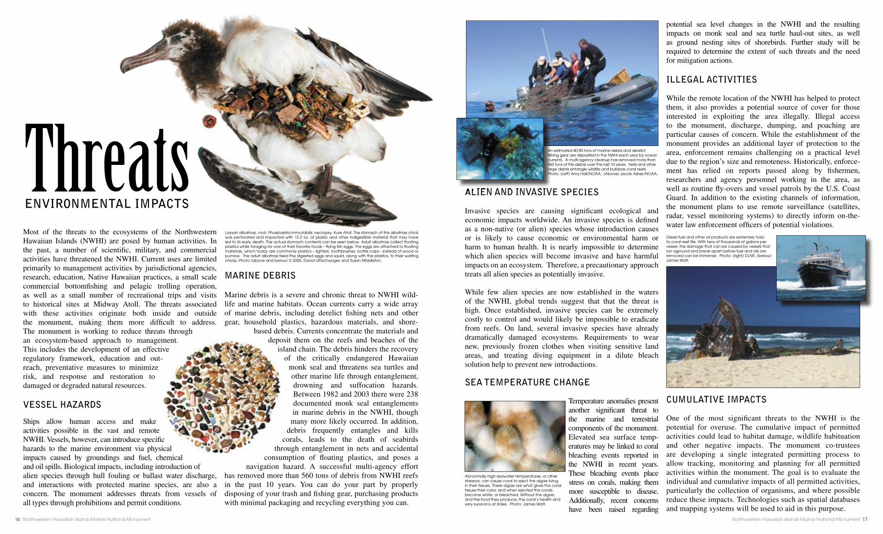
Most of the threats to the ecosystems of the Northwestern Hawaiian Islands (NWHI) are posed by human activities. In the past, a number of scientifi c, military, and commercial activities have threatened the NWHI. Current uses are limited primarily to management activities by jurisdictional agencies, research, education, Native Hawaiian practices, a small scale commercial bottomfi shing and pelagic trolling operation, as well as a small number of recreational trips and visits to historical sites at Midway Atoll. The threats associated with these activities originate both inside and outside the monument, making them more diffi cult to address. The monument is working to reduce threats through an ecosystem-based approach to management.This includes the development of an effective regulatory framework, education and out-reach, preventative measures to minimize risk, and response and restoration to damaged or degraded natural resources.
VESSEL HAZARDS
Ships allow human access and make activities possible in the vast and remote NWHI. Vessels, however, can introduce specifi c hazards to the marine environment via physical impacts caused by groundings and fuel, chemical and oil spills. Biological impacts, including introduction of alien species through hull fouling or ballast water discharge, and interactions with protected marine species, are also a concern. The monument addresses threats from vessels of all types through prohibitions and permit conditions.
MARINE DEBRIS
Marine debris is a severe and chronic threat to NWHI wild-life and marine habitats. Ocean currents carry a wide array of marine debris, including derelict fi shing nets and other gear, household plastics, hazardous materials, and shore-
based debris. Currents concentrate the materials and deposit them on the reefs and beaches of the
island chain. The debris hinders the recovery of the critically endangered Hawaiian
monk seal and threatens sea turtles and other marine life through entanglement, drowning and suffocation hazards. Between 1982 and 2003 there were 238 documented monk seal entanglements in marine debris in the NWHI, though many more likely occurred. In addition,
debris frequently entangles and kills corals, leads to the death of seabirds
through entanglement in nets and accidental consumption of fl oating plastics, and poses a
navigation hazard. A successful multi-agency effort has removed more than 560 tons of debris from NWHI reefs in the past 10 years. You can do your part by properly disposing of your trash and fi shing gear, purchasing products with minimal packaging and recycling everything you can.
ALIEN AND INVASIVE SPECIES
Invasive species are causing signifi cant ecological and economic impacts worldwide. An invasive species is defi ned as a non-native (or alien) species whose introduction causes or is likely to cause economic or environmental harm or harm to human health. It is nearly impossible to determine which alien species will become invasive and have harmful impacts on an ecosystem. Therefore, a precautionary approach treats all alien species as potentially invasive.
While few alien species are now established in the waters of the NWHI, global trends suggest that that the threat is high. Once established, invasive species can be extremely costly to control and would likely be impossible to eradicate from reefs. On land, several invasive species have already dramatically damaged ecosystems. Requirements to wear new, previously frozen clothes when visiting sensitive land areas, and treating diving equipment in a dilute bleach solution help to prevent new introductions.
SEA TEMPERATURE CHANGE
Temperature anomalies present another signifi cant threat to the marine and terrestrial components of the monument. Elevated sea surface temp-eratures may be linked to coral bleaching events reported in the NWHI in recent years. These bleaching events place stress on corals, making them more susceptible to disease. Additionally, recent concerns have been raised regarding
potential sea level changes in the NWHI and the resulting impacts on monk seal and sea turtle haul-out sites, as well as ground nesting sites of shorebirds. Further study will be required to determine the extent of such threats and the need for mitigation actions.
ILLEGAL ACTIVITIES
While the remote location of the NWHI has helped to protect them, it also provides a potential source of cover for those interested in exploiting the area illegally. Illegal access to the monument, discharge, dumping, and poaching are particular causes of concern. While the establishment of the monument provides an additional layer of protection to the area, enforcement remains challenging on a practical level due to the region’s size and remoteness. Historically, enforce-ment has relied on reports passed along by fi shermen, researchers and agency personnel working in the area, as well as routine fl y-overs and vessel patrols by the U.S. Coast Guard. In addition to the existing channels of information, the monument plans to use remote surveillance (satellites, radar, vessel monitoring systems) to directly inform on-the-water law enforcement offi cers of potential violations.
CUMULATIVE IMPACTS
One of the most signifi cant threats to the NWHI is the potential for overuse. The cumulative impact of permitted activities could lead to habitat damage, wildlife habituation and other negative impacts. The monument co-trustees are developing a single integrated permitting process to allow tracking, monitoring and planning for all permitted activities within the monument. The goal is to evaluate the individual and cumulative impacts of all permitted activities, particularly the collection of organisms, and where possible reduce these impacts. Technologies such as spatial databases and mapping systems will be used to aid in this purpose.
ThreatsENVIRONMENTAL IMPACTS
ALIEN AND INVASIVE SPECIESALIEN AND INVASIVE SPECIES
Laysan albatross, moli, Phoebastria immutabilis, necropsy, Kure Atoll. The stomach of this albatross chick was perforated and impacted with 12.2 oz. of plastic and other indigestible material that may have led to its early death. The actual stomach contents can be seen below. Adult albatross collect fl oating plastics while foraging for one of their favorite foods – fl ying fi sh eggs. The eggs are attached to fl oating materials, which today are commonly plastics – lighters, toothbrushes, bottle caps - instead of wood or pumice. The adult albatross feed the digested eggs and squid, along with the plastics, to their waiting chicks. Photo (above and below) © 2005, David Liittschwager and Susan Middleton.
An estimated 40-80 tons of marine debris and derelict fi shing gear are deposited in the NWHI each year by ocean currents. A multi-agency cleanup has removed more than 560 tons of this debris over the last 10 years. Nets and other large debris entangle wildlife and bulldoze coral reefs. Photo: (Left) Amy Hall/NOAA, (Above) Jacob Asher/NOAA.
Diesel fuel and other oil products are extremely toxic to coral reef life. With tens of thousands of gallons per vessel, the damage that can be caused by vessels that run aground and break apart before fuel and oils are removed can be immense. Photo: (right) DLNR, (below) James Watt.
Abnormally high seawater temperatures, or other stressors, can cause coral to eject the algae living in their tissues. These algae are what gives the coral tissues their color, and when ejected the corals become white, or bleached. Without the algae, and the food they produce, the coral’s health and very survival is at stake. Photo: James Watt.
Northwestern Hawaiian Islands Marine National Monument16 Northwestern Hawaiian Islands Marine National Monument 17
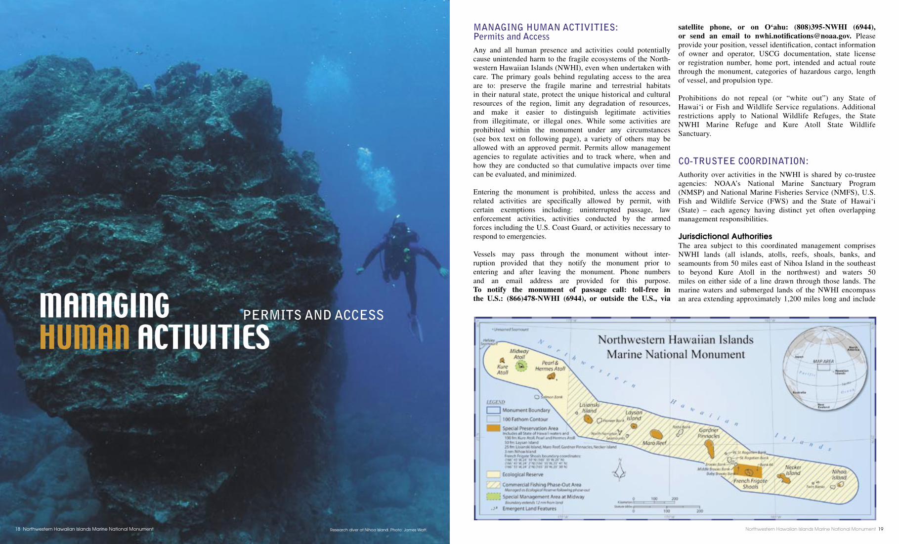
MANAGING HUMAN ACTIVITIES: Permits and AccessAny and all human presence and activities could potentially cause unintended harm to the fragile ecosystems of the North-western Hawaiian Islands (NWHI), even when undertaken with care. The primary goals behind regulating access to the area are to: preserve the fragile marine and terrestrial habitats in their natural state, protect the unique historical and cultural resources of the region, limit any degradation of resources, and make it easier to distinguish legitimate activities from illegitimate, or illegal ones. While some activities are prohibited within the monument under any circumstances (see box text on following page), a variety of others may be allowed with an approved permit. Permits allow management agencies to regulate activities and to track where, when and how they are conducted so that cumulative impacts over time can be evaluated, and minimized.
Entering the monument is prohibited, unless the access and related activities are specifi cally allowed by permit, with certain exemptions including: uninterrupted passage, law enforcement activities, activities conducted by the armed forces including the U.S. Coast Guard, or activities necessary to respond to emergencies.
Vessels may pass through the monument without inter-ruption provided that they notify the monument prior to entering and after leaving the monument. Phone numbers and an email address are provided for this purpose. To notify the monument of passage call: toll-free in the U.S.: (866)478-NWHI (6944), or outside the U.S., via
satellite phone, or on O‘ahu: (808)395-NWHI (6944), or send an email to nwhi.notifi [email protected]. Please provide your position, vessel identifi cation, contact information of owner and operator, USCG documentation, state license or registration number, home port, intended and actual route through the monument, categories of hazardous cargo, length of vessel, and propulsion type.
Prohibitions do not repeal (or “white out”) any State of Hawai‘i or Fish and Wildlife Service regulations. Additional restrictions apply to National Wildlife Refuges, the State NWHI Marine Refuge and Kure Atoll State Wildlife Sanctuary.
CO-TRUSTEE COORDINATION:Authority over activities in the NWHI is shared by co-trustee agencies: NOAA’s National Marine Sanctuary Program (NMSP) and National Marine Fisheries Service (NMFS), U.S. Fish and Wildlife Service (FWS) and the State of Hawai‘i (State) – each agency having distinct yet often overlapping management responsibilities.
Jurisdictional AuthoritiesThe area subject to this coordinated management comprises NWHI lands (all islands, atolls, reefs, shoals, banks, and seamounts from 50 miles east of Nihoa Island in the southeast to beyond Kure Atoll in the northwest) and waters 50 miles on either side of a line drawn through those lands. The marine waters and submerged lands of the NWHI encompass an area extending approximately 1,200 miles long and include MANAGING
HUMAN ACTIVITIES PERMITS AND ACCESS
Research diver at Nihoa Island. Photo: James Watt.Northwestern Hawaiian Islands Marine National Monument18 Northwestern Hawaiian Islands Marine National Monument 19
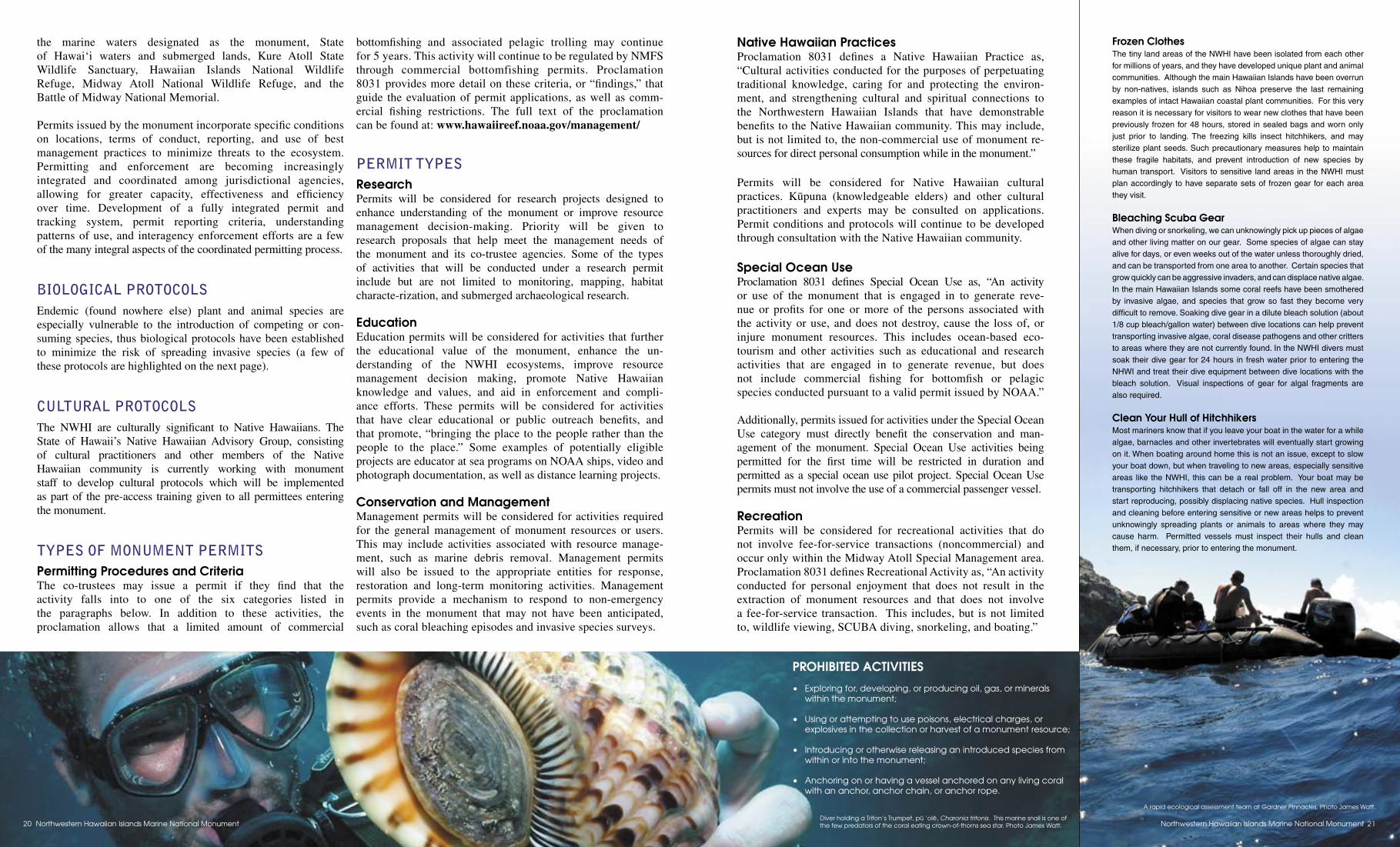
the marine waters designated as the monument, State of Hawai‘i waters and submerged lands, Kure Atoll State Wildlife Sanctuary, Hawaiian Islands National Wildlife Refuge, Midway Atoll National Wildlife Refuge, and the Battle of Midway National Memorial.
Permits issued by the monument incorporate specifi c conditions on locations, terms of conduct, reporting, and use of best management practices to minimize threats to the ecosystem. Permitting and enforcement are becoming increasingly integrated and coordinated among jurisdictional agencies, allowing for greater capacity, effectiveness and effi ciency over time. Development of a fully integrated permit and tracking system, permit reporting criteria, understanding patterns of use, and interagency enforcement efforts are a few of the many integral aspects of the coordinated permitting process.
BIOLOGICAL PROTOCOLSEndemic (found nowhere else) plant and animal species are especially vulnerable to the introduction of competing or con-suming species, thus biological protocols have been established to minimize the risk of spreading invasive species (a few of these protocols are highlighted on the next page).
CULTURAL PROTOCOLSThe NWHI are culturally signifi cant to Native Hawaiians. The State of Hawaii’s Native Hawaiian Advisory Group, consisting of cultural practitioners and other members of the Native Hawaiian community is currently working with monument staff to develop cultural protocols which will be implemented as part of the pre-access training given to all permittees entering the monument.
TYPES OF MONUMENT PERMITSPermitting Procedures and CriteriaThe co-trustees may issue a permit if they fi nd that the activity falls into to one of the six categories listed in the paragraphs below. In addition to these activities, the proclamation allows that a limited amount of commercial
bottomfi shing and associated pelagic trolling may continue for 5 years. This activity will continue to be regulated by NMFS through commercial bottomfishing permits. Proclamation 8031 provides more detail on these criteria, or “fi ndings,” that guide the evaluation of permit applications, as well as comm-ercial fi shing restrictions. The full text of the proclamation can be found at: www.hawaiireef.noaa.gov/management/
PERMIT TYPESResearchPermits will be considered for research projects designed to enhance understanding of the monument or improve resource management decision-making. Priority will be given to research proposals that help meet the management needs of the monument and its co-trustee agencies. Some of the types of activities that will be conducted under a research permit include but are not limited to monitoring, mapping, habitat characte-rization, and submerged archaeological research.
EducationEducation permits will be considered for activities that further the educational value of the monument, enhance the un-derstanding of the NWHI ecosystems, improve resource management decision making, promote Native Hawaiian knowledge and values, and aid in enforcement and compli-ance efforts. These permits will be considered for activities that have clear educational or public outreach benefi ts, and that promote, “bringing the place to the people rather than the people to the place.” Some examples of potentially eligible projects are educator at sea programs on NOAA ships, video and photograph documentation, as well as distance learning projects.
Conservation and ManagementManagement permits will be considered for activities required for the general management of monument resources or users. This may include activities associated with resource manage-ment, such as marine debris removal. Management permits will also be issued to the appropriate entities for response, restoration and long-term monitoring activities. Management permits provide a mechanism to respond to non-emergency events in the monument that may not have been anticipated, such as coral bleaching episodes and invasive species surveys.
Native Hawaiian PracticesProclamation 8031 defi nes a Native Hawaiian Practice as, “Cultural activities conducted for the purposes of perpetuating traditional knowledge, caring for and protecting the environ-ment, and strengthening cultural and spiritual connections to the Northwestern Hawaiian Islands that have demonstrable benefi ts to the Native Hawaiian community. This may include, but is not limited to, the non-commercial use of monument re-sources for direct personal consumption while in the monument.”
Permits will be considered for Native Hawaiian cultural practices. Küpuna (knowledgeable elders) and other cultural practitioners and experts may be consulted on applications. Permit conditions and protocols will continue to be developed through consultation with the Native Hawaiian community.
Special Ocean UseProclamation 8031 defi nes Special Ocean Use as, “An activity or use of the monument that is engaged in to generate reve-nue or profi ts for one or more of the persons associated with the activity or use, and does not destroy, cause the loss of, or injure monument resources. This includes ocean-based eco-tourism and other activities such as educational and research activities that are engaged in to generate revenue, but does not include commercial fi shing for bottomfi sh or pelagic species conducted pursuant to a valid permit issued by NOAA.”
Additionally, permits issued for activities under the Special Ocean Use category must directly benefi t the conservation and man-agement of the monument. Special Ocean Use activities being permitted for the fi rst time will be restricted in duration and permitted as a special ocean use pilot project. Special Ocean Usepermits must not involve the use of a commercial passenger vessel.
RecreationPermits will be considered for recreational activities that do not involve fee-for-service transactions (noncommercial) and occur only within the Midway Atoll Special Management area. Proclamation 8031 defi nes Recreational Activity as, “An activity conducted for personal enjoyment that does not result in the extraction of monument resources and that does not involve a fee-for-service transaction. This includes, but is not limited to, wildlife viewing, SCUBA diving, snorkeling, and boating.”
PROHIBITED ACTIVITIES
• Exploring for, developing, or producing oil, gas, or minerals within the monument;
• Using or attempting to use poisons, electrical charges, or explosives in the collection or harvest of a monument resource;
• Introducing or otherwise releasing an introduced species from within or into the monument;
• Anchoring on or having a vessel anchored on any living coral with an anchor, anchor chain, or anchor rope.
Frozen ClothesThe tiny land areas of the NWHI have been isolated from each other for millions of years, and they have developed unique plant and animal communities. Although the main Hawaiian Islands have been overrun by non-natives, islands such as Nihoa preserve the last remaining examples of intact Hawaiian coastal plant communities. For this very reason it is necessary for visitors to wear new clothes that have been previously frozen for 48 hours, stored in sealed bags and worn only just prior to landing. The freezing kills insect hitchhikers, and may sterilize plant seeds. Such precautionary measures help to maintain these fragile habitats, and prevent introduction of new species by human transport. Visitors to sensitive land areas in the NWHI must plan accordingly to have separate sets of frozen gear for each area they visit.
Bleaching Scuba GearWhen diving or snorkeling, we can unknowingly pick up pieces of algae and other living matter on our gear. Some species of algae can stay alive for days, or even weeks out of the water unless thoroughly dried, and can be transported from one area to another. Certain species that grow quickly can be aggressive invaders, and can displace native algae. In the main Hawaiian Islands some coral reefs have been smothered by invasive algae, and species that grow so fast they become very diffi cult to remove. Soaking dive gear in a dilute bleach solution (about 1/8 cup bleach/gallon water) between dive locations can help prevent transporting invasive algae, coral disease pathogens and other critters to areas where they are not currently found. In the NWHI divers must soak their dive gear for 24 hours in fresh water prior to entering the NHWI and treat their dive equipment between dive locations with the bleach solution. Visual inspections of gear for algal fragments are also required.
Clean Your Hull of HitchhikersMost mariners know that if you leave your boat in the water for a while algae, barnacles and other invertebrates will eventually start growing on it. When boating around home this is not an issue, except to slow your boat down, but when traveling to new areas, especially sensitive areas like the NWHI, this can be a real problem. Your boat may be transporting hitchhikers that detach or fall off in the new area and start reproducing, possibly displacing native species. Hull inspection and cleaning before entering sensitive or new areas helps to prevent unknowingly spreading plants or animals to areas where they may cause harm. Permitted vessels must inspect their hulls and clean them, if necessary, prior to entering the monument.
Diver holding a Triton’s Trumpet, pü ‘olë, Charonia tritonis. This marine snail is one of the few predators of the coral eating crown-of-thorns sea star. Photo James Watt.
A rapid ecological assessment team at Gardner Pinnacles. Photo James Watt.
Northwestern Hawaiian Islands Marine National Monument20 Northwestern Hawaiian Islands Marine National Monument 21
Student Name_________________________________
Northwestern Hawaiian Islands Quiz Complete the quiz answering each question to the best of your ability. You should be able to answer all the questions with the knowledge that you gained during your NWHI interactive lesson.
1) This island is home to the endemic Laysan Finch and Laysan Duck.
2) What island of the NWHI is the largest volcanic island of the NWHI?
3) This NWHI is the Northernmost in the chain of NWHI
4) List the names (either English or Hawaiian) of 5 NWHI
5) List the names of 3 animals that can be found in the NWHI that utilize the islands
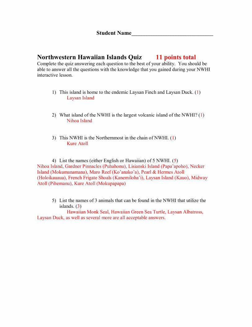
Student Name_________________________________
Northwestern Hawaiian Islands Quiz 11 points total Complete the quiz answering each question to the best of your ability. You should be able to answer all the questions with the knowledge that you gained during your NWHI interactive lesson.
1) This island is home to the endemic Laysan Finch and Laysan Duck. (1) Laysan Island
2) What island of the NWHI is the largest volcanic island of the NWHI? (1) Nihoa Island
3) This NWHI is the Northernmost in the chain of NWHI. (1) Kure Atoll
4) List the names (either English or Hawaiian) of 5 NWHI. (5) Nihoa Island, Gardner Pinnacles (Puhahonu), Lisianski Island (Papa’apoho), Necker Island (Mokumanamana), Maro Reef (Ko’anako’a), Pearl & Hermes Atoll (Holoikauaua), French Frigate Shoals (Kanemiloha’i), Laysan Island (Kauo), Midway Atoll (Pihemanu), Kure Atoll (Mokupapapa)
5) List the names of 3 animals that can be found in the NWHI that utilize the islands. (3)
Hawaiian Monk Seal, Hawaiian Green Sea Turtle, Laysan Albatross, Laysan Duck, as well as several more are all acceptable answers.

nwhı, currents and pollutıon
Concepts Currents are the oceans major means of distributing sea water around the globe. With them they carry pollution and marine debris that has a direct effect on the shores and animals of the NWHI .
Standards Addressed SC.8.5.1, 8.8.6, 8.8.7
Duration 1 1/2 hour
Source Material NOAA
Vocabulary Currents Surface Circulation Deep Circulation Gyre Coriolis Effect
Ocean Currents
Summary Students will learn what causes ocean currents and how they play a role in distributing marine debris and pollution around the world. They will also learn what causes the Coriolis Effect and El Nino.
Objectives • Students will watch an internet video on ocean currents and
complete a worksheet based on what the learned • Students will practice their understanding of the Coriolis
Effect by playing an internet based game on this phenomena • Students will gain an understanding of global impacts that
currents could cause due to global warming
Materials Computer with Internet connection (audio enabled) Ocean current handout Ocean current worksheet
Making Connections Students may recall personal experiences when they have experienced an El Nino year and how it differed from a ‘normal’ year weatherwise. They may also realize why certain marine debris that they have encountered at the beach made its way to Hawaii from other geographic areas.
Teacher Prep for Activity Activity 1: NOAA Internet Video Copy Ocean Current Internet Lesson worksheet so that each student has a copy. Be familiar with Ocean Current Internet Video, lesson 8 http://www.learningdemo.com/noaa/ Activity 2: Coriolis Effect Become familiar with Coriolis Effect game on NOAA website, lesson 8 http://www.learningdemo.com/noaa/
Background Currents are cohesive streams of seawater that circulate through the oceans. Some are shortlived and small, while others are vast flows that take centuries to complete a circuit of the globe. Currents are caused by winds, gravity, and variations in water density in different parts of the ocean. There are two distinct current systems in the oceans–surface circulation, which stirs a relatively thin upper layer of the sea, and deep circulation, which sweeps along the deepsea floor.
The dominant pattern of surface circulation is the gyre–a wellorganized, roughly circular flow. Five enormous gyres spin in subtropical waters, two in both the Atlantic and Pacific Oceans, and one in the Indian Ocean. Smaller polar gyres stir the northern Atlantic and Pacific. One surface current circles endlessly around Antarctica.
These gyres are made up of currents set in motion by winds and gravity, and steered by the placement of the continents and the rotation of the Earth. Wind is the most important cause of surface currents. Winds and gravity start water moving, but the currents that form don't flow parallel to the wind or straight down the steepest surface. Instead, the currents move at an angle to the force that generates them–a phenomenon called the Coriolis Effect. The Coriolis Effect occurs because the earth's surface rotates faster at the equator than at the poles.
Procedure Activity 1: NOAA Internet Video on Ocean Currents 1. Distribute background information and Ocean Current worksheet packet to each student. 2. Have each student or small groups of students navigate to the NOAA website and upload
the Ocean Current Lesson # 8 video (http://www.learningdemo.com/noaa/). 3. Have students begin watching Ocean Currents Internet video lesson, ~ 10 minutes.
Students should be taking notes as they watch the video. 4. Upon completion of video, students should begin to answer questions provided on the
Ocean Currents worksheet. If students need to go back throughout the video to locate correct answers they will have the option to do so on their computers, or they can use the background information that was provided by teacher at the beginning of the lesson.
5. If time allows, discuss question answers in class.
Activity 2: The Coriolis Effect Game 1. From the Ocean Currents lesson webpage (http://www.learningdemo.com/noaa/), have
students navigate to the Coriolis Effect game. 2. Have the students read the direction and practice their knowledge of the Coriolis Effect. 3. Ask the students to raise their hand to volunteer to demonstrate how the Coriolis Effect
works using the game as example.
Assessments Questions Formulated Worksheets Completed
Resources http://www.learningdemo.com/noaa/
Ocean Currents [Text from http://www.learningdemo.com/noaa/ Lesson 08]
Introduction
When poets and storytellers speak of the ocean they are often struck by its constant, restless motion, from the rolling deep of the open sea to the crashing coastal surf. Even the most casual observer is impressed by the swirl of tides or the march of waves against the shore. But few note the silent, subtle passage of currents. Yet the power of currents to move and control the seas is unmatched.
Lesson
Currents are cohesive streams of seawater that circulate through the oceans. Some are shortlived and small, while others are vast flows that take centuries to complete a circuit of the globe. [The Gulf Stream Current, which shows up in this temperature coded satellite image as a broad dark orange swath, has followed this course through the North Atlantic for millennia.] In contrast, the small eddy currents that spin off the Gulf Stream die out within a few months.
Currents are caused by winds, gravity, and variations in water density in different parts of the ocean. There are two distinct current systems in the oceans–surface circulation, which stirs a relatively thin upper layer of the sea, and deep circulation, which sweeps along the deepsea floor.
The dominant pattern of surface circulation is the gyre–a wellorganized, roughly circular flow. Five enormous gyres spin in subtropical waters, two in both the Atlantic and Pacific Oceans, and one in the Indian Ocean. Smaller polar gyres stir the northern Atlantic and Pacific. One surface current circles endlessly around Antarctica.
These gyres are made up of currents set in motion by winds and gravity, and steered by the placement of the continents and the rotation of the Earth. Wind is the most important cause of surface currents. When strong, sustained winds blow across the sea, friction drags a thin layer of water into motion.
The movement of the very topmost layer of the sea pulls on the water just beneath, which then in turn starts the layer under it moving. Energy from the wind is quickly dissipated, so winddriven currents slow down with depth, and finally die out within a few hundred meters of the surface.
Surface currents are also triggered by gravity. The top of the sea is not flat but has broad hills and valleys. Where currents converge or run into a continent, water piles up. The major ocean gyres circle around a low mound a meter or so high. And in summer, intense sunlight can heat and expand seawater, raising the surface by several centimeters in the tropics.
Currents run down these gentle slopes under the pull of gravity. Winds and gravity start water moving, but the currents that form don't flow parallel to the wind or straight down the steepest surface. Instead, the currents move at an angle to the force that generates them–a phenomenon called the Coriolis effect.
The Coriolis Effect occurs because the earth's surface rotates faster at the equator than at the poles. It influences the paths of moving objects that are only loosely in contact with the ground, from currents to winds to airplanes.
When objects move toward higher, slower moving latitudes, they outpace the rotation of the surface, and seem to veer toward the east. [If this plane left Miami heading straight at Chicago, it would miss its target unless it corrects for the Coriolis Effect.] When objects move toward lower, faster moving latitudes, they lag behind the rotation of the surface. [This plane from Valparaiso veers toward the west and misses its destination of Santa Cruz by not adjusting for the Coriolis Effect.] The Coriolis deflection is to the right in the northern hemisphere, and to the left in the southern hemisphere.
The movements of currents are also constrained by the shape of the ocean basins. When a current runs into a continent, it must turn aside. The complex interplay between wind, gravity, Coriolis Effect, and topography determines the location, size, shape, and direction of the surface current gyres. [For example,
consider this North Atlantic gyre. Like all the subtropical gyres, it is triggered by 2 of Earth's prevailing winds–the trade winds and the westerlies.]
The trade winds start a current that is turned by the Coriolis Effect into a westward flow along the equator. The Equatorial Current gets warmer and warmer as it travels across the tropics. On the other side of the gyre, winds known as the westerlies, combined with the Coriolis deflection, push midlatitude water to the east. Called the North Atlantic Current, this flow loses heat to the atmosphere.
The eastern and western currents of the gyre begin where the equatorial and midlatitude currents are blocked by land. On the Atlantic's western boundary, the Gulf Stream moves away from the equator and flows north. The Gulf Stream is the strongest, deepest, and fastest part of the gyre, and it transports an enormous amount of heat toward the poles. Finally, the slow and very shallow Canary Current runs south along the eastern edge of the Atlantic, carrying cold water to the equator to complete the gyre. A single trip around this circuit takes about 10 years.
Although the gyres dominate, a number of other currents also make important contributions to surface circulation. For example, the very warm Equatorial Countercurrent, which flows eastward, can help trigger the unusual weather pattern called El Nino. A much colder flow, called the Labrador Current, travels along the west side of Greenland. This current is notorious for flushing icebergs, including the one that sank the Titanic, into the heavily traveled North Atlantic shipping lanes.
Many surface currents the ones with names have been in constant motion for millennia. Other currents are temporary–longshore, rip, and upwelling currents only run in certain seasons or weather conditions. Longshore currents flow along coastlines when waves run into the shore at an angle. They bulldoze great volumes of sand along the shore, causing beaches to disappear and harbors to fill in. Rip currents form where obstacles channel water away from the shoreline. Many an unwary swimmer and beachcomber has been swept out to sea after stumbling into a rip.
Upwelling occurs when winds push surface water away from the shore, and deeper water rises to fill the gap. These cold currents bring nutrients to the surface and stimulate high plant and animal productivity. Deepwater circulation has a scale, pace, and power very different from surface circulation. Deep currents twist together into a continuous stream that loops through all the oceans, called the global conveyer belt. With a volume more than 16 times the combined flow of all the world's rivers, the conveyer belt slowly but steadily empties one ocean into another, and over the course of 1,000 years, turns the water in them upside down.
This vast, global circulation is driven by density variations in the ocean. Sometimes called thermohaline circulation because it depends on temperature and salinity, the conveyer begins on the surface of the sea near the poles. There, the water gets very cold, chilled by low air temperatures to freezing and below. Polar seawater also gets saltier, because when sea ice forms, the salt is left behind. As seawater gets colder and saltier, its density increases, and it starts to sink toward the bottom. Surface water is pulled in to replace the sinking water, and in its turn, eventually becomes cold and salty enough to sink. Thus, a current begins.
The conveyer belt begins at the surface of the North Atlantic where great amounts of water cool and sink off the coast of Greenland. Hemmed in by the continents, this new deep water can only flow south, past the equator, all the way to the far ends of Africa and South America. As the current travels around the edge of Antarctica, fresh streams of cold water sink into and recharge the conveyer belt.
Two sections split off and turn northward, one into the Indian Ocean, the other into the Pacific. Both these currents warm up and become less and less dense as they travel, enough that they eventually rise back toward the surface. Drawn by the inexorable pull of the conveyer belt, these now warm waters loop back the way they came and eventually return to the North Atlantic to begin the long journey all over again.
Global Impact
Currents are an integral and dynamic part of the world's oceans–they help determine the characteristics and behavior of seawater, and the distribution and abundance of marine life. But currents are surprisingly
important to landlocked creatures like us as well because they partially regulate the global climate and govern the productivity of fishing grounds.
Upwelling, the rise of deeper water to the surface, occurs only on 10% of the ocean. But that small area makes up half of the world's fisheries. The cool, nutrientfilled water in upwelling currents support blooms of algae and seaweed, the base of the food chain for many clams, crustaceans, and fish. Herring, anchovy, and sardines, three of the most widely harvested fish, are especially concentrated in upwelling zones. Such sea life is an increasingly large component of man's food supply.
Currents play an important role in the Earth's climate system. Overall, ocean currents moderate the planet's temperature extremes. Warm flows, like the western boundary currents, carry heat from the tropics toward the poles. Cold flows, such as the eastern boundary currents, bring cooler temperatures to low latitudes. On a regional scale, some areas are even more strongly affected. Because Western Europe is bathed in warm waters and winds coming east across the Atlantic, its climate is much warmer and milder than other areas at the same latitude, such as northern Canada and Alaska.
Although the ocean currents that affect climate are large and vigorous, scientists are beginning to suspect that they are surprisingly easy to disrupt. It is possible that global warming could severely alter current patterns, at least in the short term. If there is more rainfall in the North Atlantic, and significant melting of glacial and sea ice, a layer of warm fresh water could form at the sea surface. This layer could block the formation and sinking of cold salty water there, and turn off the global conveyer belt.
Once the conveyer belt, and its northward pull on warm surface currents, shuts down, average temperatures in much of Europe would plunge 1020° F. Unlike many other causes of climate change, catastrophic cooling due to the loss of the global conveyer belt could be quite rapid, taking just a few years or decades.
Student Name__________________
Ocean Current Internet Lesson Questions
Instructions: Watch the internet lesson on currents and answer the following questions. All answers will be addressed on the video. You may pause and rewind in order to ensure that answers are what you believe to be correct. Please feel free to attach an extra piece of paper if needed to complete answers.
1) What is a current?
2) What three (3) things cause currents?
3) What are the two distinct current systems?
4) What is the dominant pattern of surface circulation?
5) What is the most important cause of surface currents?
6) Where are the two places where the ocean surface is highest?
7) What causes the Coriolis Effect?
8) What direction is the Coriolis Deflection in the Northern and Southern Hemispheres?
9) What four (4) factors determine the location, size, shape, and direction of a gyre?
10)What current can trigger an El Nino?
11)Where does the global current conveyor belt begin?

Ocean Current Internet Lesson Questions
1) What is a current? Cohesive streams of sea water that circulate through the oceans
2) What three (3) things cause currents? Wind, gravity, and density
3) What are the two distinct current systems? Surface circulation and deep circulation
4) What is the dominant pattern of surface circulation? Gyre
5) What is the most important cause of surface currents? Wind
6) Where are the two places where the ocean surface is highest? Near continents and where currents meet
7) What causes the Coriolis Effect? Earth’s surface rotates faster at equator than at the poles
8) What direction is the Coriolis Deflection in the Northern and Southern Hemispheres?
North = right, South = left
9) What four (4) factors determine the location, size, shape, and direction of a gyre?
Wind, gravity, Coriolis Effect, and topography
10)What current is can trigger an El Nino? Equatorial countercurrent
11)Where does the global current conveyor belt begin?

North Atlantic Ocean
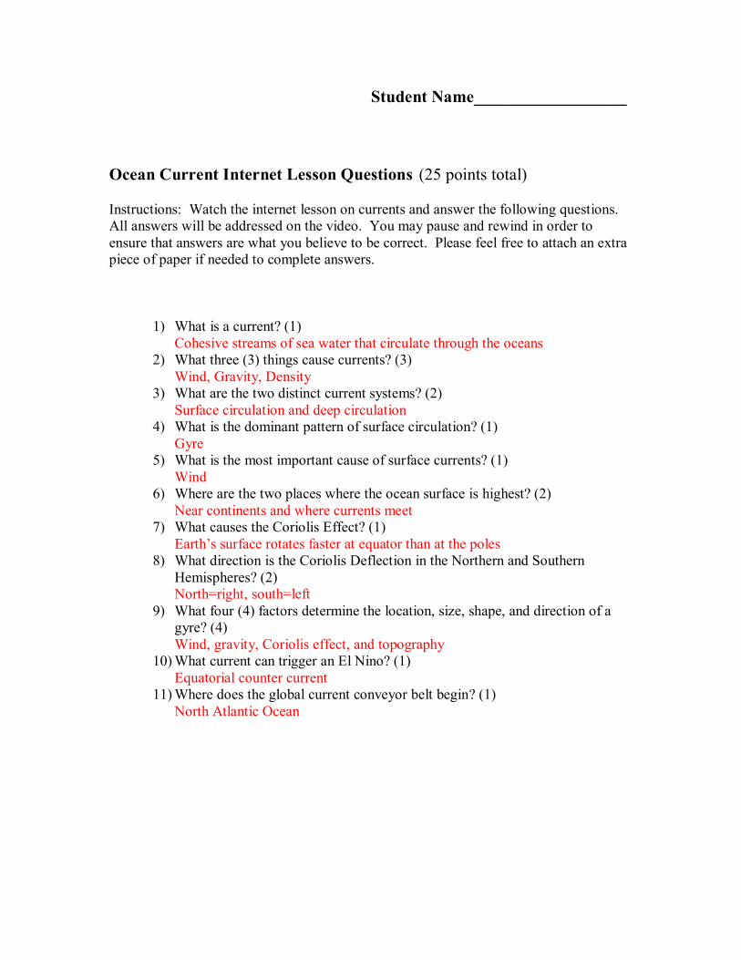
Student Name__________________
Ocean Current Internet Lesson Questions (25 points total)
Instructions: Watch the internet lesson on currents and answer the following questions. All answers will be addressed on the video. You may pause and rewind in order to ensure that answers are what you believe to be correct. Please feel free to attach an extra piece of paper if needed to complete answers.
1) What is a current? (1) Cohesive streams of sea water that circulate through the oceans
2) What three (3) things cause currents? (3) Wind, Gravity, Density
3) What are the two distinct current systems? (2) Surface circulation and deep circulation
4) What is the dominant pattern of surface circulation? (1) Gyre
5) What is the most important cause of surface currents? (1) Wind
6) Where are the two places where the ocean surface is highest? (2) Near continents and where currents meet
7) What causes the Coriolis Effect? (1) Earth’s surface rotates faster at equator than at the poles
8) What direction is the Coriolis Deflection in the Northern and Southern Hemispheres? (2) North=right, south=left
9) What four (4) factors determine the location, size, shape, and direction of a gyre? (4) Wind, gravity, Coriolis effect, and topography
10)What current can trigger an El Nino? (1) Equatorial counter current
11)Where does the global current conveyor belt begin? (1) North Atlantic Ocean
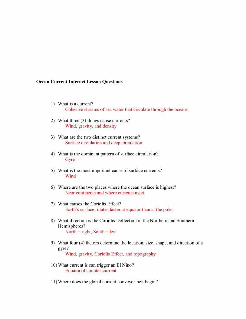
Ocean Current Internet Lesson Questions
1) What is a current? Cohesive streams of sea water that circulate through the oceans
2) What three (3) things cause currents? Wind, gravity, and density
3) What are the two distinct current systems? Surface circulation and deep circulation
4) What is the dominant pattern of surface circulation? Gyre
5) What is the most important cause of surface currents? Wind
6) Where are the two places where the ocean surface is highest? Near continents and where currents meet
7) What causes the Coriolis Effect? Earth’s surface rotates faster at equator than at the poles
8) What direction is the Coriolis Deflection in the Northern and Southern Hemispheres?
North = right, South = left
9) What four (4) factors determine the location, size, shape, and direction of a gyre?
Wind, gravity, Coriolis Effect, and topography
10)What current is can trigger an El Nino? Equatorial countercurrent
11)Where does the global current conveyor belt begin?

North Atlantic Ocean
Student Name______________________
Ocean Currents PostQuiz Questions Complete the quiz to the best of your ability with the knowledge that you now have following the lesson. This will demonstrate how much you have learned from the Pre Quiz.
1) What is a current?
2) What three (3) things cause currents?
3) What are the two distinct current systems?
4) Where are the two places where the ocean surface is highest?
5) What current can trigger an El Nino?
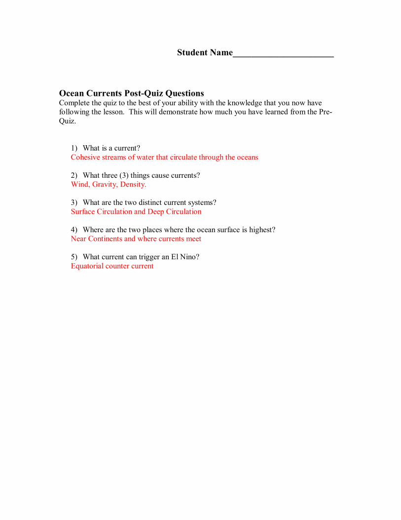
Student Name______________________
Ocean Currents PostQuiz Questions Complete the quiz to the best of your ability with the knowledge that you now have following the lesson. This will demonstrate how much you have learned from the Pre Quiz.
1) What is a current? Cohesive streams of water that circulate through the oceans
2) What three (3) things cause currents? Wind, Gravity, Density.
3) What are the two distinct current systems? Surface Circulation and Deep Circulation
4) Where are the two places where the ocean surface is highest? Near Continents and where currents meet
5) What current can trigger an El Nino? Equatorial counter current
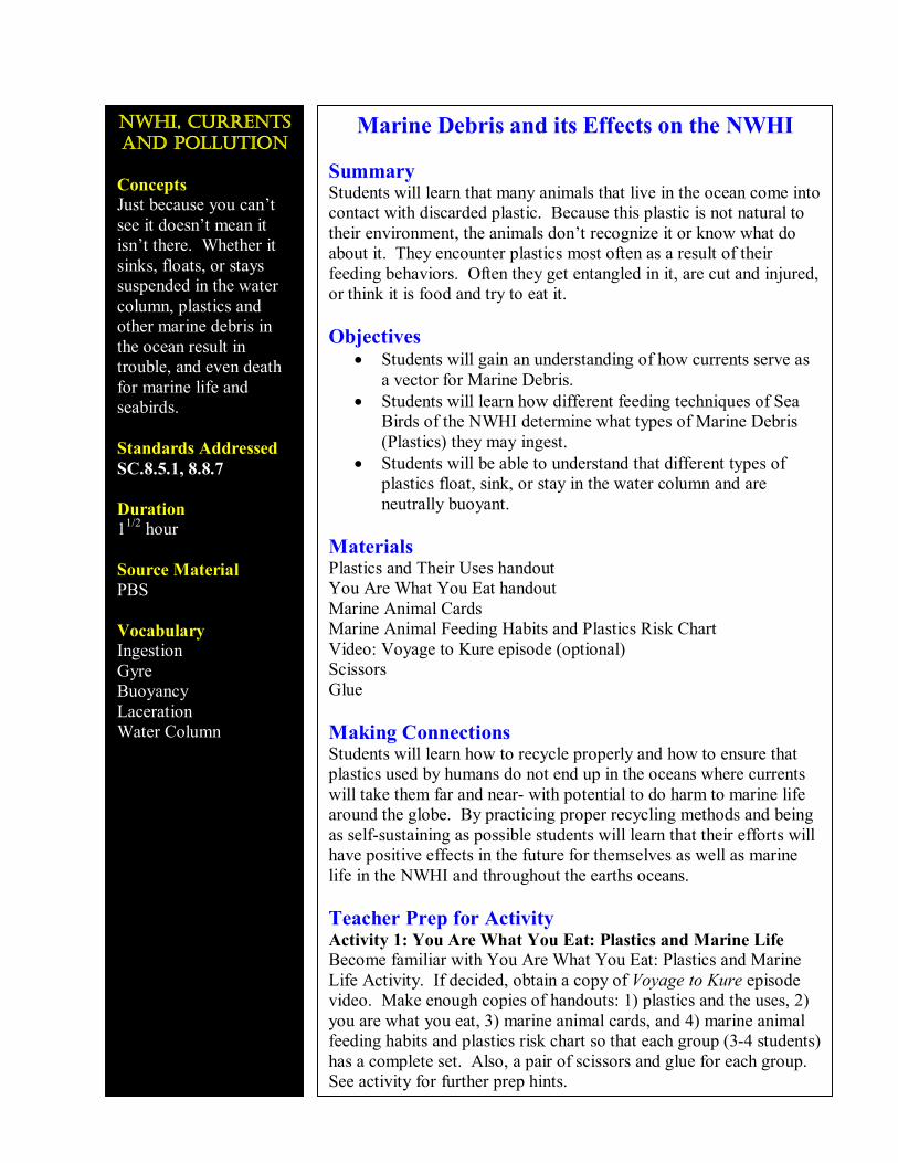
nwhı, currents and pollutıon
Concepts Just because you can’t see it doesn’t mean it isn’t there. Whether it sinks, floats, or stays suspended in the water column, plastics and other marine debris in the ocean result in trouble, and even death for marine life and seabirds.
Standards Addressed SC.8.5.1, 8.8.7
Duration 1 1/2 hour
Source Material PBS
Vocabulary Ingestion Gyre Buoyancy Laceration Water Column
Marine Debris and its Effects on the NWHI
Summary Students will learn that many animals that live in the ocean come into contact with discarded plastic. Because this plastic is not natural to their environment, the animals don’t recognize it or know what do about it. They encounter plastics most often as a result of their feeding behaviors. Often they get entangled in it, are cut and injured, or think it is food and try to eat it.
Objectives • Students will gain an understanding of how currents serve as
a vector for Marine Debris. • Students will learn how different feeding techniques of Sea
Birds of the NWHI determine what types of Marine Debris (Plastics) they may ingest.
• Students will be able to understand that different types of plastics float, sink, or stay in the water column and are neutrally buoyant.
Materials Plastics and Their Uses handout You Are What You Eat handout Marine Animal Cards Marine Animal Feeding Habits and Plastics Risk Chart Video: Voyage to Kure episode (optional) Scissors Glue
Making Connections Students will learn how to recycle properly and how to ensure that plastics used by humans do not end up in the oceans where currents will take them far and near with potential to do harm to marine life around the globe. By practicing proper recycling methods and being as selfsustaining as possible students will learn that their efforts will have positive effects in the future for themselves as well as marine life in the NWHI and throughout the earths oceans.
Teacher Prep for Activity Activity 1: You Are What You Eat: Plastics and Marine Life Become familiar with You Are What You Eat: Plastics and Marine Life Activity. If decided, obtain a copy of Voyage to Kure episode video. Make enough copies of handouts: 1) plastics and the uses, 2) you are what you eat, 3) marine animal cards, and 4) marine animal feeding habits and plastics risk chart so that each group (34 students) has a complete set. Also, a pair of scissors and glue for each group. See activity for further prep hints.
Background The potential for ingestion of plastic particles by open ocean filter feeders was assessed by the Algalita Marine Research Foundation by measuring the relative abundance (number of pieces) and mass of floating plastics and zooplankton near the central highpressure area of the North Pacific central gyre (the gyre is a large recirculating area of water halfway between California and Hawaii). Plankton abundance was approximately five times higher than that of plastic, but mass of plastic was approximately six times greater than that of plankton. This area is far from land, and many types of marine life feed here.
The effects of plastics on marine life can be devastating. Aquatic animals may be harmed by plastic objects in a variety of ways, depending on the shape and buoyancy of the object. These animals may suffer injury of even death from their encounters with plastics. Animals can be harmed through entanglement, laceration, suffocation, and ingestion.
The buoyant properties of water allow some plastics to float, some to sink, and some to stay in the water column. The types of plastics marine animals may come into contact with depend on where they live and eat: at the water’s surface, its bottom, or floating in the water column between the surface and bottom. All we see are the plastics on the surface, but there are many different varieties and shapes of plastic objects below the surface. Because we can’t see this pollution, we may forget that it exists. As cities grow and more plastics are produced and enter the marine environment, marine species will continue to be affected unless we make careful choices regarding plastics use and disposal.
Procedure Activity 1: You Are What You Eat: Plastics and Marine Life
1. Use ideas from the Voyage to Kure Viewing Guide to set the scene. Pay particular attention to the Segment Suggestions for the marine debris theme (film clips from Laysan Island and Midway Atoll). If you do not have access to the Voyage to Kure episode, try to find pictures of marine debris to show the students and lead a discussion about the danger to animals and ecosystems. What do students think about plastics in the ocean? Where does plastic go? Does it go away? What types of animals are most affected?
2. Continue class discussion by exploring the many ways we use plastics in our daily life.
3. Pass out Plastics and Their Uses student handout and discuss the different types of plastics. Note that some cities only accept Society of the Plastics Industry (SPI) codes 1 and 2 for recycling. Although many of the other types of plastic are labeled as “recyclable,” in reality, this does not occur and the majority of plastics end up in landfills.
4. From water bottles to computers, we rely on the convenience and availability of plastics to provide many of today’s necessities. List on the board the shapes that plastic can come in, and have students give examples of what they are used for:
Onedimensional objects (line, rope, strapping brands) Twodimensional objects (sheets, bags) Reticulated (netting, sixpack rings)
Hollowbodied (bottles, fishing floats) Small particles (Styrofoam, pellets used in making plastic objects) Angular (boxes, crates)
5. Discuss the marine zones in which animals feed (surface, pelagic, and benthic). Have students brainstorm what types of animals might live and feed in each of these zones.
6. Either divide the class into small groups (34 students) or distribute materials to individuals. Distribute copies of the You Are What You Eat handout, a set of the Marine Animal Cards, and a Marine Animal Feeding Habits and Plastics Risk Chart to groups or individual.
7. Have students read You Are What You Eat handout and complete the worksheet activity, placing the marine animal cards on their charts. Keep in mind that there are many different possible “correct” answers; students’ need to primarily have a rationale for their choices.
8. After the groups or individuals have completed the activity, draw the chart on the board. Have each group or student choose one form of plastic (onedimensional, two dimensional, small particles, etc.) and present to the class their results and rationale of what species would most be affected. Allow time to propose different answers, discuss them, and wrestle with different conclusions.
9. Conduct a class discussion on how to reduce the amount of plastics in the marine environment.
Assessment Completion of Marine Animal Feeding Habits and Plastics Chart Class discussion
Resources http://www.pbs.org/kqed/oceanadventures/educators/pdf/OceanAdvWhatYouEat.pdf
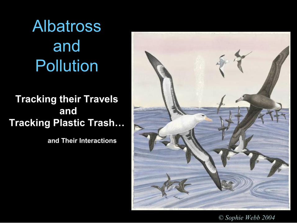
Albatross and
Pollution
© Sophie Webb 2004
Tracking their Travels and
Tracking Plastic Trash… and Their Interactions
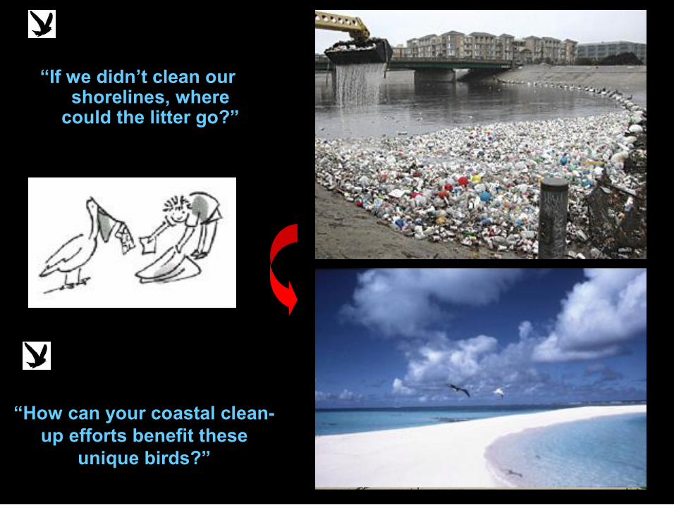
“If we didn’t clean our shorelines, where could the litter go?”
“How can your coastal clean up efforts benefit these
unique birds?” A. Nakagawa
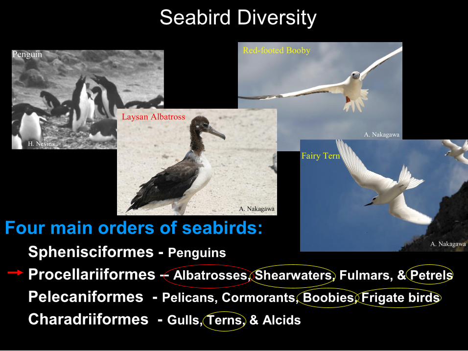
Seabird Diversity
Four main orders of seabirds: Sphenisciformes Penguins Procellariiformes – Albatrosses, Shearwaters, Fulmars, & Petrels Pelecaniformes Pelicans, Cormorants, Boobies, Frigate birds
Charadriiformes Gulls, Terns, & Alcids
Penguin
Pelican
H. Nevins
Laysan Albatross
A. Nakagawa
Redfooted Booby
A. Nakagawa
A. Nakagawa
Fairy Tern
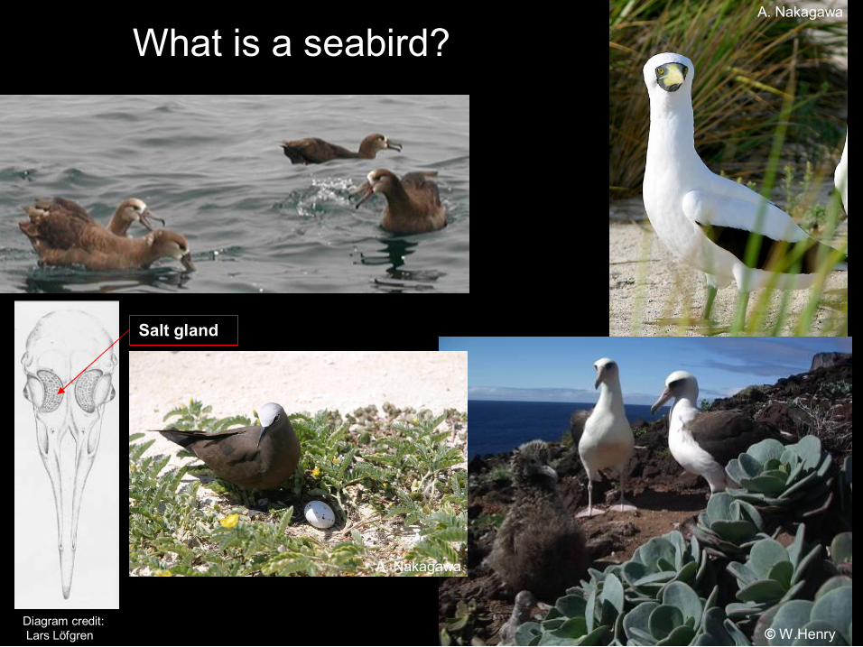
What is a seabird?
© W.Henry Diagram credit: Lars Löfgren
Salt gland
A. Nakagawa
A. Nakagawa
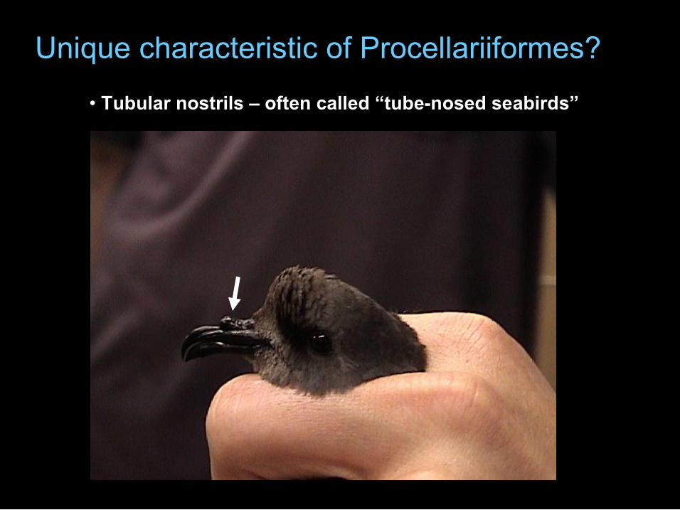
Unique characteristic of Procellariiformes?
• Tubular nostrils – often called “tubenosed seabirds”
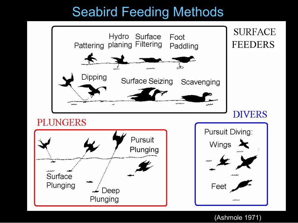
Seabird Feeding Methods
(Ashmole 1971)
Plunging
FEEDERS
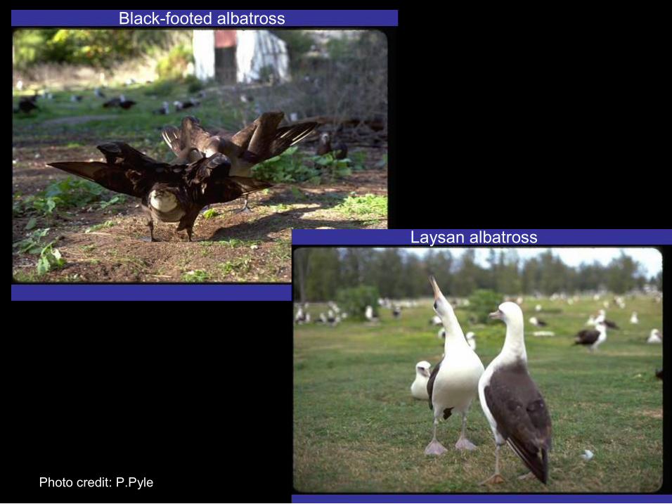
Photo credit: P.Pyle
Blackfooted albatross
Laysan albatross

What makes seabirds vulnerable? What makes seabirds vulnerable? • Longline and other fishery interactions
• Oiling from oil spills
• Threats to breeding colonies: introduced mammals, habitat destruction
Photo: W. Henry
Ebbert
• Marine debris (plastic pollution)

What are some threats to seabirds? • entanglement
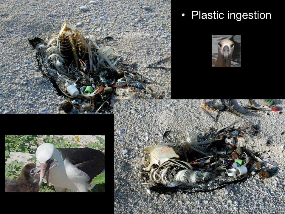
What makes seabirds vulnerable? • Plastic ingestion
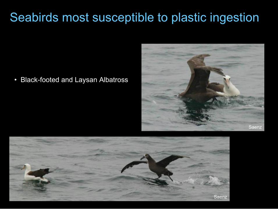
Seabirds most susceptible to plastic ingestion
Saenz
Saenz
• Blackfooted and Laysan Albatross
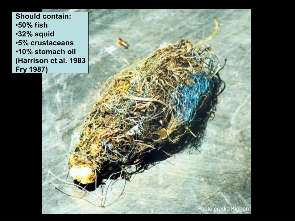
Photo credit: Kinnan
Should contain: •50% fish •32% squid •5% crustaceans •10% stomach oil (Harrison et al. 1983 Fry 1987)
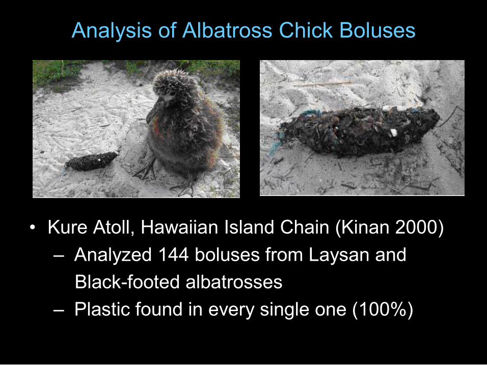
Analysis of Albatross Chick Boluses
• Kure Atoll, Hawaiian Island Chain (Kinan 2000) – Analyzed 144 boluses from Laysan and Blackfooted albatrosses
– Plastic found in every single one (100%)
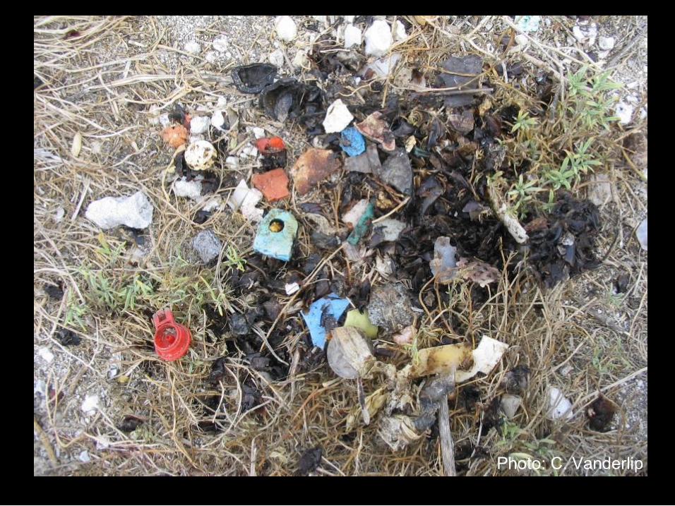
Photo: C. Vanderlip

Effects of plastic ingestion?
• Large plastic items – ulcerations, infection & obstruction
• Small plastic items – reduce meal size, dehydration
• Both may cause death
• Leaching of toxic chemicals from the plastic ?
• Decreased breeding success ?
Longterm effects of plastic ingestion?

• everywhere both marine and coastal environments
• floating
• water column
• on the seabed
• on beaches and shores
Where is marine debris found ?
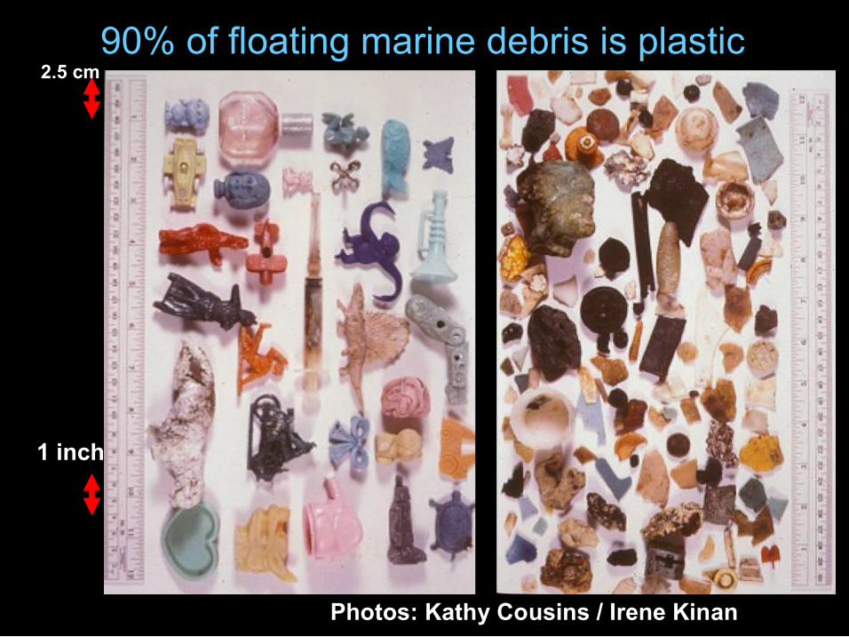
90% of floating marine debris is plastic 2.5 cm
1 inch
Photos: Kathy Cousins / Irene Kinan
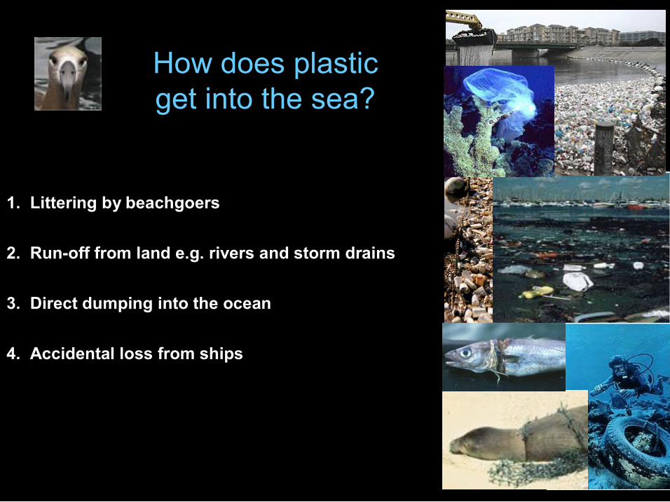
How does plastic get into the sea?
1. Littering by beachgoers
2. Runoff from land e.g. rivers and storm drains
3. Direct dumping into the ocean
4. Accidental loss from ships

Major Ocean Currents
North Pacific Gyre
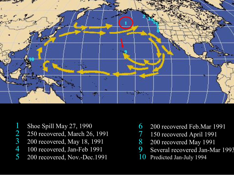
1 Shoe Spill May 27, 1990 2 250 recovered, March 26, 1991 3 200 recovered, May 18, 1991 4 100 recovered, JanFeb 1991 5 200 recovered, Nov.Dec.1991
6 200 recovered Feb.Mar 1991 7 150 recovered April 1991 8 200 recovered May 1991 9 Several recovered JanMar 1993 10 Predicted JanJuly 1994
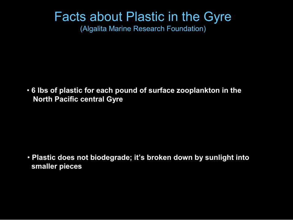
Facts about Plastic in the Gyre (Algalita Marine Research Foundation)
• 6 lbs of plastic for each pound of surface zooplankton in the North Pacific central Gyre
• Plastic does not biodegrade; it’s broken down by sunlight into smaller pieces
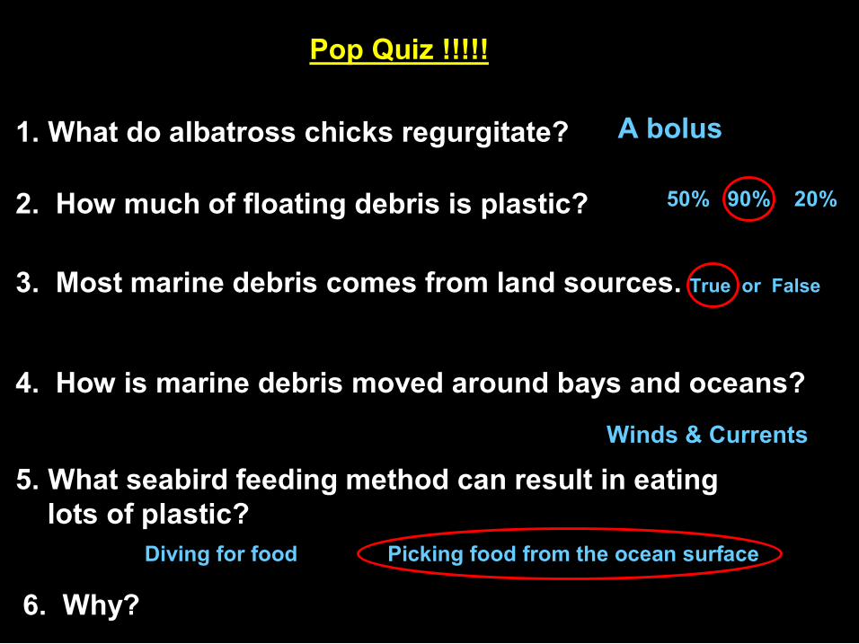
Pop Quiz !!!!!
1. What do albatross chicks regurgitate? A bolus
2. How much of floating debris is plastic? 50% 90% 20%
3. Most marine debris comes from land sources. True or False
4. How is marine debris moved around bays and oceans?
Winds & Currents
5. What seabird feeding method can result in eating lots of plastic?
Diving for food Picking food from the ocean surface
6. Why?

Solutions…..
How can you be part of the solution?

Photos courtesy Captain Charles Moore AMRF

MAHALO
Use Agreement (October 25, 2006)
• This material may be viewed and displayed for educational use only. • All images, data, and text have been contributed to Oikonos free of charge
to create this product for educational use. Content may be copyrighted and/or owned by individuals and entities other than, and in addition to, Oikonos.
• Teachers, educators, researchers and students may incorporate these materials into their lesson plans, presentations, and worksheet in hard copy and digital format for internal educational use only, not into any publication for external distribution.
• No organization or person (whether an educational body or not) may incorporate Oikonos material into any media for promotional or commercial purpose whatsoever.
• Please contact Oikonos to request further use of any images, data or text included in this presentation – we will contact the contributing authors:
Oikonos – Ecosystem Knowledge PO Box 1932 Benicia, CA 94510, USA Email: [email protected] Phone: 415 8681399

You Are What You Eat: Plastics and Marine LifeJust because you can’t see it doesn’t mean it isn’t there. Whether it sinks or floats, plastics in the sea spell
trouble for all the animals in the ocean. By matching animal cards to plastic risks, students find out the many
ways marine life can be affected by plastics in their aquatic home.
Many animals that live in the ocean come into contact with discarded plastic. Because this plastic is not natural to their environment, the animals don’t recognize it or know what to do about it. They encounter plastics most often as a result of their feeding behaviors. Often they get entangled in it, are cut and injured, or think it is food and try to eat it. The California Coastal Commission web site (http://www.coastal.ca.gov/publiced/marinedebris.html) notes that a recent study found an average of 334,271 pieces of plastic per square mile in the North Pacific Central Gyre, which serves as a natural eddy system to concentrate material. Results of more than 10 years of volunteer beach cleanup data indicate that 60 to 80 percent of beach debris comes from land-based sources. Plastic marine debris affects at least 267 species worldwide, including 86 percent of all sea turtle species, 44 percent of all sea bird species, and 43 percent of marine mammal species. (Note: this research has been documented by the Algalita Marine Research Foundation in Our Synthetic Sea, a video available at http://algalita.org/videos.html.
Plastics and Marine LifeThe potential for ingestion of plastic particles by open ocean filter feeders was assessed by the Algalita Marine Research Foundation by measuring the relative abundance (number of pieces) and mass of floating plastic and zooplankton near the central high-pressure area of the North Pacific central gyre. (The gyre is a large recirculating area of water halfway between Los Angeles and Hawaii.) Plankton abundance was approximately five times higher than that of plastic, but the mass of plastic was approximately six times that of plankton. This area is far from land, and many types of marine life feed here. The effects of plastics on marine life can be devastating. Aquatic animals may be harmed by plastic objects in a variety of ways, depending on the shape and buoyancy of the object. These animals may suffer injury or even death from their encounters with plastics. Animals can be harmed through entanglement, laceration, suffocation, and ingestion.
SUBJECTSScience
GRADE LEVELGrades 6 through 10
TIMEOne class period
OBJECTIVESStudents will be able to• understand that different types
of plastics float, sink, or stay neutrally buoyant.
• learn where ten marine species feed in the water column.
• make connections between where a marine organism lives and feeds and the types of debris to which it is exposed.
MATERIALS• Plastics and Their Uses handout • You Are What You Eat handout• Marine Animal Cards—one set
per student or student group• Marine Animal Feeding Habits
and Plastics Risk Chart • Voyage to Kure Viewing
Guide, found at pbs.org/oceanadventures/educators (optional)
• Copy of Voyage to Kure episode of Jean-Michel Cousteau: Ocean Adventures series (optional)
1. Moore, C. J., S. L. Moore, M. K. Leecaster, and S. B. Weisberg, 2001. A comparison of plastic and plankton in the North Pacific Central Gyre. In: Marine Pollution Bulletin 42, 1297-1300.
2. Laist, D. W., 1997. Impacts of marine debris: entanglement of marine life in marine debris including a comprehensive list of species with entanglement and ingestion records. In: Coe, J. M. and D. B. Rogers (Eds.), Marine Debris—Sources, Impacts and Solutions. Springer-Verlag, New York, pp. 99-139.
You Are What You Eat: Plastics and Marine Life 2
STANDARDSNational Science Education Standards Grades 5-8 (http://www.nap.edu/catalog/ 4962.html)Unifying Concepts and Processes: Systems, order, and organizationForm and function
Physical Science - Content Standard B: Properties and changes of properties in matter
Life Science - Content Standard C: Structure and function in living systems
Science and Technology - Content Standard E: Understandings about science and technology
Science in Personal and Social Perspectives - Content Standard F: Natural Hazards
The buoyant properties of water allow some plastics to float, some to sink, and some to stay in the water column. The types of plastics marine animals may come into contact with depend upon where they live and eat: at the water’s surface, its bottom, or floating in the water column between the surface and bottom. All we see are the plastics on the surface, but there are many different varieties and shapes of plastic objects below the surface. Because we can’t see this pollution, we may forget that it exists. As cities grow and more plastics are produced and enter the marine environment, marine species will continue to be affected unless we make careful choices regarding plastic use and disposal.
PROCEDURE1. Introducing Marine Debris: Use ideas from the Voyage to Kure
Viewing Guide to set the scene. Pay particular attention to the Segment Suggestions for the marine debris theme (film clips from Laysan Island and Midway Atoll). If you do not have access to the Voyage to Kure episode, try to find pictures of marine debris to show to students and lead a discussion about the danger to animals and ecosystems. What do students think about plastics in the ocean? Where does plastic go? Does it go away? What types of animals are most affected?
2. Class Discussion: Continue class discussion by exploring the many ways we use plastics in our daily lives.
3. Plastics Handout and Discussion: Pass out Plastics and Their Uses student handout and discuss the different types of plastics. Note that most cities only accept Society of the Plastics Industry (SPI) codes 1 and 2 for recycling. Although many of the other types of plastic are labeled as “recyclable,” in reality, this does not occur and the majority of plastics end up in landfills.
4. List Types of Plastics: From water bottles to computers, we rely on the convenience and availability of plastics to provide many of today’s necessities. List on the board the shapes that plastic can come in, and have students give examples of what they are used for:One-dimensional objects (line, rope, strapping bands)Two-dimensional objects (sheets, bags)Reticulated (netting, six-pack rings)Hollow-bodied (bottles, fishing floats)Small particles (Styrofoam, pellets used in making plastic objects)Angular (boxes, crates)
5. Discuss Marine Zones: Discuss the marine zones in which animals feed (surface, pelagic, and benthic). Have students brainstorm what types of animals might live and feed in each of these zones.
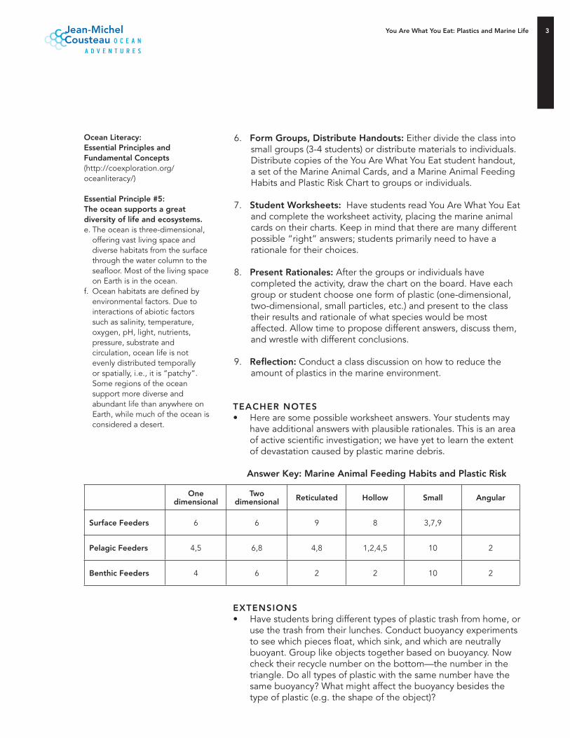
You Are What You Eat: Plastics and Marine Life
6. Form Groups, Distribute Handouts: Either divide the class into small groups (3-4 students) or distribute materials to individuals. Distribute copies of the You Are What You Eat student handout, a set of the Marine Animal Cards, and a Marine Animal Feeding Habits and Plastic Risk Chart to groups or individuals.
7. Student Worksheets: Have students read You Are What You Eat and complete the worksheet activity, placing the marine animal cards on their charts. Keep in mind that there are many different possible “right” answers; students primarily need to have a rationale for their choices.
8. Present Rationales: After the groups or individuals have completed the activity, draw the chart on the board. Have each group or student choose one form of plastic (one-dimensional, two-dimensional, small particles, etc.) and present to the class their results and rationale of what species would be most affected. Allow time to propose different answers, discuss them, and wrestle with different conclusions.
9. Reflection: Conduct a class discussion on how to reduce the amount of plastics in the marine environment.
TEACHER NOTES• Here are some possible worksheet answers. Your students may
have additional answers with plausible rationales. This is an area of active scientific investigation; we have yet to learn the extent of devastation caused by plastic marine debris.
Answer Key: Marine Animal Feeding Habits and Plastic Risk
EXTENSIONS• Have students bring different types of plastic trash from home, or
use the trash from their lunches. Conduct buoyancy experiments to see which pieces float, which sink, and which are neutrally buoyant. Group like objects together based on buoyancy. Now check their recycle number on the bottom—the number in the triangle. Do all types of plastic with the same number have the same buoyancy? What might affect the buoyancy besides the type of plastic (e.g. the shape of the object)?
Ocean Literacy: Essential Principles and Fundamental Concepts(http://coexploration.org/oceanliteracy/)
Essential Principle #5: The ocean supports a great diversity of life and ecosystems.e. The ocean is three-dimensional,
offering vast living space and diverse habitats from the surface through the water column to the seafloor. Most of the living space on Earth is in the ocean.
f. Ocean habitats are defined by environmental factors. Due to interactions of abiotic factors such as salinity, temperature, oxygen, pH, light, nutrients, pressure, substrate and circulation, ocean life is not evenly distributed temporally or spatially, i.e., it is “patchy”. Some regions of the ocean support more diverse and abundant life than anywhere on Earth, while much of the ocean is considered a desert.
One dimensional
Two dimensional Reticulated Hollow Small Angular
Surface Feeders 6 6 9 8 3,7,9
Pelagic Feeders 4,5 6,8 4,8 1,2,4,5 10 2
Benthic Feeders 4 6 2 2 10 2
You Are what You Eat: Plastics and Marine Life
• Get a list from your local refuse agency that indicates what plastics they accept for recycling, and sort your plastic trash from the preceding extension activity accordingly. Are the recyclable plastics primarily floaters or sinkers? Do you think that the plastic that is more easily recyclable ends up in the ocean less often than those that are not recyclable in your area? Which ocean animals might recycling plastic help most?
FURTHER REFERENCESAdditional educator resources for Jean-Michel Cousteau: Ocean Adventures can be found at pbs.org/oceanadventures
Also, try:• Algalita Marine Research Foundation: Plastic Debris Rivers to Sea
http://www.plasticdebris.org/ • California Coastal Commission: The Problem with Marine Debris
http://www.coastal.ca.gov/publiced/marinedebris.html • The Ocean Channel: Ocean Pollution
http://www.ocean.com/resource.asp?resourceid=1334&catid=&locationid=1
• The Smithsonian Institution: Ocean Planet—Pollution Solution http://smithsonianeducation.org/educators/lesson_plans/ocean/pollution/essay.html
CREDITSAdapted with permission from Waves, Wetlands, and Watersheds: California Coastal Commission Science Activity Guide. For more information or to order copies, contact the California Coastal Commission, 45 Fremont Street, Suite 2000, San Francisco, CA 94105, (415) 904-5215, [email protected]. The publication can be ordered or downloaded at http://www.coastal.ca.gov/publiced/waves/waves1.html
The California Coastal Commission originally adapted the activity from “Animals’ Feeding Ranges and Plastics” in Plastics Eliminators: Protecting California Shorelines by the California Aquatic Science Education Consortium. Available at http://anrcatalog.ucdavis.edu/InOrder/Shop/ItemDetails.asp?ItemNo=21608
Jean-Michel Cousteau: Ocean Adventures is produced by KQED Public Broadcasting and Ocean Futures Society.
The exclusive corporate sponsor is The Dow Chemical Company.
Additional Major Support from: the William K. Bowes Jr. Foundation, Ann Bowers and The Robert Noyce Trust, the William and Gretchen Kimball Fund, the Harold K.L. Castle Foundation, and the National Marine Sanctuary Foundation.
Essential Principle #6: The ocean and humans areinextricably interconnected.e. Humans affect the ocean in a
variety of ways. Laws, regulations and resource management affect what is taken out and put into the ocean. Human development and activity leads to pollution (point source, non-point source, and noise pollution) and physical modifications (changes to beaches, shores and rivers). In addition, humans have removed most of the large vertebrates from the ocean.
g. Everyone is responsible form caring for the ocean. The ocean sustains life on Earth and humans must live in ways that sustain the ocean. Individual and collective actions are needed to effectively manage ocean resources for all.
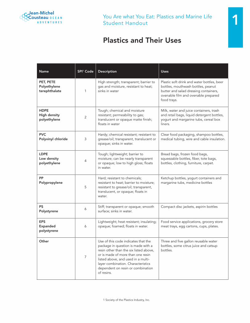
1You Are what You Eat: Plastics and Marine LifeStudent Handout
Plastics and Their Uses
Name SPI1 Code Description Uses
PET, PETEPolyethylene terephthalate 1
High strength; transparent; barrier to gas and moisture, resistant to heat; sinks in water
Plastic soft drink and water bottles, beer bottles, mouthwash bottles, peanut butter and salad dressing containers, ovenable film and ovenable prepared food trays.
HDPEHigh density polyethylene
2
Tough; chemical and moisture resistant; permeability to gas; translucent or opaque matte finish; floats in water
Milk, water and juice containers, trash and retail bags, liquid detergent bottles, yogurt and margarine tubs, cereal box liners.
PVC Polyvinyl chloride 3
Hardy; chemical resistant; resistant to grease/oil; transparent, translucent or opaque; sinks in water.
Clear food packaging, shampoo bottles, medical tubing, wire and cable insulation.
LDPELow density polyethylene
4
Tough; lightweight; barrier to moisture; can be nearly transparent or opaque; low to high gloss; floats in water.
Bread bags, frozen food bags, squeezable bottles, fiber, tote bags, bottles, clothing, furniture, carpet.
PPPolypropylene
5
Hard; resistant to chemicals; resistant to heat; barrier to moisture; resistant to grease/oil; transparent, translucent, or opaque; floats in water.
Ketchup bottles, yogurt containers and margarine tubs, medicine bottles
PS Polystyrene
6Stiff; transparent or opaque; smooth surface; sinks in water.
Compact disc jackets, aspirin bottles
EPSExpanded polystyrene
6Lightweight; heat resistant; insulating; opaque; foamed; floats in water.
Food service applications, grocery store meat trays, egg cartons, cups, plates.
Other
7
Use of this code indicates that the package in question is made with a resin other than the six listed above, or is made of more than one resin listed above, and used in a multi-layer combination. Characteristics dependent on resin or combination of resins.
Three and five gallon reusable water bottles, some citrus juice and catsup bottles.
1 Society of the Plastics Industry, Inc.
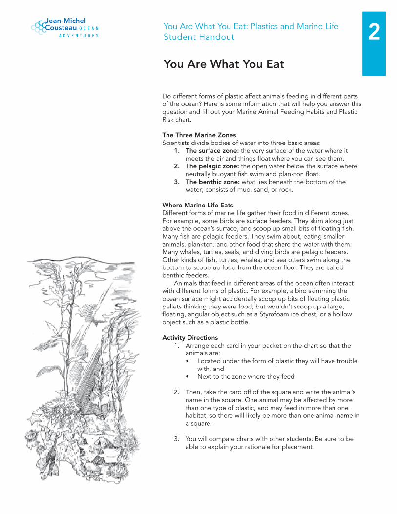
2You Are What You Eat: Plastics and Marine LifeStudent Handout
You Are What You Eat
Do different forms of plastic affect animals feeding in different parts of the ocean? Here is some information that will help you answer this question and fill out your Marine Animal Feeding Habits and Plastic Risk chart.
The Three Marine ZonesScientists divide bodies of water into three basic areas:
1. The surface zone: the very surface of the water where it meets the air and things float where you can see them.
2. The pelagic zone: the open water below the surface where neutrally buoyant fish swim and plankton float.
. The benthic zone: what lies beneath the bottom of the water; consists of mud, sand, or rock.
Where Marine Life EatsDifferent forms of marine life gather their food in different zones. For example, some birds are surface feeders. They skim along just above the ocean’s surface, and scoop up small bits of floating fish. Many fish are pelagic feeders. They swim about, eating smaller animals, plankton, and other food that share the water with them. Many whales, turtles, seals, and diving birds are pelagic feeders. Other kinds of fish, turtles, whales, and sea otters swim along the bottom to scoop up food from the ocean floor. They are called benthic feeders. Animals that feed in different areas of the ocean often interact with different forms of plastic. For example, a bird skimming the ocean surface might accidentally scoop up bits of floating plastic pellets thinking they were food, but wouldn’t scoop up a large, floating, angular object such as a Styrofoam ice chest, or a hollow object such as a plastic bottle.
Activity Directions1. Arrange each card in your packet on the chart so that the
animals are: • Located under the form of plastic they will have trouble
with, and• Next to the zone where they feed
2. Then, take the card off of the square and write the animal’s name in the square. One animal may be affected by more than one type of plastic, and may feed in more than one habitat, so there will likely be more than one animal name in a square.
3. You will compare charts with other students. Be sure to be able to explain your rationale for placement.
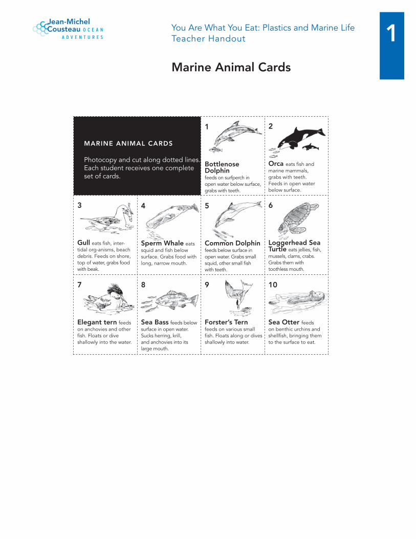
1You Are What You Eat: Plastics and Marine LifeTeacher Handout
Marine Animal Cards
1
Bottlenose Dolphin feeds on surfperch in open water below surface, grabs with teeth.
2
Orca eats fish and marine mammals, grabs with teeth. Feeds in open water below surface.
Gull eats fish, inter-tidal org-anisms, beach debris. Feeds on shore, top of water, grabs food with beak.
Sperm Whale eats squid and fish below surface. Grabs food with long, narrow mouth.
5
Common Dolphinfeeds below surface in open water. Grabs small squid, other small fish with teeth.
6
Loggerhead Sea Turtle eats jellies, fish, mussels, clams, crabs. Grabs them with toothless mouth.
7
Elegant tern feeds on anchovies and other fish. Floats or dive shallowly into the water.
8
Sea Bass feeds below surface in open water. Sucks herring, krill, and anchovies into its large mouth.
9
Forster’s Tern feeds on various small fish. Floats along or dives shallowly into water.
10
Sea Otter feeds on benthic urchins and shellfish, bringing them to the surface to eat.
MARINE ANIMAL CARDS
Photocopy and cut along dotted lines. Each student receives one complete set of cards.

2You Are What You Eat: Plastics and Marine LifeStudent Handout
Marine Animal Feeding Habits and Plastics Risk Chart
One-D
imensio
nal O
bjects
Two
-Dim
ensional
Ob
jectsR
eticulated O
bjects
Ho
llow
Ob
jectsSm
all Particles
Ang
ular Ob
jects
Surface Feed
ers
Pelag
ic Feed
ers
Benthic
Feeders
Student Name________________________
Marine Debris PostQuiz Questions Complete the quiz to the best of your ability with the knowledge that you currently have. Following the lesson you will be quizzed again to demonstrate the growth of your knowledge on Marine Debris.
1) What do Albatross Chicks regurgitate?
2) How much of Marine Debris is plastics? Circle one: 20% 50% 90%
3) Most Marine Debris comes from land sources? TRUE FALSE
4) How is Marine Debris moved around Bays and Oceans?
5) What seabird eating method can result in consuming a lot of plastics? Circle one:
Diving for food picking food from the ocean surface
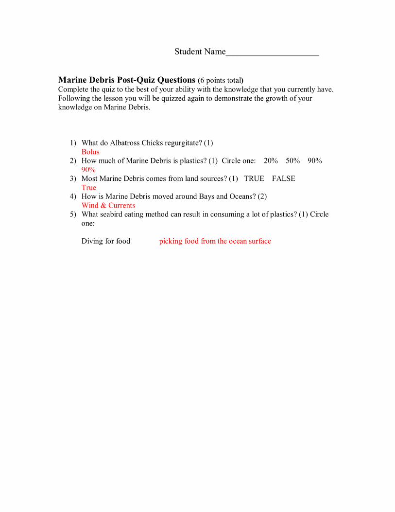
Student Name________________________
Marine Debris PostQuiz Questions (6 points total) Complete the quiz to the best of your ability with the knowledge that you currently have. Following the lesson you will be quizzed again to demonstrate the growth of your knowledge on Marine Debris.
1) What do Albatross Chicks regurgitate? (1) Bolus
2) How much of Marine Debris is plastics? (1) Circle one: 20% 50% 90% 90%
3) Most Marine Debris comes from land sources? (1) TRUE FALSE True
4) How is Marine Debris moved around Bays and Oceans? (2) Wind & Currents
5) What seabird eating method can result in consuming a lot of plastics? (1) Circle one:
Diving for food picking food from the ocean surface
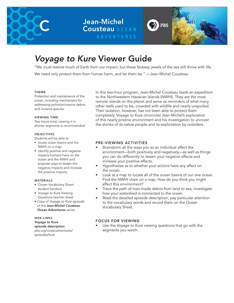
Voyage to Kure Viewer Guide“We must restore much of Earth from our impact, but these faraway jewels of the sea still thrive with life.
We need only protect them from human harm, and let them be.” —Jean‑Michel Cousteau
In this two‑hour program, Jean‑Michel Cousteau leads an expedition to the Northwestern Hawaiian Islands (NWHI). They are the most remote islands on the planet and serve as reminders of what many other reefs used to be, crowded with wildlife and nearly unspoiled. Their isolation, however, has not been able to protect them completely. Voyage to Kure chronicles Jean‑Michel’s exploration of this nearly pristine environment and his investigation to uncover the stories of its native people and its exploitation by outsiders.
PRE-VIEWING ACTIVITIES• Brainstorm all the ways you as an individual affect the
environment—both positively and negatively—as well as things you can do differently to lessen your negative effects and increase your positive effects.
• Hypothesize as to whether your actions have any affect on the ocean.
• Look at a map to locate all of the ocean basins of our one ocean. Find the NWHI chain on a map. How do you think you might affect this environment?
• Trace the path of man‑made debris from land to sea; investigate how your watershed is connected to the ocean.
• Read the detailed episode description; pay particular attention to the vocabulary words and record them on the Ocean Vocabulary Sheet.
FOCUS FOR VIEWING• Use the Voyage to Kure viewing questions that go with the
segments you watch.
THEMEProtection and maintenance of the ocean, including mechanisms for addressing pollution/marine debris and invasive species
VIEWING TIMETwo hours total; viewing it in shorter segments is recommended
OBJECTIVES Students will be able to• locate ocean basins and the
NWHI on a map.• identify positive and negative
impacts humans have on the ocean and the NWHI and propose ways to lessen the negative impacts and increase the positive impacts.
MATERIALS• Ocean Vocabulary Sheet
student handout• Voyage to Kure Viewing
Questions teacher sheet• Copy of Voyage to Kure episode of the Jean-Michel Cousteau Ocean Adventures series
WEB LINKSVoyage to Kure episode description pbs.org/oceanadventures/episodes/kure
Voyage to Kure Viewer Guide
Kure Waste Chase Game pbs.org/oceanadventures/episodes/kure
Map of the Northwest Hawaiian Islandspbs.org/oceanadventures/kure
Seabird Survival Adaptation Card Game pbs.org/oceanadventures/educators
You Are What You Eat: Plastics and Marine Life pbs.org/oceanadventures/educators
The Purple Problem pbs.org/oceanadventures/educators
STANDARDSNational Science Education StandardsGrades 5-8http://www.nap.edu/catalog/4962.html
Life Science -Content Standard C: Populations and ecosystems
Earth and Space Science -Content Standard D: Structure of the earth system
Science in Personal and Social Perspectives -Content Standard F: Personal healthPopulations, resources and environmentsNatural hazardsRisks and benefitsScience and technology in society
FOLLOW-UP ACTIVITIES• Make a collage showing either (1) the negative impacts humans
have on the marine environment and possible solutions for fixing the problems or (2) positive impacts humans have on the marine environment and examples of good practices. Use pictures from the Ocean Adventures Web site to help.
• Play Kure Clean‑Up; use the Kure Clean‑Up Lesson Plan to enhance the learning of your students.
SEGMENT SUGGESTIONSNOTE: timing listed below is approximate and is based on the PBS broadcast; home video versions may differ slightly.
Themes: Seabirds, marine debris
Location in Voyage to Kure: Tern Island (Part 1, 21:23‑26:26); Laysan Island (Part 2, 12:00‑14:20)
Pre-Viewing Questions: • Why do people move?• Why do animals move/migrate?• What problems do you think animals might encounter as
they migrate?
Focus for Viewing: • Use Questions 1, 2 and 3 for Tern Island from the Voyage to Kure
Viewing Questions.
Post-Viewing Discussion Questions: • What are some of the challenges seabirds face as they migrate?• How do you think seabirds might deal with these challenges?
Follow-up Activity: • Seabird Survival Adaptation Card Game: in this activity, students
separate into small groups, and each group will play a card game that will help them learn about the adaptations seabirds have made and do make and the environmental challenges they face.
Voyage to Kure Viewer Guide
Theme: Marine debris
Location in Voyage to Kure: Laysan Island (Part 2, 12:00‑14:20); Midway Atoll (Part 2, 35:05‑39:23)
Pre-Viewing Questions:• List as many plastic items as you can.• Name some things we use plastic for. How is plastic helpful?• What are some of the dangers of plastic when it is not recycled
or properly disposed of?
Focus for Viewing:• Use Questions 7 through 10 for Laysan Island from the Voyage to Kure Viewing Questions.• Use Questions 4 through 8 for Midway Atoll from the Voyage to Kure Viewing Questions.
Post-Viewing Discussion Questions: • What did you see that surprised you?• What were some of the plastic items you saw? Do you use those types of items?• Which types of animals do you think are most affected by marine debris?
Follow-up Activity: • You Are What You Eat: Plastics and Marine Life: in this lesson,
students learn about different types of plastics and investigate their impacts on marine life.
Theme: Invasive species
Location in Voyage to Kure: Laysan Island (Part 2, 2:23‑8:53)
Previewing Questions:• Share a time that someone invaded your space.• What did the person do? How did it make you feel?• Discuss the concept of invasive species in the plant and
animal worlds.
Focus for Viewing: • Use Questions 1 through 6 for Laysan Island from the Voyage to Kure Viewing Questions handout.
Ocean Literacy: Essential Principles and Fundamental Concepts http://coexploration.org/oceanliteracy/
Essential Principle #1: Earth has one big ocean with many features. a. The ocean is the dominant
physical feature on our planet Earth, covering approximately 70 percent of the planet’s surface. There is one ocean with many ocean basins, such as the North Pacific, South Pacific, North Atlantic, South Atlantic, Indian and Arctic.
h. Although the ocean is large, it is finite and its resources
are limited.

Voyage to Kure Viewer Guide
Essential Principle #6: The ocean and humans are inextricably interconnected.b. From the ocean we get foods,
medicines, and mineral and energy resources. In addition, it provides jobs, supports our nation’s economy, serves as a highway for transportation of goods and people, and plays
a role in national security.c. The ocean is a source of
inspiration, recreation, rejuvenation and discovery. It is also an important element in the heritage of many cultures.
e. Humans affect the ocean in a variety of ways. Laws, regulations and resource management affect what is taken out and put into the ocean. Human development and activity leads to pollution (point source, nonpoint source and noise pollution) and physical modifications (changes to beaches, shores and rivers). In addition, humans have removed most of the large vertebrates from the ocean.
g. Everyone is responsible for caring for the ocean. The ocean sustains life on Earth and humans must live in ways that sustain the ocean. Individual and collective actions are needed in order to effectively manage ocean resources for all.
Post-Viewing Discussion Questions: • Review answers from the Viewing Questions handout.• Describe some of the problems that invasive species cause.
Follow-up Activity: • The Purple Problem: in this lesson, students will learn
about purple loosestrife and the problems it causes as an invasive species.
Additional educator resources for Jean‑Michel Cousteau: Ocean Adventures can be found at pbs.org/oceanadventures.
CREDITS
Jean‑Michel Cousteau: Ocean Adventures is produced by KQED Public Broadcasting and Ocean Futures Society.
The exclusive corporate sponsor is The Dow Chemical Company.
Additional Major Support from: the William K. Bowes Jr. Foundation, Ann Bowers and The Robert Noyce Trust, the William and Gretchen Kimball Fund, the Harold K.L. Castle Foundation, and the National Marine Sanctuary Foundation.
nwhı, currents and pollutıon
Concepts Boluses contain indigestible natural (squid beaks) and un natural (plastic) materials. If chicks are fed too much plastic they are likely to suffer from physiological stress from blockage and satiation (feeling so full) that can result in their death. Chicks can become so full and items can be so large that they are unable to regurgitate a bolus.
Standards Addressed SC.8.1.1, 8.1.2, 8.5.1
Duration 1 1/2 hour
Source Material NOAA, USC, Oikonos
Vocabulary Seabirds Bolus Fledge Pelagic Scavenger Regurgitate
NWHI Albatross Bolus Dissection
Summary Students will learn that Seabirds that feed on the surface of the ocean (dippers and scavengers), such as Blackfooted Albatross and Laysan Albatross often mistake plastic pieces as food and also feed plastics to their chicks. Birds that feed by diving for their food also eat plastic, however, surface feeders eat more plastic than divers. Albatross chicks usually regurgitate a bolus right before they leave the nest and go to sea (fledge).
Objectives • Students will gain an understanding of how humans can have
a detrimental impact on animals and ecosystems in remote places.
• Students will learn how to determine the links between evidence and the conclusion of an investigation.
• Students will be able to communicate the significant components of the experimental design and results of a scientific investigation.
Materials Albatross Bolus Protocol Albatross Boluses Albatross Bolus Investigation Data Sheet Albatross Bolus Worksheet
Making Connections Students will learn that when plastics and other pollutants are not disposed of properly there is a chance that they will end up in the ocean and carried to remote places such as the NWHI. Seabirds, such as Albatross mistake marine debris as food and unknowingly feed it to their chicks. However, students can lessen the impact of plastics and other marine debris by learning how to recycle properly.
Teacher Prep for Activity Activity 1: NWHI Albatross Bolus Dissection Become familiar with Albatross Bolus Protocol. Have enough copies of Albatross Bolus Protocol packets for each groups of students (24 students). Acquire Boluses and have them prepared for dissection.
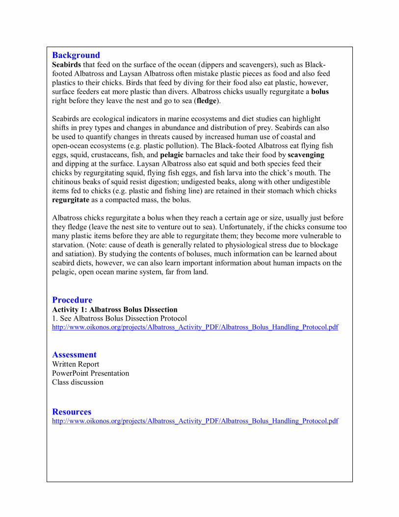
Background Seabirds that feed on the surface of the ocean (dippers and scavengers), such as Black footed Albatross and Laysan Albatross often mistake plastic pieces as food and also feed plastics to their chicks. Birds that feed by diving for their food also eat plastic, however, surface feeders eat more plastic than divers. Albatross chicks usually regurgitate a bolus right before they leave the nest and go to sea (fledge).
Seabirds are ecological indicators in marine ecosystems and diet studies can highlight shifts in prey types and changes in abundance and distribution of prey. Seabirds can also be used to quantify changes in threats caused by increased human use of coastal and openocean ecosystems (e.g. plastic pollution). The Blackfooted Albatross eat flying fish eggs, squid, crustaceans, fish, and pelagic barnacles and take their food by scavenging and dipping at the surface. Laysan Albatross also eat squid and both species feed their chicks by regurgitating squid, flying fish eggs, and fish larva into the chick’s mouth. The chitinous beaks of squid resist digestion; undigested beaks, along with other undigestible items fed to chicks (e.g. plastic and fishing line) are retained in their stomach which chicks regurgitate as a compacted mass, the bolus.
Albatross chicks regurgitate a bolus when they reach a certain age or size, usually just before they fledge (leave the nest site to venture out to sea). Unfortunately, if the chicks consume too many plastic items before they are able to regurgitate them; they become more vulnerable to starvation. (Note: cause of death is generally related to physiological stress due to blockage and satiation). By studying the contents of boluses, much information can be learned about seabird diets, however, we can also learn important information about human impacts on the pelagic, open ocean marine system, far from land.
Procedure Activity 1: Albatross Bolus Dissection 1. See Albatross Bolus Dissection Protocol http://www.oikonos.org/projects/Albatross_Activity_PDF/Albatross_Bolus_Handling_Protocol.pdf
Assessment Written Report PowerPoint Presentation Class discussion
Resources http://www.oikonos.org/projects/Albatross_Activity_PDF/Albatross_Bolus_Handling_Protocol.pdf
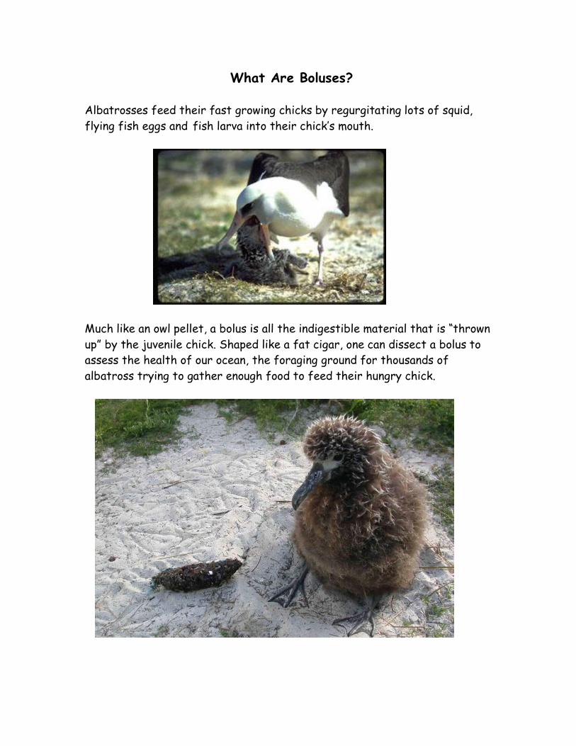
What Are Boluses?
Albatrosses feed their fast growing chicks by regurgitating lots of squid, flying fish eggs and fish larva into their chick‛s mouth.
Much like an owl pellet, a bolus is all the indigestible material that is “thrown up” by the juvenile chick. Shaped like a fat cigar, one can dissect a bolus to assess the health of our ocean, the foraging ground for thousands of albatross trying to gather enough food to feed their hungry chick.
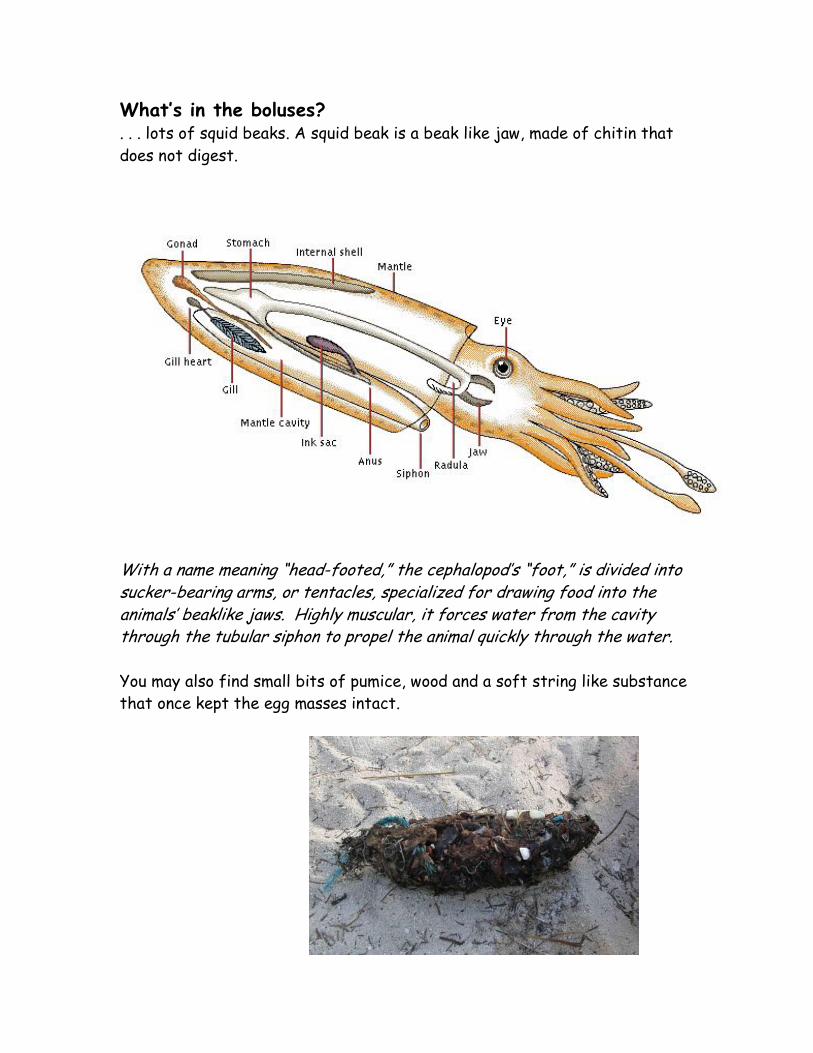
What‛s in the boluses? . . . lots of squid beaks. A squid beak is a beak like jaw, made of chitin that does not digest.
With a name meaning “head-footed,” the cephalopod‛s “foot,” is divided into sucker-bearing arms, or tentacles, specialized for drawing food into the animals‛ beaklike jaws. Highly muscular, it forces water from the cavity through the tubular siphon to propel the animal quickly through the water.
You may also find small bits of pumice, wood and a soft string like substance that once kept the egg masses intact.

Unfortunately there is usually plenty of unnatural material in a bolus. Flying fish lay their egg masses on any floating structure in the open ocean whether manmade or natural. These floating structures maybe pieces of plastic that are swallowed up whole along with the fish eggs. The adult birds then fly back to their nest to regurgitate what they gathered into the mouth of their albatross chick.
The U.S. Fish and Wildlife Service employees find boluses laced with plastics by the hundreds in the Northwestern Hawaiian Islands. On a positive note, we are lucky that albatrosses can expel these indigestible materials. However, it is not uncommon to come upon an albatross chick carcass containing intact toothbrushes, plastic toys, bottle caps, cigarette lighters and fishing line.
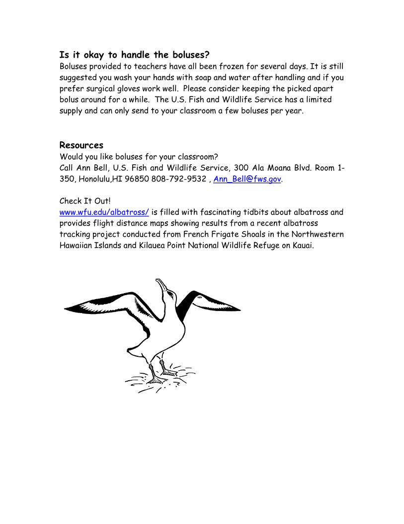
Is it okay to handle the boluses? Boluses provided to teachers have all been frozen for several days. It is still suggested you wash your hands with soap and water after handling and if you prefer surgical gloves work well. Please consider keeping the picked apart bolus around for a while. The U.S. Fish and Wildlife Service has a limited supply and can only send to your classroom a few boluses per year.
Resources Would you like boluses for your classroom? Call Ann Bell, U.S. Fish and Wildlife Service, 300 Ala Moana Blvd. Room 1- 350, Honolulu,HI 96850 808-792-9532 , [email protected].
Check It Out! www.wfu.edu/albatross/ is filled with fascinating tidbits about albatross and provides flight distance maps showing results from a recent albatross tracking project conducted from French Frigate Shoals in the Northwestern Hawaiian Islands and Kilauea Point National Wildlife Refuge on Kauai.
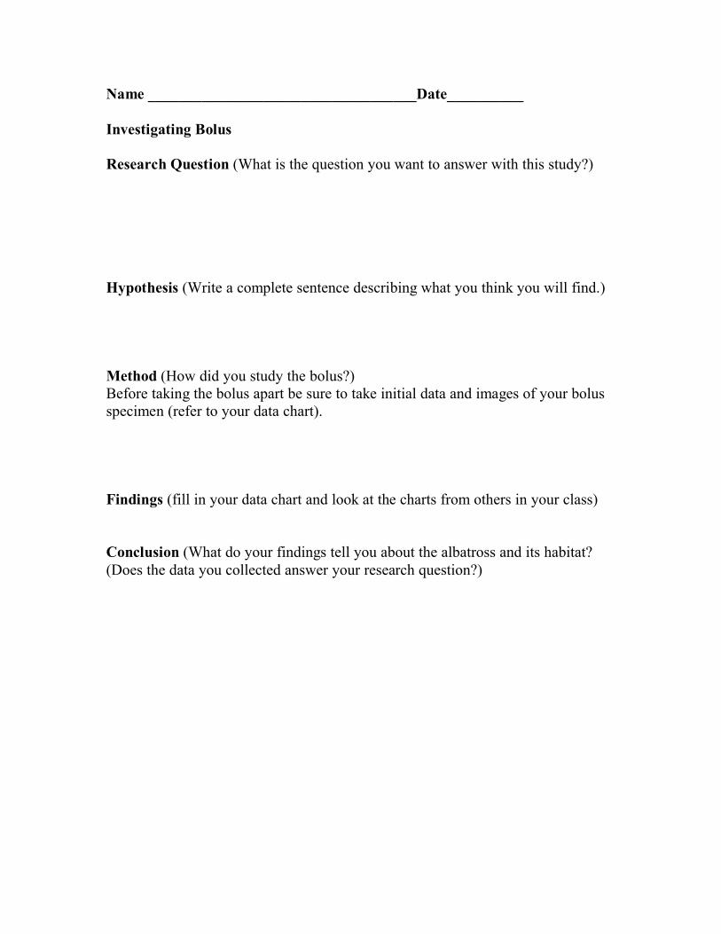
Name ___________________________________Date__________
Investigating Bolus
Research Question (What is the question you want to answer with this study?)
Hypothesis (Write a complete sentence describing what you think you will find.)
Method (How did you study the bolus?) Before taking the bolus apart be sure to take initial data and images of your bolus specimen (refer to your data chart).
Findings (fill in your data chart and look at the charts from others in your class)
Conclusion (What do your findings tell you about the albatross and its habitat? (Does the data you collected answer your research question?)
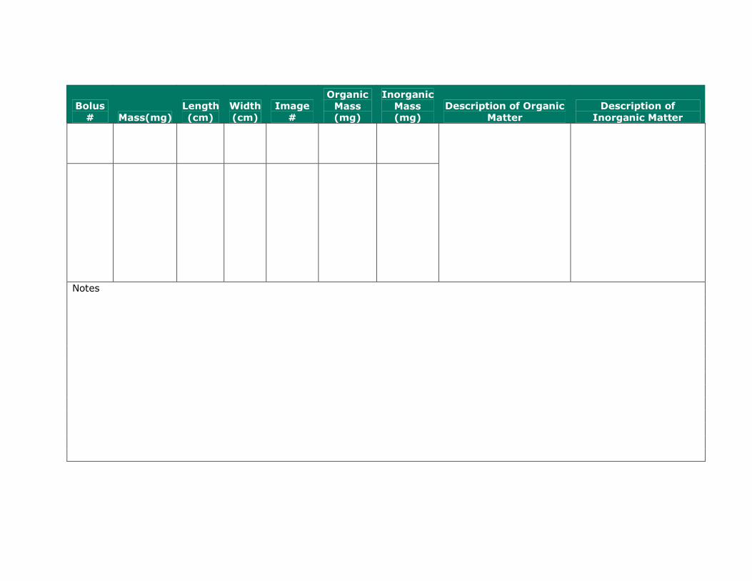
Bolus # Mass(mg)
Length (cm)
Width (cm)
Image #
Organic Mass (mg)
Inorganic Mass (mg)
Description of Organic Matter
Description of Inorganic Matter
Notes
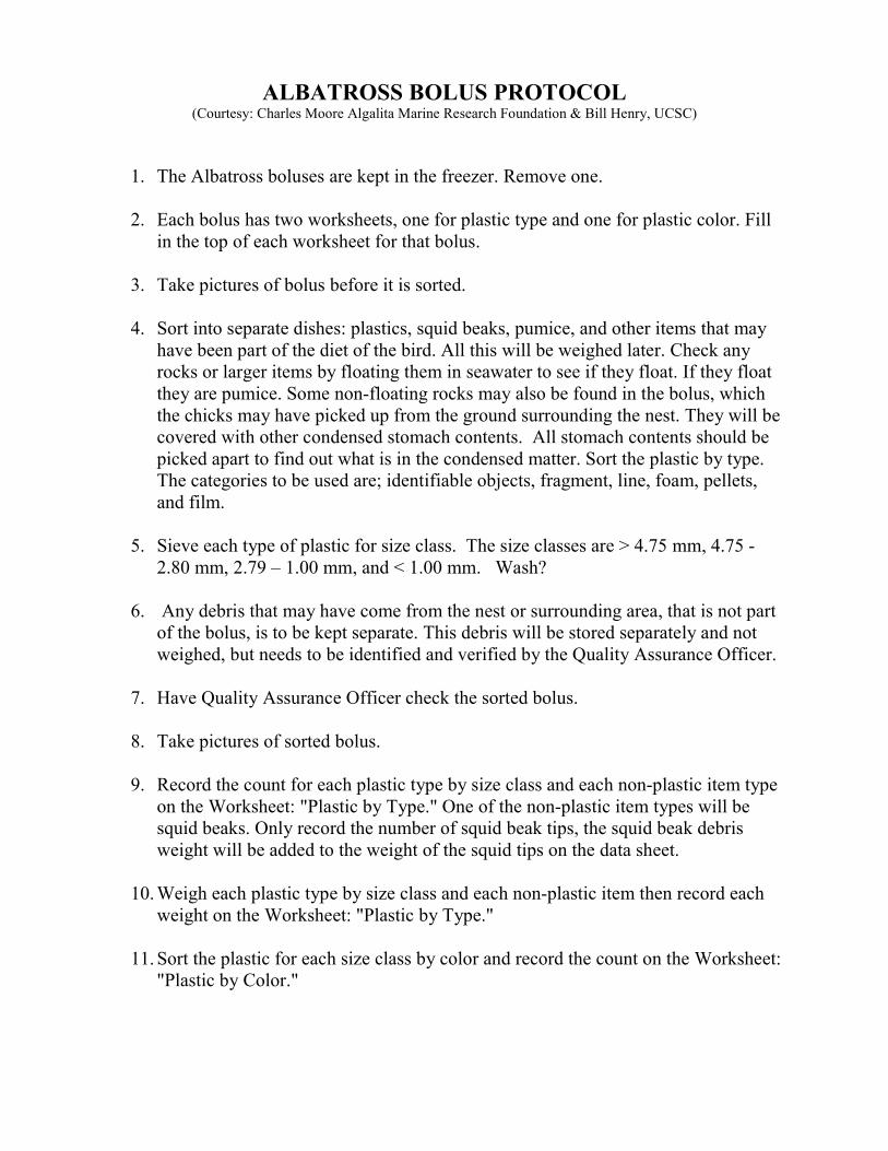
ALBATROSS BOLUS PROTOCOL (Courtesy: Charles Moore Algalita Marine Research Foundation & Bill Henry, UCSC)
1. The Albatross boluses are kept in the freezer. Remove one.
2. Each bolus has two worksheets, one for plastic type and one for plastic color. Fill
in the top of each worksheet for that bolus.
3. Take pictures of bolus before it is sorted.
4. Sort into separate dishes: plastics, squid beaks, pumice, and other items that may
have been part of the diet of the bird. All this will be weighed later. Check any
rocks or larger items by floating them in seawater to see if they float. If they float
they are pumice. Some non-floating rocks may also be found in the bolus, which
the chicks may have picked up from the ground surrounding the nest. They will be
covered with other condensed stomach contents. All stomach contents should be
picked apart to find out what is in the condensed matter. Sort the plastic by type.
The categories to be used are; identifiable objects, fragment, line, foam, pellets,
and film.
5. Sieve each type of plastic for size class. The size classes are > 4.75 mm, 4.75 -
2.80 mm, 2.79 – 1.00 mm, and < 1.00 mm. Wash?
6. Any debris that may have come from the nest or surrounding area, that is not part
of the bolus, is to be kept separate. This debris will be stored separately and not
weighed, but needs to be identified and verified by the Quality Assurance Officer.
7. Have Quality Assurance Officer check the sorted bolus.
8. Take pictures of sorted bolus.
9. Record the count for each plastic type by size class and each non-plastic item type
on the Worksheet: "Plastic by Type." One of the non-plastic item types will be
squid beaks. Only record the number of squid beak tips, the squid beak debris
weight will be added to the weight of the squid tips on the data sheet.
10. Weigh each plastic type by size class and each non-plastic item then record each
weight on the Worksheet: "Plastic by Type."
11. Sort the plastic for each size class by color and record the count on the Worksheet:
"Plastic by Color."
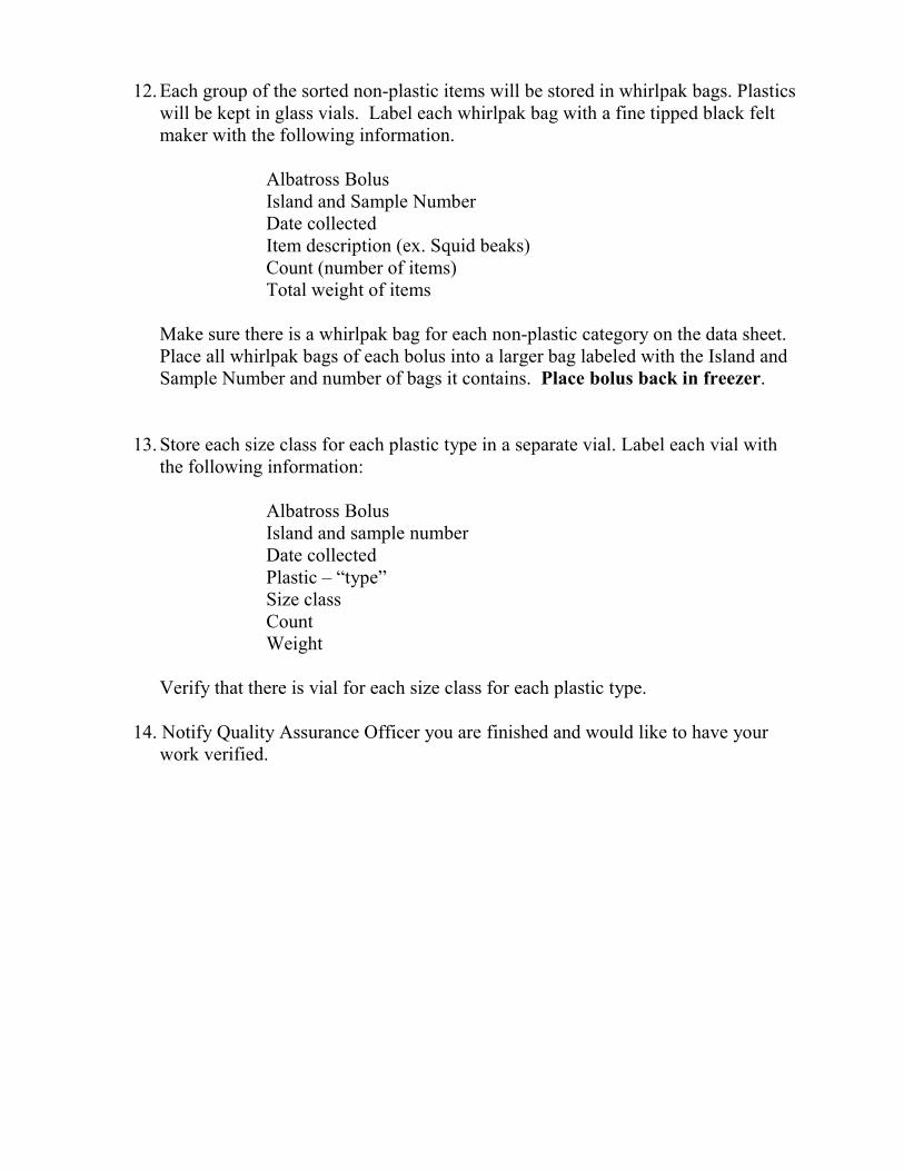
12. Each group of the sorted non-plastic items will be stored in whirlpak bags. Plastics
will be kept in glass vials. Label each whirlpak bag with a fine tipped black felt
maker with the following information.
Albatross Bolus
Island and Sample Number
Date collected
Item description (ex. Squid beaks)
Count (number of items)
Total weight of items
Make sure there is a whirlpak bag for each non-plastic category on the data sheet.
Place all whirlpak bags of each bolus into a larger bag labeled with the Island and
Sample Number and number of bags it contains. Place bolus back in freezer.
13. Store each size class for each plastic type in a separate vial. Label each vial with
the following information:
Albatross Bolus
Island and sample number
Date collected
Plastic – “type”
Size class
Count
Weight
Verify that there is vial for each size class for each plastic type.
14. Notify Quality Assurance Officer you are finished and would like to have your
work verified.
Albatross Bolus Investigation Data Sheet
Investigators: Date:
BOLUS #: Species (if known): Location (if known):
TOTAL NUMBER ITEMS IN BOLUS:
NATURAL PREY ITEMS CountPercent of Total (Count/Total)*100
NON-NATURAL ITEMS
RECOGNIZABLE WHOLE PLASTIC ITEMS (e.g.bottle caps)Count
Percent of Total (Count/Total)*100
PLASTIC FRAGMENTS (group into size, shape, & color)Count
Percent of Total (Count/Total)*100
Small (<10 mm)
Medium (<20 mm, > 10mm)
Large (>20 mm, <50 mm)
Extra large (>50 mm)
OTHER NON-NATURAL ITEMS e.g. fishing lineCount
Percent of Total (Count/Total)*100
TOTALS CountPercent of Total (Count/Total)*100
Natural items
Non-natural items
Comments & Notes

Sample Number:
Sample Location:
Lab Technician:
Sample Station:
Sample Date:
Analysis Start Date:
COLOR
SIZE
Black/Gray
Blue
Brown/Tan
Green
Orange
Pink/Red
Transparent/
Translucent
White
Yellow
Unidentified/
Misc.
Measured
> 4.75 mm
4.75 -
2.80 mm
2.79 -
1.00 mm
< 1.00 mm
Tyler-sieved
> 4.75 mm
4.75 -
2.80 mm
2.79 -
1.00 mm
< 1.00 mm
TOTALS
ALBATROSS BOLUS WORKSHEET
Sorting Worksheet for Plastic by COLOR (courtesy C.Moore, Algalita Marine Research Foundation & W.Henry, UCSC)
TOTAL
for each size class
PLASTICS
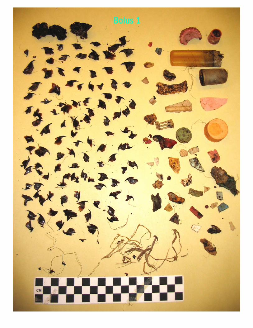
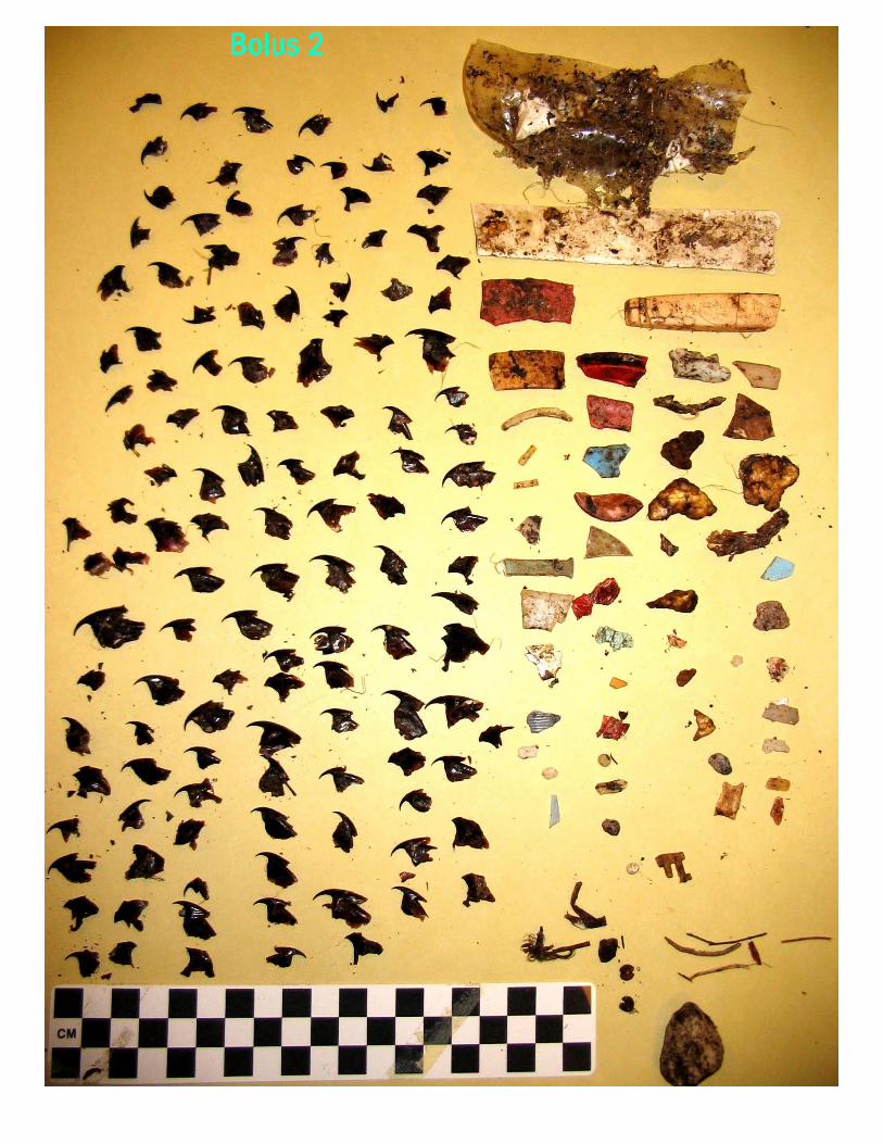
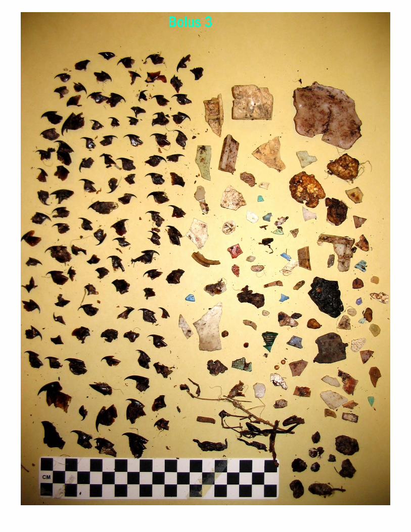
Waves, Wetlands, and Watersheds Supplemental Activities for the California Coastal Commission Science
Activity Guide Activity 8.2a Extension of 8.2 “You Are What You Eat” “Are Seabirds What They Eat? Plastics and Seabirds” (Adapted from: “How do we know what albatrosses eat?” Oikonos - Ecosystem Knowledge & Cordell Bank National Marine Sanctuary) Science skills
• Observing
• Identifying
• Analyzing
• Classifying
• Communicating Concepts
• Seabirds mistake plastic for food and feed it to themselves and their chicks
• Albatross chicks regurgitate boluses, a compact mass of undigestable material
• Ingesting plastic can harm seabirds California Science Content Standards 9. Investigation and Experimentation: Scientific progress is made by asking meaningful questions and conducting careful investigations. 9a. Plan and conduct a scientific investigation to test a hypothesis 9e. Construct appropriate graphs from data and develop quantitative statements about the relationships between variables.
Objectives Students dissect a bolus (if available) or use bolus data sheets and photos included in this activity to identify, sort, classify, quantify, and summarize contents Time to complete One class period Mode of instruction Teacher directed group lab activity and work with data sheet, followed by presentation of results and class discussion Materials
1. Power Point CD – Natural History of Black-footed Albatross
2. LCD projector 3. Color photos of contents of dissected bolus (PDFs on CD; use boluses if
available) 4. “Albatross bolus Investigation Data Sheet” 5. Gloves, tweezers for sorting boluses, hand lenses, trays, rulers (metric is
preferred), scale (digital, if available) and mounting boards and glue to mount contents of boluses (optional)
Preparation Review Natural History of Black-footed albatross and Laysan albatross Power Point presentation, photocopy Bolus Investigation Data Sheet, photos of the contents of four boluses (or assemble boluses if available) one per student or group. Outline Before class
1. Contact Carol Keiper ([email protected]) or Jennifer Stock ([email protected]) to investigate the possibility of getting boluses
2. Assemble dissecting trays, tweezers, gloves, mounting boards, glue (hot glue guns work well) if boluses are available
3. Prep for Power Point Natural History presentation; refer to script included in this packet
4. Photocopy Albatross Bolus Investigation Data Sheet, one per student or one per group of students
5. Color copy photos of boluses (included in this activity packet) or download and PDFs and laminate if possible
6. Refer to “Albatross Bolus Protocol” for additional information about handling and processing boluses
During class
7. Lead class discussion about how seabirds depend on the ocean for their food (even when they are raising a chick, they fly thousands of km in search of food for themselves and for their chick) and how they capture their prey (scavenging and dipping on the surface)
8. Discuss why some species are more susceptible to plastic ingestion than others and the importance of diet studies
9. Refer to and review “Plastics and Their Uses” and the types of plastic that floats or sinks
10. Discuss and list ideas of what they would expect to find inside the bolus, the regurgitated mass of indigestible materials
11. Investigate contents of bolus and list, quantify, and summarize findings on Albatross Bolus Investigation Data Sheet
Background Seabirds are birds that make their living on the open ocean; some are found near-shore and coastal, whereas others range far from the sight of land. They
come to land to breed on remote islands and even when nesting they have to return to sea to find food for themselves and their chicks. This makes them completely dependent on finding their food in the ocean throughout their lives. An example of pelagic (open ocean) seabirds are the Black-footed albatross and Laysan albatross and are the focus of this lab activity. These birds are ocean wanderers that migrate thousands of miles throughout the North Pacific Ocean. Seabirds are ecological indicators in marine ecosystems and diet studies can highlight shifts in prey types and changes in abundance and distribution of prey. Seabirds can also be used to quantify changes in threats caused by increased human use of coastal and open-ocean ecosystems (e.g. plastic pollution). The Black-footed albatross eat flying fish eggs, squid, crustaceans, fish, and pelagic barnacles and take their food by scavenging and dipping at the surface. Laysan albatross also eat squid and both species feed their chicks by regurgitating squid, flying fish eggs, and fish larva into the chick’s mouth. The chitinous beaks of squid resist digestion; undigested beaks, along with other undigestible items fed to chicks (e.g. plastic and fishing line) are retained in their stomach which chicks regurgitate as a compacted mass, the bolus. They regurgitate a bolus when they reach a certain age or size, usually just before they fledge (leave the nest site to venture out to sea). Unfortunately, if the chicks consume too many plastic items before they are able to regurgitate them, they become more vulnerable to starvation. (Note: cause of death is generally related to physiological stress due to blockage and satiation). By studying the contents of boluses, much information can be learned about seabird diets, however, we can also learn important information about human impacts on the pelagic, open ocean marine system, far from land. Activity
1. Present the Power Point presentation on the Natural History of the Black-footed albatross to your class; highlight a) how these birds feed (dippers and surface feeders); b) what they feed on (flying fish eggs, squid, crustaceans and fish); c) feed their chicks by regurgitating food into the chick’s mouth; d) chicks regurgitate a bolus when they reach a certain age or size, usually just before they leave the nest site; e) some parts of prey items are not digestible e.g. squid beaks
2. Conduct a class discussion on what types of threats these seabirds face (injury or death by drowning from longline fisheries and plastic ingestion)
3. Based on what they have just learned about albatrosses, their mode of feeding, their diet, and boluses, have students formulate hypotheses and predictions about the contents of a bolus
4. Divide class into small groups and distribute photos of boluses and bolus data sheet
5. Identify, count, and measure items in bolus photos; complete data sheet 6. If boluses are available, have students dissect, sort, and classify items by
size and color. Measure and group items as follows: small (0-10 mm),
medium (10-20 mm), large (20-50 mm), extra large (>50 mm), color and fishing line; complete bolus data sheet
7. Calculate the following: total number of items; total number of non-natural items; total number of plastic fragments and “user” plastic; total number of whole items e.g. bottle caps; enumerate items by color, size (see above), and shape; calculate proportions of each
8. Summarize by weight (if digital scale is available): weigh each bolus, natural, and unnatural items and calculate proportion of mass of plastic and unnatural items relative to each bolus
Results and reflection
1. Summarize results on data sheets and report findings and conclusions to the class
2. Create summary graph or chart of all bolus results e.g. graph proportion of natural vs. non-natural items; graph proportion of plastic; graph by color, size and shape
3. Compile all bolus data into a class graph and communicate results with other classes. What were some of the patterns of the plastic you observed in the bolus e.g. size, specific shape, colors, recognizable items? Was there any evidence of selective feeding e.g. did you find that only a particular kind of plastic had been ingested? What proportion of the bolus contained plastic items?
4. If boluses were used, mount on foam board and place in a display box and present results. NOTE: Bolus availability is extremely limited. Consider ways to reuse bolus as they may not be readily available.
Conclusions Seabirds that feed on the surface of the ocean (dippers and scavengers), such as Black-footed albatross and Laysan albatross often mistake plastic pieces as food and also feed plastics to their chicks. Birds that feed by diving for their food also eat plastic, however, surface feeders eat more plastic than divers. Albatross chicks usually regurgitate a bolus right before they leave the nest and go to sea (fledge). Boluses contain indigestible natural (squid beaks) and un-natural (plastic) materials. If chicks are fed too much plastic they are likely to suffer from physiological stress from blockage and satiation (feeling so full) that can result in their death. Chicks can become so full and items can be so large that they are unable to regurgitate a bolus. Types of plastic include “user” plastic e.g. bottle caps, plastic toys, cigarette lighters, light sticks, fishing floats, and fishing line. We can think of seabirds as ocean barometers that can indicate the amount and extent of plastic pollution in our oceans. Extensions and applications
1. Refer to plastics used in buoyancy experiments in Activity 8.2 to conduct Extension Lab Activity 8.2b: Plastic Investigations
2. Research the life of an albatross
Adapted from: “Fishing for a Living: How do we know what Albatrosses eat?” developed by Cordell Bank National Marine Sanctuary and Oikonos-Ecosystem Knowledge Further references on albatross: Oikonos-Ecosystem Knowledge Black-footed albatross project http://www.oikonos.org/projects/albatross.htm Cordell Bank National Marine Sanctuary http://www.cordellbank.noaa.gov US Fish and Wildlife Service at Midway http://midway.fws.gov/ Kinan, I. Occurrence of plastic debris and ingestion by Albatross at Kure Atoll, Northwestern Hawaiian Islands, Western Pacific Regional Fishery Management Council, Honolulu, Hawaii. [email protected] Schreiber, E.A. & J. Burger eds 2001. Biology of Marine Birds, CRC Marine Biology Series 2001 Safina, Carl. Eye of the Albatross. Henry Holt & Company New York Extension Lab Activity 8.2b: Plastic Investigations “What plastic items are albatross likely to eat?” (Adapted from: “How do we know what albatrosses eat?” Oikonos - Ecosystem Knowledge & Cordell Bank National Marine Sanctuary) Science skills
• Observing
• Classifying
• Predicting
• Communicating Concepts
• Understand that seabirds that are surface feeders (albatross) are more likely to ingest plastic and feed it to their chicks
• Understand that birds with bigger beaks (albatrosses) eat larger prey and plastic (20-100mm)
• Scientists use Dichotomous keys as a tool for classifying things. Typically it is used to identify organisms.
California Science Content Standards 9. Investigation and Experimentation: Scientific progress is made by asking meaningful questions and conducting careful investigations.
Objectives Students create and use a dichotomous key to determine if an albatross would ingest a particular piece of plastic. Students will measure objects and compare the characteristics of the assorted piles of plastic. Time to complete One class period Mode of instruction Teacher directed group lab activity and work with Dichotomous Key, followed by presentation of results and class discussion Materials
1. Assorted plastic trash collected for Activity 8.2; assess the need to collect more; if necessary have students collect plastic trash from their neighborhoods, homes, and schools
2. Plastic Dichotomous Key Worksheet 3. Ruler to measure plastic 4. Plastic and Seabirds Power Point presentation
Preparation Assemble all plastic that includes large/small, transparent/translucent, and assorted colors. Photocopy Plastic Dichotomous Worksheet. Read information about plastic and seabirds in the Plastic Power Point presentation. Optional: Select relevant (and appropriate to your particular class) information from the Power Point presentation to create a seabird and plastic information sheet to distribute to students. Outline Before class Assemble all plastic e.g. bottle caps, Styrofoam, children’s plastic toy parts, plastic fishing floats, toothbrushes, light sticks, and divide into piles to be distributed to each group of 4-5 students. During class
1. Review concept of density and properties of objects in salt water 2. Review “Plastics and Their Uses” and the types of plastic that floats or
sinks 3. Sort and categorize plastic into specific groups: size, shape,
transparent/translucent, light, medium, or dark colors, bright (yellow/red) or dull (blue/green); industrial plastic (pellets) or user plastic, plastic fragments
4. Group objects that have similar characteristics and create sub-groups; start with most general and progress to increasingly more specific characteristics
5. Use Example Plastic Dichotomous Key from “Fishing for a Living: How do we know what albatrosses eat?” to create a Dichotomous Key
Background Marine plastic pollution is one of the major threats to seabirds (and marine mammals, fish, sea turtles, and marine life that feeds on plankton). The increase in plastic production and “single-use” plastic has resulted in a corresponding rise in the amount of plastic debris in the oceans that is being ingested by seabirds. Seabirds mistake plastic for prey and eat bottle caps, plastic fragments, cigarette lighters, lightsticks, and pieces of children’s toys. Seabirds most susceptible to plastic ingestion are surface feeders and scavengers, such as Albatross. Birds’ beaks determine the size of the food they eat. Albatross eat flying fish eggs along with pumice that is often used as a floating item to which eggs are attached. Plastic items that range in size from ~2 – 20 cm and even as large as a toothbrush(!) are ingested; albatrosses also eat plastic wrappers. Activity
1. Examine piles of plastic and plastic fragments; separate and group into categories based on similar characteristics; include size as a category and use ruler to measure
2. List characteristics; start with most general and progress to more specific 3. Create Plastic Dichotomous Key 4. Summarize results by using diagram/photo of actual size of albatross
head and beak (see Plastics & Seabirds Power Point presentation slide # 8 & 9) and answering question “What items will an albatross most likely ingest and potentially cause harm? Assemble and label items likely to be ingested (several millimeters to ~20 cm) by an Laysan or Black-footed albatross
Results and reflection
1. Report findings and conclusions to the class 2. Create summary poster (use graphs/charts) of plastic items albatrosses
are likely to ingest Conclusions Seabirds, specifically birds that feed on the surface of the ocean (dippers and scavengers), such as Black-footed albatross and Laysan albatross, often mistake plastic pieces as food and also feed plastics to their chicks. Types of plastic include single-use “user” plastic e.g. bottle caps, plastic toys, cigarette lighters, light sticks, industrial pellets known as nurdles and fishing floats. Seabirds such as the albatrosses also eat fishing line. We can think of seabirds as ocean barometers that can indicate the amount and extent of plastic pollution in our oceans. Extensions and applications Research the “life –expectancy” of plastic; determine why there are so many bottle caps and identify their source; determine if large pieces of plastic break up
into smaller pieces. Use poster “Marine Debris Biodegradation Time Line” that can be purchased from Mote Marine Laboratory Sarasota, Florida 34236; 941-388-4441 or 1-800-691-MOTE. Use activities and discussion questions for all grades in Activity CA3 Clean shorelines, Clean Oceans: Shoreline Cleanup p. 131 and Activity CA4 Preventing Pollution at the Source Adapted from: “Fishing for a Living: How do we know what Albatrosses eat?” developed by Cordell Bank National Marine Sanctuary and Oikonos-Ecosystem Knowledge Further references on Dichotomous Keys http://www.park.edu/bhoffman/courses/bi225/labs/Dichotomous%20Keys%202.htm Further references on ocean pollution: see p. 112 in Waves, Wetlands, and Watersheds Activity 8.2c and High School “Tracking Albatross and Tracking Trash” (Adapted from Signals of Spring,Cordell Bank National Marine Sanctuary and Oikonos-Ecosystem Knowledge activities; and based on current (2004-2005) research on the Black-footed albatross being conducted by Oikonos-Ecosystem Knowledge, Duke University, Claremont Colleges, and USGS Western Ecological Research Center (http://oikonos.org/whatsnew.htm) Science skills
• Organizing
• Interpreting
• communicating Concepts
• Black-footed albatross fly long distances to search for food
• Research is needed to answer questions about where they go because they are an endangered species
• Scientists use satellite telemetry to study their movement patterns
• During their journeys across the North Pacific they can encounter and eat plastic
• Black-footed albatross are an endangered species; one of the primary factors affecting their status is by-catch associated with longline fishing
• Science plays a key role in providing important information for the conservation of the Black-footed albatross and other endangered and threatened species
California Science Content Standards 9e. Construct graphs from data Objectives
• Students map locations of Black-footed albatross on a map of the North Pacific and determine overlap with the “eastern plastic garbage patch” documented by Agalita Marine Research Foundation (AMRF)
• Students understand the critical need for plastic pollution prevention Time to complete: one class period Mode of instruction: Teacher led mapping activity: Black-footed albatross satellite tracking location data (latitude and longitude), and mapping location of “eastern garbage patch” on map of North Pacific Ocean Materials: Map of North Pacific Ocean, Black-footed albatross location data (latitude and longitude), coordinates of the “Eastern Garbage Patch”, and Albatross Mapping Activity Summary Sheet Preparation: photocopy maps and latitude/longitude data sheets for two albatross Outline Before class – photocopy maps and data sheets During class
1. Lead class discussion about how scientists study seabirds that are far from land e.g. use of satellite telemetry
2. Help students locate and map location of tagging site at Cordell Bank National Marine Sanctuary
3. Demonstrate how to plot points of Latitude and Longitude on a map 4. Lead class to make predictions where they think Black-footed albatross
would go after leaving the tagging location at Cordell Bank National Marine Sanctuary
5. Divide students into groups for mapping activity or have students work independently
6. Create an encircled point at each location and label each point with each day
7. Summarize mapping activity

Background Build on lessons learned from Activity 8.21 and 8.2b. Advances in technology provide important tools to increase our understanding about ocean habitats and seabirds’ use of these habitats and can identify potential interactions with threats far from land. Scientists use satellite telemetry to increase our understanding of long-distance ocean migrators. Satellite transmitters are placed on backs of albatross and Argos satellites (http://www.argosinc.com/mission_and_organization.htm) that orbit our planet receive signals from tags (transmitters, http://www.wildlifecomputers.com/Satellite%20Tags/SatelliteTags.htm) and then relay this information to ground receiving stations that process the data. Research is needed on the Black-footed albatross because it is listed as endangered, largely due to by-catch from longline fisheries, but also other threats such as plastic ingestion. Science plays a key role in seabird conservation by providing resource managers the important information about biology, ecology, and movement patterns required for effective management and protection. Algalita Marine Research Foundation documented the location of the “eastern garbage patch” and estimated there was ½ lb. of garbage per 100m2 of sea surface in the North Pacific Ocean. Data from the study on Black-footed albatross is included to complete the mapping activity. Activity
1. Divide class into groups (or have students work independently) 2. Distribute map of North Pacific Ocean 3. Label National Marine Sanctuaries (NMS) as follows: along west coast
from north to south label Olympic Coast NMS, Cordell Bank NMS, Gulf of the Farallones NMS, Monterey Bay NMS, Channel Islands NMS, Hawaiian Islands Humpback Whale NMS, and Northwestern Hawaiian Islands NMS (proposed)
4. Review how to map latitude/longitude 5. Label tagging location – Cordell Bank National Marine Sanctuary 6. Brainstorm with students: “As a scientist, what questions would you want to
know the answers to?” 7. Map points of latitude/longitude of selected Black-footed albatross on North
Pacific Ocean map; encircle points and label with the date for each bird 8. Use Albatross Mapping Activity Summary Sheet and calculate the following
for each bird: total number days of tracking; average number of kilometers per day (#km/#days)
9. Map location of “eastern garbage patch” 10. For each bird, determine total number days spent in garbage patch;
proportion time spent in garbage patch (# days in patch/total # days)
Results and reflection
1. Determine which birds spent the greatest amount of time in the garbage patch and would thus be likely to encounter (and possibly ingest) plastic
2. Discuss patterns of tracklines and possible reasons of their occurrence in specific locations e.g. garbage zone
Conclusions Humans are responsible for plastic marine debris that seabirds ingest. The continuing escalation of plastic marine debris warrants actions on many levels. At the local level, we can all do our part in preventing plastic debris from becoming part of the “eastern garbage patch” by being vigilant in keeping plastic from entering rivers and streams that flow into the ocean and that can then get transported around the planet via ocean currents. Extensions and applications
1. Investigate why garbage accumulates in the central Pacific: http://oceancurrents.rsmas.miami.edu/ or http://seawifs.gsfc.nasa.gov/OCEAN_PLANET/HTML/oceanography_currents_2.html
2. Investigate plastic and marine debris: www.plasticdebris.org;
www.marine-litter.gpa.unefp.org; www.earthresource.org/campaigns/capp/capp-overview; www.beachcombers.org
3. Use the following website to measure how far the albatross traveled
during different legs of its journey in miles or kilometers: http://jan.ucc.nau.edu/~cvm/latlongdist.html
Adapted from: “Fishing for a Living: How do we know what Albatrosses eat?” developed by Cordell Bank National Marine Sanctuary and Oikonos-Ecosystem Knowledge Further references:
1. Investigate longline fishing by-catch: www.abcbirds.org/policy/seabird_report.PDF ; www.wsg.washington.esdu/publications/online/execsummary.pdf
www.wpcouncil.org 2. Investigate Oikonos Black-footed albatross research:
http://www.oikonos.org/whatsnew.htm 3. Investigate Algalita Marine Research Foundation:
http://www.alguita.com/, http://www.algalita.org , www.alguita.com

4. Learn more about Cordell Bank National Marine Sanctuary: http://www.cordellbank.noaa.gov
5. Satellite telemetry:
http://www.argosinc.com/mission_and_organization.htm http://www.wildlifecomputers.com/Satellite%20Tags/SatelliteTags.htm
6. “Eye of the Albatross” by Carl Safina
Activity 9.0 – 12.0: High School extensions for Activity 8.2a and Extension 8.2 “You Are What You Eat” See 8.2a for Science skills and concepts California Science Content Standards Ecology b: Students know how to analyze changes in an ecosystem resulting from changes in climate, human activity, introduction of nonnative species, or changes in population size. Follow 8.2a Objectives, Time to complete, Mode of instruction, Activity, and Results and Reflection High School Extension of Activity: to investigate the contents of an albatross in greater detail, use Bolus Investigation Datasheet: Sorting for plastic by color and size (adopted from Charles Moore, Agalita Marine Research Foundation and Bill Henry from UCSC Extension of Results and Reflection: Summarize results by using the Percent Similarity Index (PSI) summary data sheet to calculate a (PSI) for all boluses investigated (either photocopy images or boluses). This descriptive comparison can be used to determine overall how much the composition of boluses overlap or the degree of similarity (80% or greater can be considered to be similar). Resources: 1) Send for a free DVD and curriculum titled Watershed Wonders produced by the Algalita Marine Research Foundation 148 N Marina Drive, Long Beach, CA 90803. Request a free assembly program during Fall of 2005 2) Investigate Plastic Pellets in the marine environment at http://www.mindfully.org/Plastic/Ocean/Plastic-Aquatic-EPA842B92010-Dec92_3htm
Acknowledgements & Credits: Oiknonos Ecosystem Knowledge: Carol Keiper & Michelle Hester Cordell Bank National Marine Sanctuary: Jennifer Stock & Dan Howard, Manager National Fish & Wildlife Foundation – Funding for Black-footed albatross tagging William Henry – University of California Santa Cruz Captain Charles Moore – Algalita Marine Research Foundation Dr. David Hyrenbach - Visiting Scholar at the Parrish Lab - School of Aquatic and Fishery Sciences University of Washington Michelle Hester, President Oikonos Ecosystem Knowledge Robert Anderson – Teacher at Modesto College, Modesto California