Embed Size (px)
Citation preview

A Transect of Urban Settlement Types THE TRANSECT, SMARTCODE AND URBAN STRUCTURE V3 08/08
A Transect of Urban Settlement Types THE TRANSECT, SMARTCODE AND URBAN STRUCTURE
Peter Richards
Deicke RichardsArchitecture Urban Design Landscape Community Design
58 Baxter Street Fortitude Valley Brisbane Queensland Australia 4005
V3 9/08

Research
A Transect of Urban Settlement Types THE TRANSECT, SMARTCODE AND URBAN STRUCTURE V3 08/08
This research is a hypothesis describing a range of urban settlement forms from most dense to least dense as a ‘transect’ of urban settlement types. The ‘transect” demonstrates a suggested arrangement of neighbourhoods, based upon a 5 minute walkable catchment, or 400 metre radius, to form TODs, Large and Small Towns, and Hamlets. This transect builds on the Transect and SmartCode developed by American urban designer, Andres Duany of Duany Plater-Zyberk.
The work argues that if neighbourhoods and towns are to form the ‘building blocks’ of an urban structure, neighbourhoods need to be clearly defined, and their centres recognised and declared. Fundamental to this issue is the role of retail and commercial uses located on the through street network, as the essential component of neighbourhood centres, not as districts adjacent to neighbourhoods, as has been advocated by the new urbanist movement in the United States. The through street network runs through the centres of neighbourhoods and do not form the edges of them.
The work has developed the thinking in the Liveable Neighbourhoods Code from Western Australia using the transect zones of DPZ , reinforced by observations of the urban structure of Brisbane, the capital of Queensland on the eastern seaboard of Australia.
In doing so, a new urbanist urban structure is created.
Overview
Overview 2
Introduction 3
Neighbourhoods, Locations of Centres and Urban Structure 4
The Transect, Smartcode and the Liveable Neighbourhoods Code 6
Analysis: Inner West Brisbane 7
A Transect of Urban Settlement Types 9
The Developed Transect 12
Centres Concepts 14
Conclusions 15
Contents

Research
A Transect of Urban Settlement Types THE TRANSECT, SMARTCODE AND URBAN STRUCTURE V3 08/08
The concept of the neighbourhood, scaled upon a 400 metre, five minute walkable catchment is not recent, but one that has been reinvigorated by the new urbanism movement. Neighbourhoods play a key role in forming the urban structure of new urbanism to create more sustainable settlement patterns and regions. While this is well recognised, the location and composition of the centres of neighbourhoods is not universally agreed within new urbanism. Specifically, the issue of whether retail uses are fundamental components of neighbourhood centres or are in districts adjacent to neighbourhoods remains unresolved, with both concepts supported.
The Transect and SmartCode are the most recent and influential ideas that inform the theory and practice of new urbanism in the United States. The ‘transect’ cleverly classifies types of urban and natural environments from most urban to least urban. The ‘SmartCode’, now in its ninth version with its associated manual shows how the various settlement patterns of Hamlets, TODs and Towns are elements of the region. What seems to be missing is the rationale and description of how they aggregate and cluster to structure and form the region although preferred percentages of each transect zone for various growth sectors are given in (Figure 1) While there are transect zones of different urban characteristics, can there be an accompanying ‘transect’ of neighbourhood types and settlement patterns that can inform
the placement of transect zones within a region? An essential issue is how the Transect and SmartCode fit within and inform a broader urban structure of a region. Coupled with this is the type, scale and placement of retail and commercial centres and how these may fit into this structure or, ignore or contradict it.
These issues were noted by Chip Kaufman in his paper in the CNU Retail Council Report VI where he noted that three different taxonomies of retail were discussed with no consensus about which was that most appropriate. He found,
‘...little support for alternative exemplary new urban retail and urban structuring, or even widespread recognition of a need for it. New urbanism does not yet seem to be taking the lead in the understanding, promulgation or building of more sustainable retail centres with appropriate corresponding urban structures and movement networks.’ (Kaufman 2004)
The work attempts to address these issues and has arisen from the challenge of grappling with the creation of neighbourhoods and their clustering in a number of new town projects in regional Australia, well away from large cities. The author’s inspiration for this work has come from discussions with a number of Australian colleagues, notably Chip Kaufman and Wendy Morris from ESD of Melbourne, participation in all three ACNU Conferences and observations of debates on urban structure within CNU, especially on Pro-Urb. The CNU experiences include attendance of the CNU San Diego Retail Council and SmartCode Workshop in February 2004, CNU 13 in Pasadena in June 2005 and a recent visit to Florida in November 2007 to attend a Smart Code Pro session in South Beach. The Council Report VI on Retail from the San Diego Council has been fundamental to these thoughts.
This work proposes a ‘Transect of Urban Settlement Types’ in a new diagram that is inspired by the original transect diagram. It is drawn with the highest densities to the left, to reflect authorship from the southern hemisphere. This work was commenced in 2004, refined in 2005, finalised in 2006 and revisited in 2008 in between earning a living.
FIGURE 2. Transect Smartcode V.9.0 (DPZ)
FIGURE 1. Smartcode V.8.0 (DPZ)
Introduction
T1 NATURAL ZONE T2
RURAL ZONE T3
SUB-URBANZONE T4
GENERAL URBAN ZONE T5
URBAN CENTER ZONE T6
URBAN CORE ZONE SD
SPECIAL DISTRICT

Research
A Transect of Urban Settlement Types THE TRANSECT, SMARTCODE AND URBAN STRUCTURE V3 08/08
These questions are useful and are of interest in Australia, as new urbanist theory and practice in Australia, which is strongly influenced by the CNU Award winning Western Australian Community Code is at complete variance to the ‘Traditional Neighbourhood’. The Code’s pre-eminent contribution to new urbanism (and urban design) comes from a position of a sustainable urbanism, rather than traditional urbanism. The Code advocates a strong definition of walkable neighbourhoods within a broader concern for urban structure in a regional context. The Code argues for neighbourhoods to be anchored by a mixed-use centre located on the through street network, the movement economy.
These issues were discussed in the San Diego Retail Council. Not all US new urbanists seem to support the traditional neighbourhood structure. In his article in the Retail Council Report, Peter Calthorpe argued that centres were the ‘Missing Element of New Urbanism’,
‘Part of our problem has been that new urbanism has focused on the residential neighbourhood. … retail is often seen as an appendage to a neighbourhood rather than the core of what I would classify as a range of centres. (Calthorpe 2004)
In the same publication, Dan Parolek strongly argued the counter view that neighbourhoods were the building blocks of great communities and towns. He believed that heart of the neighbourhood was,
‘…. the mixed-use neighbourhood centre that provides day-to-day amenities, places for community members to congregate and socialise, incubators for small businesses, and office spaces for small business owners within walking distance of their homes. ‘ (Parolek, 2004)
FIGURE 4 Traditional Neighbourhood Structure, cluster of four Perry Neighbourhood Units.
FIGURE 3 Traditional Neighbourhood Units. Clarence Perry 1929
In the United States, neighbourhood design is dominated by the notion of the ‘Traditional Neighbourhood’. This Traditional Neighbourhood, drawn from Clarence Perry’s Neighbourhood Unit of 1929 has quite specific characteristics. The neighbourhood is scaled upon a five minute walk, one of the first times this dimension has been formalised, The major through street network is placed on the edges of the neighbourhood with the centre formed by a park with community facilities. The retail and commercial uses are along the busier streets, so are on the edges of the neighbourhood. In the Traditional Neighbourhood, there is also potentially some form of small scale retail in this centre. (Figure 3)
The contribution to urban structure of the Traditional Neighbourhood is the cluster of four neighbourhoods backing onto the main through street network at a crossroads. The through roads, the movement economy, are configured as continuous mixed-use corridors and contain the higher order retail. This diagram can be represented with four of Perry’s neighbourhood units pasted together. (Figure 4)
In his Retail Council paper, ’Plugging Retail into TND’, Andres Duany explained the preferred locations of retail in the Transect. In Transect zones, T5 and T6, the higher density and more urban transect zones, the retail is along the through road corridor. With T4, the retail is located in the centre of the neighbourhood, no more than 400 metres from the other centres. It remains unclear whether a T4 in the centre of the neighbourhood is meant to coexist with T5 no more than 400 metres away and on the major through streets. It can be questioned as to whether there is enough catchment to support an additional centre embedded in the neighbourhood away from the movement economy and an efficient public transport route?
Similarly, what are the characteristics of a T6 retail centre and what are their spacings to achieve an appropriate catchment for each centre and a more sustainable region. Does the scale of retail placement relate in any way to the scale of clustering neighbourhoods?
Neighbourhoods, Locations of Centres and Urban Structure
Research
A Transect of Urban Settlement Types THE TRANSECT, SMARTCODE AND URBAN STRUCTURE V3 08/08
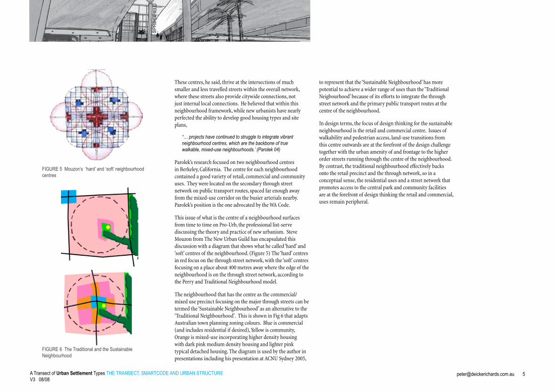
These centres, he said, thrive at the intersections of much smaller and less travelled streets within the overall network, where these streets also provide citywide connections, not just internal local connections. He believed that within this neighbourhood framework, while new urbanists have nearly perfected the ability to develop good housing types and site plans,
“… projects have continued to struggle to integrate vibrant neighbourhood centres, which are the backbone of true walkable, mixed-use neighbourhoods.’ (Parolek 04)
Parolek’s research focused on two neighbourhood centres in Berkeley, California. The centre for each neighbourhood contained a good variety of retail, commercial and community uses. They were located on the secondary through street network on public transport routes, spaced far enough away from the mixed-use corridor on the busier arterials nearby. Parolek’s position is the one advocated by the WA Code.
This issue of what is the centre of a neighbourhood surfaces from time to time on Pro-Urb, the professional list-serve discussing the theory and practice of new urbanism. Steve Mouzon from The New Urban Guild has encapsulated this discussion with a diagram that shows what he called ‘hard’ and ‘soft’ centres of the neighbourhood. (Figure 5) The ‘hard’ centres in red focus on the through street network, with the ‘soft’ centres focusing on a place about 400 metres away where the edge of the neighbourhood is on the through street network, according to the Perry and Traditional Neighbourhood model.
The neighbourhood that has the centre as the commercial/mixed use precinct focusing on the major through streets can be termed the ‘Sustainable Neighbourhood’ as an alternative to the ‘Traditional Neighbourhood’. This is shown in Fig 6 that adapts Australian town planning zoning colours. Blue is commercial (and includes residential if desired), Yellow is community, Orange is mixed-use incorporating higher density housing with dark pink medium density housing and lighter pink typical detached housing. The diagram is used by the author in presentations including his presentation at ACNU Sydney 2005,
to represent that the ‘Sustainable Neighbourhood’ has more potential to achieve a wider range of uses than the ‘Traditional Neigbourhood’ because of its efforts to integrate the through street network and the primary public transport routes at the centre of the neighbourhood.
In design terms, the focus of design thinking for the sustainable neighbourhood is the retail and commercial centre. Issues of walkability and pedestrian access, land-use transitions from this centre outwards are at the forefront of the design challenge together with the urban amenity of and frontage to the higher order streets running through the centre of the neighbourhood. By contrast, the traditional neighbourhood effectively backs onto the retail precinct and the through network, so in a conceptual sense, the residential uses and a street network that promotes access to the central park and community facilities are at the forefront of design thinking the retail and commercial, uses remain peripheral.
FIGURE 5 Mouzon’s ‘hard’ and ‘soft’ neighbourhood centres
FIGURE 6 The Traditional and the Sustainable Neighbourhood

Research
A Transect of Urban Settlement Types THE TRANSECT, SMARTCODE AND URBAN STRUCTURE V3 08/08
FIGURE 8 Neighbourhood Clusters forming towns - the Chippat - applied on a sub-region in Western Sydney
FIGURE 7 Neighbourhoods Cluster to form Towns Liveable Neighbouroods Design diagram and the Southern River Urban Structure Plan near Perth, WA
The Liveable Neighbourhoods urban structure of the town has the ‘town centre’ as a central neighbourhood elongated around a 400 metre long ‘Main Street’ with six or so neighbourhoods surrounding and supporting this town centre. Depending on the resulting density, this settlement type could have a population of 10-20,000 people, so could support higher order retail (in accordance with current Australian expenditure patterns and retail floor space provisions) of two supermarkets, or a supermarket and a discount department store. Lower densities could support a single supermarket.
This diagram is affectionately referred to as a ‘Chippat’ after Chip Kaufman and Wendy Morris’ work. It is an urban settlement type that covers an approximate area of 3 kilometres by 2.5 kilometres. These ideas have been applied on projects in Western Australia and elsewhere in Australia, in particular the urban release areas of south western Sydney (CNU Award, 2005) (Figure 8).
The traditional neighbourhood with a ‘soft centre’ is more about urban quality and the way that communities may perceive their neighbourhood. The ‘hard centre’ is about mixed-use, urban vitality and public transport integration i.e. urban structure and the form of regions. The ‘hard centre’ is always used when TOD’s are defined. It is time that the traditional neighbourhood is no longer used as an urban structuring device.
The Transect is a compelling theory explained in a beautiful cross sectional diagram describing a series of urban to rural types and their interrelationships. However, in perspective illustrations of the Transect, the preferred configuration appears to be a town or village within a natural environment, where the Transect from urban to rural occurs in a relatively short dimension. The cover illustrations of recent Smartcode documents suggests this, as does the emblematic Leon Krier drawing of an obviously European example. The SmartCode does not elaborate and conceptualise an overall urban structure within broader urban growth areas. Questions such as how much T4 are needed to create and area of T5 remains unclear. Calthorpe has observed,
The Transect lays out broad guidelines for the urban design of each but not their relationships, hierarchy, appropriate placement and integration with the larger regional form. We desperately need such a theory if we are to contribute to the larger debates on regional growth. (Calthorpe 2004)
It is at this point where Australian theory and practice may assist largely through the acclaimed Liveable Neighbourhood Design Code from Western Australia (CNU Award 2001). In recognising centres of neighbourhoods differently to the traditional neighbourhood, as the mixed-use centre on the through street network, or the ‘hard’ centre, to use Mouzon’s terminology, the ‘liveable neighbourhood’ forms the fundamental building block of urban structure.
When the centre is the focus and designed with a rich mix of uses as a high quality urban place, the centre creates a rationale and purpose to provide a diversity of housing types and densities to support the centre, and the integration of employment and community uses. When these uses are placed on the through street network, they are in very visible support and accessible locations and can readily efficient public transport. This is the sustainable neighbourhood that forms an essential settlement type to aggregate to form sustainable towns and regions. (Figure 7)
The Transect, Smartcode and the Liveable Neighbourhoods Code

Research
A Transect of Urban Settlement Types THE TRANSECT, SMARTCODE AND URBAN STRUCTURE V3 08/08
FIGURE 9 Aerial Views of Brisbane Inner West, looking away from and towards City Centre
Some lessons about neighbourhood and urban structure can be learnt from Brisbane on the eastern seaboard of Australia – a city of 1 million in a region of 3+ million. Founded in 1859, Brisbane grew comparatively slowly and has been characterised as a suburban city comprising relatively low-density timber detached houses. The inner west of Brisbane is a series of valleys situated on the hilly land west of the Brisbane River as it snakes its way past Mount Coot-tha towards the ocean. The main through streets hug the ridgelines with the secondary street network as a north-south/east west grid draped over the landscape. The upper catchments of the watercourses are generally ignored in the street network although the lower catchments create linear parklands, but not always.
The inner west of Brisbane has major arterials running through, but continuous urban development corridors evident in the older and larger cities of Sydney and Melbourne do not exist. Instead there are a series of regular nodes of retail and commercial activity along these streets interspersed by low-density housing, although in recent decades, there have been many infill densification projects, predominantly less than three storeys except where views to the Brisbane River were available. (Figure 9)
Analysis: Inner West Brisbane
The inner west of Brisbane has a wide variety of functioning centres. The largest is Toowong about four kilometres from the city centre along the main railway line south. Toowong is a large subregional centre with two supermarkets, a department store and discount department store, most of which is in a development built over the railway station that also incorporates a medium-rise commercial tower. Along the main streets are more medium-rise office buildings, the second supermarket (with on grade parking) and many new residential developments although there are no true mixed use buildings of residential over commercial.
Three kilometres (two miles) north of Toowong, located on a high ridge line directly west of the City Centre is Paddington, a strong neighbourhood centre containing a supermarket and a number of restaurants and businesses. Rosalie, down the hill about 800 metres away, constructed over the natural watercourse accommodates small specialist shops, a number of good restaurants and community facilities. About 700 metres east of Rosalie on the railway line two stops closer to the city from Toowong, another centre, Milton, has a good range of shops including a great Deli, offices, a dance school and a small supermarket of no more than 500 square metres.

Research
A Transect of Urban Settlement Types THE TRANSECT, SMARTCODE AND URBAN STRUCTURE V3 08/08
Less than a kilometre away of both Milton and Rosalie, the Torwood centre on a secondary through street is a collection of single storey businesses, two restaurants and a new small grocery shop constructed under a house that has become an office. (Figure 10)
Some observations can be made. The inner west of Brisbane has a relatively strong through street network that responds to the steep topography of the area. The grid is very deformed with many primary streets along ridgelines and valleys. East west connections are stronger with less north south connectivity. The focal points of these neighbourhoods are clearly the mixed-use centres. When the 400 metre walkable catchments are drawn over these centres, a number of patterns emerge. The circles generally touch. Some overlap and others have gaps between, but this is where there is steeper land, large green spaces and reduced street connectivity. The centres are all located on the through street network. Some of the streets do not have large traffic volumes, although virtually all of these streets have a bus route along them. This simple analysis of one city certainly supports the ideas of neighbourhoods based upon a four hundred metre walkable catchment as advocated by the ‘Liveable Neighbourhoods’ Code.
Toowong Centre Rosalie CentrePaddington Centre Torwood Neighbourhood Centre
FIGURE 10 Aerial Views of Brisbane Inner WestToowong, Paddington Rosalie and Torward

Research
A Transect of Urban Settlement Types THE TRANSECT, SMARTCODE AND URBAN STRUCTURE V3 08/08
Brisbane Inner West
Street Map. Central Business District at middle right. The Brisbane snakes through a series of hills past the western mountain range of which Mt Coot-tha is the eastern end. The terrain to the west is generally steeper than the lower plains to the east.
Streets Centres Open Spaces
The through streets within the inner west follow the distinctive topography of ridgelines and water courses. Centres are plentiful and varied, located in accessible and often visible locations, generally at the intersections of the through streets. Larger centres are found on higher order streets, with smaller centres on less busy streets or along streets where adequately separated from neighbouring centres.
Neighbourhood Structure
A settlement structure comprising walkable neighbourhoods scaled on the 400 metre radius, five minute walk. Retail and commercial centres are at the centres of the circles. The drawing shows the close clustering of neighbourhoods, in some cases with significant overlap, while in others where there is less through traffic, less catchment and more parkland, spacings are closer to 1-1.2 km. Neighbourhoods marked with red tone from north to south, Paddington, Rosalie. Milton, Torwood, Toowong
Town Structure
The application of the to inner west of Brisbane. No model has pure application, but the characteristic Types can be observed.
TOD Toowong
Large Towns Ashgrove, Newmarket Small Towns Paddington.
Analysis: Inner West Brisbane

Research
A Transect of Urban Settlement Types THE TRANSECT, SMARTCODE AND URBAN STRUCTURE V3 08/08
Based upon the preceding community and analysis, research is an attempt to marry new urbanist practice in Australia with that in the United States. In short, this involves combining the thinking of the Liveable Neighbourhoods community Code, the Transect and Smart Code with an idea of a regional settlement form that is expressed in a single diagram. This is called a ‘Transect of Urban Settlement Types’. The diagram suggests which transect zones and what quantum could be incorporated to form a number of settlement types, TOD, Small and Large Towns and Hamlets and how they may relate to each other in an urban area of about twelve kilometres by three kilometres.
In this transect, the ‘Chippat’ of the idealised town structure is re-configured as a nine square grid, with a town centre (scaled as walkable neighbourhood) surrounded by eight additional neighbourhoods. (Fig 11) This idealised arrangement has a number of neighbourhood types. There is a clear ‘Centre’ neighbourhood, four ‘Corridor’ neighbourhoods along the primary public transport routes and four ‘Edge’ neighbourhoods along the secondary street network. The square network fits comfortably with the Jefferson one-mile grid that spreads across the US.
The ‘Settlement Types Transect Diagram’ constructs three types of urban settlements and one village demonstrating their relationship to transport corridor types and to each other.
A Transect of Urban Settlement Types
FIGURE 11 Nine Square Town Structure

Research
A Transect of Urban Settlement Types THE TRANSECT, SMARTCODE AND URBAN STRUCTURE V3 08/08
TODThe TOD concentrates the most density it is located where there is excellent access to both rail network and freeway with station and freeway interchange. These corridors are nominally spaced at 400 metres leaving enough room for the main centre between. The TOD contains urban districts for employment, education, health care and others along the rail and freeway corridors. These could be universities, hospitals, and business parks etc that also require excellent regional access. Districts have identifiable urban centres conforming to the neighbourhood structure.
The TOD has a large Urban Core of T6 with the main centre between freeway and railway integrated with a railway station. T6 extends within the ten minute walk, 800m, and extends along cross bus transit way to the lesser intense settlement types to envelope the next neighbourhood centre. The edge neighbourhoods are T5 around the centre and towards the main centre transitioning to T4 at the periphery.
LARGE TOWNThe large town is a cluster of nine neighbourhoods of predominantly T4 in character. The ‘Large Town’ Centre has a T6 Core, anchored by two supermarkets, with a T5 town neighbourhood extending in direction of the TOD along the Boulevard / Transit way to form the corridor neighbourhood near to the TOD. Smaller scale urban campuses and health care facilities can be integrated into this ‘Large Town’ T6 Centre.
‘Corridor Neighbourhoods’ away from the TOD are T4 with centres of T5 transitioning to some T3 at the edges of the catchment. ‘Edge Neighbourhoods’ also have small centres of T5 within a predominant T4 with more T3 at the periphery.
SMALL TOWNCluster of nine neighbourhoods in the Small Town have a wider variety of Transect zones. The ‘Main Centre’ neighbourhood is T4 with a smaller centre of T5. ‘Corridor Neighbourhoods’ on Boulevard / bus transit ways are predominantly T4 with centres of T5. Surrounding ‘Edge Neighbourhoods’ are predominantly T3 with small T4 Centres.
The Centre and ‘Corridor Neighbourhoods are T4 with T5 centres. The main centre is scaled to accommodate a single supermarket with associated commercial and community facilities. The ‘Edge neighbourhoods’ are of lower intensity of T3 with centres of T4. These edge neighbourhoods have compromised catchments with the intrusion of topography such as ridgelines, vegetation and accordingly have less through connectivity within the region.
VILLAGES AND HAMLETSVillages and Hamlets are clusters of small villages / neighbourhoods within T1 Exurban Preserve and T2 Rural Reserve or in areas of more constrained land. These settlements are T3 generally with small centres of T4. These places are located to suit topographic and environmental corridors and watershed constraints and may not grow over time to become a small town.
The generic Transect is shown as Figure 12.

Research
A Transect of Urban Settlement Types THE TRANSECT, SMARTCODE AND URBAN STRUCTURE V3 08/08
TOD
TOD comprising an Urban Core T6. Main centre between freeway and railway integrated with transit stop. Districts for employment, education, health care are along transport corridors adjacent TOD. Districts have identifiable urban centres conforming with the urban structure
T6 extends within the ten minute walk, 800m, and extends along cross bus transit way to envelope next neighbourhood centre. T5 within edge neighbourhoods transitioning to T4.
Districts integrated with Rail Corridor and Freeway
Large Town
Cluster of nine neighbourhoods predominantly T4. Large Town Centre as a T6 Core, including possibly two supermarkets, with T5 town neighbourhood extending in direction of major TOD along Boulevard / Transitway Campuses and health care can be integrated into T6 Centre
Corridor Neighbourhoods are T4 with centres of T5,
Edge Neighbourhoods are T3 at periphery.
Small Town
Cluster of nine neighbourhoodsCorridor Neighbourhoods on Boulevard / bus transit ways predominantly T4 with centres of T5.
Surrounding Edge Neighbourhoods predominantly T3 with small T4 Centres.
Boul
evar
d / A
rteria
l
Bus
Tran
sitw
ay
Free
way
Hea
vy R
ail /
Lig
ht R
ail
Boulevard
Arterial
Bus Transitway
Boul
evar
d / A
rteria
l
Bus
Tran
sitw
ay
Boul
evar
d
Bus
Rou
te
Villages and Hamlets
Clusters of small villages / neighbourhoods within T1 Exurban Preserve and T2 Rural Reserve.
SD T6 T5 T4 T3 T2,1
Legend
FIGURE 12 The generic Transect of Urban Settlement Types

Research
A Transect of Urban Settlement Types THE TRANSECT, SMARTCODE AND URBAN STRUCTURE V3 08/08
This diagram is useful, but remains simplified. A number of issues are evident.
Pedestrian friendly mixed-use centres should not attempt to be oriented toward the intersection or built across two major arterials, but be adjacent to them.
Circular catchments are not all equal, as there is a general movement towards the larger centre. Therefore, catchments around major centres are larger with catchments around smaller centres more egg shaped, like the tail of a comet. The smaller radius is nearer to the larger centre with the larger radius towards the edge of the town. People gravitate towards the larger centres, not he smaller ones.
Topography, in particular watercourses, hill tops, ridgelines and significant vegetation will influence the form of settlements and the locations of centres as well as the potential catchments and therefore the scale of the settlement.
In order to address these concerns, a second diagram is proposed. The differences relate to:
Environmental areas and watercourses are shown and the street network becomes a modified grid to suggest responses to these features. Small towns and hamlets are located in these more constrained areas.
Centres are placed adjacent to locations of natural amenity where possible, which allows the creation of better urban amenity possible.
Centres do not directly face onto arterials, but are placed in one quadrant of the intersection of the two arterials. The centre crosses the arterial and the arterial frontages are prime locations for commercial, businesses and more car based retail and commercial uses that complement the pedestrian based retail.
The centres are focused on a ‘Main Street’ that runs at right angles to one of the arterials, preferably the one that leads to the highest order settlement in the region. This ‘Main Street’
is well connected to residential areas into for local vehicle trips and pedestrians. Crossings of these streets with arterials are signalised.
The Developed Transect of Urban Settlement Types is shown as Figure 13.
To demonstrate these ideas, a number of concept plans of centres have been prepared. These plans do not represent preferred design outcomes but act as illustrations and elaborate at a larger scale the thinking behind this transect diagram. The centres are:
Large town centre
Small town centre
Corridor neighbourhood centre
Each is a ‘Main Street’ based centre that have the ‘Main Street’ adjacent and parallel to the major arterial through street network. The ‘Main Streets become the local street network and have good access to the adjacent neighbourhoods across signalised intersections where they met the Arterials. Service roads provide access and frontage to the arterial. The Corridor neighbourhood suggests a Neighbourhood Green as a focal place, so the commercial area can be separated from the impacts of the major road. These ideas accept the difficulty encountered in regional Australia in enabling commercial frontage of any pedestrian quality directly fronting arterials. (Figure 14)
The Developed Transect

Research
A Transect of Urban Settlement Types THE TRANSECT, SMARTCODE AND URBAN STRUCTURE V3 08/08
TOD
TOD comprising an Urban Core T6. Main centre between freeway and railway integrated with transit stop. Districts for employment, education, health care are along transport corridors adjacent TOD. Districts have identifiable urban centres conforming with the urban structure
T6 extends within the ten minute walk, 800m, and extends along cross bus transit way to envelope next neighbourhood centre. T5 within edge neighbourhoods transitioning to T4.
Districts integrated with Rail Corridor and Freeway
Large Town
Cluster of nine neighbourhoods predominantly T4. Large Town Centre as a T6 Core, including possibly two supermarkets, with T5 town neighbourhood extending in direction of major TOD along Boulevard / Transitway Campuses and health care can be integrated into T6 Centre
Corridor Neighbourhoods are T4 with centres of T5,
Edge Neighbourhoods are T3 at periphery.
Small Town
Cluster of nine neighbourhoodsCorridor Neighbourhoods on Boulevard / bus transit ways predominantly T4 with centres of T5.
Surrounding Edge Neighbourhoods predominantly T3 with small T4 Centres.
Boul
evar
d / A
rteria
l
Bus
Tran
sitw
ay
Free
way
Hea
vy R
ail /
Lig
ht R
ail
Boul
evar
d / A
rteria
l
Bus
Tran
sitw
ay
Boul
evar
d
Bus
Rou
te
Villages and Hamlets
Clusters of small villages / neighbourhoods within T1 Exurban Preserve and T2 Rural Reserve.
FIGURE 13 The Developed Transect of Urban Settlement Types
Boulevard
Arterial
Bus Transitway
SD T6 T5 T4 T3 T2,1
Legend

Research
A Transect of Urban Settlement Types THE TRANSECT, SMARTCODE AND URBAN STRUCTURE V3 08/08
T4 RESIDENTIAL AREAS as predominant density within the neighbourhood with..
T3 RESIDENTIAL AREAS on the edge of the walkable catchment.
T6 Neighbourhood Centre
located to one side of the Arterial Streets intersection. The ‘Main Street’ runs at right angles to the arterial network, thus separated from through traffic, but is well connected into surrounding residential areas. Two large format retail (Supermarket/s and or Discount Department Store) are integrated into superblocks and sleeved by street facing retail and mixed-uses. Car based commercial along arterials with service roads.
T5 RESIDENTIAL AREAS are within walkable catchment of neighbourhood centre
‘LARGE TOWN’ NEIGHBOURHOOD
Riparian Corridors create urban amenity and link into centres where possible
T5 Neighbourhood Centre
located to one side of the Arterial Streets intersection. The ‘Main Street’ runs at right angles to the arterial network, thus separated from regional through traffic, but is well connected to the regional network and into surrounding residential areas. Supermarket is integrated into a superblock and sleeved by street facing retail and mixed-uses. Car based commercial along arterials with service roads.
Riparian Corridors create urban amenity and link into centres where possible
T5 Neighbourhood Centre
located to one side of the arterial streets intersection. The focus of the centre is a green on the corner of the arterial streets that provides visual relationship to the passing traffic but separates the pedestrian activity from the busy through roads thus improving urban amenity. A short ‘Main Street’ runs at right angles to the arterial network, accessible yet separated from through traffic, but is well connected into surrounding residential areas. The centre comprises smaller scale retail. Road based commercial extends along the primary arterial with service roads.
‘SMALL TOWN’ NEIGHBOURHOOD
‘CORRIDOR’ NEIGHBOURHOOD
T4 RESIDENTIAL AREAS as predominant density within the neighbourhood with
T3 RESIDENTIAL AREAS on the edge of the walkable catchment.
Centres Concepts
FIGURE 14 Centres Concept Plans
Boulevard / Arterial / Bus Transitway
SD T6 T5 T4 T3 T2,1
Legend

Research
A Transect of Urban Settlement Types THE TRANSECT, SMARTCODE AND URBAN STRUCTURE V3 08/08
These ideas are evident, but not explicit in recent projects in Australia. The plan for southwest Sydney was developed with the placement of a series of town typologies (‘chippat’) on the landscape. (Figure 15). They were located to understand the scale of the region and were placed to connect into the existing street network, define new major through streets and respond to the environmental qualities of the site. In the final plan, the various settlement forms of TOD, Large and Small Towns in blue, yellow and white are evident and the plan can be seen as the strategic grouping of these urban settlement types at a broader scale. (Figure 16) The arrangement however, is not a pure transition from most dense to less dense types.
In the regional context, this shows how neighbourhoods when scaled on five-minute walkable catchments aggregated to form towns of different scales and types can be used to conceptualise the region.
Application of these ideas suggests a different approach to the one developed by Oregon based planners, Criterion Planners. Their approach is informed by thorough and rigorous GIS
FIGURE 16 Urban Transect Types overlaid on Final Western Sydney Plan TOD (blue), Large Town (yellow) Small Town (white).
analysis of the region, which then maps each potential transect zone making a remarkable and quite beautiful maps of opportunity. But this work is predominantly based on analysis of the existing conditions. (Figure 17) The ‘Transect of Urban Settlement Types’ is informed by a vision of the future as much as analysis of the place. It demonstrates how this type of strategic thinking can achieve similar outcomes faster and with more clarity, and may make engaging with communities about complex issues of urban growth more accessible and meaningful.
So how does the ‘Settlement Types’ approach work. In short, the strategy to conceptualise the region’ could utilise the following steps.
Define where you can or should not build. This includes defining T1 and T2 Transect zones, the existing settlements and the types they currently are.
Overlay the Urban Settlement Types from the transect, TOD, Large and Small towns, villages and hamlets, on the areas where we can develop as well as existing settlements. The existing centres, of say a hamlet, may be new emerging centres of a larger town or a neighbourhood of an emerging town, where the town centre is located nearby. Reinforce the existing street network where useful and possible.
The distribution of settlement types allows various design scenarios to be developed. Economic analysis can inform the number of higher order centres that may be needed over time and their best location on current or proposed street network within the expanding settlement form. Different public transport options can be overlaid, with proposals for new lines or better utilising existing ones. This may cause the types to be spaced further or closer together, or be spaced with another settlement type. Scenarios can be developed very quickly and inform robust discussion amongst stakeholders about desired futures. This can also inform development phasing.
FIGURE 15 Conceptual Plan ‘Chippat’ in Western Sydney.
Conclusions
FIGURE 17 Grand Rapids, Michigan, Criterion Planners, Oregon

Research
A Transect of Urban Settlement Types THE TRANSECT, SMARTCODE AND URBAN STRUCTURE V3 08/08
The new settlement will need strong vehicle and public transport connections between them, so the desire lines for these routes come from the placement of each type with new streets or enhanced existing streets.
This research is a hypothesis that requires further analysis and testing. The work has argued that neighbourhoods need to be clearly defined, and their centres, once and for all, recognised and declared. Fundamental to this issue is the role of retail centres within neighbourhoods as a fundamental component of the centres of neighbourhoods not as a district adjacent to neighbourhoods. The work has taken the Liveable Neighbourhoods Code and the SmartCode and has endeavoured to demonstrate a suggested arrangement of neighbourhoods aggregating to form TODs, Large and Small Towns, and Hamlets. In doing so, some ingredients for a regional new urbanist urban structure are created.
Diagrams such as these will contribute to a debate about regional structure within new urbanist thinking in conceptualising regional structure and strategic design responses. This approach runs counter to the careful analysis which focuses on the ‘trees’ of the transect zones, not the ‘forest’ of settlement types in a regional structure. Peter Richards is an urban
designer and architect and director of home grown and Brisbane based, multi disciplinary practice, Deicke Richards. His work focuses on a sustainable regional urbanism at all scales, from towns, neighbourhoods, mixed-use centres, buildings and places on the eastern seaboard between Cairns and the Shoalhaven River.
He is an adjunct Professor in the School of Built & Environment and Engineering at QUT and is a member of the BCC/QUT Centre for Subtropical Design.