Embed Size (px)
Citation preview
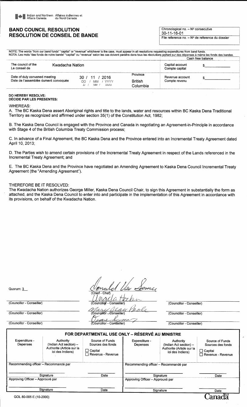
Execution Version
1
AMENDING AGREEMENT TO
KASKA DENA COUNCIL INCREMENTAL TREATY AGREEMENT
This Amending Agreement is dated for reference the 13th day of December, 2016 (the
“Effective Date”).
BETWEEN:
Her Majesty the Queen in right of the Province of British Columbia,
represented by the Minister of Aboriginal Relations and Reconciliation
hereinafter, the “Province”
AND:
Kaska Dena Council on behalf of Daylu Dena Council, Dease River First Nation
and Kwadacha First Nation
hereinafter, the “BC Kaska Dena”
Collectively referred to as the “Parties” and individually referred to as a “Party”
WHEREAS:
A. The BC Kaska Dena and the Province entered into an Incremental Treaty Agreement dated April 10, 2013 (the “Incremental Treaty Agreement”); and
B. The Parties wish to amend certain provisions of the Incremental Treaty Agreement in respect of the Lands referenced in that agreement.
NOW THEREFORE the Parties agree as follows:
PART 1 – INTERPRETATION
1.1 Definitions
In this Agreement:
“Amending Agreement” means this Amending Agreement between the BC
Kaska Dena and the Province.
1.2 Other Words and Expressions
Words and expressions not defined in this Amending Agreement but defined in
the Incremental Treaty Agreement have the meanings ascribed to them in the
Incremental Treaty Agreement.
1.3 List of Attachments
Execution Version
2
Attachment 1: Good Hope Lake - South Attachment 2: Keane Lake Attachment 3: Cotton Lake Attachment 4: Fireside Attachment 5: Liard Bench Attachment 6: GST Certificate Attachment 7: Liard Bench Gate Attachment 8: Amending Agreement Band Council Resolutions
PART 2 – AMENDMENTS
2.1 Amendments to ITA
The Parties agree that the Incremental Treaty Agreement shall be amended as follows: (a) The list of schedules on page 3 of the Incremental Treaty Agreement is
hereby deleted in its entirety and replaced with the following: “Schedule “1” – Maps of Lands for Illustrative Purposes Schedule 1-1: Lower Post Mill Schedule 1-2: Old Faddy Schedule 1-3: Rapid River Schedule 1-4: Good Hope Lake – South Schedule 1-5: Troutline Intake Schedule 1-6: Troutline Powerhouse Schedule 1-7: Obo Lake Camp Schedule 1-8: Fort Ware North Schedule 1-9: Finbow Schedule 1-10: Turnagain River Schedule 1-11: Keane Lake Schedule 1-12: Cotton Lake Schedule 1-13: Fireside Schedule 1-14: Liard Bench Schedule “2” – Permitted Encumbrances Schedule 2-1: Permitted Encumbrances Schedule 2-2: Interests Not Registered on Title
Schedule “3” – Instruments of Registration Schedule 3-1: BC Hydro Incremental Treaty Distribution Statutory
Right-of-Way Schedule 3-2: Agreement for Forest Research Plots: Growth and
Yield Site 85-21-20G
Schedule “4” – Additions to Reserve Restrictive Covenant
Schedule “5” – Designated Company Agreement
Execution Version
3
Schedule “6” – GST Certificate
Schedule “7” – Band Council Resolutions
(b) The following definitions are added to section 1.1 (Definitions) of the Incremental Treaty Agreement in the appropriate alphabetical order:
““GST” means the goods and services tax imposed under the
Excise Tax Act (Canada);”
““PST” means the sales tax imposed under the Provincial Sales
Tax Act;”
(c) The definition of “HST” in section 1.1 (Definitions) of the Incremental Treaty Agreement is hereby deleted in its entirety.
(d) The definition of “Lands” in section 1.1 (Definitions) of the Incremental Treaty Agreement is hereby deleted in its entirety and replaced with the following:
““Lands” means any or all of the following:
a) “Lower Post Mill” means the area as shown for illustrative purposes in Schedule 1-1;
“Old Faddy” means the area as shown for illustrative purposes in Schedule 1-2;
“Rapid River” means the area as shown for illustrative purposes in Schedule 1-3;
“Good Hope Lake – South” means the area as shown for illustrative purposes in Schedule 1-4;
“Troutline Intake” means the area as shown for illustrative purposes in Schedule 1-5;
“Troutline Powerhouse” means the area as shown for illustrative purposes in Schedule 1-6;
“Obo Lake Camp” means the area as shown for illustrative purposes in Schedule 1-7;
“Fort Ware North” means the area as shown for illustrative purposes in Schedule 1-8;
“Finbow” means the area as shown for illustrative purposes in Schedule 1-9;
“Turnagain River” means the area as shown for illustrative purposes in Schedule 1-10;
“Keane Lake” means the area as shown for illustrative purposes in Schedule 1-11;
“Cotton Lake” means the area as shown for illustrative purposes in Schedule 1-12;
Execution Version
4
“Fireside” means the area as shown for illustrative purposes in Schedule 1-13; and
“Liard Bench” means the area as shown for illustrative purposes in Schedule 1-14; or
b) following completion and approval of the surveys of each of those Lands identified in a), as set out in Subsection 5.2 f), the areas legally described in those surveys, which for greater certainty, will not include any land below the natural boundary (as defined in the Land Act) and the area of any Crown Corridor;”
e) Section 1.3 (Schedules) of the Incremental Treaty Agreement is hereby deleted in its entirety and replaced with the following:
“1.3 Schedules. The following are the Schedules to this Agreement:
Schedule “1” – Maps of Lands; Schedule “2” – Permitted Encumbrances; Schedule “3” – Instruments of Registration; Schedule “4” – Form C Additions to Reserve Restrictive Covenant; Schedule “5” – Agreement of Designated Company; Schedule “6” – GST Certificate; and Schedule “7” – Band Council Resolutions.”
f) Section 3.3 (Termination on Litigation) of the Incremental Treaty
Agreement is hereby deleted in its entirety and replaced with the following:
“3.3 Termination on Litigation. Notwithstanding 3.2, in the event the BC Kaska Dena commences, becomes a party to, or takes any steps to advance any court action or other legal proceeding relating to any Governmental Action within the Traditional Territory, the Province may terminate this Agreement, including the transfer of any Lands which have not been completed, except in respect of its obligations to transfer the “Lands” identified as “Cotton Lake”, “Fireside”, “Good Hope Lake – South”, “Keane Lake” and “Liard Bench”.”
g) The following subsection is added to section 5.2 (Conditions Precedent to Land Transfers) of the Incremental Treaty Agreement as the new subsection 5.2 h):
“h) the Province being satisfied that, with respect to the transfer of each of the Lands identified as “Cotton Lake”, “Fireside”, “Good Hope Lake – South”, “Keane Lake” and “Liard Bench”, it has fulfilled any consultation obligations it may have with respect to assertions of Aboriginal Rights to such Lands by First Nations other than the Daylu Dena Council, Dease River First Nation or Kwadacha First Nation.”
Execution Version
5
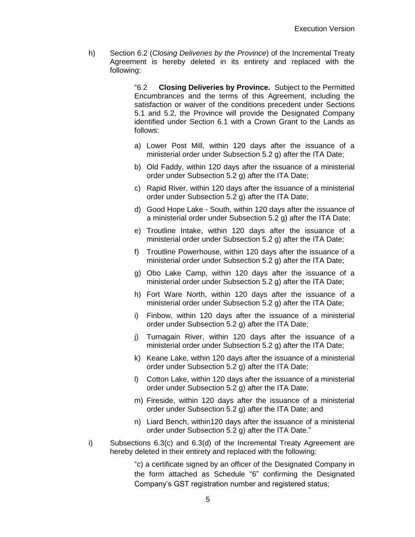
h) Section 6.2 (Closing Deliveries by the Province) of the Incremental Treaty Agreement is hereby deleted in its entirety and replaced with the following:
“6.2 Closing Deliveries by Province. Subject to the Permitted Encumbrances and the terms of this Agreement, including the satisfaction or waiver of the conditions precedent under Sections 5.1 and 5.2, the Province will provide the Designated Company identified under Section 6.1 with a Crown Grant to the Lands as follows:
a) Lower Post Mill, within 120 days after the issuance of a ministerial order under Subsection 5.2 g) after the ITA Date;
b) Old Faddy, within 120 days after the issuance of a ministerial order under Subsection 5.2 g) after the ITA Date;
c) Rapid River, within 120 days after the issuance of a ministerial order under Subsection 5.2 g) after the ITA Date;
d) Good Hope Lake - South, within 120 days after the issuance of a ministerial order under Subsection 5.2 g) after the ITA Date;
e) Troutline Intake, within 120 days after the issuance of a ministerial order under Subsection 5.2 g) after the ITA Date;
f) Troutline Powerhouse, within 120 days after the issuance of a ministerial order under Subsection 5.2 g) after the ITA Date;
g) Obo Lake Camp, within 120 days after the issuance of a ministerial order under Subsection 5.2 g) after the ITA Date;
h) Fort Ware North, within 120 days after the issuance of a ministerial order under Subsection 5.2 g) after the ITA Date;
i) Finbow, within 120 days after the issuance of a ministerial order under Subsection 5.2 g) after the ITA Date;
j) Turnagain River, within 120 days after the issuance of a ministerial order under Subsection 5.2 g) after the ITA Date;
k) Keane Lake, within 120 days after the issuance of a ministerial order under Subsection 5.2 g) after the ITA Date;
l) Cotton Lake, within 120 days after the issuance of a ministerial order under Subsection 5.2 g) after the ITA Date;
m) Fireside, within 120 days after the issuance of a ministerial order under Subsection 5.2 g) after the ITA Date; and
n) Liard Bench, within120 days after the issuance of a ministerial order under Subsection 5.2 g) after the ITA Date.”
i) Subsections 6.3(c) and 6.3(d) of the Incremental Treaty Agreement are hereby deleted in their entirety and replaced with the following:
“c) a certificate signed by an officer of the Designated Company in
the form attached as Schedule “6” confirming the Designated
Company’s GST registration number and registered status;

Execution Version
6
d) a letter of undertaking signed by the BC Kaska Dena legal
counsel, undertaking, among other things, that the restrictive
covenant (Schedule “4”) will be submitted for filing concurrently
with the Crown Grant and that the Province will be provided with a
signed copy of the Designated Company Agreement (Schedule
“5”) and the GST Certificate (Schedule “6”); and”
j) Section 9.3 (HST and Charges) of the Incremental Treaty Agreement is hereby deleted in its entirety and replaced with the following:
“9.3 GST and Charges. The BC Kaska Dena is
responsible for any federal or provincial sales tax, including
GST and any other transfer or registration charges for
which the Province has not expressly agreed to accept
responsibility under the terms of this Agreement.”
k) The cover page of schedule “1” (Map of Lands for Illustrative Purposes) of the Incremental Treaty Agreement is deleted in its entirety and replaced with the following:
“Schedule “1” – Map of Lands for Illustrative Purposes
Schedule 1-1: Lower Post Mill
Schedule 1-2: Old Faddy
Schedule 1-3: Rapid River
Schedule 1-4: Good Hope Lake – South
Schedule 1-5: Troutline Intake
Schedule 1-6: Troutline Powerhouse
Schedule 1-7: Obo Lake Camp
Schedule 1-8: Fort Ware North
Schedule 1-9: Finbow
Schedule 1-10: Turnagain River
Schedule 1-11: Keane Lake
Schedule 1-12: Cotton Lake
Schedule 1-13: Fireside
Schedule 1-14: Liard Bench”
Execution Version
7
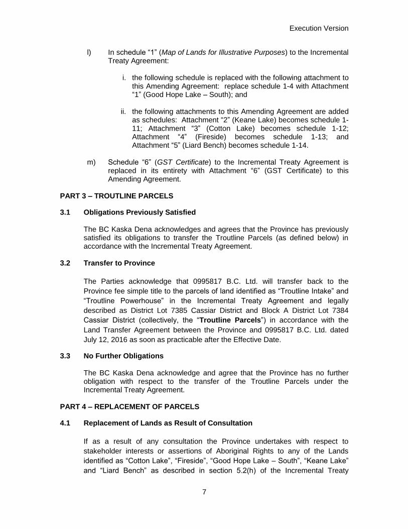
l) In schedule “1” (Map of Lands for Illustrative Purposes) to the Incremental Treaty Agreement:
i. the following schedule is replaced with the following attachment to
this Amending Agreement: replace schedule 1-4 with Attachment “1” (Good Hope Lake – South); and
ii. the following attachments to this Amending Agreement are added as schedules: Attachment “2” (Keane Lake) becomes schedule 1-11; Attachment “3” (Cotton Lake) becomes schedule 1-12; Attachment “4” (Fireside) becomes schedule 1-13; and Attachment “5” (Liard Bench) becomes schedule 1-14.
m) Schedule “6” (GST Certificate) to the Incremental Treaty Agreement is
replaced in its entirety with Attachment “6” (GST Certificate) to this Amending Agreement.
PART 3 – TROUTLINE PARCELS
3.1 Obligations Previously Satisfied The BC Kaska Dena acknowledges and agrees that the Province has previously satisfied its obligations to transfer the Troutline Parcels (as defined below) in accordance with the Incremental Treaty Agreement.
3.2 Transfer to Province
The Parties acknowledge that 0995817 B.C. Ltd. will transfer back to the
Province fee simple title to the parcels of land identified as “Troutline Intake” and
“Troutline Powerhouse” in the Incremental Treaty Agreement and legally
described as District Lot 7385 Cassiar District and Block A District Lot 7384
Cassiar District (collectively, the “Troutline Parcels”) in accordance with the
Land Transfer Agreement between the Province and 0995817 B.C. Ltd. dated
July 12, 2016 as soon as practicable after the Effective Date.
3.3 No Further Obligations The BC Kaska Dena acknowledge and agree that the Province has no further obligation with respect to the transfer of the Troutline Parcels under the Incremental Treaty Agreement.
PART 4 – REPLACEMENT OF PARCELS
4.1 Replacement of Lands as Result of Consultation
If as a result of any consultation the Province undertakes with respect to
stakeholder interests or assertions of Aboriginal Rights to any of the Lands
identified as “Cotton Lake”, “Fireside”, “Good Hope Lake – South”, “Keane Lake”
and “Liard Bench” as described in section 5.2(h) of the Incremental Treaty
Execution Version
8
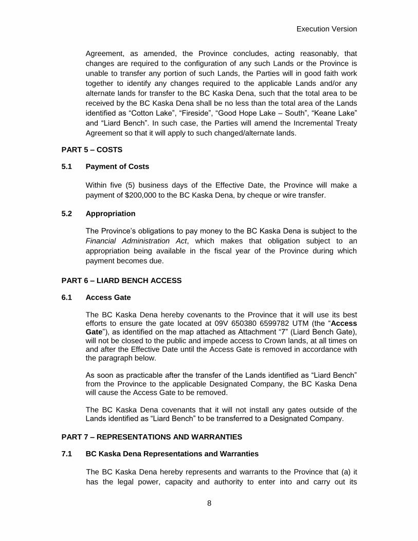
Agreement, as amended, the Province concludes, acting reasonably, that
changes are required to the configuration of any such Lands or the Province is
unable to transfer any portion of such Lands, the Parties will in good faith work
together to identify any changes required to the applicable Lands and/or any
alternate lands for transfer to the BC Kaska Dena, such that the total area to be
received by the BC Kaska Dena shall be no less than the total area of the Lands
identified as “Cotton Lake”, “Fireside”, “Good Hope Lake – South”, “Keane Lake”
and “Liard Bench”. In such case, the Parties will amend the Incremental Treaty
Agreement so that it will apply to such changed/alternate lands.
PART 5 – COSTS
5.1 Payment of Costs
Within five (5) business days of the Effective Date, the Province will make a
payment of $200,000 to the BC Kaska Dena, by cheque or wire transfer.
5.2 Appropriation
The Province’s obligations to pay money to the BC Kaska Dena is subject to the
Financial Administration Act, which makes that obligation subject to an
appropriation being available in the fiscal year of the Province during which
payment becomes due.
PART 6 – LIARD BENCH ACCESS
6.1 Access Gate The BC Kaska Dena hereby covenants to the Province that it will use its best efforts to ensure the gate located at 09V 650380 6599782 UTM (the “Access Gate”), as identified on the map attached as Attachment “7” (Liard Bench Gate), will not be closed to the public and impede access to Crown lands, at all times on and after the Effective Date until the Access Gate is removed in accordance with the paragraph below. As soon as practicable after the transfer of the Lands identified as “Liard Bench” from the Province to the applicable Designated Company, the BC Kaska Dena will cause the Access Gate to be removed. The BC Kaska Dena covenants that it will not install any gates outside of the Lands identified as “Liard Bench” to be transferred to a Designated Company.
PART 7 – REPRESENTATIONS AND WARRANTIES
7.1 BC Kaska Dena Representations and Warranties
The BC Kaska Dena hereby represents and warrants to the Province that (a) it
has the legal power, capacity and authority to enter into and carry out its

Execution Version
9
obligations under this Amending Agreement on behalf of its Members; and (b) all
representations and warranties of the BC Kaska Dena contained in section 4.1
(Representations) of the Incremental Treaty Agreement are true and correct in all
material respects on and as of the date hereof after giving effect to this Amending
Agreement, except to the extent that any such representation and warranty
specifically relates to an earlier date, in which case they shall be true and correct
in all material respects as of such earlier date after giving effect to this Amending
Agreement.
7.2 Province Representations and Warranties The Province hereby represents and warrants to the BC Kaska Dena that (a) it
has the legal power, capacity and authority to enter into this Amending
Agreement; and (b) all representations and warranties of the Province contained
in section 4.2 (Provincial Representations) of the Incremental Treaty Agreement
are true and correct in all material respects on and as of the date hereof after
giving effect to this Amending Agreement, except to the extent that any such
representation and warranty specifically relates to an earlier date, in which case
they shall be true and correct in all material respects as of such earlier date after
giving effect to this Amending Agreement.
PART 8 – CONDITIONS PRECEDENT
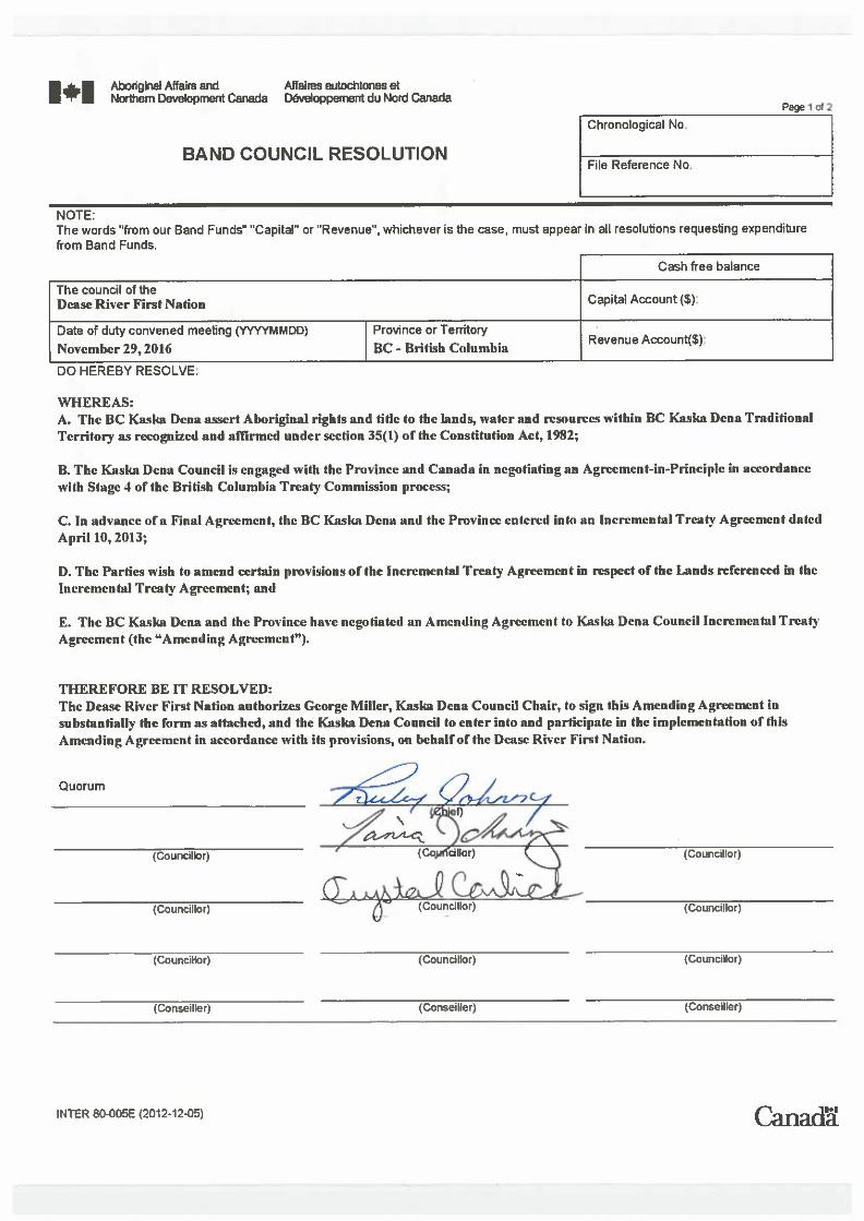
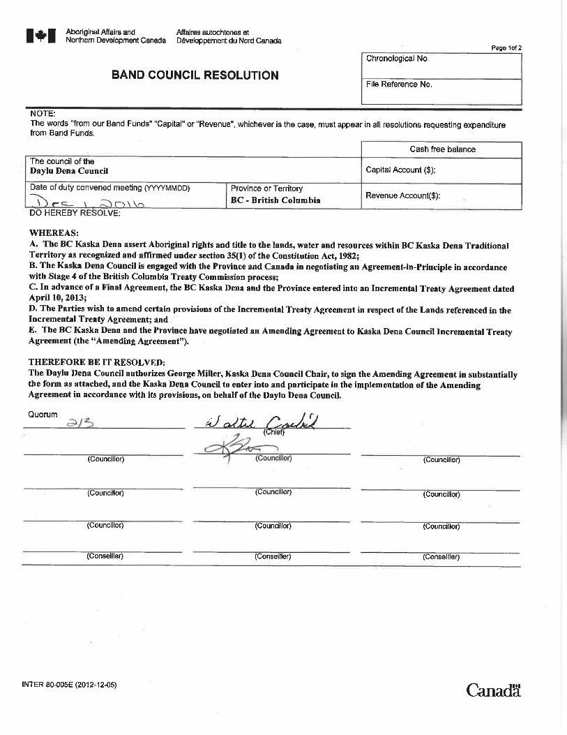
8.1 Band Council Resolutions Prior to the execution of this Amending Agreement, the Daylu Dena Council,
Dease River First Nation and Kwadacha First Nation will deliver to the Province
resolutions made by their respective elected Councils authorizing BC Kaska
Dena representatives named in the resolution to execute this Amending
Agreement on their behalf and authorizing Kaska Dena Council to act on their
behalf in entering into this Amending Agreement. Such resolutions shall be
attached to this Amending Agreement as Attachment “8” (Amending Agreement
Band Council Resolutions).
PART 9 – MISCELLANEOUS
9.1 Entire Agreement The terms and conditions of the Incremental Treaty Agreement shall remain in
full force and effect and will be deemed to be subject to and incorporate all of the
provisions of this Amending Agreement. This Amending Agreement together with
the Incremental Treaty Agreement and the Land Transfer Agreement is the entire
agreement between the Parties in respect of the subject matter of this Amending
Agreement and, except as set out in this Amending Agreement, the Incremental
Treaty Agreement and the Land Transfer Agreement, there is no representation,
warranty, collateral agreement, condition, right or obligation affecting this
Amending Agreement.

Execution Version
10
9.2 Governing Law This Amending Agreement will be governed by and construed in accordance with
the laws of the Province of British Columbia.
9.3 Enurement This Amending Agreement extends to, is binding upon and enures to the benefit
of the Parties, their respective successors and permitted assigns.
9.4 Headings The headings are for convenience only, do not form part of this Amending
Agreement and are not intended to interpret, define or limit the scope, extent or
intent of this Amending Agreement or any of its provisions.
9.5 Further Assurances Each Party will execute and deliver such further agreements and other
documents and do such further acts and things as the other party reasonably
request to evidence, carry out or give full force and effect to the intent of this
Amending Agreement.
9.6 Execution in Counterparts This Amending Agreement may be executed in counterparts and may be
delivered by facsimile or electronically transmitted. Each signature is deemed to
be an original signature and all such counterparts together will constitute one and
the same document.
[Remainder of Page Intentionally Left Blank]

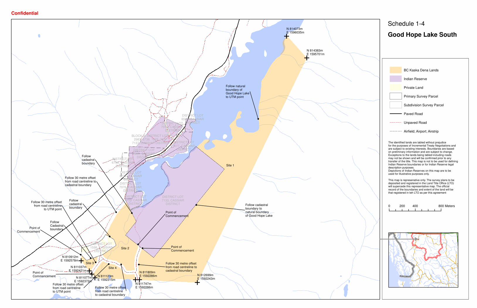
Attachment 1: Good Hope Lake – South
E
E
E
E
EE
EEE
Point ofCommencement
Follow cadastralboundary tonatural boundaryof Good Hope Lake
Follow naturalboundary ofGood Hope Laketo UTM point
Follow 30 metre offsetfrom road centreline tocadastral boundary
Follow 30 metre offsetfrom road centrelineto cadastral boundary
Followcadastralboundary
Follow 30 metre offsetfrom road centreline tocadastral boundary
Followcadastralboundary
FollowCadastralboundary
Point ofCommencement
Point ofCommencement
Follow 30 metre offsetfrom road centreline
to UTM point
Point ofCommencement
Follow 30 metre offsetfrom road centrelineto UTM point
Site 1
Site 2
Site 3
Site 4
N 810912mE 1592578m
N 811037mE 1592421m
N 814073mE 1596035m
N 814383mE 1595701m
N 811123mE 1592315m
N 812699mE 1592243m
N 811809mE 1592286m
N 811747mE 1592286m
N 811077mE 1592372m
DISTRICT LOT1598, CASSIAR
DISTRICT
DISTRICT LOT7077, CASSIAR
DISTRICT
DISTRICT LOT7077, CASSIAR
DISTRICT
BLOCK B, DISTRICT LOTS2983, 6738, 7076, 7077,
7137, CASSIAR DISTRICT
DISTRICT LOT2983, CASSIAR
DISTRICT
DISTRICT LOT6738, CASSIAR
DISTRICT
DISTRICT LOT7076, CASSIAR
DISTRICT
DISTRICT LOT7133, CASSIAR
DISTRICT
DISTRICT LOT7133, CASSIAR
DISTRICT
DISTRICT LOT6739, CASSIAR
DISTRICT
DISTRICT LOT6543, CASSIAR
DISTRICT
BC Kaska Dena Lands
Indian Reserve
Private Land
Primary Survey Parcel
Subdivision Survey Parcel
Paved Road
Unpaved Road
Airfield; Airport; Airstrip
0 400 800200 Meters
Confidential
The identified lands are tabled without prejudice for the purposes of Incremental Treaty Negotiations and are subject to existing interests. Boundaries are basedon preliminary information and are subject to change. Exceptions to the lands being tabled including roads may not be shown and will be confirmed prior to any transfer of the title. This map is not to be used for defining Indian Reserve boundaries or for Indian Reserve legal description purposes. Depictions of Indian Reserves on this map are to be used for illustrative purposes only.
This map is represenative only. The survey plans to be deposited and registered in the Land Title Office (LTO) will supercede this representative map. The official record of the boundaries and extent of the land will be that registered in teh LTO as per this agreement
Schedule 1-4
Good Hope Lake South

E
E
E
EEE
E
Point ofCommencement
Follow cadastralboundary to
natural boundaryof Good Hope Lake
Follow 30 metre offsetfrom road centrelineto cadastral boundary
Follow 30 metre offsetfrom road centrelineto cadastral boundary
Followcadastralboundary
Follow 30 metre offsetfrom road centreline tocadastral boundary
Followcadastralboundary
FollowCadastralboundary
Point ofCommencement
Point ofCommencement
Follow 30 metre offsetfrom road centreline
to UTM point
Point ofCommencement
Follow 30 metre offsetfrom road centreline
to UTM point
Site 1Site 2
Site 3
Site 4
N 810912mE 1592578m
N 811037mE 1592421m
N 811123mE 1592315m
N 812699mE 1592243m
N 811809mE 1592286m
N 811747mE 1592286m
N 811077mE 1592372m
DISTRICT LOT1598, CASSIAR
DISTRICT
BLOCK B, DISTRICT LOTS2983, 6738, 7076, 7077,
7137, CASSIAR DISTRICT
BLOCK B, DISTRICT LOTS2983, 6738, 7076, 7077,
7137, CASSIAR DISTRICT
BLOCK B, DISTRICT LOTS2983, 6738, 7076, 7077,
7137, CASSIAR DISTRICT
BLOCK B, DISTRICT LOTS2983, 6738, 7076, 7077,
7137, CASSIAR DISTRICT
DISTRICT LOT7133, CASSIAR
DISTRICT DISTRICT LOT7133, CASSIAR
DISTRICT
DISTRICT LOT6739, CASSIAR
DISTRICT
BC Kaska Dena Lands
Indian Reserve
Private Land
Primary Survey Parcel
Subdivision Survey Parcel
Paved Road
Unpaved Road
Airfield; Airport; Airstrip
0 180 36090 Meters
Confidential
The identified lands are tabled without prejudice for the purposes of Incremental Treaty Negotiations and are subject to existing interests. Boundaries are basedon preliminary information and are subject to change. Exceptions to the lands being tabled including roads may not be shown and will be confirmed prior to any transfer of the title. This map is not to be used for defining Indian Reserve boundaries or for Indian Reserve legal description purposes. Depictions of Indian Reserves on this map are to be used for illustrative purposes only.
This map is represenative only. The survey plans to be deposited and registered in the Land Title Office (LTO) will supercede this representative map. The official record of the boundaries and extent of the land will be that registered in teh LTO as per this agreement
Schedule 1-4
Good Hope Lake South
(Detail)

Attachment 2: Keane Lake

EE
EE
Point ofCommencement
Follow naturalboundary of KeaneLake to UTM point
Follow Cadastralboundary or 50 metreoffset, whichever isfurthest from highwaycentreline to UTM point
N 828756mE 1670904m
N 829331mE 1670840m
N 829301mE 1670563m
N 828615mE 1670598m
DISTRICT LOT7029, CASSIAR
DISTRICT
BC Kaska Dena Lands
Indian Reserve
Private Land
Primary Survey Parcel
Subdivision Survey Parcel
Paved Road
Unpaved Road
Airfield; Airport; Airstrip
0 400 800200 Meters
Confidential
The identified lands are tabled without prejudice for the purposes of Incremental Treaty Negotiations and are subject to existing interests. Boundaries are basedon preliminary information and are subject to change. Exceptions to the lands being tabled including roads may not be shown and will be confirmed prior to any transfer of the title. This map is not to be used for defining Indian Reserve boundaries or for Indian Reserve legal description purposes. Depictions of Indian Reserves on this map are to be used for illustrative purposes only.
This map is represenative only. The survey plans to be deposited and registered in the Land Title Office (LTO) will supercede this representative map. The official record of the boundaries and extent of the land will be that registered in teh LTO as per this agreement
Schedule 1-11
Keane Lake

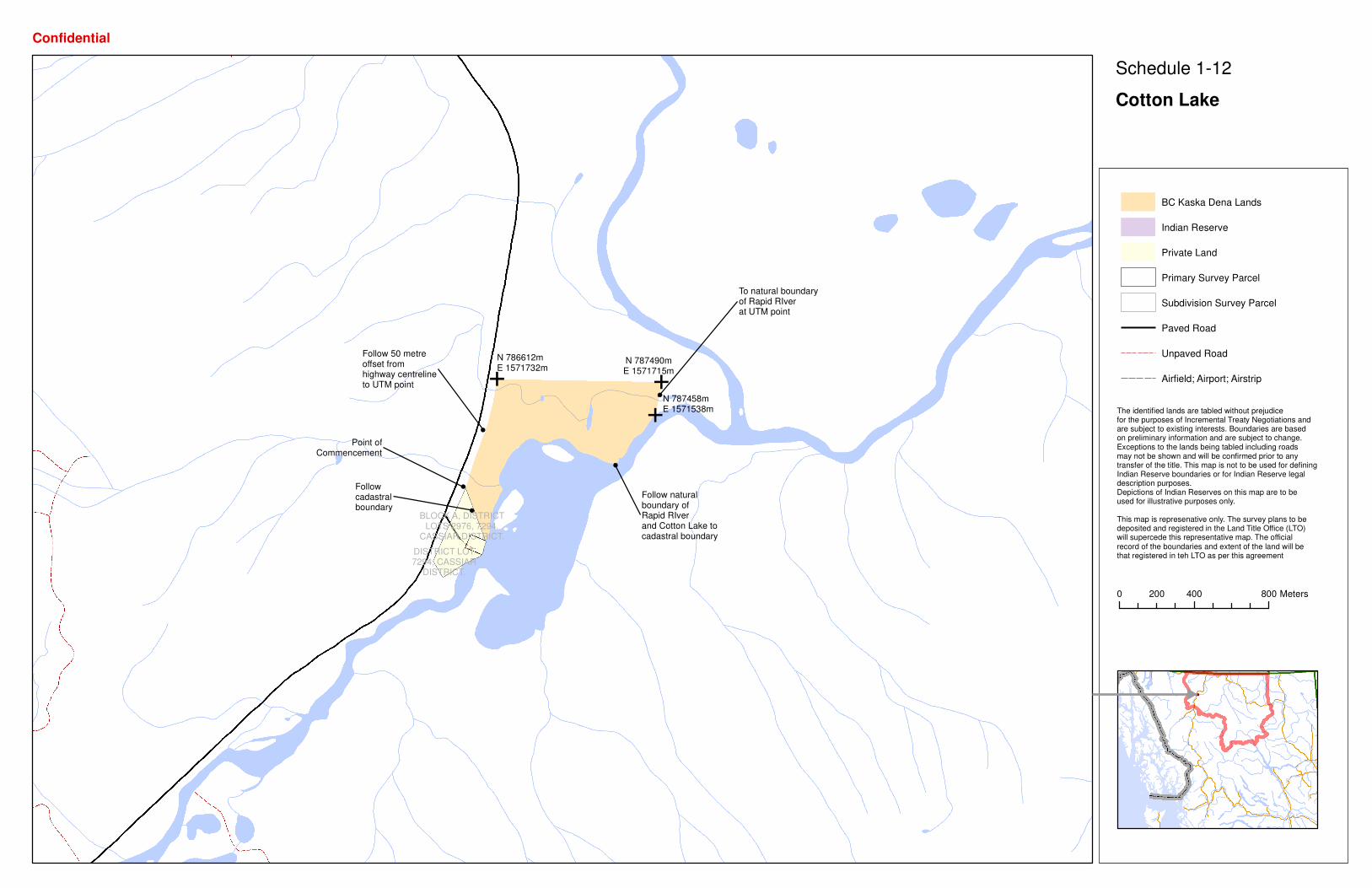
Attachment 3: Cotton Lake
E E
E
Point ofCommencement
To natural boundaryof Rapid RIverat UTM point
Follow naturalboundary ofRapid RIverand Cotton Lake tocadastral boundary
Followcadastralboundary
Follow 50 metreoffset fromhighway centrelineto UTM point
N 786612mE 1571732m
N 787490mE 1571715m
N 787458mE 1571538m
DISTRICT LOT7294, CASSIAR
DISTRICT.
BLOCK A, DISTRICTLOTS 2976, 7294,
CASSIAR DISTRICT.
BC Kaska Dena Lands
Indian Reserve
Private Land
Primary Survey Parcel
Subdivision Survey Parcel
Paved Road
Unpaved Road
Airfield; Airport; Airstrip
0 400 800200 Meters
Confidential
The identified lands are tabled without prejudice for the purposes of Incremental Treaty Negotiations and are subject to existing interests. Boundaries are basedon preliminary information and are subject to change. Exceptions to the lands being tabled including roads may not be shown and will be confirmed prior to any transfer of the title. This map is not to be used for defining Indian Reserve boundaries or for Indian Reserve legal description purposes. Depictions of Indian Reserves on this map are to be used for illustrative purposes only.
This map is represenative only. The survey plans to be deposited and registered in the Land Title Office (LTO) will supercede this representative map. The official record of the boundaries and extent of the land will be that registered in teh LTO as per this agreement
Schedule 1-12
Cotton Lake

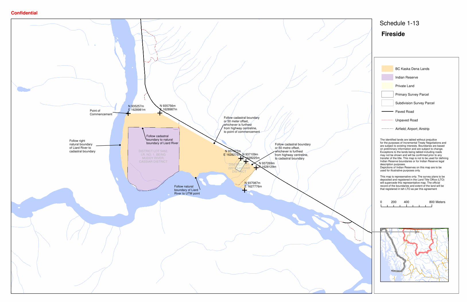
Attachment 4: Fireside
EE
E
E
EE
Point ofCommencement
Follow naturalboundary of LiardRiver to UTM point
Follow rightnatural boundaryof Liard River tocadastral boundary
Follow cadastralboundary to naturalboundary of Liard River Follow cadastral boundary
or 50 metre offset,whichever is furthestfrom highway centreline,to cadastral boundary
Follow cadastral boundaryor 50 meter offset,whichever is furthestfrom highway centreline,to point of commencement
N 935756mE 1628987m
N 935257mE 1628981m
N 937087mE 1627776m
N 937269mE 1628129m
N 937109mE 1628225m
N 937027mE 1628275m
DISTRICT LOT2201, CASSIAR
DISTRICT
DISTRICT LOT 5462,I.R. NO. 1, BEINGMUDDY RIVER,
CASSIAR DISTRICT
BC Kaska Dena Lands
Indian Reserve
Private Land
Primary Survey Parcel
Subdivision Survey Parcel
Paved Road
Unpaved Road
Airfield; Airport; Airstrip
0 400 800200 Meters
Confidential
The identified lands are tabled without prejudice for the purposes of Incremental Treaty Negotiations and are subject to existing interests. Boundaries are basedon preliminary information and are subject to change. Exceptions to the lands being tabled including roads may not be shown and will be confirmed prior to any transfer of the title. This map is not to be used for defining Indian Reserve boundaries or for Indian Reserve legal description purposes. Depictions of Indian Reserves on this map are to be used for illustrative purposes only.
This map is represenative only. The survey plans to be deposited and registered in the Land Title Office (LTO) will supercede this representative map. The official record of the boundaries and extent of the land will be that registered in teh LTO as per this agreement
Schedule 1-13
Fireside

Attachment 5: Liard Bench

E
E
E
E
E
E
EPoint ofCommencement
Follow 200 metreoffset fromhighway centrelineto UTM point
N 977920mE 1617439m
N 979423mE 1616140m
N 979432mE 1615816m
N 979221mE 1615594m
N 979209mE 1615459m
N 978982mE 1615361m
N 977727mE 1617285m
DISTRICT LOT5755, CASSIAR
DISTRICT
DISTRICT LOT6327, CASSIAR
DISTRICT
BC Kaska Dena Lands
Indian Reserve
Private Land
Primary Survey Parcel
Subdivision Survey Parcel
Paved Road
Unpaved Road
Airfield; Airport; Airstrip
0 400 800200 Meters
Confidential
The identified lands are tabled without prejudice for the purposes of Incremental Treaty Negotiations and are subject to existing interests. Boundaries are basedon preliminary information and are subject to change. Exceptions to the lands being tabled including roads may not be shown and will be confirmed prior to any transfer of the title. This map is not to be used for defining Indian Reserve boundaries or for Indian Reserve legal description purposes. Depictions of Indian Reserves on this map are to be used for illustrative purposes only.
This map is represenative only. The survey plans to be deposited and registered in the Land Title Office (LTO) will supercede this representative map. The official record of the boundaries and extent of the land will be that registered in teh LTO as per this agreement
Schedule 1-14
Liard Bench

Attachment 6: GST Certificate

Schedule “6” – GST Certificate
FORM 221(2)(b) (CERTIFICATE AS TO REGISTRATION STATUS OF PURCHASER)
Certificate as to Registration Status of Purchaser
(Paragraphs 221(2)(b) and (c))
FROM: [the “Purchaser”] TO: [the “Vendor”] RE: [the “Property”] THE PURCHASER HEREBY CERTIFIES TO THE VENDOR PURSUANT TO PARAGRAPHS 221(2)(b) AND (c) OF THE EXCISE TAX ACT (THE “ACT”) THAT THE PURCHASER: is a prescribed recipient under the Act. [OR] is registered under Part IX of the Act, its registration number is [number] and the Purchaser
will account for the tax payable in respect of the purchase of the Property in accordance with the Act.
The Purchaser acknowledges that the Vendor is relying on this Certificate in connection with the sale of the Property. Each term that is used in the Certificate and that is defined in, and for the purposes of, Part IX of the Act has the meaning assigned to it in Part IX of the Act. DATED [month, day, year]. [Name of Corporate Purchaser] Per: [Name of Individual Purchaser]

Attachment 7: Liard Bench Gate
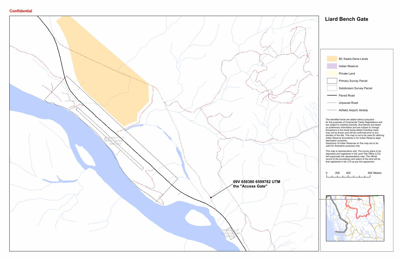
09V 650380 6599782 UTMthe "Access Gate"
DISTRICT LOT5755, CASSIAR
DISTRICT
DISTRICT LOT6343, CASSIAR
DISTRICT
BC Kaska Dena Lands
Indian Reserve
Private Land
Primary Survey Parcel
Subdivision Survey Parcel
Paved Road
Unpaved Road
Airfield; Airport; Airstrip
0 400 800200 Meters
Confidential
The identified lands are tabled without prejudice for the purposes of Incremental Treaty Negotiations and are subject to existing interests. Boundaries are basedon preliminary information and are subject to change. Exceptions to the lands being tabled including roads may not be shown and will be confirmed prior to any transfer of the title. This map is not to be used for defining Indian Reserve boundaries or for Indian Reserve legal description purposes. Depictions of Indian Reserves on this map are to be used for illustrative purposes only.This map is represenative only. The survey plans to be deposited and registered in the Land Title Office (LTO) will supercede this representative map. The official record of the boundaries and extent of the land will be that registered in teh LTO as per this agreement
Liard Bench Gate

Attachment 8: Amending Agreement Band Council Resolutionǎ


![[eBook Ita] Manuale Ita Pratico Di Java](https://img.pdfslide.us/doc/110x75/55cf9c46550346d033a944be/ebook-ita-manuale-ita-pratico-di-java-56310138ab62e.jpg)