Embed Size (px)
Citation preview

A TECHNICAL GUIDE FOR CONDUCTING TRAFFIC SAFETY ASSESSMENTS FOR CALIFORNIA COMMUNITIES REPORT BY: UNIVERSITY OF CALIFORNIA, BERKELEY INSTITUTE OF TRANSPORTATION STUDIES TECHNOLOGY TRANSFER PROGRAM www.techtransfer.berkeley.edu FUNDED BY: THE CALIFORNIA OFFICE OF TRAFFIC SAFETY THROUGH THE NATIONAL HIGHWAY TRAFFIC SAFETY ADMINISTRATION www.ots.ca.gov SEPTEMBER 2015

ABOUT THE TECHNOLOGY TRANSFER PROGRAM The Technology Transfer Program is a part of the Institute of Transportation Studies at the University of California, Berkeley. The Technology Transfer Program provides professional training, workshops, conferences, technical assistance, and informational resources in the transportation-related areas of planning and policy, engineering, project development, infrastructure design and maintenance, and safety and environmental issues for motorized and nonmotorized roadway traffic, aviation, and rail. The program serves over 25,000 public and private transportation agency personnel, providing services to California’s cities, counties, regional transportation agencies, the California Office of Traffic Safety, and the California Department of Transportation. CONTACT INFORMATION Institute of Transportation Studies University of California, Berkeley 109 McLaughlin Hall Berkeley CA 94720-1720 PHONE 510-643-4393 FAX 510-643-3955 EMAIL [email protected] WEB www.techtransfer.berkeley.edu

A TECHNICAL GUIDE FOR CONDUCTING TRAFFIC SAFETY ASSESSMENTS FOR CALIFORNIA COMMUNITIES 1
TABLE OF CONTENTS PREFACE .............................................................................................................................................. 2
1. WHY HAVE SAFETY ASSESSMENTS.............................................................................................. 3
1.1 Objective of the California TSA ........................................................................................... 4
1.2 Developing a Partnership for Safety ................................................................................... 5
2. THE CALIFORNIA TSA PROCESS ................................................................................................... 9
2.1 Collect Collision Rankings and History ................................................................................ 9
2.2 Identify Locations in the Community for Assessment ...................................................... 13
2.3 Obtain Relevant Information from the Local Agency ....................................................... 14
2.4 Conduct a Site Visit ........................................................................................................... 18
2.4.1 Introductory Meeting ...................................................................................................... 19
2.4.2 Field Audit ........................................................................................................................ 20
2.4.3 Exit Meeting ..................................................................................................................... 24
2.5 Prepare the Technical Report ................................................................................................. 26
Appendix A: List of Resources ........................................................................................................... 29
Appendix B: List of References ......................................................................................................... 31

2 A TECHNICAL GUIDE FOR CONDUCTING TRAFFIC SAFETY ASSESSMENTS FOR CALIFORNIA COMMUNITIES
PREFACE
Improving traffic and roadway safety and reducing severe injuries and fatalities for all modes of transportation—motorized vehicles, bicyclists, and pedestrians—is an ongoing process that all California communities face. But motorized vehicles present specific challenges in terms of addressing speed regulations, collision patterns, human behavior, and conflicts with other roadway users, particularly pedestrians and bicyclists. To help communities negotiate an increasingly complex roadway environment, improve safety, and reduce the conflicts between vehicles, pedestrians, and cyclists, Tech Transfer has been offering free Traffic Safety Assessments (TSA) to California communities since 1998. The TSA combines the perspectives of traffic engineering and traffic enforcement in addressing safety issues while taking into account the staffing capabilities of the participating agencies and size of community, whether urban, suburban, or rural. This document describes the California TSA process and provides guidelines for safety evaluators to conduct these assessments. It synthesizes best practices and research on traffic safety applications. This guidebook targets California communities, but the methods described are applicable for other states. Users of this guidebook outside of California should substitute national or locally adopted standards, practices, or references as needed. This guidebook is based on the experience of evaluators who have collectively conducted more than 100 TSAs over the past 10 years. The assessment process incorporates changes in technology and lessons learned over the years, from identifying essential stakeholders, to selecting appropriate study locations, presenting preliminary findings at the exit meeting, to developing the final report. These free TSAs have been made possible by annual grants from the California Office of Traffic Safety (OTS), through the National Highway Traffic Safety Administration (NHTSA). Several individuals have contributed input and ideas to this guide. Contributors include the following Tech Transfer staff and partners:
• Laura Melendy, Director • Eduardo Serafin, PE, AICP, Technical Program Manager • Afsaneh Yavari, PE, Technical Program Engineer • Nazir Lalani, PE, TSA Evaluator • John Turner, TSA Evaluator • Michelle DeRobertis, PE, TSA Evaluator • Linda Fogel, Editor
Opinions, findings, and conclusions are those of the authors and not necessarily those of the University of California or the agencies supporting or contributing to this report. No part of this publication should be construed as a standard, specification, or regulation, or as an endorsement for a commercial product, manufacturer, contractor, or consultant. Any trade names or photos of commercial products appearing in this publication are for clarity only.

A TECHNICAL GUIDE FOR CONDUCTING TRAFFIC SAFETY ASSESSMENTS FOR CALIFORNIA COMMUNITIES 3
1. WHY HAVE SAFETY ASSESSMENTS
Traffic safety affects all aspects of a community’s well being, including public health, perceptions of livability, tourism, economic vitality, and property values. The Traffic Safety Assessment (TSA) provides an outside expert evaluation to identify measures to improve traffic and roadway safety for all users of California’s roads—motorists, passengers, transit riders, bicyclists, and pedestrians. The assessment reviews internal policies and procedures to help local agencies effectively focus their limited resources on safety improvements. The TSA offers local agencies in California free expert reviews of problem areas and specific suggestions from both engineering and law enforcement perspectives. The evaluators also help local agencies identify potential sources of funding to make the suggested improvements and provide justification to use in grant applications for state and federal funding. The partnership between the California Office of Traffic Safety (OTS) and Tech Transfer Program provides local agencies with an independent, reliable, and respected source of information that fosters collaboration between engineering, public works, planning, and police departments. The TSA serves the complexities of large or urban areas as well as the unique traffic needs of smaller and rural communities.
Suburban streets

4 A TECHNICAL GUIDE FOR CONDUCTING TRAFFIC SAFETY ASSESSMENTS FOR CALIFORNIA COMMUNITIES
Rural highway To improve traffic safety for all modes of transportation in the community, the TSA study:
⇒ Provides traffic safety expertise to local agencies ⇒ Brings an external expert perspective to improve local policies and procedures ⇒ Suggests solutions that have been proven successful elsewhere in similar communities ⇒ Looks at both the engineering and enforcement implications of a traffic safety issue ⇒ Improves the local agency’s ability to successfully apply for grants
1.1 Objective of the California TSA
The primary objective of the California TSA is to improve traffic safety for all road users in the community, including motorists, bicyclists, and pedestrians. The TSA enables California communities to:
⇒ Improve traffic safety at specific locations and community-wide ⇒ Reduce the number of fatalities and injuries in traffic collisions along roads and at
intersections ⇒ Create safe, comfortable, accessible, and welcoming environments for all road users ⇒ Enhance livability and economic vitality

A TECHNICAL GUIDE FOR CONDUCTING TRAFFIC SAFETY ASSESSMENTS FOR CALIFORNIA COMMUNITIES 5
The TSA focuses primarily on traffic safety related to infrastructure, engineering, planning and policy measures, and enforcement. Suggestions for improving education and zoning might be provided as secondary considerations.
Right-turn-only lane for bicyclists
1.2 Developing a Partnership for Safety
As part of the TSA, two evaluators capture the traffic perspectives via data collection and field reviews from both the viewpoints of engineering and enforcement and suggest the appropriate best practices. Engineering In previous TSAs, evaluators with engineering expertise have done the following:
⇒ Identify collision patterns and suggest improvements for reducing specific types of collisions at intersections and road segments with high incidents
⇒ Investigate severe congestion and safety problems related to school peak hour traffic ⇒ Address neighborhood traffic problems, such as travel speeds above 30 mph and
excessive cut-through traffic ⇒ Review the safety at marked crosswalks at uncontrolled locations with known collision
problems and make suggestions for improving driver and pedestrian behavior ⇒ Provide suggestions to minimize conflicts between motor vehicles and bicyclists at
specific high-incident locations ⇒ Address the problems encountered by public transit vehicles traveling along high-
volume corridors

6 A TECHNICAL GUIDE FOR CONDUCTING TRAFFIC SAFETY ASSESSMENTS FOR CALIFORNIA COMMUNITIES
⇒ Investigate problems caused by railroad-highway grade crossings, especially those located near busy intersections and used by long, high-speed freight trains
⇒ Review traffic signal operations to determine if better timing can be implemented to improve traffic flow and reduce collisions
⇒ Identify potential grants to improve the agency’s street facilities, bicycle and pedestrian infrastructure, and land use
Railroad-highway grade crossing Enforcement Enforcement is a critical piece in addressing traffic safety. In past TSAs, enforcement evaluators have focused on:
⇒ Comparing local agency’s collisions statistics to other cities within the same county ⇒ Evaluating the local agency’s collision database and their ability to mine and analyze
their collision data ⇒ Suggestions for setting, monitoring, and reporting progress on collision reduction
goals as a result of accurate data mining

A TECHNICAL GUIDE FOR CONDUCTING TRAFFIC SAFETY ASSESSMENTS FOR CALIFORNIA COMMUNITIES 7
⇒ Disciplines for traffic deployment correlating to mined hourly and daily data, sample charts, and graphs
⇒ Realistic staffing suggestions based on the community’s history, population, and traffic volumes
⇒ Training suggestions for dedicated traffic units and patrol for traffic enforcement ⇒ Reviewing and making suggestions on collision reporting, funding disciplines, and
noting other agencies with exemplary policies or programs
Motor officer enforcing speed limits

8 A TECHNICAL GUIDE FOR CONDUCTING TRAFFIC SAFETY ASSESSMENTS FOR CALIFORNIA COMMUNITIES

A TECHNICAL GUIDE FOR CONDUCTING TRAFFIC SAFETY ASSESSMENTS FOR CALIFORNIA COMMUNITIES 9
2. THE CALIFORNIA TSA PROCESS
The TSA is conducted by two evaluators—one with traffic engineering experience and one with law enforcement experience. They are selected based on their background and knowledge of the safety concerns. The two evaluators collectively have expertise over a wide range of traffic engineering and traffic law enforcement issues. The TSA begins with pre-visit phone interviews and email communication to collect necessary data and information. The evaluators then visit the community for one or two days, depending on the size of the community and the issues involved. The evaluators follow up with a summary report of findings. The TSA is conducted as follows:
1. Determine the community’s collision rankings and analyze the collision history. 2. Identify preliminary study locations in the community for assessment. 3. Obtain relevant information from the local agency during the pre-visit interviews. 4. Visit the site.
a. Introductory meeting—Convene a meeting with key local agency staff and other stakeholders, as identified by the responsible local agency.
b. Field audit—Perform field observations and reviews of the study locations. c. Exit meeting—Present the preliminary findings at the exit meeting.
5. Prepare a technical report for the community. Each step is described in the following sections.
2.1 Collect Collision Rankings and History
The evaluator team utilizes the California Statewide Integrated Traffic Records System (SWITRS) to obtain the agency’s collision data. The TSA compares the agency with communities with similar-sized populations using OTS rankings. The OTS rankings address many types of collisions, including fatalities and injuries, alcohol involved, speed related, hit and run, pedestrians, and bicycles. This information assists the TSA evaluators in focusing on certain issues and selecting specific study locations.

10 A TECHNICAL GUIDE FOR CONDUCTING TRAFFIC SAFETY ASSESSMENTS FOR CALIFORNIA COMMUNITIES
Type of Collision Victims Killed & Injured
OTS Ranking
Total Fatal and Injury 394 21/102
Alcohol Involved 61 2/102
Had Been Drinking Driver < 21 7 22/102
Had Been Drinking Driver 21 - 34 14 38/102
Motorcycles 11 38/102
Pedestrians 34 23/102
Pedestrians < 15 7 12/102
Pedestrians 65+ 4 31/102
Bicyclists 52 11/102
Bicyclists < 15 7 22/102
Composite 7/102 Sample OTS collision rankings The TSA identifies collision trends and reviews the agency’s data analysis capabilities. The evaluators typically download collision data for the most recent 3–5 year period. The data is imported into a software program, such as Excel, and is then sorted and analyzed to determine trends and hot spots. Typically, the following is determined: ⇒ Top 5–10 high-collision intersections and the primary collision factor (PCF) at each ⇒ Top 5–10 high-collision roadway segments and the PCF at each ⇒ Top PCF for all intersections citywide ⇒ Top PCF for all roadway segments citywide ⇒ Charts depicting collisions by hour of day ⇒ Charts depicting collisions by days of week

A TECHNICAL GUIDE FOR CONDUCTING TRAFFIC SAFETY ASSESSMENTS FOR CALIFORNIA COMMUNITIES 11
Sample high-incident intersection location map
Sample total all modes collisions by hour of day
0
20
40
60
80
100
120
2011
2012
2013

12 A TECHNICAL GUIDE FOR CONDUCTING TRAFFIC SAFETY ASSESSMENTS FOR CALIFORNIA COMMUNITIES
Sample motorcycle collisions by hours of the day Sorting the data can assist in determining how and where to assign traffic enforcement resources for maximum effect, identify achievable goals, and monitor and report progress. Identifying collision time and day-of-week trends reveals when best to deploy traffic enforcement resources or patrol units. It can also indicate for which specialized equipment to pursue grants or other funding. The collision database or Records Management System (RMS) used by local agencies varies greatly, and each RMS has different capabilities to analyze collision data, query data, and produce charts and collision diagrams and other collision analysis tools. If a community’s RMS is capable of producing the top 5 or 10 collision locations, the evaluator might compare this information to SWITRS data as corroboration. Discrepancies between local RMS data and SWITRS data are common. Each agency tends to have its own policy regarding which collisions are documented, especially in terms of Property Damage Only and counter reports. In many cases, a community’s own database (RMS) is more complete than SWITRS data because it might contain counter reports, which do not meet the criteria for SWITRS submittal, and Property Damage Only, which are not required to be submitted to SWITRS.
0
5
10
15
20
0000
0100
0200
0400
0500
0600
0700
0800
0900
1000
1100
1200
1300
1400
1500
1600
1700
1800
1900
2000
2100
2200
2300

A TECHNICAL GUIDE FOR CONDUCTING TRAFFIC SAFETY ASSESSMENTS FOR CALIFORNIA COMMUNITIES 13
Collision Type Number of Collisions
2011 2012 2013 2014
4 5 5 4
Injury 433 371 354 387
Property Damage 783 508 260 134
Total 1,220 884 619 525
Ratio PDO: Injury/Fatal 1.8:1 1.4:1 0.7:1 0.3:1 Sample SWITRS collision data
PCF Collisions Percentage
No PCF Stated 112 30.27%
22107 CVC (Improper turning) 43 11.62%
21802 (A) CVC (Failure to yield to traffic from stop sign) 29 7.83%
23152 CVC (DUI) 27 7.29%
22106 CVC (Unsafe starting or backing) 21 5.67%
21703 CVC (Following too close) 20 5.41%
22350 CVC (Excessive speed) 16 4.32%
21801 (A) CVC (Left turner failing to yield) 15 4.05%
22450 CVC (Failure to stop for a stop sign) 12 3.24%
20002 CVC (Hit and run) 12 3.24% Sample Primary Collision Factors (PCF) data, source SWITRS
2.2 Identify Locations in the Community for Assessment
The evaluators work with the local agency to identify the locations in the community for the analysis. The information is gathered in a number of ways, including the following:
⇒ Information supplied by the local agency when they requested the TSA, which is discussed as part of the selection of study locations
⇒ Analysis of SWITRS data to identify high-incident intersections and road segments ⇒ Review of information generated from the Transportation Injury Mapping System
(TIMS) from UC Berkeley SafeTREC, available at http://safetrec.berkeley.edu/tims ⇒ Suggestions from local agency staff based on their familiarity with traffic safety issues
and concerns; areas of importance, such as main streets, shared-use corridors,
14 A TECHNICAL GUIDE FOR CONDUCTING TRAFFIC SAFETY ASSESSMENTS FOR CALIFORNIA COMMUNITIES
roadway crossings, bridges and tunnels, interchanges, new redevelopment areas, or corridors; and citizens’ requests and complaints
⇒ A street view survey using Internet tools or a windshield survey (driving review) to identify potential focus areas, conducted by the evaluators during the TSA
2.3 Obtain Relevant Information from the Local Agency
After a TSA is officially initiated, the evaluators conduct a phone interview with the local agency staff prior to the site visit. The evaluators ask about the available data, existing documents, previous studies, specific issues for the assessment team to address, and any other information relevant for the TSA, as listed in Tables 1 and 2. The participants for the site visit are also identified, which should include at least one representative from the traffic engineering or public works department and one from traffic law enforcement.

A TECHNICAL GUIDE FOR CONDUCTING TRAFFIC SAFETY ASSESSMENTS FOR CALIFORNIA COMMUNITIES 15
TABLE 1: ENGINEERING DATA AND DOCUMENTS REQUEST CHECKLIST
Not all items might be relevant or required. If possible, include GIS layers for the requested data.
Community-wide Traffic volumes map Truck route map; truck types and volumes on key corridors Map of traffic signal locations Collision diagrams and listings for top 5–10 high-incident locations Traffic collision and casualty density maps (pin maps) Map of existing and planned roadway, intersection, and interchange improvements Future-planned public and private development (commercial, residential, and business) List of programmed roadway improvements Information on planned developments and redevelopment areas Critical barriers to traffic circulation, such as freeways, major waterways, and railroad
corridors Transit maps, including schedules School locations and Safe Routes to School projects Previously completed TSAs, Bicycle Safety Assessments, and Pedestrian Safety
Assessments for the local agency General Plan (especially the circulation element and parks and trails elements) Relevant land use plans Zoning ordinances and maps Bicycle and pedestrian master plans Traffic calming program documentation or sample projects Recent development proposals Recent traffic studies relevant to the TSA study locations Trail or greenway master plans Parks and open space master plans Transit master plans Other regional transportation plans Community policies for traffic calming, bikeways, bike parking, and so on Land use maps (existing and planned) Completed TSA Engineering Questionnaire (see Table 3)
TSA Study Corridor Aerial photographs Speed limits and speed surveys As-built drawings Pedestrian and bicycle volumes Traffic control for intersections Collision history and collision police reports

16 A TECHNICAL GUIDE FOR CONDUCTING TRAFFIC SAFETY ASSESSMENTS FOR CALIFORNIA COMMUNITIES
TABLE 2: ENFORCEMENT DATA AND DOCUMENTS REQUEST CHECKLIST
The following data should be from the same date range, ideally the past 3–5 years.
Top-five high-collision intersections and the PCF trend at each Collision data from agency’s database exported to a spreadsheet Hazardous citation data (section and count data only) Traffic Collision and Vehicle Impound or Storage Policy from Police Department’s
manual, including current acceptable practices and expectations Agency photographs of traffic unit members, at collisions, checkpoints, and so on List of past OTS and other traffic- or alcohol-related grants, including dates Completed TSA Law Enforcement Questionnaire (see Table 4)
Sample traffic enforcement data entry

A TECHNICAL GUIDE FOR CONDUCTING TRAFFIC SAFETY ASSESSMENTS FOR CALIFORNIA COMMUNITIES 17
TABLE 3: PRE-SITE VISIT ENGINEERING QUESTIONS
What is the staffing level for traffic engineering and transportation planning? Do you have written city policies regarding using traffic control devices, such as stop
signs, in-roadway flashing lights, and traffic calming devices? Does the police department send the public works department or the traffic engineering
staff a hard copy of every collision report?
What is the procedure when public works or traffic engineering receives a collision report?
Does the public works department or traffic engineering staff prepare maps showing the locations of all collisions (collisions at high-incident locations or for specific types of collisions, such as those involving pedestrians, bicyclists, or single vehicles)?
Does the agency have Crossroads or another type of collision database software? If so, does the police department, public works department, or traffic engineering staff have access to it?
Does the police department and public works department or the traffic engineering staff have regular meetings about collision trends? If so, how often are the meetings held?
Does your agency prepare an annual report on all collision trends or for certain types of collisions, such as bicyclists, pedestrians, or DUIs?
What existing traffic safety initiatives or recently completed improvements would your agency like to have acknowledged in the final TSA report?
Is there anything else that your community does pertaining to collision review and evaluation?
TABLE 4: PRE-SITE VISIT LAW ENFORCEMENT QUESTIONS
Staffing
Police Chief’s name Department size (sworn and non-sworn positions) Number of positions assigned to patrol Shift deployment (4/10, 5/8, 3/12) Number of positions assigned specifically to traffic Traffic shift deployment, days and hours Traffic supervisor’s name and rank
Collision Information
Patrol and motor take collisions and type Department take PDO reports Top 5 or 10 high-incident intersections with PCFs for the past three years Department’s RMS vendor (RIMS, New World, Motorola, Spillman, Global, etc.) Software used to compile collision database and statistics (Crossroads), is it GIS
based?
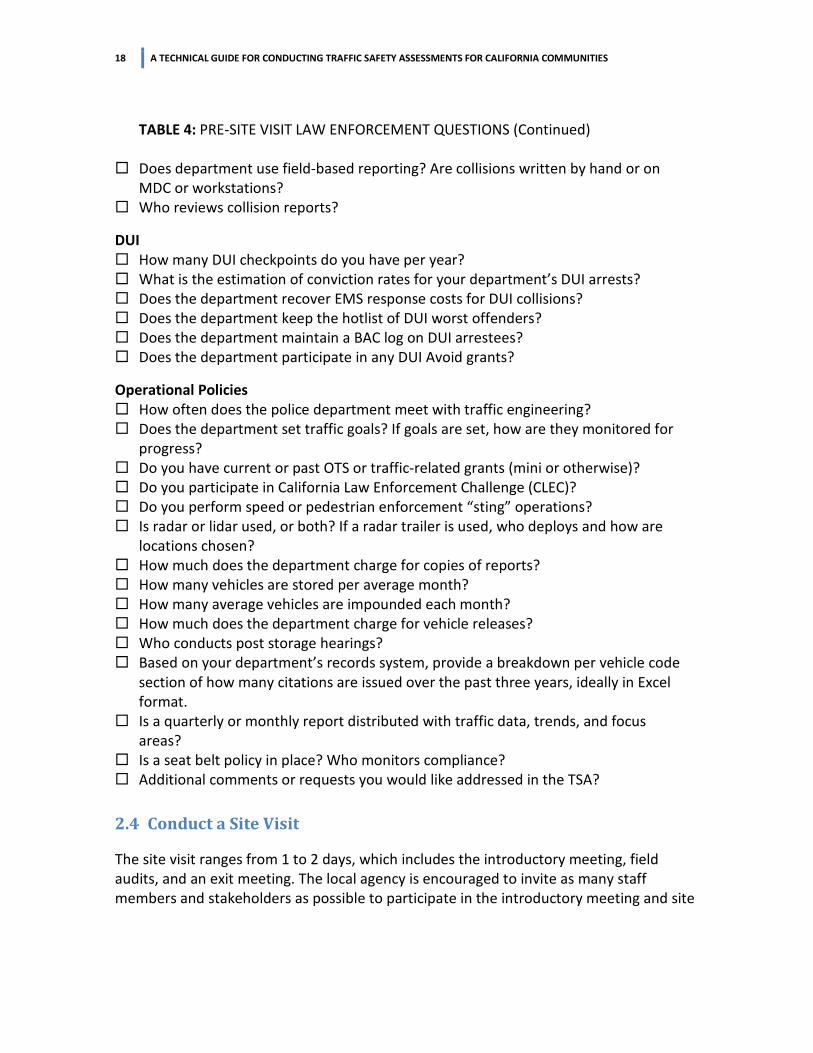
18 A TECHNICAL GUIDE FOR CONDUCTING TRAFFIC SAFETY ASSESSMENTS FOR CALIFORNIA COMMUNITIES
TABLE 4: PRE-SITE VISIT LAW ENFORCEMENT QUESTIONS (Continued)
Does department use field-based reporting? Are collisions written by hand or on MDC or workstations?
Who reviews collision reports?
DUI
How many DUI checkpoints do you have per year? What is the estimation of conviction rates for your department’s DUI arrests? Does the department recover EMS response costs for DUI collisions? Does the department keep the hotlist of DUI worst offenders? Does the department maintain a BAC log on DUI arrestees? Does the department participate in any DUI Avoid grants?
Operational Policies
How often does the police department meet with traffic engineering? Does the department set traffic goals? If goals are set, how are they monitored for
progress?
Do you have current or past OTS or traffic-related grants (mini or otherwise)? Do you participate in California Law Enforcement Challenge (CLEC)? Do you perform speed or pedestrian enforcement “sting” operations? Is radar or lidar used, or both? If a radar trailer is used, who deploys and how are
locations chosen?
How much does the department charge for copies of reports? How many vehicles are stored per average month? How many average vehicles are impounded each month? How much does the department charge for vehicle releases? Who conducts post storage hearings? Based on your department’s records system, provide a breakdown per vehicle code
section of how many citations are issued over the past three years, ideally in Excel format.
Is a quarterly or monthly report distributed with traffic data, trends, and focus areas?
Is a seat belt policy in place? Who monitors compliance? Additional comments or requests you would like addressed in the TSA?
2.4 Conduct a Site Visit
The site visit ranges from 1 to 2 days, which includes the introductory meeting, field audits, and an exit meeting. The local agency is encouraged to invite as many staff members and stakeholders as possible to participate in the introductory meeting and site

A TECHNICAL GUIDE FOR CONDUCTING TRAFFIC SAFETY ASSESSMENTS FOR CALIFORNIA COMMUNITIES 19
visit to optimize the effectiveness of the study results. All staff members and stakeholders that will be reviewing the report should attend the meetings. Other stakeholders might want to provide input for the assessment, such as representatives from local schools, the school district, county Department of Public Health, Regional Agency or Metropolitan Planning Organization, Traffic Safety Advisory committee, or California Department of Transportation (if state highways are within the community’s boundaries). Who will be participating might not become apparent until the pre-visit conference call, the introductory meeting, or the field visit. On the eve of the site visit, the evaluators might drive the streets to perform “windshield surveys” of problem areas and to familiarize themselves with the nature and layout of the transportation system.
2.4.1 Introductory Meeting
Participation is organized by the requesting agency and typically takes place at the local agency’s office. It is important that all staff members and stakeholders that will be reviewing the report attend this meeting. At the discretion of the evaluators, the introductory meeting can be convened in the field. On the first day of the site visit, the evaluators meet with key staff from both the traffic engineering and police departments to review the purpose and scope of the TSA, the focus area issues and locations, and expected deliverables. Evaluators share the information collected to date, such as the OTS rankings. The local agency can provide additional information, such as past efforts to improve safety at the study locations and planned improvement projects. The evaluators also gain insight about the agency’s practices and procedures with respect to collision data collection and information sharing between departments.
Introductory meeting

20 A TECHNICAL GUIDE FOR CONDUCTING TRAFFIC SAFETY ASSESSMENTS FOR CALIFORNIA COMMUNITIES
2.4.2 Field Audit
After the introductory meeting, the evaluators conduct field observations at the identified locations. Each evaluator walks the study corridors or intersections along with the local agency’s staff and other stakeholders and makes observations from several approaches, identifying key aspects of existing conditions that could be causing the identified collision patterns. Suggestions are provided for improving infrastructure and traffic enforcement using current resources and alternative technologies. Taking photographs at each location is encouraged for later analysis and use in the report to illustrate existing conditions. If a study corridor is longer than a few blocks, the evaluator might choose to drive. The times of day, such as peak traffic periods or school arrival and dismissal times are chosen to coincide with the times of the most urgent traffic issues. If time permits, the TSA might also include a field review of some of the high-collision locations revealed by the collision data analysis but not originally included in the list of study locations.
Evaluator at work at a high-incident location
Field site visit
As part of the engineering assessment, the evaluator observes the area addressing topics such as those outlined in Table 5. At each location, the evaluator identifies improvements based on personal experience and the technical resources listed in Appendixes A and B. The suggested improvements are categorized as either short term, (2–6 months), medium term (6–24 months), or long term (2+ years). The enforcement evaluator also visits the police department and conducts an in-depth interview with the traffic unit supervisor. To assess the existing policies and procedures and to formulate suggestions, the enforcement evaluator might pose questions such as those listed in Table 6. This visit allows the evaluator to observe the traffic office environment to gain a better understanding of local trends and goals and view the traffic

A TECHNICAL GUIDE FOR CONDUCTING TRAFFIC SAFETY ASSESSMENTS FOR CALIFORNIA COMMUNITIES 21
unit’s monitoring maps and charts. The evaluator assesses the agency’s collision and traffic data collection capabilities. The agency data is compared to SWITRS to check for discrepancies that could be contributing to the problems. The evaluator provides suggestions for how to improve the agency’s database and collection system. The evaluator also encourages the traffic unit officers to photograph the intersections’ traffic controls at collision sites to help understand and correct problems at high-incident locations.
TABLE 5: IDENTIFYING ENGINEERING ISSUES
Topic Questions Collision Patterns • Does the collision data at the study locations identify a clearly
correctible pattern of collisions? Traffic Regulations
• Are design, posted, and operating traffic speeds compatible with the transportation corridor?
Conformance with Standard Practices and Guidance
• Do the signing, striping, and traffic signal operations meet the guidelines of the California Manual on Uniform Traffic Control Devices (MUTCD)?
Complete Streets and Intersections
• What do the high-incident intersections and street segments lack in the way of Complete Streets attributes, such as sidewalks, bike lanes, wheelchair ramps, accessible signals, and raised medians and auxiliary lanes for access control?
Access Management
• Are the best access management strategies used to regulate traffic patterns at unsignalized intersections and driveways to minimize the potential for broadside, rear-end, and sideswipe collisions, such as those involving pedestrians and bicyclists?
Work Zone Traffic Control
• Are the effects of construction on the safety and accessibility of all road users addressed adequately?
School Peak Hour Traffic
• Is the safety of children in school zones adequately considered? • Can the circulation of vehicular, pedestrian, and bicycle traffic be
improved around the schools of concern to reduce conflicts and congestion during peak traffic conditions?
Transit Stops • Are there adequate sidewalk and roadway facilities to allow pedestrians and bicyclists to safely access transit services?
• Are the transit facilities provided by bus and light rail operators, such as bus stops, transit platforms, and shelters, designed to work efficiently and safely for all road users?
Night-time Conditions
• Do high-incident and conflict areas have lighting? If so, does it provide sufficient illumination?

22 A TECHNICAL GUIDE FOR CONDUCTING TRAFFIC SAFETY ASSESSMENTS FOR CALIFORNIA COMMUNITIES
Roundabout traffic control
School signage

A TECHNICAL GUIDE FOR CONDUCTING TRAFFIC SAFETY ASSESSMENTS FOR CALIFORNIA COMMUNITIES 23
TABLE 6: IDENTIFYING LAW ENFORCEMENT ISSUES
Topic Questions Staffing • Do you have a dedicated traffic division?
• Do you have a dedicated or collaterally assigned supervisor? • Is the traffic division adequately staffed for the patrol strength,
population, and traffic volumes? • What are the expectations of traffic unit deployment hours and days
and for special events? • What is the traffic unit rotation policy and practice? • Do you have focused traffic enforcement, goal setting, monitoring,
and reporting? • How does the police department interact with engineering? How
often and under which circumstances? Are diagrams shared? Data Mining • Does your RMS accommodate meaningful collision data mining and
queries? • Does the monitoring system produce top intersections and segments
and collision trends? • Can queries be made to accommodate development of attainable
traffic goals? • Does the monitoring system accommodate citation-type oversight?
Training • At which intervals do you permit intermediate and advanced collision investigation schools?
• Is there cross-training between traffic officers and patrol officers? • Is there roll-call training and bulletins? How are traffic trends or
training disseminated? • Do you provide Drug alcohol recognition (DAR) and Drug recognition
expert (DRE) training for officers? Collision Documentation
• Which types of collisions are documented and under which circumstances?
• Do you use specialized practices, information exchange, unique forms, or protocols?
• How are collision reports shared with engineering? • Which agency members produce what type of collision reports? • What are the policies for crime lab reporting on blood alcohol and
drug compound findings? Equipment Needs • Which traffic equipment is in use? Radar, lidar, radar trailers?
• How are DUI blood alcohol levels on arrestees logged? • Are there PASS devices and intoxilizers?

24 A TECHNICAL GUIDE FOR CONDUCTING TRAFFIC SAFETY ASSESSMENTS FOR CALIFORNIA COMMUNITIES
Traffic enforcement unit in action
2.4.3 Exit Meeting
After the field audit, the evaluators meet with agency staff to review the preliminary findings, observations, and suggestions, as well as to gather final thoughts from staff and other stakeholders. This meeting is a crucial component of the process. The local agency is encouraged to invite as many staff members and stakeholders as possible to participate. This meeting is also the final occasion when everyone can discuss the issues they would like addressed in the TSA and presented in the report. It is suggested that the evaluators present informal written summaries, as shown in Tables 7 and 8, at the exit meeting to allow the agency to provide feedback about the findings and share with other departments that might be affected by the suggested improvements. TABLE 7: EXAMPLE OF ENGINEERING EXIT MEETING SUMMARY OF FINDINGS
Engineering issues discussed during the conference call Collision mitigation at high-incident intersections Collision mitigation along high-incident street segments Follow-up field observations Intersection safety improvement suggestions for high-incident intersections Intersection safety improvement suggestions for high-incident corridors Observations and photographs taken during the site visit Safety enhancements already implemented by agency Existing and proposed bikeway system Major improvements currently under construction Safety enhancements for pedestrian and bicycle facilities Traffic Management Center

A TECHNICAL GUIDE FOR CONDUCTING TRAFFIC SAFETY ASSESSMENTS FOR CALIFORNIA COMMUNITIES 25
TABLE 7: EXAMPLE OF ENGINEERING EXIT MEETING SUMMARY OF FINDINGS (continued)
Safety enhancements at signalized intersections Upgrades to transit facilities Questions regarding high-incident intersections and street segments Which intersections have funded improvements programmed? Does the Police Department have specific concerns or suggestions about the intersections
viewed during the site visit? Any pictures that the participating agency can provide? Other information that the participating agency wants the evaluators to have? Best practices Experience of TSA team Lessons learned from other TSAs Use of best practices resource list
Traffic management center TABLE 8: EXAMPLE OF ENFORCEMENT EXIT MEETING SUMMARY OF FINDINGS
Department strength and deployment Suggested traffic unit strength and civilian involvement in collision investigations Traffic unit rotation and collision investigation training suggestions and best practices Past, current, and potential OTS grants participation Collision trend analysis data and rankings Collision time windows and traffic deployment contrast

26 A TECHNICAL GUIDE FOR CONDUCTING TRAFFIC SAFETY ASSESSMENTS FOR CALIFORNIA COMMUNITIES
TABLE 8: EXAMPLE OF ENFORCEMENT EXIT MEETING SUMMARY OF FINDINGS (continued)
Collision documentation policy and report flow comments and suggestions PCF contrasted to types of citations issued Maximizing current Crossroads features: citations, reports, handheld citation units Crossroads update suggestions Line beat assignments, stings, and saturation patrol suggestions Impound vehicle release, DUI costs recovery, collision report costs, fee study
suggestions Patrol participation in traffic enforcement, collision investigation, and motor
participation Officer performance tracking and high-collision area contrasts Enforcement disciplines at high red-light collision locations Quarterly traffic report; format and content suggestions Relationship between public works and police departments and resource and
information sharing among departments
2.5 Prepare the Technical Report
After completing the site visit, the evaluators prepare a technical report describing their findings and suggestions. The report summarizes the analysis of the collision data and trends and information collected from the field visit. It includes areas for improvement to reduce collisions at specific locations using engineering measures and through law enforcement initiatives. Photographs of the existing conditions are typically included for each location. The technical report can include: ⇒ Executive Summary that addresses key SWITRS data, relevant OTS rankings, collision
data, overview of engineering issues and enforcement perspectives, lists of study intersections and roadway segments, as well as suggestions for improvements
⇒ Description of the TSA’s objectives, project approach and understanding, issues and concerns precipitating the TSA, information used in the assessment, acknowledgement of all participants, and disclosures about the limitations and use of the report
⇒ Background information, documents, and data for the study, such as collision data, OTS rankings, and primary collision factors
⇒ Traffic engineering assessment and suggestions for improvements. Photographs of the existing conditions are typically included for each location. Suggested improvements may be divided into short-term, medium-term and long-term

A TECHNICAL GUIDE FOR CONDUCTING TRAFFIC SAFETY ASSESSMENTS FOR CALIFORNIA COMMUNITIES 27
⇒ Law enforcement assessment and suggestions addressing traffic enforcement capabilities, enforcement issues, and enforcement index and possibly public education and outreach
⇒ List of resources and references, such as in Appendixes A and B, respectively The report is thorough and clearly documents the areas of concern and suggestions for improvement, because many agencies rely on the report as the basis to apply for grants to implement the suggestions or conduct further studies.
Raised crosswalk, a typical engineering improvement suggestion for school area

28 A TECHNICAL GUIDE FOR CONDUCTING TRAFFIC SAFETY ASSESSMENTS FOR CALIFORNIA COMMUNITIES

A TECHNICAL GUIDE FOR CONDUCTING TRAFFIC SAFETY ASSESSMENTS FOR CALIFORNIA COMMUNITIES 29
Appendix A: List of Resources National ⇒ FHWA, Bicycle Facilities and the MUTCD
www.fhwa.dot.gov/environment/bicycle_pedestrian/guidance/mutcd
⇒ FHWA, MUTCD Official Rulings http://mutcd.fhwa.dot.gov/orsearch.asp
⇒ FHWA, MUTCD Interim Approvals http://mutcd.fhwa.dot.gov/res-interim_approvals.htm
⇒ FHWA, Accessibility Guidance for Bicycle and Pedestrian Facilities, Recreational Trails, and Transportation Enhancement Activities www.fhwa.dot.gov/environment/recreational_trails/guidance/accessibility_guidance/guidance_accessibility.cfm
⇒ FHWA, Bollards, Gates and Other Barriers www.fhwa.dot.gov/environment/recreational_trails/guidance/bollards_access.cfm
⇒ FHWA, Road Safety Audits: Case Studies http://safety.fhwa.dot.gov/rsa/case_studies
⇒ FHWA, Bicycle Road Safety Audit Guidelines and Prompt Lists http://safety.fhwa.dot.gov/ped_bike/tools_solve/fhwasa12018
⇒ NHTSA, Traffic Safety Fact Sheet on Bicycle Safety www.nrd.nhtsa.dot.gov/Pubs/811743.pdf
⇒ National Center for Safe Routes to School www.saferoutesinfo.org
⇒ ITE/FHWA, Traffic Calming: State of the Practice www.ite.org/traffic/tcstate.asp
⇒ Pedestrian and Bicycle Information Center www.pedbikeinfo.org
⇒ Pedestrian and Bicycle Crash Analysis Tool www.pedbikeinfo.org/pbcat_us/index.cfm

30 A TECHNICAL GUIDE FOR CONDUCTING TRAFFIC SAFETY ASSESSMENTS FOR CALIFORNIA COMMUNITIES
California ⇒ OTS, Collision Rankings for Cities and Counties
www.ots.ca.gov/Media_and_Research/Rankings/default.asp
⇒ UC Berkeley, Transportation Injury Mapping System http://tims.berkeley.edu/index.php
⇒ California Strategic Highway Safety and Implementation Plans www.dot.ca.gov/hq/traffops/shsp
⇒ California Traffic Control Devices Committee www.dot.ca.gov/hq/traffops/engineering/ctcdc/index.htm
⇒ Caltrans Complete Streets www.dot.ca.gov/hq/tpp/offices/ocp/complete_streets.html

A TECHNICAL GUIDE FOR CONDUCTING TRAFFIC SAFETY ASSESSMENTS FOR CALIFORNIA COMMUNITIES 31
Appendix B: List of References National Cooperative Highway Research Program (NCHRP)
⇒ A Guide for Reducing Collisions at Unsignalized Intersections. NCHRP Report 500 Volume 5, Transportation Research Board, Washington DC, USA, 2005
⇒ A Guide for Addressing Run-Off-Road Collisions. NCHRP Report 500 Volume 6, Transportation Research Board, Washington DC, USA, 2005
⇒ A Guide for Reducing Collisions on Horizontal Curves. NCHRP Report 500 Volume 7, Transportation Research Board, Washington DC, USA, 2005
⇒ A Guide for Reducing Collisions at Signalized Intersections. NCHRP Report 500 Volume 12, Transportation Research Board, Washington DC, USA, 2005
⇒ A Guide for Reducing Collisions Involving Heavy Trucks. NCHRP Report 500 Volume 13, Transportation Research Board, Washington DC, USA, 2005
⇒ A Guide for Reducing Collisions Involving Bicycles. NCHRP Report 500 Volume 18, Transportation Research Board, Washington DC, USA, 2005
⇒ Fitzpatrick, K. Improving Pedestrian Crossing Safety and Unsignalized Locations. NCHRP Report 562, Transportation Research Board, Washington DC, 2006
⇒ Guidelines for Selection of Speed Reduction Treatments at High Speed Intersections. NCHRP Report 613, Transportation Research Board, Washington DC, 2008
⇒ Accident Modification Factors for Traffic Engineering and ITS Treatments. NCHRP Report 617, Transportation Research Board, Washington DC, 2008
⇒ Effectiveness of Behavioral Highway Safety Countermeasures, NCHRP Report 622, Transportation Research Board, Washington DC, 2008
⇒ Median Intersection Design for Rural High-Speed Divided Highways. NCHRP Report 650, Transportation Research Board, Washington DC, 2010
⇒ Evaluation of Safety Strategies at Signalized Intersections. NCHRP Report 705,Transportation Research Board, Washington DC, 2011
⇒ Speed Reduction Techniques for Rural High-to-Low Speed Transitions. NCHRP Synthesis 412, Transportation Research Board, Washington DC, 2010

32 A TECHNICAL GUIDE FOR CONDUCTING TRAFFIC SAFETY ASSESSMENTS FOR CALIFORNIA COMMUNITIES
Institute of Transportation Engineers
⇒ Ridgway, M. D. and Nabti, J. Innovative Bicycle Treatments. Pedestrian and Bicycle Task Force, Institute of Transportation Engineers, Washington DC, 2002
⇒ Bergh C., and Nan, R. Applying HSM Crash Prediction to Manage Transportation Networks. ITE Western District Annual Meeting, Phoenix, AZ, July 15, 2013
⇒ Schattler, K.L., et al. Impact of Signal Mounting Configurations on Red-Light Running at Urban Signalized Intersections. ITE Journal, Institute of Transportation Engineers, Washington DC, February 2011
Federal Highway Administration
⇒ Signalized Intersections, An Informational Report. Publication No. FHWA-HRT-04-091, Federal Highway Administration, Washington DC, August 2004
⇒ Desktop Reference for Crash Reduction Factors. Report No. FHWA-SA-07-015, U.S. Department of Transportation, September 2007
⇒ Toolbox of Countermeasures and Their Potential Effectiveness for Roadway Departure Crashes. FHWA-SA-07-013, Federal Highway Administration, Washington DC, September, 2007
⇒ Two Low-Cost Safety Concepts for Two-Way Stop Controlled, Rural Intersections High-Speed Two-Lane, Two-Way Roadways. FHWA Publication No FHWA-HRT-08-063, Washington DC
⇒ Safety Evaluation of STOP AHEAD Pavement Markings. FHWA Publication No FHWA-HRT-08-045, Federal Highway Administration, Washington DC
⇒ Innovative Intersection Safety Improvement Strategies and Management Practices: A Domestic Scan. FHWA-SA-06-016, Washington DC
⇒ Low-Cost Safety Enhancements for Stop Controlled and Signalized Intersections. FHWA Publication No FHWA-SA-09-020, Federal Highway Administration, Washington DC
⇒ Safety at Unsignalized Intersections. FHWA Power Point Presentation, Federal Highway Administration, Washington DC
⇒ Engineering Countermeasures to Reduce Red-Light Running. Issue Briefs No. 6, Federal Highway Administration, Washington DC, 2009
⇒ Toolbox of Countermeasures and Their Potential Effectiveness for Intersection Crashes. Issue Briefs No. 8, FHWA, Washington DC, 2007

A TECHNICAL GUIDE FOR CONDUCTING TRAFFIC SAFETY ASSESSMENTS FOR CALIFORNIA COMMUNITIES 33
⇒ Manual on Uniform Traffic Control Devices for Streets and Highways. U.S. Department of Transportation, Federal Highway Administration, Washington DC, U.S.A., 2010
Other Sources
⇒ Kononov, J. Identifying Locations with Potential for Accident Reductions Use of Direct Diagnostics and Pattern Recognition Methodologies. Transportation Research Record 1784, Paper No. 02-2160, Transportation Research Board, Washington DC
⇒ Zegeer, Charles; Huang, Herman; Stewart, Richard. Safety Effects of Marked vs. Unmarked Crosswalks at Uncontrolled Crossing Locations. Highway Safety Research Center, University of North Carolina, 2005
⇒ Crash Factors in Intersection Related Crashes: An On-Scene Perspective. National Highway Traffic Safety Administration, US Department of Transportation, Washington DC, 2010
⇒ Highway Safety Manual. American Association of State Highway and Transportation Officials, Washington DC, 2010
⇒ Innovative Operational Safety Improvements at Unsignalized Intersections. State of Florida, Department of Transportation, August 2008
⇒ Strategies to Address Nighttime Crashes at Rural Unsignalized Intersections. Center for Transportation, Iowa State University, 2008
⇒ Countermeasures That Work: A Highway Safety Countermeasure Guide For State Highway Safety Offices. National Highway Safety Administration, U.S Department of Transportation, Washington DC, Seventh Edition, 2013
⇒ Hofer, K., and Cheng, W. A New Method to Conduct Hotspot Identification: Incorporation of Crash Type and Severity
⇒ Advanced LED Warning System for Rural Intersections: Phase 2 (ALERT-2). Minnesota Department of Transportation, February 2014
⇒ California Manual on Uniform Traffic Control Devices for Streets and Highways. California Department of Transportation, Sacramento, California, 2014
⇒ Guidelines for the Development of Bicycle Facilities. American Association of State Highway and Transportation Officials, Washington DC, 2012
⇒ Urban Bikeway Design Guide. National Association of City Transportation Officials