Embed Size (px)
Citation preview
A TAYLOR MORRISON COMMUNITY
Planned Area Development (PAD) Development Standards and Guidelines Report
Z17-12 AUGUST 2018
GRANITE H ILLS
PLANNING & ZONING Planned Area Development Approval
P/Z Commission Date:_____________________ City Council Approval Date:_______________ Planner:__________________________________ Administrative Approval Date:_____________
9/20/2018
Randy Proch10/16/2018
11/16/2018
i
GRANITE HILLS
Andy Baron, ASLA, LEED AP 50 N McClintock Dr, Suite 1
Chandler, AZ 85226 P: (480) 699-7956
Amy Weidman9000 E. Pima Center Parkway, Suite #350
Scottsdale, AZ 85258P: (480) 459-4312
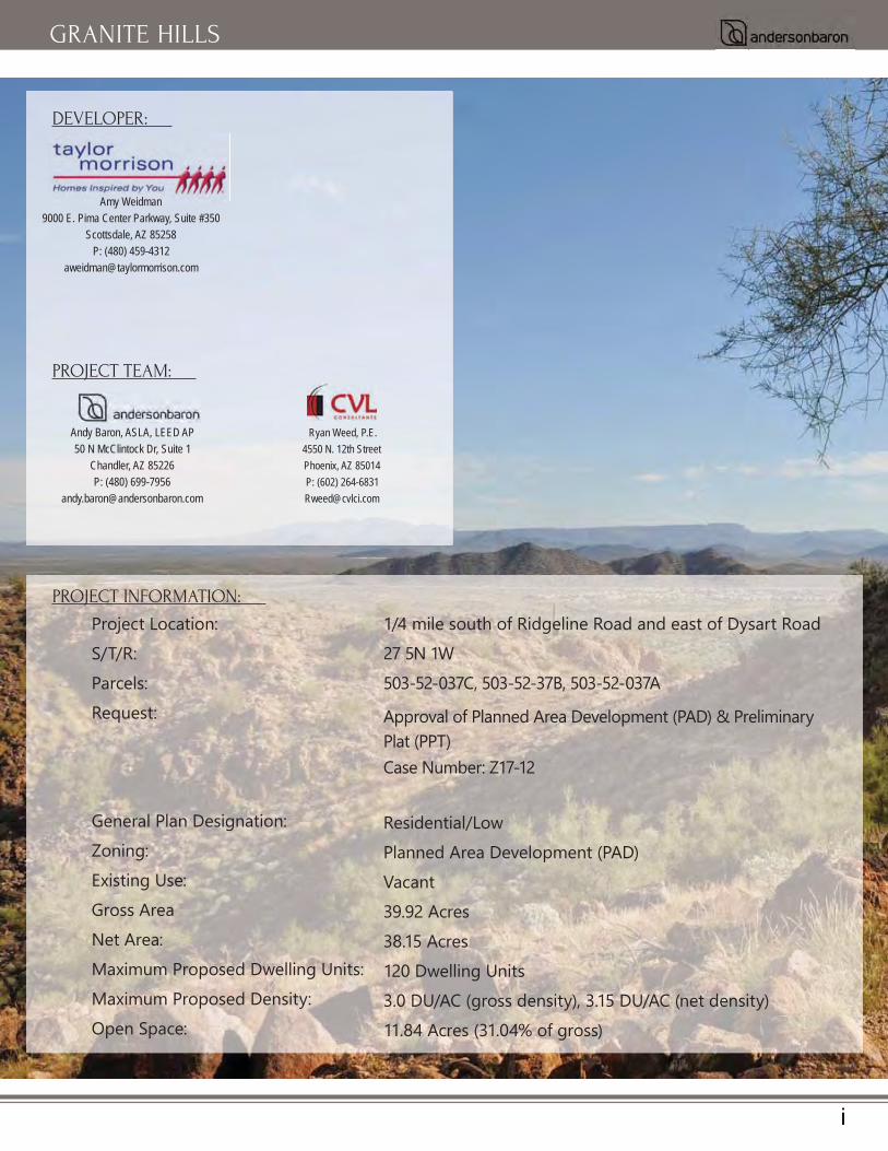
DEVELOPER:
PROJECT TEAM:
Ryan Weed, P.E.4550 N. 12th StreetPhoenix, AZ 85014P: (602) [email protected]
PROJECT INFORMATION:
Project Location:S/T/R:Parcels:Request:
General Plan Designation:Zoning:Existing Use:Gross AreaNet Area:Maximum Proposed Dwelling Units:Maximum Proposed Density:Open Space:
1/4 mile south of Ridgeline Road and east of Dysart Road27 5N 1W503-52-037C, 503-52-37B, 503-52-037A
Approval of Planned Area Development (PAD) & Preliminary Plat (PPT) Case Number: Z17-12
Residential/Low Planned Area Development (PAD)Vacant39.92 Acres38.15 Acres 120 Dwelling Units3.0 DU/AC (gross density), 3.15 DU/AC (net density) 11.84 Acres (31.04% of gross)

ii
GRANITE HILLS
TABLE OF CONTENTS:
LIST OF EXHIBITS:
1 INTRODUCTION 12 LEGAL DESCRIPTION 33 PRELIMINARY DEVELOPMENT PLAN 44 PERMITTED PRINCIPAL, CONDITIONAL AND ACCESSORY USES 85 PROJECT PHASING AND DEVELOPMENT SCHEDULE 86 PROJECT DEVELOPMENT STANDARDS 87 PROJECT SIGNAGE STANDARDS 128 PROJECT LANDSCAPE STANDARDS 139 HILLSIDE ANALYSIS 1310 INFRASTRUCTURE/UTILITIES 1311 PRELIMINARY PLAT 1412 CONCLUSION 14
EXHIBIT A: VICINITY MAP 15EXHIBIT B: GENERAL PLAN LAND USE 16EXHIBIT C: EXISTING AND PROPOSED ZONING 17EXHIBIT D: DEVELOPMENT PLAN 18EXHIBIT E: LANDSCAPE PLAN 19EXHIBIT F: ENTRY PLAN & DETAILS 20EXHIBIT G: WALL PLAN 21EXHIBIT H: WALL DETAILS 22
EXHIBIT I: SITE CROSS SECTIONS 23EXHIBIT J: USABLE OPEN SPACE 29EXHIBIT K: NOS OPEN SPACE 30EXHIBIT L: AMENITY PLAN 31EXHIBIT M: PEDESTRIAN CIRCULATION PLAN 32EXHIBIT N: LOT FIT ANALYSIS 33
TECHNICAL REPORTS (SUBMITTED SEPARATELY):TRAFFIC IMPACT ANALYSISPRELIMINARY WATER AND WASTEWATER ANALYSISPRELIMINARY DRAINAGE REPORTA.L.T.A SURVEY

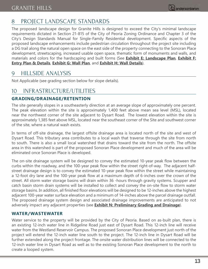
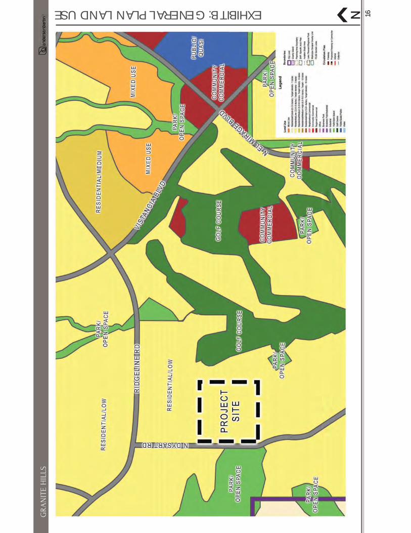
1 INTRODUCTIONTaylor Morrison is excited to introduce Granite Hills, a proposed multi-lot size, high-quality, single-family residential neighborhood to the City of Peoria. The project is located in the Southeast Quarter of Section 27, Township 5 North, Range 1 West, of the Gila and Salt River Base and Meridian, Maricopa County, parcels 503-52-037C, 503-52-37B, and 503-52-037A. More generally, the site is on the western boundary of the City of Peoria, ¼ mile south of Ridgeline Road (formerly Dixileta Parkway) and east of Dysart Road. The subject parcels are currently vacant and approximately 40-acres in size. This application proposes a change in zone from SR-43 to Planned Area Development (PAD) to allow for the development of one hundred and twenty (120) single-family detached lots, with a gross density of 3.0 dwelling units per acre (DU/AC) and approximately twelve (11.84) acres or 31.04% (percentage of gross acres) dedicated open space, including Natural Open Space (NOS), and usable and non-usable open space areas (see Exhibit A: Vicinity Map).
PURPOSE OF THE REQUEST
accommodate a variety of proposed lot sizes and mixes within this residential development.
BACKGROUND AND EXISTING CONDITIONSThe proposed development’s west and south sides of the property are adjacent to undeveloped SR-43 zoned land at the western border of the City of Peoria. To the east of the proposed development is the Trilogy at Vistancia Planned Community Development (PCD parcel C10), and the Fontenelle PAD. These developments include a mix of existing residential lot sizes ranging from approximately 5,000 square feet to 12,000 square feet (48’x115’, 50’x120’, 60’x120’). To the north of the property is the proposed Sonoran Place PAD which includes one hundred and twenty-two (122) single-family lots with a density of just over 3 dwelling units per acre. The Sonoran Place PAD plans for residential lot sizes ranging
and complementary to these surrounding developments.
1
GRANITE HILLS
unique physical features impact the property beyond a minor wash that runs through the entire length of the proposed project site. The wash is proposed to be preserved in a natural state (to the greatest
the adjacent parcels, are listed below in Table 1: Existing Conditions Summary, and further described in the following document sections.
Table 1: Existing Conditions Summary
Direction General Plan Land Use Category Existing Zoning Existing Use
Site Low Density Residential SR-43 Vacant, Undeveloped
North Low Density Residential PAD Single-Family Residential Community
SouthLow Density Residential/
Open SpaceSR-43 Vacant, Undeveloped
East Low Density Residential/ Golf Course PAD and PCD Single-Family Residential
Community
WestLow Density Residential/
Open SpaceSR-43 Vacant, Undeveloped
GENERAL PLAN CONFORMANCEThe current and proposed land use designation for this development is Low Density Residential, which
land use as areas where detached, moderately-sized lot, single-family residential neighborhoods are desirable. These areas support a suburban lifestyle with areas of increased density while maintaining a detached single-family residential character. Low Density Residential parcels should be located either
2
GRANITE HILLS
adjacent to, or in close proximity to neighborhood amenities such as joint-use schools/parks, trails, open space, or recreational facilities. Within the Low Density Residential land use category, the City of Peoria has set a target density of 3.0 DU/AC. With exactly 3.0 planned dwelling units per gross acre, this development meets the requirements of the Low Density Residential land use category (see Exhibit B: General Plan Land Use). In addition, this PAD includes superior quality and design above and beyond the minimum City standards and are described within the “Enhanced Design Standards” section of this document.
PROPOSED REZONING/PAD REQUEST• In accordance to the City of Peoria’s Zoning Ordinance, the PAD is intended to provide an
alternative zoning district to the conventional zoning and development process in order to achieve the following goals (City of Peoria Zoning Ordinance, Section 21-601):
• To enhance the City’s development growth in order that the public health, safety, and general
• To encourage innovations in residential development so that greater opportunities for better
• • To encourage a more creative approach in the utilization of land in order to accomplish a more
• To provide a compatible and stable developed environment, in harmony with that of the surrounding area.
The proposed Granite Hills residential development meets and exceeds the goals listed above for a PAD district designation as outlined in this application request. The requested rezoning from the SR-43 zoning district to PAD would allow Taylor Morrison to build one hundred and twenty (120) single-family homes
a 48’x115’ lot (5,520 Sq. Ft.), 50’x115’ lot (5,750 Sq. Ft.), and a 63’x125’ lot (7,875 Sq. Ft.). At approximately 39.92 gross acres the yield of 120 lots results in a gross density of 3.0 DU/AC and at approximately 38.15 net acres, the same yield results in a net density of 3.15 DU/AC (see Exhibit C: Existing and Proposed Zoning).
2 LEGAL DESCRIPTIONPARCEL NO. 1:
THE SOUTHEAST QUARTER OF THE SOUTHEAST QUARTER OF SECTION 27, TOWNSHIP 5 NORTH, RANGE
EXCEPT THE NORTH HALF OF THE NORTH HALF OF THE SOUTHEAST QUARTER OF THE SOUTHEAST QUARTER OF SECTION 27 THEREOF.
CONTAINING 29.938 ACRES MORE OR LESS
3
GRANITE HILLS

PARCEL NO. 2:
THE NORTH HALF OF THE NORTHEAST QUARTER OF THE SOUTHEAST QUARTER OF THE SOUTHEAST QUARTER OF SECTION 27, TOWNSHIP 5 NORTH, RANGE 1 WEST OF THE GILA AND SALT RIVER BASE AND MERIDIAN, MARICOPA COUNTY, ARIZONA.
CONTAINING 4.989 ACRES MORE OR LESS
PARCEL NO. 3:
THE NORTH HALF OF THE NORTHWEST QUARTER OF THE SOUTHEAST QUARTER OF THE SOUTHEAST QUARTER OF SECTION 27, TOWNSHIP 5 NORTH, RANGE 1 WEST OF THE GILA AND SALT RIVER BASE AND MERIDIAN, MARICOPA COUNTY, ARIZONA.
CONTAINING 4.991 ACRES MORE OR LESS
THE TOTAL CONTAINING 39.918 ACRES, MORE OR LESS
3 PRELIMINARY DEVELOPMENT PLANThe Residential Development Standards for this PAD, as outlined below, include the proposed standards
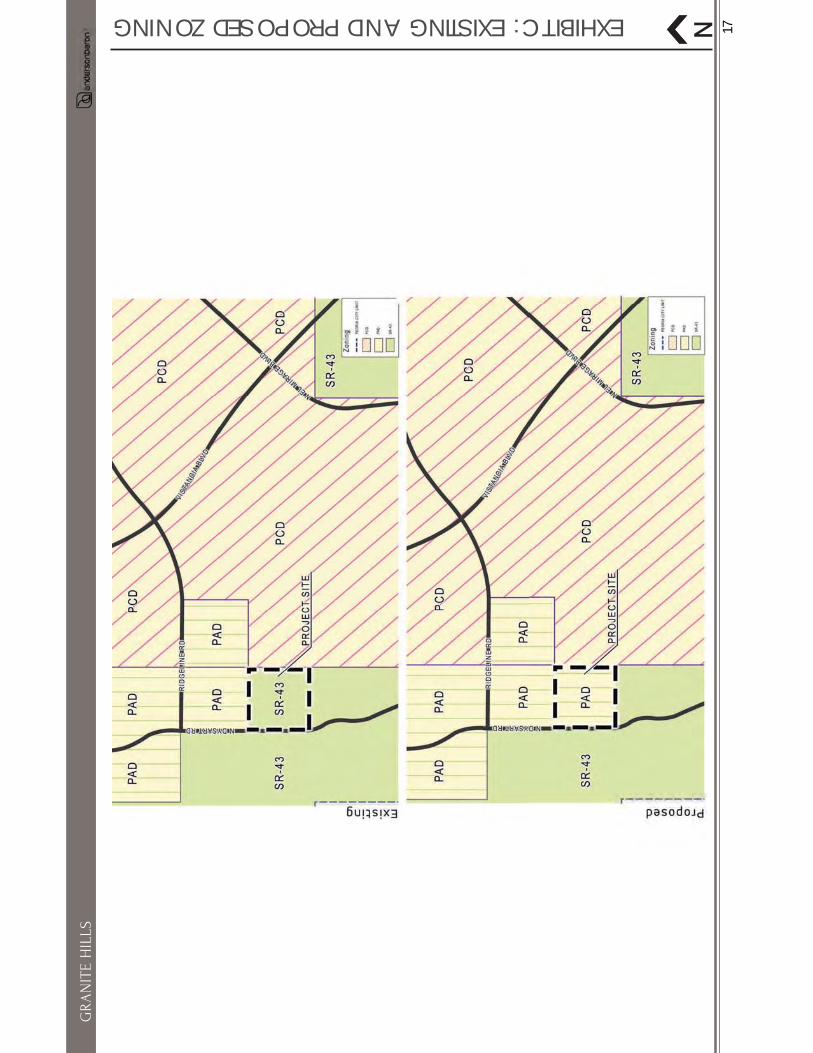
to concentrate density away from areas of open space, such as natural drainage ways and steep slopes, to protect and preserve natural open space areas. The included residential standards will serve to permit a mix of lot sizes in order to accommodate market and consumer trends as well as to buffer the existing residential community to the east. Taylor Morrison seeks to convert this long-vacant parcel of land into a vibrant residential community. The proposed preliminary development plan has been developed to integrate three (3) unique single-family lot sizes including a mix of 48’x115’ (35 units), 50’x115’ (46 units), and 63’x125’ (39 units). The proposed preliminary development plan includes a total of one hundred and twenty (120) lots achieving a low residential density across the site (3.0 gross DU/AC) (see Exhibit D: Development Plan).
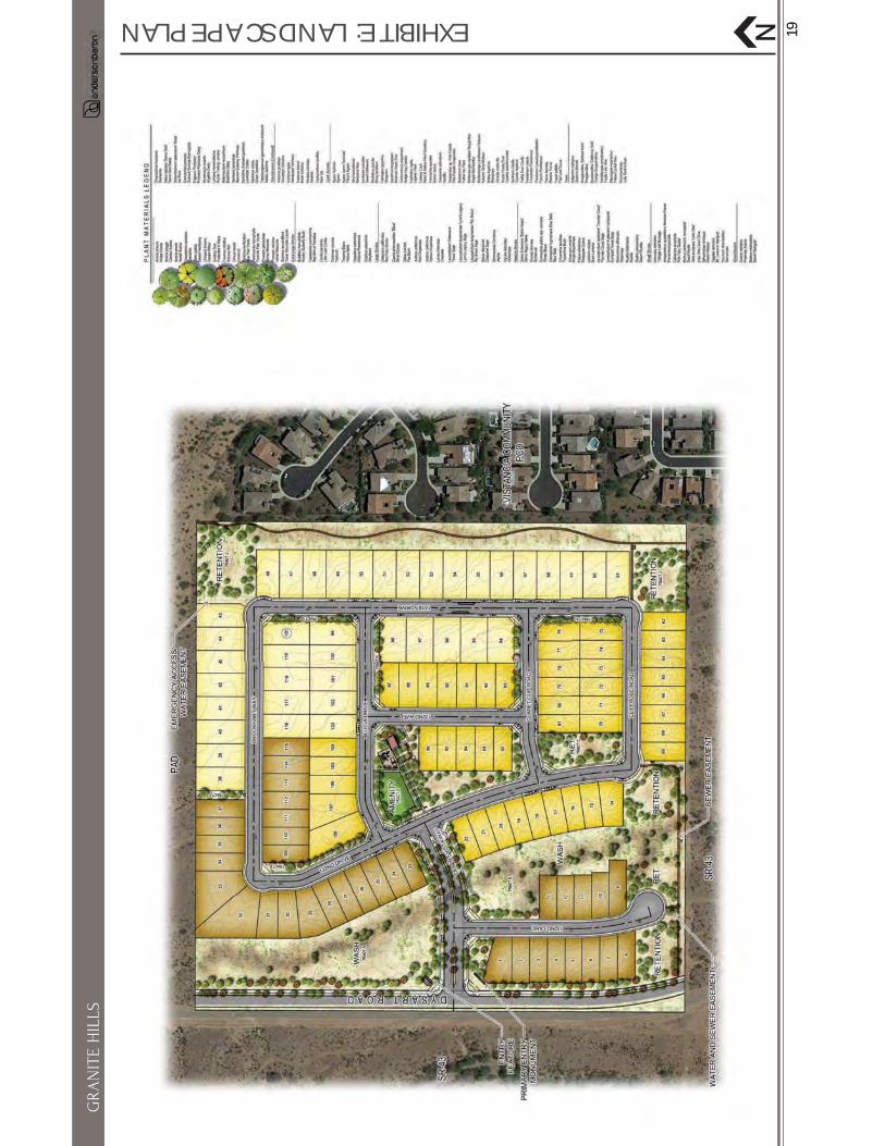
The community will feature high quality single-family homes that will utilize a public street network (50’ public street cross section) with one access point located off of Dysart Road and an emergency access point at the northeast corner of the site connecting to the Sonoran Place community to the north. A community amenity is centrally located for each home owner to enjoy. Drainage will be managed on-site within landscaped retention areas. A perimeter wall will be constructed to provide community security and safety, enhanced by a comprehensive landscape character/palette and punctuated by community monumentation signifying arrival to the community. All of these elements will be integrated to establish a character that complements the City of Peoria and the surrounding developments (See Exhibit E: Landscape Plan, Exhibit F: Entry Plan & Details, Exhibit G: Wall Plan, and Exhibit H: Wall Details).
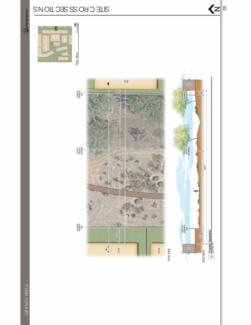
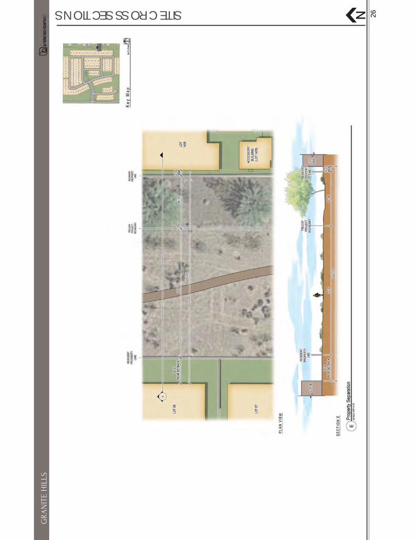
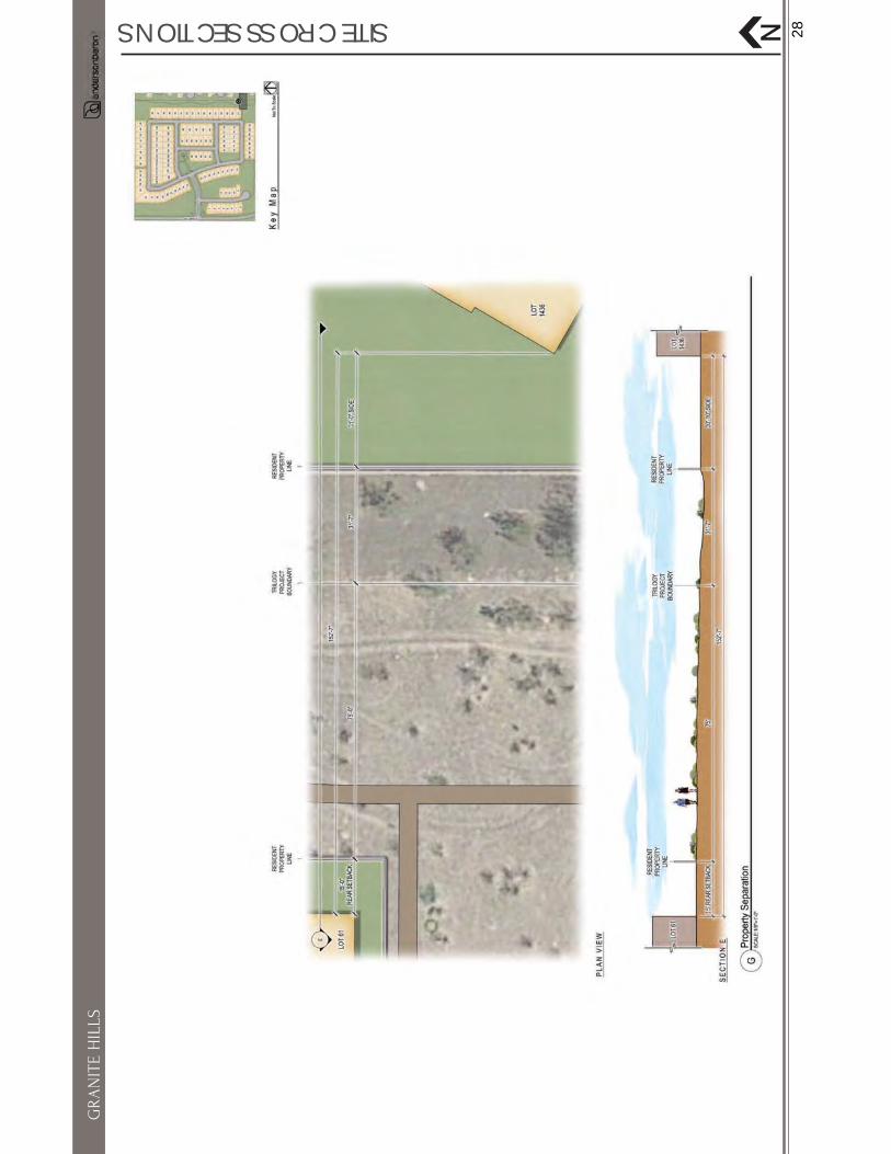
Granite Hills has been designed to provide a compatible development in harmony with the surrounding area. A large area of open space is provided on the Preliminary Development Plan creating a generous buffer between the existing developments to the east. Similarly, the Sonoran Place PAD to the north of
boundary (this project’s northern boundary) that creates a natural buffer between the two developments (see Exhibit I: Site Cross Sections).
4
GRANITE HILLS
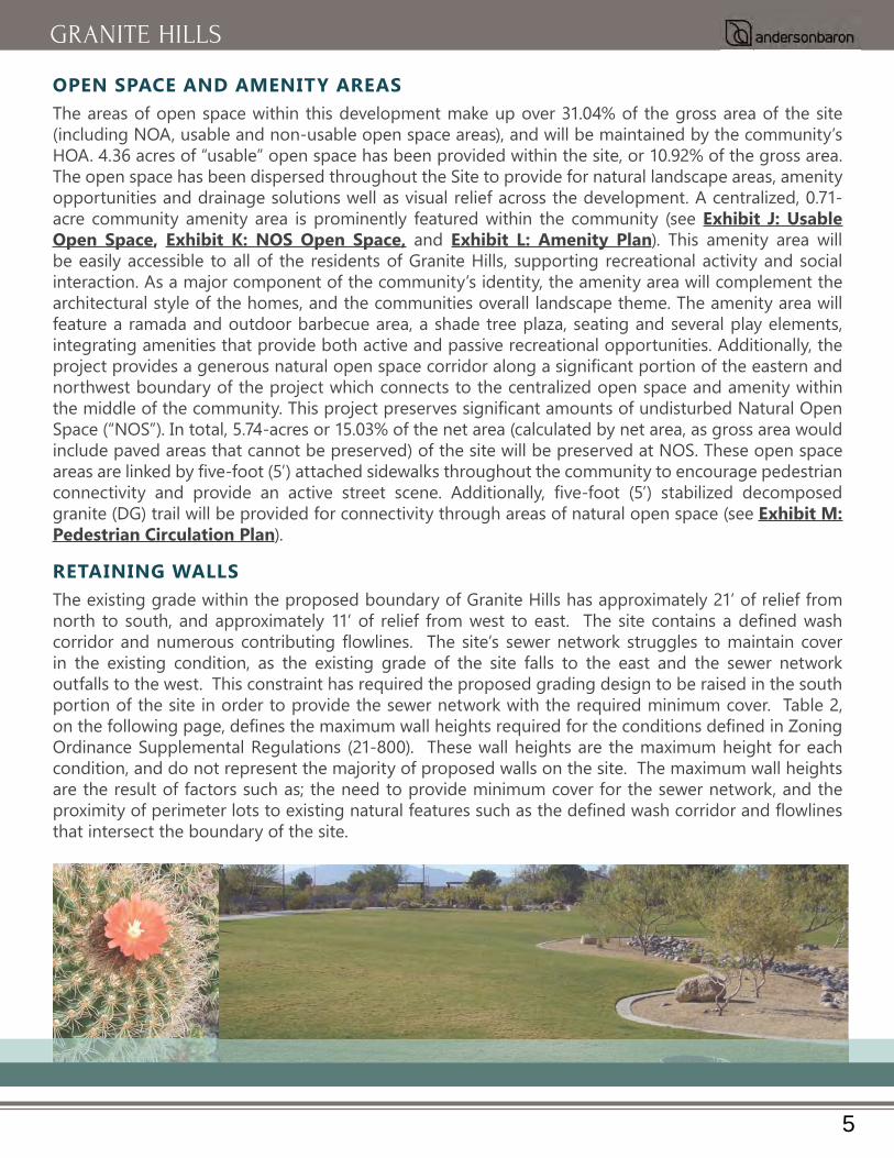
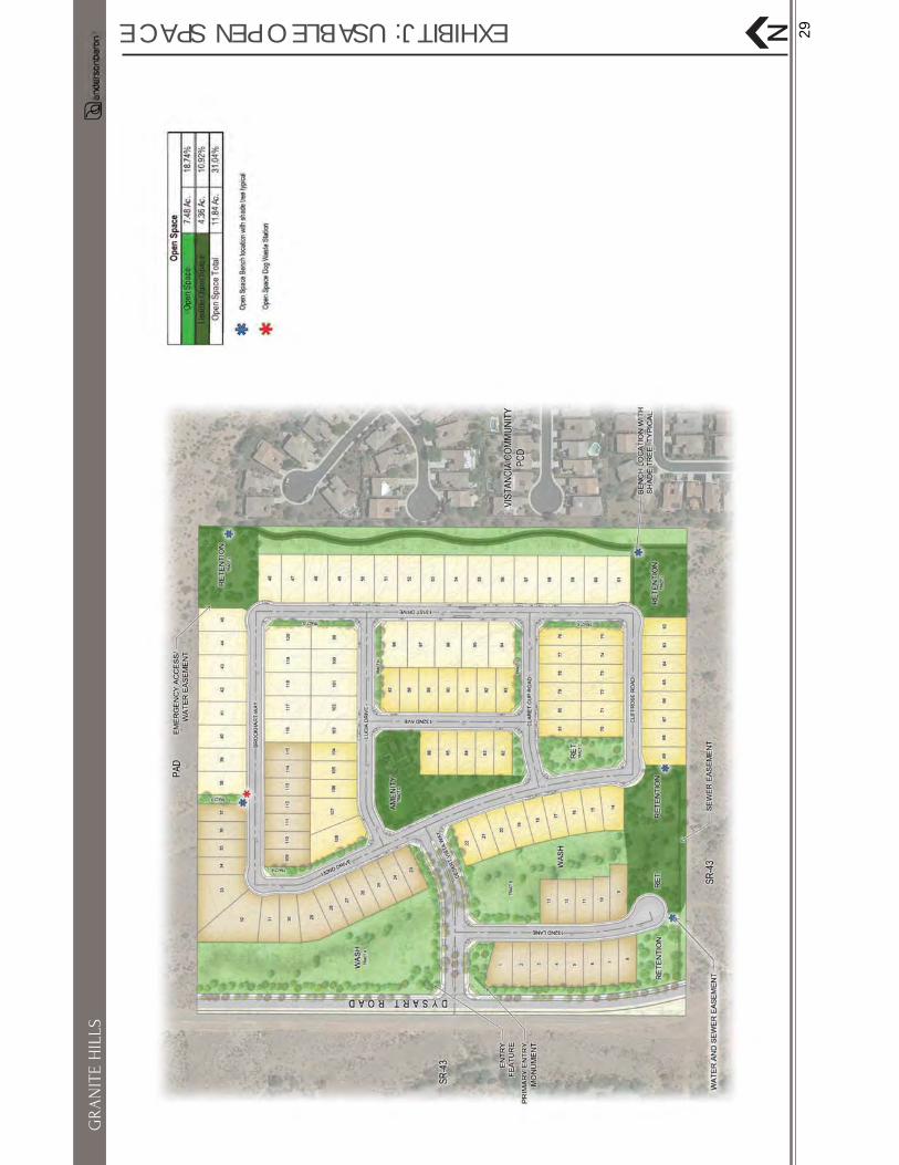
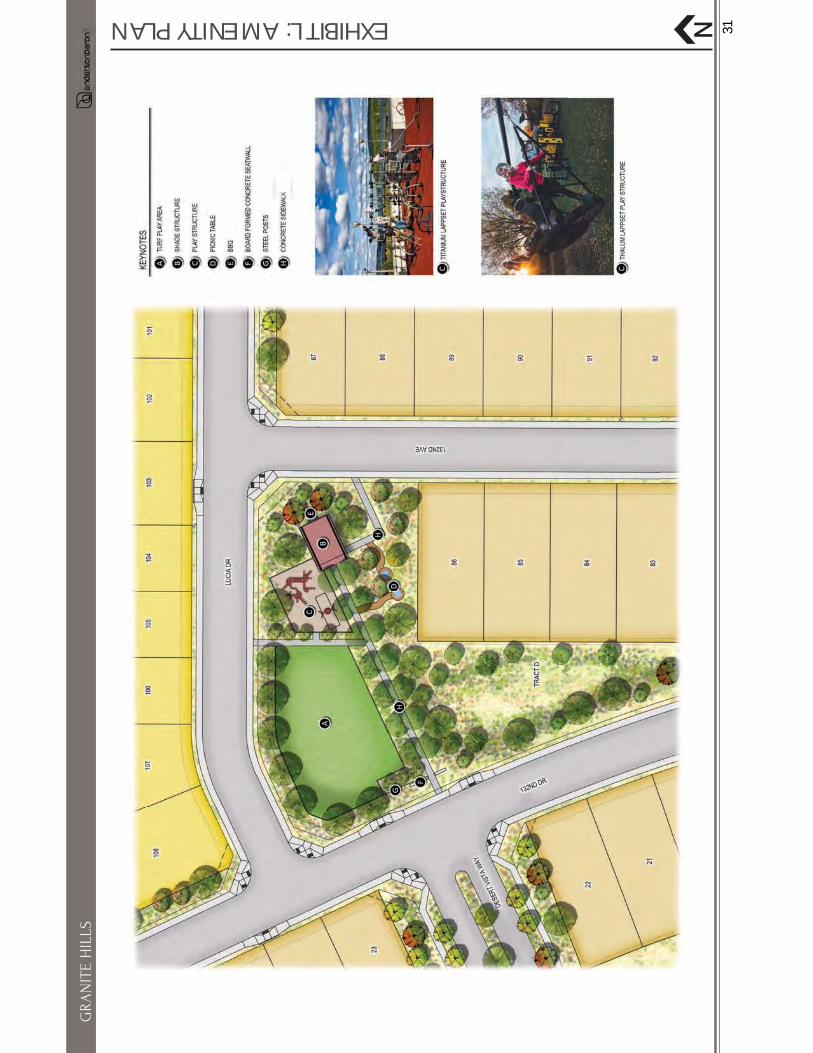
OPEN SPACE AND AMENITY AREAS The areas of open space within this development make up over 31.04% of the gross area of the site (including NOA, usable and non-usable open space areas), and will be maintained by the community’s HOA. 4.36 acres of “usable” open space has been provided within the site, or 10.92% of the gross area. The open space has been dispersed throughout the Site to provide for natural landscape areas, amenity opportunities and drainage solutions well as visual relief across the development. A centralized, 0.71-acre community amenity area is prominently featured within the community (see Exhibit J: Usable Open Space, Exhibit K: NOS Open Space, and Exhibit L: Amenity Plan). This amenity area will be easily accessible to all of the residents of Granite Hills, supporting recreational activity and social interaction. As a major component of the community’s identity, the amenity area will complement the architectural style of the homes, and the communities overall landscape theme. The amenity area will feature a ramada and outdoor barbecue area, a shade tree plaza, seating and several play elements, integrating amenities that provide both active and passive recreational opportunities. Additionally, the
northwest boundary of the project which connects to the centralized open space and amenity within
Space (“NOS”). In total, 5.74-acres or 15.03% of the net area (calculated by net area, as gross area would include paved areas that cannot be preserved) of the site will be preserved at NOS. These open space
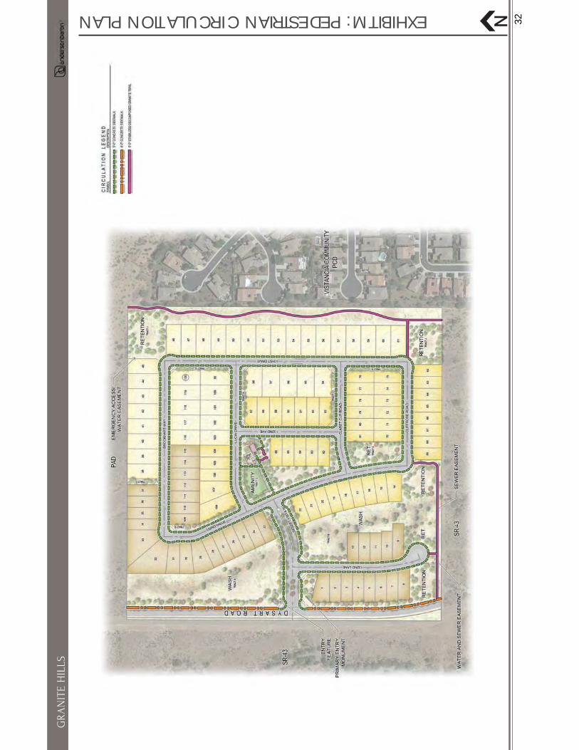
granite (DG) trail will be provided for connectivity through areas of natural open space (see Exhibit M: Pedestrian Circulation Plan).
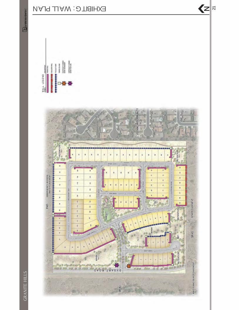
RETAINING WALLS The existing grade within the proposed boundary of Granite Hills has approximately 21’ of relief from
in the existing condition, as the existing grade of the site falls to the east and the sewer network outfalls to the west. This constraint has required the proposed grading design to be raised in the south portion of the site in order to provide the sewer network with the required minimum cover. Table 2,
Ordinance Supplemental Regulations (21-800). These wall heights are the maximum height for each condition, and do not represent the majority of proposed walls on the site. The maximum wall heights
that intersect the boundary of the site.
5
GRANITE HILLS
Table 2: Maximum Wall Heights
ZONING ORDINANCESUPPLEMENTAL REGULATIONS (800) MAXIMUM WALL HEIGHT STIPULATION
21-805 B.3. Adjacent Residential Lots Maximum wall height of 11’ on low side
21-805 B.4. Lots Adjacent to Streets Maximum wall height of 11.5’ on low side
21-805 B.5. Retaining Walls (Adjacent to Existing Grade)
Maximum wall height of 15’ on low side of single wall
21-805 B.6. Lots Adjacent To Retention Areas Maximum wall height of 11’ on low side of single wall
21-805 B.6. Lots Adjacent To Waterways Maximum wall height of 15’ on low side of single wall
CHARACTER Granite Hills will be designed and constructed as an integrated whole, both functionally and aesthetically, so as to achieve the unique project identity to contribute to high-quality residential development within the City of Peoria. The project will feature a modern desert landscape palette that will complement the surrounding architecture and environment. Authentic and natural materials will be utilized along with a patterned landscape to accentuate the development.
6
GRANITE HILLS

HOUSING PRODUCTThe architecture and character of Granite Hills will provide diversity and originality throughout the
plans and two of our best selling plans that have been revised to accommodate today’s lifestyle. The six plans selected vary in style and layout and will enhance the community streetscape in the following ways:• Three are single story plans• Three are two story plans• One includes living area behind the garage• Three include living areas in line with the garage• Two include living areas in front of the garage• The four with living areas either behind or in line with the garage, include optional front covered
porches that extend in front of the garageThe proposed residential plans will be largely consistent in style and theme with surrounding developments and will include Taylor Morrison’s high-quality elevations which enhance the street scene by utilizing
present and vary by plan. This community includes home sites that vary in width and lot size and that will
elements and characteristics of Granite Hill’s planned architectural character include:• • • • • An aesthetic and complimentary application of natural materials.
style of garage doors to suit the design of the home and to add visual interest to the street scene (See Exhibit N: Lot Fit Analysis).
7
GRANITE HILLS

4 PERMITTED PRINCIPAL, CONDITIONAL AND ACCESSORY USESAll permitted , conditional, and accessory uses shall be maintained as described and without deviation within Section 21-415 of the City’s zoning ordinance for the proposed PAD district.
5 PROJECT PHASING AND DEVELOPMENT SCHEDULEIt is anticipated that Granite Hills will be developed as one phase. It is estimated that the construction will be initiated in 2019 with a two-year build out completion.
6 PROJECT DEVELOPMENT STANDARDSThe following development standards and requirements are to be complied with and maintained without deviation from existing City of Peoria codes, regulations, provisions, and/or requirements, within the requested PAD for Granite Hills:
••••• Desert Lands Conservation Overlay.
Flexible development standards are proposed for this PAD to allow for three unique lot sizes and product
Setbacks are designed to govern the size, shape, and placement of buildings in relation to the property. They are designed to help regulate density, provide adequate daylighting, ensure privacy, and create open spaces for individual activity and relaxation. Proposed setbacks within this PAD that deviate from the typical Peoria
side setback total, when added together. These proposed setbacks are designed to allow for high-quality homes to be built on each lot while maintaining privacy, an appropriate density, and ample open space.Lot width, lot coverage, and block length standards are meant to help with massing control and the aesthetic
and sixty-three (63) foot lot widths with lot coverage standards that meet the needs of each of the three (3)
one-thousand (1,000) foot standard. Speeds will naturally be mitigated on this roadway as a result of the
chicanes have also been added to the plan. To help mitigate the proposed lot widths, coverage amounts, and block length, the site has been designed to place the largest lot sizes adjacent to the neighboring residential community to the east, with the smaller lot sizes placed within the interior of the community and along the southern boundary of the project. In addition, all of the lots on the eastern boundary of the project will be limited to single story. This self-imposed restriction will reduce the overall appearance of massing/home size from the street and neighboring developments. In addition to the enhancements listed above, the overall streetscene will be enhanced with the addition of architectural pavers in leu of standard concrete driveways and front walkways. New home products have also
architecture has been designed to mitigate garage dominance by including livable space in front of garages, creating an overall effect that draws the eye to the front of the home and down the street, versus a garage dominant appearance. There are currently 6 plans for the 48’ and 50’ lots, four (4) of which have a front porch at least 5’ in front of garage and the other two (2) have livable areas at least 5’ in front of garage.
8
GRANITE HILLS

Included below are the proposed development standards for Granite Hills (see Table 2: Proposed Development Standards, Table 3: Lot Size Variation, and Table 4: Open Space Requirements).
Table 2: Proposed Development Standards
PAD Development StandardsR1-6 City of Peoria
Standards (for comparison only)
Lot Size 48’x115’ 50’x115’ 63’x125’ 80’x100’Minimum Lot Area 5,520 5,750 7,875 6,000Minimum Lot Width 48’ 50’ 63’ 50’Minimum Lot Depth 115’ 115’ 125’ 100’Maximum Height 30’/Two-story 30’/Two-story 30’/Two-story 30’Maximum Lot Coverage (percent)
1-story - 55%2-story - 50%
1-story - 50%2-story - 45%
1-story - 50%2-story - 45% 45%
Block Length 1,050 ft 1,000 ftMinimum Building SetbacksFront Living 10’ 10’ 10’ 10’Side Loaded Garage 10’ 10’ 10’ 10’Front Loaded Garage 20’ 20’ 20’ 20’Interior Side (min/min total) 5’/13’ 5’/13’ 5’/13’ 5’/8’/13’
Rear 15’ 15’ 15’ 15’
Table 3: Lot Size Variation
Lot Size Quantity Mix % R1-6 City of Peoria Standards
48’x115’ 35 29.17% N/A50’x115’ 46 38.33% N/A63’x125’ 39 32.50% N/ATotal Number of Lots 120 100% N/A
Table 4: Open Space Requirements
Type of Open Space Acres Percent of Area R1-6 City of Peoria Standards
Unusable Open Space 7.48 acres 18.74% gross9% Gross
Undisturbed NOS 5.40 acres 14.15% net15% NetDisturbed NOS 0.34 acres 0.88% net
Total Natural Open Space 5.74 acres 15.03% netAmenity Area 0.71 1.86% net N/A
9
GRANITE HILLS

DENSITY JUSTIFICATION - ENHANCED DESIGN STANDARDSThe City of Peoria’s Low Density Residential General Plan land use category requires a density between 2-5 DU/AC, with a target density of 3.0 DU/AC. With exactly 3.0 planned dwelling units per gross acre, this development meets the requirements of the Low Density Residential land use category. To mitigate the proposed Development Standards, this project includes Enhanced Design Standards that exceed City of Peoria Standards and Requirements (20-78-3) by providing a superior quality and design.
The purpose of the City of Peoria’s Design Guidelines are to:
Granite Hills will meet and will in many cases exceed many of the Design Guidelines including the following elements:
SUBDIVISION DESIGNGranite Hills was designed to promote safety, enhanced lot functionality, provide convenient pedestrian and vehicle connections, and creates usable open space and recreation areas. The City of Peoria’s Design Guidelines for subdivision design have been met, and the following guidelines have been exceeded:
• 20-78-3.II.A.1.carterial street intersections.
• 20-78-3.II.A.2.d - Landscaping should not create blind spots or hiding spots.
• 20-78-3.II.A.2.e -Open spaces and recreational areas should be located so that they can be observed from nearby homes.
In addition to these standards, all end tracts have been designed to be at least thirteen (13) feet wide adjacent to the rights-of-ways to allow for street trees adjacent to sidewalks.
10
GRANITE HILLS

OPEN SPACEA sizable percentage of open space above the minimum standard: The provision of open spaces within new developments provide many advantages including formal and informal play and recreation areas, preservation of natural environments, provision of green space and even storm water management. The amenity area planned for Granite Hills includes several options for residents of all ages and abilities. Younger residents will enjoy structured play on provided play structures and free play within turf areas designed to accommodate a variety of activities. Family and friends may also gather under the shade structure, on the picnic tables and seatwalls, for a perfect space to share a meal, catch up with neighbors, or keep a watchful eye on their children. Residents of Granite Hills will also enjoy the interconnected system of trails that easily connect residents to the amenity area.There is a growing body of research showing a connection between human health and wellbeing and the design and structure of communities. With this in mind, Granite Hills has been designed to include over 31.04% NOS, usable, and non-usable open space areas, well above the required 9% of gross area (10.92% gross area is provided) for usable open space and 15% for natural open space (15.03% net area is provided).
Open space areas planned for Granite Hills are designed above and beyond City standards. The following Design Guidelines exceed City standards:
• 20-78-3.II.A.5.a - All developments shall provide a minimum area of Usable Open Space in accordance with the schedule outlined in Table 1. Table 1:Standard Requirement ProvidedUsable Open Space 9% gross area 10.92% gross Natural Open Space 15% net area 15.03% net areaTotal Open Space No requirement 31.04% gross area
.
CONNECTIVITYA high-level of interconnectivity throughout the community: The way cities and neighborhoods are designed affects whether or not it is easy for people to walk, cycle, participate in active recreation, and interact with neighbors and their community. For this reason, Granite Hills has been designed to include trails and connections from each area of open space to the amenity area, north to neighboring residential communities and south to future development areas to ensure connectivity remains accessible and convenient for all residents. To ensure vehicular circulation remains accessible at all times for residents of Granites Hills, the development includes one point of connection onto Dysart Road. The main entry, as described previously includes a lush park-like boulevard. A decomposed granite trail (DG) runs the entire length of the eastern property boundary connecting residents and visitors to the developments to the north and future development to the south. This trail connects to the greater Granite Hills community in multiple locations and links residents and visitors to
an eight (8) foot tree-lined sidewalk is provided along the entire length of the project’s western boundary along Dysart Road. This generous pathway will connect residents and visitors to the various trails, open spaces and amenities within the greater Peoria area (see Exhibit M: Pedestrian Circulation Plan).
11
GRANITE HILLS
WALLS AND ENTRY FEATURESCommunity character and sense of place: The perimeter of Granite Hills was considered in the design of
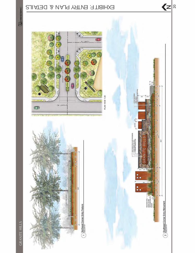
while maintaining an aesthetic balance with the existing neighboring developments. The perimeter walls that abut communities to the north, and east include a partial view wall. This wall is designed to have a four (4) foot solid base with a two (2) foot view wall on the top. At each property line, the solid portion of the walls are extended to the top of the wall creating an attractive wall variation. This enhanced design provides visual interest and an aesthetic appeal to a typically ordinary community feature. The community will also feature a centrally located primary entrance off of Dysart Road that opens onto the central amenity area. Graphics highlighting the positive visual impact of the development on the streetscene along Dysart Road have been included. The primary entrance will include community monumentation with enhanced landscape materials creating a tree-lined, park-like entrance into the community that compliment the surrounding natural desert. High-quality materials including board-form concrete, weathered steel accent columns, and stone accent with a 4” concrete cap are included in the design creating a distinguished and venerable entry into the community. The entry/gateway monumentation and overall community theming will be provided as referenced on Exhibit F: Entry Plan & Details, Exhibit G: Wall Plan, and Exhibit H: Wall Details.
ENVIRONMENTAL COMPONENTS Capitalization on the location’s assets to create destinations within a project, and preservation and retention of environmentally sensitive areas: Granite Hills values the natural resources present on the
provides shelter for wildlife, and improves soil percolation. Vegetated open spaces provide privacy from
This site has been extensively studied and all natural, cultural and historic elements have been documented
historic features, and habitat has been inventoried. The on-site washes/drainage ways will be preserved in their natural state, creating an untouched respite within the development that will be accessible to the entire community. The wash also serves as a natural buffer from Dysart Road (with the exception of a mere 13 units proposed at the southwest corner) and from future development to the west of the site. The inclusion of open space along the site’s western boundary will create a unique streetscene as compared to other developments that provide property walls straight along all project boundaries. Instead of this approach, Granite Hills will enhance a portion of the landscape adjacent to Dysart that blends with a wide swath of open space left in its natural state (over 150’ across) in order to preserve natural and riparian areas of the site as well as to create a distinct streetscene unique to most new home communities. South of the community entrance (Desert Vista Way), lots are placed against the road way, but in an effort to complement the streetscene to the north of the entry, the theme wall undulates to create articulation and interest from the street.
7 PROJECT SIGNAGE STANDARDSAll signage within Granite Hills shall conform to the standards in Section 21-827 of the Peoria Zoning
Road and will conform to City regulations (see Exhibit F: Entry Plan & Details).
12
GRANITE HILLS
8 PROJECT LANDSCAPE STANDARDSThe proposed landscape design for Granite Hills is designed to exceed the City’s minimal landscape requirements dictated in Section 21-815 of the City of Peoria Zoning Ordinance and Chapter 3 of the
proposed landscape enhancements include pedestrian circulation throughout the project site including a DG trail along the natural open space on the east side of the property connecting to the Sonoran Place development, streetscaping, increased usable open space, thematic form of monuments and walls, and materials and colors for the hardscaping and built forms (See Exhibit E: Landscape Plan, Exhibit F: Entry Plan & Details, Exhibit G: Wall Plan, and Exhibit H: Wall Details).
9 HILLSIDE ANALYSISNot Applicable (see grading section below for slope details).
10 INFRASTRUCTURE/UTILITIES GRADING/DRAINAGE/RETENTIONThe site generally slopes in a southeasterly direction at an average slope of approximately one percent. The peak elevation within the site is approximately 1,400 feet above mean sea level (MSL), located near the northwest corner of the site adjacent to Dysart Road. The lowest elevation within the site is approximately 1,385 feet above MSL, located near the southeast corner of the Site and southwest corner of the site, where a natural wash exists.
In terms of off-site drainage, the largest offsite drainage area is located north of the site and west of Dysart Road. This tributary area contributes to a local wash that traverse through the site from north to south. There is also a small local watershed that drains toward the site from the north. The offsite area in this watershed is part of the proposed Sonoran Place development and much of the area will be eliminated once Sonoran Place is developed.
street. All storm water storage basins will drain within 36 -hours through gravity systems. Scupper and
adjacent 100-year water surface elevation and a minimum of 14-inches above the parcel drainage outfall. The proposed drainage system design and associated drainage improvements are anticipated to not adversely impact any adjacent properties (see Exhibit N: Preliminary Grading and Drainage).
WATER/WASTEWATERWater service to the property will be provided by the City of Peoria. Based on as-built plan, there is an existing 12-inch water line in Ridgeline Road just east of Dysart Road. This 12-inch line will receive water from the Westland Reservoir Campus. The proposed Sonoran Place development just north of the project will extend the 12-inch water line south to the project. The 12-inch line in Dysart Road will be further extended along the project frontage. The onsite water distribution lines will be connected to the 12-inch water line in Dysart Road as well as to the existing Sonoran Place development to the north to create a looped system.
13
GRANITE HILLS

Sewer service to the project will be provided by the City of Peoria. As built information indicated that the City of Peoria has constructed a 21” sewer trunk line in Dysart Road. The sewer line is located in a 40’ sewer easement. Wastewater from this project will be collected by 8-inch sewer mains and discharged
connect the new 8” line to Manhole (MH) #20 of the 21” line. MH#20 is approximately 250’ south of the project southern boundary. This will require running the 8” line parallel to the 21” line for 250’ in the same 40’ sewer easement. Waste water treatment will take place at the existing City of Peoria Jomax
the project.
The minimum slope for an 8-inch sewer line is 0.0050 according to Table 5.7 of the IWUMP. However, due to the location and the depth of the 21” trunk line, part of the site will need to be elevated in order to drain.
ELECTRIC POWER/NATURAL GAS/TELEPHONE SERVICEElectrical service will be provided by the Arizona Public Service Company. Cox Communications and Century Link will provide communications and cable service. Southwest Gas will provide gas service.
11 PRELIMINARY PLATSee Exhibit O: Preliminary Grading and Drainage and Exhibit P: Preliminary Plat.
12 CONCLUSIONGranite Hills will be a high quality, sustainable, and dynamic development on this currently vacant Site. The proposed PAD meets the goals of the City by providing a vibrant community that is visually
the General Plan by providing a variety of compatible housing. The proposed central amenity and the related facilities will help to create a close community by providing areas and activities for families, friends and neighbors to enjoy together. Cohesive pedestrian connectivity throughout the development reinforces and encourages active lifestyles and community involvement. Unique architectural design, an inviting neighborhood street scene, and ample landscaped spaces assure that Granite Hills will be a valuable asset to the City and immediate area.
14
GRANITE HILLS

15
EXHIBIT A: VICINITY MAP
N
GR
AN
ITE
HIL
LS
16
EXHIBITB: GENERAL PLAN LAND USE
N
GR
AN
ITE
HIL
LS
17
EXHIBIT C: EXISTING AND PROPOSED ZONING
N
GR
AN
ITE
HIL
LS
18
EXHIBIT D: DEVELOPMENT PLAN
N
GR
AN
ITE
HIL
LS
19
EXHIBIT E: LANDSCAPE PLAN
N
GR
AN
ITE
HIL
LS
20
EXHIBIT F: ENTRY PLAN & DETAILS
N
GR
AN
ITE
HIL
LS
21
EXHIBIT G: WALL PLAN
N
GR
AN
ITE
HIL
LS

22
EXHIBITH: WALL DETAILS
N
GR
AN
ITE
HIL
LS

23
EXHIBITI: SITE CROSS SECTIONS
N
GR
AN
ITE
HIL
LS

24
SITE CROSS SECTIONS
N
GR
AN
ITE
HIL
LS
25
SITE CROSS SECTIONS
N
GR
AN
ITE
HIL
LS
26
SITE CROSS SECTIONS
N
GR
AN
ITE
HIL
LS

27
SITE CROSS SECTIONS
N
GR
AN
ITE
HIL
LS
28
SITE CROSS SECTIONS
N
GR
AN
ITE
HIL
LS
29
EXHIBIT J: USABLE OPEN SPACE
N
GR
AN
ITE
HIL
LS

30
EXHIBIT K: NOS OPEN SPACE
N
GR
AN
ITE
HIL
LS
31
EXHIBIT L: AMENITY PLAN N
GR
AN
ITE
HIL
LS
32
EXHIBIT M: PEDESTRIAN CIRCULATION PLAN N
GR
AN
ITE
HIL
LS

33
EXHIBIT N: LOT FIT ANALYSIS
10'(F)
48'
5'8'
35'
50'
5'8'
37'
20' (G)
20' (G)
63'
8'5'
50'
15'(R)
90'
15'(R)
100' 10'(F)
SETB
ACKS
(F) S
IDE
FACI
NG G
ARAG
E, LI
VING
AREA
AND
FRO
NT P
ORCH
SET
BACK
(G) F
RONT
FAC
ING
GARA
GE S
ETBA
CK(R
) ONE
-STO
RY R
EAR
OR C
OVER
ED P
ATIO
SET
BACK
15'(R)
90' 10'(F)
115'
115'
125'
20' (G)
N
GR
AN
ITE
HIL
LS