Embed Size (px)
Citation preview
A Survey of Mobile Indoor Navigation Systems Haosheng Huang and Georg Gartner
Institute of Geoinformation and Cartography Vienna University of Technology, Austria
Abstract
With the gradual maturating of ubiquitous computing and the rapid advances in mobile devices and wireless communication, indoor Location Based Services have gained increasing interests as an important application of indoor ubiquitous computing. In this paper, we propose an evaluation framework which combines the key aspects of indoor navigation for investigating mobile indoor navigation systems. Based on this evaluation framework, we give a comparison and analysis of the current mobile indoor navigation systems, and identify some challenges which require further research and development.
Keywords: mobile indoor navigation systems, indoor positioning, context-aware adaptation, route communication
1. Introduction
The ubiquity of mobile devices (such as cell phones and PDAs) has led to the introduction of Location Based Services (LBS), or Location-Aware Services. LBS aim at providing information/services relevant to the current location and context of a mobile user.
One of the first several LBS applications, named Active Badge Location System, was introduced in Want et al. (1992). This system employed infrared technology for tracking a user’s current location and uses this location to forward phone calls to a telephone close to the user. Since then, many researchers have studied this topic and
built several LBS applications to demonstrate the usefulness of this new technology. Recent technological advance such as the gradual maturating of ubiquitous computing (Weiser 1991, or pervasive computing) and the evolution of mobile devices (such as PDAs, cell phones, etc.) and wireless communication (3G, Wireless LAN, Wireless Sensor Network, etc.) has further increased the pace of progress (Baus et al. 2005). In order to identify the state of the art in LBS, and then indicate the further challenges, a survey of the current LBS systems is needed.
There are some surveys focusing on LBS systems. Baus et al. (2005) surveyed map-based mobile guides using the dimensions of Positioning (either GPS, WiFi, UMTS, or other), Situational factors (user or context-related), Adaptation capabilities, Interface/use interaction (multi-model or others), Use of maps (2D vector, 2D bitmap or 3D model), and Architecture (client-server, interacting, multi-blackboard or multi-agent system). These dimensions are roughly defined and further subdivision of some of these dimensions is needed. Raper et al. (2007) developed a much more complete classification which used the axes of Application (tourism, recreation, transport, and museum), Positioning, Architecture, Presentation, Context relevance, Delivery (pull or push), Use case, and Adaptivity (resource adapted, resource adaptive, resource adapting), and then made an investigation on LBS applications in the published literature.
However, these surveys are mainly for outdoor applications. For indoor applications, different positioning technologies are needed to replace GPS. As a result, more detailed dimensions on positioning, such as signal (infrared, ultrasonic, radio signals, etc.) and signal metric (Cell of Origin, Time of Arrival, Time Difference of Arrival, Angle of Arrival, etc.), are needed to evaluate the various positioning technologies. As context-awareness is very important for LBS systems, there should be some dimensions that evaluate the context-awareness of these indoor applications. Accordingly, further classification dimensions are needed in order to evaluate current various indoor LBS systems.
As the range of LBS applications is vast, it is impossible to do a survey for all of them. Mobile navigation system, which aims at providing wayfinding services to the user, is one of the most important applications of LBS. Therefore, we will focus our survey on indoor navigation systems.
This paper is structured as follows. Section 2 develops an evaluation framework which combines the key aspects of indoor navigation for investigating mobile indoor navigation systems. The evaluation framework is then applied in section 3 for an in-depth comparison and analysis of the current indoor navigation systems. Based on this survey, we identify some key challenges that remain to be tackled in section 4. Section 5 draws some concluding remarks.
2. An Evaluation Framework for Indoor Navigation Systems
Currently, most of the pedestrian navigation systems are designed to assist outdoor
wayfinding. But after arriving at a destination by using outdoor navigation services, a pedestrian always needs to enter the building (indoor) and requires indoor navigation. Also people tend to lose orientation a lot easier within buildings than outdoor (Radoczky 2003, Hohenschuh 2004). Indoor navigation systems are designed to meet this need.
When developing an indoor navigation system, different aspects have to be considered: indoor positioning, context-aware adaptation, route presentation and communication, and other features, such as network access, client platform, etc.
2.1 Indoor positioning
Most of the outdoor navigation systems employ GPS for positioning. Unfortunately, GPS can only be used outside of buildings because the employed radio signals cannot penetrate solid walls. For positioning in indoor environment, additional installations (e.g., WLAN, sensor networks) are required.
There exist numerous different positioning approaches that vary greatly in terms of accuracy, cost and used technology. When selecting a positioning approach, several key aspects have to be considered (W. Kolodziej and Hjelm 2006):
Signal: infrared (Infrared Sensors, IrDA), ultrasonic, radio signals (WLAN, Bluetooth, Zigbee, UWB, RFID), or visible light (video)
Signal metrics (Signal properties): Cell of Origin (CoO), Received Signal Strength (RSS), Angle of Arrival (AOA), Time of Arrival (TOA), or Time Difference of Arrival (TDOA)
Positioning algorithms (translate recorded signal metrics into distances and angles, and then derive the actual position): Proximity, Trangulation (Lateration and Angulation), or Location Fingerprinting
2.2 Context-aware Adaptation
Computing has become increasingly mobile and ubiquitous, which implies that services must be capable of recognizing and adapting to the highly dynamic environments while placing fewer demands on user's attention (Henricksen et al. 2002). It is widely acknowledged that context-awareness can meet these requirements. In order to have a high usability, mobile navigation systems (indoor or outdoor) should be context-aware, and adapt to the dynamic environment (context).
Before comparing various indoor navigation systems, we want to introduce the notion of context used in this paper. We adopt the definition provided by Huang and Gartner (2009): “1) Something is context because it is used for adapting the interaction between the human and the current system. 2) Activity is central to context. 3) Context differs in each occasion of the activity.”
In order to make an in-depth investigation, we will compare different indoor
navigation systems according to the following axes: the context parameters it uses, adaptivity, and adaptation object (which features of the system can be adapted). For the context parameters dimension, we will investigate which aspects of the user/context being used when providing adaption. Some examples are location, time, and device profiles (screen size, color, etc). For the adaptivity dimension, we adopt the classification provided by Krueger et al. (2007): Resource adapted (optimized in advance for regular patters of usage), Resource adaptive (rely on a single strategy for resource usage) and Resource adapting (has ability to adapt resource situations using multiple strategies).
According to Downs and Stea (1977), navigation (wayfinding) includes four processes: orientation (determining one’s position), planning the route, keeping on the right track, discovering the destination. The last two processes can be combined together as moving from origin to destination. They correspondingly relate to three modules in navigation systems: positioning, route calculation, and route communication. Context-aware adaptation can be applied to these three modules (steps). As a result, for the adaptation object dimension, we will use these three modules to classify current indoor navigation systems.
2.3 Route Presentation and Communication
Another important aspect of indoor navigation is how to communicate route information efficiently (Gartner and Uhlirz 2005). A good route presentation form will enable way finders to easily find their way with little cognitive load. We will compare the different indoor navigation systems according to their presentation forms: maps, textual or verbal instruction, signs (electronic), images, videos, 3D presentation, etc.
2.4 Other Features
Network access and client platform are also very important when designing indoor navigation systems. While not being directly apparent to the user, they have a serious impact on the system’s extensibility and adaptability (Baus et al. 2005).
For the network access dimension, we can classify indoor navigation systems into server-side (connecting) and client-side (local caching) solutions according to where the application system is executed.
For the client platform dimension, compared to outdoor navigation systems which mainly employ cellphones and PDAs, different technological platforms may be used for indoor navigation: cellphones, PDAs, wearable computers, public displays, wrist devices, etc.
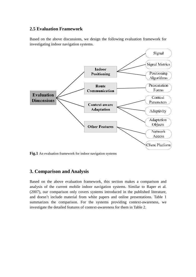
2.5 Evaluation Framework
Based on the above discussions, we design the following evaluation framework for investigating indoor navigation systems.
Fig.1 An evaluation framework for indoor navigation systems
3. Comparison and Analysis
Based on the above evaluation framework, this section makes a comparison and analysis of the current mobile indoor navigation systems. Similar to Raper et al. (2007), our comparison only covers systems introduced in the published literature, and doesn’t include material from white papers and online presentations. Table 1 summarizes the comparison. For the systems providing context-awareness, we investigate the detailed features of context-awareness for them in Table 2.
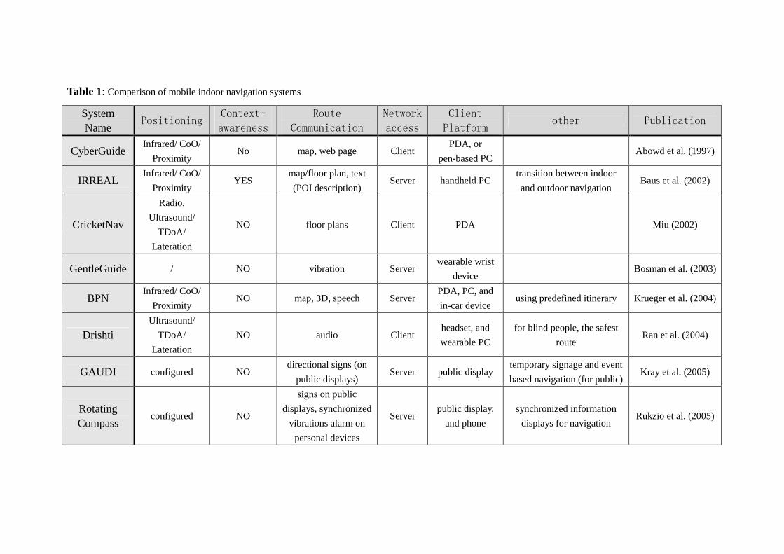
Table 1: Comparison of mobile indoor navigation systems
System Name
Positioning Context-
awareness Route
Communication Network
access
Client
Platform other Publication
CyberGuide Infrared/ CoO/
Proximity No map, web page Client
PDA, or
pen-based PC Abowd et al. (1997)
IRREAL Infrared/ CoO/
Proximity YES
map/floor plan, text
(POI description) Server handheld PC
transition between indoor
and outdoor navigation Baus et al. (2002)
CricketNav
Radio,
Ultrasound/
TDoA/
Lateration
NO floor plans Client PDA Miu (2002)
GentleGuide / NO vibration Server wearable wrist
device Bosman et al. (2003)
BPN Infrared/ CoO/
Proximity NO map, 3D, speech Server
PDA, PC, and
in-car device using predefined itinerary Krueger et al. (2004)
Drishti Ultrasound/
TDoA/
Lateration
NO audio Client headset, and
wearable PC
for blind people, the safest
route Ran et al. (2004)
GAUDI configured NO directional signs (on
public displays) Server public display
temporary signage and event
based navigation (for public) Kray et al. (2005)
Rotating Compass
configured NO
signs on public
displays, synchronized
vibrations alarm on
personal devices
Server public display,
and phone
synchronized information
displays for navigation Rukzio et al. (2005)
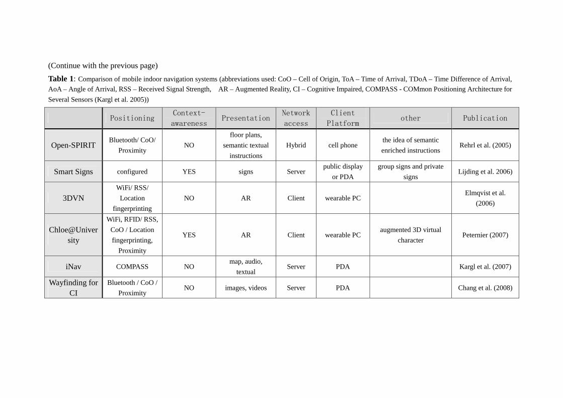
(Continue with the previous page)
Table 1: Comparison of mobile indoor navigation systems (abbreviations used: CoO – Cell of Origin, ToA – Time of Arrival, TDoA – Time Difference of Arrival,
AoA – Angle of Arrival, RSS – Received Signal Strength, AR – Augmented Reality, CI – Cognitive Impaired, COMPASS - COMmon Positioning Architecture for
Several Sensors (Kargl et al. 2005))
Positioning Context-
awareness Presentation
Network
access
Client
Platform other Publication
Open-SPIRIT Bluetooth/ CoO/
Proximity NO
floor plans,
semantic textual
instructions
Hybrid cell phone the idea of semantic
enriched instructions Rehrl et al. (2005)
Smart Signs configured YES signs Server public display
or PDA
group signs and private
signs Lijding et al. 2006)
3DVN WiFi/ RSS/
Location
fingerprinting
NO AR Client wearable PC Elmqvist et al.
(2006)
Chloe@University
WiFi, RFID/ RSS,
CoO / Location
fingerprinting,
Proximity
YES AR Client wearable PC augmented 3D virtual
character Peternier (2007)
iNav COMPASS NO map, audio,
textual Server PDA Kargl et al. (2007)
Wayfinding for CI
Bluetooth / CoO /
Proximity NO images, videos Server PDA Chang et al. (2008)
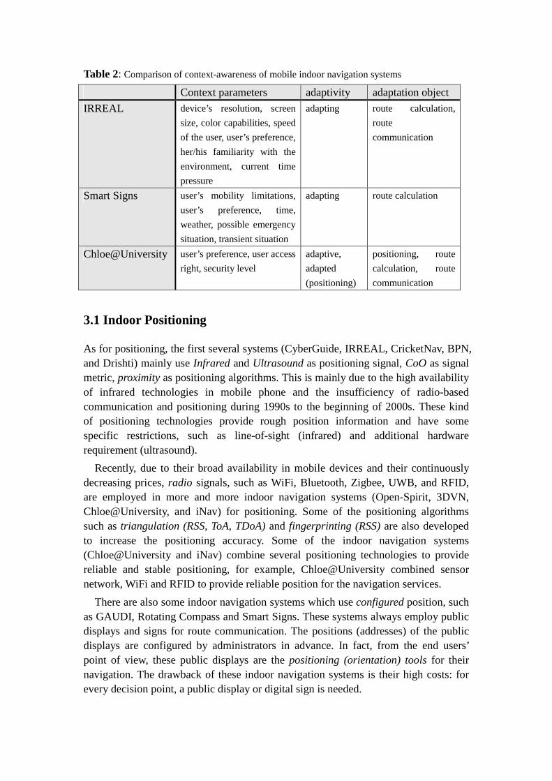
Table 2: Comparison of context-awareness of mobile indoor navigation systems
Context parameters adaptivity adaptation object
IRREAL device’s resolution, screen
size, color capabilities, speed
of the user, user’s preference,
her/his familiarity with the
environment, current time
pressure
adapting route calculation,
route
communication
Smart Signs user’s mobility limitations,
user’s preference, time,
weather, possible emergency
situation, transient situation
adapting route calculation
Chloe@University user’s preference, user access
right, security level
adaptive,
adapted
(positioning)
positioning, route
calculation, route
communication
3.1 Indoor Positioning
As for positioning, the first several systems (CyberGuide, IRREAL, CricketNav, BPN, and Drishti) mainly use Infrared and Ultrasound as positioning signal, CoO as signal metric, proximity as positioning algorithms. This is mainly due to the high availability of infrared technologies in mobile phone and the insufficiency of radio-based communication and positioning during 1990s to the beginning of 2000s. These kind of positioning technologies provide rough position information and have some specific restrictions, such as line-of-sight (infrared) and additional hardware requirement (ultrasound).
Recently, due to their broad availability in mobile devices and their continuously decreasing prices, radio signals, such as WiFi, Bluetooth, Zigbee, UWB, and RFID, are employed in more and more indoor navigation systems (Open-Spirit, 3DVN, Chloe@University, and iNav) for positioning. Some of the positioning algorithms such as triangulation (RSS, ToA, TDoA) and fingerprinting (RSS) are also developed to increase the positioning accuracy. Some of the indoor navigation systems (Chloe@University and iNav) combine several positioning technologies to provide reliable and stable positioning, for example, Chloe@University combined sensor network, WiFi and RFID to provide reliable position for the navigation services.
There are also some indoor navigation systems which use configured position, such as GAUDI, Rotating Compass and Smart Signs. These systems always employ public displays and signs for route communication. The positions (addresses) of the public displays are configured by administrators in advance. In fact, from the end users’ point of view, these public displays are the positioning (orientation) tools for their navigation. The drawback of these indoor navigation systems is their high costs: for every decision point, a public display or digital sign is needed.
3.2 Context-awareness and Adaptation
Although context-awareness is very important for mobile applications, surprisingly, most of mobile indoor navigation systems only use location as context parameter and provide location-related services to the users. There are only three systems providing context-aware adaptation: IRREAL, Smart Signs and Chloe@University.
The Chloe@Unversity system provides a very simple context-aware adaptation. In the system, an augmented 3D virtual character in front of a user guides him/her to destination so that he/she can just follow the virtual guide to the desired destination. The most suitable virtual character is selected depending on user’s preference. The system also provides adapted (see resource adapted - optimized in advance for regular patterns of usage) localization approaches for indoor positioning. In addition, it calculates the route based on user profiles and security level.
For the Smart Signs system, context-awareness is applied to route calculation. User’s mobility limitations, preference, time, weather, transient situation are used to calculate the route. It defines business rules to determine which and how context parameters are translated into the costs of a route.
The IRREAL system provides context-aware adaptation on route calculation and route communication. Route calculation is based on user’s preference, her/his familiarity with the environment and current time pressure, etc. After the optimal route is determined, it is forwarded to the presentation (communication) planning module. This module optimizes the presentation of the route not only according to the resolution, screen size, and color capabilities of the output device, but also to the position, orientation and speed of the user.
3.3 Route Presentation and Communication
Compared to outdoor navigation systems which mainly employ map (2D or 3D), textual and verbal instruction for route communication, indoor navigation systems use various presentation forms: map (CyberGuide, IRREAL, CricketNav, BPN, Open-SPIRIT, and iNav), textual or verbal instruction (Dirshti, Open-SPIRIT, and iNav), Augmented Reality (3DVN and Chloe@University), sign (GAUDI, Rotating Compass, and Smart Signs), vibration (GentelGuide, Rotating Compass), image and video (Wayfinding for CI), etc.
For indoor navigation, maps, especially floor plans, are still the most popular presentation form. One reason for this is certainly their pervasive use in physical guides (such as paper maps, You-Are-Here maps installed in the environment) (Baus et al. 2005). Mobile maps can differ in scale, content, and style. As a result, the effectiveness of different types of maps (ranging from sketch or schematic map to topographic map or other detailed map) for indoor route communication should be evaluated. However, little work has been done on that.
Textual or verbal instructions can be also used for route communication. When
being used to a mobile device with earphones, verbal guiding instructions can be very useful when users are engaged with other activities during wayfinding because users don’t need to refer to the mobile devices (little cognitive load). Textual (written) guidance is the most simple presentation form for navigation. They are easy to create and can be used in almost every mobile phone. Concerning route communication, textual guidance is similar to verbal guidance. The only difference is that when using textual guidance, users have to read the text on the screen.
Some of the systems propose that route communication (such as map, textual instructions, image and video) that requires users to look at the handheld device “head down” while walking is not easy to use (Lijding et al. 2006). As a result, other alternatives are proposed: vibration (GentelGuide and Rotating Compass), signs on public displays (Rotating Compass and Smart Signs). The GentelGuide uses two wrist devices on the two arms for route communication: 0.7 seconds on right (left) receiver - go to your right (left), 0.7 seconds on both receivers - destination reached, 1.5 seconds on both receivers - wrong direction. The project concluded that: “pressure haptic output offers significant promise both in improving performance and in reducing the disruptiveness of technology”, also “a negative aspect of exclusively relying on a device like GentleGuide is the reduced location and orientation awareness by some participants” (Bosman et al. 2003).
Signs are easy to understand and have always been used for route communication. Signs always have self-explaining meaning. As a result, signs clearly support “computational offloading”’: navigating from sign to sign requires virtually low cognitive load and no memorizing of multiple route segments (Hoelscher et al. 2007). Users only need to search for the next sign. Electronic signs can be generated by a navigation system according to the user’s context and then displayed on users’ mobile devices or public displays mounted on the wall (GAUDI, Rotating Compass, and Smart Signs).
Although several presentation forms have been proposed for route communication, there is little work focusing on evaluating the effectiveness of the above presentation forms for indoor navigation. In order to reduce the cognitive load of the way finders, some user tests should be carried out to find out the optimal presentation styles for indoor navigation.
3.4 Network Access
There are several systems using the server-side solution: IRREAL, GentleGuide, BPN, GAUDI, Rotating Compass, Smart Signs. iNav and Wayfinding for CI. In this solution, all the calculation (e.g., route calculation) is executed on the server, data is stored in a database which is deployed on the server. The clients (mobile devices) only provide an UI (User Interface) for users’ interaction and route communication. Compared to client-side solution, the client devices don’t need to have a high process power and big memory, the client devices also consume less power (battery) which is crucial for mobile devices. The disadvantage for the server-side solution is that
continual network access is required during the whole navigation.
In the client-side solution (CyberGuide, CricketNav, Drishti, Open-SPIRIT, 3DVN, Chloe@University), sometimes named local caching solution, data and application system are downloaded/copied from the server in advance (for example, when you enter a building at the first time). All the functions (calculation, result visualization) are executed on the client devices. No network access is needed during users’ navigation. However, the client devices need to have a high process power and big memory. And also, high power (battery) consumption may become a big problem.
In fact, it is not suitable to simply assign the calculation and data to the server side or the client side. In order to have an extensible and adaptable system, where the calculation is executed should depend on the current context (such as power level of the devices, the requirement of the calculation, the network availability etc.). Load balancing between server side and client side is needed.
3.5 Client Platform
As for client platform, it is important to note that compared to outdoor navigation systems which mainly use cell phones and PDAs, the client platforms of indoor navigation systems are much more varied: cell phones (Rotating Compass and Open-SPIRIT), PDAs (CyberGuide, CricketNav, BPN, Smart Signs, iNav, and Wayfinding for CI), wearable computers (CyberGuide, IRREAL, Drishti, 3DVN, and Chloe@University), public displays (GAUDI, Rotating Compass, and Smart Signs), wrist devices (GentleGuide), etc. The reason for this is that it is easy and unobtrusive to place/use these kinds of devices (such as public displays) in the indoor environment.
It’s also interesting to note that, with the rapid advances in the enabling technologies (wireless communication, mobile devices, and sensor network) for ubiquitous computing, more and more indoor navigation systems integrate mobile devices (PDAs or cell phones) with devices that are installed in the smart environment (e.g. public displays, PCs, printers, or sensors), for example, Rotating Compass displays route guidance (signs) on public displays, and provides a synchronized vibration alarm on mobile devices when users approach public displays. It can be anticipated that a smart environment augmenting with active or passive devices/sensors will enable context-aware route guiding and therefore optimize the wayfinding process. However, little work has been done on how smart ambient intelligent environment optimizes the wayfinding process.
3.6 Others
The project IRREAL addressed the problem of transition between indoor navigation and outdoor navigation. It identified several prerequisites (Baus et al. 2002): the coordination of data for indoor and outdoor, and the seamless switch between indoor
and outdoor positioning. As indoor navigation and outdoor navigation differ in positioning technologies, data modeling, and spatial cognition basics, more work should be done on the seamless switch between indoor and outdoor navigation.
The project Open-SPIRIT presented a nice idea about semantic enriched instructions. It proposed that simple turn-by-turn instructions that are solely based on geometric information of the form “walk 9 meters straight and turn left” should be avoided, instead instructions should be semantic enriched which are more natural sounding and contain references to objects (e.g., landmarks, gateways, and signs) in the scene space in order to improve the interaction of pedestrians and the environment, such as “Walk to the lower end of the stairs marked with the sign ‘Neubaugasse’. Walk up the stairs” (Rehrl et al. 2005). This idea is continually investigated in their other project named SemWay (Semantic Wayfinding, outdoor pedestrian navigation). The SemWay (SemWay 2009) project carried out several field tests (city touring and skiing touring), and currently is trying to identify basic concepts and image schemas from the field tests, then will combine basic concepts, image schemas and landmarks into route instructions. The SemWay project focuses on outdoor navigation, some similar work for indoor should be done to provide semantic instructions for indoor navigation.
4. Challenges
From the above comparison and analysis, we can draw the conclusion that indoor navigation systems are still on an early development stage. With the rapid advances in the enabling technologies, such as wireless communication, mobile devices, and sensors, indoor navigation services will gain increasing interests as an important application of indoor ubiquitous computing. A number of areas obviously require further research and development:
•••• Indoor positioning: Currently, indoor navigation systems always employ radio signal (WiFi, Bluetooth, RFID, etc.) for positioning, which may suffer from the problem of signal impairments, such as Radio Frequency interference and multipath propagation. Further investigation and performance tests of the indoor positioning technologies are especially required. Also how to provide reliable and stable position information in a complex and changing environment is a very challenging task. Sensor fusion may be an option for this question.
•••• Context-awareness: In order to provide high usability, context-awareness should be introduced for indoor navigation. As identified in Brusilovsky (1996), context-aware adaptation has the following dimensions: Why (why do we need that a system adapts itself to the particular user/context), What (which features of the system can be adapted), To what (what aspects of the user/context working with the system can be taken into account when providing adaptation), When (timing and triggering of adaptation), How (which procedures are needed to adapt the adaptation objects according to the users/context), How well (how to evaluate the adaptation processes).
Currently, most of the indoor navigation systems only focus on the To what and What dimensions. More work should be done on the other dimensions. In addition, some field experiments on the relationship between “To What” and “What” should be done, such as how much detail is needed for wayfinding (What) in a specific context (To what).
• Route communication: Floor plan, textual and verbal instruction, sign are always used for route communication. However, more work should be done to evaluate the suitability and efficiency of varied presentation forms for indoor navigation in detail. Also, how to provide landmark-based semantic enriched presentation/instruction should be considered.
• Combination of outdoor and indoor navigation: In daily life, people always have to combine outdoor and indoor navigation, for example outdoor wayfinding from train station to the city hall, and then entering the city hall to find somebody with indoor navigation. The combination of outdoor and indoor navigation should also take place in three modules: positioning (seamless switch between outdoor GPS and indoor positioning), route calculation (seamless switch between the different data models of indoor and outdoor, different context), and route communication (providing a smooth visual switch).
• Indoor navigation in a smart ambient intelligent environment: As more and more active or passive devices/sensors are augmented in the indoor environment, indoor environment has become smarter. This abundance of technology has given place to the new notions of “Smart Environments (SmE)” and “Ambient Intelligent (AmI)”. The basic idea behind SmE and AmI is that “by enriching an environment with technology (sensors, processors, actuators, information terminals, and other devices interconnected through a network), a system can be built such that based on the real-time information gathered and the historical data accumulated, decisions can be taken to benefit the users of that environment” (Augusto and Aghajan 2009). Indoor navigation should also introduce these notions, and provide fully context-aware smart wayfinding services to the users, such as Amazon-like recommendation.
5. Conclusions
In this paper, we proposed an evaluation framework which combines the key aspects of indoor navigation for investigating mobile indoor navigation systems. Based on this evaluation framework, we gave a comparison and analysis of the current mobile indoor navigation systems, and then identified some challenges which require further research and development.
From the survey, we can draw the conclusion that indoor navigation systems are still on an early development stage. More attention should be paid to sensor fusion, context-awareness, route communication, seamless switch between indoor and outdoor navigation, and ubiquitous indoor computing.
Acknowledgements
This work has been supported by the UCPNavi project (Ubiquitous Cartography for Pedestrian Navigation, funded by Austrian FWF), which issues the problem of indoor navigation in a smart ambient intelligent environment.
References
Abowd, G.D., Atkeson, C.G., Hong, J., Long, S., Kooper, R. and Pinkerton, M., 1997. CyberGuide:
A Mobile Context-Aware Tour. Wireless Networks, 3(5), pp. 421-433.
Augusto, J.C. and Aghajan, H., 2009. Editorial: Inaugural issue. Journal of Ambient Intelligence
and Smart Environments, 1(1), pp. 1-4.
Baus, J., Krueger, A. and Wahlster, W., 2002. A resource-adaptive mobile navigation system. In:
Proceedings of the 7th International Conference on Intelligent user Interfaces, San Francisco,
USA, ACM Press, pp. 15-22.
Baus, J., Cheverst, K. and Kray, C., 2005. A survey of map-based mobile guides. In L. Meng, A.
Zipf and T. Rechenbacher, eds, Map-Based Mobile Services. Springer: Berlin, pp. 193-209.
Bossman, S., Groenendal, B., Findlater, J.W., Visser, T., de Graaf, M. and Markopoulos, P., 2003.
GentleGuide: An exploration of haptic output for indoors pedestrian guidance. In Chittaro, L.
Eds, Proceedings Mobile HCI, LNCS 2795, Springer, pp.358-362.
Brusilovsky, P., 1996. Methods and techniques of adaptive hypermedia. User Modeling and
User-Adapted Interaction, 6(2-3), pp. 87-129.
Chang, Y., Chu, Y., Chen, C. and Wang, T., 2008. Mobile Computing for Indoor Wayfinding Based
on Bluetooth Sensors for Individuals with Cognitive Impairments. In Proceedings of
International Symposium on Wireless Pervasive Computing 2008, Santorini, Greece.
Downs, R.M. and Stea, D., 1977. Maps in minds: Reflections on cognitive mapping. Harper &
Row.
Elmqvist, N., Fjeld, M., Axblom, D. et al., 2007. 3DVN: A Mixed Reality Platform for Mobile
Navigation Assistance. ACM CHI2007 Workshop on Mobile Spatial Interaction.
Gartner, G. and Uhlirz, S., 2005. Cartographic Location Based Services. In Meng, L., Zipf, A.and
Rechenbacher T., eds, Map-Based Mobile Services. Springer: Berlin, pp. 159-171.
Henricksen, K., Indulska, J. and Rakotonirainy, A., 2002. Modeling context information in
pervasive computing systems. In Mattern, F. and Naghshineh, M., eds, Pervasive 2002,
Springer LNCS 2414, pp. 167–180.
Hoelscher, C., Büchner,S. J., Broesamle, M., Meilinger, T. and Strube, G., 2007. Signs and Maps:
Cognitive Economy in the Use of External Aids for Indoor Navigation. In: Proceedings of the
29th Annual Conference of the Cognitive Science Society (CogSci 2007), pp.377-382.
Hohenschuh, F. ,2004: Prototyping eines mobilen Navigationssystems fuer die Stadt Hamburg,
Master Thesis, Hamburg University.
Huang, H. and Gartner, G., 2009. Using Activity Theory to identify relevant context parameters. In
Gartner, G. and Rehrl, K., eds, Location Based Services and TeleCartography II - from Sensor
Fusion to Context Models, Springer LNG&C, pp. 35-45.
Kargl, F., Bernauer, A.: The compass location system. In Strang, T., and Linnhoff- Popien, C., eds,
LoCA 2005. LNCS, vol. 3479, Springer, Heidelberg.
Kargl, F., Flerlage, F. and Gessler, S., 2007. The iNAV Indoor Navigation System, Ubiquitous
Computing Systems.In Proceedings of 4th International Symposium Ubiquitous Computing
Systems 2007, Tokyo, Japan.
Kray, C., Kortuem, G. and Krueger, A., 2005. Adaptive Navigation Support with Public Displays.
In: Proceedings of the 10th international conference on intelligent user interfaces. San Diego,
California, USA.
Krueger, A., Butz, A., Mueller, C., Stahl, C. Wasinger, R., Steinberg K.E. and Dirschl, A., 2004.
The connected user interface: realizing a personal situated navigation service. In: Proceedings
of the 9th International Conference on Intelligent user Interfaces, Funchal, Portugal, ACM
Press, pp.161-168.
Krueger, A., Bausm J., Heckmann, D., Kruppa, M. and Wasinger, R., 2007. Adaptive Mobile
Guides. In Brusilovsky, P. Kobsa, K. and Nejdl, W., eds, The Adaptive Web, Springer LNCS
4321, pp. 521–549.
Lijding, M., Benz, H., Meratnia, N. and Havinga, P., 2006. Smart Signs: Showing the way in
Smart Surroundings. Technical Report TR-CTIT-06-20 Centre for Telematics and
Information Technology, University of Twente, Enschede. ISSN 1381-3625.
Miu, A., 2002. Design and Implementation of an Indoor Mobile Navigation System. Master Thesis
of MIT.
Peternier, A., Righetti, A., Hopmann, M. et al., 2007. Chloe@University: an indoor, mobile mixed
reality guidance system. In Proceedings of the ACM Symposium on Virtual Reality Software
and Technology, pp.227-228.
Radoczky, V., 2003. Kartographische Unterstuetzungsmoeglichkeiten zur Routenbeschreibung in
Fussgaenger Navigationssystemen im In- und Outdoorbereich. Master Thesis, Vienna
University of Technology, 2003.
Ran, L., Helal, A. and Moore, S., 2004. Drishti: An Integrated Indoor/Outdoor Blind Navigation
System and Service. In: Proceedings of the 2nd IEEE Pervasive Computing Conference,
Orlando, Florida.
Raper, J., Gartner, G., Karimi, H. and Rizos, C., 2007. Applications of location-based services: a
selected review. Journal of Location Based Services, 1(2), pp. 89-111.
Rehrl, K., Goell, N., Leitinger, S. and Bruntsch, S., 2005. Combined indoor/outdoor Smartphone
navigation for public transport travelers. In Gartner, G. eds, Proc. 3rd Symp. LBS &
TeleCartography, Vienna, Austria: Vienna University of Technology, pp. 235–239.
Rukzio, E., Schmidt, A. and Krueger, A., 2005. The rotating compass: a novel interaction
technique for mobile navigation. CHI Extended Abstracts 2005, pp.1761-1764.
SemWay, 2009. Semantic Wayfinding. http://semway.salzburgresearch.at/. Accessed 3.2009.
Want, R., Hopper, A., Falcao, V. and Gibbson, J., 1992. The Active Badge Location System. ACM
Transactions on Information Systems, 10(1), pp. 91–102.
Weiser, M., 1991. The computer of the 21st century. Scientific American, 1991, pp.94-100.
W.Kolodziej, K. and Hjelm, J., 2006. Local Positioning Systems: LBS Applications and Services.
CRC Press.