Embed Size (px)
Citation preview
A Summary Report of Chariton County Historic Preservation Survey
for the
Office of Parks, Recreation, and Historic PreservationDepartment of Natural Resources
Jefferson City, Missouri
by the
Missouri Valley Regional Planning CommissionCarrollton, Missouri
and
Kalen and MorrowForsyth, Missouri
September, 1987
2
r
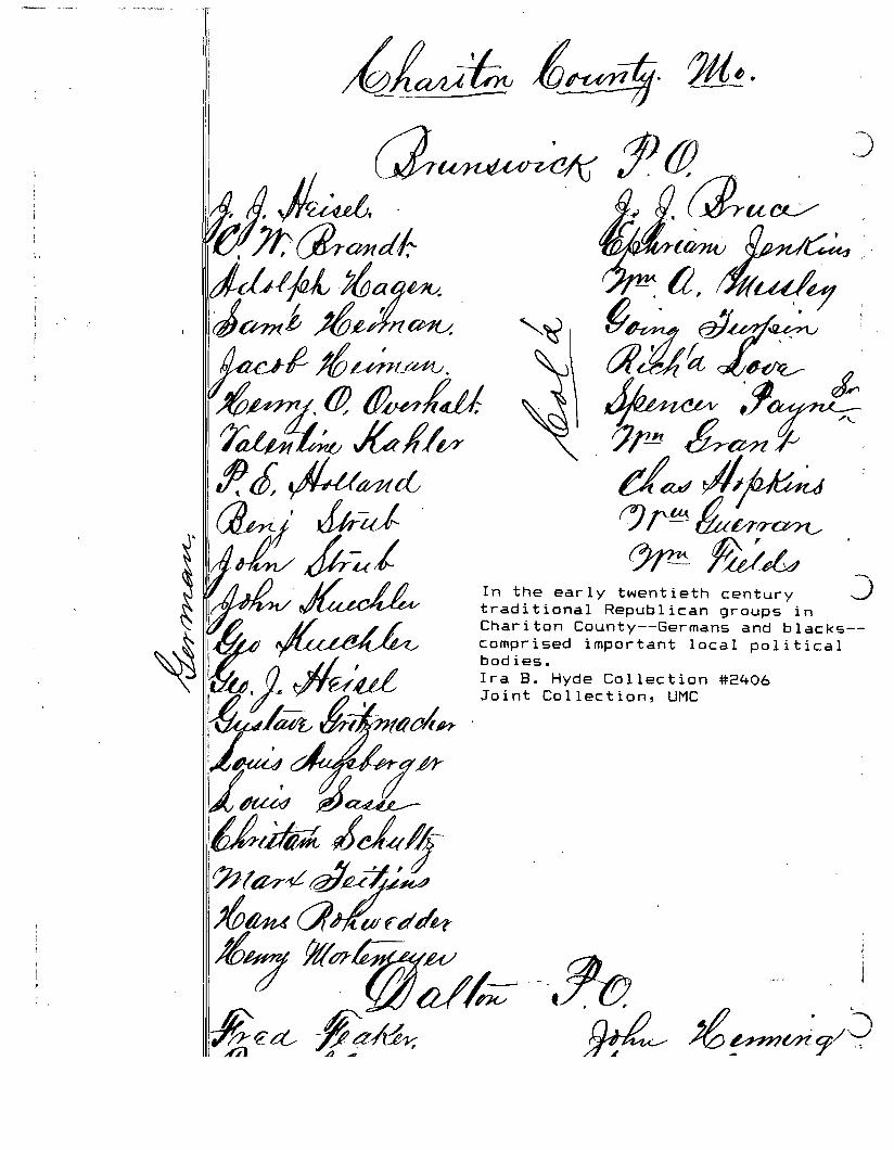
As the Missouri preservation movement
knew very little about the spectrum of Chariton County historic
resources, (except that it has been and is dominated by
agricultural economies), a field survey of broad-scale was
conceived for the entire county. Every public road--rural and
town--was traveled by vehicle, and in the commercial districts of
towns and hamlets, by foot. Also, numerous individual properties
were inspected by foot; the surveyor observed an unusually high
incidence of recently vacated, but excellent, rural properties.
Many of these are probably related to the recent 2-3 year
agricultural depression for overextended farmers. Furthermore,
numerous residents were not at home indicating perhaps a
relatively high percentage of rural dwellers who work off the
farm.
Such extensive inspection of the local landscape provided a
subjective reflection by the surveyor on 99X of Chariton's
domestic and commercial built environment. There were not any
towns or townships that did not yield historic properties that
related to the general agricultural and small town economies of
Chariton County. Vital to any survey, the contractor augmented
the countywide survey with archival research in Ellis Library,
University of Missouri; use of Sanborn Insurance maps in the
Missouri State Archives; visits to the Chariton County Museum,
Sterling Price Museum, and Keytesville Library; and the use'~f
several centennial and local history publications that are
3

rspecifically indicated on the inventory data sheets.
The selected sites, clusters, groups and zones of
concentration of historic properties subjectively classified as
"eligible for the National Register of Historic Places" are not
casually chosen; they are a selection weighed against the known
cultural resources of Chariton County as understood by the
surveyor. As in Carroll County during the previous survey
season, the surveyor traveled some 3,000 miles inspecting extant
structures. Although this methodology is expensive and time
consuming, it does result in a strong conviction of summary
conclusions about classifications and inclusions in the survey
inventory.
Properties that appear eminently eligible for the National
Register of Historic Places have a lQQ §~Il~? ?1~~ D~mQ~I;
properties that appear eligible for the National Register of
Historic Places, but require further research before such
conclusion could confidently be made by the surveyor have a ggg
§~Ii§§ DYmQ~I; §11 of the other site numbers are properties that
lend themselves to some description in the overall historic
context of Chariton County's landscape. It is not likely that
any structural form of a domestic or commercial nature found in
significant local patterns will not be represented in the
inventory.
As the basic purpose in reconnaissance survey is to obtain a
"general picture of the distribution of different types and
styles. "we are confident that the Chari ton County survey
achieved this goal. In addition to Kalen and Morrow's normal use
4
rof 5 x 7 black and white photographs, we supplemented dozens of
sites with instamatic photographs. We also shot many
"streetscape" photographs--rural and town--in the effort to
convey a wider view of representative landscapes. As with all
surveys conducted by Kalen and Morrow a relatively high
percentage of 35mm exposures were not printed, but remain in
archival storage. Should preservation planners at the Office of
Historic Preservation, DNR, need to view the additional exposures
they are available on request. The built environment that
normally goes undocumented in rural surveys is the same one that
is unrepresentative here, i.e., the tremendous number of rural,
agriculturally-based dependencies that comprise such a large
share of any agricultural landscape. Often they number 18-25 per
agricultural complex while only the house site and/or nearby
barn, cellar, or poultry house appear in the inventory
photographs. However, it is not likely in the foreseeable future
that any local citizen will ask for National Register of Historic
Place nomination for any property that is not represented in the
reconnaissance inventory. Thus, the emphasis on the broad-scale
reconnaissance survey to provide a selection of properties that
most likely will or should receive National Register attention in
preservation planning has been achieved.
As suggested in National Register Bulletin #24 the specific
goal of locating concentrations of potential districts in
Chariton County was accomplished. In the view of the surveyor
rthese consist principally of two: a domestic neighbor-hood located
on South Broadway in Salisbury (this is a c1880-1940 neighborhood
of Salisbury's professional/merchant class. Architecturally, the
5
r houses are superior, but conservative, pattern book houses, and
the two block district is dramatically set off by a very wide
thoroughfare. It has long been the premier residential street in
Salisbury); and Wien, a German-Catholic hamlet in northeast
Chariton County (Wien is reminiscent of many small hamlets in the
Missouri Rhineland. It is very uncommon in the greater north-
central Missouri regions to find an ethnic-American hamlet so
distinct in its character, so prominent on the rolling prairie.
The institutions of church and parochial school are landscape
anchors in the center of the primary street and they are flanked
by three country stores and modest rural residences). Possibly, a
case for the old-town commercial district of Salisbury could be
made, although the surveyor is not altogether sanguine about the
latter. The dispersed nature of settlement in a rural county
accounts for so few potential districts although Chariton County
does have many single sites (see 100 and 200 series) that should
have intensive documentation. It is quite possible that
intensive explorations into single sites may yield yet another
potential district. For example, one such place where that
could conceivably develop is the historic "Chariton Forks" valley
region of tobacco and commercial-ag farms in Chariton township.
6
CUUfURAL ENVIRONMENTS for BUILDING and REBUILDING MISSOURI:A Modular Approach for Interpreting .the Landscape
____---r.;.:.W;;.;;h.::.at~T;:.;:i:.:.m::.:;e..~s t~e Lands.cape?
a) vernacular/academic arch.b) town plansc) social institutions
d) agricultural &ystem~
e) industrial facilitiesf) engineering sites
I 153 yrs. II 16 yrs.CHRONOLOGY
... ._._ £!~S.Q~~I}Q_~._!QQ4.~l82()
III 22 yrs. V 21 yrs. V 21 yrs. I 21 yrs.
1'11"118~1,.::·la43 844-1865.. 1.866-.1893 18.94,.1910
VII 29 yrs. III IX
Ictl r- 1946-? ?-present1911-1945--.- .. -._-_._...--
BUIIDINGSET
b. vernacula· .•..••.......••••...•..
Revivals
a. academic
c. idiosyncr
Classicism eorgian
tic••••••••••••••••••••
Federal rreek Rev. Ital/Q An e Neo-Class
············r······················:·········.............................................
I
Calif. inf1 ences/RanchoidI
............ . .
............ . .
What is theresult oftime?
Preliminaryproperty tYldecision:
1\ integrity'
GEOGRAPHY
. _'_ •• _ .• __L.- -I__ .
HISTORICAL CONTEXT: Themes of Cultural Expression---.-' ::.-.-__-._-__-··:-..:..-=-:-==r.~._-_-.-----.-.---.'''''''''''C'..... _~ _.
CONCLUSIONS
SPACE SET (see map)
a} 21 study unit spacesgeographically de~ine
'......
...
.,
CULTURE SET
ethnic evidence?
rural--urban
economypoliticsreligionsociety
EVENT SET
Intangibles
episodesbenchmarks
A conclusion uses multidisciplinary methods andapplies data that defines abuilding, site or landscape aa product of its own time.
Property type:
A plusB associative characteristic3
A + B = a defensible hi5tori~
explanation
ascribe significance
LJ
(To be used with Missouri reference guides-- ritLen and visual) (Conceptual framework byMissouri preservationists-James Denny. Robert Flande, ,and Lynn Morrow)
u
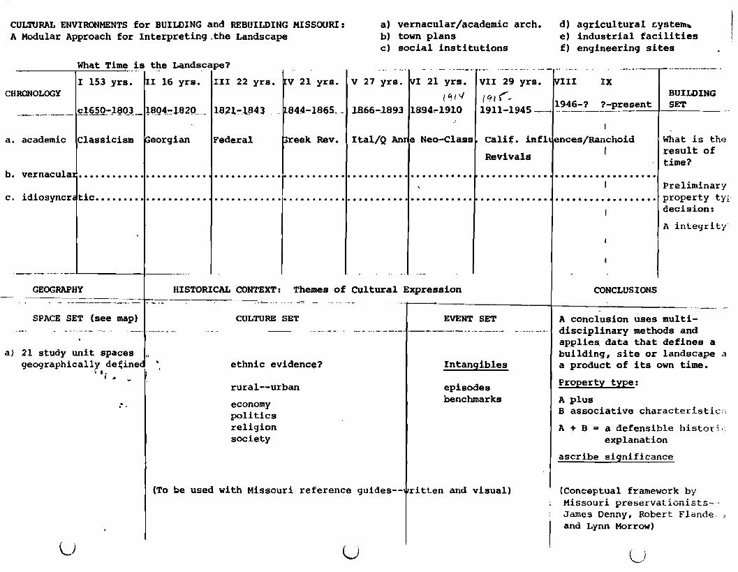
Historic Context and Property Type
Chariton County's historic context and associated property
types can conveniently be grouped into the proposed Cultural
Environments for Building and Rebuilding Missouri: A Modular
Approach for Interpreting the Landscape in Lynn Morrow's
"Prospectus for Preservation Master Planning in Missouri"
submitted to DNR during FY 85-86. The classifications therein
are based on demographic, economic, and stylistic fashion all of
which are intrinsically tied to national and state trends in
Missouri. During these cycles of movement stylistic innovations
successively follow in each periodization while traditional
vernacular forms parallel innovation until the tradition ends in
favor of new fashion. For example, the great transition in
vernacular housing from the generations-old double pen house to
bungalow and bungaloid design refashioned the general built
environment; the ranch and ranchoid fashion replaced the
bungalows.
The nine classifications suggested above will collapse into
four for the purpose of this reconnaissance survey.
include,
They
A Exploration and Pioneer Period c1650-1865B Commercial and Transportation Revolution 1866-1893C Midwestern Main Street 1894-1945D Modern Industrial Period 1946-present
The titles represent major descriptive aspects of the Periods;
they do not eliminate other thematic considerations. Due to the
guidelines involving "exceptional significance for properties
7
r less than fifty years old" no comments for the Modern Industrial
Period 1946-present will be made.
A. Exploration and Pioneer Period c1650-1865I 1650-1803II 1804-1820III 1821-1843IV 1844-1865
Obviously period I of European contact with North American
Indian cultures and early Creole exploration into mid-Missouri
survives only in literature, art, and the archaeological record;
for the purposes of this survey the same can be said for period
II. The documentary record is replete with hundreds of sites
along old waterways. The most dramatic, of course, is Old
Chariton, a settlement visited in 1819 by the famous Yankee
evangelist Reverend John M. Peck. However, Chariton County along
its interior waterways and along its southern border with the
Missouri River has undergone major environmental change during
all past generations. Therefore the early riverine landscapes
must yield to written source~ and archaeology for an
understanding of their character. Old Chariton as a town of
considerable size and activity and the fact that brick sidewalks
and brick houses were built there offers a major opportunity in
cultural inquiry/preservation for what may be the best chance in
Territorial period archaeology in outstate Missouri.
In one 1819 account from Old Chariton David Manchester wrote
to his sister in New York about the new land and how several
young bachelors had fared during the 1818-19 winter. Manchester
related the federal government land price of $1.50 per acre, but
he said that most nearby land sold from $2-6, and the majority around
8

-.
.1I\I

'.
MISSOURI
15
IOWA
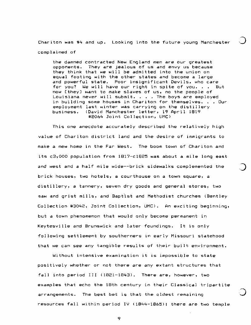
Chariton was $4 and up.
complained of
Looking into the future young Manchester
the damned contracted New England men are our greatestopponents. They are jealous of us and envy us becausethey think that we will be admitted into the union onequal footing with the other states and become a largeand powerful state. Poor insignificant Devils, who carefor you? We will have our right in spite of you. Butnow [they] want to make slaves of us, no the people ofLouisiana never will submit. • The boys are employedin building some houses in Chariton for themselves. . Ouremployment last winter was carrying on the distillerybusiness. (David Manchester letter, 19 April 1819
#2064 Joint Collection, UMC)
This one anecdote accurately described the relatively high
value of Chariton district land and the desire of immigrants to
make a new home in the Far West. The boom town of Chariton and
its c3,000 population from 1817-c1825 was about a mile long east
and west and a half mile wide--brick sidewalks complemented the
brick houses, two hotels, a courthouse on a town square, a
distillery, a tannery, seven dry goods and general stores, two
saw and grist mills, and Baptist and Methodist churches (Bentley
Collection #3042, Joint Collection, UMC). An exciting beginning,
but a town phenomenon that would only become permanent in
Keytesville and Brunswick and later foundings. It is only
following settlement by southerners in early Missouri statehood
that we can see any tangible results of their built environment.
Without intensive examination it is impossible to state
positively whether or not there are any extant structures that
fall into period III (1821-1843). There are, however, two
examples that echo the 18th century in their Classical tripartite
arrangements. The best bet is that the oldest remaining
resources fall within period IV (1844-1865); there are two temple
9

rform houses with single room lateral extensions and a couple of
• late antebellum I houses . There is one brick "semi-flounder"
house ·on West Broadway, Brunswick, that is an 1850s house.
Although these structures are scanty physical evidence of
the general Pioneer Period they do represent two primary
social groups in Chariton County's historic demography--
southerners and Germans. This artifactual record left by these
two groups represents the more economically successful of both
culture groups. The occupants were all engaged in regional and
town marketing activities. The most common of vernacular house
forms of the Pioneer Period have long vanished from the built
environment. There are no visible dog-trot, stack, saddle-bag,
double pen, or single pen houses from Period A. This
circumstance is a common one in locales with a long tradition in
commercial agriculture. "Progressive" farmers use marketing
innovations and commonly update their own built environment. The
Classical temple form house diffused from Virginia and the brick
"semi-flounder" diffused from Philadelphia-St. Louis are both
strong examples of major culture streams in Missouri as a whole,
and in Chariton County their survival in the late 20th century
designates them as fragile resources.
Though the snapshot of an I house near Triplett pictured
below is a postbellum house the form is suggestive of the
ideal in antebellum southern architecture. Though the county
retains dozens of I houses, few surpass the general
state of integrity that this house possesses. In other words,
local representatives in the I house family do not appear to have
10
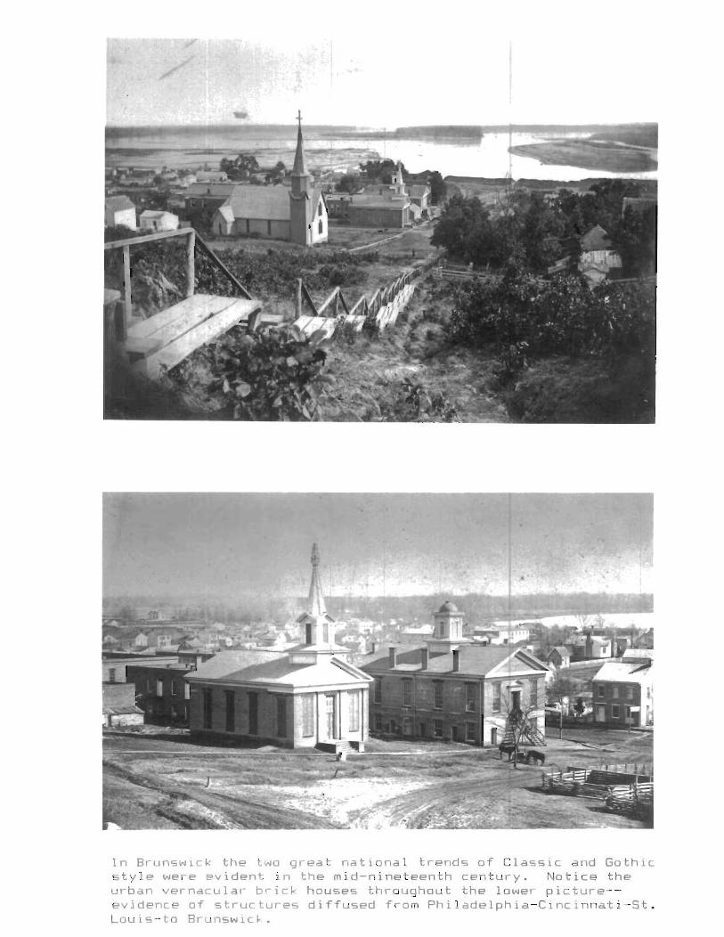
In Brunswick the two great national trends of Classic and Gothicstyle were evident in the mid-nineteenth century. Notice theurban vernacula,- brick houses throughout the lower picture-evidence of structures diffused from Philadelphia-Cincinnati-St.Louis-to Brunswic~.
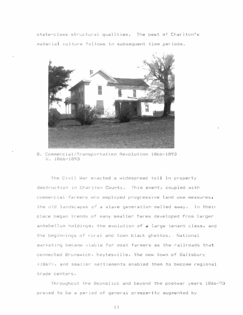
state-class structural qualities. The best of Chariton's
•material culture follows in subsequent time periods .
B. Commercial/Transportation Revolution 1866-1893v. 1866-1893
The Civil War exacted a widespread toll in property
destruction in Chariton County. This event, coupled with
commercial farmers who employed progressive land use measures,
the old landscapes of a slave generation melted away. In their
place began trends of many smaller farms developed from larger
antebellum holdings. the evolution of a large tenant class, and
the beginnings of rural and town black ghettos. National
marketing became viable for most farmers as the railroads that
connected Brunswick, Keytesville, the new town of Salisbury
(1867), and smaller settlements enabled them to become regional
trade centers.
Throughout the Boonslick and beyond the postwar years 1866-73
proved to be a period of general prosperity augmented by
1 1
•
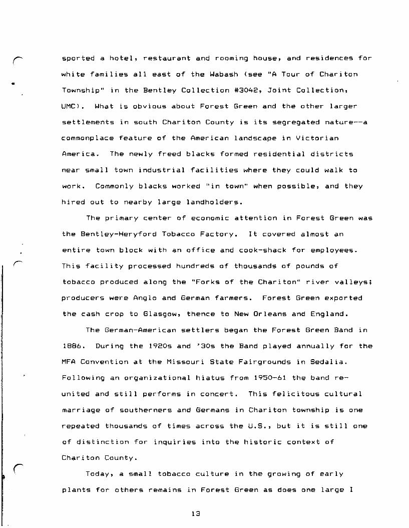
sported a hotel, restaurant and rooming house, and residences for
white families all east of the Wabash (see "A Tour of Chariton
Township" in the Bentley Collection #3042, Joint Collection,
UMC). What is obvious about Forest Green and the other larger
settlements in south Chariton County is its segregated nature--a
commonplace feature of the American landscape in Victorian
America. The newly freed blacks formed residential districts
near small town industrial facilities where they could walk to
work. Commonly blacks worked "in town" when possible, and they
r
hired out to nearby large landholder~.
The primary center of economic attention in Forest Green was
the Bentley-Heryford Tobacco Factory. It covered almost an
entire town block with an office and cook-shack for employees.
This facility processed hundreds of thousands of pounds of
tobacco produced along the "Forks of the Chariton" river valleys;
producers were Anglo and German farmers. Forest Green exported
the cash crop to Glasgow, thence to New Orleans and England.
The German-American settlers began the Forest Green Band in
1886. During the 1920s and '30s the Band played annually for the
MFA Convention at the Missouri State Fairgrounds in Sedalia.
Following an organizational hiatus from 1950-61 the band re-
united and still performs in concert. This felicitous cultural
marriage of southerners and Germans in Chariton township is one
repeated thousands of times across the U.S., but it is still one
of distinction for inquiries into the historic context of
Chariton County.
Today, a small tobacco culture in the growing of early
plants for others remains in Forest Green as does one large I
13
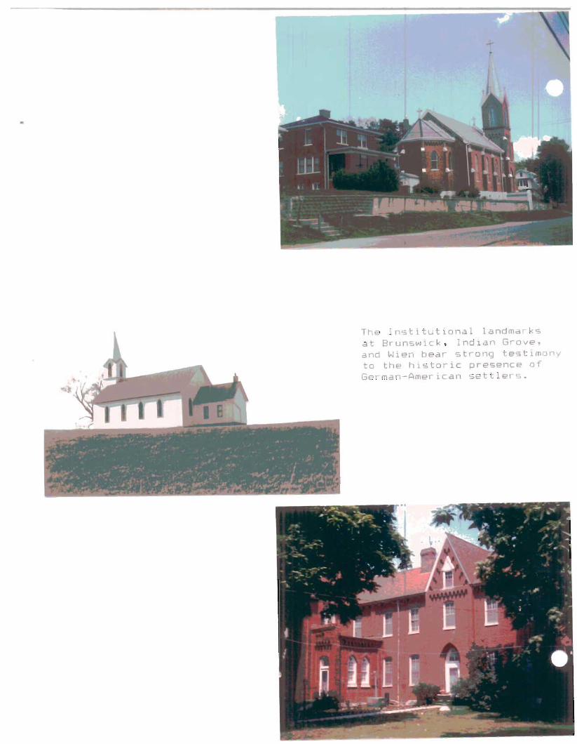
The institutional landmarksat Brunswick. Indian Grove.and Wien bear strong testimonyto the historic presence ofGerman-American settlers.

immigration and the development and improvement of transportation
routes. Spacious I houses continued to be built, often with
Classical detailing, and many owners located them within a mile
of the railroad corridor (The circumstance of good I houses in
proximity to the railroad corridor proved to be the same in both
the Chariton and Carroll county surveys). At this time the new
national Italianate fashion was woven into many I house and
Victorian forms. Urbanization in the countryside and the cry for
"progress" in the local newspapers was read throughout the
county. Increasing rural populations founded new crossroads
r
hamlets; one such place was Forest Green.
Chariton township is the county's oldest township, and
Forest Green, unlike the long disappeared Old Chariton, was built
in 1873 out of the valley land on a high rolling prairie pocket
south of the junction of the Middle and East Forks of Little
Chariton River (see Walter Schroeder's ~c~~~ttl~m~Dt ~c~ici~~ 2f
~l§§g~rl map, 1981). It is not surprising that a member of Old
Chariton society, John Green Forest, promoted the settlement.
The hamlet was built on the east and west side of the Wabash
Branch railroad, a corridor that parallels modern Highway 5.
West of the Wabash stood the depot, a grist and saw mill, a cider
mill, the stock yards, six or eight houses, negro cabins, the
negro school and church--in other words, the hamlet's industry
and a black freedmen's neighborhood was on the west side of town.
East of the Wabash line developed two saloons, a drug store,
hardware store, a poultry house, general store, elevator and
granary (and black families south of here).
12
Forest Green
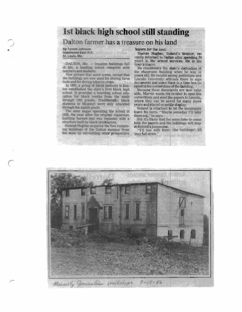
c high school still standingDalton farm r as a treasure on his land
• By Tyrone JohnsonHazelwood East H.S.St. louis, Mo.
DALTON, Mo. - Imagine buildings fullof life, a bustlmg school complete withteachers and students.
Now picture that same scene, except thatthe buildings ar now used for storing farmtools and for drymg tobacco crops.
In 1883, a group of black farmers in Dalton established the state's first black highschool. It provided a boarding school education for blac youths from the ninththrough 12th grades. Traditionally, blackstudents in Missouri were only educatedthrough the eighth grade.
The state began operating the school in1938, the year after the original classroombuilding burned and was replaced with astructure built b .black bric layers.
Roland Hughes acquired the two remaining buildings of the Dalton campus fromthe state by out-bidding other proopective
buyers for the land.Marvin Hughes, Roland's brother, re
cently returned to Dalton after spending 30years in the anned services. He is thetown's mayor.
He remembers the state's dedication ofthe classroom building when he was 11years old. He recalls seeing politicians andLincoln University officials there to signdocuments and place them in a time box located in. the cornerstone of the building.
Because these documents are now valuable, Marvin wants his brother to open thecornerstone and end the papers to Lincoln,where they can be saved for many moreyears and placed on public display.
Roland is reluctant to let the documentsleav his farm. "Maybe someday I'll takethem out," he says.
But it's likely that for some time to comeboth the papers and the buildings will stayin Roland's possession. .. .
"I'll fool with them (the bUIldmgs) tillthey fall down."
r
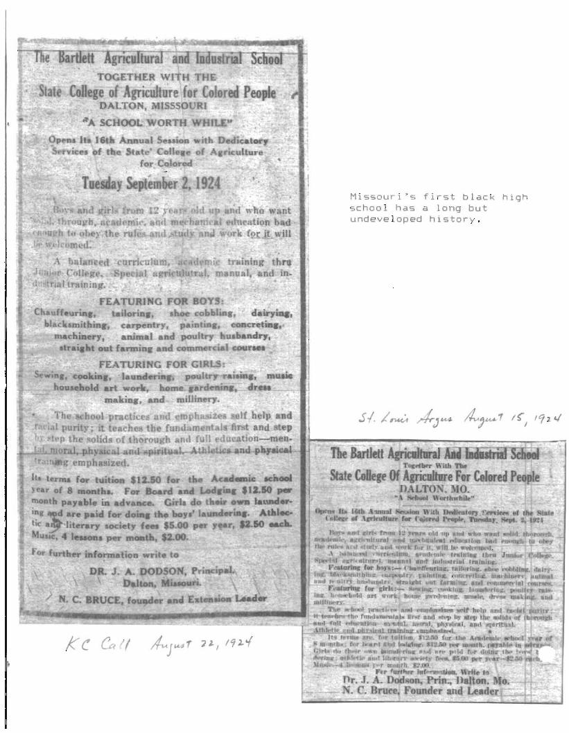
Kc ~(I
Missouri's first black highschool has a long butundeveloped history.

•
D8n~pho'O
At top, what used to be a classroom in Missouri's first black high school,is now a workshop on the Roland Hughes farm. Taking a break from farmchores are Roland's son, Marlon (foreground), and Roland's grandson, Darius Colbert. At left, one of the school's old dormitories serves as a placefor Roland to dry tobacco.
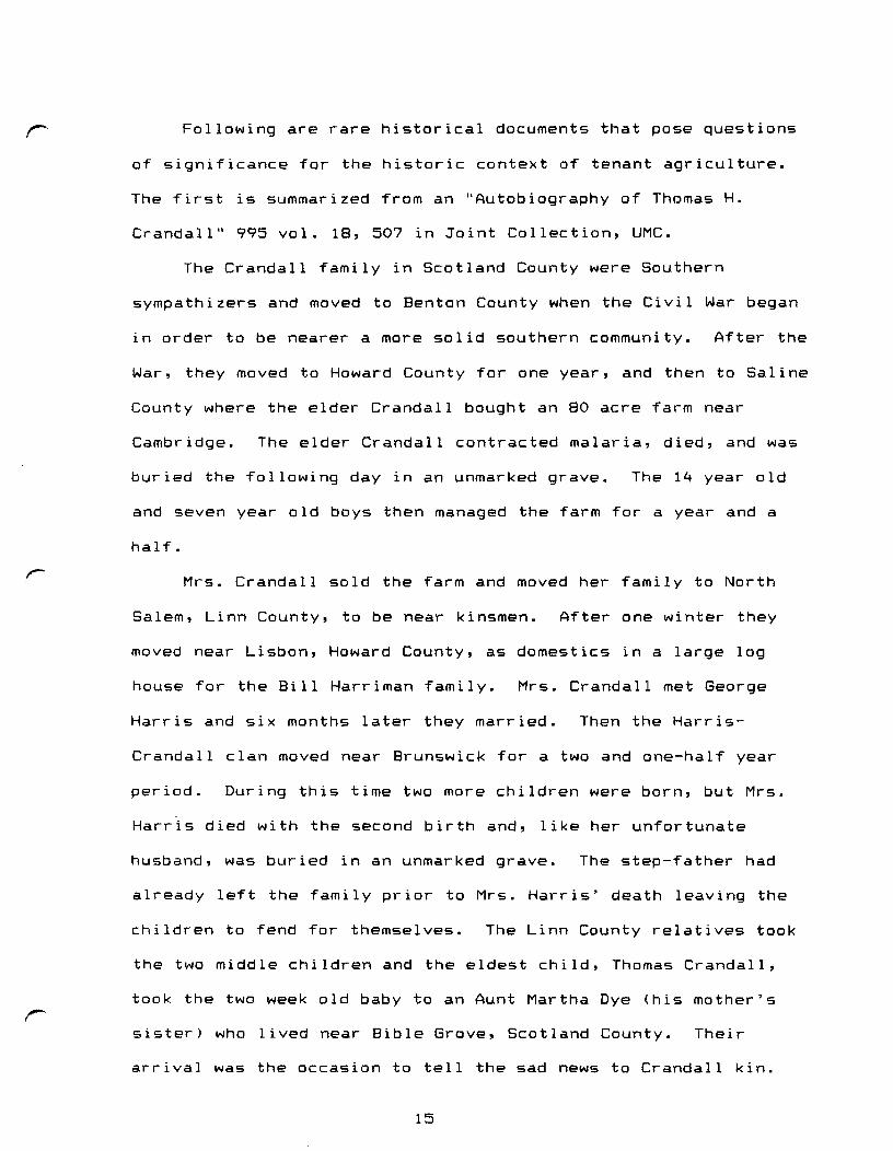
Following are rare historical documents that pose questions
of significance for the historic context of tenant agriculture.
The first is summarized from an "Autobiography of Thomas H.
Crandall" 995 vol. 18, 507 in Joint Collection, UMC.
The Crandall family in Scotland County were Southern
sympathizers and moved to Benton County when the Civil War began
in order to be nearer a more solid southern community. After the
War, they moved to Howard County for one year, and then to Saline
County where the elder Crandall bought an 80 acre farm near
Cambridge. The elder Crandall contracted malaria, died, and was
buried the following day in an unmarked grave. The 14 year old
and seven year old boys then managed the farm for a year and a
half.
Mrs. Crandall sold the farm and moved her family to North
Salem, Linn County, to be near kinsmen. After one winter they
moved near Lisbon, Howard County, as domestics in a large log
house for the Bill Harriman family. Mrs. Crandall met George
Harris and six months later they married. Then the Harris
Crandall clan moved near Brunswick for a two and one-half year
period. During this time two more children were born, but Mrs.
Harris died with the second birth and, like her unfortunate
husband, was buried in an unmarked grave. The step-father had
already left the family prior to Mrs. Harris' death leaving the
children to fend for themselves. The Linn County relatives took
the two middle children and the eldest child, Thomas Crandall,
took the two week old baby to an Aunt Martha Dye (his mother's
sister) who lived near Bible Grove, Scotland County. Their
arrival was the occasion to tell the sad news to Crandall kin.
15

house, a remnant of the southern landscape around the hamlet.
Most everything west of the Wabash railroad in Forest Green has
disappeared, but the late Victorian settlement continues on the
east side. Many descendants of nineteenth-century German
American farmers remain near the Salem community in the Forks of
the Chariton valleys. Some still profit in the historic tobacco
culture, but their market is in Weston, Missouri.
The growth of tenantry during the late nineteenth century is
a well known phenomenon that resulted in part in the formation of
the short-lived Populist Party. The historic tenant landscape,
now commonly perceived in double pen houses and four room,
pyramidal roof houses, is ubiquitous throughout the Missouri
Boonslick and beyond. The tenant house often stands alone near
the road divested of its fence, privy, and small dependencies, or
it has been moved behind the property owner's house to serve as a
washroom, storeroom, toolroom, guest house, or other secondary
domestic functions. Historically, tenantry was often an interim
status "on the way up" to yeoman farmer, a man who owned his land
in fee simple. Small yeoman farm families often lived in the
same kinds of vernacular houses and lived within comparable rural
economies. Like tenants, they moved often, practiced a multituQe
of livelihoods, and many stayed in the region. Their landscapes,
like ethnic ones, quickly pass away and become mere shadows in
terms of the grasp of historic preservation. To ignore them is
to discount a major portion of rural society's fabric.
14

r Young Thomas stayed the winter at Aunt Martha's and worked in the
timber for the family.
The following spring Thomas worked for Martha's husband
until the crop was laid by and then Thomas walked back to Howard
County and hired out to a farmer 5-6 miles north of Glasgow for
several months. While in Howard County Thomas' Uncle Charles
from Linn County visited him. Charles organized a guardianship
for the three younger children and persuaded Thomas to go to
Pettis County near Sedalia to stay with his grandmother, the late
Mrs. Harris-Crandall's mother, and Aunt Sally, another sister of
Mrs. Harris-Crandall.
Thomas stayed the winter, but come summer he returned to
Scotland County to resume an earlier friendship with a local girl
named Lena. He farmed on shares with her father for the next
three years. In December, 1880, Thomas and his fiance eloped,
traveled to Moberly, were married in a hotel by a Justice of the
Peace, and in honor of their special day the hotel management
placed a white tablecloth on their dinner table.
The new Mr. and Mrs. Crandall went to Glasgow to begin their
married life. Thomas hired on at a veneering mill, and later
worked in a livery barn. Afterwards, they hired out in Chariton
r
County as retainers for General Edwin Price on a farm located on
Bowling Green Prairie near Brunswick. The many negroes employed
by Price about the plantation frightened the young Mrs. Crandall
and she refused to remain there very long. So, the Crandalls
left Chariton County and returned to Scotland County.
Thomas Crandall lived most of the next generation in
16

?In~SS SUM:AARY RJleased for tl1e use of (~~0:rllom1 papers I C.:;~c·:,er 21 I 1925----------------.---------------.----------- -------------_. ------------ ---------------------------------
Chari ton Coun t;yMissouri.
Dii;PAi1,T,ilNT OF (:OI~nl:E..RCE
'.'! SIlINGTml
43211695 )
~,t~i~~~{~~Pre1imina!'y Anrl'lUnCement': Cl1.a~i to•• Cou:.:ty. 14:. ssouri
~_. \
W~sh~.ngton. D. C., JC'~OIJ0r i t1925. - 'T'he fol1owi.ng stetement givon some ofthe results of the 1925 farm Cf3nsus for Chari ton CountJr. Missouri .I;:ith comparative datR for 1920. lhe 1925 fi,lros are preliminary and subject to correction.,.-_-_-_-t.-.-.;-_-_-_-.:"_-.;....- _-_-_-.:_-.:_- -:_-_-_-:_-_-.::-_-.:'_-_-_-_-:_-_-_-_-:_-:_-:_- - _-..;"_-_-_- -_-_-..;.-_-_-_-:_-::_.._-.:-:_-_-_-.-_-_-_-_-_-.-.---.---.-------.-.-,.---------.-•••- :.:-:.-:-":"'.:".-.-.-.
Jan. I,19::5
h . I,1 ZO
Jail. I,1'325
Jan. 1,1920
---~_.__ .. _-.-------~---_._-----------------------------------_._-------------------------------------------.}JUMBER OF FARMS; $ iJ J g; 4#J.IWJi .~
TotaL ,_. 3.373
Operated by:
3.426
FAR:vl VALUESLand and buildings __ $34,836,920 $50,777.755
Land alone· . 28,344,214 44,063,745Buildings______ 6,492,706 6. "j14,010
---_.~---------------------------_._------- ..--------------
FARM ACREAGE
All land in farms__ 435.725 445.102
)
14.5125,044
43,821
LIVESTOCK or~ F:\kMSHorses _Mules , _Cattle. tctal_I _
~eer ·COW3* _
Otlierreei cattlE(...----Dairy·cowo* _Other dairy cattle _
Swine, total _-'.' Broeding sows'** _
Owners _Managers _Tena.nts _
~.'"....2,219 2.222
16 411.133 1.163
. t b. .lIS § .~l
._~----------------------------------------------
1924 1919.----~~------------------i'101.571 91.070
2.531,029 3.356,10736,390' 69,591
659,836 1.205.97047.773 40,15849,447 54,315
136 200lOb. 900 195.703
--------------------------------- ~-----_._-----------_.
PRINCIFAL CROPSCorn•..........•Acres
BushelsWheat ........•.•Acres
Bushels.• Hay·••••••••••••• Acre s
Tons••__ Tobacco Ar.res
Pounds8,300
23,223
164,023105,63525,36932.519
240,179218.15914.3857.635
Appies:i '., Y.o:ung trees......... 25.299 10.041
Trees of bearing ago 38,999 39.158Bushels...... .....•• 5e t 573 50 ,354-;- c~~/~--~~d-h-;i r-;;;--2 -~-;~~:;-~-ld- -~~d--~i ~;~- .. --. -. -- ----. -- -------- -------------.- ----------------.
.... SOV!S and gilts for breeding purpose 6 monthn old and over.#: Cattle arc of general purpose type. classifit:8Gion as beef or dairy depending ">:£,~':;~~~~.
largely on individual judgment; 5 175 "beef" cows were milked in 1924.·~/'·:·~·~~~.;:;···~
.:'.:J
All other 1and _
Pas iure. 1924 _Plow?,b1e _We odlan,L _Other _._. _
Woodland not pastured
Cl'OP land, 1924 _Harve~ ted _Crop failure _Fallow or idle __
10/6/25 In broad, general terms one-thirdof Chariton County's landscape waslived in and managed by tenant farmersc1890-1940.
r Scotland County, but he did take "prospecting tours" to
California and Colorado searching for better economic
opportunities. Finally in 1916 the Crandalls did move to
r
r
Colorado where they eventually lost their 400 acre farm in the
Depression and moved to a small tract south of Las Animas.
The second example is summarized from the Hubert Rogers
Memoirs (1888-?) #2113 in Joint Collection, UMC.
Rogers' forebearers were prosperous Boone County, Kentucky,
farmers whose patrimony became too small to support increasing
numbers of heirs. Beauregard Rogers (1861-?), Hubert's father,
came to Missouri in 1884 and settled north of Rothville. In 1887
he married Stacy Stanley and they reared four children, Hubert
being the eldest.
Beauregard and Stacy Rogers moved onto one of Billy
Riddell's farms as tenants. Five years later in 1892 they bought
the 100 acre old Stanley farm for $700. Mrs. Rogers inherited
another 40 acres adjoining the homeplace. The house was a one
and one-half story log dog-trot located on a hill near Yellow
Creek. In 1895 Beauregard and Stacy traded horses and mule colts
to a kinsman for 105 acres across the creek; thus, they managed
245 acres.
In addition to his stock and grain agricultural enterprises,
Beauregard cut wood for the Brookfield town market. Merchants
normally bought all that he hauled to town. Beauregard was also an
auctioneer and cried sales throughout Chariton and Linn counties.
To augment the family income the Rogers raised blackberries in
the timber to sell for 25 cents a gallon.
17
--Managing Office, BRUNSWICK, MO.---H' Directors :._
w. W. RIDDELL,President.
DDGE,Vlce-Pr••ldent.
JESS';: T. SWlUN.
JND. E. ERAGG.
E. M. WILIlIAMS.
ETT.
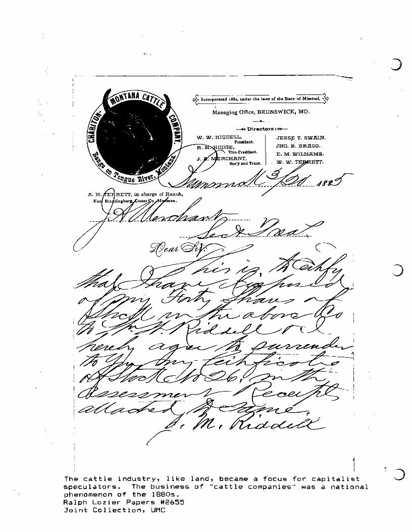
The cattle industry, like land, became a focus for capitalistspeculators. The business of "cattle companies" was a nationalphenomenon of the 1880s.Ralph Lozier Papers #2655Joint Collection, UMC
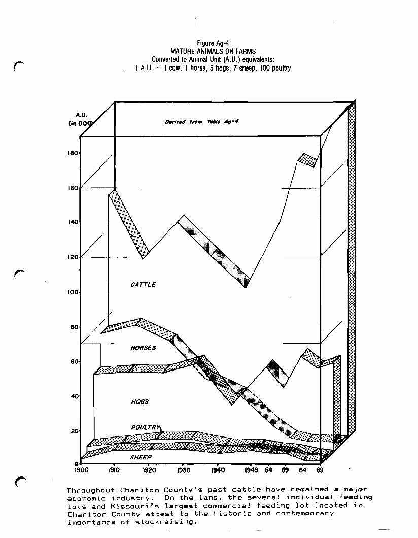
rI Figure Ag-4
MATUREiANIMALS ON FARMSConverted to A~imal Unit (A.U.) equivalents:
1 A.U. = 1 cow, 1 horse, 5 hogs, 7 sheep, 100 poultry
r
180
140
12:(HC:..-----l1---
CATTLE100
1910 1920 1930 1940 1949 54 59 64 69
Throughout Chariton County's past cattle have remained a majoreconomic industry. On the land, the several individua,l feedinglots and Missouri's largest commercial feeding lot located inChariton County attest to the historic and contemporaryimportance of stockraising.
During construction of the new bridge across Yellow Creek in
1895 young Hubert (age 7) hauled water for the carpenters to
drink in lard cans on a sled pulled by his pony. Hubert used his
sled throughout the 1890s to haul shocks of fodder from the corn
fields to the barn. At corn planting time the elder Rogers built
a larger sled using two 2 x 6 planks for runners underneath a
,)
sled 3' 6" wide. Father and son then marked off the corn field
for planting, marking it so one could plow in two directions-
north and south and east and west. On one occasion Hubert took a
portion of his agricultural surplus and introduced himself to
store-bought goods by trading a chicken for a jar of olives--a
trade he regretted.
In 1902 the Rogers sold their 245 acre farm for $32.50 per
acre ($7,962.50). Farmers from Iowa bought theirs and other ,~
local farms. The Rogers clan pulled up stakes ~~t ~f tQ~ ~~ll~~
gr§§~ Y~ll§Y and moved onto the Qr~lrlg purchasing a 147 acre
farm for $45 per acre ($6,615). On 4 July 1904 during their
absence the Rogers' house burned to the ground. Beauregard
Rogers found a vacant house two miles away to live in
temporarily. Mr. Rogers had some house insurance that helped to
construct a new one while he purchased second hand clothing for
the family.
In 1904 Hubert began riding a horse to high school in
Brookfield, but in 1905 he caught the measles and quit school.
He then rented (at age 16) 40 acres of "corn ground" on shares
and sold his half to a livery stable in Brookfield. During 1906-07
Hubert attended and received a diploma from the Chillicothie ,~
Business College. He then joined a new Christian Church in 1907,
18
r began courting his youthful sweetheart, and in 1911 they married.
In 1909 Beauregard Rogers purchased a 160 acre farm near
Brookfield for $95 per acre ($15,200). The Rogers had a public
sale at their old place and moved to be nearer town where Rogers
traded in horses and continued a brisk auctioneer trade. He
invested in all new machinery and harness. They removed the old
hedge fence--a nineteenth-century mainstay in central and
northern Missouri--and they built a new board fence, new hip-roof
barn, and installed square cement posts in the fence adjacent to
the road. The "cement texture" in fencing joined the
r
r
contemporary rage for cement sidewalks and concrete buildings.
As Hubert remembered, "It sure looked nice."
In 1911 Hubert and Naomi Rogers married and at Beauregard's
suggestion they took over the "new farm" while the elder Rogers
and the rest of the family moved to a rental house on North Main
Street in Brookfield. Naomi immediately began the mainstay of
rural women's cash economy by raising Rhode Island pullets. In
1913 the elder Rogers decided that the rest of the family should
move back to the farm, so Hubert and Naomi prepared to leave.
The young Rogers couple borrowed $5,000 from the principal
of Brookfield High School and bought 107 acres with a four room
house near Rothville. Then, in 1916, they traded their 107 acres
for 101 acres adjoining Brookfield on the southeast. They moved
into a "modern house 5 rooms [probably a late Victorian cottage]
and a nice barn with electric lights in it."
During the War the Rogers sold their 101 acre Brookfield
farm to an Iowa man for $165 per acre ($16,665); they bought a
19
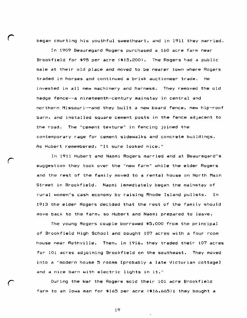
BIG 81'RINGS DISTILLERY, KEYTESVILLE, MO.
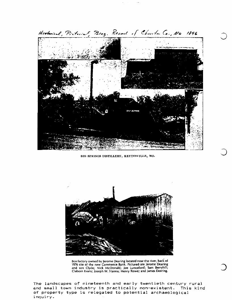
Box factory owned by Jerome Dearing located near the river, back of1976 site of the new Commerce Bank. Pittured are Jerome Dearingand son Clyde; Nick McDonald; Joe Lunceford; Sam Berryhill;Claborn Evans; Joseph W. Hanna; Henry Rowe; and James Dearing.
The landscapes of nineteenth and early twentieth century ruraland small town industry is practically non-existent. This kindof property type is relegated to potential archaeologicalinquiry.
r
r: ~ -
Saw Mill of Yesteryear
.)·1, .c.,:.;:....J
r
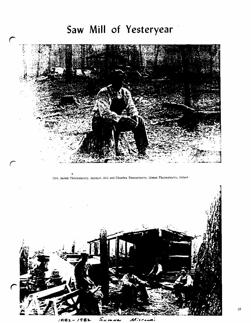
~Irs. Sarah Thornsberry, mother. Bill and Charles Thornsberry. Simon Thornsherry, father
M ....I_~.~;
23
160 acre farm three miles southwest of Brookfield on the National JTrail. As the sellers could not vacate the "big house" until
June the Rogers moved into a recently vacated two room tenant
house.
The saga of the Rogers and Crandall families is of course
much more, but one point of these brief chronicles is the
mobility and necessity of spaciously small but functional
vernacular housing that seemed always available to rural society.
In some ways the double pen and four room houses seem more like
"shelter" to late twentieth-century society, however, as the
Rogers Memoirs indicates they were often much more than that--
they were sites for homes like all vernacular housing. Just as
the Rogers were mobile, so has the small vernacular house been
mobile; farmers and tenants have moved them allover the country.
They have an elusive quality similar to Mr. and Mrs. Crandall's
unmarked graves. Though they are not normally "seen" by
preservationists, the temporary and marginal vernacular housing
is everywhere. What level of documentation should we provide for
them? It remains a challenge for historic preservation to
interpret the significance of this common landscape.
C. Midwestern Main Street 1894-1945VI 1894-1914VII 1915-1945
Like the New England church with tall spire, Main Street is
a symbolic American landscape filled with the memory of positive
cultural values. Main Street has represented the ideal for
community as the I house once was an ideal for successful
20
r agriculturalists. Promoters of Main Street were American
republicans devoted to visions of face-to-face business dealings,
institutions of church and school, a town focus for major social
events, and a place with a future of progressiveness where their
children could be nurtured and eventually belong. From 1896-1913
American per capita wealth tripled and earlier hamlet beginnings
and small railroad towns reached an important zenith in their
economic and landscape development. (The influential lines in
Chariton County were the Wabash [Sumner, Triplett, Brunswick,
Dalton, Salisbury, and Forest Green]; the Atchison, Topeka and
Santa Fe [Mendon]; and the Chicago, Burlington and Quincy
[Sumner] . ) This Period saw the climax of many nineteenth-century
visions for the future; on the land this generation engagedrin expansive building projects. The visual appearance of
r
historic Missouri and Chariton County has a particular relevance
in this Period for it was the era when a major portion of small
town Missouri landscape was built; for years to come probably
most of Missouri's rural preservation concerns will involve in
one way or another this Period of Midwestern Main Street.
In the Bentley Collection at Joint Manuscripts, UMC, is an
early twentieth-century writing entitled, "Salisbury--The Prairie
Queen." The first sentences read,
Salisbury is a city of 2,500 people and is the largest townin Chariton County. The country surrounding it is famousfor its bluegrass and fine stock and it is also known as thecenter of the best farming community in this section of thestate. It is located on the main line of the WabashRailroad and also on the Glasgow Branch of the same system.
A "railroad, 2,500 people, fine stock and farming country"
communicates a ~£~l~ and a £QQ~~~~ for town and rural history in
21
•
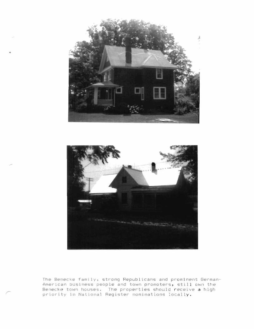
The Benecke family, strong Republicans and prominent GermanAmerican business people and town promoters, still own theBenecke town houses. The properties should receive a highpriority in National Register nominations locally.
•
Chariton County.
In the same collection is another promotional excerpt from
the July, 1913, issue of ygy ell~§ ~~9~~lD~. It draws attention
to Salisbury's new architectural monuments constructed by
religious bodies; it says that local colored people have three
religious denominations and good membership; it recounts
membership in a variety of fraternal orders; it reported the
transition of a local academy into a high school; and it detailed
the commercial district "on Broadway between the Wabash Station
and Fourth Street, and on side streets one block each way;" this
latter description is the same modern spatial dimensions of
Salisbury's commercial district. And, as the 1913 journalist
pointed out, the church buildings are still prominent in the
local cultural landscape. All but one of these major landmarks
downtown was constructed during the great boon of per capita
gain, 1896-1913 (the other was built shortly after in 1919). The
~2t~C~' modern Salisbury of c1925 (and Brunswick, Keytesville,
and many regional towns) remains a benchmark in environmental
development, one in which historical context for much of Chariton
County can be established.
At the same time agricultural extension programs began to
create major innovations in land use and the built environment.
Farmers' Week at the University of Missouri and agricultural
bulletins promoted the vision of increased rural efficiency and
increased standards of living. Farmers remodeled and built new
houses, radically changed their field systems, founded
agriculturally-based clubs, built a new generation of pattern-
22
c
book barns, poultry houses, silos, and with the installation of
electricity, stopped building privies (See the lengthy section
on experiment station plans and innovations in an ~i~t~ci£
January, 1986). This historic, influential movement known in
Missouri after 1941 as ~~l~n£~g E~C~iQq, eliminated much of the
nineteenth-century landscape and traditional farming practices.
In terms of historic context Balanced Farming ushered in a
modern, ~l~QQ~g arrangement of agricultural environments. By
c1925 this altered rural profile had achieved a certain zenith as
had its local counterpart in the Midwestern Main Street towns.
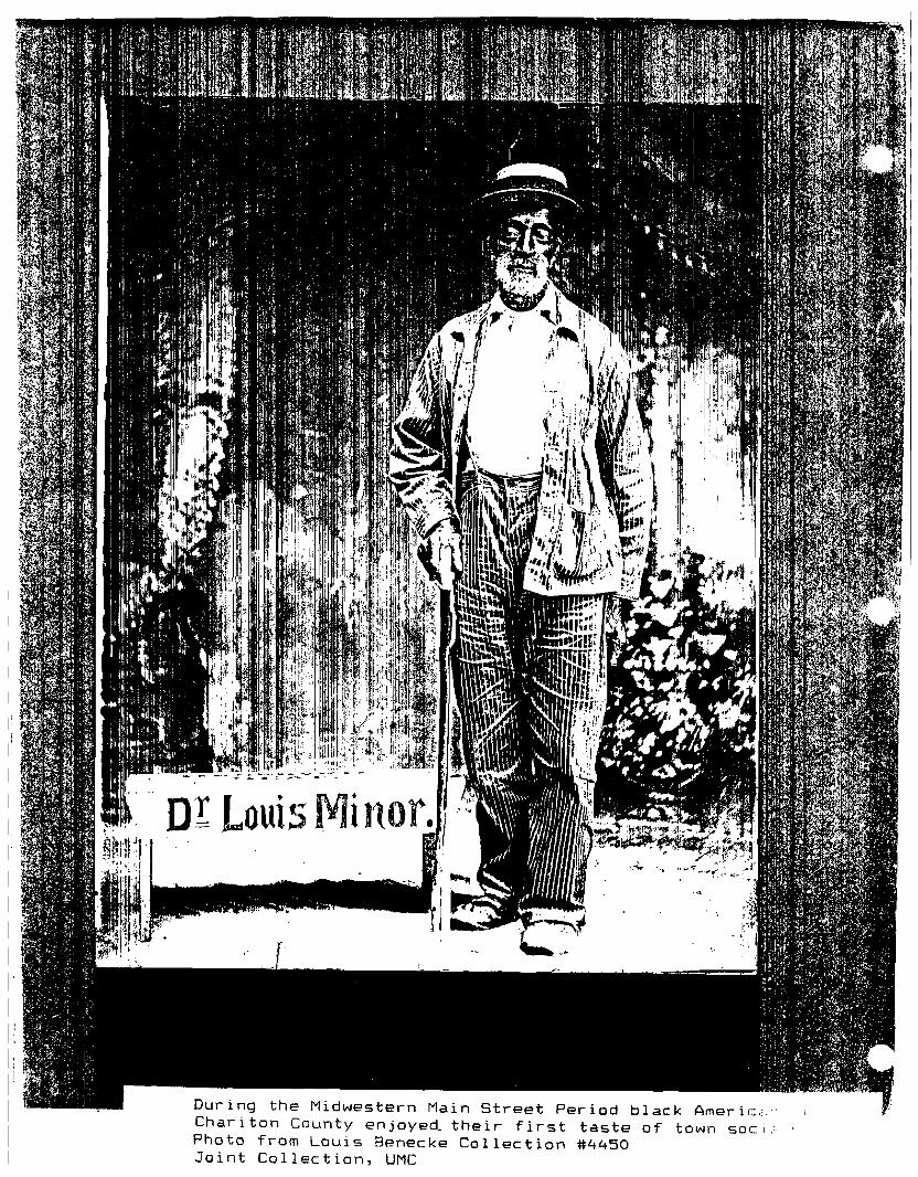
A brief look at local statistics plots a pattern away from
the mature society of the Midwestern Main Street Period. Bll
Chariton County township populations have rapidly declined in the
mid-twentieth century. The figures for the three largest
townships are
l~QQ l~~Q l~~QBrunswick 3645 2992 2384Keytesville 3753 2187 1433Salisbury 4359 3353 3011(Chariton County Agri-Facts, Missouri CropReporting Service)
l~~Q192912332978
and Livestock
The towns indicate that only in Salisbury has there been a
relative demographic stability and modest growth.
BrunswickKeytesvilleSalisbury
140311271847
1749854
1759
1493644
1787
1272689
1975
In the countryside tenant management and occupancy had
changed dramatically.
*" of tenantmanaged farms
1344 1045
23
307 (1959) 142 (1978)
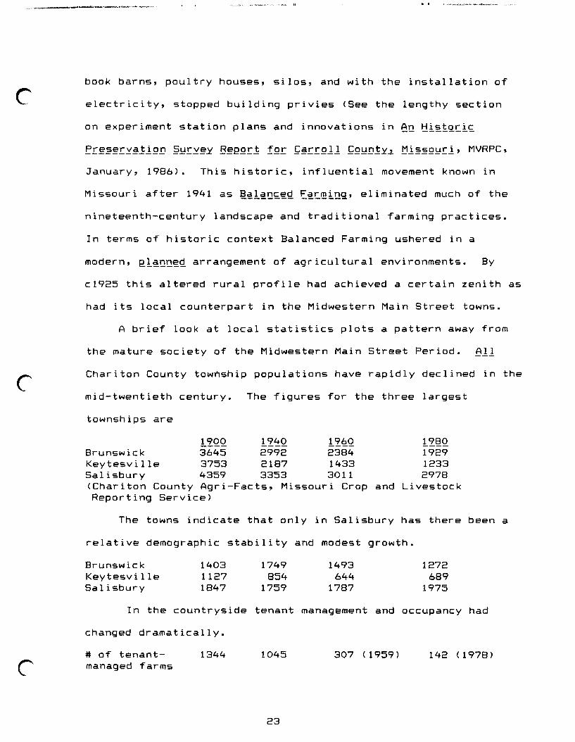
During the Midwestern Main Street Period black Americ.,.·'Chariton County enjoyed. their first taste of town soc.i:Photo from Louis Benecke Collection #4450Joint Collection, UMC
Farm numbers and acreage also reflect national trends.rfarms: number
size3805
1182774
1521875 (1959)
223 (1959)1328 (1978)
313 (1978)
r
r
It is clear from these and other associated statistics that
the Midwestern Main Street Period has flourished and passed into
a post-WWII modernization that in detail, and on the landscape,
is very different. The composition of local towns during the
1920s is a useful benchmark of mature development and appearance
in the built environment from which significance can be drawn for
the remaining landscapes of that Period.
24

~~iUgttSlS of tbt lluittb &tattSl.0USt of !\tprtsentatibt.
IIIUfJington, J). C.
~1
~. ,~
: j ;;,-• i\1II: II
j: LI ': 1, ,. i
1aD.\llU7 8~· 1'.4_i
1.,.. .• _ ........__ A.. •
. ~~. !..1"
•
I desire to send to eaQ,h f~:ron ,soh rural route out of 7our;iosJ·Pf#loe.fa~,ers' bUlletllne 1ssued.b, ~th.~D.pameatof Agrio~ture aDd wh1~'.u. n01f'~a"'a11able:1br free 41stribntiolh I will appreoiat.your. advising me as to the number of b•••on ,aoh of the rou"-8 88rved fro... Four Poe,.Offl oe_,,} ",. i
\' ..;. i . !he Po eta! Laws and RtS\llat iOne ~
Seo1;1on 823. as 8DleDded by 1l»8tr:tt.OIl· 737.,ord~r No. 7137. Februar,v 29; ·192~.;peraltsth;1s in1'otmation to be' given. th_ .-.nlmet18 ae follows;
"Po atmastal's JS7 tamiah 1ntOJ'JDatlon ae to the numb.1t of Rural loutee a1;their oUlae and the number ot boXes sentiby eaoh oarrler...fter aatlefylng themselvesthat: noh information 1. not to be ••4 fOJlaD1' lIlprOper or \U1lawtul purpo••..". ,
\
. :
.)
,., 0,
l{~~¥I.···...:,Jl. l " •,i'. .
I enolose ataJll)e4 enT.lope :fbI'ftP17 aael \1111 thank ,-ou t or an earl,- l'.apo.e.
'.q V1:L17 7oual,
"~ .-.__._.....~----=-----_. .... -. -' - - - ._._..-_.-~~ .,..
•
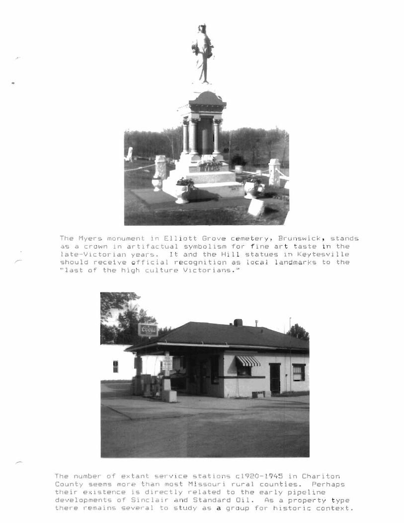
The Myers monument in Elliott Grove cemetery, Brunswick, standsas a crown in artifactual symbolism for fine art taste in thelate-Victorian years. It and the Hill statues in Keytesvilleshould receive official recognition as local landmarks to the"last of the high culture Victorians."
The number of extant service stations c1920-1945 in CharitonCounty seems more than most Missouri rural counties. Perhapstheir existence is directly related to the early pipelinedevelopments of Sinclair and Standard Oil. As a property typethere remains several to study as a group for historic context.

•
John Meinhardt at Wien crafted superb creations in homemadeconcrete molds. This bungalow has a singular distinction inChariton County for its multiplicity of textures and concreteblock design woven into a workable whole. It and a nearbyVictorian expression by Meinhardt are unique in the GermanAmerican built environment of the MVRPC service area.
This rear view of the Edwards' International house in BowlingGreen township represents an artifactural pinnacle incosmopolitan awareness and investment during the Midwestern MainStreet Period. It is a classic form commonly found in stylebooks. It is unique in the MVRPC service region and it shouldreceive status as a local landmark.
~-
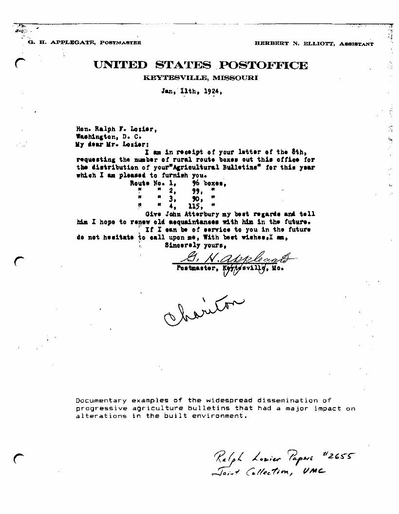
G. H. APPLEGATE, POSTMASTBR
-----'------ -- . - -- --- -- .HERBERT N. ELLIOTT, A88ISTANT
lJNITED STATES, POSTOFFICEKEYTESVILLE, MISSOURI
Jan,'11th,1'24,
Hon. Ralph r. Lol1er,Wuh1ll1ton, D. c.111 .ear 111'. Lod.er:
I • in receipt of your letter of tbe hh,rlque.t1na the number of rural route boxe. out tb1. ott1•• tortu 41.tr1but1on 0 f your"Acr1ou1tural Bullet1••" tor tbb 1.arwbloh I am plea••' to furn1.h you. ,
loute No.1, ,6 box•• ,~ "2, ","" .. 3, ~,"!' .. 4, llS, ..
G1Te John Attlrbury .y bid "aari. aM telltda I hop. to ren." old a.qua1ntan••• w1th hila in tbl futur••
\' It I oan bI of .,nice to you in the futurl4. not he.itate to ,all upon .e, With 'beet wilh...I _,
:: 81nclre1y your.,
""",!!,~~/..£.#:~.~~~.c~%Zk--POI.alter, , lIo~
Documentary examples of the widespread dissemination ofprogressive agriculture bulletins that had a major impact onalterations in the built environment.
'2 ~, Lo.,·W' 7l,~, tIZ,~~
~'''''f ~/!'e7intl VIU~
· ,''''
.~-~--,-_.._-,._.~.,._---:--- ._---------------------
•
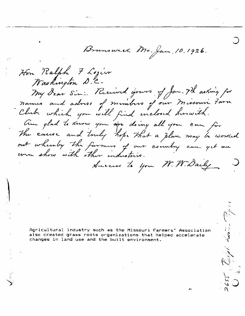
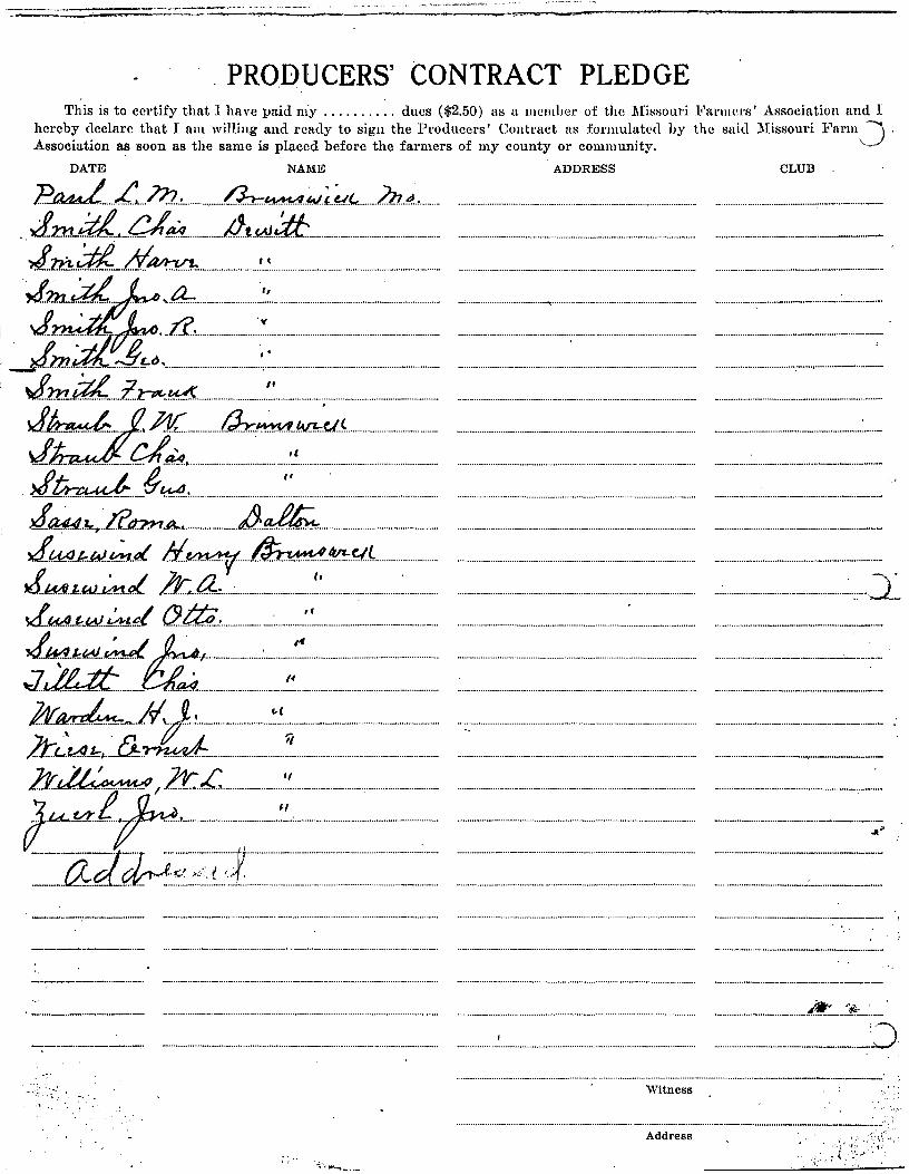
Agricultural industry such as the Missouri Farmers' Associationalso created grass roots organizations that helped acceleratechanges in land use and the built environment.
~
1 ~1\
\;(
'\~
N"~ "'~
,~O'1'\

I't~ Yh1~I ~~I:)t:1=t3=~~=t;;;t:):j~=K1~z.t::~Et~UE
, ,i . /
.~,
This is to certify that I have paid my dues ($2.50) as 11 mcmher of the Missouri J<'m'lllel'S' Associatioli ana I"rreb~ ~eclaroth~t I am willing. and ready to sign the Producers' Contmct as forIllul~tl'a by thc said :Missouri :b'armcl's'
j;;SOclatlOn as so~n a$ the same IS placed before the farmers of my county or commuUlty, . . .
DATE'~ NAME ADDRESS CLUB
It...... . __ __ __ __ _-
_..~..~ _ _ _._._.: -:-.._.__.__ _' -
, ...•.... -_ - _.._- _-_ ..
,._.__..•........•..._ _ _..__.._.._--_.._--.,
"_...........•......._......-._._._--_...__.-_..-..
• .. '<.'.';................................; · ·Add;·~·~·~··, ·_ ··· ·.._·..···..·· ..f{~::;~~1 t(~·::~~c'K\~T~
--------=====:::::- -.."-.._-~....----~ ...:.===== ,.,....,......_---............-.----.------------- -",-- Q
PRODUCERS' CONTRACT PLEDGEThis is to certify that I have paid niy dues ($2.50) as a member of the :l\fissouri Farlllers' Association and I
hereby declare that I am willing and ready to sign the Producers' Contract as forlUulated by the said Missouri l!'urm -) .Association as soon as the same is placed before the farmers of my county or community. '".-
DATE NAME ADDRESS CLUB
P~ L. 7JJ.., O::r::.~.(&{.;...~.(.. 2lJ..~·,.......... . _._. ,J:n::u~ ati1!. iJ..t..~.::ti:. _................................................. .. _ _.._.._ _-4..m..~_ ..d~ '. ..~................................................ ................................ . ..
~·~~-=:-::i-:-~~-==~=-~~~: ~~::~=~=-~-=~:=:~:-~-:::=:== :==::==J..J:1::!:.~ :l..}::7It-;,~ ~.' _..................................................................... .. ..
~4 t.b.:..-~c.lL_______________________ _~ dti4 '.(
,J~.7..r.T.:12(}ZH.A rI),.~......................................................... .. .
~.·.·.~.t&4.·.I·~ ·~·~.•.t.fJ.'.' ·~.._~AA·.~.· ·.·.«.·.~". ~·.·.·.·.~.·.·.a.··.·.·.·.·.·.· ·.· ·.·.·.·~~ ~eI~ :................................. .. _ - .."!l..~.I!..." ""'-...V-<:.'.«. Lr....~ ...: :..::.~ ..J~
0..fdA~.w. ..~!:.~t (J.ttii..L ~ '..~................................................. ........... .. _..~ ~~ I~
J..'L..~ ..:~ti...a4.:'.:.~:.: ..:~::.: ::.:.:.:':..:: ;~ ::.: ::..:.:..:::.:..::..:.: ::.:::.:.:::::..:.:..:: ::..::::::::: : ::..:.::::::::::::::::.::.::.::.:..:..::.::.::.:::::..::.:::::::.: ::::..:::::::.. ..::::::::::::.:.::.: ::.:.~.:~:..::~..=~ ~:..~:ti=:::~~~~:=:===== :~~::=::===~::=_:::==:: :==:=====b.~ /.ft..~ ~.~.......................................................... ............ .. _...'3, t ....~ H .
~~~;::i::==:=:===~= ==~::__:::::~=::=:~= :=~=:=~
.............................................~:_ ...~~.:.._~ ...-
....................._ _.._ __8,Witness
...........................••........•............._ _ _ _ _ _ __.__ _...-.-_-_.__ ' .
.....~- ~-
Address (:,f~,',' :,!:,: 1'1,;c','.,."
) , 'J
"'"
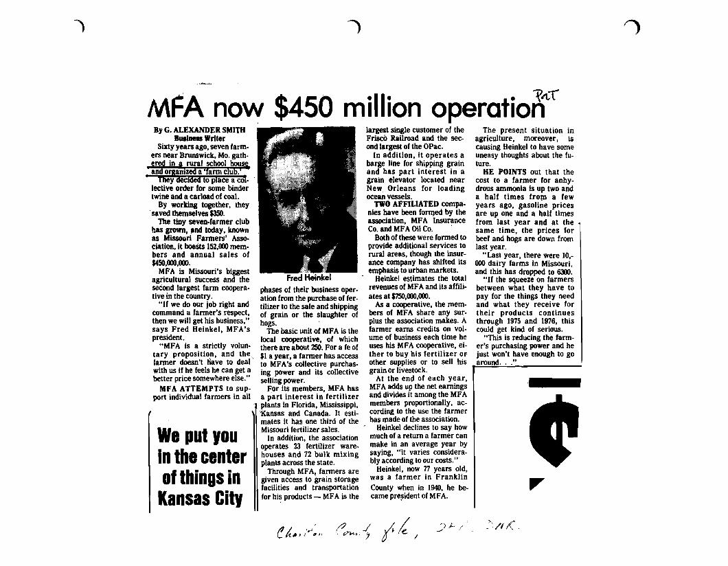
The present situation inagriculture, moreover, iscausing Heinkel to have someuneasy thoughts about the future.
HE POINTS out that thecost to a farmer for anhydrous ammonia Is up two anda half times from a fewyears ago, gasoline pricesare up one and a half timesfrom last year and at thesame time, the prices forbeef and hogs are down fromlast year.
"Last year, there were 10,000 dairy farms in Missouri,and this has dropped to 6300.
"If the squeeze on farmersbetween what they have topay for the things they needand what they receive fortheir products continuesthrough 1975 and 1976, thiscould get kind of serious.
"This is reducing the farmer's purchasing power and hejust won't have enough to goaround..."
largest single customer of theFrisco Railroad and the second largest of the OPac.
In addition, it operates abarge line for shipping grainand has part interest in agrain elevator located nearNew, Orleans for loadingocean vessels.
TWO AFFILIATED compa·nies have been formed by theassociation, MFA InsuranceCo. and MFA Oil Co. .
Both of these were formed toprovide additional services torural areas, though the insurance company has shifted itsemphasis to urban markets.
Heinkel estimates the totalrevenues of MFA and its affiliates at $750,000,000.
As a cOoperative, the members of MFA share any surplus the association makes. Afarmer earns credits on volume of business each time heuses his MFA cooperative, either to buy his fertilizer orother supplies or to sell hisgrain or livestock.
At the end of each year,MFA adds up the net earningsand divides it among the MFAmembers proportionally, according to the use the farmerhas made of the association.
Heinkel declines to say howmuch of a return a farmer canmake in an average year bysaying, "it varies considerably according to our costs.'"
Heinkel, now n years old,was a farmer in FranklinCounty when in 1940, he became pre~ident of MFA.
,i.!Fred Heinkel
phases of their business operation from the purchase of fer·tilizer to the sale and shippingof grain or the slaughter ofhogs.
The basic unit of MFA is thelocal cooperative, of whichthere are about 250. For a fe of$1 a year, a farmer has accessto MFA's collective purchasing power and its collectiveseIling power.
For its members, MFA hasa p'art interest in fertilizerplants in Florida, Mississippi,Xansas and Canada. It estimates it has one third of theMissouri fertilizer sales.
In addition, the associationoperates 23 fertilizer warehouses and 72 bulk mixingplants across the state.
Through MFA, farmers aregiven access to grain storagefacilities and transportationfor hi~ products - MFA is the
We put 'auIn the centerof things in
Kansas Cit,
MFA now $450 million operatio~lt{By G. ALEXANDER SMITH
Business WriterSixty years ago, seven farm
ers near Brunswick, Mo. gath.ered in a rural school hou§aDd organized a 'farm club. '
'I'lley aeCided to place a co,·lective order for some bindertwine and a carload of coal.
By working together, theysaved themselves $350.
The tiny seven-farmer clubhas grown, and today, knownas Missouri Farmers' Ass0ciation, it boasts 152,000 members and annual sales of$450,000,000.
MFA is Missouri's biggestagricultural success and theseCond largest farm cooperative in the country.
"If we do our job right andcommand a farmer's respect,then we will get his business,"says Fred Heinkel, MFA'spresident.
"MFA is a strictly voluntary proposition, and the,farmer doesn't tiave to deal'with us if he feels he can get abetter price somewhere else."
MFA ATTEMPTS to support individual farmers in all
(! h"fI''''~JII/? ..J A /~ i '/'1 J ,~/e. I
~)I-, /~ , _'"'/1(( ,
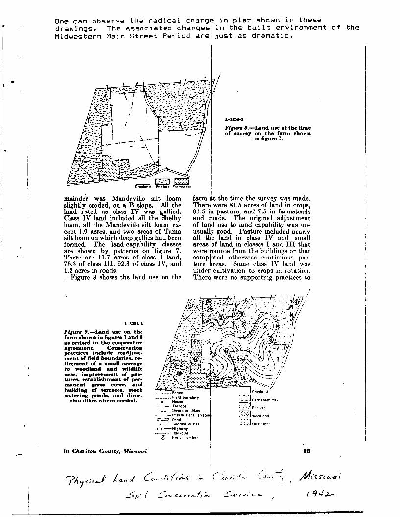
One can observe the radical change in plan shown in thesedrawings. The associated changes in the built environment of theMidwestern Main Street Period are just as dramatic .
•
L-lI2H-I
Figure B.-Land use at the timeof survey on the fann shown
in figure 7.
mainder was Mandeville silt loamslightly eroded, on & B slope. All theland rated as class IV was gullied.Class IV land included all the Shelbyloam, all the Mandeville silt loam except 1.9 acres, and two areas of Tamasilt loam on which deep gullies had beenformed. The land-capability classesare shown by patterns on figure 7.There are 11.7 acres of class I land,75.3 of class III, 92.3 of class IV, and1.2 acres in roads.. 'Figure 8 shows the land use on the
farm t the time the survey was made.Ther were 81.5 acres of land in crops,91.5 i pasture, and 7.5 in farmsteadsand oads. The original adjustmentof la use to land capability was unusual good. Pasture included nearlyall t e land in class IV and smallareas of land in classes I and III thatwere emote from the buildings or thatcomp eted otherwise continuous pasture reas. Some class IV land wasunde cultivation to crops in rotation.Ther were no supporting practices to
• !
L-lI254-4
Figure 9.-Land use on thefann shown in figures 7 and 8as revised in the eooperativeagreement. Conservationpractices include readjustment of field boundaries, retirement of a small acreageto woodland and wildlifeUIIeII, improvement of palltures, establishment of permanent 8ftI1III cover, andbuilding of terraces, stockwaterinl( ponds, and diver-
sion dikes where needed.
in. Chariton County, Minouri
_.__ Fence~ Field boundary
• House__~Terroc.
__ Diyerslon dikes- - _ Intermit1ent streoC:::::;:., Pond
P;-.....1ZJ Sodded outlet=Highwoy~Rallroad
® Field number
19
•
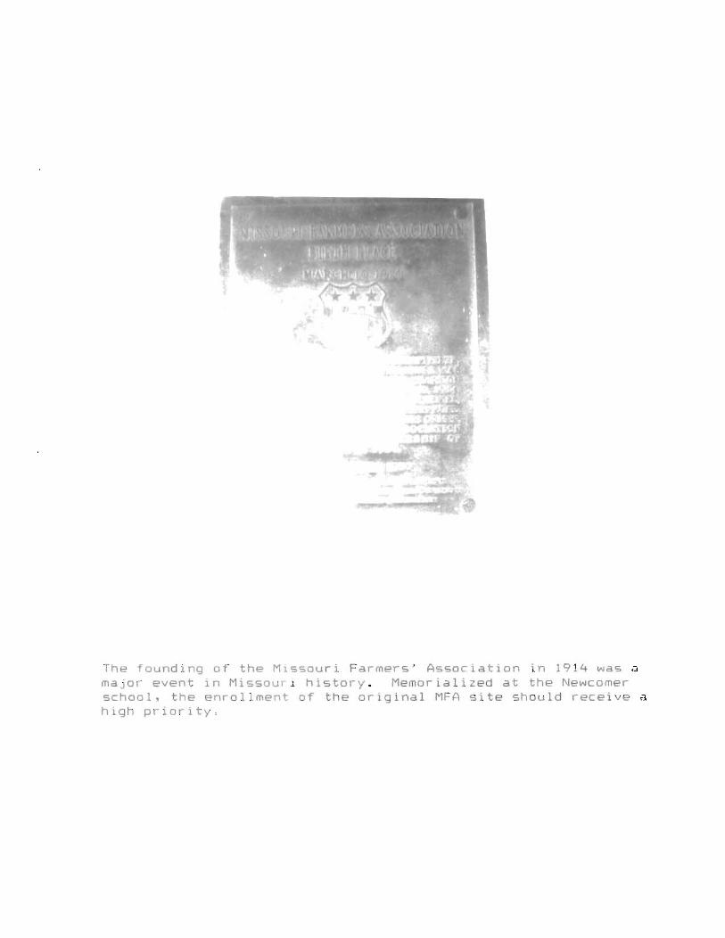
The founding of the Missouri Farmers' Association in 1914 was amajor event in Missourl history. Memorialized at the Newcomerschool, the enrollment of the original MFA site should receive ahigh priority.
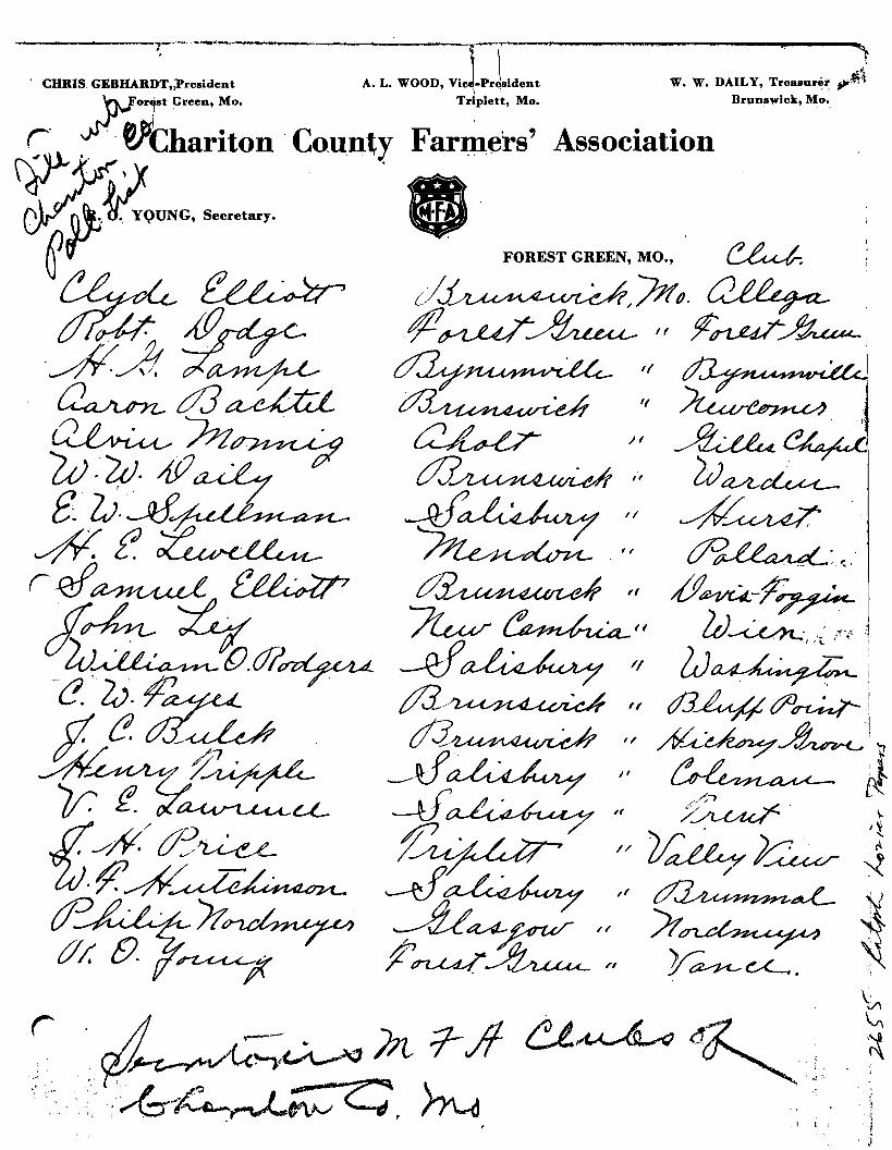
FOREST GREEN, MO.,
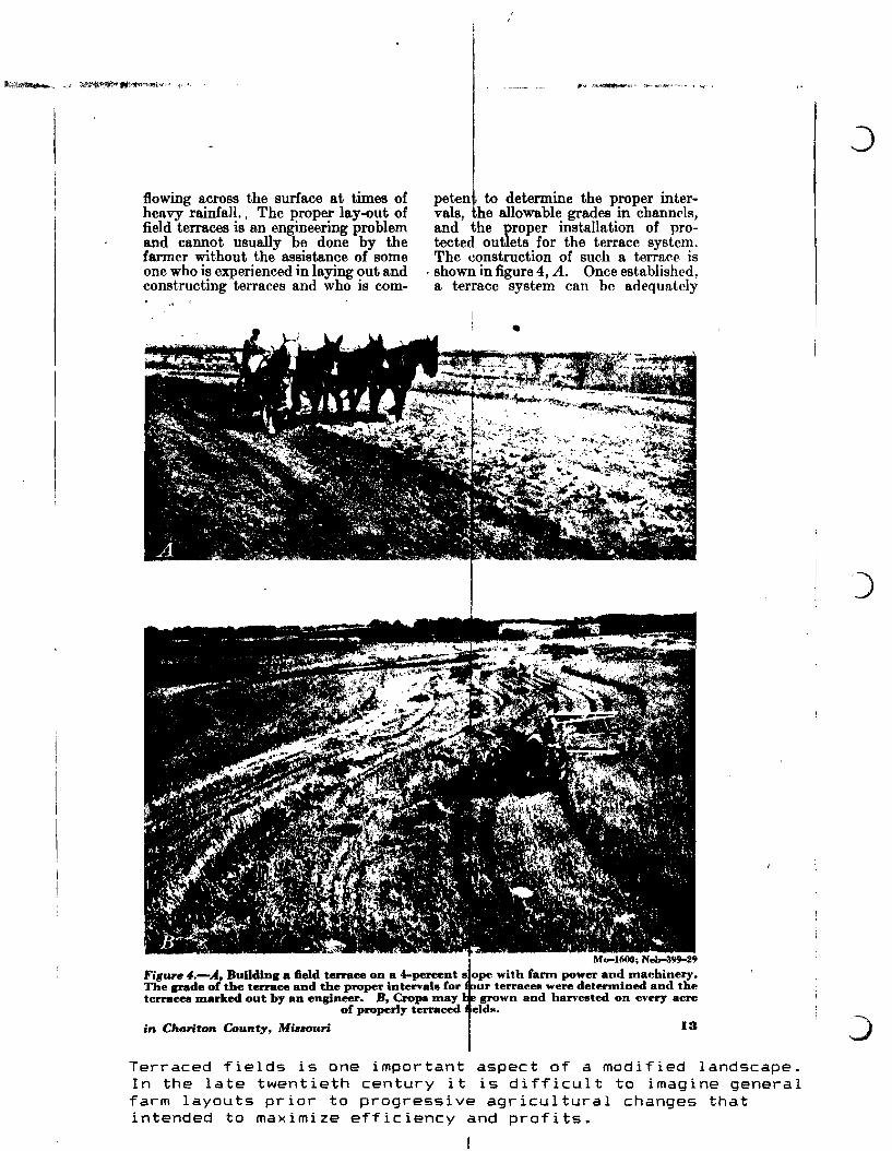
flowing across the surface at times ofheavy rainfall. I The proper lay-out offield terraces is an engineering problemand cannot usually be done by thefarmer without the assistance of someone who is experienced in la,ying out andconstructing terraces and who is com-
peten to determine the proper intervals, he allowable grades in channels,and the proper installation of protected outlets for the terrace system.The construction of such a terrace is
. shown in figure 4, A. Once established,a terrace system can be adequately
Mo-l600; Neb-399-29
Fillurfl4.-A, Building a field terrace on a 4-percent s ope with farm power and machinery.The IJI'llde of the terrace and the proper intervals for ur terraces were determined and theterraces marked out by an engineer. B, Crops may grown and harvested on every acre
of properly terraced elds.
in Chariton County, Mi330uri 13
Terraced fields is one important aspect of a modified landscape.In the late twentieth century it is difficult to imagine generalfarm layouts prior to progressive agricultural changes thatintended to maximize efficiency and profits.
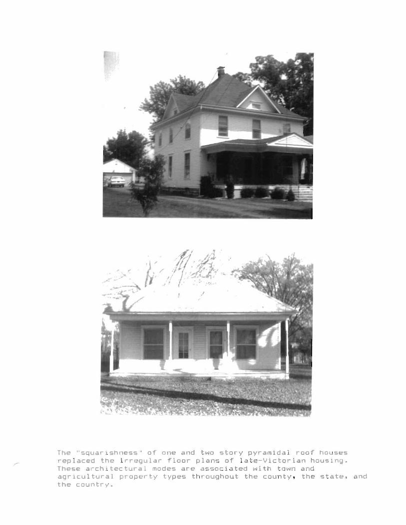
The "squarishness" of one and two story pyramidal roof housesreplaced the irregular floor plans of late-Victorian housing.These architectural modes are associated with town andagricultural property types throughout the county, the state, andthe country.
•
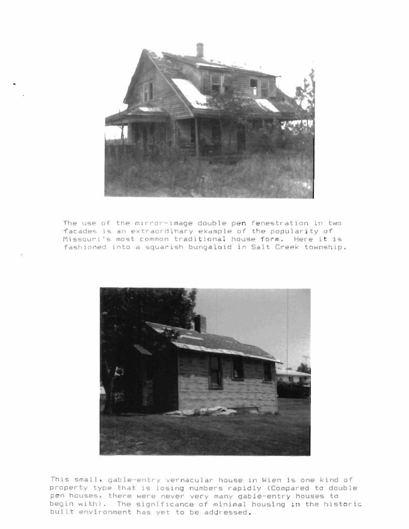
The use of the mirror-image double pen fenestration in twofacades is an extraordinary example of the popularity ofMissouri's most common traditional house form. Here it isfashioned into a squarish bungaloid in Salt Creek township.
This small, gable-entry vernacular house in Wien is one kind ofproperty type that is losing numbers rapidly (Compared to doublepen houses, there were never very many gable-entry houses tobegin with). The significance of minimal housing in the historicbuilt environment has yet to be addressed.

•Recommendations
John Higham, an American historian, predicted thirty-five
years ago that the American family farm was on the decline and
would rapidly succumb to the superstructure of American corporate
capitalism. That day has come and is easily observed in the
cultural landscape. Rural dependencies are disappearing--poultry
houses, silos, privies, cellars, sheds, shops and more. They are
being replaced by trailers, metal buildings in great profusion,
and concentrations of people who form a new rural settlement
class of non-agricultural competitors. The crunch of corporate
capitalism has produced an ever-decreasing "historic" rural
landscape. The centralization of processing, marketing, and
transportation has had an enormous impact on buildings. The
former pattern book creativity in the agricultural industry is
greatly diminished or in most cases ended. The late nineteenth
century transition from pre-industrial landscapes to diversified
farming to modern agribusiness has shaped a new profile on the
land.
Seen by most as a positive good in the modern economy
wealthy farmers who have believed in and supported the ethic of
progressive agriculture as sponsored by extension programs
occasionally endow continuing educational support for more of the
same. In Chariton County a recent example was Frederick B.
Miller's gift of $1.7 million to the University of Missouri;
Miller was a strong supporter of University Extension.
It is no accident that a great many family farms with a
25
•
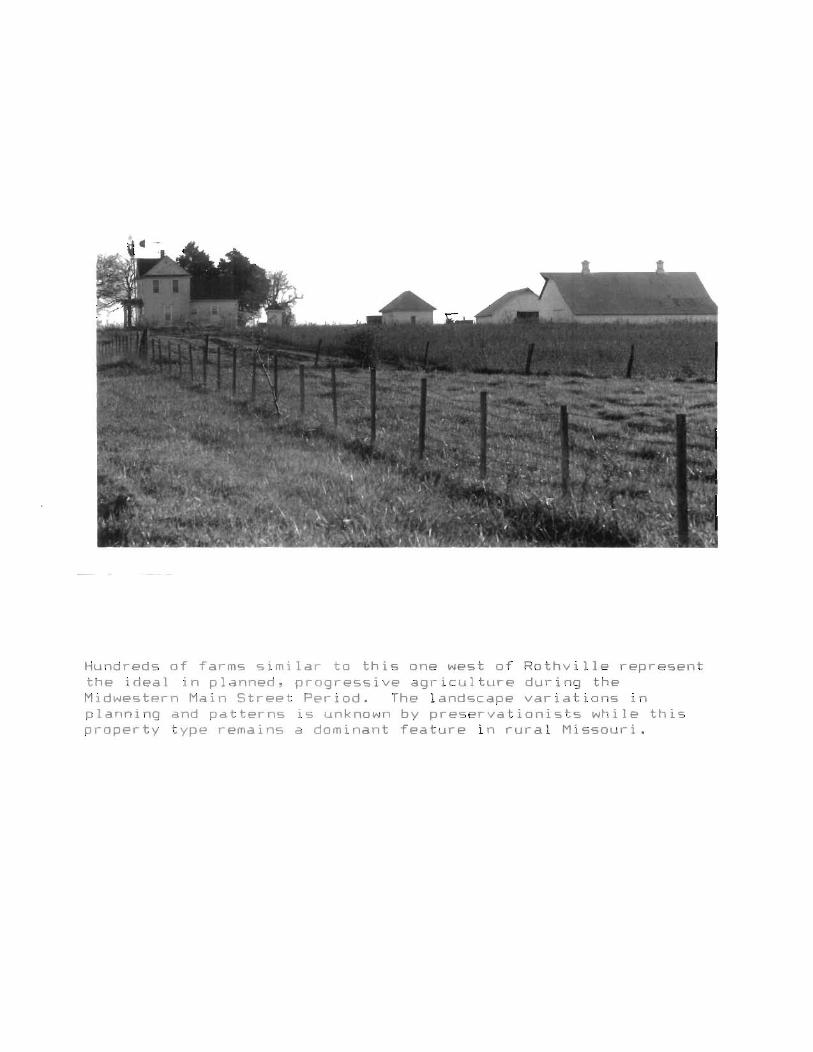
Hundreds of farms similar to this one west of Rothville representthe ideal in planned, progressive agriculture during theMidwestern Main Street Period. The landscape variations inplanning and patterns is unknown by preservationists while thisproperty type remains a dominant feature in rural Missouri.
r history of fifty to seventy years' association with state
agricultural programs are often recognized on Centennial Farm
lists. These farms have survived with some independence due to
their family's long tenure on the land, and by keeping abreast in
modern, progressive management.
In order to describe, comprehend, and interpret the changes
on the land in the MVRPC region we recommend that the most
efficient approach for agricultural properties would be to
intensively investigate a cross-section of Centennial Farms. The
Centennial Farm owners have consistently been the most informed
of local history, and have precise knowledge, photographs, and
papers concerning the evolution of their land and buildings.
These farms also commonly retain some residue of structures that
pre-date Extension work. There exists in the rural sociology
department, UMC, transcribed interviews from the 1930s and
specific farm data on many participants in the Balanced Farming
program.
Centennial Farm lists are normally available at Extension
offices in local courthouses, or they are often incorporated into
local history publications (see attached). A research design,
with probably two or three seasons' work, focused on a region's
Centennial Farms should yield a long-lasting historic context for
thousands of rural Missouri properties.
26
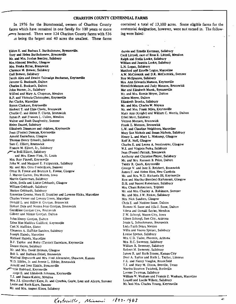
CHARITON COUNTY CENTENNIAL FARMS
In 1976 for the Bicentennial, owners of Chariton Countyfarms which have remained in one family for 100 years or morere honored. There were 124 Chariton County farms with 536
~s being the largest and 40 acres the smallest. These farms
Eldon E. and Barbara J. Bartholomew, Bynumville.Troy and Helen Bartholomew, BynumvilleMr. and Mrs. Jordan Bentley, SalisburyMrs.Almond Bentley, GlasgowMrs. Reaka Bitter, BrunswickClarence M. Brewer, SalisburyGail Brewer, SalisburyJacob Alex and Dewitt Talmadge Buchanan, KeytesvilleJerome G. Bucksath, DaltonCharles E. Bucksath, DaltonJohn Burner, Jr., SalisburyWilfred and Mary A. Chapman, MendonR.P. and Victoria Christopher, KeytesvillePat Clarke, MarcelineByron Clarkson, KeytesvilleHerbert T. and Elsie Clavin, BrunswickCharlie C. and Helen T. Clavin, BrunswickJames P. and Frances L. Cullen, MendonWalter and Ruth Daugherity, SumnerHelen Dautel, SalisburyElizabeth Dinsmore and children, KeytesvilleJoan (Foster) Duncan, KeytesvilleArnold Easterhaus, GlasgowThomas Henry Erhardt, SalisburySam C. Elliott, BrunswickFrancis M. Elliott, Jr., Salisburyras Brill Elliott, Salisbury
, and Mrs. Elmer Fink, St. LouisMrs. Roy Finnell, KeytesvilleJohn W. and Margaret E. Fitzpatrick, SalisburyMr. and Mrs. Otto Frederiksen, SumnerOmar H. Freese and Beatrice L. Freese, GlasgowJ. Marvin Garner, Des Moines, IowaMartin Gatterman, SalisburyAlvin, Stella and Lizzie Gebhardt, GlasgowWilliam Gebhardt, SalisburyMarion Gebhardt, SalisburyErnestine Greene, Nora H. Standley and Laverne Hicks, MarcelineCharles Verner and Lenora Green, MarcelineDonald L. and Billye B. Grotjan, BrunswickHobart Dale and Norma Jean Grotjan, BrunswickGeraldine Grotjan Cox, BrunswickGilbert and ~1innie Grotjan. Dalton
John Henry Grotjan, DaltonEdna Mae Maddox Guilford, KeytesvilleCarl N. Haffcke, SlaterEleanora A. Haffcke Sanders, SalisburyJoseph Hainds, ~1arceline
Richard Hainds, MarcelineB.F. Taylor and Ruby (Taylor) Harrelson, KeytesvilleDuane Hayes, SalisburyMr. and Mrs. David Heiman, GlasgowBob L. and Barbara Heisel, BrunswickWinfred Hepworth and Mrs. Fred Alexander, Shawnee, KansasW.D. Hibler, Jr. and Jennie L. Hibler, BrunswickArnold and Inez Hinkle, Bynumville
r'ttie Hubbard, Keytesville~rge E. and Elizabeth Johnson, Keytesville
T.1. and Duane Kahler, MendonMrs. J.I. (Dorothy) Kaye, Jr. and Cynthia, Gayle, Lesz and Alicyn, SumnerLeslie and Ruth Kaye, SumnerMr. and Mrs. August Klaus, Salisbury
contained a total of 13,100 acres. Some eligible farms for thecentennial designation, however, were not turned in. The following were listed:
riarvin and Emelle Kottrnan, SalisburyCecil Littrell, care of Ross E. Littrell, MendonRalph and Stella Locke, SalisburyWilliam and Juanita Locke, SalisburyL.N. Logan, SalilburyManford and Emelle Logue, MarcelineA.W. McCormick and O.K. McCormick, SumnerRoy McSparren, SalisburyMrs. Ann Edwards Manson, KeytesvilleMeredith Manson and Judy Manson, BrunswickMat and Elizabeth Marelc, BynumvilleMr. and Mrs. Romie Meyer, DaltonAllene Meyer, DaltonElizabeth Brooks, SalisburyMr. and Mrs. O1arles W. MeyersMr. and Mrs. Frank Miles, KeytesvilleMary Ann (Knight) and William C. Morris, DaltonEthel Mott, SalisburyVernon Munson, BrunswickFrank E. Munson, BrunswickL.W. and Claudine Neighbors, MarcelineMary Sue Nichols and Susan Nichols, SalisburyHenry L. and Mary L. Niekamp, GlasgowRolf R. Noll, GlasgowCharles E. and Leona A. Nordmeyer, GlasgowW.J. and Virginia Parks, SalisburyJean (Foster) Patrick, BrunswickAnthony and Christine Pleyer, SalisburyMr. and Mrs. Ransom B. Price, DaltonTeddy R. Quick, KeytesvilleGeorge V. and Inez E. Reichert, BrunswickJames F. and Helen Rice, New CambriaMr. and Mrs. W.D. Richards lIl, KeytesvilleRon and Martha (Bentley) Richmond, GlasgowD.H. and Naomi Robertson, SalisburyMrs. Chant Robertson, TriplettMr. and Mrs. Charley A. Robinson, SumnerMr. and Mrs. J.W. Ricker, SalisburyMrs. Nick Sanders, GlasgowChris E. and Naidine Sasse, DaltonRomeo H. Sasse and Ella J. Sasse, DaltonVileta and Donald Sayler, MendonF.W. Schorgl, Mason City, IowaEileen Schorgl, Sun City, ArizonaJessie L. Schuchmann, BrunswickLed:. Faith Sears, MexicoWillis and Vaona Speiser, SalisburyLouise Spence, SalisburyMrs. C. D. Tuder, Phoenix, ArizonaMrs. R.C. Sweeney, SalisburyWilliam R. Sweeney, SalisburyRobert M. Sweeney, SalisburyJames R. and Ruth Stoner, Kansas CityDorr A. Taylor and Ruth L. Taylor, LinneusF.E. and Nancy Vaughn, BrookfieldT.J. and Mary M. Dixon, Beeville, TexasMartha Stratton Twichell, RothvilleLorene Twyman, SalisburyWilliam W. Washam and Francis Z. Washam, MarcelineLo~elI and Lucile Wilkey, SalisburyMr. 'and Mrs. Charles Young, Keytesville
41