Embed Size (px)
Citation preview
A Summary of Existing Research on Low-Head Dam Removal Projects
Requested by:
American Association of State Highway and Transportation Officials (AASHTO)
Standing Committee on the Environment
Prepared by:
ICF Consulting 33 Hayden Ave.
Lexington, MA 02421 USA 781/676-4000
In association with Woodlot Alternatives, Inc.
September, 2005
The information contained in this report was prepared as part of NCHRP Project 25-25, Task 14, National Cooperative Highway Research Program, Transportation Research Board.
Acknowledgements This study was requested by the American Association of State Highway and Transportation Officials (AASHTO), and conducted as part of the National Cooperative Highway Research Program (NCHRP) Project 25-25. The NCHRP is supported by annual voluntary contributions from the state Departments of Transportation. Project 25-25 is intended to fund quick response studies on behalf of the AASHTO Standing Committee on the Environment. The report was prepared by a research team led by Francisco Silva of ICF Consulting. The work was guided by a task group chaired by Gary McVoy which included Jock Conyngham, Timothy Granata, Elizabeth Maclin, Stephen Radzyminski, and Matthew Raymond. The project was managed by Christopher Hedges, NCHRP Senior Program Officer. Disclaimer The opinions and conclusions expressed or implied are those of the research agency that performed the research and are not necessarily those of the Transportation Research Board or its sponsoring agencies. This report has not been reviewed or accepted by the Transportation Research Board Executive Committee or the Governing Board of the National Research Council.
A Summary of Existing Research on Low-Head Dam Removal Projects
EXECUTIVE SUMMARY
During the past decade, dam removal has emerged as a major environmental management issue. Recently, several state transportation agencies have been negotiating with federal and state regulatory agencies regarding the use of low-head dam removal projects as a method of stream restoration to receive stream mitigation credit. Removal of unneeded dams is often promoted under the assumption that dam removal will be inherently beneficial because the dam presence is detrimental to aquatic ecosystems. While dam removal can benefit many components of local ecosystems, removing a dam may also result in detrimental impacts. For example, sediment released following a dam removal may be harmful to many downstream flora and fauna. Whether such detrimental impacts will be temporary phenomena, or whether they will be significant perturbations to already highly altered ecosystems is an issue deserving of increased attention and consideration among researchers, practitioners and regulators. Therefore, one must consider that dam removal might “fail” (i.e., be contrary or inefficient with regard to particular goals, such as environmental restoration). Because of the potential for both beneficial and detrimental effects of low-head dam removal, the appropriateness of using low-head dam removal projects as a mitigation technique requires evaluation. Dam removal has intuitive appeal as an environmental mitigation technique for lineal projects, such as many transportation projects. Instead of a restoration project extending over many miles along a stream alignment, the removal of a relatively short structure spanning the stream channel could have beneficial impacts, possibly extending for miles upstream and downstream of the dam location. Although many dams have been removed in the United States, very few published environmental impact studies accompanied the removals. The lack of studies documenting the actual impacts of dam removal makes it necessary to produce a document that outlines and summarizes the benefits and impacts associated with dam removal, including its effects on water quality, aquatic biology, and physical stream characteristics. Therefore, the National Cooperative Highway Research Program initiated this research project with the objective of producing a document to provide transportation departments, regulatory agencies, resource agencies, and the public with a tool to help assess the value of low-head dam removal projects as a stream restoration and mitigation option. This study focuses on removal of low-head or small run-of-river dams, which are defined as follows: Low-head dam: A constructed barrier in a river with a hydraulic height (head water to tail water) not exceeding 25 feet. This definition encompasses run-of-river dams as well as other small dams but not industrial dams that do not create an impoundment in a river.
ES-1
A Summary of Existing Research on Low-Head Dam Removal Projects
Run-of-river dam: A constructed barrier in a river where the river inflow normally overflows from behind the dam from one side of the waterway to the other. A run-of-river dam has limited short-term storage capacity. Small dam: A constructed barrier in a river with a structural height not exceeding 50 feet. This definition does not attempt to encompass industrial dams not built to create an impoundment in a river. A brief review of the available data on dam removal projects shows that the existing databases do not include all the dams removed in the United States and, for the dams included in the existing databases, only limited information is included for each dam removal project. To bridge these data gaps, a survey was conducted for this study. We sent the survey to 169 individuals at different agencies and received 50 responses (a 30% response rate after sending two “tickler messages”). Among the respondents, 21 (42%) provided new data and 29 (48%) provided no new information. Appendix B presents the survey results and final list of dam removal projects we collected. Analyses of the survey results and the final dam removal project database lead to the following conclusions:
1. Dam removal appears to have been relatively uncommon before the 1980s but has escalated significantly in the 21st century. The recent acceleration of dam removals reflects problems associated with aging structures, growing interest in restoring rivers and fish passage, new funding opportunities to support dam removal, and national policies aimed at improving the safety of aging structures and mitigating the environmental impacts of these structures.
2. The three most common reasons for dam removals are, in order of frequency, ecology, economics, and safety.
3. Most of the dams removed have a structural height smaller than 20 feet. This is in agreement with Heinz Center’s (2002) conclusion that “almost all of the dams removed thus far have been small ones.”
4. Most of the dams (79%) were totally removed, and only 21% were breached or partially removed.
5. The deconstruction cost is about half (52%) the total removal cost. Removal of low-head dams has different impacts, both beneficial and adverse, including physical and chemical, ecological, social, and economic. Chapter 3 discusses these impacts in detail. Removing dams can have distinct economic benefits, such as cost savings over repairing and maintaining the dam, potential for community riverfront revitalization, increased income to local fishing and boating industries, and decreased costs related to water quality improvements and fisheries management. However, these dam removal benefits may also come at a price, due to the loss of economic benefits from the dam. To determine the economic consequences of a dam removal, one has to consider different costs and benefits including those to the dam owner, society, recreation, and the environment. Chapter 4 discusses the various costs and benefits associated with dam removal and the challenges for economic analysis of dam removals.
ES-2
A Summary of Existing Research on Low-Head Dam Removal Projects
Different legal and regulatory requirements exist for dam removal projects. Chapter 5 describes these requirements and illustrates the general permitting process for dam removal projects. This chapter also discusses primary and secondary criteria for determining mitigation credit for dam removal.
Partial dam removal and/or diversion/bypass structures have also been used for stream restoration, although complete removal of dams may not always be the best option for a river system. Chapter 6 presents examples of partial dam removal projects and discusses the specific issues related to partial dam removal. Monitoring is necessary to measure the performance of dam removal projects. Chapter 7 discusses the importance of monitoring and describes who should do the monitoring and what should be monitored. It also presents applicable monitoring techniques for low-head dam removal projects. Chapter 8 briefly reviews and evaluates existing guidance documents on decision-making related to dam removal. These existing documents, produced by different state and federal agencies, are presented in different formats. Some documents provide detailed coverage of activities before, during, and after dam removal while others cover only information used to decide whether a dam should be removed. All the documents cover the issues of safety, cost, ecology, technology, etc. However, none describe the issues related to mitigation credits for transportation projects. Our review and evaluation of the information available led to a simple method for ranking and identifying dams that can be removed so that stream remediation credits can be obtained for transportation projects. This method consists of four progressive evaluation steps: preliminary, basic, detailed, and mitigation-credit evaluation. Scientific research on the effects of dam removal is still in its initial stages, and elaborate theories and practices on the subject are not yet developed. Although more than 600 dams have been removed in the United States in the past decades, very few removals are documented in published investigations. Chapter 9 lists the topics (environmental, economic, social, etc.) associated with low-head dam removal and needing additional research and study. The following individuals from ICF Consulting and Woodlot Alternatives participated in the investigation and preparation for this report: ICF Consulting
Phyllis Nissen Francisco Silva Lianyang Zhang
Woodlot Alternatives
Michael Chelminski Stephanie Lindloff
ES-3

A Summary of Existing Research on Low-Head Dam Removal Projects
ES-4
A Summary of Existing Research on Low-Head Dam Removal Projects
TABLE OF CONTENTS
EXECUTIVE SUMMARY .................................................................................................... ES-1
1 INTRODUCTION.............................................................................................................. 1-1
1.1 BACKGROUND............................................................................................................... 1-1 1.2 LOW-HEAD, SMALL AND RUN-OF-RIVER DAMS.............................................................. 1-3 1.3 REPORT CONTENTS....................................................................................................... 1-3
2 SUMMARY OF DAM REMOVAL PROJECTS ........................................................... 2-1 2.1 AVAILABLE DATA......................................................................................................... 2-1 2.2 SURVEY FOR THIS STUDY.............................................................................................. 2-2 2.3 DATA ANALYSIS............................................................................................................ 2-6 2.4 PROBLEMS WITH CURRENT DAM REMOVAL DATA ..................................................... 2-14
3 DAM REMOVAL IMPACTS........................................................................................... 3-1
3.1 PHYSICAL AND CHEMICAL IMPACTS ............................................................................. 3-1 3.1.1 River Hydrology ...................................................................................................... 3-1 3.1.2 River Morphology.................................................................................................... 3-1 3.1.3 Flooding ................................................................................................................... 3-3 3.1.4 Sediment Transport.................................................................................................. 3-3 3.1.5 Erosion ..................................................................................................................... 3-4 3.1.6 Wetlands .................................................................................................................. 3-5 3.1.7 Water Quality........................................................................................................... 3-6
3.2 ECOLOGICAL IMPACTS .................................................................................................. 3-7 3.2.1 Aquatic Habitats....................................................................................................... 3-7 3.2.2 Vegetation ................................................................................................................ 3-9
3.3 SOCIAL IMPACTS......................................................................................................... 3-10 3.4 ECONOMIC IMPACTS ................................................................................................... 3-11
4 COSTS AND BENEFITS ASSOCIATED WITH DAM REMOVALS ........................ 4-1
4.1 DIRECT COST COMPARISON: REMOVAL VERSUS REPAIR.............................................. 4-1 4.2 OPERATION AND MAINTENANCE COSTS ....................................................................... 4-4 4.3 SAFETY AND LIABILITY COSTS ..................................................................................... 4-4 4.4 ECONOMIC GROWTH..................................................................................................... 4-5 4.5 ECOLOGICAL BENEFITS................................................................................................. 4-6 4.6 SOCIAL BENEFITS ......................................................................................................... 4-6
4.6.1 Property Values........................................................................................................ 4-7 4.6.2 Exposed Land........................................................................................................... 4-7 4.6.3 Aesthetic Concerns .................................................................................................. 4-7
4.7 CHALLENGES FOR ECONOMIC ANALYSIS OF DAM REMOVALS...................................... 4-7
5 LEGAL AND REGULATORY REQUIREMENTS OF DAM REMOVAL PROJECTS................................................................................................................................. 5-1
i
A Summary of Existing Research on Low-Head Dam Removal Projects
5.1 FEDERAL, STATE AND MUNICIPAL PERMITTING REQUIREMENTS.................................. 5-1 5.1.1 Federal Requirements .............................................................................................. 5-1 5.1.2 State Requirements .................................................................................................. 5-3 5.1.3 County or Municipal Requirements......................................................................... 5-4
5.2 PERMITTING PROCESS................................................................................................... 5-4 5.3 CWA 404 PERMIT AND 401 CERTIFICATION FOR DAM REMOVAL ................................ 5-6
5.3.1 How is Section 404 considered for dam removal? .................................................. 5-6 5.3.2 How is Section 401 considered for dam removal? .................................................. 5-7
5.4 OTHER LEGAL ISSUES ................................................................................................... 5-8 5.5 MITIGATION CREDITS ................................................................................................... 5-9
5.5.1 Primary Criteria to Consider When Determining Mitigation Credit. .................... 5-10 5.5.2 Secondary Criteria to Consider When Determining Mitigation Credit ................. 5-12 5.5.3 Agencies that have Received Mitigation Credits................................................... 5-13
5.6 MITIGATION CASE STUDY – ST. JOHN’S DAM, SANDUSKY RIVER, OHIO .................... 5-13
6 PARTIAL DAM REMOVAL AND/OR DIVERSION/BYPASS STRUCTURES FOR STREAM RESTORATION...................................................................................................... 6-1
7 MONITORING TECHNIQUES TO MEASURE PERFORMANCE OF DAM REMOVAL PROJECTS........................................................................................................... 7-1
7.1 IMPORTANCE OF MONITORING PERFORMANCE ............................................................. 7-1 7.1.1 Relevance to Mitigation........................................................................................... 7-1 7.1.2 Cost–Benefit Ratios ................................................................................................. 7-1
7.2 WHAT TO MONITOR...................................................................................................... 7-3 7.3 WHO MONITORS THE PERFORMANCE OF DAM REMOVAL PROJECTS ............................ 7-5 7.4 MONITORING TECHNIQUES ........................................................................................... 7-6
8 TECHNICAL GUIDANCE AND SITE-APPROPRIATE PRACTICE FOR IMPLEMENTING DAM REMOVAL PROJECTS............................................................... 8-1
8.1 EXISTING TECHNICAL GUIDANCE ................................................................................. 8-1 8.1.1 List of Existing Guidance Documents ..................................................................... 8-1 8.1.2 Evaluation of Existing Guidance Documents .......................................................... 8-5
8.2 GUIDANCE FOR TRANSPORTATION PROJECTS – DECISION TREE OUTLINE .................... 8-5 8.2.1 Preliminary Evaluation ............................................................................................ 8-5 8.2.2 Basic Evaluation ...................................................................................................... 8-7 8.2.3 Detailed Evaluation.................................................................................................. 8-7 8.2.4 Mitigation Credit for Transportation Projects.......................................................... 8-7
9 TOPICS IN NEED OF ADDITIONAL RESEARCH AND STUDY ............................ 9-1
10 CONCLUSIONS .............................................................................................................. 10-1
11 REFERENCES................................................................................................................. 11-1 APPENDICES Appendix A Survey Cover Letter and Contact List………………………………………… A-1
ii
A Summary of Existing Research on Low-Head Dam Removal Projects
Appendix B Survey Results………………………………………………………………… B-1
LIST OF TABLES Table 1.1 Different definitions of low-head, small and run-of-river dams.......................... 1-5 Table 2.1 First several rows of the table containing the dam removal projects and related
information........................................................................................................... 2-3 Table 2.2 Survey questions sent to different agencies. ........................................................ 2-5 Table 2.3 Removed dams with removal cost over U.S. $1,000,000.................................... 2-9 Table 3.1 Summary of dam removal impacts. ................................................................... 3-12 Table 4.1 List of dams with estimated repair costs and actual removal costs (Modified from
Trout Unlimited, 2001). ....................................................................................... 4-2 Table 8.1 Basic Dam Removal Evaluation Criteria for Candidate Facilities ...................... 8-8 Table B.1 Answers to survey questions............................................................................... B-3 Table B.2 Final list of dam removal projects. ..................................................................... B-8
LIST OF FIGURES Figure 1.1 Number of dams constructed over the past 200 years by decade and by National
Inventory of Dams height class (FEMA, 1999)................................................... 1-2 Figure 2.1 Number of low head dams or small dams removed in different decades. ........... 2-6 Figure 2.2 Number of low head dams or small dams removed due to different reasons. ..... 2-8 Figure 2.3 Number of removed low head dams or small dams of different structural heights
....................................................................................................................... 2-9 Figure 2.4 Removal cost of low head dams or small dams of different structural heights. 2-10 Figure 2.5 Number of removed low head dams or small dams with different fund resources
............................................................................................................................ 2-11 Figure 2.6 Number of removed low head dams or small dams at different conditions prior to
removal .............................................................................................................. 2-12 Figure 4.1 Estimated repair costs versus actual removal costs. ............................................ 4-3 Figure 5.1 The St. John’s Dam (a) before the breach in March 2003; and (b) after the breach
in April 2003. ..................................................................................................... 5-15 Figure 5.2 (a) The St. John’s Dam during removal at 8:30am on November 17, 2003; and (b)
The same site two hours after removal. ............................................................. 5-16 Figure 6.1 Breaching of Embrey Dam on Monday, February 23, 2004 (after
http://www.dgif.state.va.us/ fishing/embrey_dam.html) ..................................... 6-2 Figure 6.2 Bosher’s Dam and fishway, James River, Richmond, VA (after
http://www.dgif.state.va.us/ fishing/embrey_dam.html) ..................................... 6-3 Figure 8.1. Flow chart for determining a dam candidate for removal to obtain mitigation
credit for transportation projects.......................................................................... 8-6
iii

A Summary of Existing Research on Low-Head Dam Removal Projects
iv
A Summary of Existing Research on Low-Head Dam Removal Projects
1 INTRODUCTION
1.1 BACKGROUND
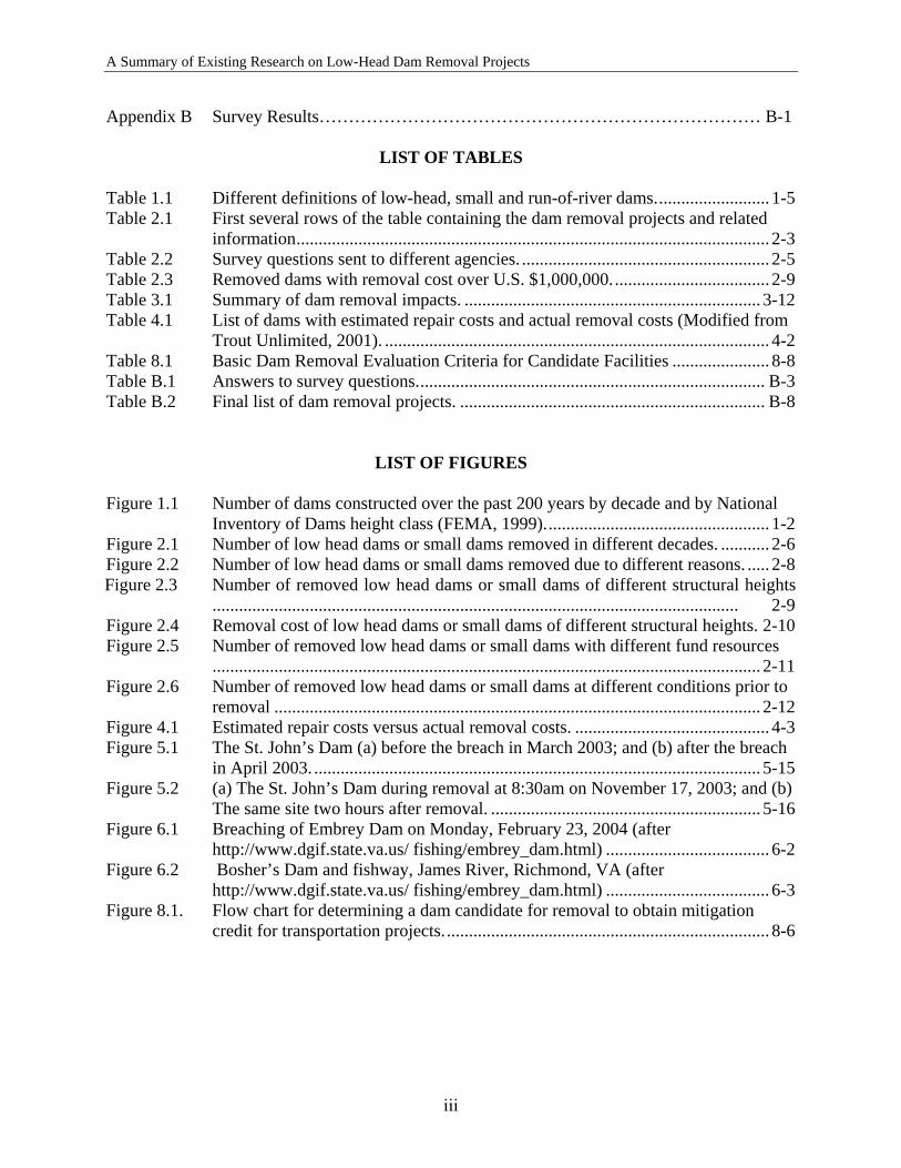
The purpose of a dam is to impound (store) water, wastewater or liquid borne materials for various reasons (e.g., flood control, human water supply, irrigation, livestock water supply, energy generation, containment of mine tailings, navigation, recreation, or pollution control [ASDSO, 2005]). Over the past 200 years, thousands of dams were built in the United States to fulfill one or more of the above functions (see Figure 1.1). Dams are a vital part of the national infrastructure, providing a life-sustaining resource to people in all regions of the United States. As part of the national infrastructure, dams are equal in importance to bridges, roads, airports, or other major elements of the infrastructure (ASDSO, 2005). However, the planned life expectancy of many dams is commonly around 50 years (Trout Unlimited, 2001), and many existing dams can no longer serve their intended purpose because of poor condition or changes in societal needs since their construction. Although many dams are no longer in use, they continue to exist in rivers and creeks and may block the movement of fish and other aquatic species, degrade water quality, and alter the flow of sediment and nutrients critical for stream health. Dams in a state of disrepair can also create safety hazards to downstream communities if they fail and to boaters and canoeists who sometimes go over them and get caught in dangerous currents. The deterioration of some aging dams, coupled with safety and environmental concerns, has led to the removal of many of them (American Rivers, 2002). During the past decade, dam removal has emerged as a major environmental management issue. Recently, several state transportation agencies have been negotiating with federal and state regulatory agencies regarding the use of low-head dam removal projects as a method of stream restoration to receive stream mitigation credit. Removal of unneeded dams is often promoted under the assumption that dam removal will be inherently beneficial because the dam presence is detrimental to aquatic ecosystems. For example, Bednarek’s (2001) examination of the ecological impacts of dam removal was based primarily on a review of the ecological impacts of dams, extrapolated to generate predictions of how dam removal would reverse these effects. While dam removal can benefit many components of local ecosystems, removing a dam may also cause detrimental impacts. For example, sediment released following a dam removal may be harmful to many downstream flora and fauna. Whether such detrimental impacts will be temporary phenomena, or whether they will be significant perturbations to already highly altered ecosystems is an issue deserving of increased attention and consideration among researchers, practitioners and regulators. Therefore, one must consider that dam removal might “fail,” i.e., be contrary or inefficient with regard to particular goals, such as environmental restoration. Although many dams have been removed in the United States, very few published environmental impact studies accompanied the removals. The lack of studies documenting the actual impacts of dam removal makes it necessary to produce a document that outlines and summarizes the
1-1
A Summary of Existing Research on Low-Head Dam Removal Projects
benefits and impacts associated with dam removal, including the effects on water quality, aquatic biology, and physical stream characteristics. The removal of some dams can be straightforward and inexpensive. But for many dams, it is difficult and time-consuming to evaluate and implement the removal option because removing a dam can result in different economic, ecological, and societal impacts, both beneficial and adverse. Although several guidance documents on decision-making related to dam removal are available, they were produced by different agencies for their specific goals, and none are directly related to stream restoration and mitigation credits relevant to transportation agencies. The current research project, “A Study of Existing Research on Low-Head Dam Removal Projects,” culminated in this document, which provides transportation departments, regulatory agencies, resource agencies, and the public a tool to help assess the value of low-head dam removal projects as a stream restoration and mitigation option. The research relies on a multitude of outreach activities (e.g., literature reviews and surveys) to obtain needed information on dam removal projects; and employs experts in ecological, environmental, geotechnical, and hydraulic engineering to ensure that critical issues, diverse perspectives, and innovative responses are identified to result in a technically robust final document. Figure 1.1 Number of dams constructed over the past 200 years by decade and by National Inventory of Dams height class (FEMA, 1999). The most active period of dam building occurred between 1950 and 1970, and has been called "the golden age of dam building."
1-2
A Summary of Existing Research on Low-Head Dam Removal Projects
1.2 LOW-HEAD, SMALL AND RUN-OF-RIVER DAMS
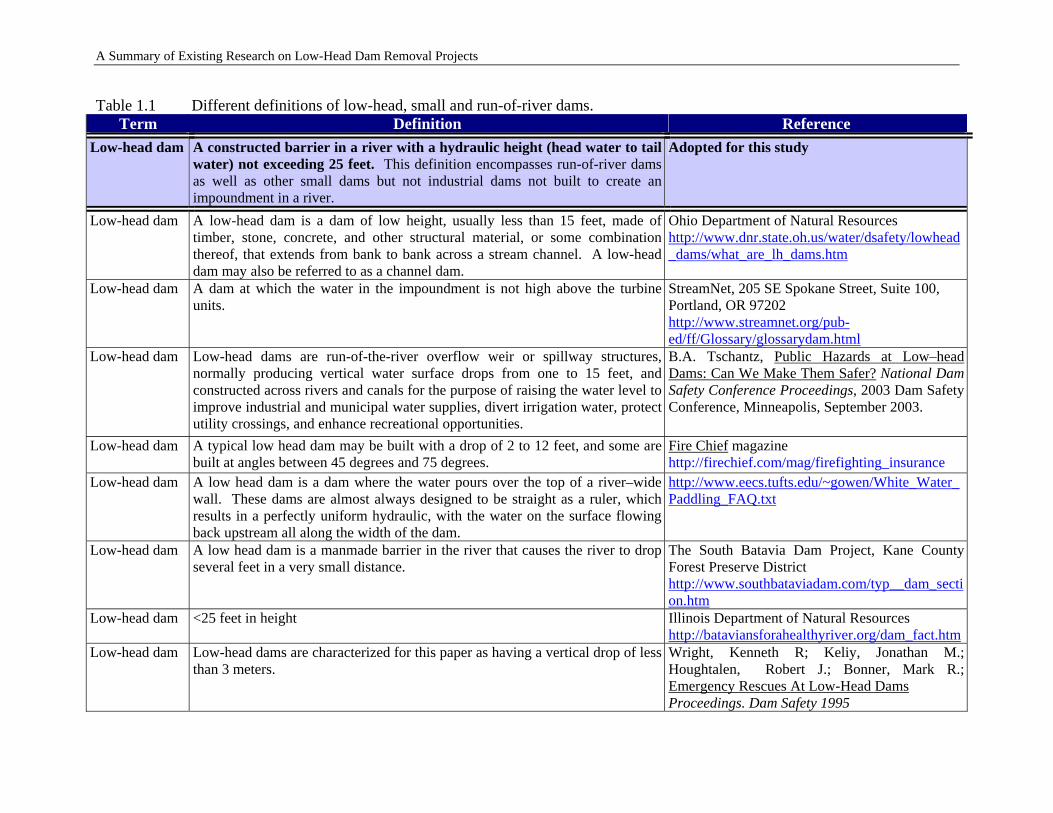
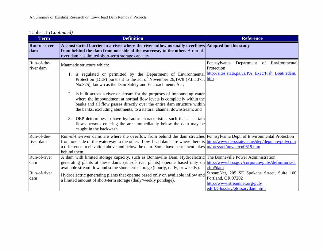
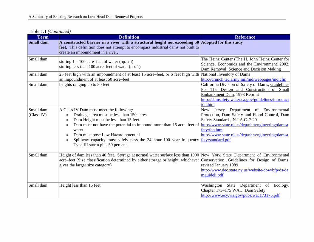
A universal specification defining low-head, small, or run-of-river dams does not exist. Table 1.1 lists different definitions of low-head, small, or run-of-river dams. For this study, the following definitions are adopted: Low-head dam: A constructed barrier in a river with a hydraulic height (head water to tail water) not exceeding 25 feet. This definition encompasses run-of-river dams as well as other small dams but not industrial dams not built to create an impoundment in a river. Run-of-river dam: A constructed barrier in a river where the river inflow normally overflows from behind the dam from one side of the waterway to the other. A run-of-river dam has limited short-term storage capacity. Small dam: A constructed barrier in a river with a structural height not exceeding 50 feet. This definition does not attempt to encompass industrial dams not built to create an impoundment in a river. The vast majority of removals to date have been of small, privately-owned structures (Heinz Center, 2002). Large dams store a disproportionately large amount of water and sediment and often have profound effects on riverine ecosystems at both local and watershed scales; but in most cases, they still serve their original, or at least modified, purposes. The time and cost to remove a large dam are substantial (Wik, 1995), and removal may cause unanticipated environmental damage with uncertain long-term benefits. In contrast to their larger counterparts, smaller dams are typically older, frequently no longer serve their original purpose, have deteriorated, and may have impoundments filled with sediment. Although they store only small volumes of water and sediment, they may impose other ecological impacts on rivers, including blocking migration routes and impounding unique habitats. Removal of these structures is often a cost-effective alternative to repair and maintenance; recent studies show removals of small dams can have limited negative environmental impacts while restoring riverine functions (Kanehl et al., 1997; Stanley et al., 2002). Most dams removed to date in the United States have been small, and this trend is likely to continue. Issues surrounding small dam removals are thus the most critical focus for new science and policy. This study will focus on removal of low-head or small run-of-river dams.
1.3 REPORT CONTENTS
This report contains ten chapters and two appendices starting with this initial Chapter 1 that provides a brief introduction to the background of this research project, defines the low-head and small run-of-rivers dams considered, and describes the various topics covered in this report.
1-3
A Summary of Existing Research on Low-Head Dam Removal Projects
1-4
Chapter 2 presents a brief review of the available data on dam removal projects, the survey conducted for this study in order to bridge the data gaps, and the analysis of the survey results and the final dam removal project database constructed for this project. A case study is also presented to show the benefits of a dam removal and how a state Department of Transportation (DOT) obtained remediation credits by sponsoring the dam removal. Removal of low-head dams has different impacts, both beneficial and adverse, including physical, chemical, ecological, social, and economical impacts. These impacts are discussed in Chapter 3. Chapter 4 discusses the various costs and benefits associated with dam removal, which include the costs and benefits to the dam owner, and the societal, recreational, and environmental costs and benefits. The challenges for economic analysis of dam removals are also briefly discussed. In Chapter 5, the legal and regulatory requirements of dam removal projects are described. This chapter also discusses the primary and secondary criteria for determining the mitigation credit for dam removal. Partial dam removal and/or diversion/bypass structures have also been used for stream restoration, recognizing that complete removal of dams may not always be the best option for a river system. Chapter 6 presents examples of partial dam removal projects and discusses the specific issues related to partial dam removal. Monitoring is necessary to measure the performance of dam removal projects. Chapter 7 discusses the importance of monitoring and describes who should do the monitoring and what should be monitored. The applicable monitoring techniques for low-head dam removal projects are also presented. Chapter 8 briefly reviews and evaluates the existing guidance documents on decision-making related to dam removal. Based on the review and evaluation, a simple method is proposed for ranking and identifying the candidates of dams that can be removed so that stream remediation credits can be obtained for transportation projects. The scientific research on the effects of dam removal is still in its initial stages, and elaborate theories and practices on the subject are not yet developed. Although more than 600 dams have been removed in the United States in the past decades, very few published investigations accompanied the removals. Chapter 9 lists the topics (environmental, economical, social, etc.) associated with low-head dam removal that are in need of additional research and study. Finally, the conclusions of this research project are presented in Chapter 10.
A Summary of Existing Research on Low-Head Dam Removal Projects
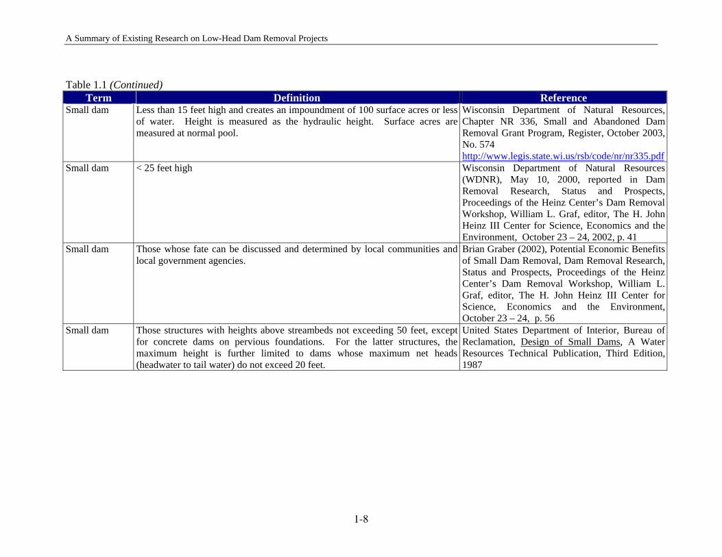
Table 1.1 Different definitions of low-head, small and run-of-river dams. Term Definition Reference
Low-head dam A constructed barrier in a river with a hydraulic height (head water to tail water) not exceeding 25 feet. This definition encompasses run-of-river dams as well as other small dams but not industrial dams not built to create an impoundment in a river.
Adopted for this study
Low-head dam A low-head dam is a dam of low height, usually less than 15 feet, made of timber, stone, concrete, and other structural material, or some combination thereof, that extends from bank to bank across a stream channel. A low-head dam may also be referred to as a channel dam.
Ohio Department of Natural Resources http://www.dnr.state.oh.us/water/dsafety/lowhead_dams/what_are_lh_dams.htm
Low-head dam A dam at which the water in the impoundment is not high above the turbine units.
StreamNet, 205 SE Spokane Street, Suite 100, Portland, OR 97202 http://www.streamnet.org/pub-ed/ff/Glossary/glossarydam.html
Low-head dam Low-head dams are run-of-the-river overflow weir or spillway structures, normally producing vertical water surface drops from one to 15 feet, and constructed across rivers and canals for the purpose of raising the water level to improve industrial and municipal water supplies, divert irrigation water, protect utility crossings, and enhance recreational opportunities.
B.A. Tschantz, Public Hazards at Low–head Dams: Can We Make Them Safer? National Dam Safety Conference Proceedings, 2003 Dam Safety Conference, Minneapolis, September 2003.
Low-head dam A typical low head dam may be built with a drop of 2 to 12 feet, and some are built at angles between 45 degrees and 75 degrees.
Fire Chief magazine http://firechief.com/mag/firefighting_insurance
Low-head dam A low head dam is a dam where the water pours over the top of a river–wide wall. These dams are almost always designed to be straight as a ruler, which results in a perfectly uniform hydraulic, with the water on the surface flowing back upstream all along the width of the dam.
http://www.eecs.tufts.edu/~gowen/White_Water_Paddling_FAQ.txt
Low-head dam A low head dam is a manmade barrier in the river that causes the river to drop several feet in a very small distance.
The South Batavia Dam Project, Kane County Forest Preserve District http://www.southbataviadam.com/typ__dam_section.htm
Low-head dam <25 feet in height
Illinois Department of Natural Resources http://bataviansforahealthyriver.org/dam_fact.htm
Low-head dam Low-head dams are characterized for this paper as having a vertical drop of less than 3 meters.
Wright, Kenneth R; Keliy, Jonathan M.; Houghtalen, Robert J.; Bonner, Mark R.; Emergency Rescues At Low-Head Dams Proceedings. Dam Safety 1995
1-5
A Summary of Existing Research on Low-Head Dam Removal Projects
Table 1.1 (Continued) Term Definition Reference
Run-of-river dam
A constructed barrier in a river where the river inflow normally overflows from behind the dam from one side of the waterway to the other. A run-of-river dam has limited short-term storage capacity.
Adopted for this study
Run-of-the-river dam
Manmade structure which:
1. is regulated or permitted by the Department of Environmental Protection (DEP) pursuant to the act of November 26,1978 (P.L.1375, No.325), known as the Dam Safety and Encroachments Act;
2. is built across a river or stream for the purposes of impounding water where the impoundment at normal flow levels is completely within the banks and all flow passes directly over the entire dam structure within the banks, excluding abutments, to a natural channel downstream; and
3. DEP determines to have hydraulic characteristics such that at certain flows persons entering the area immediately below the dam may be caught in the backwash.
Pennsylvania Department of Environmental Protection http://sites.state.pa.us/PA_Exec/Fish_Boat/rrdam.htm
Run-of-the-river dam
Run-of-the-river dams are where the overflow from behind the dam stretches from one side of the waterway to the other. Low–head dams are where there is a difference in elevation above and below the dam. Some have permanent lakes behind them.
Pennsylvania Dept. of Environmental Protection http://www.dep.state.pa.us/dep/deputate/polycomm/pressrel/novak/cn0619.htm
Run-of-river dam
A dam with limited storage capacity, such as Bonneville Dam. Hydroelectric generating plants at these dams (run-of-river plants) operate based only on available stream flow and some short-term storage (hourly, daily, or weekly).
The Bonneville Power Administration http://www.bpa.gov/corporate/pubs/definitions/d.cfm#dam
Run-of-river dam
Hydroelectric generating plants that operate based only on available inflow and a limited amount of short-term storage (daily/weekly pondage).
StreamNet, 205 SE Spokane Street, Suite 100, Portland, OR 97202 http://www.streamnet.org/pub-ed/ff/Glossary/glossarydam.html
1-6
A Summary of Existing Research on Low-Head Dam Removal Projects
Table 1.1 (Continued) Term Definition Reference
Small dam A constructed barrier in a river with a structural height not exceeding 50 feet. This definition does not attempt to encompass industrial dams not built to create an impoundment in a river.
Adopted for this study
Small dam storing 1 – 100 acre–feet of water (pp. xii) storing less than 100 acre–feet of water (pp. 1)
The Heinz Center (The H. John Heinz Center for Science, Economics and the Environment),2002, Dam Removal: Science and Decision Making
Small dam 25 feet high with an impoundment of at least 15 acre–feet, or 6 feet high with an impoundment of at least 50 acre–feet
National Inventory of Dams http://crunch.tec.army.mil/nid/webpages/nid.cfm
Small dam heights ranging up to 50 feet California Division of Safety of Dams, Guidelines For The Design and Construction of Small Embankment Dam, 1993 Reprint http://damsafety.water.ca.gov/guidelines/introduction.htm
Small dam (Class IV)
A Class IV Dam must meet the following: • Drainage area must be less than 150 acres. • Dam Height must be less than 15 feet. • Dam must not have the potential to impound more than 15 acre–feet of
water. • Dam must pose Low Hazard potential. • Spillway capacity must safely pass the 24–hour 100–year frequency
Type III storm plus 50 percent
New Jersey Department of Environmental Protection, Dam Safety and Flood Control, Dam Safety Standards, N.J.A.C. 7:20http://www.state.nj.us/dep/nhr/engineering/damsafety/faq.htmhttp://www.state.nj.us/dep/nhr/engineering/damsafety/standard.pdf
Small dam Height of dam less than 40 feet. Storage at normal water surface less than 1000 acre–feet (Size classification determined by either storage or height, whichever gives the larger size category)
New York State Department of Environmental Conservation, Guidelines for Design of Dams, revised January 1989 http://www.dec.state.ny.us/website/dow/bfp/ds/damguideli.pdf
Small dam Height less than 15 feet Washington State Department of Ecology, Chapter 173–175 WAC, Dam Safety http://www.ecy.wa.gov/pubs/wac173175.pdf
1-7
ary of Existing Research on Low-Head Dam Removal Projects
1-8
Table 1.1 (Continued)
Term Definition Reference Small dam Less than 15 feet high and creates an impoundment of 100 surface acres or less
of water. Height is measured as the hydraulic height. Surface acres are measured at normal pool.
Wisconsin Department of Natural Resources, Chapter NR 336, Small and Abandoned Dam Removal Grant Program, Register, October 2003, No. 574 http://www.legis.state.wi.us/rsb/code/nr/nr335.pdf
Small dam < 25 feet high Wisconsin Department of Natural Resources (WDNR), May 10, 2000, reported in Dam Removal Research, Status and Prospects, Proceedings of the Heinz Center’s Dam Removal Workshop, William L. Graf, editor, The H. John Heinz III Center for Science, Economics and the Environment, October 23 – 24, 2002, p. 41
Small dam Those whose fate can be discussed and determined by local communities and local government agencies.
Brian Graber (2002), Potential Economic Benefits of Small Dam Removal, Dam Removal Research, Status and Prospects, Proceedings of the Heinz Center’s Dam Removal Workshop, William L. Graf, editor, The H. John Heinz III Center for Science, Economics and the Environment, October 23 – 24, p. 56
Small dam Those structures with heights above streambeds not exceeding 50 feet, except for concrete dams on pervious foundations. For the latter structures, the maximum height is further limited to dams whose maximum net heads (headwater to tail water) do not exceed 20 feet.
United States Department of Interior, Bureau of Reclamation, Design of Small Dams, A Water Resources Technical Publication, Third Edition, 1987
A Summ
A Summary of Existing Research on Low-Head Dam Removal Projects
2 SUMMARY OF DAM REMOVAL PROJECTS
To obtain the information on dam removal practices, a database containing dam removal projects has been developed. The following describes the process for developing the database and the results of the data analysis.
2.1 AVAILABLE DATA
American Rivers, Inc. (1999) produced a database containing dam removal projects up to 1999, which served as the starting point for developing the database used in this investigation. The American Rivers database, however, contains only very brief information and has several limitations including:
• No distinction between dams that were completely removed and those breached; • No information on the cost of dam removal; • No information on the type of dams removed; and • Dam removal projects are only up to 1999.
In order to construct a more comprehensive and more detailed dam removal database, we expanded the American Rivers database by
• adding other dams removed up to 1999 but not included in the American Rivers database;
• adding new dams removed after 1999; and • including more information available for each dam removal project.
We obtained the new information on dam removals by conducting a literature review, including web searches. We also received existing dam removal project databases from Ms. Elizabeth Maclin of American Rivers, Inc. and Professor Molly Pohl-Costello of San Diego State University. We listed the dam removal projects that we could find in a Microsoft Excel table. For each project, we listed the available data as well as unavailable information that we would like to obtain. Table 2.1 shows the first several rows of this table. Because much important information is missing, we conducted a survey in order to bridge the data gaps. The details of the survey are presented in the next section.
2-1
A Summary of Existing Research on Low-Head Dam Removal Projects
2-2
2.2 SURVEY FOR THIS STUDY
The purposes of the survey are:
• To identify additional dam removal projects; • To bridge data gaps for known dam removal projects; and • To learn about the current dam removal practices from different agencies.
In order to maximize the response rate and receive useful information, it is important to define simple and clear survey questions and determine the right agencies to which the questions would be sent. After finishing the literature review, we conducted a brain-storming meeting to discuss the survey questions and the agencies to which the questions would be sent. Besides filling the data gaps for each dam removal project (as shown in Table 2.1), we also prepared survey questions specifically related to this research project as shown in Table 2.2. The answers to these questions would provide state-of-the-art information on current dam removal practices. We prepared a list of contacts, including more than 100 individual from different agencies such as:
• State DOTs • Association of State Dam Safety Officials • State Departments of Environment and Natural Resources • State Department of Water Resources • State Environmental Protection Agencies (EPA) • U.S. Environmental Protection Agency (USEPA) – Regional offices • U. S. Army Corps of Engineers (USACE) – District offices
These agencies provide a representative sample of the organizations involved in dam removals. The preparation of the recipient list proved to be a major effort since most organizations did not have updated lists of individuals in the target positions (e.g., state CWA 401 and 404 representatives). To make it convenient for the person contacted to fill the data gaps for each dam project and answer the survey questions, we decided to send out the survey via email. The email cover letter and a list of entities that were contacted are included in Appendix A. In total we sent the survey to 169 individuals and received 50 responses (a 30% response rate, after sending two “tickler messages”). Among the respondents, 21 (42%) provided new data and 29 (48%) provided no new information.

A Summary of Existing Research on Low-Head Dam Removal Projects
Table 2.1 First several rows of the table containing the dam removal projects and related information
State Dam RiverRemoval
Date
Total Removal Cost in US$
(Engineering, Permitting,
Deconstruction, etc.)
Removal Cost in US$
(deconstruction cost only)
How was removal funded?
Indicate whether dam was removed (total removal) or breached
(partial removal)
Dam Maximum Structural Height (ft)
Dam Hydraulic
Height (ft)
Dam Length
(ft)
Reservoir Volume (acre-ft) Owner
Date Built Type of Dam
State Hazard Classification
Who regulates dam
Run–of–river dam?
(Yes or No)
Original purpose of dam
Most recent use of dam and reservoir
AK Unnamed Dam Allison Creek
2004 6 30 1970 Gravel Stream Gauging
AK Davidson Ditch Diversion Dam
Chatanika River
2002 1920s Concrete butress
AK Switzer One Dam
Switzer Creek (trib.)
1988 15
AK Switzer Two Dam
Switzer Creek (trib.)
1988 15
Dam ID Removal Information Dam Characteristics
Condition of dam prior to removal
Did dam meet applicable safety
requirements
PrimaryRemoval Reason
Other (secondary)Removal Reasons Benefits
CWA 404 Permit
or 401 Certification
Stream Mitigation
Credit assigned? (Yes or No)
Study after Removal? (Yes or
No). Please provide reference
in comments column.
Contact Information (please include e-mail address) Additional information or comments
No longer in service; Block fish passage
Restore creek's ecological integrity by restoring free movement of fish and other aquatic organisms
Meagan Boltwood, Anchorage Waterways Council, (907) 743-1052, [email protected].
Severely damaged Open upstream habitat to fisheries;Increase recreational opportunities
Mike Roy, U.S. Fish and Wildlife Service, (907) 786-3825, [email protected]
Supplementary InformationRemoval Details
2-3

ary of Existing Research on Low-Head Dam Removal Projects
2-4
This page is intentionally left blank.
A Summ

A Summary of Existing Research on Low-Head Dam Removal Projects
T able 2.2 Survey questions sent to different agencies.
# Survey Questions Responses 1 The worksheet "Database for Your Input" lists the dam
removal projects we have collected. However, we were unable to find much information. If you have information to bridge these knowledge gaps, please fill in as many blank or partially completed cells as possible, particularly for those projects with your name in column "AC." For ease of navigation, the projects have been sorted by state.
2 If you can, please add any other dam removal projects not listed on the sheet. Even partial information that could help us track down the information will help.
Please write your responses on the work sheet "Database for Your Input." If you do not have documentation for numerical answers but can estimate the magnitude, please follow your estimate with an asterisk (*).
3 What federal, state and local permits/approvals are required to conduct the dam removals which you have participated in? Please provide citations for applicable laws, statutes, regulations and/or codes, where possible.
4 Have you used or do you know any regulatory guidelines specifically applicable to dam removal projects? If so, please cite.
5 How do you or your organization define low-headdams?
Your organization's definition: Your own personal definition:
6 Do you know of any dam removal projects that have qualified for stream mitigation credits to transportation agencies? If so, please provide project name and contact information. (Note: Stream Mitigation Credit refers to credits assigned to project owners to compensate for adverse impacts to the stream due to new construction.)
7 Does your organization have technical guidance documents regarding which dams are good candidates for removal? If so, please provide reference(s).
8 How does your organization handle the issue of land ownership for previously inundated lands that become accessible after the removal of the reservoir? Please provide references to any guidance documents.
Notes: The worksheet "Database for Your Input" is in the format of Table 2.1 and contains the dam removal projects we could found before sending the survey.
2-5
A Summary of Existing Research on Low-Head Dam Removal Projects
2.3 DATA ANALYSIS
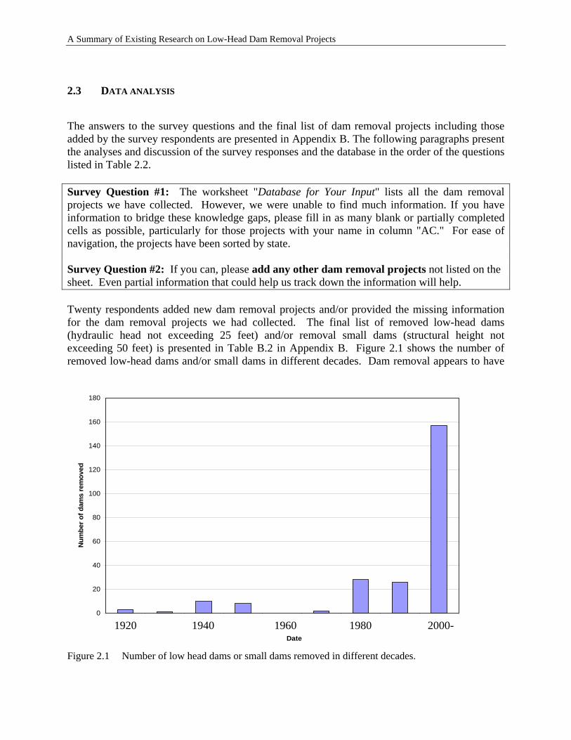
The answers to the survey questions and the final list of dam removal projects including those added by the survey respondents are presented in Appendix B. The following paragraphs present the analyses and discussion of the survey responses and the database in the order of the questions listed in Table 2.2. Survey Question #1: The worksheet "Database for Your Input" lists all the dam removal projects we have collected. However, we were unable to find much information. If you have information to bridge these knowledge gaps, please fill in as many blank or partially completed cells as possible, particularly for those projects with your name in column "AC." For ease of navigation, the projects have been sorted by state. Survey Question #2: If you can, please add any other dam removal projects not listed on the sheet. Even partial information that could help us track down the information will help. Twenty respondents added new dam removal projects and/or provided the missing information for the dam removal projects we had collected. The final list of removed low-head dams (hydraulic head not exceeding 25 feet) and/or removal small dams (structural height not exceeding 50 feet) is presented in Table B.2 in Appendix B. Figure 2.1 shows the number of removed low-head dams and/or small dams in different decades. Dam removal appears to have
1920 1940 1960 1980 2000-0
20
40
60
80
100
120
140
160
180
Date
Num
ber o
f dam
s re
mov
ed
Figure 2.1 Number of low head dams or small dams removed in different decades.
2-6
A Summary of Existing Research on Low-Head Dam Removal Projects
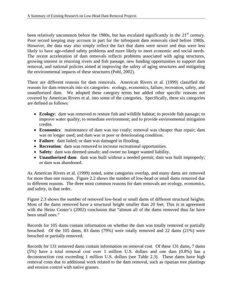
been relatively uncommon before the 1980s, but has escalated significantly in the 21st century. Poor record keeping may account in part for the infrequent dam removals cited before 1980s. However, the data may also simply reflect the fact that dams were newer and thus were less likely to have age-related safety problems and more likely to meet economic and social needs. The recent acceleration of dam removals reflects problems associated with aging structures, growing interest in restoring rivers and fish passage, new funding opportunities to support dam removal, and national policies aimed at improving the safety of aging structures and mitigating the environmental impacts of these structures (Pohl, 2002). There are different reasons for dam removals. American Rivers et al. (1999) classified the reasons for dam removals into six categories: ecology, economics, failure, recreation, safety, and unauthorized dam. We adopted these category terms but added other specific reasons not covered by American Rivers et al. into some of the categories. Specifically, these six categories are defined as follows:
• Ecology: dam was removed to restore fish and wildlife habitat; to provide fish passage; to improve water quality; to remediate environment; and to provide environmental mitigation credits.
• Economics: maintenance of dam was too costly; removal was cheaper than repair; dam was no longer used; and dam was in poor or deteriorating condition.
• Failure: dam failed; or dam was damaged in flooding. • Recreation: dam was removed to increase recreational opportunities. • Safety: dam was deemed unsafe; and owner no longer wanted liability. • Unauthorized dam: dam was built without a needed permit; dam was built improperly;
or dam was abandoned.
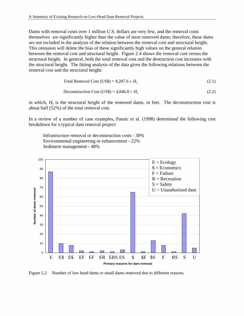
As American Rivers et al. (1999) noted, some categories overlap, and many dams are removed for more than one reason. Figure 2.2 shows the number of low-head or small dams removed due to different reasons. The three most common reasons for dam removals are ecology, economics, and safety, in that order. Figure 2.3 shows the number of removed low-head or small dams of different structural heights. Most of the dams removed have a structural height smaller than 20 feet. This is in agreement with the Heinz Center’s (2002) conclusion that “almost all of the dams removed thus far have been small ones.” Records for 105 dams contain information on whether the dam was totally removed or partially breached. Of the 105 dams, 83 dams (79%) were totally removed and 22 dams (21%) were breached or partially removed. Records for 131 removed dams contain information on removal cost. Of these 131 dams, 7 dams (5%) have a total removal cost over 1 million U.S. dollars and one dam (0.8%) has a deconstruction cost exceeding 1 million U.S. dollars (see Table 2.3). These dams have high removal costs due to additional work related to the dam removal, such as riparian tree plantings and erosion control with native grasses.
2-7
A Summary of Existing Research on Low-Head Dam Removal Projects
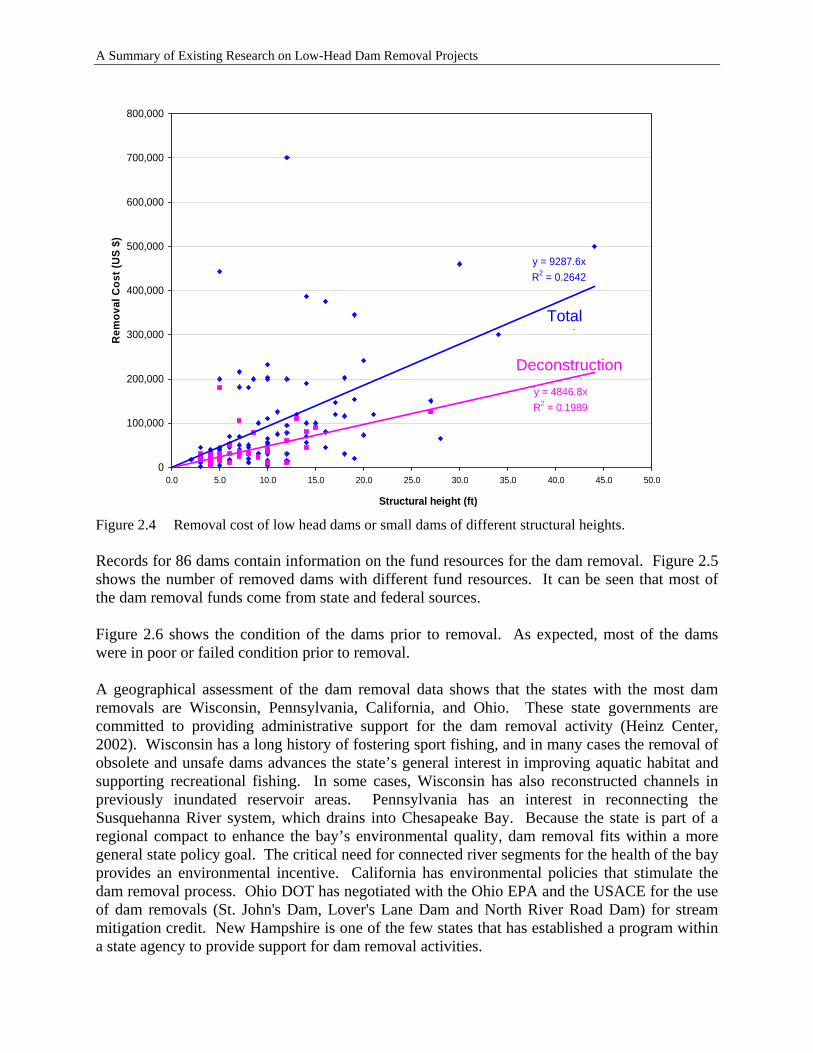
Dams with removal costs over 1 million U.S. dollars are very few, and the removal costs themselves are significantly higher than the value of most removed dams; therefore, these dams are not included in the analysis of the relation between the removal cost and structural height. This omission will delete the bias of these significantly high values on the general relation between the removal cost and structural height. Figure 2.4 shows the removal cost versus the structural height. In general, both the total removal cost and the destruction cost increases with the structural height. The fitting analysis of the data gives the following relations between the removal cost and the structural height:
Total Removal Cost (US$) = 9,287.6 × Hs (2.1)
Deconstruction Cost (US$) = 4,846.8 × Hs (2.2) in which, Hs is the structural height of the removed dams, in feet. The deconstruction cost is about half (52%) of the total removal cost. In a review of a number of case examples, Pansic et al. (1998) determined the following cost breakdown for a typical dam removal project:
Infrastructure removal or deconstruction costs - 30% Environmental engineering or enhancement - 22% Sediment management - 48%
0
10
20
30
40
50
60
70
80
90
100
Primary reasons for dam removal
Num
ber o
f dam
s re
mov
ed
U
E = Ecology $ = Economics F = Failure R = Recreation S = Safety U = Unauthorized dam
S $ESE$ E$ RS $F F$SEF EREF ERSE
Figure 2.2 Number of low head dams or small dams removed due to different reasons.
2-8
A Summary of Existing Research on Low-Head Dam Removal Projects
0
10
20
30
40
50
60
70
80
Structural height (ft)
Num
ber o
f dam
s re
mov
ed
≤ 5.0 5.1-10.0 10.1-15.0 15.1-20.0 20.1-25.0 25.1-30.0 30.1-35.0 35.1-40.0 40.1-45.0
Figure 2.3 Number of removed low head dams or small dams of different structural heights. T able 2.3 Removed dams with removal cost over U.S. $1,000,000.
State Dam River Removal Date
Total Removal Cost in US$
(Engineering, Permitting,
Deconstruction, etc.)
Removal Cost in US$
(deconstruction cost only)
CA McPherrin Dam
Butte Creek 1998 9,500,000
ME Smelt Hill Presumpscot River
2002 1,017,000 311,000
ME Edwards Dam Kennebec River
1999 2,100,000
MI Newaygo Dam Muskegon River
1969 1,300,000
NY Cuddebackville Dam
Neversink River
2004 2,200,000 1,400,000
OR Jackson Street Dam
Bear Creek 1998 1,200,000
WA Goldsborough Creek Dam
Goldsborough Creek
2001 4,800,000
2-9
A Summary of Existing Research on Low-Head Dam Removal Projects
y = 9287.6xR2 = 0.2642
y = 4846.8xR2 = 0.1989
0
100,000
200,000
300,000
400,000
500,000
600,000
700,000
800,000
0.0 5.0 10.0 15.0 20.0 25.0 30.0 35.0 40.0 45.0 50.0
Structural height (ft)
Rem
oval
Cos
t (U
S $)
Total t
Deconstruction t
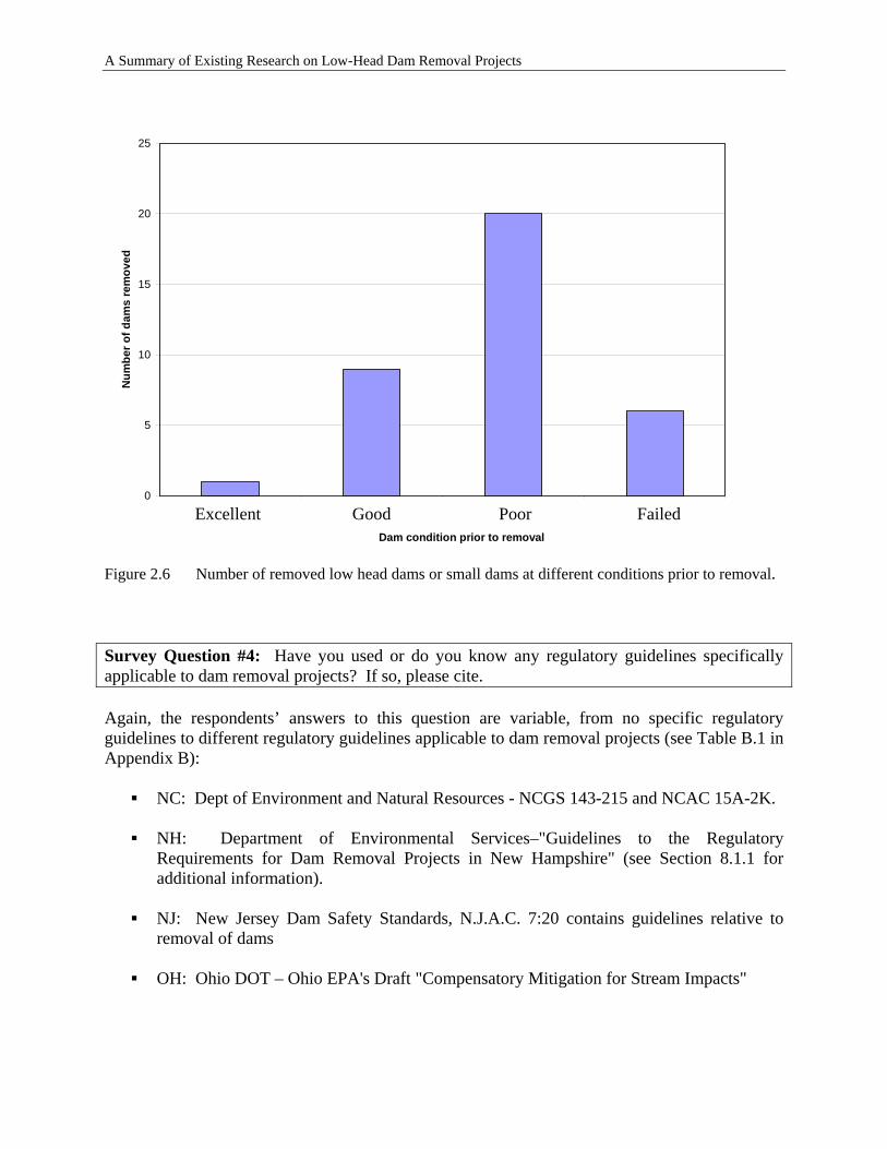
Figure 2.4 Removal cost of low head dams or small dams of different structural heights. Records for 86 dams contain information on the fund resources for the dam removal. Figure 2.5 shows the number of removed dams with different fund resources. It can be seen that most of the dam removal funds come from state and federal sources. Figure 2.6 shows the condition of the dams prior to removal. As expected, most of the dams were in poor or failed condition prior to removal. A geographical assessment of the dam removal data shows that the states with the most dam removals are Wisconsin, Pennsylvania, California, and Ohio. These state governments are committed to providing administrative support for the dam removal activity (Heinz Center, 2002). Wisconsin has a long history of fostering sport fishing, and in many cases the removal of obsolete and unsafe dams advances the state’s general interest in improving aquatic habitat and supporting recreational fishing. In some cases, Wisconsin has also reconstructed channels in previously inundated reservoir areas. Pennsylvania has an interest in reconnecting the Susquehanna River system, which drains into Chesapeake Bay. Because the state is part of a regional compact to enhance the bay’s environmental quality, dam removal fits within a more general state policy goal. The critical need for connected river segments for the health of the bay provides an environmental incentive. California has environmental policies that stimulate the dam removal process. Ohio DOT has negotiated with the Ohio EPA and the USACE for the use of dam removals (St. John's Dam, Lover's Lane Dam and North River Road Dam) for stream mitigation credit. New Hampshire is one of the few states that has established a program within a state agency to provide support for dam removal activities.
2-10
A Summary of Existing Research on Low-Head Dam Removal Projects
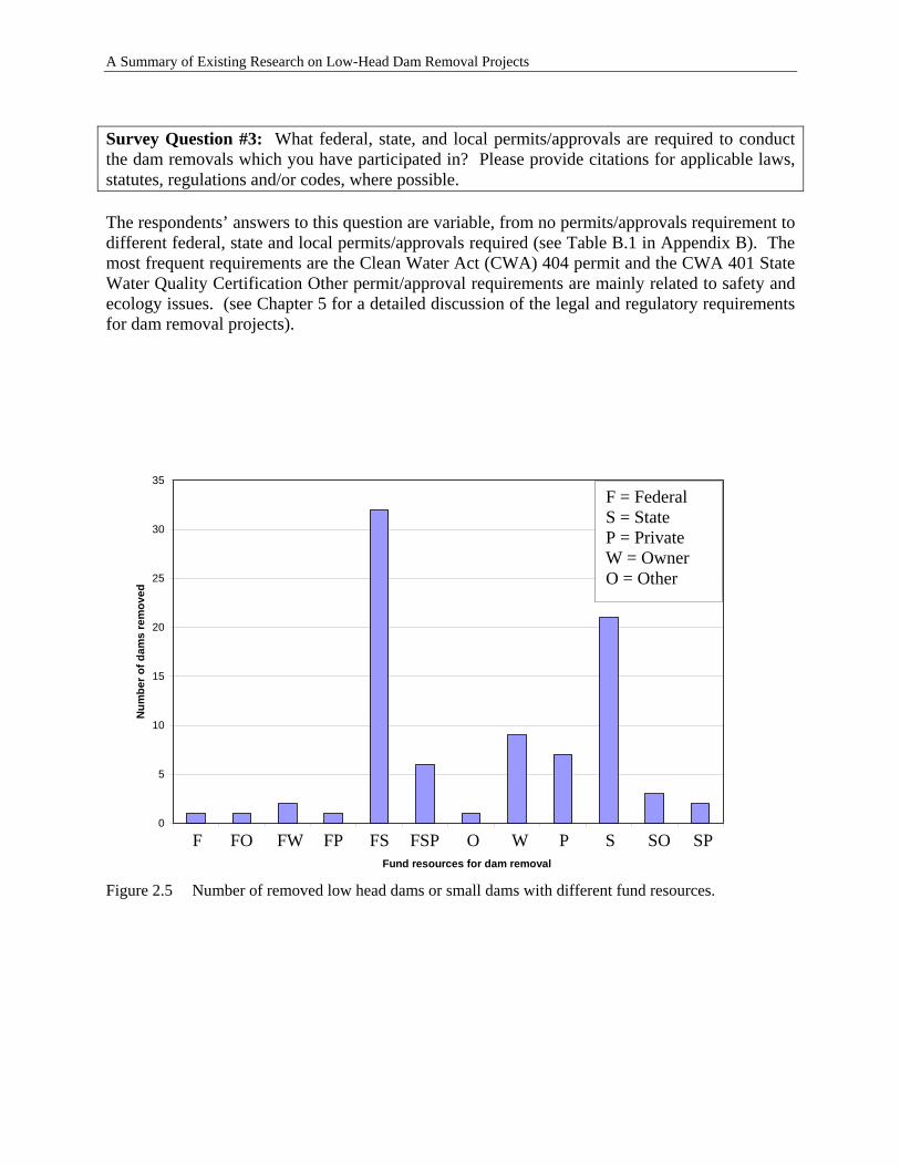
Survey Question #3: What federal, state, and local permits/approvals are required to conduct the dam removals which you have participated in? Please provide citations for applicable laws, statutes, regulations and/or codes, where possible. The respondents’ answers to this question are variable, from no permits/approvals requirement to different federal, state and local permits/approvals required (see Table B.1 in Appendix B). The most frequent requirements are the Clean Water Act (CWA) 404 permit and the CWA 401 State Water Quality Certification Other permit/approval requirements are mainly related to safety and ecology issues. (see Chapter 5 for a detailed discussion of the legal and regulatory requirements for dam removal projects).
0
5
10
15
20
25
30
35
Fund resources for dam removal
Num
ber o
f dam
s re
mov
ed
F FO FW FP FS FSP O W P S SO SP
F = Federal S = State P = Private W = Owner O = Other
Figure 2.5 Number of removed low head dams or small dams with different fund resources.
2-11
A Summary of Existing Research on Low-Head Dam Removal Projects
0
5
10
15
20
25
Dam condition prior to removal
Num
ber o
f dam
s re
mov
ed
Excellent Poor Good Failed
Figure 2.6 Number of removed low head dams or small dams at different conditions prior to removal. Survey Question #4: Have you used or do you know any regulatory guidelines specifically applicable to dam removal projects? If so, please cite. Again, the respondents’ answers to this question are variable, from no specific regulatory guidelines to different regulatory guidelines applicable to dam removal projects (see Table B.1 in Appendix B):
NC: Dept of Environment and Natural Resources - NCGS 143-215 and NCAC 15A-2K.
NH: Department of Environmental Services–"Guidelines to the Regulatory Requirements for Dam Removal Projects in New Hampshire" (see Section 8.1.1 for additional information).
NJ: New Jersey Dam Safety Standards, N.J.A.C. 7:20 contains guidelines relative to
removal of dams
OH: Ohio DOT – Ohio EPA's Draft "Compensatory Mitigation for Stream Impacts"
2-12
A Summary of Existing Research on Low-Head Dam Removal Projects
Survey Question #5: How do you or your organization define low-head dams? Many of the respondents’ organizations do not define low-head dams. As expected, the respondents’ definitions or classifications of low-head dams are variable and are within the range covered in Table 1.1. Survey Question #6: Do you know of any dam removal projects that have qualified for stream mitigation credits to transportation agencies? If so, please provide project name and contact information. (Note: Stream Mitigation Credit refers to credits assigned to project owners to compensate for adverse impacts to the stream due to new construction.) Only the two respondents from NH and OH provided the information on dam removal projects in planning or that have been conducted for stream mitigation credits:
• NH: Two dam removal projects, currently in the planning process, may be conducted to offset impacts associated with the filling wetlands for an airport expansion.
• OH: Ohio DOT has negotiated with the Ohio EPA and USACE for the use of dam
removals for stream mitigation credit. They are the St. John's Dam (see Case Study in Section 5.4.3), Lover's Lane Dam, and North River Road Dam.
While not indicated in their survey response, additional contact was initiated with a NC agency based on prior knowledge of potential mitigation projects. Three dam removal projects for the purpose of obtaining stream mitigation credit are currently under review; however, the feasibility of the projects has not been finalized. Survey Question #7: Does your organization have technical guidance documents regarding which dams are good candidates for removal? If so, please provide reference(s). Most of the respondents’ organizations do not have technical guidance documents for making removal decisions. However, the respondents of NH, OH, and PA provided information on their technical guidance documents:
• NH Department of Environmental Services - "Guidelines for Prioritizing Dam Removal Projects in New Hampshire" was developed in response to numerous requests for agency assistance in planning and conducting dam removal projects. These guidelines are completely distinct from the regulatory permit review process. The document provides a method for agencies to determine which proposed dam removal projects represent the most effective use of limited agency resources (see Section 8.1.1 for additional information).
• Ohio DOT – The Ohio DOT works closely with the OH Department of Natural
Resources (ODNR) to establish those dams that should be removed.
2-13
A Summary of Existing Research on Low-Head Dam Removal Projects
• Pennsylvania Fish And Boat Commission - Project Selection Protocol and Guidelines for Pennsylvania Fish And Boat Commission Consultation and Grant Program for Fish Passage and Habitat Restoration
Survey Question #8: How does your organization handle the issue of land ownership for previously inundated lands that become accessible after the removal of the reservoir? Please provide references to any guidance documents. Many of the respondents have not yet addressed or fully considered this issue. However, the ownership of land exposed through dam removal typically requires site-specific investigation. In addition, a variety of state-specific laws may apply to determining ownership of lands exposed through dam removal. Land ownership questions can typically be answered by referring to the deeds for the specific dam property and the adjacent properties. The dam's deed might include all of the land that was flooded and the exposed land would revert to the dam owner. Some dam owners have donated these lands to land trusts or quit-claim deeded them to adjacent land owners or municipalities. In other cases, the land currently underwater may be publicly owned, or it may simply revert to the property owners bordering the restored river (NHDES, 2005).
2.4 PROBLEMS WITH CURRENT DAM REMOVAL DATA
It is noted that the information on most of the removed dams is incomplete. Although Table B.2 contains information on more than 600 dams, most of the entries lack one or more types of information. The incomplete information may be due to the following reasons (Pohl, 2002):
• No one organization or agency has formal responsibility for collecting and compiling these data at the national level. Much of the information on dam removals is found piecemeal through various local, state, and federal agencies and organizations that have responsibility for (or interest in) dams, water, and environmental quality. These agencies or organizations may just report dam removal information limited to their own interest.
• In past decades, dam removal was not a major issue, and the investigations, if conducted, are not readily available.
2-14
A Summary of Existing Research on Low-Head Dam Removal Projects
3 DAM REMOVAL IMPACTS
3.1 PHYSICAL AND CHEMICAL IMPACTS
Potential impacts of low-head dam removal on river morphology, flooding, sedimentation and sediment transport, and erosion are discussed. Although low-head dams typically function as run-of-river systems with commensurate, minimal effects on the riverine hydrologic regime, their presence and subsequent removal can affect a variety of other riverine processes. These potential effects should therefore be evaluated when planning and implementing the removal of a low-head dam.
3.1.1 River Hydrology
Hydrologic effects of low-head dam removal will depend on factors including the size of the upstream impoundment, the impoundment’s effect on groundwater recharge to the formally-impounded area, and the geometry and operational regime of outlet appurtenances. Where low-head dams function as run-of-river systems, dam removal should have minimal effects on the riverine hydrologic regime except for the restoration of riverine conditions in formally-impounded and backwatered areas. Where low-level outlet appurtenances in a low-head dam provide for gradual drawing-down of an impoundment during periods of low flow, removal may affect downstream flows. This condition is quantifiable, however, and may be evaluated in planning for dam removal. Impacts to groundwater recharge may result from the increased hydraulic gradient (i.e., slope) following dam removal and drawdown of the formally-impounded areas. Potential changes in groundwater recharge will be site-specific and dependent on factors including the magnitude of the drawdown and substrate conditions.
3.1.2 River Morphology
Effects of dam removal on river morphology will vary depending on site-specific parameters, including the quantity and composition of impounded sediments and the rate of sediment erosion and transport. Specific parameters associated with river morphology include stream channel hydrogeometry and slope, hydrology, and the duration of time in which the dam impounded water and sediments. Changes associated with these parameters can be correlated to the effect of the dam on 1) changes in the downstream hydrologic regime and 2) trapping of sediments in the impoundment and changes in the delivery of sediments to the river downstream of the dam. By definition, low-head dams have minimal effects on downstream hydrologic regimes, and therefore hydrologic effects of low-head dam removal on river morphology will not be discussed.
3-1
A Summary of Existing Research on Low-Head Dam Removal Projects
A fundamental problem in the evaluation of potential geomorphic effects resulting from dam removal is that most of the available information on fluvial response is based on the regime concept. This concept implies that a river channel system is in a state of dynamic, or “quasi”, equilibrium (Chang, 1998). Potential morphological effects resulting from dam removal may occur over transient time scales characteristic, however, thereby violating the dynamic equilibrium basis of regime concepts such as Lane’s relationship or the process-response relationships developed by Schumm (Chang, 1998). Due to the lack of information on transient responses, the following discussion is based on regime concepts, and the reader must therefore consider the applicability of this information on a project-specific basis. Morphologic effects associated with the construction of a dam, and therefore also associated with the removal of dam, can be discrete by location such as 1) the reach of river upstream of an impoundment, 2) within an impoundment, and 3) downstream of a dam. A potential morphological effect associated with the construction of a dam is streambed aggradation upstream of the impoundment (Morris and Fann, 1998). Removal of a downstream dam can reverse this process but may not necessarily result in the river reestablishing itself within the original channel. Possible remedial actions in this case may include mechanized restoration of the original stream channel, including the removal or redistribution of sediment deposit. Morphological effects within the impoundment as a result of dam removal may be similar to morphological effects upstream of the impoundment (Morris and Fann, 1998). To a large extent, this is dependent on the quantity, composition, and distribution of the deposited materials, particularly in relation to the river channel that is reestablished post-dam removal. If sedimentation within an impoundment is minimal, morphological change resulting from dam removal is likely to be similarly minimal. If a large volume of sediment is present, however, there is the potential for increased morphological change, and, depending on the composition of the native substrates relative to the sediments, the possibility that the channel could reestablish in a location other than the preexisting stream channel. For this case, reconstruction of the preexisting river channel within the formally impounded area may be desirable. Morphological changes can occur downstream of a dam (Chang, 1998), and the removal of a dam and restoration of sediment continuity may therefore also effect the downstream morphology. The time scale associated with the presence of the dam may be an important characteristic affecting potential downstream changes in river morphology following dam removal. As previously discussed, a transient (i.e., short and non-equilibrium) response may require judgment in the application of regime concepts. In cases where there has not been substantial sedimentation upstream of a dam, affects on river morphology may be minimal, as it can be assumed that dynamic equilibrium of the riverine system was not affected. Over longer time scales and/or in cases where large amounts of sediment have been and continue to be trapped upstream of a dam, the lack of sediment replenishment downstream of the dam may result in channel degradation and incising, as well as erosion and slumping of stream banks. While removal of the dam in this case could replenish the sediment deficit downstream, rapid erosion of previously-impounded sediments could result in changes to channel morphology. In cases where an impoundment has experienced substantial sedimentation and sediment continuity to the downstream channel has been restored through dam removal, the potential exists for increased effects on river morphology (Morris and Fann, 1998), as the downstream channel may
3-2
A Summary of Existing Research on Low-Head Dam Removal Projects
not have sufficient sediment transport capacity. For this case, removal of sediments within the impounded area should be considered as a means to control downstream morphological effects associated with dam removal.
3.1.3 Flooding
Effects on flooding associated with the removal of a low-head dam include direct effects associated with changes in riverine hydrology and indirect effects related to potential changes in river morphology. Because low-head dams typically function as run-of-river systems and therefore do not provide a flood control function, deleterious effects of low-head dam removal on flooding will likely be minimal, with potential benefits achieved through the reduction in flood elevations upstream of the dam. In cases where a dam is in disrepair, the removal of the dam can eliminate the risk of uncontrolled releases of water and sediment resulting from a dam failure event. Indirect effects of low-head dam removal associated with changes in river morphology can result in increased flood elevations, and should be considered in the determination of appropriate sediment management options when considering dam removal. Within a formally impounded area, removal of a low-head dam will typically result in reduced flooding due to the loss of backwater effects associated with the presence of the dam. Increased flooding could occur downstream of a dam following removal if the volume of released sediment exceeds the river channel’s conveyance capacity resulting in aggradation of downstream channel (Morris and Fann, 1998). The potential for this condition should therefore be evaluated when substantial sedimentation has occurred upstream of a dam being considered for removal.
3.1.4 Sediment Transport
The effect of dam removal on sediment transport can be correlated to the changes in sediment transport associated with the presence of a given dam. In cases where minimal sedimentation upstream of a dam has occurred, removal of the dam should have a similarly minimal impact on sediment transport. This condition might occur where a dam has been in place for only a short period of time and/or when sediment transport through the impoundment has not been significantly altered by the presence of a dam. Conversely, dam removal may have increased effects on sediment transport where substantial sedimentation has occurred upstream of a dam, particularly if sedimentation has substantially changed the pre-dam hydrogeometry within the impounded area. Sedimentation upstream of a dam typically results from decreased capacity for sediment transport due to backwater effects and decreased flow velocities, causing sediment to drop out of the water column. Factors affecting the quantity of material that may accumulate in an impoundment include the sediment delivery into the impounded area, the period over which sediments were impounded, sediment composition (i.e., grain size), and the hydrogeometry of the impounded area. Removal of a dam can restore the pre-dam hydraulic gradient and sediment transport capacity upstream of the dam. Depending on the volume and composition of the sediment, spatially uniform remobilization of sediment may occur, as the river channel gradually reestablishes itself through the formally
3-3
A Summary of Existing Research on Low-Head Dam Removal Projects
impounded area. If the volume of sediment is sufficient, however, removal of the dam may not immediately restore the upstream hydraulic gradient. In this case, remobilization of sediments may occur through head-cutting, with the cut progressing upstream. The period of time required for a head cut to reach equilibrium is determined by several factors including, but not limited to, sediment composition, channel-forming flow events, high-flow events, physical characteristics of the channel (e.g., ledge), presence of infrastructure (e.g., pipeline), and whether river channel aggradation has occurred upstream of the impoundment. Potential impacts associated with quantity and quality of impounded sediment should be considered as part of the planning and implementation of a dam removal project. This is particularly important when there is a history of industrial or agricultural use in the watershed upstream of the impoundment. Mitigation of deleterious impacts resulting from the remobilization or previously-impounded sediments may be required. Potential remedial measures may include full or partial removal of impounded materials, staged removal of a dam to control sediment remobilization, and/or stabilizing sediment exposed through dam removal. A critical component in the evaluation of sediment management strategies for dam removal planning and implementation is sediment quality (Morris and Fann, 1998). This evaluation should extend to both “clean” and contaminated sediments. Clean sediments are considered natural and indigenous materials, including organic detritus and inorganic materials (e.g., sand). In some cases, such as with organic materials, the release of these materials can adversely affect downstream water quality. Contaminated sediments are assumed to include compounds such as industrial wastes. While the release of contaminated sediments from an impoundment would not necessarily increase their overall quantity within the riverine system, it can increase their bioavailability and result in more diffuse concentrations, confounding the future feasibility of remediation, if necessary. The proper assessment of sediment quality is impoundment-specific. For impoundments with sediment deposits that are shallow, surficial or “grab” sampling of sediment may be appropriate. Where sediment deposits are relatively deep and there are historic or current upstream contaminant sources, sampling of sediment depths to point of refusal (e.g., core sampling) may be required. Target contaminants should be assessed based on state and federal requirements, along with local and historical knowledge of potential upstream contaminant sources.
3.1.5 Erosion
The affect of dam removal on erosion is closely related to sedimentation and sediment transport capacity. As previously discussed, removal of a dam can result in remobilization of previously impounded sediments. Erosion of “native” materials can also occur following dam removal due to 1) increased flow speeds in the formally backwatered area, 2) realignment of the upstream river channel and 3) changes in the flow patterns immediately downstream of a former dam. Potential means to control erosion during and after dam removal include controlling upstream flow speeds, installing grade control structures/systems, reconstructing the upstream channel to be stable and self-maintaining, and stabilizing areas where erosion may occur. These methods may be applied in a complementary manner, with features such as grade control structures (including partial breaching of a dam) and realigning the river channel to reduce reach-length
3-4
A Summary of Existing Research on Low-Head Dam Removal Projects
slopes and flow speeds. A gradual drawdown of the impounded area can be used to foster the growth of stabilizing vegetation before a return to full riverine conditions and minimize sloughing of sediments associated with rapid dewatering. Sediment stabilization can be accomplished using a variety of methods, including traditional, engineering-based methods, such as riprap armoring, as well as the installation of riparian vegetation and/or bio-engineering systems. Applicable methods are typically determined on a project-specific basis due to factors associated with the risk of soil and sediment erosion. At sites where contaminated soils or sediments may be left in place following dam removal, for instance, applied methods should have well documented performance capabilities.
3.1.6 Wetlands
Impacts to wetlands can occur upstream and downstream of dam removal. Because low-head dams typically function as run-of-river systems and do not substantially alter the downstream surface water hydrology, this assessment assumes no hydrologic impact to downstream wetlands resulting from a dam removal project. Dewatering of an impoundment upstream of a dam following its removal may affect wetlands due to changes in surface water and groundwater hydrology. These effects may occur on a seasonal and/or long-term basis, depending on factors including changes in flood stage associated with dam removal and changes in groundwater elevations resulting from the loss of the impoundment. Dam removal can impact downstream wetlands due to factors including the restoration of sediment continuity within the riverine system, and in specific cases, changes in groundwater hydrology adjacent to a dam. If a dam removal results in downstream sediment deposition, colonization by wetland plants may result in the creation of wetlands. Where an impoundment has resulted in increased groundwater levels, lateral seepage around a dam can provide hydrology sufficient for the formation of wetlands in the vicinity of a dam. A drawdown in groundwater levels resulting from the removal of a dam in this case could result in the loss of sufficient hydrology for maintaining the wetland. Dam removal can cause a variety of impacts to wetlands that are adjacent to impounded rivers as well as those occurring downstream of the dam. The type and magnitude of impact is largely site specific. Vegetation at the interface between a water body and surrounding uplands is primarily structured by the hydrologic gradient (Shafroth et al, 2002). The duration, frequency, and timing of inundation are variable along this gradient. Species tolerances and requirements produce zonation and patterns along the hydrologic gradient (Shafroth et al., 2002). The removal of a dam may alter the hydrological regime and therefore affect the hydrologic gradient within a former impoundment. Depending on site conditions, dam removal may expose land that was previously under water, resulting in a commensurate shift in the groundwater gradient towards the developing stream channel. This change in hydrology could result in mortality of vegetation along the margin of
3-5
A Summary of Existing Research on Low-Head Dam Removal Projects
the former impoundment, especially if it is sensitive to water table declines associated with the drawdown (Shafroth et al., 2002). The new location of the hydrologic gradient will depend on the topography and stage-discharge relations that develop within the former impoundment. These impacts commonly result from the change in the hydrologic gradient in the former impoundment and the transport of sediment to downstream riparian wetlands. Studies to remove the Rodman Dam in Florida stressed the need to restore natural flows, which serve to inundate terrestrial areas, such as riverine floodplains. The studies found that if the Rodman Dam is removed, riparian areas would likely flood more frequently, promoting riparian plant growth, revitalizing inland wetlands, and creating small ephemeral ponds that serve as nurseries for aquatic species (American Rivers, 2002; Kaufman, 1992). In some dam removal cases, the diversity of certain organisms that prefer deeper water wetlands may decline. Wet meadow grasses replaced species of cattail and sedge when the Fulton Dam on the Yahara River was removed in Wisconsin. Consequently, the duck and muskrat populations that relied upon cattail and sedge for habitat were negatively impacted by the dam’s removal.
3.1.7 Water Quality
Dams modify the hydrologic regime of a river. A result of this modification is increased retention time of carbon, nutrients (e.g., nitrogen, phosphorus), and sediments within the impounded area (Bushaw-Newton et al., 2002). As water and sediment moves through an impounded reach of river, a variety of biogeochemical reactions take place. These reactions often result in changed water quality conditions within the impounded area, and subsequently downstream of the dam, in comparison to water quality conditions found upstream of the impoundment (Bushaw-Newton, et al, 2002; Newbold, 1987; Mullholand, 1996; Martin et al. 2001). These reactions affect a variety of water quality parameters including, but not limited to, dissolved oxygen, dissolved nutrients, temperature, dissolved organic carbon, total suspended solids, biological oxygen demand, conductivity, and pH. Two of the key factors in determining these processes are the hydraulic residence time (volume/discharge) and the aerobic/anaerobic sediment/water interface (Hannon, 1979; Naiman and Melillo, 1984; Naiman et al., 1988; St Louis et al., 2000; Wetzel, 2001). The removal of a dam and subsequent return to lotic conditions decreases the hydraulic residence time. The extent of this decrease is specific to the physical characteristics of a particular site. The removal of similarly-sized dams can have different effects on water quality because of differences in their hydraulic residence time (Poff and Hart, 2002). Depending on the rates of various biological reactions (e.g., plant uptake, nitrification, denitrification) dam removal can cause a change in water quality conditions so that the upstream, former impoundment area and downstream areas are more similar (Bushaw-Newton et al. 2002). The lotic physical conditions that are re-established following removal of a dam can also affect water quality. For instance, emergence of vegetation in the riparian zone of the former impoundment may shade the stream channel, resulting in decreased water temperatures that experience minimal diurnal fluctuation. Another example is the re-emergence of formerly
3-6
A Summary of Existing Research on Low-Head Dam Removal Projects
impounded riffles or cascades that serve to aerate the water and increase dissolved oxygen concentrations. As described in published studies, the effect of dam removal on water quality varies due to physical characteristics of different river systems (Hart et al, 2002). For instance, a study of the Manatawny Creek Dam in Pennsylvania found that water quality did not change markedly following dam removal. Researchers conclude this is likely because the impoundment had a hydraulic residence time of less than two hours at base flow and infrequent temperature stratification (Bushaw-Newton et al. 2002). There was also no substantial accumulation of fine-grained, organically-rich sediment within the impoundment, which would contribute to many biological reactions. In contrast, Stanley and Doyle (2002) studied the effects of removing the Rockdale Dam on Koshkonong Creek in Wisconsin. This impoundment was dominated by fine-grained sediment. After removal there was a net export of phosphorus-rich sediment to downstream reaches (Stanley and Doyle, 2001) contributing to biological reactions that could adversely affect several water quality parameters. Relatively few scientific investigations have been completed and published on the effects of dam removal, highlighting the importance of gleaning information from other sources. State water quality assessments and resulting water body classifications can provide pertinent information about the impacts of dam removal. Before the Edwards Dam was removed from the Kennebec River in Maine, the impoundment behind the dam did not meet the minimum state water quality standards (i.e., class C). Following the removal of the dam, water quality notably improved, enough to reclassify the river segment as meeting the higher water quality standard of class B. A Total Maximum Daily Load (TMDL) study on the Cuyahoga River was conducted in 1999 by the Ohio EPA. The TMDL identified impaired water quality conditions in the impoundment of the Kent Dam. These impairments impeded the attainment of the water body’s state designation of warm water habitat. It was determined that if the City of Kent did not reduce or eliminate the impoundment, Ohio EPA would impose stringent effluent discharge limits on the municipal waste water treatment plant. The dam’s removal was completed in 2004. It features an innovative design that has transformed the dam into an aesthetic component of a new park while allowing the river to flow freely through the former lock structure (Oakland and Bolender, 2003). The free-flowing river in the former impoundment area has since been evaluated by the Ohio EPA and is now in compliance with state water quality standards (City of Kent, 2004).
3.2 ECOLOGICAL IMPACTS
3.2.1 Aquatic Habitats
Ecological impacts of dam removal to natural communities can be correlated with physical changes in habitat. Such changes may affect dependent flora and fauna due to changes or loss of habitat-specific functions and values. Specific impacts may affect physical and water quality parameters and occur over both short and long-term time scales. Changes in physical parameters affecting aquatic habitats may include the restoration of riverine continuity through formally
3-7
A Summary of Existing Research on Low-Head Dam Removal Projects
lotic habitat within the impounded reach of river. Changes in water quality parameters may include increased turbidity resulting from the mobilization of previously deposited sediments and changes in chemical interactions related to the loss of the upstream impoundment. Short-term impacts include the dewatering of the upstream impoundment immediately following dam removal. Long-term impacts may include succession of vegetation in terrestrial vegetation, mobilization of upstream sediments, and increased recruitment of migratory fish. Dam removal will likely alter the areal extent and composition of aquatic habitats. Changes in the extents of aquatic habitats can be quantified based on post-removal water levels. In some cases, the loss of aquatic habitat may be offset by the restoration of riverine continuity, particularly where opportunities for fish passage are limited or not present prior to dam removal. Changes in the composition of specific aquatic habitat types may result from dam removal, resulting in the partial or complete loss of specific habitats and connection of previously fragmented communities. However, the loss of lentic habitat that is absent elsewhere in the riverine system could include both species and ecological impacts to a variety of life stages. Sediment dynamics may affect the quantity and type of aquatic habitats upstream and downstream of a dam following removal. While a relatively rapid reversion from lotic to lentic habitat will typically occur following dewatering of an impoundment, ongoing mobilization of sediments can alter habitat parameters including substrate composition over longer time scales. Note that changes in substrate composition can occur upstream of an impoundment following dam removal. The former condition may occur where sediments have aggraded due to backwater effects and remobilize due to the diminished backwater effects. The latter condition may occur where a dam has restricted downstream sediment transport and dam removal has restored sediment continuity into the downstream reach. Ecological impacts resulting from changes in water quality following dam removal may result from factors including the reversion from lacustrine to riverine conditions and the mobilization of impoundment substrates. Riverine conditions may be less favorable to chemical processes, such as the decomposition of organic detritus under lacustrine conditions, affecting chemical processes though the water column and into underlying sediments. Ecological impacts associated with these changes will be dependent on the nature and extent of specific changes and ecological dependence of specific organisms. The restoration of riverine conditions can result in increased dissolved oxygen, particularly where hypoxia or anoxia occurs within an impoundment. The removal of a dam and elimination of conditions resulting in low dissolved oxygen can directly improve water quality and aquatic communities downstream of a dam, particularly if dam operations have resulted in the release of poor quality water. The duration of water quality impacts resulting from the reversion of lacustrine to riverine conditions will vary. Chemical processes associated with lacustrine conditions may no longer occur following dewatering of an impoundment. Increased turbidity resulting from the mobilization of impounded detritus and sediments will be dependent on the quantity of available material, and will likely diminish over time.
3-8
A Summary of Existing Research on Low-Head Dam Removal Projects
3.2.2 Vegetation
Low head dam removal can affect both aquatic and terrestrial vegetation. Potential affects can largely be correlated with changes in surface water and groundwater hydrology, particularly changes resulting from the loss of the hydraulic backwater following dam removal and exposure of previously inundated areas. In general, low head dam removal can result in increased habitat for terrestrial vegetation through the exposure of sediments within the former impoundment. The extent and type of terrestrial vegetation colonization and succession will depend on factors including hydrology, sediment composition, and the topography of exposed areas. Changes in hydrology can result in succession of palustrine forested and shrub/shrub wetland habitat to upland habitat. The extent of aquatic vegetation will typically decrease following dam removal due to decreased water surface elevations and, therefore, a decreased area of inundation. Depending upon flow characteristics, such as velocity and depth, restoration of riverine (i.e., lotic) habitat in previously backwatered areas typified by lacustrine habitat may occur following dam removal. Changes in surface water and groundwater hydrology may affect the type and extent of terrestrial vegetation following dam removal. Palustrine habitat may develop in areas experiencing temporary (i.e., annual) inundation following dam removal, with the establishment of forested wetlands and/or persistent emergent wetlands. This condition can foster revegetation by plant species requiring regular inundation for regeneration, such as cottonwoods (Populus sp.). Persistent and non-persistent emergent wetland habitat may form in areas that experience temporary inundation and have hydric soils. Factors affecting the duration and degree of saturation include soil composition and groundwater recharge. Low permeability soils combined with persistent groundwater discharge will typically result in wet conditions favorable to the formation of emergent wetland habitat, while more permeable soils may foster the growth of forested wetlands. A typical example of the latter condition is the establishment of cottonwoods on gravel bars throughout Rocky Mountains riverine systems. The topography of exposed areas will affect the extent of specific terrestrial vegetation habitats, with flatter areas providing increased opportunity for the formation of relatively homogeneous habitats. Such a condition may occur where sediment deposition has been relatively uniform upstream of a dam. The segregation of deposited sediments may also affect terrestrial revegetation, as coarser materials are more likely to aggrade in the upper reach of an impoundment. Consideration should be given to the likelihood of erosion and redistribution of soils and sediments following dam removal, however, when evaluating terrestrial and aquatic revegetation of sedimented material. The normal succession of terrestrial revegetation is the growth of herbaceous vegetation with subsequent colonization by shrubs and trees. Succession should be considered following dam removal, particularly where foliar coverage is desirable or vegetation is considered for stabilizing exposed sediments. Although viable natural seed stocks may be present in exposed materials or from existing adjacent vegetation stocks, planting of herbaceous seed and appropriate shrub and trees stock may be advantageous. The application of herbaceous seed and installation of plant stock represents a common approach to stabilizing exposed sediments and are typically components of bioengineering-based stabilization schemes.
3-9
A Summary of Existing Research on Low-Head Dam Removal Projects
The effects of dam removal on aquatic vegetation may include the loss of areas suitable for specific habitat types. Changes in habitat within the formally inundated area may include the alteration or loss of lacustrine, palustrine, or riverine habitats and the restoration of riverine habitat. The extents and types of changes will be highly site specific, and dependent on factors including the geometry of the formally impounded area, post-dam removal hydrology, and substrate composition. In general, existing littoral habitat may be reduced or eliminated following the restoration of riverine conditions. The control of invasive plants should be considered during planning for dam removal and may be a regulatory requirement for mitigation projects. A practical first step towards controlling colonization by terrestrial invasive plants in exposed areas is to apply herbaceous seed and eradicate adjacent invasive plant stock. Ongoing invasive plant control efforts may be required following initial work. Aquatic vegetation can be planted in inundated area as a means to inhibit colonization by invasive aquatic species, but can be problematic due to possible supply of parent material from stocks upstream of the project area.
3.3 SOCIAL IMPACTS
Dam removal can have different social impacts, both beneficial and adverse. While the ecological impacts of dam removal can be felt far upstream and downstream, the social impacts can range even further. The most directly affected people are often those in the community where the dam is located, including above or below the dam. A much broader community may have a stake in the resources and recreational opportunities associated with the river. This community may be regional, national, or even international (American Rivers and Trout Unlimited, 2002). Dam removal may have the social benefits of removing known safety hazards and eliminating the safety and liability costs are associated with dam failure, personal injury on or near the structure, or drowning. Dam removal may also lead to free-flowing rivers and provide new recreational and tourism opportunities, such as canoeing, swimming, and fishing. However, recreational opportunities related to the dam impounded may also be lost. For instance, anglers who prefer largemouth bass, sunfish, and other deeper-water species may also lose opportunities with dam removal. Since most dams that are under consideration for removal were constructed many years ago, they often have historical and cultural value to the local community. Communities that consider a dam to a tangible piece of their history or civic identity may feel a loss with dam removal. Removing a dam will bring aesthetic value related to the free-flowing river. The exposed land of the original impoundment area can also be transformed to a park and additional aesthetic value can be added. However, removing a dam will result in the loss of the aesthetic value of the impoundment. Community members that have riverfront property often express the concern that the loss of a dam and its impoundment will automatically reduce their property values. In truth, there is very
3-10
A Summary of Existing Research on Low-Head Dam Removal Projects
3-11
little factual information available on this issue to point either way. A study done on this issue over a ten-year period following a removal in Wisconsin shows that property values stayed the same following the removal, although there was a slight decline in property values of homes located several blocks from the impoundment because these residents lost their view. Dam removal may create upland for owners who abut the impoundment area, and the exposure of this land will have economic ramifications as well.
3.4 ECONOMIC IMPACTS
The removal of a dam can have a range of economic costs and benefits. The extent of these costs and benefits are highly site specific. Many factors will influence the economic impact of a particular dam’s removal. Decision-makers need to assess the operational costs and benefits of a dam. Long-term costs of operating and maintaining a dam and an impoundment (e.g., dredging, weed harvesting) should be compared to the one-time cost of removing the dam and the associated restoration activities. Removing a dam that provides a viable service, such as hydropower production, water storage, flood control or recreational uses may require replacement of that service, or may make dam removal infeasible. Dam removal can provide for new service opportunities, including improved water quality for water supply needs, river-based recreation, and revitalization of riverfront properties. Liability associated with public safety hazards and attractive nuisance should be considered when evaluating dam removal. These factors should be considered, particularly those relating to financial and legal responsibilities for risk reduction. Dam removal may also entail liability risk, and proper dam removal planning is critical to prevent or minimize impacts to infrastructure, riverfront properties and the environment. The environmental effects of dams and dam removal should also be considered in the context of economic impacts. For instance, dam removal may enable improvements to water quality that alleviate the need for costly upgrades to water and wastewater treatment facilities. Programs that focus on stocking of certain fish species may no longer be necessary if natural recruitment is enhanced through dam removal. Maintaining a dam may serve to prevent contaminated sediment from being transported downstream. Likewise, retaining a dam may prevent exotic, diseased or toxic species from accessing upstream aquatic habitats.
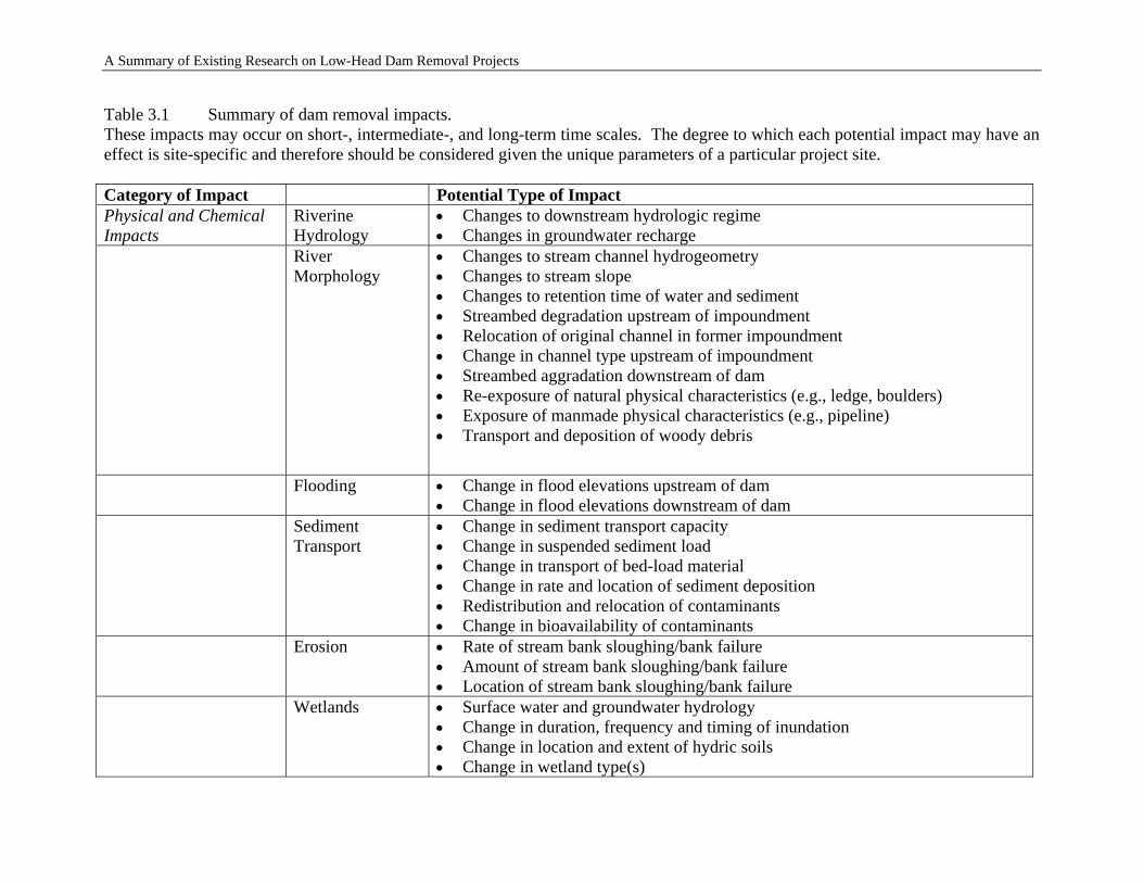
A Summary of Existing Research on Low-Head Dam Removal Projects
Table 3.1 Summary of dam removal impacts. These impacts may occur on short-, intermediate-, and long-term time scales. The degree to which each potential impact may have an effect is site-specific and therefore should be considered given the unique parameters of a particular project site. Category of Impact Potential Type of Impact Physical and Chemical Impacts
Riverine Hydrology
• Changes to downstream hydrologic regime • Changes in groundwater recharge
River Morphology
• Changes to stream channel hydrogeometry • Changes to stream slope • Changes to retention time of water and sediment • Streambed degradation upstream of impoundment • Relocation of original channel in former impoundment • Change in channel type upstream of impoundment • Streambed aggradation downstream of dam • Re-exposure of natural physical characteristics (e.g., ledge, boulders) • Exposure of manmade physical characteristics (e.g., pipeline) • Transport and deposition of woody debris
Flooding • Change in flood elevations upstream of dam • Change in flood elevations downstream of dam
Sediment Transport
• Change in sediment transport capacity • Change in suspended sediment load • Change in transport of bed-load material • Change in rate and location of sediment deposition • Redistribution and relocation of contaminants • Change in bioavailability of contaminants
Erosion • Rate of stream bank sloughing/bank failure • Amount of stream bank sloughing/bank failure • Location of stream bank sloughing/bank failure
Wetlands • Surface water and groundwater hydrology • Change in duration, frequency and timing of inundation • Change in location and extent of hydric soils • Change in wetland type(s)
3-12
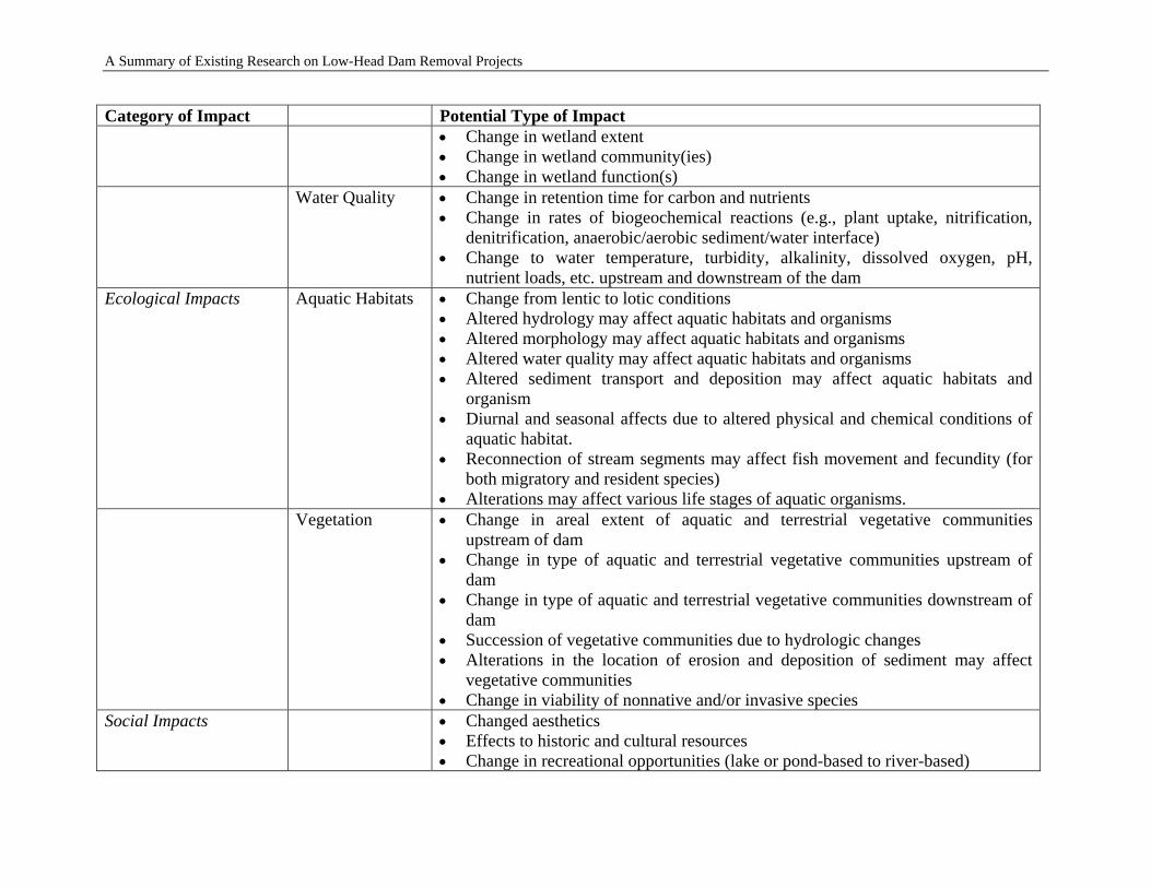
A Summary of Existing Research on Low-Head Dam Removal Projects
Category of Impact Potential Type of Impact • Change in wetland extent • Change in wetland community(ies) • Change in wetland function(s)
Water Quality • Change in retention time for carbon and nutrients • Change in rates of biogeochemical reactions (e.g., plant uptake, nitrification,
denitrification, anaerobic/aerobic sediment/water interface) • Change to water temperature, turbidity, alkalinity, dissolved oxygen, pH,
nutrient loads, etc. upstream and downstream of the dam Ecological Impacts Aquatic Habitats • Change from lentic to lotic conditions
• Altered hydrology may affect aquatic habitats and organisms • Altered morphology may affect aquatic habitats and organisms • Altered water quality may affect aquatic habitats and organisms • Altered sediment transport and deposition may affect aquatic habitats and
organism • Diurnal and seasonal affects due to altered physical and chemical conditions of
aquatic habitat. • Reconnection of stream segments may affect fish movement and fecundity (for
both migratory and resident species) • Alterations may affect various life stages of aquatic organisms.
Vegetation • Change in areal extent of aquatic and terrestrial vegetative communities upstream of dam
• Change in type of aquatic and terrestrial vegetative communities upstream of dam
• Change in type of aquatic and terrestrial vegetative communities downstream of dam
• Succession of vegetative communities due to hydrologic changes • Alterations in the location of erosion and deposition of sediment may affect
vegetative communities • Change in viability of nonnative and/or invasive species
Social Impacts • Changed aesthetics • Effects to historic and cultural resources • Change in recreational opportunities (lake or pond-based to river-based)
3-13
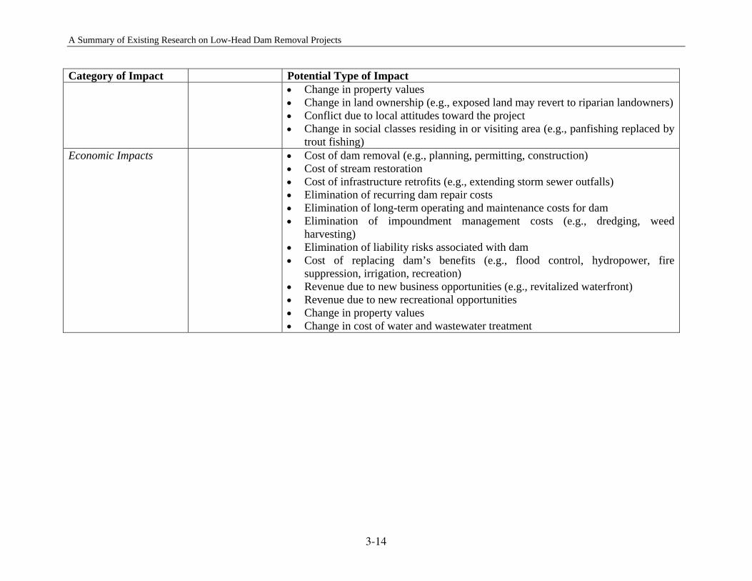
ary of Existing Research on Low-Head Dam Removal Projects
3-14
Category of Impact Potential Type of Impact • Change in property values • Change in land ownership (e.g., exposed land may revert to riparian landowners) • Conflict due to local attitudes toward the project • Change in social classes residing in or visiting area (e.g., panfishing replaced by
trout fishing) Economic Impacts • Cost of dam removal (e.g., planning, permitting, construction)
• Cost of stream restoration • Cost of infrastructure retrofits (e.g., extending storm sewer outfalls) • Elimination of recurring dam repair costs • Elimination of long-term operating and maintenance costs for dam • Elimination of impoundment management costs (e.g., dredging, weed
harvesting) • Elimination of liability risks associated with dam • Cost of replacing dam’s benefits (e.g., flood control, hydropower, fire
suppression, irrigation, recreation) • Revenue due to new business opportunities (e.g., revitalized waterfront) • Revenue due to new recreational opportunities • Change in property values • Change in cost of water and wastewater treatment
A Summ
A Summary of Existing Research on Low-Head Dam Removal Projects
4 COSTS AND BENEFITS ASSOCIATED WITH DAM REMOVALS
Removing dams can have distinct economic benefits such as cost savings over repairing and maintaining the dam, potential for community riverfront revitalization, increased income to local fishing and boating industries, and decreased costs related to water quality improvements and fisheries management. However, these dam removal benefits may come at a price as well, due to the loss of economic benefits from the dam. To determine the economic benefits of a dam removal, we have to consider different costs and benefits including the costs and benefits to the dam owner, the societal costs and benefits, the recreational costs and benefits, and the environmental costs and benefits.
4.1 DIRECT COST COMPARISON: REMOVAL VERSUS REPAIR
Dams are removed for different reasons, but many low-head or small dam removals are triggered by safety concerns. Once a dam no longer conforms to safety standards, a decision has to be made whether to repair or remove the dam by comparing the relative costs and benefits of the two choices. The direct costs for an actual dam, whether they are repair or removal costs, will be site-specific. The amount of repair needed is proportional to the size and the severity of deterioration the dam has experienced over its life. The goal of any repair activity is to make the appropriate repairs to comply with safety standards. These activities may include repairing the part of the dam that spans the river, fixing abutments on the banks, and many other items. A cost that must commonly be considered when repairing a dam is a fish-passage structure. Although not directly considered in the repair cost, operation and maintenance are important considerations when making a decision. The other associated costs with repairing a dam are the liability costs. The removal of a dam includes the removal of the dam itself and its appurtenant structures such as concrete wings that reach upstream, spillways, powerhouses, and raceways. Other possible costs are associated with sediment management, grading, vegetation, channel work, etc. In most cases, the cost of removing a small dam is significantly less than the cost of repairing it (Trout Unlimited, 2001). Born et al. (1998) found that in Wisconsin, small dam removals typically cost $100,000 to $1 million, which was 3 times less than the estimated cost of repair. In several cases, the repair cost estimates were more than 10 times removal costs. Table 4.1 lists the estimated repair costs and actual removal costs for a number of dams. Regression analysis (see Figure 4.1) shows that the average repair cost is about two times the average removal cost, which is in general agreement with the conclusion of Born et al. (1998).
4-1
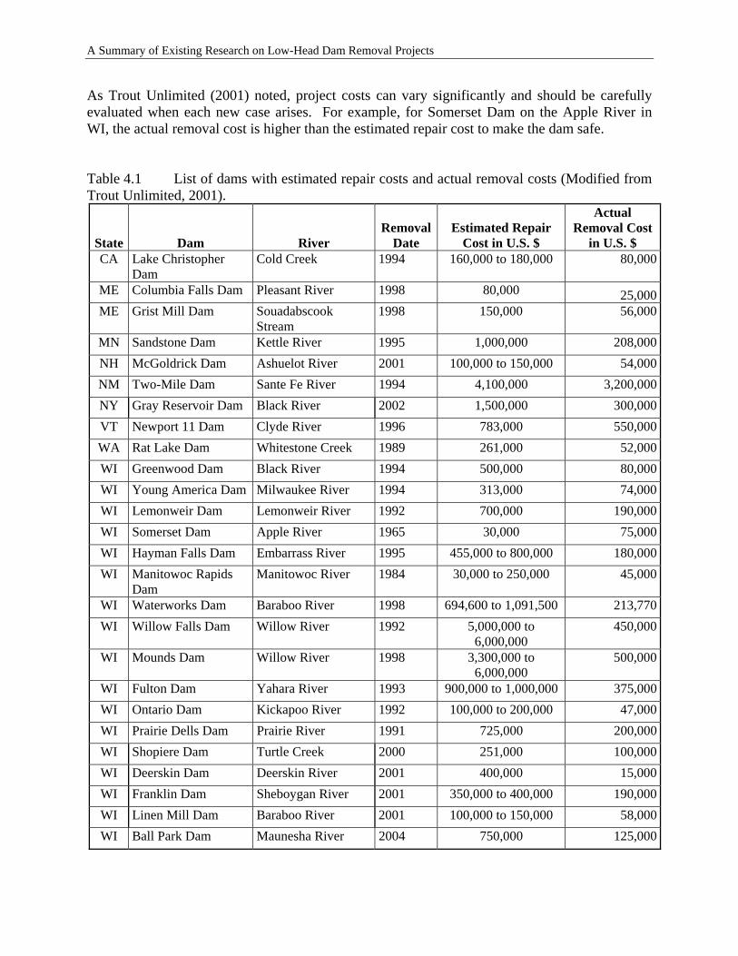
A Summary of Existing Research on Low-Head Dam Removal Projects
As Trout Unlimited (2001) noted, project costs can vary significantly and should be carefully evaluated when each new case arises. For example, for Somerset Dam on the Apple River in WI, the actual removal cost is higher than the estimated repair cost to make the dam safe. Table 4.1 List of dams with estimated repair costs and actual removal costs (Modified from Trout Unlimited, 2001).
State Dam River Removal
Date Estimated Repair
Cost in U.S. $
Actual Removal Cost
in U.S. $ CA Lake Christopher
Dam Cold Creek 1994 160,000 to 180,000 80,000
ME Columbia Falls Dam Pleasant River 1998 80,000 25,000ME Grist Mill Dam Souadabscook
Stream 1998 150,000 56,000
MN Sandstone Dam Kettle River 1995 1,000,000 208,000NH McGoldrick Dam Ashuelot River 2001 100,000 to 150,000 54,000NM Two-Mile Dam Sante Fe River 1994 4,100,000 3,200,000NY Gray Reservoir Dam Black River 2002 1,500,000 300,000VT Newport 11 Dam Clyde River 1996 783,000 550,000WA Rat Lake Dam Whitestone Creek 1989 261,000 52,000WI Greenwood Dam Black River 1994 500,000 80,000WI Young America Dam Milwaukee River 1994 313,000 74,000WI Lemonweir Dam Lemonweir River 1992 700,000 190,000WI Somerset Dam Apple River 1965 30,000 75,000WI Hayman Falls Dam Embarrass River 1995 455,000 to 800,000 180,000WI Manitowoc Rapids
Dam Manitowoc River 1984 30,000 to 250,000 45,000
WI Waterworks Dam Baraboo River 1998 694,600 to 1,091,500 213,770WI Willow Falls Dam Willow River 1992 5,000,000 to
6,000,000 450,000
WI Mounds Dam Willow River 1998 3,300,000 to 6,000,000
500,000
WI Fulton Dam Yahara River 1993 900,000 to 1,000,000 375,000WI Ontario Dam Kickapoo River 1992 100,000 to 200,000 47,000WI Prairie Dells Dam Prairie River 1991 725,000 200,000WI Shopiere Dam Turtle Creek 2000 251,000 100,000WI Deerskin Dam Deerskin River 2001 400,000 15,000WI Franklin Dam Sheboygan River 2001 350,000 to 400,000 190,000WI Linen Mill Dam Baraboo River 2001 100,000 to 150,000 58,000WI Ball Park Dam Maunesha River 2004 750,000 125,000
4-2
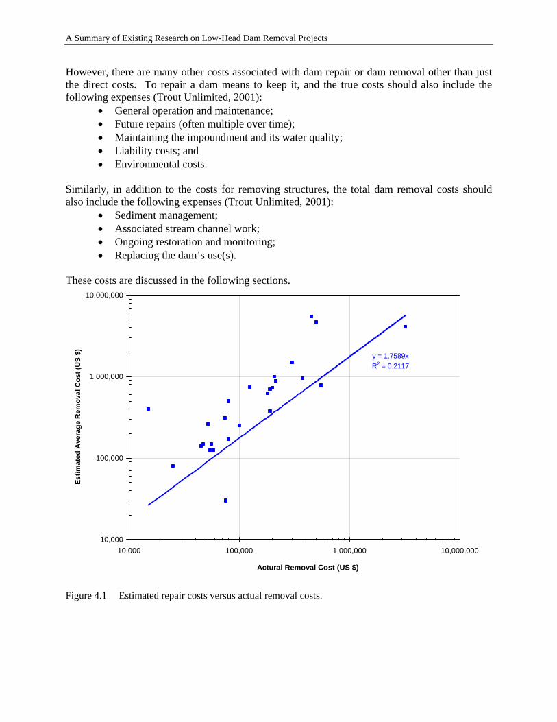
A Summary of Existing Research on Low-Head Dam Removal Projects
However, there are many other costs associated with dam repair or dam removal other than just the direct costs. To repair a dam means to keep it, and the true costs should also include the following expenses (Trout Unlimited, 2001):
• General operation and maintenance; • Future repairs (often multiple over time); • Maintaining the impoundment and its water quality; • Liability costs; and • Environmental costs.
Similarly, in addition to the costs for removing structures, the total dam removal costs should also include the following expenses (Trout Unlimited, 2001):
• Sediment management; • Associated stream channel work; • Ongoing restoration and monitoring; • Replacing the dam’s use(s).
These costs are discussed in the following sections.
y = 1.7589xR2 = 0.2117
10,000
100,000
1,000,000
10,000,000
10,000 100,000 1,000,000 10,000,000
Actural Removal Cost (US $)
Estim
ated
Ave
rage
Rem
oval
Cos
t (U
S $)
Figure 4.1 Estimated repair costs versus actual removal costs.
4-3
A Summary of Existing Research on Low-Head Dam Removal Projects
4.2 OPERATION AND MAINTENANCE COSTS
Operation and maintenance (O&M) are needed after a dam is repaired. The O&M costs vary greatly depending on the size and condition of the dam. For example, the O&M costs for the Ward Paper Mill Dam, Prairie River, WI is $20,000-$50,000 a year, while the O&M costs for the Waterworks Dam, Baraboo River, WI is about $203,900 a year (WRM, 2000). The O&M covers not only the dam itself but also the impoundment (e.g., dredging of the sediment). Dredging is expensive, with onetime costs ranging from $200,000 to $700,000 for a 30 to100-acre impoundment (Marshall, 1988). Moreover, dredging is not a permanent solution because it does not remove the source of the material filling the impoundment. Consequently, an impoundment that needs to be dredged will likely have to be dredged again. It should be noted that dam repair may not be a one-time event. To keep a dam operational for its intended uses, future repairs may be required. For example, the 30-foot high Little Falls Dam on Willow River, WI was built in the 1920s and was repaired in 1980, 1990, 1991, and 1996, with repair costs greater than $250,000 each year (Trout Unlimited, 2001). Despite examples like Little Falls Dam, well designed dams are robust structures. Numerous examples exist of dams that perform satisfactorily year after year with only routine maintenance. Dam removal may eliminate the O&M costs for the dam itself, but operating and maintaining the land of the old impoundment will cost money. The following lists the O&M costs for three parks located on former impoundment beds (WRM, 2000):
• Woolen Mills Dam, Milwaukee River, WI: About $3000 per year • Colfax Dam, Eighteen Mile Creek, WI: Maximum of $500 per year • North Avenue Dam, Milwaukee River, WI: Average of $3,000
The costs for operating and maintaining the parks on former impoundment beds are generally much lower than those for operating and maintaining the repaired dams. The operation and maintenance costs of active dams are usually justified based on the service or benefits provided by the structure.
4.3 SAFETY AND LIABILITY COSTS
Repairing a dam will reduce but not eliminate the safety and liability costs. The safety and liability costs are associated with dam failure, personal injury on or near the structure, or drowning. Even small dams can pose significant risks. In 1999, the Federal Emergency Management Agency (FEMA) reported to Congress: “Failure of even a small dam releases sufficient water energy to cause great loss of life, personal injury, and property damage.” A sudden, massive release of water and sediment can also devastate aquatic habitat (Trout Unlimited, 2001).
4-4
A Summary of Existing Research on Low-Head Dam Removal Projects
Dam owners will almost certainly need some type of insurance to protect against the liabilities at the dam site and downstream from the dam. The combined cost of insuring against dam failures and accidents can result in high liability protection costs. The Waterworks Dam, Baraboo River, WI includes the following safety and liability costs (WRM, 2000):
• Dam Failure Analysis: $16,500 • Emergency Action Plan: $5,500 • Liability insurance: $5,000 per year
Removing the dam will eliminate almost all safety and liability costs associated with the dam itself. However, removing a dam may result in new liabilities such as the release of unknown toxic sediments downstream. The liability can be decreased greatly by rigorous pre-removal investigations of both the impoundment and the previous land-use activities around the impoundment. If the dam is used for flood control purposes, removal may have a negative impact downstream.
4.4 ECONOMIC GROWTH
Since impoundments created by dams and free-flowing rivers provide different economic opportunities, dam removal and dam repair can have different impacts on economic growth. Members of the dam community may favor or oppose dam removal on the basis of the possible changes in economic opportunities. Community businesses, particularly those at or near large impoundments, may rely directly on the impoundment for income. Many of these are recreation-based businesses, such as fishing and boating businesses. Other nearby businesses, such as restaurants and lodges, may indirectly rely on people who come to use the impoundment. Repairing the dam and restoring the impoundment will promote the existing businesses that have been affected by the deteriorating condition of the dam. Although dam removal eliminates the economic opportunities related to the impoundment, it will bring different opportunities to stimulate economic growth in communities close to the free-flowing rivers. Free-flowing rivers provide many recreational opportunities, such as canoeing, swimming, and fishing. It is noted that the character of a fishery may change after the dam is removed. The removal of a dam tends to cool the water in the river and may change a warm-water fishery to a cool- or cold-water fishery. The fisheries in rivers may support warm-water fish as well as cool- and cold-water species, depending on the temperature of the river. Some rivers may support all of these types of fisheries along their lengths through the seasonal migration of fish. Because the removal of a dam may change the character of the fishery, it may change the types and abundance of sport fish in the river. The recreational opportunities of free-flowing rivers provide opportunities for recreation-based businesses. Any existing river-based recreation business will probably enjoy increased trade.
4-5
A Summary of Existing Research on Low-Head Dam Removal Projects
The change of the water resource to a river may also attract new river recreation businesses to the area. Also, recreation businesses that rely on the impoundment can change their business strategy to take advantage of the new recreation opportunities afforded by the river. For example, a boat rental business could change to a canoe rental and shuttle business. Also, a community can use dam removal to spur economic development along the river where it flows through town. Examples of this strategy would include creating a river walk or a waterfront business district (WRM, 2000). Removing a dam can expose relatively large amounts of previously flooded land. If the exposed lands are publicly owned, they may be dedicated as new open spaces adjacent to the river, such as parks, nature walks, bird watching areas, or other natural areas. For example, more than 37,000 people a year now use a park in downtown West Bend, WI that was developed in the area formerly impounded by the Woolen Mills Dam. The impoundment had previously experienced very little activity. Increased use of the area translates into more activity and exposure for nearby businesses. A local business executive also noted that the improved quality of life associated with the new recreational opportunities and improved aesthetics helps his business to recruit and keep employees (Trout Unlimited, 2001). Removing dams may also improve a system-wide river habitat and promote economic growth. For example, at a cost of under $1 million, 17 dams have been removed from the Conestoga River in PA since 1996. The removals have allowed the return of American shad to the river, which had been absent for more than 80 years. The rejuvenated fishery is expected to generate $2–3 million a year for local economies (Trout Unlimited, 2001).
4.5 ECOLOGICAL BENEFITS
Repairing dams will essentially provide no ecological changes. Impoundments behind dams often have poor water quality and may not have the quantity and diversity of aquatic species often found in a free-flowing river. Removing dams, however, will bring different ecological benefits, including restoring free-flowing rivers, enabling unobstructed fish passage, and improving water quality (Scruton et al., 1998; Bednarek, 2001). Bednarek (2001) reviewed the long-term and short-term ecological impacts of dam removal based on 16 dams. She concluded that biotic diversity could increase by removing the dams and that the increased sediment load was a short-term effect. Scruton et al. (1998) showed an 18-fold increase in biomass of juvenile salmon and trout, a result of a 62% habitat increase after removing some dams.
4.6 SOCIAL BENEFITS
Ecological, engineering, and economic factors drive the decision to remove or repair a dam, but public acceptance of change may be the ultimate determining factor (Johnson and Graber, 2002). Furthermore, all the economic issues and virtually all of the biological or technical issues affect
4-6
A Summary of Existing Research on Low-Head Dam Removal Projects
humans, and therefore can translate into social issues. Thus, it is important to consider the social perspectives on dam repair and dam removal.
4.6.1 Property Values
Repairing a dam or removing a dam will have different benefits to property values. Repairing a dam will essentially not change the surrounding property values. However, repairing a dam may also mean that the community has to pay for permanent and continuous maintenance of the dam throughout the years to come. These payments may come in the form of higher property taxes that may make property in the area less attractive. It has been generally observed that property adjacent to a lake or river is more valuable than property farther away from the water. Therefore, if a dam is removed, it is possible that certain properties that were on the impoundment would no longer be near the water and might decline in value as a result. On the other hand, if a stagnant, silted impoundment that holds only a few inches of water is converted into a free-flowing river by removing the dam, nearby properties may well increase in value. Of course, many other factors determine property values, so full investigation is critical to determine the impact of dam removal on property values.
4.6.2 Exposed Land
Repairing dams will essentially provide no exposed land and sometimes may even reduce the exposed land by raising the impounded water level. Removing a dam will provide exposed land, which can be used as new public space such as parks, nature walks, bird watching areas, or other natural areas. For example, more than 37,000 people a year now use a park in downtown West Bend, WI that was built over the former impoundment of Woolen Mills Dam where there had previously been very little activity (Trout Unlimited, 2001).
4.6.3 Aesthetic Concerns
The aesthetics of a dam impoundment are those qualities that people might find beautiful or attractive. Repairing a dam will essentially keep the aesthetic value of the impoundment. However, because the dam repair may also include a development option, some new aesthetic value may be added to the impoundment development. For instance, after the repair of a dam, dredging the impoundment can increase its depth and improve the water clarity. Removing a dam will bring aesthetic value related to the free-flowing river. The exposed land of the original impoundment area can also be transformed to a park and additional aesthetic value can be added.
4.7 CHALLENGES FOR ECONOMIC ANALYSIS OF DAM REMOVALS
Formal economic analysis can be very helpful in supporting the decision-making process for dam removal, in setting priorities, and in considering the interests of stakeholders and agencies.
4-7
A Summary of Existing Research on Low-Head Dam Removal Projects
Nevertheless, significant challenges remain for those who would use methods such as benefit-cost analysis for this purpose (Heinz Center, 2002). Dam removal has a number of beneficial and adverse outcomes, some of which can be easily valued monetarily while others are highly uncertain and difficult or impossible to value. For example, the cost of removing the structure and disposing the debris can be easily estimated. The evaluation of one category of dam removal outcomes—lost dam services—may be facilitated if there are usable data on some or all of these services in past years. However, the various environmental outcomes of dam removal may be difficult or impossible to evaluate economically. The removal of a dam usually has a profound effect on the stream and its riparian environment. Specifically, the stream flows freely again; there is no longer a distinction between upstream and downstream areas in the reach containing the dam site; land previously inundated is exposed and revegetated; slack water habitats and flat-water recreation areas may be lost; stream habitats may be expanded and reconnected; and some fish habitats are lost and others re-created. However, the restored habitats and biological communities will not necessarily be identical to those that were lost when the dam was constructed. Fish runs may or may not approximate those of historical record and may develop only after some time. Exposed land may revegetate with exotic trees or plants. An assessment of restored environmental functions and related economic benefits, therefore, requires a determination of what is likely to be created and how long it will take. However, predictions of many environmental outcomes are likely to be quite uncertain, as are the predictions of the times at which such outcomes will appear. As part of an on-going research program at the Ohio State University on the economics of river restoration (Hitzhusen, 2003), Kruse (2005), based on contingent valuation (CV), attempted to create an interdisciplinary framework for estimating the economic benefits of dam removal. The framework was applied to the Ballville Dam located in Sandusky County, in northwest Ohio. A CV survey and several variants were developed to test several methodological considerations.
4-8
A Summary of Existing Research on Low-Head Dam Removal Projects
5 LEGAL AND REGULATORY REQUIREMENTS OF DAM REMOVAL PROJECTS
5.1 FEDERAL, STATE AND MUNICIPAL PERMITTING REQUIREMENTS
5.1.1 Federal Requirements
Permits. The U.S. Army Corps of Engineers (USACE) and the Federal Energy Regulatory Commission (FERC) are the federal entities with permitting and licensing authorities that most directly apply to dam removal actions. CWA Section 404 Dredge and Fill Permit. The purpose of the CWA is to restore and maintain the physical, chemical, and biological integrity of the nation’s waters. CWA Section 404 (33 U.S.C 1344) requires authorization from the USACE for the discharge of dredged or fill material into all waters of the United States, including wetlands. A Section 404 permit is required whether the work is permanent or temporary. There are several components of removing a dam that may require a Section 404 permit, including but not limited to temporary fills for access roadways, cofferdams, storage and work areas and temporary dewatering of dredged material prior to final disposal. Additional detail on the various types of Section 404 permits is found in Section 5.3.1. Rivers and Harbors Act Permit. In conjunction with a Section 404 permit, the USACE will issue a Rivers and Harbors section 10 permit (33 U.S.C. 403). The USACE will issue the permit if there is no adverse impact on interstate navigability (Bowman, 2002). FERC License Surrender Order or Non-power License Approval. If the dam to be removed is regulated by FERC, the dam owner will have to apply for surrender of the FERC license or issuance of a non-power license (16 U.S.C. 799, 808[f]). As part of issuing a license surrender or non-power license, FERC can impose conditions on how the dam is removed (Bowman, 2002). Reviews and Consultations. In accordance with federal statute, federal agencies are subject to various reviews and consultations when permitting, licensing, approving or funding a proposed action. The following reviews and consultations are directly relevant to the removal of a dam. National Environmental Policy Act (NEPA) review. The permitting, licensing, approval or funding of a project by any federal agency requires the agency or agencies to consider the project’s potential to cause environmental and socioeconomic impacts, including direct and indirect impacts, beneficial and adverse impacts and potential cumulative impacts (42 U.S.C. 4321 et seq.). A NEPA document may already have been prepared as part of the permitting,
5-1
A Summary of Existing Research on Low-Head Dam Removal Projects
licensing or funding process and, therefore, it may not be necessary to prepare a new NEPA document, or only a supplemental document may be required. Endangered Species Act consultation. If federally threatened or endangered species are present at or near the project site, the lead federal agency (e.g., USACE, FERC) may need to consult with the U.S. Fish and Wildlife Service (USFWS) or the National Marine Fisheries Service (NMFS) regarding the impact of the dam’s removal on these species. (16 U.S.C. 1531-1543) (Bowman, 2002). Fish and Wildlife Coordination Act consultation. Federal agencies that construct, license or permit water resource development projects, including dam removals, are required to consult and coordinate with the USFWS and the applicable state fish and wildlife agency regarding impacts on fish and wildlife resources and measures to mitigate these impacts. Magnuson-Stevens Act consultation. The lead federal agency may need to consult with the NMFS regarding the impact of the dam’s removal on any fishery management plan developed by a regional fishery management council (16 U.S.C. 1855[b][2]). This consultation is carried out to ensure that the dam’s removal will not adversely affect any essential fish habitat established in the fishery management plan. (Bowman, 2002) National Historic Preservation Act consultation. Federal agencies permitting, licensing, approving, or funding a dam removal project are required to assess the impact of the proposed action on historic properties pursuant to Section 106 of the National Historic Preservation Act (16 U.S.C. 470[f]). The lead federal agency for the proposed dam removal must consult with the state historic preservation officer. The two entities must coordinate to (1) determine whether the project has the potential to impact resources of historic significance; (2) identify potentially historic resources and evaluate their historic significance; (3) assess adverse effects of the proposed project to historically significant resources; and (4) resolve adverse effects through avoidance, minimization and/or mitigation. Wild and Scenic Rivers Act. The USACE must consult with the National Park Service (NPS) regarding any activity that occurs in a segment of a river within the National Wild and Scenic River System, or within 0.25 mile up or downstream of the main stem or tributaries of a designated segment, or that has the potential to alter flows within a designated segment. This condition applies to both designated Wild and Scenic Rivers and rivers officially designated by Congress as study rivers for possible inclusion while such rivers are in official study status. The USACE will consult with the NPS with regard to potential impacts of the proposed work on the resource values of the wild and scenic river. Certifications. In order for the USACE to issue a Section 404 permit or for FERC to issue a license surrender or non-power license, the state must grant the following certifications. CWA Section 401 Water Quality Certification. The state must grant water quality certification pursuant to Section 401 of the CWA (33 U.S.C. 1341). This certificate states that the proposed activity will not result in the violation of state water quality standards. As part of this
5-2
A Summary of Existing Research on Low-Head Dam Removal Projects
certification, the state may issue conditions related to how the dam is removed (Bowman, 2002). Additional information on the Section 401 Water Quality Certification is found in Section 5.3.2. Coastal Zone Management Act certification. If the project would take place in a coastal zone, the state must issue a certificate pursuant to the Coastal Zone Management Act (16 U.S.C. 1451 et seq.). This certification states that the proposed activity is consistent with the state’s approved coastal zone management program. As part of this certification, the state may issue conditions related to how the dam is removed (Bowman, 2002).
5.1.2 State Requirements
State permit, approval and consultation requirements vary from state to state. The following are the most common requirements for dam removal projects. Dam Safety Permit or Approval. The state may have regulations that require a permit or approval for any activity that will affect the construction and safety of a dam. Removal of a dam may require such a permit or approval from the state dam safety office. Floodplain Map Amendments. Most states require review of any activity that may change the 100-year floodplain. The applicant may be required to determine the new elevation for the 100-year floodplain once the dam is removed. This information would be provided to FEMA to update the existing floodplain maps (Bowman, 2002). Historic Preservation Review. The state may have a state historic preservation act similar to the National Historic Preservation Act. The state act may require that before any state permit, approval or funding is issued to a project the potential impacts to historic and cultural resources must be reviewed and approved by the state historic preservation officer. This may involve additional investigations before the project can be approved, and can usually be done in conjunction with the federal historic preservation review. Impoundment Drawdown Permit. The state may require operators of dams to obtain a permit or approval to conduct the drawdown of an impoundment. This may be a requirement in addition to the dam safety permit or approval mentioned above. It is often state fish and wildlife agencies that require an impoundment drawdown permit or approval. Outstanding Resource Review. The state may have statutes or regulations requiring review and approval for activities to be conducted on or near specific rivers or wetlands that have been determined to be of outstanding natural and cultural resource value. Shoreland Management Review. The state may restrict or prohibit certain activities on lands within a protected buffer area around public water bodies and require that other activities obtain a permit. Species of Concern Consultation. The state may require consultation with resource agency personnel regarding potential for impacts to rare, threatened or endangered species and habitats.
5-3

A Summary of Existing Research on Low-Head Dam Removal Projects
State Environmental Policy Act Review. The state may have an environmental impact review statute similar to NEPA. A proposed dam removal action may trigger the requirement for consideration of environmental and socioeconomic impacts by the state agency or agencies that are permitting, approving, licensing or funding the proposed project. Appropriate coordination between the relevant federal and state agencies can meet these requirements in a single document or decision-making process. Waterways Development Permits. The state may have laws that regulate the development of waterways for hydropower, navigation and other purposes. Dam removal may require such a permit (Bowman, 2002). Wetlands Permit. The state may have a permit for dredge and fill activities in wetlands similar to the CWA Section 404 permit. Wetlands may include rivers, streams and tidal buffer zones. Projects conducted in the state’s wetland jurisdictional areas may require avoidance, minimization and/or mitigation of impacts.
5.1.3 County or Municipal Requirements
Additional permits, approvals, and notifications may be required by county or municipal governments. Examples of requirements include approval from a Conservation Commission approval, erosion and sediment control plans, a demolition permit, a building permit, a zoning variance or permit, and a disposal permit.
5.2 PERMITTING PROCESS
The following pages illustrate a generalized version of the permitting process for dam removal projects. The specific permitting process will vary depending upon project specifics, location and jurisdiction.
5-4
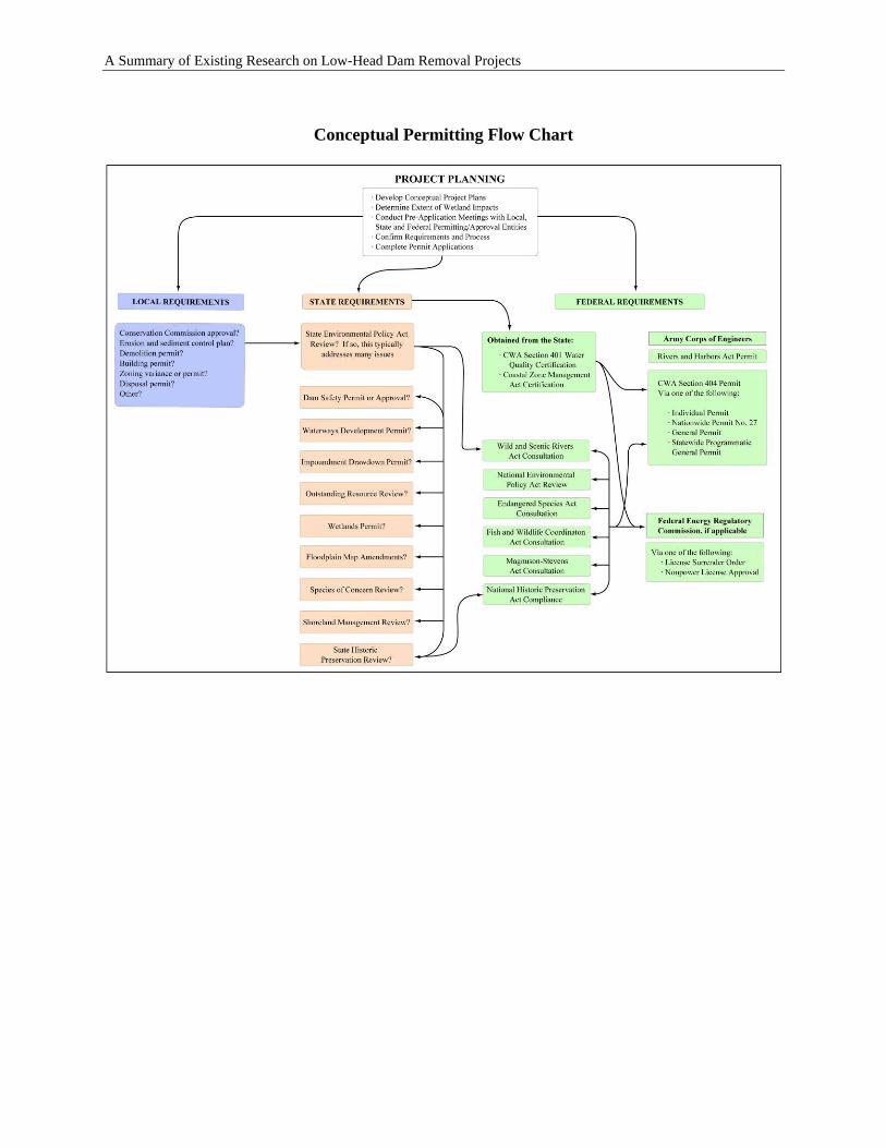
A Summary of Existing Research on Low-Head Dam Removal Projects
Conceptual Permitting Flow Chart
5-5
A Summary of Existing Research on Low-Head Dam Removal Projects
5.3 CWA 404 PERMIT AND 401 CERTIFICATION FOR DAM REMOVAL
5.3.1 How is Section 404 considered for dam removal?
A CWA Section 404 permit has been required for the great majority of dam removal projects conducted in the United States. There are four methods of meeting the CWA Section 404 permit requirement. The USACE District determines which type of permit is applicable for the project.
Individual Permits: Individual Permits are typically required where the level of activities associated with the dam removal project exceeds work thresholds authorized by General Permits or Nationwide Permits. Individual Permits require the applicant to submit a permit application to the USACE directly. The USACE will post public notice for both agency and public review of the project activities (USACE, 2003b). Nationwide Permits: Nationwide Permits (NWPs) are issued by the Chief of Engineers at USACE Headquarters through publication in the Federal Register (33 C.F.R. 330). NWPs are a type of general permit designed to authorize certain activities that have minimal impact on the aquatic environment. Activities that result in more than minimal adverse effects on the aquatic environmental both individually and cumulatively cannot be authorized by NWPs. Individual review of each project authorized by an NWP will not normally occur. Potential adverse impacts and compliance with applicable laws are controlled by the terms and conditions of each NWP which may require notification, coordination and authorization of other federal, state and local government entities. NWP No. 27 “Stream and Wetland Restoration Activities” has been applied to dam removal projects. This NWP addresses activities in waters of the United States associated with the restoration and enhancement of degraded tidal and non-tidal wetlands and riparian areas, the creation of tidal and non-tidal wetlands and riparian areas, and the restoration and enhancement of non-tidal streams and non-tidal open water areas. Compensatory mitigation is not required for activities authorized by NWP 27, provided the authorized work results in a net increase in aquatic resource functions and values in the project area. NWP 27 can be used to authorize compensatory mitigation projects, including mitigation banks, provided the applicant notifies the USACE District Engineer accordingly, and the project includes compensatory mitigation for impacts to waters of the U.S. that are caused by the authorized work. Regional General Permits: Regional General Permits (GPs) are developed and issued by the applicable USACE District or Division on a regional basis. Regional GPs typically authorize commonly occurring activities that are specific to the District/Region and that are not addressed by existing NWPs. Certain Regional GPs require notification prior to starting work. As with NWPs, Regional GP activities typically cause minimal impact on the aquatic environment. Where authorized work exceeds the minimal impact
5-6
A Summary of Existing Research on Low-Head Dam Removal Projects
threshold, mitigation may be necessary to lessen effects on aquatic resources (USACE, 2003b). Statewide Programmatic General Permits: USACE District or Division offices have also issued Statewide Programmatic General Permits (SPGPs) in states with comprehensive wetland protection programs. These SPGPs allow applicants to conduct work that meets the requirements for issuance of a relevant state permit or permits. This programmatic approach reduces delays and paperwork for applicants and allows the USACE to devote its resources to the most significant cases while maintaining the environmental safeguards of the CWA. States that have utilized SPGPs for dam removal activities include MA, NH, PA, and WI.
Through a Memorandum of Agreement (MOA), the USEPA and the Department of the Army (1990) have articulated policy and procedure to be used in determining the type and level of mitigation necessary to comply with the CWA Section 404(b)(1) Guidelines (“Guidelines”) which states that “… no discharge of dredged or fill material shall be permitted unless appropriate and practicable steps have been taken which will minimize potential adverse impacts of the discharge on the aquatic ecosystem.” In the MOA, and pursuant to their responsibility under Section 404, the USACE has adopted the goal of “no overall net loss to wetlands.” The MOA states that special recognition of wetlands resources does not diminish the value of other waters of the U.S. and that all waters, such as streams, rivers, lakes, etc. will be accorded the full measure of protection under the Guidelines, including requirements for appropriate and practicable mitigation. The Guidelines identify a number of “special aquatic sites,” including riffle pool complexes, which require a higher level of regulatory review and protection. In accordance with the Guidelines and the policy of no net loss to wetlands, the USACE reviews a proposed dam removal project in the following sequence. First, the USACE will make a determination of whether potential impacts have been avoided to the maximum extent practicable. Second, the remaining unavoidable impacts will be minimized to the extent appropriate and practicable. Third, compensatory mitigation will be required for unavoidable adverse impacts to aquatic resource values. The MOA states that it may be appropriate to deviate from the sequence if the USEPA or the USACE agree that the proposed discharge can reasonably be expected to result in environmental gain or insignificant losses. In some cases, dam removal will result in a net loss of wetlands. To obtain a permit, the USACE will have to find that the benefits of dam removal outweigh the loss of wetlands, or that the loss of wetlands is mitigated by the restoration of wetlands as a result of the dam removal. Otherwise, the applicant is likely to be required to mitigate for the loss of wetlands through the restoration, creation or enhancement of wetlands elsewhere.
5.3.2 How is Section 401 considered for dam removal?
When the USACE District determines that a CWA Section 404 permit is required to remove a dam, a 401Water Quality Certification is also required from the respective State. All methods of
5-7
A Summary of Existing Research on Low-Head Dam Removal Projects
meeting CWA Section 404 requirements also require a 401 Water Quality Certification from the respective state. Likewise, when FERC determines that a License Surrender Order or Non-power License Approval is required to remove a dam, a 401 Water Quality Certification is also required from the respective state. This state certification states that the removal of the dam will not result in the violation of state water quality standards. As part of this certification, the state may issue conditions related to how the dam is removed. If an Individual 404 Permit is required, an Individual 401 Water Quality Certification is necessary. For Nationwide, Regional, or Statewide Programmatic GPs, the state has three options in issuing 401 Water Quality Certification, and they must do one of the following in order for the Section 404 permit to be utilized: (1) issue a matching General 401 Certification if one exists, (2) issue an Individual 401 Certification, or (3) waive the Individual 401 Certification.
5.4 OTHER LEGAL ISSUES
Dam removal may present additional legal issues that need to be addressed on a site- and state-specific basis. Clarifying ownership of lands that would be exposed as a result of dam removal requires deed research. This research may uncover additional rights and responsibilities associated with the dam and impoundment. For instance, some riparian landowners may have an established right to guaranteed water surface elevations to ensure direct withdrawals or that water tables are appropriate for wells in the location of the impoundment. Landowners that do not have an established right to guaranteed water surface elevations may find that shallow wells are affected by the removal of a dam. The legal redress for such a situation varies by state. Similarly, waterfront businesses that depend on predictable water surface elevations in the impoundment may be strongly impacted by a dam’s removal. Certain types of water-dependent businesses, such as marinas, may no longer be capable of operating. Other waterfront businesses, such as restaurants with a docking facility, may experience a measurable decline in business. As discussed by the Aspen Institute (2002), many dams have direct and/or indirect or incidental beneficiaries who would be, or perceive they would be, adversely affected by dam removal. Regulatory authorities need to heed legal contracts and follow fair guidelines in deciding whether and how to beneficiaries should be made whole. However, provided that legal obligations are met, it is unfair to force a dam owner to maintain a dam in perpetuity when the beneficiaries of the dam are not willing to assume the legal and financial responsibilities associated with dam ownership. The Aspen Institute (2002) recommends that the rights of dam owners, legal beneficiaries, and incidental beneficiaries are clarified at the beginning of the dam removal decision-making
5-8
A Summary of Existing Research on Low-Head Dam Removal Projects
process. In appropriate cases, alternatives to services or compensatory for lost services that a dam owner is legally required to provide (e.g., power or water supply) should be considered. Examples of services that a dam owner is typically not legally required to provide include contributing to a local tax base and maintaining property values around an impoundment.
5.5 MITIGATION CREDITS
Historically, impacts to stream systems such as filling, impoundment, and channelization have been compensated with wetland mitigation. To date, limited guidance has been provided to agency field staff in the appropriate considerations for mitigating impacts to streams (USEPA, 2002). It is increasingly recognized that wetland mitigation does not provide appropriate replacement of aquatic functions lost due to impacts to fluvial systems (USACE, 2003b). As a result, it is inappropriate to apply the same mitigation credit structures to stream mitigation as has been developed for wetland mitigation. The development and approval of compensatory stream mitigation credits via dam removal should concentrate on identifying and replacing the functions proposed to be impacted and applying the same methodology (i.e., functional assessment) to site of the potential dam removal. A mitigation credit structure that adequately addresses short-term and long-term functional gains is of particular importance when dam removal is used to achieve mitigation. In 2001, the National Academy of Sciences’ National Research Council (NRC) published the report “Compensating for Wetlands Loss Under the Clean Water Act.” While the report focuses on wetland mitigation rather than stream mitigation, it provides many observations that can be directly applied to stream mitigation via dam removal. For instance, the NRC writes that
“Linking designs to ecological performance can be extremely difficult, because [river restoration] science and restoration … efforts are still developing and must be tailored to individual sites. Therefore, while site designs should reflect current mitigation science and emerging scientific understanding, the initial designs may not always result in the exact [fluvial] properties that were the original intent of the design. However, much can be accomplished within the limits of the current science. … In short, we can design sites with a high probability of becoming functional [river systems], but whether particular sites will always result in particular functional outcomes is less certain…. Permit conditions for legal compliance with the mitigation obligation should recognize this reality.” (NRC, 2001)
It can be argued the state of science on river restoration via dam removal is even less developed than that for wetland restoration. Therefore, it is strongly recommended that applicants coordinate with relevant regulatory entities as early as possible in the dam removal planning and design process. This early coordination should not be limited to the agency requiring the mitigation to occur. The NRC (2001) recommends that a first obligation of the applicant should be to initiate the required compensatory mitigation project concurrent with the permitted activity with the goal of minimizing temporal loss of function. To achieve this goal, the applicant and regulators must work together to design the project appropriately and according to specified criteria included in the permit. The applicant would then construct by that design and coordinate
5-9
A Summary of Existing Research on Low-Head Dam Removal Projects
any changes identified in the field as necessary to meet the performance criteria with the regulator (NRC, 2001). The mitigation plan should concentrate on the project design factors that will ensure the restoration or implementation of ecological and hydrological processes appropriate to the project. The dam removal and subsequent river restoration activities should be designed in recognition of these factors. Consideration of societal values should emphasize functional benefits that dam removal can provide for issues such as water quality improvement, reduction of flooding, stream bank stabilization and reduced risk to the riparian environment (NRC, 2001).
5.5.1 Primary Criteria to Consider When Determining Mitigation Credit.
The guidance document “Determining Appropriate Compensatory Mitigation Credit for Dam Removal Projects” (USACE, 2004) provides an excellent foundation for the development of these criteria. Primary criteria are generally those directly accomplished or established during project construction (USACE, 2003b). Water Quality. Dam removal may alleviate documented water quality impairments within the impoundment and downstream of the dam. Attainment of some water quality parameters (e.g., temperature) could be sufficiently demonstrated through short-term monitoring (i.e., immediate to three years after removal). However, long-term monitoring (i.e., 5 years or more) will be necessary to document attainment of other parameters (e.g., benthic deposits, hydrologic modification). Impairments associated with and/or exacerbated by the presence of dams include, but are not limited to:
• hydrologic modification impacting biological and aquatic community integrity; • low dissolved oxygen; • elevated temperatures; • elevated turbidity; • benthic deposits causing a detrimental impact to the benthic community; • elevated nutrients (phosphorus and nitrogen); • concentrations of toxic substances that are injurious to the environment; and/or
persistent in harmful concentrations.
Additional water quality-related factors that could be taken into consideration include:
• listing of the water body on the state 303(d) list of impaired waters; • known, repeated violations of water quality standards; • special aquatic resource classification in segments upstream or downstream of the
dam, including Outstanding National Resource Water, Outstanding Resource Water, Exceptional Resource Water, Essential Fish Habitat, or blue ribbon trout stream designation; and
• water supply protection. Species and Habitats of Concern. Dam removal can benefit federally or state-listed rare, threatened or endangered aquatic and semi-aquatic species, and rare or exemplary habitats.
5-10
A Summary of Existing Research on Low-Head Dam Removal Projects
Benefits can be demonstrated through colonization of the restored river reach, including stream banks, the riparian zone, and restored floodplains. Credit could also be applied to demonstrably increased numbers or documented expansion of the range of distribution extending either upstream or downstream of the former dam site. It must be emphasized that the credit should not be solely limited to the longitudinal and lateral extent of the former impoundment. Riverine species move in both upstream and downstream directions. Focusing entirely on the former impounded reach removes the restoration activity from the larger riverine context. Similarly, credit should not be solely limited to benefits to the aquatic community. Semi-aquatic species (e.g., reptiles, amphibians, birds) may also benefit from dam removal. Establishment of an appropriate aquatic and semi-aquatic community. Dam removal may provide restoration of a site-appropriate aquatic and semi-aquatic community. This criterion may be evaluated based upon demonstrated improvements during the monitoring period utilizing metrics such as the Index of Biotic Integrity and the Rapid Bioassessment Protocols (Barbour et al., 1999). Demonstrated restoration of appropriate stream community fish species, such as darters, may also receive mitigation credit. Passage of Target Fish Species. Dam removal typically results in improved conditions for fish passage, both upstream and downstream. Mitigation credit structures should identify target fish species for restoration of movement. The definition of a fish species of interest should be both state- and site-specific and should not be limited to anadromous fish species. Documented benefits to other migratory and resident fish species of interest should also be considered eligible for mitigation credit, including recreational sport fish and host species for freshwater mussels, such as darters. Federal and state natural resource agencies should be consulted for development of state- and site-appropriate mitigation credit for restoration for fish passage and provide feedback on appropriate monitoring and success criteria.
Water Quantity. Low-head dams typically function as run-of-river facilities and therefore will have minimal effects on increasing the quantity of water available for downstream discharge absent specific operating rules. In the case where the operation of a run-of-river facility requires drawing down of the impoundment to augment downstream flows during periods of low water, diminished instream flows could result from dam removal. A potential mitigating factor is increased groundwater recharge to a channel reach following dam removal. This would result from the increased hydraulic gradient between groundwater to the lower channel water surface elevation following dam removal. Floodplain Functions and Riparian Wetlands. While dam removal may result in increased flood attenuation functions through restoration of riparian wetlands and natural floodplain hydrology, the removal of a low head dam will typically result in no benefits to floodplain wetlands. Potential changes to floodplain functions are highly site-specific, and dependent on factors including channel and floodplain geometries, dam spillway capacity, and the condition of the adjacent floodplain (e.g., developed, undeveloped). Potential benefits to riparian wetlands are similarly site-specific and dependent on floodplain and channel geometries. Where a low head dam has inundated floodplain wetlands bounded by steep upland slopes affording limited areas for the formation of bounding riparian wetland, removal of a low head dam would result in the restoration of riparian wetlands.
5-11
A Summary of Existing Research on Low-Head Dam Removal Projects
Risk to the Environment. Dam removal may eliminate the risk posed to the environment by dam failure. Environmental risk associated with dam failure is increasingly considered by agencies that determine dam safety requirements at the state and federal levels. If the failure or inappropriate operation of a particular dam poses a significant risk to natural resources, the removal of that dam would result in a reduced anthropogenic risk to the environment. Environmental risk of dam failure may include the effects of a sudden, uncontrollable release of impounded water and other materials, such as sediment, that exceeds the downstream channel carrying capacities. This can result in long and short-term damage to channel stability, riparian habitat, spawning substrate, mussel beds, and other components of the river environment. Long-term Protection and Responsibility of Restoration Site. Adequate protections must be obtained at the former dam site to insure that construction of a new dam will not occur. The extent of protections required for the restored riparian corridor may be limited to the former impoundment site, or an expanded area as necessary to protect the documented benefits that are provided mitigation credit. Long-term protections may be through conservation easements, deed restrictions or public ownership. In addition to the requirement of long-term protection of the mitigation site, long-term responsibility for the site should be considered eligible for mitigation credit. An adaptive management approach is recommended for wetland mitigation projects (NRC, 2001). The inherent dynamic nature of rivers, in combination with the fundamental change in a river’s ability to function naturally that is provided by dam removal, emphasizes the need for a long-term, adaptive approach to management. To this end, the NRC (2001) recommends that applicants transfer the long-term site management and maintenance responsibility, along with a cash endowment for these purposes, to a prescribed management authority (the characteristics for such an authority are discussed in their report).
5.5.2 Secondary Criteria to Consider When Determining Mitigation Credit
Riparian Buffers. Dam removal may provide the opportunity to reestablish riparian buffers through the drawdown of the impoundment and subsequent revegetation of the exposed lands. These buffers can provide important riparian habitat and enable water quality improvements through increases in wooded canopy and filtration of overland runoff. Favorable mitigation credit should be provided in cases where a pre-determined buffer width on one or both sides of the stream is to be revegetated either naturally or with plantings. Social Value. Dam removal may provide benefits to human uses of stream environments. Consideration of these benefits should not be limited to water-based activities. In some places, the dewatering of an impoundment and exposure of “new land” presents the opportunity to create new community parks and other public spaces that provide public access to the river and riparian corridor. Social benefits of stream restoration via dam removal can include fishing, boating, trails, interpretive signage and other environmental education opportunities, and scientific research beyond that required by the mitigation project. Another social benefit dam removal can provide is the restoration of aesthetically valued natural features, such as riffles, rapids, and waterfalls. The USACE Wilmington District guidelines (2004) note that this criterion is intended to encourage dam removal applicants to incorporate the provision of these benefits in
5-12

A Summary of Existing Research on Low-Head Dam Removal Projects
dam removal planning. These activities may help offset negative public perceptions associated with a specific dam’s removal, if any. Public Safety. Dam removal eliminates the public safety hazard(s) posed by the existence of the dam. This includes eliminating the potential of dam failure that, depending upon the dam, could result in loss of human life, damage to property and infrastructure such as roads, bridges, water and sewer lines, etc. The public safety benefit of dam removal may also include elimination of a hazard to recreational users, such as boaters, swimmers and anglers. Lastly, dam removal may eliminate an “attractive nuisance” that is of particular concern for children and others who fail to recognize the type of injury that could be sustained on the property. Local Economic Benefit. Dam removal may provide benefits to communities through the elimination of their financial responsibility for maintaining and operating aging infrastructure that may no longer generates economic benefit but that 1) represents a legal liability, 2) represents a public safety hazard, and 3) contributes to water quality impairments that necessitate upgrades to other infrastructure, such as water treatment plants and wastewater treatment facilities. Mitigation credit may be appropriate for addressing these local economic issues through the removal of a dam, whether it is publicly or privately owned. Sediment Regime. Dam removal may provide benefits through the properly designed and managed restoration of the river’s sediment regime. These benefits may include beach replenishment, substrate to address downstream channel degradation, transport of woody debris for various riparian habitats and functions, and distribution of nutrients.
5.5.3 Agencies that have Received Mitigation Credits
The concept of obtaining credit for stream mitigation through the use of dam removal is a very new approach in compensatory mitigation. The only completed project that was identified through the survey conducted for this report is the removal of the St. John’s Dam in Ohio.
5.6 MITIGATION CASE STUDY – ST. JOHN’S DAM, SANDUSKY RIVER, OHIO
St. John’s Dam was located on the Sandusky River upstream of the City of Tiffin in Seneca County, OH, near the intersection of County Rd. 6 and Township Rd. 131. It was a 7.2-foot high and 150-foot long concrete dam, constructed during early 1900s for water supply. The estimated impoundment volume is 455 acre-feet. The ODNR, Division of Water inspected the dam in 1999, and ordered the owner, Ohio American Water Co. (OAWC), to repair or destroy the dam because of safety issues. The OAWC had the dam evaluated and determined that it would cost $300,000 to make necessary repairs. In 2003, ODNR Division of Natural Areas and Preserves (DNAP), Scenic Rivers Section, approached OAWC and offered to pay for the removal of the structure through the Scenic Rivers License Plate Fund, conditional upon ODNR receiving ownership of the structure and adjacent land. OAWC agreed to turn St. John’s Dam over to the ODNR DNAP so that the dam could be removed. ODNR then entered into an agreement with the OH DOT to have the dam removed. The OH DOT agreed to remove the dam and pay all removal costs as part of
5-13
A Summary of Existing Research on Low-Head Dam Removal Projects
mitigating a highway project that was recently completed nearby. This dam removal project is now referred to as the St. John’s Dam Pooled Stream Mitigation Area. The St. John’s Dam was partially breached in March, 2003 (see Figure 5.1). The deconstruction schedule originally stipulated the complete removal of the dam 1-2 weeks subsequent to the breach, but was postponed as a result of unusually high water levels in April 2003. Deconstruction was further postponed during the fish spawning season in late spring. In early summer of 2003, the elimination of the Civilian Conservation Corp due to state budget cuts put the project in jeopardy since this group was operating the heavy machinery for the removal. Substitution of a private contractor was too expensive, since the state had reduced the operating budget for the Scenic Rivers Program. In mid-summer, the state DOT offered financial assistance for fully removing the dam in exchange for mitigation credit for restoring the riparian zone. The dam was completely removed in November 2003 (see Figure 5.2). The total removal cost (including engineering, permitting, deconstruction, etc.) was $200,000, of which $79,000 was for dam deconstruction. The state funded the entire project. Before the dam removal, a local landowner whose property is on the Sandusky State and Scenic River expressed concern with the breaching of St. John’s Dam. He also objected to the use of public funds to cover the cost of removal. ODNR responded to his objections and proceeded with the project. After the dam was removed, problems were encountered with sloughing of the banks near some homes. This problem was partially attributed to the fact that the dam was removed in a couple of hours, thereby creating high water levels downstream over the next couple of days. As a result, the banks became saturated with water and sloughing problems occurred. It is conceivable that had the dam been lowered and eventually removed over a couple of days, it might have lessened this problem. The OH DOT sent a Geotechnical Engineer to evaluate the sloughing problem that occurred at Locust Grove. After careful review, it was determined that the worst of the problems were over. The situation was compounded by the fact that the Locust Grove development was built primarily on fill material.
5-14
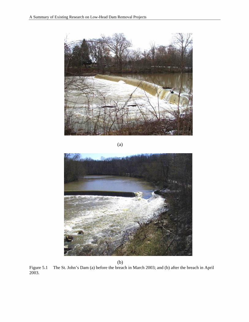
A Summary of Existing Research on Low-Head Dam Removal Projects
(a) (b) Figure 5.1 The St. John’s Dam (a) before the breach in March 2003; and (b) after the breach in April 2003.
5-15
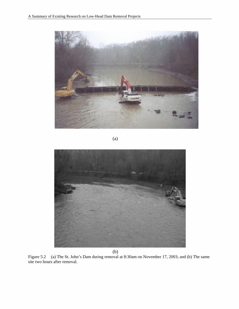
A Summary of Existing Research on Low-Head Dam Removal Projects
(a) (b) Figure 5.2 (a) The St. John’s Dam during removal at 8:30am on November 17, 2003; and (b) The same site two hours after removal.
5-16
A Summary of Existing Research on Low-Head Dam Removal Projects
A CWA 404 permit was not required because the Buffalo District of the USACE determined the work did not involve a discharge of dredged or fill material into the river. The concrete debris was removed from the river to an upland location the same day it was demolished. The successful removal of the dam eliminated a public safety hazards and provided different benefits including aesthetic enhancement, fish and wildlife habitat improvement, community revitalization, recreational improvement, and water quality improvement. On June 29, 2004, staff from ODNR and the OH DOT canoed the eight-mile stretch of the former dam pool to evaluate stream morphology and the effects of the dam removal. Staff encountered five new riffle run complexes that had formed naturally under the new flow regime. These initial results are encouraging (ODNR, 2005). A more comprehensive analysis of the effects of the dam removal project is being conducted over a five-year monitoring period by a research team including ODNR Divisions of Geological Survey, Natural Areas and Preserves, Water and Wildlife; Ohio State University; and Heidelberg College Water Quality Lab. As part of the mitigation agreement, a number of parameters will be monitored over the course of five years. ODNR will conduct Index Biotic Integrity, Invertebrate Community Index, and Qualitative Habitat Evaluation Index (QHEIs) at five existing OH (EPA) habitat and biological monitoring sites above the dam and below the dam. The frequency of monitoring will be twice a year over the next five years.
• OH DOT will perform QHEIs every two miles on the main stem of the Sandusky River starting at the first riffle downstream of the dam to the riffle located at the end of the dam impoundment. The frequency will be once a year on the first, third, and fifth monitoring years following the removal of the dam.
• ODNR Division of Geological Survey will survey substrate composition and conduct channel morphology analyses for five years after removal of the dam.
• The Ohio State University will conduct unionid mollusk (i.e., freshwater mussel) inventories at the riffle below the dam and at one of the OH EPA habitat and biological monitoring sites above the dam once every year for five years after the removal of the St. Johns Dam (ODNR, web).
5-17

A Summary of Existing Research on Low-Head Dam Removal Projects
5-18
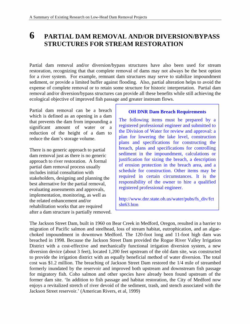
A Summary of Existing Research on Low-Head Dam Removal Projects
6 PARTIAL DAM REMOVAL AND/OR DIVERSION/BYPASS STRUCTURES FOR STREAM RESTORATION
Partial dam removal and/or diversion/bypass structures have also been used for stream restoration, recognizing that that complete removal of dams may not always be the best option for a river system. For example, remnant dam structures may serve to stabilize impoundment sediment, or provide a limited buffer against flooding. Also, partial alteration helps to avoid the expense of complete removal or to retain some structure for historic interpretation. Partial dam removal and/or diversion/bypass structures can provide all these benefits while still achieving the ecological objective of improved fish passage and greater instream flows. Partial dam removal can be a breach which is defined as an opening in a dam that prevents the dam from impounding a significant amount of water or a reduction of the height of a dam to reduce the dam’s storage volume.
OH DNR Dam Breach Requirements The following items must be prepared by a registered professional engineer and submitted to the Division of Water for review and approval: a plan for lowering the lake level, construction plans and specifications for constructing the breach, plans and specifications for controlling sediment in the impoundment, calculations or justification for sizing the breach, a description of erosion protection in the breach area, and a schedule for construction. Other items may be required in certain circumstances. It is the responsibility of the owner to hire a qualified registered professional engineer.
There is no generic approach to partial dam removal just as there is no generic approach to river restoration. A formal partial dam removal process usually includes initial consultation with stakeholders, designing and planning the best alternative for the partial removal, evaluating assessments and approvals, implementation, monitoring, as well as the related enhancement and/or rehabilitation works that are required after a dam structure is partially removed.
http://www.dnr.state.oh.us/water/pubs/fs_div/fctsht63.htm
The Jackson Street Dam, built in 1960 on Bear Creek in Medford, Oregon, resulted in a barrier to migration of Pacific salmon and steelhead, loss of stream habitat, eutrophication, and an algae-choked impoundment in downtown Medford. The 120-foot long and 11-foot high dam was breached in 1998. Because the Jackson Street Dam provided the Rogue River Valley Irrigation District with a cost-effective and mechanically functional irrigation diversion system, a new diversion device (about 3 feet), located 1,200 feet upstream of the old dam site, was constructed to provide the irrigation district with an equally beneficial method of water diversion. The total cost was $1.2 million. The breaching of Jackson Street Dam restored the 1/4 mile of streambed formerly inundated by the reservoir and improved both upstream and downstream fish passage for migratory fish. Coho salmon and other species have already been found upstream of the former dam site. ‘In addition to fish passage and habitat restoration, the City of Medford now enjoys a revitalized stretch of river devoid of the sediment, trash, and stench associated with the Jackson Street reservoir.’ (American Rivers, et al, 1999)
6-1
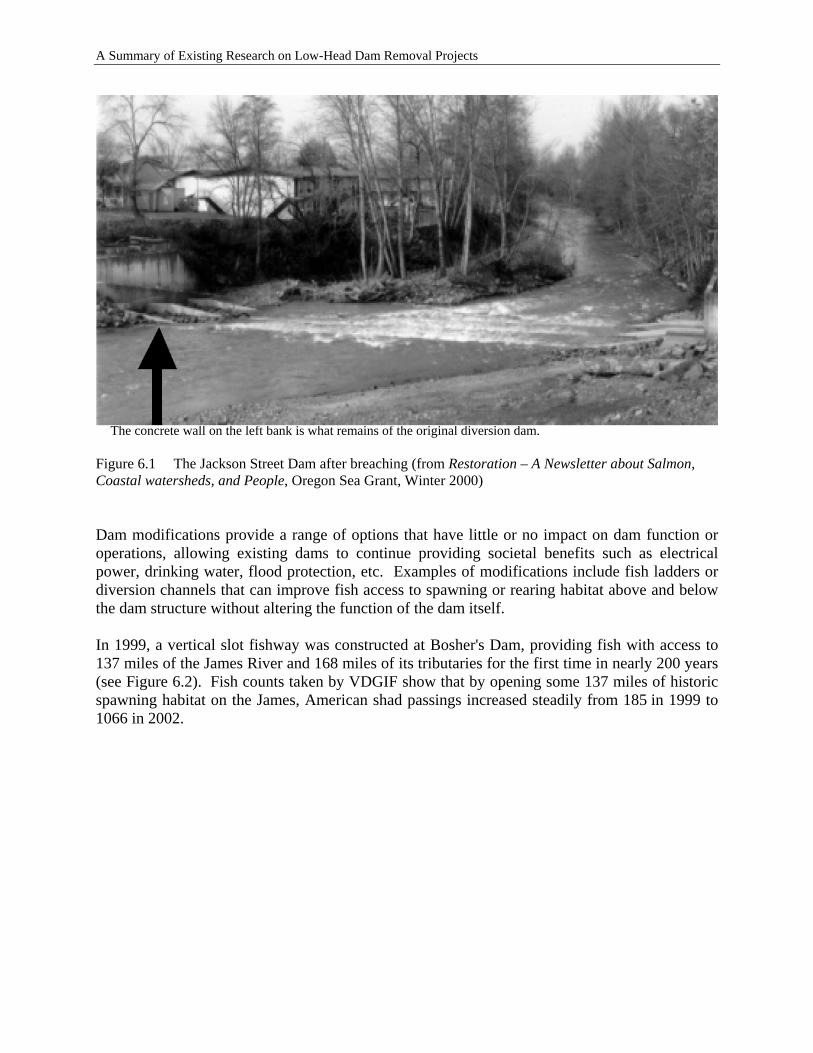
A Summary of Existing Research on Low-Head Dam Removal Projects
The concrete wall on the left bank is what remains of the original diversion dam. Figure 6.1 The Jackson Street Dam after breaching (from Restoration – A Newsletter about Salmon, Coastal watersheds, and People, Oregon Sea Grant, Winter 2000) Dam modifications provide a range of options that have little or no impact on dam function or operations, allowing existing dams to continue providing societal benefits such as electrical power, drinking water, flood protection, etc. Examples of modifications include fish ladders or diversion channels that can improve fish access to spawning or rearing habitat above and below the dam structure without altering the function of the dam itself. In 1999, a vertical slot fishway was constructed at Bosher's Dam, providing fish with access to 137 miles of the James River and 168 miles of its tributaries for the first time in nearly 200 years (see Figure 6.2). Fish counts taken by VDGIF show that by opening some 137 miles of historic spawning habitat on the James, American shad passings increased steadily from 185 in 1999 to 1066 in 2002.
6-2
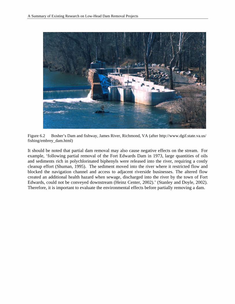
A Summary of Existing Research on Low-Head Dam Removal Projects
Figure 6.2 Bosher’s Dam and fishway, James River, Richmond, VA (after http://www.dgif.state.va.us/ fishing/embrey_dam.html) It should be noted that partial dam removal may also cause negative effects on the stream. For example, ‘following partial removal of the Fort Edwards Dam in 1973, large quantities of oils and sediments rich in polychlorinated biphenyls were released into the river, requiring a costly cleanup effort (Shuman, 1995). The sediment moved into the river where it restricted flow and blocked the navigation channel and access to adjacent riverside businesses. The altered flow created an additional health hazard when sewage, discharged into the river by the town of Fort Edwards, could not be conveyed downstream (Heinz Center, 2002).’ (Stanley and Doyle, 2002). Therefore, it is important to evaluate the environmental effects before partially removing a dam.
6-3

A Summary of Existing Research on Low-Head Dam Removal Projects
6-4
A Summary of Existing Research on Low-Head Dam Removal Projects
7 MONITORING TECHNIQUES TO MEASURE PERFORMANCE OF DAM REMOVAL PROJECTS
7.1 IMPORTANCE OF MONITORING PERFORMANCE
Monitoring is necessary to determine the degree to which a mitigation project has successfully met the objectives stated in the project’s mitigation plan. Site-specific objectives must be incorporated in the design and implementation of the project. These objectives must be appropriately evaluated. Monitoring should be directed at evaluating primary objectives to be accomplished by the mitigation project. Monitoring of secondary benefits may also be appropriate, depending upon the components of the mitigation plan. When mitigation projects have higher levels of scientific uncertainty, such as stream mitigation through dam removal, the project should include long-term monitoring, reporting and potential remedial actions (USEPA and Department of Army, 1990). The period for monitoring mitigation projects is typically 5 years; however, it may be necessary to extend this period for projects requiring more time to reach a stable condition (e.g., such as a formerly impounded stream segment) (USACE et al., 1995). The justification for a flexible and adaptive approach to monitoring requirements is that the time it takes to attain different criteria will vary for different parameters and for different projects. For instance, water quality criteria may be achieved rapidly for some dam removal projects, while they may take years for other projects. Similarly, migratory fish criteria may be met within a year in a watershed with few dams, whereas a watershed with many additional dams may preclude attaining increased distribution of migratory fishes. There are many site-specific factors that need to be considered when developing criteria to evaluate the ecological results of dam removal over time.
7.1.1 Relevance to Mitigation
Collection of pre-removal data is critical to monitor the success and failure of dam removal in general, as well as dam removal as a stream mitigation tool. Data should be collected from several locations that may be affected by the proposed project, including both upstream and downstream locations. Both short- and long-term monitoring should be conducted, as the project’s impacts on various parameters may change over time.
7.1.2 Cost–Benefit Ratios
The regulatory entity may account for functional changes by recording them as site-specific debits and credits. Guidance developed by the USACE (2002) defines credits and debits as follows:
Credit: A unit of measure of functional capacity representing the gain of aquatic function at a compensatory mitigation site.
7-1
A Summary of Existing Research on Low-Head Dam Removal Projects
Debit: A unit of measure of functional capacity representing the loss of aquatic function at a project site requiring compensatory mitigation.
Stream mitigation projects should replace lost stream functions. When sufficient functional assessment is not feasible, mitigation projects for streams should generally replace linear feet of stream on a one-to-one- basis. The measure of function is typically indexed to the number of acres of resource restored, established, enhanced, or protected as compensatory mitigation. Such surrogate mitigation proposals must be carefully evaluated because experience has shown that stream compensation measures are not always practicable, constructible, or ecologically desirable (USACE, 2002). Mitigation guidance (USACE, 2002) indicates that USACE Districts may require on-site mitigation, off-site mitigation, or a combination of on- and off-site mitigation to maintain stream functional levels within watersheds. Mitigation of wetland impacts is typically required on-site, when practicable, such as in areas adjacent or contiguous to the site where the loss of aquatic function will occur. However, mitigation of stream impacts through dam removal is more likely to be conducted off-site, particularly when off-site mitigation would provide more benefits to the watershed in which the stream impacts will occur. Dam removal may present opportunities for in-kind mitigation, out-of-kind mitigation, and combinations of in-kind and out-of-kind migration to achieve functional replacement within a watershed. In-kind compensation for a loss of stream function can be provided through a dam removal project that involves replacement of that function by restoring, enhancing, or protecting and maintaining a stream segment of the same physical and functional type. Out-of-kind compensation for a stream function loss involves replacement of that function by restoring, enhancing, or protecting and maintaining an aquatic resource of different physical and functional type. Out-of-kind mitigation may be appropriate when it is practicable and provides more environmental or watershed benefit than in-kind compensation (e.g., of greater ecological importance to the region of impact) (USACE, 2002). Existing guidance on compensatory stream mitigation through dam removal (USACE, 2004) indicates that the maximum potential credit in linear feet that may be generated by a single dam removal project is the length of stream restored to free-flowing condition as measured from the dam to the upstream edge of the normal pool as indicated by the elevation of the crest of the dam for run-of-river dams or the outfall, which is lower in elevation. This would be measured from the dam to the upstream extent of the former impoundment, and may extend into tributaries as well. The USACE Guidance (2004) states that, when appropriate, a functional habitat-based calculation may also be used on a case-by-case basis and that additional credit may also be attained for demonstrated downstream functional benefits. However, dam removal may provide demonstrable functional benefits both downstream and upstream of the project site. A range of physical, chemical and biological functions may be attained on a project-by-project basis. It is recommended that credit structures consider the watershed-wide functional benefits that may be possible via dam removal.
7-2
A Summary of Existing Research on Low-Head Dam Removal Projects
7.2 WHAT TO MONITOR
At least one year of pre-removal monitoring must be conducted as part of the mitigation plan. A thorough monitoring plan before, during, and after dam removal is not only necessary to determine attainment of mitigated stream function, but is also necessary as part of an adaptive management program that provides early indication of potential problems and direction for correction actions (USACE, 2002). Monitoring and control of nonindigenous and exotic species should be a part of any effective adaptive management program. Entities conducting monitoring must have an understanding of the processes that drive the structure and characteristics of the river as it responds to the dam removal action. Simply documenting the structure (e.g., hydrology, sediment, fauna, flora, water quality) will not provide the knowledge and guidance required to take adaptive corrections if adverse conditions and need for remedial actions are discovered. Although restoration of stream functions may take years to decades, process-based monitoring will help provide more sensitive early indicators of whether a mitigation site is proceeding along an appropriate trajectory (USACE, 2002). Previous dam removal projects, not necessarily conducted for mitigation purposes, have incorporated monitoring into project implementation. Published studies exist on the impact of dam removal to fish (Kanehl et al., 1997), macroinvertebrates (Stanley et al., 2002), vegetation (Lenhart, 2000) and geomorphology (Williams, 1997; Wohl and Cenderelli, 2000) (Doyle et al, 2003). Perhaps the most extensive study yet undertaken on the effects of dam removal was conducted by the Patrick Center for Environmental Research of the Academy of Natural Sciences in Philadelphia. This multi-year interdisciplinary study focused on the effects of removing a small lowhead dam on Manatawny Creek in PA (Bushaw-Newton et al., 2002). The specific parameters that need to be monitored are likely to be tailored to the project site and mitigation plan. The location of the monitoring will also vary (e.g., points within the impoundment, riparian zone, former dam site, points downstream, points upstream). Bushaw-Newton et al. (2002) list several potential ecological responses to dam removal. The Heinz Center (2002) also lists a number of potential outcomes of dam removal. The following potential outcomes may be appropriate parameters to monitor for a stream mitigation project. Physical
• Change to downstream hydrology • Sediment degradation within the impounded area and upstream • Sediment aggradation downstream of the former dam site • Grain size analysis • Bedload analysis • Channel morphology (cross sectional and longitudinal) • Floodplain morphology (e.g., connection to channel, frequency of inundation) • Groundwater recharge • Watershed fragmentation
7-3
A Summary of Existing Research on Low-Head Dam Removal Projects
Chemical • Water quality parameters
o Dissolved oxygen o Temperature o Specific conductance o pH o Turbidity o Suspended particulate material and nutrients (C, N, P)
• Redistributions of organic contaminants • Redistribution of particulate organic matter • Change in seasonal nutrients (e.g., due to fish migration)
Biological
• Change in algal biomass and species composition • Change in benthic macroinvertebrate taxa • Change to freshwater mussel beds • Return of host fishes for freshwater mussels • Change in fish community assemblage (natives, exotics, cold-, cool- and warm
water, etc.) • Restored fish passage and distribution • Decrease in fish parasites • Change in populations and distributions of nonindigenous and exotic species • Change in riffle habitat • Change in deep pool habitat • Change in wetland type • Change in wetland acreage • Change in connection of floodplain with stream • Change in riparian vegetation • Change in waterfowl populations
Economic
• Cost-benefit of dam operations and maintenance versus removal • Value of services lost and services gained • Change in property values • Change in cost of infrastructure maintenance and operation (e.g., bridges,
pipelines, water/wastewater treatment) • Change in local business revenue
Social
• Change in public attitudes to project over time • Change in recreational patterns • Change in property ownership near project • Change in seasonal homeowners • Change in perceptions of public safety • Change in zoning or long-term municipal planning
7-4
A Summary of Existing Research on Low-Head Dam Removal Projects
7.3 WHO MONITORS THE PERFORMANCE OF DAM REMOVAL PROJECTS
A number of entities have noted that too little scientific research has been conducted on the benefits and impacts of dam removal (Aspen Institute, 2002; Heinz Center, 2002). There is a clear need for an increased effort to monitor the effects of dam removal, regardless of whether or not the project is taking place as a stream mitigation project. Information gleaned from monitoring the effects of dam removal will further the development of appropriate programmatic approaches to dam removal at the local, state and federal level. Programmatic approaches include decision-making frameworks, laws, and policies regulating dam removal activities, technical guidance documents, and funding arrangements. Monitoring of dam removal projects have been conducted by a range of entities and has taken a diversity of forms, from funded, multi-year, interdisciplinary studies conducted by academic institutions to volunteer-based monitoring of water quality parameters. In many cases, before and after data at dam removal sites are not reported in refereed scientific literature. Some state and federal agencies now require pre- and post-removal monitoring as a permit condition, or as part of financial assistance to remove the dam. Several important disconnects exist between research and monitoring conducted by the academic community and the research and monitoring that is needed by decision makers (Heinz Center, 2002; Doyle et al., 2003). Dam removal as a tool for stream mitigation may help address some of this disconnect between science and policy. The base of scientific knowledge to support regulatory decision-making, permit conditions, and mitigation requirements for dam removal is progressing, but much of the research conducted to date has focused on single dam removal projects. As a result, conclusions drawn tend to be somewhat site-specific. Few studies have attempted to collate information from several sites and develop policy recommendations regarding dam removal on a watershed or statewide basis. There is an increase of high quality research being conducted and published but many research and monitoring projects are moving forward in isolation of similar work elsewhere (Heinz Center, 2002). The questions and approaches that are most important to a fluvial geomorphologist are likely to be different than questions and approaches that are important to an ecologist. But, if both sets of questions were evaluated on a single project, an integrated analysis of the effects of dam removal would be possible. Also, properly understanding the issues faced by planners, legal experts, property owners, and dam owners require still more integration (Heinz Center, 2002). This need for an integration of monitoring efforts following dam removals requires a multi-disciplinary dialogue. To establish reasonable policies and permit conditions, decision-makers need to know about the integrative effects of dam removal, not only specific effects such as those to a particular fish species or changes in morphological conditions. Doyle et al. (2003) recommend that monitoring should be conducted or administered by the agency responsible for a dam’s removal, leaving the responsibility of proving the efficacy of
7-5
A Summary of Existing Research on Low-Head Dam Removal Projects
dam removal on the agency permitting the removal. In reality, the budgetary and regulatory constraints under which most agencies operate make this unlikely.
7.4 MONITORING TECHNIQUES
Applicable monitoring methods for low head dam removal projects implemented for mitigation should be determined based upon specific monitoring goals and requirements as defined in project permits. Specific monitoring requirements may include evaluation of primary and secondary indicators of project success. Primary indicators are directly associated with mitigation requirements, such as the reestablishment of riparian wetlands in previously inundated areas or the restoration of fish passage for migratory fish. Secondary indicators could include water quality suitable for sustaining target fish species and seasonal flooding of adjacent wetlands. Note that the determination of primary and secondary criteria is project specific, and will likely vary depending on mitigation needs and associated requirements. Guidelines for monitoring techniques should be determined based on monitoring requirements. The following documents are suggested as general references for applicable ecological and biological monitoring protocols. The referenced documents are commonly used by the regulatory community and therefore applicable to the determination of mitigation benefits associated with dam removal. Specific regional guidelines should also be referenced, as required.
• Wetlands – USACE Wetlands Delineation Manual (Technical Report Y-87-1) (Environmental Laboratory, 1987)
• Riverine Fauna – Rapid Bioassessment Protocols for Use in Wadeable Streams and Rivers (Barbour, 1999)
• River Morphology – Applied River Morphology (Rosgen, 1996) In addition to the aforementioned references, regional, state, and local guidelines should also be assessed to establish practical and meaningful monitoring strategies. Monitoring techniques should also consider the timing of specific mitigation components. For instance, monitoring of vegetation and associated control of invasive plant species would typically commence immediately following a dam removal. Monitoring of projects where mitigation objectives include native fish populations may warrant a delay prior to monitoring to allow for a population to adjust to restored conditions, particularly where the restored reach of river is intended to support life-stage specific use (e.g., spawning, rearing).
7-6
A Summary of Existing Research on Low-Head Dam Removal Projects
8 TECHNICAL GUIDANCE AND SITE-APPROPRIATE PRACTICE FOR IMPLEMENTING DAM REMOVAL PROJECTS
Deciding whether to remove a dam can be contentious. Designing and adhering to a well-considered collaborative decision-making process can significantly reduce the conflicts. A well-designed decision-making process can address safety, economic, and environmental concerns and also satisfy the desire of community members and other stakeholders to participate actively in shaping the future of the dam and related natural resources in their community. In this chapter, we will first briefly review and evaluate the existing guidance documents on decision-making related to dam removal. Based on the review and evaluation, we will propose a simple method for ranking and identifying the candidates of dams that can be removed so that stream remediation credits can be obtained for transportation projects.
8.1 EXISTING TECHNICAL GUIDANCE
8.1.1 List of Existing Guidance Documents
There exist different documents containing guidance information on decision-making related to dam removals. Several of these guidance documents are listed and briefly described below. Heinz Center (2002). Dam Removal – Science and Decision Making – This document presents a general method for reaching decisions about dam removal involving four basic four steps: Step 1: Define the goals and objectives Step 2: Identify major issues of concern Step 3: Data collection and assessment Step 4: Decision making
If a decision is reached to remove the dam, two more steps are added: Step 5: Dam removal Step 6: Data collection, assessment, and monitoring For each step, the document provides detailed discussion and related information. WRM (2000). Dam Repair or Removal – A Decision-Making Guide, Water Resources Management Practicum 2000 – This document gives a brief background and an overview of the pertinent issues associated with dam repair/removal decision-making in WI. The principal components involved in designing and implementing an appropriate decision-making process is presented in the following flow chart.
8-1
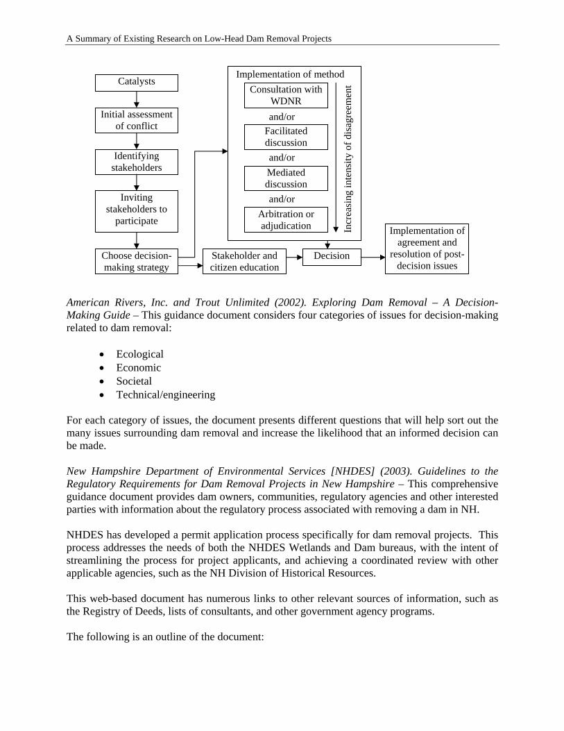
A Summary of Existing Research on Low-Head Dam Removal Projects
Catalysts
Initial assessment of conflict
Identifying stakeholders
Inviting stakeholders to
participate
Choose decision-making strategy
Consultation with WDNR
Facilitated discussion
Mediated discussion
Arbitration or adjudication
Implementation of method
and/or
and/or
and/or
Incr
easi
ng in
tens
ity o
f dis
agre
emen
t
Stakeholder and citizen education
Decision
Implementation of agreement and
resolution of post-decision issues
American Rivers, Inc. and Trout Unlimited (2002). Exploring Dam Removal – A Decision-Making Guide – This guidance document considers four categories of issues for decision-making related to dam removal:
• Ecological • Economic • Societal • Technical/engineering
For each category of issues, the document presents different questions that will help sort out the many issues surrounding dam removal and increase the likelihood that an informed decision can be made. New Hampshire Department of Environmental Services [NHDES] (2003). Guidelines to the Regulatory Requirements for Dam Removal Projects in New Hampshire – This comprehensive guidance document provides dam owners, communities, regulatory agencies and other interested parties with information about the regulatory process associated with removing a dam in NH. NHDES has developed a permit application process specifically for dam removal projects. This process addresses the needs of both the NHDES Wetlands and Dam bureaus, with the intent of streamlining the process for project applicants, and achieving a coordinated review with other applicable agencies, such as the NH Division of Historical Resources. This web-based document has numerous links to other relevant sources of information, such as the Registry of Deeds, lists of consultants, and other government agency programs. The following is an outline of the document:
8-2

A Summary of Existing Research on Low-Head Dam Removal Projects
Overview: State Laws and Regulations Pertaining to Dam Removal Step One: Obtaining Necessary Information
• Who to Contact for Information • Necessary Permits and Permit Applications
Step Two: Researching, Planning and Designing the Project • Key Technical Issues to Address Early
o Sediment Management Concerns o Potential Effects to Historical Resources o Potential Effects to Infrastructure
• Additional Issues to Consider Step Three: Preparing the Permit Application Package
• Detailed Instructions on Completing and Submitting the Application Package
Step Four: Permit Review and Issuance Process • Agency Decision-making Timelines • Public Information Meeting or Hearing Requirements • General Permit Conditions
NHDES and New Hampshire Office of Emergency Management (2003). Procedure to Assist in the Prioritization of Dam Removal Projects. New Hampshire Department of Environmental Services – This document was developed in response to numerous requests for agency technical and financial assistance in planning and conducting dam removal projects. This procedure is completely distinct from the regulatory permit review process. The document provides a method for agencies to determine which proposed dam removal projects represent the most effective use of limited agency resources, and agency missions and authorities. For example, the New Hampshire Office of Emergency Management (NHOEM) is beginning to receive grant applications from municipalities that are seeking to remove dams in their communities in order to eliminate the hazards that are caused or exacerbated by that presence of a dam. NHOEM is primarily interested in how a dam scores in the category of Hazard Mitigation and Public Safety. However, NHOEM is also interested in other relevant issues, such as whether a project will provide additional benefits, whether it has local support, whether it is technically feasible, etc. This document provides a prioritization process consisting of six categories of criteria. For each criterion, the document provides guidance for determining the appropriate score.
• Dam Owner Willingness • Hazard Mitigation and Public Safety Criteria
o Dam safety enforcement o Dam hazard classification o Riverine ice regime issues
• Ecological Value Criteria o Fishery resource value o Existing fish passage o Natural resource value o Species of concern issues o Federal river designation
8-3
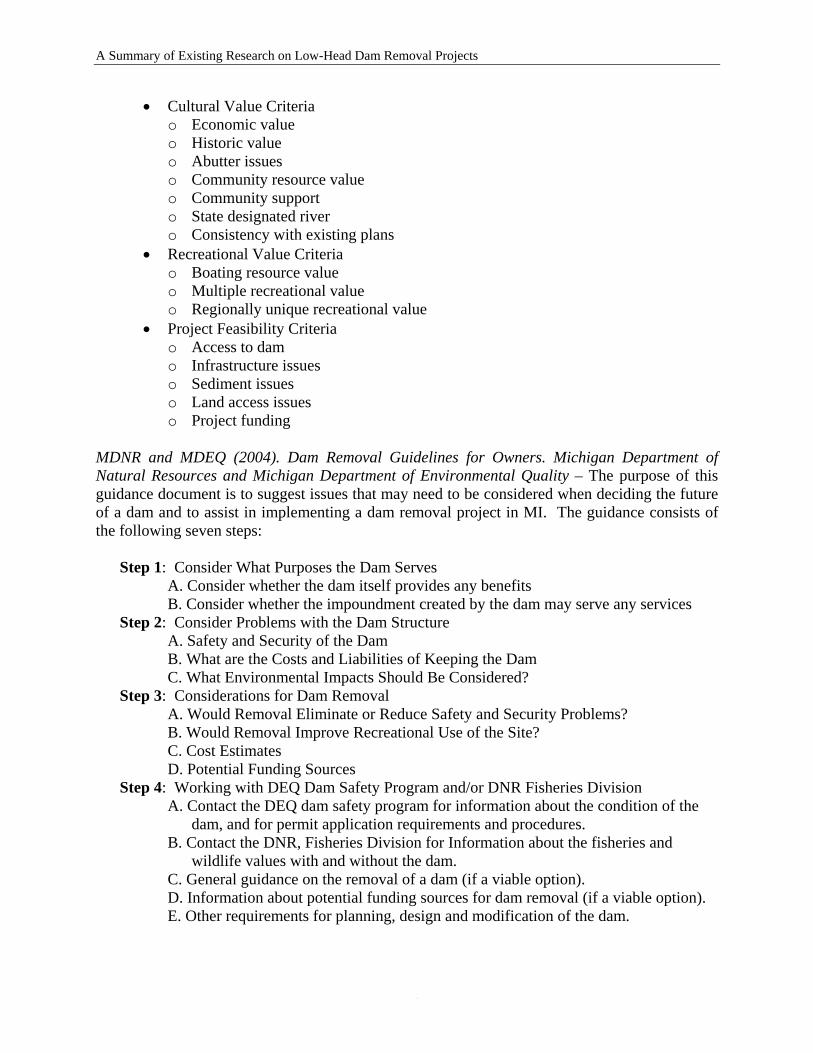
A Summary of Existing Research on Low-Head Dam Removal Projects
• Cultural Value Criteria o Economic value o Historic value o Abutter issues o Community resource value o Community support o State designated river o Consistency with existing plans
• Recreational Value Criteria o Boating resource value o Multiple recreational value o Regionally unique recreational value
• Project Feasibility Criteria o Access to dam o Infrastructure issues o Sediment issues o Land access issues o Project funding
MDNR and MDEQ (2004). Dam Removal Guidelines for Owners. Michigan Department of Natural Resources and Michigan Department of Environmental Quality – The purpose of this guidance document is to suggest issues that may need to be considered when deciding the future of a dam and to assist in implementing a dam removal project in MI. The guidance consists of the following seven steps: Step 1: Consider What Purposes the Dam Serves A. Consider whether the dam itself provides any benefits B. Consider whether the impoundment created by the dam may serve any services Step 2: Consider Problems with the Dam Structure A. Safety and Security of the Dam B. What are the Costs and Liabilities of Keeping the Dam C. What Environmental Impacts Should Be Considered? Step 3: Considerations for Dam Removal A. Would Removal Eliminate or Reduce Safety and Security Problems? B. Would Removal Improve Recreational Use of the Site? C. Cost Estimates D. Potential Funding Sources Step 4: Working with DEQ Dam Safety Program and/or DNR Fisheries Division A. Contact the DEQ dam safety program for information about the condition of the dam, and for permit application requirements and procedures. B. Contact the DNR, Fisheries Division for Information about the fisheries and wildlife values with and without the dam. C. General guidance on the removal of a dam (if a viable option). D. Information about potential funding sources for dam removal (if a viable option). E. Other requirements for planning, design and modification of the dam.
8-4
A Summary of Existing Research on Low-Head Dam Removal Projects
Step 5: Explore Resident and Community Concerns Including Local Watershed Council, Conservation Clubs, Economic Development Groups, others
A. Historic and aesthetic values of the dam and or impoundment B. Property Owners Interests C. Other Social Issues Step 6: Collect and Assess Information (Professional Engineering and/or Legal Services
Necessary) A. Legal Issues B. Engineering Issues C. Economic Issues
Step 7: Taking Action A. Secure Local, State and Federal Permits. B. Complete Site Land Survey, Final Design Engineering Plans. C. Secure Funding (construction, site restoration and monitoring). D. Determine Sediment Management Plan (may include dredge and disposal or in place stabilization as recommended by DEQ and DNR). E. Secure Authorization for Site Access.
8.1.2 Evaluation of Existing Guidance Documents
The existing guidance documents are produced by different agencies and are presented in different formats. Some of the guidance documents are detailed covering the information before, during, and after the dam removal while the others only cover the information for making the decision whether a dam should be removed. It is noted that all of the guidance documents cover the issues of safety, costs, ecology, technology, etc. None of the existing guidance documents describes the issues related to mitigation credits for transportation projects.
8.2 GUIDANCE FOR TRANSPORTATION PROJECTS – DECISION TREE OUTLINE
In this section, we will present a simple method for ranking and identifying the candidates of dams that can be removed so that stream remediation credits can be obtained for transportation projects. The method is illustrated in the flow chart in Figure 8.1. It need be noted that the proposed approach is to find the potential candidate dams for removal so that mitigation credit can be obtained. A potential candidate dam need be studied in detail before it is removed. The proposed approach is not intended to cover the detailed study.
8.2.1 Preliminary Evaluation
The primary driving forces for consideration of dam removal are
1. The cost of maintenance and repair when the benefits of maintaining a dam are diminished;
2. Public safety and liability concerns; and
8-5
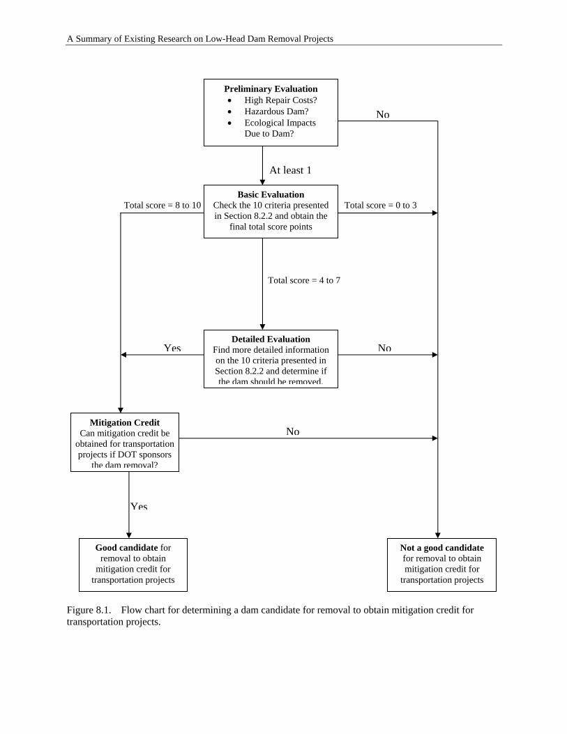
A Summary of Existing Research on Low-Head Dam Removal Projects
Preliminary Evaluation • High Repair Costs? • Hazardous Dam? • Ecological Impacts
Due to Dam?
At least 1
Basic Evaluation Check the 10 criteria presented in Section 8.2.2 and obtain the
final total score points
No
Total score = 0 to 3
Total score = 4 to 7
Detailed Evaluation Find more detailed information on the 10 criteria presented in Section 8.2.2 and determine if the dam should be removed.
Total score = 8 to 10
Not a good candidate for removal to obtain mitigation credit for
transportation projects
Mitigation Credit Can mitigation credit be
obtained for transportation projects if DOT sponsors
the dam removal?
Good candidate for removal to obtain
mitigation credit for transportation projects
Yes
No
NoYes
Figure 8.1. Flow chart for determining a dam candidate for removal to obtain mitigation credit for transportation projects.
8-6
A Summary of Existing Research on Low-Head Dam Removal Projects
3. Potential fisheries, water quality and recreational use improvements that can be realized with dam removal.
If a dam satisfies one or more of the above factors, then it can be selected for the potential candidate list. Dams from the potential candidate list are then evaluated based on the individual criteria described hereafter and prioritized according to their final score.
8.2.2 Basic Evaluation
Dams with increased potential for removal are those that provide little or no benefit, are a potential liability, are too costly to maintain or upgrade, and would provide an opportunity for economic, social, or environmental improvements to a river system if they are removed. The potential candidate dams can then be evaluated based on 10-weighted criteria. Each criterion is assigned a weighting of one point. If a dam meets a criterion condition, it receives a score of one point. The maximum score for a dam is 10. The 10 criteria are listed in Table 8.1:
8.2.3 Detailed Evaluation
For a dam with a score of 4 to 7, more detailed information needs to be collected and further evaluation needs to be conducted to determine if it should be removed for the purpose of obtaining mitigation credit.
8.2.4 Mitigation Credit for Transportation Projects
If evaluation determines that an unused dam is a good candidate for removal, one then needs to know if mitigation credit can be obtained for transportation projects (e.g., if state DOTs sponsor the removal). The following questions need be studied related to mitigation credit for transportation projects:
• Will the dam removal be related to any transportation projects? • Can mitigation credit be obtained if state DOTs sponsor the removal? • If yes, how much credit can be obtained if state DOTs sponsor the removal?
The process presented in Section 5.5 can be followed to determine the mitigation credits that can be obtained from a low-head dam removal project.
8-7
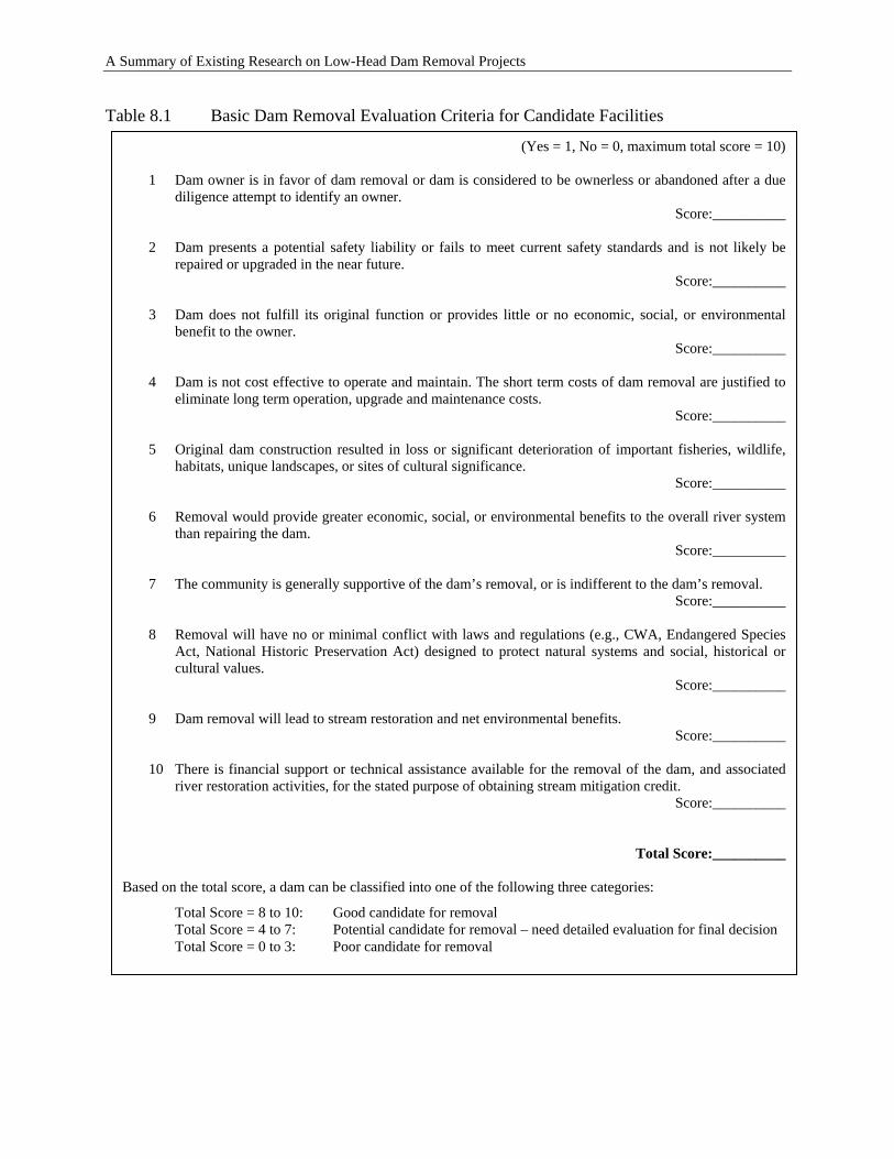
A Summary of Existing Research on Low-Head Dam Removal Projects
Table 8.1 Basic Dam Removal Evaluation Criteria for Candidate Facilities
Based on the total score, a dam can be classified into one of the following three categories:
Total Score = 8 to 10: Good candidate for removal Total Score = 4 to 7: Potential candidate for removal – need detailed evaluation for final decision Total Score = 0 to 3: Poor candidate for removal
9 Dam removal will lead to stream restoration and net environmental benefits. Score:__________
10 There is financial support or technical assistance available for the removal of the dam, and associated
river restoration activities, for the stated purpose of obtaining stream mitigation credit. Score:__________
Total Score:__________
8 Removal will have no or minimal conflict with laws and regulations (e.g., CWA, Endangered Species Act, National Historic Preservation Act) designed to protect natural systems and social, historical or cultural values.
Score:__________
7 The community is generally supportive of the dam’s removal, or is indifferent to the dam’s removal. Score:__________
6 Removal would provide greater economic, social, or environmental benefits to the overall river system than repairing the dam.
Score:__________
5 Original dam construction resulted in loss or significant deterioration of important fisheries, wildlife, habitats, unique landscapes, or sites of cultural significance.
Score:__________
4 Dam is not cost effective to operate and maintain. The short term costs of dam removal are justified to eliminate long term operation, upgrade and maintenance costs.
Score:__________
(Yes = 1, No = 0, maximum total score = 10) 1 Dam owner is in favor of dam removal or dam is considered to be ownerless or abandoned after a due
diligence attempt to identify an owner. Score:__________
2 Dam presents a potential safety liability or fails to meet current safety standards and is not likely be
repaired or upgraded in the near future. Score:__________
3 Dam does not fulfill its original function or provides little or no economic, social, or environmental
benefit to the owner. Score:__________
8-8
A Summary of Existing Research on Low-Head Dam Removal Projects
9 TOPICS IN NEED OF ADDITIONAL RESEARCH AND STUDY
The scientific research on the effects of dam removal is still in its initial stages, and elaborate theories on the subject are not yet developed. Although more than 600 dams have been removed in the United States in the past decades, very few published investigations accompanied each removal. While conducting other tasks of this project, we have identified the topics (environmental, economical, social, etc.) associated with low-head dam removals that are in need of additional research and study.
1. Dam removal database – Although more than 600 dams are collected and listed in Table B.2, most of them lack one or more types of information. It is necessary to have one organization or agency such as the National Dam Inventory to take formal responsibility for collecting and compiling these data at the national level.
2. Detailed study of dam removal projects – Very few of the dam removal projects are
studied in detail. It is necessary to select several dams and conduct detailed pre- and post-removal study. For example, the OH Scenic Rivers Program is conducting a 5-year pre- and post-removal study of St. John’s Dam removal. The study will examine how a formerly impounded river naturally recovers over time. The study includes fish electro-shocking, macroinvertebrate trapping, mussel surveys, water chemistry, sediment transport, Global Positioning System (GPS) mapping of cross sections of the river channel, GPS mapping of the river substrate and morphology (riffles, runs and pools), and monitoring of static water levels in 14 area wells. The researchers come from a variety of agencies including ODNR, Ohio State University, and Heidelberg College’s Water Quality Lab. The research is partially funded by monies raised through Scenic Rivers license plate sales (Vargo, 2004).
3. Economic analysis tool - Formal economic analysis can be very helpful in supporting the
decision-making process for dam removal, in setting priorities, and in considering the interests of stakeholders and agencies. However, significant challenges remain for the formal economic analysis because dam removal has a number of beneficial and adverse outcomes, some of which can be easily valued monetarily while others are highly uncertain and difficult or impossible to value. It is necessary to develop economic analysis tool specifically for supporting the decision-making process of dam removal.
4. There is little research on social science aspects related to dam removal (Heinz Center,
2002). This is a serious shortcoming because the social context of dam removal decisions is often as important as the environmental and economic contexts, and decisions regarding removal are made by people who are affected as much as the environment. This significant gap could be filled in many ways. For instance, research in sociology, geography, history, and planning could investigate the connections among communities, rivers, and dams. There is also more to learn more about the cultural significance of dams. Some dams or structures directly associated with them may have
9-1
A Summary of Existing Research on Low-Head Dam Removal Projects
substantial historical significance, so there may be reasons to remove only part of a dam or to preserve or restore the associated mill works or power house. A particularly important line of investigation that could be undertaken by nongovernmental organizations with the cooperation of state agencies would be to investigate the social and economics outcomes after dam removal. These after project studies are at least as important as environmental and social impact studies undertaken before the dam removal.
5. Very limited information exists regarding the potential impact that a dam removal may
have on property values. This is an issue often of great concern to landowners; therefore, this complex question is in need of additional research. Existing studies of the effect of water quality on lakefront property values are sometimes referenced in relation to dam removal. These studies have found that improvements to water quality often result in increased property values. However, these studies are lacking in the context of dam removal because they have not integrated the change in recreational use, aesthetics, and quality of life issues resulting from a change from a lake or pond environment to a riverine environment. For instance, a study conducted by the Minnesota Headwaters Board and Bemidji State University (2003) applied a hedonic analysis to model the incremental amounts that people are willing to pay for lake and river water quality. Researchers discovered that the model used for lakeshore analysis would apply very differently to river property. The variability of purchase price was far less predictable among riparian property sales than lakefront property sales. The researchers choose not to apply the river data to the hedonic model. This study demonstrates the uniqueness of studying riverfront property values. Research in relation to dam removal is likely to be complex in nature.
6. There is a need to clarify the feasibility and method of conducting a project that would
clearly result in credits in excess of those required for mitigation, but where the entity requiring credits does not wish to establish a mitigation bank. Certain projects with the potential for significant restoration benefits may only be possible through a combination of funding from entities requiring mitigation credit and funding from other entities that have an interest in dam removal and river restoration. There is considerable public and private funding available for dam removal projects but, for a variety of reasons, many fund providers do not consider mitigation projects to be eligible for funding. Would such a project be considered eligible for mitigation? How would the credit structure be established, monitored and assigned? How could entities requiring mitigation credit adequately evaluate these projects for their mitigation potential?
9-2
A Summary of Existing Research on Low-Head Dam Removal Projects
10 CONCLUSIONS
This research project has led to the following conclusions:
1. The existing dam removal databases do not include all the dams removed in the United States and, for the dams that are included in the existing databases, only limited information is included for each dam removal project. To bridge the data gaps, a survey was conducted for this study. The survey results and the final list of the collected dam removal projects are presented in Appendix B. Analyses of the survey results and the final dam removal project database lead to the following conclusions:
a. Dam removal appears to have been relatively uncommon before the 1980s but has
escalated significantly in the 21st century. The recent acceleration of dam removals reflects problems associated with aging structures, growing interest in restoring rivers and fish passage, new funding opportunities to support dam removal, and national policies aimed at improving the safety of aging structures and mitigating the environmental impacts of these structures.
b. The three most common reasons for dam removals are, in order, ecology, economics, and safety.
c. Most of the dams removed have a structural height smaller than 20 feet. This is in agreement with Heinz Center’s (2002) conclusion that “almost all of the dams removed thus far have been small ones.”
d. Most of the dams (79%) were totally removed, and only 21% were breached or partially removed.
e. The deconstruction cost is about half (52%) the total removal cost. 2. Removal of low-head dams has different impacts, both beneficial and adverse, including
physical and chemical impacts, ecological impacts, social impacts and economical impacts.
3. Removing dams can have distinct economic benefits, such as cost savings over repairing and maintaining the dam, potential for community riverfront revitalization, increased income to local fishing and boating industries, and decreased costs related to water quality improvements and fisheries management. However, these dam removal benefits may come at a price, due to the loss of economic benefits from the dam. To determine the economic benefits of a dam removal, one has to consider different costs and benefits including the costs and benefits to the dam owner, the societal costs and benefits, the recreational costs and benefits, and the environmental costs and benefits.
4. There are different legal and regulatory requirements for dam removal projects. It is important to follow a permitting process for dam removal projects so that the relevant legal and regulatory requirements are met.
10-1
A Summary of Existing Research on Low-Head Dam Removal Projects
5. Partial dam removal and/or diversion/bypass structures have also been used for stream restoration, recognizing that that complete removal of dams may not always be the best option for a river system. The impacts of partial dam removal, both beneficial and adverse, also need to be evaluated appropriately.
6. It’s been several decades since low-head dam removals were first used for stream restoration; but only several years since transportation agencies started to use low-head dam removal projects as a method of stream restoration to receive stream mitigation credit. The primary and secondary criteria need to be considered for determining the mitigation credit for dam removal.
7. Monitoring is necessary to measure the performance of dam removal projects. For a specific dam removal project, it is important to decide who should do the monitoring, what to monitor, and what applicable monitoring techniques to use.
8. Various guidance documents—produced by different agencies and presented in different formats—exist on decision-making related to dam removal. Some documents cover information related to each stage of dam removal (before, during, and after) while others cover only the information for deciding whether a dam should be removed. All guidance documents cover the issues of safety, costs, ecology, technology, etc. However, none describes the issues related to mitigation credits for transportation projects. Our review and evaluation of the information available led to a simple method for ranking and identifying dams that can be removed so that stream remediation credits can be obtained for transportation projects. This method consists of four progressive evaluation steps: preliminary, basic, detailed, and mitigation-credit evaluation.
9. Scientific research on the effects of dam removal is still in its initial stages, and elaborate
theories on the subject are not yet developed. Although more than 600 dams have been removed in the United States in the past decades, very few were accompanied by published investigations. The following topics associated with low-head dam removal need additional research and study: a. Dam removal database – one organization or agency, such as the National Inventory
of Dams, should take formal responsibility for collecting and compiling these data at the national level. The database should include the important information for each dam removal project such as the parameters listed in Table.2.1.
b. Detailed case studies of dam removal projects – select several dams and conduct detailed pre- and post-removal studies.
c. Economic analysis tool – develop an economic analysis tool specifically for supporting the decision-making process in dam removal.
d. Sociological study method – develop a methodology to analyze the social impacts of dam removal capable of supporting decision-making.
e. Impact of dam removal on property values – The information about the impact of dam removal on property values is very limited. This issue is often of great concern to landowners and needs additional research.
f. Mitigation credit for transportation projects – The concept of receiving stream mitigation credits for transportation projects by removing low-head dams is relatively
10-2

A Summary of Existing Research on Low-Head Dam Removal Projects
new. Studying how to determine mitigation credits and developing corresponding guidelines are necessary.
10-3

A Summary of Existing Research on Low-Head Dam Removal Projects
10-4
A Summary of Existing Research on Low-Head Dam Removal Projects
11 REFERENCES
American Rivers (2002). The Ecology of Dam Removal: A Summary of Benefits and Impacts. American Rivers, Washington, D.C. 15 pp. American Rivers, Friends of the Earth, and Trout Unlimited (1999). Dam Removal Success Stories – Restoring Rivers through Selective Removal of Dams that Don’t Make Sense. Aspen Institute (2002). Dam Removal: A New Option for a New Century. Washington, D.C. Barbour, M. T., J. Gerritsen, B. D. Snyder, and J. B. Stribling (1999). Rapid Bioassessment Protocols for Use in Streams and Wadeable Rivers: Periphyton, Benthic Macroinvertebrates and Fish, Second Edition. EPA 841-B-99-002. U.S. Environmental Protection Agency; Office of Water; Washington, D.C. Bednarek, A. T. (2001). Undamming rivers: A review of the ecological impacts of dam removal. Environmental Management, 27, 803-814. Bowman, M. (2002). Legal Perspectives on Dam Removal. Bioscience, 52(8), 739-747. Bushaw-Newton, K. L., D. D. Hart, J. E. Pizzuto, J. R. Thomson, J. Egan, J. T. Ashley, T. E. Johnson, R. J. Horwitz, M. Keeley, J. Lawrence, D. Charles, C. Gatenby, D.A. Kreeger, T. Nightengale, R.L. Thomas, and D.J. Velinsky (2002). An Integrative Approach Towards Understanding Ecological Responses to Dam Removal: The Manatawny Creek Study. Journal of the American Water Resources Association 38:1581-1599. Chang, H. H. (1998). Fluvial Processes in River Engineering. Krieger Publishing Company. Malabar, FL. 432pp. City of Kent, Ohio (2004). Cuyahoga River Restoration Project: October 2004 Progress Report. http://www.kentohio.org/reports/dam.asp. Doyle, M.W., J. M. Harbor and E. H. Stanley (2003). Toward Policies and Decision-Making for Dam Removal. Environmental Management 31(4): 453-465. Environmental Laboratory (1987). Corps of Engineers Wetlands Delineation Manual, Technical Report Y-87-1, US Army Corps of Engineers Waterways Experiment Station, Vicksburg, Miss. Federal Highway Administration (2001). River Engineering for Highway Encroachments: Highways in the River Environment. Hydraulic Design Series No. 6. U.S. Department of Transportation Publication No. FHWA NHI 01-004. [FEMA] Federal Emergency Management Agency (1999). National Dam Safety Program, http://www.fema.gov/mit/ndspweb.htm. French, R.H. (1985). Open-Channel Hydraulics. McGraw-Hill, USA, 739 pages Hannon, H. H. (1979). Chemical Modifications in Reservoir-Regulated Streams. In: The Ecology of Regulated Streams, J. V. Ward and J. A. Stanford (Editors). Plenum Press, New York, New York, 75-94.
11-1
A Summary of Existing Research on Low-Head Dam Removal Projects
Hart, D. D., T. E. Johnson, K. L. Bushaw-Newton, R. J. Horowitz, A. T. Bednarek, D. F. Charles, D. A. Kreeger and D. J. Velinsky (2002). Dam Removal: Challenges and Opportunities for Ecological Research and River Restoration. Bioscience 52: 669-681. Heinz Center (2002). Dam Removal: Science and Decision Making. Washington, D. C. Hitzhusen, F. (2003). Economic analysis of selected river corridor impacts and improvements: a Northeast U.S. case. Selected paper presented at the International Association of Agricultural Economists Meeting in Durbin, South Africa. Kanehl, P. D., J. Lyons and J. E. Nelson (1997). Changes in the Habitat and Fish Community of the Milwaukee River, Wisconsin, following the removal of the Woolen Mills Dam. North American Journal of Fisheries Management 11: 387-400. Kaufman, J. H. (1992). Effects on Wildlife of Restoration the Riverine Forest in the Rodman Pool Area. In: The Case for Restoring the Free-flowing Ocklawaha River. Florida Defenders of the Environment. 38-41. Kruse, S. A. (2005). Creating an interdisciplinary framework for economic valuation: a CVM application to dam removal. PhD Thesis, Ohio State University, Ohio. Lenhart, C. F. (2000). The vegetation and hydrology of impoundments after dam removal in southern Wisconsin. M.S. thesis. University of Wisconsin, Madison, Wisconsin. Martin, L. A., P. J. Mullholland, J. R. Webster, and H. M. Valett (2001). Denitrification Potential in Sediments of Headwater Streams in the Southern Appalachian Mountains, USA. Journal of the North American Benthological Society 20(4):505-519. Minnesota Headwaters Board and Bemidji State University (2003). Lakeshore Property Values and Water Quality: Evidence from Property Sales in the Mississippi Headwaters Area. Mississippi Headwaters Board. Morris, G.L. and J. Fan. (1998). Reservoir Sedimentation Handbook: Design and Management of Dams, Reservoirs, and Watersheds for Sustainable Use. The McGraw-Hill Companies, Inc. New York, NY Mulholland, P. J. (1996). Role of Nutrients Cycling in Streams. In: Algal Ecology: Freshwater Benthic Ecosystems, R. J. Stevenson, M. L. Bothwell, and R. L. Lowe (Editors). Academic Press, New York, New York, 609-633. Naiman, R. J. and J. M. Melillo (1984). Nitrogen Budget of a Sub-arctic Stream Altered by Beaver (Castor canadensis). Oecologica 62:150-155. Naiman, R. J., C. A. Johnston, and J. C. Kelley (1988). Alteration of North American Streams by Beaver. Bioscience 38:753-762. Newbold, J. D. (1987). Phosphorus Sprialing in Rivers and River-Reservoir Systems: Implications of a Model. In: Regulated Rivers, J. F. Craig and J. B. Kemper (Editors). Plenum Publishing, New York, New York. 303-327.
11-2
A Summary of Existing Research on Low-Head Dam Removal Projects
[NHDES] New Hampshire Department of Environmental Services (2005). Dam Removal and River Restoration Program web site: http://www.des.state.nh.us/dam/damremoval/faqs.asp. NHDES (2003) Guidelines to the Regulatory Requirements for Dam Removal Projects in New Hampshire. New Hampshire Department of Environmental Services, Concord, NH. DES-WD-03-35. http://www.des.state.nh.us/dam/damRemoval/Guidelines.pdf NHDES and New Hampshire Office Emergency Management (2003). Procedure to Assist in the Prioritization of Dam Removal Projects. New Hampshire Department of Environmental Services, Concord, NH. NRC (2001). National Research Council, Compensating for Wetland Losses under the Clean Water Act. Washington, D.C., National Academy Press. Oakland, M. W. and I. M. Bolender (2003). Retirement isn’t the end of a historic dam’s career. In: Proceedings of the 2003 Annual Conference of the Association of State Dam Safety Officials, Minneapolis, Minnesota. [ODNR] Ohio Department of Natural Resources. (undated) Web site http://www.dnr.state.oh.us/water/dsafety/lowhead_dams/case_study_stjohn.htm. ODNR (2005). Ohio Non-point Source Pollution Management 2005-2010. http://www.epa.state.oh.us/dsw/nps/NPSMP/docs/stjohncasestudy.html. Pansic, N., Austin, R. J. and Finis, M. (1998). Sediment Management for Dam Decommissioning. 15th Annual USCOLD Lecture Series, USCOLD, Denver. Poff, N. L. and D. D. Hart (2002). How Dams Vary and Why It Matters for the Emerging Science of Dam Removal. Bioscience 52:659-668. Rosgen, D. (1996). Applied River Morphology. Wildland Hydrology. Pagosa Springs, CO. Scruton, D. A. , Anderson, T. C. and King, L. W. (1998). Pamehac Brook: A case study of the restoration of a Newfoundland, Canada, river impacted by flow diversion for pulpwood transportation. Aquatic Conserv., 8, 145-157. Shafroth, P. B., J. M. Friedman, G. T. Auble, M. L. Scott, and J. H. Braatne (2002). Potential Responses of Riparian Vegetations to Dam Removal. BioScience 52:703-712. Shuman, J. R. (1995). Environmental considerations for assessing dam removal alternatives for river restoration. Regul River, 11, 249–61. Stanley, E. H. and M. W. Doyle (2001). Phosphorus Transport Before and After Dam Removal From a Nutrient-Rich Creek in Southern Wisconsin. Bulletin from the North American Benthological Society 18:172. Stanley, E. H. and M. W. Doyle (2002). A Geomorphic Perspective on Nutrient Retention Following Dam Removal. BioScience 52:693-701.
11-3
A Summary of Existing Research on Low-Head Dam Removal Projects
Stanley, E. H., M.A. Luebke, M.W. Doyle, and D.W. Marshall (2002). Short-term changes in channel form and macroinvertebrate communities following low-head dam removal. Journal of the North American Benthological Society 21: 172-187. St. Louis, V. I., C. A. Kelly, E. Duchemin, J. W. M. Rudd, and D. M. Rosenberg (2000). Reservoir Surfaces as Source of Greenhouse Gases to the Atmosphere: A Global Estimate. Bioscience 50:766-775. [USACE] U.S. Army Corps of Engineers (2002). Guidance on Compensatory Mitigation Projects for Aquatic Resource Impacts Under the Corps Regulatory Program Pursuant to Section 404 of the Clean Water Act and Section 10 of the Rivers and Harbors Act of 1899. Regulatory Guidance Letter 01-2. December 2002. USACE (2003b). Stream Mitigation Guidelines. Wilmington District, Regulatory Division. April 2003. USACE (2004). Determining Appropriate Compensatory Mitigation Credit for Dam Removal Projects. Wilmington District, Regulatory Division. March 22, 2004. USACE, Environmental Protection Agency, National Resources Conservation Service, US Fish and Wildlife Service, and National Marine Fisheries Service (1995). Federal Guidance for the Establishment, Use and Operation of Mitigation Banks. Federal Register 60: 58,605-58,614. [USEPA] United States Environmental Protection, U.S. Army Corps of Engineers, Department of Agriculture, Department of Commerce, Department of Interior and Department of Transportation (2002). National Wetlands Mitigation Action Plan. Dec. 24, 2002. USEPA and Department of the Army (1990). Memorandum of Agreement between the EPA and the Department of the Army Concerning the Determination of Mitigation Under the Clean Water Act Section 404(b)(1) Guidelines. February 6, 1990. Vargo, B (2004). Dam removal benefits stream ecology. Natural Ohio, Ohio Department of Natural Resources, 27(1), 6. Wetzel, R. G. (2001). Limnology: Lake and River Ecosystems (Third Edition). Academic Press, New York, New York. Williams, D. T. (1977). Effects of dam removal: an approach to sedimentation. Hydrologic Engineering Center Technical Paper No. 50. US Army Corps of Engineers, Davis, California. Wohl, E. E. and D. A. Cenderelli (2000). Sediment Deposition and Transport Patterns Following a Reservoir Sediment Release. Water Resources Research 36: 319-333. Yang, C. T. (1996). Sediment Transport Theory and Practice. The McGraw-Hill Companies, Inc. 396pp.
11-4

Appendix A
Survey Cover Letter and Contact List
A-1

A-2

Cover Letter Dear Colleagues, ICF Consulting is preparing a report entitled A Summary of Existing Research on Low-Head Dam Removal Projects for the Transportation Research Board's National Cooperative Highway Research Program (NCHRP). As part of our research, we have prepared a survey to fill data gaps related to dam removal in general and its application to environmental mitigation in particular. You have been identified as a professional who could potentially increase the body of knowledge related to dam removal. Do you regulate or deal with low-head dams in any way? If so, we thank you in advance for taking time from your schedule to complete the survey in the Microsoft Excel file attached. If not, can you direct us to an authority that can better assist with this survey? Please feel free to forward them this message with the survey attached. The survey has three parts: Tab #1: Respondent Information – Seven entries for your contact information Tab #2: Survey questions – Eight questions to fill specific knowledge gaps. For the first two
questions, please enter your input under Tab #3. For the remaining six questions, please enter your response directly in the right-hand column of Tab #2.
Tab #3: Case Study Database – A case study database on dam removal projects for you to fill in gaps or add new case studies. Please keep the “track changes” feature on to facilitate the handling of the new information.
Please send the completed survey to the following address: [email protected] Thank you again for your help in this important undertaking. Additional information: For the subject study, we are inclined to adopt the definitions shown below. However, do not fail to include a project because of conflicts with the definitions adopted for the study. We prefer to make our survey more inclusive rather than exclusive.
Low-head dam: A constructed barrier in a river with a hydraulic height (head water to tail water) not exceeding 25 feet. For the subject study, this definition encompasses run-of-river dams as well as other small dams but omits dams not built to create an impoundment in a river.
A-3

Run-of-river dam: A constructed barrier in a river where the river inflow normally overflows from behind the dam from one side of the waterway to the other. A run-of-river dam has limited short-term storage capacity. Small dam: A constructed barrier in a river with a structural height not exceeding 50 feet. For the subject study, this definition omits dams not built to create an impoundment in a river.
We apologize for any duplicate e-mails.
Francisco Silva, Sc.D., P.E. Senior Vice President ICF Consulting 33 Hayden Avenue Office 326 Lexington, Massachusetts U.S.A. 02421-7918 +1-781-676-4087 Tel +1-781-676-4066 Fax [email protected]
A-4

List of Contact Email Address
[email protected] [email protected] [email protected] [email protected] [email protected] [email protected] [email protected] [email protected] [email protected] [email protected] [email protected] [email protected] [email protected] [email protected] [email protected] [email protected] [email protected] [email protected] [email protected] [email protected] [email protected] [email protected] [email protected] [email protected] [email protected] [email protected] [email protected] [email protected] [email protected] [email protected] [email protected] [email protected] [email protected] [email protected] [email protected] [email protected] [email protected] [email protected] [email protected] [email protected] [email protected] [email protected] [email protected] [email protected]
[email protected] Beverley.B.Getzen@ hq02.usace.army.mil Mark.F.Sudol@ hq02.usace.army.mil [email protected] [email protected] [email protected] [email protected] [email protected] [email protected] [email protected] [email protected] [email protected] [email protected] [email protected] [email protected] [email protected] [email protected] [email protected] [email protected] [email protected]@[email protected] [email protected] [email protected] [email protected] [email protected] [email protected] [email protected] [email protected] [email protected] [email protected] [email protected] [email protected] [email protected] [email protected] [email protected] [email protected] [email protected] [email protected] [email protected] [email protected] [email protected] [email protected]
A-5

[email protected] [email protected]; [email protected] [email protected]; [email protected] [email protected]; [email protected] [email protected]; [email protected] [email protected]@erdc.usace.army.mil [email protected]; [email protected] [email protected] [email protected] [email protected]; [email protected] [email protected];
[email protected]; [email protected] [email protected] [email protected]; [email protected] [email protected]; [email protected] [email protected]; [email protected] [email protected]; [email protected] [email protected]; [email protected] [email protected]; [email protected] [email protected]; [email protected] [email protected]; [email protected] [email protected]; [email protected] [email protected]; [email protected] [email protected]; [email protected] [email protected]; [email protected] [email protected]; [email protected] [email protected]; [email protected] [email protected]; [email protected] [email protected]; [email protected] [email protected]; [email protected]; [email protected]; [email protected]; [email protected]; [email protected]; [email protected]; [email protected]; [email protected]@dep.state.fl.us; [email protected]; [email protected]; [email protected]; [email protected]; [email protected]; [email protected]; [email protected]; [email protected]; [email protected]; [email protected]; [email protected]@adwr.state.az.us; [email protected]@ecy.wa.gov; [email protected]@dnr.state.wi.us; [email protected]@wvdep.org; [email protected] Notes: ** = Responded with new information; and ** = Responded without new information.
A-6

Appendix B
Answers to Survey Questions and
Final List of Dam Removal Projects
B-1

B-2
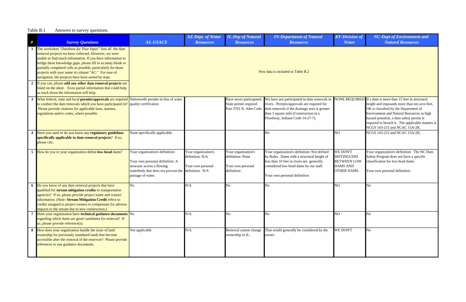
Table B.1 Answers to survey questions.
# Survey Questions AL-USACEAZ-Dept. of Water
ResourcesIL-Dep of Natural
ResourcesIN-Department of Natural
ResourcesKY-Division of
WaterNC-Dept of Environment and
Natural Resources1 The worksheet "Database for Your Input " lists all the dam
removal projects we have collected. However, we were unable to find much information. If you have information to bridge these knowledge gaps, please fill in as many blank or partially completed cells as possible, particularly for those projects with your name in column "AC." For ease of navigation, the projects have been sorted by state.
2 If you can, please add any other dam removal projects not listed on the sheet. Even partial information that could help us track down the information will help.
3 What federal, state and local permits/approvals are required to conduct the dam removals which you have participated in? Please provide citations for applicable laws, statutes, regulations and/or codes, where possible.
Nationwide permits in lieu of water quality certification
Have never participated.State permit required Part 3702 IL Adm Code
We have not participated in dam removals in rivers. Permits/approvals are required for dam removals if the drainage area is greater than 1 square mile (Construction in a Floodway, Indiana Code 14-27-7).
NONE REQUIRED If a dam is more than 15 feet in structural height and impounds more than ten acre-feet, OR is classified by the Department of Environment and Natural Resources as high hazard potential, a dam safety permit is required to breach it. The applicable statutes is NCGS 143-215 and NCAC 15A-2K.
4 Have you used or do you know any regulatory guidelines specifically applicable to dam removal projects? If so, please cite.
None specifically applicable. No NO NCGS 143-215 and NCAC 15A-2K.
5 How do you or your organization define low-head dams? Your organization's definition: Your own personal definition: A structure across a flowing waterbody that does not prevent the passage of water.
Your organization's definition: N/A Your own personal definition: N/A
Your organization's definition: None Your own personal definition:
Your organization's definition: Not defined by Rules. Dams with a structural height of less than 10 feet in rivers are generally considered low-head dams by our staff. Your own personal definition:
WE DON'T DISTINGUISH BETWEEN LOW DAMS AND OTHER DAMS.
Your organization's definition: The NC Dam Safety Program does not have a specific classification for low head dams. Your own personal definition:
6 Do you know of any dam removal projects that have qualified for stream mitigation credits to transportation agencies? If so, please provide project name and contact information. (Note: Stream Mitigation Credit refers to credits assigned to project owners to compensate for adverse impacts to the stream due to new construction.)
No N/A No No NO No
7 Does your organization have technical guidance documents regarding which dams are good candidates for removal? If so, please provide reference(s).
No N/A No No NO No
8 How does your organization handle the issue of land ownership for previously inundated lands that become accessible after the removal of the reservoir? Please provide references to any guidance documents.
Not applicable N/A Removal cannot change ownership in IL.
That would generally be considered by the owner.
WE DON'T No
New data is included in Table B.2
B-3
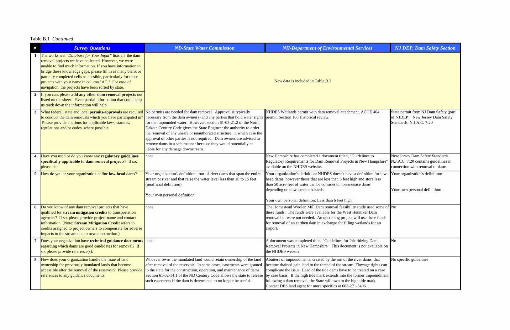
Table B.1 Continued.
# Survey Questions ND-State Water Commission NH-Department of Environmental Services NJ DEP, Dam Safety Section1 The worksheet "Database for Your Input " lists all the dam
removal projects we have collected. However, we were unable to find much information. If you have information to bridge these knowledge gaps, please fill in as many blank or partially completed cells as possible, particularly for those projects with your name in column "AC." For ease of navigation, the projects have been sorted by state.
2 If you can, please add any other dam removal projects not listed on the sheet. Even partial information that could help us track down the information will help.
3 What federal, state and local permits/approvals are required to conduct the dam removals which you have participated in? Please provide citations for applicable laws, statutes, regulations and/or codes, where possible.
No permits are needed for dam removal. Approval is typically necessary from the dam owner(s) and any parties that hold water rights for the impounded water. However, section 61-03-21.2 of the North Dakota Century Code gives the State Engineer the authority to order the removal of any unsafe or unauthorized structure, in which case the approval of other parties is not required. Dam owners are advised to remove dams in a safe manner because they would potentially be liable for any damage downstream.
NHDES Wetlands permit with dam removal attachment, ACOE 404 permit, Section 106 Historical review,
State permit from NJ Dam Safety (part of NJDEP). New Jersey Dam Safety Standards, N.J.A.C. 7:20
4 Have you used or do you know any regulatory guidelines specifically applicable to dam removal projects? If so, please cite.
none New Hampshire has completed a document titled, "Guidelines to Regulatory Requirements for Dam Removal Projects in New Hampshire" available on the NHDES website.
New Jersey Dam Safety Standards, N.J.A.C. 7:20 contains guidelines in connection with removal of dams
5 How do you or your organization define low-head dams? Your organization's definition: run-of-river dams that span the entire stream or river and that raise the water level less than 10 to 15 feet (unofficial definition) Your own personal definition:
Your organization's definition: NHDES doesn't have a definition for low-head dams, however those that are less than 6 feet high and store less than 50 acre-feet of water can be considered non-menace dams depending on downstream hazards. Your own personal definition: Less than 6 feet high
Your organization's definition:
Your own personal definition:
6 Do you know of any dam removal projects that have qualified for stream mitigation credits to transportation agencies? If so, please provide project name and contact information. (Note: Stream Mitigation Credit refers to credits assigned to project owners to compensate for adverse impacts to the stream due to new construction.)
none The Homestead Woolen Mill Dam removal feasibility study used some of these funds. The funds were available for the West Henniker Dam removal but were not needed. An upcoming project will use these funds for removal of an earthen dam in exchange for filling wetlands for an airport.
No
7 Does your organization have technical guidance documents regarding which dams are good candidates for removal? If so, please provide reference(s).
none A document was completed titled "Guidelines for Prioritizing Dam Removal Projects in New Hampshire" This document is not available on the NHDES website.
No
8 How does your organization handle the issue of land ownership for previously inundated lands that become accessible after the removal of the reservoir? Please provide references to any guidance documents.
Whoever owns the inundated land would retain ownership of the land after removal of the reservoir. In some cases, easements were granted to the state for the construction, operation, and maintenance of dams. Section 61-02-14.1 of the ND Century Code allows the state to release such easements if the dam is determined to no longer be useful.
Abutters of impoundments, created by the run of the river dams, that become drained gain land to the thread of the stream. Flowage rights can complicate the issue. Head of the tide dams have to be treated on a case by case basis. If the high tide mark extends into the former impoundment following a dam removal, the State will own to the high tide mark. Contact DES land agent for more specifics at 603-271-3406.
No specific guidelines
New data is included in Table B.2
B-4
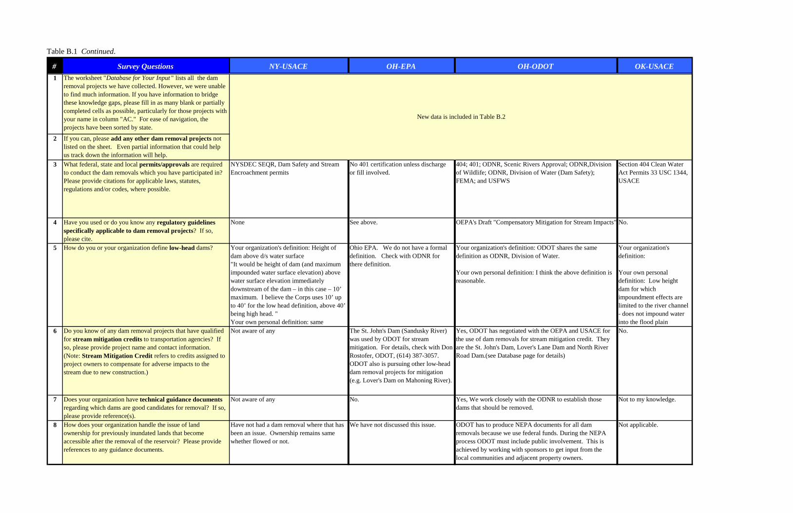
Table B.1 Continued.
# Survey Questions NY-USACE OH-EPA OH-ODOT OK-USACE1 The worksheet "Database for Your Input " lists all the dam
removal projects we have collected. However, we were unable to find much information. If you have information to bridge these knowledge gaps, please fill in as many blank or partially completed cells as possible, particularly for those projects with your name in column "AC." For ease of navigation, the projects have been sorted by state.
2 If you can, please add any other dam removal projects not listed on the sheet. Even partial information that could help us track down the information will help.
3 What federal, state and local permits/approvals are required to conduct the dam removals which you have participated in? Please provide citations for applicable laws, statutes, regulations and/or codes, where possible.
NYSDEC SEQR, Dam Safety and Stream Encroachment permits
No 401 certification unless discharge or fill involved.
404; 401; ODNR, Scenic Rivers Approval; ODNR,Division of Wildlife; ODNR, Division of Water (Dam Safety); FEMA; and USFWS
Section 404 Clean Water Act Permits 33 USC 1344, USACE
4 Have you used or do you know any regulatory guidelines specifically applicable to dam removal projects? If so, please cite.
None See above. OEPA's Draft "Compensatory Mitigation for Stream Impacts" No.
5 How do you or your organization define low-head dams? Your organization's definition: Height of dam above d/s water surface"It would be height of dam (and maximum impounded water surface elevation) above water surface elevation immediately downstream of the dam – in this case – 10’ maximum. I believe the Corps uses 10’ up to 40’ for the low head definition, above 40’ being high head. "Your own personal definition: same
Ohio EPA. We do not have a formal definition. Check with ODNR for there definition.
Your organization's definition: ODOT shares the same definition as ODNR, Division of Water. Your own personal definition: I think the above definition is reasonable.
Your organization's definition: Your own personal definition: Low height dam for which impoundment effects are limited to the river channel - does not impound water into the flood plain
6 Do you know of any dam removal projects that have qualified for stream mitigation credits to transportation agencies? If so, please provide project name and contact information. (Note: Stream Mitigation Credit refers to credits assigned to project owners to compensate for adverse impacts to the stream due to new construction.)
Not aware of any The St. John's Dam (Sandusky River) was used by ODOT for stream mitigation. For details, check with Don Rostofer, ODOT, (614) 387-3057. ODOT also is pursuing other low-head dam removal projects for mitigation (e.g. Lover's Dam on Mahoning River).
Yes, ODOT has negotiated with the OEPA and USACE for the use of dam removals for stream mitigation credit. They are the St. John's Dam, Lover's Lane Dam and North River Road Dam.(see Database page for details)
No.
7 Does your organization have technical guidance documents regarding which dams are good candidates for removal? If so, please provide reference(s).
Not aware of any No. Yes, We work closely with the ODNR to establish those dams that should be removed.
Not to my knowledge.
8 How does your organization handle the issue of land ownership for previously inundated lands that become accessible after the removal of the reservoir? Please provide references to any guidance documents.
Have not had a dam removal where that has been an issue. Ownership remains same whether flowed or not.
We have not discussed this issue. ODOT has to produce NEPA documents for all dam removals because we use federal funds. During the NEPA process ODOT must include public involvement. This is achieved by working with sponsors to get input from the local communities and adjacent property owners.
Not applicable.
New data is included in Table B.2
B-5
Table B.1 Continued.
# Survey Questions PA-Fish and Boat Commission
RI-Department of Environmental
ManagementTN-Department of Environment and
ConservaionTX-TX Commission
of Env Quality WA-State Dam safety1 The worksheet "Database for Your Input " lists all the dam
removal projects we have collected. However, we were unable to find much information. If you have information to bridge these knowledge gaps, please fill in as many blank or partially completed cells as possible, particularly for those projects with your name in column "AC." For ease of navigation, the projects have been sorted by state.
2 If you can, please add any other dam removal projects not listed on the sheet. Even partial information that could help us track down the information will help.
3 What federal, state and local permits/approvals are required to conduct the dam removals which you have participated in? Please provide citations for applicable laws, statutes, regulations and/or codes, where possible.
federal-Section 404 of Clean Water Act as amended, Section 10 of River and Harbor Act, PA State Programmatic General Permit. State: waiver provision of Title 25, Section 105.12(a)(1) of the Pennsylvania Code (DEP), Drawdown Permit (PFBC), Erosion and Sediment Control Plan (County).
Removal would require a state Aquatic Resource Alteration Permit under the Tennessee Water Quality Control ACT and The Rules of the Water Quality Control Board Chapter 1200-4-7
State approval is required to remove a dam. See 30 Texas Administrative Code Chapter 299, §299.51.
Federal - USACE 404 and/or 404 permits, State - Dam Construction Permit/approval (RCW90.03.350 and WAC 173-175) for other permits, visit our web page at http://www.ecy.wa.gov/pubs/9255b.pdf (pages 5 through 8)
4 Have you used or do you know any regulatory guidelines specifically applicable to dam removal projects? If so, please cite.
covered under above No. Dam removal activities cannot result in violation of state water quality criteria (not specific to dam removal, but applicable to all activities requiring a permit).
We have no regulatory guidelines for dam removal other than the rule given above.
No
5 How do you or your organization define low-head dams? Your organization's definition:
Your own personal definition:
None. Your organization's definition:
Your own personal definition:
We have no definition for low-head dam in the rules.
Your organization's definition: we don't have a "low-head" definition. We do define a "small Dam" as being < 15 feet high Your own personal definition: same as a "small dam"
6 Do you know of any dam removal projects that have qualified for stream mitigation credits to transportation agencies? If so, please provide project name and contact information. (Note: Stream Mitigation Credit refers to credits assigned to project owners to compensate for adverse impacts to the stream due to new construction.)
No. No, but construction of new impoundments is an activity that, if permitted, requires compensatory mitigation. Dam removal would be one of a variety of mitigation measures to offset a permitted loss of water resource value.
I do not know of any removal projects that qualified for a stream mitigation credit.
NO
7 Does your organization have technical guidance documents regarding which dams are good candidates for removal? If so, please provide reference(s).
Project Selection Protocol and Guidelines for Pennsylvania Fish And Boat Commission Consultation and Grant Program for Fish Passage and Habitat Restoration
No. No. We have no guidance documents regarding dams that may be a candidate for removal.
NO
8 How does your organization handle the issue of land ownership for previously inundated lands that become accessible after the removal of the reservoir? Please provide references to any guidance documents.
Has not come up, to my knowledge.
N/A We have not addressed ownership of the reservoir area.
NO
New data is included in Table B.2
B-6

This page is intentionally left blank.
B-7

Table B.2 Final list of dam removal projects.
State Dam River Removal Date
Total Removal Cost in US$
(Engineering, Permitting,
Deconstruction, etc.)
Removal Cost in US$
(deconstruction cost only)
How was removal funded?
Indicate whether dam was removed (total removal) or breached (partial
removal)
Dam Maximum Structural Height (ft)
Dam
Length (ft)
Reservoir Volume (acre-ft)
Owner Date Built
Type of Dam
State Hazard Classification
Who regulates dam
Run–of– river dam?
(Yes or No)
Original purpose of
dam
Most recent use of dam
and reservoir
AK Unnamed Dam Allison Creek 2004 6 30 1970 Gravel Stream Gauging
AK Davidson Ditch Diversion Dam
Chatanika River 2002 1920s Concrete butress
AK Switzer One Dam Switzer Creek (trib.)
1988 15
AK Switzer Two Dam
Switzer Creek (trib.)
1988 15
AL Marvel Slab Cahaba River 2004 216,000 105,000 Federal, Other Removed 7 5 210 State government
1965 Concrete Non-regulated Yes Other Other
AR Lake St. Francis Dam
Crow Creek 1989 45
AR Mansfield Dam Coop Creek 19AR Winton Spring
DamUnknown 4
AR Hot Springs Park Ricks Lower #1 Dam
Unknown 1986 11
AZ Golder Dam Canada del Oro 1980AZ Concrete Dam Walsh Canyon 1982 39AZ Perrin Dam Walsh Canyon 1980 Owner Breached 32 Local
governmentEarth fill High State Yes Water Supply
CA York Creek Diversion Structure
York Creek 2004 Concrete masonry
Diversion
CA A-Frame Dam Brandy Creek 2003 30 100 1950s Earth Recreation
CA Haypress Pond Dam
Haypress Pond 2003 20 Earth Watering stock
CA Cascade Diversion Dam
Merced River 2003 18 184 1916 Timber crib Supply power
CA Unnamed Dam Murphy Creek 2003 700,000 12 Earth Watering hole
CA Mumford Dam Russian River 2003 60
CA East Panther Creek Dam
East Panther Creek
2003 Pacific Gas & Electric
Dam ID Removal Information Dam Characteristics
B-8
Condition of dam prior to removal
Did dam meet applicable
safety requirements
PrimaryRemoval Reason
Other (secondary)
Removal Reasons
Benefits
CWA 404 Permit
or 401 Certification
Stream Mitigation
Credit assigned? (Yes
or No)
Study after Removal? (Yes or
No). Please provide reference
in comments column.
Contact Information (please include e-mail address) Additional information or comments
E$ Restore creek's ecological integrity by restoring free movement of fish and other aquatic organisms
Meagan Boltwood, Anchorage Waterways Council, (907) 743-1052, [email protected].
F Open upstream habitat to fisheries;Increase recreational opportunities
Mike Roy, U.S. Fish and Wildlife Service, (907) 786-3825, [email protected]
Good Unregulated E Aesthetics Expands the potential range of fish; Increases habitat;
None No Yes The Nature Conservancy partnered the project. TNC proposes future monitoring.
Verified by Pohl and not included in database.DATA LACKING. Need measurements and removal verification.
Verified by Pohl and not included in database.
SS
Poor No S Bill Jenkins, AZ Dept of Water Resources, (602) 417-2445, [email protected]
Open 2.5 miles of high-quality shaded habitat for steelhead and native rainbow trout;Increase delivery of spawning-sized gravel to lower York Creek and the Napa River
Steve Rothert, American Rivers, (530) 478-5672, [email protected]
E$S Jerry Wheeler, National Park Service, (530) 242-3430, [email protected]
E Darren Fong, Golden Gate National Recreation Area, (415) 331-8716, Darren [email protected]
$ Restore the river Steve Evans, Friends of the Rivers, (916) 442-3155, [email protected]
E John Brody, Natural Resources Conservation Service, (209) 327-2823
Restore approximately 720 feet of stream channel below Dam;Provide fish passage
Ron Benkert, Sonoma County Water Agency, (707) 547-1905, [email protected]
Partial removal
Restore natural flow patterns Pete Bell, Foothills Conservancy, 209-296-5734 Partial removal and removal of the remaining structure scheduled for 2008
Supplementary InformationRemoval Details
B-9

Table B.2 Continued.
State Dam River Removal Date
Total Removal Cost in US$
(Engineering, Permitting,
Deconstruction, etc.)
Removal Cost in US$
(deconstruction cost only)
How was removal funded?
Indicate whether dam was removed (total removal) or breached (partial
removal)
Dam Maximum Structural Height (ft)
Dam Hydraulic
Height (ft)
Dam Length
(ft)
Reservoir Volume (acre-ft)
Owner Date Built
Type of Dam
State Hazard Classification
Who regulates dam
Run–of– river dam?
(Yes or No)
Original purpose of
dam
Most recent use of dam
and reservoir
CA West Panther Creek Dam
West Panther Creek
2003 16 Pacific Gas & Electric
1930s Hydropower
CA Crocker Creek Dam
Crocker Creek 2002 460,000 30 80 1904 Concrete Recreation
CA Unnamed Arizona Crossing
Solstice Creek 2002
CA Unnamed Dam Ferrari Creek 2002 5 Earth
CA North Debris Dam
Unnamed Tributary to the LA River
2002 20 Earth Catch debris
CA Trancas Debris Dam
Unnamed Tributary to Trancas Canyon
2002 15 Steel & timber
Debris control
CA Two Swim Dams Alameda Creek 2001
CA McCormick-Saeltzer Dam
Clear Creek 2000 18 60
CA D.B. Fields/Johnson Dam
Indian Creek 1946 Mining
CA Henry Danninbrink D
Canyon Creek 1927 Mining
CA Moser Dam Swillup Creek 1949 Mining
CA Three C. Picket Dam
Beaver Creek 1949
CA Trout Haven Dam Monkey Creek
CA unnamed dam (1) Guadalupe River 1998 317,140 Federal, State, Other
CA unnamed dam (2) Guadalupe River 1998 317,140 Federal, State, Other
CA Red Hill Mining Co. Dam
Canyon Creek 1951 30 Mining
Dam ID Removal Information Dam Characteristics
B-10
Condition of dam prior to removal
Did dam meet applicable
safety requirements
PrimaryRemoval Reason
Other (secondary)
Removal Reasons
Benefits
CWA 404 Permit
or 401 Certification
Stream Mitigation
Credit assigned? (Yes
or No)
Study after Removal? (Yes or
No). Please provide reference
in comments column.
Contact Information (please include e-mail address) Additional information or comments
Restore natural flow patterns;Open additional habitat for trout ;Allow sediment to more naturally disperse throughout the system
Pete Bell, Foothills Conservancy, 209-296-5735
$ Opened 2 miles of habitat for chinook and steelhead
Ron Benkert, Sonoma County Water Agency, (707) 547-1905, [email protected]
E Charles Karpowicz, National Park Service, (202) 513-7022, [email protected]
Fish have returned; Vegetation has reestablished itself
Katherine Elliot, Trust for Public Land, (415) 495-5660
$ Charles Karpowicz, National Park Service, (202) 513-7022, [email protected]
Charles Karpowicz, National Park Service, (202) 513-7022, [email protected]
Pete Alexander, East Bay Regional Park District, (510) 635-0135 ext. 2342
Opened 12 miles of spawning habitat to threatened salmon and steelhead, providing enough habitat to produce an additional 2,000 fish of each species per year
Steve Evans, Friends of the River, (916) 442- 3155, [email protected]. http://www.friendsoftheriver.org/riversreborn/clear.html
DATA LACKING. Dam removed (CA Dept Water Resources). Need measurements.
DATA LACKING. Dam removed (CA Dept Water Resources). Need measurements.DATA LACKING. Dam removed (CA Dept Water Resources). Need measurements.DATA LACKING. Dam removed (CA Dept Water Resources). Need measurements.
DATA LACKING. Need measurements and removal verification. Article from the San Jose Mercury News (9/28/98) Authorities Will Dismantle Fish Barriers on San Jose, Calif., River By Frank SweeneyDATA LACKING. Need measurements and removal verification. Article from the San Jose Mercury News (9/28/98) in filesAuthorities Will Dismantle Fish Barriers on San Jose, Calif., River By Frank Sweeney
Supplementary InformationRemoval Details
B-11

Table B.2 Continued.
State Dam River Removal Date
Total Removal Cost in US$
(Engineering, Permitting,
Deconstruction, etc.)
Removal Cost in US$
(deconstruction cost only)
How was removal funded?
Indicate whether dam was removed (total removal) or breached (partial
removal)
Dam Maximum Structural Height (ft)
Dam Hydraulic
Height (ft)
Dam Length
(ft)
Reservoir Volume (acre-ft)
Owner Date Built
Type of Dam
State Hazard Classification
Who regulates dam
Run–of– river dam?
(Yes or No)
Original purpose of
dam
Most recent use of dam
and reservoir
CA Lone Jack Dam Trinity River (East Fork of North Fork)
24 Mining
CA Anderline Dam Rush Creek 1936 20 MiningCA Clarissa V.
Mining DamRedding Creek 1950 20 Mining
CA Minnie Reeves Dam
Indian Creek 20 Mining
CA North Fork Placers Dam
Trinity River (North Fork)
1950 15 Mining
CA McCormick-Saeltzer Dam
Clear Creek 2000 15 150 1902-1912
Irrigation
CA Big Creek Mfg. Dam
Big Creek 14
CA Quinn Dam Trinity River (East Fork of North Fork)
1951 14 Mining
CA Todd Dam Trinity River (East Fork of North Fork)
1949 14 Mining
CA Altoona Dam Kidder Creek 1947 12 60 MiningCA Barton Dam Scott River
(South Fork)1950 12 25
CA Big Nugget Mine Dam
Horse Creek 1949 12 40 Mining
CA McPherrin Dam Butte Creek 1998 9,500,000 12 McPherrin family
Irrigation
CA Bonally Mining Co. Dam
Salmon River (North Fork)
1946 11 177 Mining
CA Russel/Hinkley Dam
Hayfork Creek 1922 11
CA Bennett-Smith Dam
Salmon River (South Fork)
1950 10
CA Hessellwood Dam Hayfork Creek 1925 10
CA Salt Creek Dam Salt Creek 10CA Trinity Cty.
Water & Power Co. Dam
Trinity River (East Fork)
1946 10 Water Supply
CA Western Canal East Dam
Butte Creek 1998 10 Irrigation
CA Smith Dam White's Gulch 1949 8 25 MiningCA Upper Dam Lost Man Creek 1989 29,000 7 57 1936 Water
StorageCA D.B. Fields Dam Indian Creek 1947 6 MiningCA McGowan Dam Butte Creek 1998 6 IrrigationCA Point Four Dam Butte Creek 1993 6 IrrigationCA Unnamed Dam
#1Wildcat Creek 1992 6
Dam ID Removal Information Dam Characteristics
B-12

Condition of dam prior to removal
Did dam meet applicable
safety requirements
PrimaryRemoval Reason
Other (secondary)
Removal Reasons
Benefits
CWA 404 Permit
or 401 Certification
Stream Mitigation
Credit assigned? (Yes
or No)
Study after Removal? (Yes or
No). Please provide reference
in comments column.
Contact Information (please include e-mail address) Additional information or comments
[email protected] Verified by Ashley and included in database.
E
E
E
E
Verified by Pohl and not included in database.E
E
Removal Details Supplementary Information
B-13

Table B.2 Continued.
B-14
State Dam River Removal Date
Total Removal Cost in US$
(Engineering, Permitting,
Deconstruction, etc.)
Removal Cost in US$
(deconstruction cost only)
How was removal funded?
Indicate whether dam was removed (total removal) or breached (partial
removal)
Dam Maximum Structural Height (ft)
Dam Hydraulic
Height (ft)
Dam Length
(ft)
Reservoir Volume (acre-ft)
Owner Date Built
Type of Dam
State Hazard Classification
Who regulates dam
Run–of– river dam?
(Yes or No)
Original purpose of
dam
Most recent use of dam
and reservoir
CA Unnamed Dam #2
Wildcat Creek 1992 6
CA Rock Creek Dam Rock Creek 1985 12 63 Pacific Gas & Electric Co.
1925 Concrete Gravity
Diversion
CA John Muir #1 Dam
Unknown
CA Rogers Dam Unknown 1983 40CA Hagmmaier
North DamUnknown 30
CA Upper Murphy Dam
Unknown 25
CA Bear Valley Dam Unknown 1982 15
CA Arco Pond Dam Unknown 10CA Happy Isles Dam Unknown 1987 8CA Lower Murphy
DamUnknown 6
CA Lake Christopher Dam
Cold Creek 1994 80,000 10 400 City of South Lake Tahoe
1950s Earth Irrigation
CO Two Unnamed Dams
Unnamed Tributary to the Platt River
2002
CO Unnamed Dam #21
Unknown 1990
CO Pear Lake Dam Cony Creek 1988 28CO Sand Beach Dam Sand Beach
Creek1988 25
CO Unnamed Dam #15
Unknown 15
CO Unnamed Dam #17
Unknown 15
CO Unnamed Dam #22
Unknown 15
CO Unnamed Dam #8
Unknown 1990 12
CO Glacier #1Dam Unknown 1985 11CT Chase Brass Dam Naugatuck River 2004 4 100 ~1900 ? Timber crib Water supply
CT Baltic Mills Dam Shetucket River 1938 26
CT John Dee's Dam Mad River 17 45 Homart, Inc. ~1900CT Woodings Pond
DamQunnipiac River (trib.)
1971 15
CT Indian Lake Dam Indian River 1994 12CT Lower Pond Dam Cedar Swamp 1991 12
Brook
Removal Information Dam CharacteristicsDam ID

Condition of dam prior to removal
Did dam meet applicable
safety requirements
PrimaryRemoval Reason
Other (secondary)
Removal Reasons
Benefits
CWA 404 Permit
or 401 Certification
Stream Mitigation
Credit assigned? (Yes
or No)
Study after Removal? (Yes or
No). Please provide reference
in comments column.
Contact Information (please include e-mail address) Additional information or comments
E
DATA LACKING. Dam removed (CA Dept Water Resources). Need measurements.
Verified by Pohl and not included in database.
Verified by Pohl and not included in database.
Verified by Pohl and not included in database.Verified by Pohl and not included in database.
E Charles Karpowicz, National Park Service, (202) 513-7022, [email protected]
DATA LACKING. Need measurements and removal verification.
Verified by Pohl and not included in database.
Verified by Pohl and not included in database.
S Provide access to historic spawning habitat for several migratory fish species;Improve water quality
Ray Spry, Waterbury's Water Pollution Control Facility, 203-753-0217
F
$$
Supplementary InformationRemoval Details
B-15

Table B.2 Continued.
State Dam River Removal Date
Total Removal Cost in US$
(Engineering, Permitting,
Deconstruction, etc.)
Removal Cost in US$
(deconstruction cost only)
How was removal funded?
Indicate whether dam was removed (total removal) or breached (partial
removal)
Dam Maximum Structural Height (ft)
Dam Hydraulic
Height (ft)
Dam Length
(ft)
Reservoir Volume (acre-ft)
Owner Date Built
Type of Dam
State Hazard Classification
Who regulates dam
Run–of– river dam?
(Yes or No)
Original purpose of
dam
Most recent use of dam
and reservoir
CT Turner & Seymour Dam
Gulf Stream 2000 12
CT Anaconda Dam Naugatuck River 1999 11 330 Waterbury House Wrecking
~1800
CT Unnamed Dam Bradley Brook 1993 11CT Little Pond Dam Bigelow Creek
(trib.)1994 10
CT Platts Mills Dam Naugatuck River 1999 10 231 Platts Brothers and Co.
~1800
CT Sprucedale Water Dam
Mill Brook 1980 10
CT Muddy Pond Dam
Muddy Brook 1992 8
CT Simpson's Pond Dam
Wharton Brook 1995 8
CT Frost Road Pond Dam
Mad River (trib.) 1983 7
CT Paradise Lake Dam
Blackwell Brook (trib.)
1991 6
CT Freight Street Dam
Naugatuck River 1999 2 158 City of Waterbury
~1930
CT Union City Dam Naugatuck River 1999 16 200 120 NID - unknown; Borough of Naugatuck
1860 Concrete Gravity
Recreation
DC Unnamed Ford Rock Creek 2004 3 Smithsonian National Zoological Park
DC Unnamed Ford Rock Creek 2003 3.5 Smithsonian National Zoological Park
DC Ford Dam #3 Rock Creek 1991DC Millrace Dam Rock Creek 18FL Dam and Lock Kissimmee River 2000
FL Wysong Dam Withlacoochee River
1988 3 1963
FL Dead Lakes Dam Chipola River 1987 32,000 22 820 34800 Dead Lakes Water Management
1962 Other Gravity
Recreation Fire Protection/Farm Pond
FL Pace's Dike Dam Unknown 1991 6
Dam ID Removal Information Dam Characteristics
B-16

Condition of dam prior to removal
Did dam meet applicable
safety requirements
PrimaryRemoval Reason
Other (secondary)
Removal Reasons
Benefits
CWA 404 Permit
or 401 Certification
Stream Mitigation
Credit assigned? (Yes
or No)
Study after Removal? (Yes or
No). Please provide reference
in comments column.
Contact Information (please include e-mail address) Additional information or comments
DATA LACKING. Need measurements and removal verification.
E [email protected] An ice dam caused a breach in the dam which in turn caused the City of Waterbury to remove the rest of the dam. The dam was one of 5 dams scheduled to be removed on the Naugatuck. Information obtained from Rivers Alliance Newsletter (2/17/99)
SU
S
$
S
$
E Open additional habitat for alewife, blueback herring, and American eel
Serena McClain, American Rivers, (202) 347-7550, [email protected]
E Open additional habitat for alewife, blueback herring, and American eel
Serena McClain, American Rivers, (202) 347-7550, [email protected]
Reconnected and restored 14 miles of natural meandering river channel;Allowed water to overflow on the floodplain, amplifying wetlands
Lou Toth, South Florida Water Management District, (561) 682-6615. http://www.sfwmd.gov/org/erd/krr/index.html
$ Dam rebuilt in 2002.
E 1990-93 Apalachicola River Watershed Investigation
Verified by Pohl and not included in database.
Removal Details Supplementary Information
B-17

Table B.2 Continued.
State Dam River Removal Date
Total Removal Cost in US$
(Engineering, Permitting,
Deconstruction, etc.)
Removal Cost in US$
(deconstruction cost only)
How was removal funded?
Indicate whether dam was removed (total removal) or breached (partial
removal)
Dam Maximum Structural Height (ft)
Dam Hydraulic
Height (ft)
Dam Length
(ft)
Reservoir Volume (acre-ft)
Owner Date Built
Type of Dam
State Hazard Classification
Who regulates dam
Run–of– river dam?
(Yes or No)
Original purpose of
dam
Most recent use of dam
and reservoir
GA Hamilton Mill Lake Dam
Wahoo Creek
ID Buster Lake Dam Garden Creek
ID Colburn Mill Pond Dam
Colburn Creek 1999 30,000 12 35
ID Dip Creek Dam Dip CreekID Kashmitter Dam John Day Creek-
TR1988
ID Kunkel Dam Soldier Creek 1994ID Lane Dam Elkhorn GulchID Malony Lake
DamLake Fork Creek 1986
ID Packsaddle Dam Packsaddle Creek
ID Skein Lake Dam Skein Lake 1980ID Sunbeam Dam Salmon River 1931 1910
ID Timber Creek Dam
Little Timber Creek
1970
ID Lewiston Dam Clearwater River 1973 633,428 45 1060 Washington Water Power
1927 Hydropower
IL Hofmann Dam Des Plaines River 2004 8 250 Concrete Medium State Yes Recreation
IL Fairbanks Road Dam
Des Plaines River 2004 2 158 Concrete Yes
IL Armitage Avenue Dam
Des Plaines River 2004 5 115 Concrete Yes
IL South Batavia Dam
Fox River 2004 7 700 Kane County Forest Preserve District
1917 Timber crib Low State Yes Electrical Power Generation
Dam ID Removal Information Dam Characteristics
B-18

Condition of dam prior to removal
Did dam meet applicable
safety requirements
PrimaryRemoval Reason
Other (secondary)
Removal Reasons
Benefits
CWA 404 Permit
or 401 Certification
Stream Mitigation
Credit assigned? (Yes
or No)
Study after Removal? (Yes or
No). Please provide reference
in comments column.
Contact Information (please include e-mail address) Additional information or comments
DATA LACKING. Need removal verification and measurements.
E
U DATA LACKING. Need removal verification and measurements.
Verified by Pohl and not included in database.
E
DATA LACKING. Dam removed by US F&W. Need measurements. Sent e-mail to [email protected]. Located north of Stanley about 20 miles, the Sunbeam Dam was built in 1910 across the Salmon River.DATA LACKING. Need removal verification and measurements.
E
Yes E Improve water quality; Open habitat for northern pike, smallmouth bass, and walleye;Eliminate safety hazards and obstructions to recreational boating
Jenni Reichard, U.S. Army Corps of Engineers, Chicago District, (312) 846-5562
E Improve water quality; Open habitat for northern pike, smallmouth bass, and walleye;Eliminate safety hazards and obstructions to recreational boating
Jenni Reichard, U.S. Army Corps of Engineers, Chicago District, (312) 846-5563
E Improve water quality; Open habitat for northern pike, smallmouth bass, and walleye;Eliminate safety hazards and obstructions to recreational boating
Jenni Reichard, U.S. Army Corps of Engineers, Chicago District, (312) 846-5564
No EF Eliminate safety hazards;Provide fish passage
Drew Ullberg, Kane County Forest Preserve, (630) 232-5980
Supplementary InformationRemoval Details
B-19

Table B.2 Continued.
State Dam River Removal Date
Total Removal Cost in US$
(Engineering, Permitting,
Deconstruction, etc.)
Removal Cost in US$
(deconstruction cost only)
How was removal funded?
Indicate whether dam was removed (total removal) or breached (partial
removal)
Dam Maximum Structural Height (ft)
Dam Hydraulic
Height (ft)
Dam Length
(ft)
Reservoir Volume (acre-ft)
Owner Date Built
Type of Dam
State Hazard Classification
Who regulates dam
Run–of– river dam?
(Yes or No)
Original purpose of
dam
Most recent use of dam
and reservoir
IL YWCA Dam Brewster Creek (Tributary to Fox River)
2004 YWCA Camp Tu-Endie-Wei
Concrete Low State No Recreation
IL Garden Forest Pond Dam
Wolf Branch-TR Earth fill State No
IL Lake Marion Dam
Delta Creek 1982 Earth fill High State No
IL Turkey Bluff Dam
Mississippi River (trib.)
43 Earth fill Medium State No
IL Peabody #5 Dam Cypress Ditch (trib.)
42 Earth fill Low State No Mining
IL Faries Park Dredge Disposal Dam
Sangamon River (trib.)
29 Earth fill High State No Derdge Disp.
IL Old Ben Dam Ewing Creek (trib.)
29 Earth fill Low State No Mining
IL Springfield Dam Sugar Creek (trib.)
1989 25 Earth fill High State No Mining
IL Peabody #1A Dam
Cypress Ditch (trib.)
24 Earth fill Low State No Derdge Disp.
IL Paradise Lake Dam
Wood River (trib.)
20 Earth fill High State No
IL Consol/Burning Star 5/20 Dam
Little Muddy River (trib.)
18 Earth fill Medium State No Mining
IL Olsens Lake Dam Sevenmile Branch
17 Earth fill Medium State No Sediment
IL Lake Adelpha Dam
Negro Creek (trib.)
1990 15 Earth fill Medium State No Mining
IL Woodhaven North Impoundment Dam
Unknown 1992 12 Earth fill High State No Derdge Disp.
IL Amax Delta Basin 31 Dam
Brush Creek (trib.)
11 Earth fill Medium State No Mining
IL Woodhaven South Impoundment Dam
Unknown 1992 11 Earth fill High State No Derdge Disp.
IL Stone Gate Dam Waubonsie Creek 1999 130,000 Federal, State 4 100 Concrete State No
IN Pinhook Dam Unknown 15IN Flat Rock River
Dam #2Flatrock 1997 Removed 8 140 Local
government Concrete Low State Yes Old Mill
DamIN Weekly Camp
DamFlatrock 1997 Breached 2 60 Local
government Boulder/Rock
Low State Yes Old Mill Dam
KS Kansas Gas & Electric Dam
KS Robert Yonally Dam
Dam ID Removal Information Dam Characteristics
B-20

Condition of dam prior to removal
Did dam meet applicable
safety requirements
PrimaryRemoval Reason
Other (secondary)
Removal Reasons
Benefits
CWA 404 Permit
or 401 Certification
Stream Mitigation
Credit assigned? (Yes
or No)
Study after Removal? (Yes or
No). Please provide reference
in comments column.
Contact Information (please include e-mail address) Additional information or comments
No $S Karen Kosky, Kane County Department of Environmental Management, (630) 208-8665 or Steve Pescitelli, Illinois Department of Natural Resources, (630) 553-0164, [email protected]
No S DATA LACKING. Need removal verification and measurements.
No S DATA LACKING. Need removal verification and measurements.
S
Yes $
Yes $ Rebuilt in 2004
Yes $
Yes $
Yes $
No S
Yes $
No O
No $
Yes $
Yes $
Yes $
EFS
No Records availableGood E to reduce the flood damage on
the adjacent farm landsCWA404 & 401 Wilbur Hoeing, Project Steering Committee, 3787 West 415
South, Rushville, IN 46173 Robert Downy, 609 North Hickory, Kokomo, IN 4690, Data needs to be verified!
Failed E to reduce the flood damage on the adjacent farm lands
CWA404 & 401 Wilbur Hoeing, Project Steering Committee, 3787 West 415 South, Rushville, IN 46173
Data provided needs to be verified!
DATA LACKING. Need removal verification and measurements.
DATA LACKING. Need removal verification and measurements.
Removal Details Supplementary Information
B-21

Table B.2 Continued.
State Dam River Removal Date
Total Removal Cost in US$
(Engineering, Permitting,
Deconstruction, etc.)
Removal Cost in US$
(deconstruction cost only)
How was removal funded?
Indicate whether dam was removed (total removal) or breached (partial
removal)
Dam Maximum Structural Height (ft)
Dam Hydraulic
Height (ft)
Dam Length
(ft)
Reservoir Volume (acre-ft)
Owner Date Built
Type of Dam
State Hazard Classification
Who regulates dam
Run–of– river dam?
(Yes or No)
Original purpose of
dam
Most recent use of dam
and reservoir
KS Chapman Lake Dam
Unknown 38
KS City of Wellington Dam
Unknown 36
KS Edwin K. Simpson Dam
Unknown 25
KS Moline Middle City Lake Dam
Unknown 21
KS Mott Dam Unknown 21KS Soldier Lake
DamUnknown 14
KY Ebenezer Lake Dam
Pond Creek (trib.)
15 515 Industrial/Utility
surface mining No Other
KY Unnamed #1 Dam
Great Onyx Pond 1982 5 Non-regulated
KY Unnamed #2 Dam
Great Onyx Pond 1982 5 Non-regulated
KY Sharpsburgh Reservoir Dam
Little Flat Creek 1985 35
KY West Fork Pond River #2 Dam
Pond River 16
LA Kisathie Lake Dam
Dry Pong Creek 25
LA Bayou Dupont #13 Dam
Bayou Dupont (trib.)
23
LA Castor Lake Dam Pond Branch 10
LA Shirley Willis Pond Dam
Bayou Dorcheat 10
MA Silk Mill Dam Yokum Brook 2003 15 Concrete Power
MA Billington Street Dam
Town Brook 2002 Earth
MA Old Berkshire Dam
Housatonic River (East Branch)
2000 Owner 15 120 10 Crane & Company
1915 Gravity Water Supply (inactive)
MD Octoraro Rubble Dam
Octoraro Creek 2004
MD Bishopville Pond Dam
St. Martin River 2004 4 Maryland Department of Transportatio
Steel pile
MD Polly Pond Dam Big Run 2002 25 Earth Part of a canal waste weir
MD Bacon Ridge Branch Weir
Bacon Ridge Branch
1991
Dam ID Removal Information Dam Characteristics
B-22

Condition of dam prior to removal
Did dam meet applicable
safety requirements
PrimaryRemoval Reason
Other (secondary)
Removal Reasons
Benefits
CWA 404 Permit
or 401 Certification
Stream Mitigation
Credit assigned? (Yes
or No)
Study after Removal? (Yes or
No). Please provide reference
in comments column.
Contact Information (please include e-mail address) Additional information or comments
Thomas, Marilyn (EPPC DEP DOW) [[email protected]]Thomas, Marilyn (EPPC DEP DOW) [[email protected]]
DATA LACKING. Need removal verification and measurements.
Thomas, Marilyn (EPPC DEP DOW) [[email protected]]
DATA LACKING. Need removal verification and measurements.
E Benefit resident and migratory fish populations (Atlantic salmon)
Karen Pelto, Massachusetts Riverways Program, (617) 626-1542, [email protected]
E Restored migration of fisheries Karen Pelto, Massachusetts Riverways Program, (617) 626-1542, [email protected]. http://www.state.ma.us/dfwele/River/riv_toc.htmKaren Pelto, Massachusetts Riverways Program, (617) 626-1542, [email protected]. http://www.state.ma.us/dfwele/River/pdf/rivWinsert.pdf
E Provide fish passage Sara Nicholas, American Rivers, (717) 232-8355, [email protected]
E Restore the original stream channel
Kevin Smith, Maryland Department of Natural Resources, (410) 260-8797, [email protected]
$ Charles Karpowicz, National Park Service, (202) 513-7022, [email protected]
DATA LACKING. Need removal verification and measurements.
Supplementary InformationRemoval Details
B-23

Table B.2 Continued.
State Dam River Removal Date
Total Removal Cost in US$
(Engineering, Permitting,
Deconstruction, etc.)
Removal Cost in US$
(deconstruction cost only)
How was removal funded?
Indicate whether dam was removed (total removal) or breached (partial
removal)
Dam Maximum Structural Height (ft)
Dam Hydraulic
Height (ft)
Dam Length
(ft)
Reservoir Volume (acre-ft)
Owner Date Built
Type of Dam
State Hazard Classification
Who regulates dam
Run–of– river dam?
(Yes or No)
Original purpose of
dam
Most recent use of dam
and reservoir
MD Boy Scout Dam Octoraro Creek 1998MD Deep Run Dam Deep Run 1989MD Horsepen Branch
DamHorsepen Branch 1995
MD Route 214 Dam Western Branch 1998MD Stony Run Dam Stony Run 1990MD Railroad Trestle
damDorsey Run 1994
MD Railroad Bridge at Elkton Dam
Little Elk Creek 1992
ME Gardiner Paper Mill Dam
Tributary to Kennebec River
2004 110,000 10 200 Hydropower & Water supply
ME Saco Falls Dam Pleasant River 2004 1926 Hydropower
ME Main Street Dam Sebasticook River
2002
ME Sennebec Dam St. George River 2002 15 240 Hydropower
ME Smelt Hill Presumpscot River
2002 1,017,000 311,000 Federal, State removed 15 151 Industrial/Utility
1732; reconstructed in 1898
Timber crib & concrete
Low Federal Yes Mechanical Power Generation
Electrical Power Generation
ME East Machias Dam
East Machias River
2000 16 50 1926
ME Bangor Dam Penobscot River 1995 7000 City of Bangor
1875 Concrete Timber Crib Gravity
Water Storage
Fire Protection/Farm Pond
ME Canaan Lake Outlet Dam
Machias River 1999
ME Columbia Falls Dam
Pleasant River 1998 30,000 9 350
ME East Machias Dam
East Machias River
2000
ME Souadabscook Falls Dam
Souadabscook Stream
1998 56,000 14 150
Dam ID Removal Information Dam Characteristics
B-24

Condition of dam prior to removal
Did dam meet applicable
safety requirements
PrimaryRemoval Reason
Other (secondary)
Removal Reasons
Benefits
CWA 404 Permit
or 401 Certification
Stream Mitigation
Credit assigned? (Yes
or No)
Study after Removal? (Yes or
No). Please provide reference
in comments column.
Contact Information (please include e-mail address) Additional information or comments
Verified by Pohl and not included in database.DATA LACKING. Need removal verification and measurements.DATA LACKING. Need removal verification and measurements.
DATA LACKING. Need removal verification and measurements.DATA LACKING. Need removal verification and measurements.
E$S Reduce liability; Improve safety; Restore impounded habitat;Restore fish passage
Doug Watts, Friends of the Kennebec Salmon, 207-626-8178, [email protected]
E Enhance fish passage;Restore impounded habitat
Jed Wright, USFWS Gulf of Maine Program, (207) 781-8364
Fish passage and riverine habitat were restored for alewife on the Sebasticook River
Jeff Reardon, Trout Unlimited, (207) 623-1470, [email protected] or Tom Squiers, Maine Department of Marine Resources, (207) 624-6348, [email protected]
E$ Restore fish passageMaintain lake levels
David Glasser, Sennebec Pond Association, at (207) 236-8330, [email protected]; Jeff Reardon, Trout Unlimited, (207) 373-0700, [email protected] ; or Laura Wildman, American Rivers, (860) 652-9911, [email protected]
Good E Aesthetics Restore the lower portion of the Presumpscot, creating habitat for river herring, striped bass, smelt, and American eel and opening passage for other migratory fish
CWA404 & 401 No No Dusti Faucher, Friends of the Presumpscot, (207) 892-8281, [email protected]; Larry Oliver, U.S. Army Corps of Engineers; 978-318-8347; [email protected]
ERS Dwayne Shaw, Downeast Salmon Foundation, (207) 483-4336. http://www.mainesalmonrivers.org/east_machias/home.html
DATA LACKING. Dam was removed (http://www.nefsc.noaa.gov/USASAC/2002%20USASAC%20Report/atsasscom.pdf). Need measurements.
DATA LACKING. Need removal verification and measurements.
$
Removal Details Supplementary Information
B-25

Table B.2 Continued.
State Dam River Removal Date
Total Removal Cost in US$
(Engineering, Permitting,
Deconstruction, etc.)
Removal Cost in US$
(deconstruction cost only)
How was removal funded?
Indicate whether dam was removed (total removal) or breached (partial
removal)
Dam Maximum Structural Height (ft)
Dam Hydraulic
Height (ft)
Dam Length
(ft)
Reservoir Volume (acre-ft)
Owner Date Built
Type of Dam
State Hazard Classification
Who regulates dam
Run–of– river dam?
(Yes or No)
Original purpose of
dam
Most recent use of dam
and reservoir
ME Archer's Mill Dam
Stetson Stream 1999 13,000 12 50
ME Brownville Dam Pleasant River 1999 78,000 12 300ME Hampden
Recreation Area Dam
Souadabscook Stream
1999 2 Recreation
ME Edwards Dam Kennebec River 1999 2,100,000 24 917 16985 Edwards Manufacturing Co.
1837 Timber Crib Rockfill Gravity
Hydropower
ME Grist Mill Dam Souadabscook Stream
1998 56,000 14 75 58 Maine Energy Partners
1920 Earth Concrete Stone
Hydropower
MI Charlotte City Dam
Battle Creek River
2005 180,100 8 1903 Earth Recreation
MI Elm Street Dam Battle Creek River
2004 13.5 100 1920s Sheet Pile Maintain water level for cooling
i kMI Marquette City Dam #1
Dead River 2004 200,000 10 200 Marquette Board of Light and P
Hydropower
MI Dimondale Dam Grand River 2004 442,400 5 300 Lansing Board of Power and Light
1880 Earth Recreational & mill use
MI Rice Creek Dam Rice Creek 2004 203,000 10 500 The city of Marshall
1835 Mill pond
MI Kimberly-Clark Dam
North Branch Spars Creek
2004 2 200 Michigan DNR
1965 Earth Recreation
MI Tannery Creek Dam
Tannery Creek 2004
MI Copemish Dam First Creek (tributary to Bear Creek)
2003 50,000 8 Village of Copemish
1950 Earth Recreation
MI Sturgeon River Dam
Sturgeon River 2003 45 We Energies Hydropower
MI Mill Pond Dam Chippewa River 2002 15 100 Concrete
Dam ID Removal Information Dam Characteristics
B-26
Condition of dam prior to removal
Did dam meet applicable
safety requirements
PrimaryRemoval Reason
Other (secondary)
Removal Reasons
Benefits
CWA 404 Permit
or 401 Certification
Stream Mitigation
Credit assigned? (Yes
or No)
Study after Removal? (Yes or
No). Please provide reference
in comments column.
Contact Information (please include e-mail address) Additional information or comments
DATA LACKING. Need measurements. Dam was breached, not fully removed. Breaching occurred June 1999.
[email protected] NID has year built as 1870, height of 42, length 1044
E
Improve water quality;Reduce erosion;Provide habitat for fisheries
Chris Freiburger, MDNR, 517-373-6644, [email protected]
$ Restore fish passage;Improve water quality;Improve stream habitat
Chris Freiburger, MDNR, 517-373-6644, [email protected]
E$ Restore fish passage;Improve fisheries habitat
Jessica Mistak, MDNR, 906-249-1611, [email protected]
EF Restore fish passage;Improved use of park and river
Chris Freiburger, MDNR, 517-373-6644, freiburg@michigan,gov
partially removed and replaced with a “W” weir
Improve stream habitat;Aesthetics;Safer recreational use of adjacent park
Chris Freiburger, MDNR, 517-373-6644, freiburg@michigan,gov
Sharon Hanshue, Michigan DNR, (517) 335-4058, [email protected]
E Restore three miles of fragmented brook trout habitat
Susan Wells, U.S. Fish & Wildlife Service, (989) 356-5102
E Sharon Hanshue, Michigan Department of Natural Resources, (517) 335-4058, [email protected].
Open spawning habitat for lake sturgeon
Sharon Hanshue, Michigan Department of Natural Resources, (517) 335-4058, [email protected].
Removing the dam in stages to allow for the reservoir and sediment transport to stabilize and reduce fish and wildlife impacts
ES Opened 71 miles of habitat for steelhead, bluegills, and other resident fish
Greg Baderschneider, Director of Parks, City of Mount Pleasant, (989) 779-5331
Supplementary InformationRemoval Details
B-27

Table B.2 Continued.
State Dam River Removal Date
Total Removal Cost in US$
(Engineering, Permitting,
Deconstruction, etc.)
Removal Cost in US$
(deconstruction cost only)
How was removal funded?
Indicate whether dam was removed (total removal) or breached (partial
removal)
Dam Maximum Structural Height (ft)
Dam Hydraulic
Height (ft)
Dam Length
(ft)
Reservoir Volume (acre-ft)
Owner Date Built
Type of Dam
State Hazard Classification
Who regulates dam
Run–of– river dam?
(Yes or No)
Original purpose of
dam
Most recent use of dam
and reservoir
MI Stronach Dam Pine River 2002 18 350 1918 Concrete Hydropower
MI Big Rapids Dam Muskegon River 2000
MI Air Force Dam Silver Lead Creek
1998
MI Marquette Dam Dead River 1912MI Newaygo Dam Muskegon River 1969 1,300,000 18MI Three River City
DamUnknown 1992 13
MI Wager Dam Grand River 1985 10MI Wacousta Dam Looking Glass
River1966 4
MI Foster Trout Pond Dam
Unknown 1983 17
MI Salling Dam AuSable River 1991 17 250 370 Estate of Augsta Katona
1914 Earth Gravity
Recreation; Hydropower
MN Appleton Mill Pond Dam
Pomme de Terre River
1999
MN Berning Mill Dam
Crow River 1986 10
MN Flandrau Dam Cottonwood River
1995 200,000 12 1938
MN Hanover Dam Crow River 1984 12
MN Pomme de Terre River Dam
Pomme de Terre River
State
MN Stockton Dam Garvin Brook 1994 30
MN Frazee Dam Otter Tail River 1999 21 60 HydropowerMN Lake Florence
DamRoot River 12
MN Old Mill State Park
Middle Two Rivers
1997 11 92
MN Kettle River Dam Kettle River 1995 25 321 200 State of Minnesota
1908 Gravity Recreation
Dam ID Removal Information Dam Characteristics
B-28

Condition of dam prior to removal
Did dam meet applicable
safety requirements
PrimaryRemoval Reason
Other (secondary)
Removal Reasons
Benefits
CWA 404 Permit
or 401 Certification
Stream Mitigation
Credit assigned? (Yes
or No)
Study after Removal? (Yes or
No). Please provide reference
in comments column.
Contact Information (please include e-mail address) Additional information or comments
$ Increase trout populations;Increase recreational opportunities
Sharon Hanshue, Michigan Department of Natural Resources, (517) 335-4058, [email protected]
S Safer for canoeing and swimming;More aesthetically pleasing;Habitat quality has dramatically improved
Steven Stilwell, City of Big Rapids, (231) 592-4021. http://www.ci.big-rapids.mi.us/damremoval/outline.htm
DATA LACKING. Need removal verification and measurements.
Verified by Pohl and not included in database.
Verified by Pohl and not included in database.
ER Dam was removed according to US F&W and several other sources.
F Removed in late 1980s? (confirm)Hanover Dam and Berning Mills Dam were both removed with public $ after the dams partially failed.Caoneists had drowned at the sites.
E
F Removed in late 1980s? (confirm)Hanover Dam and Berning Mills Dam were both removed with public $ after the dams partially failed.Caoneists had drowned at the sites.
F DATA LACKING. Dam was removed according to MN DNR Dam Removal report. Need measurements.
in Stewartville, MN
Dam removed: MN DNR
[email protected] Information from River Network, River Voices, Winter 1995, Vol. 5, No. 4.
Removal Details Supplementary Information
B-29

Table B.2 Continued.
State Dam River Removal Date
Total Removal Cost in US$
(Engineering, Permitting,
Deconstruction, etc.)
Removal Cost in US$
(deconstruction cost only)
How was removal funded?
Indicate whether dam was removed (total removal) or breached (partial
removal)
Dam Maximum Structural Height (ft)
Dam Hydraulic
Height (ft)
Dam Length
(ft)
Reservoir Volume (acre-ft)
Owner Date Built
Type of Dam
State Hazard Classification
Who regulates dam
Run–of– river dam?
(Yes or No)
Original purpose of
dam
Most recent use of dam
and reservoir
MN Welch Dam Cannon River 1994 46,000 9 120 10 Welch Villiage Ski Area
1900 Gravity Hydropower Recreation
MN Sandstone Dam Kettle River 1995 208,000 20 150
MO Alkire Lake Dam Unknown 1990 30
MT small dam Rock CreekMT Peet Creek Dam Peet Creek 1994 43MT Vaux #1 Dam Lone Tree Creek 1995 34
MT Three Bears Lake-West Dam
Bear Creek 20
MT Three Bears Lake-East Dam
Bear Creek 10
MT Wallace Creek Dam
Wallace Creek 1997 Owner 29 720 100 Roy P. Handley
1922 Earth Gravity
Irrigation
NC Freedom Park Dam
Little Sugar Creek
2002 10 60 Early 1970s
Hollow-concrete
Regulate water levelsRecreation
NC Unnamed Dam Unnamed Tributary of Marks Creek
2002 25 400 Earth fill
NC Rains Mill Dam Little River 1999NC Ash Bear Pen
DamUnknown 1990 10
NC Forny Ridge Dam 1988 4
NC Cherry Hospital Dam
Little River 1998 69,000 Federal, State 7 135 State of North Carolina
1940's Water Storage
NC Quaker Neck Dam
Neuse River 1998 205,500 Federal, State 7 260 360 Carolina Power & Light Co.
1952 Earth Gravity
Other
ND Epping Dam Stony Creek 1979 47
ND Kunick Dam tributary of Elk Creek
24
ND Antelope Creek Dam
Knife River 1979 22
Dam ID
B-30
Removal Information Dam Characteristics

Condition of dam prior to removal
Did dam meet applicable
safety requirements
PrimaryRemoval Reason
Other (secondary)
Removal Reasons
Benefits
CWA 404 Permit
or 401 Certification
Stream Mitigation
Credit assigned? (Yes
or No)
Study after Removal? (Yes or
No). Please provide reference
in comments column.
Contact Information (please include e-mail address) Additional information or comments
ES Information from River Network, River Voices, Winter 1995, Vol. 5, No. 4.Canoeing hazard and fish barrier.
ER
tributary to NinemileSS
Verified by Pohl and not included in database.
Wallace Creek Dam is located on Wallace Creek, a tributary to the Clark Fork River, in Missoula County.
E Improve water quality (temperature and oxygen levels);Uncover prime fish habitat
Andrew Burg, Mecklenburg County Storm Water Services, (704) 336-4328,[email protected]
E Brad Fairley, Stantec Consulting, (919) 851-6866, [email protected]
DATA LACKING. Need removal verification and measurements.
E
E Removed in December, 1997..removal opens up 75 miles of the Neuse and 925 miles of tributariesNID has year built 1955, height 12, length 170
Karen Goff, ND State Water Commission, (701) 328-4953, [email protected]
Verified by Pohl and not included in database. This was not a dam removal. The reservoir was temporarily lowered in 1979 after the spillway was damaged during spring runoff. The dam was rebuilt in 1980.
U Karen Goff, ND State Water Commission, (701) 328-4953, [email protected]
This dam was lowered but was not removed.
S
Supplementary InformationRemoval Details
B-31

Table B.2 Continued.
State Dam River Removal Date
Total Removal Cost in US$
(Engineering, Permitting,
Deconstruction, etc.)
Removal Cost in US$
(deconstruction cost only)
How was removal funded?
Indicate whether dam was removed (total removal) or breached (partial
removal)
Dam Maximum Structural Height (ft)
Dam Hydraulic
Height (ft)
Dam Length
(ft)
Reservoir Volume (acre-ft)
Owner Date Built
Type of Dam
State Hazard Classification
Who regulates dam
Run–of– river dam?
(Yes or No)
Original purpose of
dam
Most recent use of dam
and reservoir
ND Iverson Dam (Main)
Little Coulee 1997 Breached 18 385 123 Local government
1937 Earth fill State No Recreation Recreation
ND Grand Forks Riverside Park Dam (old)
Red River 1989 Removed 19 185 2106 Local government
1925 Timber crib & rock
Medium State Yes Water Supply Water Supply
ND Logan Center Dam
tributary of Goose River
1958 Breached 990 Local government
1936 Earth fill Low State No Recreation Recreation
ND Lester Schatz Dam
Big Muddy Creek 1989 Breached 15 242 Private 1959 Earth fill Medium State No Irrigation Irrigation
ND Mantador Dam Wild Rice River 1957 Breached Local government
1936 Low State Recreation Recreation
NE Helen Fehrs Trust Dam
Timber Creek (trib.)
1995 35
NE Diehl Dam Camp Creek 1981 34NE Golf Course Dam Unknown 25
NE Lake Crawford Dam
Bozle Creek 1987 25
NE Bennet Dam Lodgepole Creek 1982 21
NE Fullerton Power Plant Dam
Cedar River 15
NH Bellamy River Dam V
Bellamy River 2004 13,000 Federal, State Removed 4 4 90 Private 1928 Timber crib Low State Yes Mechanical Power Generation
Unknown
NH West Henniker Dam
Contoocook River
2004 116,000 Federal, State Removed 18 10 137 31 Local government
1936 Concrete Low State Yes Mechanical Power Generation
Recreation
NH Badger Pond Dam
Tioga River 2004 30,000 Private Breached 18 12 800 99 Private 1934 Concrete Masonry
High State No Water Supply Recreation
NH Bearcamp River Dam
Bearcamp River 2003 73,000 Federal, State Removed 20 20 231 4 Private 1929 Timber crib & concrete
Low State Yes Mechanical Power Generation
Unknown
NH Winchester Dam Ashuelot River 2002 31,400 Federal, State Removed 5 3 105 40 Local government
1910 Timber crib Low State Yes Mechanical Power Generation
Unknown
Dam ID Removal Information Dam Characteristics
B-32
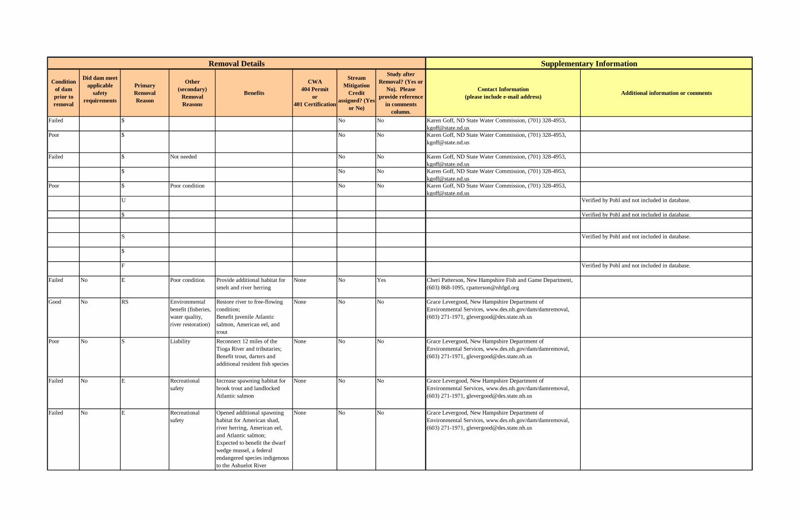
Condition of dam prior to removal
Did dam meet applicable
safety requirements
PrimaryRemoval Reason
Other (secondary)
Removal Reasons
Benefits
CWA 404 Permit
or 401 Certification
Stream Mitigation
Credit assigned? (Yes
or No)
Study after Removal? (Yes or
No). Please provide reference
in comments column.
Contact Information (please include e-mail address) Additional information or comments
Failed $ No No Karen Goff, ND State Water Commission, (701) 328-4953, [email protected]
Poor $ No No Karen Goff, ND State Water Commission, (701) 328-4953, [email protected]
Failed $ Not needed No No Karen Goff, ND State Water Commission, (701) 328-4953, [email protected]
$ No No Karen Goff, ND State Water Commission, (701) 328-4953, [email protected]
Poor $ Poor condition No No Karen Goff, ND State Water Commission, (701) 328-4953, [email protected]
U Verified by Pohl and not included in database.
$ Verified by Pohl and not included in database.
S Verified by Pohl and not included in database.
$
F Verified by Pohl and not included in database.
Failed No E Poor condition Provide additional habitat for smelt and river herring
None No Yes Cheri Patterson, New Hampshire Fish and Game Department, (603) 868-1095, [email protected]
Good No RS Environmental benefit (fisheries, water quality, river restoration)
Restore river to free-flowing condition; Benefit juvenile Atlantic salmon, American eel, and trout
None No No Grace Levergood, New Hampshire Department of Environmental Services, www.des.nh.gov/dam/damremoval, (603) 271-1971, [email protected]
Poor No S Liability Reconnect 12 miles of the Tioga River and tributaries;Benefit trout, darters and additional resident fish species
None No No Grace Levergood, New Hampshire Department of Environmental Services, www.des.nh.gov/dam/damremoval, (603) 271-1971, [email protected]
Failed No E Recreational safety
Increase spawning habitat for brook trout and landlocked Atlantic salmon
None No No Grace Levergood, New Hampshire Department of Environmental Services, www.des.nh.gov/dam/damremoval, (603) 271-1971, [email protected]
Failed No E Recreational safety
Opened additional spawning habitat for American shad, river herring, American eel, and Atlantic salmon;Expected to benefit the dwarf wedge mussel, a federal endangered species indigenous to the Ashuelot River
None No No Grace Levergood, New Hampshire Department of Environmental Services, www.des.nh.gov/dam/damremoval, (603) 271-1971, [email protected]
Removal Details Supplementary Information
B-33

Table B.2 Continued.
State Dam River Removal Date
Total Removal Cost in US$
(Engineering, Permitting,
Deconstruction, etc.)
Removal Cost in US$
(deconstruction cost only)
How was removal funded?
Indicate whether dam was removed (total removal) or breached (partial
removal)
Dam Maximum Structural Height (ft)
Dam Hydraulic
Height (ft)
Dam Length
(ft)
Reservoir Volume (acre-ft)
Owner Date Built
Type of Dam
State Hazard Classification
Who regulates dam
Run–of– river dam?
(Yes or No)
Original purpose of
dam
Most recent use of dam
and reservoir
NH McGoldrick Dam Ashuelot River 2001 54,000 Federal, State Removed 6 6 5 Private Low State Yes Mechanical Power Generation
Unknown
NJ Harry Pursel Dam Lopatcong Creek 2004 15 Henry Pursel 1925 Water supply
NJ Pottersville Dam Cold Brook 1985 20 180
NJ Upper Blue Mountain Lake Dam
Van Campens Brook
1995 Federal, Owner Breached 26 210 187 Federal government
Earth fill Low State No
NJ Lake Success Dam
Delaware River (trib.)
1995 Federal, Owner Breached 20 300 320 Federal government
Earth fill Low State No
NJ Patex Pond Dam Crooked Brook 1990 Breached 20 340 22 Private Earth fill Low State NoNJ Knox Hill Dam Whippany River
(trib.)1996 18 150 State
NJ Glenside Dam S. B. Timber Creek
1997 Breached 12 130 13 Private Earth fill Low State No
NJ Fieldsville Dam Raritan River 1990 10 400NJ Pool Colony Dam Van Campens
Brook (trib.)1999 8
NV Katherine Borrow Pit Embankment
Unknown 1992 15
NY Cuddebackville Dam
Neversink River 2004 2,200,000 1,400,000 Federal Breached 10 6 107 run of river Orange County
1907 Stop Log Pier and concrete overflow weir
Low NYSDEC Dam Safety
yes Originally water supply feeder for canal, then hydropower
Aestetics ( water for canal remnant in County park)
NY Gray Reservoir Dam
Black Creek 2002 300,000 34 385 Upper Mohawk Valley Regional
1905-1906
Buttress Water storage
NY Fort Edward Dam Hudson River 1973 31 586 Niagara Mohawk Power Corp.
1898 Timbercrib Hydropower
NY Luxton Lake Dam
Unknown 15
NY Curry Pond Dam 3OH Kent Dam Cuyahoga River 2004
OH St. John’s Dam Sandusky River 2003 200,000 79,000 State Removed 8.5 150 Ohio-American Water Company
Early 1900s
Concrete Arch
High Federal Yes Water Supply Water Supply
Dam ID Removal Information Dam Characteristics
B-34
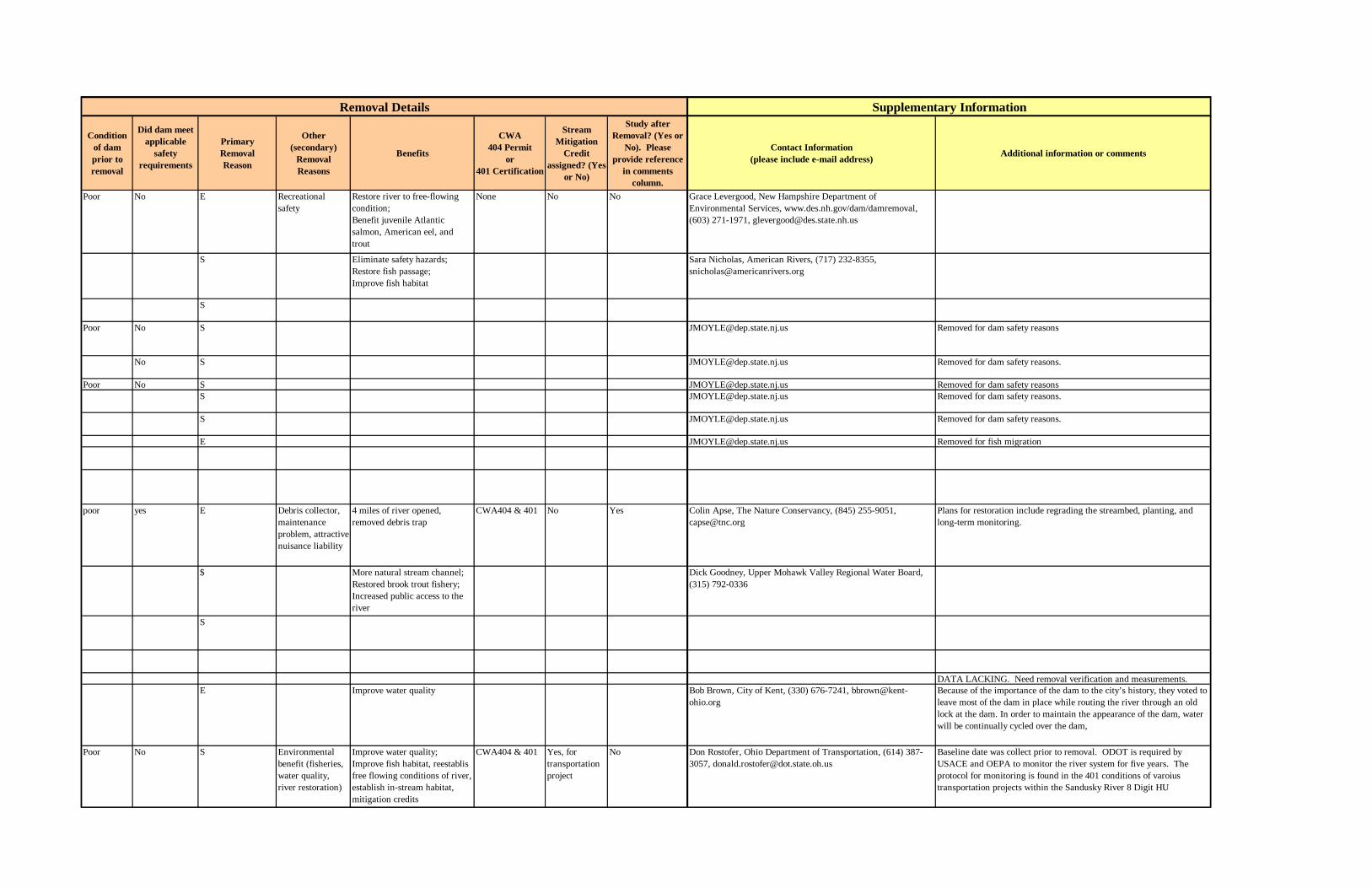
Condition of dam prior to removal
Did dam meet applicable
safety requirements
PrimaryRemoval Reason
Other (secondary)
Removal Reasons
Benefits
CWA 404 Permit
or 401 Certification
Stream Mitigation
Credit assigned? (Yes
or No)
Study after Removal? (Yes or
No). Please provide reference
in comments column.
Contact Information (please include e-mail address) Additional information or comments
Poor No E Recreational safety
Restore river to free-flowing condition; Benefit juvenile Atlantic salmon, American eel, and trout
None No No Grace Levergood, New Hampshire Department of Environmental Services, www.des.nh.gov/dam/damremoval, (603) 271-1971, [email protected]
S Eliminate safety hazards;Restore fish passage;Improve fish habitat
Sara Nicholas, American Rivers, (717) 232-8355, [email protected]
S
Poor No S [email protected] Removed for dam safety reasons
No S [email protected] Removed for dam safety reasons.
Poor No S [email protected] Removed for dam safety reasonsS [email protected] Removed for dam safety reasons.
S [email protected] Removed for dam safety reasons.
E [email protected] Removed for fish migration
poor yes E Debris collector,
maintenance p
roblem, attractive nuisance liability
4 miles of river opened, removed debris trap
CWA404 & 401 No Yes Colin Apse, The Nature Conservancy, (845) 255-9051, [email protected]
Plans for restoration include regrading the streambed, planting, and long-term monitoring.
$ More natural stream channel;Restored brook trout fishery;Increased public access to the river
Dick Goodney, Upper Mohawk Valley Regional Water Board, (315) 792-0336
S
DATA LACKING. Need removal verification and measurements.E Improve water quality Bob Brown, City of Kent, (330) 676-7241, bbrown@kent-
ohio.orgBecause of the importance of the dam to the city’s history, they voted to leave most of the dam in place while routing the river through an old lock at the dam. In order to maintain the appearance of the dam, water will be continually cycled over the dam,
Poor No S Environmental benefit (fisheries, water quality, river restoration)
Improve water quality;Improve fish habitat, reestablis free flowing conditions of river, establish in-stream habitat, mitigation credits
CWA404 & 401 Yes, for transportation project
No Don Rostofer, Ohio Department of Transportation, (614) 387-3057, [email protected]
Baseline date was collect prior to removal. ODOT is required by USACE and OEPA to monitor the river system for five years. The protocol for monitoring is found in the 401 conditions of varoius transportation projects within the Sandusky River 8 Digit HU
Supplementary InformationRemoval Details
B-35

Table B.2 Continued.
State Dam River Removal Date
Total Removal Cost in US$
(Engineering, Permitting,
Deconstruction, etc.)
Removal Cost in US$
(deconstruction cost only)
How was removal funded?
Indicate whether dam was removed (total removal) or breached (partial
removal)
Dam Maximum Structural Height (ft)
Dam Hydraulic
Height (ft)
Dam Length
(ft)
Reservoir Volume (acre-ft)
Owner Date Built
Type of Dam
State Hazard Classification
Who regulates dam
Run–of– river dam?
(Yes or No)
Original purpose of
dam
Most recent use of dam
and reservoir
OH Unnamed Dam Ottawa River 2003 5 50
OH Dennison Dam Olentangy River 2002 17,000 State 2 225 Private Early 1900s
Concrete Arch
Electrical Power Generation
OH Milan Wildlife Area Dam
Huron River 2002 5 100 1969 Concrete Hold coho salmon
OH Chapel Church Lake Dam
Silver Creek-TR 1989
OH Foster Dam Little Miami River
1984
OH Howard's Lake Dam
Jackson Run (trib.)
OH Silver Creek Dam Silver Creek
OH Poston Fresh Water Pond Dam
Hamley Run (trib.)
1988 42
OH Williams Dam Brush Creek (trib.)
40
OH Altier Pond Dam Black Ford (trib.) 1989 33
OH Derby Petroleum lake Dam
Timber Run (trib.)
1984 30
OH Fair Haven lake Dam
Ice Creek (trib.) 1980 30
OH Lake Hill #1 Dam Robinson Run (trib.)
30
OH Lake Hill #2 Dam Robinson Run (trib.)
30
OH Yankee Lake Dam
Yankee Run 1980 26
OH Ashworth Lake Dam
Seven Mile Creek (trib.)
25
OH State Route 800 Dam
Spencer Creek (trib.)
1989 25
OH Strip Mine Pond Dam
McLuney Creek (trib.)
25
OH Modoc Reservoir Dam
Modoc Run 1981 24
OH Old Jenkins Lake Dam
Little Yellow Creek (trib.)
22
Dam ID Removal Information Dam Characteristics
B-36

B-37
Condition of dam prior to removal
Did dam meet applicable
safety requirements
PrimaryRemoval Reason
Other (secondary)
Removal Reasons
Benefits
CWA 404 Permit
or 401 Certification
Stream Mitigation
Credit assigned? (Yes
or No)
Study after Removal? (Yes or
No). Please provide reference
in comments column.
Contact Information (please include e-mail address) Additional information or comments
Larry Goedde, Ohio Department of Natural Resources, (419) 429-8370, [email protected]
E Improve water quality; Improve fish and aquatic habitat; Already uncovered a natural waterfall
CWA401 Tim Peterkoski, Ohio Department of Natural Resources. PHONE NUMBER, EMAIL?
$ Opened 25 miles of spawning habitat for steelhead and coho salmon
Larry Goedde, Ohio Department of Natural Resources, (419) 429-8370, [email protected]
DATA LACKING. Need removal verification and measurements.
DATA LACKING. Need measurements. Removed approximately 1984. Had a breach in it at the time so there was no significant sediment build-up to speak of.
Verified by Pohl and not included in database.
Removal Details Supplementary Information

Table B.2 Continued.
State Dam River Removal Date
Total Removal Cost in US$
(Engineering, Permitting,
Deconstruction, etc.)
Removal Cost in US$
(deconstruction cost only)
How was removal funded?
Indicate whether dam was removed (total removal) or breached (partial
removal)
Dam Maximum Structural Height (ft)
Dam Hydraulic
Height (ft)
Dam Length
(ft)
Reservoir Volume (acre-ft)
Owner Date Built
Type of Dam
State Hazard Classification
Who regulates dam
Run–of– river dam?
(Yes or No)
Original purpose of
dam
Most recent use of dam
and reservoir
OH Jones Lake Dam Ogg Creek 20OH Burt Lake Dam Little Auglaize
River (trib.)1992 18
OH Cottingham Lake Dam
Hocking River (trib.)
1991 17
OH Ohio Power Company Pond Dam
Brannon Fork 1987 17
OH Brashear Lake Dam
Sugartree Creek (trib.)
1991 16
OH Marshfield Lake Dam
Porter Creek 1973 15
OH Mastrine Pond Dam
Little Pine Creek (trib.)
1978 15
OH Toronto Band Father's lake Dam
Town Fork 1991 15
OH Wonder Lake Dam
East Reservoir (trib.)
1986 15
OH Dutiel Pond Dam Licking River (trib.)
1986 14
OH Georgetown Freshwater Dam
South Fork (trib.) 1988 13
OH Ohio Power Company Pond Dam
Collins Fork 13
OH Consol Pond Dam
Stillwater Creek 12
OH Okie Rice Dam Little Darby Creek
1990 12
OH Carr Lake Dam Johnny Woods River (trib.)
1985 10
OH Glen Hellen Dam Little Miami River
1997 10,000 8 100
OH Killiany Lake Dam
Wills Creek (trib.)
8
OH Village at Rocky Fork Lake Dam
Rocky Fork (trib.)
7
OH Little Darby Dam Little Darby Creek
1989 20 Columbia/Franklin County Metropolitan
OH Foxtail Dam Unknown 30OH Armington Dam
#2Unknown 1991 15
OH Slippery Run (Stahl) Dam
Unknown 1990 14
OH Jacoby Road Dam Little Miami 1997 10,000 State Removed 8 100 Private 1910 Concrete Electrical RecreationOH Middletown
Hydraulic DamGreat Miami River
1993 231,975 State Removed 10 Local government
1840 Timber crib Other
Dam ID Removal Information Dam Characteristics
B-38

Condition of dam prior to removal
Did dam meet applicable
safety requirements
PrimaryRemoval Reason
Other (secondary)
Removal Reasons
Benefits
CWA 404 Permit
or 401 Certification
Stream Mitigation
Credit assigned? (Yes
or No)
Study after Removal? (Yes or
No). Please provide reference
in comments column.
Contact Information (please include e-mail address) Additional information or comments
S
Used to divert water through a mill race to power a mill that no longer operates.
O
Removed approximately 1989. Little Darby Creek is a tributary of Big Darby Creek, which between the two contain some of the most diverse aquatic life in the state.
No E Ohio Department of Natural ResourcesNo S Ohio Department of Natural Resources
Supplementary InformationRemoval Details
B-39

Table B.2 Continued.
State Dam River Removal Date
Total Removal Cost in US$
(Engineering, Permitting,
Deconstruction, etc.)
Removal Cost in US$
(deconstruction cost only)
How was removal funded?
Indicate whether dam was removed (total removal) or breached (partial
removal)
Dam Maximum Structural Height (ft)
Dam Hydraulic
Height (ft)
Dam Length
(ft)
Reservoir Volume (acre-ft)
Owner Date Built
Type of Dam
State Hazard Classification
Who regulates dam
Run–of– river dam?
(Yes or No)
Original purpose of
dam
Most recent use of dam
and reservoir
OH Coho Dam Huron River 2003 20,000 State Removed 5 114 State 1960s Concrete OH Lover's Lane
DamMahoning 2005 30,000 20,000 State Removed 3 125 Private 1950s Rock &
concreteLow Federal Yes Cooling
WaterUnknown
OH North River Road Dam
Mahoning 2006 40,000 30,000 State Removed 4 150 Private 1950s Rock & concrete
Low Federal Yes Cooling Water
Unknown
OH Panhandle Road Dam
Olentangy River 2005 50,000 35,000 State Removed 7 150 Private/ODOT
1950s Concrete Arch
Low Federal Yes Fisheries Management
OH Grinnelle Road Dam
Little Miami River
2007 100,000 80,000 State Removed 14 160 Private 1900s Timber crib & concrete
Medium Federal Yes Diversion-Grain Mill Race
OK Sand Springs ReRegulation Dam
Arkansas 1985 removed 19 13 1651 5,600 Federal government
1968 Concrete Federal No Other Other
OR Buck & Jones Diversion Dam
Little Applegate River
2003 5 100 Concrete Diversion
OR Dinner Creek Dam
Dinner Creek 2003 10 35 1925 Concrete Water supply
OR Unnamed Dam Wagner Creek 2003 4 Concrete Diversion
OR Byrne Diversion Dam
Beaver Creek 2002 3 Concrete Irrigation diversion
OR Irrigation Push-Up Dam
Applegate River 2002 4 Gravel pushup
Irrigation
OR Rock Creek Dam Tributary to the Powder River
2002 Oregon Trail Electric Cooperative
Hydropower
OR Maple Gulch Diversion Dam
Evans Creek 2002 13 Early 1900s
Concrete Supply water
OR Three Unnamed Dams
Ashland Creek 2000
Dam ID Removal Information Dam Characteristics
B-40
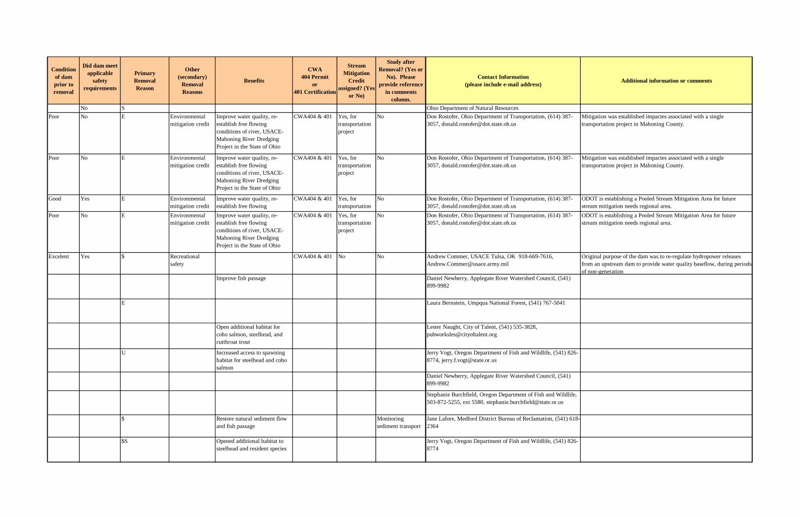
Condition of dam prior to removal
Did dam meet applicable
safety requirements
PrimaryRemoval Reason
Other (secondary)
Removal Reasons
Benefits
CWA 404 Permit
or 401 Certification
Stream Mitigation
Credit assigned? (Yes
or No)
Study after Removal? (Yes or
No). Please provide reference
in comments column.
Contact Information (please include e-mail address) Additional information or comments
No S Ohio Department of Natural ResourcesPoor No E Environmental
mitigation creditImprove water quality, re-establish free flowing conditions of river, USACE-Mahoning River Dredging Project in the State of Ohio
CWA404 & 401 Yes, for transportation project
No Don Rostofer, Ohio Department of Transportation, (614) 387-3057, [email protected]
Mitigation was established impactes associated with a single transportation project in Mahoning County.
Poor No E Environmental mitigation credit
Improve water quality, re-establish free flowing conditions of river, USACE-Mahoning River Dredging Project in the State of Ohio
CWA404 & 401 Yes, for transportation project
No Don Rostofer, Ohio Department of Transportation, (614) 387-3057, [email protected]
Mitigation was established impactes associated with a single transportation project in Mahoning County.
Good Yes E Environmental mitigation credit
Improve water quality, re-establish free flowing
CWA404 & 401 Yes, for transportation
No Don Rostofer, Ohio Department of Transportation, (614) 387-3057, [email protected]
ODOT is establishing a Pooled Stream Mitigation Area for future stream mitigation needs regional area.
Poor No E Environmental mitigation credit
Improve water quality, re-establish free flowing conditions of river, USACE-Mahoning River Dredging Project in the State of Ohio
CWA404 & 401 Yes, for transportation project
No Don Rostofer, Ohio Department of Transportation, (614) 387-3057, [email protected]
ODOT is establishing a Pooled Stream Mitigation Area for future stream mitigation needs regional area.
Excelent Yes $ Recreational safety
CWA404 & 401 No No Andrew Commer, USACE Tulsa, OK 918-669-7616, [email protected]
Original purpose of the dam was to re-regulate hydropower releases from an upstream dam to provide water quality baseflow, during periods of non-generation
Improve fish passage Daniel Newberry, Applegate River Watershed Council, (541) 899-9982
E Laura Bernstein, Umpqua National Forest, (541) 767-5041
Open additional habitat for coho salmon, steelhead, and cutthroat trout
Lester Naught, City of Talent, (541) 535-3828, [email protected]
U Increased access to spawning habitat for steelhead and coho salmon
Jerry Vogt, Oregon Department of Fish and Wildlife, (541) 826-8774, [email protected]
Daniel Newberry, Applegate River Watershed Council, (541) 899-9982
Stephanie Burchfield, Oregon Department of Fish and Wildlife, 503-872-5255, ext 5580, [email protected]
$ Restore natural sediment flow and fish passage
Monitoring sediment transport
Jane Lafore, Medford District Bureau of Reclamation, (541) 618-2364
$S Opened additional habitat to steelhead and resident species
Jerry Vogt, Oregon Department of Fish and Wildlife, (541) 826-8774
B-41

Table B.2 Continued.
State Dam River Removal Date
Total Removal Cost in US$
(Engineering, Permitting,
Deconstruction, etc.)
Removal Cost in US$
(deconstruction cost only)
How was removal funded?
Indicate whether dam was removed (total removal) or breached (partial
removal)
Dam Maximum Structural Height (ft)
Dam Hydraulic
Height (ft)
Dam Length
(ft)
Reservoir Volume (acre-ft)
Owner Date Built
Type of Dam
State Hazard Classification
Who regulates dam
Run–of– river dam?
(Yes or No)
Original purpose of
dam
Most recent use of dam
and reservoir
OR Unnamed Dam Poorman Creek 1999OR Lafayette Locks
DamYamhill Basin 1963
OR Jackson Street Dam
Bear Creek 1998 1,200,000 11 120 Rogue River Valley Irrigation District
1960s Irrigation
OR Marie Dorian Dam
Walla Walla River
1997 300,000 State 8 100 Milton-Freewater Water Control District
1880s Concrete Irrigation Hydropower (inactive)
OR Alphonso Dam Evans Creek 1999 55,000 10 56 1890s Irrigation
OR Catching Dam Willamette River (North Fork of Middle Fork)
1994 64,708 State 28 225 190 private individual
1924 Timbercrib; Concrete; Wood; Steel; Gravity
Water Diversion
Log Storage
PA Bear Rock 1 and 2 Dams
Bear Rock Run 2005 Removed 26 560 24 Local government
19031904
Earth fill High State Water supply
PA Benscreek Intake Ben's Creek 2005 Removed 6 60 1900 - 1905
State Water supply
PA Detter’s Mill Dam
Conewago Creek 2004 35,000 25,000 Federal, State Removed 7 250 20 State government
Rock & concrete
Low State Yes Mill Dam Recreation
PA Sharrer’s Mill Dam
Conewago Creek 2005 Removed 8 220 10 Private Concrete Low State Yes Mill Dam Recreation
PA Siloam Dam Conococheague Creek
2005 Removed 10 City of Chambersburg
Concrete Low State Yes
PA Durham Dam Cooks Creek 2004 50,000 35,000 Private Removed 10 3 Private Concrete State Yes
Dam ID Removal Information Dam Characteristics
B-42

Condition of dam prior to removal
Did dam meet applicable
safety requirements
PrimaryRemoval Reason
Other (secondary)
Removal Reasons
Benefits
CWA 404 Permit
or 401 Certification
Stream Mitigation
Credit assigned? (Yes
or No)
Study after Removal? (Yes or
No). Please provide reference
in comments column.
Contact Information (please include e-mail address) Additional information or comments
Verified by Pohl and not included in database.DATA LACKING. Need measurements. In 1963, a dam was removed at Lafayette locks in order to restore fish runs to the Yamhill Basin. According to OR Fish Commission, coho and steelhead runs now exist above the site of the old dam.
E
E Removed in April 1997.
E taken from: http://www.spokane.net/news-story-body.asp?Date=080399&ID=s616522&cat=Irrigation dam torn down in OregonAction expected to improve fish habitat in Rogue River areaAugust 3, 1999
$S CWA404 & 401 Ed Englehart, Highland Water and Sewer Authority, [email protected]
$S Reduce liability concerns;Eliminate financial burden of maintenance;Restore habitat
CWA404 & 401 Ed Englehart, Highland Water and Sewer Authority, [email protected]
Poor No $ Eliminated safety concerns;Opened seven miles of spawning habitat for American shad, blueback herring, and American eel
CWA404 & 401 Scott Carney, Pennsylvania Fish and Boat Commission, (814) 353-2225, [email protected]
No E$S CWA404 & 401 Sara Nicholas, American Rivers, (717) 232-8355; [email protected]
Partial Removal
E$S CWA404 & 401 Bruce Mcnew, City of Chambersburg, (717) 261-3288, [email protected]
actively monitoring this site and the downstream dam at Wilson College slated for removal in 2005 to record pre- and post-removal changes in water quality and benthic life
E$S CWA404 & 401 Vince Humenay, Pennsylvania Department of Environmental Protection, (717) 783-7482, [email protected]
Supplementary InformationRemoval Details
B-43

Table B.2 Continued.
State Dam River Removal Date
Total Removal Cost in US$
(Engineering, Permitting,
Deconstruction, etc.)
Removal Cost in US$
(deconstruction cost only)
How was removal funded?
Indicate whether dam was removed (total removal) or breached (partial
removal)
Dam Maximum Structural Height (ft)
Dam Hydraulic
Height (ft)
Dam Length
(ft)
Reservoir Volume (acre-ft)
Owner Date Built
Type of Dam
State Hazard Classification
Who regulates dam
Run–of– river dam?
(Yes or No)
Original purpose of
dam
Most recent use of dam
and reservoir
PA Cussewago Creek Dam
Cussewago Creek 2005 Removed 6 70 Private Concrete Low State Yes
PA Girl Scout Dam Laurel Run 2005 Removed 9 50 Private Stone masonry
Low State No Recreation
PA Lower Lloydell Dam
South Fork of the Little Conemaugh
2004 31,000 23,000 State Removed 9 70 Lloydell Water Co.
1900 - 1910
Stone masonry
Low State No Water reservoir
PA Cleversburg Water Supply Dam
Milesburn Run 2004 Removed 4 90 3 Local government
1902 Concrete State Water supply
PA Frankford Dam Pennypack Creek 2005 Removed 12.5 150 City of Philadelphia
State
PA Binky Lee Preserve
Tributary to Pickering Creek
2004 8 Natural Lands Trust
Stone masonry
State
PA Two Unnamed Dams
Poplar Run 2004 Removed 11 Stone masonry
State Water supply
PA Irving Mill Dam Ridley Creek 2004 95,000 60,000 Federal, State, Private
Removed 12 100 Private 1919 Stone masonry
State Yes
PA Twining Valley Golf Course Dam
Tributary to Sandy Run
2004 15 200 2 Private State Irrigation to a golf course;Aesthetics enhancementPA Reedsville
Milling Company Dam
Tea Creek 2004 70,000 45,000 Removed 14 130 Private 1970s Timber crib, rock and concrete
State
PA Charming Forge Dam
Tulpehocken Creek
2004 55,000 35,000 Federal, State Removed 10 204 71 State government
1919 Concrete Gravity
State Yes Power Recreation
PA Upper Grove City Dam
Wolf Creek 2004 15,000 10,000 State Removed 10 100 Local government
1885 Concrete State Yes Power
PA Mohnton Dam Wyomissing Creek
2005 70,000 50,000 Removed 6 Local government
mid 1800sEarly 1900s
Concrete Gravity
Low State No First power thenwater supply
PA Reading Museum Dam1
Wyomissing Creek
2004 45,000 30,000 Federal, State Removed 3 45 Private ~1900 State
PA Reading Museum Dam2
Wyomissing Creek
2004 45,000 30,000 Federal, State Removed 8 60 Private Early 1900s
Rock State
PA Hoffman Dam Yellow Breaches Creek
2005 Removed 12 130 Private ~1900 Concrete Low State Yes Power Other
Dam ID Removal Information Dam Characteristics
B-44
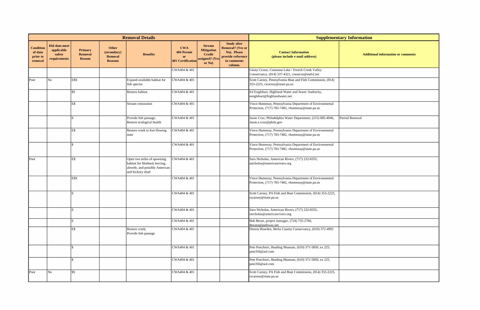
Condition of dam prior to removal
Did dam meet applicable
safety requirements
PrimaryRemoval Reason
Other (secondary)
Removal Reasons
Benefits
CWA 404 Permit
or 401 Certification
Stream Mitigation
Credit assigned? (Yes
or No)
Study after Removal? (Yes or
No). Please provide reference
in comments column.
Contact Information (please include e-mail address) Additional information or comments
CWA404 & 401 Ginny Crowe, Conneaut Lake / French Creek Valley Conservancy, (814) 337-4321, [email protected]
Poor No E$S Expand available habitat for fish species
CWA404 & 401 Scott Carney, Pennsylvania Boat and Fish Commission, (814) 353-2225, [email protected]
$S Restore habitat CWA404 & 401 Ed Englehart, Highland Water and Sewer Authority, [email protected]
E$ Stream restoration CWA404 & 401 Vince Humenay, Pennsylvania Department of Environmental Protection, (717) 783-7482, [email protected]
E Provide fish passage;Restore ecological health
CWA404 & 401 Jason Cruz, Philadelphia Water Department, (215) 685-4946, [email protected]
Partial Removal
E$ Restore creek to free-flowing state
CWA404 & 401 Vince Humenay, Pennsylvania Department of Environmental Protection, (717) 783-7482, [email protected]
$ CWA404 & 401 Vince Humenay, Pennsylvania Department of Environmental Protection, (717) 783-7482, [email protected]
Poor E$ Open two miles of spawning habitat for blueback herring, alewife, and possibly American and hickory shad
CWA404 & 401 Sara Nicholas, American Rivers, (717) 232-8355, [email protected]
E$S CWA404 & 401 Vince Humenay, Pennsylvania Department of Environmental Protection, (717) 783-7482, [email protected]
E CWA404 & 401 Scott Carney, PA Fish and Boat Commission, (814) 353-2225, [email protected]
E CWA404 & 401 Sara Nicholas, American Rivers, (717) 232-8355, [email protected]
E CWA404 & 401 Bob Beran, project manager, (724) 735-2766, [email protected]
E$ Restore creek; Provide fish passage
CWA404 & 401 Dennis Rearden, Berks County Conservancy, (610) 372-4992
$ CWA404 & 401 Pete Ponchieri, Reading Museum, (610) 371-5850, ex 225, [email protected]
$ CWA404 & 401 Pete Ponchieri, Reading Museum, (610) 371-5850, ex 225, [email protected]
Poor No $S CWA404 & 401 Scott Carney, PA Fish and Boat Commission, (814) 353-2225, [email protected]
Removal Details Supplementary Information
B-45

Table B.2 Continued.
State Dam River Removal Date
Total Removal Cost in US$
(Engineering, Permitting,
Deconstruction, etc.)
Removal Cost in US$
(deconstruction cost only)
How was removal funded?
Indicate whether dam was removed (total removal) or breached (partial
removal)
Dam Maximum Structural Height (ft)
Dam Hydraulic
Height (ft)
Dam Length
(ft)
Reservoir Volume (acre-ft)
Owner Date Built
Type of Dam
State Hazard Classification
Who regulates dam
Run–of– river dam?
(Yes or No)
Original purpose of
dam
Most recent use of dam
and reservoir
PA Black Dam Conodoguinet Creek
2003 65,000 40,000 Federal, State Removed 10 400 31 Private 1919 Concrete State Yes Water supply
PA Collegeville Mill Dam
Perkiomen Creek 2003 45,000 30,000 State Removed 5 200 Local government
1708 Stone masonry
State Yes
PA Daniel Esh Dam Mill Creek 2003 1,500 State Removed 2 State Impound water for skating and
PA Young’s Dam Lititz Run 2002 10,000 20,000 Federal, State Removed 3 State
PA Four Amish Dams
Muddy Run 2001 25,000 Federal, State Removed State Water supply
PA Good Hope Dam Conodoguinet Creek
2001 45,000 30,000 Federal, State Removed 6 300 State government
1821 Concrete State Yes Recreation
PA Meisers Mill Dam
Manantango Creek
2001 22,000 15,000 Federal, State Removed 5 75 State
PA Intake Dam Rife Run 2001 25,000 15,000 Federal, State Removed 4 47 1 Local government
1962 Concrete State Yes Water Supply
PA Hammer Creek Dam
Hammer Creek 2001 Removed 4 60 State government
Concrete State Yes Recreation
PA Two Unnamed Dams
Huston Run 2001 10,000 Federal, State Removed State Generate power
PA Barnitz Mill Dam Yellow Breeches Creek
2000 30,000 20,000 Federal, State Removed 5 Dickenson Township
Concrete State Yes
PA Franklin Mill Dam
Middle Creek 2000 24,000 14,000 Federal, State Removed 4 2.5 Private Concrete State Yes
PA Hinkletown Mill Dam
Conestoga River 2000 Removed State
Dam ID Removal Information Dam Characteristics
B-46
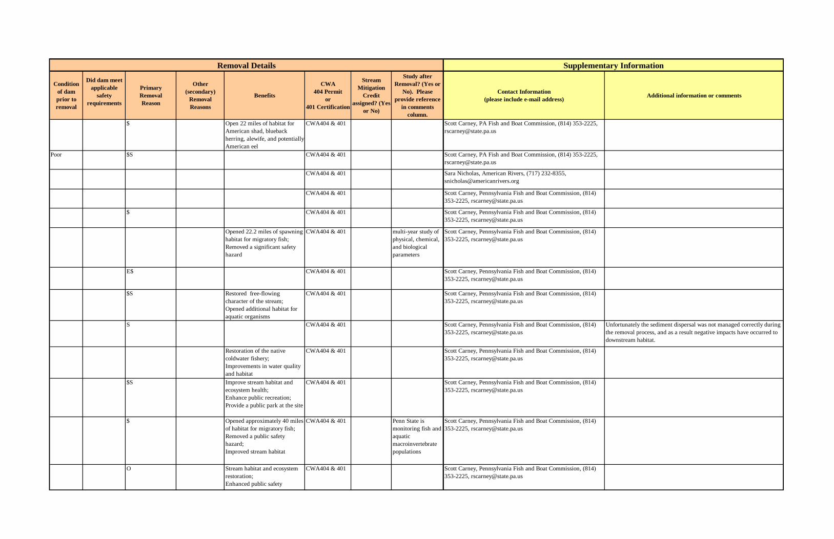
Condition of dam prior to removal
Did dam meet applicable
safety requirements
PrimaryRemoval Reason
Other (secondary)
Removal Reasons
Benefits
CWA 404 Permit
or 401 Certification
Stream Mitigation
Credit assigned? (Yes
or No)
Study after Removal? (Yes or
No). Please provide reference
in comments column.
Contact Information (please include e-mail address) Additional information or comments
$ Open 22 miles of habitat for American shad, blueback herring, alewife, and potentially American eel
CWA404 & 401 Scott Carney, PA Fish and Boat Commission, (814) 353-2225, [email protected]
Poor $S CWA404 & 401 Scott Carney, PA Fish and Boat Commission, (814) 353-2225, [email protected]
CWA404 & 401 Sara Nicholas, American Rivers, (717) 232-8355, [email protected]
CWA404 & 401 Scott Carney, Pennsylvania Fish and Boat Commission, (814) 353-2225, [email protected]
$ CWA404 & 401 Scott Carney, Pennsylvania Fish and Boat Commission, (814) 353-2225, [email protected]
Opened 22.2 miles of spawning habitat for migratory fish; Removed a significant safety hazard
CWA404 & 401 multi-year study of physical, chemical, and biological parameters
Scott Carney, Pennsylvania Fish and Boat Commission, (814) 353-2225, [email protected]
E$ CWA404 & 401 Scott Carney, Pennsylvania Fish and Boat Commission, (814) 353-2225, [email protected]
$S Restored free-flowing character of the stream; Opened additional habitat for aquatic organisms
CWA404 & 401 Scott Carney, Pennsylvania Fish and Boat Commission, (814) 353-2225, [email protected]
S CWA404 & 401 Scott Carney, Pennsylvania Fish and Boat Commission, (814) 353-2225, [email protected]
Unfortunately the sediment dispersal was not managed correctly during the removal process, and as a result negative impacts have occurred to downstream habitat.
Restoration of the native coldwater fishery; Improvements in water quality and habitat
CWA404 & 401 Scott Carney, Pennsylvania Fish and Boat Commission, (814) 353-2225, [email protected]
$S Improve stream habitat and ecosystem health;Enhance public recreation;Provide a public park at the site
CWA404 & 401 Scott Carney, Pennsylvania Fish and Boat Commission, (814) 353-2225, [email protected]
$ Opened approximately 40 miles of habitat for migratory fish; Removed a public safety hazard; Improved stream habitat
CWA404 & 401 Penn State is monitoring fish and aquatic macroinvertebrate populations
Scott Carney, Pennsylvania Fish and Boat Commission, (814) 353-2225, [email protected]
O Stream habitat and ecosystem restoration;Enhanced public safety
CWA404 & 401 Scott Carney, Pennsylvania Fish and Boat Commission, (814) 353-2225, [email protected]
Supplementary InformationRemoval Details
B-47

Table B.2 Continued.
State Dam River Removal Date
Total Removal Cost in US$
(Engineering, Permitting,
Deconstruction, etc.)
Removal Cost in US$
(deconstruction cost only)
How was removal funded?
Indicate whether dam was removed (total removal) or breached (partial
removal)
Dam Maximum Structural Height (ft)
Dam Hydraulic
Height (ft)
Dam Length
(ft)
Reservoir Volume (acre-ft)
Owner Date Built
Type of Dam
State Hazard Classification
Who regulates dam
Run–of– river dam?
(Yes or No)
Original purpose of
dam
Most recent use of dam
and reservoir
PA Martins Dam Cocalico Creek 2000 30,000 20,000 Federal, State Removed 4 60 4 Private Stone masonry
State No Recreation
PA Muren’s (Seitzville Mill) Dam
South Branch of Codorus Creek
2000 40,000 35,000 Federal, State Removed 7 225 7.5 Private Stone masonry
State Yes Recreation
PA Wild Lands Conservancy Dam
Little Leheigh Creek
2000 5,000 Removed 5 75 State
PA Unnamed Dam Manatawny Creek
2000 Removed State government
~1850 Concrete Masonry
State Yes
PA Cabin Hill Dam Spring Creek 1998 100,000 90,000 State, Private Removed 15 284 5 State government
1915 Concrete Gravity
State No Recreation
PA Dauphin County Park & Recreation Dam
Spring Creek 1999 22,000 15,000 Federal, State Removed State
PA Greenville Dam #3
Little Shenango River
1999 State
PA Hellberg's Dam Conestoga River 1999 45,000 35,000 Federal, State Removed StatePA unnamed dam Lititz Run 2000 15,000 10,000 Federal, State Removed StatePA unnamed dam Noels Creek 1999 StatePA Yorkane Dam Codorus River-
TR1997 Private Removed State
PA Coal Creek Dam #3
Coal Creek 1995 24 Stone Masonry
State Water Storage
PA Pomeroy Memorial Dam
Sugar Creek (West Branch)
1996 24 442 54 Local government
1923 Earth fill State No Water Storage
PA Coal Creek Dam #2
Coal Creek 1995 23 116 6 1876 Stone Masonry
State No Water Storage
PA Maple Hollow Reservoir Dam
Gillians Run 1995 22 192 1902 Earthfill w/concrete spillway
State Water Storage
PA Niederriter Farm Pond Dam
Mill Creek 1995 21 350 1960s Earthfill State Recreation
PA Clear Shade Creek Reservoir Dam
Clear Shade Creek
1998 14 190 18 Local government
1800s Concrete State Yes Hydropower
Dam ID Removal Information Dam Characteristics
B-48
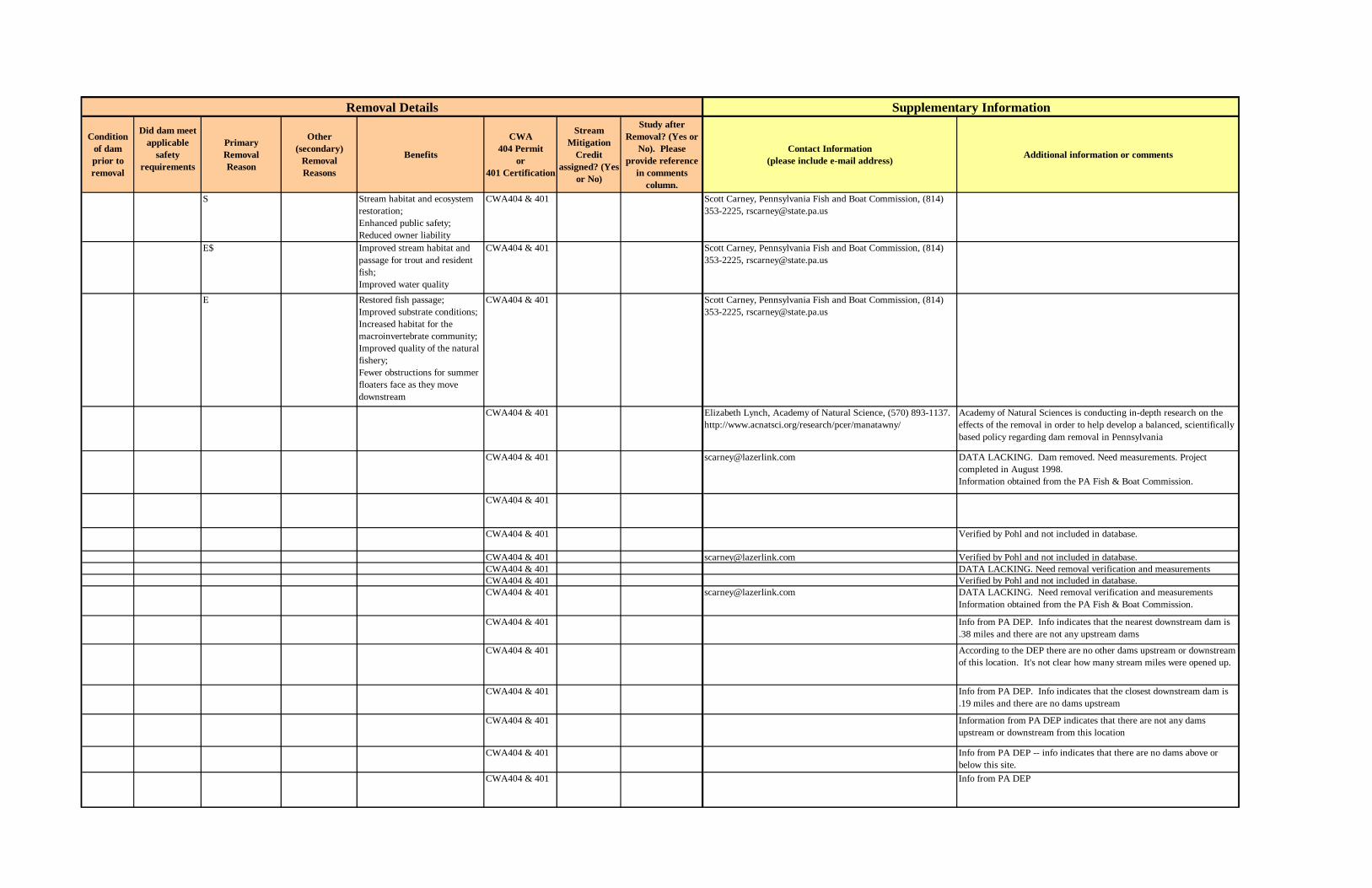
Condition of dam prior to removal
Did dam meet applicable
safety requirements
PrimaryRemoval Reason
Other (secondary)
Removal Reasons
Benefits
CWA 404 Permit
or 401 Certification
Stream Mitigation
Credit assigned? (Yes
or No)
Study after Removal? (Yes or
No). Please provide reference
in comments column.
Contact Information (please include e-mail address) Additional information or comments
S Stream habitat and ecosystem restoration;Enhanced public safety;Reduced owner liability
CWA404 & 401 Scott Carney, Pennsylvania Fish and Boat Commission, (814) 353-2225, [email protected]
E$ Improved stream habitat and passage for trout and resident fish; Improved water quality
CWA404 & 401 Scott Carney, Pennsylvania Fish and Boat Commission, (814) 353-2225, [email protected]
E Restored fish passage; Improved substrate conditions; Increased habitat for the macroinvertebrate community; Improved quality of the natural fishery;Fewer obstructions for summer floaters face as they move downstream
CWA404 & 401 Scott Carney, Pennsylvania Fish and Boat Commission, (814) 353-2225, [email protected]
CWA404 & 401 Elizabeth Lynch, Academy of Natural Science, (570) 893-1137. http://www.acnatsci.org/research/pcer/manatawny/
Academy of Natural Sciences is conducting in-depth research on the effects of the removal in order to help develop a balanced, scientifically based policy regarding dam removal in Pennsylvania
CWA404 & 401 [email protected] DATA LACKING. Dam removed. Need measurements. Project completed in August 1998.Information obtained from the PA Fish & Boat Commission.
CWA404 & 401
CWA404 & 401 Verified by Pohl and not included in database.
CWA404 & 401 [email protected] Verified by Pohl and not included in database.CWA404 & 401 DATA LACKING. Need removal verification and measurementsCWA404 & 401 Verified by Pohl and not included in database.CWA404 & 401 [email protected] DATA LACKING. Need removal verification and measurements
Information obtained from the PA Fish & Boat Commission.
CWA404 & 401 Info from PA DEP. Info indicates that the nearest downstream dam is .38 miles and there are not any upstream dams
CWA404 & 401 According to the DEP there are no other dams upstream or downstream of this location. It's not clear how many stream miles were opened up.
CWA404 & 401 Info from PA DEP. Info indicates that the closest downstream dam is .19 miles and there are no dams upstream
CWA404 & 401 Information from PA DEP indicates that there are not any dams upstream or downstream from this location
CWA404 & 401 Info from PA DEP -- info indicates that there are no dams above or below this site.
CWA404 & 401 Info from PA DEP
Removal Details Supplementary Information
B-49

Table B.2 Continued.
State Dam River Removal Date
Total Removal Cost in US$
(Engineering, Permitting,
Deconstruction, etc.)
Removal Cost in US$
(deconstruction cost only)
How was removal funded?
Indicate whether dam was removed (total removal) or breached (partial
removal)
Dam Maximum Structural Height (ft)
Dam Hydraulic
Height (ft)
Dam Length
(ft)
Reservoir Volume (acre-ft)
Owner Date Built
Type of Dam
State Hazard Classification
Who regulates dam
Run–of– river dam?
(Yes or No)
Original purpose of
dam
Most recent use of dam
and reservoir
PA Coal Creek Dam #4
Coal Creek 1995 14 356 18 Private Stone masonry
State Water Storage
PA Rock Hill Dam Conestoga River 1997 120,000 110,000 Federal, State Removed 13 300 State government
<1918 Rock fill State Yes Hydropower Recreation
PA Rose Hill Intake Dam
Kettle Creek 1998 15,000 10,000 Federal, Private Removed 12 150 Private Stone Masonry
State Water Storage
PA Mill Port Conservancy Dam
Lititz Run 1998 15,000 10,000 Federal, State Removed 10 10 1600s State
PA unnamed dam Kishacoquillas Creek
1998 30,000 25,000 State Removed 9 175 State
PA Diverting Dam Coal Creek 8 55 Concrete and Stone Masonry
State Water Storage
PA Red Run Dam Red Run 1996 7 40 Masonry State Water Storage
PA Maple Grove Dam
Little Conestoga River
1997 17,000 10,000 Federal, State, Private
Removed 6 60 Concrete State Hydropower
PA unnamed dam Tinicum Creek Tributary
1998 6 40 1965 Concrete and Stone Masonry
State Recreation
PA Castle Fin Dam Muddy Creek 1997 200,000 180,000 Federal, State, Private
Removed 5 383 1917 Concrete State Hydropower
PA unnamed dam Laural Run 1998 Private Removed 5 50 1923 Concrete State Recreation
PA Yorktowne Paper Dam
Mill Creek 1997 Private Removed 5 60 Stone Masonry
State Water Storage
PA American Paper Products Dam
Conestoga River 1998 60,000 25,000 Federal, State, Private
Removed 4 130 1800s Stone Masonry
State Hydropower
PA East Petersburg Authority Dam
Little Conestoga River
1998 5,000 5,000 Federal, State, Private
Removed 4 20 State
PA unnamed dam (1) Lititz Run 1998 10,000 10,000 Federal, State, Private
Removed 4 10 State
PA Amish Dam Muddy Creek 1,500 Federal, State 3 40 StatePA Snavely's Mill
DamFishing Creek 1997 10,000 Federal, State Removed 3 106 Private 1800s Concrete State Yes Hydropower
Dam ID Removal Information Dam Characteristics
B-50
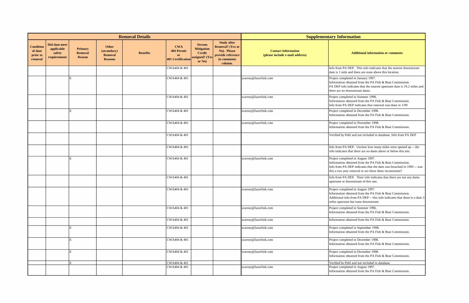
Condition of dam prior to removal
Did dam meet applicable
safety requirements
PrimaryRemoval Reason
Other (secondary)
Removal Reasons
Benefits
CWA 404 Permit
or 401 Certification
Stream Mitigation
Credit assigned? (Yes
or No)
Study after Removal? (Yes or
No). Please provide reference
in comments column.
Contact Information (please include e-mail address) Additional information or comments
CWA404 & 401 Info from PA DEP. This info indicates that the nearest downstream dam is 1 mile and there are none above this location.
E CWA404 & 401 [email protected] Project completed in January 1997.Information obtained from the PA Fish & Boat Commission.PA DEP info indicates that the nearest upstream dam is 19.2 miles and there are no downstream dams.
CWA404 & 401 [email protected] Project completed in Summer 1998.Information obtained from the PA Fish & Boat Commission.Info from PA DEP indicates that removal was done in 1/99
E CWA404 & 401 [email protected] Project completed in December 1998.Information obtained from the PA Fish & Boat Commission.
CWA404 & 401 [email protected] Project completed in November 1998.Information obtained from the PA Fish & Boat Commission.
CWA404 & 401 Verified by Pohl and not included in database. Info from PA DEP
CWA404 & 401 Info from PA DEP. Unclear how many miles were opened up -- the info indicates that there are no dams above or below this site.
E CWA404 & 401 [email protected] Project completed in August 1997.Information obtained from the PA Fish & Boat Commission.Info from PA DEP indicates that the dam was breached in 1995 -- was this a two year removal or are these dates inconsistent?
CWA404 & 401 Info from PA DEP. Their info indicates that there are not any dams upstream or downstream of this one.
CWA404 & 401 [email protected] Project completed in August 1997.Information obtained from the PA Fish & Boat Commission.Additional info from PA DEP -- this info indicates that three is a dam 3 miles upstream but none downstream
CWA404 & 401 [email protected] Project completed in Summer 1996.Information obtained from the PA Fish & Boat Commission.
CWA404 & 401 [email protected] Information obtained from the PA Fish & Boat Commission.
E CWA404 & 401 [email protected] Project completed in September 1998.Information obtained from the PA Fish & Boat Commission.
E CWA404 & 401 [email protected] Project completed in December 1998.Information obtained from the PA Fish & Boat Commission.
E CWA404 & 401 [email protected] Project completed in December 1998.Information obtained from the PA Fish & Boat Commission.
E CWA404 & 401 Verified by Pohl and not included in database.CWA404 & 401 [email protected] Project completed in August 1997.
Information obtained from the PA Fish & Boat Commission.
Supplementary InformationRemoval Details
B-51

Table B.2 Continued.
State Dam River Removal Date
Total Removal Cost in US$
(Engineering, Permitting,
Deconstruction, etc.)
Removal Cost in US$
(deconstruction cost only)
How was removal funded?
Indicate whether dam was removed (total removal) or breached (partial
removal)
Dam Maximum Structural Height (ft)
Dam Hydraulic
Height (ft)
Dam Length
(ft)
Reservoir Volume (acre-ft)
Owner Date Built
Type of Dam
State Hazard Classification
Who regulates dam
Run–of– river dam?
(Yes or No)
Original purpose of
dam
Most recent use of dam
and reservoir
PA Mussers Dam Middle Creek 1992 State Removed 31 384 American Hydro Power Company
1906 Timber Earth
State Hydropower Water Storage; Recreation
PA Lower Friendship Dam
Unknown 1982 30 State
PA Carpenters Pond Dam
Delaware River (trib.)
17 State
PA Fire Pond Dam at Incline #10
Unknown 16 State
PA Lemon House Pond Dam
Unknown 1984 15 State
PA Butterfield Pond Dam
Unknown 1992 13 State
PA Upper Friendship Dam
Unknown 1982 12 State
PA Van Horn #5 Dam
Unknown 1991 12 State
PA Van Horn #2 Dam
Unknown 10 State
PA Va Horn #1 Dam Unknown 1991 8 StatePA Lake Lettini Dam Delaware River
(trib.)7 State
PA Unnamed Dam, Peace Light Inn
Unknown 1991 7 State
PA Williamsburg Station Dam
Juniata River (Frankstown Branch)
1996 150,000 125,000 Private Removed 13 260 199 Pennsylvania Electric Co.
1922 Earth Concrete Gravity
State Water Storage
RI Jackson Pond Dam
Pawtuxet River 1979 20
SC Gallagher Pond Dam
Burgess Creek 1989 42
SC Miller Trust Pond Dam
Tools Fork (trib.) 1993 38
SC Pole Branch Dam Pole Branch River
1990 26
SC Old City Reservoir Dam
Turkey Quarter Creek
1988 25
SC Unnamed Dam, State Road 11-58
Cowpens National Battlefield
1979 7
SD Arikara Dam Unknown 1978 39SD Menno Lake Dam Unkown 1984 38
SD Lake Farley Dam Unknown 1980 25
SD Mission Dam Unknown 1987 25
Dam ID Removal Information Dam Characteristics
B-52

Condition of dam prior to removal
Did dam meet applicable
safety requirements
PrimaryRemoval Reason
Other (secondary)
Removal Reasons
Benefits
CWA 404 Permit
or 401 Certification
Stream Mitigation
Credit assigned? (Yes
or No)
Study after Removal? (Yes or
No). Please provide reference
in comments column.
Contact Information (please include e-mail address) Additional information or comments
CWA404 & 401
CWA404 & 401
CWA404 & 401 Verified by Pohl and not included in database.
CWA404 & 401
CWA404 & 401
CWA404 & 401
CWA404 & 401
CWA404 & 401
CWA404 & 401
CWA404 & 401CWA404 & 401 Verified by Pohl and not included in database.
CWA404 & 401
E CWA404 & 401 [email protected] Project completed in August 1996.Information obtained from the PA Fish & Boat Commission.According to the PA DEP, the neares downstream dam is 61.5 miles and there are no dams upstream.
$
S
S
F
S
Verified by Pohl and not included in database.
O
Removal Details Supplementary Information
B-53

Table B.2 Continued.
State Dam River Removal Date
Total Removal Cost in US$
(Engineering, Permitting,
Deconstruction, etc.)
Removal Cost in US$
(deconstruction cost only)
How was removal funded?
Indicate whether dam was removed (total removal) or breached (partial
removal)
Dam Maximum Structural Height (ft)
Dam Hydraulic
Height (ft)
Dam Length
(ft)
Reservoir Volume (acre-ft)
Owner Date Built
Type of Dam
State Hazard Classification
Who regulates dam
Run–of– river dam?
(Yes or No)
Original purpose of
dam
Most recent use of dam
and reservoir
SD Farmingdale Dam
Unknown 1986 24
SD Norbeck Dam & SD Highway 87
Unknown 40
SD P6L-Lower Bigger Dam
Unknown 10
SD Unnamed Dam #26
Unknown 1987 10
SD Unnamed Dam #30
Unknown 1987 10
SD Unnamed Dam #32
Unknown 10
SD Unnamed Dam #35
Unknown 1987 10
TN Spence Farm Pond Dam #5
Snake Creek (trib.)
1983 Owner breached 35 25 300 70 Private 1987 Earth fill Low State No Irrigation Irrigation
TN Monsanto Dam #9
Helms Branch 1990 Owner breached 33 23 1413 1700 Industrial/Utility
1963 Earth fill Low State No Aesthetics Other
TN Rhone Poulenc Dam #20
Quality Creek 1995 Owner breached 33 18 3854 1230 Industrial/Utility
1978 Earth fill High State No Aesthetics Other
TN Walkers Dam Walker Stream 1992 Owner breached 32 16 291 26 Private unknown Earth fill Low State No Irrigation Irrigation
TN Ballard Mill Mine Dam
Fork Creek (trib.) 1992 Owner breached 30 25 691 403 Private 1956 Earth fill Low State No Detention Other
TN Cities Service Company Dam
Burra-Burra Creek
1995 30 Unknown
TN L. Thompson Dam #1
Unknown 1990 10 Unknown
TN L.C. Hancock #1 Unknown 1990 8 UnknownTN L.C. Hancock #3 Unknown 8 UnknownTX Alamo Arroyo
DamAlamo Arroyo 1979 Removed 48 1,940 1234 Local
government1960 Earth fill High State No Flood control
TX H & H Feedlot Dam
Cottonwood Creek
1980 Breached 35 225 128 Private 1960 Earth fill Low State No Feedlot lake
TX Barefoot Lake Dam
Mill Creek 1994 Breached 27 1,610 819 Ray Reily 1964 Earth fill High State No Recreation
TX Lake Downs Dam Big Sandy Creek (trib.)
26 470 54 Private 1963 Earth fill High State No Recreation
TX Millsap Reservoir Dam
Daves White Branch
1988 Breached 25 1,062 162 Missouri Pacific RR
1928 Earth fill High State No Water Supply Recreation
Dam ID Removal Information Dam Characteristics
B-54
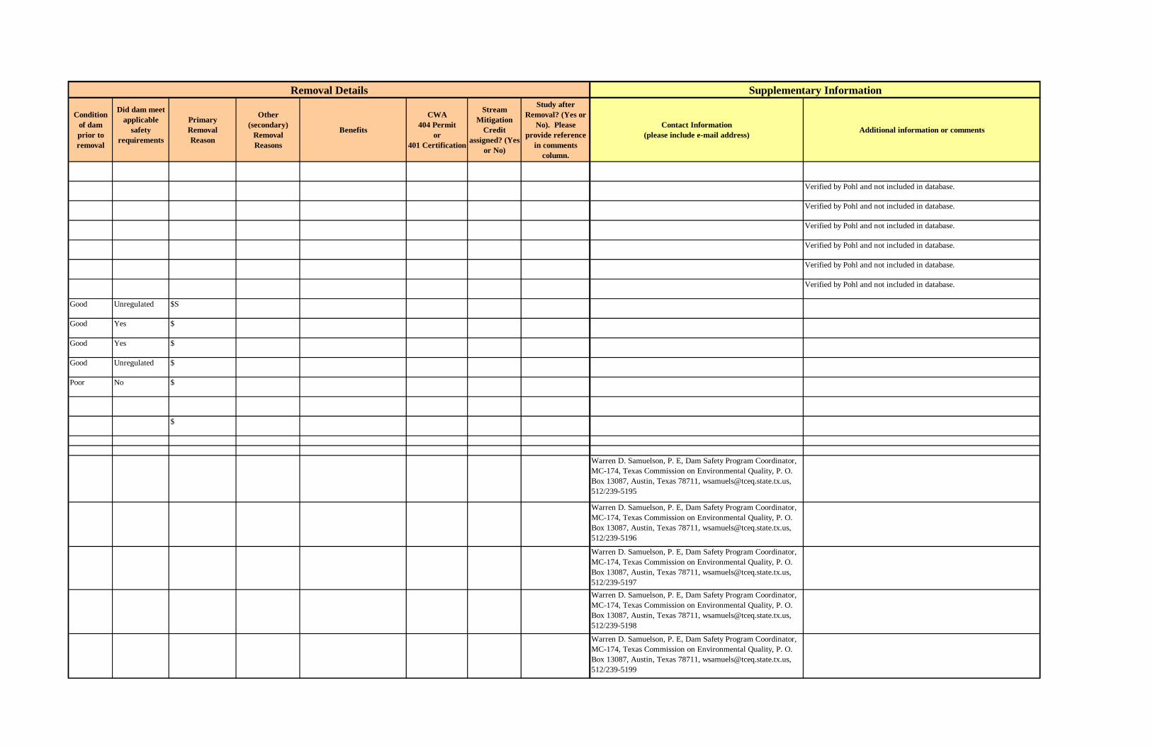
Condition of dam prior to removal
Did dam meet applicable
safety requirements
PrimaryRemoval Reason
Other (secondary)
Removal Reasons
Benefits
CWA 404 Permit
or 401 Certification
Stream Mitigation
Credit assigned? (Yes
or No)
Study after Removal? (Yes or
No). Please provide reference
in comments column.
Contact Information (please include e-mail address) Additional information or comments
Verified by Pohl and not included in database.
Verified by Pohl and not included in database.
Verified by Pohl and not included in database.
Verified by Pohl and not included in database.
Verified by Pohl and not included in database.
Verified by Pohl and not included in database.
Good Unregulated $S
Good Yes $
Good Yes $
Good Unregulated $
Poor No $
$
Warren D. Samuelson, P. E, Dam Safety Program Coordinator, MC-174, Texas Commission on Environmental Quality, P. O. Box 13087, Austin, Texas 78711, [email protected], 512/239-5195
Warren D. Samuelson, P. E, Dam Safety Program Coordinator, MC-174, Texas Commission on Environmental Quality, P. O. Box 13087, Austin, Texas 78711, [email protected], 512/239-5196
Warren D. Samuelson, P. E, Dam Safety Program Coordinator, MC-174, Texas Commission on Environmental Quality, P. O. Box 13087, Austin, Texas 78711, [email protected], 512/239-5197Warren D. Samuelson, P. E, Dam Safety Program Coordinator, MC-174, Texas Commission on Environmental Quality, P. O. Box 13087, Austin, Texas 78711, [email protected], 512/239-5198
Warren D. Samuelson, P. E, Dam Safety Program Coordinator, MC-174, Texas Commission on Environmental Quality, P. O. Box 13087, Austin, Texas 78711, [email protected], 512/239-5199
Supplementary InformationRemoval Details
B-55

Table B.2 Continued.
State Dam River Removal Date
Total Removal Cost in US$
(Engineering, Permitting,
Deconstruction, etc.)
Removal Cost in US$
(deconstruction cost only)
How was removal funded?
Indicate whether dam was removed (total removal) or breached (partial
removal)
Dam Maximum Structural Height (ft)
Dam Hydraulic
Height (ft)
Dam Length
(ft)
Reservoir Volume (acre-ft)
Owner Date Built
Type of Dam
State Hazard Classification
Who regulates dam
Run–of– river dam?
(Yes or No)
Original purpose of
dam
Most recent use of dam
and reservoir
TX Nix Lake Dam Wasson Branch 23 525 609 Nix Club lake
1940 Earth fill Low State No Recreation
TX Bland Lake Dam Mustang Creek (trib.)
1989 21 1,410 54 Union Pacific RR
1969 Earth fill Low State No Other
TX Hilsboro Lake Park Dam
Pecan River (trib.)
Removed 15 1,200 65 Union Pacific RR
Earth fill High State No Other
TX Harris Back Lake Dam
Tributary of Parker Creek
1989 Breached 15 810 77 Private 1900 Earth fill High State No Recreation
TX Railroad Reservoir Dam
Willis Creek (trib.)
1992 Removed 10 840 26 Union Pacific RR
1904 Earth fill High State No Other
TX Boot Spring Dam Unknown 15 Earth fill State No
TX Duke Dam Unknown 8 Earth fill State NoUT Box Elder Creek
DamBox Elder Creek 1995 50
UT Brush Dam Muddy Creek 1983 49UT Bell Canyon Dam 1979 30
VA Embrey Dam Rappahannock River
2005
VA McGaheysville Dam
South Branch of the Shenandoah River
2004 1920s Power source
VA Chancellorsville Brygadier A & B Dam
Tributary of Hunting Run
2000 15,000
VA Fredricksburgh & Spotsylvania Dam #1
2000
VA Fredricksburgh & Spotsylvania Dam #2
2000
VA Fredricksburgh & Spotsylvania Dam #3
2000
VA Fredricksburgh & Spotsylvania Dam #4
2000
VA Sykes Dam 1992 22
Dam ID Removal Information Dam Characteristics
B-56
Condition of dam prior to removal
Did dam meet applicable
safety requirements
PrimaryRemoval Reason
Other (secondary)
Removal Reasons
Benefits
CWA 404 Permit
or 401 Certification
Stream Mitigation
Credit assigned? (Yes
or No)
Study after Removal? (Yes or
No). Please provide reference
in comments column.
Contact Information (please include e-mail address) Additional information or comments
Warren D. Samuelson, P. E, Dam Safety Program Coordinator, MC-174, Texas Commission on Environmental Quality, P. O. Box 13087, Austin, Texas 78711, [email protected], 512/239-5200
Warren D. Samuelson, P. E, Dam Safety Program Coordinator, MC-174, Texas Commission on Environmental Quality, P. O. Box 13087, Austin, Texas 78711, [email protected], 512/239-5201
Warren D. Samuelson, P. E, Dam Safety Program Coordinator, MC-174, Texas Commission on Environmental Quality, P. O. Box 13087, Austin, Texas 78711, [email protected], 512/239-5202
Warren D. Samuelson, P. E, Dam Safety Program Coordinator, MC-174, Texas Commission on Environmental Quality, P. O. Box 13087, Austin, Texas 78711, [email protected], 512/239-5203
Verified by Pohl and not included in database.
Verified by Pohl and not included in database.S
$$
More than 170 miles of habitat open to several species of migratory fish
John Tippett, Friends of the Rappahannock, (540) 373-3448, [email protected]
E$S Sara Nicholas, American Rivers, (717) 232-8355, [email protected]
$ Gregg Knapp, National Park Service, (540) 785-7448
DATA LACKING. Need removal verification and measurements.
DATA LACKING. Need removal verification and measurements.
DATA LACKING. Need removal verification and measurements.
DATA LACKING. Need removal verification and measurements.
Removal Details Supplementary Information
B-57

Table B.2 Continued.
State Dam River Removal Date
Total Removal Cost in US$
(Engineering, Permitting,
Deconstruction, etc.)
Removal Cost in US$
(deconstruction cost only)
How was removal funded?
Indicate whether dam was removed (total removal) or breached (partial
removal)
Dam Maximum Structural Height (ft)
Dam Hydraulic
Height (ft)
Dam Length
(ft)
Reservoir Volume (acre-ft)
Owner Date Built
Type of Dam
State Hazard Classification
Who regulates dam
Run–of– river dam?
(Yes or No)
Original purpose of
dam
Most recent use of dam
and reservoir
VA Berryville Reservoir
15
VA Adney Gap Pond Dam
1984 12
VA Fredricksburgh & Spotsylvania Dam #2
5
VA Fredricksburgh & Spotsylvania Dam #3
5
VA Osborne Dam 12VA Fredricksburgh &
Spotsylvania Dam #5
5
VA Picnic Area Dam Manassas NP Battlefield
1984 5
VA Fredricksburgh & Spotsylvania Dam #6
4
VT Cold River Dam Cold River 2003 7 90 1970s Boulder
VT Hillside Farm Dam
Tributary to the Ompompanoosuc River
2003 18 Earth
VT Johnson State College Dam
Tributary to the LaMoille River
2003 30 Earth Aesthetic purposes
VT Lyndon State College Lower Dam
Passumpsic River-TR
VT Red Mill Dam Battenkill RiverVT Youngs Brook
DamYoungs Brook 1995 46
VT Lower Eddy Pond Dam
Mussey Brook 1981 20
VT Norwich Reservoir Dam
Charles Brown Brook
20
VT Winooski Water Supply Upper Dam
Winooski River (trib.)
1983 19
VT Newport 11 Dam Clyde River 1996 550,000 19 90 20 Citizens Utility Co.
1956 Concrete Buttress Gravity
Hydropower
VT Groton Dam Wells River 1998 5 Town of Groton
1803 Timber Crib
Dam ID Removal Information Dam Characteristics
B-58

Condition of dam prior to removal
Did dam meet applicable
safety requirements
PrimaryRemoval Reason
Other (secondary)
Removal Reasons
Benefits
CWA 404 Permit
or 401 Certification
Stream Mitigation
Credit assigned? (Yes
or No)
Study after Removal? (Yes or
No). Please provide reference
in comments column.
Contact Information (please include e-mail address) Additional information or comments
DATA LACKING. Need removal verification and measurements.
DATA LACKING. Need removal verification and measurements.
DATA LACKING. Need removal verification and measurements.
DATA LACKING. Need removal verification and measurements.
DATA LACKING. Need removal verification and measurements.
E Monitoring after removal
Jim MacCartney, Trout Unlimited and National Park Service, (603) 226-3436, [email protected]
F Brian Fitzgerald, Vermont Agency of Natural Resources, (802) 241-3468, [email protected]
$F Brian Fitzgerald, Vermont Agency of Natural Resources, (802) 241-3468, [email protected]
DATA LACKING. Need removal verification and measurements.
DATA LACKING. Need removal verification and measurements.S Verified by Pohl and not included in database.
S
S Verified by Pohl and not included in database.
S Verified by Pohl and not included in database.
E
DATA LACKING. The dam was washed out in January of 1998. A permit to rebuild it was denied by the VT Water Resources Board in March of 1998. Detailed account of decision in files.
Supplementary InformationRemoval Details
B-59

Table B.2 Continued.
State Dam River Removal Date
Total Removal Cost in US$
(Engineering, Permitting,
Deconstruction, etc.)
Removal Cost in US$
(deconstruction cost only)
How was removal funded?
Indicate whether dam was removed (total removal) or breached (partial
removal)
Dam Maximum Structural Height (ft)
Dam Hydraulic
Height (ft)
Dam Length
(ft)
Reservoir Volume (acre-ft)
Owner Date Built
Type of Dam
State Hazard Classification
Who regulates dam
Run–of– river dam?
(Yes or No)
Original purpose of
dam
Most recent use of dam
and reservoir
WA Three Unnamed Barriers
Icicle Creek 9 Hold adult salmon and steelhead
WA Goldsborough Creek Dam
Goldsborough Creek
2001 4,800,000 Federal, State Removed 14 100 1 Simpson Timber Company
1921 Timber crib & concrete
Low State Yes Electrical Power Generation
Diversion
WA Unnamed Dam Headquarters Creek at Willapa National Wildlife Refuge
2000 5 Early 1940s
Source of water
WA Maiden Dam Touchet River 1998WA Pomeroy Gulch
Damoff-channel dam Removed 38
WA North End Reservoir
Unknown OFFSTREAM
Removed 28
WA Wind River Dam Wind River 20WA Darrington Water
Works DamSauk River (trib.) 1985 20,000 State Breached 19 19 200 100 Local
government1966 Earth fill Medium State No Water Supply
WA Sultan Mill Pond Dam
Wagleys Creek 15
WA Black Mud Waste Pond Dam A
off-channel dam Removed 15
WA Black Mud Waste Pond Dam B
off-channel dam Removed 15
WA Black Mud Waste Pond Dam C
off-channel dam Removed 15
WA City Lakes Dam off-channel dam 15WA Mill Creek
Settling Basin Dam
Mill Creek 15
WA PEO Dam #32A Hanford Creek (trib.)
14
WA Coffee Creek Dam
Coffee Creek 10
WA Bow Lake Reservoir
7
WA Stromer Lake Dam
Columbia River-TR
5
WA PEO Dam #48 Hanford Creek (trib.)
3
WA White River Mill Pond Dam
Boise Creek 3
Dam ID Removal Information Dam Characteristics
B-60

Condition of dam prior to removal
Did dam meet applicable
safety requirements
PrimaryRemoval Reason
Other (secondary)
Removal Reasons
Benefits
CWA 404 Permit
or 401 Certification
Stream Mitigation
Credit assigned? (Yes
or No)
Study after Removal? (Yes or
No). Please provide reference
in comments column.
Contact Information (please include e-mail address) Additional information or comments
E Open an additional two to three miles of habitat for salmon;Return flow to the original channel of Icicle Creek
Buford Howell, Icicle Creek Watershed Council, (509) 548-6017
Poor No $ Environmental benefit (fisheries, water quality, river restoration)
Amount of wildlife seen in the area has increased
CWA404 & 401 No Yes Patti Case, Simpson Timber Company, (360) 427-4733 See info on Friends of the Earth website: http://www.foe.org/camps/reg/nw/river/golds.html
E Return of cutthroat trout;Increase in salmon runs;Restore some of the rich amphibian diversity
Charlie Stenvall, U.S. Fish and Wildlife Service, (360) 484-3482, [email protected]
Pratial Removal
DATA LACKING. Dam removed. Need measurements.Offstream Storage Reservoir - removed and replaced by a tank.
Dam was an in-city reservoir and was drrained, the site was regarded, and an above ground tank was put in place of the open reservoir
Poor No S Removed Safety Hazard None No No Doug Johnson, Washington State Dam Safety [email protected]
Verified by Pohl and not included in database.
Verified by Pohl and not included in database.
Verified by Pohl and not included in database.
Dam was not on a stream
Verified by Pohl and not included in database.
DATA LACKING. Need removal verification and measurements.
Verified by Pohl and not included in database.
Verified by Pohl and not included in database.
Removal Details Supplementary Information
B-61

Table B.2 Continued.
State Dam River Removal Date
Total Removal Cost in US$
(Engineering, Permitting,
Deconstruction, etc.)
Removal Cost in US$
(deconstruction cost only)
How was removal funded?
Indicate whether dam was removed (total removal) or breached (partial
removal)
Dam Maximum Structural Height (ft)
Dam Hydraulic
Height (ft)
Dam Length
(ft)
Reservoir Volume (acre-ft)
Owner Date Built
Type of Dam
State Hazard Classification
Who regulates dam
Run–of– river dam?
(Yes or No)
Original purpose of
dam
Most recent use of dam
and reservoir
WA Rat Lake Dam Whitestone Creek
1989 52,000 52,000 32 240
WI Country Dam Apple River 2004
WI Ball Park Dam Maunesha River 2004 125,000 11
WI McCaslin Brook Dam
McCaslin Brook 2004 8 108 Large boulders, wood crib structures
WI Knowles Dam Oconto River 2004 7.5
WI Hemlock Dam Oconto River 2004 7.5
WI Kenosha Country Club Dam
Pike River 2004 4 Concrete
WI Athens Dam Totato Creek 2004 9 Rock & concrete
WI Planning Mill Dam
Waupaca River 2004
WI Two Boulder Creek Dams
Boulder Creek 2003 Timber crib & cement
WI Clark’s Mill Dam Magdantz Creek 2003 7 166 Earth
WI Unnamed Dam Branch River 2003 5 40
WI Waubeka Dam Milwaukee River 2003 10 222 Rock
WI White River Dam Fox River 2003 12 250 Rock & timber crib
WI Afton Dam Bass Creek 2002
WI Grand River Dam Grand River 2002 11 Concrete
Dam ID Removal Information Dam Characteristics
B-62
Condition of dam prior to removal
Did dam meet applicable
safety requirements
PrimaryRemoval Reason
Other (secondary)
Removal Reasons
Benefits
CWA 404 Permit
or 401 Certification
Stream Mitigation
Credit assigned? (Yes
or No)
Study after Removal? (Yes or
No). Please provide reference
in comments column.
Contact Information (please include e-mail address) Additional information or comments
S
Helen Sarakinos, River Alliance of Wisconsin, (608) 257-2424 ext. 112, [email protected]
$ Improve fish movement, species and habitat diversity navigation and water quality
Laura Stremick-Thompson, WI Department of Natural Resources, (920) 387-7876, [email protected]
E$ Improve water quality;Increase population of native brook trout
Helen Sarakinos, River Alliance of Wisconsin, (608) 257-2424 ext. 112, [email protected]
Restore a cold-water fishery;Benefit native brook trout populations
Tom Moris, Wildlife Biologist, Chequamegon-Nicolet National Forest, (715) 674-4481
Restore a cold-water fishery;Benefit native brook trout populations
Tom Moris, Wildlife Biologist, Chequamegon-Nicolet National Forest, (715) 674-4482
E Increased habitat for Lake Michigan migratory species
Art Kitchen, U.S. Fish & Wildlife Service, (608) 221-1206, [email protected]
$ Keith Patrick, WI Department of Natural Resources, (715) 241-7502, [email protected] Stitgen, WI Department of Natural Resources, (608) 266-1925 [email protected]
ES Restore fish habitat;Improve water quality
Helen Sarakinos, River Alliance of Wisconsin, (608) 275-2424 ext. 112, [email protected]
$ Restore fish habitat;Return creek to free-flowing status
Linda Hyatt, Wisconsin Department of Natural Resources, (920) 787-4686, [email protected]
E Helen Sarakinos, River Alliance of Wisconsin, (608) 275-2424 ext. 112, [email protected]
$S Improve water quality;Expose riffle habitat for smallmouth bass
Helen Sarakinos, River Alliance of Wisconsin, (608) 275-2424 ext. 112, [email protected]
$S Remove safety liability;Open up the Fox River to fish migration for species such as lake sturgeon, flathead catfish, and walleye
Linda Hyatt, Wisconsin Department of Natural Resources, (920) 787-4686, [email protected]
S Improve habitat for fish;May upstream wetland restoration
Helen Sarakinos, River Alliance of Wisconsin, (608) 257-2424, [email protected] or Sue Josheff, Wisconsin Department of Natural Resources, (608) 275-3305. http://www.wisconsinrivers.org/SmallDams/20by2000-detailed-list.html#Afton%20DamLinda Hyatt, Wisconsin Department of Natural Resources Dam Safety Engineer, 920-787-4686, [email protected]
Supplementary InformationRemoval Details
B-63

Table B.2 Continued.
State Dam River Removal Date
Total Removal Cost in US$
(Engineering, Permitting,
Deconstruction, etc.)
Removal Cost in US$
(deconstruction cost only)
How was removal funded?
Indicate whether dam was removed (total removal) or breached (partial
removal)
Dam Maximum Structural Height (ft)
Dam Hydraulic
Height (ft)
Dam Length
(ft)
Reservoir Volume (acre-ft)
Owner Date Built
Type of Dam
State Hazard Classification
Who regulates dam
Run–of– river dam?
(Yes or No)
Original purpose of
dam
Most recent use of dam
and reservoir
WI Schweitzer Dam Cedar Creek 2002 8 30 Timber crib
WI Woods Creek Dam
Woods Creek 2002 16 200 Hydropower
WI Silver Springs multi-dam complex (13 dams)
tributary of Onion River
2002 6 Wood and Concrete
WI Deerskin Dam Deerskin River 2001 15,000
WI Franklin Dam Sheboygan River 2001 13 280 94 Franklin Volunteer Fire Department
1850 Gravity Earth Rockfill
Recreation
WI Kamrath Dam Tributary of Onion River
2001 5
WI LaValle Dam Baraboo River 2001WI Linen Mill Dam Baraboo River 2001 58,000
WI New Fane Dam East Branch of the Milwaukee River
2001 50,000
WI Orienta Dam Iron River 2001 500,000 44 1930s Hydropower
WI Waubeka Dam Milwaukee River 2001 Power
Dam ID Removal Information Dam Characteristics
B-64
Condition of dam prior to removal
Did dam meet applicable
safety requirements
PrimaryRemoval Reason
Other (secondary)
Removal Reasons
Benefits
CWA 404 Permit
or 401 Certification
Stream Mitigation
Credit assigned? (Yes
or No)
Study after Removal? (Yes or
No). Please provide reference
in comments column.
Contact Information (please include e-mail address) Additional information or comments
E Restored the entire creek from a shallow and algae-filled impoundment to a free-flowing stream and natural floodplain open to public use
Will Wawrzyn, Wisconsin Department of Natural Resources, (414) 263-8699
O Return stream to free-flowing state; Allow brook trout access to overwintering habitat
Bob Martini, Wisconsin Department of Natural Resources, (715) 365-8969
E Restore trout habitat;Restore stream channels
Laura Hewitt, Trout Unlimited, (608) 250-2757, [email protected]
$S Improve water quality;Restore fish habitat
Helen Sarakinos, River Alliance of Wisconsin, (608) 257-2424, [email protected]. http://www.wisconsinrivers.org/SmallDams/deerskin_dam.html
$ Restored 10 miles of free flowing river; Improved water quality;Benefited smallmouth bass and northern pike; Populations of mayfly and kadisfly increased above the former dam site
Helen Sarakinos, River Alliance of Wisconsin, (608) 257-2424, [email protected]. http://www.wisconsinrivers.org/SmallDams/deerskin_dam.html
E Stream returned to its historic, meandering path; Benefited the health of the entire Great Lakes Basin
Laura Hewitt, Trout Unlimited, (608) 250-2757, [email protected]. http://www.wisconsinrivers.org/SmallDams/20by2000-detailed-list.html#Onion%20River%20Project
John Laub, Sand County Foundation, (608) 244-3512$ Restored river to free-flowing
state;Habitat improvements for fish
Helen Sarakinos, River Alliance of Wisconsin, (608) 257-2424. http://www.wisconsinrivers.org/SmallDams/baraboo_casestudy.html
$ Restored 6 miles of free flowing river;Benefited many species
Helen Sarakinos, River Alliance of Wisconsin, (608) 257-2424, [email protected]
$ Improved at least 1.5 miles of spawning habitat for salmon and trout migrating from Lake Superior
Helen Sarakinos, River Alliance of Wisconsin, (608) 257-2424, [email protected]. http://www.wisconsinrivers.org/SmallDams/20by2000-detailed-list.html#Orienta%20Dam
$ Restored oxygen and temperature levels; Return of sediment and nutrients to sediment-starved downstream reaches; Decreased flood risk; Additional habitat for smallmouth bass and other warmwater sportfish;Additional public land to create public parks
Helen Sarakinos, River Alliance of Wisconsin, (608) 257-2424, [email protected]
Removal Details Supplementary Information
B-65

Table B.2 Continued.
State Dam River Removal Date
Total Removal Cost in US$
(Engineering, Permitting,
Deconstruction, etc.)
Removal Cost in US$
(deconstruction cost only)
How was removal funded?
Indicate whether dam was removed (total removal) or breached (partial
removal)
Dam Maximum Structural Height (ft)
Dam Hydraulic
Height (ft)
Dam Length
(ft)
Reservoir Volume (acre-ft)
Owner Date Built
Type of Dam
State Hazard Classification
Who regulates dam
Run–of– river dam?
(Yes or No)
Original purpose of
dam
Most recent use of dam
and reservoir
WI Chair Factory Dam
Milwaukee River 2001 175,000
WI Oak Street Dam Baraboo River 2000 30,000 12 208
WI Rockdale Dam Koshkonong Creek
2000
WI Shopiere Dam Turtle Creek 2000 100,000 9 250 35 abandoned by private owner
1939 Gravity Earth
Recreation
WI Beardsley Dam Madden Branch Tributary
1990 12,000 12
WI Bowen Mill Dam Pine River 1996 12
WI Carpenter Creek Dam
Carpenter Creek 1995 8,500 4
WI Cartwright Dam Shell Creek 1995 7 10WI Colfax Light
Power DamRed Cedar River 1969 120,000 21 52
WI Crivitz Dam Peshtigo River 1993 35,000WI Dunlop Creek
DamDunlop Creek 1955
WI Ettrick Dam Beaver Creek (North Fork)
1976
WI Fulton Dam Yahara River 1993 375,784 State, Other 16 350 Rock County 1800s (mid)
Hydropower
WI Funks Dam Oconomowoc River
1993 40,000 5 80
WI Greenwood Dam Black River 1994 80,000 16 unknown 1905 Hydropower
WI Huigen Dam Handsaw Creek 1970 6
Dam ID Removal Information Dam Characteristics
B-66
Condition of dam prior to removal
Did dam meet applicable
safety requirements
PrimaryRemoval Reason
Other (secondary)
Removal Reasons
Benefits
CWA 404 Permit
or 401 Certification
Stream Mitigation
Credit assigned? (Yes
or No)
Study after Removal? (Yes or
No). Please provide reference
in comments column.
Contact Information (please include e-mail address) Additional information or comments
$ Exposed riffle habitat important to smallmouth bass and other sportfish; Improved water quality
Helen Sarakinos, River Alliance of Wisconsin, (608) 257-2424, [email protected]. http://www.wisconsinrivers.org/SmallDams/20by2000-detailed-list.html#Chair%20Factory%20Dam
$ Opened up spawning grounds important to sturgeon, endangered paddlefish, and small mouth bass; Grown canoeing activity, increasing revenue in the town of Baraboo;The town plans to develop the waterfront as recreation and a community-gathering place
Helen Sarakinos, River Alliance of Wisconsin, (608) 257-2424, [email protected]. http://www.wisconsinrivers.org/SmallDams/oakstreet_pics.html
$ Sue Josheff, Wisconsin Department of Natural Resources, (608) 275-3305
$ Restored 30 miles of free-flowing river;Improved habitat for fish populations;Improved water quality
Helen Sarakinos, River Alliance of Wisconsin, (608) 257-2424, [email protected]. http://www.wisconsinrivers.org/SmallDams/shopiere_dam.html
Dam removal improved water quality on this stretch of the river.
DATA LACKING. Dam removed. Need measurements. This dam was built without legal consent. It was removed because it was a boating hazard.
The WI DNR states that this is an excellent small mouth bass site -- it is unclear how much the dam removal contributed to this.
A boating hazard was removed with the dam was taken out.DATA LACKING. Need removal verification and measurements.
E One of the dams studied in the Wisconsin small dam removal report. The removal of the dam decreased the rough fish population and established a warm water fishery.Dam removed. Need measurements. Removal of the dam increased water fowl habitat and increased the spawning runs of walleye and small mouth bass.One of the dams studied in the Wisconsin small dam removal report.
abandoned dam (under WI criteria)
A boating hazard was removed with the dam was taken out.
Supplementary InformationRemoval Details
B-67

Table B.2 Continued.
State Dam River Removal Date
Total Removal Cost in US$
(Engineering, Permitting,
Deconstruction, etc.)
Removal Cost in US$
(deconstruction cost only)
How was removal funded?
Indicate whether dam was removed (total removal) or breached (partial
removal)
Dam Maximum Structural Height (ft)
Dam Hydraulic
Height (ft)
Dam Length
(ft)
Reservoir Volume (acre-ft)
Owner Date Built
Type of Dam
State Hazard Classification
Who regulates dam
Run–of– river dam?
(Yes or No)
Original purpose of
dam
Most recent use of dam
and reservoir
WI Huntington Dam Apple River 1968 35,000 60 Northern States Power Co.
1910 Hydropower
WI Island Woolen Co. Dam
Baraboo River 1972
WI Lowe Creek 1 Dam
Lowe Creek 35
WI Lowe Creek 2 Dam
Lowe Creek 12
WI Marengo Dam Marengo River 1993 120,000 17 80
WI McClure Dam Apple River 1968 50,000 22 Northern States Power Co.
1910 Hydropower
WI Mellen Dam Bad River 1967 150,000 150
WI Mellen Waterworks Dam
City Creek 1995 12 5
WI Northland Dam Flume River 1992 10 30WI Oslo Dam Manitowoc River 1991 19,000 8
WI Port Arthur Dam Flambeau River 1968 600,000 250WI Pulcifer Dam Oconto River 1994 40,000 State 5 1869 Hydropower
WI Readstown Dam Kickapoo River 1985 30WI Schiek Dam Handsaw Creek 1970 15,000 6WI Upper Tigerton
DamEmbarrass River 1997 4 200
WI Whitehall Dam Trempealeau River
1988 30
WI Wonewoc Dam Baraboo River 1996 28WI Young America
DamMilwaukee River 1994 75,000 11 130
WI Klondike Dam Otter Creek 1978 30WI Token Creek
DamToken Creek 1999 13
WI Centerville Dam Centerville Creek 1996 12
WI Cross Plains Dam Black Earth Creek
1955 11
WI Mount Vernon Dam
Sugar River 1950 11
WI Black Earth Dam Black Earth Creek
1957 9
WI Reedsburg Dam Baraboo River 1973 9WI Hamilton Mill
DamCedar Creek 1996 8 100
Dam ID Removal Information Dam Characteristics
B-68

Condition of dam prior to removal
Did dam meet applicable
safety requirements
PrimaryRemoval Reason
Other (secondary)
Removal Reasons
Benefits
CWA 404 Permit
or 401 Certification
Stream Mitigation
Credit assigned? (Yes
or No)
Study after Removal? (Yes or
No). Please provide reference
in comments column.
Contact Information (please include e-mail address) Additional information or comments
One of the dams studied in the Wisconsin small dam removal report. The WI DNR states that this is an excellent small mouth bass site -- it is unclear how much the dam removal contributed to this.
E Removal of the dam restored trout habitat to this stretch of the river.
E One of the dams studied in the Wisconsin small dam removal report. The dam removal helped restore a small mouth bass habitat.
E Dam was removed to aid trout stream restoration. The old dam site is now a state park with a 50 ft natural falls.
E Removal of the dam opened four additional miles of steelhead fishing.
E The removal of the dam developed 5 miles of cold water fishery.DATA LACKING. Dam removed. Need measurements. One of the dams studied in the Wisconsin small dam removal report. A boating hazard was removed with the dam was taken out.
Dam removal restored trout fishing to this stretch of the river.DATA LACKING. Dam removed. Need measurements.
DATA LACKING. Dam removed. Need measurements.
Removal of the dam improved the small mouth bass fishing and water fowl habitat. It also provided better access to the river.
Removal Details Supplementary Information
B-69

Table B.2 Continued.
State Dam River Removal Date
Total Removal Cost in US$
(Engineering, Permitting,
Deconstruction, etc.)
Removal Cost in US$
(deconstruction cost only)
How was removal funded?
Indicate whether dam was removed (total removal) or breached (partial
removal)
Dam Maximum Structural Height (ft)
Dam Hydraulic
Height (ft)
Dam Length
(ft)
Reservoir Volume (acre-ft)
Owner Date Built
Type of Dam
State Hazard Classification
Who regulates dam
Run–of– river dam?
(Yes or No)
Original purpose of
dam
Most recent use of dam
and reservoir
WI Spring Valley Dam
Eau Galle River 1997 3 3
WI Ward Paper Mill Dam
Prairie River 1999 18 640 709 Ward Paper Co.
1905 Gravity Earth
Hydropower Water Storage
WI Oak Street Dam Baraboo River 2000 State 14 270 60 Robert McArthur
1929 Gravity Hydropower Recreation
WI Rassussen #1 Dam
Unknown
WI Unnamed Dam #1 Larrabee Tract
Unknown 1990
WI McNally Trout Pond Dam
Unknown 1983 5
WI Rassussen #2 Dam
Unknown 1982 3
WI Rassussen #3 Dam
Unknown 1982 3
WI Poppe Dam Unknown 1982 2WI Schaaf #1 Dam Unknown 1982 2WI Schaaf #2 Dam Unknown 1982 2WI Weingarten Dam Unknown 1982 2WI Evans Pond Dam Rathbone Creek 1998 5,000 10
WI Lemonweir Dam Lemonweir River 1992 190,000 State, Other 14 80 1914 Hydropower (inactive)
Recreation
WI Nelsonville Dam Tomorrow/Waupaca River
1988 62,000 Other 180 private owner 1860s Hydropower
WI Ontario Dam Kickapoo River 1992 47,000 121 unknown 1865 Hydropower (inactive)
Other
WI Somerset Dam Apple River 1965 75,000 83 Village of Somerset
1856 Hydropower
WI Woolen Mills Dam
Milwaukee River 1988 202,000 18 70 City of West Bend
1870 Hydropower Recreation; Other
WI Colfax Dam Eighteen Mile Creek
1998 241,000 20 350 42 Village of Colfax
1938 Rockfill Earth Gravity
Recreation
WI North Avenue Dam
Milwaukee River 1997 345,000 19 432 200 City of Milwaukee
1920 Gravity Other
Recreation
Dam ID Removal Information Dam Characteristics
B-70

Condition of dam prior to removal
Did dam meet applicable
safety requirements
PrimaryRemoval Reason
Other (secondary)
Removal Reasons
Benefits
CWA 404 Permit
or 401 Certification
Stream Mitigation
Credit assigned? (Yes
or No)
Study after Removal? (Yes or
No). Please provide reference
in comments column.
Contact Information (please include e-mail address) Additional information or comments
Verified by Pohl and not included in database.
[email protected] Taken from River Alliance's 20 by 2000
DATA LACKING. Need removal verification and measurements.
DATA LACKING. Need removal verification and measurements.
DATA LACKING. Need removal verification and measurements.
DATA LACKING. Need removal verification and measurements.
DATA LACKING. Need removal verification and measurements.
DATA LACKING. Need removal verification and measurements.Verified by Pohl and not included in database.Verified by Pohl and not included in database.DATA LACKING. Need removal verification and measurements.WI DNR owned the dam. The dam was located on a trout stream. The dam was removed because it was in poor shape -- and because its costs outwieghed its benefits in the b-c analysis.
One of the dams studied in the Wisconsin small dam removal report. The removal of the dam allowed walleyes to return upstream of the dam site.
One of the dams studied in the Wisconsin small dam removal report.
Not sure of exact date that the dam was removed -- either late 1980s or early 1990s.
Dam was sold to WDNR for removal.One of the dams studied in the Wisconsin small dam removal report. Removal of the dam improved both recreational canoeing and trout fishing at this stretch of the river.
One of the dams studied in the Wisconsin small dam removal report. The area is now a recreation area for tubing with 100,000 people per year that participate.
$ N.A. Journal of Fisheries ManagementOne of the dams studied in the Wisconsin small dam removal report.Removal of the dam restored a sport fishery on this stretch of the river.Taken from River Alliance's 20 by 2000
Supplementary InformationRemoval Details
B-71

Table B.2 Continued.
State Dam River Removal Date
Total Removal Cost in US$
(Engineering, Permitting,
Deconstruction, etc.)
Removal Cost in US$
(deconstruction cost only)
How was removal funded?
Indicate whether dam was removed (total removal) or breached (partial
removal)
Dam Maximum Structural Height (ft)
Dam Hydraulic
Height (ft)
Dam Length
(ft)
Reservoir Volume (acre-ft)
Owner Date Built
Type of Dam
State Hazard Classification
Who regulates dam
Run–of– river dam?
(Yes or No)
Original purpose of
dam
Most recent use of dam
and reservoir
WI Parfrey Glen Dam
Pine River 1996 154,000 19 450 90 City of Richland Center
1934 Earth Other Gravity
Recreation
WI Hayman Falls Dam
Embarrass River 1995 146,000 17 200 415 Shawano County
1918 Gravity Earth
Recreation
WI Hebron Dam Bark River 1996 17 170 100 Hebron Rod & Gun Club
1933 Gravity Earth
Recreation
WI Upper Waterloo Dam
Maunesha River 1995 17 115 320 Waterloo Malting Co.
1915 Gravity Earth
Recreation
WI Manitowoc Rapids Dam
Manitowoc River 1984 45,000 State, Private 16 400 45 Ray Bertler 1854 Gravity Earth Rockfill
Recreation
WI Waterworks Dam Baraboo River 1998 213,770 State, Other 14 220 190 City of Baraboo
1913 Gravity Recreation Water Storage
WI Slabtown Dam Bark River 1992 30,000 10 60 70 unknown 1948 Gravity Earth
Recreation
WI Wilmot Dam Fox River 1992 3 200 177 Kenosha County
1941 Gravity Earth
Recreation
WV Ladoucer Pond Dam
Unknown 1993
WY Sheridan Heights Reservoir
City of Sheridan (trib.)
WY Unnamed Dam Laramie River 1997WY White Grass
Dude Ranch DamUnknown 1988
WY North Dam Unknown 15WY East Dam Unknown 7WY South Dam Unknown 7WY Unnamed Dam
#1Unknown 7
WY West Dam Unknown 7
Dam ID Removal Information Dam Characteristics
B-72

Condition of dam prior to removal
Did dam meet applicable
safety requirements
PrimaryRemoval Reason
Other (secondary)
Removal Reasons
Benefits
CWA 404 Permit
or 401 Certification
Stream Mitigation
Credit assigned? (Yes
or No)
Study after Removal? (Yes or
No). Please provide reference
in comments column.
Contact Information (please include e-mail address) Additional information or comments
One of the dams studied in the Wisconsin small dam removal report.
E One of the dams studied in the Wisconsin small dam removal report. The dam removal created 40 miles of steelhead fishing.
[email protected] Taken from River Alliance's 20 by 2000
The removal of the dam increased the available water fowl habitat.
Verified by Ashley and included in database.
DATA LACKING. Need removal verification and measurements.
$
DATA LACKING. Need removal verification and measurements.DATA LACKING. Need removal verification and measurements.
Removal Details Supplementary Information
B-73