Embed Size (px)
Citation preview
A stunning Utah oil discovery has uncovered a new oil and gas province. This
incredible new find focuses spotlights on the Utah Hingeline and Utah Thrust Belt. This report has been revised January 17, 2006. Floyd C. Moulton Consulting Geologist International Petroleum, LLC Salt Lake City Michael L. Pinnell Pioneer Oil & Gas South Jordan, Utah
Central Utah, once the orphan child of hydrocarbon exploration, may soon have
many fathers. A recent new field discovery and nine productive offsets have been drilled on the
Central Utah Overthrust. At lease seven wells are hooked up with production of about 1,000,000 bbl of oil since May 2004 from the Jurassic Navajo Sandstone at depths ranging from 5,800 ft. to 6,500 ft. The discovery was drilled and is operated by Wolverine Gas & Oil Co., a private company located in Grand Rapids, Mich.
The ten wells are now capable of yielding as much as 8,000 to 10,000 b/d of oil on a very large hanging wall, thrusted anticlinal structure defined by 2-D seismic. A defining 3-D seismic program has been permitted and may soon be in the process of acquisition. The structure could produce well over 100 million bbl of oil from approximately 830 acres, or an incredible 120,000 bbls of oil/ acre. Deeper potential pay horizons are certainly present but have not yet been drilled. A shallower zone is productive but has not yet been developed.
Wolverine has directionally drilled nine development wells and one dry hole from two surface locations to define the oil field limits.
“Covenant” has been designated as the name for this new field. Most active thrust belt exploration since the Pineview discovery. The Wolverine discovery is one of many fine prospects drilled as major discoveries
after being shown at the North American Prospect Expo held annually in Houston. This, however, is a prospect that almost no one would buy.
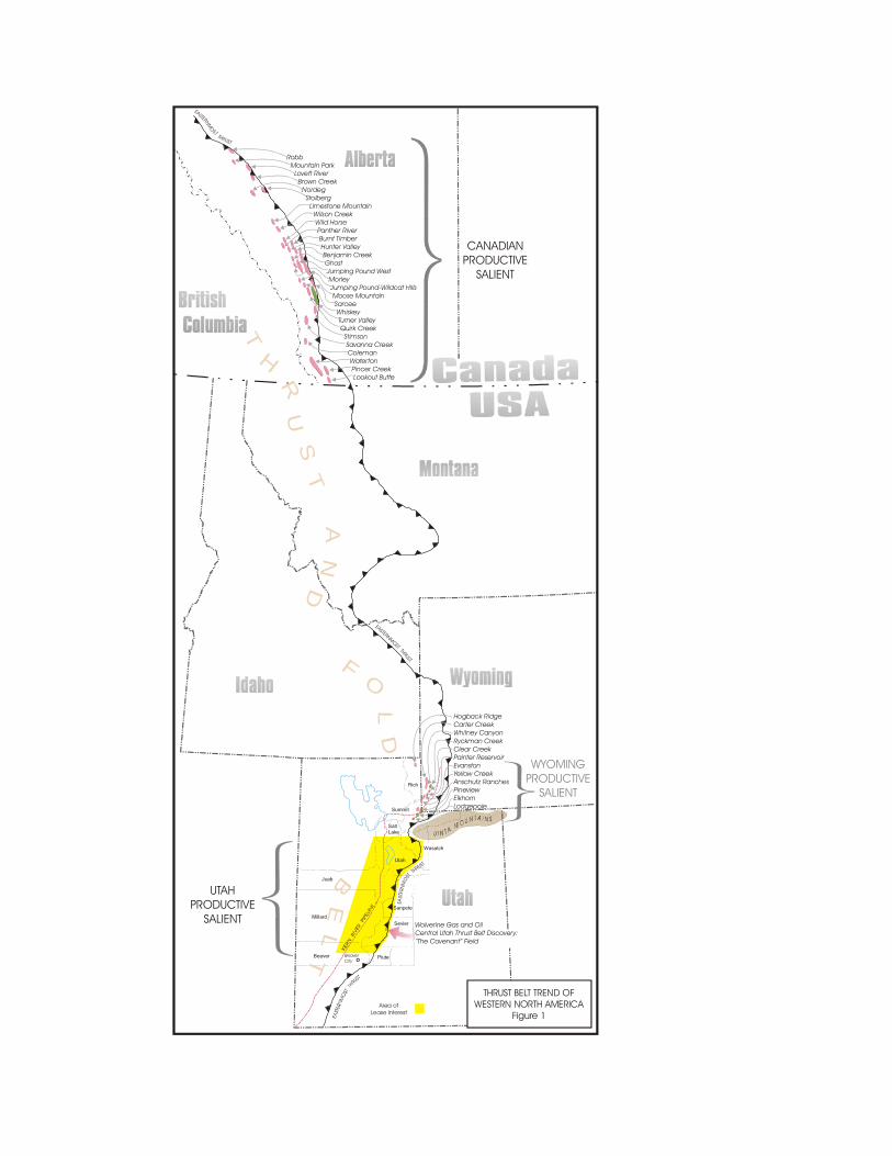
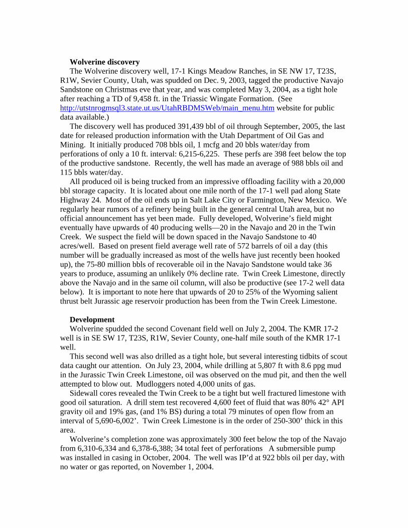
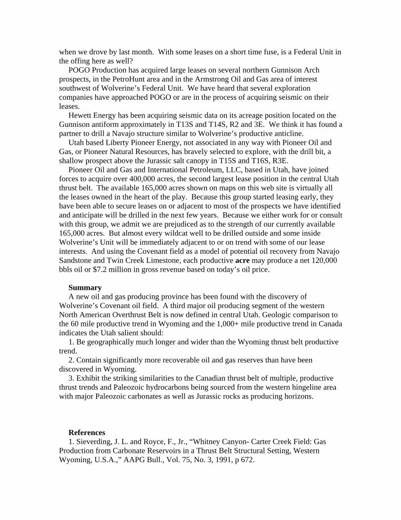
The story we have heard is that Sidney J. Jansma Jr., president of Wolverine, raised his drilling funds mostly from outside the oil industry. His bold vision has caused a 150-mile-long segment of the Central Utah thrust belt to become the focus of what is becoming a fierce and rewarding firestorm of leasing, drilling, and discovery not seen since Pineview field was brought into production in 1975 (Fig. 1).
The Pineview discovery set off a 5-year exploration melee that resulted in the drilling of 175 exploratory wells and the discovery of 11 new major fields, with recoverable
Rich
Wasatch
Utah
Juab
Millard
Piute
Sevier
Beaver
Sanpete
SaltLake
Summit
Hogback RidgeCarter CreekWhitney CanyonRyckman CreekClear CreekPainter ReservoirEvanstonYellow CreekAnschutz RanchesPineviewElkhornLodgepole
Wolverine Gas and OilCentral Utah Thrust Belt Discovery:“The Covenant” Field
Robb Mountain Park Lovett River Brown Creek Nordeg Stolberg Limestone Mountain Wilson Creek Wild Horse Panther River Burnt Timber Hunter Valley Benjamin Creek Ghost Jumping Pound West Morley Jumping Pound-Wildcat Hills Moose Mountain Sarcee Whiskey Turner Valley Quirk Creek Stimson Savanna Creek Coleman Waterton Pincer Creek Lookout Butte
BeaverCity
THRUST BELT TREND OFWESTERN NORTH AMERICA
Figure 1
EA
TE
R
S
NM
OST
T
THR
SU
EASTERNMOST THRUST
EASTE
RNMO
ST
THRUST
CANADIANPRODUCTIVE
SALIENT
WYOMINGPRODUCTIVE
SALIENT
UTAHPRODUCTIVE
SALIENT
T
R
H
U
S
T
A
L
N D
FO
D
L
B ET
Area ofLease Interest
reserves in the neighborhood of 4 to 5 billion BOE, mostly in Wyoming. Two of these discovered fields are giants Anschutz Ranch East and Whitney Canyon-Carter Creek.
The former Amoco Production Co., with its control of the Union Pacific acreage right-of-way, essentially controlled the destiny of the Pineview era exploration effort. The central Utah play, on the other hand, was pretty much open to independents since most major oil companies no longer explore in the Rocky Mountain basins. In the two years since Wolverine’s discovery, most of the leasable tracts in the heart of the area have been taken, with a few minor exceptions.
If recent competitive federal and state lease sales are an indication of intent, then Wolverine Gas & Oil, Pioneer Oil & Gas, International Petroleum LLC, Armstrong Oil and Gas, PetroHunt, Burnett Oil Company, Clayton Williams Energy, Yates, POGO Production Company, and Cleary Petroleum are but a few of the independents presently leading the charge. And the potential could easily exceed what was discovered in the sister play to the north.
Wolverine completed a 116 mile seismic program in 2005 and has initiated an aggressive 2006 program which complements recent seismic acquisition and older Chevron data (the discovery was a farmout from ChevronTexaco Corp.). These data will assist Wolverine in drilling and developing at least four additional “Covenant-like” prospect structures in their 70,000-acre federal unit and will also allow for additional prospects to be drilled elsewhere in the area. This “outside the Unit” exploration will initiate with Wolverine’s latest two new wells, the Cedar Ridge 7-1 wildcat in SE SW 7, T19S, R1E, and the Cedar Ridge 18-1, SW NW 18, also in T19S, R1E, Sanpete County, Utah. Many more will follow. We are aware of at least four areas outside Wolverine’s Federal Unit where Wolverine is preparing to drill additional, prospective structures. We will address Wolverine’s exploration later in this paper.
At the writing of this report we are aware of at least seven unique 2-D seismic programs underway or imminent, including a large spec shoot recently initiated by a major seismic acquisition company. And there may be many more seismic programs of which we are unaware. In addition, we anticipate seeing seven or eight more wildcat wells initiated or drilled along the Central Utah thrust belt by the end of 2006, depending on the permitting procedures and approvals.
Competitive oil and gas lease bids have risen to over $1200/acre in some high priority areas. One very large lease package in the order of 35,000 acres was gobbled up a year ago for $450/acre from a Utah operator before it was known if a second well at Covenant field was even productive. Large, open lease blocks are present only on US Forest Service lands where requests for public leasing opportunities have been repeatedly denied for years. It will not be long, however, until these restricted areas will play a significant role in the development of oil and gas reserves. A portion of the large, undrilled anticlinal structure south of Wolverine’s new field discovery may be partially located on US Forest Service ownership.
Lease price hikes can be expected as word spreads about the quality and magnitude of the new production. Even though the discovery was made over two years ago, Wolverine is still trying hard to keep critical engineering and geological information as confidential as possible for good reason. In the Pineview era, lease prices reached thousands of dollars per acre in high priority areas, and those were 1970 dollars. We do not blame Wolverine for its actions; there is no reason to throw an accelerant on a conflagration.
Wolverine discovery The Wolverine discovery well, 17-1 Kings Meadow Ranches, in SE NW 17, T23S,
R1W, Sevier County, Utah, was spudded on Dec. 9, 2003, tagged the productive Navajo Sandstone on Christmas eve that year, and was completed May 3, 2004, as a tight hole after reaching a TD of 9,458 ft. in the Triassic Wingate Formation. (See http://utstnrogmsql3.state.ut.us/UtahRBDMSWeb/main_menu.htm website for public data available.)
The discovery well has produced 391,439 bbl of oil through September, 2005, the last date for released production information with the Utah Department of Oil Gas and Mining. It initially produced 708 bbls oil, 1 mcfg and 20 bbls water/day from perforations of only a 10 ft. interval: 6,215-6,225. These perfs are 398 feet below the top of the productive sandstone. Recently, the well has made an average of 988 bbls oil and 115 bbls water/day.
All produced oil is being trucked from an impressive offloading facility with a 20,000 bbl storage capacity. It is located about one mile north of the 17-1 well pad along State Highway 24. Most of the oil ends up in Salt Lake City or Farmington, New Mexico. We regularly hear rumors of a refinery being built in the general central Utah area, but no official announcement has yet been made. Fully developed, Wolverine’s field might eventually have upwards of 40 producing wells—20 in the Navajo and 20 in the Twin Creek. We suspect the field will be down spaced in the Navajo Sandstone to 40 acres/well. Based on present field average well rate of 572 barrels of oil a day (this number will be gradually increased as most of the wells have just recently been hooked up), the 75-80 million bbls of recoverable oil in the Navajo Sandstone would take 36 years to produce, assuming an unlikely 0% decline rate. Twin Creek Limestone, directly above the Navajo and in the same oil column, will also be productive (see 17-2 well data below). It is important to note here that upwards of 20 to 25% of the Wyoming salient thrust belt Jurassic age reservoir production has been from the Twin Creek Limestone.
Development Wolverine spudded the second Covenant field well on July 2, 2004. The KMR 17-2
well is in SE SW 17, T23S, R1W, Sevier County, one-half mile south of the KMR 17-1 well.
This second well was also drilled as a tight hole, but several interesting tidbits of scout data caught our attention. On July 23, 2004, while drilling at 5,807 ft with 8.6 ppg mud in the Jurassic Twin Creek Limestone, oil was observed on the mud pit, and then the well attempted to blow out. Mudloggers noted 4,000 units of gas.
Sidewall cores revealed the Twin Creek to be a tight but well fractured limestone with good oil saturation. A drill stem test recovered 4,600 feet of fluid that was 80% 42° API gravity oil and 19% gas, (and 1% BS) during a total 79 minutes of open flow from an interval of 5,690-6,002’. Twin Creek Limestone is in the order of 250-300’ thick in this area.
Wolverine’s completion zone was approximately 300 feet below the top of the Navajo from 6,310-6,334 and 6,378-6,388; 34 total feet of perforations A submersible pump was installed in casing in October, 2004. The well was IP’d at 922 bbls oil per day, with no water or gas reported, on November 1, 2004.
Oil characteristics Oil produced from the Navajo Sandstone in the Wolverine wells is Paleozoic sourced.
It is low in sulfur content (0.57%) and of good quality (at least 40° gravity). Two marine biomarkers have been observed in the oil. They have been identified as
probably Permian and Mississippian with a possible overmature condensate added which may have originated either from organic rich Lower Cretaceous sediments below and on the east side of the Gunnison thrust or from Mississippian or Permian rocks matured at a different time and place than the majority of the recovered oil. Structures farther north of Wolverine’s discovery should have an even better chance of a Cretaceous oil source in addition to the primary Paleozoic sources already noted.
World class reservoir The Navajo Sandstone Formation is comprised mostly of very clean, eolian, quartzose
sandstone with 14% average porosity and permeabilities averaging 40-50md. The field is reported to have no pressure decline because it has an active water drive. It has been estimated that at least 50% of the original oil in place may eventually be recovered.
The Navajo Sandstone is over 1,200 ft thick in the discovery well. At least the top 500 feet are filled with oil. A secondary reservoir, Twin Creek Limestone, rests atop the Navajo. It is apparently similar to Twin Creek production in the thrust belt’s Wyoming salient where it has fracture porosity.
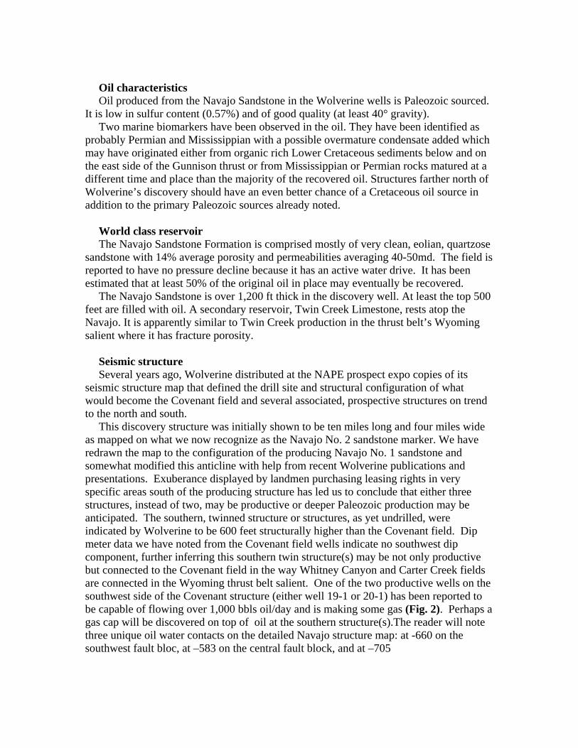
Seismic structure Several years ago, Wolverine distributed at the NAPE prospect expo copies of its
seismic structure map that defined the drill site and structural configuration of what would become the Covenant field and several associated, prospective structures on trend to the north and south.
This discovery structure was initially shown to be ten miles long and four miles wide as mapped on what we now recognize as the Navajo No. 2 sandstone marker. We have redrawn the map to the configuration of the producing Navajo No. 1 sandstone and somewhat modified this anticline with help from recent Wolverine publications and presentations. Exuberance displayed by landmen purchasing leasing rights in very specific areas south of the producing structure has led us to conclude that either three structures, instead of two, may be productive or deeper Paleozoic production may be anticipated. The southern, twinned structure or structures, as yet undrilled, were indicated by Wolverine to be 600 feet structurally higher than the Covenant field. Dip meter data we have noted from the Covenant field wells indicate no southwest dip component, further inferring this southern twin structure(s) may be not only productive but connected to the Covenant field in the way Whitney Canyon and Carter Creek fields are connected in the Wyoming thrust belt salient. One of the two productive wells on the southwest side of the Covenant structure (either well 19-1 or 20-1) has been reported to be capable of flowing over 1,000 bbls oil/day and is making some gas (Fig. 2). Perhaps a gas cap will be discovered on top of oil at the southern structure(s).The reader will note three unique oil water contacts on the detailed Navajo structure map: at -660 on the southwest fault bloc, at –583 on the central fault block, and at –705
on the northeast fault block. We are delighted to see this fault differentiation of the oil column because there is now the possibility that faulted structural noses may even be productive.
Duplex structure Two Navajo sandstones are superposed on the Gunnison hanging wall folded structure
at Covenant field (Fig. 3). Navajo Sandstone No. 1 is the producing zone now being developed by Wolverine.
According to data submitted to the state of Utah, Navajo No. 2 (approximately 2,000 ft deeper) had porosity as high as 18%, oil saturations as high as 23%, gas saturations at 12 %, and up to 100 md permeability. Unfortunately, this zone tested water with 32,000 ppm chlorides. The good news may be that this second Navajo may be productive south of Covenant field. The 17-2 well was not drilled deep enough to penetrate Navajo No. 2 Sandstone. Other cross sections we have made on the trend of the Gunnison thrust fault antiform (anticline) clearly indicate similar structural geometry. For what it is worth, between Chevron’s two dry holes just north of the Wolverine discovery and the recent, directionally drilled but “tight hole” Ansbro well in Section 28, 11S, 4E, no wells have been drilled deep enough to penetrate the Navajo Sandstone on the Gunnison antiform. So we must rely on seismic data to define the structural nature of the Navajo Sandstone in this 70 mile long, undrilled (as to the Navajo) structural trend. We believe this subsalt trend may be the most prospective giant and super giant oil field prospect area in the entire American onshore exploration theatre.
Both Navajo sandstones may be productive on the higher part of the structure to the south (Fig. 2). Since the south leg of the anticline may have 600 ft more structural closure than the discovery, just the Navajo No. 1 in the south leg may have 1,200 gross feet of pay which would obviously yield up to twice the recoverable oil per well as the discovery! And do not forget about potentially productive Navajo No. 2. The structure to the south may be a 300 million bbl field.
Undrilled Potential Elsewhere in the digital data accompanying this report is a map and detailed list of all
significant wells drilled in the 4,000 square miles of our study area. With reference to these data, we make the following observations.
1. Pavant thrust: Eight Navajo Sandstone tests have been drilled on the 85 mile segment of the Pavant thrust anticline, all on the north half of the trend, with the most recent being drilled 24 years ago. Two had significant shows of oil and gas.
2. Paxton thrust: The southern 60 miles of this anticlinal trend are undrilled. Six Navajo Sandstone tests have been drilled on the northern 30 mile segment of the thrust, all being drilled prior to 1982 with the exception of the Cleary 1-11 Utah State well in SE SW 11, T11S, R1E. This well set a production string in the fall of 2005 and will continue to be perforated and tested in the spring of this year. Temporary abandonment of this well was required by the State of Utah for wildlife issues. Cleary will be allowed to reoccupy the site after May 1, 2006. We have heard rumors that the Cleary group hopes to drill a 5,000 foot test well less than one mile west of the above noted location, as well as one or perhaps
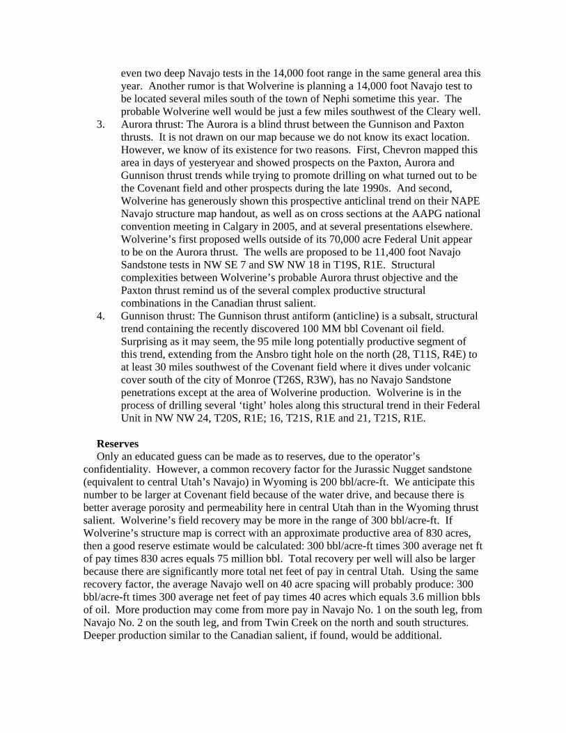
even two deep Navajo tests in the 14,000 foot range in the same general area this year. Another rumor is that Wolverine is planning a 14,000 foot Navajo test to be located several miles south of the town of Nephi sometime this year. The probable Wolverine well would be just a few miles southwest of the Cleary well.
3. Aurora thrust: The Aurora is a blind thrust between the Gunnison and Paxton thrusts. It is not drawn on our map because we do not know its exact location. However, we know of its existence for two reasons. First, Chevron mapped this area in days of yesteryear and showed prospects on the Paxton, Aurora and Gunnison thrust trends while trying to promote drilling on what turned out to be the Covenant field and other prospects during the late 1990s. And second, Wolverine has generously shown this prospective anticlinal trend on their NAPE Navajo structure map handout, as well as on cross sections at the AAPG national convention meeting in Calgary in 2005, and at several presentations elsewhere. Wolverine’s first proposed wells outside of its 70,000 acre Federal Unit appear to be on the Aurora thrust. The wells are proposed to be 11,400 foot Navajo Sandstone tests in NW SE 7 and SW NW 18 in T19S, R1E. Structural complexities between Wolverine’s probable Aurora thrust objective and the Paxton thrust remind us of the several complex productive structural combinations in the Canadian thrust salient.
4. Gunnison thrust: The Gunnison thrust antiform (anticline) is a subsalt, structural trend containing the recently discovered 100 MM bbl Covenant oil field. Surprising as it may seem, the 95 mile long potentially productive segment of this trend, extending from the Ansbro tight hole on the north (28, T11S, R4E) to at least 30 miles southwest of the Covenant field where it dives under volcanic cover south of the city of Monroe (T26S, R3W), has no Navajo Sandstone penetrations except at the area of Wolverine production. Wolverine is in the process of drilling several ‘tight’ holes along this structural trend in their Federal Unit in NW NW 24, T20S, R1E; 16, T21S, R1E and 21, T21S, R1E.
Reserves Only an educated guess can be made as to reserves, due to the operator’s
confidentiality. However, a common recovery factor for the Jurassic Nugget sandstone (equivalent to central Utah’s Navajo) in Wyoming is 200 bbl/acre-ft. We anticipate this number to be larger at Covenant field because of the water drive, and because there is better average porosity and permeability here in central Utah than in the Wyoming thrust salient. Wolverine’s field recovery may be more in the range of 300 bbl/acre-ft. If Wolverine’s structure map is correct with an approximate productive area of 830 acres, then a good reserve estimate would be calculated: 300 bbl/acre-ft times 300 average net ft of pay times 830 acres equals 75 million bbl. Total recovery per well will also be larger because there are significantly more total net feet of pay in central Utah. Using the same recovery factor, the average Navajo well on 40 acre spacing will probably produce: 300 bbl/acre-ft times 300 average net feet of pay times 40 acres which equals 3.6 million bbls of oil. More production may come from more pay in Navajo No. 1 on the south leg, from Navajo No. 2 on the south leg, and from Twin Creek on the north and south structures. Deeper production similar to the Canadian salient, if found, would be additional.
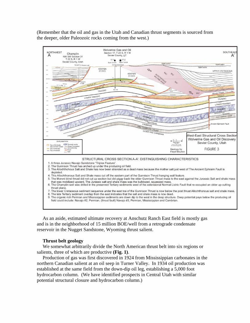
(Remember that the oil and gas in the Utah and Canadian thrust segments is sourced from the deeper, older Paleozoic rocks coming from the west.)
As an aside, estimated ultimate recovery at Anschutz Ranch East field is mostly gas
and is in the neighborhood of 15 million BOE/well from a retrograde condensate reservoir in the Nugget Sandstone, Wyoming thrust salient.
Thrust belt geology We somewhat arbitrarily divide the North American thrust belt into six regions or
salients, three of which are productive (Fig. 1). Production of gas was first discovered in 1924 from Mississippian carbonates in the
northern Canadian salient at an oil seep in Turner Valley. In 1934 oil production was established at the same field from the down-dip oil leg, establishing a 5,000 foot hydrocarbon column. (We have identified prospects in Central Utah with similar potential structural closure and hydrocarbon column.)
The central portion we call the Wyoming salient had its first significant production established at Pineview, Utah, in 1975. This salient is mostly in Wyoming and is bounded by the Uinta Mountains to the south and the Snake River Plain to the north.
The third productive salient is in central Utah and is a new oil and gas producing province. It is located south of the Uinta Mountains, extending south 150 miles, perhaps even beyond Beaver, Utah (35 miles south of Richfield and the Covenant field). This Central Utah thrust and fold belt was drilled by approximately 100 significant exploration wells prior to the discovery of the Covenant field. Only about twenty-five of these wells penetrated Navajo or older formations in the 4,000 square mile thrusted area covered by this report.
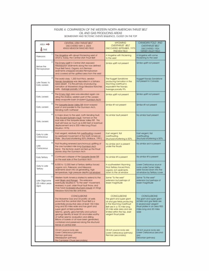
The basic geology of the central Utah play does have some similarities but definite differences when compared to productive thrust trends of the Canadian and Wyoming salients. We have elected to compare the basic geology of these three salients on a spreadsheet (Fig. 4).
Ultimately, the death knell to Central Utah thrust belt exploration, prior to Wolverine’s discovery, was a perceived absence of source rocks.
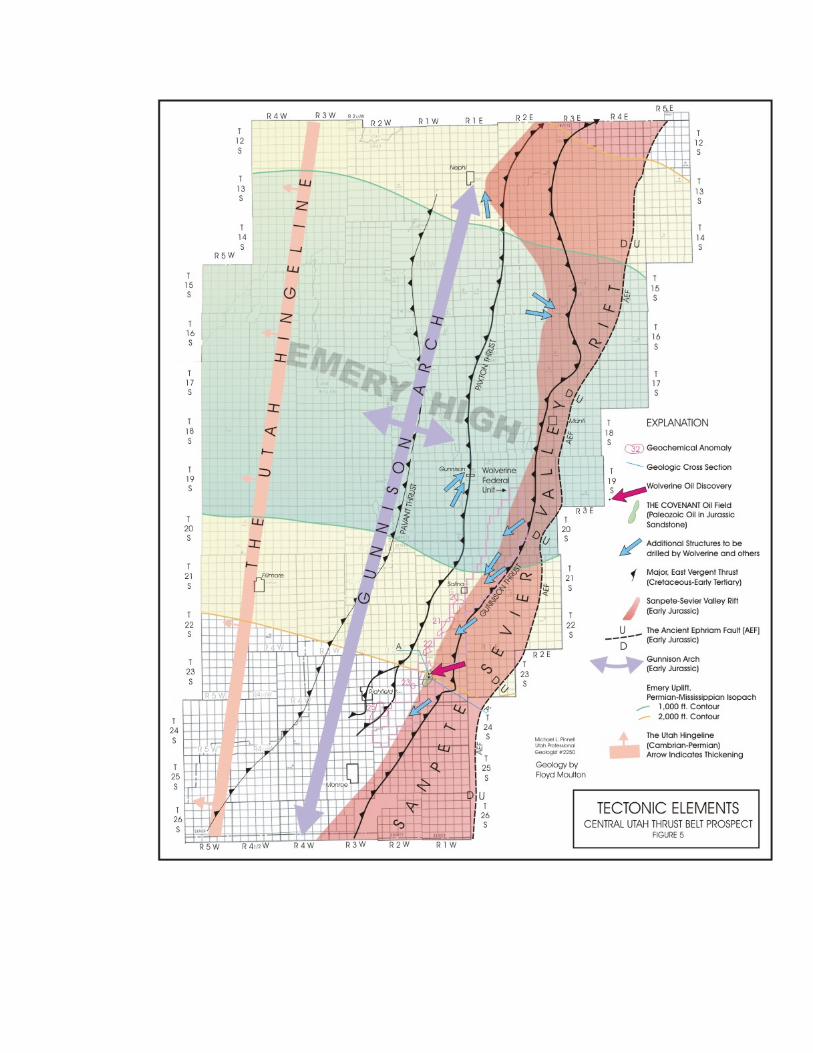
1. The Hingeline. The Central Utah thrust belt (Utah salient) is located just east of the
abrupt, western thickening of Paleozoic rocks (Fig. 5). This thickening is more abrupt than at the Canadian or Wyoming salients.
Thick, organic-rich Paleozoic rocks are critical as both source and potential reservoir rocks and possibly even sealing rocks in the Utah salient: The Wolverine discovery produces oil typed as being Paleozoic (Mississippian and possibly Permian age).
Since this oil has migrated from west to east to fill Covenant field, all contemporaneous, intervening structural closures must have been filled with hydrocarbons prior to Wolverine’s anticline.
Do these undrilled structures contain oil to the west where some of the best Central Utah thrust belt oil and gas shows were noted prior to Wolverine’s success? We have geochemistry data that indicate “yes” and point to even more potentially productive structures in the Aurora, Paxton, and Pavant thrust trends than in the easternmost Gunnison Thrust trend.
In addition to Jurassic reservoirs now productive in central Utah, Paleozoic carbonates may also be productive from porosity enhanced by karsting as well as fracturing, in some ways similar to Whitney Canyon-Carter Creek field Paleozoic production sourced by Cretaceous shales[1] in Wyoming and Paleozoic sourced Mississippian and Devonian carbonate reservoirs in Canada.
2. Emery uplift. In central Utah, a large, east-west trending uplift began prior to Pennsylvanian and exposed rocks at least as old as Mississippian carbonates in an area now occupied in part by the central Utah thrusts (Fig. 5). This uplift is defined by isopach (thickness) mapping of the Mississippian to Permian interval. Pennsylvanian carbonates were either eroded or not deposited, as well.
This type of uplift resulted in porosity enhancement in exposed rocks. Karsting may provide even better oil production in Paleozoic rocks than the great rates in Wolverine’s Jurassic-age reservoirs. Organic rich Permian sediments onlapped and covered all the uplifted area from the west.
Permian oil is the source of several well-known oil fields and tar deposits in central and southern Utah. These include Upper Valley field in the Kaiparowitz basin, the Virgin Anticline located 23 miles east-northeast of Saint George, Utah, and 125 miles south of Covenant field, and the Tar Sand Triangle. The Triangle area is 60 miles east of the Wolverine discovery. Up to 16 billion bbl of oil migrated into a stratigraphic trap in the Permian White Rim sandstone. This former oil field was then exposed on the surface as a tar sand deposit by recent erosion. 3.Navajo sandstone. The world class, 1,200-ft thick, Early Jurassic age eolian Navajo Sandstone was deposited in a Sahara-sized desert that ranged from Nevada to Nebraska and Arizona to Montana. This same sandstone is called the Nugget in the Wyoming salient, where it is the primary productive horizon.
But there are differences. In Wyoming Navajo Sandstone can be 400 to 1,000 ft thick, but there it is much tighter and often needs natural fracturing in anticlinal folds to enhance hydrocarbon deliverability; average porosity is commonly 9%. Near Wolverine’s discovery, Standard of California (Chevron’s predecessor) drilled and cored the Navajo Sandstone in 1957 where it displayed better reservoir qualities in thicker zones with better porosity, averaging over 12%, and it had a few good oil shows (much better oil shows were in the Twin Creek Limestone, above the Navajo). A small amount of gas (3 MCFG/D) was recovered on a DST. Wolverine has further reported average porosity from cores and logs in the producing portion of the Covenant field at 14 % with average permeabilities of 40-50 md.
4. Emery uplift rejuvenated. In early Jurassic, the Emery high was again elevated. This uplift isolated the shallow, western part of the Jurassic deep evaporite basin wherein thick strata of gypsum, salts, silts, and shales were deposited as the Arapien and Carmel formations. These evaporites will later play a significant role in post-thrusting hydrocarbon migration and tectonics not displayed in the Wyoming or Canadian salients.
The renewed Emery uplift transformed into the more northerly trending, narrower, incipient Gunnison Arch. Synchronous highs like the Emery uplift-Gunnison arch are known to contain vast amounts of oil. A few examples are Elk Hills, Yates, and Lost Soldier fields.[2,3]
We are not saying these California, Texas, and Wyoming giant fields are in thrust regimes but that, prior to major tectonism, fields of these magnitudes may have already been present only to be modified by more recent tectonics. Pre-thrusting oil migration in this general trend has been suggested by Loucks [4], Schelling and Wavrek [5], and Stone [6].
5. Sanpete-Sevier Valley rift. A contemporaneous downwarping east of and parallel to the incipient Gunnison arch accentuated Jurassic evaporite deposition. No similar feature was present in Canada or Wyoming.
6. Ancient Ephraim fault: Also in early Jurassic a major down-to-the-west, north trending fault developed on the east side of the Sanpete-Sevier Valley rift and was accentuated by the Sanpete-Sevier Valley rift. This fault is 200 miles long and had throw of as much as 6,000 ft. Moulton recognized the importance of this fault and named it “The Ancient Ephraim fault” in 1976.
7. Overthrusting. East vergent, relatively flat overthrusts initiated in western Utah during late Jurassic or early Cretaceous and continued, by earliest Paleocene, to central

Utah. Westward movement of the North American Plate[7] caused a structural shortening of 50%, similar to Canadian and Wyoming salients [7].
In Utah at least four or five major, unique thrusted sheets are oldest on the west and include the Canyon Range thrust, the Pavant thrust, the Paxton thrust, the blind Aurora thrust, and the youngest, and easternmost Gunnison thrust (containing Covenant field) [8].
In Canada, most similar thrusts contain economic hydrocarbons east of the Rocky Mountain Trench. However, in Wyoming only the eastern Absaroka thrust is economic with an undeniable symbiotic relationship with the Fossil basin providing required source rock depths. Other thrusted anticlines are essentially dry west of the Absaroka thrust because substantial quantities of oil and gas were unable to migrate to them from the east to the west. The migration pathway for the source of mature Cretaceous shales below and east of the Absaroka thrust plane was blocked. Fortunately, in the Utah salient, sufficient Tertiary cover, 8,000 to 12,000 feet, was or is present, mimicking the Fossil basin relationship of Wyoming, except the Utah area of thick Tertiary cover was much larger than the area of the Fossil basin.
On the other hand, west to east migration of Paleozoic oil and gas has never been noted in thrust layers in Wyoming. Fortunately, this migration does happen in the Canadian and Utah salients. For this reason the Utah salient may be productive from several separate thrust fronts like Canada and unlike Wyoming.
In an effort to evaluate this possibility of oil and gas migration into multiple thrusts in central Utah, we acquired a proprietary satellite geochemical evaluation of the entire central Utah trend and looked for geochem signatures similar to the ones we noted associated with the Wolverine discovery. Each of the major thrust trends exhibits Covenant field-like geochem signatures at or near structural culminations identified from gravity, seismic or surface geology, with the Pavant, Paxton, Aurora and Gunnison thrust trends exhibiting numerous anomalies. Many have a stronger signature than what is displayed at Wolverine’s discovery.
We include the locations of several of these geochemical anomalies associated with the Covenant anticline and related structures on our tectonic elements map (Fig. 5). Note the position of anomalies 20 through 23 at the western edge of the canopy of thick evaporates in the Sanpete-Sevier Valley rift. We suspect these anomalies are from hydrocarbon microseepage deflected somewhat westward, having traveled under the allochthonous salt and shale mass.
8. Gunnison arch continues. As thrusting wound down at the end of the Cretaceous, uplift at the Gunnison arch intensified. This hundred mile long north-northeast trending tectonic event (Fig. 5) arched up the thrust planes and continued through at least the early part of the Paleocene.
9. Sanpete-Sevier rift continues. Continued sagging above the Sanpete-Sevier rift accentuated the rift between the Gunnison arch and Ancient Ephraim fault during Tertiary and even Quaternary time.
After thrusting, thick salty zones within the rift have mobilized and moved up geologic section (west) approximately at a 45° angle along an 80-mile trend that, for the most part, follows the Gunnison thrust (see cross section, Fig. 3). This lateral salt movement is an allochthonous, evaporitic mass that is sometimes designated as a subsurface salt glacier, or a salt canopy.

Gravity data clearly show an abrupt salt termination where it is eroded on the west. On the east, where it was once up to 6,000 feet thick, there appears to be a gradual, volumetric decrease. In many instances, the salty deposit has vanished up-dip from where it was once over 6,000 feet thick.
10. Oil window. During early to late Tertiary, the oil window was achieved in central Utah in both Paleozoic source rocks to the west and Cretaceous source rocks to the east because, at least in part, of the deposition of 8,000-12,000 ft of overlying Tertiary detritus.
These source rocks were forced deep enough to reach temperatures, pressures and
chemical balance sufficient to generate oil and gas. This also happened in Canada, but in the Wyoming salient it appears that only Cretaceous shales yielded hydrocarbons almost exclusively from under the Fossil Basin Tertiary deposits associated with the Absaroka thrust.
11. Basin and Range. Around 25 million years ago central and western Utah initiated extension. This “to the west” movement probably took place on the older thrust planes and may have actually increased east dip and, hence, the structural closure of the already existing Covenant field like-anticlines. This “to the west” extension may have also caused the older thrust planes to arch up under the Covenant type structures (Fig. 3).
Geologic conclusions A giant oil field has been found in the Central Utah thrust belt below an extensive,
thick Jurassic salt deposit that covers thousands of square miles. The geologic conditions for the trapping of hydrocarbons is more favorable in the
central Utah thrust province than in the Wyoming thrust salient. Although the thrusting is similar in age and magnitude, oil in the Central Utah thrust belt has migrated from both the west and the east, thereby significantly increasing the possibility of oil in all thrusted structural trends, not just the eastern Absaroka equivalent thrust as is the case in the Wyoming salient.
Production in central Utah may be more like the Canadian thrust belt, with the exception that Utah’s fields will contain more oil than gas and be lower in sulfur content while Canada’s reserves are high sulfur and more gas prone. In the likely case of Canadian-like deeper Mississippian and Devonian carbonate gas production being established in central Utah, the Kern River pipeline is not far away (Fig. 1).
Early exploration techniques Older seismic data in the Central Utah thrust belt is spotty. It is fair in some areas but
poor in others. Data from old wells is also spotty. We suspect many shows as well as results of tests of oil and gas, never made an appearance in the public domain so as to protect any of the drilling companies’ future exploration strategies, most of which never occurred. Gravity and magnetic data, surface geology, and geochemistry are all helpful until new vintage seismic takes over. Seismic data will be definitive for the locations of the many wells we know will soon be drilled. Because of the 85 mile salt canopy along the Gunnison thrust antiform, 3-D seismic may eventually help solve many of the structurally complex subsalt riddles as they appear along this trend.
One exploration tool we have found useful in areas where we have no usable seismic data is a satellite technique of measuring relative amounts of kaolinite in surface rocks. Microseepage of hydrocarbons creates a reducing environment, either stabilizing the kaolinite or altering other clay minerals to form kaolinite.[9]
A geochemical anomaly, caused by kaolinite abundance, is present at the Wolverine discovery well and is repeated over and over along the structural trends caused by the various oil trapping thrust fault structures over an area at least 150 miles long and 40 miles wide in the Central Utah thrust belt trend.
At least 30 of these geochemical anomalies appear to be located on or adjacent to either seismic or gravity-defined structural culminations in the heart of the play approximately between Nephi and Monroe, north to south, and Salina and Filmore, east to west. These geochemical anomalies look very much like the seismic, gravity residual anomaly and geochemical anomalies we mapped at Wolverine’s discovery.
Drilling and other exploration activity Wolverine and several other exploration companies could have three to five rigs active
in the area during the 2006 drilling season; here is why. Wolverine, we are certain, will drill at least three or four seismically defined prospects
within its 70,000-acre Federal Unit because this drilling is required to earn all acreage associated with its Chevron-Texaco farmout option. In addition, Wolverine has been very actively acquiring new seismic outside the Federal Unit where it just recently announced two of what we believe will be many test wells on other prospects. We believe their focus areas are: In their Federal Unit, of course; north of the Federal Unit along the same Gunnison antiform near the towns of Manti and Mayfield, at least as far north as the Ansbro well (T11S, R4E); on the other side of the Federal Unit extending at least 25 miles south and southwest of the Covenant discovery; along the Aurora thrust (including the latest announced wells in SE SW 7, and NWSW 18, T19S, R1E); on the Gunnison Arch which includes a significant portion of the Paxton thrust, (including a 14,000 foot Navajo #2 test a few miles south of Nephi); east of the Gunnison thrust but west of the Ancient Ephraim Fault; under volcanic cover and many miles southwest of Covenant field; and a fistful of other prospective areas in various stages of exploration. In all, Wolverine has stated publicly on may occasions it intends to drill over twenty already defined structural anomalies in Sanpete, Sevier, Millard and Juab counties.
Oklahoma based Cleary Petroleum and partners executed a farmout option from Lion Oil Co., private Denver independent, to drill a Navajo Sandstone well in SE SW 11, T13S, R1E, just east of the crest of a surface anticline mapped by State of Utah geologists and in the foothill area southeast of the town of Nephi. A significant residual gravity anomaly indicates this to be a large, northerly trending structural high. We also note several geochemical anomalies along this same structural trend. This area is 60 miles north of Wolverine’s discovery (Fig. 5). The well apparently did not achieve its proposed deep objective. Something good must have happened, though, because casing was run and the well has additional perforations to make during tests in the spring of 2006. Rumor has it that the Cleary group may also drill a shallow hole west of the well presently being tested and perhaps a deep, 14,000 foot sub-thrust Navajo test soon. Such action may require the forming of a federal unit since many of their leases will soon be expiring.
PetroHunt and partners are very active primarily along the Gunnison antiform in a number of townships just north of Wolverine’s Federal Unit. This group may have set a record in January, 2005, by taking 35,000 acres with not a lot of lease term remaining. These leases, from a Utah Independent, were purchased for $450/acre with substantial deep drilling commitments and included large cash penalties for non-performance. Subsequent to this acquisition the group spent $1200/acre for thousands of acres at a competitive Federal lease auction. Their pattern of new seismic acquisition indicates they are deciding on exact locations for several key wildcat wells. The group has been extremely aggressive, filling the gaps of lease blocks with tracts as small as one and two acres in anticipation of the drilling of at least two deep Navajo Sandstone tests in the T15S to T19S and R2E to R3E area. We have heard that at least one well is required in 2006 and one in 2007. We recently found out from an inside source that the PetroHunt group will drill the first well in the second quarter of 2006. They also picked up a significant acreage position on several structures in townships west of the town of Nephi near wells with good shows, drilled in the 1980s by sister company, Placid Oil, on the Gunnison Arch.
Armstrong Oil and Gas, Denver, has selected an area immediately south-southwest of Wolverine’s Federal Unit for exploration. Armstrong has paid a substantial amount for leases on several prospective structures and, according to the Deseret Morning News (October 13, 2005), has plans to drill several wells before the end of 2006. International and Pioneer have been approached by Armstrong to sell all their leases in T24S to T26S, R2W to 4W. No specific well locations or terms have been mentioned yet, but when we contour the Armstrong dollars/acre paid, our “iso-dollar map,” at competitive lease sales, we think we have a pretty good idea as to where the hot spots may be. In addition, we have heard of several possible Armstrong partners, including but not limited to, Wolverine Gas and Oil.
Burnett Oil is kind of a mystery company. This group has a significant lease position scattered over a very large area in central Utah. And Burnett has an active seismic program going between the southern end of the PetroHunt area and just north of the Wolverine Federal Unit. We believe Burnett is capable of drilling deep prospects when defined.
Threshold Energy is another mystery company. It has the Delta and Cherry thrusts in the T12S to T14S, and R4W to R6W area under seismic scrutiny, with plans to drill a well or two in the near future. Tidewater also has a significant lease position in this area.
Samson Resources, Tulsa, may have taken over the Ansbro exploration effort in the general area of T9S to T12S, R7E to R3E. This area has had several wells drilled over the years with some really good shows, including 120 feet of oil with no water recovered on a DST by Unocal from 5788’-5812’ in SW NE 24, T11S, R4E. Why so many wells? The answer is oil: shows and seeps. Three or four significant surface oil seeps have been mapped in the area, mostly north and west of these wells, over the last 50 years. (The name of a canyon in the area has an interesting ring to it: Oil Hollow. It contains one of the largest oil seeps.) We note new north south seismic acquisition just west of the surface location of the Ansbro well. Furthermore, we have heard rumors of a possible Federal Unit and perhaps even two deep, 15,000 foot wildcats in the works. Apparently the Ansbro wildcat well, Section 28, T11S, R4E, only reached the first Navajo and not the primary objective: the second Navajo. A Christmas tree was seen on the wellbore
when we drove by last month. With some leases on a short time fuse, is a Federal Unit in the offing here as well?
POGO Production has acquired large leases on several northern Gunnison Arch prospects, in the PetroHunt area and in the Armstrong Oil and Gas area of interest southwest of Wolverine’s Federal Unit. We have heard that several exploration companies have approached POGO or are in the process of acquiring seismic on their leases.
Hewett Energy has been acquiring seismic data on its acreage position located on the Gunnison antiform approximately in T13S and T14S, R2 and 3E. We think it has found a partner to drill a Navajo structure similar to Wolverine’s productive anticline.
Utah based Liberty Pioneer Energy, not associated in any way with Pioneer Oil and Gas, or Pioneer Natural Resources, has bravely selected to explore, with the drill bit, a shallow prospect above the Jurassic salt canopy in T15S and T16S, R3E.
Pioneer Oil and Gas and International Petroleum, LLC, based in Utah, have joined forces to acquire over 400,000 acres, the second largest lease position in the central Utah thrust belt. The available 165,000 acres shown on maps on this web site is virtually all the leases owned in the heart of the play. Because this group started leasing early, they have been able to secure leases on or adjacent to most of the prospects we have identified and anticipate will be drilled in the next few years. Because we either work for or consult with this group, we admit we are prejudiced as to the strength of our currently available 165,000 acres. But almost every wildcat well to be drilled outside and some inside Wolverine’s Unit will be immediately adjacent to or on trend with some of our lease interests. And using the Covenant field as a model of potential oil recovery from Navajo Sandstone and Twin Creek Limestone, each productive acre may produce a net 120,000 bbls oil or $7.2 million in gross revenue based on today’s oil price.
Summary A new oil and gas producing province has been found with the discovery of
Wolverine’s Covenant oil field. A third major oil producing segment of the western North American Overthrust Belt is now defined in central Utah. Geologic comparison to the 60 mile productive trend in Wyoming and the 1,000+ mile productive trend in Canada indicates the Utah salient should:
1. Be geographically much longer and wider than the Wyoming thrust belt productive trend.
2. Contain significantly more recoverable oil and gas reserves than have been discovered in Wyoming.
3. Exhibit the striking similarities to the Canadian thrust belt of multiple, productive thrust trends and Paleozoic hydrocarbons being sourced from the western hingeline area with major Paleozoic carbonates as well as Jurassic rocks as producing horizons.
References 1. Sieverding, J. L. and Royce, F., Jr., “Whitney Canyon- Carter Creek Field: Gas
Production from Carbonate Reservoirs in a Thrust Belt Structural Setting, Western Wyoming, U.S.A.,” AAPG Bull., Vol. 75, No. 3, 1991, p 672.

2. Scholten, R., “Synchronous Highs: Preferential Habitat of Oil,” AAPG Bull., Vol. 43, No. 8, 1959.
3. Reynolds, M.R., “Influence of Recurrent Laramide Strucutral Growth on Sedimentation and Petroleum Accumulation, Lost Soldier Area, Wyoming,” AAPG Bull., Vol. 60, No. 1, 1976.
4. Loucks, G.G., 1975, “The search for Pineview Field, Summit County, Utah,” in “Symposium on deep drilling frontiers of the central Rocky Mountains,” RMAG, 1975, pp. 255-264.
5. Schelling, D.D., and Wavrek, D.A., “Structural Geology and Petroleum Systems of the Northwestern Wind River Basin, Wyoming,” AAPG Bull., Vol. 85, No. 13, 2001 (supplement).
6. Stone, D.S., “Theory of Paleozoic Oil and Gas Accumulation in the Big Horn Basin, Wyoming,” AAPG Bull., Vol. 51, No. 10, 1967, pp 2,056-2,114.
7. Wallace, R.E., ed., “The San Andreas Fault System, California,” USGS Professional Paper 1515, 1991.
8. Hintze, L.F., and Davis, F.D., “Geology of Millard County, Utah,” Bull. 133, Utah Geologic Survey, 2003.
9. Schumacher, D., “Hydrocarbon Induced Alteration of Soils and Sediments,” in Schumacher, D., and Abrams, M.A., eds., “Hydrocarbon migration and its near-surface expression,” AAPG Memoir 66, 1996, pp. 71-89. Bibliography
Moulton, F.C., “Lower Mesozoic and Upper Paleozoic Petroleum Potential of the Hingeline Area, Central Utah,” in RMAG Guidebook, “Symposium on Geology on the Cordilleran Hingeline,” 1976.
Powers, R.B., “Oil and Gas Potential of Wyoming-Utah-Idaho Overthrust Belt—Relation to Canadian Foothills Province Analog,” Abstract, AAPG Bull., Vol. 69, 1980, p. 767.
Rosenfeld, J.K., et al., “Oil-to-Source Correlation—Pineview Field, Overthrust Belt, Utah,” Abstract, AAPG Bull., Vol. 64, 1980, p. 776.